Embed Size (px)
Citation preview
Acknowledgements for cover photos:
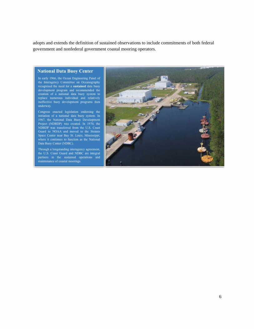
Top: National Oceanic and Atmospheric Administration (NOAA) National Data Buoy Center
Lower left: NOAA Photo Library, NOAA Ship Discoverer (R 102), Bering Sea. Image by Rear Admiral Richard R. Behn, NOAA (Ret.) Director, Marine Operations, University of Miami/ Rosenstiel School of Marine and Atmospheric Science
Lower right: NOAA Photo Library, Voyage to Inner Space - Exploring the Seas from NOAA Collection, Sargassum triggerfish, Location: Gulf of Mexico, West Bank, Flower Garden Banks National Marine Sanctuaries. Image by: National Undersea Research Center/University of North Carolina Wilmington and NOAA/Flower Garden Banks National Marine Sanctuary
1/13/2017
iv
Preface In October 2015, the National Oceanic and Atmospheric Administration (NOAA) U.S. Integrated Ocean Observing System (IOOS®) Office, along with the NOAA National Data Buoy Center (NDBC), chartered the development of a plan to examine and define the sustained network of coastal moorings surrounding the U.S. coastline, including U.S. territories and the Great Lakes region.
The National Strategy for a Sustained Network of Coastal Moorings was developed by a writing team of NOAA federal and nonfederal subject-matter experts and scientists, and led jointly by the U.S. IOOS Office and NDBC. The moorings identified and discussed in this document were compiled from IOOS Regional Association (RA) data portals and NOAA data center portals and program documentation, with input from observing system operators. Regional lists of moorings were vetted by RA Executive Directors and/or RA Data Management and Communications (DMAC) representatives. The Strategy was reviewed by the IOOS RAs and their partners, the U.S. Army Corps of Engineers, NDBC and IOOS Office staff, and the NOAA Observing Systems Council. This final version is a synthesis of over 500 comments and suggestions.
The writing team acknowledges the support and direction of the sponsors, Zdenka Willis, Director of the U.S. IOOS Office, and Joseph Pica, Director of the NWS Office of Observations. The team thanks the IOOS RA Executive Directors and their DMAC representatives, and the director and staff of NDBC and the IOOS Office for their input and help in strengthening the Strategy.
Writing Team Shannon McArthur, PMP WMO/IOC Vice-Chair Data Buoy Cooperation Panel and Program Manager, NOAA National Data Buoy Center
Kathleen Bailey Physical Scientist, NOAA U.S. Integrated Ocean Observing System (IOOS) Office
Dr. Carol Janzen Director of Operations and Development, Alaska Ocean Observing System (AOOS)
Dr. Ru Morrison Executive Director, Northeastern Regional Association of Coastal Ocean Observing Systems (NERACOOS)
Teresa Murphy Physical Scientist, NOAA National Weather Service, Office of Observations
Dr. Jan Newton Executive Director, Northwest Association of Networked Ocean Observing Systems (NANOOS) and Senior Principal Oceanographer, University of Washington
Steve Ruberg Scientist, NOAA Great Lakes Environmental Research Laboratory
Dr. Uwe Send Professor of Oceanography, Scripps Institution of Oceanography
Technical Editor Helen Worthington REMSA, Inc.
Sponsors Zdenka Willis Director, U.S. Integrated Ocean Observing System (IOOS) Office
Joseph Pica Director, NOAA National Weather Service Office of Observations
v
Table of Contents
Preface ............................................................................................................................... iv
Table of Contents ................................................................................................................ v
Executive Summary ............................................................................................................ vi
Introduction ........................................................................................................................ 1 Vision and Goals of the Strategy .................................................................................................. 3 Scope of the Strategy ................................................................................................................... 5
Geographic Constraints ................................................................................................................... 5 Sustained and Experimental Observations ..................................................................................... 5 Existing Coastal Mooring Networks Within Scope .......................................................................... 7
Background ....................................................................................................................... 11 Regional Associations ................................................................................................................ 11 Coastal Moorings and Their Unique Capabilities ........................................................................ 12 The Societal Benefits and Value of Coastal Moorings and Their Impact on the Coastal Economy 14 Critical Infrastructure for a Sustained Network of Coastal Moorings .......................................... 17
An Examination of Existing Coastal Moorings .................................................................... 19 Major Observation Categories of Coastal Moorings ................................................................... 19 A Regional Look at Existing Coastal Mooring Observing Networks ............................................. 21
Atlantic Coast ................................................................................................................................ 21 Gulf of Mexico ............................................................................................................................... 28 Caribbean Sea ................................................................................................................................ 30 Pacific Coast ................................................................................................................................... 33 Pacific Islands ................................................................................................................................ 40 Alaska ............................................................................................................................................ 43 Great Lakes .................................................................................................................................... 47 Nationwide Ecosystem Observing Capabilities from Moorings .................................................... 51
Recommendations ............................................................................................................ 54
Appendix I: IOOS Regional Associations and Stakeholders ................................................ 57
Appendix II: Global Climate Observing System (GCOS) Climate Monitoring Principles ....... 60
Acronyms .......................................................................................................................... 61
vi
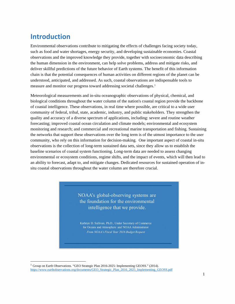
Executive Summary Environmental observations collected from the ocean, estuaries, and the Great Lakes are critical to the success of the nation’s economy. This information equips NOAA and its partners to: monitor, prepare, and respond to events threatening coastal communities, human health and safety, and vulnerable ecosystems; to support a productive and efficient economy through safe marine transportation; and to understand the impacts of a changing climate to prepare informed adaptation and mitigation strategies.
Many of these observations are made from coastal moorings, which are instrumented buoys or a configuration of instruments suspended below the surface and anchored to the ocean or lake floor. Coastal moorings allow for the deployment of multiple co-located sensors to measure in-situ surface atmospheric, surface ocean, and water column variables.
The marine transportation industry, the tourism industry, fisheries, the military, public health officials, and coastal and emergency managers are among numerous stakeholders who rely on observations from coastal moorings. Recent incidents involving the threat of removal of long-term moorings near Tillamook, Oregon and Cape Canaveral, Florida due to funding constraints highlighted this dependence. The stakeholders of those communities were vocal about how they used the data and the impact of losing such important information. As a result, the NOAA National Data Buoy Center (NDBC) and the U.S. Integrated Ocean Observing System (IOOS) Office worked together to ensure the observations from these moorings remained available to stakeholders. However, these incidents also revealed a larger need for a plan to sustain a network of critical coastal moorings.
Therefore, the National Strategy for a Sustained Network of Coastal Moorings (the Strategy) to identify, preserve, monitor, and adaptively manage and integrate a network of coastal moorings, operated by federal agencies, IOOS Regional Associations (RAs) and non-federal entities, was developed to establish a framework for in-depth planning and implementation of a sustained national coastal mooring network. The Strategy enables enhanced integrated stakeholder engagement by establishing a planning framework by which operators, users, and stakeholders of the coastal mooring network may stay engaged, provide cyclic peer review, and offer input into the progressively evolving architecture and design of the network.
The scope of the Strategy focuses on coastal moorings within the Exclusive Economic Zone (EEZ) that are operated by NOAA or that are included in IOOS RAs’ networks, while recognizing and considering other complementary coastal and ocean observing systems. The network is an integrated piece of a full system of mutually complementary sustained coastal observations. Overall, 370 existing moorings were identified within the scope of the Strategy.
The Strategy offers a high-level geographic overview of the existing mooring locations and observations to provide a starting point for identifying observational gaps that could best be addressed with coastal moorings. Overall, the Strategy provides ten recommendations to achieve a sustainable national network of coastal moorings:
vii
1. Develop an implementation plan with stakeholder input.
2. Identify mechanisms to sustain priority stations.
3. Consider complementary systems and emerging technologies in the development of a coastal moorings implementation plan.
4. Routinely monitor and assess the design of the national coastal mooring network.
5. Add water temperature and salinity measurements to designated existing NDBC mooring stations.
6. Identify and sustain water column ecosystem moorings at four to eight locations in each of the seven primary coastal regions of the United States.
7. Update and implement the National Operational Wave Observation Plan.
8. Promote environmental health and operational safety stewardship and regulatory compliance.
9. Develop coastal mooring network performance metrics.
10. Standardize and integrate data management best practices across coastal mooring networks.
Failure to maintain a sustainable coastal mooring network could put the health of our oceans, estuaries, and the Great Lakes at risk. Monitoring ocean and Great Lakes health can only be done through long-term multidisciplinary observations, many of which are made from coastal moorings that are uniquely suited for this task.
1
Introduction Environmental observations contribute to mitigating the effects of challenges facing society today, such as food and water shortages, energy security, and developing sustainable economies. Coastal observations and the improved knowledge they provide, together with socioeconomic data describing the human dimension in the environment, can help solve problems, address and mitigate risks, and deliver skillful predictions of the future behavior of Earth systems. The benefit of this information chain is that the potential consequences of human activities on different regions of the planet can be understood, anticipated, and addressed. As such, coastal observations are indispensable tools to measure and monitor our progress toward addressing societal challenges.1
Meteorological measurements and in-situ oceanographic observations of physical, chemical, and biological conditions throughout the water column of the nation's coastal region provide the backbone of coastal intelligence. These observations, in real time where possible, are critical to a wide user community of federal, tribal, state, academic, industry, and public stakeholders. They strengthen the quality and accuracy of a diverse spectrum of applications, including: severe and routine weather forecasting; improved coastal ocean circulation and climate models; environmental and ecosystem monitoring and research; and commercial and recreational marine transportation and fishing. Sustaining the networks that support these observations over the long term is of the utmost importance to the user community, who rely on this information for decision-making. One important aspect of coastal in-situ observations is the collection of long-term sustained data sets, since they allow us to establish the baseline scenarios of coastal system functioning. Long-term data are needed to assess changing environmental or ecosystem conditions, regime shifts, and the impact of events, which will then lead to an ability to forecast, adapt to, and mitigate changes. Dedicated resources for sustained operation of in-situ coastal observations throughout the water column are therefore crucial.
1 Group on Earth Observations. “GEO Strategic Plan 2016-2025: Implementing GEOSS.” (2014). https://www.earthobservations.org/documents/GEO_Strategic_Plan_2016_2025_Implementing_GEOSS.pdf
2
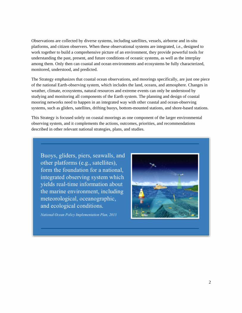
Observations are collected by diverse systems, including satellites, vessels, airborne and in-situ platforms, and citizen observers. When these observational systems are integrated, i.e., designed to work together to build a comprehensive picture of an environment, they provide powerful tools for understanding the past, present, and future conditions of oceanic systems, as well as the interplay among them. Only then can coastal and ocean environments and ecosystems be fully characterized, monitored, understood, and predicted.
The Strategy emphasizes that coastal ocean observations, and moorings specifically, are just one piece of the national Earth-observing system, which includes the land, oceans, and atmosphere. Changes in weather, climate, ecosystems, natural resources and extreme events can only be understood by studying and monitoring all components of the Earth system. The planning and design of coastal mooring networks need to happen in an integrated way with other coastal and ocean-observing systems, such as gliders, satellites, drifting buoys, bottom-mounted stations, and shore-based stations.
This Strategy is focused solely on coastal moorings as one component of the larger environmental observing system, and it complements the actions, outcomes, priorities, and recommendations described in other relevant national strategies, plans, and studies.
3
Vision and Goals of the Strategy The vision of the Strategy is a sustainable national network of coastal moorings integrated with other environmental observing systems to improve management of resources, safety of life, protection of property, enhancement of the economy, protection of the environment, and science and information about the coastal system.
The goals of the Strategy are to: ensure the preservation and implementation continuity, transparency, and public availability
of critical integrated coastal and ocean observations;
define a framework for guiding the continued planning and build-out of a sustained coastal mooring network; and
justify the need for a core sustained network of federal and nonfederal coastal moorings that adheres to national and international data standards and best practices.
The vision and goals of the Strategy align with and support the mission of NOAA2 and the actions and outcomes of the National Ocean Policy Implementation Plan3 for improving science-based products and services for informed decision-making. The Strategy characterizes the types of coastal moorings required to best meet these missions, explains the value and societal benefits of coastal moorings, and provides actionable recommendations to guide the future development of a National Plan for a Sustained Network of Coastal Moorings informed by regional stakeholders of coastal observations. The Strategy guides the development of a robust coastal moorings implementation plan that will leverage, complement, and better integrate the existing federal network of NOAA coastal moorings, as well as the federal and nonfederal coastal moorings under the purview of the IOOS Regional Associations (RAs) and other regional programs. It highlights the need for identification of ocean and coastal observation gaps within specific regions that can best be addressed by coastal moorings. It outlines the need for a sustained national network of coastal moorings, while suggesting ways in which coastal mooring operators and stakeholders of the national coastal mooring network may collaborate and engage in successful partnerships, stakeholder identification, and coastal mooring network change management solutions.
2 NOAA. “NOAA’s Next Generation Strategic Plan.” (2010). http://www.performance.noaa.gov/wp-content/uploads/NOAA_NGSP.pdf NOAA’s Next Generation Strategic Plan describes NOAA’s mission, vision, and related goals and objectives to face challenges related to safety, health, and environmental change affecting the nation. This vision involves healthy oceans that include marine fisheries, habitats, and biodiversity sustained within healthy and productive ecosystems; coastal and Great Lakes communities that are environmentally and economically sustainable; and a weather-ready nation prepared to respond to weather-related events. 3 National Ocean Council. “National Ocean Policy Implementation Plan.” (2013). https://www.whitehouse.gov/sites/default/files/national_ocean_policy_implementation_plan.pdf The National Ocean Policy Implementation Plan translates the National Ocean Policy into on-the-ground actions and presents specific actions that federal agencies will take to bolster our ocean economy, improve ocean health, support local communities, strengthen our security, and provide better science and information to improve decision-making.
4
National plans that complement the Strategy and that are relevant to the vision of an integrated system must be considered in the planning and development of a sustained network of coastal moorings.
The National Operational Wave Observation Plan4 provides recommendations for a comprehensive, high-quality surface-wave monitoring network for the United States that meets the requirements of the maritime user community.
A Plan to Meet the Nation’s Needs for Surface Current Mapping5 uses information collected from subject-matter experts across the high-frequency-radar community to deliver a collaborative approach for the design, implementation, and management of the national surface current monitoring network.
Toward a U.S. IOOS Underwater Glider Network Plan6 outlines how the U.S. IOOS Office will coordinate efforts across the glider community to deliver a collaborative approach for the design, implementation, and management of the glider network.
Cooperation in coastal mooring programs is also important and necessary in the coastal mooring operator community. For scientists, coastal moorings and data buoys represent “real estate-at-sea” on which sensors and instruments may be installed. In many situations, a single coastal mooring may be utilized to support the sensors for multiple scientific programs at once, enabling scientific investigators to share common mooring components like the mooring hardware, communication, and power systems. This sharing and cooperation promotes efficiencies by leveraging operational resources, improving safety, and reducing the environmental footprint of deployed ocean hardware. For these reasons, cooperative promotion efforts by IOOS, NDBC, and the Data Buoy Cooperation Panel work across coastal mooring programs to identify, promote, and coordinate the sharing of moorings and operational activities.
4 Interagency Working Group on Ocean Observations. “A National Operational Wave Observation Plan.” (2009). https://ioos.noaa.gov/wp-content/uploads/2015/09/wave_plan_final_03122009.pdf 5 Interagency Working Group on Ocean Observations. “A Plan to Meet the Nation’s Needs for Surface Current Mapping.” (2015). https://ioos.noaa.gov/wp-content/uploads/2015/09/national_surface_current_plan.pdf 6 U. S. IOOS. “Toward a U.S. IOOS Underwater Glider Network Plan: Part of a comprehensive subsurface observing system.” (2014). https://www.ioos.noaa.gov/wp-content/uploads/2015/10/glider_network_whitepaper_final.pdf
5
Scope of the Strategy The Strategy focuses on U.S. federal and nonfederal coastal moorings intended for sustained coastal observations needed to: protect lives and livelihoods, understand and predict changes in weather, oceans, coasts and climate; publicly share that knowledge and information; and conserve and manage coastal and marine ecosystems and resources. This integrated network of coastal moorings ensures the continuity of sustained observation systems essential to public safety, national and economic security interests, and programs supporting services critical to agency missions and scientific research. Observational mooring systems discussed in the Strategy may contain components owned by either federal or nonfederal entities, or a combination thereof.
Geographic Constraints In general, the geographic scope of the Strategy is constrained to the coastal region of the United States to include the area from the head of tide along the U.S. coast out to the approximate edge of the U.S. Exclusive Economic Zone (EEZ). This does not necessarily mean that all moorings in this range are considered coastal; if they clearly are meant to observe open-ocean conditions without connections to a coastal regime, they may not be included in the scope of the Strategy. It also includes the entirety of the Great Lakes but does not include moorings from other inland lakes.
Sustained and Experimental Observations The National Plan for Civil Earth Observations7 classifies Earth observation activities in two broad categories, sustained and experimental. These categories are based on the duration of the anticipated federal government commitment.
Sustained observations are defined as measurements taken routinely on an ongoing basis, generally for seven years or more. These measurements can be for public services or for Earth-system research in the public interest.
Experimental observations are defined as measurements taken for a limited observing period, generally seven years or fewer, that federal and nonfederal agencies are committed to collecting for process research and development. Experimental observations are conducted for finite-duration scientific research.
Sustainability is identified in the Strategy as a primary criterion for evaluating the core moorings network that supports ocean-observing capabilities. The scope of the Strategy excludes coastal moorings intended for experimental observations and process studies. Furthermore, the Strategy
7 National Science and Technology Council Executive Office of the President. “National Plan for Civil Earth Observations.” (2014). https://www.whitehouse.gov/sites/default/files/microsites/ostp/NSTC/national_plan_for_civil_earth_observations_-_july_2014.pdf The National Plan for Civil Earth Observations establishes priorities and supporting actions for advancing our civil Earth observation capabilities and marks an important step in our ability to understand, prioritize, and coordinate these observations and to better inform our investments in civil Earth observation systems.
6
adopts and extends the definition of sustained observations to include commitments of both federal government and nonfederal government coastal mooring operators.
7
Existing Coastal Mooring Networks Within Scope As of 2016, there are 370 federal and nonfederal coastal mooring stations within the scope of the Strategy (155 nonfederal, and 215 federal). These moorings are located throughout the coastal regions of the United States, including its territories and the Great Lakes. The Strategy includes moorings in large estuaries, such as the Chesapeake Bay and the Puget Sound, and provides a framework for considering the observational gaps in smaller estuarine environments. The following mooring networks provide the moorings covered in the Strategy, and some of the 370 moorings belong to more than one network.
● IOOS Regional Associations8 (143 moorings) RAs own and operate moorings but also ingest other mooring data from local partners. Therefore, some of these integrated observations are provided by a collection of various state, academic, and tribal government assets and private industry. All these moorings are considered in the Strategy. See appendix I for more information on the RAs.
○ Northeastern Regional Association of Coastal Ocean Observing Systems (NERACOOS) ○ Mid-Atlantic Regional Association Ocean Observing System (MARACOOS) ○ Southeast Coastal Ocean Observing Regional Association (SECOORA) ○ Gulf of Mexico Coastal Ocean Observing System (GCOOS) ○ Caribbean Coastal Ocean Observing System (CariCOOS) ○ Southern California Coastal Ocean Observing System (SCCOOS) ○ Central and Northern California Ocean Observing System (CeNCOOS) ○ Northwest Association of Networked Ocean Observing Systems (NANOOS) ○ Pacific Islands Ocean Observing System (PacIOOS) ○ Alaska Ocean Observing System (AOOS) ○ Great Lakes Observing System (GLOS)
● NWS NDBC Coastal Weather Buoy (CWB) network.9 (106 moorings) The CWBs are deployed in United States coastal and offshore waters for use in operational forecasting, warnings, and atmospheric models, as well as scientific and research programs, emergency response to chemical spills, legal proceedings, and engineering design. CWB moorings beyond the United States EEZ are included due to their importance to the network. NDBC is internationally recognized by the World Meteorological Organization (WMO) and the Intergovernmental Oceanographic Commission as a center of excellence for moored data buoy technology, data management, and operational standards.
● National Marine Fisheries Service (NMFS) Chesapeake Bay Office Chesapeake Bay Interpretive Buoy System (CBIBS).10 (10 moorings) CBIBS is a network of real-time observation buoys located in the Chesapeake Bay estuary and tributaries in Virginia and Maryland. The myriad observations are used for protection,
8 IOOS Association: http://www.ioosassociation.org/regionalIOOS 9 NOAA NDBC: http://www.ndbc.noaa.gov 10 NOAA Chesapeake Bay Interpretive Buoy System: http://buoybay.noaa.gov
8
management, and restoration of the Chesapeake Bay, and contribute to marine weather forecasting. MARACOOS provides the data management for CBIBS.
● National Ocean Service (NOS) Physical Oceanographic Real-time System (PORTS®).11 (22 moorings) The NOS Center for Operational Oceanographic Products and Services (CO-OPS) operates the PORTS program, which supports safe and cost-efficient navigation by providing ship masters and pilots with accurate real-time information required to avoid groundings and collisions. In almost 30 major ports and harbors, CO-OPS operates current meters deployed on United States Coast Guard (USCG) buoys through an agreement with local partners and the USCG.
● Office of Oceanic and Atmospheric Research (OAR) Great Lakes Environmental Research Laboratory (GLERL) Real-time Coastal Observation Network (ReCON).12 (10 moorings) GLERL and its consortium partners within the Cooperative Institute for Limnology and Ecosystems Research conduct integrated scientific research on the Great Lakes and coastal ecosystems, develop and transition products and services, and share knowledge and information to advance science, service, and stewardship. The ReCON mooring observations are used to support harmful algal bloom (HAB) and hypoxia (low-oxygen conditions) research and decision support, Thunder Bay National Marine Sanctuary marine observations, open water evaporation and water level research, rip current warnings in collaboration with the NWS, ecological observation monitoring and research, and NWS marine forecast verification (marine winds, waves, and current forecasts).
o GLERL also operates an additional six moorings that support thermal modeling and forecasting, hydrodynamic modeling and forecasting, and ecosystem monitoring.
● NOAA’s Ocean Acidification Program (OAP)13 (13 moorings). The OAP was established in May 2011 by the Federal Ocean Acidification Research and Monitoring Act for long-term monitoring of the chemistry of the ocean, in addition to other requirements including species-specific impacts research. The OAP is headquartered at OAR but is a matrixed, cross-NOAA effort in partnership with other federal agencies, academic and cooperative institutions, and IOOS RAs. The moored CO2 program, initiated by the OAR Climate Program Office, uses a carbon dioxide measurement system for surface buoys — developed by the Pacific Marine Environmental Laboratory (PMEL) carbon group and researchers at the Monterey Bay Aquarium Research Institute (MBARI) — paired with pH sensors. These Moored Autonomous pCO2 systems collect high-frequency carbon observations that are critical to examine and evaluate air-sea carbon dioxide fluxes and assess ocean acidification. PMEL has installed these systems on moorings operated by a variety of federal and nonfederal operators (e.g., NOAA Office of Climate Observations, NDBC and
11 NOAA CO-OPS PORTS: https://tidesandcurrents.noaa.gov/ports.html 12 NOAA Great Lakes Environmental Research Laboratory: http://www.glerl.noaa.gov 13 NOAA’s Ocean Acidification Program: http://oceanacidification.noaa.gov/
9
IOOS RAs) who contribute to the OAP observing requirements. There are 19 OAP moorings, and 13 are within scope of the Strategy, half of which are IOOS RA moorings.
o Some moorings contribute to the network of coastal ocean acidification measurements, but are not official OAP sites since they do not include pH paired with the surface CO2 measurement. The CO2 measurements, however, along with other proxies, can still be used to estimate ocean acidification conditions. Among these are three moorings within the PacIOOS network, maintained by the University of Hawaii in partnership with the PMEL carbon group, and two moorings within the NANOOS network, maintained by the University of Washington, in partnership with PMEL.
● NOAA’s Ecosystems and Fisheries-Oceanography Coordinated Investigations (ecoFOCI) Program.14 (4 moorings) EcoFOCI is a joint research program between the NMFS Alaska Fisheries Science Center and PMEL to examine climate variability, ecosystem dynamics, and recruitment variability of commercially valuable fish and shellfish stocks. Data from EcoFOCI observing systems are used in ecosystem forecasts that inform commercial fishery managers, and also help communities mitigate the effects of climate change on marine species and coastal areas. One of the four ecoFOCI moorings also supports the OAP.
● National Science Foundation (NSF) Ocean Observatories Initiative (OOI).15 (12 moorings). The OOI is a research initiative of integrated platforms for studying physical, biogeochemical, and ecosystem ocean properties. There are seven arrays located across the globe that comprise a variety of cabled systems and instrumented platforms. The moorings within one array (the Coastal Endurance Array, located off the coast of Washington and Oregon) are within geographic scope of the Strategy. These moorings are funded by the NSF but are operated by nonfederal groups, and therefore are considered nonfederal moorings.
● U.S. Army Corps of Engineers (USACE) Coastal Data Information Program (CDIP).16 (68 moorings) CDIP is an extensive network of wave buoys, measuring waves, sea surface temperature, and currents along the coastal United States. Since its inception in 1975, the program has produced a vast database of publicly accessible environmental data for use by coastal engineers and planners, scientists, mariners, and marine enthusiasts. This was accomplished with funding from the USACE — in partnership with the California Division of Boating and Waterways (CDBW) — as well as with many additional federal, state, academic, and industry partners across the nation. Roughly one-third of the CDIP moorings are owned and operated by groups other than USACE and the CDBW, including the U.S. Navy, IOOS RAs, and the private sector. The IOOS RAs operate 20 moorings for which CDIP is the data manager.
14 ecoFOCI: http://www.ecofoci.noaa.gov/ 15 NSF Ocean Observatories Initiative: http://oceanobservatories.org 16 USACE - CDIP: https://cdip.ucsd.edu
10
Considered but excluded from the scope of the Strategy are various networks of shoreline observations from rigid structures, such as towers, lighthouses, piers, pilings, and bottom-mounted stations. Shore or near-shore-based observing systems are similar in function to coastal moorings but are different in design. Examples include NOAA’s Coastal-Marine Automated Network, the National Water Level Observation Network, and National Estuarine Research Reserve shore stations. Also considered but excluded from the scope are sustained, single-purpose deep-ocean moorings such as the Deep-ocean Assessment and Reporting of Tsunamis network, and the single-purpose NOAA Marine Optical Buoy, which contains optical sensors used for radiometric calibration of satellite instruments.
11
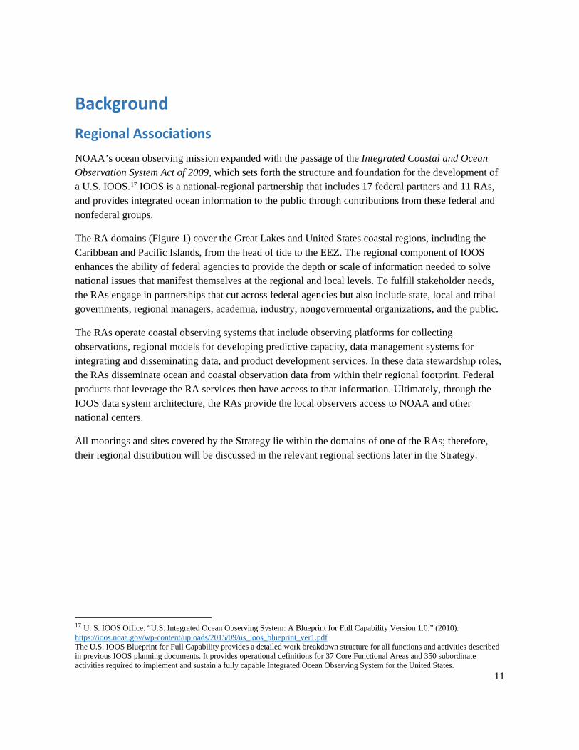
Background Regional Associations NOAA’s ocean observing mission expanded with the passage of the Integrated Coastal and Ocean Observation System Act of 2009, which sets forth the structure and foundation for the development of a U.S. IOOS.17 IOOS is a national-regional partnership that includes 17 federal partners and 11 RAs, and provides integrated ocean information to the public through contributions from these federal and nonfederal groups.
The RA domains (Figure 1) cover the Great Lakes and United States coastal regions, including the Caribbean and Pacific Islands, from the head of tide to the EEZ. The regional component of IOOS enhances the ability of federal agencies to provide the depth or scale of information needed to solve national issues that manifest themselves at the regional and local levels. To fulfill stakeholder needs, the RAs engage in partnerships that cut across federal agencies but also include state, local and tribal governments, regional managers, academia, industry, nongovernmental organizations, and the public.
The RAs operate coastal observing systems that include observing platforms for collecting observations, regional models for developing predictive capacity, data management systems for integrating and disseminating data, and product development services. In these data stewardship roles, the RAs disseminate ocean and coastal observation data from within their regional footprint. Federal products that leverage the RA services then have access to that information. Ultimately, through the IOOS data system architecture, the RAs provide the local observers access to NOAA and other national centers.
All moorings and sites covered by the Strategy lie within the domains of one of the RAs; therefore, their regional distribution will be discussed in the relevant regional sections later in the Strategy.
17 U. S. IOOS Office. “U.S. Integrated Ocean Observing System: A Blueprint for Full Capability Version 1.0.” (2010). https://ioos.noaa.gov/wp-content/uploads/2015/09/us_ioos_blueprint_ver1.pdf The U.S. IOOS Blueprint for Full Capability provides a detailed work breakdown structure for all functions and activities described in previous IOOS planning documents. It provides operational definitions for 37 Core Functional Areas and 350 subordinate activities required to implement and sustain a fully capable Integrated Ocean Observing System for the United States.
12
Figure 1. Geographic scope of the 11 U.S. IOOS RAs. RA domains extend out to the EEZ, and some domains overlap in regions where RAs work collectively.
Coastal Moorings and Their Unique Capabilities A key goal of an observing system is to resolve environmental temporal and spatial variability and change. By observing variability, scientists are able to better understand key mechanisms and processes driving the environment and make informed decisions on their use and management. By observing change and understanding it, scientists can provide decision makers with information needed to evaluate options and implications.
No single type of observing platform is capable of resolving the spatial and temporal variability of coastal oceans. It is only by deploying and integrating data from multiple platforms with appropriate model and forecast systems that the most applicable information can be delivered.
Ocean observations are collected from various Ocean Data Acquisition Systems (ODAS).18 Coastal moorings are a distinct type of ODAS used in the coastal, littoral, and near-offshore zones for the collection of ocean observations. They are unique in design from other types of ODAS in that they are 18 Meindl, Eric A. “Guide to Moored Buoys and Other Ocean Data Acquisition Systems.” Intergovernmental Oceanographic Commission (IOC) and World Meteorological Organization (WMO) Data Buoy Cooperation Panel. (1996). ftp://http://www.wmo.int/pages/prog/amp/mmop/documents/dbcp/Dbcp8/DBCP-08-Guide-Moored-Buoys.pdf The United Nations World Meteorological Organization (WMO) defines an ODAS as a “structure, platform, installation, buoy, or other device, not being a ship, together with its appurtenant equipment, deployed at sea essentially to collect, store or transmit samples or data relating to the marine environment or the atmosphere.”
13
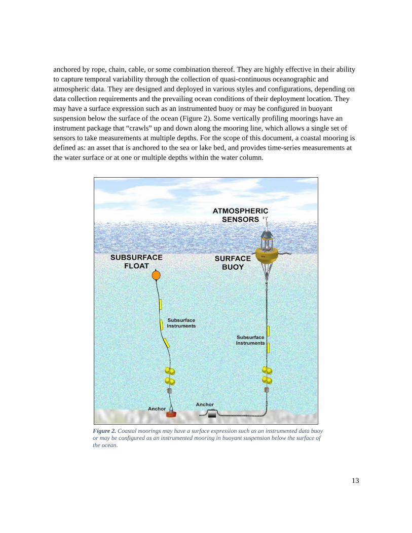
anchored by rope, chain, cable, or some combination thereof. They are highly effective in their ability to capture temporal variability through the collection of quasi-continuous oceanographic and atmospheric data. They are designed and deployed in various styles and configurations, depending on data collection requirements and the prevailing ocean conditions of their deployment location. They may have a surface expression such as an instrumented buoy or may be configured in buoyant suspension below the surface of the ocean (Figure 2). Some vertically profiling moorings have an instrument package that “crawls” up and down along the mooring line, which allows a single set of sensors to take measurements at multiple depths. For the scope of this document, a coastal mooring is defined as: an asset that is anchored to the sea or lake bed, and provides time-series measurements at the water surface or at one or multiple depths within the water column.
Figure 2. Coastal moorings may have a surface expression such as an instrumented data buoy or may be configured as an instrumented mooring in buoyant suspension below the surface of the ocean.
14
Coastal moorings typically consist of a floating, moored system and associated hardware that support environmental sensors, as well as data storage and transmission payloads. Environmental sensors deployed on moorings can measure a variety of different meteorological, physical oceanographic, chemical, and biological variables. Moorings provide a unique capability for the required time-space sampling of the coastal ocean and complement other more spatially-focused approaches (e.g., gliders, satellites, and floats).
Coastal moorings are unique in that they are the only type of ocean observing system that can provide systematic observations in the air, at the sea surface, and throughout the water column all the way to the seafloor. They allow sampling with high time-resolution, enabling the observation and response to sudden events, fast processes, and variability on virtually all timescales. Many ecosystem changes are event-driven (e.g., blooms, upwelling, etc.) and thus require continuous observations in representative or important locations. Moorings can support very complex payloads, allowing co-located measurements of many variables and using sensors that have not yet been miniaturized. Coastal moorings are relatively easy to upgrade and equip with additional sensors, especially as the adaptive management needs of mission requirements evolve.
The Societal Benefits and Value of Coastal Moorings and Their Impact on the Coastal Economy The societal benefits of ocean observations are interconnected at local, regional, national, and global scales. The National Plan for Civil Earth Observations7 identifies Societal Benefit Areas that apply to coastal moorings. Information from coastal moorings support and bolster scientific research, economic activities, and environmental and social domains. Many involve critical government functions, such the protection of life and property.
Coastal moorings expand our understanding of: Climate: Understanding, assessing, predicting, mitigating, and adapting to climate variability
and change.
Coastal and Marine Hazards and Disasters: Reducing loss of life, property, and ecosystem damage from natural and human-induced disasters.
Ocean and Coastal Energy and Mineral Resources: Improving the identification and management of energy and mineral resources.
Human Health: Understanding environmental factors affecting human health and well-being.
Ocean and Coastal Resources and Ecosystems: Understanding and protecting ocean, coastal, and Great Lakes populations and resources, including fisheries, aquaculture, and marine ecosystems.
Marine Transportation: Improving the safety and efficiency of all forms of marine transportation.
15
Water Resources: Improving water-resource management through better understanding and monitoring of the water cycle.
Coastal and Marine Weather: Improving weather information, forecasts, and warnings.
Reference Measurements: Improving the fundamental measurement systems and standards.
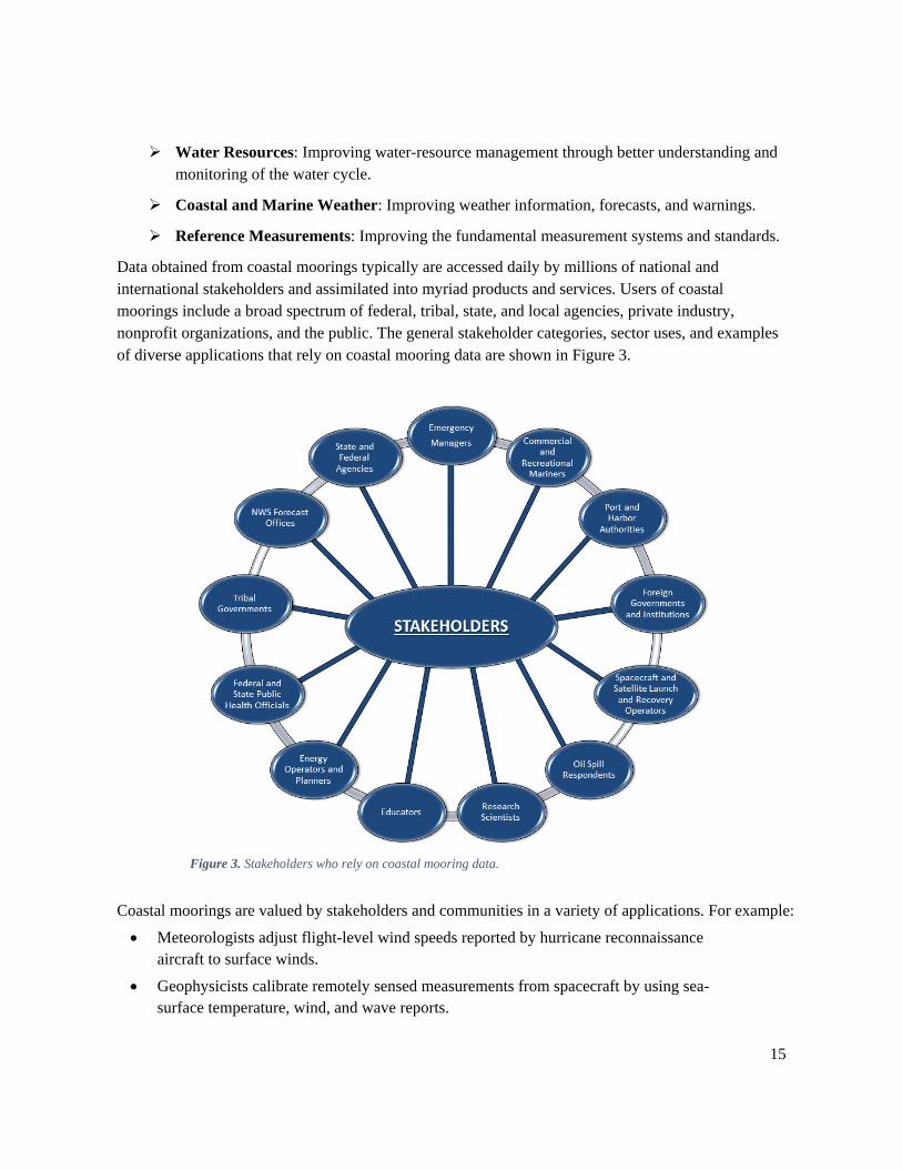
Data obtained from coastal moorings typically are accessed daily by millions of national and international stakeholders and assimilated into myriad products and services. Users of coastal moorings include a broad spectrum of federal, tribal, state, and local agencies, private industry, nonprofit organizations, and the public. The general stakeholder categories, sector uses, and examples of diverse applications that rely on coastal mooring data are shown in Figure 3.
Figure 3. Stakeholders who rely on coastal mooring data.
Coastal moorings are valued by stakeholders and communities in a variety of applications. For example:
• Meteorologists adjust flight-level wind speeds reported by hurricane reconnaissance aircraft to surface winds.
• Geophysicists calibrate remotely sensed measurements from spacecraft by using sea-surface temperature, wind, and wave reports.
16
• Engineers obtain directional wave measurements to study beach erosion and shore protection and to design bridges and other coastal infrastructure.
• Fishermen, boaters, and surfers use wave, current, and meteorological data to determine if it is safe to venture offshore.
• Mariners use wave and current data to make decisions on whether to safely leave or enter seaports.
• Marine biologists monitor ocean water quality in sensitive ecosystems and marine protected areas.
• Modelers use observations to develop, improve and validate climate, circulation, ecosystem, and nearshore models and other numerical ocean models.
Measuring, observing, and forecasting our oceans, coastal waters and Great Lakes is a crucial endeavor, supporting a wide range of safety, economic and environmental benefits. Coastal mooring networks are important economic elements of the Ocean Enterprise,19 which encompasses the for-profit and not-for-profit businesses that support ocean measurement, observations, and forecasting. The businesses that enable ocean observation, measurement, and forecasting and deliver benefits through related products and services combine to create a unique marine observation industry cluster, which enhances the Coastal Economy.20
19 U.S IOOS. “The Ocean Enterprise: A study of US business activity in ocean measurement, observation and forecasting.” (2016). https://ioos.noaa.gov/wp-content/uploads/2016/12/oceanenterprise_feb2016_secure.pdf 20 Middlebury Institute of International Studies at Monterey, Center for the Blue Economy. National Ocean Economics Program. “State of the U.S. Ocean and Coastal Economies. 2016 Update.” (2016). http://www.oceaneconomics.org/
17
Critical Infrastructure for a Sustained Network of Coastal Moorings In 2011, the Ocean Studies Board of the National Academy of Sciences published a study on the Critical Infrastructure for Ocean Research and Societal Needs in 2030.21 Identified among the critical infrastructure needs was a sustained network of coastal moorings. Of particular note is the need to develop in-situ sensors, especially chemical and biological sensors. To ensure that the United States has the capacity by 2030 to undertake and benefit from knowledge and innovations possible with oceanographic research, key recommendations in the study are:
Expand abilities for autonomous monitoring at a wide range of spatial and temporal scales with greater sensor and platform capabilities.
Enable sustained, continuous time-series measurements.
Support continued innovation in ocean infrastructure development.
Engage allied disciplines and diverse fields to leverage technological developments outside oceanography.
Establish broadly accessible virtual (distributed) data centers that have seamless integration of federal, state, and locally held databases, accompanying metadata compliant with proven standards, and intuitive archiving and synthesizing tools.
Examine and adopt proven data management practices from allied disciplines.
Facilitate broad community access to infrastructure assets, including mobile and fixed platforms and costly analytical equipment.
Expand interdisciplinary education and promote a technically skilled workforce.
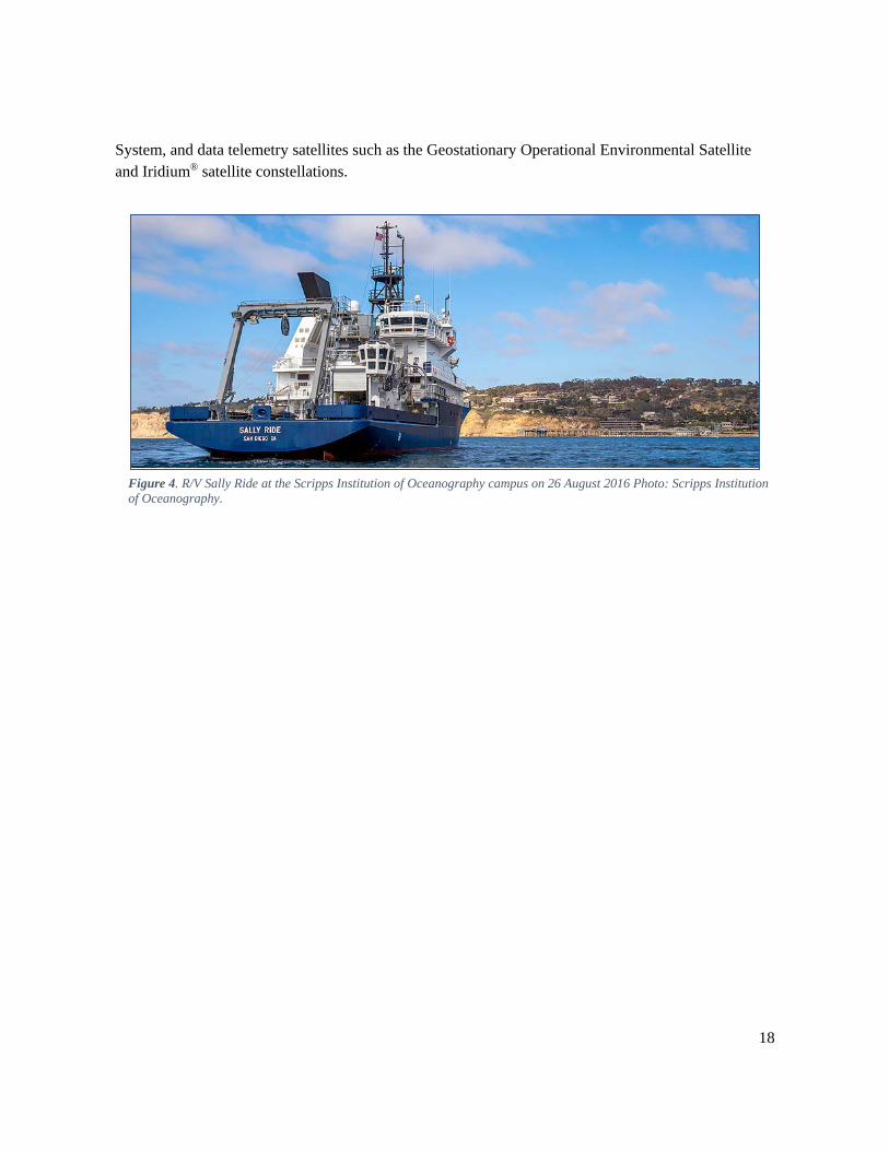
Underpinning the sustainability of ocean and coastal mooring networks is the need for a sustained infrastructure of oceanographic support systems required to maintain and operate these networks. Major infrastructure systems include ships and satellites to support the operations, maintenance, and research conducted on coastal moorings. Ships are an essential component of ocean research infrastructure.22 Coastal moorings are maintained using ships in the University-National Oceanographic Laboratory System (Figure 4), the NOAA research and survey fleet, the buoy tender fleet of the USCG, and a wide complement of commercial ships. Coastal mooring networks are critically dependent on global positioning and timekeeping satellites such as the Global Positioning 21 Ocean Studies Board of the National Academy of Sciences. “Critical Infrastructure for Ocean Research and Societal Needs in 2030.” (2011). http://www.nap.edu/catalog/13081/critical-infrastructure-for-ocean-research-and-societal-needs-in-2030 Critical Infrastructure for Ocean Research and Societal Needs in 2030 identified coastal mooring platforms as one of the essential components of ocean infrastructure: “Moorings will remain a key element of ocean observing infrastructure by providing high-frequency fixed location data to supplement spatial data collected by mobile sampling networks and satellite remote sensing.” 22 National Research Council. Science at Sea. “Meeting Future Oceanographic Goals with a Robust Academic Research Fleet.” Washington, DC: The National Academies Press, 2009. https://doi.org/10.17226/12775. Science at Sea: Meeting Future Oceanographic Goals with a Robust Academic Research Fleet states: “The future academic research fleet requires investment in larger, more capable, general purpose Global and Regional class ships to support multidisciplinary, multi-investigator research and advances in ocean technology.”
18
System, and data telemetry satellites such as the Geostationary Operational Environmental Satellite and Iridium® satellite constellations.
Figure 4. R/V Sally Ride at the Scripps Institution of Oceanography campus on 26 August 2016 Photo: Scripps Institution of Oceanography.
19
An Examination of Existing Coastal Moorings A first step toward designing a sustained network of coastal moorings is to understand the existing mooring stations’ spatial distribution and observing capabilities. This section provides an overview of the capabilities, categories, and spatial distribution of existing moorings in a breakdown of seven coastal regions, along with a brief description of environmental issues and areas of economic importance that rely on moorings observations.
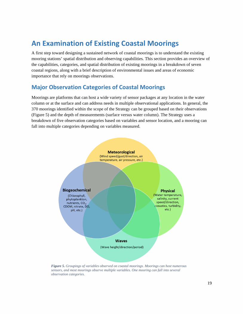
Major Observation Categories of Coastal Moorings Moorings are platforms that can host a wide variety of sensor packages at any location in the water column or at the surface and can address needs in multiple observational applications. In general, the 370 moorings identified within the scope of the Strategy can be grouped based on their observations (Figure 5) and the depth of measurements (surface versus water column). The Strategy uses a breakdown of five observation categories based on variables and sensor location, and a mooring can fall into multiple categories depending on variables measured.
Figure 5. Groupings of variables observed on coastal moorings. Moorings can host numerous sensors, and most moorings observe multiple variables. One mooring can fall into several observation categories.
20
Meteorological and Surface Physical Oceanographic (Meteorological / Sfc Physical): This observation category includes moorings that measure meteorological and/or multiple physical variables at or near the sea surface. Typical variables are winds, air temperature, air pressure, relative humidity, sea surface temperature, and sea surface salinity. These are core variables used in marine meteorology and oceanography and are critical for marine weather forecasting and navigation. All NDBC CWBs are included in this category.
Waves: Wave observations include wave direction, wave height and wave period, and the associated spectra. Moorings that measure all or some of these variables are in this category. These measurements can contribute to swell modeling, forecasting, and the analysis of coastal environment data for use by coastal engineers, planners, managers, scientists, and mariners. All CDIP wave moorings and NDBC CWBs are included in this category and align with the moorings listed in the National Operational Wave Observations Plan (the Waves Plan).
Surface Biogeochemical: Moorings with surface chemical and/or biological sensors are used by scientists to characterize and monitor ocean conditions related to issues such as water quality, ocean acidification, and ecosystem health. Surface biogeochemical observations frequently include carbon dioxide, pH, chlorophyll, nutrients, and dissolved oxygen; operation of any such sensor at or near the surface satisfies this category. New technological developments that can be included are optical plankton recorders or molecular/genetic probes for species and toxins. These measurements are important for monitoring community structure and changes, detecting HABs, and observing water quality.
Water Column Physical: This category covers moorings that measure physical oceanographic variables (water temperature, salinity, pressure, currents, sound, and light field) in the water column below the surface. These observations might be at a single depth or multiple depths within the water column.
Water Column Biogeochemical: This category describes moorings with biogeochemical variables (such as those described above) at one or more depths within the water column. Water column structure (e.g., the degree of stratification, which influences blooms, hypoxia, etc.) can be examined with these measurements to assess ecosystem characteristics. Such coverage is critical for monitoring chemical and biological conditions and processes in the coastal ocean, such as ocean acidification, hypoxia, and ecosystem health. The higher trophic levels of marine organisms in the water column can only be observed with optical (imaging) and acoustic sensors; therefore, these are highly desirable wherever possible.
Climate-Quality observations make up a crosscutting qualifier that includes any of the measurements identified in the above categories of observations contingent upon adherence to the Global Climate Observing System (GCOS) Climate Monitoring Principles (appendix II) or, for carbon variables, in the Global Ocean Acidification Observing Network Plan.23 Climate-quality standards must be met year-round for a coastal mooring to qualify as climate-quality. For example, climate-quality observations 23 “Global Ocean Acidification Observing Network Plan.” (2015). http://goa-on.org/docs/GOA-ON_2nd_edition_final.pdf
21
are typical of those found in the international OceanSITES24 system. Coastal moorings within the OceanSITES system collect and deliver high-quality climate data from long-term, high-frequency observations at fixed locations.
A Regional Look at Existing Coastal Mooring Observing Networks In 2016, the Strategy writing team evaluated the existing coastal mooring network and developed a strategy to define improved planning for a sustained network. The evaluation revealed significantly undersampled areas in each region, along with a need for a locally refined gap analysis in coordination with local stakeholders and subject-matter experts. Therefore, the need for a robust gap analysis through stakeholder engagement and coordination is a key recommendation of the Strategy to successfully determine the full reality of regional observational gaps best addressed with coastal moorings.
In the following sections, the distribution of existing coastal moorings is described for each coastal region of the United States. It should also be noted that, while many environmental issues are described in each section, HABs, along with ocean acidification and hypoxia, are serious threats in all coastal waters, though they may not be described in every section. The information in these sections should be considered while planning, along with the recommendations described in the Waves Plan, which calls for a comprehensive, high quality, surface-wave monitoring network for the United States that meets the requirements of the maritime user community. It identifies and regionally prioritizes specific critical surface-wave monitoring gaps to support maritime operations and the understanding of shoreline processes. For example, because of high vessel activity and dangerous conditions, the Pacific Northwest requires and critically lacks sustained, high-quality, surface-wave monitoring at the north side of the Columbia River mouth off Neah Bay, Washington near the entrance to the Strait of Juan de Fuca and at the near-to-mid-shelf offshore Tillamook Bay, Oregon, where loss of life has occurred.
Atlantic Coast The Atlantic coast region extends from Maine through the Florida Keys, and encompasses three IOOS regions (NERACOOS, MARACOOS, and SECOORA). Along the coast, numerous beaches are major tourist destinations that are susceptible to hazards such as rip currents, and HAB and hypoxia events. Inundation driven by tropical cyclones and northeasters are year-round threats to the large populations that live along the coast. This vast region is influenced by different drivers and needs, and can be discussed in two categories: the Northeast and the Southeast.
Northeast The Northeast region extends from Maine through Virginia and covers two IOOS regions (NERACOOS and MARACOOS). The part of the region served by NERACOOS (covering Maine through New York) encompasses diverse coastal and ocean environments from the Scotian Shelf to the Bay of Fundy and Gulf of Maine, and through the Southern New England Bight and the Long Island Sound. The area covered by MARACOOS (from Cape Cod, Massachusetts to Cape Hatteras,
24 OceanSITES: http://www.oceansites.org/
22
North Carolina) comprises the Mid-Atlantic Bight (MAB) and includes four major estuaries: Buzzards Bay, Narragansett Bay, the Delaware Bay, and the Chesapeake Bay.
The Northeast region is influenced by the cold Labrador Current bringing cold, nutrient-rich waters into the area. The Gulf of Maine contains high tidal ranges that create strong currents, keeping the water well-mixed. These dynamics increase the availability of nutrients, resulting in high biological productivity, and therefore has made the area a productive fishing ground. The MAB is a dynamic boundary between cooler arctic waters and warmer tropical waters, with complex seasonal physical dynamics. These dynamics structure shellfish and migratory fish habitats that support both commercial and recreational fisheries.25
The economy in the NERACOOS domain is tightly connected to marine-related industries. Coastal counties contribute 71 percent of the states’ gross domestic product. United States ports in the Northeast handle $24.5 billion in commercial goods.26 The regional commercial fishing industry is valued at over $950 million (22 percent of the nation’s fishing industry with lobster and scallop accounting for over $660 million);26 the recreational boating industry is valued at $3.5 billion, and the region’s maritime commerce routes handle 4,000 transects of commercial ships and 8,000 transits of cargo barges per year.27 In 2011, over 29 million tons of cargo (approximately 90 percent petroleum) were shipped between major Canadian and United States ports in the Northeast. The region’s energy security is reliant upon maritime transportation. New ocean uses are being developed with the construction of the first U.S. offshore windfarm in coastal waters of Rhode Island. All these marine related industries require ocean and weather information to operate safely and efficiently.
The MARACOOS domain encompasses approximately 76 million people, or 25 percent of the U.S. population. The mid-Atlantic, in 2010, contributed $2 trillion or 14 percent of the United States’ Gross Domestic Product. The region hosts the world’s largest naval base in Norfolk, Virginia, and the nation’s largest city and the East Coast’s largest seaport by tonnage in New York, New York.28
There is a large amount of industrial activity in the Northeast, particularly from major metropolitan cities, which are sources of contaminants in coastal waters. Industrial and sewage discharges, as well as stormwater runoff, carry pollutants to coastal waters, creating a health risk for recreational users and the fishing industry. HABs are economically detrimental to the region and can cost the shellfishing and tourist industries millions of dollars. Coastal managers require early information for monitoring conditions conducive to HABs. Measurements of physical, chemical, and biological variables are necessary to describe effects and trends, including physical and chemical precursor conditions to algal blooms or hypoxic events.
Climate variability and change affects a broad range of variables, processes, and issues in the region including: distribution, abundance, and productivity of species and habitats; sea-level rise and coastal
25 MARACOOS: http://maracoos.org/about_maracoos 26 National Ocean Economics Program (2010 data): www.oceaneconomics.org/Market/coastal/coastalEcon.asp 27 Northeast Regional Planning Body: http://neoceanplanning.org/projects/recreation/ 28 Mid-Atlantic Regional Ocean Plan: http://www.boem.gov/Ocean-Action-Plan/
23
inundation; and ocean acidification. Climate effects are caused by both large-scale forcing in the North Atlantic and local-scale forcing within the region. To track and forecast these effects, it is necessary to make observations on boundary forcing as well as key internal climate-system variables. Sustained observations are necessary to provide the requisite time-series for climate scale analyses.29
When coastal storms threaten the Northeast, stakeholders rely on ocean data and forecasts from NOAA, USACE CDIP, and IOOS RAs to help them prepare and improve safety. Hurricane Sandy (2012) in particular had an enormous impact on the northeast coast, and the CDIP wave buoy and NDBC CWB observations provided critical wave and meteorological measurements along its track.
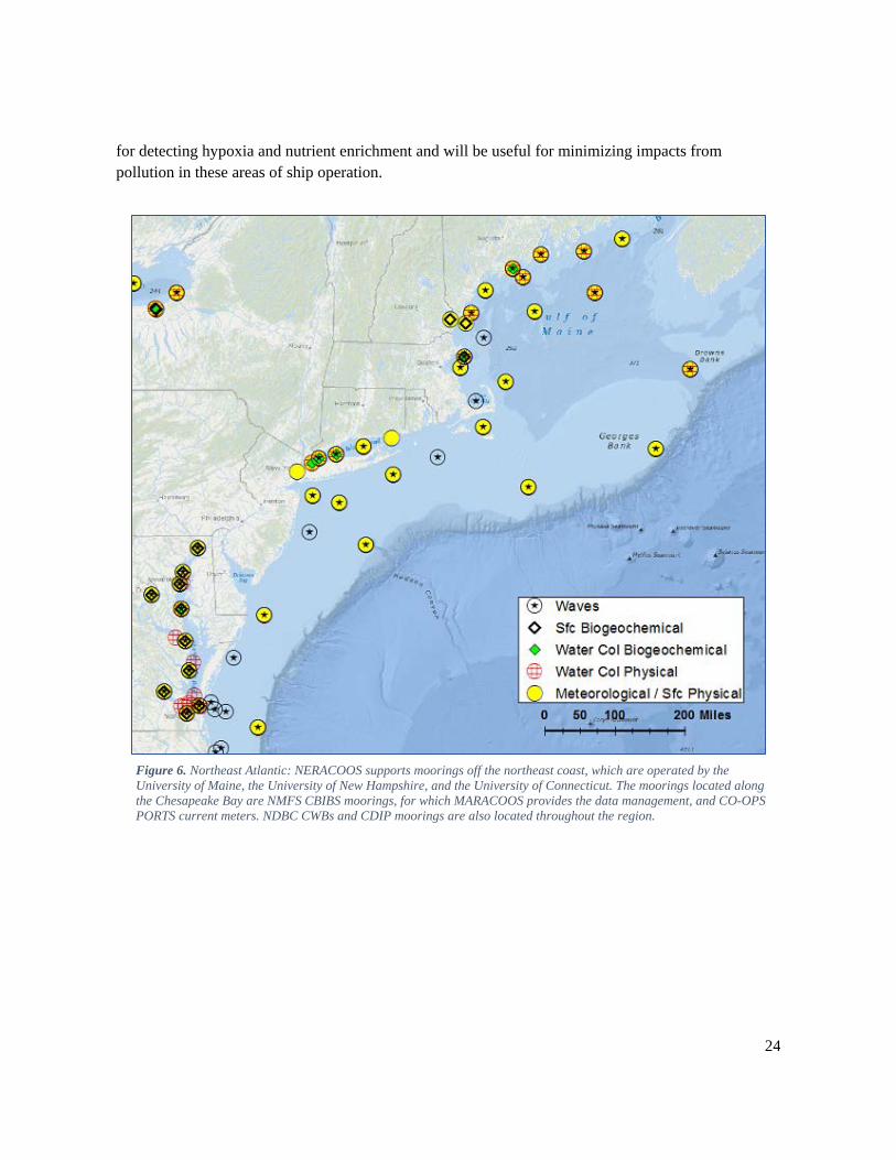
Existing Coastal Moorings
The IOOS RA moorings, NOAA CBIBS moorings, and several NDBC CWBs comprise most stations in the northeast Atlantic Coast (Figure 6). The Gulf of Maine, the Long Island Sound, and the Chesapeake Bay contain a large number of moorings that measure meteorological and surface physical oceanographic and wave variables. Meteorological observations from coastal moorings off the coast of Virginia are particularly sparse, with only one mooring station located 64 nautical miles east of Virginia Beach (NDBC Station 44014) measuring meteorological variables. Station 44014 is maintained by NDBC as part of a cross-agency project sponsored by USACE.
There are relatively few water column biogeochemical measurements in the region. The CBIBS stations throughout the Chesapeake Bay are well-equipped with meteorological, physical, and biogeochemical sensors for ecosystem monitoring and research, though only one mooring measures water column biogeochemical variables. Expansion of nearshore and estuarine moorings with biogeochemical sensors are necessary in ports and harbors to monitor water quality. This is important
29 NERACOOS Build out Plan: http://www.neracoos.org/sites/neracoos.org/files/documents/strategic_planning/Northeast Regional Build Out Plan_Exec_Summ_sept30_2011.docx
24
for detecting hypoxia and nutrient enrichment and will be useful for minimizing impacts from pollution in these areas of ship operation.
Figure 6. Northeast Atlantic: NERACOOS supports moorings off the northeast coast, which are operated by the University of Maine, the University of New Hampshire, and the University of Connecticut. The moorings located along the Chesapeake Bay are NMFS CBIBS moorings, for which MARACOOS provides the data management, and CO-OPS PORTS current meters. NDBC CWBs and CDIP moorings are also located throughout the region.
25
Southeast The Southeast spans the coastal ocean from North Carolina to the Florida Keys. It covers the Atlantic portion of the SECOORA domain and comprises the South Atlantic Bight.
The dynamics of the Southeast coastal waters are largely controlled by the Gulf Stream; however, the region is linked through large-scale circulation patterns. The western boundary current (WBC) system comprising the Loop Current, Florida Current, and Gulf Stream along the shelf margin throughout most of the southeast states (Florida through North Carolina) interacts strongly with coastal waters, intimately coupling the region to the adjacent regions (Gulf, Caribbean, and northeast Atlantic) and to the global circulation. As a result, HABs originating off the western Florida Shelf, as well as oil spills and contaminants, can be transported into the South Atlantic Bight via the Loop Current and Gulf Stream. Changes in shelf width (from less than 10 km to greater than 100 km) across the region and changes in circulation with time modulate the degree to which the deep ocean interacts with the coastal and nearshore environment, but throughout the region shelf water properties reflect the WBC influence.30
Varied estuarine systems, from broad lagoons to dendritic marsh systems with large tidal ranges, also are influenced by shelf processes and establish a strong connectivity between the land and the sea. Better understanding of the nature of the connections between the watersheds and coastal environments will support informed management and growth in the region.
The transition from the WBC in deep water to varied nearshore and estuarine environments can be complex and leads to a requirement that observations be collected from all these environments. The cross-shelf structure can be captured by measurements made within the WBC, on the outer, middle and inner continental shelf, nearshore, and within the estuaries.
The ocean and coastal waters of the southeastern United States help drive local weather and regional climate conditions, support ecologically and economically significant ecosystems (which include important fisheries), and provide tourism, boating, and other recreational opportunities. The oceans and coasts annually provide over $675 billion worth of economic impact in the southeast U.S.31
The region is subject to major storm events, frequent coastal flooding, and chronic erosion. The Gulf Stream can influence the development and intensity of tropical cyclones, and wintertime cyclogenesis occurs over the Gulf Stream, creating severe weather such as extratropical cyclones that impact both the southeast and neighboring mid-Atlantic region. These severe weather events may result in loss of life and property in addition to profound economic consequences. Real-time meteorological data are critical for planning and preparedness during these events.
30 H.E. Seim, M. Fletcher, et al., Towards a regional coastal ocean observing system: An initial design for the Southeast Coastal Ocean Observing Regional Association, Journal of Marine Systems, Volume 77, Issue 3, May 2009, Pages 261-277. http://dx.doi.org/10.1016/j.jmarsys.2007.12.016. 31 SECOORA Strategic Priorities Document: http://secoora.org/sites/default/files/webfm/members/documents/SECOORA_Strategic_Priorities.pdf
26
Another aspect of the linkage between the Gulf Coast and southeast Atlantic region is the atmospheric influence where strong frontal passages impact ocean circulation in the eastern Gulf of Mexico and along the eastern seaboard of the region. Strong surface winds such as those produced by tropical storms can induce coastal upwelling or downwelling regimes that affect the ecosystem in profound ways.
The region is vulnerable to HABs and potential impacts from oil drilling off Cuba and the Gulf of Mexico. Climate change impacts such as sea-level rise, warming temperatures, and increased storminess all create significant challenges for the region because of low-lying coastal land, sensitive habitats such as corals, and increasing development and population. The region is also a major tourist destination and a commercial and recreational fishing hub, which makes it an active region for USCG boating distress incidents.
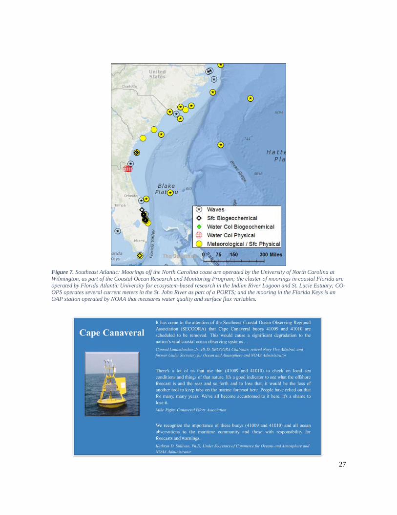
Existing Coastal Moorings Biogeochemical observations are largely absent in the Southeast (Figure 7). Few offshore moorings exist, and a significant number of them measure only surface properties. Coastal Florida is a particularly data-sparse area. There are only two moorings providing meteorological observations, which are located near Cape Canaveral and maintained by NDBC but as part of a National Aeronautics and Space Administration project. Recent project closure amplified the stakeholder need for these observations and identified the risk to sustaining them as components of the national network of coastal moorings. Without these two moorings, the east coast of Florida would essentially have no in-situ, real-time meteorological data from coastal moorings, thereby negatively impacting forecasts and maritime operations. These moorings are also critical considering the high recreational boating accident rate. In 2015, Florida had the greatest number of boating accidents (including fatal ones) of any state.32
32 Department of Homeland Security U.S. Coast Guard Office of Auxiliary and Boating Safety. “Recreational Boating Statistics COMDTPUB P16754.29.” (2015). http://www.uscgboating.org/library/accident-statistics/Recreational-Boating-Statistics-2015.pdf
27
Figure 7. Southeast Atlantic: Moorings off the North Carolina coast are operated by the University of North Carolina at Wilmington, as part of the Coastal Ocean Research and Monitoring Program; the cluster of moorings in coastal Florida are operated by Florida Atlantic University for ecosystem-based research in the Indian River Lagoon and St. Lucie Estuary; CO-OPS operates several current meters in the St. John River as part of a PORTS; and the mooring in the Florida Keys is an OAP station operated by NOAA that measures water quality and surface flux variables.
28
Gulf of Mexico The Gulf of Mexico region extends from the west coast of Florida just north of the Florida Keys through Texas. The GCOOS domain covers this entire region, and the SECOORA domain covers Florida’s coastal waters, overlapping a portion of the GCOOS domain.
The Gulf of Mexico coastal dynamics are controlled by the Loop Current, warm closed-ring Loop Current Eddies that spin off the Loop Current, the Mississippi River (the Gulf’s largest source of freshwater input and nutrients), and upwelling events that are wind-induced but also can result from interactions between the Loop Current or a Loop Current Eddy and the bathymetry. These dynamics can cause major events that threaten the health and safety of Gulf Coast communities, such as rapid intensification of tropical cyclones fueled by a warm Loop Current Eddy, as well as HABs and hypoxia resulting from prolonged periods of upwelling. HABs on the west Florida Shelf develop and can become entrained in the Loop Current, where they can be transported into the South Atlantic Bight. Eddies can also transport algal blooms to the western Gulf. Similarly, oil and contaminant spills can become entrained in the Loop Current, threatening the Florida coast and Atlantic coastal areas.
The Gulf of Mexico provides over 40 percent and approximately 30 percent, respectively, of the total U.S. crude oil refinery capacity and natural gas processing plant capacity along the Gulf Coast. Gulf shores and beaches support a $20+ billion tourist industry. Over 1.4 billion pounds of commercial seafood were landed in 2009, including 78 percent of U.S. shrimp, 62 percent of oysters, as well as finfish and crab, and 13 of the top 20 U.S. ports by 2009 tonnage are in the Gulf.33 Near real-time information on coastal ocean surface currents, waves, and winds are particularly critical for navigation safety in this region.
The region’s ecosystem has been significantly impacted in recent years from loss of critical wetland habitats, erosion of barrier islands, overfishing, water-quality degradation, and significant coastal erosion. The Deepwater Horizon oil spill in 2010 was the largest spill in United States history with millions of gallons entering the Gulf over the course of several months. In response, Congress passed the Resources and Ecosystems Sustainability, Tourist Opportunities, and Revived Economies of the Gulf Coast States Act (RESTORE Act), which included authorization and funding for a Gulf Coast Ecosystem Restoration Science, Observation, Monitoring, and Technology Program to be administered by NOAA in consultation with the U.S. Fish and Wildlife Service. This act focuses efforts toward achieving long-term sustainability of the Gulf Coast ecosystem. The NOAA RESTORE Act Science Plan34 recommends continued development of molecular and image-based sensor technologies such as flow cytometers to increase the breadth of microbial and microalgal sampling and to provide resource managers with a higher-resolution picture of these important ecosystem components. These new technologies have been deployed on buoys and used for real-time detection of HABs and their toxins.
33 GCOOS Build Out Plan 2.0: http://gcoos.tamu.edu/BuildOut/BuildOutPlan-V2.pdf 34 NOAA. "NOAA RESTORE Act Science Program: Science Plan." (2015). https://restoreactscienceprogram.noaa.gov/wp-content/uploads/2015/05/Science-Plan-FINAL-for-website.pdf
29
Mooring data are critical for safe and efficient marine operations, improved meteorological analyses and forecasts, assimilation into and verification of numerical models, safer recreational opportunities, and long-term observations for planning and design considerations, among other needs. Approximately 59 percent of the Gulf shoreline is considered susceptible to changes in sea level. As sea level rises and land subsides, the physical changes will adversely affect communities, infrastructure, and natural resources.35
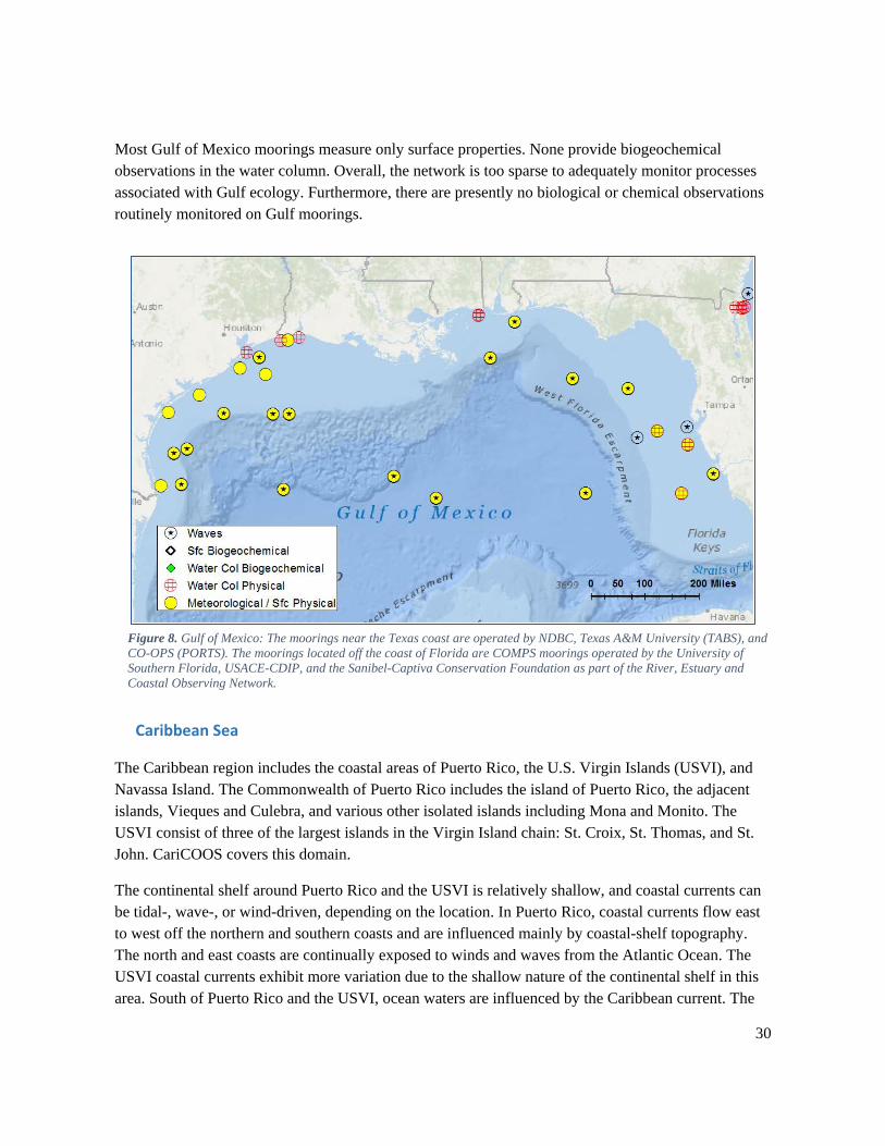
Existing Coastal Moorings
Moorings in the Gulf are shown in Figure 8. The Florida Coastal Ocean Monitoring and Prediction System (COMPS)36 operated by the University of South Florida presently maintains three real-time moorings off the west coast of Florida, each with surface meteorological and water column sensors. The Texas Automated Buoy System (TABS)37 operated by Texas A&M University maintains 10 real-time moorings off the Texas coast, four of which measure only surface physical oceanographic variables (currents and water temperature) to support oil spill prevention and response. CO-OPS also maintains current meters on navigation buoys near major ports in Texas, Louisiana, and Mississippi, and NDBC moorings are located throughout the Gulf. Not shown are several oil platforms throughout the Gulf that provide additional oceanographic observations. Although these are outside the scope of the Strategy, their monitoring capabilities must be considered during planning.
35 GCOOS. “A Sustained, Integrated Ocean Observing System for the Gulf of Mexico (GCOOS): Infrastructure for Decision-making." (2014). http://gcoos.tamu.edu/BuildOut/BuildOutPlan-V2.pdf 36 COMPS, Coastal Ocean Monitoring and Prediction System: http://comps.marine.usf.edu/ 37 TABS, Texas Automated Buoy System: http://tabs.gerg.tamu.edu
30
Most Gulf of Mexico moorings measure only surface properties. None provide biogeochemical observations in the water column. Overall, the network is too sparse to adequately monitor processes associated with Gulf ecology. Furthermore, there are presently no biological or chemical observations routinely monitored on Gulf moorings.
Figure 8. Gulf of Mexico: The moorings near the Texas coast are operated by NDBC, Texas A&M University (TABS), and CO-OPS (PORTS). The moorings located off the coast of Florida are COMPS moorings operated by the University of Southern Florida, USACE-CDIP, and the Sanibel-Captiva Conservation Foundation as part of the River, Estuary and Coastal Observing Network.
Caribbean Sea
The Caribbean region includes the coastal areas of Puerto Rico, the U.S. Virgin Islands (USVI), and Navassa Island. The Commonwealth of Puerto Rico includes the island of Puerto Rico, the adjacent islands, Vieques and Culebra, and various other isolated islands including Mona and Monito. The USVI consist of three of the largest islands in the Virgin Island chain: St. Croix, St. Thomas, and St. John. CariCOOS covers this domain.
The continental shelf around Puerto Rico and the USVI is relatively shallow, and coastal currents can be tidal-, wave-, or wind-driven, depending on the location. In Puerto Rico, coastal currents flow east to west off the northern and southern coasts and are influenced mainly by coastal-shelf topography. The north and east coasts are continually exposed to winds and waves from the Atlantic Ocean. The USVI coastal currents exhibit more variation due to the shallow nature of the continental shelf in this area. South of Puerto Rico and the USVI, ocean waters are influenced by the Caribbean current. The
31
Caribbean current also flows west and is located about 100 km south of the islands but can move south in the winter time. Circulation within the Caribbean Sea exhibits temporal and spatial variation in the form of eddies and meanders, and it is mainly dependent on bottom topography, wind forcing, current width and shear, and collision of different currents. Ocean waters north of Puerto Rico and the USVI are influenced by the westward North Equatorial current, which is the predominant hydrodynamic driving force in the Caribbean region.38
In a study across the Caribbean, Mexico, and Central and South America, the USVI had the fourth highest level of direct cruise sector expenditures with $344 million in spending. The $344 million in cruise tourism expenditures generated an estimated 6,397 jobs paying $141 million in wage income, the second highest total in the Caribbean during the 2014-2015 cruise year. Puerto Rico benefited from $198 million in total cruise tourism expenditures, which, in turn, generated 5,209 jobs and $75 million in wages during the 2014-2015 cruise year. Puerto Rico led the Caribbean in passenger embarkations during the 2014-2015 cruise year with over 454,000 embarkations.39
The overall condition of the Puerto Rico coastal waters is poor. Noncoastal waters near Puerto Rico and the USVI are relatively stratified and, because no upwelling occurs in this area, are severely nutrient-limited, with nitrogen being the principal limiting nutrient. In 2010, Puerto Rico assessed water quality for 94 percent of its coastal shoreline. Thirty-eight percent of assessed shorelines were impaired mainly due to organic enrichment, oxygen depletion, pathogens, and turbidity. Major sources for coastal contaminants and pollutants include urban runoff, sewage and municipal discharges, and modifications of rivers that drain to the coast. In 2010, the USVI water quality assessment revealed that nine percent of the shoreline was impaired mainly from turbidity, organic enrichment, oxygen depletion, pathogens, and nutrients. Major sources of contaminants included nonpoint source pollution, recreational uses, municipal and sewage discharges, and runoff.40
Coastal weather and sea state, potential hurricane or tsunami impact to coastal communities, coral reef health (effects from sedimentation, bleaching, and ocean acidification), and overfishing are the major areas of concern for the Caribbean region. Storm-surge inundation, strong winds, and severe waves from tropical and extratropical cyclones, as well as recurring harmful bacteria in coastal waters and the potential for tsunami impact, pose unique challenges. A large portion of the Caribbean is susceptible to tropical cyclone impact, which can substantially affect portions of shallow reefs and other coastal habitats. Past storms have significantly reduced coral populations, uprooted mangroves and seagrass habitats, and deposited sediments and other materials.
Beach safety, port operations, ocean acidification, and ocean conditions are high priority issues to numerous stakeholders. Shipping and ferry industries are essential to providing the population with food, fuel, and means of transportation. Recreational operations and activities, ranging from luxury
38 NOAA. “U.S. Integrated Ocean Observing System (IOOS) Program Programmatic Environmental Assessment.” (2016). 39 Business Research & Economic Advisors. “Economic Contribution of Cruise Tourism to the Destination Economies.” (2015). http://www.f-cca.com/downloads/2015-cruise-analysis-volume-1.pdf 40 EPA. “Puerto Rico Water Quality Assessment Report.” (2014). http://iaspub.epa.gov/waters10/attains_state.control?p_state=PR
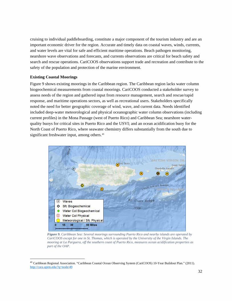
32
cruising to individual paddleboarding, constitute a major component of the tourism industry and are an important economic driver for the region. Accurate and timely data on coastal waves, winds, currents, and water levels are vital for safe and efficient maritime operations. Beach pathogen monitoring, nearshore wave observations and forecasts, and currents observations are critical for beach safety and search and rescue operations. CariCOOS observations support trade and recreation and contribute to the safety of the population and protection of the marine environment.
Existing Coastal Moorings Figure 9 shows existing moorings in the Caribbean region. The Caribbean region lacks water column biogeochemical measurements from coastal moorings. CariCOOS conducted a stakeholder survey to assess needs of the region and gathered input from resource management, search and rescue/rapid response, and maritime operations sectors, as well as recreational users. Stakeholders specifically noted the need for better geographic coverage of wind, wave, and current data. Needs identified included deep-water meteorological and physical oceanographic water column observations (including current profiles) in the Mona Passage (west of Puerto Rico) and Caribbean Sea; nearshore water-quality buoys for critical sites in Puerto Rico and the USVI; and an ocean acidification buoy for the North Coast of Puerto Rico, where seawater chemistry differs substantially from the south due to significant freshwater input, among others.41
Figure 9. Caribbean Sea: Several moorings surrounding Puerto Rico and nearby islands are operated by CariCOOS except for one in St. Thomas, which is operated by the University of the Virgin Islands. The mooring at La Parguera, off the southern coast of Puerto Rico, measures ocean acidification properties as part of the OAP.
41 Caribbean Regional Association. “Caribbean Coastal Ocean Observing System (CariCOOS) 10-Year Buildout Plan.” (2011). http://cara.uprm.edu/?q=node/49
33
Pacific Coast The Pacific Coast region extends from Washington through California and encompasses three IOOS regions (NANOOS, CeNCOOS, and SCCOOS). Because this vast region contains different drivers, users, and needs, it can be discussed in two categories: the Pacific Northwest and California. While the entire United States Pacific Coast is part of the California Current System and shares characteristics such as upwelling and a large marine ecosystem, the Pacific Northwest receives a large freshwater signal from rivers and more influence from subarctic features, whereas California is more strongly influenced by extra-tropical processes. With northward progression along the coast, the shelf is broader and upwelling winds are more seasonal. Moreover, users and needs differ, such as more public swimming beach use in California and more salmon fishing in the Pacific Northwest.
Pacific Northwest The Pacific Northwest includes the coastal ocean regions of Washington and Oregon. NANOOS covers this domain, with overlap with CeNCOOS in northern California, and connections with programs in British Columbia, Canada.
The dynamics of the coastal ocean off the Pacific Northwest (PNW) are controlled by the seasonal shift of upwelling and downwelling favorable winds, the interaction of the coastal waters with significant freshwater input (e.g., Columbia River and Strait of Juan de Fuca), the branching of the North Pacific Current to form the northern extent of the California Current System, and by large-scale variability due to El Niño Southern Oscillation and other climate forcing. These forcings result in highly variable and temperate coastal ocean conditions, with the capacity for large disruptions such as storms and coastal erosion.
Two inland waterways are critical to the region: the Columbia River and the Strait of Juan de Fuca. The Columbia River contributes approximately 75 percent of the freshwater input to Pacific from the U.S. West Coast, has thriving maritime operations, and yet is highly perilous for navigation.
The Strait of Juan de Fuca is the wide waterway connecting with the inland Salish Sea, including Puget Sound, a major metropolis and shipping hub. It is exposed to the generally westerly winds and waves of the Pacific Ocean. Sea and weather conditions in Juan de Fuca Strait are, on average, rougher than in the more protected waters inland, thereby resulting in a number of small-craft advisories.
The PNW is a vital hub of maritime transportation with major port facilities located in Puget Sound (e.g., Seattle and Tacoma) and the Columbia River (e.g., Portland and Vancouver), as well as other secondary ports along the Washington and Oregon coasts (e.g., Grays Harbor, Astoria, Tillamook Bay, Coos Bay, and Newport). Commercial and recreational fisheries off the PNW coast generate considerable revenue and jobs for the region. With two refinery complexes and a web of distribution routes to coastal and estuarine waters, transportation of oil is another major industry in the PNW region. Access to reliable and consistent sources of ocean and climate conditions and forecasts remains paramount to safeguard lives and environmental quality.
34
While variation is large, change is also evident. Climate- and human-related agents of change can jeopardize the economy and ecology of the region. Since 1985, regional spills from vessels and land facilities have included five spills of over 50,000 gallons.42 PNW ocean wave heights have been progressively increasing throughout the North Pacific since the mid-1970s.43 Ocean acidification is presently increasing at an alarming rate, compounded by upwelling and high respiration rates, which could impact fishery and shellfish populations sooner than anticipated.44, 45 Sea level is presently rising along much of the coasts of Oregon and Washington and in many places exceeds regional tectonic uplift in those locations, increasing the incidence of coastal erosion, ocean flooding, and inundation to low-lying communities.46, 47 Since 2000, fish and crab kills due to hypoxia in Puget Sound and the Oregon coast shelf have become more common and frequent occurrences; low oxygen levels have caused massive die-offs of organisms along the central Oregon coast.48 Water-quality degradation of PNW coastal waters and estuaries is an increasing concern for environmental management agencies, municipal governments, aquaculturists, and coastal residents. Large HAB events in coastal-shelf areas near the Juan de Fuca eddy and Heceta Bank, as well as the numerous coastal estuaries including Puget Sound, Willapa Bay, and South Slough, threaten rich shellfish growing areas for tribal and
42 Oil Spills in Washington State: A Historical Analysis, Ecology, Rev. 2007. https://fortress.wa.gov/ecy/publications/documents/97252.pdf 43 Allan, J. C., and Komar, P. D., 2006, Climate controls on U.S. West Coast erosion processes: Journal of Coastal Research, v. 22, no. 3, p. 511-529. Ruggiero, P., Komar, P. D., and Allan, J. C., 2010, Increasing wave heights and extreme value projections: The wave climate of the U.S. Pacific Northwest: Coastal Engineering, v. 57, no. 5, p. 539-552. http://dx.doi.org/10.2112/03-0108.1 44 Feely R.A., T. Klinger, J. Newton, and M. Chadsey. 2012. Scientific Summary of Ocean Acidification in Washington State Marine Waters. NOAA OAR Special Report. 157 pp. http://pmel.noaa.gov/co2/files/wa_shellfish_initiative_blue_ribbon_panel_oa_11-27-2012.pdf 45 Harris, K. E., M. D. DeGrandpre, and B. Hales. 2013. Aragonite saturation state dynamics in a coastal upwelling zone. Geophysical Research Letters, 40: 1-6. http://dx.doi.org/10.1002/grl.50526 46 Komar, P. D., Allan, J. C., and Ruggiero, P., 2011, Sea Level Variations along the U.S. Pacific Northwest Coast: Tectonic and Climate Controls Journal of Coastal Research, v. 27, no. 5, p. 808-823. http://dx.doi.org/10.2112/JCOASTRES-D-10-00116.1 47 National Research Council, 2012, Sea-Level Rise for the Coasts of California, Oregon, and Washington: Past, Present, and Future: Committee on Sea Level Rise in California, Oregon, and Washington; Board on Earth Sciences and Resources; Ocean Studies Board; Division on Earth and Life Studies. 275 pp. 48 Grantham, B. A., F. Chan, K. J. Nielsen, D. S. Fox, J. A. Barth, A. Huyer, J. Lubchenco, and B. A. Menge., 2004. Upwelling-driven nearshore hypoxia signals ecosystem and oceanographic changes in the northeast Pacific. Nature 429:749-754. https://dx.doi.org/10.1038/nature02605
35
commercial use.49, 50 The sport and commercial razor clam fisheries in the PNW has been plagued by recurring HABs such as Pseudo-nitzschia, which can cause domoic acid shellfish toxicity. These blooms have had a devastating economic effect on coastal communities already suffering from changes in forest practices and harvests.
In response, NANOOS has been coordinating efforts with various offshore programs/assets to enhance the geographic coverage and range of measured variables on the PNW shelf through the prioritized operation of coastal and estuarine moorings. Nonetheless, several gaps and deficiencies exist.
Existing Coastal Moorings Coastal moorings in the PNW are shown in Figure 10. In the region, several CDIP and NDBC moorings are critical to maintaining navigational safety near the Columbia River, Strait of Juan de Fuca, and along this very busy coast. However, wave moorings are notably lacking, especially in the Strait of Juan de Fuca.
Two moorings in the Juan de Fuca Strait (NDBC Stations 46087 and 46088) maintained by NDBC as part of a cross-agency project sponsored by the USCG function as a source of meteorological data and as traffic-separation, lighted navigational buoys in the Strait. The sustainment and expansion of these assets to other variables, e.g., salinity and subsurface temperature, would considerably enhance their utility to hydrodynamic models with wide-ranging application.
Advanced information on hypoxia, ocean acidification, and HABs, which are major regional concerns affecting ecosystem and human health, fisheries, and coastal economies, and long-term information on climate change, are priorities in the PNW. Investment and leveraged operation have been substantial. Three universities, University of Washington, Oregon State University, and Oregon Health and Science University, operate coastal ecosystem moorings leveraging NANOOS funding in the offshore coastal waters of the PNW and within Puget Sound and the Columbia River estuary. However, operations and maintenance costs have outpaced level-funding sources, and continued operation of the assets is jeopardized. Expansion so that more moorings measure surface and subsurface ocean acidification and utilize new developments in HAB detection is needed. Moorings/sensors are lacking in some of the minor but critical estuaries, such as Yaquina Bay and Willapa Bay.
49 Trainer, V.L., Bates, S.S., Lundholm, N., Thessen, A.E., Adams, N.G., Cochlan, W.P., Trick, C.G. 2012. Pseudo-nitzschia physiological ecology, phylogeny, toxicity, monitoring and impacts on ecosystem health. Harmful Algae. 14, 271-300. http://dx.doi.org/10.1016/j.hal.2011.10.025 50 Hickey, B.M., Trainer, V.L., Kosro, M.P., Adams, N.G., Connolly, T.P., Kachel, N.B., Geier, S.L. 2013. A springtime source of toxic Pseudo-nitzschia on razor clam beaches in the Pacific Northwest. Harmful Algae. http://dx.doi.org/10.1016/j.hal.2013.01.006.
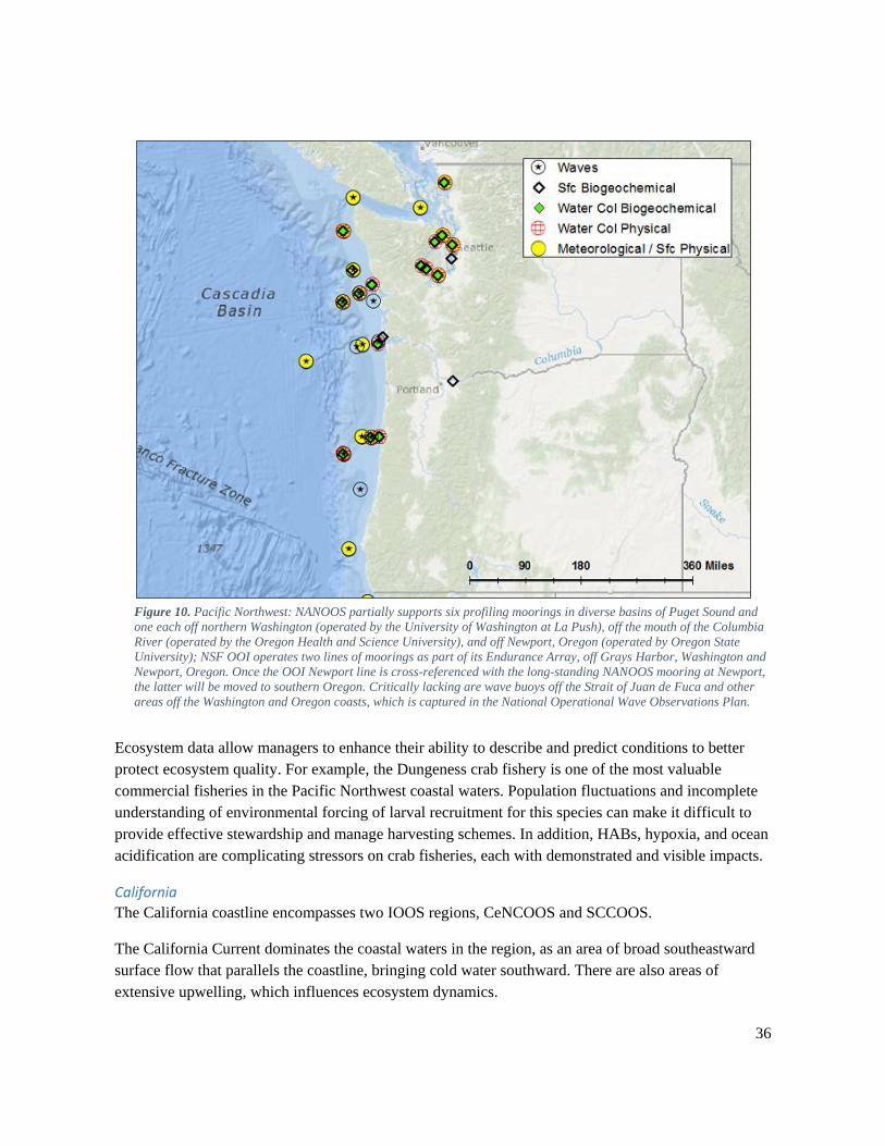
36
Figure 10. Pacific Northwest: NANOOS partially supports six profiling moorings in diverse basins of Puget Sound and one each off northern Washington (operated by the University of Washington at La Push), off the mouth of the Columbia River (operated by the Oregon Health and Science University), and off Newport, Oregon (operated by Oregon State University); NSF OOI operates two lines of moorings as part of its Endurance Array, off Grays Harbor, Washington and Newport, Oregon. Once the OOI Newport line is cross-referenced with the long-standing NANOOS mooring at Newport, the latter will be moved to southern Oregon. Critically lacking are wave buoys off the Strait of Juan de Fuca and other areas off the Washington and Oregon coasts, which is captured in the National Operational Wave Observations Plan.
Ecosystem data allow managers to enhance their ability to describe and predict conditions to better protect ecosystem quality. For example, the Dungeness crab fishery is one of the most valuable commercial fisheries in the Pacific Northwest coastal waters. Population fluctuations and incomplete understanding of environmental forcing of larval recruitment for this species can make it difficult to provide effective stewardship and manage harvesting schemes. In addition, HABs, hypoxia, and ocean acidification are complicating stressors on crab fisheries, each with demonstrated and visible impacts.
California The California coastline encompasses two IOOS regions, CeNCOOS and SCCOOS.
The California Current dominates the coastal waters in the region, as an area of broad southeastward surface flow that parallels the coastline, bringing cold water southward. There are also areas of extensive upwelling, which influences ecosystem dynamics.
37
California is the sixth-largest economy in the world, with a significant amount of that economy generated by the coastal counties. Two sectors of California’s ocean economy—tourism and recreation and marine transportation—are significant both at the state level and on a national scale. In 2012, ocean-dependent tourism and recreation generated more than $1 billion of Gross Domestic Product in five California counties. In 2012, approximately $331 billion of foreign goods were imported to the United States through California’s ports, providing goods such as intermediate components crucial for U.S. manufacturers in inland states and the finished products upon which U.S. retailers depend. Moreover, in 2012, $99 billion of goods were exported through California ports to the rest of the world, illustrating the key role California’s marine transportation sector plays in allowing U.S. companies to reach foreign markets.51 The Ports of Long Beach and Los Angeles combined are the largest ports in the United States and eighth largest in the world. Port Hueneme in Southern California is the first secure port south of Westport, Washington. San Francisco handles a wide variety of cargo in an efficient and cost-effective manner.
There are multiple major areas of concern for this large region, including: sustainable commercial and recreational fisheries, safe and efficient commercial shipping, search and rescue, spill response, offshore energy, aquaculture, tourism, severe weather, ocean acidification and hypoxia, algal blooms, sea level change, impact of climate variability such as El Niño and the Pacific Decadal Oscillation (PDO), and recreational boating. There are also numerous beaches along the California coast that are susceptible to hazards such as rip currents, coastal erosion, and HAB and hypoxia events. Inundation is a year-round threat to the large populations that live along and near the California coast, albeit not to the degree that the southeast Atlantic and Gulf of Mexico coasts are affected. Climatic warming and ocean acidification are altering fish and shellfish habitats. Shellfish and migratory fish habitats support both commercial and recreational fisheries and directly impact state economies.
51 NOAA. “The National Significance of California’s Ocean Economy.” (2015) https://coast.noaa.gov/data/digitalcoast/pdf/california-ocean-economy.pdf
38
An important legacy and critical part of the coastal observing system off California is the California Cooperative Oceanic Fisheries Investigations (CalCOFI)52 program of quarterly vessel surveys on a regular grid pattern. This system takes water samples, conducts net tows, and provides reference information for autonomous continuous observations, which can only sample a few variables. In the open ocean, three sustained underwater glider lines operated by Scripps Institution of Oceanography represent one part of the autonomous observations complementing CalCOFI. Multidisciplinary moorings represent the other complement, and together these three programs are starting to provide more complete sampling of the coastal ocean. Wave moorings operated by CDIP and CWBs operated by NDBC are also distributed closer to the coast. Additionally, nearshore surface current observations are provided by a dense high frequency radar network.
Because of the ecosystem sensitivity to El Niño and the PDO, to physical circulation changes, and to event-scale processes (e.g., upwelling events), and since NOAA and the academic partners expend significant effort in ecosystem surveys and management, the most critical observations are those related to ecosystem and habitat changes. For this, the physical and biogeochemical state of the coastal ocean needs to be monitored and understood, and the ecosystem responses and possible regime changes have to be recognized and quantified. A focus, therefore, needs to be on ocean acidification and biological observations using autonomous systems, particularly coastal moorings.
52 CalCOFI: http://calcofi.org/
39
Existing Coastal Moorings
Coastal moorings in California are shown in Figure 11. Based on upwelling and ecosystem regimes, fish migrations, and coastal responses to climate variability, continuous water column observations with moorings are needed at four locations along the California coast: at the southern end of the Southern California Bight (distinct regime and needed for fish migrations from Mexican waters), at the upwelling center off Pt. Conception, off central California (vicinity of Monterey), and off northern California. For distinguishing the very different nearshore and offshore habitats for different fish species, two moorings for ecosystem monitoring are needed for each location. These moorings could also become the backbone for acoustic fish “tollgates” using the same broadband acoustic backscatter systems as are used on fish stock survey vessels. At present, there are five moorings with surface and water column sensors used for ecosystem monitoring. A mooring pair near the Mexican border (off San Diego) is being deployed as part of a one-year acoustic tollgate pilot study but would need new and sustained funding after that. The northern California area is a major observing gap that needs to be addressed.
Figure 11. California: Moorings off the coast of California. NDBC operates numerous CWBs along the coast, and CDIP wave moorings are prevalent off the southern coast of California, operated with funding from the U.S. Navy, SCCOOS, and USACE. MBARI operates 4 moorings around the Monterey Bay; CO-OPS PORTS current meters are in San Francisco Bay on navigation aid buoys; and University of California San Diego Scripps Institution of Oceanography operates two moorings with water column biogeochemical observations near Pt. Conception and one near San Diego for ecosystem monitoring.
40
Pacific Islands The Pacific Islands region includes the U.S. Pacific Islands (Hawaii, Guam, American Samoa, Commonwealth of the Northern Mariana Islands), the Pacific nations in Free Association with the U.S. (Republic of the Marshall Islands, Federated States of Micronesia, Republic of Palau), and the U.S. Pacific Remote Island Areas (Howland, Baker, Johnston, Jarvis, Kingman, Palmyra, Midway, and Wake). The PacIOOS region covers this entire domain.
The open and coastal waters of the region are a leading source of food and cultural significance, place of recreation, fuel for tourism-based economies, network for transportation, and are a dominant driver of regional weather patterns and global climate. The Pacific Islands are also home to some of the richest, most diverse, and commercially important ecosystems in the world.53
Populations of the Pacific Islands reside within the coastal zone and are deeply affected by coastal hazards such as sea-level rise, shoreline erosion, lowland flooding, and coastal inundation. Many low-lying islands are increasingly vulnerable to changes in sea level and periodic large storm and wave events, as well as earthquake and tsunami events. These hazards endanger safety and property, infrastructure, and agriculture. The ability to monitor and forecast coastal hazardous events and ocean conditions is critical to many stakeholders, including commercial operators, resource managers, government officials, planners, search and rescue operators, spill responders, and recreational ocean users.53
53 PacIOOS Strategic Operational Plan 2013–2018.” (2012). http://www.pacioos.hawaii.edu/wp-content/uploads/2016/02/PacIOOS_Strat_Op_Plan_print.pdf
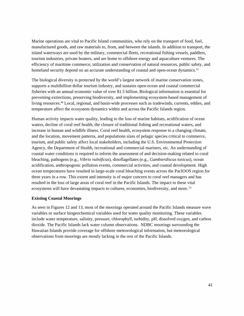
41
Marine operations are vital to Pacific Island communities, who rely on the transport of food, fuel, manufactured goods, and raw materials to, from, and between the islands. In addition to transport, the island waterways are used by the military, commercial fleets, recreational fishing vessels, paddlers, tourism industries, private boaters, and are home to offshore energy and aquaculture ventures. The efficiency of maritime commerce, utilization and conservation of natural resources, public safety, and homeland security depend on an accurate understanding of coastal and open-ocean dynamics.53
The biological diversity is protected by the world’s largest network of marine conservation zones, supports a multibillion dollar tourism industry, and sustains open-ocean and coastal commercial fisheries with an annual economic value of over $1.5 billion. Biological information is essential for preventing extinctions, preserving biodiversity, and implementing ecosystem-based management of living resources.49 Local, regional, and basin-wide processes such as tradewinds, currents, eddies, and temperature affect the ecosystem dynamics within and across the Pacific Islands region.
Human activity impacts water quality, leading to the loss of marine habitats, acidification of ocean waters, decline of coral reef health, the closure of traditional fishing and recreational waters, and increase in human and wildlife illness. Coral reef health, ecosystem response to a changing climate, and the location, movement patterns, and populations sizes of pelagic species critical to commerce, tourism, and public safety affect local stakeholders, including the U.S. Environmental Protection Agency, the Department of Health, recreational and commercial mariners, etc. An understanding of coastal water conditions is required to inform the assessment of and decision-making related to coral bleaching, pathogens (e.g., Vibrio vulnificus), dinoflagellates (e.g., Gambierdiscus toxicus), ocean acidification, anthropogenic pollution events, commercial activities, and coastal development. High ocean temperatures have resulted in large-scale coral bleaching events across the PacIOOS region for three years in a row. This extent and intensity is of major concern to coral reef managers and has resulted in the loss of large areas of coral reef in the Pacific Islands. The impact to these vital ecosystems will have devastating impacts to cultures, economies, biodiversity, and more. 53
Existing Coastal Moorings
As seen in Figures 12 and 13, most of the moorings operated around the Pacific Islands measure wave variables or surface biogeochemical variables used for water quality monitoring. These variables include water temperature, salinity, pressure, chlorophyll, turbidity, pH, dissolved oxygen, and carbon dioxide. The Pacific Islands lack water column observations. NDBC moorings surrounding the Hawaiian Islands provide coverage for offshore meteorological information, but meteorological observations from moorings are mostly lacking in the rest of the Pacific Islands.
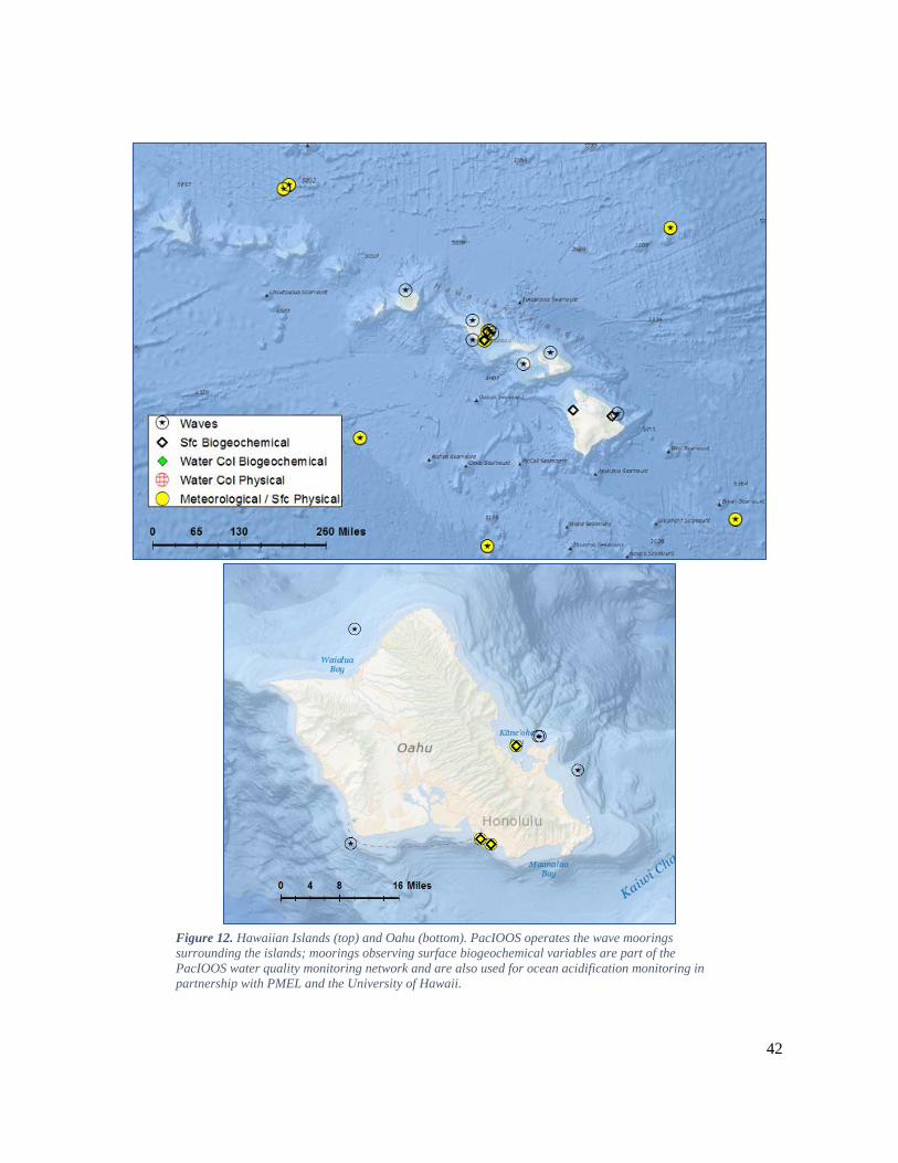
42
Figure 12. Hawaiian Islands (top) and Oahu (bottom). PacIOOS operates the wave moorings surrounding the islands; moorings observing surface biogeochemical variables are part of the PacIOOS water quality monitoring network and are also used for ocean acidification monitoring in partnership with PMEL and the University of Hawaii.
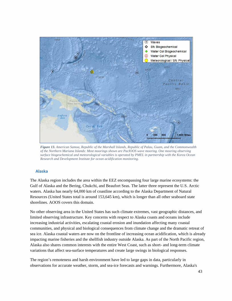
43
Figure 13. American Samoa, Republic of the Marshall Islands, Republic of Palau, Guam, and the Commonwealth of the Northern Mariana Islands: Most moorings shown are PacIOOS wave mooring. One mooring observing surface biogeochemical and meteorological variables is operated by PMEL in partnership with the Korea Ocean Research and Development Institute for ocean acidification monitoring.
Alaska
The Alaska region includes the area within the EEZ encompassing four large marine ecosystems: the Gulf of Alaska and the Bering, Chukchi, and Beaufort Seas. The latter three represent the U.S. Arctic waters. Alaska has nearly 64,000 km of coastline according to the Alaska Department of Natural Resources (United States total is around 153,645 km), which is longer than all other seaboard state shorelines. AOOS covers this domain.
No other observing area in the United States has such climate extremes, vast geographic distances, and limited observing infrastructure. Key concerns with respect to Alaska coasts and oceans include increasing industrial activities, escalating coastal erosion and inundation affecting many coastal communities, and physical and biological consequences from climate change and the dramatic retreat of sea ice. Alaska coastal waters are now on the frontline of increasing ocean acidification, which is already impacting marine fisheries and the shellfish industry outside Alaska. As part of the North Pacific region, Alaska also shares common interests with the entire West Coast, such as short- and long-term climate variations that affect sea-surface temperatures and create large swings in biological responses.
The region’s remoteness and harsh environment have led to large gaps in data, particularly in observations for accurate weather, storm, and sea-ice forecasts and warnings. Furthermore, Alaska's
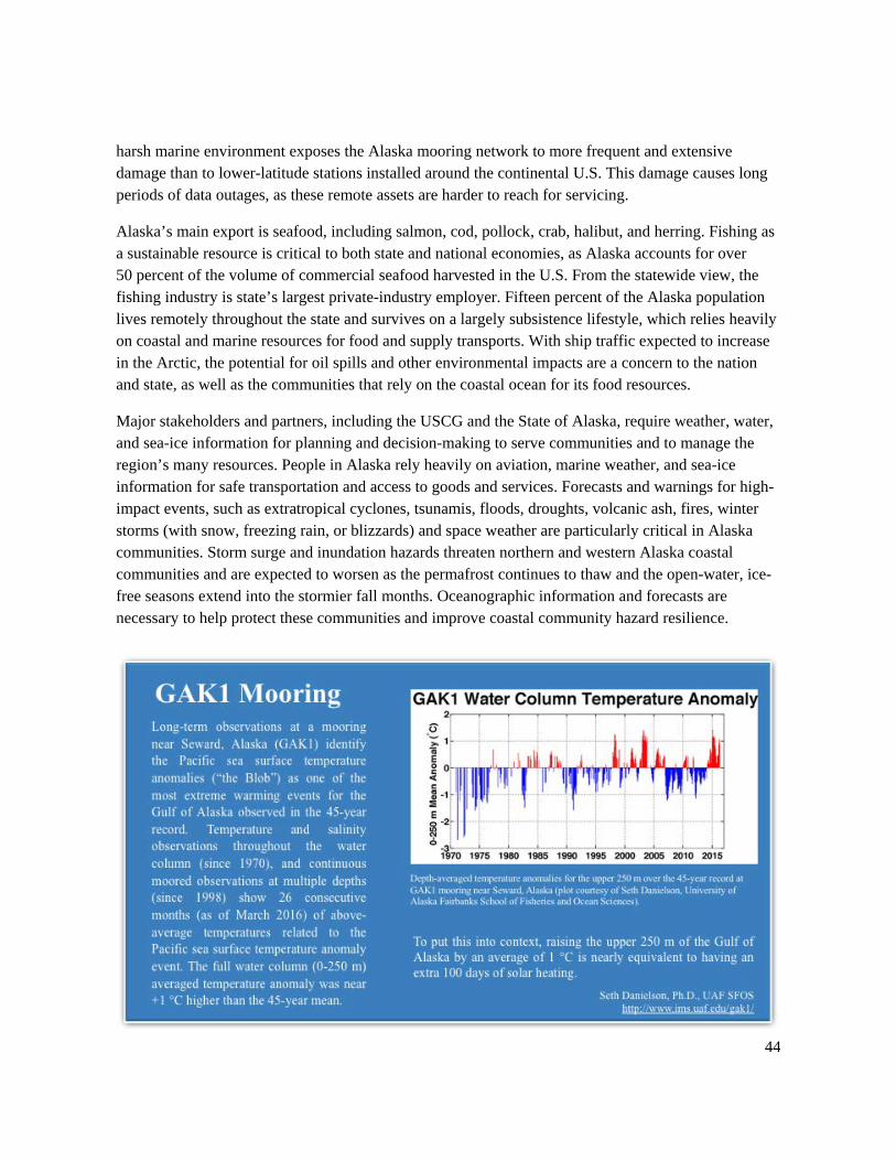
44
harsh marine environment exposes the Alaska mooring network to more frequent and extensive damage than to lower-latitude stations installed around the continental U.S. This damage causes long periods of data outages, as these remote assets are harder to reach for servicing.
Alaska’s main export is seafood, including salmon, cod, pollock, crab, halibut, and herring. Fishing as a sustainable resource is critical to both state and national economies, as Alaska accounts for over 50 percent of the volume of commercial seafood harvested in the U.S. From the statewide view, the fishing industry is state’s largest private-industry employer. Fifteen percent of the Alaska population lives remotely throughout the state and survives on a largely subsistence lifestyle, which relies heavily on coastal and marine resources for food and supply transports. With ship traffic expected to increase in the Arctic, the potential for oil spills and other environmental impacts are a concern to the nation and state, as well as the communities that rely on the coastal ocean for its food resources.
Major stakeholders and partners, including the USCG and the State of Alaska, require weather, water, and sea-ice information for planning and decision-making to serve communities and to manage the region’s many resources. People in Alaska rely heavily on aviation, marine weather, and sea-ice information for safe transportation and access to goods and services. Forecasts and warnings for high-impact events, such as extratropical cyclones, tsunamis, floods, droughts, volcanic ash, fires, winter storms (with snow, freezing rain, or blizzards) and space weather are particularly critical in Alaska communities. Storm surge and inundation hazards threaten northern and western Alaska coastal communities and are expected to worsen as the permafrost continues to thaw and the open-water, ice-free seasons extend into the stormier fall months. Oceanographic information and forecasts are necessary to help protect these communities and improve coastal community hazard resilience.
45
Existing Coastal Moorings
Existing moorings are shown in Figure 14. The four ecoFOCI moorings are year-round, but only one reports data in real time. The Chukchi Sea mooring lies in an area known as a biological hotspot for primary productivity to higher trophic levels, including fish and marine mammals. It samples year-round, is serviced once per year, and supports the Distributed Biological Observatory (DBO),54 a change detection array of designated transects and stations in the Arctic sampled annually by multiple national and international partners. As with all moorings left to overwinter in the Arctic, the Chukchi Sea mooring is not reporting data in real time, as it has no surface buoy to support telemetry and maintains a clearance from the surface to avoid ice keels. The four moorings in the Bering Strait measure properties of the Pacific inflow passing through to the Chukchi Sea and Arctic ecosystems.55 This inflow is the primary source of nutrients for Arctic ecosystems and dominates the water properties of the Chukchi Sea, one of the most biologically productive regions of the world’s oceans. It also provides about 40 percent of the freshwater input to the Arctic region and determines the ventilation depth in the Arctic.56 These moorings also support the DBO. Moorings maintained by NDBC are most numerous in the south-central region of Alaska, in part driven by the presence of shipping, fishing, oil and gas activities (e.g., Valdez and Prince William Sound), and the absence of seasonal ice.
During stakeholder workshops sponsored by AOOS, users have identified a need for more intensive observations and forecasts of higher spatial resolution in certain areas, such as relatively populated embayments and coastlines, places of concern due to industrial activities, or the need for more ecological understanding.
Observations needed across the region include ocean currents and subsurface temperature/salinity that can determine: sea ice development and the timing of “freeze-up” in regions that become seasonally ice-bound; profiles of wind speed and direction for precipitation, wind, and turbulence and volcanic ash transport forecasts; and surface weather, ocean surface winds, and sea-ice information for public marine and aviation weather forecasts. One key to improving weather and sea-ice forecasts includes the deployment of diverse observational technologies to collect critical information in addition to weather and waves.
54 Distributed Biological Observatory: http://www.pmel.noaa.gov/dbo/ 55 Bering Strait: Pacific Gateway to the Arctic: http://psc.apl.washington.edu/HLD/Bstrait/bstrait.html 56 Woodgate, R. A., and K. Aagaard (2005), Revising the Bering Strait freshwater flux into the Arctic Ocean, Geophys. Res. Lett., 32, L02602. http://dx.doi.org/10.1029/2004GL021747
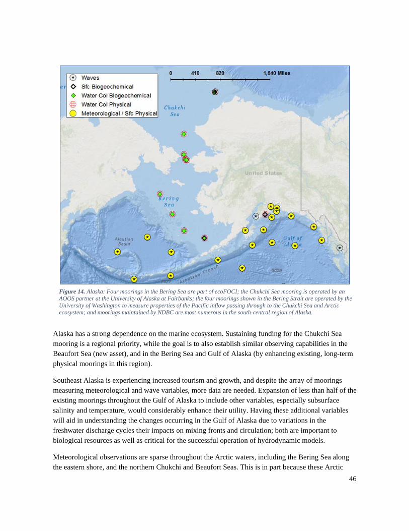
46
Figure 14. Alaska: Four moorings in the Bering Sea are part of ecoFOCI; the Chukchi Sea mooring is operated by an AOOS partner at the University of Alaska at Fairbanks; the four moorings shown in the Bering Strait are operated by the University of Washington to measure properties of the Pacific inflow passing through to the Chukchi Sea and Arctic ecosystem; and moorings maintained by NDBC are most numerous in the south-central region of Alaska.
Alaska has a strong dependence on the marine ecosystem. Sustaining funding for the Chukchi Sea mooring is a regional priority, while the goal is to also establish similar observing capabilities in the Beaufort Sea (new asset), and in the Bering Sea and Gulf of Alaska (by enhancing existing, long-term physical moorings in this region).
Southeast Alaska is experiencing increased tourism and growth, and despite the array of moorings measuring meteorological and wave variables, more data are needed. Expansion of less than half of the existing moorings throughout the Gulf of Alaska to include other variables, especially subsurface salinity and temperature, would considerably enhance their utility. Having these additional variables will aid in understanding the changes occurring in the Gulf of Alaska due to variations in the freshwater discharge cycles their impacts on mixing fronts and circulation; both are important to biological resources as well as critical for the successful operation of hydrodynamic models.
Meteorological observations are sparse throughout the Arctic waters, including the Bering Sea along the eastern shore, and the northern Chukchi and Beaufort Seas. This is in part because these Arctic
47
waters experience ice conditions for more than half of the year. However, as the Arctic open-water season lengthens, there is increased interest in extending and establishing new shipping routes throughout the Arctic region that will make meteorological and surface physical oceanographic observations critical for safe passage. Additional ice detection options could be implemented alongside any meteorological and surface physical observing capability that develops in the Arctic. New technologies are currently being tested for use in providing real-time information necessary for successful ice-model forecasting, which is of keen interest to NWS.
Great Lakes The Great Lakes—the largest system of freshwater lakes on Earth—is a vital and highly valued resource, providing ecological, economic, and societal benefits for the region. The five Great Lakes—Superior, Michigan, Huron, Erie, and Ontario—hold 95 percent of our nation’s surface freshwater supply and 20 percent of the world’s surface freshwater. These “freshwater seas” provide Great Lakes communities with valuable assets, including drinking water, agriculture, transportation, commercial shipping, hydroelectric power, a wide variety of recreational opportunities, and a world-class fishery assessed at $7 billion. GLOS and GLERL operate in this domain.
Great Lakes resources, however, are at risk. Human-induced stressors generated from industry and land use changes (including deforestation, urbanization, and agricultural activity) threaten the Lakes’ water quantity, water quality, and ecological health. Human settlement and habitat destruction across the basin also jeopardize the Lakes’ resiliency. Shoreline erosion, rip currents, and coastal flooding due to seiche (wind-driven) and meteotsunami (weather-induced, long-period waves) events also pose a coastal hazard.
Currently, one of the most critical concerns is increasing levels of nutrient runoff from rural and urban land that drains into the lakes, particularly during periods of heavy precipitation. The resulting excess phosphorus and nitrogen loading into the western basin of Lake Erie stimulate the growth of HABs that can produce toxins, such as cyanobacteria, e.g., Microcystis, thus posing human health risks.
The resiliency of the Great Lakes ecosystem has also been jeopardized for decades by the introduction of nonindigenous aquatic nuisance species from waters around the world. For example, sea lamprey entered the Great Lakes and destroyed native lake trout populations. In the absence of a top predator, invasive alewife proliferated; Pacific salmon were then introduced to control the alewife. Invasive dreissenid, e.g., zebra and quagga mussels, introduced via ballast water from the Baltic Sea, are now abundant throughout the lower Great Lakes. These mussels directly undermine the base of the food web and ultimately threaten the sustainability of a lucrative fishery based on non-native Pacific salmon and alewife.
Climate variability, another stressor to the Great Lakes, impacts the thermal and hydrologic regime, driving extreme fluctuations in Great Lakes water level and extent in ice cover. A relevant case in point is the unprecedented period of below-average water levels in Lake Michigan-Huron and Lake Superior that occurred over roughly 15 years, beginning in 1998. This period of low water level
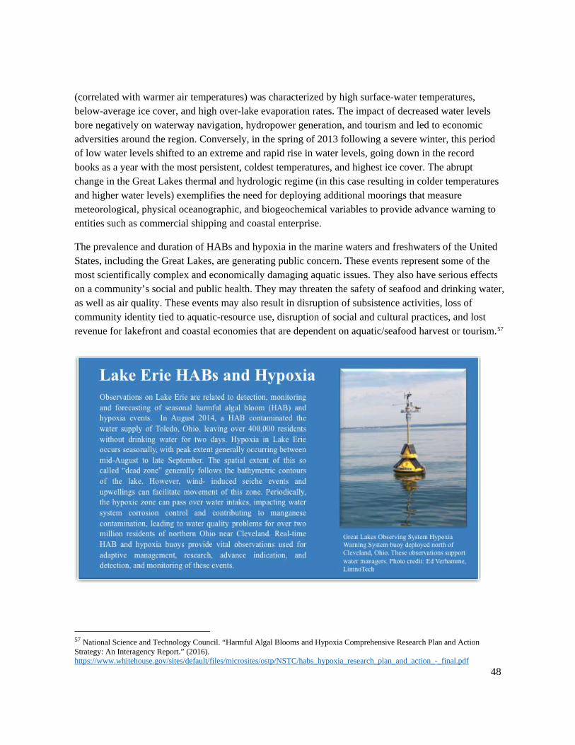
48
(correlated with warmer air temperatures) was characterized by high surface-water temperatures, below-average ice cover, and high over-lake evaporation rates. The impact of decreased water levels bore negatively on waterway navigation, hydropower generation, and tourism and led to economic adversities around the region. Conversely, in the spring of 2013 following a severe winter, this period of low water levels shifted to an extreme and rapid rise in water levels, going down in the record books as a year with the most persistent, coldest temperatures, and highest ice cover. The abrupt change in the Great Lakes thermal and hydrologic regime (in this case resulting in colder temperatures and higher water levels) exemplifies the need for deploying additional moorings that measure meteorological, physical oceanographic, and biogeochemical variables to provide advance warning to entities such as commercial shipping and coastal enterprise.
The prevalence and duration of HABs and hypoxia in the marine waters and freshwaters of the United States, including the Great Lakes, are generating public concern. These events represent some of the most scientifically complex and economically damaging aquatic issues. They also have serious effects on a community’s social and public health. They may threaten the safety of seafood and drinking water, as well as air quality. These events may also result in disruption of subsistence activities, loss of community identity tied to aquatic-resource use, disruption of social and cultural practices, and lost revenue for lakefront and coastal economies that are dependent on aquatic/seafood harvest or tourism.57
57 National Science and Technology Council. “Harmful Algal Blooms and Hypoxia Comprehensive Research Plan and Action Strategy: An Interagency Report.” (2016). https://www.whitehouse.gov/sites/default/files/microsites/ostp/NSTC/habs_hypoxia_research_plan_and_action_-_final.pdf
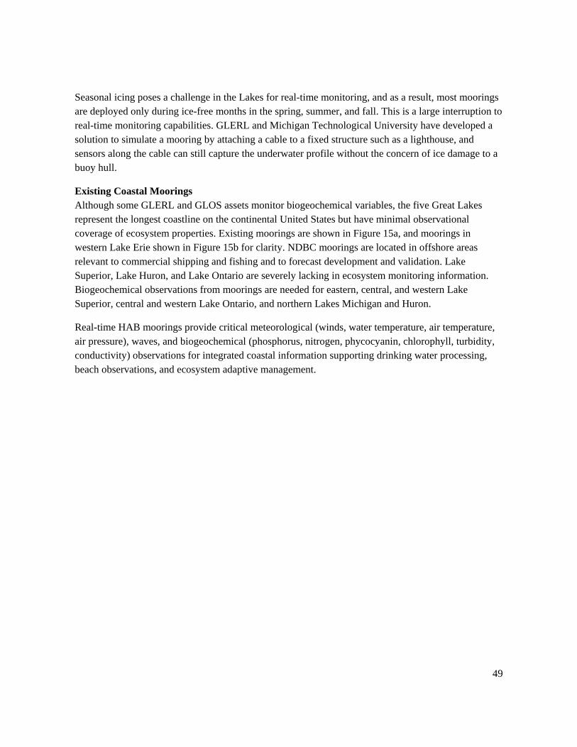
49
Seasonal icing poses a challenge in the Lakes for real-time monitoring, and as a result, most moorings are deployed only during ice-free months in the spring, summer, and fall. This is a large interruption to real-time monitoring capabilities. GLERL and Michigan Technological University have developed a solution to simulate a mooring by attaching a cable to a fixed structure such as a lighthouse, and sensors along the cable can still capture the underwater profile without the concern of ice damage to a buoy hull.
Existing Coastal Moorings Although some GLERL and GLOS assets monitor biogeochemical variables, the five Great Lakes represent the longest coastline on the continental United States but have minimal observational coverage of ecosystem properties. Existing moorings are shown in Figure 15a, and moorings in western Lake Erie shown in Figure 15b for clarity. NDBC moorings are located in offshore areas relevant to commercial shipping and fishing and to forecast development and validation. Lake Superior, Lake Huron, and Lake Ontario are severely lacking in ecosystem monitoring information. Biogeochemical observations from moorings are needed for eastern, central, and western Lake Superior, central and western Lake Ontario, and northern Lakes Michigan and Huron.
Real-time HAB moorings provide critical meteorological (winds, water temperature, air temperature, air pressure), waves, and biogeochemical (phosphorus, nitrogen, phycocyanin, chlorophyll, turbidity, conductivity) observations for integrated coastal information supporting drinking water processing, beach observations, and ecosystem adaptive management.
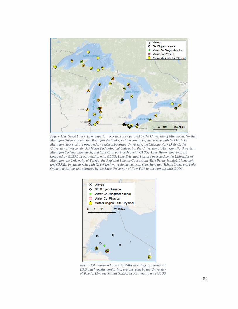
50
Figure 15a. Great Lakes: Lake Superior moorings are operated by the University of Minnesota, Northern Michigan University and the Michigan Technological University in partnership with GLOS; Lake Michigan moorings are operated by SeaGrant/Purdue University, the Chicago Park District, the University of Wisconsin, Michigan Technological University, the University of Michigan, Northwestern Michigan College, Limnotech, and GLERL in partnership with GLOS; Lake Huron moorings are operated by GLERL in partnership with GLOS; Lake Erie moorings are operated by the University of Michigan, the University of Toledo, the Regional Science Consortium (Erie Pennsylvania), Limnotech, and GLERL in partnership with GLOS and water departments at Cleveland and Toledo Ohio; and Lake Ontario moorings are operated by the State University of New York in partnership with GLOS.
Figure 15b. Western Lake Erie HABs moorings primarily for HAB and hypoxia monitoring, are operated by the University of Toledo, Limnotech, and GLERL in partnership with GLOS.
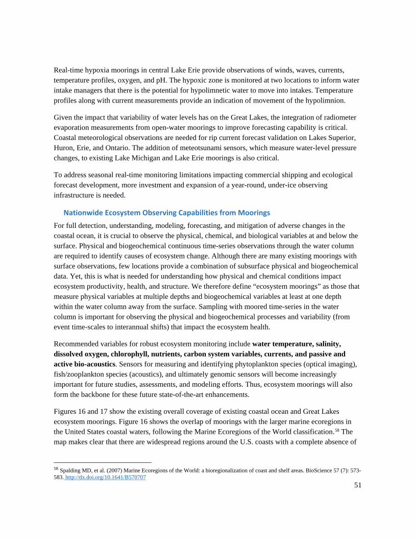
51
Real-time hypoxia moorings in central Lake Erie provide observations of winds, waves, currents, temperature profiles, oxygen, and pH. The hypoxic zone is monitored at two locations to inform water intake managers that there is the potential for hypolimnetic water to move into intakes. Temperature profiles along with current measurements provide an indication of movement of the hypolimnion.
Given the impact that variability of water levels has on the Great Lakes, the integration of radiometer evaporation measurements from open-water moorings to improve forecasting capability is critical. Coastal meteorological observations are needed for rip current forecast validation on Lakes Superior, Huron, Erie, and Ontario. The addition of meteotsunami sensors, which measure water-level pressure changes, to existing Lake Michigan and Lake Erie moorings is also critical.
To address seasonal real-time monitoring limitations impacting commercial shipping and ecological forecast development, more investment and expansion of a year-round, under-ice observing infrastructure is needed.
Nationwide Ecosystem Observing Capabilities from Moorings For full detection, understanding, modeling, forecasting, and mitigation of adverse changes in the coastal ocean, it is crucial to observe the physical, chemical, and biological variables at and below the surface. Physical and biogeochemical continuous time-series observations through the water column are required to identify causes of ecosystem change. Although there are many existing moorings with surface observations, few locations provide a combination of subsurface physical and biogeochemical data. Yet, this is what is needed for understanding how physical and chemical conditions impact ecosystem productivity, health, and structure. We therefore define “ecosystem moorings” as those that measure physical variables at multiple depths and biogeochemical variables at least at one depth within the water column away from the surface. Sampling with moored time-series in the water column is important for observing the physical and biogeochemical processes and variability (from event time-scales to interannual shifts) that impact the ecosystem health.
Recommended variables for robust ecosystem monitoring include water temperature, salinity, dissolved oxygen, chlorophyll, nutrients, carbon system variables, currents, and passive and active bio-acoustics. Sensors for measuring and identifying phytoplankton species (optical imaging), fish/zooplankton species (acoustics), and ultimately genomic sensors will become increasingly important for future studies, assessments, and modeling efforts. Thus, ecosystem moorings will also form the backbone for these future state-of-the-art enhancements.
Figures 16 and 17 show the existing overall coverage of existing coastal ocean and Great Lakes ecosystem moorings. Figure 16 shows the overlap of moorings with the larger marine ecoregions in the United States coastal waters, following the Marine Ecoregions of the World classification.58 The map makes clear that there are widespread regions around the U.S. coasts with a complete absence of
58 Spalding MD, et al. (2007) Marine Ecoregions of the World: a bioregionalization of coast and shelf areas. BioScience 57 (7): 573-583. http://dx.doi.org/10.1641/B570707
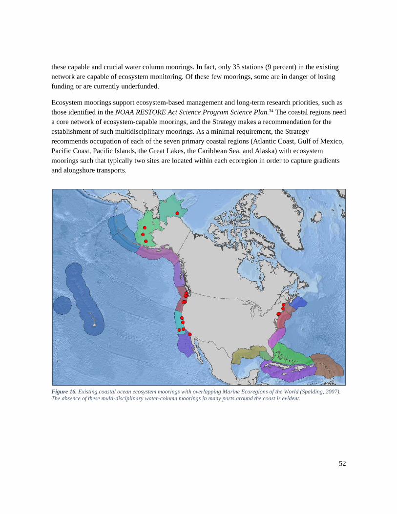
52
these capable and crucial water column moorings. In fact, only 35 stations (9 percent) in the existing network are capable of ecosystem monitoring. Of these few moorings, some are in danger of losing funding or are currently underfunded.
Ecosystem moorings support ecosystem-based management and long-term research priorities, such as those identified in the NOAA RESTORE Act Science Program Science Plan.34 The coastal regions need a core network of ecosystem-capable moorings, and the Strategy makes a recommendation for the establishment of such multidisciplinary moorings. As a minimal requirement, the Strategy recommends occupation of each of the seven primary coastal regions (Atlantic Coast, Gulf of Mexico, Pacific Coast, Pacific Islands, the Great Lakes, the Caribbean Sea, and Alaska) with ecosystem moorings such that typically two sites are located within each ecoregion in order to capture gradients and alongshore transports.
Figure 16. Existing coastal ocean ecosystem moorings with overlapping Marine Ecoregions of the World (Spalding, 2007). The absence of these multi-disciplinary water-column moorings in many parts around the coast is evident.
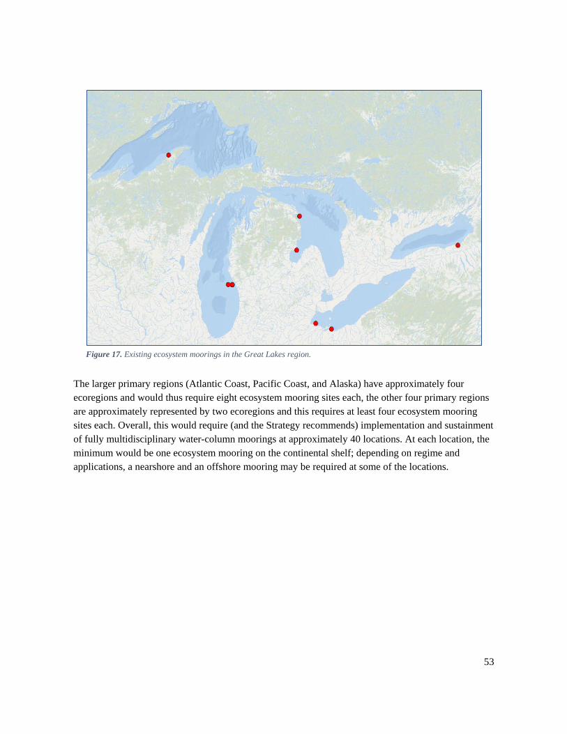
53
Figure 17. Existing ecosystem moorings in the Great Lakes region.
The larger primary regions (Atlantic Coast, Pacific Coast, and Alaska) have approximately four ecoregions and would thus require eight ecosystem mooring sites each, the other four primary regions are approximately represented by two ecoregions and this requires at least four ecosystem mooring sites each. Overall, this would require (and the Strategy recommends) implementation and sustainment of fully multidisciplinary water-column moorings at approximately 40 locations. At each location, the minimum would be one ecosystem mooring on the continental shelf; depending on regime and applications, a nearshore and an offshore mooring may be required at some of the locations.
54
Recommendations An initial assessment by the Strategy writing team revealed no glaring spatial observation redundancies in the existing network of coastal moorings. This assessment included a geospatial and observational category review of the 370 existing coastal mooring station locations of NOAA and IOOS RAs. It revealed some regional observational needs based on writing team experience and subject-matter expert input, and sustainability risk among the existing moorings. The near-absence of ecosystem moorings across all regions is a significant example of a major need.
Based upon consultation with coastal mooring subject-matter experts from a subset of the IOOS RAs and NOAA, the following strategic recommendations are offered to enhance the current network of coastal moorings and develop a more complete and sustainable network.
1. Develop an implementation plan with stakeholder input. The primary recommendation of the Strategy is the development of a National Plan for a Sustained Network of Coastal Moorings to identify the regional observational gaps best addressed with coastal moorings and describe the implementation actions necessary to achieve an optimized sustained coastal mooring network. The Strategy recommends a stakeholder engagement approach to integrate the collective input of national and regional marine operators, federal and nonfederal moorings operators, and scientists. The Strategy recommends collecting stakeholder priorities for mooring measurements through targeted regional stakeholder engagement, led jointly by NOAA and the IOOS RAs.59
2. Identify mechanisms to sustain priority stations. A national coastal mooring network of priority stations must be identified, along with sustainable funding mechanisms, to ensure and preserve the continuity and accuracy of the coastal environmental record. In 1967, The United States federal government approved the development of a core backbone of sustained coastal moorings via the NDBC, and in 2009 federal law was enacted authorizing IOOS. These steps marked important milestones in building and sustaining the national network of coastal moorings discussed in the Strategy. The Strategy recommends the identification of sustainment mechanisms to define a pathway toward the ensured future of a national coastal mooring network.
3. Consider complementary systems and emerging technologies in the development of a coastal moorings implementation plan. Coastal moorings are one of many critical pieces in the Earth observation system-of-systems. Linking coastal mooring observations with complementary observation and monitoring systems allows scientists to assess the Earth’s environment. The Strategy recommends the consideration of complementary observing
59 The most recent IOOS Regional Association Build-out Plans can be used as a starting point for regional stakeholder discussions about gaps and needs: http://www.ioosassociation.org/
55
system linkages, as well as the role of emerging technology during the development of a coastal moorings implementation plan.
4. Routinely monitor and assess the design of the national coastal mooring network. Once completed, the implementation plan is intended to be reviewed and updated periodically, as needed. Routine assessment and coordinated stakeholder planning will promote adaptive management of the network. This review should include a measure of sustainability (continuity of funding) for each coastal mooring in the network.
5. Add water temperature and salinity measurements to designated existing NDBC mooring stations. Water temperature and salinity measurements aid in ocean circulation models, climate assessments, and coastal processes. A preliminary review of the known observational gaps revealed the need to add underwater profiles of water temperature and salinity measurements to select existing NDBC mooring stations. The Strategy recommends that RAs assist in the identification and implementation of water temperature and salinity measurements to specific existing NDBC mooring stations.
6. Identify and sustain water column ecosystem moorings at four to eight locations in each of the seven primary coastal regions of the United States. The Strategy recommends the sustainment of moorings with substantial ecosystem monitoring capabilities at four to eight locations along the coast in each of the seven primary coastal regions of the United States (Atlantic Coast, Gulf of Mexico, Pacific Coast, Pacific Islands, the Great Lakes, the Caribbean Sea, and Alaska). Ecosystem monitoring capability requires at least measurements of subsurface chlorophyll, dissolved oxygen, and salinity/water temperature over multiple depths. Highly recommended are additional current profiling, nutrient, carbon, and acoustic backscatter sensors. Few moorings are capable of ecosystem monitoring due to lack of subsurface sampling. Therefore, it is recommended that ecosystem moorings be operational at approximately 40 locations on the continental shelves around the coasts and the Great Lakes, and that sustained funding of the existing ecosystem moorings is ensured.
7. Update and implement the National Operational Wave Observation Plan. The Waves Plan provides recommendations for a comprehensive, high-quality, surface-wave monitoring network for the United States that addresses the requirements of the maritime user community. As of the 2012 update to this plan, there are 200 active wave observation sites, and 157 sites comprise a national backbone of wave observations. The Waves Plan proposes 47 new stations, and upgrades to 87 existing stations.60 An additional update to this 2012 version is necessary to account for changes in the USACE and the CDIP network.
60 Birkemeier, WA, et al. "IOOS Wave Observations, a National Perspective." (2012). https://doi.org/10.1109/OCEANS.2012.6405055.
56
8. Promote environmental health and operational safety stewardship and regulatory compliance. Environmental stewardship in mooring operations is important for ocean and coastal stewardship because it promotes the sustainability of coastal mooring networks. Operators of coastal mooring networks should ensure and demonstrate compliance with the relevant environmental law such as the National Environmental Policy Act.
9. Develop coastal mooring network performance metrics. Coastal mooring networks should ensure performance metrics align with key stakeholder needs and promote key performance indicators (KPI) to be used by all network operators. KPIs should span areas of funding assessment and sustainability, data quality and availability, environmental compliance, operational safety, and adherence to standards and best practices.
10. Standardize and integrate data management best practices across coastal mooring networks. Coordinate and integrate observations from multiple platforms, as appropriate, in compliance with data standards and best practices. This includes compliance with NOAA procedural directives, such as the NOAA Data Management Planning Procedural Directive,61 the NOAA Data Sharing Policy,62 IOOS data management standards,63 and the IOOS Quality Assurance/Quality Control of Real-Time Oceanographic Data (QARTOD).64 Data must be publicly available via the Global Telecommunication System and/or NDBC and partner data portals.
61 NOAA. “Data Management Planning Procedural Directive, v.2.0.1.” (2015). https://nosc.noaa.gov/EDMC/documents/EDMC-PD-DMP-2.0.1.pdf 62 NOAA. “Data and Publication Sharing Directive for NOAA Grants, Cooperative Agreements, and Contracts, v3.0.” (2016). https://nosc.noaa.gov/EDMC/documents/Data_Sharing_Directive_v3.0.pdf 63 IOOS GitHub pages: ioos.github.io 64 QARTOD: https://ioos.noaa.gov/project/qartod/
57
Appendix I: IOOS Regional Associations and Stakeholders The Northeastern Regional Association of Coastal Ocean Observing Systems (NERACOOS) provides weather and ocean data to fishers and commercial shippers determining if conditions are safe for passage and to emergency managers communicating storm warnings. NERACOOS is also advancing efforts to improve water quality monitoring, harmful algal bloom predictions and warnings, and coastal flooding and erosion forecasting systems. NERACOOS members and partners can be found at http://www.neracoos.org/community. Executive Director: Dr. Ru Morrison
The Mid-Atlantic Regional Association Coastal Ocean Observing System (MARACOOS) provides the necessary ocean observing, data management, and forecasting capacity to systematically address maritime safety, ecosystem based management, water quality, coastal inundation, and offshore energy. Its mission is to seek, discover, share and apply knowledge and understanding of our coastal ocean. MARACOOS membership can be found at: http://maracoos.org/members. Executive Director: Dr. Gerhard Kuska
The Southeast Coastal Ocean Observing Regional Association (SECOORA) is the regional solution to integrating coastal and ocean observing data and information in the Southeast United States. It coordinates coastal and ocean observing activities, and facilitates continuous dialogue among stakeholders so that the benefits from the sustained operation of a coastal and ocean observing system can be realized. SECOORA focuses its efforts on four main thematic areas: marine operations, ecosystems (living marine resources and water quality) coastal hazards, and climate change. SECOORA membership can be found at http://secoora.org/about/membership. Executive Director: Ms. Debra Hernandez
The Gulf of Mexico Coastal Ocean Observing System (GCOOS) provides timely information about the Gulf of Mexico and its estuaries for use by decision-makers, including researchers, government managers, industry, the military, educators, emergency responders, and the public. GCOOS provides observations and products to detect and predict climate variability and consequences, preserve and restore healthy marine ecosystems, ensure human health, manage resources, facilitate safe and efficient marine transportation, enhance national security, and predict and mitigate coastal hazards. The need for integrated ocean observations is of utmost importance to this region to mitigate impacts from coastal disasters. These integrated observations will assist the region in sustaining coastal resources and enhancing coastal resilience. GCOOS membership can be found at http://gcoos.tamu.edu/?page_id=2031. Executive Director: Dr. Barb Kirkpatrick
58
The Caribbean Coastal Ocean Observing System (CariCOOS) is focused on meeting identified stakeholder needs for improved real-time data products and forecasts of coastal weather (winds), currents, waves, water quality, and hurricane-driven inundation for the U.S. Caribbean EEZ. The mission of CARICOOS is to provide unquestionably high-priority decision supporting information for enhancing safety in our coasts and ocean, improving efficiency of maritime operations and support coastal resource management. CARICOOS supports safe and efficient maritime operations; minimizing impacts from coastal hazards; provides support for coastal resource management; and monitors climate variability. Stakeholder information can be found at http://www.caricoos.org/. Executive Director: Mr. Julio Morell
The Southern California Coastal Ocean Observing System (SCCOOS) brings together coastal observations in the Southern California Bight to provide information necessary to address issues in climate change, ecosystem preservation and management, coastal water quality, maritime operations, coastal hazards, and national security. As a science-based decision-support system, SCCOOS works interactively with local, state, and federal agencies, resource managers, industry, policy makers, educators, scientists, and the public to provide data, models, and products that advance our understanding of the current and future state of our coastal and global environment. SCCOOS partners and sponsors can be found at http://www.sccoos.org/about/partners-sponsors/. Executive Director: Ms. Julie Thomas
The Central and Northern California Ocean Observing System (CeNCOOS) enables sustained and coordinated measurements, model nowcasts and forecasts, and integrated products to inform decisions about our regional ocean. Stakeholders (membership, organizations, and individuals engaged in the collection, delivery, or use of CeNCOOS ocean observing data or information) that maintain regular contact with CeNCOOS can be found at http://www.cencoos.org/about/program/membership. Executive Director: Dr. David Anderson
The Northwest Association of Networked Ocean Observing Systems (NANOOS) provides PNW stakeholders with the coastal ocean, estuarine, and shoreline data, forecasts, tools, and information they need to make responsive and responsible decisions, appropriate to their individual and collective societal roles. It has strong ties with observing programs in Alaska, California, and British Columbia through common purpose and shared interest in data and tailored user products. NANOOS members represent organizations and interests of different regions and sectors, including tribal, federal, state and local governments, research, education, industry, and nonprofits. Information about members can be found at http://www.nanoos.org/about_nanoos/members.php. Executive Director: Dr. Jan Newton
59
The Pacific Islands Ocean Observing System (PacIOOS) believes that ocean data and information can help save lives and resources. Aiming to promote a safe, healthy, and productive ocean and resilient coastal zone, PacIOOS collects real-time data on ocean conditions, forecasts future events, and develops user-friendly tools to access this information. In collaboration with a large network of partners, PacIOOS helps inform decision-making in Pacific communities on a daily basis. PacIOOS partners and signatories of the PacIOOS Memorandum of Agreement can be found at http://www.pacioos.hawaii.edu/partners/. Executive Director: Ms. Melissa Iwamoto
The Alaska Ocean Observing System (AOOS) is the “eye on Alaska’s coasts and oceans,” and represents a network of critical ocean and coastal observations, data and information products that aid our understanding of the status of Alaska’s marine ecosystem and allow stakeholders to make better decisions about their use of the marine environment. AOOS organizes and facilitates several topic-specific groups by convening relevant partners and discussing objectives, available resources, existing needs, and potential next steps to expand ocean monitoring and data access. AOOS stakeholders and users can be found at http://www.aoos.org/stakeholders-2/. Executive Director: Ms. Molly McCammon
The Great Lakes Observing System (GLOS) works to make real-time and historical data publicly available to the larger Great Lakes community, benefiting data users and decision makers. GLOS is organized to address focus areas that correspond to IOOS societal goals and are management issues, identified by members, partners, and users as being important to the Great Lakes. Information on GLOS membership can be found at http://www.glos.us/. Executive Director: Ms. Kelli Paige
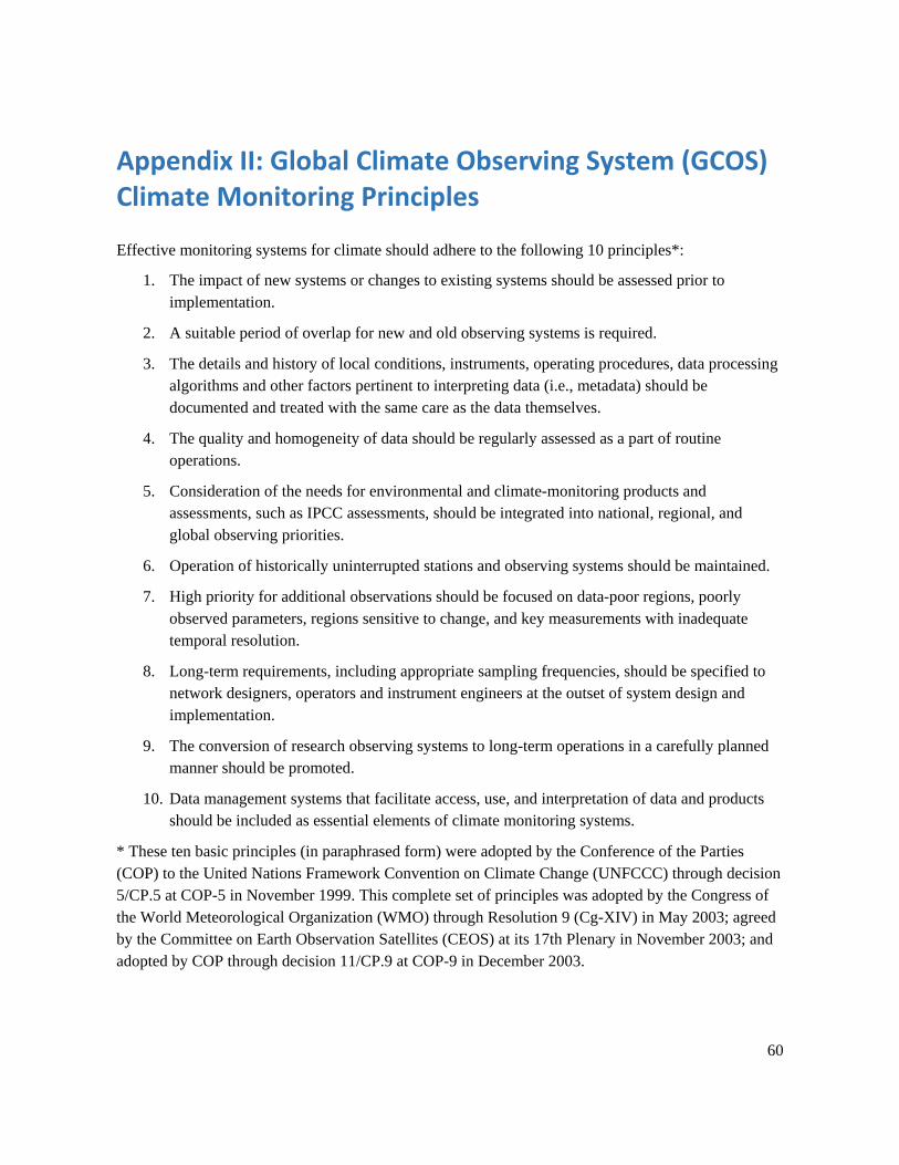
60
Appendix II: Global Climate Observing System (GCOS) Climate Monitoring Principles
Effective monitoring systems for climate should adhere to the following 10 principles*:
1. The impact of new systems or changes to existing systems should be assessed prior to implementation.
2. A suitable period of overlap for new and old observing systems is required.
3. The details and history of local conditions, instruments, operating procedures, data processing algorithms and other factors pertinent to interpreting data (i.e., metadata) should be documented and treated with the same care as the data themselves.
4. The quality and homogeneity of data should be regularly assessed as a part of routine operations.
5. Consideration of the needs for environmental and climate-monitoring products and assessments, such as IPCC assessments, should be integrated into national, regional, and global observing priorities.
6. Operation of historically uninterrupted stations and observing systems should be maintained.
7. High priority for additional observations should be focused on data-poor regions, poorly observed parameters, regions sensitive to change, and key measurements with inadequate temporal resolution.
8. Long-term requirements, including appropriate sampling frequencies, should be specified to network designers, operators and instrument engineers at the outset of system design and implementation.
9. The conversion of research observing systems to long-term operations in a carefully planned manner should be promoted.
10. Data management systems that facilitate access, use, and interpretation of data and products should be included as essential elements of climate monitoring systems.
* These ten basic principles (in paraphrased form) were adopted by the Conference of the Parties (COP) to the United Nations Framework Convention on Climate Change (UNFCCC) through decision 5/CP.5 at COP-5 in November 1999. This complete set of principles was adopted by the Congress of the World Meteorological Organization (WMO) through Resolution 9 (Cg-XIV) in May 2003; agreed by the Committee on Earth Observation Satellites (CEOS) at its 17th Plenary in November 2003; and adopted by COP through decision 11/CP.9 at COP-9 in December 2003.
61
Acronyms AOOS Alaska Ocean Observing System CalCOFI California Cooperative Oceanic Fisheries Investigations CariCOOS Caribbean Coastal Ocean Observing System CBIBS Chesapeake Bay Interpretive Buoy System CDIP Coastal Data Information Program CeNCOOS Central and Northern California Ocean Observing System COMPS Coastal Ocean Monitoring and Prediction System CO-OPS Center for Operational Oceanographic Products and Services CWB Coastal Weather Buoys DBO Distributed Biological Observatory DMAC Data Management and Communications EEZ Exclusive Economic Zone ecoFOCI Ecosystems and Fisheries-Oceanography Coordinated Investigations GCOS Global Climate Observing System GCOOS Gulf of Mexico Coastal Ocean Observing System GLERL Great Lakes Environmental Research Laboratory GLOS Great Lakes Observing System HAB Harmful Algal Bloom IOOS Integrated Ocean Observing System km Kilometer KPI Key Performance Indicator MAB Mid-Atlantic Bight MARACOOS Mid-Atlantic Regional Association Ocean Observing System MBARI Monterey Bay Aquarium Research Institute NANOOS Northwest Association of Networked Ocean Observing Systems NDBC National Data Buoy Center NERACOOS Northeastern Regional Association of Coastal Ocean Observing Systems NOAA National Oceanic and Atmospheric Administration NOS National Ocean Service NMFS National Marine Fisheries Service NSF National Science Foundation NWS National Weather Service OAP Ocean Acidification Program OAR Office of Oceanic and Atmospheric Research ODAS Ocean Data Acquisition Systems OOI Ocean Observatories Initiative PacIOOS Pacific Islands Ocean Observing System
62
PDO Pacific Decadal Oscillation PMEL Pacific Marine Environmental Laboratory PNW Pacific Northwest PORTS Physical Oceanographic Real-Time System QARTOD Quality Assurance/Quality Control of Real-Time Oceanographic Data RA Regional Association ReCON Real-time Coastal Observation Network RESTORE Resources and Ecosystems Sustainability, Tourist Opportunities, and Revived
Economies SCCOOS Southern California Coastal Ocean Observing System SECOORA Southeast Coastal Ocean Observing Regional Association TABS Texas Automated Buoy System USCG United States Coast Guard USACE United States Army Corps of Engineers USVI United States Virgin Islands UW University of Washington WBC Western Boundary Current WMO World Meteorological Organization