Embed Size (px)
Citation preview

Available online at www.sciencedirect.com
& TECTONOPHYSICSDIRECT*SCIENCE
ELSEVIER Tectonophysics 380 (2004) 123-130www.elsevier.com/locate/tecto
Active faults in Eurasia: general remarksV.G. Trifonov*
Geological Institute of the Russian Academy of Sciences, 7 Pyzhevsky, Moscow 119017, Russia
Received 30 September 2001; accepted 28 September 2003
Abstract
The database and map of active faults of Eurasia, 1:5,000,000, have been compiled according to the ILP Project II-2 “WorldMap of Major Active Faults.” The map shows the complicated distribution of active faulting. The major faults group in broadmobile belts between relatively weakly faulted parts of the main plates. The faults form the plates, microplates and crustalblocks boundaries there and are accompanied by deformation of the boundary areas. Using active fault data for the seismichazard assessment (estimation of maximum possible magnitudes of earthquakes in fault zones), it is necessary to take intoaccount the total neotectonic activity of the territory and average rate and sense of motion on the fault. Because trenching givesa possibility to determine only vertical earthquake offset on a fault, it is necessary to make corrections for strike-slip faults toestimate the earthquake magnitude by using this parameter.© 2003 Elsevier B.V. All rights reserved.
Keywords: Active faults; Recent geodynamics; Seismic hazard
Their results enriched the Project II-2 by new de¬tailed results. Later, the Project П-2 was included tothe Global Seismic Hazard Assessment Program(GSHAP). It gave a possibility to use the projectresults directly for seismic hazard assessment andseismic zoning. For example, the new Series ofSeismic Zonation Maps of Russia, 1:8,000,000 (Ulo-mov and Shumilina, 2000) were compiled with usingthe Project II-2 data.
For better management, the Project II-2 was divid¬ed into two subprojects: for the western (led by M.S.Machette, USGS, Denver) and the eastern (led byV.G. Trifonov) hemispheres. The common under¬standing of the terms and common legend for themaps of countries, regions and continents were dis¬cussed and accepted (Trifonov and Machette, 1993).
The “Eastern” subproject studies were concentrat¬ed in research and mapping of active faults in Eurasia
1. The ILP project II-2 “World Map of MajorActive Faults”
In view of the significance of the active faultsstudies for understanding of recent geodynamics andseismic hazard assessment, the International Litho¬sphere Commission initiated in 1989 the Project II-2“World Map of Major Active Faults,” led by theauthor of this paper. The project was accepted as acontribution of the International Lithosphere Program(ILP) to the United Nations’ Decade of NaturalDisaster Reduction. The ILP Project II-2 attracted alot of scientists from different countries and initiatedmany national projects for active fault studying.
* Fax: +7-95-951-0443.E-mail address: [email protected] (V.G. Trifonov).
0040-1951/$ - see front matter © 2003 Elsevier B.V. All rights reserved.doi:10.1016/j.tecto.2003.09.017
124 V.G. Trifonov / Tectonophysics 380 (2004) 123-130
and Africa and included participants from 37countries. These are: M. Meghraoui (Algeria); A.S.Karakhanian (Armenia); J. Klerkx, D. Delvouix, andM. Hanon (Belgium); R.G. Garetsky, A.M. Bobory¬kin, R.R. Pavlovets and other (Belarus); P. Gochev,M. Matova, and H. Spiridonov (Bulgaria); DingGuoyu, Gao Weiming, and Deng Qidong (China);S.M. Mahmud, A. Swedan, and M. Abdeen (Egypt);H. Philip (France); S.I. Kuloshvili (Georgia); P. Bank-witz (Germany); R. Muir Wood (Great Britain); S.Pavlides, A. Chatzipetros, and I. Mariolakos (Greece);A. Sinha (India); M. Berberian, Kh. Hessami, and F.Jamali (Iran); A. Gelat and I. Karcz (Israel); E. Vittori,D. Castaldini, M. Panizza, D. Pantosti, L. Serva, andD. Slejko (Italy); Y. Kinugasa and T. Nakata (Japan);Z.H. El-Isa (Jordan); A.V. Timush (Kazakhstan); K.E.Abdrakhmatov (Kyrgizstan); H.H. Silbvee and V.I.Suvezdis (Lithuania); M. Tjia (Malaysia); G.M. Bilin-kis (Moldova); P. Khosbayar (Mongolia); O. Olesen(Norway); M. Graniczny and W. Zuchiewicz(Poland); A. Ribeiro (Portugal); M.N. Alekseev,L.B. Aristarkhova, B.A. Assinovskaya, V.I. Babak,D.M. Bachmanov, N.K. Dmitrieva, V.S. Imaev, L.S.Imaeva, A.I. Ioffe, T.P. Ivanova, V.G. Kazmin, M.L.Kopp, A.I. Kozhurin, K.G. Levi, N.V. Lukina, V.I.Makarov, N.A. Malyshev, E.K. Mel’nikov, A.A.Nikonov, V.A. Ogadzhanov, M.V. Rozanov, G.P.Shcherbinina, S.I. Sherman, V.V. Sholokhov, S.S.Shults, Jr., S.F. Skobelev, L.I. Soloviova, M.I. Strelt¬sov, A.L. Strom, V.G. Trifonov, R.V. Trifonov, G.B.Udintsev, G.A. Vostrikov, and D.S. Zykov (Russia);V. Banacki, P. Grecula, and J. Hok (Slovakia); J.M.Diaz and P. Villamor (Spain); N.-A. Momer and R.Lagerback (Sweden); N. Pavoni (Switzerland); A.Barka, F. Saroglu, O. Emre, and I. Kuscu (Turkey);V.P. Palienko, R.P. Kuprash, L.S. Borisenko, and V.I.Somov (Ukraine); R. Yeats, M. Barazangi, and P.Molnar (USA); Sh.H. Abdullaev and A.R. Yarmukha-medov (Uzbekistan); D. Cvijanovich (Yugoslavia).
All the obtained data on the active faults wereconcentrated in Moscow. The active fault databasewas compiled (Ioffe and Kozhurin, 1996; Ioffe et al.,1993; Trifonov, 2000a). The information presented inthe database was divided into two groups. The firstgroup included the most important information oblig¬atory provided for each fault and required for com¬piling the fault maps. These data were the following:the ordinal number of a fault; the age of the last
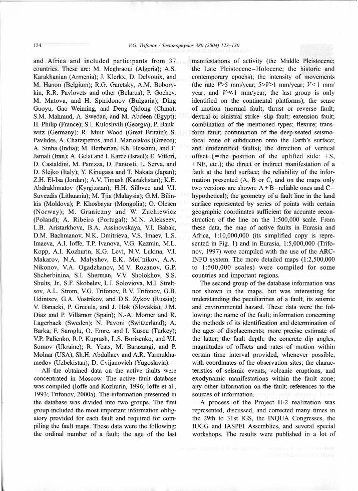
manifestations of activity (the Middle Pleistocene;the Late Pleistocene-Holocene; the historic andcontemporary epochs); the intensity of movements(the rate V>5 mm/year; 5>F>1 mm/year; V< 1 mm/year; and Vÿl mm/year; the last group is onlyidentified on the continental platforms); the senseof motion (normal fault; thrust or reverse fault;dextral or sinistral strike-slip fault; extension fault;combination of the mentioned types; flexure; trans¬form fault; continuation of the deep-seated seismo-focal zone of subduction onto the Earth’s surface;and unidentified faults); the direction of verticaloffset ( = the position of the uplifted side: +S,+ NE, etc.); the direct or indirect manifestation of afault at the land surface; the reliability of the infor¬mation presented (A, В or C, and on the maps onlytwo versions are shown: A +B-reliable ones and C-hypothetical); the geometry of a fault line in the landsurface represented by series of points with certaingeographic coordinates sufficient for accurate recon¬struction of the line on the 1:500,000 scale. Fromthese data, the map of active faults in Eurasia andAfrica, 1:10,000,000 (its simplified copy is repre¬sented in Fig. 1) and in Eurasia, 1:5,000,000 (Trifo¬nov, 1997) were compiled with the use of the ARC-INFO system. The more detailed maps (1:2,500,000to 1:500,000 scales) were compiled for somecountries and important regions.
The second group of the database information wasnot shown in the maps, but was interesting forunderstanding the peculiarities of a fault, its seismicand environmental hazard. These data were the fol¬lowing: the name of the fault; information concerningthe methods of its identification and determination ofthe ages of displacements; more precise estimate ofthe latter; the fault depth; the concrete dip angles,magnitudes of offsets and rates of motion withincertain time interval provided, whenever possible,with coordinates of the observation sites; the charac¬teristics of seismic events, volcanic eruptions, andexodynamic manifestations within the fault zone;any other information on the fault; references to thesources of information.
A process of the Project II-2 realization wasrepresented, discussed, and corrected many times inthe 29th to 31st IGS, the INQUA Congresses, theIUGG and IASPEI Assemblies, and several specialworkshops. The results were published in a lot of
-160 -150'0‘ 20 40 60' 80 100' 120 140° 160 180-60' -50 -4С -20"V5°V: J I- V v
■Wk 50Mapvllof
./ лactive faults ■w"
i \ l'::3 v.< ■
4ÿ'■ %v%. i
~ÿk*A\db;ч>.
Eurasia >•'40'
з -Y’ ■’If 'and
fAfricaf
40X \r:.p/-KM IOOO 0 500 iooo KM Rates of motion
V, mm/year
171V>5715>v>1
7V<1 EH v<<1
/ÿuA.
71 ~m30' ч 7s
/> V 3?30-Age of last manifestation
of activity:Middle Pleistocene:v'/ s •Ж;<ÿ'
Proved |ÿ. " ]Assumed: A\
- P t 7? -jr /l, /
5K>- /' /20' VLate Pleistocene and Holocene:
Ж |адй~%FProved[T]Assumed/ |J: • >
/ /4м> ■§■is И rDeep-seated
fault zone. ■ :p.ЩИТ
s10 u>
Oo10 ®#Г-
r* S
£J“Г Ш70' rÿ- '7°\\ - 0'.»4 lSf
7-10'
t"Ж i!K- -10'V'-"
/t
Ц‘J! \ %t-20' - 4
-20
Ii 11
150'14080' 100' 110 120- 13030' 40 50- 60 70' 90-
Fig. 1. Simplified map of active faults in Eurasia and Africa.
KJ
126 V.G. Trifonov / Tectonophysics 380 (2004) 123-130
with estimates of the present-day stress state, obtainedby different methods.
Two main mobile belts of Eurasia, the East Asianand Alpine-Himalayan ones, are characterized by thetransverse segmentation. The rates of fault motion aredifferent in different segments. In the Alpine-Hima¬layan belt, the rates systematically increase to the eastthat depends on peculiarities of rotation of the south¬ern plates. However, it is interesting that the rates offault motion as well as the rates of transverse short¬ening of the belt change sharply in the segmentboundaries. For example, the rate of the shortening,calculated as the algebraic sum of average rates ofmotion on active faults, is about 2 cm/year in theCaucasus-Arabian intersection and about 3 cm/yearin the Pamir-Himalayan intersection of the belt(Trifonov et al., 1999).
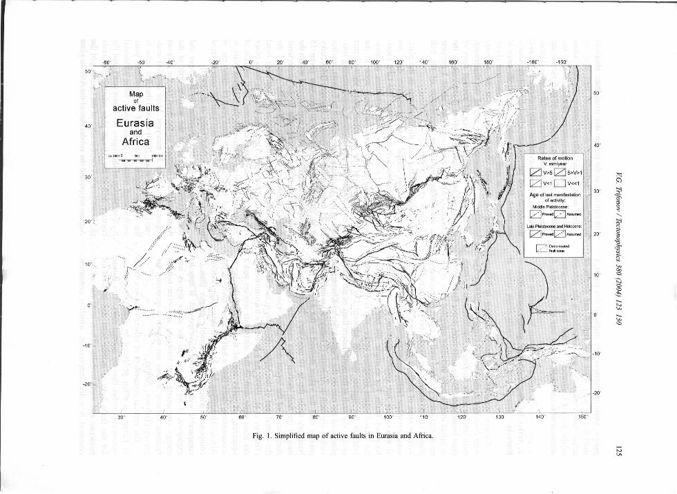
A balance of the fault displacements in the plate,microplate, and crustal block boundaries does notexhaust the mobile belt deformation. The GPS meas¬urements of the contemporary deformation, accumu¬lated near the North Anatolian fault zone in thenorthern flank of the Anatolian plate showed thatthe total strike-slip deformation, demonstrating rota¬tion of the Anatolian plate relative to Eurasia, reaches20-25 mm/year (24 mm/year in average) (McCluskyet al., 2000). However, only 20 mm/year (even 15mm/year in the central part) is concentrated within thefault zone itself that corresponds to the neotectonicdata (Trifonov et al., 1994). The other part of thedeformation is distributed in the 100-km-wide bendaround the fault zone. The same situation takes placealong the East Anatolian fault zone: Total rotation ofthe Anatolian plate relative to the Arabian plate isestimated here as 8-12 mm/year (9 mm/year inaverage), but only 4-8 mm/year is concentratedwithin the fault zone (McClusky et al., 2000).
According to the data presented by Reilinger andBarka (1997), the rate of the western drift of theAnatolian plate increase to the west (to the Aegeanregion) from 20 to 35 mm/year. More detailed anal¬ysis (McClusky et al., 2000) showed that this value inthe Aegean region is a sum of the Anatolian platesouthwestern rotation (24 mm/year), some additionalN-S extension of the region (6-8 mm/year), and thecontrary drift of the African plate relative to Eurasia(5-7 mm/year). A combination of the thrusting of theAegean region and the subduction of the African plate
papers, some monographs and maps. In this paper, Ishall discuss only some new aspects and results ofactive fault studies that were obtained in the processof the project realization and that had not attractedattention of scientists before.
2. Active faulting and recent geodynamics inEurasia
General regularities of active faulting in Eurasiawere discussed in the 31st IGS (Trifonov, 2000b). Themost intense active faulting is manifested in the mainplate boundaries. At the same time, active faults groupin broad mobile belts including marginal parts of themain interacting plates as well as minor plates, micro¬plates, crustal slides, and blocks between them. Theaverage rates of the Late Quaternary movements onsome intraplate faults, separating microplates or crust¬al blocks are not smaller than on the main plateboundary faults. For example, the rate of motion onthe Talas-Fergana intraplate strike-slip fault (15 mm/year) is not smaller than on adjacent Darvaz-Alaistrike-slip fault at the northeastern flank of the Indianplate, and the rate on the Pambak-Sevan-Khanarassarstrike-slip fault in Armenia (5 mm/year) is only twicesmaller than the values derived in the Arabian plateboundary faults (up to 10 mm/year). These peculiar¬ities of the fault motion rates cause the complicateddistribution of the recent deformation, calculated forthe central part of the Alpine-Himalayan mobile belt(Trifonov et al., 1999). As a result of a transmission ofthe main plate drift to the microplate motion and asqueezing of rocks out of the areas of the largercompression, more than a half of active faults in theAlpine-Himalayan belt have the strike-slip motioncomponent which is considerably greater than orcomparable with the vertical component. It may beexplained, if we assume that the strike slip is lessenergy consuming than thrusting and even normalfaulting, because it does not require overcoming thegravity (Trifonov, 2000a).
The vertical component of offsets on active faultsin Eurasia is often produced by thrust or reversemovements rather than by normal ones. This is truefor the faults both in mobile belts and in areas ofmoderate and weak mobility. Thus, most part of thecontinent is under compression, which is consistent
1
V.G. Trifonov / Tectonophysics 380 (2004) 123-130 127
plates than a rotation of the separate Okhotsk Seaplate.
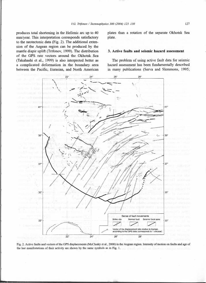
produces total shortening in the Hellenic arc up to 40mm/year. This interpretation corresponds satisfactoryto the neotectonic data (Fig. 2). The additional exten¬sion of the Aegean region can be produced by themantle diapir uplift (Trifonov, 1999). The distributionof the GPS rate vectors around the Okhotsk Sea(Takahashi et al., 1999) is also interpreted better asa complicated deformation in the boundary areabetween the Pacific, Eurasian, and North American
3. Active faults and seismic hazard assessment
The problem of using active fault data for seismichazard assessment has been fundamentally describedin many publications (Serva and Slemmons, 1995;
24" 26" 28"22"4
4 V\
< \
41"41“ \ r// «5 >5 h 3LIs
/39°39°
\Ji,/
//* r14
\37°37° 4 \ .'ÿ&%/ у
I
*35°35°
//f
Sense of fault movementsNormal fault Seismic focal zoneStrike-slip 33°33°
Vector of the displacement rate relative to Europe,according to the GPS data (corresponds to 1 cm/year)
22° 24° 26° 28°
Fig. 2. Active faults and vectors of the GPS displacements (McClusky et al., 2000) in the Aegean region. Intensity of motion on faults and age ofthe last manifestations of their activity are shown by the same symbols as in Fig. 1.
128 V.G. Trifonov / Tectonophysics 380 (2004) 123-130
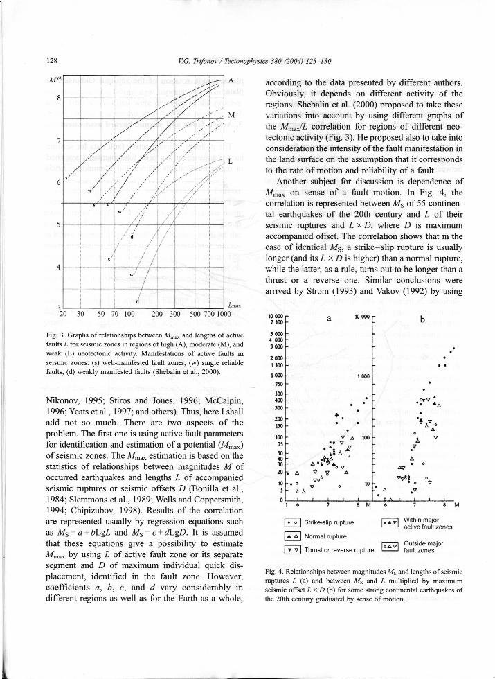
M<4> A according to the data presented by different authors.Obviously, it depends on different activity of theregions. Shebalin et al. (2000) proposed to take thesevariations into account by using different graphs ofthe Mmax/L correlation for regions of different neo-tectonic activity (Fig. 3). He proposed also to take intoconsideration the intensity of the fault manifestation inthe land surface on the assumption that it correspondsto the rate of motion and reliability of a fault.
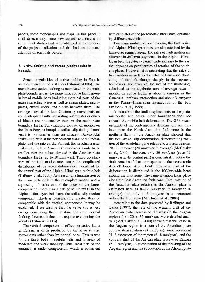
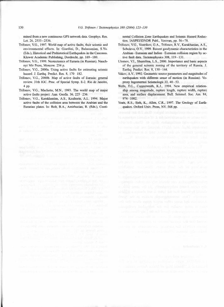
Another subject for discussion is dependence ofon sense of a fault motion. In Fig. 4, the
correlation is represented between Ms of 55 continen¬tal earthquakes of the 20th century and L of theirseismic ruptures and LxD, where D is maximumaccompanied offset. The correlation shows that in thecase of identical Ms, a strike-slip rupture is usuallylonger (and its L x D is higher) than a normal rupture,while the latter, as a rule, turns out to be longer than athrust or a reverse one. Similar conclusions werearrived by Strom (1993) and Vakov (1992) by using
8
M
L/
/9ГS'6' Ж MnaxYX //
771\/f //5i-—/s '
/4 J !
1f
d Ьтпях.320 30 50 70 100 200 300 500 700 1000 10 000 10 000 ba7 500
5 0004 000
Fig. 3. Graphs of relationships between M and lengths of activefaults L for seismic zones in regions of high (A), moderate (M), andweak (L) neotectonic activity. Manifestations of active faults inseismic zones: (s) well-manifested fault zones; (w) single reliablefaults; (d) weakly manifested faults (Shebalin et al., 2000).
3 000
2 0001 500
1000 1 000750500
*Nikonov, 1995; Stiros and Jones, 1996; McCalpin,1996; Yeats et al., 1997; and others). Thus, here I shalladd not so much. There are two aspects of theproblem. The first one is using active fault parametersfor identification and estimation of a potential (Mmax)of seismic zones. The M,statistics of relationships between magnitudes M ofoccurred earthquakes and lengths L of accompaniedseismic ruptures or seismic offsets D (Bonilla et al.,1984; Slemmons et al., 1989; Wells and Coppersmith,1994; Chipizubov, 1998). Results of the correlationare represented usually by regression equations suchas M$=a+bLgL and Ms= c+dLgD. It is assumedthat these equations give a possibility to estimate
by using L of active fault zone or its separatesegment and D of maximum individual quick dis¬placement, identified in the fault zone. However,coefficients a, b, c, and d vary considerably indifferent regions as well as for the Earth as a whole,
400300
♦200 ‘4’150
100 v д 100 VA•о V75
A'*
50estimation is based on the A4030
* 420 i д AVo610 -. о 10V5 д6 A
0 г 1 ; ■
[. AT| Within major'-' active fault zones
Al 6 7 8 M 8 M
| ♦ о |Strike-slip rupture
|* A| Normal rupture
| ▼ v [ Thrust or reverse rupture EZzl Outside majorfault zones37ma\
Fig. 4. Relationships between magnitudes Ms and lengths of seismicruptures L (a) and between Ms and L multiplied by maximumseismic offset L/D (b) for some strong continental earthquakes ofthe 20th century graduated by sense of motion.
1

V.G. Trifonov / Tectonophysics 380 (2004) 123-130 129
both seismic ruptures in the land surface and focalzone dimensions, identified by aftershock distribution.The relationships between Ms and values of themaximum and weighted average seismic offsets, Dand jf>av, were investigated also (Strom, 1993; Stromand Nikonov, 1997). Although the obtained valuesexhibited a large spread, the tendency was revealedfor normal offsets to increase with Ms more sharplythan thrust-reverse offsets, and this is more noticeablefor Z)av than for Dslip faults with Ms is the same as, or a little higherthan, that of normal faults, while the spread in the datais considerably smaller. Here, £>av of strike-slip faultsreach larger values, since Ms of the strongest strike-slip earthquakes exceed 8, whereas no Ms of thenormal fault earthquakes higher than 7.8 are known.The same is characteristic for L of seismic ruptures ofthe strike-slip earthquakes (Fig. 4). Thus, the rela¬tionships Ms/L and Ms/D depend on the sense ofseismic motion on the faults, and it is necessary totake them into consideration to estimate M,using active fault data.
The second aspect of the problem is using archaeo-and paleoseismological manifestations in active faultzones for a prolongation of catalogues of earthquakesto the past. The main results come here from thetrenching of the fault zones. However, trenchingallows to estimate only a vertical component of faultmovements. In order to conclude on the magnitudes ofpaleoearthquakes, one should rely on strike-slip/dip—slip ratios found independently. At the same time, itshould be noted that the latter is not always a reliablemeasure. Thus, seismotectonic studies in the NorthAnatolian and some other active zones show that thisratio is often smaller for the individual earthquakethan its average value found for the Late Pleistocene-Holocene time span. It seems in the cases just men¬tioned that the special empirical graphs compiled byStrom (1993) for vertical components of mostlystrike-slip seismic offsets can be applied.
the tectonic processes. Active faults are sources ofstrong earthquakes and some disasters like the grounddeformation, landslides, and volcanism that oftenaccompanied the earthquakes, but can be also byresults of slow motion on the faults and be causedby their structural peculiarities.
ReferencesThe increase of Z)av of strike—max-
Bonilla, M.G., Mark, R.K., Lienkaemper, J.J., 1984. Statistical re¬lations among earthquake magnitude, rupture length and surfacefault displacement. Bull. Seismol. Soc. Am. 74, 2379-2412.
Chipizubov, A.V, 1998. Identification of correlated synchronouspaleoseismic dislocations and using thier values for estimationof paleoearthquake magnitudes (in Russian). Geol. Geophys. 39,386-398.
Ioffe, A.I., Kozhurin, A.I., 1996. Database of active faults of Eur¬asia. J. Earthq. Predict. Res. 5, 431-435.
Ioffe, A., Govorova, N., Volchkova, G., Trifonov, R., 1993. Database of active faults for the USSR area. Geoinformatics 4,289-290.
McCalpin, J.P. (Ed.), 1996. Paleoseismology. Int. Geophys. Ser.,vol. 62. Academic Press, San Diego. 588 pp.
McClusky, S., Balassanian, S., Barka, A., et al., 2000. Global posi¬tioning system constraints on plate kinematics and dynamics inthe eastern Mediterranean and Caucasus. J. Geophys. Res. 105,5695-5719.
Nikonov, A.A., 1995. Active Faults: Definition and IdentificationProblems. Research on Active Faults, vol. 4. Seismol. Press,Beijing, pp. 140-152.
Reilinger, R., Barka, A., 1997. GPS constraints on fault slip rates inthe Arabia-Africa-Eurasia plate collision zone: implicationsfor earthquake recurrence times. In: Giardini, D., Balassanian,S.Y. (Eds.), Historical and Prehistorical Earthquakes in the Cau¬casus. Kluwer Academic Publishing, Dordrecht, pp. 91-108.
Serva, L., Slemmons, D.B. (Eds.), 1995. Perspectives in Paleoseis¬mology. AEG, Special Publ., vol. 6. 140 pp.
Shebalin, N.V., Trifonov, V.G., Kozhurin, A.I., et al., 2000. A uni¬fied seismotectonic zonation of northern Eurasia. J. Earthq. Pre¬dict. Res. 8, 8-31.
Slemmons, D.B., Podin, P., Zang, X., 1989. Determination of earth¬quake size from surface faulting events. Proc. of the Intern.Seminar of Seismic Zonation, Guangzou. State Seismol. Bu¬reau, Beijing, pp. 157-169.
Stiros, S., Jones, R.E. (Eds.), 1996. Archaeoseismology. I.G.M.E.and the British School at Athens, Fitch Lab. Occasional Paper,vol. 7. Athens, 268 pp.
Strom, A.L., 1993. Correlation of contemporary and paleo-seismicrupture parameters (in Russian). Physika Zemli 9, 38-42.
Strom, A.L., Nikonov, A.A., 1997. Correlation between seismicrupture parameters and magnitudes of earthquakes (in Russian).Physika Zemli 12, 55-67.
Takahashi, H., Kasahara, M., Kimata, F., et al., 1999. Velocity fieldof around the sea of Okhotsk and sea of Japan regions deter-
by-
4. Conclusion
The database and map of active faults of Eurasia,1:5,000,000, were compiled according to the ILPProject II-2 “World Map of Major Active Faults.” Itgave a lot of new data to understand geodynamics of
130 V.G. Trifonov / Tectonophysics 380 (2004) 123-130
mined from a new continuous GPS network data. Geophys. Res.Let. 26, 2533-2536.
Trifonov, V.G., 1997. World map of active faults, their seismic andenvironmental effects. In: Giardini, D., Balassanian, S.Yu.(Eds.), Historical and Prehistorical Earthquakes in the Caucasus.Kluwer Academic Publishing, Dordrecht, pp. 169-180.
Trifonov, V.G., 1999. Neotectonics of Eurasia (in Russian). Nauch-nyi Mir Press, Moscow. 254 p.
Trifonov, V.G., 2000a. Using active faults for estimating seismichazard. J. Earthq. Predict. Res. 8, 170-182.
Trifonov, V.G., 2000b. Map of active faults of Eurasia: generalreview. 31th IGC. Proc. of Special Symp. E-2. Rio de Janeiro,4 pp.
Trifonov, V.G., Machette, M.N., 1993. The world map of majoractive faults project. Ann. Geofis. 36, 225-236.
Trifonov, V.G., Karakhanian, A.S., Kozhurin, A.I., 1994. Majoractive faults of the collision area between the Arabian and theEurasian plates. In: Bolt, B.A., Amirbecian, R. (Eds.), Conti¬
nental Collision Zone Earthquakes and Seismic Hazard Reduc¬tion. IASPEI/IDNDR Publ., Yerevan, pp. 56-78.
Trifonov, V.G., Vostrikov, G.A., Trifonov, R.V., Karakhanian, A.S.,Soboleva, O.V., 1999. Recent geodynamic characteristics in theArabian-Eurasian and Indian-Eurasian collision region by ac¬tive fault data. Tectonophysics 308, 119-131.
Ulomov, V.I., Shumilina, L.S., 2000. Importance and basic aspectsof the general seismic zoning of the territory of Russia. J.Earthq. Predict. Res. 8, 130-144.
Vakov, A.V., 1992. Geometric source parameters and magnitudes ofearthquakes with different sense of motion (in Russian). Vo-prosy Ingeenemoi Seismologii 33, 40-53.
Wells, D.L., Coppersmith, K.J., 1994. New empirical relation¬ship among magnitude, rupture length, rupture width, rupturearea, and surface displacement. Bull. Seismol. Soc. Am. 84,974-1002.
Yeats, R.S., Sieh, K., Allen, C.R., 1997. The Geology of Earth¬quakes. Oxford Univ. Press, NY. 568 pp.
I