Embed Size (px)
Citation preview
(2008) 84–103www.elsevier.com/locate/margeo
Marine Geology 247
Activity of the turbidite levees of the Celtic–Armorican margin (Bayof Biscay) during the last 30,000 years: Imprints of the last European
deglaciation and Heinrich events
S. Toucanne a,⁎, S. Zaragosi a, J.F. Bourillet b, F. Naughton a, M. Cremer a,F. Eynaud a, B. Dennielou b
a Université Bordeaux 1, UMR 5805-EPOC, Avenue des Facultés, F-33405 Talence, Franceb IFREMER, GM/LES, BP70, 29280 Plouzané Cedex, France
Received 2 February 2007; received in revised form 8 August 2007; accepted 16 August 2007
Abstract
High-resolution sedimentological and micropaleontological studies of several deep-sea cores retrieved from the levees of theCeltic and Armorican turbidite systems (Bay of Biscay— North Atlantic Ocean) allow the detection of the major oscillations of theBritish–Irish Ice Sheet (BIIS) and ‘Fleuve Manche’ palaeoriver discharges over the last 30,000 years, which were mainly triggeredby climate changes.
Between 30 and 20 cal ka, the turbiditic activity on the Celtic–Armorican margin was weak, contrasting with previousstratigraphic models which predicted a substantial increase of sediment supply during low sea-level stands. This low turbiditedeposit frequency was most likely the result of a weak activity of the ‘Fleuve Manche’ palaeoriver and/or of a reduced seawardtransfer of sediments from the shelf to the margin. However, two episodes of turbiditic activity increase were detected in theCeltic–Armorican margin, during Heinrich events (HE) 3 and 2. This strengthening of the turbiditic activity was triggered by themeltwater releases from European ice sheets and glaciers favouring the seaward transfer of subglacial material, at least via ‘FleuveManche’ palaeoriver.
At around 20 cal ka, a significant increase of turbidite deposit frequency occurred as a response to the onset of the lastdeglaciation. The retreat of the European ice sheets and glaciers induced a substantial increase of the ‘Fleuve Manche’ palaeoriverdischarges and seaward transfer of continentally-derived material into the Armorican turbidite system. The intensification of theturbiditic activity on the Celtic system was directly sustained by the widespread transport of subglacial sediments from the British–Irish Ice Sheet (BIIS) to the Celtic Sea via the Irish Sea Basin. A sudden reduction of turbiditic activity in the Armorican system,between ca. 19 and 18.3 cal ka, could have been triggered by the first well known abrupt sea-level rise (‘meltwater pulse’, at around19 cal ka) favouring the trapping of sediment in the ‘Fleuve Manche’ palaeoriver valleys and the decrease of the seaward transfer ofcontinentally-derived material.
The maximum of turbiditic activity strengthening in the Celtic–Armorican margin, between ca. 18.3 and 17 cal ka, was inducedby the decay of European ice sheets and glaciers producing the most extreme episode of the ‘Fleuve Manche’ palaeoriver runoffand a great seaward transfer of subglacial material into the Bay of Biscay. Between ca. 17.5 and 16 cal ka, the turbiditic activitysignificantly decreased in both Celtic and Armorican turbidite systems in response to a global re-advance of glaciers and ice sheetsin Europe. The last episode of ice sheet retreat, between ca. 16 and 14 cal ka, is well expressed in the Celtic system by a new
⁎ Corresponding author. Tel.: +33 5 40 00 84 38; fax: +33 5 56 84 08 48.E-mail address: [email protected] (S. Toucanne).
0025-3227/$ - see front matter © 2007 Elsevier B.V. All rights reserved.doi:10.1016/j.margeo.2007.08.006
85S. Toucanne et al. / Marine Geology 247 (2008) 84–103
increase of the turbiditic activity. The major episode of sea-level rise at around 14 cal ka (‘Meltwater Pulse 1A’), precluding theseaward transfer of sediments, induced the end of turbiditic activity in both the Celtic and the Armorican system.
Although two main phases of global sea-level rise seem to have had an effect on the Celtic–Armorican margin, this workproposes the BIIS retreat and associated riverine discharges as the main trigger mechanisms of the turbiditic activity in this regionduring the last 30,000 years.© 2007 Elsevier B.V. All rights reserved.
Keywords: Bay of Biscay; British–Irish Ice Sheet; ‘Fleuve Manche’; palaeoriver; last deglaciation; LGM; Heinrich events; turbidites
1. Introduction
It is widely acknowledged that climate change andresulting sea-level oscillations affect in some way thesedimentary processes operating along continental mar-gins and in particular fine-grained turbidite systems (Stowet al., 1985). This is the case of non-glaciated marginslocated at mid- to low latitudes of the eastern NorthAtlantic (south of 26-N), far way from glaciers (e.g.Weaver et al., 2000). Inversely, the eastern North Atlanticmargin (north of 56°N) and adjacent submarine fans havebeen particularly affected by ice sheet oscillations duringthe last part of the full-glacial period (e.g. Dowdeswellet al., 2002; Elverhoi et al., 1998). The effectiveness of icesheets for sustained glaciated margins is recorded in theBear Island Fan (western Barents Sea— 75°N). The BearIsland Fan has a similar area and volume to the low-latitude fluvially-derived Amazon and Mississippi turbi-dite systems but a smallest drainage basin (Dowdeswellet al., 2002) suggesting that the adjacent glaciers have agreat ability to erode their substrate. Recent surgingglaciers (e.g. Gilbert et al., 2002) also show the closeconnection between sediment supply and ice sheetoscillations in the high-latitude continental margins.
The Celtic and Armorican turbidite systems (Bay ofBiscay— 46°N) are located at the transition zone betweenthe eastern North Atlantic glaciated and non-glaciatedmargins. Weaver and Benetti (2006) have suggested thatdeep-sea sedimentation in this region is mostly likeinfluenced by sea-level changes. However, previousstudies on continuous hemipelagic sequences suggestthat the Celtic–Armorican margin was affected by theBritish–Irish Ice Sheet (BIIS) oscillations and in particularduring an extreme episode of meltwater discharge via the‘Fleuve Manche' palaeoriver at around 18 cal ka (Eynaudet al., 2007;Mojtahid et al., 2005; Zaragosi et al., 2001b). Arecent multi-proxy study on three turbidite levees fromnorthern Celtic–Armorican margin also suggests that theBIIS oscillations have had an impact on the deep-sea clasticsedimentation during the last deglaciation and can provideimportant information about palaeoenvironmental changesat a high-resolution time-scale (Zaragosi et al., 2006).
However, none of these studies have showed howsedimentary processes operating along this continentalmargin have been affected by the successive BIISoscillations occurring between the final stages of the lastglacial and the last glacial–interglacial transition (LGIT).The aim of this study is therefore to investigate therelationship between gravity processes in the Celtic andArmorican turbidite systems and the BIIS oscillations forthe last 30,000 years. Towards this aim wehave performed a high-resolution sedimentological andmicropaleontological study from five long piston cores(MD04-2836, MD04-2837, MD03-2690, MD03-2688and MD03-2695) retrieved in turbidite levees of theCeltic–Armorican margin. In particular, we have estimat-ed the frequency of turbidite deposits which allowquantification of the continental sediment supply remov-ing the problems inherent to local sedimentation rate and/or of coring deformations (Skinner and McCave, 2003).
2. Geological and environmental settings
The Celtic–Armorican margin is a passive margincomposed of two medium-sized deep-sea clastic systems:the Celtic and the Armorican turbidite systems (Drozet al., 1999; Le Suavé, 2000; Zaragosi et al., 2001a;Zaragosi et al., 2000). The Celtic and Armorican turbiditesystems are located in the northern and central part of theBay ofBiscay abyssal plain respectively (Fig. 1), and havebeen active since the Early Miocene (Droz et al., 1999;Mansor, 2004). Each system covers about 30,000 km2 inwater depths ranging from 4100 m to 4900 m. Theturbidite systems are sustained by more than thirty deepcanyons capturing continentally-derived sediments.These canyons converge down to five submarine drainagebasins (Bourillet et al., 2003) (Fig. 1):
– The ‘Grande Sole’ extends from the Goban to theBrenot spurs. The Whittard channel–levee system(Fig. 2) is located basinwards of this catchment area;
– The ‘Petite Sole’ extends from the Brenot to theBerthois spurs and nourishes the Shamrock channel–levee system (Fig. 2);
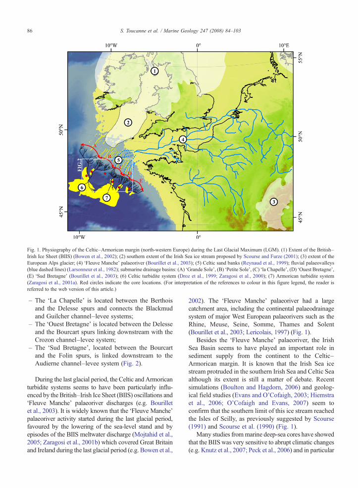
Fig. 1. Physiography of the Celtic–Armorican margin (north-western Europe) during the Last Glacial Maximum (LGM). (1) Extent of the British–Irish Ice Sheet (BIIS) (Bowen et al., 2002); (2) southern extent of the Irish Sea ice stream proposed by Scourse and Furze (2001); (3) extent of theEuropean Alps glacier; (4) ‘Fleuve Manche’ palaeoriver (Bourillet et al., 2003); (5) Celtic sand banks (Reynaud et al., 1999); fluvial palaeovalleys(blue dashed lines) (Larsonneur et al., 1982); submarine drainage basins: (A) ‘Grande Sole’, (B) ‘Petite Sole’, (C) ‘la Chapelle’, (D) ‘Ouest Bretagne’,(E) ‘Sud Bretagne’ (Bourillet et al., 2003); (6) Celtic turbidite system (Droz et al., 1999; Zaragosi et al., 2000); (7) Armorican turbidite system(Zaragosi et al., 2001a). Red circles indicate the core locations. (For interpretation of the references to colour in this figure legend, the reader isreferred to the web version of this article.)
86 S. Toucanne et al. / Marine Geology 247 (2008) 84–103
– The ‘La Chapelle’ is located between the Berthoisand the Delesse spurs and connects the Blackmudand Guilcher channel–levee systems;
– The ‘Ouest Bretagne’ is located between the Delesseand the Bourcart spurs linking downstream with theCrozon channel–levee system;
– The ‘Sud Bretagne’, located between the Bourcartand the Folin spurs, is linked downstream to theAudierne channel–levee system (Fig. 2).
During the last glacial period, the Celtic andArmoricanturbidite systems seems to have been particularly influ-enced by theBritish–Irish Ice Sheet (BIIS) oscillations and‘Fleuve Manche’ palaeoriver discharges (e.g. Bourilletet al., 2003). It is widely known that the ‘Fleuve Manche’palaeoriver activity started during the last glacial period,favoured by the lowering of the sea-level stand and byepisodes of the BIIS meltwater discharge (Mojtahid et al.,2005; Zaragosi et al., 2001b) which covered Great Britainand Ireland during the last glacial period (e.g. Bowen et al.,
2002). The ‘Fleuve Manche’ palaeoriver had a largecatchment area, including the continental palaeodrainagesystem of major West European palaeorivers such as theRhine, Meuse, Seine, Somme, Thames and Solent(Bourillet et al., 2003; Lericolais, 1997) (Fig. 1).
Besides the ‘Fleuve Manche’ palaeoriver, the IrishSea Basin seems to have played an important role insediment supply from the continent to the Celtic–Armorican margin. It is known that the Irish Sea icestream protruded in the southern Irish Sea and Celtic Seaalthough its extent is still a matter of debate. Recentsimulations (Boulton and Hagdorn, 2006) and geolog-ical field studies (Evans and O'Cofaigh, 2003; Hiemstraet al., 2006; O'Cofaigh and Evans, 2007) seem toconfirm that the southern limit of this ice stream reachedthe Isles of Scilly, as previously suggested by Scourse(1991) and Scourse et al. (1990) (Fig. 1).
Many studies frommarine deep-sea cores have showedthat the BIIS was very sensitive to abrupt climatic changes(e.g. Knutz et al., 2007; Peck et al., 2006) and in particular
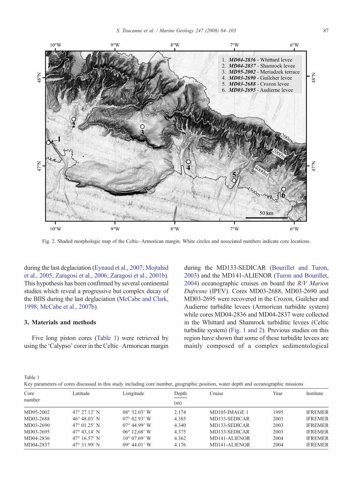
Fig. 2. Shaded morphologic map of the Celtic–Armorican margin. White circles and associated numbers indicate core locations.
87S. Toucanne et al. / Marine Geology 247 (2008) 84–103
during the last deglaciation (Eynaud et al., 2007; Mojtahidet al., 2005; Zaragosi et al., 2006; Zaragosi et al., 2001b).This hypothesis has been confirmed by several continentalstudies which reveal a progressive but complex decay ofthe BIIS during the last deglaciation (McCabe and Clark,1998; McCabe et al., 2007b).
3. Materials and methods
Five long piston cores (Table 1) were retrieved byusing the ‘Calypso’ corer in the Celtic–Armorican margin
Table 1Key parameters of cores discussed in this study including core number, geo
Corenumber
Latitude Longitude Dep
(m)
MD95-2002 47° 27.12′ N 08° 32.03′ W 2.17MD03-2688 46° 48.03′ N 07° 02.93′ W 4.38MD03-2690 47° 01.25′ N 07° 44.99′ W 4.34MD03-2695 47° 43,14′ N 06° 12,68′ W 4.37MD04-2836 47° 16.57′ N 10° 07.69′ W 4.36MD04-2837 47° 31.99′ N 09° 44.01' W 4.17
during the MD133-SEDICAR (Bourillet and Turon,2003) and the MD141-ALIENOR (Turon and Bourillet,2004) oceanographic cruises on board the R/V MarionDufresne (IPEV). Cores MD03-2688, MD03-2690 andMD03-2695 were recovered in the Crozon, Guilcher andAudierne turbidite levees (Armorican turbidite system)while cores MD04-2836 and MD04-2837 were collectedin the Whittard and Shamrock turbiditic levees (Celticturbidite system) (Fig. 1 and 2). Previous studies on thisregion have shown that some of these turbidite levees aremainly composed of a complex sedimentological
graphic position, water depth and oceanographic missions
th Cruise Year Institute
4 MD105-IMAGE 1 1995 IFREMER5 MD133-SEDICAR 2003 IFREMER0 MD133-SEDICAR 2003 IFREMER5 MD133-SEDICAR 2003 IFREMER2 MD141-ALIENOR 2004 IFREMER6 MD141-ALIENOR 2004 IFREMER
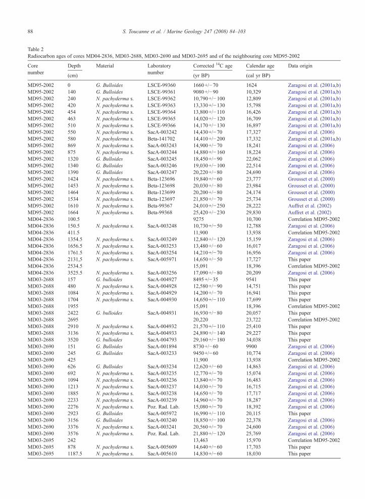
Table 2Radiocarbon ages of cores MD04-2836, MD03-2688, MD03-2690 and MD03-2695 and of the neighbouring core MD95-2002
Corenumber
Depth Material Laboratorynumber
Corrected 14C age Calendar age Data origin
(cm) (yr BP) (cal yr BP)
MD95-2002 0 G. Bulloides LSCE-99360 1660+/−70 1624 Zaragosi et al. (2001a,b)MD95-2002 140 G. Bulloides LSCE-99361 9080+/−90 10,329 Zaragosi et al. (2001a,b)MD95-2002 240 N. pachyderma s. LSCE-99362 10,790+/−100 12,809 Zaragosi et al. (2001a,b)MD95-2002 420 N. pachyderma s. LSCE-99363 13,330+/−130 15,798 Zaragosi et al. (2001a,b)MD95-2002 454 N. pachyderma s. LSCE-99364 13,800+/−110 16,426 Zaragosi et al. (2001a,b)MD95-2002 463 N. pachyderma s. LSCE-99365 14,020+/−120 16,709 Zaragosi et al. (2001a,b)MD95-2002 510 N. pachyderma s. LSCE-99366 14,170+/−130 16,897 Zaragosi et al. (2001a,b)MD95-2002 550 N. pachyderma s. SacA-003242 14,430+/−70 17,327 Zaragosi et al. (2006)MD95-2002 580 N. pachyderma s. Beta-141702 14,410+/−200 17,332 Zaragosi et al. (2001a,b)MD95-2002 869 N. pachyderma s. SacA-003243 14,900+/−70 18,241 Zaragosi et al. (2006)MD95-2002 875 N. pachyderma s. SacA-003244 14,880+/−160 18,224 Zaragosi et al. (2006)MD95-2002 1320 G. Bulloides SacA-003245 18,450+/−90 22,062 Zaragosi et al. (2006)MD95-2002 1340 G. Bulloides SacA-003246 19,030+/−100 22,514 Zaragosi et al. (2006)MD95-2002 1390 G. Bulloides SacA-003247 20,220+/−80 24,690 Zaragosi et al. (2006)MD95-2002 1424 N. pachyderma s. Beta-123696 19,840+/−60 23,777 Grousset et al. (2000)MD95-2002 1453 N. pachyderma s. Beta-123698 20,030+/−80 23,984 Grousset et al. (2000)MD95-2002 1464 N. pachyderma s. Beta-123699 20,200+/−80 24,174 Grousset et al. (2000)MD95-2002 1534 N. pachyderma s. Beta-123697 21,850+/−70 25,734 Grousset et al. (2000)MD95-2002 1610 N. pachyderma s. Beta-99367 24,010+/−250 28,222 Auffret et al. (2002)MD95-2002 1664 N. pachyderma s. Beta-99368 25,420+/−230 29,830 Auffret et al. (2002)MD04-2836 100.5 9275 10,700 Correlation MD95-2002MD04-2836 150.5 N. pachyderma s. SacA-003248 10,730+/−50 12,788 Zaragosi et al. (2006)MD04-2836 411.5 11,900 13,938 Correlation MD95-2002MD04-2836 1354.5 N. pachyderma s. SacA-003249 12,840+/−120 15,159 Zaragosi et al. (2006)MD04-2836 1656.5 N. pachyderma s. SacA-003253 13,480+/−60 16,017 Zaragosi et al. (2006)MD04-2836 1761.5 N. pachyderma s. SacA-003254 14,210+/−70 16,956 Zaragosi et al. (2006)MD04-2836 2131,5 N. pachyderma s. SacA-005971 14,650+/−50 17,727 This paperMD04-2836 2534.5 15,091 18,396 Correlation MD95-2002MD04-2836 3525.5 N. pachyderma s. SacA-003256 17,090+/−80 20,209 Zaragosi et al. (2006)MD03-2688 157 G. bulloides SacA-004927 8495+/−35 9541 This paperMD03-2688 480 N. pachyderma s. SacA-004928 12,580+/−90 14,751 This paperMD03-2688 1084 N. pachyderma s. SacA-004929 14,200+/−70 16,941 This paperMD03-2688 1704 N. pachyderma s. SacA-004930 14,650+/−110 17,699 This paperMD03-2688 1955 15,091 18,396 Correlation MD95-2002MD03-2688 2422 G. bulloides SacA-004931 16,930+/−80 20,057 This paperMD03-2688 2695 20,220 23,722 Correlation MD95-2002MD03-2688 2910 N. pachyderma s. SacA-004932 21,570+/−110 25,410 This paperMD03-2688 3136 N. pachyderma s. SacA-004933 24,890+/−140 29,227 This paperMD03-2688 3520 G. bulloides SacA-004793 29,160+/−180 34,038 This paperMD03-2690 151 G. Bulloides SacA-001894 8730+/−60 9900 Zaragosi et al. (2006)MD03-2690 245 G. Bulloides SacA-003233 9450+/−60 10,774 Zaragosi et al. (2006)MD03-2690 425 11,900 13,938 Correlation MD95-2002MD03-2690 626 G. Bulloides SacA-003234 12,620+/−60 14,863 Zaragosi et al. (2006)MD03-2690 692 N. pachyderma s. SacA-003235 12,770+/−70 15,074 Zaragosi et al. (2006)MD03-2690 1094 N. pachyderma s. SacA-003236 13,840+/−70 16,483 Zaragosi et al. (2006)MD03-2690 1213 N. pachyderma s. SacA-003237 14,030+/−70 16,715 Zaragosi et al. (2006)MD03-2690 1885 N. pachyderma s. SacA-003238 14,650+/−70 17,717 Zaragosi et al. (2006)MD03-2690 2233 N. pachyderma s. SacA-003239 14,960+/−70 18,287 Zaragosi et al. (2006)MD03-2690 2276 N. pachyderma s. Poz. Rad. Lab. 15,080+/−70 18,392 Zaragosi et al. (2006)MD03-2690 2923 G. Bulloides SacA-005972 16,990+/−110 20,115 This paperMD03-2690 3156 G. Bulloides SacA-003240 18,850+/−100 22,378 Zaragosi et al. (2006)MD03-2690 3376 N. pachyderma s. SacA-003241 20,560+/−70 24,600 Zaragosi et al. (2006)MD03-2690 3576 N. pachyderma s. Poz. Rad. Lab. 21,880+/−120 25,769 Zaragosi et al. (2006)MD03-2695 242 13,463 15,970 Correlation MD95-2002MD03-2695 878 N. pachyderma s. SacA-005609 14,640+/−60 17,703 This paperMD03-2695 1187.5 N. pachyderma s. SacA-005610 14,830+/−60 18,030 This paper
88 S. Toucanne et al. / Marine Geology 247 (2008) 84–103
Table 2 (continued)
Corenumber
Depth Material Laboratorynumber
Corrected 14C age Calendar age Data origin
(cm) (yr BP) (cal yr BP)
MD03-2695 1347 N. pachyderma s. SacA-005611 14,990+/−60 18,305 This paperMD03-2695 1420 15,091 18,396 Correlation MD95-2002MD03-2695 1991 N. pachyderma s. SacA-005612 17,130+/−70 20,248 This paperMD03-2695 2255 N. pachyderma s. SacA-005613 20,300+/−100 24,284 This paperMD03-2695 2393 22,028.2 26,032 Correlation MD95-2002MD03-2695 2444 N. pachyderma s. SacA-005614 25,600+/−150 30,034.4 This paperMD03-2695 2600 27,400 32,068 Elliot et al., 2001 (HE3)MD03-2695 2758 N. pachyderma s. SacA-005616 28,710+/−210 33,536.2 This paper
Radiocarbon ages of this study were performed at the ‘Laboratoire de Mesure du Carbone 14’ in Saclay (‘SacA’). Radiocarbon dates have beencorrected for a marine reservoir effect of 400 years and calibrated to calendar years using CALIB Rev 5.0/Marine04 data set (Hughen et al., 2004;Stuiver and Reimer, 1993; Stuiver et al., 2005) up to 21.78 14C ka and Bard et al. (1998) thereafter.
89S. Toucanne et al. / Marine Geology 247 (2008) 84–103
succession of turbiditic sequences alternating with ice-rafted laminae and hemipelagic layers (Zaragosi et al.,2006).
3.1. Chronostratigraphy
The age models for cores MD03-2688, MD03-2690,MD03-2695 and MD04-2836 have been determinedbased on foraminiferal stratigraphy, AMS dating and byusing additional control points from the reference coreMD95-2002 (Table 2). The age model of core MD95-2002 was based on 20 14C AMS ages spanning the last30 ka (Table 2) (Auffret et al., 2002; Grousset et al.,2000; Zaragosi et al., 2006; Zaragosi et al., 2001b).
Cores were sub-sampled with a sample spacing of 5to 20 cm for micropaleontological analysis along thehemipalegic layers. These hemipelagic layers are notcontaminated by reworked material and representintervals of continuous sedimentation. The subsampleswere then dried, weighed and washed through a 150 μmmesh sieve. At least 300 polar foraminifera Neoglobo-quadrina pachyderma (s.) were counted jointly with anumber of other planktonic species in order to determinethe relative abundances (%) of this polar species. Pre-vious studies on this region have shown the suitable useof N. pachyderma (s.) to reconstruct drastic sea surfacechanges which are stratigraphically contemporaneouswith major climatic events (Mojtahid et al., 2005; Pecket al., 2007; Zaragosi et al., 2001b).
Thirty four accelerator mass spectrometer (AMS) 14Cdates were obtained from cores MD03-2688, MD03-2690, MD03-2695 and MD04-2836 (Table 2).
3.2. Sedimentological analyses
The sedimentological analyses of the Celtic–Armor-ican deep-sea cores consist firstly of visual description
and X-ray analysis obtained with a SCOPIX imageprocessing tool (Migeon et al., 1999). Additionally, grain-size analysis were performed using a Malvern™ Super-sizer ‘S’. Finally, microscopical observations of about tenthin-sections (10 cm long) of impregnated sedimentsselected from well-preserved and representative sedimen-tary facies were performed using a fully automatedLeica™ DM6000B Digital Microscope. The last methodhas been recently detailed in Zaragosi et al. (2006).
In order to understand the activity of the Celtic andArmorican turbidite systems, we have detected and quan-tified the number of turbiditic deposits in the Whittard,Guilcher, Crozon and Audierne turbidite levees. For this,we firstly observed several thin-sections of impregnatedsediments representing distinctive alternated facies of ice-rafted, turbiditic deposits and hemipelagic layers (Fig. 3).Secondly, we have determined the criteria to distinguisheach facies viamicroscope andX-ray imagery. Finally, weapplied these criteria to distinguish each facies in all coresusing X-ray imagery. Indeed, microscopic observation ofIRD laminae reveals heterogeneous and scattered angularlithic grains within fine-bioturbated clay while fine (mm-thick) and slightly dark layers are observed in the X-rayimagery (Fig. 3). Turbiditic deposits are generally thicker(mm-thick to cm-thick) than IRD laminae and presentusually sharply eroded basal contacts. The progressivetransition from very dense (dark) contacts to a slightlylighter (grey) top of sequences, visible on X-ray imagery,is associated with the typical fining-up trend of turbiditicdeposits (Bouma, 1962; Stow and Piper, 1984) (Fig. 3).
Each turbiditic deposit of cores MD04-2836, MD03-2690, MD03-2688 and MD03-2695 has been countedusing X-ray imagery. Turbidites have not been counted incore MD04-2837 because this record presents importantdisturbances linked to coring stretching. Following this,we have quantified the turbidite deposit frequency on theWhittard, Guilcher, Crozon and Audierne levees per
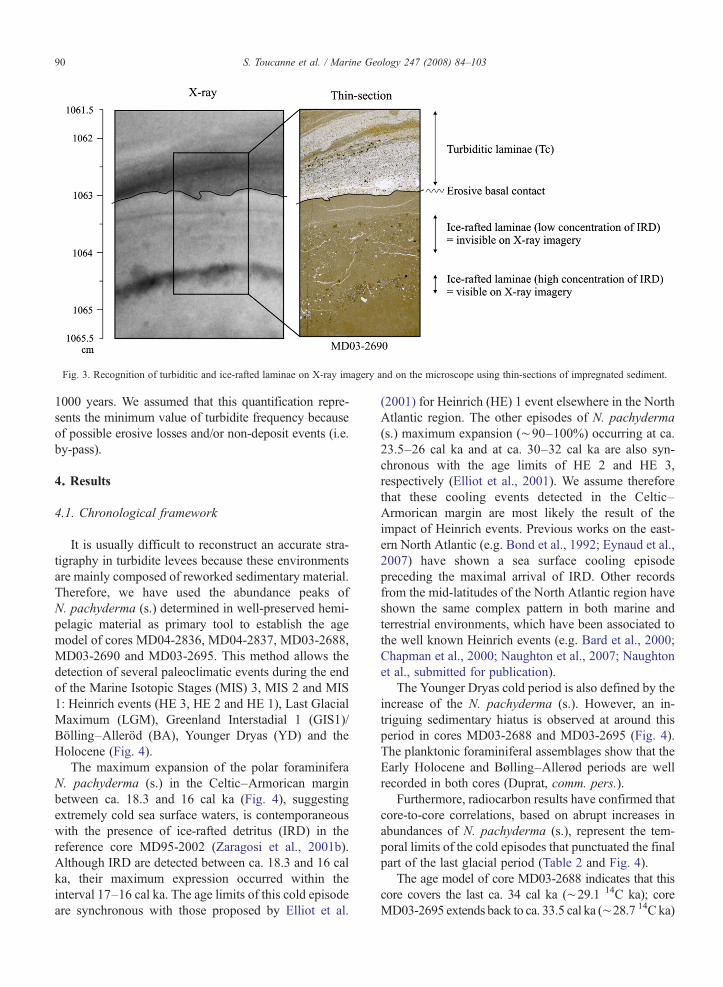
Fig. 3. Recognition of turbiditic and ice-rafted laminae on X-ray imagery and on the microscope using thin-sections of impregnated sediment.
90 S. Toucanne et al. / Marine Geology 247 (2008) 84–103
1000 years. We assumed that this quantification repre-sents the minimum value of turbidite frequency becauseof possible erosive losses and/or non-deposit events (i.e.by-pass).
4. Results
4.1. Chronological framework
It is usually difficult to reconstruct an accurate stra-tigraphy in turbidite levees because these environmentsare mainly composed of reworked sedimentary material.Therefore, we have used the abundance peaks ofN. pachyderma (s.) determined in well-preserved hemi-pelagic material as primary tool to establish the agemodel of cores MD04-2836, MD04-2837, MD03-2688,MD03-2690 and MD03-2695. This method allows thedetection of several paleoclimatic events during the endof the Marine Isotopic Stages (MIS) 3, MIS 2 and MIS1: Heinrich events (HE 3, HE 2 and HE 1), Last GlacialMaximum (LGM), Greenland Interstadial 1 (GIS1)/Bölling–Alleröd (BA), Younger Dryas (YD) and theHolocene (Fig. 4).
The maximum expansion of the polar foraminiferaN. pachyderma (s.) in the Celtic–Armorican marginbetween ca. 18.3 and 16 cal ka (Fig. 4), suggestingextremely cold sea surface waters, is contemporaneouswith the presence of ice-rafted detritus (IRD) in thereference core MD95-2002 (Zaragosi et al., 2001b).Although IRD are detected between ca. 18.3 and 16 calka, their maximum expression occurred within theinterval 17–16 cal ka. The age limits of this cold episodeare synchronous with those proposed by Elliot et al.
(2001) for Heinrich (HE) 1 event elsewhere in the NorthAtlantic region. The other episodes of N. pachyderma(s.) maximum expansion (∼90–100%) occurring at ca.23.5–26 cal ka and at ca. 30–32 cal ka are also syn-chronous with the age limits of HE 2 and HE 3,respectively (Elliot et al., 2001). We assume thereforethat these cooling events detected in the Celtic–Armorican margin are most likely the result of theimpact of Heinrich events. Previous works on the east-ern North Atlantic (e.g. Bond et al., 1992; Eynaud et al.,2007) have shown a sea surface cooling episodepreceding the maximal arrival of IRD. Other recordsfrom the mid-latitudes of the North Atlantic region haveshown the same complex pattern in both marine andterrestrial environments, which have been associated tothe well known Heinrich events (e.g. Bard et al., 2000;Chapman et al., 2000; Naughton et al., 2007; Naughtonet al., submitted for publication).
The Younger Dryas cold period is also defined by theincrease of the N. pachyderma (s.). However, an in-triguing sedimentary hiatus is observed at around thisperiod in cores MD03-2688 and MD03-2695 (Fig. 4).The planktonic foraminiferal assemblages show that theEarly Holocene and Bølling–Allerød periods are wellrecorded in both cores (Duprat, comm. pers.).
Furthermore, radiocarbon results have confirmed thatcore-to-core correlations, based on abrupt increases inabundances of N. pachyderma (s.), represent the tem-poral limits of the cold episodes that punctuated the finalpart of the last glacial period (Table 2 and Fig. 4).
The age model of core MD03-2688 indicates that thiscore covers the last ca. 34 cal ka (∼29.1 14C ka); coreMD03-2695 extends back to ca. 33.5 cal ka (∼28.7 14C ka)
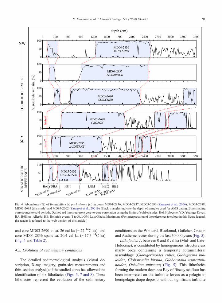
Fig. 4. Abundance (%) of foraminifera N. pachyderma (s.) in cores MD04-2836, MD04-2837, MD03-2690 (Zaragosi et al., 2006), MD03-2688,MD03-2695 (this study) and MD95-2002 (Zaragosi et al., 2001b). Black triangles indicate the depth of samples used for AMS dating. Blue shadingcorresponds to cold periods. Dashed red lines represent core-to-core correlation using the limits of cold episodes. Hol: Holocene, YD: Younger Dryas,BA: Bölling–Alleröd, HE: Heinrich events (1 to 3), LGM: Last Glacial Maximum. (For interpretation of the references to colour in this figure legend,the reader is referred to the web version of this article.)
91S. Toucanne et al. / Marine Geology 247 (2008) 84–103
and core MD03-2690 to ca. 26 cal ka (∼22 14C ka); andcore MD04-2836 spans ca. 20.4 cal ka (∼17.3 14C ka)(Fig. 4 and Table 2).
4.2. Evolution of sedimentary conditions
The detailed sedimentological analysis (visual de-scription, X-ray imagery, grain-size measurements andthin-section analysis) of the studied cores has allowed theidentification of six lithofacies (Figs. 5, 7 and 8). Theselithofacies represent the evolution of the sedimentary
conditions on the Whittard, Blackmud, Guilcher, Crozonand Audierne levees during the last 30,000 years (Fig. 5):
Lithofacies 1, between 0 and 8 cal ka (Mid- and Late-Holocene), is constituted by homogeneous, structurelessmarly ooze containing a temperate foraminiferalassemblage (Globigerinoides ruber, Globigerina bul-loides, Globorotalia hirsuta, Globorotalia truncatuli-noides, Orbulina universa) (Fig. 5). This lithofaciesforming the modern deep-sea Bay of Biscay seafloor hasbeen interpreted on the turbidite levees as a pelagic tohemipelagic drape deposits without significant turbidite
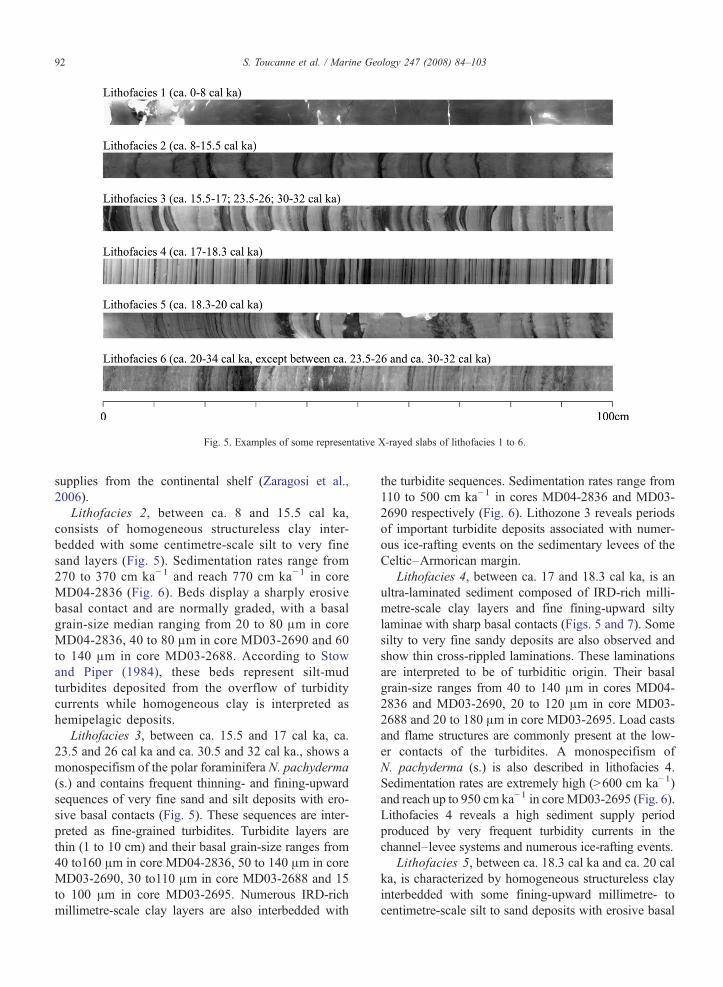
Fig. 5. Examples of some representative X-rayed slabs of lithofacies 1 to 6.
92 S. Toucanne et al. / Marine Geology 247 (2008) 84–103
supplies from the continental shelf (Zaragosi et al.,2006).
Lithofacies 2, between ca. 8 and 15.5 cal ka,consists of homogeneous structureless clay inter-bedded with some centimetre-scale silt to very finesand layers (Fig. 5). Sedimentation rates range from270 to 370 cm ka− 1 and reach 770 cm ka− 1 in coreMD04-2836 (Fig. 6). Beds display a sharply erosivebasal contact and are normally graded, with a basalgrain-size median ranging from 20 to 80 μm in coreMD04-2836, 40 to 80 μm in core MD03-2690 and 60to 140 μm in core MD03-2688. According to Stowand Piper (1984), these beds represent silt-mudturbidites deposited from the overflow of turbiditycurrents while homogeneous clay is interpreted ashemipelagic deposits.
Lithofacies 3, between ca. 15.5 and 17 cal ka, ca.23.5 and 26 cal ka and ca. 30.5 and 32 cal ka., shows amonospecifism of the polar foraminifera N. pachyderma(s.) and contains frequent thinning- and fining-upwardsequences of very fine sand and silt deposits with ero-sive basal contacts (Fig. 5). These sequences are inter-preted as fine-grained turbidites. Turbidite layers arethin (1 to 10 cm) and their basal grain-size ranges from40 to160 μm in core MD04-2836, 50 to 140 μm in coreMD03-2690, 30 to110 μm in core MD03-2688 and 15to 100 μm in core MD03-2695. Numerous IRD-richmillimetre-scale clay layers are also interbedded with
the turbidite sequences. Sedimentation rates range from110 to 500 cm ka−1 in cores MD04-2836 and MD03-2690 respectively (Fig. 6). Lithozone 3 reveals periodsof important turbidite deposits associated with numer-ous ice-rafting events on the sedimentary levees of theCeltic–Armorican margin.
Lithofacies 4, between ca. 17 and 18.3 cal ka, is anultra-laminated sediment composed of IRD-rich milli-metre-scale clay layers and fine fining-upward siltylaminae with sharp basal contacts (Figs. 5 and 7). Somesilty to very fine sandy deposits are also observed andshow thin cross-rippled laminations. These laminationsare interpreted to be of turbiditic origin. Their basalgrain-size ranges from 40 to 140 μm in cores MD04-2836 and MD03-2690, 20 to 120 μm in core MD03-2688 and 20 to 180 μm in core MD03-2695. Load castsand flame structures are commonly present at the low-er contacts of the turbidites. A monospecifism ofN. pachyderma (s.) is also described in lithofacies 4.Sedimentation rates are extremely high (N600 cm ka−1)and reach up to 950 cm ka−1 in coreMD03-2695 (Fig. 6).Lithofacies 4 reveals a high sediment supply periodproduced by very frequent turbidity currents in thechannel–levee systems and numerous ice-rafting events.
Lithofacies 5, between ca. 18.3 cal ka and ca. 20 calka, is characterized by homogeneous structureless clayinterbedded with some fining-upward millimetre- tocentimetre-scale silt to sand deposits with erosive basal
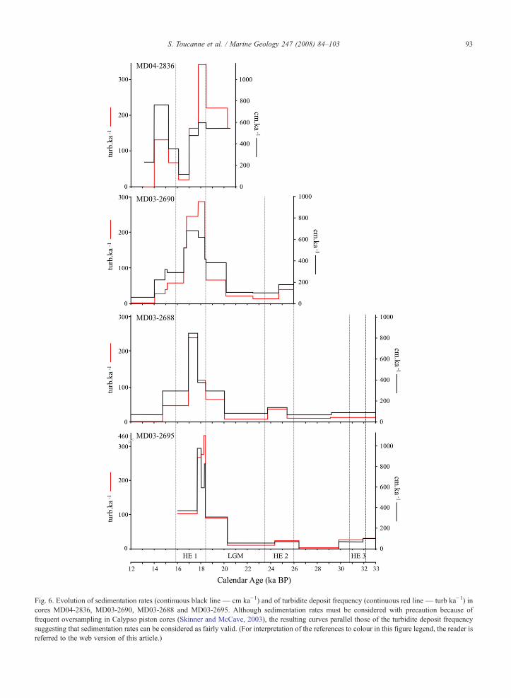
Fig. 6. Evolution of sedimentation rates (continuous black line — cm ka−1) and of turbidite deposit frequency (continuous red line — turb ka−1) incores MD04-2836, MD03-2690, MD03-2688 and MD03-2695. Although sedimentation rates must be considered with precaution because offrequent oversampling in Calypso piston cores (Skinner and McCave, 2003), the resulting curves parallel those of the turbidite deposit frequencysuggesting that sedimentation rates can be considered as fairly valid. (For interpretation of the references to colour in this figure legend, the reader isreferred to the web version of this article.)
93S. Toucanne et al. / Marine Geology 247 (2008) 84–103
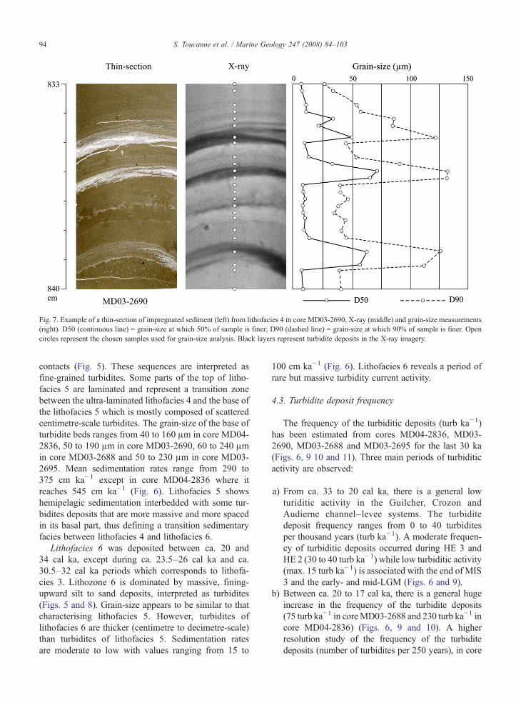
Fig. 7. Example of a thin-section of impregnated sediment (left) from lithofacies 4 in core MD03-2690, X-ray (middle) and grain-size measurements(right). D50 (continuous line) = grain-size at which 50% of sample is finer; D90 (dashed line) = grain-size at which 90% of sample is finer. Opencircles represent the chosen samples used for grain-size analysis. Black layers represent turbidite deposits in the X-ray imagery.
94 S. Toucanne et al. / Marine Geology 247 (2008) 84–103
contacts (Fig. 5). These sequences are interpreted asfine-grained turbidites. Some parts of the top of litho-facies 5 are laminated and represent a transition zonebetween the ultra-laminated lithofacies 4 and the base ofthe lithofacies 5 which is mostly composed of scatteredcentimetre-scale turbidites. The grain-size of the base ofturbidite beds ranges from 40 to 160 μm in core MD04-2836, 50 to 190 μm in core MD03-2690, 60 to 240 μmin core MD03-2688 and 50 to 230 μm in core MD03-2695. Mean sedimentation rates range from 290 to375 cm ka−1 except in core MD04-2836 where itreaches 545 cm ka−1 (Fig. 6). Lithofacies 5 showshemipelagic sedimentation interbedded with some tur-bidites deposits that are more massive and more spacedin its basal part, thus defining a transition sedimentaryfacies between lithofacies 4 and lithofacies 6.
Lithofacies 6 was deposited between ca. 20 and34 cal ka, except during ca. 23.5–26 cal ka and ca.30.5–32 cal ka periods which corresponds to lithofa-cies 3. Lithozone 6 is dominated by massive, fining-upward silt to sand deposits, interpreted as turbidites(Figs. 5 and 8). Grain-size appears to be similar to thatcharacterising lithofacies 5. However, turbidites oflithofacies 6 are thicker (centimetre to decimetre-scale)than turbidites of lithofacies 5. Sedimentation ratesare moderate to low with values ranging from 15 to
100 cm ka−1 (Fig. 6). Lithofacies 6 reveals a period ofrare but massive turbidity current activity.
4.3. Turbidite deposit frequency
The frequency of the turbiditic deposits (turb ka−1)has been estimated from cores MD04-2836, MD03-2690, MD03-2688 and MD03-2695 for the last 30 ka(Figs. 6, 9 10 and 11). Three main periods of turbiditicactivity are observed:
a) From ca. 33 to 20 cal ka, there is a general lowturiditic activity in the Guilcher, Crozon andAudierne channel–levee systems. The turbiditedeposit frequency ranges from 0 to 40 turbiditesper thousand years (turb ka−1). A moderate frequen-cy of turbiditic deposits occurred during HE 3 andHE 2 (30 to 40 turb ka−1) while low turbiditic activity(max. 15 turb ka−1) is associated with the end of MIS3 and the early- and mid-LGM (Figs. 6 and 9).
b) Between ca. 20 to 17 cal ka, there is a general hugeincrease in the frequency of the turbidite deposits(75 turb ka−1 in coreMD03-2688 and 230 turb ka−1 incore MD04-2836) (Figs. 6, 9 and 10). A higherresolution study of the frequency of the turbiditedeposits (number of turbidites per 250 years), in core
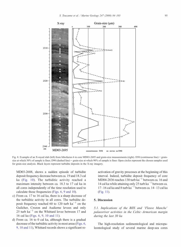
Fig. 8. Example of an X-rayed slab (left) from lithofacies 6 in core MD03-2695 and grain-size measurements (right). D50 (continuous line) = grain-size at which 50% of sample is finer; D90 (dashed line) = grain-size at which 90% of sample is finer. Open circles represent the chosen samples usedfor grain-size analysis. Black layers represent turbidite deposits in the X-ray imagery.
95S. Toucanne et al. / Marine Geology 247 (2008) 84–103
MD03-2688, shows a sudden episode of turbiditedeposit frequency decrease between ca. 19 and 18.3 calka (Fig. 10). The turbiditic activity reached amaximum intensity between ca. 18.3 to 17 cal ka inall cores independently of the time resolution used tocalculate those frequencies (Figs. 6, 9 and 10).
c) From ca. 17 to 16 cal ka, there is a sharp decrease ofthe turbiditic activity in all cores. The turbidite de-posit frequency reached 60 to 120 turb ka−1 on theGuilcher, Crozon and Audierne levees and only25 turb ka−1 on the Whittard levee between 17 and16 cal ka (Figs. 6, 9, 10 and 11).
d) From ca. 16 to 0 cal ka, although there is a gradualdecrease of the turbiditic activity inmost areas (Figs. 6,9, 10 and 11), Whittard records shows a significant re-
activation of gravity processes at the beginning of thisinterval. Indeed, turbidite deposit frequency of coreMD04-2836 reaches 130 turb ka−1 between ca. 16 and14 cal kawhile attaining only 25 turb ka−1 between ca.17–16 cal ka and 8 turb ka−1 between ca. 14–13 cal ka(Fig. 11).
5. Discussion
5.1. Implications of the BIIS and ‘Fleuve Manche’palaeoriver activities in the Celtic–Armorican marginduring the last 30 ka
The high-resolution sedimentological and micropa-leontological study of several marine deep-sea cores
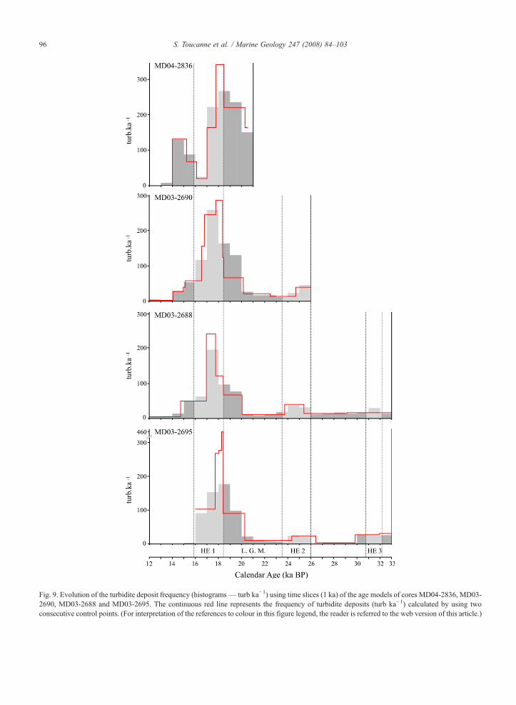
Fig. 9. Evolution of the turbidite deposit frequency (histograms— turb ka−1) using time slices (1 ka) of the age models of cores MD04-2836, MD03-2690, MD03-2688 and MD03-2695. The continuous red line represents the frequency of turbidite deposits (turb ka−1) calculated by using twoconsecutive control points. (For interpretation of the references to colour in this figure legend, the reader is referred to the web version of this article.)
96 S. Toucanne et al. / Marine Geology 247 (2008) 84–103
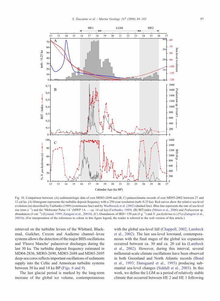
Fig. 10. Comparison between: (A) sedimentologic data of core MD03-2690 and (B, C) palaeoclimatic records of core MD95-2002 between 27 and12 cal ka. (A) Histogram represents the turbidite deposit frequency with a 250-year resolution (turb./0.25 ka). Red curves show the relative sea-levelevolution (m) described by Fairbanks (1989) (continuous line) and by Waelbroeck et al. (2002) (dashed line). Blue line represents the rate of sea-levelrise (mm a−1) and the ‘Meltwater Pulse 1A’ (MWP 1A — ca. 14 cal ka) (Fairbanks, 1989). (B) BIT-index (Ménot et al., 2006) and Pediastrum sp.abundances (# cm−3) (Eynaud, 1999; Zaragosi et al., 2001b). (C) Abundances of IRDN150 μm (# g−1) and N. pachyderma (s.) (%) (Zaragosi et al.,2001b). (For interpretation of the references to colour in this figure legend, the reader is referred to the web version of this article.)
97S. Toucanne et al. / Marine Geology 247 (2008) 84–103
retrieved on the turbidite levees of the Whittard, Black-mud, Guilcher, Crozon and Audierne channel–leveesystems allows the detection of themajor BIIS oscillationsand ‘Fleuve Manche’ palaeoriver discharges during thelast 30 ka. The turbidite deposit frequency estimated inMD04-2836, MD03-2690, MD03-2688 andMD03-2695deep-sea cores reflects important oscillations of sedimentssupply into the Celtic and Armorican turbidite systemsbetween 30 ka and 14 ka BP (Figs. 6 and 9).
The last glacial period is marked by the long-termincrease of the global ice volume, contemporaneous
with the global sea-level fall (Chappell, 2002; Lambecket al., 2002). The last sea-level lowstand, contempora-neous with the final stages of the global ice expansionoccurred between ca. 30 and ca. 20 cal ka (Lambecket al., 2002). However, during this interval, severalmillennial-scale climate oscillations have been observedin both Greenland and North Atlantic records (Bondet al., 1993; Dansgaard et al., 1993) producing sub-stantial sea-level changes (Siddall et al., 2003). In thiswork, we define the LGM as a period of relatively stableclimate that occurred between HE 2 and HE 1 following
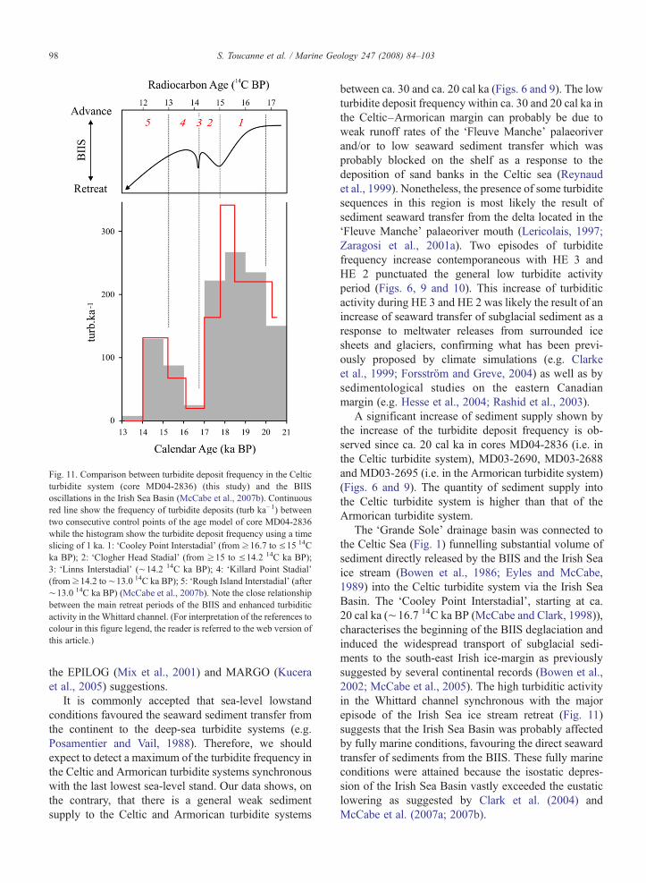
Fig. 11. Comparison between turbidite deposit frequency in the Celticturbidite system (core MD04-2836) (this study) and the BIISoscillations in the Irish Sea Basin (McCabe et al., 2007b). Continuousred line show the frequency of turbidite deposits (turb ka−1) betweentwo consecutive control points of the age model of core MD04-2836while the histogram show the turbidite deposit frequency using a timeslicing of 1 ka. 1: ‘Cooley Point Interstadial’ (from ≥16.7 to ≤15 14Cka BP); 2: ‘Clogher Head Stadial’ (from ≥15 to ≤14.2 14C ka BP);3: ‘Linns Interstadial’ (∼14.2 14C ka BP); 4: ‘Killard Point Stadial’(from≥14.2 to∼13.0 14C ka BP); 5: ‘Rough Island Interstadial’ (after∼13.0 14C ka BP) (McCabe et al., 2007b). Note the close relationshipbetween the main retreat periods of the BIIS and enhanced turbiditicactivity in the Whittard channel. (For interpretation of the references tocolour in this figure legend, the reader is referred to the web version ofthis article.)
98 S. Toucanne et al. / Marine Geology 247 (2008) 84–103
the EPILOG (Mix et al., 2001) and MARGO (Kuceraet al., 2005) suggestions.
It is commonly accepted that sea-level lowstandconditions favoured the seaward sediment transfer fromthe continent to the deep-sea turbidite systems (e.g.Posamentier and Vail, 1988). Therefore, we shouldexpect to detect a maximum of the turbidite frequency inthe Celtic and Armorican turbidite systems synchronouswith the last lowest sea-level stand. Our data shows, onthe contrary, that there is a general weak sedimentsupply to the Celtic and Armorican turbidite systems
between ca. 30 and ca. 20 cal ka (Figs. 6 and 9). The lowturbidite deposit frequency within ca. 30 and 20 cal ka inthe Celtic–Armorican margin can probably be due toweak runoff rates of the ‘Fleuve Manche’ palaeoriverand/or to low seaward sediment transfer which wasprobably blocked on the shelf as a response to thedeposition of sand banks in the Celtic sea (Reynaudet al., 1999). Nonetheless, the presence of some turbiditesequences in this region is most likely the result ofsediment seaward transfer from the delta located in the‘Fleuve Manche’ palaeoriver mouth (Lericolais, 1997;Zaragosi et al., 2001a). Two episodes of turbiditefrequency increase contemporaneous with HE 3 andHE 2 punctuated the general low turbidite activityperiod (Figs. 6, 9 and 10). This increase of turbiditicactivity during HE 3 and HE 2 was likely the result of anincrease of seaward transfer of subglacial sediment as aresponse to meltwater releases from surrounded icesheets and glaciers, confirming what has been previ-ously proposed by climate simulations (e.g. Clarkeet al., 1999; Forsström and Greve, 2004) as well as bysedimentological studies on the eastern Canadianmargin (e.g. Hesse et al., 2004; Rashid et al., 2003).
A significant increase of sediment supply shown bythe increase of the turbidite deposit frequency is ob-served since ca. 20 cal ka in cores MD04-2836 (i.e. inthe Celtic turbidite system), MD03-2690, MD03-2688and MD03-2695 (i.e. in the Armorican turbidite system)(Figs. 6 and 9). The quantity of sediment supply intothe Celtic turbidite system is higher than that of theArmorican turbidite system.
The ‘Grande Sole’ drainage basin was connected tothe Celtic Sea (Fig. 1) funnelling substantial volume ofsediment directly released by the BIIS and the Irish Seaice stream (Bowen et al., 1986; Eyles and McCabe,1989) into the Celtic turbidite system via the Irish SeaBasin. The ‘Cooley Point Interstadial’, starting at ca.20 cal ka (∼16.7 14C ka BP (McCabe and Clark, 1998)),characterises the beginning of the BIIS deglaciation andinduced the widespread transport of subglacial sedi-ments to the south-east Irish ice-margin as previouslysuggested by several continental records (Bowen et al.,2002; McCabe et al., 2005). The high turbiditic activityin the Whittard channel synchronous with the majorepisode of the Irish Sea ice stream retreat (Fig. 11)suggests that the Irish Sea Basin was probably affectedby fully marine conditions, favouring the direct seawardtransfer of sediments from the BIIS. These fully marineconditions were attained because the isostatic depres-sion of the Irish Sea Basin vastly exceeded the eustaticlowering as suggested by Clark et al. (2004) andMcCabe et al. (2007a; 2007b).
99S. Toucanne et al. / Marine Geology 247 (2008) 84–103
Although the turbidite deposit frequency in the Ar-morican turbidite system is lower than that recorded inthe Celtic system, an increase of the turbiditic activityhas been also detected in cores MD03-2690, MD03-2688and MD03-2695 at around 20 cal ka (Figs. 6, 9 and 10).This increase of the turbidite deposit frequency in theArmorican turbidite system suggests the strengthening ofthe ‘Fleuve Manche’ palaeoriver discharges at around20 cal ka. Seismic records from this region show thepresence of Neogene fluvial palaeovalleys in the present-day shelf (Fig. 1), between the ‘Fleuve Manche’ palae-oriver and canyons of the Armorican margin (Bourilletet al., 2003). This suggests that these sub-environmentswere directly connected in the past, favouring the greatseaward transfer of sediments from the ‘Fleuve Manche’palaeoriver via the numerous canyons which composedthe ‘La Chapelle’, ‘Ouest Bretagne’ and ‘Sud Bretagne’drainage basins (Figs. 1 and 2). Furthermore, previousstudies on this region detected an increase of Pediastrumsp. concentration (freshwater alga) (Zaragosi et al.,2001b) and of BIT-index (Branched and IsoprenoidTetraether) (Ménot et al., 2006) reflecting the introductionof high quantities of fluvial terrestrial organic material inthe Armoricanmargin contemporaneous with the increaseof turbiditic activity in this area (Fig. 10). Additionally,recent simulations have shown that tides and tidal currentsof the Celtic–Armorican shelf also contributed to theseaward transfer of continental material between 20 and10 ka (Uehara et al., 2006).
The strengthening of the ‘Fleuve Manche’ palaeori-ver discharges was probably induced by the retreat ofthe BIIS, the European glaciers and the south-westernpart of the Fennoscandian ice sheet. The well knownepisodes of glacier decay in Scandinavia (Rinterknechtet al., 2006), Poland (Marks, 2002) and in the EuropeanAlps (Hinderer, 2001; Ivy-Ochs et al., 2004) at aroundca. 20 cal ka corroborate our hypothesis.
The retreat and melting of the European ice sheetsand glaciers at ca. 20 cal ka contributed to an abrupt sea-level rise, known as a ‘meltwater pulse’ at around 19 calka (19-ka MWP) (Clark et al., 2004; Yokoyama et al.,2000). This abrupt episode lasted 500 years and sea-level rise amounted to over 15 m (Yokoyama et al.,2000) favouring the trapping of sediments in the ‘FleuveManche’ palaeoriver valleys. Synchronously, the de-crease of both BIT-index and Pediastrum sp. concen-tration in the neighbouring core (MD95-2002) (Ménotet al., 2006; Zaragosi et al., 2001b) (Fig. 10) suggests adecrease of continentally-derived material to the Ar-morican margin, also supporting the idea of reduced‘Fleuve Manche’ discharges in the northern part of theBay of Biscay.
Following this, the observed abrupt increase of sed-iment supply in the Celtic and Armorican turbidite sys-tems at ca. 18.3 cal ka (Figs. 6, 9, 10 and 11) was mostlikely the result of a seaward sediment transfer increasefrom the south-east Irish ice-margin and an intensifica-tion of the ‘Fleuve Manche’ palaeoriver runoff, re-spectively. In the Armorican turbidite system, thehighest turbidite deposit frequency is synchronouswith the maximal arrival of continental material asdemonstrated by BIT-index (Ménot et al., 2006) andPediastrum sp. concentration (Zaragosi et al., 2001b)(Fig. 10). This suggests that the ‘Fleuve Manche’discharges increased drastically at around 18.3 cal kaconfirming what has been previously proposed byZaragosi et al. (2001b) and Ménot et al. (2006). Thisepisode of high riverine discharges, occurring at ca.18.3 cal ka, was clearly more intense than that char-acterizing the beginning of the deglaciation (ca. 20 cal ka)(Figs. 6, 9 and 10) and was also likely the result of theEuropean glacier retreat. Several studies have shown thatimportant environmental changes leading to a substantialretreat of the BIIS occurred in the north and north-westernUK margin (Knutz et al., 2002a; Knutz et al., 2002b;Wilson et al., 2002), contemporaneouswith themaximumdecay of the Fennoscandian ice sheet at ca. 18.3 cal ka(Dahlgren and Vorren, 2003; Lekens et al., 2005; Nygardet al., 2004). The deposition of one ultra-laminated faciesin the Celtic–Armorican margin between ca. 18.3 cal kaand 17 cal ka (lithofacies 4 — Fig. 5) reveals that asignificant environmental change has had an impact innorthern and southern part of the glacially-influencedEuropean margin. This facies has been recognized asmarine ‘varves’ resulting from episodic cycles betweenmeltwater discharges and iceberg calving (Zaragosi et al.,2006).
Between ca. 17.5 and 16 cal ka, there was a decreaseof the turbiditic activity in the Celtic turbidite system(Figs. 6, 9 and 11) which was contemporaneous with thetwo main general re-advance phases of the BIIS: the‘Clogher Head’ and ‘Killard Point’ stadials (after 15 anduntil ∼13 14C ka BP), detected in the northern Irish SeaBasin by McCabe et al. (2007b). This suggests thatsubglacial material transfer from the BIIS to the ‘GrandeSole’ drainage basin was most likely reduced during re-advance episodes of the BIIS. Theses episodes weresynchronous with the re-advance of the Fennoscandianice sheet and central European glaciers (Alps, Jura)(Buoncristiani and Campy, 2004; Everest et al., 2006;Ivy-Ochs et al., 2006; Knies et al., 2007). The rapiddecrease of the turbidite deposit frequency in theArmorican turbidite system (Figs. 6, 9 and 10) revealsa substantial decrease of the ‘Fleuve Manche’
100 S. Toucanne et al. / Marine Geology 247 (2008) 84–103
palaeoriver runoff, in response to the episodic ‘pause’ ofthe last deglaciation.
The resumption of the last deglaciation is particularlywell expressed in the Celtic turbidite system recordduring the well known Bölling–Alleröd episode. In-deed, the last major decay of the BIIS, associated withthe ‘Stagnation Zone Retreat’ and the ‘Rough IslandInterstadial’ episodes detected in the northern Irish SeaBasin (McCabe et al., 2005; McCabe et al., 2007b),induced a relatively huge increase of the turbiditicactivity in the Celtic turbidite system, between ca. 16and 14 cal ka (Fig. 11). Besides the last stages of theBIIS decay, the Celtic–Armorican margin was alsoaffected by a rapid and sustained rise of the global sea-level from 16 to 12.5 cal ka (Lambeck et al., 2002).Indeed, the cessation of turbiditic activity on the Celtic–Armorican margin occurred during or after the episodeof maximum sea-level rise (Fig. 10), known as the‘Meltwater Pulse 1A’ (MWP 1A — ca. 14 cal ka)(Fairbanks, 1989) contributing to the disappearance ofthe ‘Fleuve Manche’ palaeoriver. Moreover, the increaseof dry conditions in Europe during the Younger Dryas ataround 13 cal ka (e.g. Watts, 1980) also decreased theseaward transfer of fluvially-derived sediment onto theCeltic–Armorican margin.
The comparison of the turbiditic activity between theCeltic turbidite system and the Laurentian Fan, whichextends at the outlet of the Laurentide Ice Sheet (LIS)(Skene and Piper, 2003), reveals a similar sedimentarypattern over the last deglaciation. Two main phases ofturbidite deposition occurred at the end of the LGM andafter ca.16 cal ka, bracketing a huge reduction of sed-iment supply at around 16.5 cal ka. Despite a short timelag between the BIIS and the LIS oscillations over thelast deglaciation (McCabe and Clark, 1998), thesimilarity of both turbiditic records from the LaurentianFan and the Celtic system suggests that seaward transferof glacially-derived material to the deep-sea NorthAtlantic have been clearly forced by the combined effectof global climate changes and amphi-North Atlantic icesheets oscillations for at least the last 20,000 years.
6. Conclusions
The high-resolution sedimentological (includingturbidite frequency analysis) and micropaleontologicalstudies performed in the Celtic–Armorican margindocument the evolution of the turbidite systems in thisregion over the last 30,000 years. Changes in thefrequency of turbidite deposits in the Celtic–Armoricanmargin were mainly triggered by the British–Irish IceSheet (BIIS) and European glaciers oscillations (ad-
vance and retreat episodes). The retreat of the BIIS andEuropean glaciers favoured the transfer of continentally-derived material via the Irish Sea ice stream and the‘Fleuve Manche’ palaeoriver into the Celtic and theArmorican systems respectively. Inversely, the BIIS andEuropean glaciers advances preclude the introduction oflarge amounts of meltwater into the ‘Fleuve Manche’palaeoriver, reducing drastically the seaward transfer ofsediments in the Bay of Biscay. This evidence, con-trasting with stratigraphic models which predict thatturbidite systems are mainly controlled by sea-levelchanges, confirms that glacially-influenced turbiditesystems are largely controlled by ice sheets and glaciersoscillations. However, the synchronicity between turbi-dite deposit frequency reduction and the abrupt melt-water pulse episode (19-ka MWP) suggests that thisdrastic sea-level rise would have favoured the trappingof sediments in the ‘Fleuve Manche’ palaeoriver. Sim-ilarly, after the last stage of the BIIS decay a secondsudden episode of sea-level rise (MWP 1A) contributedto the end of the ‘Fleuve Manche’ palaeoriver dischargesand consequent turbiditic activity in the Celtic–Ar-morican margin.
Acknowledgements
The authors warmly thank G. Chabaud, G. Floch, R.Kerbrat, B. Martin, M. Rovere, J. Saint Paul and O. Therfor their technical support and J. Duprat and A. Van Toerfor their useful assistance to the biostratigraphicapproach. We thank also G. Ménot for data of theBIT-index; P. De Deckker, M. Gaudin and M.F. SánchezGoñi for valuable comments and language improve-ment; and the crew and scientific teams of MD133/SEDICAR and MD141/ALIENOR cruises on the ‘R/VMarion Dufresne’ (IPEV) for the recovery of the longpiston cores. We acknowledge financial support by theFrench Programme ‘GDR MARGES’ and ‘RELIEFSDE LA TERRE’, the ‘ARTEMIS’ 14C AMS FrenchProject and the ANR ‘IDEGLACE’. We finallyacknowledge A.M. McCabe, J.D. Scourse and EditorD.J.W. Piper for their helpful comments which greatlyimproved this paper. This is an UMR 5805 ‘EPOC’(Bordeaux 1 University — CNRS) contribution no.1637.
References
Auffret, G., Zaragosi, S., Dennielou, B., Cortijo, E., Van Rooij, D.,Grousset, F., Pujol, C., Eynaud, F., Siegert, M., 2002. Terrigenousfluxes at the Celtic margin during the last glacial cycle. MarineGeology 188 (1-2), 79–108.
101S. Toucanne et al. / Marine Geology 247 (2008) 84–103
Bard, E., 1998. Geochemical and geophysical implications of theradiocarbon calibration. Geochimica Cosmochimica Acta 62,2025–2038.
Bard, E., Rostek, F., Turon, J.L., Gendreau, S., 2000. Hydrologicalimpact of Heinrich events in the subtropical Northeast Atlantic.Science 289, 1321–1324.
Bond, G., Heinrich, H., Broecker, W., Labeyrie, L., McManus, J.,Andrews, J., Huon, Jantschik, R., Clasen, S., Simet, C., Tedesco,K., Klas, M., Bonani, G., Ivy, S., 1992. Evidence for massivedischarges of icebergs into the North Atlantic ocean during the lastglacial period. Nature 360, 245–249.
Bond, G., Broecker, W., Johnsen, S., McManus, J., Labeyrie, L., Jouzel,J., Bonani, G., 1993. Correlations between climate records fromNorth Atlantic sediments and Greenland ice. Nature 365, 143–147.
Boulton, G., Hagdorn, M., 2006. Glaciology of the British Isles IceSheet during the last glacial cycle: form, flow, streams and lobes.Quaternary Science Reviews 25 (23-24), 3359–3390.
Bouma, A.H., 1962. Sedimentology of Some Flysch Deposits: a GraphicApproach to Facies Interpretation. Elsevier, Amsterdam. 168 pp.
Bourillet, J.F., Turon, J.L., 2003. Rapport de mission MD133-SEDICAR. 150 pp.
Bourillet, J.F., Reynaud, J.Y., Baltzer, A., Zaragosi, S., 2003. The“Fleuve Manche”: the submarine sedimentary features from theouter shelf to the deep-sea fans. Journal of Quaternary Science 18(3-4), 261–282.
Bowen, D.Q., Rose, J., McCabe, A.M., Sutherland, D.G., 1986.Correlation of Quaternary glaciations in England, Ireland, Scotlandand Wales. Quaternary Science Reviews 5, 299–340.
Bowen, D.Q., Phillips, F.M., McCabe, A.M., Knutz, P.C., Sykes, G.A.,2002. New data for the Last Glacial Maximum in Great Britain andIreland. Quaternary Science Reviews 21 (1-3), 89–101.
Buoncristiani, J.F., Campy, M., 2004. Expansion and retreat of the Juraice sheet (France) during the last glacial maximum. SedimentaryGeology 165, 253–264.
Chapman, M.R., Shackleton, N.J., Duplessy, J.C., 2000. Sea surfacetemperature variability during the last glacial–interglacial cycle:assessing the magnitude and pattern of climate change in the NorthAtlantic. Palaeogeography, Palaeoclimatology, Palaeoecology 157(1-2), 1–25.
Chappell, J., 2002. Sea level changes forced ice breakouts in the LastGlacial cycle: new results from coral terraces. Quaternary ScienceReviews 21 (10), 1229–1240.
Clark, P.U., McCabe, A.M., Mix, A.C., Weaver, A.J., 2004. Rapid sealevel rise at 19,000 years ago and its global implications. Science304, 1141–1144. doi:10.1126/science.1094449.
Clarke, G.K.C., Marshall, S.J., Hillaire-Marcel, C., Bilodeau, G., Veiga-Pires, C., 1999. A glaciological perspective on Heinrich events. In:Clark, P.U., Webb, R.S., Keigwin, L.D. (Eds.), Mechanisms ofGlobal Climate Change at Millennial Time Scales. AGU Geophys-ical Monograph, vol. 112, pp. 243–262. Washington D.C.
Dahlgren, K.I.T., Vorren, T.O., 2003. Sedimentary environment andglacial history during the last 40 ka of the Voring continentalmargin, mid-Norway. Marine Geology 193, 93–127.
Dansgaard, W., Johnsen, S.J., Clausen, H.B., Dahl-Jengen, D.,Gundestrup, N.S., Hammer, C.U., Hvidberg, C.S., Steffensen, J.P.,Sveinbjörnsdottir, A.E., Jouzel, J., Bond, G., 1993. Evidence forgeneral instability of past climate from 250-kyr ice-core record.Nature 364, 218–220.
Dowdeswell, J.A., O'Cofaigh, C., Taylor, J., Kenyon, N.H., Mienert,J., Wilken, M., 2002. On the architecture of high-latitudecontinental margins: the influence of ice-sheet and sea-iceprocesses in the Polar North Atlantic. 2002 In: Dowdeswell, J.A.,
O'Cofaigh, C. (Eds.), Glacier-Influenced Sedimentation on High-Latitude Continental Margins, 203. Geological Society, London,pp. 33–54. Special Publications.
Droz, L., Auffret, G.A., Savoye, B., Bourillet, J.F., 1999. L'éventailprofond de la marge Celtique: stratigraphie et évolution sédimen-taire. Comptes rendus de l'Academie des Sciences Paris 328,173–180.
Elliot, M., Labeyrie, L., Dokken, T., Manthe, S., 2001. Coherentpatterns of ice-rafted debris deposits in the Nordic regions duringthe last glacial (10–60 ka). Earth and Planetary Science Letters 194(1-2), 151–163.
Elverhoi, A., Hooke, R.L., Solheim, A., 1998. Late Cenozoic erosionand sediment yield from the Svalbard–Barents Sea region: im-plications for the understanding of glacierized basins. QuaternarySciences Reviews 17, 209–241.
Evans, D.J.A., O'Cofaigh, C., 2003. Depositional evidence for mar-ginal oscillations of the Irish Sea ice stream in southeast Irelandduring the last glaciation. Boreas 32, 76–101.
Everest, J.D., Bradwell, T., Fogwill, C.J., Kubik, P.W., 2006.Cosmogenic 10BE age constraints for the Wester Ross Readvancemoraine: insights into British Ice-Sheet behaviour. GeografiskaAnnaler. Series A. Physical Geography 88 (1), 9–17.
Eyles, N., McCabe, A., 1989. The Late Devensian (b22,000 BP) IrishSea Basin: the sedimentary record of a collapsed ice sheet margin.Quaternary Science Reviews 8 (4), 307–351.
Eynaud, F., 1999. Kystes de dinoflagellés et évolution paléoclimatiqueet paléohydrologique de l'Atlantique Nord au cours du derniercycle climatique du Quaternaire. Thèse de doctorat, UniversitéBordeaux 1, 291.
Eynaud, F., Zaragosi, S., Scourse, J.D., Mojtahid, M., Bourillet, J.F.,Hall, I.R., Penaud, A., Locascio, M., Reijonen, A., 2007. Deglaciallaminated facies on the NW European continental margin: thehydrographic significance of British Ice sheet deglaciation andFleuve Manche paleoriver discharges. Geochemistry, Geophysics,Geosystems 8 (1). doi:10.1029/2006GC001496.
Fairbanks, R.G., 1989. A 17,000-year glacioeustatic sea level record:influence of glacial melting on the Younger Dryas event and deep-ocean circulation. Nature 342, 637–642.
Forsström, P.L., Greve, R., 2004. Simulation of the Eurasian ice sheetdynamics during the last glaciation. Global and Planetary Change42, 59–81.
Gilbert, R., Nielsen, N., Moller, H., Desloges, J.R., Rasch, M., 2002.Glacimarine sedimentation in Kangerdluk (Disko Fjord), WestGreenland, in response to a surging glacier. Marine Geology 191(1-2), 1–18.
Grousset, F.E., Pujol, C., Labeyrie, L., Auffret, G., Boelaert, A., 2000.Were the North Atlantic Heinrich events triggered by the behaviorof the European ice sheets? Geology 28 (2), 123–126.
Hesse, R., Rashid, H., Khodabakhsh, S., 2004. Fine-grained sedimentlofting from meltwater-generated turbidity currents during Hein-rich events. Geology 32 (5), 449–452.
Hiemstra, J.F., Evans, D.J.A., Scourse, J.D., McCarroll, D., Furze, M.F.A., Rhodes, E., 2006. New evidence for a grounded Irish Seaglaciation of the Isles of Scilly, UK. Quaternary Science Reviews25, 299–309.
Hinderer, M., 2001. Late Quaternary denudation of the Alps, valley andlake fillings andmodern river loads. GeodinamicaActa 14, 231–263.
Hughen, K.A., et al., 2004. Marine04 Marine Radiocarbon AgeCalibration, 0–26 cal kyr BP. Radiocarbon 46, 1059–1086.
Ivy-Ochs, S., Schäfer, J., Kubik, P.W., Synal, H.-A., Schlüchter, C.,2004. Timing of deglaciation on the northern Alpine foreland(Switzerland). Eclogae Geologicae Helvetiae 97 (1), 47–55.
102 S. Toucanne et al. / Marine Geology 247 (2008) 84–103
Ivy-Ochs, S., Kerschner, H., Kubik, P.W., Schlüchter, C., 2006. Glacierresponse in the European Alps to Heinrich Event 1 cooling: theGschnitz stadial. Journal of Quaternary Science 21 (2), 115–130.
Knies, J., Vogt, C., Matthiessen, J., Nam, S.I., Ottesen, D., Rise, L.,Bargel, T., Eilertsen, R.S., 2007. Re-advance of the FennoscandianIce Sheet during Heinrich Event 1. Marine Geology 240 (1-4),1–18.
Knutz, P.C., Hall, M.A., Zahn, R., Rasmussen, T.L., Kuijpers, A.,Moros, M., Shackleton, N.J., 2002a. Multidecadal ocean variabil-ity and NW European ice sheet surges during the last deglaciation.Geochemistry, Geophysics, Geosystems 3 (12), 1077.doi:10.1029/2002GC000351.
Knutz, P.C., Jones, E.J.W., Austin, W.E.N., van Weering, T.C.E.,2002b. Glacimarine slope sedimentation, contourite drifts andbottom current pathways on the Barra Fan, UK North Atlanticmargin. Marine Geology 188 (1-2), 129–146.
Knutz, P.C., Zahn, R., Hall, I.R., 2007. Centennial-scale variability ifthe British Ice Sheet: implications for climate forcing and Atlanticmeridional overturning circulation during the last deglaciation.Paleoceanography 22. doi:10.1029/2006PA001298 PA1207.
Kucera, M., Rosell-Mele, A., Schneider, R., Waelbroeck, C., Weinelt,M., 2005. Multiproxy approach for the reconstruction of the glacialocean surface (MARGO). Quaternary Science Reviews 24 (7-9),813–819.
Lambeck, K., Yokoyama, Y., Purcell, T., 2002. Into and out of the LastGlacial Maximum: sea-level change during Oxygen Isotope Stages3 and 2. Quaternary Science Reviews 21 (1-3), 343–360.
Larsonneur, C., Auffret, J.P., Smith, A.J., 1982. Carte des paléo-valléeset des bancs de la Manche orientale (1/50 000). BRGM, Brest.
Le Suavé, R., 2000. Synthèse bathymétrique et imagerie acoustique.zone économique exclusive (ZEE). Atlantique nord-Est, Brest,Editions IFREMER.
Lekens, W.A.H., Sejrup, H.P., Haflidason, H., Petersen, G.O.,Hjelstuen, B., Knorr, G., 2005. Laminated sediments precedingHeinrich event 1 in the Northern North Sea and SouthernNorwegian Sea: origin, processes and regional linkage. MarineGeology 216 (1-2), 27–50.
Lericolais, G., 1997. Evolution du Fleuve Manche depuis l'Oligocène:stratigraphie et géomorphologie d'une plate-forme continentale enrégime périglaciaire. Thèse de doctorat, Université Bordeaux 1,265 pp.
Mansor, S., 2004. Faciès sismique et architecture du systèmeturbiditique armoricain. Rapport de Diplôme d'Etudes Appro-fondi. Université de Bretagne Occidentale. 51 pp. available onlinevia the ASF website: http://www.sedimentologie.com.
Marks, L., 2002. Last Glacial Maximum in Poland. Quaternary ScienceReviews 21 (1-3), 103–110.
McCabe, A.M., Clark, P.U., 1998. Ice-sheet variability around the NorthAtlantic Ocean during the last deglaciation. Nature 392, 373–376.
McCabe,A.M., Clark, P.U.,Clark, J., 2005.AMS14Cdating of deglacialevents in the Irish Sea Basin and other sectors of the British–Irish icesheet. Quaternary Science Reviews 24 (14-15), 1673–1690.
McCabe, A.M., Clark, P.U., Clark, J., 2007a. Radiocarbon constraintson the history of the western Irish ice sheet prior to the Last GlacialMaximum. Geology 35 (2), 147–150.
McCabe, A.M., Clark, P.U., Clark, J., Dunlop, P., 2007b. Radiocarbonconstraints on readvances of the British–Irish Ice Sheet in thenorthern Irish Sea Basin during the last deglaciation. QuaternaryScience Reviews 26 (9-10), 1204–1211.
Ménot, G., Bard, E., Rostek, F., Weijers, J.W.H., E.C., H., Schouten,S., Sinninghe Damsté, J.S., 2006. Early reactivation of EuropeanRivers during the last deglaciation. Science 313, 1623–1625.
Migeon, S., Weber, O., Faugères, J.-C., Saint-Paul, J., 1999. SCOPIX:a new X-ray imaging system for core analysis. Geo-Marine Letters18, 251–255.
Mix, A.C., Bard, E., Schneider, R., 2001. Environmental processes ofthe ice age: land, oceans, glaciers (EPILOG). Quaternary ScienceReviews 20, 627–657.
Mojtahid, M., Eynaud, F., Zaragosi, S., Scourse, J., Bourillet, J.F.,Garlan, T., 2005. Palaeoclimatology and palaeohydrography of theglacial stages on Celtic and Armorican margins over the last360000 yrs. Marine Geology 224 (1-4), 57–82.
Naughton, F., Sanchez Goñi, M.F., Desprat, S., Turon, J.L., Duprat, J.,Malaizé, B., Joli, C., Cortijo, E., Drago, T., Freitas, M.C., 2007.Present-day and past (last 25000 years) marine pollen signal offwestern Iberia. Marine Micropaleontology 62 (2), 91–114.
Naughton, F., Sanchez Goñi, M.F., Turon, J.L., Duprat, J., Cortijo, E.,Malaizé, B., Joli, C., Bard, E., Rostek, F., 2007. Wet to dry climatictrend in north western Iberia within Heinrich events. IXInternational Conference on Paleoceanography (ICP9), September2007, Shanghai (China).
Nygard, A., Sejrup, H.P., Haflidason, H., Cecchi, M., Ottesen, D.,2004. Deglaciation history of the southwestern Fennoscandian IceSheet between 15 and 13 14C ka BP. Boreas 33, 1–17.
O'Cofaigh, C., Evans, D.J.A., 2007. Radiocarbon constraints on theage of the maximum advance of the British–Irish Ice Sheet in theCeltic Sea. Quaternary Science Reviews 26 (9-10), 1197–1203.
Peck, V.L., Hall, I.R., Zahn, R., Elderfield, H., Grousset, F., Hemming,S.R., Scourse, J.D., 2006. High resolution evidence for linkagesbetween NW European ice sheet instability and AtlanticMeridional Overturning Circulation. Earth and Planetary ScienceLetters 243 (3-4), 476–488.
Peck, V.L., Hall, I.R., Zahn, R., Grousset, F., Hemming, S.R., Scourse,J.D., 2007. The relationship of Heinrich events and their Europeanprecursors over the past 60 ka BP: a multi-proxy ice-rafted debrisprovenance study in the North East Atlantic. Quaternary ScienceReviews 26, 862–875.
Posamentier, H.W., Vail, P.R., 1988. Eustatic controls on clasticdeposition II — Sequence and systems tract models. In: Wilgus,Ch.K., et al. (Ed.), Sea-level Changes: an Integrated Approach.Social and Economic Paleontological Mineral. Special Publica-tion, 42, pp. 125–154.
Rashid, H., Hesse, R., Piper, D.J.W., 2003. Origin of unusually thickHeinrich layers in ice-proximal regions of the northwest LabradorSea. Earth and Planetary Science Letters 208 (3-4), 319–336.
Reynaud, J.Y., Tessier, B., Proust, J.N., Dalrymple, R., Marsset, T.,DeBatist, M., Bourillet, J.F., Lericolais, G., 1999. Eustatic andhydrodynamic controls on the architecture of a deep shelf sandbank (Celtic Sea). Sedimentology 46 (4), 703–721.
Rinterknecht, V.R., Clark, P.U., Raisbeck, G.M., Yiou, F., Bitinas, A.,Brook, E.J., Marks, L., Zelcs, V., Lunkka, J.P., Pavlovskaya, I.E.,Piotrowski, J.A., Raukas, A., 2006. The last deglaciation of thesoutheastern sector of the Scandinavian Ice Sheet. Science 311(5766), 1449–1452.
Scourse, J.D., 1991. Late Pleistocene Stratigraphy and Palaeobotanyof the Isles of Scilly. Philosophical Transactions of the RoyalSociety of London B334, pp. 405–448.
Scourse, J.D., Austin, W.E.N., Bateman, R.M., Catt, J.A., Evans, C.D.R., Robinson, J.E., Young, J.R., 1990. Sedimentology andmicropaleontology of glacimarine sediments from the Centraland Southwestern Celtic Sea. Special Publication of the GeologicalSociety of London 53, 329–347.
Scourse, J.D., Furze, M.F.A., 2001. A critical review of theglaciomarine model for Irish sea deglaciation: evidence from
103S. Toucanne et al. / Marine Geology 247 (2008) 84–103
southern Britain, the Celtic shelf and adjacent continental slope.Journal of Quaternary Science 16 (5), 419–434.
Siddall, M., Rohling, E.J., Almogi-Labin, A., Hemleben, C.,Meischner, D., Scheizmer, I., Smeed, D.A., 2003. Sea-level fluc-tuations during the last glacial cycle. Nature 423, 853–858.
Skene, K.I., Piper, D.J.W., 2003. Late Quaternary stratigraphy ofLaurentian Fan: a record of events off the eastern Canadiancontinental margin during the last deglacial period. QuaternaryInternational 99100, 135–152.
Skinner, L.C., McCave, I.N., 2003. Analysis and modelling of gravity-and piston coring based on soil mechanics. Marine Geology 199(1-2), 181–204.
Stow, D.A.V., Piper, D.J.W., 1984. Deep-water fine-grained sedi-ments: facies model. Fine-grained sediments: deep-water processesand facies. Geological Society, Special Publication 15, 611–645.
Stow, D.A.V., Howell, D.G., Nelson, H.C., 1985. Sedimentary, Tectonic,and sea-level controls. In: Bouma, A.H., Normark,W.R., Barnes, N.E.(Eds.), Submarine Fans and related Turbidite Systems. Springer, New-York, pp. 15–22.
Stuiver, M., Reimer, P.J., 1993. Extended 14C data base and revisedCALIB radiocarbon calibration program. Radiocarbon 35, 215–230.
Stuiver, M., Reimer, P.J., Reimer, R.W., 2005. CALIB 5.0. WWWprogram and documentation.
Turon, J.L., Bourillet, J.F., 2004. Rapport de mission MD141-ALIENOR. 45 pp.
Uehara, K., Scourse, J.D., Horsburgh, K.J., Lambeck, K., Purcell, A.P.,2006. Tidal evolution of the northwest European shelf seas fromthe Last Glacial Maximum to the present. Journal of GeophysicalResearch 111, C09025. doi:10.1029/2006JC003531.
Waelbroeck, C., Labeyrie, L., Michel, E., Duplessy, J.C., McManus, J.F.,Lambeck, K., Balbon, E., Labracherie,M., 2002. Sea-level and deep-water temperature changes derived from benthic foraminiferaisotopic records. Quaternary Science Reviews 21, 295–305.
Watts, W.A., 1980. Regional variation in the response of vegetation toLateglacial climatic events in Europe. In: Lowe, J.J., Gray, J.M.,
Robinson, J.E. (Eds.), Studies in the Lateglacial of North WestEurope. Pergamon Press, Oxford, pp. 1–22.
Weaver, P.P.E., Benetti, S., 2006. The North Atlantic deep-sea floor-glacial versus interglacial controls and comparisons between theeastern and western North Atlantic. Geophysical ResearchAbstracts 8, 10678.
Weaver, P.P.E., Wynn, R.B., Kenyon, N.H., Evans, J., 2000. Con-tinental margin sedimentation, with special reference to the north-east Atlantic margin. Sedimentology 47 (1), 239–256.
Wilson, L.J., Austin, W.E.N., Jansen, E., 2002. The last British IceSheet: growth, maximum extent and deglaciation. Polar Research21 (2), 243–250.
Yokoyama, Y., Lambeck, K., De Deckker, P., Johnston, P., Fifield, L.K.,2000. Timing of the Last Glacial Maximum from observed sea-levelminima. Nature 406, 713–716.
Zaragosi, S., Auffret, G.A., Faugeres, J.C., Garlan, T., Pujol, C.,Cortijo, E., 2000. Physiography and recent sediment distributionof the Celtic Deep-Sea Fan, Bay of Biscay. Marine Geology 169(1-2), 207–237.
Zaragosi, Le, S., Bourillet, Auffret, Faugères, Pujol, Garlan, 2001a.The deep-sea Armorican depositional system (Bay of Biscay), amultiple source, ramp model. Geo-Marine Letters 20 (4), 219–232.
Zaragosi, S., Eynaud, F., Pujol, C., Auffret, G.A., Turon, J.L., Garlan,T., 2001b. Initiation of the European deglaciation as recorded inthe northwestern Bay of Biscay slope environments (MeriadzekTerrace and Trevelyan Escarpment): a multi-proxy approach. Earthand Planetary Science Letters 188 (3-4), 493–507.
Zaragosi, S., Bourillet, J.F., Eynaud, F., Toucanne, S., Denhard, B.,Van Toer, A., Lanfumey, V., 2006. The impact of the last Europeandeglaciation on the deep-sea turbidite systems of the Celtic–Armorican margin (Bay of Biscay). Geo-Marine Letters V26 (6),317–329.