Embed Size (px)
Citation preview
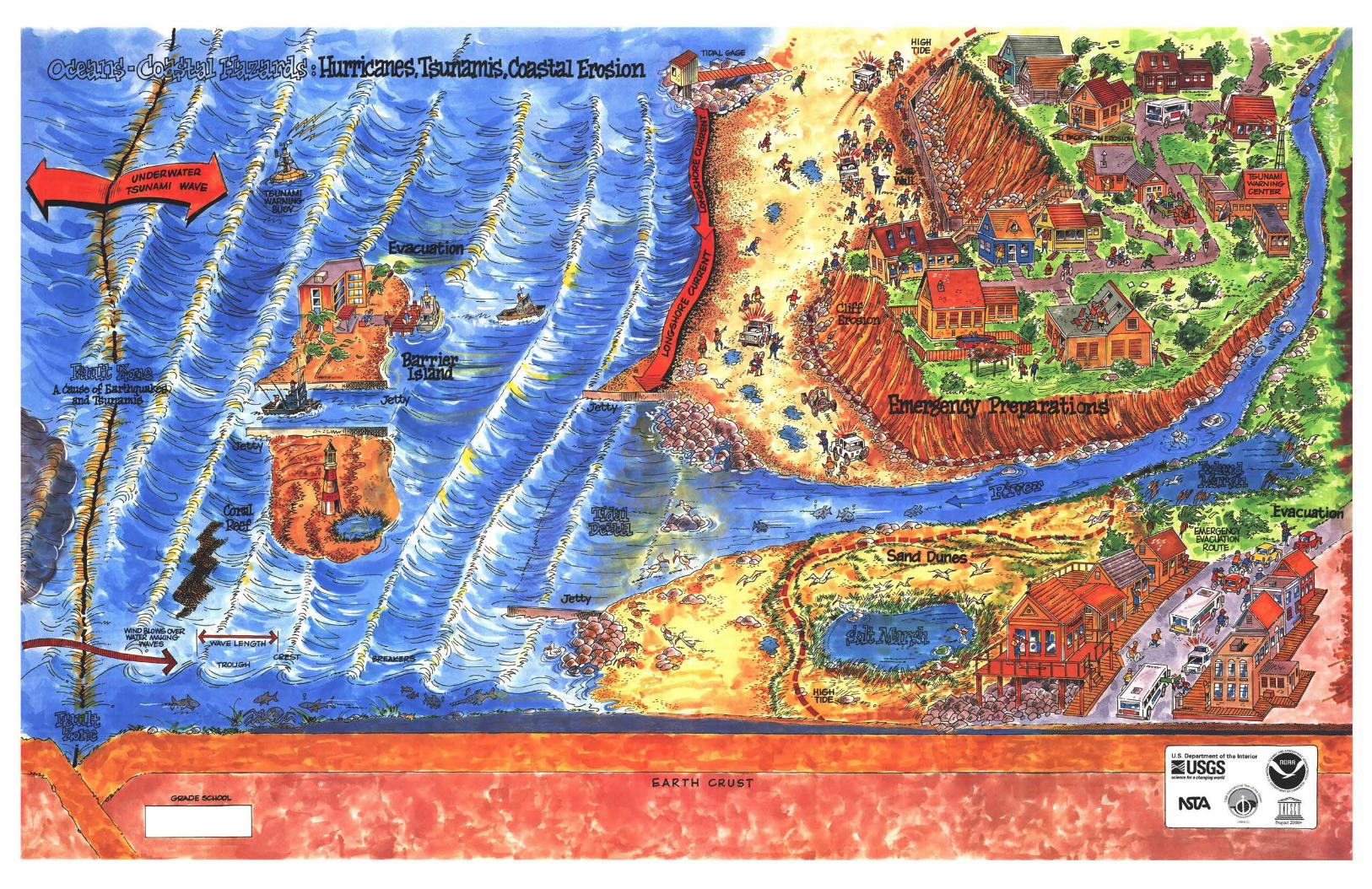

Oceans are the largest geographic feature on the surface of the Earth, covering approximately 70% of the planet 's surface. As a result, oceans have a tremendous impact on the Earth, its climate, and its inhabitants. The coast or shoreline is the boundary between ocean environments and land habitats. By the year 2025, it is estimated that approximately two•thirds of the world's population will be living within 200 kilometers of a coast. In many ways, we treat the coast just like any other type of land area, as a safe and stable place to live and play. However, coastal environments are dynamic, and they constantly change in response to natural processes and to human activities.
Storms can change the shape of the shoreline and destroy buildings, roads, and homes. Flooding along the coast can occur during storms, especially when high tides combine with large waves to raise sea level. This is called a storm surge. Catastrophic events such as hurricanes or tsunamis can greatly modify the shape of coastal areas, cause major flooding, destroy property, and take lives. The sediment that forms a beach, or dune, can come from rivers, cliff erosion, waves, or currents that flow along the shore {longshore current). Waves, currents, and storms can also remove or erode coastal sediments. Extensive beach erosion can cause buildings to collapse into the ocean and dramatically change the nature of the shoreline.
In recognition of the importance of the ocean and the need to sustain our greatest common global heritage, the United Nations declared 1998 the Year of the Ocean. The idea for the Year of the Ocean, which will be celebrated around the world, was originated by the Intergovernmental Oceanographic Commission (JOG) in 1993. As one of many contributions to the Year of the Ocean, this poster is designed to describe several natural processes or events that can change the shape of the coast and affect nearby environments. Coastal erosion, flooding, and the effects of hurricanes or tsunamis are all considered coastal hazards. The causes of these hazards and community preparations and responses to the hazards are depicted here. This poster is folded into 8.5" X 11 "panels; front and back panels can easily be photocopied for educational use.
Tjdes and Waves
Tides rise and fall in response to the gravitational pull of the Sun and the Moon. High and low tides occur each month when the Sun and Moon align. Tides help determine where waves break on the shore-low on the beach at low tides, and high on the beach at high tides. Most waves are created by winds. The size of a wave depends upon the force of the wind (magnitude), the length of time the wind blows (duration) , and the amount of open water over which the wind can blow (fetch) . Although waves look as if they move horizontally through water, they actually are the vertical (up and down) movement of water. The highest point of a wave is the crest. Between the crests of two waves is a low point , called the trough. The height of a wave is the distance from the trough to the crest. As waves get closer to shore , depths tend to become more shallow, causing waves to break. In the ocean, there are many waves moving in different directions at the same time. Storm systems and movement on the ocean floor can create waves up to 30 meters high.
~ ,l --- ? _ j_ ,. __ - f. = F_::--:.. , =-- c -~
Coastal Erosion Coastal lands are constantly changing through erosion and deposition. Waves are the primary cause of coastal erosion. The larger the waves, the greater their erosive power; thus, storm-generated waves cause the greatest coastal erosion. Breaking waves can undercut cliffs and break down rocks and sediments into smaller and smaller pieces. Waves can also cause barrier islands to erode and move landward. Because breaking waves do not always approach the coast straight-on, longshore currents can form along the coast , flowing in the direction of wave movement. Sediment moves gradually along the coast until an obstacle, such as a jetty, is encountered. Water flow is slowed and the sediment is deposited. Rivers can carry new sediments to the coast , building deltas and widening beaches.
Hurricanes Hurricanes form in areas of low atmospheric pressure over warm ocean water. As warm air rises and expands, winds near the ocean surface spiral, bringing in more humid air that continues to feed the storm. As the storm grows, atmospheric pressure drops and wind speed increases. If the wind speed exceeds 119 kilometers per hour (74 miles per hour), the storm is called a hurricane. Hurricanes can bring high winds, flooding , and excessive rain to the coast. Because scientists can estimate a hurricane's strength and where it will strike, there can be time to warn at-risk communities. Preparations for a hurricane include clearing all loose objects from around homes, buildings, and yards; boarding of windows; storing drinking water and nonperishable food supplies; planning evacuation routes ,and possiblyeven evacuation.
Tsunamis A tsunami is a series of waves spreading rapidly in all directions from a disturbance on the ocean floor. The most common source of tsunamis is earthquakes. Earthquakes are produced by the sudden movement of the Earth's crust. Unlike waves produced by winds, which travel only on the surface of the ocean, tsunamis travel through the entire depth of the ocean waters. The speed of a tsunami depends on water depth; in the deep ocean, a tsunami can travel at the speed of a commercial jet plane. When a tsunami reaches the coastline where water becomes shallow, the waves slow down and their energy is compressed, causing them to build as high as 30 meters. Tsunami waves and resulting flooding can cause property damage and loss of life in low-lying areas. Most tsunamis occur in the Pacific Ocean. Because of this danger, the International Tsunami Warning System was created to warn people in countries around the Pacific Ocean of tsunami danger. When a major earthquake occurs, scientists identify the earthquake's size and location by using seismographs located around the world. If the earthquake is large enough and is located near the ocean, a tsunami warning is issued to potentially affected areas. The progress of the tsunami is monitored by water•level gages located along the shorelines of continents or islands or by instruments placed on buoys in midocean.
ACTIVITY Coastal Erosion
INTRODUCTION
Coastal lands are constantly changing in response to wave action. As a wave approaches the shore, it breaks and releases stored energy, causing erosion and the transport and deposition of sediments. Waves breaking at the base of a sea cliff can cause it to erode and collapse into the sea. Waves breaking at an angle to the coast can create longshore currents, which transport sediment along the beach. Rivers supply new sediment to the coast which can form deltas or be moved along the coast by longshore currents. Coastal erosion depends on the stability of shoreline sediments, the intensity and frequency of storm waves, and the exposure of coastal lands. The following activity is designed to provide students with an understanding of coastal erosion caused by waves.
OBJECTIVE5=-$tudent:; will:
1. Model and observe how waves affect the movement of sand on a coastline.
2. Observe how rivers provide sand to the coast.
3. Observe the effect of coastline shape and manmade structures on the movement of sand.
MA TERfALS----Each group of three student:; will need:
1. One large paint tray or large rectangular container at least 35 cm by 28 cm.
2. 700 ml of moist play sand.
3. 50 ml of a different color or texture sand, such as silica sand.
4. 700 ml of water.
5. One 15-cm-long flat object for a wavemaker. One-half of a 30-cm ruler or paint stir-stick works well.
6. One stick, approximately 10 cm long by approximately 1 cm in diameter.
7. A metric ruler.
8. Four rocks , each about 1 to 2 cm.
9. Paper and pencil.
10. Graduated cylinder or measuring cup.
TEACHER PREPARATION
1. This activity is designed for groups of three students
2. Display a copy of the poster titled "Oceans- Coastal Hazards: Hurricanes, Tsunamis, Coastal Erosion" on the classroom wall several days prior to conducting this activity.
3. Obtain a sufficient quantity of both types of sand from a garden or hardware store or from a beach. Wash each type of sand separately in a large container until the rinse water is mostly clear. Collect sufficient materials for each group. Cut paint stir·sticks or plastic rulers in half to provide a wavemaker for each group. Each 10-cm stick is to be used as a seawall by the students.
4. Assemble one of the models and try the activity prior to presentation to the students. (See Example.)
INTERPRETIVE QUESTIONS
Conduct a class discussion concerning coastal erosion. Using the diagrams for references, solicit answers to the following questions:
1. Compare diagrams 1 and 2. Were there any changes in the shape of the beach? Describe these changes and the cause of the changes.
2. In which direction did the sand move ( which direction was the longshore current)?
Potential Answer: At an acute angle to the waves.
3. The sand deposited from the river created a delta. What happened to the delta when the storm waves came in contact with it?
Potential Answer: The sand became part of the beach. Sediments delivered from rivers are a major source of sand on beaches.
4. Identify a major river delta in the world that has not been removed by waves.
Potential Answer: Deltas exist at the mouths of the Mississippi and Nile Rivers.
5. Have each group give a presentation describing the effectiveness of their structures in reducing coastal erosion. Use diagrams 1 and 4 to show changes in the coast resulting from the construction of the barriers. Were any of the structures effective in reducing beach erosion? If you owned a home on the beach, which structure would you build and where would you locate it? What impact would your structure have on your neighbor's beach? How long would your structure last?
EXTENSION Have students do research on the types and effectiveness of various methods in preventing beach erosion.
Through the research, students should answer the following questions:
1. What methods are available for reducing beach erosion?
2. Are these methods only a short-term fix or are they good for at least 100 years?
3. Why might one group (such as homeowners) favor one method, while other groups (such as ecologists) favor another? Is a compromise between the groups possible?
PROCEDURE
1. Divide the class into groups of three. Provide each group with a paint tray or large rectangular container, 700 ml al moist play sand, 50 ml of moist, different colored or textured sand, 700 ml of water, the 10-cm stick, four rocks. one wavemaker, a graduated cylinder or measuring cup, pencil, and paper.
2. Have the students spread the 700 ml of play sand in the container, covering approximately three-fourths of the sloping part of the paint tray from the top edge of the paint tray. The sand represents a beach. If using large rectangular containers, the students should cover not more than 15 cm from the long side of the container. This side of the container should then be elevated approximately 2.5 cm. Allow the students to shape their model beach any way they would like within those parameters. Add approximately 600 ml of water to the bottom part of the container where there is no sand. The water represents the ocean. Students should draw a diagram of the model beach they created (diagram 1 ).
3. Using the wavemaker, have each student take a turn creating waves in the ocean. Holding the wavemaker horizontally, students should use a sharp, short , pushing motion with the wavemaker, pushing the wave at an angle to the beach. Each student should make approximately 20 waves. After each student has taken a turn making waves, have them make a second diagram of the beach (diagram 2). Have students then compare their "before•and-after" diagrams. Have them describe how the shape of the coastline changed.
4. Students should make a small crater and ditch in the sand. The crater should be approximately 8 cm wide, should expose the bottom of the container, and should be located at the top of the model. The ditch should be approximately 4 cm wide, should expose the bottom of the container, and should connect the crater and the ocean. The crater represents a lake, and the ditch represents a river. Place 50 ml of moist, different colored or textured sand in the crater and ditch. ~ pour 100 ml of water into the crater until this different sand is washed down to the ocean. Have the students write down or draw their observations (diagram 3) of what happened to this sand. A delta should form where the sand was deposited at the ocean. Continue to make waves as described in step 3. Try to make the waves at the same angle to the beach as before. What happened to the delta?
5. Reconstruct the beach exactly as drawn in the first diagram. Have students brainstorm ways to keep the beach from eroding . Using the rocks and 10-cm stick, have the students construct a wall , jetty, or any barrier they like to prevent the beach from eroding. These structures can be placed anywhere the students like. After these structures are constructed, have the students make waves as described in step 3. Again , try to make the waves at the same angle to the beach as before. Students should draw a diagram of the beach (diagram 4).
QEf(NfTIONS
Atmospheric pressure - The weight of Earth's atmosphere. Atmospheric pressure is usually measured in inches of mercury with normal pressure raising a column of mercury 29.92 inches (76.0 cm). Measurements above 29.92 inches of mercury are considered high pressure and measurements below are considered low pressure.
Delta - A deposit of sediment at or near the mouth of a river.
Erosion - Process whereby materials of the Earth's crust are loosened, dissolved, or worn away and moved , usually by water or wind.
Hurricane - An atmospheric low-pressure system with a circular motion , counterclockwise in the Northern Hemisphere and clockwise in the Southern Hemisphere, with wind speeds equal to or greater than 119 kilometers per hour (74 miles per hour).
Jetty - An engineered structure designed to direct currents or tides.
Longshore current - An ocean current that flows parallel to the shore and is caused by waves approaching the coast at an angle.
Sediment - Particles derived from rock or organic materials that have been transported by water or wind.
Storm surge - An abnormal rise of the ocean along a shore as the result of storm-generated winds.
Tides -The rise and fall of the ocean caused by the gravitational pull of the Moon and Sun.
Tsunamis • A series of wav~s spreading rapidly in all directions from the area on the ocean floor, where a large earthquake, volcanic eruption, or landslide has occurred.
Water wave· A disturbance in water that transmits energy from one place to another. In the ocean, the most common cause of this disturbance is wind.
Wavelength - The distance between the crests of two successive waves.
Wave height - The vertical distance between a wave crest and the preceding trough.
Wave trough - The lowest part of a wave, between successive crests.
ORDERING INFORMATION
Copies of the other posters in the series (see Poster Series Panel) and the Oceans poster (color for grades 3-5 and 6--8 or black-and•white) can be obtained at no cost from the U.S. Geological Survey. Write to the address below and specify the poster title(s) and grade level(s) desired. A limited number of color and black-and-white posters entitled "Water : The Resource That Gets Used & Used & Used for Everything!" are also available in Spanish by writing to the· address below.
U.S. Geological Survey Branch of Information Services Box 25286 Denver Federal Center Denver, CO 80225 Telephone: (800) 435-7627
Poster Series This poster is part of a series of water-resources education posters developed through the U.S. Geological
Survey's Water Resources Education Initiative, a cooperative effort between public and private education interests. Partners in the program include the U.S. Geological Survey, Bureau of Reclamation, and the U.S. Fish and Wildlife Service of the U.S. Department of the Interior; the National Oceanic and Atmospheric Administration; the U.S. Environmental Protection Agency; the U.S. Army Corps of Engineers; the Nebraska Groundwater Foundation : and the National Science Teachers Association.
The other posters in the series are entitled "Water:The Resource That Gets Used & Used & Used for Everything!", "How Do We Treat Our Wastewater?", "Wetlands: Water, Wildlife , Plants, & People!", "Ground Water: The Hidden Resource I", "Water Quality: Potential Sources of Pollution", "Navigation: Traveling the Water Highways!", "Hazardous Waste: Cleanup and Prevention", and "Watersheds: Where We Live." The posters in the series are designed to be joined to create a large wall mural. A schematic of the wall mural is displayed on this panel. The gray shaded spaces represent the posters listed above. The black shaded space represents this poster.
OCEANS WATERSHEDS HAZARDOUS WASTE
WETLANDS WATER USE WASTEWATER TREATMENT
NAVIGATION GROUND WATER WATER QUALITY
Water-resources topics of the posters are drawn in a cartoon format by the same artist. Posters are available in color or black and white. The reverse sides of the color posters contain educational activities: one version for children in grades 3--5 and the other for children in grades 6--8. The black-and•white posters are intended for coloring by children in grades K-2.
ACKNOWLEDGMENTS
The following individuals and organizations contributed to the development of this poster:
Project Chief, Principal Author, and Layout: Stephen Vandas, U.S. Geological Survey, Denver, Colorado
Project Coordinator: Lynne Mersfelder, National Oceanic and Atmospheric Administration
Art Work: Frank Farrar, Frank Farrar Graphics, Denver, Colorado, under contract to the National Science Teachers Association.
u.s. GEOLOGICAL SURVEY tUSGS/
The USGS provides the Nation with reliable, impartial information to describe and understand the Earth. This information is used to minimize loss of life and property from natural disasters; manage water, biological, energy, and mineral resources; enhance and protect the quality of life; and contribute to wise economic and physical development. The USGS proudly serves the Nation in providing "science for a changing world ."
NATIONAL OCEANIC AND ATMOSPHERIC ADMINISTRATION fNOAA/ The NOAA's mission is to describe and predict changes in the Earth 's environment and to conserve and manage
wisely the Nation's coastal and marine resources to ensure sustainable economic opportunities. The NOAA is
committed to a 21 st century in which environmental stewardship, assessment, and prediction serve as keystones to enhancing economic prosperity and quality of life, better protecting lives and property, and strengthening the United States balance of trade.
UNITED NATIONS EDUCATIONAL SCIENTIFIC AND CULTURAL ORGANIZATION WNESCO/
The purpose of UNESCO is to contribute to peace and security by promoting collaboration among nations through education , science, and culture in order to further universal respect for justice and for the human rights and fundamental freedoms which are affirmed for the peoples of the world , without distinction of race, sex, language, or religion by the charter of the United Nations. Project 2000+ aims at achieving scientific and technological literacy for all and is implemented by the Science & Technology Education Section of UNESCO.
INTERGOVERNMENTAL OCEANOGRAPHIC COMMISSION QOC/ The IOC of UNESCO is an agency established in 1960 to promote scientific marine investigations and related
ocean services with a view to learning more about the nature and resources of the ocean through the concerted actions of its 125 members. The IOC plays a pivotal role in expanding knowledge about the world's oceans and improving international capabilities through a commitment to coastal and oceanographic research, systematic ocean observations, technology development and transfer, and related education and training.
Middle Schoof