Embed Size (px)
DESCRIPTION
By Monica PrattArcUser October–December 2002
Citation preview
44 ArcUser October–December 2002 www.esri.com
Adding Fields to a Shapefile Attribute Table in ArcGISBy Monica Pratt, ArcUser EditorAttributes, which describe qualities associated with features, are stored in tables. Data attribute type and field properties, such as precision, scale, or length, must be specified when creating fields for the attribute table of a new shapefile or when adding a new field to the attribute table for an existing shapefile. The choice of attribute data type and associated settings affect storage and display and can have serious consequences for the accuracy and efficiency of the underlying database. In ArcGIS, you can store a value for a fea-ture attribute as one of seven data types—short integer, long integer, float, double, text, date, and binary large object (BLOB). Attribute tables also contain predefined fields that hold data on geometry and the object ID. Float and double data types contain real numeric values and are used for continuous data that is measured or calculated. Short and long integer data types store data that represents numeric values that can be counted or that designate a coded value used for classification. Text data fields can also store coded values or contain descriptive text that characterizes a feature or provides its name. Temporal aspects of a feature, such as when a valve was last tested, are stored as a date type. BLOB data types allow integration of other me-dia such as video, images, or sound. The table in Figure 1 summarizes information on these data types. Most large organizations manage databases using a schema that specifies fields. Unless you
are the database manager for your organization, typically you will only modify the tables associ-ated with data you personally manage. To add a field to a table, you must have write access to the data and no other user or application, including
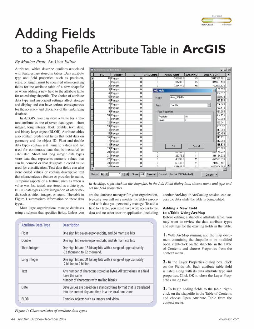
In ArcMap, right-click on the shapefile. In the Add Field dialog box, choose name and type and set the field properties.
another ArcMap or ArcCatalog session, can ac-cess the data while the table is being edited.
Adding a New Fieldto a Table Using ArcMapBefore editing a shapefile attribute table, you may want to review the data attribute types and settings for the existing fields in the table.
1. With ArcMap running and the map docu-ment containing the shapefile to be modified open, right-click on the shapefile in the Table of Contents and choose Properties from the context menu.
2. In the Layer Properties dialog box, click on the Fields tab. Each attribute table field is listed along with its data attribute type and properties. Click OK to close the Layer Prop-erties dialog box.
3. To begin adding fields to the table, right-click on the shapefile in the Table of Contents and choose Open Attribute Table from the context menu.
Figure 1: Characteristics of attribute data types
New/Casual Advanced
User Level
Hands On
www.esri.com ArcUser October–December 2002 45
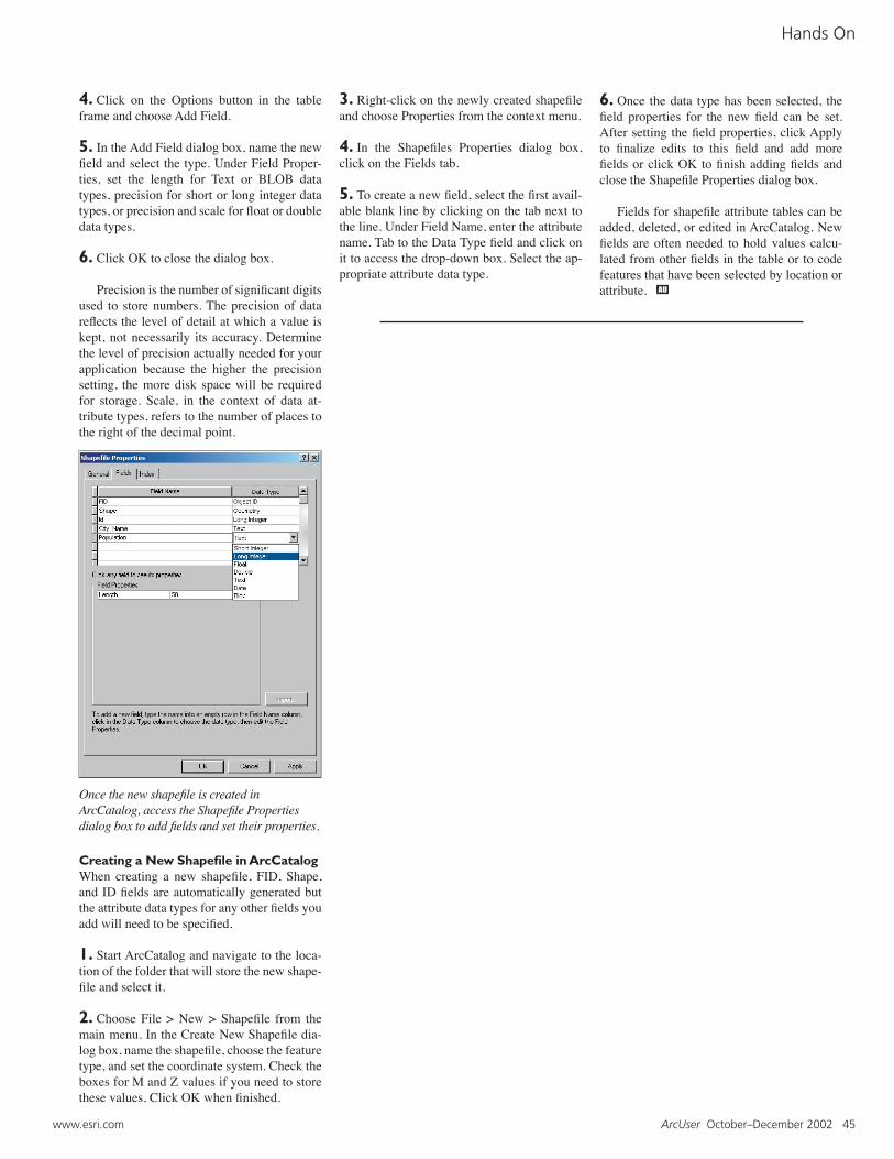
Once the new shapefile is created inArcCatalog, access the Shapefile Properties dialog box to add fields and set their properties.
4. Click on the Options button in the table frame and choose Add Field.
5. In the Add Field dialog box, name the new field and select the type. Under Field Proper-ties, set the length for Text or BLOB data types, precision for short or long integer data types, or precision and scale for float or double data types.
6. Click OK to close the dialog box.
Precision is the number of significant digits used to store numbers. The precision of data reflects the level of detail at which a value is kept, not necessarily its accuracy. Determine the level of precision actually needed for your application because the higher the precision setting, the more disk space will be required for storage. Scale, in the context of data at-tribute types, refers to the number of places to the right of the decimal point.
3. Right-click on the newly created shapefile and choose Properties from the context menu. 4. In the Shapefiles Properties dialog box, click on the Fields tab.
5. To create a new field, select the first avail-able blank line by clicking on the tab next to the line. Under Field Name, enter the attribute name. Tab to the Data Type field and click on it to access the drop-down box. Select the ap-propriate attribute data type.
6. Once the data type has been selected, the field properties for the new field can be set. After setting the field properties, click Apply to finalize edits to this field and add more fields or click OK to finish adding fields and close the Shapefile Properties dialog box.
Fields for shapefile attribute tables can be added, deleted, or edited in ArcCatalog. New fields are often needed to hold values calcu-lated from other fields in the table or to code features that have been selected by location or attribute.
Creating a New Shapefile in ArcCatalogWhen creating a new shapefile, FID, Shape, and ID fields are automatically generated but the attribute data types for any other fields you add will need to be specified.
1. Start ArcCatalog and navigate to the loca-tion of the folder that will store the new shape-file and select it.
2. Choose File > New > Shapefile from the main menu. In the Create New Shapefile dia-log box, name the shapefile, choose the feature type, and set the coordinate system. Check the boxes for M and Z values if you need to store these values. Click OK when finished.