Embed Size (px)
Citation preview
§̈¦215
§̈¦15
RR
RR
RR
RR
RR
MDR
MDR
MDR
MDR
EDR-RC
EDR-RC
LDR-RC
VLDR-RC
LDRLDR
LDROS-C
OS-C
OS-C
OS-C
OS-C
OS-C
MDR
LDR
CR
CR
OS-R
OS-R
OS-R
CRLI
LI
MUPA
LI
LI
MDR
MDR
CO
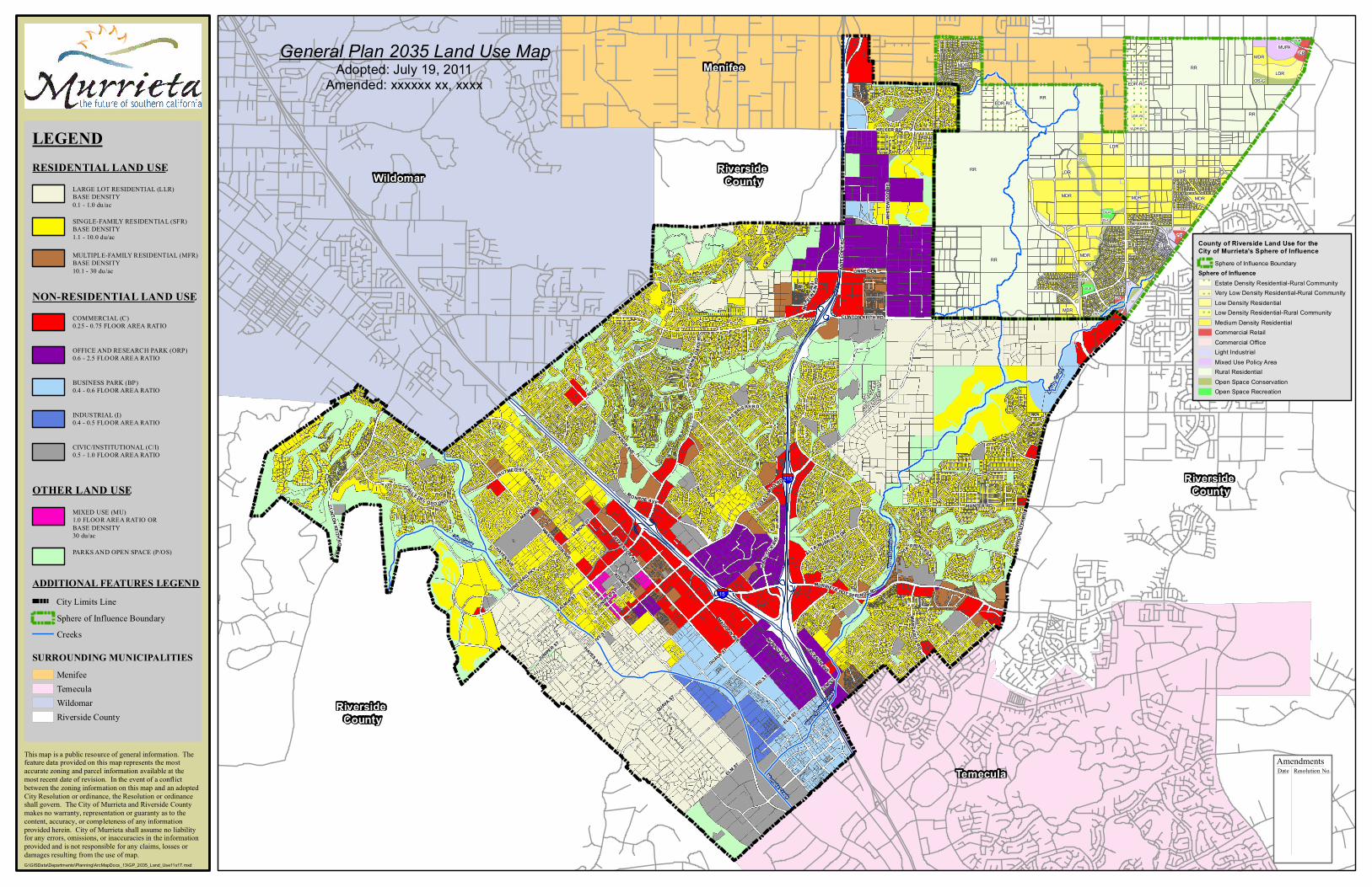
General Plan 2035 Land Use MapAdopted: July 19, 2011
Amended: xxxxxx xx, xxxx
ADAMS AVE
WHITE
WOO
D RD
JEFFERSON AVE
LOS ALAMOS RD
IVY ST
WASHINGTON AVE
WINC
HEST
ER R
D
ANTE
LOPE
RD
MADISON AVE
KALMIA ST
NUTMEG ST
CLINTON KEITH RD
HAYES AVEHA
NCOCK AV
E
MURRIETA HOT SP RINGS RD
FIG ST
CAL IF
ORNI A
OAK
S RD
HUNTER RD
KELLER RD
MAGNOLIA ST
LINNEL LN
CALLE DEL OS O OROMO NROE AVE
JACKSON AVE
LINCOLN AVE
VINEYARD PKY
LEMON ST
ELM ST
JUNIPER ST
LAS BRISAS RD
GUAVA ST
ALTA MURRIETA DR
MAR GARITA RD
MC EL
WAIN
RD
VIA PRINCESA
ADAMS AVE
JACKSON AVE
NUTMEG ST
CLINTON KEIT H R D
MONROE AVE
ELM ST
JUNIPER ST
HAYES AVE
ELM ST
GUAVA ST
Murrieta Creek
Warm
Spr
ings C
reek
Cole Creek
Adob
e Cree
k
Warm Spri
ngs C
reek
County of Riverside Land Use for the City of Murrieta's Sphere of Influence
Sphere of Influence BoundarySphere of Influence
Estate Density Residential-Rural CommunityVery Low Density Residential-Rural CommunityLow Density ResidentialLow Density Residential-Rural CommunityMedium Density ResidentialCommercial RetailCommercial OfficeLight IndustrialMixed Use Policy AreaRural ResidentialOpen Space ConservationOpen Space Recreation
LEGENDRESIDENTIAL LAND USE
SINGLE-FAMILY RESIDENTIAL (SFR)BASE DENSITY1.1 - 10.0 du/ac
MULTIPLE-FAMILY RESIDENTIAL (MFR)BASE DENSITY10.1 - 30 du/ac
NON-RESIDENTIAL LAND USECOMMERCIAL (C)0.25 - 0.75 FLOOR AREA RATIO
OFFICE AND RESEARCH PARK (ORP)0.6 - 2.5 FLOOR AREA RATIO
BUSINESS PARK (BP)0.4 - 0.6 FLOOR AREA RATIO
INDUSTRIAL (I)0.4 - 0.5 FLOOR AREA RATIO
CIVIC/INSTITUTIONAL (C/I)0.5 - 1.0 FLOOR AREA RATIO
OTHER LAND USEMIXED USE (MU)1.0 FLOOR AREA RATIO ORBASE DENSITY30 du/ac
PARKS AND OPEN SPACE (P/OS)
ADDITIONAL FEATURES LEGEND
LARGE LOT RESIDENTIAL (LLR)BASE DENSITY0.1 - 1.0 du/ac
This map is a public resource of general information. Thefeature data provided on this map represents the mostaccurate zoning and parcel information available at themost recent date of revision. In the event of a conflictbetween the zoning information on this map and an adoptedCity Resolution or ordinance, the Resolution or ordinanceshall govern. The City of Murrieta and Riverside County makes no warranty, representation or guaranty as to the content, accuracy, or completeness of any information provided herein. City of Murrieta shall assume no liability for any errors, omissions, or inaccuracies in the information provided and is not responsible for any claims, losses or damages resulting from the use of map.G:\GISData\Departments\Planning\ArcMapDocs_13\GP_2035_Land_Use11x17.mxd
SURROUNDING MUNICIPALITIESMenifee
Riverside County
TemeculaWildomar
CreeksSphere of Influence BoundaryCity Limits Line
AmendmentsResolution No.DateTemecula
Riverside County
Riverside County
Riverside CountyWildomar
Menifee