Embed Size (px)
Citation preview

coleridgeinitiative.org
ADRFDOCUMENTATION
2
Contents1. Motivation................................................................................................................................................3
2. Context.....................................................................................................................................................3
3. CurrentADRFapproach............................................................................................................................3
3.1 MetadataHarmonization................................................................................................................3
3.2 UrbanProfiler..................................................................................................................................4
3.3 ADRFExplorer.................................................................................................................................5
3.4 DataFacility(DF)Admin..................................................................................................................7
4. FeaturesinDevelopment.........................................................................................................................8
4.1 RichContextEnhancements............................................................................................................8
4.2 ETLImprovements...........................................................................................................................9
Appendix........................................................................................................................................................10
GMetaMETADATASCHEMAV.1.0.............................................................................................................10
Datasetlevelmetadata..........................................................................................................................10
Filelevelmetadata.................................................................................................................................13
Variablelevelmetadata..........................................................................................................................15
SampledetailedGMETAfile...................................................................................................................16

3
1. Motivation
Thiswhitepaperdescribesthedatapoliciesandproceduresformakingmetadataandmicrodatamorediscoverableandusableacrossinstitutionalboundaries.TheADRFisdesignedforthatpurpose.Thisdocumentprovidesthefollowing:
(i) asummaryoftheexistingADRFapproach,(ii) featuresindevelopment,and(iii) adiscussionofhowwewillcustomizethesetools.
2. Context
Thegoalofmetadatatoolsistomakeiteasierforendusersofconfidentialdatatodiscoverandusedatasetsappropriateforresearchandanalysis.Thisisamajorchallenge,becausemostdatasetsareeithernotwelldocumentedorarenotdocumentedwiththepurposeofbeingconceptuallyorelectronicallyconnectedtootherdatasets.Databaseshavehistoricallybeenindexedandcataloguedbyinputcharacteristics(nameorprovider),ratherthanbytheirpotentialusecharacteristics(topicorresearcharea).Preparingdataforuseoutsideofitsoriginalpurpose(e.g.creatingdescriptionsandprovidinginformationforanominalfutureusertounderstandthedata)isdifficult,timeconsuming,anderrorprone.
3. CurrentADRFapproach
TheADRF’sDocumentationmoduleemploysthefollowingcomponentstosimplifyandautomatetheaccessibilityofdatafromdifferentorganizations:metadataharmonization;atoolcalledUrbanProfilerforgeneratingmoredetailedcolumnlevelmetadatafordatasets;theADRFExplorerforhelpingusersfinddatasetsrelevanttotheirworkandenrichdatasetdescriptions;andDFAdminforadministeringdatasetmetadataandaccesswithintheADRF.
3.1 MetadataHarmonization
TheADRFingestprocessusesaflexible,generalizedmetadataschemacalledGMeta(seeAppendix)fordatasetdescriptionthatisbasedontheestablishedDataCatalogVocabulary(DCAT)1.Thisprovidesalevelofstandardizationfordatasetscomingfromdifferentindustries,
1DataCatalogVocabulary(DCAT):https://www.w3.org/TR/vocab-dcat/

4
organizations,andresearchpurposes.DCATIsalreadyadoptedbytheUSFederalgovernment2,andisanaccepteddatasetdescriptionstandardoftheEuropeanCommissioninmultipleEuropeandataportals3.
Additionally,theGMetaschemaprovidesstandardizationofcontrolledvocabularycategorieswhileallowingformoreopen-endedtags,tomakedisparatedatasetsmorediscoverableinrelationtoeachother.GMetaalsodefinesownershipandtheaccessrestrictionsandrequirementsofthird-partydatasets,providingusersabetterwaytounderstandwhatdatasetstheymightbeabletoaccessandhowtoaccessthosedatasets.GMetaalsoallowsrelatedpublicationstobeassociatedwithdatasets,forbetterunderstandinghowthesedatasetshavebeenusedbyothersintheiranalyses.Finally,GMetaprovidesfordescriptionoftemporalandgeographiccoveragesothatdatasetsaboutthesametimeandplacemightbefoundandlinkedtogether.
3.2 UrbanProfiler
UrbanProfilerisatoolwritteninPythonwhichscans,computes,andoutputscolumn-levelmetadatathatfacilitatescomparisonandevaluationofvariablesforadatasetataglance.UrbanProfileroutputisfoldedintotheGMetametadataschemaforeachfilethatispartofadataset(seeAppendix).UrbanProfilergeneratessuchinformationas:thepercentageofmissingvalues;numberofuniquevalues;inferreddatatypes(e.g.,numeric,textual,date),statisticalsummariesforvariableswhosevaluesarenumeric,andfrequencyoftopkvaluesaswellasdataforgeneratinghistogramsfordistributionofvalues.Thislevelofdetailallowsanalyststobetterunderstandthecontentsandqualityofadatasetquicklyandprovidesanopportunitytoexaminevariablesacrossdatasetsforabilitytolinkorcomparewitheachother.
2 USProjectOpenData:https://project-open-data.cio.gov/v1.1/schema/
3 DCATApplicationProfilefordataportalsinEurope:https://joinup.ec.europa.eu/release/dcat-application-profile-data-portals-europe-final

5
3.3 ADRFExplorer
TheADRFExplorerisadiscoverytoolthatprovidesaninventoryofwhichdatasetscurrentlyexistwithinanADRFenvironment.TheADRFExplorerrequiresdatasetstobedescribedwiththeGMetametadataschemaandisconnectedtoaninstallationofElasticsearch4,whichsupportstheretrievalandindexingofGMetainformationinsidetheADRF.ItalsoservesasatooltoallowuserstoaddenhancedcontextforunderstandingadatasetandenforcesrestrictionsondatasetsthatarerestrictedtoonlyspecificusersoftheADRF.Toelaborateonhowthistoolallowsuserstoaddenhancedcontext,theADRFExplorergivesuserstheabilitytoprovidefeedback(intheformofcommentsandannotationsasshowninFigure1)ondatasetsatthedatasetanddatasetvariablelevel.Commentsmightincludeinformationfromanexpertonhowavariablewascollectedoritmightalsobearequestformoreinformationaboutthevariable.Inthisway,itenablesevenrichermetadatawithwhichtounderstandadataset’sutility.
Figure1:FeedbackmechanisminADRFExplorer
Entitiesthatcanbeassociatedwithdatasets
Finally,theADRFExplorerallowsuserstoconnectdatasetstothecontextwithinwhichtheymaybeused.Thecoreapproachistorelatedatasetstokeyentitiesinvolvedintheirusage:people;researchproducts;recipes(code);andtools.
4Elasticsearch:https://www.elastic.co/products/elasticsearch

6
People:ADRFExplorerinitiallydesignatestwoclassesof“people”:usersandauthors.Usershaveprofilestowhichtheymayaddpersonaldetailsandwhereeventuallytheywillalsobeabletodisplayearnedstatuslevelsorrewards(e.g.,badges)viatheRichContexttool(describedinmoredetailbelow).Thesemaybeearnedbycommentingonorannotatingdatasets,addingcodesnippets,andthroughpeer-inputsuchashavingotherusersranktheircommentsorcodesnippets.
Researchproducts:Researchproducts—articles,publications,orreports—areingestedintotheExplorerandeachhaveindividuallandingpagesjustlikedatasets,providingADRFuserswithaccesstothedetailsoftheresearch.Eachresearchproductmayalsobelinkedtootherentitiessuchaspeople,recipes,andtools,improvingthesearchanddiscoveryresults.ThesystemcurrentlyincludesmanyselectedpapersandwillexpandasADRFExplorerfeaturesareadded,includingamorestreamlinedresearchcontentuploadinterfaceaswellasanautomatedresearchcollectionengine.
Recipes:CompleteJupyternotebooks5andotheranalyticalscriptscanbeuploadedtotheADRFExploreras“recipes”byADRFusers.Theserangefromcontained,reproducibleexamplesofaspecificanalyticaltasktoentireanalyticalworkflowsassociatedwithagivenresearchproduct.ADRFuserscandownloadrecipestotheirownworkspaceforfurtherworkinordertogetarunningstartusingaparticulardatasetortoadaptexistinganalysesfortheirownpurpose.
Tools:TheADRFprovidesasuiteofanalyticaltoolsthatcanbeadaptedtoincludeneworadditionaltoolsbasedonuserneeds.ThecurrenttoolkitincludesRandPython(withpopulardatasciencepackagesinstalledsuchasSciPy,NumPy,pandas,Matplotlib,andscikit-learn)programmingenvironments,Jupyternotebooks,andPostgreSQL\PostGISdatabaseenvironments.EachprojectalsohasasharedrepositoryinaGitlab6installation,whichprovidesproject-by-projectversioncontroltoresearchteams(i.e.,allowinguserstotrackandavoidoverwritingchangesaswellasprovidingadetailedhistoryofdevelopmentofcode,documents,andnotesinaproject).
5 Jupyter(http://jupyter.org/)Notebook“isanopen-sourcewebapplicationthatallowsyoutocreateandsharedocumentsthatcontainlivecode,equations,visualizationsandexplanatorytext”
6 Gitlab(https://about.gitlab.com/)isabrowseraccessibletoolwhichcanbeusedbyteamstocollaborateonprojectswhichinvolvecodedevelopment.ItisdesignedtoaddasocialcomponenttothepopularversioncontrolsystemGitandismuchlikeGithubwiththeimportantdifferencethatitcanbeinstalledlocallyforuseinsideanenvironmentthatisnotconnecttotheInternet.

7
3.4 DataFacility(DF)Admin
DFAdminisawebaccessibleadministrativeportalbuiltinsideoftheADRFtomanageusers,projects,datasets,anduseraccesstoprojectsanddatasetsintheADRF.ItstechnicalunderpinningsareaDjango7webapplicationfrontendconnectedtoaPostgreSQL8databaseanditisopensource.ItprovidesaninterfaceforsystemadministratorstoseeallthedatasetsintheADRF,whohasaccesstothem,andtomodifyuserandprojectaccesstothosedatasetsbasedonaccesspoliciesforthosedatasets.
Figure2:DFAdmininterfaceofentitieswhichmaybemanagedcurrentlyintheADRF
DFAdminwasdesignedtobeintegratedwiththeGMetametadataschemaandtheADRFExplorer. FuturedevelopmentofDFAdminwillincludemoregranulardatasetmetadataeditingthatwillupdaterecordsastheyappearinADRFExplorer.AdditionalfeaturestoDFAdminwillalsoincludetoolsforexamininganddefiningrelationshipsbetweendatasetsbasedonsimilaritybetweentheirmetadataandspecificallythesimilaritybetweenvariableswithindatasetsaswellasexportofdatasetmetadataforsharingwithothersystems.
7https://www.djangoproject.com/
8https://www.postgresql.org/

8
4. FeaturesinDevelopment
AkeythemefortheongoingdevelopmentoftheADRFExploreristheincorporationofcommon“gamification”conceptsborrowedfromsocialmediaandonlineservices.Thegoalofwhichistoincentivizeexpertsanddatasetuserstohelpbetterdescribeandsupplementdatasetdescriptionwithsamplecode,publications,andannotationsonthedataset.
4.1 RichContextEnhancements
Developingarichercontexttounderstandadatasetrequiresinputfromusersandexpertswhoareusing,haveused,orhaveanin-depthunderstandingofhowthedataweregenerated.InspiredbyTripAdvisorandAmazon,webelievediscoveryandconsumptioncanbeimprovedbydocumentingdatabyhowitisusedaswellasbyhowitwasproduced.Thismoduleprovidesalreadyenablesresearcherstobothannotatedatasetsanduploadcodethatcanbeusedtoreadinandreusedata.Themodulewouldthenbeextendedtomakeiteasierforuserstoaddthis“richcontext”–informationaboutotherresearchers,publications,andtopicsthathavebeenassociatedwiththedata.
WehaveworkedrecentlyandareincontinuedpartnershipwiththeNYUGameCenteronawebapplicationthatisbuiltwithpolicyanalystsandusersofadministrativedatainmindtohelpthemtocollaborate.Thisworktodatehasresultedinaworkingprototypethatdemonstratesthepotentialofconnectingresearchersinmorepracticalwaystothedatatheyuse.Theapproachhasbeentodesignwaysinwhichuserscanearnrewardsandreputationpointsastheycontributeadditionalcontext,aswellasbettermetadataandvariabledescriptionstodatasetstheyusewithintheirwork.TheGameCenterisdevelopinga"Prestige"featurethatappliessetvaluestomeaningfulactionsthatuserstakewiththetool.Prestigewillallowuserstoquantifyandvisualizetheircontributionstothelargerknowledgebase,andencouragefurthercontributionbyhighlyfeaturingtheworkofuserswithhighengagement.Applyingpointvaluestoparticipation,comments,metadatacontributions,andmeaningfulinteractionwillencourageexpertuserstosharetheirknowledgeinexchangeforheightenedvisibilityandrecognition.

9
FIGURE3:SCREENSHOTOFRICHCONTEXTTOOLPROTOTYPEHOMEPAGE
4.2 ETLImprovements
ThroughourcurrentAppliedDataAnalyticstrainingcourses,weareintheprocessofdevelopingbetterapproachesbywhichthedataweuseforthecoursearetransformedandloadedbasedonapre-definedsetofdata-userneeds(e.g.,thecreationofstandardizeddatatypesaroundcommonlyusedvariablessuchasdates,geospatialdata,andcategoricaldata).

10
AppendixGMetaMETADATASCHEMAV.1.0Datasetlevelmetadata
Metadataassociatedwithintellectualentityofthedataset
FieldName DataType
Description InExplorer
Obligation
file_names Arrayofstrings
Alistoffilenamesinthedataset.
No 1-n
dataset_id String Datasetid Yes 1
Title String Titleofthedataset Yes 1
description String Descriptionofthedataset
Yes 1
temporal_coverage_start DateinISO8601format
(yyyy-mm-dd)
Startdateforyears/monthsthedatasetisvalidfor
Yes 0-1
temporal_coverage_end DateinISO8601format(yyyy-mm-dd)
Enddateforyears/monthsthedatasetisvalidfor
Yes 0-1
geographic_coverage ArrayofStrings
HumanReadablegeographiclocationthedatasetappliesto
Yes 0-n
geographic_unit ArrayofStrings
Geographicresolutionatwhichdatasetisrendered,ifapplicable(e.g.,State,City,CensusBlock,CensusTract).
Yes 0-n
11
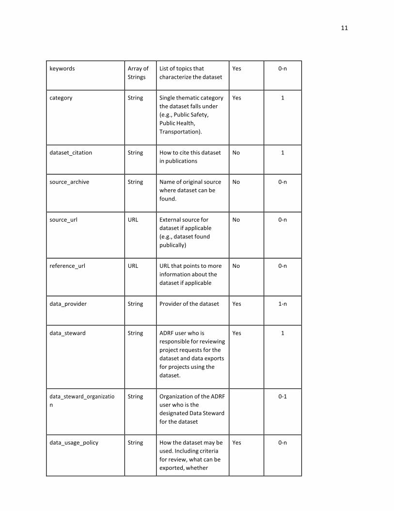
keywords ArrayofStrings
Listoftopicsthatcharacterizethedataset
Yes 0-n
category String Singlethematiccategorythedatasetfallsunder(e.g.,PublicSafety,PublicHealth,Transportation).
Yes 1
dataset_citation String Howtocitethisdatasetinpublications
No 1
source_archive String Nameoforiginalsourcewheredatasetcanbefound.
No 0-n
source_url URL Externalsourcefordatasetifapplicable(e.g.,datasetfoundpublically)
No 0-n
reference_url URL URLthatpointstomoreinformationaboutthedatasetifapplicable
No 0-n
data_provider String Providerofthedataset Yes 1-n
data_steward String ADRFuserwhoisresponsibleforreviewingprojectrequestsforthedatasetanddataexportsforprojectsusingthedataset.
Yes 1
data_steward_organization
String OrganizationoftheADRFuserwhoisthedesignatedDataStewardforthedataset
0-1
data_usage_policy String Howthedatasetmaybeused.Includingcriteriaforreview,whatcanbeexported,whether
Yes 0-n

12
resultsofanyanalysescanbepublishedornot
access_actions_required String Proofoftraining/certification,signingofNDA,MOU,orotheragreementwhichmustoccurbeforeusercangainaccesstodataset.
0-n
access_requirements String Explicitrequirementsusersmustmeetinordertobeabletorequestaccesstoadataset.Forexample:USCitizen,USGovernmentEmployee,ResearcheratInstitutionofhighereducation,swornstatus.
0-n
data_classification String LikeCUSPDataClassification,alevelwhichdictatesthetypeofuserswhohaveaccessorwhetheritrequirestheusertorequestaccess.
1
dataset_documentation ArrayofStrings(Filepaths)
Listofdocumentsthatdocumentthedatainthisdataset.
No 0-n
files_total Integer TotalnumberoffilesinDataset(notincludingattachmentssuchasdatadictionaries)
No 1
related_articles ArrayofStrings(articleids)
Listofarticlesrelatedtothedataset
Yes 0-n
13
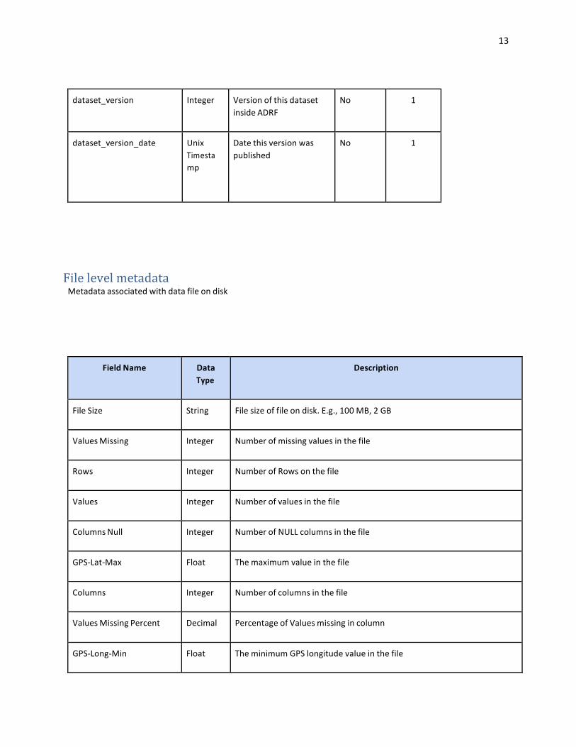
dataset_version Integer VersionofthisdatasetinsideADRF
No 1
dataset_version_date UnixTimestamp
Datethisversionwaspublished
No 1
FilelevelmetadataMetadataassociatedwithdatafileondisk
FieldName DataType
Description
FileSize String Filesizeoffileondisk.E.g.,100MB,2GB
ValuesMissing Integer Numberofmissingvaluesinthefile
Rows Integer NumberofRowsonthefile
Values Integer Numberofvaluesinthefile
ColumnsNull Integer NumberofNULLcolumnsinthefile
GPS-Lat-Max Float Themaximumvalueinthefile
Columns Integer Numberofcolumnsinthefile
ValuesMissingPercent Decimal PercentageofValuesmissingincolumn
GPS-Long-Min Float TheminimumGPSlongitudevalueinthefile

14
ETL-ProfilerStatus Boolean IthastheOKvaluewhenUrbanProfilerprocesseditsuccessfullyortheerrormessage.Probablywillnotbeincluded
GPS-Long-Max Float ThemaximumGPSlongitudevalueinthedataset
ETL-ProfilerInputFileSize(KB)
Integer FIlesizeofdatafileinputtoUrbanProfiler
ETL-ProfilerInputFile String FilenameoffileinputtoUrbanProfiler
GPS-Lat-Min Float TheminimumGPSlatitudevalueinthedataset
columns_metadata ArrayofStrings
Listofcolumn_metadataobjects.Eachentryinthelisthasitsnameaskeyandthecolumn_metadaobjectasvalue.

15
Variablelevelmetadata
Metadataassociatedwithdatafilevariables(sameascolumns)
FieldName DataType
Description
Adult_child_ind Thisasampleofacolumn_metadataobject.
column-name String Thenameofthecolumn
description String Descriptionofthecolumn,itwillbeprovidedbythesteward
values Numberofvalues
provided-type String Datatypeofcolumnfromthedataprovider
profiler-most-detected-% Decimal Percentageofthevaluesthathavethemostdetectedtype
profiler-most-detected Themostdetectedtype
unique_values Numberofuniquevalues.
missing Integer Numberofmissingvalues
profiler-type String Typeofthecolumn.Sometimesitisdifferentthanthemostdetected

16
type.
max Variable MaxvalueFornumeric,temporalorgeo(gpsonly)
min Variable MinvalueFornumeric,temporalorgeo(gpsonly)
HistogramDataJSON Object Datatocreateahistogram
top-k Object Listoftop-kvalues.Kisaparameterofurbanprofiler.
Thislistcanhavesize<=k.
std Float StandardDeviation
Fornumericcolumns.
mean Float MeanFornumericfornumericcolumns
top-value Variable Thevaluethatoccurredmost.
freq-top-value Variable Thefrequencyofthetopvalue.
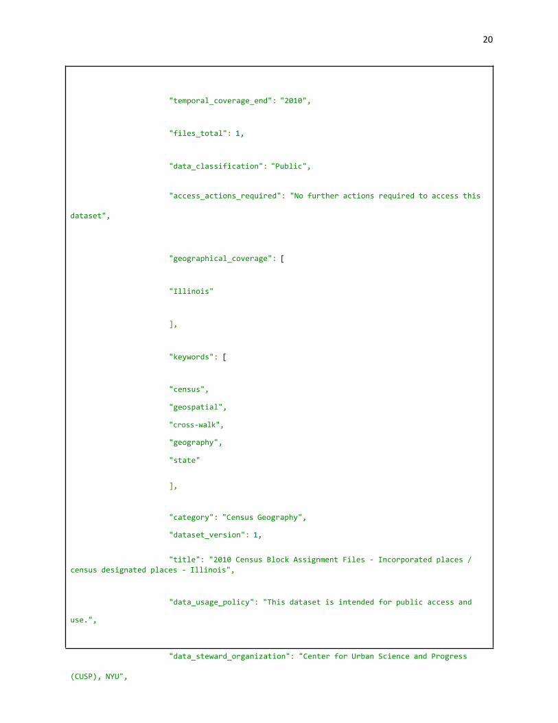
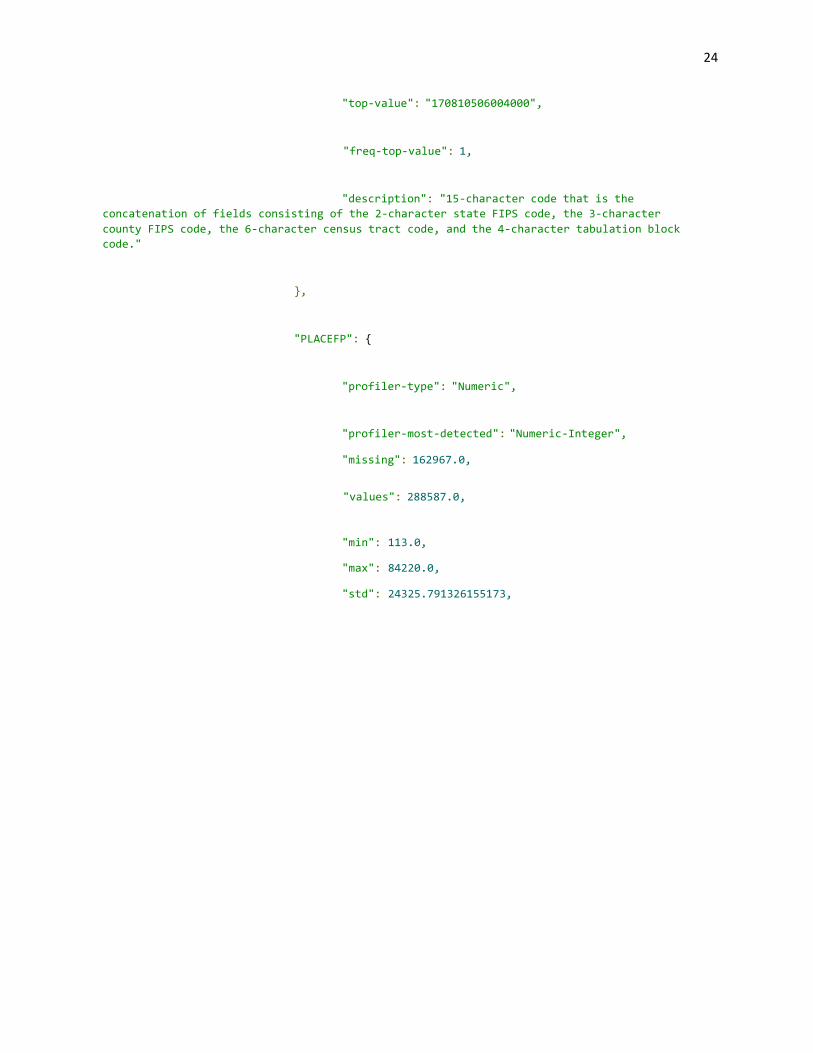
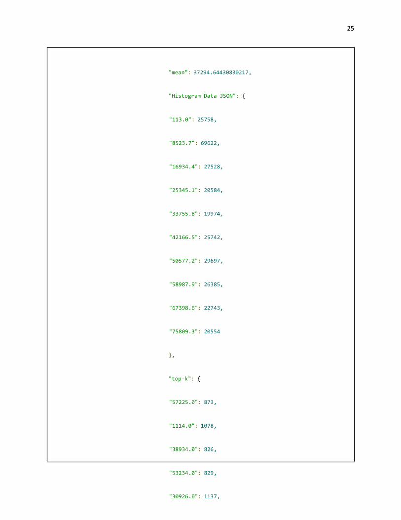
SampledetailedGMETAfile
ThisisasampleofaGMetaJSONfilewithmetadataforADRFdatasetsandfiles.
{
"gmeta": [
{
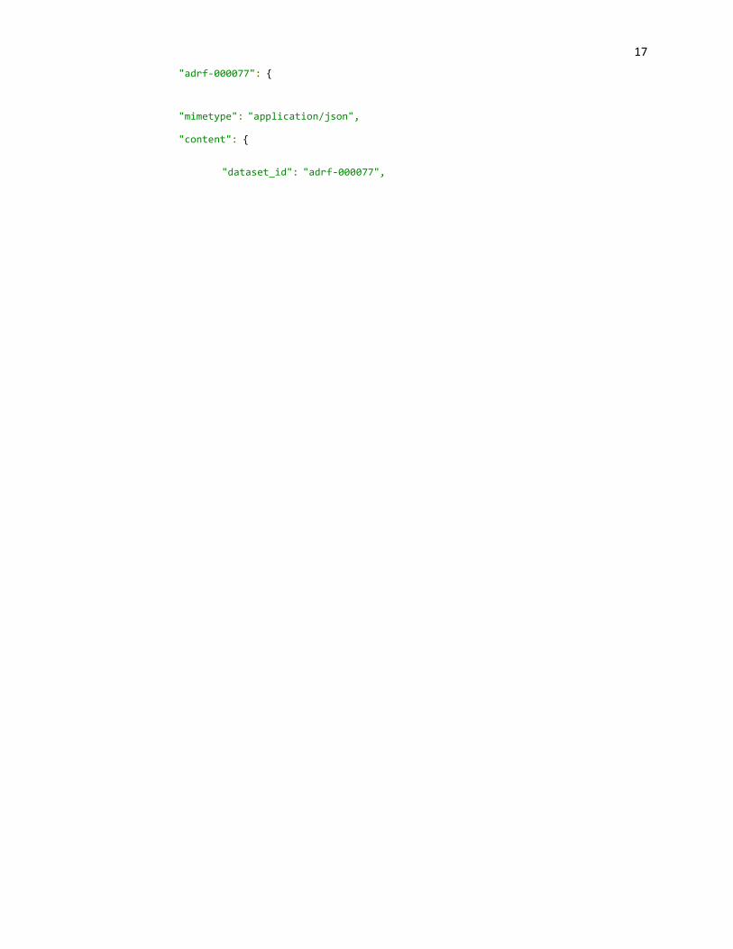
17
"adrf-000077": {
"mimetype": "application/json",
"content": {
"dataset_id": "adrf-000077",
20
"temporal_coverage_end": "2010",
"files_total": 1,
"data_classification": "Public",
dataset",
"access_actions_required": "No further actions required to access this
"geographical_coverage": [
"Illinois"
],
"keywords": [
"census",
"geospatial",
"cross-walk",
"geography",
"state"
],
"category": "Census Geography",
"dataset_version": 1,
"title": "2010 Census Block Assignment Files - Incorporated places / census designated places - Illinois",
use.",
"data_usage_policy": "This dataset is intended for public access and
(CUSP), NYU",
"data_steward_organization": "Center for Urban Science and Progress

20
"data_steward": "Drew Gordon",
"files": [
{
"file_name": "adrf-000077-census_baf_il_incplace_cdp.csv",
"columns_metadata": {
"BLOCKID": {
"profiler-type": "Textual",
"profiler-most-detected": "Textual-PHONE",
"missing": 0.0,
"values": 451554.0,
"top-k": {

21
"171635043031106": 1,
"171635043031107": 1,
"171635043031104": 1,
"171635043031105": 1,
"171635043031102": 1,
"171635043031103": 1,
"171635043031100": 1,
"171635043031101": 1,
"171635043031108": 1,
"171635043031109": 1,
"170314914001002": 1,
"170314914001003": 1,
"170314914001000": 1,
"170318077001027": 1,
"171978803041011": 1,
"172030302002038": 1,
"170810506004000": 1,
"172030302002036": 1,
"172030304001061": 1,

22
"171430002003001": 1,
"170630005001056": 1,
"170630005001055": 1,
"171950009002078": 1,
"171950009002079": 1,
"171950009002072": 1,
"171950009002073": 1,
"171950009002071": 1,
"171950009002076": 1,
"171950009002077": 1,
"171950009002074": 1,
"171950009002075": 1,
"170898501064017": 1,

23
"170898501064016": 1,
"170898501064015": 1,
"170898501064014": 1,
"170898501064013": 1,
"170898501064012": 1,
"171830112001017": 1,
"170898501064019": 1,
"170898501064018": 1,
"170318212001029": 1,
"170318212001028": 1,
"170318212001021": 1,
"170318212001020": 1,
"170318212001023": 1,
"170318212001022": 1,
"170318212001025": 1,
"170318212001024": 1,
"170318212001027": 1,
"170318212001026": 1
},
24
"top-value": "170810506004000",
"freq-top-value": 1,
"description": "15-character code that is the concatenation of fields consisting of the 2-character state FIPS code, the 3-character county FIPS code, the 6-character census tract code, and the 4-character tabulation block code."
},
"PLACEFP": {
"profiler-type": "Numeric",
"profiler-most-detected": "Numeric-Integer",
"missing": 162967.0,
"values": 288587.0,
"min": 113.0,
"max": 84220.0,
"std": 24325.791326155173,
25
"mean": 37294.64430830217,
"Histogram Data JSON": {
"113.0": 25758,
"8523.7": 69622,
"16934.4": 27528,
"25345.1": 20584,
"33755.8": 19974,
"42166.5": 25742,
"50577.2": 29697,
"58987.9": 26385,
"67398.6": 22743,
"75809.3": 20554
},
"top-k": {
"57225.0": 873,
"1114.0": 1078,
"38934.0": 826,
"53234.0": 829,
"30926.0": 1137,
26
"3012.0": 2362,
"14000.0": 46324,
"12385.0": 1580,
"14351.0": 1273,
"19642.0": 1008,
"81048.0": 881,
"72546.0": 971,
"49867.0": 949,
"6613.0": 1744,
"51622.0": 1806,
"38570.0": 2694,
"2154.0": 1252,
"33383.0": 1107,

27
"20591.0": 921,
"62367.0": 1266,
"54885.0": 1138,
"54820.0": 1010,
"22164.0": 905,
"10487.0": 1088,
"72000.0": 3901,
"65078.0": 917,
"35411.0": 864,
"24582.0": 1504,
"68003.0": 1109,
"79293.0": 1200,
"57628.0": 959,
"46916.0": 872,
"18823.0": 2202,
"12164.0": 880,
"22255.0": 1289,
"43536.0": 907,
"23074.0": 1899,
"56640.0": 957,
"28326.0": 884,
"7133.0": 888,
"18563.0": 1882,
"14026.0": 904,
"77005.0": 904,
"5573.0": 1139,
"75484.0": 825,
"70122.0": 1779,
"58447.0": 1207,
"65000.0": 4496,
"4845.0": 1303,
"59000.0": 2482

28
},
"top-value": 14000.0,
"freq-top-value": 46324,
"description": "5-character place FIPS code"
}
},
"file_type": "data",
"file_size": 9570922,
"mimetype": "text/csv"
},
{
"file_name": "adrf-000077-census_baf_il_incplace_cdp_dd.csv",
"file_type": "documentation",
"file_size": 259,
"mimetype": "text/csv"
}
],
"access_requirements": "No access restrictions on this dataset",
"description": "Cross walk of 2010 Census Blocks to Census Places for
the state of Illinois. Geographic data here has been pulled from the 2010 Census Block
Assignment Files dataset.\r\n\r\n\r\nBlock Assignment Files (BAFs) have been created for each of the 50 states, the District of Columbia, and Puerto Rico. Each file contains 2010 Census tabulation block codes and geographic area codes for a specific geographic entity type. Each BAF contains every block within the given state, even if the block is not within one of the geographic areas represented in the file. For those blocks where no geographic area is present, the block is listed, followed by one or more commas (depending on the file layout for the specific geographic area type).",

29
"source_url": "https://www.census.gov/geo/maps-data/data/baf.html",
"geographical_unit": [
"State",
"Census Block",
"Census Place"
],
"related_articles": [],
"data_provider": "US Census Bureau",
"dataset_documentation": [
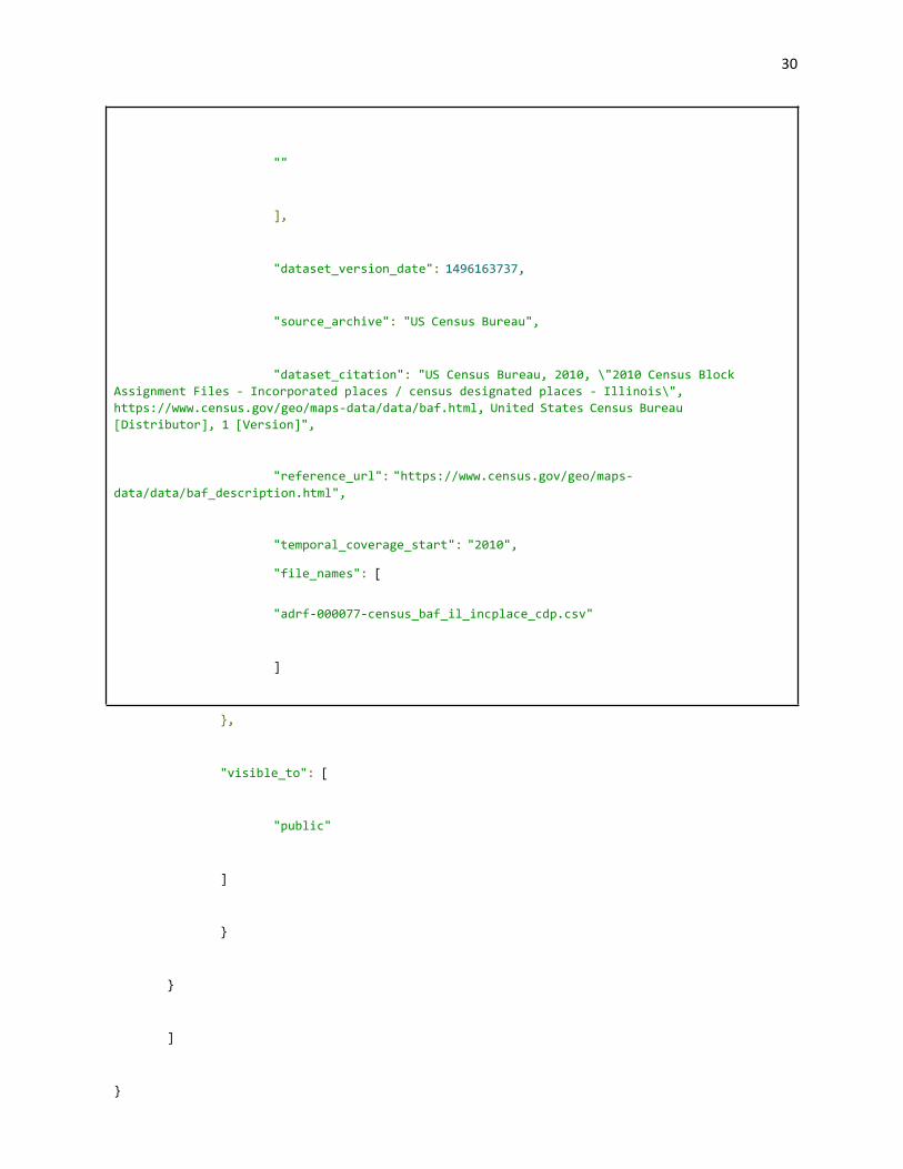
30
""
],
"dataset_version_date": 1496163737,
"source_archive": "US Census Bureau",
"dataset_citation": "US Census Bureau, 2010, \"2010 Census Block Assignment Files - Incorporated places / census designated places - Illinois\", https://www.census.gov/geo/maps-data/data/baf.html, United States Census Bureau [Distributor], 1 [Version]",
"reference_url": "https://www.census.gov/geo/maps- data/data/baf_description.html",
"temporal_coverage_start": "2010",
"file_names": [
"adrf-000077-census_baf_il_incplace_cdp.csv"
]
},
"visible_to": [
"public"
]
}
}
]
}


![Holistic and Comprehensive Annotation of Clinically ... · Noisy and incomplete training labels often exist in datasets mined from the web [7], which is similar to our la-bels mined](https://img.pdfslide.net/doc/110x75/5e0d854ae6c1b52940032038/holistic-and-comprehensive-annotation-of-clinically-noisy-and-incomplete-training.jpg)