Embed Size (px)
Citation preview
Advances in Environmental Biology, 8(12) July 2014, Pages: 1406-1414
AENSI Journals
Advances in Environmental Biology ISSN-1995-0756 EISSN-1998-1066
Journal home page: http://www.aensiweb.com/AEB/
Corresponding Author: Rasool Dadkhah, Young Researchers and Elite Club, Khorasgan (Isfahan) Branch, Islamic Azad
University, Isfahan, Iran
E-mail:[email protected]
Investigation of Engineering Geology Characterization of Khersan 3 Dam Site
Rasool Dadkhah and Zahra Hoseein Mirzaee Beni
Young Researchers and Elite Club, Khorasgan (Isfahan) Branch, Islamic Azad University, Isfahan, Iran
A R T I C L E I N F O A B S T R A C T
Article history: Received 19 August 2014
Received in revised form
19 September 2014 Accepted 29 September 2014
Available online 12 November 2014
Keywords:
The purpose of this study is to investigate the Engineering geological characteristics of the rock material and rock mass a khersan3 dam. The Khersan3 dam will be situated on
the Khersan River, 50 km south-west of Lordegan in the east part Mountain Zakrose of
Iran. Khersan3 Dam will be built on sedimentary rocks which consist of microcrystalline limestone and marly limestone of the tercier Age. In the study, rock
mass properties were classified using RMR, Q and GSI was used to obtain rock mass
strength parameters.
© 2014 AENSI Publisher All rights reserved.
To Cite This Article: Rasool Dadkhah and Zahra Hoseein Mirzaee Beni., Investigation of Engineering Geology Characterization of
Khersan 3 Dam Site. Adv. Environ. Biol., 8(12), 1406-1414, 2014
INTRODUCTION
Rocks have been classified on the basis of their origin, mineralogical composition, void index, fracture/joint
intensity, joint inclination, flow rate of water, velocity of propagation of shock wave, weathering, colour or
grain size. When rocks and rock masses are classified for geotechnical purposes, they need to be classified on
the basis of strength and/or modulus to give an indication of their stability and/or deformability.
The purpose of this study is to investigate the Engineering geological characteristics of the rock Material
and rock mass a khersan3 dam.
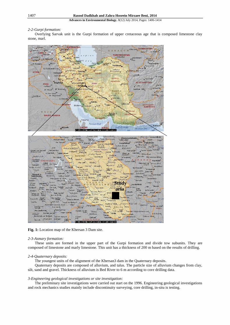
The Khersan3 dam will be situated on the Khersan River, 50 km south-west of Lordegan in the east part
Mountain Zakrose of Iran (Fig. 1). It will be used for flow control and water storage for product energy projects.
The design of Khersan3 Dam is under the direction of General Directorate of the Ministry of Energy, Iran.
This paper explains engineering geological assessment for safe design of the proposed khersan3 Dam. These
geotechnical Investigations (for example, scan-line survey, discontinuity measurements, various laboratory and
in-situ tests, kinematical analyses, etc.) have been carried out at the project site and in the laboratory. Various
laboratory and in-situ tests were performed to assess the characteristics of rock masses. Detailed discontinuity
surveying was also carried out.
In the study, rock mass properties were classified using RMR [3], Q [2] and GSI [6] was used to obtain rock
mass strength parameters.
2. Geological setting:
Geological factors play a major role in designing and constructing a dam. Of the various natural factors that
influence the design of dams, none are more important than the geological ones. Not only do they control the
character of formations, but they also govern the material available for construction. There exist numerous
examples of projects where the conditions of the foundation were not sufficiently known and the cost of
construction and treatment greatly exceeded the original budget [10].
Information on the regional geology of the area has been given by Ali Darvishzade, Geology of Iran [1] and
Water and energy Engineering Company [12].
The Khersan3 Dam is located on sedimentary rocks of the Tercier Age and on Quaternary deposits.
2-1-Sarvak formation:
The oldest geologic unit regional is the Sarvak formation of Cretaceous age. That is composed mainly of
limestone gray color and chert.
1407 Rasool Dadkhah and Zahra Hoseein Mirzaee Beni, 2014
Advances in Environmental Biology, 8(12) July 2014, Pages: 1406-1414
2-2-Gurpi formation:
Overlying Sarvak unit is the Gurpi formation of upper cretaceous age that is composed limestone clay
stone, marl.
Fig. 1: Location map of the Khersan 3 Dam site.
2-3-Asmary formation:
These units are formed in the upper part of the Gurpi formation and divide tow subunits. They are
composed of limestone and marly limestone. This unit has a thickness of 200 m based on the results of drilling.
2-4-Quaternary deposits:
The youngest units of the alignment of the Khersan3 dam in the Quaternary deposits.
Quaternary deposits are composed of alluvium, and talus. The particle size of alluvium changes from clay,
silt, sand and gravel. Thickness of alluvium is Bed River to 6 m according to core drilling data.
3-Engineering geological investigations or site investigation:
The preliminary site investigations were carried out start on the 1996. Engineering geological investigations
and rock mechanics studies mainly include discontinuity surveying, core drilling, in-situ is testing.
Study
aria
1408 Rasool Dadkhah and Zahra Hoseein Mirzaee Beni, 2014
Advances in Environmental Biology, 8(12) July 2014, Pages: 1406-1414
3-1-Mass properties:
The engineering geological properties of the rock masses at the site have been assessed in accordance with
the working partly report [12] and the International Society for Rock Mechanics (ISRM) Suggested method
[11].
3-2-Discontinuity surveying:
Discontinuities surveys consisted of orientation, aperture, roughness, persistence, infilling and spacing was
determined at the site by exposure logging in accordance to ISRM [11].
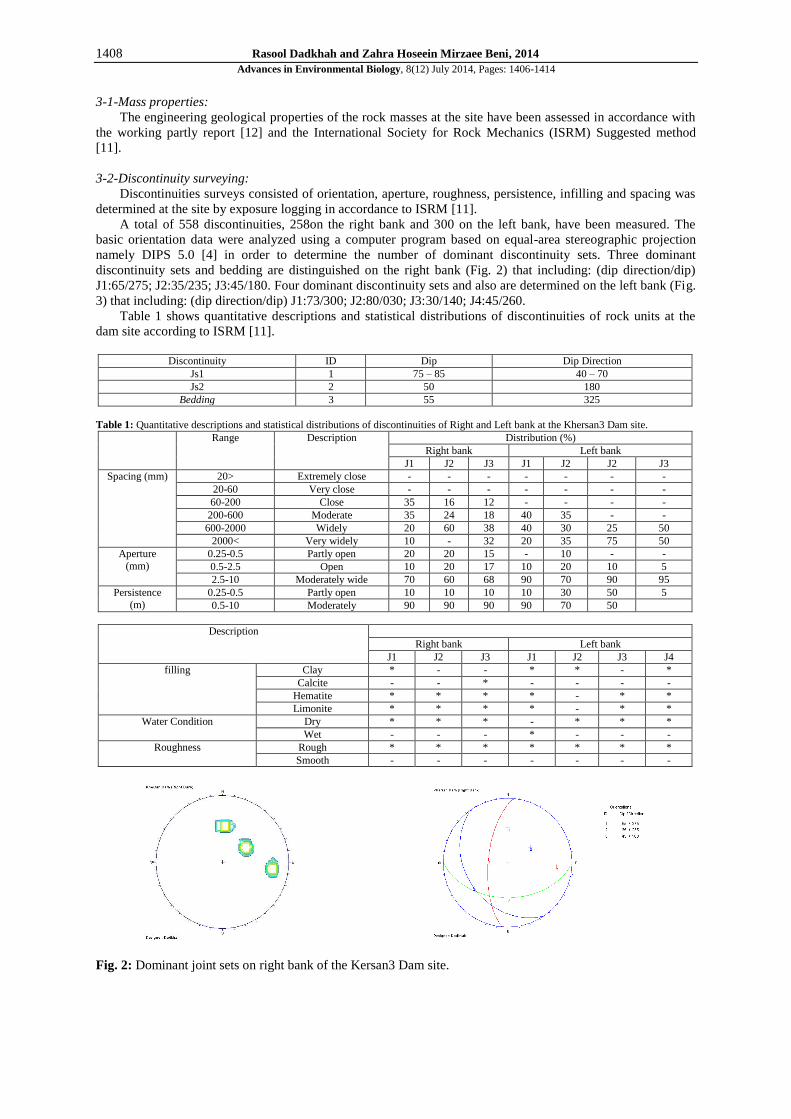
A total of 558 discontinuities, 258on the right bank and 300 on the left bank, have been measured. The
basic orientation data were analyzed using a computer program based on equal-area stereographic projection
namely DIPS 5.0 [4] in order to determine the number of dominant discontinuity sets. Three dominant
discontinuity sets and bedding are distinguished on the right bank (Fig. 2) that including: (dip direction/dip)
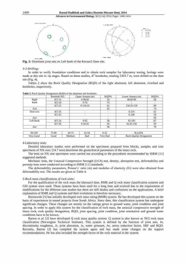
J1:65/275; J2:35/235; J3:45/180. Four dominant discontinuity sets and also are determined on the left bank (Fig.
3) that including: (dip direction/dip) J1:73/300; J2:80/030; J3:30/140; J4:45/260.
Table 1 shows quantitative descriptions and statistical distributions of discontinuities of rock units at the
dam site according to ISRM [11].
Discontinuity ID Dip Dip Direction
Js1 1 75 – 85 40 – 70
Js2 2 50 180
Bedding 3 55 325
Table 1: Quantitative descriptions and statistical distributions of discontinuities of Right and Left bank at the Khersan3 Dam site.
Range Description Distribution (%)
Right bank Left bank
J1 J2 J3 J1 J2 J2 J3
Spacing (mm) 20> Extremely close - - - - - - -
20-60 Very close - - - - - - -
60-200 Close 35 16 12 - - - -
200-600 Moderate 35 24 18 40 35 - -
600-2000 Widely 20 60 38 40 30 25 50
2000< Very widely 10 - 32 20 35 75 50
Aperture
(mm)
0.25-0.5 Partly open 20 20 15 - 10 - -
0.5-2.5 Open 10 20 17 10 20 10 5
2.5-10 Moderately wide 70 60 68 90 70 90 95
Persistence
(m)
0.25-0.5 Partly open 10 10 10 10 30 50 5
0.5-10 Moderately 90 90 90 90 70 50
Description
Right bank Left bank
J1 J2 J3 J1 J2 J3 J4
filling Clay * - - * * - *
Calcite - - * - - - -
Hematite * * * * - * *
Limonite * * * * - * *
Water Condition Dry * * * - * * *
Wet - - - * - - -
Roughness Rough * * * * * * *
Smooth - - - - - - -
Fig. 2: Dominant joint sets on right bank of the Kersan3 Dam site.
1409 Rasool Dadkhah and Zahra Hoseein Mirzaee Beni, 2014
Advances in Environmental Biology, 8(12) July 2014, Pages: 1406-1414
Fig. 3: Dominant joint sets on Left bank of the Kersan3 Dam site.
3-3-Drilling:
In order to verify foundation conditions and to obtain rock samples for laboratory testing, borings were
made at this site in چند stages. Based on these studies, 47 boreholes, totaling 5303.7 m, were drilled on the dam
site (Fig. 4).
Tables 2 show the Rock Quality Designation (RQD) of the right abutment, left abutment, riverbed and
boreholes, respectively.
Table 2: Rock Quality Designation (RQD) of the abutment site boreholes.
Borehole NO. Upper Asmary (m) RQD% Lower Asmary (m) RQD%
Right
Bank
KT-15 0-48.60 56 48.60-90 68
KT-18 0-70 74 - -
KT-23 0-134.35 62 134.35-150 80
Ave 65 74
Dam axis KT-33 - - 6-210 63
KT-35 - - 6-100 58
Ave - 60
Left Bank KT-24 0-92 58 92-105 87
KT-36 0-44.45 56 44.45-150 69
Ave 58 78
90-100 75-90 50-75 25-50 0-25 R.Q.D%
Very Good Good Medium Bad Very Bad Rock Quality Designation
4-Laboratory tests:
Detailed laboratory studies were performed on the specimens prepared from blocks, samples and core
specimens of NX-size; (54.7 mm) determine the geotechnical parameters of the intact rock.
The tests on NX size specimens were carried out according to the procedures recommended by ISRM [11]
suggested methods
Mechanic tests, the Uniaxial Compressive Strength (UCS) test, density, absorption test, deformability and
porosity tests were conducted according to ISRM [11] standards.
The deformability parameters, Poison’s` ratio (m) and modulus of elasticity (Ei) were also obtained from
deformability test. The results are given in Table 4.
5-Rock mass classifications of rock units:
For the qualification of the rock mass the khersan3 dam, RMR and Q rock mass classification systems and
GSI system were used. These systems have been used for a long time and evolved due to the requirement of
modifications for the different case studies but there are still doubts and confusions on the applications. A brief
explanation of RMR and Q systems and their evolutions is therefore necessary.
Bieniawski [3] has initially developed rock mass rating (RMR) system. He has developed this system on the
basis of experiences in tunnel projects from South Africa. Since then, this classification system has undergone
significant changes. These changes are mostly on the ratings given to ground water, joint condition and joint
spacing. In order to apply this system for the classification of rock mass, the uniaxial compressive strength of
intact rock, rock quality designation, RQD, joint spacing, joint condition, joint orientation and ground water
conditions have to be known.
Barton et al. [2] have developed Q rock mass quality system. Q system is also known as NGI rock mass
classification (Norwegian Technical Institute). This system is defined by the function of joint sets, Jn,
discontinuity roughness, Jr, joint alteration, Ja, water pressure, Jw, stress reduction factor, SRF and RQD.
Recently, Barton [2] has compiled the system again and has made some changes on the support
recommendations. He has also included the strength factor of the rock material in the system.
1410 Rasool Dadkhah and Zahra Hoseein Mirzaee Beni, 2014
Advances in Environmental Biology, 8(12) July 2014, Pages: 1406-1414
Rock mass classifications can serve as a powerful design tool in Dams construction, showed how to
estimate the compressive strength of a rock mass based on the (m) and (s) criteria. Hoek et al. [6] have
expressed the compressive strength of rock masses with an equivalent set of cohesion and friction parameters
for given Hoek–Brown values.
The geotechnical properties of the rock units comprising the Dam site were assessed by using three
empirical rock mass classification systems, namely RMR method, Q method and GSI (Geological Strength
Index).
The Geological Strength Index (GSI), introduced by Hoek [6], Hoek et al. [7] and Hoek et al. [8] provides
a system for estimating the reduction in rock mass strength for different geological conditions as identified by
field observations.
5.1. Results of rock mass classification systems at dam site rock units:
In order to overcome some uncertainties of these classification systems, a range of rock mass values was
estimated rather than just a single value.
The RMR [3] classification of the Dam site rock units is shown in Table 5. As shown in this table, the rock
units are classified as medium rock quality (class III). The Asmary unit at left bank is classified as medium rock
masses (RMR=56). The Asmary unit at right bank and riverbed is classified as fair rock (RMR=59).
The Q [2] classification of the dam site rock units is shown in Table 6. As shown in this table, the rock units
are classified as medium rock quality (class III). The Asmary unit at left bank is classified as medium rock
masses (Q=6.79). The Asmary unit at right bank is classified as fair rock (Q=7).
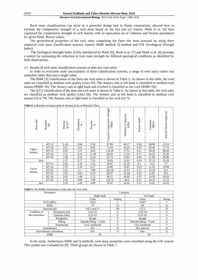
Table 4: Laboratory testing results of Asmary rocks at Khersan3 Dam.
Rock
un
it
Bo
reho
le
NO
.
Den
sity
gr/
cm3
Ab
sorp
tion
%
Po
rosi
ty
%
Un
iaxia
l C
om
pre
ssiv
e S
tren
gth
(Mpa)
Modu
lus
of
elas
tici
ty
(GP
a)
Po
isso
n R
atio
Coh
esio
n
(MP
a)
Inte
rnal
fri
ctio
n a
ng
le (
φ)
Upper
Asmary
KT-15 2..66 0.94 2.18 67.99 40.17 0.20 49.98 53.19
KT-18 2.61 2.01 4.92 73.18 43.25 0.19 50.49 57.75
KT-23 2.63 1.57 4.03 118.26 37.51 0.21 39.20 60.20
KT-24 2.51 4.31 11.30 68.78 23.35 0.17 24.20 55.30
KT-36 2.48 5.02 12.41 62.73 19.81 0.20 21.80 49.99
Ave 2.57 2.77 7.52 78.02 32.81 0.19 37.13 55.28
Lower
Asmary
KT-15 2.60 1.91 3.23 58.47 41.25 0.2 13.2 27
KT-23 2.53 2.58 6.37 36.89 34.67 0.25 11.50 18.98
KT-33 2.61 2.1 5.98 102.18 32.23 0.17 15.30 31.1
KT-35 2.62 2.01 4.19 48.37 26.30 0.22 12.81 19.1
KT-24 2.62 1.48 2.72 94.57 43.83 0.25 14.39 29.20
KT-36 2.59 0.98 1.99 120.72 40.4 0.21 16.32 21.23
Ave 2.59 1.69 4.08 76.87 36.45 0.21 13.92 24.43
Table 5: The RMR classification of the dam site rock units.
Parameters Location
Right bank Left bank
Value Rating Value Rating
UCS (MPa) 78.02 7 76.87 7
RQD 70 13 68 13
Spacing (m) 0.6-2 and 2< 18 0.2-2 12
Condition of
discontinuities
Persistence (m) 0.25-10 4 0.25-10 4
Aperture (mm) 0.25-10 0 0.25-10 0
Roughness Rough 5 Rough 5
Filling Smooth filling < 5 mm 0 Smooth filling < 5 mm 0
Weathering Low weathered 5 Low weathered 5
Groundwater dry 15 Dry and wet 12
Discontinuity orientation Fair -5 Fair -5
RMR 59 56
In the study, furthermore RMR and Q methods, rock mass properties were classified using the GSI system.
This system was evaluated by [9]. These groups are shown in Table 7.
1411 Rasool Dadkhah and Zahra Hoseein Mirzaee Beni, 2014
Advances in Environmental Biology, 8(12) July 2014, Pages: 1406-1414
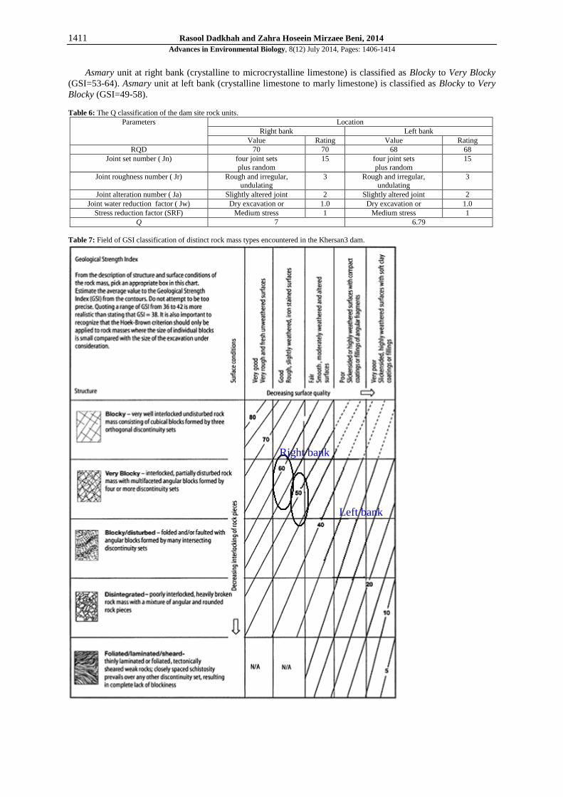
Asmary unit at right bank (crystalline to microcrystalline limestone) is classified as Blocky to Very Blocky
(GSI=53-64). Asmary unit at left bank (crystalline limestone to marly limestone) is classified as Blocky to Very
Blocky (GSI=49-58).
Table 6: The Q classification of the dam site rock units.
Parameters Location
Right bank Left bank
Value Rating Value Rating
RQD 70 70 68 68
Joint set number ( Jn) four joint sets
plus random
15 four joint sets
plus random
15
Joint roughness number ( Jr) Rough and irregular, undulating
3 Rough and irregular, undulating
3
Joint alteration number ( Ja) Slightly altered joint 2 Slightly altered joint 2
Joint water reduction factor ( Jw) Dry excavation or 1.0 Dry excavation or 1.0
Stress reduction factor (SRF) Medium stress 1 Medium stress 1
Q 7 6.79
Table 7: Field of GSI classification of distinct rock mass types encountered in the Khersan3 dam.
Right bank
Left bank

1412 Rasool Dadkhah and Zahra Hoseein Mirzaee Beni, 2014
Advances in Environmental Biology, 8(12) July 2014, Pages: 1406-1414
6. Rock mass strength estimation:
Singh proposed the following relationship to be an approximate estimate to the value of the rock mass
compressive strength based on the rock mass Q and rock density γ (kN/m3), in Bhasin and Grimstad [5].
)(7.0 31
MPaQm
The uniaxial compressive strength of the rock mass m , on the other hand, based on c′ and φ ́
c′ is the cohesive strength; φ′ the angle of friction of the rock mass.
sin1
cos2cm
Too the rock mass strength parameters such as, Hoek–Brown constants, modulus of elasticity and uniaxial
compressive strength, are essential need in the preliminary stages of dam design. In this study, Hoek–Brown
strength criterion was used for estimation of the rock mass strength parameters. To estimate, the parameters
related to Hoek–Brown criterion, which represent the rock mass, the test results of the intact rock specimen were
used in conjunction with GSI values. The generalized empirical failure criterion is as follows [8] a
ci
bci sm
3
31
Where σ'1 and σ'3 are the major and minor effective principal stresses at failure σci is the uniaxial
compressive strength of the intact rock material and mb is a reduced value of the material constant mi and is
given by
D
GSImm ib
1428
100exp
Intact rock constant (mi) was found from Table 8.3 of Hoek et al. [7].
s and a are constants for the rock mass given by the following relationships:
D
GSIs
39
100exp
3
2015
6
1
2
1eea
GSI
D is a factor which depends upon the degree of disturbance to which the rock mass has been subjected by
blast damage and stress relaxation. It varies from 0 for undisturbed in situ rock masses to 1 for very disturbed
rock masses [8].
The uniaxial compressive strength is obtained by setting σ'3=0 in equation 1, giving: a
cic s.
Also the in-situ deformation modulus of rock masses (Em) can be obtained by using the GSI value in the
formula below [8].
4010
10.1002
1)(GSI
cim
DGPaE
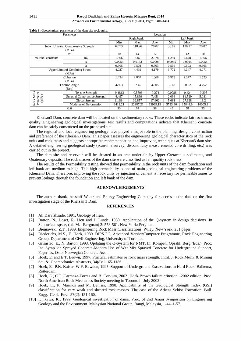
The rock mass constants, uniaxial compression strength and the in-situ deformation modulus of each rock
units are presented in Table 8.
7-Conclusions and recommendations:
Based on the information collected at site and the analysis carried out, the Both theoretical and empirical
solutions showed that limestone Asmary unit creates no problem since the rock mass strength greater than
tangential stress concentration.
When the results from different methods based on parameters found by using GSI are examined, it is seen
that GSI gives consistent results irrespective of the evaluation method.
Khersan3 Dam will be built on sedimentary rocks which consist of microcrystalline limestone and marly
limestone of the tercier Age. Quantitative description of discontinuities was performed at the site by exposure
logging in accordance with ISRM (1981).
This high permeability is one of main geological engineering problems of the Khersan3 Dam. Therefore,
improving the rock units by injection of cement is recommended for reduction of seepage flow through the
foundation and left bank of the dam.
1413 Rasool Dadkhah and Zahra Hoseein Mirzaee Beni, 2014
Advances in Environmental Biology, 8(12) July 2014, Pages: 1406-1414
Table 8: Geotechnical parameter of the dam site rock units.
Parameter Location
Right bank Left bank
Min Max Ave Min Max Ave
Intact Uniaxial Compressive Strength
(MPa)
62.73 118.26 78.02 36.89 120.72 70.87
mi 10 14 12 8 12 10
material constants mb 1.866 3.87 2.678 1.294 2.678 1.866
s 0.0054 0.0183 0.0094 0.0035 0.0094 0.0054
a 0.505 0.502 0.503 0.506 0.503 0.505
Upper Limit of Confining Stress
(MPa)
4.027 4.419 4.179 3.772 4.347 4.071
Cohesion (MPa)
1.434 2.869 1.868 0.973 2.377 1.523
Friction Angle
(Deg)
42.63 52.45 47.05 35.63 50.02 43.52
Rock
Mas
s
Par
amet
er
(MP
a) Tensile Strength -0.1813 -0.5596 -0.274 -0.0986 -0.424 -0.205
Uniaxial Compressive Strength 4.497 15.869 7.451 2.096 11.529 5.081
Global Strength 11.684 32.857 17.662 5.661 27.328 13.2
Modulus of Deformation 9413.21 22387.21 13999.19 5733.96 15848.9 10005.3
GSI 53 64 58 49 58 53
Khersan3 Dam, concrete dam will be located on the sedimentary rocks. These rocks indicate fair rock mass
quality. Engineering geological investigations, test results and computations indicate that Khersan3 concrete
dam can be safely constructed on the proposed site.
The regional and local engineering geology have played a major role in the planning, design, construction
and preference of the Khersan3 Dam. This paper assesses the engineering geological characteristics of the rock
units and rock mass and suggests appropriate recommendation and improving techniques at Khersan3 dam site.
A detailed engineering geological study (scan-line survey, discontinuity measurements, core drilling, etc.) was
carried out in the project.
The dam site and reservoir will be situated in an area underlain by Upper Cretaceous sediments, and
Quaternary deposits. The rock masses of the dam site were classified as fair quality rock mass.
The results of the Permeability testing showed that permeability in the rock units of the dam foundation and
left bank are medium to high. This high permeability is one of main geological engineering problems of the
Khersan3 Dam. Therefore, improving the rock units by injection of cement is necessary for permeable zones to
prevent leakage through the foundation and left bank of the dam.
ACKNOWLEDGEMENTS
The authors thank the staff Water and Energy Engineering Company for access to the data on the first
investigation stage of the Khersan 3 Dam.
REFERENCES
[1] Ali Darvishzade, 1991. Geology of Iran.
[2] Barton, N., Loset, R. Lien and J. Lunde, 1980. Application of the Q-system in design decisions. In
Subsurface spsce, (ed. M. Bergman) 2: 553-561. New York: Pergman.
[3] Bieniawski, Z.T., 1989. Engineering Rock Mass Classifications. Wiley, New York. 251 pages.
[4] Diederichs, M.S., E. Hoek, 1989. DIPS 2.2. Advanced VersionComputer Programme, Rock Engineering
Group, Department of Civil Engineering, University of Toronto.
[5] Grimstad, E., N. Barton, 1993. Updating the Q-System for NMT. In: Kompen, Opsahl, Berg (Eds.), Proc.
Int. Symp. on Sprayed Concrete-Modern Use of Wet Mix Sprayed Concrete for Underground Support,
Fagernes, Oslo: Norwegian Concrete Assn.
[6] Hoek, E. and E.T. Brown, 1997. Practical estimates or rock mass strength. Intnl. J. Rock Mech. & Mining
Sci. & Geomechanics Abstracts, 34(8): 1165-1186.
[7] Hoek, E., P.K. Kaiser, W.F. Bawden, 1995. Support of Underground Excavations in Hard Rock. Balkema,
Rotterdam.
[8] Hoek, E., C.T. Carranza-Torres and B. Corkum, 2002. Hoek-Brown failure criterion –2002 edition. Proc.
North American Rock Mechanics Society meeting in Toronto in July 2002.
[9] Hoek, E., P. Marinos and M. Benissi, 1998. Applicability of the Geological Strength Index (GSI)
classification for very weak and sheared rock masses. The case of the Athens Schist Formation. Bull.
Engg. Geol. Env. 57(2): 151-160.
[10] Ichikawa, K., 1999. Geological investigation of dams. Proc. of 2nd Asian Symposium on Engineering
Geology and the Environment. Malaysian National Group, Bangi, Malaysia, 1-44–1-57.

1414 Rasool Dadkhah and Zahra Hoseein Mirzaee Beni, 2014
Advances in Environmental Biology, 8(12) July 2014, Pages: 1406-1414
[11] ISRM, 1981. Suggested Methods for the Quantitative Description of Discontinuities in Rock Masses.
Rock Characterization, Testing and Monitoring, London. Pergamon, Oxford, 221 pp.
[12] Water Engineering Company, 2003. Engineering geology report of Kersan3 dam site. Khersan3 project.
Ministry of Energy, Iran, in Persian.
[13] Sari, D., A.G. Pasamehmetoglu, 2003. Proposed support design, Kaletepe tunnel, Turkey, engineering
geology, article in press.