Embed Size (px)
Citation preview

AEHFINTELLIGENCE, RECONNAISSANCE, SURVEILLANCE
The Russians have come, the Russians have come
Command centers: palu, boutelle + matheson
Military + government communications
Latest MILSATCOM news

MilsatMagazine — January 20102
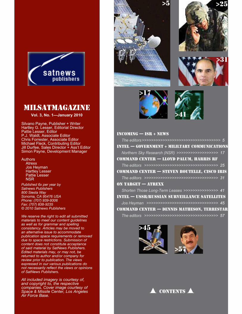
MilsatmagazineVol. 3, No. 1—January 2010
Silvano Payne, Publisher + WriterHartley G. Lesser, Editorial DirectorPattie Lesser, EditorP.J. Waldt, Associate EditorChris Forrester, Associate EditorMichael Fleck, Contributing EditorJill Durfee, Sales Director + Ass’t EditorSimon Payne, Development Manager
Authors Atrexx Jos Heyman Hartley Lesser Pattie Lesser NSRPublished 6x per year by Satnews Publishers800 Siesta WaySonoma, CA 95476 USAPhone: (707) 939-9306Fax: (707) 838-9235© 2010 Satnews Publishers
We reserve the right to edit all submitted materials to meet our content guidelines as well as for grammar and spelling consistency. Articles may be moved to an alternative issue to accommodate publication space requirements or removed due to space restrictions. Submission of content does not constitute acceptance of said material by SatNews Publishers. Edited materials may, or may not, be returned to author and/or company for review prior to publication. The views expressed in our various publications do not necessarily reflect the views or opinions of SatNews Publishers.
All included imagery is courtesy of, and copyright to, the respective companies. Cover image courtesy of Space & Missile Center, Los Angeles Air Force Base.
Incoming — ISR + News The editors >>>>>>>>>>>>>>>>>>>>>>>>>>>>>>>>>> 5
Intel — Government + Mililtary Communications Northern Sky Research (NSR) >>>>>>>>>>>>>>>>>> 17
Command center — Lloyd palum, Harris RF The editors >>>>>>>>>>>>>>>>>>>>>>>>>>>>>>>> 25
Command center — Steven boutelle, Cisco IRIS The editors >>>>>>>>>>>>>>>>>>>>>>>>>>>>>>>> 31
On TArget — atrexx Shorten Those Long-Term Leases >>>>>>>>>>>>>>> 41
Intel — USSR/Russian surveillance satellites Jos Heyman >>>>>>>>>>>>>>>>>>>>>>>>>>>>>>> 45
Command center — Dennis matheson, Terrestar The editors >>>>>>>>>>>>>>>>>>>>>>>>>>>>>>>> 57
D CONTENTS D
>25
>31
>41
>17
>57
>45
>5
MilsatMagazine —January 2010 5
With comsats (communication satellites) and weather satellites in
geosynchronous orbits 23,000 miles above the Earth, and photo recon
satellites ranging in altitude from hundreds to thousands of miles
(depending upon the resolution required for viewing the target area),
the purposes of the various military satellites operated by various
countries are as varied as they are secret. Additionally, the latest
flock of military satellites also carry civil bandwidths for government,
non-military use — multi-tasking of the MILSATCOM kind.
I S R
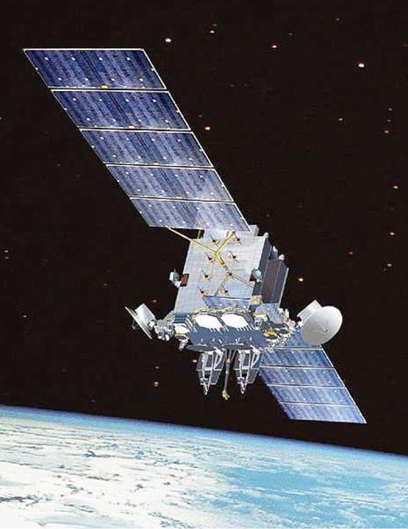
AEHFSet for launch this year is the U.S. Air Force’s Advanced Extremely High Frequency (AEHF) System. Courtesy of SMC Public Affairs at Los Angeles Air Force Base, we learn that AEHF is a joint service satellite communications system that will provide survivable, global, secure, protected, and jam-resistant communications for high-priority military ground, sea and air assets.
Advanced EHF will allow the National Security Council and Unified Combatant Commanders
to control their tactical and strategic forces at all levels of conflict through general nuclear war, and supports the attainment of information superiority.
The AEHF System is the follow-on to the Milstar system, augmenting and improving on the capabilities of Milstar, and expanding the MILSATCOM architecture. AEHF will provide connectivity across the spectrum of mission areas, including land, air and naval warfare; special operations; strategic nuclear operations; strategic defense; theater
Inco
min
g
MilsatMagazine — January 20106
(Canada, Netherlands and U.K.). MCSW is responsible for acquisition of the space and ground segments as well as the Air Force terminal segments. The Army and Navy will acquire their own terminals. The general characteristics of AEHF are:
Primary Function: Near-worldwide, •secure, survivable satellite communicationsPrimary Contractor: Lockheed Martin •Space Systems CompanyPayload: Onboard signal •processing, crossbanded EHF/SHF communicationsAntennas: 2 SHF Downlink Phased •Arrays, 2 Crosslinks, 2 Uplink/Downlink Nulling Antennas, 1 Uplink EHF Phased Array, 6 Uplink/Downlink Gimbaled Dish Antenna, 1 Each Uplink/Downlink Earth coverage horns
Capability: Data rates from 75 bps to •approximately 8 Mbps
missile defense; and space operations and intelligence. Part of the MCSW’s Protected SATCOM Group, the system consists of four satellites in geosynchronous Earth orbit (GEO) that provides 10 times the throughput of the 1990s-era Milstar satellites with a substantial increase in coverage for users. The first launch of AEHF is scheduled for late 2010.
The AEHF system is composed of three segments: space (the
satellites), ground (mission control
and associated communications links) and terminals (the users). The
segments will provide
communications in a specified set of
data rates from 75 bps to approximately 8 Mbps. The space segment consists of a cross-linked constellation of three satellites. The mission control segment controls satellites on orbit, monitors satellite health and provides communications system planning and monitoring.
This segment is highly survivable, with both fixed and mobile control stations. System uplinks and crosslinks will operate in the extremely high frequency (EHF) range and downlinks in the super high frequency (SHF) range.
The terminal segment includes fixed and ground mobile terminals, ship and submarine terminals, and airborne terminals used by all of the Services and international partners
GPS SATELLITE
Inco
min
g
MilsatMagazine —January 2010 7
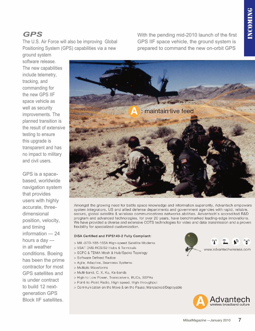
GPSThe U.S. Air Force will also be improving Global Positioning System (GPS) capabilities via a new ground system software release. The new capabilities include telemetry, tracking, and commanding for the new GPS IIF space vehicle as well as security improvements. The planned transition is the result of extensive testing to ensure this upgrade is transparent and has no impact to military and civil users.
GPS is a space-based, worldwide navigation system that provides users with highly accurate, three-dimensional position, velocity, and timing information — 24 hours a day — in all weather conditions. Boeing has been the prime contractor for most GPS satellites and is under contract to build 12 next-generation GPS Block IIF satellites.
With the pending mid-2010 launch of the first GPS IIF space vehicle, the ground system is prepared to command the new on-orbit GPS
Inco
min
g
MilsatMagazine — January 20108
IIF capabilities that include a new navigation signal for civil users, encrypted military code, crosslink enhancements, improved navigation signal accuracy and signal power increases. The new software also provides robust security improvements to include “over-the-air” distribution of encryption keys to properly equipped military users.
Preparation for activation of the new software included rigorous developmental and operational testing events including five transition exercises.
The new ground system software commanded current individual GPS satellites during numerous testing events and rehearsals. In November and December of 2009, the new software successfully uploaded operational GPS IIA and IIR space vehicles with navigation data and completed normal operational functions.
This improvement initiative continues the Air Force’s commitment to the global community of GPS users. The Air Force will continue to pursue an achievable path maintaining GPS as the premier provider of positioning, navigation and timing for military and civilian users around the world.
Boeing
The Boeing Company has instituted a number of changes within the Company’s Integrated Defense Systems’ unit, with the realignment effective immediately. The unit will now operate under a new name: Boeing Defense, Space & Security. In announcing the changes, Boeing Defense, Space & Security
President and CEO Dennis Muilenburg stated the realignment is part of a continuing effort to successfully compete in a rapidly evolving global defense and security marketplace. Muilenburg said that reshaping the unit positions Boeing for further growth in new and adjacent markets, while continuing to serve existing defense and space customers. While Boeing Defense, Space & Security will retain its current operating units — Boeing Military Aircraft (BMA), Network and Space Systems (N&SS), and Global Services & Support (GS&S) — the realignment consolidates some divisions and makes a number of leadership changes. Chief among the moves is consolidation of two divisions in N&SS: The Combat Systems division and the Command, Control & Communications (C3) Networks division will be unified as the new Network and Tactical Systems division.
EADS Astrium
Astrium Services has been awarded a contract by the European Defence Agency (EDA) for a new preparatory study aimed at coordinating the future military communication needs of the European Union (EU). The single year pilot project aims at creating a centralized system for the procurement of satellite communications (SATCOM) on commercial space capacity, such as Ku-, Ka- and C-bands. Over the next year, Astrium Services will map out the SATCOM requirements of the European Member States’ respective armed forces, while developing an operational framework for the European Satellite Communication Procurement Cell (ESCPC). The aim of the ESCPC will be to
Inco
min
g
MilsatMagazine —January 2010 9
coordinate and aggregate EU Member States’ orders for satellite communications services — ultimately ensuring the best and most cost-effective access to commercial capacity for military purposes.
Once the ESCPC is in place, Astrium Services will be able to offer its unique one-stop-shop 24/7 approach, via its London Satellite Exchange (LSE) subsidiary, and will be ready to manage and execute a full catalogue of services.
NASAThe latest Geostationary Operational Environmental Satellite, GOES, developed by NASA for the National Oceanic and Atmospheric Administration (NOAA), called GOES-P, arrived on Thursday, December 17, on a C-17 military cargo aircraft at the Kennedy Space Center’s Shuttle Landing Facility from its manufacturing plant in El Segundo, California. The GOES-P satellite is targeted to launch on February 25 onboard a United Launch Alliance Delta IV expendable launch vehicle.
Once in geosynchronous orbit, GOES-P will be designated GOES-15 and NASA will provide on-orbit checkout and then transfer operational responsibility to
NOAA. GOES-P will be placed in on-orbit storage as a replacement for an older GOES satellite. After arriving, the satellite was transported to Astrotech in Titusville, Florida, where final testing of the imaging system, instrumentation, communications and power systems will be performed.
Inco
min
g
MilsatMagazine — January 201010
These tests will take approximately six weeks to complete. Then the spacecraft will be fueled with the propellant necessary for orbit maneuvers and the attitude control system. When the fueling is completed, the spacecraft is encapsulated in the Delta IV nose fairing and prepared for transport to the launch pad.GOES-P is the third and last spacecraft to be launched in the GOES N-P series of geostationary environmental weather satellites. The GOES satellites continuously provide observations of 60 percent of the Earth including the continental United States, providing weather monitoring and forecast operations, as well as a continuous and reliable stream of environmental information and severe weather warnings. GOES-P carries an advanced attitude control system using star
trackers and Hemispherical Inertial Reference Units. The imager and sounder instruments are mounted on a stable optical bench, which provides enhanced instrument pointing performance for improved image navigation and registration. This means better location of severe storms and other events important to the NOAA National Weather Service.
The Imager on GOES-P, as on the GOES-O before it, has improved resolution from previous GOES missions in the 13 micron channel from 8 km to 4 km. The finer spatial resolution allows improved estimates of horizontal distribution of cloud-top, height of atmospheric motion vectors, and volcanic ash detection. Similarly to the GOES-O mission, the GOES-P image navigation accuracy of about 2 km from an orbit altitude of about 22,300 miles, or 35,700 km, is superior compared to the previous series of GOES satellites. GOES-P only differs from GOES-O in the channel configuration for the solar Extreme Ultraviolet (EUV) telescope. The
Inco
min
g
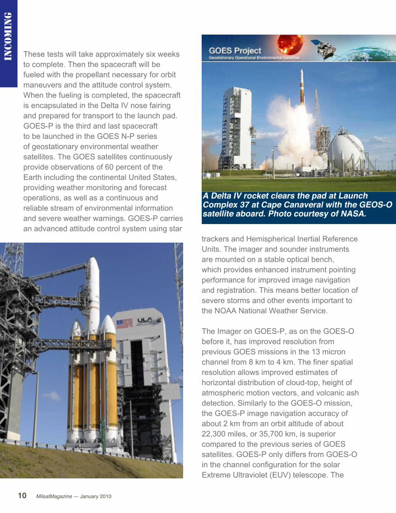
A Delta IV rocket clears the pad at Launch Complex 37 at Cape Canaveral with the GEOS-O satellite aboard. Photo courtesy of NASA.

11MilsatMagazine —January 2010
Inco
min
g
EUV will be the same 5 channel configuration that flew on GOES-N/13.
A United Launch Alliance Delta IV expendable launch vehicle will be erected in early January at Space Launch Complex 37-B, Cape Canaveral Air Force Station, Florida. NOAA manages the operational environmental satellite program and establishes requirements, provides all funding and distributes operational environmental satellite data for the United States. NASA’s Goddard Space Flight Center in Greenbelt, Maryland, procures and manages the development and launch of the satellites for NOAA on a cost-reimbursable basis. United Launch Alliance will conduct the commercial launch with a Federal Aviation Administration launch license. They will also oversee launch service duties that include oversight of the launch vehicle processing activities, integration of the GOES-P spacecraft with the Delta IV rocket, and the launch countdown activities.
COM DEV InternationalCOM DEV International Ltd. (TSX:CDV) has been awarded follow-on contracts totaling more than CDN$7 million to provide
passive microwave equipment for a military communications satellite. COM DEV will supply UHF diplexers, switch and filter assemblies, standalone switches and ancillary components. The Company expects to complete work on the contracts by the end of its 2011 fiscal year at its facility in Cambridge, Ontario.
MilsatMagazine — January 201012
Spirent Communications
Continuing on its path of innovation in LBS performance testing, Spirent Communications plc has introduced the industry’s first solution to test Assisted GLONASS (A-GLONASS) capability on UMTS mobile devices and chipsets. Supported on Spirent’s 8100 UMTS Location Technology Solution (ULTS), the new A-GLONASS testing capability gives early adopters of A-GLONASS a competitive edge by enabling the delivery of better-performing devices and improved user experiences.
The addition of A-GLONASS to the list of available LBS enabling technologies such as GPS is set to make a major impact on mobile device positioning in 2010 and beyond. GLONASS is a Russian navigation satellite system with recently-formalized open civilian access. Using both GPS and GLONASS offers a mobile device receiver almost twice the number of usable satellites in the sky compared with GPS alone. This can significantly improve the performance of location-based applications in challenging environments such as urban streets, where much of the sky can be obstructed and multiple signal reflections from tall buildings can confuse satellite receivers.
Providing assistance data over the cellular network (A-GLONASS) further improves the speed and reliability of position fixes, in the same way as A-GPS. A-GLONASS device testing on the 8100 ULTS is built upon the expertise gained from Spirent’s PLTS, which
was introduced into the CDMA market in 2001 and ULTS, the first commercially-available UMTS A-GPS test system. Since then, most of the world’s largest network operators, together with all the major mobile device and A-GPS chipset manufacturers, have relied on the Spirent 8100 ULTS for design, test and certification of their LBS solutions.
U.S. Air Force + Lockheed Martin
This team, who is developing the Space Based Infrared System program, has achieved two key milestones: a testing milestone demonstrating the ground system is on track to support launch of the first SBIRS geosynchronous GEO-1 satellite in the constellation; and a maturity milestone moving the ground system into the next level of integration. The testing milestone, known as the Combined Day-In-The-Life Test, validated the functionality, performance and operability of the SBIRS GEO ground system for its planned operational use.
Inco
min
g
MilsatMagazine —January 2010 13
The campaign included testing of more than 1.5 million source lines of code and 133 ground segment requirements. The new SBIRS ground system includes software and hardware necessary to perform activation, checkout and initial operations of the GEO-1 satellite after launch. SBIRS uses “Day-in-the-Life” test events to validate the integrated ground system following successful verification at the segment level.
The CDITL test integrated several geographically separated sites used for command and control, factory engineering support and direct interface to mission data users. The 17-day test included the use of high fidelity spacecraft simulators to complete the launch and early orbit test processes and products that will be used for the GEO-1 launch. Each site contributed significantly to the observed stability, robustness and operability of the SBIRS system. Completion of the ground segments verification process and the CDITL led to the readiness milestone, known as the System Integration Readiness Review.
This event, completed on January 12th, officially moves the ground
segment into the next level of integration. The Sunnyvale-based System Engineering, Integration and Test group formally accepted SBIRS’ approved completed ground component delivered for system level integration to include multiple end-to-end test and rehearsal events with space vehicle
Inco
min
g
MilsatMagazine — January 201014
simulators and the GEO-1 vehicle itself. This series of events are the final efforts leading to system operations readiness for launch of the GEO-1 space vehicle.
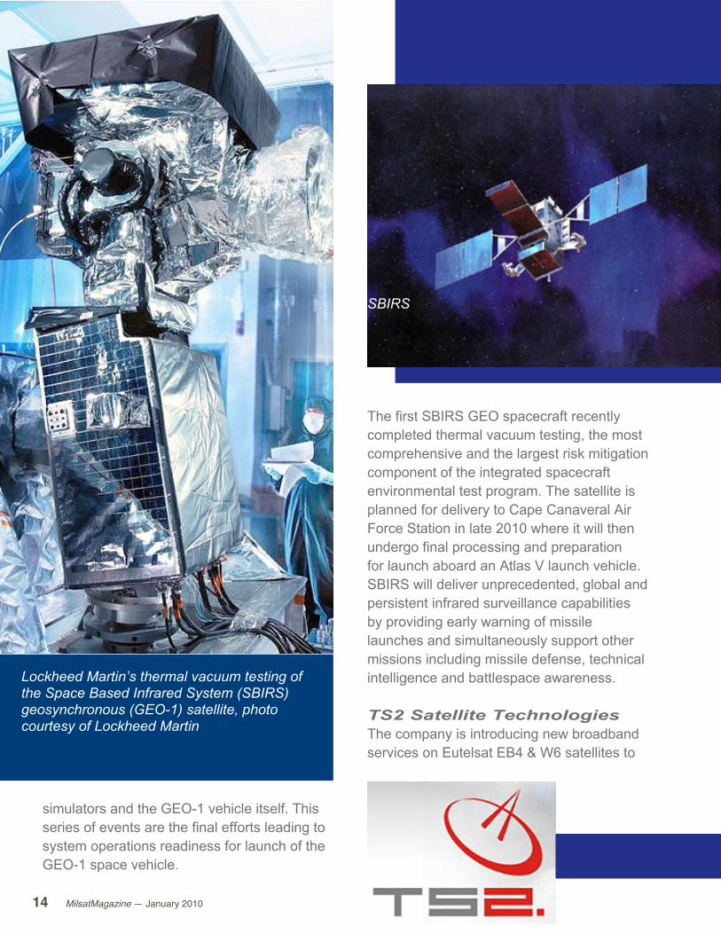
Lockheed Martin’s thermal vacuum testing of the Space Based Infrared System (SBIRS) geosynchronous (GEO-1) satellite, photo courtesy of Lockheed Martin
The first SBIRS GEO spacecraft recently completed thermal vacuum testing, the most comprehensive and the largest risk mitigation component of the integrated spacecraft environmental test program. The satellite is planned for delivery to Cape Canaveral Air Force Station in late 2010 where it will then undergo final processing and preparation for launch aboard an Atlas V launch vehicle. SBIRS will deliver unprecedented, global and persistent infrared surveillance capabilities by providing early warning of missile launches and simultaneously support other missions including missile defense, technical intelligence and battlespace awareness.
TS2 Satellite Technologies The company is introducing new broadband services on Eutelsat EB4 & W6 satellites to
SBIRS
MilsatMagazine —January 2010 15
the Afghan market. The broadband service offer two-way high-speed Internet access with no phone lines, no cable, no dial-up modem.
The offered satellite system is ideally suited for broadband requirements such as Internet and VPN access to enterprise networks, as well as real-time VoIP and video conferencing. The Internet connection can be shared with other users via wireless or wired network. Most soldiers deploy with a laptop in hand and a hookup to the Internet in their barracks. This is especially important for the many who are married, and have young children. The Internet access has resulted in major morale improvements. Troops no longer feel cut off
from home.
Not all the Internet connectivity is just for staying in touch with the folks back home. The troops in Afghanistan use the Internet a lot for professional tasks, and not all of them are official business. Some troops blog, and many other stay in touch with military friends and associates in other parts of
the world. The Internet has made possible many online communities composed of military professionals.

MilsatMagazine —January 2010 17
intel
Government + Military communications
By Northern Sky Research (NSR)
After going through a year of vast changes in program orientation,
budgetary allocation and delays or outright cancellation of
satellites, the Government and Military Satellite Communications
(GMSC) market still faces one stable trend: bandwidth demand.
The demand in the market is oblivious to economic recessions since users continue to ask for coverage and capacity to fulfill missions or public service mandates.
However, the outline and shape of this demand is not monolithic as it will give rise to sizeable revenues in some markets and warning flags in others.
Catch A WaveGenerally, the market looks good and is on the upswing, with users becoming savvier about what they want and wanting it in a very short timeframe. However, their demand for capacity is creating a gap as internal capacity is insufficient to meet all their needs. This is where the market shifts towards one side or the other: to proprietary systems or commercial satellites. The current trend points to an increase in the former, which will have both a positive and negative impact on the market at hand.
As they say, the devil is in the details, and the finer features of the demand curve tell us where commercial satellite equipment and services fit into the picture.
MilsatMagazine — January 201018
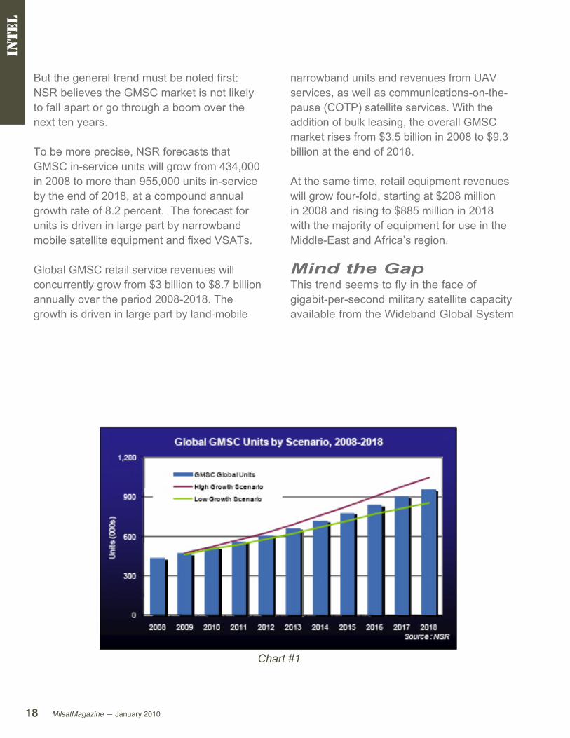
But the general trend must be noted first: NSR believes the GMSC market is not likely to fall apart or go through a boom over the next ten years.
To be more precise, NSR forecasts that GMSC in-service units will grow from 434,000 in 2008 to more than 955,000 units in-service by the end of 2018, at a compound annual growth rate of 8.2 percent. The forecast for units is driven in large part by narrowband mobile satellite equipment and fixed VSATs.
Global GMSC retail service revenues will concurrently grow from $3 billion to $8.7 billion annually over the period 2008-2018. The growth is driven in large part by land-mobile
Chart 1 — Global GMSC Units by Scenario, 2002-2018
narrowband units and revenues from UAV services, as well as communications-on-the-pause (COTP) satellite services. With the addition of bulk leasing, the overall GMSC market rises from $3.5 billion in 2008 to $9.3 billion at the end of 2018.
At the same time, retail equipment revenues will grow four-fold, starting at $208 million in 2008 and rising to $885 million in 2018 with the majority of equipment for use in the Middle-East and Africa’s region.
Mind the GapThis trend seems to fly in the face of gigabit-per-second military satellite capacity available from the Wideband Global System
intel
Chart #1
(WGS), AEHF, SICRAL 1B and Syracuse 5 on which governments are spending billions to put into orbit and lessen their reliance on commercial satellites.
However, commercial operators have repositioned satellites over areas of demand, and even provided spacecraft room for payloads reserved for military or government users as these new programs were in the planning stages. They also set up huge VSAT networks that ensure connectivity in bridging the digital divide and meeting warfighter needs for welfare communications from abroad.
As it is well known, the finer print is often where the bottom line gets either red or black. The situation that will unfold in the coming years will see users benefit from ‘free’ protected assets, while they still rely on ‘expensive’ commercial bandwidth for their voice, data and video applications. Free is not so free when considering the price tag of the satellites to be launched (well over $10 billion), and commercial bandwidth
intel
is sometimes a much better deal than purchasing expensive and sophisticated space hardware.
The small print tells the following story:
Usersarebetterdefiningtheirdemand•for bandwidth for applications such as VSATs, comms-on-the-move (COTM) and comms-on-the-pause (COTP) which leads to large increases in these markets.
Military proprietary satellites provide •protected communications links that will attract users currently on commercial satcom such that the
MilsatMagazine — January 201020
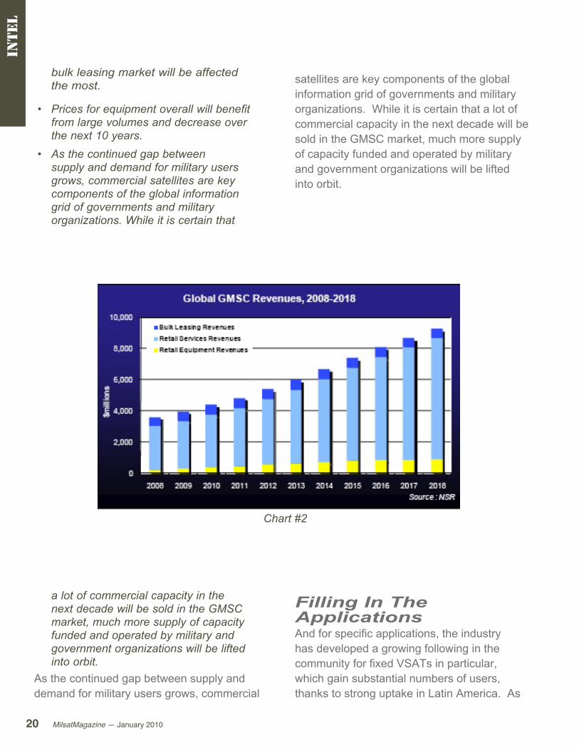
bulk leasing market will be affected the most.
Pricesforequipmentoverallwillbenefit•from large volumes and decrease over the next 10 years.As the continued gap between •supply and demand for military users grows, commercial satellites are key components of the global information grid of governments and military organizations. While it is certain that
satellites are key components of the global information grid of governments and military organizations. While it is certain that a lot of commercial capacity in the next decade will be sold in the GMSC market, much more supply of capacity funded and operated by military and government organizations will be lifted into orbit.
intel
a lot of commercial capacity in the next decade will be sold in the GMSC market, much more supply of capacity funded and operated by military and government organizations will be lifted into orbit.
As the continued gap between supply and demand for military users grows, commercial
Filling In The ApplicationsAnd for specific applications, the industry has developed a growing following in the community for fixed VSATs in particular, which gain substantial numbers of users, thanks to strong uptake in Latin America. As
Chart #2
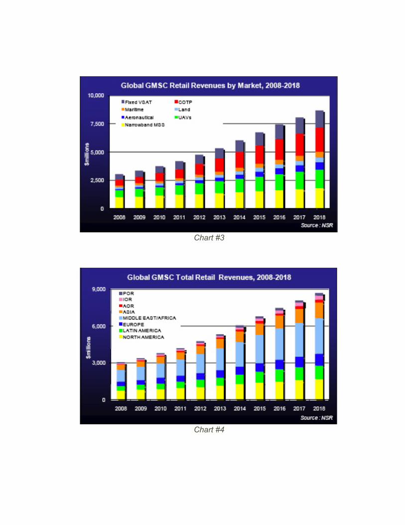
Chart #3
Chart #4
MilsatMagazine — January 201022
in other regions, government-funded digital divide programs support large deployments of VSATs there.
We find also that there is a striking difference between MSS and FSS-based applications for the GMSC markets. The high-yield aeronautical and UAV COTM and the COTP markets are leading the growth in revenues and taking up market share as the forecast advances in time. COTP in particular has growing revenues from Ku- and X-band capacity users, mixed into multiband equipment that gives greater flexibility to users, especially in military operations.
But at the same time, MSS narrowband terminals represent more than 50 percent of all units for the whole forecast, while revenues decline from 33 percent in 2008 down to 21 percent in 2018 of the total forecast. It suffers from high volumes notably for tracking assets and machine-to-machine (M2M) applications associated with lower price of equipment and average revenues per user (ARPU). (See Chart 3 on previous page.)
The regional play unfolds itself in an instinctive way towards the Middle-East and Africa where the area is filled with demand, in particular from UAVs. At the same time, Latin America, which will have major sports events in the next decade (FIFA
intel
Chart #5

MilsatMagazine —January 2010 23
intel
World Cup, Summer Olympic Games), will motivate governments, particularly Brazil, to upgrade and purchase new communications equipment and services for government organizations as well as military ones. (See Chart 4 on page 21.)
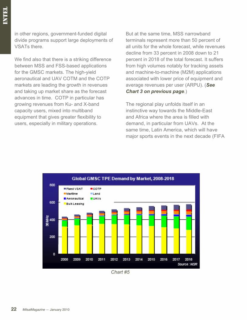
Getting Off The BulkBut as the applications fill transponders in growing numbers, NSR believes that bulk leasing will see a drop in demand as more of these applications grow and internal capacity from new programs planned or currently in orbit replace some commercial bulk leasing contracts.
Ku-band is most affected by this capacity growth on proprietary assets. While delivering approximately 115 more TPEs in application-specific markets over the next ten years, a drop of 55 Ku-band TPEs in bulk leasing is registered in the forecast for a net result of only 60 additional Ku-band TPEs overall by 2018.
NSR forecasts that TPE demand and bulk leasing for the GMSC market will reach 578 TPEs by the end of 2018, an increase of 144 TPEs in total, driven in large part by demand for UAVs and fixed VSATs.
As there is a migration expected to internal capacity, another competitor, the higher-performing X-band commercial satellites, will see the highest growth rate from both bulk leasing and specific application TPE demand.

25MilsatMagazine —January 2010
For this ISR issue we spoke with Lloyd Palum, who is the Senior
Principal Engineer for Harris RF Communications. Mr. Palum is
currently responsible for the strategy, development, and general
management of tactical communications products in ISR for the
Company. Previously, Mr. Palum oversaw wireless networking
product strategy, including marketing analysis and a phased set of
software releases that cover IP networking, security, and wireless
protocols. He has also served as a systems’ engineer responsible
for definition of design and architecture on the Falcon III JTRS
SCA compliant family of radios and supervised a staff of 12 in the
development and delivery of key SCA radio software components
for the JTRS-Approved Falcon III AN/PRC 152(C) handheld radio. Mr.
Palum has authored numerous technical conference publications
and customer presentations and publications.
Lloyd PalumHarris RF Communications
Com
ma
nd
ce
nter
MilsatMagazine — January 201026
MilsatMagazine (MSM)Intelligence, Surveillance and Reconnaissance (ISR) is a critical aspect of warfighting today. Can you provide a snapshot of this industry segment?
Lloyd PalumThe expanding use of Unmanned Aerial Systems (UAS) and Ground Systems (UGS) in battle has altered the course of mission planning and operations. These systems are providing U.S. forces with a significant new offensive tool and advanced capabilities in ISR. The U.S. Department of Defense (DoD) stresses the importance of ISR as a means for enhancing situational awareness across the battlefield and to the tactical edge. This awareness bears heavily on the success of missions and safety of warfighters. The use of remotely transmitted video provides deployed forces with the capability to see and prepare for what they are about to face — whether around the next corner or over the distant hill.
MSMWhat challenges do warfighters encounter with ISR?
Lloyd PalumHigh-bandwidth ISR tends to be limited by both geography and the slow rollout of network-centric technologies toward the tactical edge, resulting in potentiallycompromising delays as information is communicated from the air, to the ground station, to individual warfighters and back.
What typically happens is that ISR video feeds are delivered to tactical operations centers (TOCs), where they are then analyzed with conclusions communicated back to the edge
over heavy, multi-piece equipment. The ground controller, or soldier, maneuvering the flight of the Unmanned Aerial Vehicle (UAV) is unable to disseminate this feed to other soldiers in the field. While this does help to close communication gaps, the lag involved in such transmissions disrupts the natural tempo of video downlink data. The ideal model would put these streams in the hands of personnel at the tactical edge. However, currently, systems developed to extend video to forward-deployed forces have proven to be lacking in portability, maneuverability and power efficiency
MSMWhat current technology addresses these extremely important issues?
Lloyd PalumISR video receivers play a significant role in effective ground-to-air coordination in ISR. The receivers provide DoD personnel on the battlefield with live video feeds directly from UAVs, allowing troops to make critical split-second decisions. However, the current generation of Remotely Operated Video Enhanced Receivers (ROVER) terminals are heavy and, therefore, of limited value to the dismounted warfighter.
Com
ma
nd
ce
nter

MilsatMagazine —January 2010 27
The receivers are typically centralized in TOCs and provide streams for analysis. Harris Corporation is focused on developing smaller, portable, power-efficient ISR technologies that will move these feeds out of the TOCs and into the field.
MSMIs Harris addressing these crucial issues?
Lloyd PalumHarris responded to these issues — and to the increased emphasis on ISR by the U.S. DoD — by putting ROVER capability into a smaller, lighter package that could be carried into the field. Weighing in at four pounds, the RF-7800T is the world’s smallest and lightest ROVER terminal. It is the first such device to be built into the standard form factor of a ruggedized military handheld radio. The RF-7800T handheld ISR video receiver establishes a critical, portable and direct downlink between unmanned systems and the individual warfighter, delivering intelligence to the tactical edge more quickly and efficiently for real time ISR. The RF-7800T comes with a monocle display that will allow the warfighter to view live video feeds from UAVs or aircraft, but with
standard electronic connectors to allow for a range of display options. When directed into a network, commonly enabled by the Harris AN/PRC-117G manpack, the video and other data can be shared to all members of the mission, providing a common operational picture for improved and more immediate decision-making capabilities.
Com
ma
nd
ce
nter
MilsatMagazine — January 201028
In a new application, Harris has demonstrated ways of controlling unmanned vehicles via the AN/PRC-117G and its wideband mesh networking capability. This shift allows members of the network to maneuver UAVs to specific areas of interest to capture secure digital video for ISR Harris, in these demonstrations, was able to digitize the video stream and send it across networks, thereby giving those inside the TOC or at the FOB the ability to move the air vehicle to any necessary position. Harris also extended the range from which they are normally able to view the feed directly from.
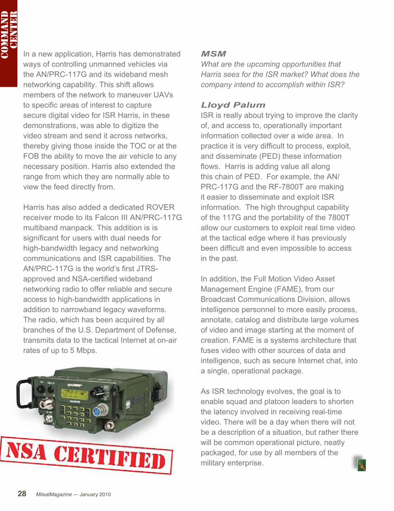
Harris has also added a dedicated ROVER receiver mode to its Falcon III AN/PRC-117G multiband manpack. This addition is is significant for users with dual needs for high-bandwidth legacy and networking communications and ISR capabilities. The AN/PRC-117G is the world’s first JTRS-approved and NSA-certified wideband networking radio to offer reliable and secure access to high-bandwidth applications in addition to narrowband legacy waveforms. The radio, which has been acquired by all branches of the U.S. Department of Defense, transmits data to the tactical Internet at on-air rates of up to 5 Mbps.
MSMWhat are the upcoming opportunities that Harris sees for the ISR market? What does the company intend to accomplish within ISR?
Lloyd PalumISR is really about trying to improve the clarity of, and access to, operationally important information collected over a wide area. In practice it is very difficult to process, exploit, and disseminate (PED) these information flows. Harris is adding value all along this chain of PED. For example, the AN/PRC-117G and the RF-7800T are making it easier to disseminate and exploit ISR information. The high throughput capability of the 117G and the portability of the 7800T allow our customers to exploit real time video at the tactical edge where it has previously been difficult and even impossible to access in the past.
In addition, the Full Motion Video Asset Management Engine (FAME), from our Broadcast Communications Division, allows intelligence personnel to more easily process, annotate, catalog and distribute large volumes of video and image starting at the moment of creation. FAME is a systems architecture that fuses video with other sources of data and intelligence, such as secure Internet chat, into a single, operational package.
As ISR technology evolves, the goal is to enable squad and platoon leaders to shorten the latency involved in receiving real-time video. There will be a day when there will not be a description of a situation, but rather there will be common operational picture, neatly packaged, for use by all members of the military enterprise.
Com
ma
nd
ce
nter
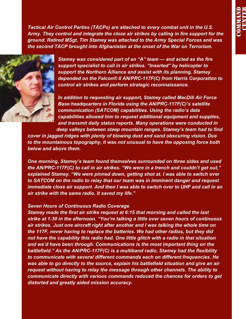
Tactical Air Control Parties (TACPs) are attached to every combat unit in the U.S. Army. They control and integrate the close air strikes by calling in fire support for the ground. Retired MSgt. Tim Stamey was attached to the Army Special Forces and was the second TACP brought into Afghanistan at the onset of the War on Terrorism.
Stamey was considered part of an “A” team — and acted as the fire support specialist to call in air strikes. “Inserted” by helicopter to support the Northern Alliance and assist with its planning, Stamey depended on the Falcon® II AN/PRC-117F(C) from Harris Corporation to control air strikes and perform strategic reconnaissance.
In addition to requesting air support, Stamey called MacDill Air Force Base headquarters in Florida using the AN/PRC-117F(C)’s satellite communication (SATCOM) capabilities. Using the radio’s data capabilities allowed him to request additional equipment and supplies, and transmit daily status reports. Many operations were conducted in
deep valleys between steep mountain ranges. Stamey’s team had to find cover in jagged ridges with plenty of blowing dust and sand obscuring vision. Due to the mountainous topography, it was not unusual to have the opposing force both below and above them.
One morning, Stamey’s team found themselves surrounded on three sides and used the AN/PRC-117F(C) to call in air strikes. “We were in a trench and couldn’t get out,” explained Stamey. “We were pinned down, getting shot at. I was able to switch over to SATCOM on the radio to relay that our team was in imminent danger and request immediate close air support. And then I was able to switch over to UHF and call in an air strike with the same radio. It saved my life.”
Seven Hours of Continuous Radio CoverageStamey made the first air strike request at 6:15 that morning and called the last strike at 1:30 in the afternoon. “You’re talking a little over seven hours of continuous air strikes. Just one aircraft right after another and I was talking the whole time on the 117F, never having to replace the batteries. We had other radios, but they did not have the capability this radio had. One little glitch with a radio in that situation and we’d have been through. Communications is the most important thing on the battlefield.” As the AN/PRC-117F(C) is a multiband radio, Stamey had the flexibility to communicate with several different commands each on different frequencies. He was able to go directly to the source, explain his battlefield situation and give an air request without having to relay the message through other channels. The ability to communicate directly with various commands reduced the chances for orders to get distorted and greatly aided mission accuracy.
Com
ma
nd
ce
nter
Constant Contact With The Source“It’s just human nature that when you pass details through several people in a command chain, things tend to get changed along the way. So with this radio, I went directly to the source and told them what I needed. When my aircraft showed up, I could monitor both frequencies at the same time.” While in Afghanistan, Stamey found the AN/PRC- 117F(C)’s reliability to be excellent. He also valued the radio’s transmit power output. “Other radios weren’t able to contact aircraft at the altitude and great distances they were flying because they didn’t put out enough power. But with the 10-watt capability on the UHF/AM with the 117F, we were able to talk to aircraft much more clearly.”
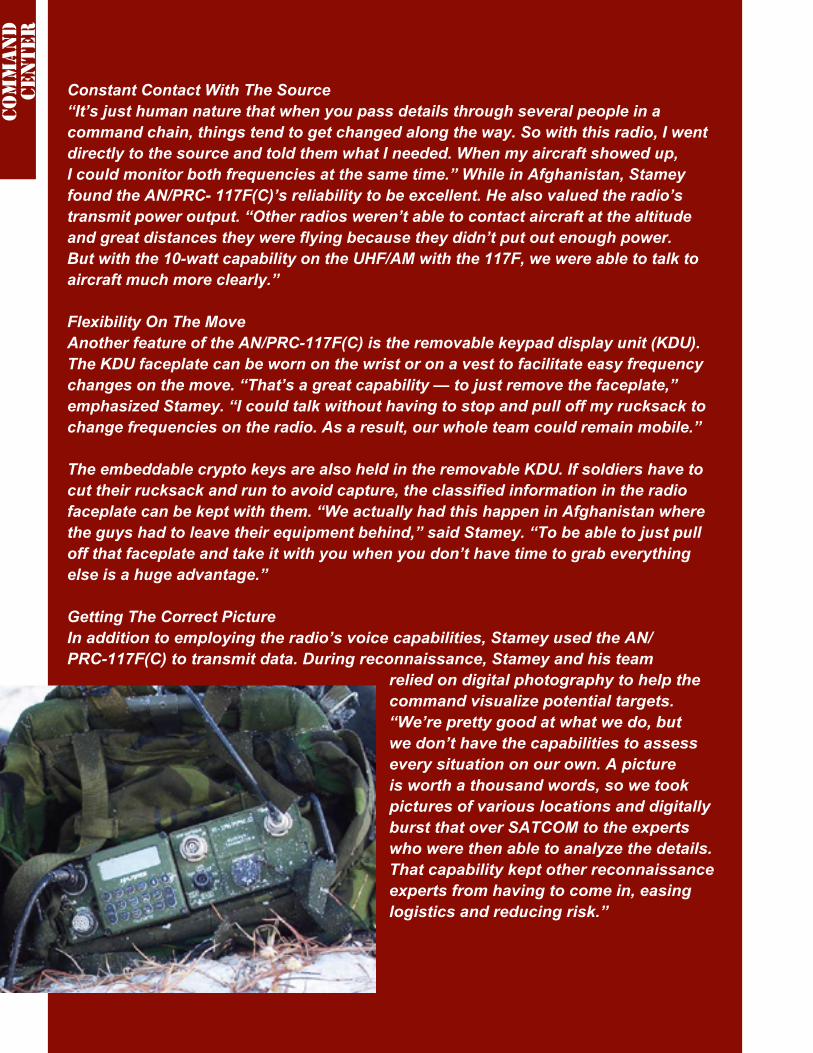
Flexibility On The MoveAnother feature of the AN/PRC-117F(C) is the removable keypad display unit (KDU). The KDU faceplate can be worn on the wrist or on a vest to facilitate easy frequency changes on the move. “That’s a great capability — to just remove the faceplate,” emphasized Stamey. “I could talk without having to stop and pull off my rucksack to change frequencies on the radio. As a result, our whole team could remain mobile.”
The embeddable crypto keys are also held in the removable KDU. If soldiers have to cut their rucksack and run to avoid capture, the classified information in the radio faceplate can be kept with them. “We actually had this happen in Afghanistan where the guys had to leave their equipment behind,” said Stamey. “To be able to just pull off that faceplate and take it with you when you don’t have time to grab everything else is a huge advantage.”
Getting The Correct PictureIn addition to employing the radio’s voice capabilities, Stamey used the AN/PRC-117F(C) to transmit data. During reconnaissance, Stamey and his team
relied on digital photography to help the command visualize potential targets. “We’re pretty good at what we do, but we don’t have the capabilities to assess every situation on our own. A picture is worth a thousand words, so we took pictures of various locations and digitally burst that over SATCOM to the experts who were then able to analyze the details. That capability kept other reconnaissance experts from having to come in, easing logistics and reducing risk.”
Com
ma
nd
ce
nter
MilsatMagazine —January 2010 31
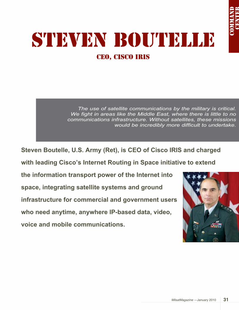
Steven Boutelle, U.S. Army (Ret), is CEO of Cisco IRIS and charged
with leading Cisco’s Internet Routing in Space initiative to extend
the information transport power of the Internet into
space, integrating satellite systems and ground
infrastructure for commercial and government users
who need anytime, anywhere IP-based data, video,
voice and mobile communications.Co
mm
an
d
cen
ter
Steven BoutelleCEO, Cisco Iris
The use of satellite communications by the military is critical. We fight in areas like the Middle East, where there is little to no
communications infrastructure. Without satellites, these missions would be incredibly more difficult to undertake.
MilsatMagazine (MSM)General, would you please offer our readers information regarding your background and why you selected the U.S. Army as your career choice?
Steven BoutelleIn 1969, I was drafted during the time of the Viet Nam war. Instead of allowing others to determine my fate, I selected the Army and enlisted for three years. During my enlistment, I was selected to participate in Officer Candidate School, and, well, the rest is history.
For 38 years, I had the honor of serving my country. Even though I started my military career as an artillery officer, my life’s passion was, and still is, electronics. In college, I studied electrical engineering and as my military career progressed, I served as a communications officer in a number of Signal Brigades.
The acquisition and development of technology became very important to the military as it modernized in the 80’s and 90’s. To support this mission, I built and acquired communications technology for satellite, ground, logistics, intelligence, and personnel and missile and other types of systems.
While I loved the technical side of my job, I never forgot that my ultimate goal was to provide the warfighter with the technology needed to save lives and complete the mission.
MSMStarting in July of 2003, you were the CIO for the Army... what missions did this command role entail?
Com
ma
nd
ce
nter
Boutelle is also Vice President of the Global Government Solutions Group (GGSG) at Cisco Systems, where he leads a business development team that advises government customers on business practices and technology solutions to achieve and enhance their mission goals.
Prior to joining Cisco, Boutelle served as the Chief Information Officer of the U.S. Army, responsible for the Service’s worldwide use of information technology. He introduced converged voice, data and video to the Army, building an enhanced network infrastructure to serve 1.9 million users. Boutelle established an industry recognized portal, the Army Knowledge Online, and the Defense Knowledge Online to provide streamlined access to content for six million defense users. Through an IT portfolio management program, he reduced the costs of IT systems and applications by half. He is a recognized leader, technology evangelist and mentor.
His career in the U.S. Army is marked by a consistent record of driving the adoption of new technologies and streamlining processes to improve productivity and enhance collaboration. He led the U.S. Federal Government in implementation of “Secure Network Logon” with 98 percent of 1.2 million Army users adopting Common Access Cards. He also led compliance with the U.S. Office of Management Budget criteria and the President’s Management Agenda, with 100 percent compliance for two years.

Steven Boutelle The ultimate responsibility of CIO/G6 of the Army is to provide a reliable and secure network that gives civilian and military leadership access to the information it needs for time-sensitive decisions. This is especially critical in the Global War on Terror where commanders must make immediate decisions based on real-time intelligence. Given the reliance on information, the CIO/G6 now reports directly to the Secretary of the Army and Chief of Staff of the Army.
From a technical perspective, the CIO/G6 has become a critical position within the Army as
it continues to support the Army Knowledge Enterprise (AKE). With more than 17,000 men and women in its command, as a Direct (DRU), or Acquisition Organization, it is responsible for operating the Army network around the world. In addition to maintaining the network, the CIO/G6 has oversight responsibility for acquisition of all fixed communications systems.
During my tenure, we were focused on battlefield communications support. As the country waged two wars and operations continued in support of the Global War on Terror, collaboration and actionable information
Com
ma
nd
ce
nter

were essential to completing the mission. For the first time, we were providing voice, data and video communications in real-time to people separated by thousands of miles.
Among the many initiatives we undertook, one of the most significant was the move to Everything Over IP (EOIP). As I visited the units preparing for the Iraq war, I found that the lack of policy was making the move to IP sub-optimal. A number of the Army Divisions were taking matters into their own hands and using discretionary funds to develop and run their own EOIP communications networks.
To support this natural evolution to IP, I made a push to deploy the Joint Network Node (JNN). The JNN is the Army’s first deployable IP-based converged communications system that can support voice, video and data communications on the battlefield.
MSMWhat do you see as some of the obstacles to moving to EOIP?
Steven Boutelle There is not a set policy for the services to go to Everything Over IP. Instead, you see more of a generational influence on
Com
ma
nd
ce
nter

MilsatMagazine —January 2010 35
the communications equipment being installed or deployed. For example, some camps are continuing to install circuit-based equipment, not because that is the best solution, but because that is what they are most familiar with. This can lead to dead-end investments and an inability to migrate to newer technology.
Another obstacle is complexity. As systems increase in functionality, they often increase in complexity as disparate components must be integrated and configured. This complexity typically requires a highly technical, highly trained individual. However, having adequately trained personnel available to operate these solutions becomes a challenge.
Sophisticated system software, such as those driven by powerful wizard interfaces, can reduce the complexity of the solution and make difficult tasks easier to execute with fewer errors. Acting as a force multiplier, system software can enlarge the pool of personnel that can be rapidly trained to effectively operate a highly advanced communications system. In a tactical environment, quickly and accurately establishing situational awareness is critical to mission success. Software can also assist in monitoring the health of the components within the solution, so that trouble-shooting issues can be addressed quickly and confidently by examining log databases, thus reducing the amount of downtime.
MSMHow can the private sector assist with the development of a variety of solutions for military communications?
Steven Boutelle Almost everything being used is commercial. The commercial sector must understand that systems need to be Joint Interoperability Test Command (JITC) compliant to get implemented. If you are a vendor you have a duty to not only meet the requirements, but go through rigorous testing to become fully certified. This is how the military ensures its systems are interoperable between the services.
MSM How does the U.S. Army’s Command and Control rely upon MILSATCOM for the implementation of communications?
Steven Boutelle The use of satellite communications by the military is critical. We fight in areas like the Middle East, where there is little to no communications infrastructure. Without satellites, these missions would be incredibly more difficult to undertake.
Today, more than 94 percent of military satellite communications in the Gulf are done over commercial satellites. With the cancellation of the Transformational Satellite Communications (TSAT) System, we are looking at another decade of dependence on commercial satellites as our primary source of communications. In addition to commercial satellite capacity, the US needs dedicated satellites that are completely secure and hardened against attacks.
MSM Was the transition from command in the U.S. Army to that of the private sector difficult to accomplish? Could you define your executive responsibilities as the Vice President for Cisco’s Global Government Solutions Group?
Com
ma
nd
ce
nter

Do you see Cisco as becoming more involved in MILSATCOM, and creating what effect?
Steven Boutelle The transition from the Army to the civilian world was not a difficult one for me. The last 15 years of my career was spent working closely with the commercial sector to develop the Army’s latest communications systems. It did take me some time to understand what drives the commercial sector though. In the military, especially at the CIO/G6 level, you have a tremendous amount of responsibility in terms of
people and tax dollars. On the commercial side, companies work hard to build great products for the military, but they must also focus on making a profit and generating value for employees and the shareholder. In the end, people in the military and commercial sectors both want to do a good job that helps the men and women of the armed forces accomplish their mission as safely and effectively as possible.
Currently, I am the CEO of Cisco Internet Routing in Space (IRIS) and charged with leading Cisco’s IRIS initiative to extend the
Com
ma
nd
ce
nter
A Technical Look At The Cisco Space Router
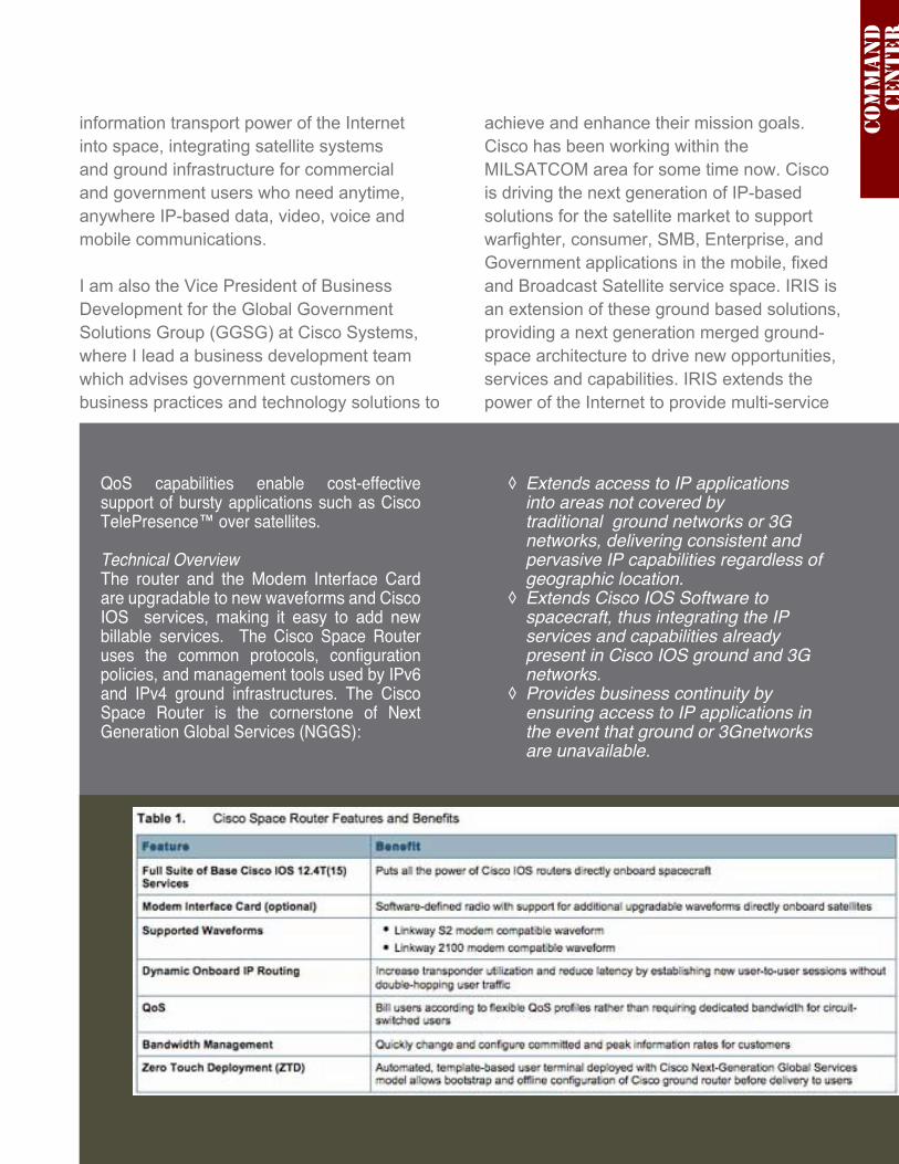
Product Overview Exploding demand for satellite capacity is driven by IP services such as high-definition video. Most applications on satellite networks today are IP applications, yet satellite networks have traditionally been deployed as a circuit-switched network. The Cisco Space Router provides the ability to route IP traffic on the satellite, eliminating the need to send the data to and from an extra ground station to implement the circuit-switched function. Routing IP traffic natively on the satellite with the router’s built-in Cisco IOS® Software can increase throughput, reduce latency, and enable flexible bandwidth-on-demand applications between users in different geographic regions without static configuration.
Features and Benefits An option for the Cisco Space Router is an embedded RF Modem Interface Card that removes the need for a ground-based modem hub. That allows customers to deploy
smaller satellite antenna dishes, increasing the attractiveness, revenue per user, and adoptability of satellite network services.
Cisco Space Routers allow you to implement routed services on the satellite using the same Cisco IOS IP routing used on ground station. The entire suite of Cisco IOS services is supported on the Cisco Space Router, improving the security, manageability, and upgradability of a satellite network:
Cisco IOS Security and onboard ◊termination of the uplink and downlink help protect transmissions from spoofing and other attacks. Dynamic IP routing allows secure ◊peer-to-peer communication between users without cumbersome static configuration. Zero-Touch Deployment (ZTD) allows ◊automated configuration of routers that are deployed on the ground behind the satellite antenna.
MilsatMagazine —January 2010 37
information transport power of the Internet into space, integrating satellite systems and ground infrastructure for commercial and government users who need anytime, anywhere IP-based data, video, voice and mobile communications.
I am also the Vice President of Business Development for the Global Government Solutions Group (GGSG) at Cisco Systems, where I lead a business development team which advises government customers on business practices and technology solutions to
achieve and enhance their mission goals.Cisco has been working within the MILSATCOM area for some time now. Cisco is driving the next generation of IP-based solutions for the satellite market to support warfighter, consumer, SMB, Enterprise, and Government applications in the mobile, fixed and Broadcast Satellite service space. IRIS is an extension of these ground based solutions, providing a next generation merged ground-space architecture to drive new opportunities, services and capabilities. IRIS extends the power of the Internet to provide multi-service
QoS capabilities enable cost-effective support of bursty applications such as Cisco TelePresence™ over satellites. Technical Overview The router and the Modem Interface Card are upgradable to new waveforms and Cisco IOS services, making it easy to add new billable services. The Cisco Space Router uses the common protocols, configuration policies, and management tools used by IPv6 and IPv4 ground infrastructures. The Cisco Space Router is the cornerstone of Next Generation Global Services (NGGS):
Extends access to IP applications ◊into areas not covered by traditional ground networks or 3G networks, delivering consistent and pervasive IP capabilities regardless of geographic location. Extends Cisco IOS Software to ◊spacecraft, thus integrating the IP services and capabilities already present in Cisco IOS ground and 3G networks.Provides business continuity by ◊ensuring access to IP applications in the event that ground or 3Gnetworks are unavailable.
Com
ma
nd
ce
nter

MilsatMagazine — January 201038
networks and personalized rich media through space by integrating satellite systems and ground infrastructure for commercial and government users who need instant, seamless, global, broadband communications.
MSM What advice do you have for organizations that are waiting to transition to IP?
Steven Boutelle Don’t wait! For those organizations entrenched in older technologies, I would recommend they pursue a migration strategy that enables them to leverage their current investment, but start the transition to newer, IP-based technologies.
A hybrid TDM-IP voice switch, for example, would provide a bridge from TDM technology to full IP. There is no need to wait for another
Photo credit: NASA/courtesy of nasaimages.org
Com
ma
nd
ce
nter

MilsatMagazine —January 2010 39
generation of IP solutions, such as Local Session Controller (LSC), to be launched in the marketplace. It’s important to take the first steps now.
Second, I have already mentioned that IT has become a world of convergence of voice and data. As a former CIO of the Army, I also saw a convergence occurring across tactical and strategic operations. The communications across the two is becoming seamless, and people at the base need to readily communicate to individuals in the battlefield.
This requirement of seamless communications can be facilitated by leveraging a common communications platform across the entire network, both voice and data. The converged
IT network is here today, and I would encourage teams to embrace it and take advantage of the powerful capabilities that come along with unified communications.
Former Chief of Staff of the Army General Eric K. Shinseki said it best when he stated, “if you don’t like change, you will like irrelevance even less.”
Com
ma
nd
ce
nter

atrexx Ltd. & Co. KG is a key solution provider for the telecommunications and broadcast industries, with strong focus on satellite communications. Offerings include Internet via Satellite, Voice Communication, Corporate Networks as well as Radio and TV via Satellite services. In addition, atrexx operates an online market exchange platform which offers a neutral and independent arena for both buyers and sellers of telecommunications and broadcast resources.

MilsatMagazine —January 2010 41
In a recent report, Northern Sky Research stated that satellite
operators had increased their revenues in 2008 and forecast steady
growth in 2009 with their revenues rising by an impressive 50
percent to 2018. This is good news indeed, with obvious demand
fueling growth even in very difficult economic conditions. The satellite operators are doing well, but what about their customers? Capacity has always been a burning issue. There is either too much capacity or not enough. At present, there is a problem that has come to atrexx’s attention regarding long-term capacity leases. The fact is that sometimes customers are no longer happy with the long-term contracts that they had previously signed with satellite operators.
One reason could be the economic situation taking its toll on those who have leased capacity, as their customers are finding it difficult to pay for the service. Moreover, as new capacity is being introduced to the market through satellites that have higher power, better coverage and optimized beams for particular regions, this new capacity is obviously attractive to those who previously leased older capacity. They would like to upgrade — but they are still tied into their long-term agreements. The operators will generally not show flexibility in their contracts and allow an exchange of capacity or take the capacity back. The atrexx Trading Platform may well offer a viable solution!
Sell Your Unwanted Satellite Capacity!The atrexx Trading Platform is a valuable resource that can be used to sell or exchange unwanted capacity. The Platform brings together those who wish to sell or exchange their capacity with those who are seeking capacity and it is simple to use.
Shorten those long-term leases
atrexx
focu
s

MilsatMagazine — January 201042
iDirect iNFINITI platform over the Intelsat 10-02 satellite, which boasts very strong C-band coverage over all of Europe, the entire African Continent, and the Middle East.
The key advantage for customers is there is no requirement to invest in any new equipment when opting for 2way2sat via Intelsat 10-02. atrexx is ready to start the service with users’ existing hardware that typically includes an iNFINITI Series 3100 modem, a 2.4 meter C-band antenna and a 5 Watt Block-Upconverter (BUC). Due to the much lower frequency range of C-band, the margin for weather degradation is often only 1 decibel (dB), but in Ku-band such can range from 6 to 10 dB in subtropical and tropical regions.
Also offered is 2way2sat iDirect Evolution services for Middle East, which are delivered via the re-positioned EUROBIRD™4A and the Eutelsat W6 satellites, providing wide beam coverages including Iraq and Afghanistan.
atrexx’s QMSQuality is, and will continue to be, an essential competitive factor, if not the most decisive one. A recent audit by DQS has verified that atrexx Quality Management System (QMS) now fulfills the requirements of the updated standard ISO 9001:2008.
Select this link to access the atrexx website home.
focu
s
By registering for the atrexx Trading Platform online, buyers and sellers can reach potential customers and providers all over the world at the click of a mouse. Sellers can find a buyer for their excess capacity that would previously have been left idle, and buyers can find the capacity that they desperately need. The Platform also eliminates conventional sales and procurement that can often be inefficient and time consuming. This is all completed with the support of atrexx professionals who broker each and every deal to ensure protocol is followed.
atrexx has already assisted many who have found they no longer wish to hold their capacity. In a market where the recession is a biting reality, atrexx provides a valuable resource that enables you to get the most out of your capacity, even when you no longer have a need for it.
atrexx is also offering more widespread 2way2sat services in C-band to tropical regions, especially to Africa, where rain
attenuation often presents a
problem. The company is
responding to many inquiries
received from users who currently find
themselves underserved
by C-bBand services. The
2way2sat services offered by atrexx are based on the


MilsatMagazine — January 201044
>1
>2
>3
1 — Oko 2 — Prognoz 3 — Tselina
MilsatMagazine —January 2010 45
USSR/Russian EW, elint, and surveillance
satellitesBy Jos Heyman, Tiros Space Information
intel
In this overview we will look at military early warning satellites,
electronic intelligence gathering satellites and ocean surveillance
satellites launched by the military forces of the former USSR and,
currently, Russia. Information about these satellites is invariably
secret and the satellites are grouped in the multi-discipline Kosmos
series of military satellites, in which the first was launched on
16 March 1962. Over the years western analysts have perfected
techniques whereby the objective of a specific satellite can be
determined, with a fair degree of certainty, by the orbit, radio
transmissions. Currently the Kosmos series has reached 2454
satellites of over 50 types, based on their purpose.

Early warning satellites provide an advance warning of missile attacks through the detection of missile exhaust plumes.
Electronic intelligence (elint) satellites pick up and record radio transmissions and radar transmissions whilst they are over foreign territory and play this back over friendly territory. The information gained in this manner gives an insight into the strategy of the opposing powers and also reveals the location of the radar sites.
Ocean surveillance satellites locate and monitor the movements of naval vessels by means of electronic equipment.
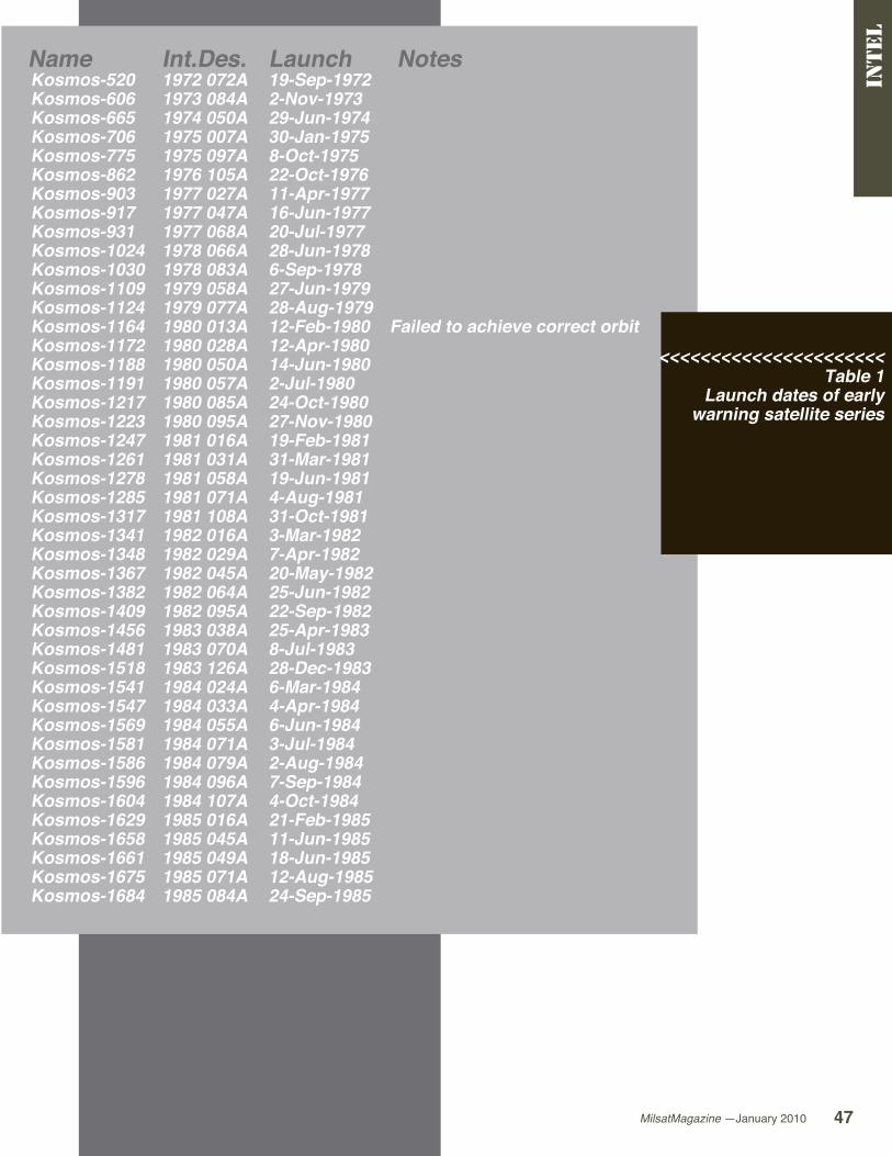
Early Warning SeriesAlthough such is not officially confirmed, there is compelling evidence that suggests that the USSR had considerable difficulties in establishing an operational system.
Tests commenced in 1972 and a limited operational system capability was not
achieved until 1976. In 1980 a fully operational system of nine satellites, referred to as Oko, was being established, an effort which was not completed until 1988 as a number of satellites ceased operation after a short time, were in incorrect orbits or drifted out of the correct orbit.
The satellites were placed in highly elliptical orbits with 40∞ intervals. The orbit, which is somewhat similar to that employed by the Molniya communications satellites, ensures that a satellite is over the region to be observed for an extended period. Orbits are typical of 600 x 40,000 km with an inclination of 62.9∞.
In 1975 an Oko satellite designated as Kosmos-775, was placed in a geostationary orbit over 24∞ W. Since no further such satellites launched, it may be assumed that this launch constituted a test which was not successful. As the USSR already had the capability to place satellites in a geostationary
Oko satellite
Prognoz satellite
intel
MilsatMagazine —January 2010 47
Name Int.Des. Launch Notes Kosmos-520 1972 072A 19-Sep-1972 Kosmos-606 1973 084A 2-Nov-1973 Kosmos-665 1974 050A 29-Jun-1974 Kosmos-706 1975 007A 30-Jan-1975 Kosmos-775 1975 097A 8-Oct-1975 Kosmos-862 1976 105A 22-Oct-1976 Kosmos-903 1977 027A 11-Apr-1977 Kosmos-917 1977 047A 16-Jun-1977 Kosmos-931 1977 068A 20-Jul-1977 Kosmos-1024 1978 066A 28-Jun-1978 Kosmos-1030 1978 083A 6-Sep-1978 Kosmos-1109 1979 058A 27-Jun-1979 Kosmos-1124 1979 077A 28-Aug-1979 Kosmos-1164 1980 013A 12-Feb-1980 Failed to achieve correct orbit Kosmos-1172 1980 028A 12-Apr-1980 Kosmos-1188 1980 050A 14-Jun-1980 Kosmos-1191 1980 057A 2-Jul-1980 Kosmos-1217 1980 085A 24-Oct-1980 Kosmos-1223 1980 095A 27-Nov-1980 Kosmos-1247 1981 016A 19-Feb-1981 Kosmos-1261 1981 031A 31-Mar-1981 Kosmos-1278 1981 058A 19-Jun-1981 Kosmos-1285 1981 071A 4-Aug-1981 Kosmos-1317 1981 108A 31-Oct-1981 Kosmos-1341 1982 016A 3-Mar-1982 Kosmos-1348 1982 029A 7-Apr-1982 Kosmos-1367 1982 045A 20-May-1982 Kosmos-1382 1982 064A 25-Jun-1982 Kosmos-1409 1982 095A 22-Sep-1982 Kosmos-1456 1983 038A 25-Apr-1983 Kosmos-1481 1983 070A 8-Jul-1983 Kosmos-1518 1983 126A 28-Dec-1983 Kosmos-1541 1984 024A 6-Mar-1984 Kosmos-1547 1984 033A 4-Apr-1984 Kosmos-1569 1984 055A 6-Jun-1984 Kosmos-1581 1984 071A 3-Jul-1984 Kosmos-1586 1984 079A 2-Aug-1984 Kosmos-1596 1984 096A 7-Sep-1984 Kosmos-1604 1984 107A 4-Oct-1984 Kosmos-1629 1985 016A 21-Feb-1985 Kosmos-1658 1985 045A 11-Jun-1985 Kosmos-1661 1985 049A 18-Jun-1985 Kosmos-1675 1985 071A 12-Aug-1985 Kosmos-1684 1985 084A 24-Sep-1985
<<<<<<<<<<<<<<<<<<<<<<Table 1
Launch dates of early warning satellite series
intel
MilsatMagazine — January 201048
orbit, it may be assumed that the sensing equipment was not satisfactory at the time.
About nine years later a series of satellites was placed in geostationary orbit which, it has been suggested, have a combined early warning and elint objective. Known as the Prognoz system, it is likely that these satellites were dissimilar to Kosmos-775.
To date, western observers have not been able to determine generations of early warning satellites although there is little doubt that such generations do exist.
Elint SeriesSince 1965, the USSR has launched three separate types of Kosmos satellites for the gathering of electronic intelligence data (elint). The first type of elint satellite, also known as Tselina O, were of a cylindrical shape with a length of approximately 2.00 m and a mass of approximately 900 kg. They were placed in orbits of 550 x 525 km with an inclination of 74∞ and an operational system consisted of
intel
Tselina satellite
four satellites spaced 45∞ apart. The satellites were launched between 1967 and 1982. (See table on page 47.)
The second type, known as Tselina D, had a mass of 2500 to 3800 kg and a length of about 5 m. The operational system of these satellites consisted of six satellites spaced 60∞ apart and with typical 630 x 650 km orbits and inclinations of 81∞.
The third type of elint satellite, which has been identified as Tselina-2, is believed to have a mass of approximately 6000 kg. They appear to be placed in a higher orbit than earlier satellites and an operational constellation may consist of four satellites although such an assumption can only be confirmed by the passing of time. The type was introduced in 1984. Based on launches this system is currently operational.
Ocean Surveillance SeriesThe USSR has deployed two distinctive classes of ocean surveillance satellites which are referred to as radar ocean reconnaissance satellites (Rorsat) and electronic ocean reconnaissance satellites (Eorsat) by Western observers.
The latter class undertook passive monitoring of radio communications which, except during periods of complete radio silence, will occur in association with naval vessels.
Tselina-D

Name Int.Des. Launch Notes Kosmos-1687 1985 088A 30-Sep-1985 Kosmos-1698 1985 098A 22-Oct-1985 Kosmos-1701 1985 105A 9-Nov-1985 Kosmos-1729 1986 011A 1-Feb-1986 Kosmos-1761 1986 050A 5-Jul-1986 Kosmos-1774 1986 065A 28-Aug-1986 Kosmos-1783 1986 075A 3-Oct-1986 Failed to achieve correct orbit Kosmos-1785 1986 078A 15-Oct-1986 Kosmos-1793 1986 091A 20-Nov-1986 Kosmos-1806 1986 098A 12-Dec-1986 Kosmos-1849 1987 048A 4-Jun-1987 Kosmos-1851 1987 050A 12-Jun-1987 Kosmos-1894 1987 091A 28-Oct-1987 Kosmos-1903 1987 105A 21-Dec-1987 Kosmos-1922 1988 013A 26-Feb-1988 Kosmos-1966 1988 076A 30-Aug-1988 Kosmos-1974 1988 092A 3-Oct-1988 Kosmos-1977 1988 096A 25-Oct-1988 Kosmos-2001 1989 011A 14-Feb-1989 Kosmos-2050 1989 091A 23-Nov-1989 Kosmos-2063 1990 026A 27-Mar-1990 Kosmos-2076 1990 040A 28-Apr-1990 Kosmos-2084 1990 055A 21-Jun-1990 Failed to achieve correct orbit Kosmos-2087 1990 064A 25-Jul-1990 Kosmos-2097 1990 076A 28-Aug-1990 Kosmos-2105 1990 099A 20-Nov-1990 Kosmos-2176 1992 003A 24-Jan-1992 Kosmos-2196 1992 040A 8-Jul-1992 Kosmos-2209 1992 059A 10-Sep-1992 Kosmos-2217 1992 069A 21-Oct-1992 Kosmos-2222 1992 081A 25-Nov-1992 Kosmos-2232 1993 006A 26-Jan-1993 Kosmos-2241 1993 022A 6-Apr-1993 Kosmos-2261 1993 051A 10-Aug-1993 Kosmos-2286 1994 048A 5-Aug-1994 Kosmos-2312 1995 026A 24-May-1995 Kosmos-2340 1997 015A 9-Apr-1997 Kosmos-2342 1997 022A 14-May-1997 Kosmos-2351 1998 027A 7-May-1998 Kosmos-2368 1999 073A 27-Dec-1999 Kosmos-2388 2002 017A 1-Apr-2002 Kosmos-2393 2002 059A 24-Dec-2002 Kosmos-2422 2006 030A 21-Jul-2006 Kosmos-2430 2007 049A 23-Oct-2007 Kosmos-2446 2008 062A 2-Dec-2008
<<<<<<<<<<<<<<<<<<<<<<Table 1
continued
intel
Name Int.Des. Launch Kosmos-1546 1984 031A 29-Mar-1984 Kosmos-1940 1988 034A 26-Apr-1988 Kosmos-2133 1991 010A 14-Feb-1991 Kosmos-2155 1991 064A 13-Sep-1991 Kosmos-2224 1992 088A 17-Dec-1992 Kosmos-2282 1994 038A 7-Jul-1994 Kosmos-2345 1997 041A 14-Aug-1997 Kosmos-2350 1998 025A 29-Apr-1998 Kosmos-2379 2001 037A 24-Aug-2001 Kosmos-2397 2003 015A 24-Apr-2003 Kosmos-2440 2008 033A 26-Jun-2008
Table 2Launch dates of
geostationary early warning and
elint satellites
∆ ∆ ∆ ∆ ∆ ∆ ∆ ∆ ∆

MilsatMagazine — January 201050
In spite of the distinction between the two classes they were initially considered complementary to each other and a pair of Rorsats and a pair of Eorsats was believed to be the minimum requirement for a reliable surveillance system.
As now new Rorsats have been launched since 1988 it can be assumed that the surveillance equipment on board of the Eorsats has been improved over time.
The Rorsats, also known as Upravlyaemyi Sputnik - Aktivny (US-A), were first launched in 1967. The satellites are believed to have been equipped with sideways looking radar and could detect and identify naval ships. They were deployed in typical orbits of 250 x 260 km with an inclination of 65∞. During their operational life these orbits were maintained through the use of ion thrusters. The power requirement for the US-A satellites was provided by a Topiaz thermionic nuclear reactor which, at the end of its operational life, was separated from the main satellite and boosted into a higher orbit of approximately 9000 x 1000 km.
The Upravlyaemyi Sputnik - Passivny (US-P) series of Eorsats operate in circular orbits of 435 km with an inclination of 65∞. Like the Rorsats, their orbits are maintained by micro thrusters but the Eorsats are powered by solar cells.
It is believed they are capable to provide target data with an accuracy of approximately 2 km to anti-ship missile platforms. The first US-P was launched in 1974 and a second generation, placed in a higher orbit, was identified from 1987.
intel
A Russian Soyuz-U rocket launched from the Plesetsk cosmodrome carrying the Kosmos-2420 satellite for Russian Ministry of Defence.Photo courtesy of nasaspaceflight.com

MilsatMagazine —January 2010 51
Name Int.Des. Launch Notes --- --- 26-Jun-1967 Failed to orbit (FTO) Kosmos-189 1967 108A 30-Oct-1967 Kosmos-200 1968 006A 19-Jan-1968 Kosmos-250 1968 095A 30-Oct-1968 Kosmos-269 1969 021A 5-Mar-1969 Kosmos-315 1969 107A 20-Dec-1969 Kosmos-330 1970 024A 7-Apr-1970 Kosmos-387 1970 111A 16-Dec-1970 Kosmos-395 1971 013A 17-Feb-1971 Kosmos-425 1971 050A 29-May-1971 --- --- 22-Jul-1971 FTO Kosmos-436 1971 074A 7-Sep-1971 Kosmos-437 1971 075A 10-Sep-1971 Kosmos-460 1971 103A 30-Nov-1971 Kosmos-479 1972 017A 22-Mar-1972 Kosmos-500 1972 053A 10-Jul-1972 Kosmos-536 1972 088A 3-Nov-1972 Kosmos-544 1973 003A 20-Jan-1973 Kosmos-549 1973 010A 28-Feb-1973 Kosmos-582 1973 060A 28-Aug-1973 Kosmos-610 1973 093A 27-Nov-1973 Kosmos-631 1974 005A 6-Feb-1974 Kosmos-655 1974 035A 21-May-1974 Kosmos-661 1974 045A 21-Jun-1974 Kosmos-698 1974 100A 18-Dec-1974 Kosmos-707 1975 008A 5-Feb-1975 Kosmos-749 1975 062A 4-Jul-1975 Kosmos-781 1975 109A 21-Nov-1975 Kosmos-787 1976 001A 6-Jan-1976 Kosmos-790 1976 007A 22-Jan-1976 Kosmos-812 1976 031A 6-Apr-1976 Kosmos-845 1976 075A 27-Jul-1976 Kosmos-870 1976 115A 2-Dec-1976 Kosmos-899 1977 022A 24-Mar-1977 Kosmos-924 1977 060A 4-Jul-1977 Kosmos-960 1977 103A 25-Oct-1977 Kosmos-1008 1978 049A 17-May-1978 Kosmos-1062 1978 115A 15-Dec-1978 Kosmos-1114 1979 065A 11-Jul-1979 Kosmos-1215 1980 083A 14-Oct-1980 Kosmos-1345 1982 026A 31-Mar-1982
<<<<<<<<<<<<<<<<<<<<<<Table 3
Launch dates of Tselina “O” elint satellite series
intel

Name Int.Des. Launch Kosmos-389 1970 113A 18-Dec-1970
Kosmos-405 1971 028A 7-Apr-1971 Kosmos-476 1972 011A 1-Mar-1972 Kosmos-542 1972 106A 28-Dec-1972 --- --- 26-Jun-1973 Kosmos-604 1973 080A 29-Oct-1973 Kosmos-673 1974 066A 16-Aug-1974 Kosmos-744 1975 056A 20-Jun-1975 Kosmos-756 1975 076A 22-Aug-1975 Kosmos-808 1976 024A 16-Mar-1976 Kosmos-851 1976 085A 27-Aug-1976 Kosmos-895 1977 015A 26-Feb-1977 Kosmos-925 1977 061A 7-Jul-1977 Kosmos-955 1977 091A 20-Sep-1977 Kosmos-975 1978 004A 10-Jan-1978 Kosmos-1005 1978 045A 12-May-1978 Kosmos-1043 1978 094A 10-Oct-1978 Kosmos-1063 1978 117A 19-Dec-1978 Kosmos-1077 1979 012A 13-Feb-1979 Kosmos-1093 1979 032A 14-Apr-1979 Kosmos-1116 1979 067A 20-Jul-1979 Kosmos-1143 1979 093A 26-Oct-1979 Kosmos-1145 1979 099A 27-Nov-1979 Kosmos-1154 1980 008A 30-Jan-1980 --- --- 18-Mar-1980 Kosmos-1184 1980 044A 4-Jun-1980 Kosmos-1206 1980 069A 15-Aug-1980 Kosmos-1222 1980 093A 21-Nov-1980 Kosmos-1242 1981 008A 27-Jan-1981 Kosmos-1271 1981 046A 19-May-1981 Kosmos-1300 1981 082A 24-Aug-1981 Kosmos-1315 1981 103A 13-Oct-1981 Kosmos-1328 1981 117A 3-Dec-1981 Kosmos-1340 1982 013A 19-Feb-1982 Kosmos-1346 1982 027A 31-Mar-1982 Kosmos-1356 1982 039A 5-May-1982 Kosmos-1378 1982 059A 10-Jun-1982 Kosmos-1400 1982 079A 5-Aug-1982 Kosmos-1408 1982 092A 16-Sep-1982 Kosmos-1437 1983 003A 20-Jan-1983 Kosmos-1441 1983 010A 16-Feb-1983 Kosmos-1455 1983 037A 23-Apr-1983 Kosmos-1470 1983 061A 23-Jun-1983 Kosmos-1515 1983 122A 15-Dec-1983 Kosmos-1536 1984 013A 8-Feb-1984
Name Int.Des. Launch Kosmos-1544 1984 027A 15-Mar-1984 Kosmos-1606 1984 111A 18-Oct-1984 Kosmos-1626 1985 009A 24-Jan-1985 Kosmos-1633 1985 020A 5-Mar-1985
Kosmos-1666 1985 058A 8-Jul-1985 Kosmos-1674 1985 069A 8-Aug-1985 Kosmos-1703 1985 108A 22-Nov-1985 Kosmos-1707 1985 113A 12-Dec-1985 Kosmos-1726 1986 006A 17-Jan-1986 Kosmos-1733 1986 018A 19-Feb-1986 Kosmos-1743 1986 034A 15-May-1986 Kosmos-1758 1986 046A 12-Jun-1986 Kosmos-1782 1986 074A 30-Sep-1986 Kosmos-1805 1986 097A 10-Dec-1986 Kosmos-1812 1987 003A 14-Jan-1987 Kosmos-1825 1987 024A 3-Mar-1987 Kosmos-1842 1987 038A 27-Apr-1987 Kosmos-1862 1987 055A 1-Jul-1987 Kosmos-1892 1987 088A 20-Oct-1987 Kosmos-1908 1988 001A 6-Jan-1988 Kosmos-1933 1988 020A 15-Mar-1988 Kosmos-1953 1988 050A 14-Jun-1988 Kosmos-1975 1988 093A 11-Oct-1988 Kosmos-2058 1990 010A 30-Jan-1990 Kosmos-2151 1991 042A 13-Jun-1991 Kosmos-2221 1992 080A 24-Nov-1992 Kosmos-2228 1992 094A 25-Dec-1992 Kosmos-2242 1993 024A 16-Apr-1993
intel
Baikonaur launch
Table 4 Launch dates of Tselina D
elint satellite series

Baikonaur launch
Name Int.Des. Launch Notes --- --- 26-Jun-1967 Failed to orbit (FTO) Kosmos-1603 1984 106A 28-Sep-1984 Kosmos-1656 1985 042A 30-May-1985 Kosmos-1697 1985 097A 22-Oct-1985 Kosmos-1714 1985 121A 28-Dec-1985 Failed to achieve correct orbit Kosmos-1833 1987 027A 18-Mar-1987 Kosmos-1844 1987 041A 13-May-1987 Kosmos-1943 1988 039A 15-May-1988 Kosmos-1980 1988 102A 23-Nov-1988 Kosmos-2082 1990 046A 22-May-1990 --- --- 4-Oct-1990 Failed to orbit --- --- 30-Aug-1991 Failed to orbit --- --- 5-Feb-1992 Failed to orbit Kosmos-2219 1992 076A 17-Nov-1992 Kosmos-2227 1992 093A 25-Dec-1992 Kosmos-2237 1993 016A 26-Mar-1993 Kosmos-2263 1993 059A 16-Sep-1993 Kosmos-2278 1994 023A 23-Apr-1994 Kosmos-2297 1994 077A 24-Nov-1994 Kosmos-2322 1995 058A 31-Oct-1995 Kosmos-2333 1996 051A 4-Sep-1996 --- --- 20-May-1997 Failed to orbit Kosmos-2360 1998 045A 28-Jul-1998 Kosmos-2369 2000 006A 3-Feb-2000 Kosmos-2406 2004 021A 10-Jun-2004 Kosmos-2428 2007 029A 29-Jun-2007
<<<<<<<<<<<<<<<<<<<<<<Table 5
Launch dates of Tselina 2 elint satellite series
Rorsat satellite
intel
Name Int.Des. Launch Notes Kosmos-102 1965 111A 27-Dec-1965 Precursor Kosmos-125 1966 067A 20-Jul-1966 Precursor Kosmos-198 1967 127A 27-Dec-1967 Kosmos-209 1968 023A 22-Mar-1968 --- --- 24-Jan-1969 Failed to orbit Kosmos-367 1970 079A 3-Oct-1970 Kosmos-402 1971 025A 1-Apr-1971 Kosmos-469 1971 117A 25-Dec-1971 Kosmos-516 1972 066A 21-Aug-1972 --- --- 25-Apr-1973 Failed to orbit Kosmos-626 1973 108A 27-Dec-1973 Kosmos-651 1974 029A 15-May-1974 Kosmos-654 1974 032A 17-May-1974 Kosmos-723 1975 024A 2-Apr-1975 Kosmos-724 1975 025A 7-Apr-1975 Kosmos-785 1975 116A 12-Dec-1975 Kosmos-860 1976 103A 17-Oct-1976 Kosmos-861 1976 104A 21-Oct-1976 Kosmos-952 1977 088A 16-Sep-1977 Kosmos-954 1977 090A 18-Sep-1977 Kosmos-1176 1980 034A 29-Apr-1980 Kosmos-1249 1981 021A 5-Mar-1981 Kosmos-1266 1981 037A 21-Apr-1981 Kosmos-1299 1981 081A 24-Aug-1981 Kosmos-1365 1982 043A 14-May-1982 Kosmos-1372 1982 052A 1-Jun-1982 Kosmos-1402 1982 084A 30-Aug-1982 Kosmos-1412 1982 099A 2-Oct-1982 Kosmos-1579 1984 069A 29-Jun-1984 Kosmos-1607 1984 112A 31-Oct-1984 Kosmos-1670 1985 064A 1-Aug-1985 Kosmos-1677 1985 075A 23-Aug-1985 Kosmos-1736 1986 024A 21-Mar-1986 Kosmos-1771 1986 062A 20-Aug-1986 Kosmos-1860 1987 052A 18-Jun-1987 Kosmos-1900 1987 101A 12-Dec-1987 Kosmos-1932 1988 019A 14-Mar-1988
<<<<<<<<<<<<<<<<<<<<<<Table 6 Launch dates of US-A ocean surveillance satellites
intel
Name Int.Des. Launch Notes Kosmos-699 1974 103A 24-Dec-1974 Kosmos-777 1975 102A 29-Oct-1975 Kosmos-838 1976 063A 2-Jul-1976 Kosmos-868 1976 113A 26-Nov-1976 Kosmos-937 1977 077A 24-Aug-1977 Kosmos-1094 1979 033A 18-Apr-1979 Kosmos-1096 1979 036A 25-Apr-1979 Kosmos-1167 1980 021A 14-Mar-1980 Kosmos-1220 1980 089A 4-Nov-1980 Kosmos-1260 1981 028A 20-Mar-1981 Kosmos-1286 1981 072A 4-Aug-1981 Kosmos-1306 1981 089A 14-Sep-1981 Kosmos-1337 1982 010A 11-Feb-1982 Kosmos-1355 1982 038A 29-Apr-1982 Kosmos-1405 1982 088A 4-Sep-1982 Kosmos-1461 1983 044A 7-May-1983 Kosmos-1507 1983 110A 29-Oct-1983 Kosmos-1567 1984 053A 30-May-1984 Kosmos-1588 1984 083A 7-Aug-1984 Kosmos-1625 1985 008A 23-Jan-1985 Failed to achieve correct orbit Kosmos-1646 1985 030A 18-Apr-1985 Kosmos-1682 1985 082A 19-Sep-1985 Kosmos-1735 1986 021A 27-Feb-1986 Kosmos-1737 1986 025A 25-Mar-1986 Kosmos-1769 1986 059A 4-Aug-1986 Kosmos-1834 1987 031A 8-Apr-1987 Kosmos-1890 1987 086A 10-Oct-1987 Kosmos-1949 1988 045A 28-May-1988 Kosmos-1979 1988 101A 18-Nov-1988 Kosmos-2033 1989 058A 24-Jul-1989 Kosmos-2046 1989 079A 27-Sep-1989 Kosmos-2051 1989 092A 24-Nov-1989 Kosmos-2060 1990 022A 14-Mar-1990 Kosmos-2096 1990 075A 23-Aug-1990 Kosmos-2103 1990 096A 14-Nov-1990 Kosmos-2107 1990 108A 4-Dec-1990 Kosmos-2122 1991 005A 18-Jan-1991 Kosmos-2238 1993 018A 30-Mar-1993 Kosmos-2244 1993 029A 28-Apr-1993 First US-PU sub-type Kosmos-2258 1993 044A 7-Jul-1993 Kosmos-2264 1993 060A 17-Sep-1993 --- --- 25-May-1994 Failed to orbit Kosmos-2293 1994 072A 2-Nov-1994 Kosmos-2313 1995 028A 8-Jun-1995 Kosmos-2326 1995 071A 20-Dec-1995 Kosmos-2335 1996 069A 11-Dec-1996 Kosmos-2347 1997 079A 9-Dec-1997 Kosmos-2367 1999 072A 26-Dec-1999 Kosmos-2383 2001 057A 21-Dec-2001 Kosmos-2405 2004 020A 28-May-2004 Kosmos-2421 2006 026A 25-Jun-2006
<<<<<<<<<<<<<<<<<<<<<<Table 7
Launch dates of US-P ocean surveillance
satellites
intel
About the authorJos Heyman is the Managing Director of Tiros Space Information, a Western Australian consultancy specializing in the dissemination of information on the scientific exploration and commercial application of space for use by educational as well as commercial organisations. An accountant by profession, Jos is the editor of the TSI News Bulletin and is also a regular contributor to the British Interplanetary Society’s Spaceflight journal.

The TerreStar-1 telecommunications
satellite being mated to its Ariane
5 launcher — photo courtesy of
Arianespace.

MilsatMagazine —January 2010 57
Mr. Matheson is responsible for TerreStar’s corporate planning
and drives the technical direction and delivery for development
of the satellite and network systems and handset
technologies for TerreStar Networks. Prior to
joining TerreStar, Mr. Matheson was the Senior Vice
President and Chief Technical Officer for Motient,
providing the technical direction for all services,
responsible for the ground station development
and satellite operations for the L-band spectrum. He previously
was the Senior Manager of Systems Architecture for Bell Northern
Research, a provider of telecommunications equipment for wireless
and wireline applications. He has also held engineering positions
with Texas Instruments. Mr. Matheson holds a B.S. in electrical
engineering from Clemson University and an M.S. in electrical
engineering from the University of Tennessee.
Com
ma
nd
ce
nter
Dennis mathesoncto, terrestar
MilsatMagazine — January 201058
MilsatMagazine (MSM)This past summer TerreStar launched the largest, most powerful satellite to date powering the smallest dual-mode satellite/terrestrial cell phone. Can you explain a little more about what the satellite is?
Dennis MathesonTerreStar-1 is the world’s largest commercial satellite. It was launched on July 1 from French Guiana by our partner Arianespace. It is a geosynchronous satellite covering North America, and will support the delivery of advanced and all IP-based mobile data, video, and voice services. On July 14th we announced that the satellite had been successfully placed into its assigned orbital slot (at 111 degrees) as well as the successful deployment of the 18 meter 2GHz S-band reflector. On July 20th we announced the successful completion of our first handset to handset call.
Specifically, TerreStar-1 will enable ubiquitous North American service with coverage in the Continental United States, Canada, Puerto Rico, U.S. Virgin Islands, Hawaii and Alaska. TerreStar-1 will offer several advantages over other satellites in orbit today. Most obviously, the extra power and sensitivity of TerreStar-1’s antenna will allow the satellite service to be added to mainstream cell phones with little or no penalty in size and weight, as opposed to traditional satellite ‘brick’-sized handsets. This is something that makes our satellite very unique. Our goal was to provide satellite service to your everyday handset. In order to do that, we had to build a very large, very powerful satellite.
MSMWhat does all-IP enabled actually mean?
Com
ma
nd
ce
nter
Dennis MathesonAll-IP networks are much more efficient networks, allowing system resources to be utilized only when they are needed. This allows more users to make use of the network at a lower cost per user. Additionally, all-IP networks will allow for applications to be introduced to devices, and for the networks to handle the traffic in an efficient way.
The network services that customers use will be converged and blended, which will enable new business models. Utility companies, for example, can monitor their systems health through the TerreStar network. A security company can offer remote security. The network will be open to different service providers to offer telecommunications and non-telecom-specific services. That’s an important difference from the circuit switched network, which could not offer these choices.
MSMWhat is the TerreStar™ GENUS™ phone, and why is this an important product for TerreStar?
TerreStar™ GENUS™

MilsatMagazine —January 2010 59
Dennis MathesonThe TerreStar GENUS is the world’s first smartphone that integrates 3G cellular wireless connectivity with an all-IP satellite network. Smaller, more affordable, and more feature-rich than previous satellite devices, the TerreStar GENUS does not require an external antenna. The device also includes premium features such as a touchscreen, 3.0 megapixel camera, WiFi, Bluetooth, GPS, and a full QWERTY keyboard.
MSMWhat makes the GENUS so different from current satellite phones?
Dennis MathesonThe GENUS is truly different from other satellite devices on the market, and offers many unique features. It is the world’s first quad-band GSM and tri-band WCDMA/HSPA smartphone with integrated all-IP satellite-terrestrial voice and data capabilities. It is also the first satellite-terrestrial smartphone to have an internal antenna; be a fully IP-based satellite phone using high-speed packet data; offer a touch screen/full QWERTY keyboard; be based on the Windows Mobile operating system; and have planned competitive service
offerings, including: SMS, MMS, IM, Email, Push to Talk and LBS.
MSMWhat benefits will having a dual satellite/terrestrial phone provide the military?
Com
ma
nd
ce
nter
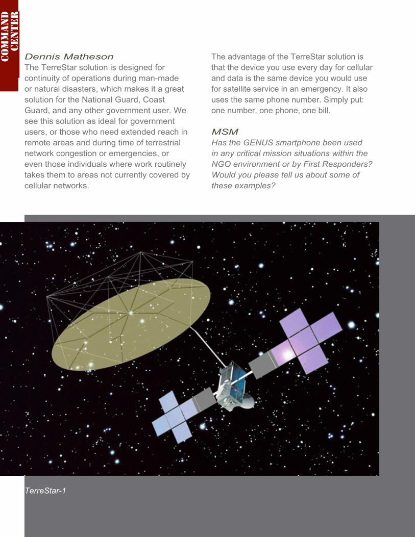
Dennis MathesonThe TerreStar solution is designed for continuity of operations during man-made or natural disasters, which makes it a great solution for the National Guard, Coast Guard, and any other government user. We see this solution as ideal for government users, or those who need extended reach in remote areas and during time of terrestrial network congestion or emergencies, or even those individuals where work routinely takes them to areas not currently covered by cellular networks.
The advantage of the TerreStar solution is that the device you use every day for cellular and data is the same device you would use for satellite service in an emergency. It also uses the same phone number. Simply put: one number, one phone, one bill.
MSMHas the GENUS smartphone been used in any critical mission situations within the NGO environment or by First Responders? Would you please tell us about some of these examples?
Com
ma
nd
ce
nter
TerreStar-1
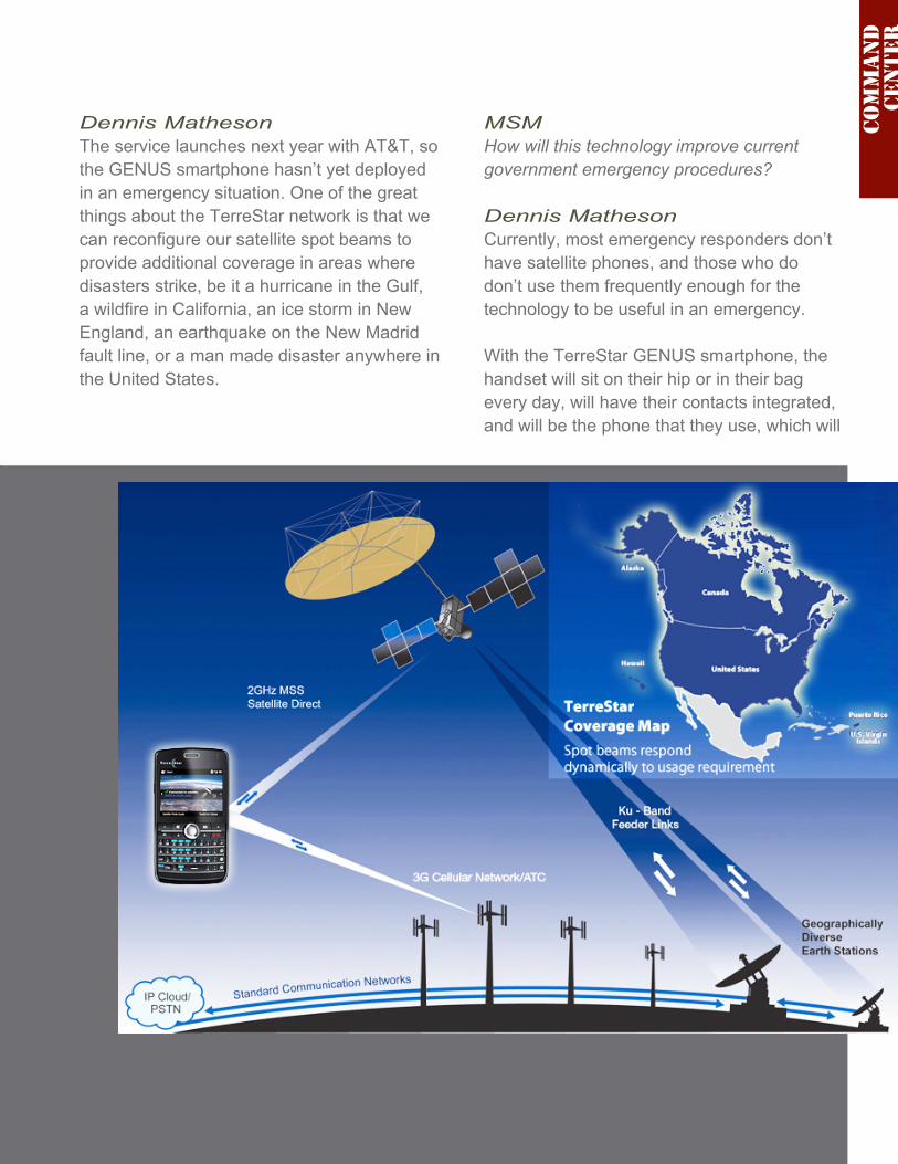
Dennis MathesonThe service launches next year with AT&T, so the GENUS smartphone hasn’t yet deployed in an emergency situation. One of the great things about the TerreStar network is that we can reconfigure our satellite spot beams to provide additional coverage in areas where disasters strike, be it a hurricane in the Gulf, a wildfire in California, an ice storm in New England, an earthquake on the New Madrid fault line, or a man made disaster anywhere in the United States.
MSMHow will this technology improve current government emergency procedures?
Dennis MathesonCurrently, most emergency responders don’t have satellite phones, and those who do don’t use them frequently enough for the technology to be useful in an emergency.
With the TerreStar GENUS smartphone, the handset will sit on their hip or in their bag every day, will have their contacts integrated, and will be the phone that they use, which will
Com
ma
nd
ce
nter

MilsatMagazine — January 201062
speed the ability of the government to respond in case of emergency.
MSMHow does Ground Based Beam Forming compliment the spot beam technology? How is such managed at the ground stations?
Dennis MathesonIn a traditional spot beam configuration the beam shape (circular) and pitch are fixed, and there is little or no flexibility in re-allocating bandwidth and power resources within the coverage area. Ground Based Beam Forming (GBBF) provides nearly unlimited flexibility in matching resources with demand. For example, in case of a natural disaster we can increase the capacity allocated to the affected area in order to assist first responders.
The GBBF system is housed at ground stations where it connects through a base station subsystem to other networks. The beam configurations and bandwidth and power resource allocation are managed by uploading pre-computed beam plans to the GBBF. The GBBF also contains complex software that provides for real-time calibration and electronic beam pointing correction.
MSMHow do you see the Intelsat purchase of ProtoStar 1 impacting TerreStar’s business?
Dennis MathesonWe cannot speculate on this matter.
MSMWhen you discuss “wireless devices,” do you see this market segment’s growth rate absolutely ramping capacity in the not-too-distant future? If so, how will TerreStar counter such consumer and operator needs in this arena?
Dennis MathesonTerreStar is taking satellite phones into the mainstream by launching a device users can carry everyday that acts as their mobile phone and their satellite phone. We believe there is tremendous opportunity in this space and we look forward to bringing our product to market.
MSMIs TerreStar considering an expansion of their all-IP network to the global market?
Dennis MathesonWe believe there is tremendous value in the ecosystem we have created to support the S-band and hope to share these advances around the world. We were one of four applicants for spectrum in Europe and although we were not awarded spectrum we continue to seek other opportunities to leverage our assets to bring this valuable service to customers.
Com
ma
nd
ce
nter
MilsatMagazine —January 2010 63
Advertisers
AAE Systems 9Advantech 7AVL Technologies 15Comtech EF Data 11IDGA 63Integral Systems 43Intelsat General 2MITEQ / MCL Front CoverMITEQ / MCL 27NSR 19SMi 13SatMagazine 65Wavestream 59Xicom 11XipLink 23
A SatNews Publishers publicationCopyright 2010, SatNews Publishers

MilsatMagazine —January 2010 65


![SatCom For Net-Centric Warfare May 2008 MilsatMagazine · 2008. 5. 20. · Nicholas Yuran SMC History Office SPECIAL THANKS TO: General Hamel General Pawlikowski General Armor [Ret.]](https://img.pdfslide.net/doc/110x75/60da57ec0f3c36643a00b1d7/satcom-for-net-centric-warfare-may-2008-2008-5-20-nicholas-yuran-smc-history.jpg)