Embed Size (px)
Citation preview
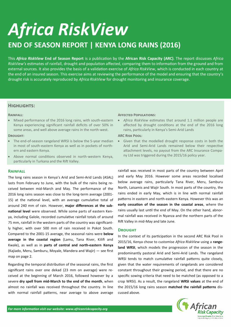
This Africa RiskView End of Season Report is a publication by the African Risk Capacity (ARC). The report discusses Africa RiskView’s estimates of rainfall, drought and population affected, comparing them to information from the ground and from external sources. It also provides the basis of a validation exercise of Africa RiskView, which is conducted in each country at the end of an insured season. This exercise aims at reviewing the performance of the model and ensuring that the country’s drought risk is accurately reproduced by Africa RiskView for drought monitoring and insurance coverage.
For more information visit our website: www.africanriskcapacity.org
Africa RiskView END OF SEASON REPORT | KENYA LONG RAINS (2016)
Rainfall
The long rains season in Kenya’s Arid and Semi-Arid Lands (ASAL)
lasts from February to June, with the bulk of the rains being re-
ceived between mid-March and May. The performance of the
2016 long rains season was close to the long-term average (2001-
15) at the national level, with an average cumulative total of
around 240 mm of rain. However, major differences at the sub-
national level were observed. While some parts of eastern Ken-
ya, including Galole, recorded cumulative rainfall totals of around
75 mm, rainfall in the western parts of the country was significant-
ly higher, with over 500 mm of rain received in Pokot South.
Compared to the 2001-15 average, the seasonal rains were below
average in the coastal region (Lamu, Tana River, Kilifi and
Kwale), as well as in parts of central and north-eastern Kenya
(Kajiado, Meru, Samburu, Moyale, Mandera and Wajir) — see first
map on page 2.
Regarding the temporal distribution of the seasonal rains, the first
significant rains over one dekad (23 mm on average) were re-
ceived at the beginning of March 2016, followed however by a
severe dry spell from mid-March to the end of the month, when
almost no rainfall was received throughout the country. In line
with normal rainfall patterns, near average to above average
rainfall was received in most parts of the country between April
and early May 2016. However some areas recorded localised
below average rains, particularly Tana River, Meru, Samburu
North, Laisamis and Wajir South. In most parts of the country, the
rains ended in early May, which is in line with normal rainfall
patterns in eastern and north-eastern Kenya. However this was an
early cessation of the season in the coastal areas, where the
rains usually last until the end of May. On the other hand, abnor-
mal rainfall was received in Nyanza and the northern parts of the
Rift Valley in mid-May and late June.
Drought
In the context of its participation in the second ARC Risk Pool in
2015/16, Kenya chose to customise Africa RiskView using a range-
land WRSI, which models the progression of the season in the
predominantly pastoral Arid and Semi-Arid Lands. The rangeland
WRSI tends to match cumulative rainfall patterns quite closely,
given that the water requirements of rangelands are considered
constant throughout their growing period, and that there are no
specific sowing criteria that need to be matched (as opposed to a
crop WRSI). As a result, the rangeland WRSI values at the end of
the 2015/16 long rains season matched the rainfall patterns dis-
cussed above.
Rainfall:
Mixed performance of the 2016 long rains, with south-eastern Kenya experiencing significant rainfall deficits of over 50% in some areas, and well above average rains in the north-west.
Drought:
The end-of-season rangeland WRSI is below the 5-year median in most of south-eastern Kenya as well as in pockets of north-ern and eastern Kenya.
Above normal conditions observed in north-western Kenya, particularly in Turkana and the Rift Valley.
Affected Populations:
Africa RiskView estimates that around 1.1 million people are affected by drought conditions at the end of the 2016 long rains, particularly in Kenya’s Semi-Arid Lands
ARC Risk Pool:
Given that the modelled drought response costs in both the Arid and Semi-Arid Lands remained below their respective attachment levels, no payout from the ARC Insurance Compa-ny Ltd was triggered during the 2015/16 policy year.
Highlights:
For more information visit our website: www.africanriskcapacity.org
In coastal areas (Tana River, Malindi, Kilifi, Kitui and Ijara), the
WRSI values were more than 50% below the benchmark set by the
country as an indicator for normal conditions (in the case of Ken-
ya, the median of the previous 5 years). Moreover, 30-50% below
normal rangeland WRSI values were observed in parts of north-
western, northern and north-eastern Kenya, including Turkana
East, Samburu North, Laisamis, northern Wajir South, northern
Moyale, Wajir North and Mandera West, as well as in Turkana
West. In the rest of the country, the rangeland WRSI values at the
end of the season were normal to above normal, according to
Africa RiskView — see second map above.
Affected Populations
As mentioned above, the end-of-season rangeland WRSI was
below the benchmark in some parts of the country, due to the
rainfall deficits recorded over the course of the 2016 long rains
season. Overall, in 33 sub-counties, the rangeland WRSI was
below the drought detection point (set at 95% of the benchmark),
thus triggering drought events with varying severity. The impact of
drought on each area’s population is determined by both the
severity of the drought event as detected by Africa RiskView and
the vulnerability of the population (which in the case of Kenya
tends to be higher in chronically vulnerable areas such as Turkana,
Mandera, Samburu or Marsabit).
As a result, according to the model, the most severe drought
impacts were recorded in south-western Kenya, specifically in
Ganze (62% of the population), Galole (57%), Garsen (55%) and
Kaloleni (53%). In neighbouring Malindi, where Africa RiskView
also detected a very severe drought event, the relatively lower
vulnerability mitigated the impact, with only 24% of the popula-
tion affected — see third map above.
In terms of total population affected, Africa RiskView estimates
that over 1.1 million people across the country were affected by
drought conditions at the end of the 2016 long rains season,
248,000 of which are in the Arid counties and 855,000 in the Semi-
Arid counties. At sub-county level, the numbers of drought affect-
ed people were highest in Ganze, Kaloleni, Magarini, Kinango and
Kilifi North.
Compared to the 2001-15 average, the number of people affected
by drought at the national level was just below average. However,
it was nearly 50% above average for the Semi-Arid Lands.
Comparison with External Sources
An important aspect of the in-country customisation review pro-
cess of Africa RisKView is the comparison of the modelled esti-
mates with external sources. Products from a variety of technical
partners are consulted in this process, including in-country tech-
nical partners such as Kenya’s National Drought Management
Authority (NDMA), or international partners such as the Famine
Early Warning Systems Network (FEWS NET).
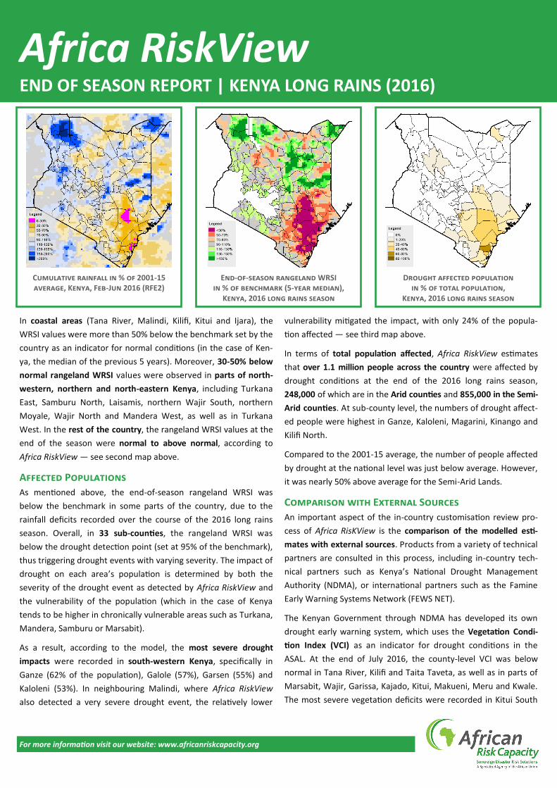
The Kenyan Government through NDMA has developed its own
drought early warning system, which uses the Vegetation Condi-
tion Index (VCI) as an indicator for drought conditions in the
ASAL. At the end of July 2016, the county-level VCI was below
normal in Tana River, Kilifi and Taita Taveta, as well as in parts of
Marsabit, Wajir, Garissa, Kajado, Kitui, Makueni, Meru and Kwale.
The most severe vegetation deficits were recorded in Kitui South
Cumulative rainfall in % of 2001-15 average, Kenya, Feb-Jun 2016 (RFE2)
End-of-season rangeland WRSI in % of benchmark (5-year median),
Kenya, 2016 long rains season
Drought affected population in % of total population,
Kenya, 2016 long rains season
Africa RiskView END OF SEASON REPORT | KENYA LONG RAINS (2016)
For more information visit our website: www.africanriskcapacity.org
sub-county (Kitui), Kibwezi East (Makueni) and Ganze (Kilifi) — see
first map on page 3. While overall there is a good match between
the VCI conditions detected by NDMA and Africa RiskView’s mod-
elled estimates, there are some areas where the model picks up
below-normal conditions that are not necessarily confirmed by
the VCI, such as Kilifi North, Msambweni, Lamu West and Ijara.
Conversely, Africa RiskView’s rangeland WRSI is average in Moy-
ale, Kibwezi West, Wajir East, Tigania East and North Horr, while
the VCI suggests that these sub-counties experienced below
normal vegetation conditions.
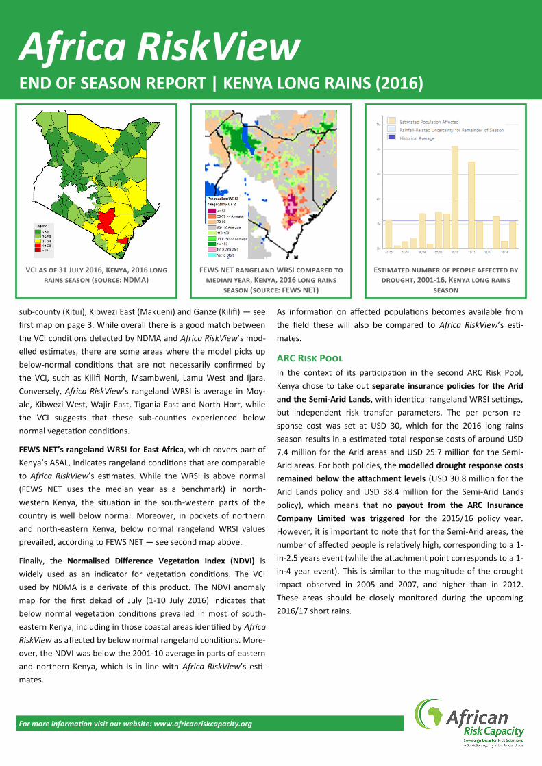
FEWS NET’s rangeland WRSI for East Africa, which covers part of
Kenya’s ASAL, indicates rangeland conditions that are comparable
to Africa RiskView’s estimates. While the WRSI is above normal
(FEWS NET uses the median year as a benchmark) in north-
western Kenya, the situation in the south-western parts of the
country is well below normal. Moreover, in pockets of northern
and north-eastern Kenya, below normal rangeland WRSI values
prevailed, according to FEWS NET — see second map above.
Finally, the Normalised Difference Vegetation Index (NDVI) is
widely used as an indicator for vegetation conditions. The VCI
used by NDMA is a derivate of this product. The NDVI anomaly
map for the first dekad of July (1-10 July 2016) indicates that
below normal vegetation conditions prevailed in most of south-
eastern Kenya, including in those coastal areas identified by Africa
RiskView as affected by below normal rangeland conditions. More-
over, the NDVI was below the 2001-10 average in parts of eastern
and northern Kenya, which is in line with Africa RiskView’s esti-
mates.
As information on affected populations becomes available from
the field these will also be compared to Africa RiskView’s esti-
mates.
ARC Risk Pool
In the context of its participation in the second ARC Risk Pool,
Kenya chose to take out separate insurance policies for the Arid
and the Semi-Arid Lands, with identical rangeland WRSI settings,
but independent risk transfer parameters. The per person re-
sponse cost was set at USD 30, which for the 2016 long rains
season results in a estimated total response costs of around USD
7.4 million for the Arid areas and USD 25.7 million for the Semi-
Arid areas. For both policies, the modelled drought response costs
remained below the attachment levels (USD 30.8 million for the
Arid Lands policy and USD 38.4 million for the Semi-Arid Lands
policy), which means that no payout from the ARC Insurance
Company Limited was triggered for the 2015/16 policy year.
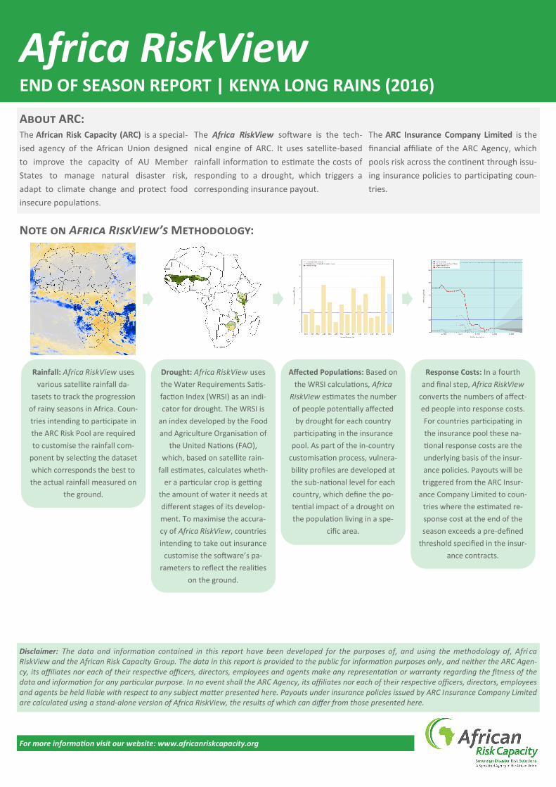
However, it is important to note that for the Semi-Arid areas, the
number of affected people is relatively high, corresponding to a 1-
in-2.5 years event (while the attachment point corresponds to a 1-
in-4 year event). This is similar to the magnitude of the drought
impact observed in 2005 and 2007, and higher than in 2012.
These areas should be closely monitored during the upcoming
2016/17 short rains.
Africa RiskView END OF SEASON REPORT | KENYA LONG RAINS (2016)
VCI as of 31 July 2016, Kenya, 2016 long rains season (source: NDMA)
FEWS NET rangeland WRSI compared to median year, Kenya, 2016 long rains
season (source: FEWS NET)
Estimated number of people affected by drought, 2001-16, Kenya long rains
season
For more information visit our website: www.africanriskcapacity.org
The African Risk Capacity (ARC) is a special-
ised agency of the African Union designed
to improve the capacity of AU Member
States to manage natural disaster risk,
adapt to climate change and protect food
insecure populations.
The Africa RiskView software is the tech-
nical engine of ARC. It uses satellite-based
rainfall information to estimate the costs of
responding to a drought, which triggers a
corresponding insurance payout.
The ARC Insurance Company Limited is the
financial affiliate of the ARC Agency, which
pools risk across the continent through issu-
ing insurance policies to participating coun-
tries.
About ARC:
Disclaimer: The data and information contained in this report have been developed for the purposes of, and using the methodology of, Afri ca RiskView and the African Risk Capacity Group. The data in this report is provided to the public for information purposes only, and neither the ARC Agen-cy, its affiliates nor each of their respective officers, directors, employees and agents make any representation or warranty regarding the fitness of the data and information for any particular purpose. In no event shall the ARC Agency, its affiliates nor each of their respective officers, directors, employees and agents be held liable with respect to any subject matter presented here. Payouts under insurance policies issued by ARC Insurance Company Limited are calculated using a stand-alone version of Africa RiskView, the results of which can differ from those presented here.
Note on Africa RiskView’s Methodology:
Rainfall: Africa RiskView uses
various satellite rainfall da-
tasets to track the progression
of rainy seasons in Africa. Coun-
tries intending to participate in
the ARC Risk Pool are required
to customise the rainfall com-
ponent by selecting the dataset
which corresponds the best to
the actual rainfall measured on
the ground.
Drought: Africa RiskView uses
the Water Requirements Satis-
faction Index (WRSI) as an indi-
cator for drought. The WRSI is
an index developed by the Food
and Agriculture Organisation of
the United Nations (FAO),
which, based on satellite rain-
fall estimates, calculates wheth-
er a particular crop is getting
the amount of water it needs at
different stages of its develop-
ment. To maximise the accura-
cy of Africa RiskView, countries
intending to take out insurance
customise the software’s pa-
rameters to reflect the realities
on the ground.
Affected Populations: Based on
the WRSI calculations, Africa
RiskView estimates the number
of people potentially affected
by drought for each country
participating in the insurance
pool. As part of the in-country
customisation process, vulnera-
bility profiles are developed at
the sub-national level for each
country, which define the po-
tential impact of a drought on
the population living in a spe-
cific area.
Response Costs: In a fourth
and final step, Africa RiskView
converts the numbers of affect-
ed people into response costs.
For countries participating in
the insurance pool these na-
tional response costs are the
underlying basis of the insur-
ance policies. Payouts will be
triggered from the ARC Insur-
ance Company Limited to coun-
tries where the estimated re-
sponse cost at the end of the
season exceeds a pre-defined
threshold specified in the insur-
ance contracts.
Africa RiskView END OF SEASON REPORT | KENYA LONG RAINS (2016)