Embed Size (px)
Citation preview

Gazetteer ApplicationGazetteer ApplicationPresented at the 25Presented at the 25thth Session of UNGEGNSession of UNGEGN
Presented by : Yoseph MekashaPresented by : Yoseph MekashaSoftware Engineer, UNECASoftware Engineer, UNECA

AfricanGazAfricanGazIs a name given to the tool being Is a name given to the tool being developed by UNECA/GiSS to developed by UNECA/GiSS to collect geographical names collect geographical names (Toponyms)(Toponyms)The name can be contestedThe name can be contested

Why AfricanGaz ?Why AfricanGaz ?
Provide African countries a free Provide African countries a free tooltoolNationally approved(Correct) Nationally approved(Correct) names names Makeup African SDIMakeup African SDI‐‐>UNGEGN >UNGEGN Geographical Names DBGeographical Names DB

BackgroundBackground
Ethiopian mapping authority was Ethiopian mapping authority was using an MS XL form for collecting using an MS XL form for collecting geographic names. geographic names. Came to UNECACame to UNECA‐‐Geoinfo for a Geoinfo for a better solutionbetter solutionweb based intranet solution web based intranet solution Ethiopia is still using.Ethiopia is still using.

EthioGazEthioGaz

EthioGazEthioGaz

EthioGazEthioGaz

EthioGazEthioGaz
EthioGazEthioGaz

UNGEGNUNGEGN’’s Interests InterestOn the 24 th session a presentation On the 24 th session a presentation was made by UNECA representative was made by UNECA representative on EthioGaz and its featureson EthioGaz and its featuressuggestion was made to develop a suggestion was made to develop a tool that can serve any country in tool that can serve any country in need of such a tool.need of such a tool.ECA/Geoinfo took the assignmentECA/Geoinfo took the assignment
BackgroundBackground –– Contd.Contd.

New AfricanGaz ApplicationNew AfricanGaz Application
Designed around Designed around three core nonthree core non‐‐functional functional requirements requirements (Ideas)(Ideas)Increase usability Increase usability and availabilityand availability

AfricanGaz ApplicationAfricanGaz Application
1.1. Open sourceOpen source2.2. Platform IndependencePlatform Independence3.3. Architectural InteroperabilityArchitectural Interoperability
AfricanGaz AfricanGaz –– Contd.Contd.

Open sourceOpen sourceNo proprietor tools employed No proprietor tools employed
Development: Adobe Flex AIR/ActionScript 3.0Development: Adobe Flex AIR/ActionScript 3.0RDBMS: SQLiteRDBMS: SQLite
GPL : no payment of any sortGPL : no payment of any sortMember states can extend it to cater for their Member states can extend it to cater for their special needspecial need
Note:Note:Responsible body to form user community and Responsible body to form user community and coordinate initiatives (UNECA with coordinate initiatives (UNECA with UNGEGN/UNSD) can take this responsibilityUNGEGN/UNSD) can take this responsibility
AfricanGaz AfricanGaz –– Contd.Contd.

Platform IndependencePlatform IndependenceRuns on all known platforms Runs on all known platforms AIR applications built with Flex use AIR applications built with Flex use the highthe high‐‐performance, crossperformance, cross‐‐operating operating system virtual machine from Adobe system virtual machine from Adobe FlashFlash®® Player 9 softwarePlayer 9 softwareUse proven, open technologies such as Use proven, open technologies such as Tamarin, WebKit, and SQLite.Tamarin, WebKit, and SQLite.
AfricanGaz AfricanGaz –– Contd.Contd.

Architectural CompatibilityArchitectural CompatibilityWith African SDI names databaseWith African SDI names databaseNews Items , Application Settings News Items , Application Settings ‐‐>Member States>Member StatesGeographical Name records Geographical Name records (Feature Data) (Feature Data) ‐‐> Global DB.> Global DB.
AfricanGaz AfricanGaz –– Contd.Contd.

Architectural Compatibility Cond.Architectural Compatibility Cond.
AfricanGaz AfricanGaz –– Contd.Contd.


Welcome pageWelcome page

Feature Editor pageFeature Editor page
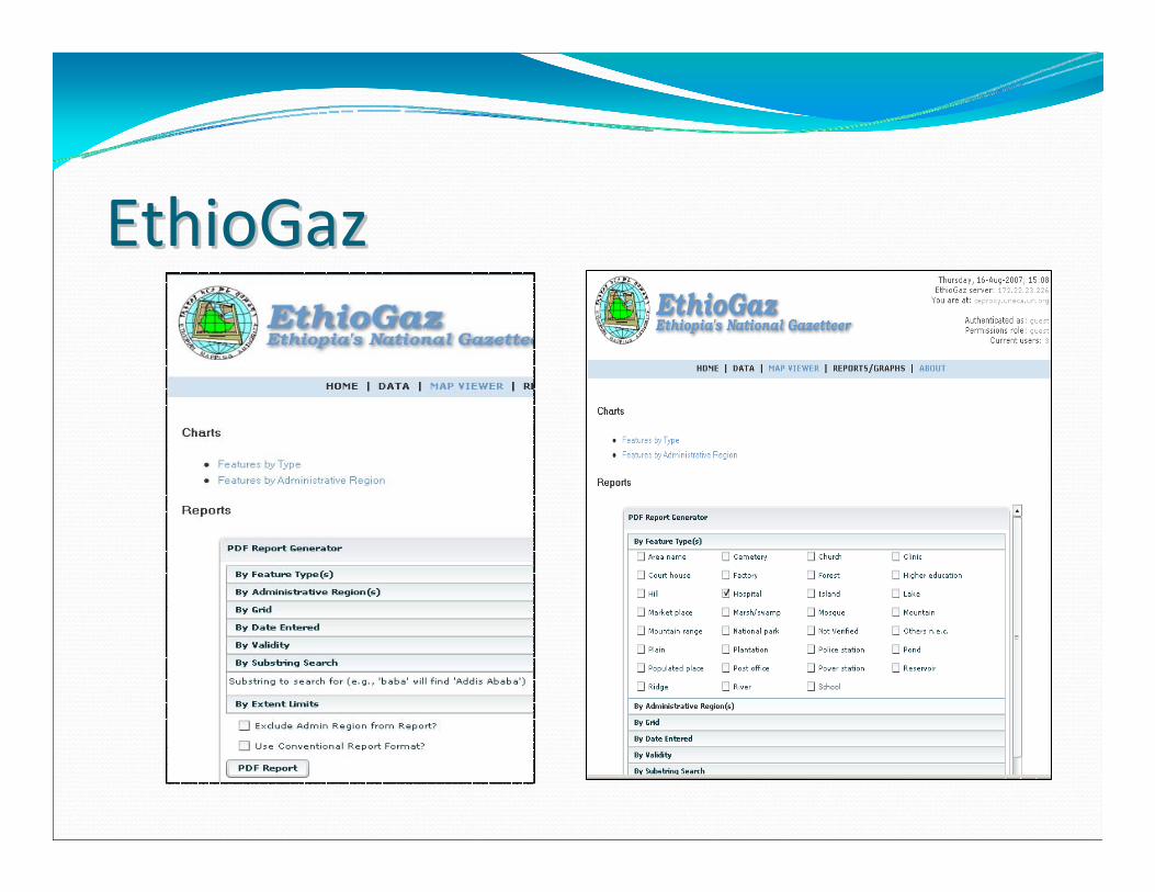
Feature Feature –– Location pageLocation page

Feature Feature ‐‐ Note pageNote page

Feature Feature –– Audio/VisualAudio/Visual

Feature Feature ‐‐ Metadata pageMetadata page

MapMap
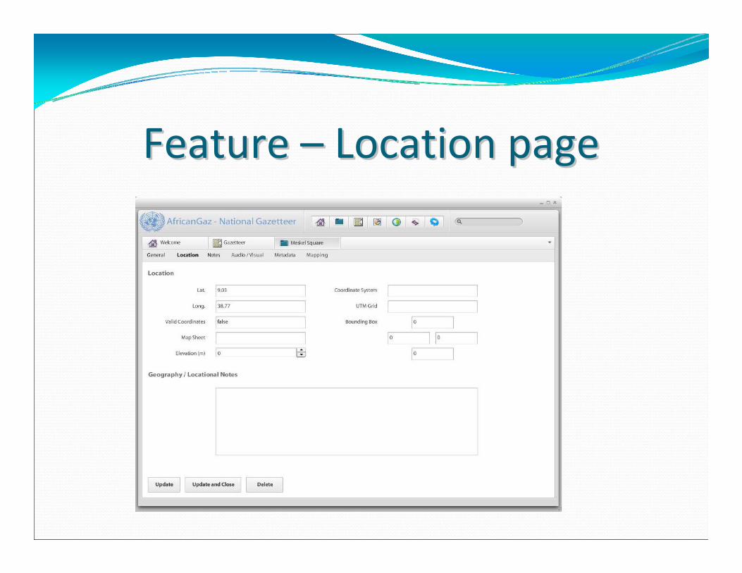
GazetteerGazetteer


Phase IAutomated metadata setup utilityAutomated metadata setup utilitypre‐usage metadata setup facility Enable users to set up the system with their metadata
Authentication/AuthorizationAuthentication/Authorization modulemoduleAuthentication‐>Protecting the systemAuthorization ‐>Provide different level of accessAuthorization ‐> Enforce working procedure MultiMulti‐‐lingual skinlingual skin

Phase ISearch:Search:Search by name by geographical location (Lat/Long), by Feature type, By Administrative division …
Import:Import:Batch Importing feature data from XL, XML, and formatted text file …Verification module that would let the user
Export:Export:Export to XL, XML, formatted text file
Contd.Contd.

Phase IIMap based Record Entry:Map based Record Entry:Using Google Map – satellite imagery or a better precision source, providing users the option of creating feature records.
Data Synchronization Tool(s) Data Synchronization Tool(s) Extracts member states data in the format that can be imported into the African SDI/UNGEGN DBPulls News, metadata setups from African SDI/UNGEGN database to the Member stats’

Phase IIStatistical Reports (Including charts):Statistical Reports (Including charts):Generating pre‐formatted reports on Data Statistics such as number of features per admin division and producing different Charts to depict the information clearly and more easily
Contd.Contd.


Complete DevelopmentPrepare/setup access points and community siteConduct workshops on Methodology and toolSupport and encourage member states to populate DB

Integrate African Toponyms/ African SDI ‐>UNGEGN DBDevelop African toponyms websiteAssist African countries to develop/host their own toponym websitePromote/ensure the usage of these DBs