Embed Size (px)
Citation preview
Alaska Forest Resources and Practices Act REGULATIONS
ALASKA
FOREST
RESOURCES
& PRACTICES
REGULATIONS
11 AAC 95
March 2017
DIVISION OF FORESTRY
The Department of Natural Resources provides this booklet as a public courtesy. It
includes the Forest Resources and Practices Regulations (11 AAC 95) through March
2017 (Register 221). This book also includes portions of 18 AAC 90 adopted by the
Department of Environmental Conservation regarding pesticide control, that are
specific to forestry applications. It does not include the attorney general's notes or the
history notes that are given in the official compilation. The department cannot
guarantee the absolute accuracy of this reproduction of the regulations. For the official
published version of the regulations, and for any changes to the regulations since
March 2017, please refer to the Alaska Administrative Code.
1
Table of Contents
Alaska Forest Resources and Practices Regulations, 2017
Title 11. Natural Resources
Chapter 95. Forest Resources and Practices
Article 1. Introductory and notification provisions
11 AAC 95
Section
185. Purpose and relationship to other laws 4
190. Applicability 5
195. Clearing of spruce trees 6
200. Land use conversion 7
210. Voluntary plan of operations 7
220. Detailed plan of operations 8
225. Review of a detailed plan of operations 11
230. Change in operations 12
235. Variation procedures 13
240. Variation from requirements in areas adjoining a small streamside
zone in Region I 13
245. Inspections 15
250. Hearings 16
255. Corrective action 16
Article 2. Riparian standards
11 AAC 95
Section
260. Riparian standards 17
265. Classification of surface water bodies 17
270. Designation and marking of a riparian area 20
275. Uses within a riparian area 21
280. Slope stability standards in a riparian area 22
Article 3. Road construction
11 AAC 95
Section
285. Road location 23
290. Road construction 24
295. Road drainage 26
300. Bridge standards 27
305. Culverts and other water crossing provisions 29
315. Road maintenance 30
320. Road closure 31
325. Material extraction and disposal sites 32
2
330. Rehabilitation after mass wasting 34
335. Blasting standards 34
Article 4. Timber harvesting
11 AAC 95
Section
340. Harvest unit planning and design 34
345. Landing location, construction, and operation 35
350. Bank integrity 36
355. Felling and bucking 36
360. Cable yarding 37
365. Tracked and wheeled harvest systems 38
370. Slash 39
Article 5. Reforestation
11 AAC 95
Section
375. Reforestation requirement 39
380. Natural regeneration standards 42
385. Regeneration survey and report 42
390. Site preparation 43
Note: For Article 6, Forest fire protection, see the Alaska Administrative Code, or
the Division of Forestry fieldbook (orange) titled “Alaska Wildland Fire Protection
Statutes and Regulations Booklet.”
Article 7. General provisions
11 AAC 95
Section
800. Designation of regions 44
805. Computation of time 44
810. Measurement of distances 44
815. Disposal of waste material 44
820. Aesthetics 45
825. Water quality monitoring 45
830. Monitoring effectiveness of forest practices regulations 46
835. Other rights not affected 46
900. Definitions 47
3
Chapter 99. Management of Alaska Mental Health Trust Land
11 AAC 99
Section
140. Application of other state and local law. 55
Title 18. Environmental Conservation
Chapter 90. Pesticide Control
NOTE: This section includes portions of 18 AAC 90 regarding pesticide control
that are specific to forestry applications. These regulations, adopted by the
Department of Environmental Conservation (DEC), implement AS 41.17.100.
Please refer to the Alaska Administrative Code for the complete regulations when
considering pesticide use.
Article 3. Certification Requirements\
18 AAC 90
300(c)(12). Certification requirements. 56
Article 5. Permit Requirements
18 AAC 90
505. Permit for water and aerial application of pesticides. 56
520. Public notice requirements; public hearings. 56
Article 8. Forestry Vegetation Management
18 AAC 90
800. Protective area. 57
Article 9. General Provisions
18 AAC 90
990. Definitions. 58
Topic Guide 59
Stream classification chart 62
Riparian standards chart 64
Slope stability standards chart 68
4
Through Register 221, March 2017 NATURAL RESOURCES
Title 11. Natural Resources-Chapter 95. Forest Resources and Practices
Article 1. Introductory and notification provisions Section
185. Purpose and relationship to other laws
190. Applicability
195. Clearing of spruce trees
200. Land use conversion
210. Voluntary plan of operations
220. Detailed plan of operations
225. Review of a detailed plan of operations
230. Change in operations
235. Variation procedures
240. Variation from requirements in areas adjoining a small streamside zone
in Region I
245. Inspections
250. Hearings
255. Corrective action
11 AAC 95.185. Purpose and relationship to other laws. (a) This chapter
implements and interprets AS 41.17 (Forest Resources and Practices). For land
outside riparian areas, the purpose of this chapter is to provide protection of
important public resources, maintain an economically viable timber industry,
prevent or minimize significant adverse effects of soil erosion and mass wasting on
water quality and fish habitat, and ensure reforestation to the fullest extent practical,
taking into account the economic feasibility of timber operations. For riparian
areas, the purpose of this chapter is to protect these areas from significant adverse
effects of timber harvest activities on fish habitat and water quality, taking into
account the economic feasibility of timber operations.
(b) For all lands, the operations recognized under this chapter shall be conducted in
a manner that does not cause or constitute a substantial factor in causing a
degradation of water quality.
(c) The best management practices identified in this chapter for operations
conducted under this chapter are the sole enforcement mechanism for violations of
water quality standards. Data collected under 11 AAC 95.825 will be used to revise
the best management practices as necessary to attain and maintain water quality
standards.
(d) Nothing in this chapter affects the applicability of 18 AAC 70.015 or precludes
the Department of Environmental Conservation from granting a variance from the
antidegradation requirements of 18 AAC 70.010(c) and the water quality criteria of
18 AAC 70.020(b) for a project in accordance with the requirements of 18 AAC
70.015. A Department of Environmental Conservation variance does not relieve a
5
forest manager, forest landowner, timber owner, or operator from meeting the
requirements of (b) of this section or any other provision of this chapter.
(e) For state managed lands, the purpose of this chapter is also to ensure that forest
land is administered for the multiple use of all resources and to ensure the sustained
yield of renewable resources. This purpose is achieved through the provisions of
this chapter in conjunction with AS 38 and appropriate land use plans.
(f) The purposes of this chapter are achieved by establishing measurable forestry
standards, and providing the capability to tailor those standards to particular field
conditions.
(g) [Repealed 12/27/2012, Register 204]
(h) The regulations adopted in this chapter, as approved by the Department of
Environmental Conservation, establish the review, riparian, monitoring, and field
operation standards that, in conjunction with additional non-regulatory forestry
components of the Department of Environmental Conservation's federally approved
nonpoint source pollution control program under the 33 U.S.C. 1329 (Clean Water
Act, sec. 319), as amended February 4, 1987, constitute the nonpoint source
pollution control requirements for activities recognized in this chapter. (Eff.
6/10/93, Register 126,)
Authority: AS 41.17.010 AS 41.17.055 AS 41.17.080
AS 41.17.098 AS 41.17.115 AS 41.17.900
11 AAC 95.190. Applicability. (a) The provisions of this chapter apply to an
operation on state land, other public land, or private forest land if all of the
following criteria are met:
(1) the operation is on forest land as defined in AS 41.17.950;
(2) the operation involves any of the following activities:
(A) harvesting, including felling, bucking, yarding, decking, hauling,
log dumping, log transfer, log rafting, and related road construction,
reconstruction, improvement, or maintenance;
(B) road construction or reconstruction, material source development,
and maintenance of an existing road or bridge not within the operation
area, but connected with, the harvesting operation;
(C) site preparation;
(D) precommercial thinning;
(E) slash treatment; or
(F) any other activity leading to, or connected with commercial
timber harvest; and
(3) a commercial operation that intersects, encompasses, or borders on
surface waters or a riparian area, or that, for a single landowner or operator,
equals or exceeds in the aggregate the following acreage:
(A) 10 acres in Region I;
(B) 40 acres in Region II; or
6
(C) 40 acres in Region III for land owners who own more than 160
acres in total; if a landowner has a total ownership of 160 acres or less,
then an operation on any of that 160 acres or less is not a commercial
forest operation.
(b) A land use conversion involving a commercial forest operation that meets the
criteria in (a) of this section must meet the requirements of 11 AAC 95.200. (Eff.
6/10/93, Register 126)
Authority: AS 41.17.010 AS 41.17.055 AS 41.17.080
AS 41.17.098 AS 41.17.900
Editor's Notes: Operations in waters containing fish may be subject to laws and
regulations governing fish in AS 16 and 5 AAC.
11 AAC 95.195. Clearing of spruce trees. (a) Notwithstanding the provisions of
11 AAC 95.190, in order to minimize the spread of destructive forest insects and
reduce the risk of wildfire, a landowner in Region II or III shall perform one or
more of the practices identified in (b) of this section within one year, unless notified
by the division, of clearing spruce trees, other than black spruce. A landowner in
Region I must perform one or more of the practices identified in (b) of this section
if notified by the division.
(b) The following practices may be performed to comply with (a) of this section:
(1) spruce trees or limbs greater than five inches in diameter may be
disposed of by manufacturing into cants, lumber, houselogs, chips, or
firewood;
(2) spruce trees or limbs greater than five inches in diameter may be
disposed of by burning, subject to applicable regulations;
(3) downed and removed spruce trees or limbs greater than five inches in
diameter may be treated or stored in an appropriate manner, if they are not
burned, manufactured, or otherwise used in a way that will prevent the
spread of bark beetles;
(4) spruce limbs greater than five inches in diameter may be dried by
uniform scattering in areas open to sunshine if they are not burned or
chemically treated.
(c) The division will, in its discretion, approve other methods for disposal or
treatment of downed spruce trees to minimize the spread of bark beetles or reduce
the risk of wildfire.
(d) If notified by the division, a landowner must provide a slash management plan
that addresses the requirements of this section. (Eff. 6/10/93, Register 126; am
2/24/2000, Register 153)
Authority: AS 41.17.010 AS 41.17.055 AS 41.17.080
AS 41.17.082 AS 41.17.136
7
11 AAC 95.200. Land use conversion. (a) The requirements of 11 AAC 95.260 -
11 AAC 95.390 do not apply if a landowner intends to convert forest land to
another use within five years after timber harvest and the land is converted or in the
process of conversion within five years.
(b) If, five years after timber harvest, the land is not converted or actively in the
process of conversion, a landowner shall meet the reforestation requirements of 11
AAC 95.375 - 11 AAC 95.390 within three years.
(c) If, as part of a land use conversion, a landowner intends to begin a commercial
forest operation subject to 11 AAC 95.190, the following notification provisions
apply:
(1) if the land use conversion is within a borough or municipality and the
borough or municipality has granted a plat approval, a building permit, or
other authorization for that specific land use, the operator is not required to
notify the division; zoning of the land does not constitute an authorization;
(2) if the land conversion has not been authorized by a borough or
municipality, the landowner shall notify the division before beginning the
operation.
(d) If the division finds that a forest landowner has provided false information
about the owner's intention to convert forest land as stated in the notice under (c)(2)
of this section, the division will, in its discretion, require full compliance with AS
41.17. (Eff. 6/10/93, Register 126)
Authority: AS 41.17.010 AS 41.17.055 AS 41.17.080
11 AAC 95.210. Voluntary plan of operations. (a) If a forest landowner, timber
owner, or operator provides a voluntary plan of operations under AS 41.17.090
describing long term plans for timber harvesting, the division will, within 10 days
after receipt of the plan, distribute a copy of the voluntary plan of operations to each
agency. The division will distribute summary information to persons on the
mailing list established under 11 AAC 95.225(a).
(b) In addition to the distribution under (a) of this section, within 60 days after a
voluntary plan of operations has been filed, the division will review the voluntary
plan of operations and provide a written response to the forest landowner, timber
owner, or operator. The division will not consider any comments received more
than 45 days after the date of filing of the voluntary plan of operations. The
division response to a voluntary plan of operations will identify areas of concern,
provide local knowledge, and early notice of potential problems, including any
conflicts with AS 41.17 and this chapter. The specificity of the division response
will depend upon the quality and type of information supplied by the forest
8
landowner, timber owner, or operator. The division will send a copy of all
comments to the forest landowner, timber owner, or operator. (Eff. 6/10/93,
Register 126)
Authority: AS 41.17.010 AS 41.17.055 AS 41.17.080 AS 41.17.090
11 AAC 95.220. Detailed plan of operations. (a) Before beginning an operation
on forest land, the operator shall file a detailed plan of operations with the state
forester at the area office of the division with jurisdiction over the geographic area
in which the operations will occur. A detailed plan of operations must be submitted
on a form provided by the division and must include the following information:
(1) subject to the requirements of (b) of this section, the name, address, and
approving signatures of the forest landowner, timber owner, and operator;
(2) a 1:63,360 scale USGS quadrangle map showing the area of operation
and suitable for black and white duplication on 8-1/2 by 11-inch paper;
(3) four copies of a map at a scale providing the most detail available
showing the proposed operation, including unit boundaries;
(4) the dates that the operation is expected to begin and end;
(5) the following surface water information:
(A) the location and, if applicable, the classification according to 11
AAC 95.265, of known surface waters that abut or are within harvest
units;
(B) the approximate location of proposed stream crossings; a stream
crossing must be designed and constructed in accordance with 11
AAC 95.300 and 11 AAC 95.305;
(C) the approximate location of stream crossings requiring approval
by the Department of Fish and Game under AS 16.05.871; and
(D) the approximate location of surface waters for which the operator
requests the Department of Fish and Game determine or verify the
presence of fish by a field inspection;
(E) within harvest units along Type II-A and II-B water bodies, the
location of outer bends subject to erosion;
(6) the boundaries of cutting units, harvest techniques, and, where known,
the yarding techniques and location of landings;
(7) the following roading information:
(A) the approximate location of a mainline or spur road and whether
the road is intended to be permanent or temporary;
(B) any road to be closed in accordance with 11 AAC 95.320 during
the period of operation; and
(C) where known and consistent with 11 AAC 95.285(b), any known
road to be located in a riparian area for a reason other than a water
crossing;
(D) in Region II and III, where known, the approximate location of
9
any winter road intended to be used for more than one winter.
(8) to the extent known, the approximate location of a material extraction
site as provided for in 11 AAC 95.325;
(9) the following slope information for areas that are located in cutting units
or are traversed by roads:
(A) any known unstable area; for the purposes of identifying unstable
areas under this subparagraph, the operator shall consider sites with
slopes generally in excess of 50 percent gradient, where one or more
of the following indicators exist:
(i) landslide scars;
(ii) jack-strawed trees;
(iii) gullied or dissected slopes;
(iv) a high density of streams or zero-order basins; in this
subparagraph, “zero-order basin” means a source basin for a
headwater stream,
(v) evidence of soil creep;
(B) slope gradient greater than 67 percent; and
(C) where known, the site-specific erosion prevention measures
developed under 11 AAC 95.290(a);
(10) reforestation and site preparation methods;
(11) [repealed 6/8/2007]
(12) the location of log transfer and log sort yard facilities;
(13) where applicable, measures to be taken for control of insect infestation
or disease outbreak;
(14) any requests for variation from riparian standards, or as known, any
other request for variation from standards under 11 AAC 95.235 or 11 AAC
95.240; requests for variation from riparian standards under 11 AAC 95.235
must include the following information:
(A) in Region I,
(i) a map at 1:12,000 scale or finer that clearly shows the
anadromous fish waterbody and the approximate location of the
requested, numbered trees;
(ii) a list of requested trees giving the species, DBH, and
distance to ordinary high water mark (OHWM) of each tree;
(iii) length of reach along which the variation trees are
requested;
(iv) the surface water body classification type and average
channel width of the reach along which the variation trees are
requested;
(v) the number of stems 12 inches DBH or greater in the
riparian retention area of the reach along which the variation
trees are requested; and
(vi) the percentage of stems 12 inches DBH or greater within
the reach for which any variation is sought that the operator is
10
requesting to harvest, and that were harvested under a prior
variation request, if any; and
(B) in Regions II and III,
(i) a map at 1:12,000 scale or finer that clearly shows the
anadromous or high value resident fish water body and the
approximate location of the requested trees;
(ii) length of reach along which the variation trees are
requested;
(iii) the surface water body classification type and average
channel width of the reach along which the variation trees are
requested;
(iv) a description of the species and the DBH range of the trees
requested for harvesting;
(v) the minimum distance from OHWM to the proposed
variation harvest; and
(vi) the percentage of trees nine inches DBH or greater within
the reach for which any variation is sought that the operator is
requesting to harvest, and that were harvested under a prior
variation request, if any; and
(15) the sum total of new road construction; and
(16) a summary of the detailed plan of operation submitted on a summary
form provided by the division.
(b) For the purpose of (b)(1) of this section, a corporation must be identified by a
copy of the corporation's certificate of incorporation and articles of incorporation
showing the corporation's name, state of incorporation, and identities of the
registered agent, president, vice president, secretary, and treasurer. A limited
partnership must be identified by a copy of the limited partnership agreement, by
evidence of filing of the limited partnership in the real property records as required
by AS 32.11.010(a), and by the names and addresses of all general partners. A
general partnership or joint venture must be identified by documentation showing
the
(1) proper name of the partnership or joint venture;
(2) date that the partnership or joint venture was formed;
(3) mailing address of the partnership or joint venture;
(4) physical address of the partnership or joint venture;
(5) names and titles of persons authorized to act for the partnership or joint
venture; and
(6) names and addresses of all partners or all parties to a joint venture.
(c) The period for review of a detailed plan of operations as provided for under AS
41.17.090(b) begins on the day that the area office of the division receives a
completed detailed plan of operations. However, the review period will not begin if
the state forester determines that the detailed plan of operations does not include the
information required in (a) of this section, or the summary provided under (a)(16)
of this section is not suitable for black and white duplication. Within five days of
11
receiving the initial detailed plan of operations, the state forester will notify the
operator if the detailed plan of operations is incomplete or if the summary is
unsuitable for duplication.
(d) For operations conducted in Region I, the detailed plan of operations will be
accepted only for those portions of the operation that the operator states will be
completed by December 31 of the year for which the plan is submitted. If an
operation in the detailed plan of operations is not completed by December 31 of the
year for which the plan is submitted, and the operator plans to continue the opera-
tion, the detailed plan of operations must be renewed and reflect any change in or
addition to the operations.
(e) For operations conducted in Region II or III, the detailed plan of operations
must specify the beginning month and year covered by the plan; an approved plan
will expire 12 months after the date specified. If an operation in the detailed plan of
operations is not completed within that 12-month period and the operator plans to
continue the previously reviewed operation, the detailed plan of operations must be
renewed.
(f) Renewal of a detailed plan of operations is not subject to the review periods
required in AS 41.17.090(e). To renew a detailed plan of operations, the operator
shall submit a letter of intent to renew at the area office where the detailed plan of
operations was originally submitted. (Eff. 6/10/93, Register 126; am 11/20/99,
Register 152; am 6/24/2004, Register 170; am 6/8/2007, Register 182; am
9/25/2013, Register 207)
Authority: AS 41.17.010 AS 41.17.055 AS 41.17.080
AS 41.17.087 AS 41.17.090 AS 41.17.900
11 AAC 95.225. Review of a detailed plan of operations. (a) A person desiring
to receive an operations summary submitted under 11 AAC 95.220(a)(16) for plans
submitted during a calendar year must file a written request with the division to be
placed on the mailing list for that calendar year. A mailing list expires at the end of
the calendar year. A person may inspect a complete detailed plan of operations
during regular business hours in the division office where the plan was submitted.
(b) A detailed plan of operation will be distributed in accordance with
AS 41.17.090(d). The state forester will distribute a copy of the Detailed Plan of
Operations Summary and accompanying map provided by the operator to each
person on the mailing list established under (a) of this section.
(c) The state forester will consider agency comments on a detailed plan of
operations only if they are timely and directly pertain to the compliance of the
operation with applicable standards established by AS 41.17 or this chapter.
(d) The state forester will provide a written review of a detailed plan of operations
consistent with the timelines and purposes of AS 41.17.090(e) and (f). The state
forester need not consider any comments received more than 20 days after the date
of filing of a detailed plan of operations, or more than five days after notice of an
12
elevation under (e) of this section. The state forester will forward copies of all
comments to the forest landowner.
(e) If the state forester determines that an agency recommendation will not be
addressed in the state forester's written response to the landowner, the state forester
will first notify the commenting agency. If, before the expiration of the review
period under this chapter, an agency requests that a disagreement be elevated to a
higher level of authority within the agency under AS 41.17.098(f), the state forester
will notify the operator that the particular portion of the plan that is the subject of
the disagreement may not begin until the 41st day after the plan was filed, or until
the state forester renders a decision, whichever occurs first. A request for an
elevation must be in writing, and must set out the factual basis for the need to
elevate the disagreement. A request for an elevation, and the department's re-
sponse, must be promptly served on the operator. The operator will be allowed to
participate at every step in the elevation process. (Eff. 6/10/93, Register 126)
Authority: AS 41.17.010 AS 41.17.055 AS 41.17.080
AS 41.17.090 AS 41.17.098 AS 41.17.143
11 AAC 95.230. Change in operations. (a) An operator shall notify the state
forester of a change in operations from those described in the finalized detailed plan
of operations that is likely to cause significant adverse impact to fish habitat or
surface water quality. Changes in operations that require agency review include:
(1) a new or reconstructed bridge, road segment, or material disposal site
that crosses surface waters, abuts a riparian area, or is on unstable soils;
(2) a new or modified activity in a riparian area; or
(3) the ten acres or more increase of a cutting unit.
(b) Upon receipt of a notice of a change in operations, the division will promptly
review the proposed change, either in the field or in the office, and notify the
operator of the time required for complete review. The division may take up to
fifteen days for its review.
(c) The state forester will coordinate the review with the other agencies. A review
of a change and an agency decision made under this section will be conducted in
accordance with AS 41.17.098. If the state forester determines that a change in
operations is a substantial change, the operator shall revise the detailed plan of
operations and submit it to the state forester for review under 11 AAC 95.220 and
11 AAC 95.225.
(d) An operator shall promptly inform the state forester when a previously
unknown anadromous fish water body is discovered within an area covered by a
detailed plan of operations. The state forester will review the activities to be
conducted within the riparian area of that water body in accordance with (b) of this
section; however, discovery of such a water body will not be considered a
substantial change. Operations in the vicinity of a newly discovered anadromous
water body must be consistent with other regulations of this chapter, including 11
13
AAC 95.265(e).
(e) In this section, "substantial change" means a change in operations of sufficient
scope so as to require a full 30-day review; "substantial change" includes the
inclusion of a new harvest unit and the construction of a road accessing a new area;
"substantial change" does not include a change made in response to an agency
request, or a change made in response to field conditions that is intended to
accomplish an operation included in the detailed plan of operations. (Eff. 6/10/93,
Register 126)
Authority: AS 41.17.010 AS 41.17.055 AS 41.17.080
AS 41.17.090 AS 41.17.098
11 AAC 95.235. Variation procedures. (a) In accordance with AS 41.17.098,
the state forester will either process a request for a variation under AS 41.17.087 at
the same time that the detailed plan of operations is reviewed, using the procedures
set out in 11 AAC 95.220 and 11 AAC 95.225, or will process a request for
variation as a change in operations using the procedures set out in 11 AAC 95.230.
(b) When requesting a variation under this section, an operator shall list any
additional practices or measures that will be used.
(c) The state forester will, in the state forester's discretion, grant a variation if the
variation is needed to conduct a scientific experiment designed to further the
knowledge of appropriate forest management and that evaluates the effectiveness of
various forest practices in achieving the objectives of AS 41.17. On or before
February 1 of each year, the state forester will prepare and transmit to the Board of
Forestry an annual report of all variations applied for under this section within the
previous calendar year and the action taken on each application.
(d) In evaluating a request for a variation to harvest timber in a riparian retention
area under AS 41.17.087(a), the state forester will consider the impact of the
harvest on non-merchantable trees within the riparian retention area, and will in the
state forester's discretion, condition and document the variation authorization in
order to protect non-merchantable trees that are important to maintain fish habitat
and water quality.
(e) In evaluating a request for a variation to reforestation stocking distribution
standards under 11 AAC 95.375(d)(5), the state forester will consider non-stockable
areas and long-term and short-term site conditions. (Eff. 6/10/93, Register 126;
am 11/20/99, Register 152; am 6/24/2004, Register 170; am 3/9/2017, Register 221)
Authority: AS 41.17.010 AS 41.17.055 AS 41.17.080
AS 41.17.087 AS 41.17.098
11 AAC 95.240. Variation from requirements in areas adjoining a small
streamside zone in Region I. (a) Under AS 41.17.087(b), the department grants a
14
general variation for activities, including timber harvest, in small streamside zones
on private land in Region I. A small streamside zone is a riparian area adjacent to a
Type I-A water body with a width of six and one-half feet or less as determined by
actual measurement between the ordinary high water marks.
(b) The general variation granted in (a) of this section is in addition to any site-
specific variation available under AS 41.17.087(a) and 11 AAC 95.235.
(c) If the state forester determines a general stream side zone variation under this
section is likely to cause significant harm to fish habitat or water quality due to site
specific conditions, a general variation is not available. A landowner may request a
site specific variation under AS 41.17.087(a) and 11 AAC 95.235. When making a
decision under this section, the state forester will give due deference to the
Department of Fish and Game and Department of Environmental Conservation in
accordance with AS 41.17.098.
(d) The following standards shall apply in a small streamside zone in Region I:
(1) an operator may not fell a tree that stands within 25 feet of the stream as
measured from the ordinary high water mark;
(2) in the area between 25 feet of the stream and 66 feet of the ordinary high
water marks of the stream, the operator may harvest up to
(A) 25 percent of all standing qualifying trees; and
(B) 25 percent of all downed qualifying trees within the riparian
retention area adjacent to the stream; for land east of the most westerly
point of Cape Suckling, the total number of qualifying trees includes
all timber with a diameter of 12 inches DBH or more; for land west of
the most westerly point of Cape Suckling, the total number of
qualifying trees includes all timber with a diameter of eight inches
DBH or more; the landowner requesting a variation under this section
shall calculate the number of qualifying trees using the following
method, and provide this information to the state forester:
(i) Step 1. over the reach from which variation trees are requested to
be removed, identify and count all qualifying standing trees, and as a
separate count, all qualifying downed trees, between the ordinary high
water mark (OHWM) and 66 feet from the OHWM; for land east of
the most westerly point of Cape Suckling, qualifying trees are 12
inches DBH or greater; for land west of the most westerly point of
Cape Suckling, qualifying trees are 8 inches DBH or greater; when
calculating qualifying trees, each streambank is considered a separate
reach;
(ii) Step 2. multiply the number of qualifying trees in Step 1 by 0.25
for each category, for example, standing trees as compared to downed
trees;
(iii) Step 3. within the defined reach, up to the number of trees
calculated in step 2 may be felled, killed, or harvested; trees that are
felled, killed, or harvested must be qualifying trees and must be more
than 25 feet from the OHWM.
15
(3) when choosing a tree to harvest or retain under this subsection,
preference should be given to retaining a tree that
(A) has the dominant crown on the streamside of the tree and is a
primary source of shade to the stream;
(B) is on the windward side of the prevailing wind throw pattern and
closest to the stream; and
(C) leans toward the stream channel and is a likely source of woody
debris;
(4) felling, bucking, and yarding must comply with the following standards:
(A) a tree must be directionally felled away from a Type I-A water
body; however, if directional felling cannot be accomplished, and
topography or safety requirements indicate a need to fell across a
Type I-A water body, that felling and yarding must be conducted in a
manner that minimizes sedimentation of the water body and
disturbance of the riparian area; felling and bucking must also be
accomplished in accordance with 11 AAC 95.355(a);
(B) for cable yarding systems in which the leading edge of the log is
not suspended, the leading edge of the log must extend outside the
riparian area in accordance with 11 AAC 95.360;
(C) where site-specific conditions require, and where consistent with
safety standards, jacking and pulling of a standing tree must be used to
prevent felling a tree into the stream or damaging retained timber;
(5) the tracks or wheels of a skidder, logging shovel, or other piece of heavy
equipment may not be operated within 33 feet of the streambank in
accordance with 11 AAC 95.365;
(6) tree removal must be done in a way that minimizes damage to retained
trees and understory vegetation within the riparian zone;
(7) use of a tailhold, corner block, or lift tree must be done in accordance
with 11 AAC 95.275. (Eff. 6/10/93, Register 126; am. 11/10/99, Register
152)
Authority: AS 41.17.010 AS 41.17.055 AS 41.17.080
AS 41.17.087 AS 41.17.098
11 AAC 95.245. Inspections. (a) For the purposes of AS 41.17.120, the division
shall coordinate agency inspections under this chapter. An agency may request that
the division schedule an inspection or the division may initiate an inspection. If re-
quested, the division shall schedule the inspection, or deny the agency's request and
provide a response to the agency stating the reasons for denying the request. An
agency disagreement concerning whether to schedule an inspection under this
section is subject to elevation under AS 41.17.098(f).
(b) If the state forester requires a field inspection under AS 41.17.090(f), an
operator shall inform the division when the site will be available for an inspection.
16
To be available for an inspection, a site must be accessible by mechanized means to
within one mile of the activity or proposed activity and, except for a winter logging
operation, the site must be free of significant snow cover. For a winter logging
operation the feature to be inspected must be locatable or be adequately marked.
(c) The division shall make every reasonable effort to notify the operator's
representative of a pending inspection at least five days in advance of the inspection
and to give the operator the opportunity to accompany state personnel during the
inspection.
(d) A written forest operation inspection report shall be prepared by the forest
practices forester after each inspection and must be distributed to the operator,
forest landowner, timber owner, and agencies. The forest practices forester may
provide the report to the operator before leaving the site. (Eff. 6/10/93, Register
126; am 12/27/12, Register 204)
Authority: AS 41.17.010 AS 41.17.055 AS 41.17.080
AS 41.17.098 AS 41.17.120 AS 44.17.010
11 AAC 95.250. Hearings. The department will make an electronic recording of
all hearings conducted under AS 41.17.131, AS 41.17.136, AS 41.17.138, and AS
41.17.139. (Eff. 6/10/93, Register 126)
Authority: AS 41.17.010 AS 41.17.055 AS 41.17.080 AS 41.17.139
11 AAC 95.255. Corrective action. On private forest land, state forest land, and
other public land as defined in AS 41.17.950, if an operation is resulting, or is likely
to result, in a degradation of water quality, notwithstanding compliance with the
best management practices established in this chapter, the state forester, with due
deference to the Department of Environmental Conservation, will direct the
operator, forest landowner, or timber owner to correct the degradation through the
use of a directive or stop work order as provided for under AS 41.17.136 and AS
41.17.138. Failure to comply with a directive or stop work order issued under this
section shall subject the violator to a penalty under AS 41.17.131. (Eff. 6/10/93,
Register 126)
Authority: AS 41.17.010 AS 41.17.055 AS 41.17.080 AS 41.17.098
Article 2. Riparian standards Section
260. Riparian standards
265. Classification of surface water bodies
270. Designation and marking of a riparian area
17
275. Uses within a riparian area
280. Slope stability standards in a riparian area
11 AAC 95.260. Riparian standards. (a) Riparian standards that apply to private
land are set out in AS 41.17.116.
(b) On state land managed by the department or on other public land as defined in
AS 41.17.950, a timber harvest operation within 180 feet of a non-glacial Type II-C
water body where the riparian retention area under AS 41.17.118 or 41.17.119 is
not forested shall be designed to retain forest cover necessary to maintain stream
temperature. For a harvest on state land managed by the department, the state
forester will determine, during review of the forest land use plan adopted under AS
38.05.112, what forest cover is necessary to maintain stream temperature. For a
harvest on other public land, the state forester will determine, during review of the
detailed plan of operations, whether the forest cover proposed for retention is
sufficient to maintain steam temperature. In making a determination under this
section, the state forester will give due deference to the Department of Fish and
Game.
(c) A timber harvest operation on state land managed by the department must
follow
(1) the riparian standard set out in AS 41.17.118(a), and
(2) applicable standards and guidelines of land use plans or forest
management plans adopted under AS 38.04.065, AS 38.05.112, or AS
41.17.230.
(d) Riparian standards that apply to other public land as defined in AS 41.17.950
are set out in AS 41.17.119. (Eff. 6/10/93, Register 126; am 6/24/2004, Register
170; am 6/8/2007, Register 182)
Authority: AS 41.17.010 AS 41.17.055 AS 41.17.080
AS 41.17.115 AS 41.17.116 AS 41.17.118
AS 41.17.119
11 AAC 95.265. Classification of surface water bodies. (a) Classification of
surface water bodies by an operator or by an agency must be made according to the
following criteria:
(1) on private land in Region I, classification of surface waters into Type I-
A, I-B, I-C or I-D must be made in accordance with AS 41.17.950(31) – (34)
using the procedures established in this section; any surface waters that do
not meet the criteria set out in AS 41.17.950(31) – (34) do not have a riparian
area, within the meaning given the term in AS 41.17.950, but are subject to
surface water quality protection best management practices in accordance
with this chapter;
(2) on private land in Region II, classification of surface waters into Type II-
A, II-B, II-C, or II-D must be made in accordance with AS 41.17.950 (35)-
18
(38) using the procedures established in this section; any surface waters that
do not meet the criteria set out in AS 41.17.950(35)-(38) do not have a
riparian area, within the meaning given the term in AS 41.17.950, but are
subject to surface water quality protection best management practices in
accordance with this chapter;
(3) on private land in Region III, classification of surface waters into Type
III-A, III-B, or III-C must be made in accordance with AS 41.17.950(39) –
(41) using the procedures established in this section; any surface waters that
do not meet the criteria set out in AS 41.17.950(31) – (33) do not have a
riparian area, within the meaning given this term in AS 41.17.950, but are
subject to surface water quality protection best management practices in
accordance with this chapter;
(4) on other public land and on state land managed by the department in
Region I, classification of surface waters must indicate whether the surface
waters are anadromous or contain high value resident fish under AS
41.17.950;
(5) on other public land and on state land managed by the department in
Regions II and III, classification of surface waters into Type II-A, II-B, II-C,
II-D, III-A, III-B, or III-C must be made in accordance with AS 41.17.950
(35) – (41).
(b) A stream may have more than one water body classification along its length
and may also have a different water body classification on opposite banks,
depending on stream bank characteristics.
(c) An operator's classification of a water body type may be verified by the
agencies before or during the review of a detailed plan of operations, and is subject
to a field inspection under AS 41.17.090(f). Except as provided in AS
41.17.090(e), the division will change the water body classification made by an
operator if the division determines that a water body was incorrectly classified. For
private land in Region I, the division will base its decision on evidence or lack of
evidence of anadromous fish at or upstream of the area proposed for reclassification
using procedures in (g) of this section and the criteria set out in AS 41.17.950(31) –
(34). In Regions II and III, the division will base its decision on the criteria set out
in AS 41.17.950(35) – (41) and the evidence or lack of evidence of anadromous fish
or high value resident fish at or upstream of the area proposed for reclassification.
(d) An operator or the division may request the Department of Fish and Game to
conduct a field review to document the presence or absence of anadromous fish,
and in Regions II and III, the presence or absence of high value resident fish. The
recommended practice is to schedule a field review at a time when anadromous fish
or evidence of anadromous fish are likely to be present and the site is accessible.
This subsection provides an optional procedure for an operator and does not extend
the time schedule for field inspections under AS 41.17.090(f).
(e) A water body that was incorrectly classified at the time of submission of the
detailed plan of operations, and that has standing timber remaining in the riparian
area at the time of subsequent reclassification under (c) of this section, is, with
19
respect to any remaining standing timber, subject to the appropriate riparian
standard under AS 41.17.116 -- AS 41.17.119, and this section.
(f) Except for an estuarine area at the mouth of a Type I-A, II-A, II-B, II-C, or II-D
water body, salt water bodies are not subject to AS 41.17.115 -- AS 41.17.119.
(g) The following provisions and Table A of this subsection apply to classification
of an anadromous fish stream on private land in Region I:
(1) beginning at the mouth of an anadromous fish stream and proceeding
upstream, a stream in which all the required elements of a Type I-A stream
as defined in AS 41.17.950(31) predominate remains a Type I-A stream up to
the point of physical blockage, or where any required element of a Type I-A
stream ceases to predominate for the remainder of the stream, whichever
occurs first; at that point, the stream becomes a Type I-B, I-C or I-D stream
as the case may be;
(2) a Type I-B stream may become, in an upstream segment, a Type I-A
stream if the required elements of a Type I-A stream are present in that
upstream segment;
(3) a stream may not be classified a Type I-A or I-B upstream from the point
of physical blockage;
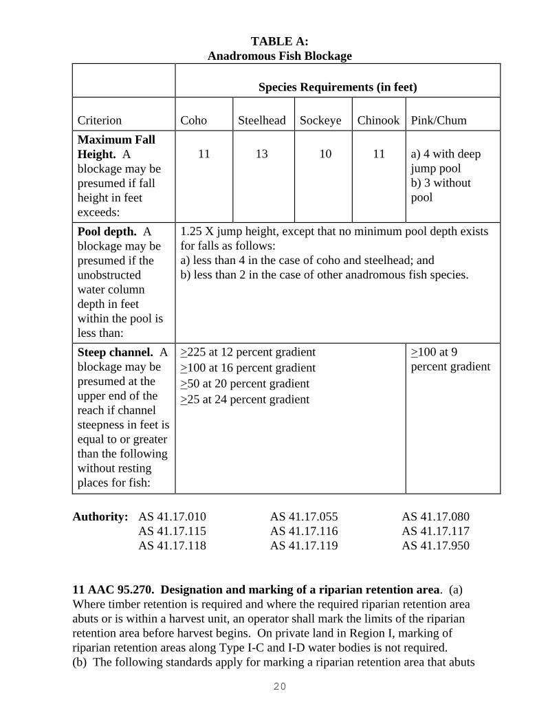
(4) an operator may presume that a physical blockage occurs at any point or
stream reach that meets one or more of the criteria in Table A: Anadromous
Fish Blockage Table; however, the agencies and operators may not consider
a physical blockage to occur if evidence or presence of anadromous fish is
found above that point or reach of the stream, in which case it would be
reclassified using the procedures and standards in this section;
(5) to determine fall height under (4) of this subsection, measure the additive
height of multiple falls only if resting pools do not occur between them;
otherwise, the falls are separate features; measurements are made from the
jump pool surface to the water surface above the fall, both at ordinary high
water;
(6) notwithstanding (4) of this subsection, in stream reaches that provide
rearing habitat for juvenile anadromous fish, but not spawning habitat for
adult anadromous fish, an operator may presume a blockage if any individual
falls is greater than three feet, measured as described in (5) of this
subsection;
(7) a beaver dam is not presumed to constitute a blockage.
(h) In Region II, an operator may presume that a physical blockage occurs at any
point or stream reach that meets one or more of the criteria in Table A, set out in (g)
of this section. However, if evidence or the presence of anadromous fish or high
value resident fish is found above that point or reach of the stream,
(1) an agency or operator may not consider a physical blockage to occur;
and
(2) the stream will be reclassified using the criteria set out in AS
41.17.950(35)-(38). (Eff. 6/10/93, Register 126; am 11/20/99, Register 152;
am 6/24/2004, Register 170; am 6/8/2007, Register 182)
20
TABLE A:
Anadromous Fish Blockage
Species Requirements (in feet)
Criterion
Coho
Steelhead
Sockeye
Chinook
Pink/Chum
Maximum Fall
Height. A
blockage may be
presumed if fall
height in feet
exceeds:
11
13
10
11
a) 4 with deep
jump pool
b) 3 without
pool
Pool depth. A
blockage may be
presumed if the
unobstructed
water column
depth in feet
within the pool is
less than:
1.25 X jump height, except that no minimum pool depth exists
for falls as follows:
a) less than 4 in the case of coho and steelhead; and
b) less than 2 in the case of other anadromous fish species.
Steep channel. A
blockage may be
presumed at the
upper end of the
reach if channel
steepness in feet is
equal to or greater
than the following
without resting
places for fish:
>225 at 12 percent gradient
>100 at 16 percent gradient
>50 at 20 percent gradient
>25 at 24 percent gradient
>100 at 9
percent gradient
Authority: AS 41.17.010 AS 41.17.055 AS 41.17.080
AS 41.17.115 AS 41.17.116 AS 41.17.117
AS 41.17.118 AS 41.17.119 AS 41.17.950
11 AAC 95.270. Designation and marking of a riparian retention area. (a)
Where timber retention is required and where the required riparian retention area
abuts or is within a harvest unit, an operator shall mark the limits of the riparian
retention area before harvest begins. On private land in Region I, marking of
riparian retention areas along Type I-C and I-D water bodies is not required.
(b) The following standards apply for marking a riparian retention area that abuts
21
or is within a harvest unit:
(1) each marking must be visible from adjacent markings;
(2) marking must be by flagging, painting, or another identification system.
(c) A water body or its timber retention area must be marked while the area is free
of snow cover that would prevent accurate marking, unless a water body is large,
incised, or otherwise identifiable when under snow cover.
(d) A tree on the boundary of a riparian retention area is within the riparian
retention area if over 50 percent of the diameter of the bole of the tree is within the
riparian retention area. For the purposes of this section, a diameter of the bole of
the tree is measured at four and one-half feet above ground level or at the top of the
root collar, whichever is higher. (Eff. 6/10/93, Register 126; am 6/24/2004,
Register 170)
Authority: AS 41.17.010 AS 41.17.055 AS 41.17.080 AS 41.17.115
AS 41.17.116 AS 41.17.118 AS 41.17.119
11 AAC 95.275. Uses within a riparian area. (a) The following operations are
allowed within a riparian area without the necessity of obtaining a variation under
AS 41.17.087:
(1) road building and associated activities performed in accordance with 11
AAC 95.285(b);
(2) a water body crossing built in accordance with 11 AAC 95.300;
(3) felling and removal of hazardous trees along roadways as required by
state or federal law;
(4) locating material extraction sites in braided, glacial floodplains in
accordance with 11 AAC 95.325;
(5) installation of blocks, or similar devices on a tree required for retention
under this chapter if the device is installed to minimize damage to the tree;
(6) the use, as lift trees or tail holds, of trees required for retention under this
chapter;
(7) the hanging of rigging through the riparian area if necessary to be
consistent with operator safety requirements and to have a clear line of sight
and working area for the rigging;
(8) in the case of a riparian area on land identified in AS 41.17.118 and
41.17.119 only, yarding corridors and other logging methods that do not
cause a significant adverse impact to the riparian habitat.
(b) The operations identified in (a)(1), (2), and (4) of this section must be identified
in the detailed plan of operations and comply with AS 41.17 and this chapter.
(c) The felling of trees identified in (a)(3) of this section need not be identified in
the detailed plan of operations or comply with AS 41.17 and this chapter.
(d) Between 50 feet and 100 feet from a Type II-D water body, harvest may occur,
but may not create flow paths or ruts that could channelize sheet flow or introduce
sediment into the water body.
22
(e) On state and other public land, a timber harvest along a non-glacial Type II-C
water body will be designed in consultation with the Department of Fish and Game,
to identify sites where stream temperature is a concern and where the buffer is not
forested. On those sites, the timber harvest will be designed to maintain forest
cover within 180 feet from the ordinary high water mark (OHWM), where needed
to retain shade and maintain stream temperature.
(f) Within the portion of a Type III-B water body riparian area under AS
41.17.116(c)(2), AS 41.17.118(a)(3)(B), and AS 41.17.119(3) where harvesting is
allowed,
(1) retention trees must include, to the extent feasible, trees with high value
for wildlife habitat, including snags, forked trees, and trees with multiple
stems;
(2) following procedures in 11 AAC 95.355(a) - (d), harvest trees may be
felled into the no-harvest zone of the riparian area if necessary to minimize
damage to residual trees;
(3) trees felled into the no-harvest zone may be topped to the merchantable
specification and the tops left within the no-harvest zone; tops left shall be
treated in accordance with 11 AAC 95.370(d) - (e) to reduce risk of insect
infestation;
(4) each harvest tree shall be high- and low-marked with paint; and
(5) retention trees must be well-dispersed throughout the riparian area where
harvesting is allowed.
(g) Activities described in this section that are conducted within a riparian area
must be done in compliance with the slope stability standards of 11 AAC 95.280(d).
(Eff. 6/10/93, Register 126; am 11/20/99, Register 152; am 6/24/2004, Register
170; am 6/8/2007, Register 182)
Authority: AS 41.17.010 AS 41.17.055 AS 41.17.080
AS 41.17.087 AS 41.17.115 AS 41.17.118
AS 41.17.119
11 AAC 95.280. Slope stability standards. (a) The slope stability standards in
this section apply to the following areas of private land in Region I:
(1) the area within 100 feet of an ordinary high water mark of a Type I-A, I-
B, or I-C water body or to the break of the slope to that water body,
whichever occurs first; and
(2) the area within 50 feet of an ordinary high water mark of a Type I-D
water body or to the break of the slope, whichever occurs first.
(b) In Region I, on all state lands and on all other public lands, the slope stability
standards in this section apply within 100 feet of an ordinary high water mark of an
anadromous or high value resident fish water body, or a water body with a gradient
of 12 percent or less that is tributary to an anadromous or high value resident fish
water body, and within 50 feet of all other tributaries to anadromous and high value
23
resident fish water bodies.
(c) The break of a slope is the point where the slope extending up from the top of
the stream bank changes to the lower angle slope of the adjacent upland. For
purposes of measurement, the break of a slope is where the degree of slope is
reduced by 20 percent or more when measured away from the stream.
(d) An operator shall adhere to the following standards when conducting timber
harvest activity in an area identified in (a) and (b) of this section:
(1) avoid constructing a road that will undercut the toe of a slope that has a
high risk of slope failure;
(2) within the riparian area of streams not subject to AS 41.17.116(a)(3)(B)
or 41.17.116 (a)(4)(B), in the operator's discretion, leave low-value timber
where prudent;
(3) achieve full or partial suspension in yarding operations;
(4) fall timber away from streams in V-notches; and
(5) avoid sidecasting of displaced soil from road construction to the
maximum extent feasible. (Eff. 6/10/93, Register 126; am 11/20/99,
Register 152; am 6/24/2004, Register 170; am 6/8/2007, Register 182)
Authority: AS 41.17.010 AS 41.17.055 AS 41.17.080 AS 41.17.115
AS 41.17.116 AS 41.17.118 AS 41.17.119
Article 3. Road construction Section
285. Road location
290. Road construction
295. Road drainage
300. Bridge standards
305. Culverts and other water crossing provisions
315. Road maintenance
320. Road closure
325. Material extraction and disposal sites
330. Rehabilitation after mass wasting
335. Blasting standards
11 AAC 95.285. Road location. (a) This subsection sets out the general standards
for determining the location of a new road. An operator shall
(1) minimize the amount of road construction;
(2) avoid isolating a patch of timber that may require unnecessary additional
road construction;
(3) where feasible, use an existing road;
(4) where feasible, locate a road to fit the topography and to minimize
alterations to natural features;
24
(5) where feasible, locate all-season roads and associated activities to avoid
marshes or non-forested muskegs;
(6) minimize the number of stream crossings;
(7) where feasible, cross a stream at a right angle to the stream channel;
(8) where feasible, locate a road away from or upstream of a meander bend
or a recently abandoned channel; and
(9) where feasible, avoid crossing deep gullies where fine textured soils such
as clay or ash soils exist.
(b) A road may not be located in a riparian area except where access is needed to a
water body crossing, or where there is no feasible alternative. A stream crossing or
a road in any riparian area must be designed and located to minimize significant
adverse effects on fish habitat and on water quality. (Eff. 6/10/93, Register 126)
Authority: AS 41.17.010 AS 41.17.055 AS 41.17.080 AS 41.17.115
11 AAC 95.290. Road construction. (a) When constructing a forest road on a
slope, an operator, where feasible, shall avoid locating a road on a slope greater
than 67 percent or on an unstable slope. If avoiding that slope is not feasible, site-
specific measures must be planned to address slope instability due to road
construction. The measures must be approved by the division and must meet the
requirements of (b) of this section.
(b) If constructing a road on a slope greater than 67 percent or on an unstable slope
is necessary, an operator
(1) may not bury any of the following material except as puncheon across
swampy ground or for culvert protection:
(A) a log chunk of more than five cubic feet in volume or a loose
stump, in the load-bearing portion of a road;
(B) any significant amount of organic debris within the load-bearing
portion of a road;
(C) excessive accumulation of debris or slash in the road-bearing
portion of a road fill;
(2) shall balance cuts and fills so that as much of the excavated material as is
feasible is deposited in the roadway fill section; however, unstable fill
material may not be used, and cuts must be minimized where fine textured
soils are known or encountered; and
(3) may not conduct excavation and blasting activities during saturated soil
conditions if mass wasting is likely to result and cause degradation of surface
or standing water quality.
(c) To prevent or minimize sedimentation, an operator shall treat unstable soils
with effective and appropriate erosion control measures such as grass seeding,
erosion control mats, or end-hauling of materials.
(d) An operator shall use end-hauling and full-bench construction techniques if
mass wasting from overloading on an unstable slope or erosion of sidecast material
25
is likely to occur and cause degradation of surface or standing water quality.
(e) Notwithstanding the provisions of 11 AAC 95.355, when constructing a forest
road, an operator shall, where feasible, fell trees away from fish-bearing surface
waters and from standing waters, and shall fell trees away from other surface where
feasible and if necessary to avoid degradation of water quality. An operator shall
comply with the following standards when constructing a forest road:
(1) an operator may not fell a tree into anadromous fish waters catalogued
under AS 16.05.871 without prior written approval of the Department of Fish
and Game;
(2) if a tree is felled into fish-bearing waters not catalogued under AS
16.05.871, the operator shall remove the limbs and other small debris within
48 hours, and shall remove the bole as soon as the necessary equipment is at
the site;
(3) if a tree is felled into nonfish-bearing surface waters and standing waters,
the operator shall remove debris at the earliest feasible time when necessary
to avoid degradation of water quality.
(f) A winter road must be constructed to avoid degradation of water quality and
where feasible the alteration of drainage systems.
(g) If constructing a winter road,
(1) the operator shall, where feasible, avoid placing fill material other than
snow or ice on non-forested muskegs; if fill material other than snow or ice is
required to cross a non-forested muskeg, the operator shall install culverts or
other drainage structures as necessary to maintain natural hydrologic flow
through muskeg vegetation;
(2) the operator shall complete construction across non-forested muskegs
when snow conditions, ground frost conditions, or a combination of those
conditions will support construction equipment; disturbance to muskeg
vegetation must be limited to that necessary to provide a level running
surface, and may not alter hydrologic flow or cause erosion and
sedimentation.
(3) where the road is within 50 feet of a stream, or slopes continuously
toward a stream crossing, the operator shall
(A) prevent the introduction of sediment or other debris into surface
waters; and
(B) maintain the integrity of the surface organic mat, unless the state
forester
(i) determines that avoiding disturbance of the organic mat is
not feasible; and
(ii) authorizes the disturbance and determines techniques, if
necessary, to prevent sedimentation; and
(4) the operator shall close a temporary winter road in accordance with 11
AAC 95.320 when use of the road is concluded.
(h) On state and other public land, winter roads must be designed and used so as to
protect the roadbed from significant rutting and ground disturbance. The following

26
practices are required where feasible:
(1) if the surface organic mat is removed or excessively reduced over thaw-
unstable permafrost terrain, that area must be stabilized by recovering that
area with insulating material, re-vegetating, water-barring the area, or using
other techniques demonstrated to be effective;
(2) soil cuts or fills in thaw-unstable permafrost terrain must be avoided to
the extent feasible; all cuts must be stabilized;
(3) routes must be selected that are less likely to be used or damaged by
highway vehicle traffic when the soil is not frozen or snow covered.
(i) The division may physically block or otherwise seasonally prohibit vehicle
traffic on winter roads if necessary to prevent significant roadbed degradation or
surface water siltation.
(j) Spoil, waste, and overburden that is generated during construction and not
sidecasted shall be deposited in a suitable upland site stabilized by effective and
appropriate erosion control measures. Disposal must also meet the standards set out
in 11 AAC 95.325, 11 AAC 95.815, and 18 AAC 60.
(k) Where feasible, the running surface of a road must use material that will
minimize erosion of the road surface and prevent degradation of water quality.
(l) A person may not operate construction equipment or machinery in
(1) an anadromous fish water catalogued under AS 16.05.871 without
written approval of the Department of Fish and Game, or
(2) any other surface waters, without prior notice to the division. (Eff.
6/10/93, Register 126; am 6/24/2004, Register 170; am 6/8/2007, Register
182, am 9/25/2013, Register 207)
Authority: AS 41.17.010 AS 41.17.055 AS 41.17.080 AS 41.17.098
11 AAC 95.295. Road drainage. (a) This section sets out the drainage standards
that apply to a forest road.
(b) An operator shall minimize the erosion of a road bed, cut bank, and fill slope
through the use of cross drains, ditches, relief culverts, bridges, water bars,
diversion ditches, or other structures demonstrated to be effective. These drainage
structures shall be installed at all natural drainages and must be spaced at least as
frequently as set out in the following table:
SPACING OF DRAINAGE STRUCTURES (in feet)
PERCENT
OF GRADE REGION I REGION II AND III
0 to 2 Meet other standards of this section
2 to 7 1,000 1,500
8 to 15 800 1,000
Over 15 600 800
27
More frequent drainage structure spacing or other drainage improvements must be
used where site-specific conditions of peak flows or soil instability makes
additional drainage structures necessary to prevent degradation of standing or
surface water quality. Less frequent drainage spacing is permissible if the parent
material of the roadway is not erodible, such as rock or gravel; the topography or
other local conditions are not conducive to erosion; or the degradation of surface or
standing waters is not likely to occur.
(c) During road construction, an operator shall install the appropriate ditches,
culverts, cross drains, drainage dips, water bars, and diversion ditches when the
natural drainage is crossed with the roadbed material.
(d) A road shall be outsloped or ditched on the uphill side.
(e) In the event an incomplete road is left over the winter season or other extended
period, an operator shall, before suspending operations, provide adequate interim
drainage by outsloping or cross draining the road, or by the use of water bars and
diversion ditches.
(f) An operator shall to the extent feasible direct ditchline water away from
unstable soils and surface waters, and onto vegetated areas.
(g) To minimize sedimentation of standing and surface waters, marshes, and non-
forested muskegs caused by drainage from road surfaces and ditches, an operator
shall use measures such as settling basins, cross drains, or vegetated areas.
(h) A relief culvert installed on a forest road must be at least 12 inches in diameter
or the equivalent capacity, and be installed sloping toward the downslope edge of
the road at a minimum gradient of three percent.
(i) A cross drain, relief culvert, or diversion ditch may not discharge onto erodible
soil or over fill slopes unless adequate outfall protection is provided and slope
stability is ensured.
(j) A drainage structure must also comply with the directional and placement
requirements of 11 AAC 95.305. (Eff. 6/10/93, Register 126; am 6/24/2004,
Register 170)
Authority: AS 41.17.010 AS 41.17.055 AS 41.17.080
11 AAC 95.300. Bridge standards. (a) An operator shall install a bridge on a
forest road according to the following standards:
(1) a temporary bridge and the adjacent roadway must be constructed to pass
or withstand the 25 year flood without damage; a permanent bridge and the
adjacent roadway must be constructed to pass or withstand the 50 year flood
without damage; any adjustment to these design standards must be
determined in the field considering the characteristics of the drainage and
stream crossing, the design life of the bridge, the importance of downstream
resources, the type of construction techniques, and the likelihood of bridge
failure during flood; an operator shall, as necessary, minimize potential flood
28
damage to the structure and to downstream water quality and fish habitat by
installing relief culverts through approach roads or by other means;
(2) one end of each new permanent log or wood bridge must be firmly
anchored;
(3) an earth embankment constructed for use as a bridge approach must be
protected from erosion by using planted or seeded ground cover, bulkheads,
rock riprap, retaining walls, or other equally effective means;
(4) on a rock-decked bridge, curbs must be installed to contain road surface
material, and a filter fabric must be laid underneath the material to prevent it
from falling within the ordinary high water marks of the water body;
(5) a snow ramp or ice bridge must be constructed only of snow, ice, and
cribbing, and must be largely free of soil and organic mat; it must be
constructed to go out with natural ice breakup, or it must be breached and the
cribbing removed when feasible before breakup to protect downstream
structures, water quality, and fish habitat;
(6) a bridge must be installed to provide fish passage in accordance with AS
16.05.841;
(7) in deep V-notches or in drainages where a culvert may require
substantial fill, a bridge is the preferred crossing structure, if feasible;
(8) a bridge must be installed in such a way as to minimize disturbance to
the bed and banks of a stream.
(b) In addition to the requirements of (a) of this section, when installing a new
bridge or replacing an existing bridge on a forest road that crosses anadromous fish
waters, the installation must be in accordance with the standards set out in (c) of
this section. In anadromous fish waters catalogued under AS 16.05.871, an
operator may not cross the water body with equipment, install a bridge or conduct
excavation for bridges, place sills or abutments, or place stringers or girders within
the ordinary high-water marks without prior written approval from the Department
of Fish and Game. If prior written approval is required by the Department of Fish
and Game under AS 16.05.871, an operator shall comply with that department’s
requirements instead of the standards of (c) of this section.
(c) When installing a bridge over anadromous waters that have not been catalogued
under AS 16.05.871, an operator shall:
(1) locate a bridge where the banks are stable;
(2) locate a bridge on a straight reach of stream;
(3) locate a bridge where the bank and approach characteristics are suitable;
(4) schedule bridge building activity to occur during a period that will avoid
or reduce adverse impact on fish; and
(5) where feasible, avoid the use of center supports.
(d) An operator may not narrow an anadromous stream between its ordinary high
water marks.
(e) For water body types in Regions II and III, a crossing may be made on natural
ice. Natural ice thickness may be augmented if site-specific conditions, including
water depth, are sufficient to protect fish habitat. In determining whether
29
conditions are sufficient to protect fish habitat, the state forester will consider
whether augmented ice thickness is likely to
(1) cause freezedown into gravels used for spawning or fish overwintering
habitat;
(2) cause bed scouring that disturbs gravels used for fish spawning or fish
overwintering habitat;
(3) excessively reduce the quality or volume of fish overwintering habitat; or
(4) adversely alter stream flow patterns above or below the crossing.
(f) In this section, "augmentation"
(1) means a technique to increase the freezing depth of natural ice; and
(2) includes any of the following:
(A) adding water or ice to the surface;
(B) removing snow. (Eff. 6/10/93, Register 126; Register 166; am
6/24/2004, Register 170; am 6/8/2007; Register 182)
Authority: AS 41.17.010 AS 41.17.055 AS 41.17.080 AS 41.17.098
11 AAC 95.305. Culverts and other water crossing provisions. (a) An operator
shall install a culvert on a forest road according to the following standards:
(1) a temporary culvert and the adjacent roadway must be constructed to
pass or withstand the 25 year flood without damage; a permanent culvert and
the adjacent roadway must be constructed to pass or withstand the 50 year
flood without damage; any adjustment to these design standards must be
determined in the field considering the characteristics of the drainage, the
design life of the road, the importance of downstream resources, the type of
construction techniques, and the likelihood of culvert or road failure;
(2) the size of the culvert must be determined in accordance with hydrologic
engineering principles; a culvert may not be installed that is smaller than 12
inches in diameter or equivalent capacity; where culvert icing conditions are
to be expected, other drainage designs such as open flumes buried in the road
surface should be considered instead of culverts;
(3) for fish-bearing waters, the entrance, to the extent possible, and exit of a
stream culvert must match the natural course of a stream channel; a culvert
may not be perched at its inlet or outlet.
(4) a culvert must terminate on material that will not readily erode, such as
riprap, the original streambed if stable, or other suitable materials;
(5) a change may not be made in the course or channel of anadromous fish
waters catalogued under AS 16.05.871 without giving notice to the division
and receiving written approval of the Department of Fish and Game; a
change may not be made in the course or channel of other waters that are
significant for protection of downstream water quality, without prior notice
to the division;
(6) when a flume, downspout, downfall culvert, or similar structure is used
30
to protect fill slopes or to return water to its natural course, the discharge
point shall be protected from erosion by
(A) reducing the velocity of the water;
(B) using rock spillways, riprap, or splash plates; or
(C) using equally effective methods or structures;
(7) for nonfish-bearing waters, the area of a stream bed from a culvert inlet
to 50 feet upstream from the culvert inlet must be cleared of mobile slash or
debris that may be expected to plug a culvert;
(8) to prevent or minimize sedimentation, the entrance of a relief culvert
must have adequate and appropriate catch basins, consistent with physical
features of the ground; a headwall must be used to direct ditch water into
cross drains;
(9) a culvert must be of sufficient length to prevent road overlay materials
from blocking an end of the culvert.
(b) A properly prepared and maintained ford may be used for an equipment
crossing during a period of low water. If the ford crosses anadromous fish waters
catalogued under AS 16.05.871, written approval of the Department of Fish and
Game is required. For other surface waters, prior notice to the division is required.
A ford must cross a stream substantially perpendicular to the stream flow, and the
approaches must be properly ballasted or otherwise stabilized to avoid
sedimentation. Ford construction must comply with AS 16.05.841. (Eff. 6/10/93,
Register 126; am 6/24/04, Register 170)
Authority: AS 41.17.010 AS 41.17.080 AS 41.17.055 AS 41.17.098
11 AAC 95.315. Road maintenance. (a) For purposes of the road maintenance
requirements of this section, a landing is considered part of a road.
(b) An operator shall conduct the following maintenance on an active road:
(1) keep culverts, flumes, and ditches functional;
(2) if a settling basin is used, keep an adequate reserve volume; sediment
removed from a settling basin during maintenance operations must be
deposited in a location where it is not likely to enter nearby surface waters;
(3) perform road surface maintenance as necessary to minimize erosion of
the surface and the subgrade;
(4) during operations, keep the road surface crowned or outsloped, and keep
the downhill side of the road free from berms except those intentionally
constructed for protection of fill;
(5) when grading on a nonrock-decked bridge, minimize the deposit of road
surface material on the bridge surface; and
(6) when grading on a rock-decked bridge, avoid pushing material over the
rub rails or through gaps in the bridge surface.
(c) An operator or forest landowner shall conduct the following maintenance on an
inactive road:
31
(1) as soon as feasible following termination of active use, keep ditches and
drainage structures maintained as necessary to assure water flow and fish
passage;
(2) keep the road surface crowned, outsloped, water barred, or otherwise left
in a condition not conducive to erosion; and
(3) except as provided in (d) of this section, keep ditches and drainage
structures clear and in good repair.
(d) An operator or forest landowner is not subject to the penalties or liable for the
monetary damages under AS 41.17 for any damage occurring from a condition
brought about by public use of a road, unless an operator or forest landowner fails
to make repairs under a directive of the division.
(e) If necessary to prevent significant degradation of surface water quality or fish
habitat, the division will, in its discretion, require an operator or forest landowner to
perform the following activities:
(1) install additional or larger culverts or other drainage improvements as
determined necessary by the division;
(2) provide additional road maintenance;
(3) close an inadequately maintained portion of the road system in
accordance with 11 AAC 95.320; and
(4) rehabilitate unstable or erodible exposed soils by a suitable method to
minimize siltation of surface waters.
(f) Winter roads must be maintained as follows:
(1) winter roads must be maintained to provide a frozen running surface that
will support logging vehicle traffic; during thaw periods or spring breakup,
an operator shall suspend or manage road use as necessary to minimize
erosion of soils and organic material, and to minimize significant impacts to
non-forested muskeg vegetation;
(2) before spring breakup, an operator shall perform maintenance activities
to reduce meltwater runoff and erosion of soils and organic material; those
maintenance activities may include creating runoff breaks in snow berms,
use of slash debris on road surfaces, water bars, or other techniques
demonstrated to be effective. (Eff. 6/10/93, Register 126; am 6/8/2007,
Register 182)
Authority: AS 41.17.010 AS 41.17.080 AS 41.17.055
11 AAC 95.320. Road closure. (a) For purposes of the road closure requirements
of this section, a landing is considered part of a road.
(b) A closed road is exempt from maintenance under 11 AAC 95.315. Except as
provided in (f) of this section, a road is closed when the following activities have all
been completed:
(1) the road is outsloped or water barred as directed by the division or is
otherwise left in a condition suitable to control erosion;
32
(2) ditches are left in a condition suitable to reduce erosion;
(3) in areas accessible to highway vehicles, the road is blocked so that a
highway vehicle cannot pass the point of blockage;
(4) bridges, culverts, and fills are removed from surface waters, unless the
division determines that other measures would provide adequate protection;
bridge, culvert, or fill removal must be completed in accordance with (c) of
this section.
(c) Bridge, culvert, or fill removal under this section must be completed as follows:
(1) in fish-bearing waters, bridge, culvert, and fill material must be
completely removed from the natural streambed and from within the ordinary
high waters marks, except where removal would cause adverse impacts to
water quality or fish habitat;
(2) after culvert removal is completed, the walls of the remaining trench
must be sloped to the angle of repose or otherwise permanently stabilized to
prevent erosion of the walls and siltation of surface waters;
(3) surplus fill material and bridge stringers must be deposited in a location
where they are not likely to re-enter the stream;
(4) bridge, culvert, and fill removal must be conducted in accordance with
AS 16.05.871.
(d) At the conclusion of temporary winter road use, the operator shall close roads
as necessary to avoid degradation of water quality and significant erosion of soils
and organic material. Techniques for closing temporary winter roads may include
creating runoff breaks in snow berms, using slash debris on road surfaces, installing
water bars, or using other techniques demonstrated to be effective.
(e) If degradation of water quality occurs due to erosion from a closed road, the
forest landowner, the operator, or the person responsible for creating the condition
shall correct the problem.
(f) A road is closed if it was closed to highway vehicles by a permanent barrier
before 6/10/93. (Eff. 6/10/93, Register 126; Register 166; am 6/8/2007, Register
182)
Authority: AS 41.17.010 AS 41.17.055 AS 41.17.080
AS 41.17.098
11 AAC 95.325. Material extraction and disposal sites. (a) If feasible, an
operator must verify that suitable material is present at a proposed extraction site
before stripping the entire site of surface soils. A material extraction site must be
located in an area
(1) that is outside surface waters, standing waters, and marshes;
(2) that is outside non-forested muskegs, except with prior notice to the divi-
sion;
(3) with a low risk of siltation to surface water;
(4) where the risk of causing significant harm to fish habitat through soil
33
erosion and mass wasting is minimal;
(5) where there is adequate and appropriate sediment filtering vegetation or
equivalent treatment;
(6) that is outside a riparian area unless inside a riparian area is authorized
by the division; a material extraction site located in a braided, glacial flood
plain may be subject to AS 41.14; and
(7) that will not cause hydrologic changes such as dewatering a stream.
(b) An operator shall locate an area to deposit material extraction site overburden
and end hauling material
(1) that is outside surface waters, standing waters, marshes, and non-forested
muskegs;
(2) with a low risk of siltation to surface water;
(3) where the risk of causing significant harm to fish habitat through soil
erosion and mass wasting is minimal;
(4) where there is adequate and appropriate sediment filtering vegetation or
equivalent treatment; and
(5) that is outside a riparian area.
(c) During the construction and use of a material extraction site or a soil disposal
site, runoff water must either be diverted onto the forest floor or intercepted and
passed through one or more settling basins. When a settling basin is used, it must
be maintained to have an adequate reserve volume. Sediment removed from a
settling basin during a maintenance operation must be deposited in a location where
it is not likely to enter any nearby surface waters.
(d) An operator shall rehabilitate a material extraction site or a soil disposal site
after the material source is exhausted or abandoned, or operations at the disposal
site are completed. Within the first growing season after abandonment of an
extraction site or completion of disposal operations, an operator shall
(1) remove and place in a stable location all material that has potential for
entering surface or standing waters, or that would prevent reforestation of an
otherwise plantable area; and
(2) where necessary to prevent erosion, stabilize a disposal site and all
exposed erodible soils by
(A) revegetation with grass, clover, ground cover, or, if possible,
native ground cover;
(B) compacting, rip rapping, water barring, benching, or mulching; or
(C) other means required by the division.
(e) If degradation of water quality occurs due to erosion from an abandoned
material extraction or disposal site, the forest landowner, the operator, or the person
responsible for creating the condition, must correct the problem. (Eff. 6/10/93,
Register 126; am 6/24/2004, Register 170)
Authority: AS 41.17.010 AS 41.17.055 AS 41.17.080
34
11 AAC 95.330. Rehabilitation after mass wasting. (a) Where mass wasting is
caused by operations, the operator shall, to the extent feasible, take effective and
appropriate measures to stabilize the slide path and all associated exposed soils,
such as grass seeding, erosion control mats, excavation of the head wall to the angle
of repose, placement of ballast to control mass wasting, or other effective slope
stabilization method.
(b) The division will, in its discretion, require an operator to remove debris from
surface waters impacted by mass wasting, to the degree necessary to restore water
quality or fish habitat.
(c) Ditchline water must be directed away from mass wasting and into vegetated
areas. (Eff. 6/10/93, Register 126)
Authority: AS 41.17.010 AS 41.17.080 AS 41.17.055
11 AAC 95.335. Blasting standards. (a) A person may not discharge an
explosive in the following areas without first obtaining a variation under 11 AAC
95.235:
(1) Type I-A or Type I-B stream riparian areas in Region I;
(2) within all riparian areas in Region II or III.
(b) During blasting, an operator shall minimize the amount of flyrock materials
deposited into fish-bearing waters. (Eff. 6/10/93, Register 126; am 6/24/04,
Register 170)
Authority: AS 41.17.010 AS 41.17.080
Article 4. Timber harvesting
Section
340. Harvest unit planning and design
345. Landing location, construction, and operation
350. Bank integrity
355. Felling and bucking
360. Cable yarding
365. Tracked and wheeled harvest systems
370. Slash
11 AAC 95.340. Harvest unit planning and design. (a) A logging system must
be appropriate for the terrain, soils, and timber type so that yarding or skidding can
be accomplished in compliance with AS 41.17 and this chapter.
(b) A harvest unit must be designed so that felling, bucking, yarding, skidding, and
reforestation can be accomplished in compliance with AS 41.17 and this chapter.
35
(c) On state and municipal forest land, an operator conducting timber harvest, road
construction, or a related activity shall, where feasible, retain a buffer of not less
than 330 feet in radius around each bald eagle nesting tree.
(d) On unstable slopes, an operator shall consider one or more of the following:
(1) partial cuts;
(2) retention areas;
(3) use of helicopter or skyline systems to achieve full suspension of logs;
(4) other techniques to minimize disturbance to soils, understory vegetation,
stumps, and root systems. (Eff. 6/10/93, Register 126; am 9/25/2013, Register
207)
Authority: AS 41.17.010 AS 41.17.055 AS 41.17.080
11 AAC 95.345. Landing location, construction, and operation. (a) A landing
must be located, constructed, and operated in a manner that
(1) avoids surface and standing waters, except when frozen;
(2) minimizes the use of marshes and non-forested muskegs, except when
frozen;
(3) prevents logs and vegetative debris from entering surface and standing
waters; and
(4) minimizes the sedimentation of surface and standing waters.
(b) An operator shall locate and construct a landing according to the following
standards:
(1) when choosing the site of a landing, an operator shall consider the effects
of the landing location and provide for a logging layout that will reduce the
overall adverse effects of the operation;
(2) the design of a landing must minimize the need for sidecasting or fill;
(3) a landing must be no larger than necessary for safe operation of the
equipment and decking of logs;
(4) where slopes have a grade greater than 67 percent or are unstable, fill
material used in construction of a landing must be free from loose stumps
and excessive accumulations of slash, and must be mechanically compacted
in layers if necessary to prevent soil erosion and mass wasting;
(5) a truck road, a skid trail, or a fire trail must be outsloped or cross drained
uphill of the landing and the water diverted onto the forest floor away from
the toe of any landing fill;
(6) a landing must be sloped, water barred, ditched or otherwise constructed
and maintained to minimize accumulation of water on the landing; and
(7) any excavated material from the construction of a landing may not be
placed where it is likely to result in degradation of surface water quality.
(c) Slash may not be buried in any portion of a landing during landing cleanup
operations.
(d) For purposes of this chapter, a helicopter drop zone is considered a landing.
36
(Eff. 6/10/93, Register 126; am 6/8/2007; Register 182; am 9/25/2013, Register
207)
Authority: AS 41.17.010 AS 41.17.055 AS 41.17.080
11 AAC 95.350. Bank integrity. (a) To maintain bank integrity, an operator shall
minimize disturbance of residual trees, brush, and similar understory vegetation
adjacent to surface and standing waters.
(b) An operator shall, where feasible, avoid disturbing roots, stumps, and deadfalls
embedded in the bed or bank of surface waters, and standing waters larger than one-
half acre.
(c) In a riparian area, an operator shall, where feasible and necessary, leave high
stumps to prevent felled and bucked timber from entering surface waters.
(d) The division will, in its discretion, require stabilization, to the extent feasible,
of disturbed banks to prevent soil erosion and degradation of water quality. (Eff.
6/10/93, Register 126)
Authority: AS 41.17.010 AS 41.17.055 AS 41.17.080
11 AAC 95.355. Felling and bucking. (a) An operator may not fell a tree into or
remove a tree or vegetative debris from anadromous fish waters catalogued under
AS 16.05.871 without the prior written approval of the Department of Fish and
Game, or into or from other surface waters, without giving prior notice to the
division. A tree felled into surface waters containing fish must provide fish passage
in accordance with AS 16.05.841.
(b) If a tree is felled into fish-bearing surface waters not catalogued under AS
16.05.871, the operator shall remove the limbs and other small debris within 48
hours, and shall remove the bole as soon as the necessary equipment is at the site.
(c) If a tree is felled into nonfish-bearing surface or standing waters, the operator
shall remove the tree and its debris at the earliest feasible time, to the extent
necessary to avoid degradation of water quality.
(d) An operator may not buck or limb a tree or any portion of a tree lying between
the banks of surface waters, except as necessary to remove the bole, limbs, or small
debris from the water as required by 11 AAC 95.290(e) or this section.
(e) If feasible, an operator
(1) may not fell a tree into a riparian timber retention area; and
(2) shall fell a tree in a direction that minimizes damage to trees retained in a
partial cut.
(f) A requirement of (a) or (b) of this section will, in the division's discretion, be
waived if the division, with due deference to the Department of Fish and Game,
requests that the material deposited in a water body remain to benefit fish resources.
(Eff. 6/10/93, Register 126)
37
Authority: AS 41.17.010 AS 41.17.055 AS 41.17.080 AS 41.17.098
11 AAC 95.360. Cable yarding. (a) During yarding, an operator shall keep a log
fully suspended above or yarded away from surface waters where feasible, in light
of the necessary equipment being reasonably available to the operator and the
importance of the surface water to fish habitat and water quality, unless full
suspension or split yarding would likely cause greater degradation of surface water
quality or impact to fish habitat than cross-stream yarding.
(b) When full suspension or split yarding is not used under (a) of this section,
operations are subject to the following standards:
(1) unless logs are completely suspended above surface water, no timber
may be yarded across anadromous fish waters catalogued under AS
16.05.871 without written approval from the Department of Fish and Game;
no timber may be cable yarded across other anadromous or high value
resident fish waters without prior notice to the division;
(2) cable yarding across surface waters must be conducted in a manner to
avoid degrading water quality;
(3) where any cross-stream yarding occurs, an operator shall minimize
damage to stream channels, stream banks, retained trees, understory
vegetation, stumps, and root systems by a technique such as
(A) when 50 percent or more of a tree that is to be yarded across a
stream will bridge the stream and lie on the side on which the yarder is
located, the tree is directionally felled across the stream at right angles
to the stream channel;
(B) minimizing the number of yarding corridors across streams;
(C) using bumper logs to protect stream banks;
(4) yarding up, down or across a V-notch channel must be accomplished in a
manner that does not create significant erosion; and
(5) consistent with good safety practices, the direction of log movement
between stream banks must be as close to right angles to the stream channel
as is feasible.
(c) The following standards apply to cable yarding operations:
(1) when feasible, an operator shall use maximum available deflection;
(2) where feasible, an operator shall use uphill yarding techniques;
(3) where downhill yarding is used, an operator shall use deflection to lift
the leading end of the log and minimize downhill movement of slash and
soils;
(4) when yarding parallel to surface waters, and when in or near a riparian
area, an operator shall make an effort to minimize soil disturbance and to
prevent logs from rolling into surface waters or the riparian area;
(5) when yarding across marshes and non-forested muskegs, an operator
shall make an effort to minimize damage to vegetative cover; and
38
(6) on unstable slopes, an operator shall minimize disturbance to soils,
understory vegetation, stumps, and root systems.
(d) This section also applies to unconventional cable yarding systems. (Eff.
6/10/93, Register 126; am 9/25/2013, Register 207)
Authority: AS 41.17.010 AS 41.17.055 AS 41.17.080
11 AAC 95.365. Tracked and wheeled harvest systems. (a) A person may not
skid timber or operate construction equipment or machinery
(1) in a water body catalogued as anadromous under AS 16.05.871, without
written approval of the Department of Fish and Game;
(2) in any other surface waters, marshes, or non-forested muskegs without
prior notice to the division, except that equipment may be operated on frozen
surface waters, marshes, or non-forested muskegs without prior notice to the
division; or
(3) on unstable slopes without prior notice to the division.
(b) An operator shall comply with the following restrictions on tracked and
wheeled harvest systems in riparian areas:
(1) the number of skidding routes through an area must be minimized;
(2) consistent with good safety practices, log skidding must minimize
damage to retained trees, stumps, root systems, understory vegetation, and
soils; and
(3) one-end suspension of logs is required.
(c) Any debris that may enter surface waters from that part of a winter trail located
over those surface waters must be removed by the operator before thaw to the
extent necessary to avoid degradation of water quality. During winter logging,
substantial concentrations of debris that may enter surface waters must be removed
before thaw.
(d) An operator may not use a tracked skidder, a wheeled skidder, or a logging
shovel during saturated soil conditions if degradation of surface and standing water
quality is likely to result.
(e) An operator shall minimize damage from skidding to the stems and root
systems of retained timber.
(f) When using tracked and wheeled vehicles, an operator shall
(1) use puncheon where significant ground disturbances may contribute to
sedimentation of surface water;
(2) locate skid trails to minimize degradation of surface water quality;
(3) use water bars or other appropriate techniques as necessary to prevent or
minimize sedimentation;
(4) keep skid trails to the minimum feasible width; and
(5) outslope skid trails where feasible, unless an inslope is necessary to
prevent logs from sliding or rolling downhill off the skid trail.
(g) Upon the completion of operations at a site, a skid trail shall be water-barred
39
according to the standards set out in 11 AAC 95.315 and 11 AAC 95.320 or
otherwise stabilized to prevent erosion from entering surface waters.
(h) An operator may not use a tracked or wheeled skidder on a slope where this
method of operations is likely to cause degradation of surface and standing water
quality. (Eff. 6/10/93, Register 126; am 6/24/2004, Register 170; am 9/25/2013,
Register 207)
Authority: AS 41.17.010 AS 41.17.055 AS 41.17.080 AS 41.17.098
11 AAC 95.370. Slash. (a) In an area where slash treatment is necessary to
prevent or reduce the spread of fire, an operator shall reduce the concentration of
slash by scattering, piling or windrowing, mechanized chipping, compacting,
burying, or controlled burning, or other method approved by the division.
Controlled burning requires approval from the Department of Environmental
Conservation under 18 AAC 50.030(e) and may require a burning permit from the
division.
(b) When slash is disposed of by burning, an operator shall protect a riparian area
from fire, and shall burn under weather conditions that minimize the chance of air
quality degradation and fire escape.
(c) Unstable slash concentrations around a landing must be disposed of or
dispersed by the operator to prevent entry into surface waters.
(d) Except where burning will be completed before the next spring, an operator
shall deposit slash in a location where it is not likely to enter a stream.
(e) If operating within a potential or known bark beetle infestation area, an operator
shall include a spruce slash reduction, isolation, or abatement plan in the detailed
plan of operations.
(f) The division will, in its discretion, require the operator, timber owner, or
landowner to submit a treatment plan for felled timber or log decks left in the field
for more than one growing season in an area of potential bark beetle infestation.
(Eff. 6/10/93, Register 126; am 2/24/00, Register 153)
Authority: AS 41.17.010 AS 41.17.055 AS 41.17.080 AS 41.17.098
Article 5. Reforestation
Section
375. Reforestation requirement
380. Natural regeneration standards
385. Regeneration survey and report
390. Site preparation
11 AAC 95.375. Reforestation requirement. (a) The reforestation plan included
in the detailed plan of operations must identify the preferred target species,
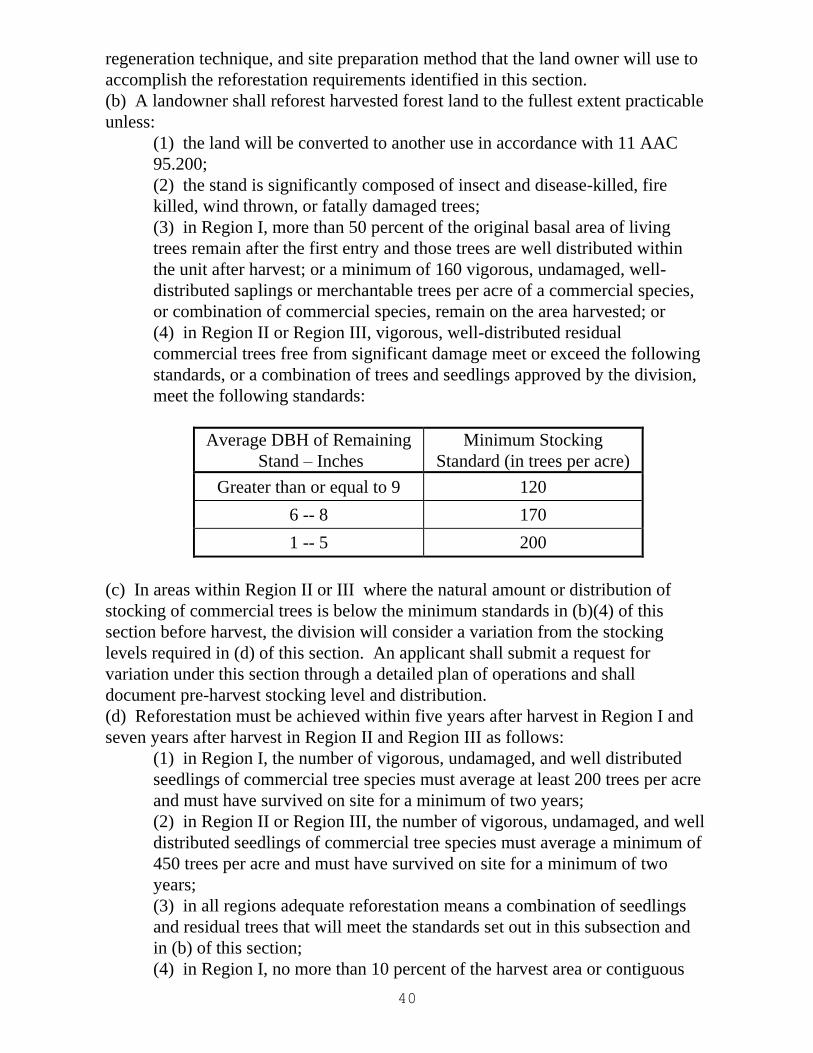
40
regeneration technique, and site preparation method that the land owner will use to
accomplish the reforestation requirements identified in this section.
(b) A landowner shall reforest harvested forest land to the fullest extent practicable
unless:
(1) the land will be converted to another use in accordance with 11 AAC
95.200;
(2) the stand is significantly composed of insect and disease-killed, fire
killed, wind thrown, or fatally damaged trees;
(3) in Region I, more than 50 percent of the original basal area of living
trees remain after the first entry and those trees are well distributed within
the unit after harvest; or a minimum of 160 vigorous, undamaged, well-
distributed saplings or merchantable trees per acre of a commercial species,
or combination of commercial species, remain on the area harvested; or
(4) in Region II or Region III, vigorous, well-distributed residual
commercial trees free from significant damage meet or exceed the following
standards, or a combination of trees and seedlings approved by the division,
meet the following standards:
Average DBH of Remaining
Stand – Inches
Minimum Stocking
Standard (in trees per acre)
Greater than or equal to 9 120
6 -- 8 170
1 -- 5 200
(c) In areas within Region II or III where the natural amount or distribution of
stocking of commercial trees is below the minimum standards in (b)(4) of this
section before harvest, the division will consider a variation from the stocking
levels required in (d) of this section. An applicant shall submit a request for
variation under this section through a detailed plan of operations and shall
document pre-harvest stocking level and distribution.
(d) Reforestation must be achieved within five years after harvest in Region I and
seven years after harvest in Region II and Region III as follows:
(1) in Region I, the number of vigorous, undamaged, and well distributed
seedlings of commercial tree species must average at least 200 trees per acre
and must have survived on site for a minimum of two years;
(2) in Region II or Region III, the number of vigorous, undamaged, and well
distributed seedlings of commercial tree species must average a minimum of
450 trees per acre and must have survived on site for a minimum of two
years;
(3) in all regions adequate reforestation means a combination of seedlings
and residual trees that will meet the standards set out in this subsection and
in (b) of this section;
(4) in Region I, no more than 10 percent of the harvest area or contiguous
41
areas may be below the stocking levels as set out in (1) of this subsection.
(5) in Region II or III, no more than 20 percent of the harvest area or
contiguous areas may be below the stocking levels as set out in (2) of this
subsection; and;
(6) in Region II or Region III, the division may allow a period of up to 12
years for natural regeneration where site conditions indicate a high likelihood
of regeneration success within that period based on information in the
detailed plan of operations.
(e) The division will, in its discretion, grant a reasonable extension of time to
comply with the requirements of this section if planting or seeding fails or cannot
be completed because of circumstances beyond the control of the forest landowner.
To be eligible for a time extension the forest landowner must notify the division
within 30 days of becoming aware of the circumstances requiring an extension.
The written request must identify the reason for the extension and give a reasonable
estimation of the time needed to achieve adequate reforestation in accordance with
this section.
(f) Unless otherwise authorized by the division, seeds used for reforestation must
be
(1) from a similar latitude, climatic area, and elevation as the harvested area;
or
(2) in Region II or Region III, a mix of seed for native species from similar
conditions with seed from up to 10 degrees latitude south of the planting site;
seeds from other locations that have been demonstrated to be successful and
are approved by the division may be used;
(3) in Region II or Region III, known invasive species may not be planted.
(g) To apply for an exemption from reforestation requirements under (b)(2) of this
section, a landowner must request an exemption in the reforestation section of a
detailed plan of operations under 11 AAC 95.220(10) or a change in operations
under 11 AAC 95.230 and must demonstrate that the affected stand is significantly
composed of insect and disease-killed, fire killed, wind thrown, or fatally damaged
trees. If required by the division, the request must include a description of the
sampling procedure, the sampling data, and a data summary. The data summary
must show the number of commercial trees per acre that are dead or fatally
damaged, and the percentage of commercial trees in the stand that are dead or
fatally damaged. Sample plots must be located without bias throughout the affected
stand. For stands 1,000 acres or less, the minimum sample density is 10 plots per
100 acres. For stands greater than 1,000 acres, the minimum sample density is six
plots per 100 acres. Fewer plots are acceptable if the sample standard error is less
than 10 percent of the mean. Either fixed diameter or variable plot sampling
methods are acceptable. Sample plots must average approximately at least five
sample trees of commercial value. Trees must be recorded by diameter class as
either dead, damaged by insects, disease, fire, or wind, or not impacted. Other
documentation or field evidence approved by the division may be used in lieu of
sampling.
42
(h) Following receipt of the exemption request, the division may inspect the site to
confirm the information submitted before determining whether the stand is
significantly composed of insect and disease-killed, fire killed, wind thrown, or
fatally damaged trees. The division will make this determination as part of the
review of the detailed plan of operations or change in operations. In areas exempted
from reforestation requirements, the landowner and operator shall protect existing
reproduction from logging damage where feasible. (Eff. 6/10/93, Register 126;
am 9/6/96, Register 139; am 3/9/2017, Register 221)
Authority: AS 41.17.010 AS 41.17.055 AS 41.17.060 AS 41.17.080
11 AAC 95.380. Natural regeneration. (a) If a forest landowner in Region II or
III intends to rely on natural regeneration from seed for reforestation, the forest
landowner shall ensure a seed source of well-formed, vigorous trees of commercial
tree species. The seed source must be capable of distributing an adequate amount
of seed throughout the harvest area to meet the reforestation requirements set out in
11 AAC 95.375(d). A forest landowner may not harvest the seed source identified
for natural regeneration until the division has received a regeneration report
showing that the harvest area has met the reforestation requirements set out in 11
AAC 95.375.
(b) If a forest landowner intends to rely on vegetative reproduction for
reforestation, the harvest area must contain aspen, balsam poplar, western black
cottonwood, red alder, or paper birch in sufficient distribution and condition to meet
the reforestation requirements set out in 11 AAC 95.375. (Eff. 6/10/93, Register
126; am 3/9/2017, Register 221)
Authority: AS 41.17.010 AS 41.17.080
11 AAC 95.385. Regeneration survey and report. (a) A forest landowner in
Region II or III shall conduct a regeneration survey or provide alternative
documentation and shall file a regeneration report with the division. A forest land
owner in Region I shall file a regeneration report with the division and, if requested
by the division, conduct a regeneration survey. A regeneration survey or alternative
documentation must be conducted in a manner acceptable to the division. In an
area reforested by natural regeneration, planting, or artificial seeding, a regeneration
report shall be submitted within
(1) five years after timber harvest in Region I; a visual overview is
acceptable in areas of obvious reforestation, however, the division may
require a regeneration survey if the division determines the visual overview
is inaccurate;
(2) seven years after the timber harvest in Region II or III; if the period for
natural regeneration is extended to 12 years under 11 AAC 95.375(d)(6), a
43
regeneration report shall be submitted
(A) within five years after the timber harvest to determine whether the
reforestation requirements are likely to be met; and if the report shows
deficiencies in reforestation, the division will direct the forest
landowner to correct them;
(B) within 12 years after the timber harvest to document that the
reforestation requirements have been met; if the report shows
deficiencies in reforestation, the division will direct the forest
landowner to correct them.
(b) The division will review a regeneration report within 30 days and will inform
the forest landowner if field verification is planned. Field verification must occur
within 12 months after receipt of the regeneration report. If the report or field
verification shows that the reforestation requirements of 11 AAC 95.375 have not
been met, the division will direct the forest landowner to correct the deficiencies
according to a reasonable timeline set by the division. (Eff. 6/10/93, Register 126;
am 3/9/2017, Register 221)
Authority: AS 41.17.010 AS 41.17.055 AS 41.17.080
11 AAC 95.390. Site preparation. If site preparation for reforestation is
necessary, a forest land owner
(1) shall incorporate reasonable measures to protect residual trees intended
to be retained;
(2) shall avoid degradation of surface water quality;
(3) may not cause significant harm to fish habitat; and
(4) shall minimize the use of heavy equipment where soil compaction or
impacts to drainage will cause degradation of site productivity. (Eff.
6/10/93, Register 126; am 6/24/2004, Register 170)
Authority: AS 41.17.010 AS 41.17.055 AS 41.17.080
Note: For Article 6, Forest fire protection, see the Alaska Administrative Code, or
the Division of Forestry fieldbook (orange) titled “Alaska Wildland Fire Protection
Statutes and Regulations Booklet.”
Article 7. General provisions
Section
800. Designation of regions
805. Computation of time
44
810. Measurement of distances
815. Disposal of waste material
820. Aesthetics
825. Water quality monitoring
830. Monitoring effectiveness of forest practices regulations
835. Other rights not affected
900. Definitions
11 AAC 95.800. Designation of regions. Repealed. [See AS 41.17.950 (20-22) for
Region designations]. (Eff. 6/10/93, Register 126; repealed 6/24/04, Register 170)
Authority: AS 41.17.010 AS 41.17.055 AS 41.17.080
11 AAC 95.805. Computation of time. In computing a period of time under AS
41.17 or this chapter, the day of the act, event, or default from which the period of
time applies is not included in the computation. The last day of the period is
included, unless it is a Saturday, a Sunday, or a legal holiday, in which case the
period of time runs until the end of the next day that is not a Saturday, Sunday, or
legal holiday. If the period of time under AS 41.17 or this chapter is less than seven
days, intermediate Saturdays, Sundays, and legal holidays are excluded in the
computation. A half holiday shall be considered as other days and not a holiday.
(Eff. 6/10/93, Register 126)
Authority: AS 41.17.010 AS 41.17.055 AS 41.17.080
11 AAC 95.810. Measurement of distances. When a distance is specified in AS
41.17 or this chapter, the following applies:
(1) the distance measured must be horizontal distance rather than slope
distance;
(2) the distance from a tidal zone is measured from the line of mean higher
high water mark; and
(3) repealed11/10/99 (Eff. 6/10/93, Register 126; am 11/20/99, Register
152)
Authority: AS 41.17.010 AS 41.17.055 AS 41.17.080 AS 41.17.098
11 AAC 95.815. Disposal of waste material. (a) A petroleum product may not be
disposed of onto land or into waters.
(b) Waste material, such as crankcase oil, fuel, grease, filters, hydraulic fluid and
their containers, machine parts, wire rope, oil-contaminated soils, scrap culverts, or
45
similar scrap wastes resulting from forest operations, must be disposed of in
accordance with 18 AAC 60 and 18 AAC 62.
(c) Petroleum products and waste material as identified in this section must be
handled in a manner that does not violate the water quality standards of 18 AAC 70.
(Eff. 6/10/93, Register 126)
Authority: AS 41.17.010 AS 41.17.055 AS 41.17.080 AS 41.17.098
11 AAC 95.820. Aesthetics. On state and municipal forest land in or adjacent to
areas of substantial importance to the tourism or recreation industry, an operator
shall minimize the visual impact through timber sale design and layout and through
post-harvest clean-up of major slash accumulations. (Eff. 6 /10/93, Register 126)
Authority: AS 41.17.010 AS 41.17.060 AS 41.17.080
11 AAC 95.825. Water quality monitoring. (a) This section establishes the
water quality monitoring requirements for private forest land, state forest land, and
other public land as defined in AS 41.17.950.
(b) The department, with due deference to the Department of Environmental
Conservation, will, in its discretion, instruct the forest landowner, timber owner,
operator, or forest manager to conduct routine or comprehensive water quality
monitoring for the purpose of assessing the impacts of operations on water quality
and protected water uses, and for the purpose of demonstrating the effectiveness of
best management practices in meeting water quality standards. In determining the
type and level of monitoring that will occur, the department will, in its discretion,
and with due deference to the Department of Environmental Conservation, consider
the
(1) likelihood of a significant impact on water quality;
(2) sensitivity of the receiving environment;
(3) availability of suitable personnel at the operating location to conduct and
report the monitoring;
(4) contribution that water quality observation will make to other water
quality data being collected in the area; and
(5) availability of monies.
(c) Routine monitoring will include, at a minimum, visual turbidity observations in
association with each operation. Monitoring may also be required for water
temperature. The forest landowner, timber owner, operator, or forest manager may
request reevaluation of the requirement to monitor water temperature by a higher
level of authority. The specific monitoring parameters, locations, techniques, and
sampling intervals will be determined by the department, with due deference to the
Department of Environmental Conservation and in consultation with the forest
landowner, timber owner, operator, or forest manager.
46
(d) If routine monitoring is required, the forest landowner, timber owner, operator,
or forest manager shall
(1) at regular intervals, make water quality observations at one or more
representative locations when the operation or activity is in progress;
(2) use simple, conventional, or qualitative assessment techniques for water
quality measurement; and
(3) report each month to the department and to the Department of
Environmental Conservation the observations made, data collected, and
measures taken to correct any identified problem.
(e) Comprehensive monitoring may include biological, chemical, and physical
measurements, including sediment. The department, with due deference to the
Department of Environmental Conservation, will develop comprehensive
monitoring plans, in consultation and cooperation with the Department of Fish and
Game, the timber industry, forest managers, affected landowners, operators, and the
affected public. The participants shall meet at least annually to discuss and develop
monitoring plans. Forest landowners, timber owners, operators, and forest
managers shall participate in the implementation of comprehensive monitoring
plans in cooperation with the agencies. (Eff. 6/10/93, Register 126)
Authority: AS 41.17.010 AS 41.17.047 AS 41.17.055
AS 41.17.080 AS 41.17.098
11 AAC 95.830. Monitoring effectiveness of forest practice regulations.
Consistent with AS 41.17.047(d) as coordinated by the Board of Forestry, the
agencies and the timber industry will review the implementation and effectiveness
of AS 41.17 and this chapter, including the best management practices adopted to
implement AS 41.17. This review will be designed to determine the effectiveness
of AS 41.17 and this chapter, including best management practices, in meeting state
water quality standards, fish habitat requirements, and other forestry objectives.
(Eff. 6/10/93, Register 126)
Authority: AS 41.17.010 AS 41.17.047 AS 41.17.055 AS 41.17.080
11 AAC 95.835. Other rights not affected. Except as otherwise provided in AS
41.17 and this chapter, nothing in this chapter alters or diminishes the authority of
the Department of Environmental Conservation. (Eff. 6/10/93, Register 126)
Authority: AS 41.17.055 AS 41.17.080 AS 41.17.098
47
11 AAC 95.900. Definitions. In this chapter, unless the context specifically states
otherwise:
(1) "active road" means a forest road being actively used for hauling logs,
pulpwood, chips, or other major forest products, or rock and other road building
materials;
(2) "agencies" means the Department of Fish and Game, the Department of
Environmental Conservation, and the division of forestry within the Department of
Natural Resources;
(3) "agency" means the Department of Fish and Game, Department of
Environmental Conservation, or the division of forestry within the Department of
Natural Resources;
(4) "angle of repose" means the angle at which a cut or fill slope will stand
naturally;
(5) "appropriate" means warranted in light of potential effects on public
resources;
(6) "approved device" includes conventional and portable stoves, fireplaces, and
incinerators with adequate safeguards to prevent escapement of fire;
(7) "bedrock" means solid rock or accumulation of material more than three feet
in diameter that predominate within a streambed or streambank;
(8) "burning" includes setting fires and excludes smoking;
(9) "commercial operation" means:
A. in Region I or II, an operation or harvest with an annual production in
excess of 10,000 board feet of wood products for sale; and
B. in Region III, an operation or harvest with an annual production in excess
of 30,000 board feet of wood products for sale;
(10) "commercial timber harvest" means:
A. in Region I or II, an operation or harvest with an annual production in
excess of 10,000 board feet of wood products for sale; and
B. in Region III, an operation or harvest with an annual production in excess
of 30,000 board feet of wood products for sale;
(11) "commercial tree species" means any species that is capable of producing a
merchantable stand of timber on a particular site or is being grown as part of a
Christmas tree or ornamental tree-growing operation;
48
(12) "commissioner" means the commissioner of natural resources or the
commissioner's authorized designee;
(13) "conversion" means a bona fide land use conversion to a use that is
incompatible with timber growing;
(14) "cribbing" means brush, small poles, or small diameter logs used to increase
the structural integrity of a snow ramp or ice bridge;
(15) "cross drain" means a cross ditch used to move water from one side of a road
to the other to prevent accumulation of runoff without the need of a culvert or
bridge;
(16) "crowned" means the running surface of a road is made higher in the center
to direct runoff away from the centerline and into roadside ditches;
(17) "DBH" means the diameter of a tree at breast height (commonly four and
one-half feet);
(18) "debris" means woody vegetative residue less than four inches in diameter
and less than three feet in length resulting from a forest practice operation;
(19) "degradation of water quality" means a decrease in water quality such that
the affected waters are unable to fully maintain existing or designated uses;
"degradation of water quality" does not include changes that are temporary,
localized, and reparable decreases in water quality; in this paragraph
(A) "reparable" means an effect on, or change to, a use or aquatic system
due to a decrease in water quality that is reversible by natural processes such
that the use or system will return to a state functionally identical to the
original;
(B) "temporary" means 48 hours or less with respect to existing uses;
(20) "department" means the Department of Natural Resources;
Note: for regulations under 18 AAC 980, “department” means the Department of
Environmental Conservation.
(21) "designated uses" means those protected water uses specified in 18 AAC
70.020 for each water body or segment of a water body;
(22) "division" means the division of forestry in the department;
(23) "end hauling" means the removal and transportation of excavated material,
pit or quarry overburden, or landing or road cut material from an excavation site to
a deposit site not adjacent to the point of removal;
49
(24) "erodible soils" means soils exposed or displaced by a forest practice
operation and soils that would be readily moved by the erodible force of moving
water;
(25) "estuarine area" means that area at the mouth of a Type I-A, II-A, II-B, II-C,
or II-D stream where fresh and salt water mix; the landward extent of an estuary is
the limit of salt-tolerant vegetation, and the seaward extent is a stream's delta at
mean lower low water;
(26) "existing uses" means those uses actually attained in a water body on or after
November 28, 1975;
(27) "fall" means a free fall or precipitous descent of water or a fast white water
cascade;
(28) "fatally damaged tree" means a tree that is damaged to the extent that it is
unlikely to survive; breakage of limbs or tips, bark scrapes, or notching of a tree for
tail holds does not constitute fatal damage as long as the tree is likely to survive;
(29) "feasible" means capable of being accomplished in a successful manner
within a reasonable period of time, taking into account economic, environmental,
technical, and safety factors;
(30) "first entry" means the initial period of entry during a rotation or cutting
cycle;
(31) "fish-bearing waters" means waters containing anadromous or high-value
resident fish at any time during the year;
(32) "forest practices forester" means the field person assigned by the
commissioner to implement AS 41.17;
(33) "full suspension" means lifting the load completely clear of the ground,
including obstacles;
(34) "gravel" means streambed and streambank material ranging in size from 0.16
inches to 2.5 inches in diameter;
(35) "half holiday" means an agency office is closed a portion of a day for
circumstances beyond the control of the agency;
(36) "inactive road" means a forest road on which commercial hauling is
discontinued for one or more logging seasons, and the forest landowner desires
50
continuation of access for fire control, forest management activities, occasional or
incidental use for forest products harvesting, or similar activities;
(37) "incised channel" means a channel having banks that, when viewing a
vertical cross section through the water body, are sharply angular or perpendicular
to water flow, are capable of containing the flow of the stream at annual high water,
and in which the top of the embankment is at least six feet above the water surface
during normal flow;
(38) "infestation" means attack and invasion by macroscopic organisms in
considerable concentration;
(39) "lake or pond" means
(A) a confined fresh water body with perennial water, defined shorelines,
and an identifiable inlet and outlet; and
(B) a confined fresh water body with perennial standing water and defined
shorelines, and without an identifiable inlet or outlet, if the water body contains a
population of anadromous or high value resident fish;
(40) "landing" means the location where logs are deposited by yarding or
skidding equipment, including helicopters;
(41) "load-bearing portion" means that part of a road, landing, or other surface
that consists of supportive soil, earth, rock, or other material directly below the
working surface and the associated earth structure necessary for support of a part of
a road;
(42) "low value" has the meaning given in AS 41.17.116(d)(1);
(43) "marsh" means a frequently or continually inundated area of saturated soils
characterized by emergent reeds, grasses, and sedges;
(44) "mass wasting" means the slow to rapid downslope movement of significant
masses of earth material of varying water content, primarily under the force of
gravity;
(45) "material" means the same as in 11 AAC 71.910;
(46) "material extraction site" means an excavation site outside the limits of
construction where material necessary for that construction, such as fill material,
are extracted;
51
(47) "mean higher high water mark" means, for estuaries, an elevation below
which the presence of marine water is so common and of sufficient duration as to
prevent establishment of forest floor mosses and other salt-intolerant vegetation;
(48) "mineral soil" means a soil containing insufficient organic material to sustain
fire;
(49) "minimize" means to limit to the extent feasible, and does not include the
requirement of improving naturally existing conditions;
(50) "non-forested muskeg" means an expanse of saturated, poorly drained soil,
including a swamp or bog, that is characterized by accumulation of peat or partially
decayed plant matter, has no significant inflows or outflows, supports acidophilic
mosses, and is not stocked with trees;
(51) "normal channel flow conditions" means that a stream's discharge is
approximating mean flow as determined by a nonquantitative field assessment; this
condition would usually occur no earlier than 2 days after a significant rain event;
this condition would not occur during active snow melt, a distinct drought period,
freeze up, or any other extraordinary conditions;
(52) "operation" means the same as in AS 41.17.950; except that in 11 AAC
95.340 -- 11 AAC 95.390, "operation" also includes land clearing activities on
forest land;
(53) "ordinary high water mark" or "OHWM" means the mark along the bank or
shore up to which the presence and action of the tidal or nontidal water are so
common and usual, and so long continued in all ordinary years, as to leave a natural
line impressed on the bank or shore and indicated by erosion, shelving, changes in
soil characteristics, destruction of terrestrial vegetation, or other distinctive physical
characteristics;
(54) "organic mat" means the dead and living layer of plant material that has
accumulated over time on the surface of the mineral soil;
(55) "outsloping" means to shape the running surface of a road in a manner that
carries runoff to the downslope side of the road; "outsloping" is used for roads
without roadside ditches;
(56) "partial cut" means tree removal other than a clear cutting, such as removing
only part of a stand;
52
(57) "permanent" when used to describe a road, or when used to describe a
bridge, culvert, or other crossing structure, means a road or structure that will be left
in place for at least seven years from the date of original construction;
(58) "physical blockage" means a natural feature or an authorized artificial
structure that prevents upstream migration of fish, including a presumed physical
blockage under 11 AAC 95.265(g)(4);
(59) "presence or evidence of anadromous fish" means the documented
occurrence of live anadromous fish, eggs, or their remains;
(60) "project" means
(A) for private and other public land as defined under AS 41.17.950, a
detailed plan of operation as described under 11 AAC.95.220,
(B) for state land, an activity or use under a forest land use plan adopted
under the authority of AS 38.05.112; and
(C) an activity subject to federal consistency review under 33 U.S.C. 1329
(Clean Water Act, sec. 319), as amended February 4, 1987;
(61) "prudent" has the meaning given in AS 41.17.116 (d)(2);
(62) "puncheon" means a slab of timber used for flooring or footing, or woody
material used as a mat in overlay road construction;
(63) "reforest" means the successful reestablishment of commercial tree species
following harvest;
(64) "Region I," "Region II," and "Region III" have the meanings given in
AS 41.17.950.
(65) "rehabilitate" means to control and stabilize erodible material to the extent
feasible, through construction of a control structure, revegetation, or another
method;
(66) "relief culvert" means a structure to relieve surface runoff from roadside
ditches to prevent excessive buildup in water volume and velocity;
(67) "residual trees" means commercial tree species left standing in a harvest unit
or other specified area after completion of harvest or, for purposes of 11 AAC
95.375, immediately before beginning reforestation activities in that unit or area;
(68) "road reconstruction" means the process of making an inactive or closed
road useable, including reinstalling drainage structures, removing vegetation, and
resurfacing;
53
(69) "rubble" means streambed or streambank material ranging in size from 2.5
inches to 3 feet in diameter;
(70) "sand" means streambed or streambank material with a diameter of 0.1 mm
to 0.4 mm;
(71) "sapling" means a live tree 1.0 inch to 5.0 inches in DBH;
(72) "saturated soil" means soil that has all of its voids completely filled with
water, to the point where the addition of any further water will result in a rising
surface water table;
(73) "seedling" means a live tree less than 1.0 inches in DBH, or under 10 feet
tall;
(74) "sidecasting" means the act of moving excavated material to the side and
depositing that material within the limits of construction or dumping it over the side
and outside the limits of construction;
(75) "silt" means streambed or streambank material with a diameter of less than
0.1 mm;
(76) "skid trail" means a route used by tracked or wheeled skidders to move logs
to a landing or road;
(77) "slash" means pieces of woody vegetative residue greater than five inches in
diameter or longer than three feet in length resulting from a forest practice
operation;
(78) "spoil" means excess material removed as overburden or generated during
road or landing construction that is not used within the limits of construction;
(79) "spring" means a place where subterranean water naturally flows from a rock
or soil upon the land or into a body of surface water;
(80) "standing water" means a water body, one half acre or larger, that has
defined banks but no surface outlet;
(81) "state forester" means the same as in AS 41.17.020 and, for the purposes of
administering this chapter, includes division employees to whom the state forester
has delegated responsibility for carrying out AS 41.17 and this chapter;
54
(82) "stream" means a perennial flow of water along a defined channel, or an
intermittent flow of water along a defined channel that is significant for protection
of downstream water quality;
(83) "substantial factor" means a proximate or direct cause among two or more
causes operating to bring about or give rise to an injury and that is a cause which
reasonable persons would regard as a basis for responsibility for that injury;
(84) "surface waters" means fresh water springs, lakes, or ponds, or a freshwater
stream the designated uses of which are protected under 18 AAC 70, regardless if
those waters are classified under AS 41.17.950(31) – (41);
(85) "temporary," when used to describe a road, or when used to describe a
bridge, culvert, or other stream crossing structure, means a road or structure that
will be left in place for a period of less than seven years from the date of original
construction;
(86) "timber" means merchantable trees, standing or down, of a commercial tree
species;
(87) "vegetative reproduction" means coppice, suckering, or sprouting from the
roots or stump sprouts or from buds around the root collar;
(88) "vigorous" means live, free of disease or gross defects, exhibiting terminal or
annual growth, capable of continued growth, and appears able to survive until the
end of rotation; a conifer must contain a minimum of one third live crown;
(89) "water bar" means a diversion ditch or hump created in a trail or road for the
purpose of carrying surface water runoff into the vegetation duff, ditch, or other
dispersion area so that it does not gain the volume and velocity that cause soil
movement and erosion;
(90) "well distributed" means that average stocking levels meet or exceed the
minimum standards with no more than 10 percent of the harvest unit excluding
roads, landings, and material sites, below minimum standards;
(91) "windthrown" means a natural process by which trees are uprooted or
sustain severe damage by the wind;
(92) “winter road” means a road that has a load-bearing capacity derived from a
combination of frost, snow, or ice that can seasonally support highway vehicles and
logging equipment;
55
(93) “fine textured soil” means mineral soil with a texture of silty-clay, sandy-
clay, or clay;
(94) “unstable fill material” means organic debris, organic soil, or fine textured
soil;
(95) “unstable slope” means a slope exhibiting mass wasting or where mass
wasting is likely to occur. (Eff. 2/15/81, Register 77; am 11/21/82, Register 84; am
6/10/93, Register 126; am 11/20/99, Register 152; am 6/24/2004, Register 170; am
6/8/2007; Register 182; am 12/27/2012, Register 204; am 12/272012, Register 204;
am 9/25/2013, Register 207)
Authority: AS 41.15.050 AS 41.15.060 AS 41.15.090 AS 41.17.010
AS 41.17.055 AS 41.17.060 AS 41.17.080 AS 41.17.090
AS 41.17.900
Editor's note: Activities subject to federal consistency review under 33 U.S.C.
1329, as mentioned in 11 AAC 95.840(60), are described in a publication entitled,
"Alaska Nonpoint Source Pollution Control Strategy", available from the
Department of Environmental Conservation, Division of Environmental Quality,
Water Quality Section, 410 Willoughby Avenue, Juneau, AK 99801-1795.
Chapter 99. Management of Alaska Mental Health Trust Land
11 AAC 99.140. Application of other state and local law. (a) The management of
trust land is subject to the police power authority of the state and its political
subdivisions to the same extent as private land, including compliance with AS 41.17.
(b) Land designated as trust land by sec. 40(a)(1) and (2), ch. 5, FSSLA 1994, as
amended by sec. 4, ch. 1, SSSLA 1994, remains subject to all encumbrances and
interests existing on the effective date of its designation as Alaska mental health trust
land. (Eff. 3/31/97, Register 141; am 12/27/2012, Register 204)
Authority: AS 37.14.009 AS 38.05.020 AS 38.05.801
56
Title 18. Environmental Conservation
Chapter 90. Pesticide Control
Article 3. Certification Requirements
NOTE: This section includes portions of 18 AAC 90 regarding pesticide control
that are specific to forestry applications. These regulations, adopted by the
Department of Environmental Conservation, implement AS 41.17.100. Please refer
to the Alaska Administrative Code for the complete regulations when considering
pesticide use. Within 18 AAC, “department” means the Department of
Environmental Conservation.
18 AAC 90.300(c)(12). Certification requirements. (c) The department may
certify an applicant for one or more categories of use listed in this subsection if the
applicant meets the requirements of 18 AAC 90.305:
(12) Forest Pest Control: individuals who use pesticides to control forest insects,
control vegetation for forestry vegetation management programs, to maintain or
create logging roads, paths, or loading areas, or for other similar uses; (Eff.
2/15/98, Register 145; am 3/31/2002, Register 161; am 11/30/2003; Register 168;
am 9/30/2007, Register 183)
Authority: AS 41.17.100 AS 46.03.010 AS 46.03.020 AS 46.03.320
AS 46.03.330 AS 46.03.730
Article 5. Permit Requirements
18 AAC 90.505. Permit for water and aerial application of pesticides. A person
or government entity may not, without first obtaining a permit issued by the
department, direct, conduct, participate in, or allow the use of a pesticide (1) to
waters of the state; or (2) by aircraft or helicopter. (Eff. 2/15/98, Register 145)
Authority: AS 46.03.010 AS 46.03.020 AS 46.03.320
AS 46.03.330 AS 46.03.730
18 AAC 90.520. Public notice requirements; public hearings. (a) A person
required to have a permit under this chapter must publish a public notice in
accordance with the requirements of 18 AAC 15.050.
(b) If a public hearing is required under 18 AAC 15.060, (1) the applicant must
publish the notice of public hearing in accordance with 18 AAC 15.060; (2) the
department will conduct the public hearing in accordance with 18 AAC 15.060; and
(3) the applicant must provide a transcript of the hearing to the department no more
than 15 days after the hearing.
(c) Upon receipt of a permit application, the department may send a copy of the
57
permit application and the public notice of application to appropriate local, state,
and federal agencies requesting that any comments on the application be submitted
in writing to the department no more than 21 days after the department mails out
the copy.
(d) If an applicant submits a permit application under 18 AAC 90.505 for forestry
vegetation management where a pesticide is to be applied by aircraft or helicopter,
the applicant may not publish a public notice until the department sends the
applicant the copy of comments or notification described in this subsection. Upon
receipt of the application, the department will immediately send a copy of the
permit application to the Department of Natural Resources for review and
comment, requesting that any comments on the permit application be submitted in
writing to the department no more than 21 days after the department mails out the
copy. Upon receipt of those comments or the expiration of the 21-day period
without receipt of comments, the department will send the applicant a copy of those
comments or a notification that comments were not received. The applicant may
make changes to the permit application to address any comments and must submit
those changes, in writing, to the department no more than 10 days after the
applicant receives the comments. After submitting any changes to the department,
the applicant must publish public notice under (a) of this section.
(e) An applicant for a permit for forestry vegetation management where a pesticide
is to be applied by aircraft or helicopter shall make available for public review,
during the period for filing written public comments with the department, (1)
comments from the Department of Natural Resources or a statement that comments
from that department were not received before public notice was published; and (2)
a description of any changes to the permit application in response to comments
from the Department of Natural Resources. (Eff. 2/15/98, Register 145; am
3/31/2002, Register 161; am 11/30/2003; Register 168; am 9/30/2007, Register 183;
am 4/10/2010, Register 194)
Authority: AS 41.17.100 AS 46.03.010 AS 46.03.020 AS 46.03.320
AS 46.03.330 AS 46.03.730
Article 8. Forestry Vegetation Management
18 AAC 90.800. Protective area. An applicator who applies a pesticide as part of a
forestry vegetation management project
(1) may not apply a pesticide within a protective area (A) of 200 feet,
measured horizontally, from a surface water source that is used for a public water
system; for purposes of this subparagraph, "public water system" has the meaning
given in 18 AAC 80.1990; and (B) sufficient in size to ensure that a pesticide
applied by the applicator does not enter a pesticide-free zone composed of (i) a
surface water or marine water body; and (ii) land within 35 feet of that surface
water, measured horizontally from the ordinary high water mark, or that marine
58
water body, measured horizontally from the mean higher high water mark; and
(2) if the department determines that it is necessary to protect against an
unreasonable adverse effect, may be required by the department to (A) conduct
monitoring; or (B) modify the protective area described in (1) of this section. (Eff.
11/30/2003, Register 168)
Authority: AS 41.17.100 AS 46.03.010 AS 46.03.020 AS 46.03.320
AS 46.03.330 AS 46.03.730
Article 9. General Provisions
18 AAC 90.990. Definitions.
(20) "forestry vegetation management" means the application of a pesticide for
afforestation or reforestation, including conifer release; "forestry vegetation
management" does not include the application of a pesticide for control of
nonindigenous species or pests that may present a risk to human health or the
environment; for purposes of this paragraph,
(A) "afforestation" means the establishment of a forest or a stand in an area
where the preceding vegetation or land use was not a forest;
(B) "conifer release" means a project to clear weedy vegetation from the area
around young conifer seedlings;
(C) "reforestation" means the natural or artificial restocking of an area with
forest trees;
(53) "surface water" means any of the following water bodies, the designated uses
of which are protected under 18 AAC 70: (A) a fresh water lake or pond with a
surface outlet; for purposes of this subparagraph, "fresh water lake or pond" means
a confined fresh water body with perennial water and defined shorelines; (B) a fresh
water spring with a surface outlet; for purposes of this subparagraph, "fresh water
spring" means a place where subterranean fresh water naturally flows from a rock
or soil upon the land or into a body of surface water; and (C) a fresh water stream;
for purposes of this subparagraph, "fresh water stream" means a perennial flow of
fresh water along a defined channel, or an intermittent flow of fresh water along a
defined channel that is significant for protection of downstream water quality; (Eff.
2/15/98, Register 145; am 3/31/2002, Register 161; am 11/30/2003; Register 168;
am 9/30/2007, Register 183)
Authority: AS 41.17.100 AS 46.03.010 AS 46.03.020 AS 46.03.320
AS 46.03.330 AS 46.03.730
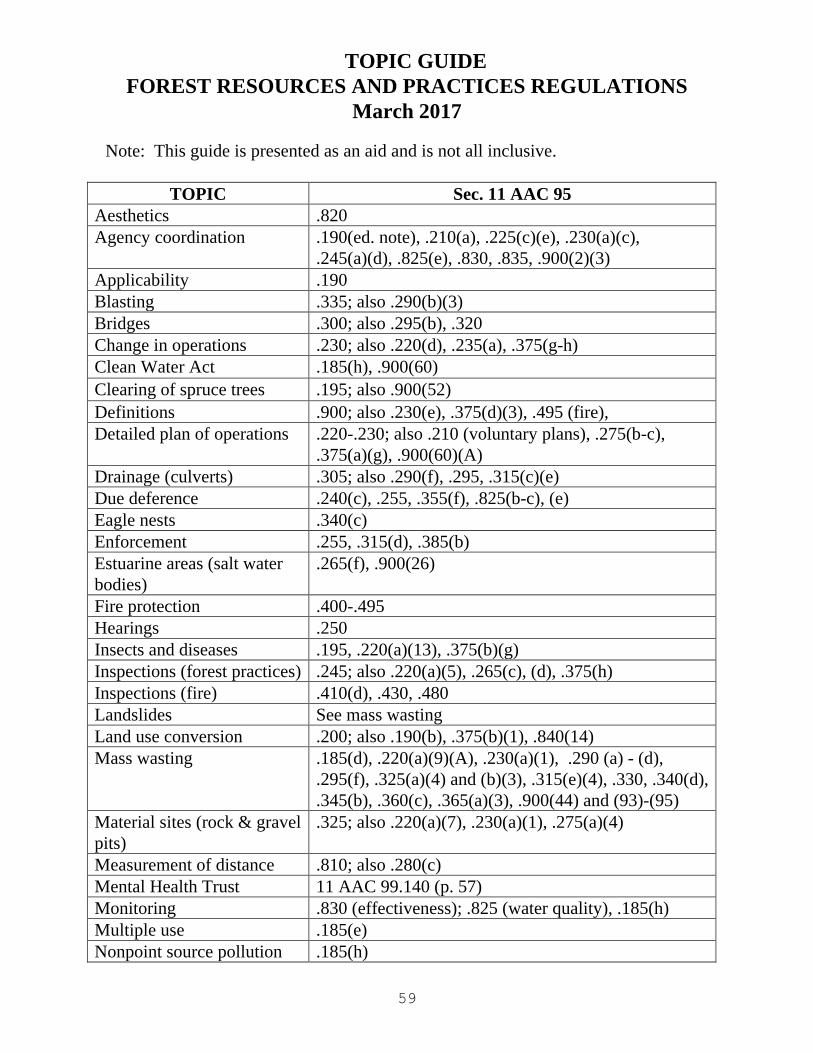
59
TOPIC GUIDE
FOREST RESOURCES AND PRACTICES REGULATIONS
March 2017
Note: This guide is presented as an aid and is not all inclusive.
TOPIC Sec. 11 AAC 95
Aesthetics .820
Agency coordination .190(ed. note), .210(a), .225(c)(e), .230(a)(c),
.245(a)(d), .825(e), .830, .835, .900(2)(3)
Applicability .190
Blasting .335; also .290(b)(3)
Bridges .300; also .295(b), .320
Change in operations .230; also .220(d), .235(a), .375(g-h)
Clean Water Act .185(h), .900(60)
Clearing of spruce trees .195; also .900(52)
Definitions .900; also .230(e), .375(d)(3), .495 (fire),
Detailed plan of operations .220-.230; also .210 (voluntary plans), .275(b-c),
.375(a)(g), .900(60)(A)
Drainage (culverts) .305; also .290(f), .295, .315(c)(e)
Due deference .240(c), .255, .355(f), .825(b-c), (e)
Eagle nests .340(c)
Enforcement .255, .315(d), .385(b)
Estuarine areas (salt water
bodies)
.265(f), .900(26)
Fire protection .400-.495
Hearings .250
Insects and diseases .195, .220(a)(13), .375(b)(g)
Inspections (forest practices) .245; also .220(a)(5), .265(c), (d), .375(h)
Inspections (fire) .410(d), .430, .480
Landslides See mass wasting
Land use conversion .200; also .190(b), .375(b)(1), .840(14)
Mass wasting .185(d), .220(a)(9)(A), .230(a)(1), .290 (a) - (d),
.295(f), .325(a)(4) and (b)(3), .315(e)(4), .330, .340(d),
.345(b), .360(c), .365(a)(3), .900(44) and (93)-(95)
Material sites (rock & gravel
pits)
.325; also .220(a)(7), .230(a)(1), .275(a)(4)
Measurement of distance .810; also .280(c)
Mental Health Trust 11 AAC 99.140 (p. 57)
Monitoring .830 (effectiveness); .825 (water quality), .185(h)
Multiple use .185(e)
Nonpoint source pollution .185(h)
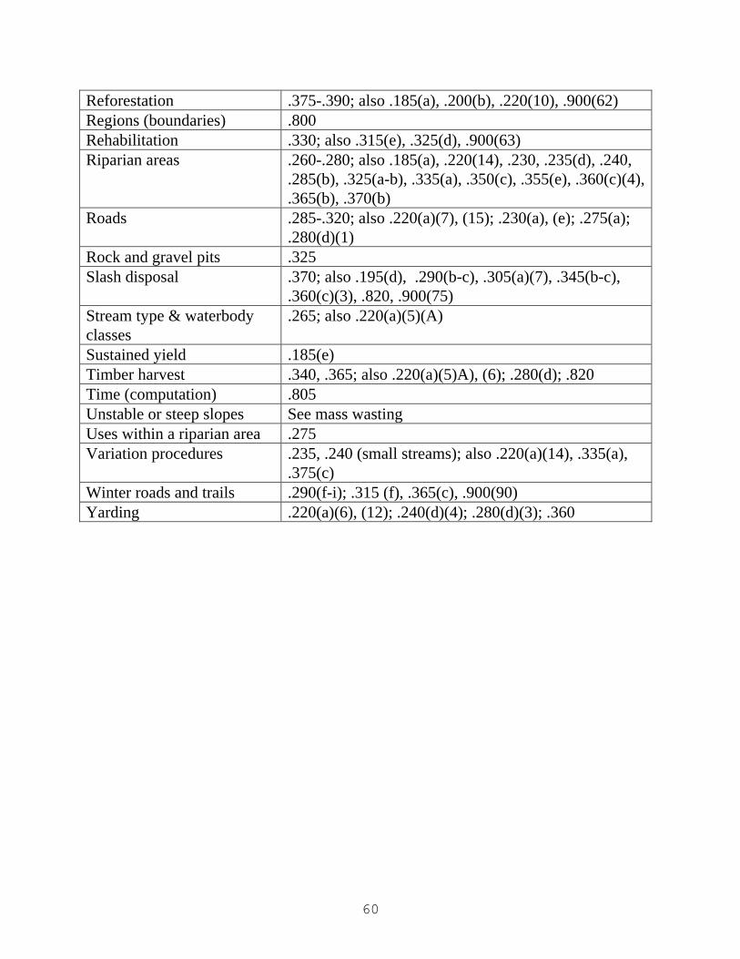
60
Reforestation .375-.390; also .185(a), .200(b), .220(10), .900(62)
Regions (boundaries) .800
Rehabilitation .330; also .315(e), .325(d), .900(63)
Riparian areas .260-.280; also .185(a), .220(14), .230, .235(d), .240,
.285(b), .325(a-b), .335(a), .350(c), .355(e), .360(c)(4),
.365(b), .370(b)
Roads .285-.320; also .220(a)(7), (15); .230(a), (e); .275(a);
.280(d)(1)
Rock and gravel pits .325
Slash disposal .370; also .195(d), .290(b-c), .305(a)(7), .345(b-c),
.360(c)(3), .820, .900(75)
Stream type & waterbody
classes
.265; also .220(a)(5)(A)
Sustained yield .185(e)
Timber harvest .340, .365; also .220(a)(5)A), (6); .280(d); .820
Time (computation) .805
Unstable or steep slopes See mass wasting
Uses within a riparian area .275
Variation procedures .235, .240 (small streams); also .220(a)(14), .335(a),
.375(c)
Winter roads and trails .290(f-i); .315 (f), .365(c), .900(90)
Yarding .220(a)(6), (12); .240(d)(4); .280(d)(3); .360

61
fc
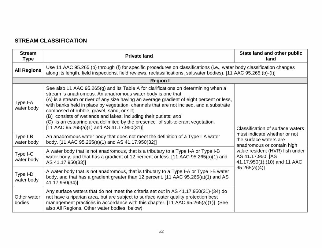
62
STREAM CLASSIFICATION
Stream
Type Private land
State land and other public
land
All Regions Use 11 AAC 95.265 (b) through (f) for specific procedures on classifications (i.e., water body classification changes along its length, field inspections, field reviews, reclassifications, saltwater bodies). [11 AAC 95.265 (b)-(f)]
Region I
Type I-A water body
See also 11 AAC 95.265(g) and its Table A for clarifications on determining when a stream is anadromous. An anadromous water body is one that (A) is a stream or river of any size having an average gradient of eight percent or less, with banks held in place by vegetation, channels that are not incised, and a substrate composed of rubble, gravel, sand, or silt; (B) consists of wetlands and lakes, including their outlets; and (C) is an estuarine area delimited by the presence of salt-tolerant vegetation. [11 AAC 95.265(a)(1) and AS 41.17.950(31)] Classification of surface waters
must indicate whether or not the surface waters are anadromous or contain high value resident (HVR) fish under AS 41.17.950. [AS 41.17.950(1),(10) and 11 AAC 95.265(a)(4)]
Type I-B water body
An anadromous water body that does not meet the definition of a Type I-A water body. [11 AAC 95.265(a)(1) and AS 41.17.950(32)]
Type I-C water body
A water body that is not anadromous, that is a tributary to a Type I-A or Type I-B water body, and that has a gradient of 12 percent or less. [11 AAC 95.265(a)(1) and AS 41.17.950(33)]
Type I-D water body
A water body that is not anadromous, that is tributary to a Type I-A or Type I-B water body, and that has a gradient greater than 12 percent. [11 AAC 95.265(a)(1) and AS 41.17.950(34)]
Other water bodies
Any surface waters that do not meet the criteria set out in AS 41.17.950(31)-(34) do not have a riparian area, but are subject to surface water quality protection best management practices in accordance with this chapter. [11 AAC 95.265(a)(1)] (See also All Regions, Other water bodies, below)
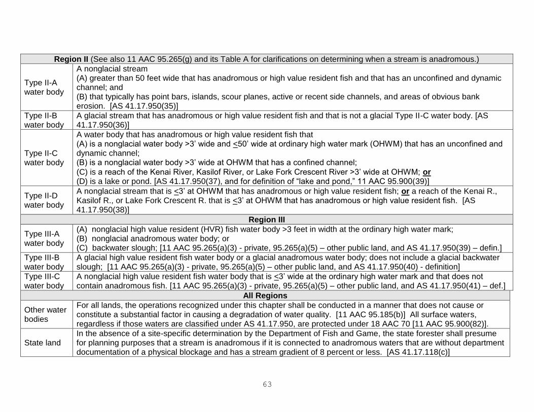
63
Region II (See also 11 AAC 95.265(g) and its Table A for clarifications on determining when a stream is anadromous.)
Type II-A water body
A nonglacial stream (A) greater than 50 feet wide that has anadromous or high value resident fish and that has an unconfined and dynamic channel; and (B) that typically has point bars, islands, scour planes, active or recent side channels, and areas of obvious bank erosion. [AS 41.17.950(35)]
Type II-B water body
A glacial stream that has anadromous or high value resident fish and that is not a glacial Type II-C water body. [AS 41.17.950(36)]
Type II-C water body
A water body that has anadromous or high value resident fish that (A) is a nonglacial water body >3’ wide and <50’ wide at ordinary high water mark (OHWM) that has an unconfined and dynamic channel; (B) is a nonglacial water body >3’ wide at OHWM that has a confined channel;
(C) is a reach of the Kenai River, Kasilof River, or Lake Fork Crescent River >3’ wide at OHWM; or (D) is a lake or pond. [AS 41.17.950(37), and for definition of “lake and pond,” 11 AAC 95.900(39)]
Type II-D water body
A nonglacial stream that is <3’ at OHWM that has anadromous or high value resident fish; or a reach of the Kenai R., Kasilof R., or Lake Fork Crescent R. that is <3’ at OHWM that has anadromous or high value resident fish. [AS 41.17.950(38)]
Region III
Type III-A water body
(A) nonglacial high value resident (HVR) fish water body >3 feet in width at the ordinary high water mark; (B) nonglacial anadromous water body; or (C) backwater slough; [11 AAC 95.265(a)(3) - private, 95.265(a)(5) – other public land, and AS 41.17.950(39) – defin.]
Type III-B water body
A glacial high value resident fish water body or a glacial anadromous water body; does not include a glacial backwater slough; [11 AAC 95.265(a)(3) - private, 95.265(a)(5) – other public land, and AS 41.17.950(40) - definition]
Type III-C water body
A nonglacial high value resident fish water body that is <3’ wide at the ordinary high water mark and that does not contain anadromous fish. [11 AAC 95.265(a)(3) - private, 95.265(a)(5) – other public land, and AS 41.17.950(41) – def.]
All Regions
Other water bodies
For all lands, the operations recognized under this chapter shall be conducted in a manner that does not cause or constitute a substantial factor in causing a degradation of water quality. [11 AAC 95.185(b)] All surface waters, regardless if those waters are classified under AS 41.17.950, are protected under 18 AAC 70 [11 AAC 95.900(82)].
State land In the absence of a site-specific determination by the Department of Fish and Game, the state forester shall presume for planning purposes that a stream is anadromous if it is connected to anadromous waters that are without department documentation of a physical blockage and has a stream gradient of 8 percent or less. [AS 41.17.118(c)]
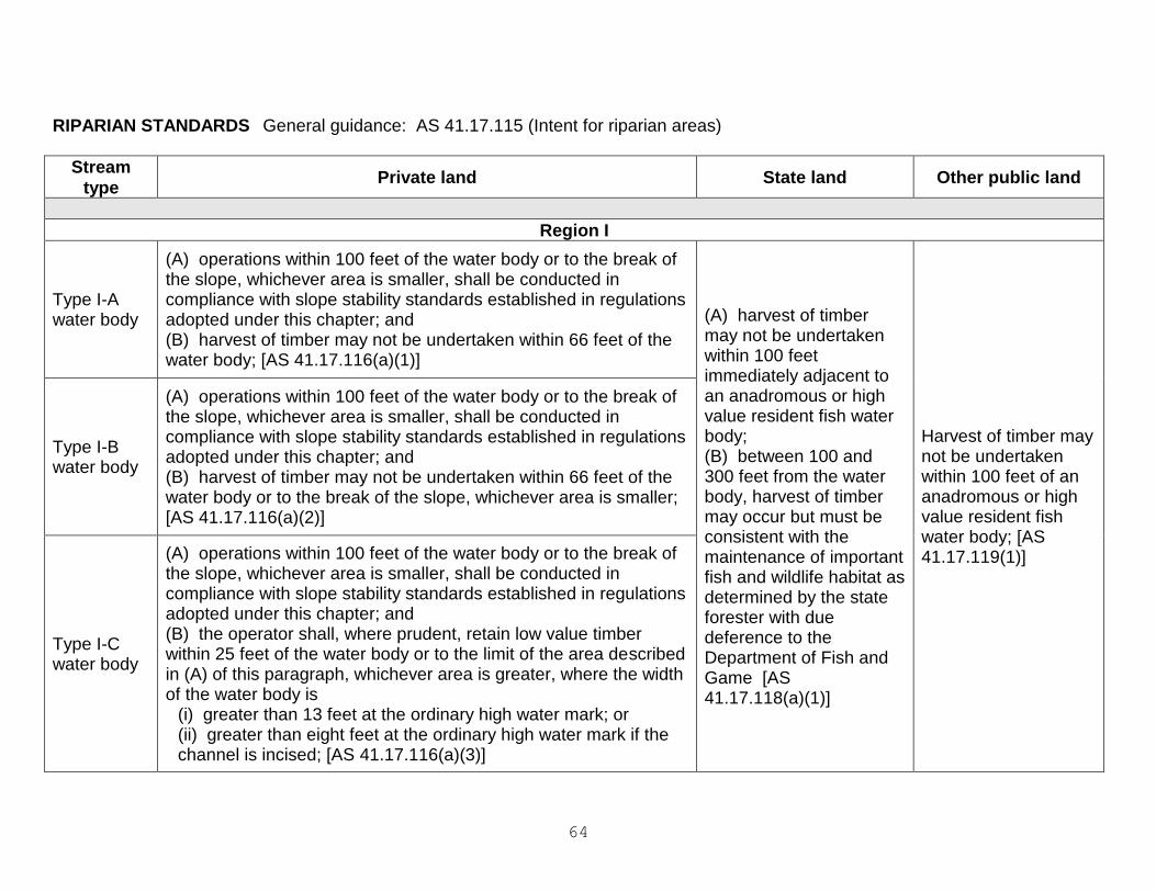
64
RIPARIAN STANDARDS General guidance: AS 41.17.115 (Intent for riparian areas)
Stream
type Private land State land Other public land
Region I
Type I-A water body
(A) operations within 100 feet of the water body or to the break of the slope, whichever area is smaller, shall be conducted in compliance with slope stability standards established in regulations adopted under this chapter; and (B) harvest of timber may not be undertaken within 66 feet of the water body; [AS 41.17.116(a)(1)]
(A) harvest of timber may not be undertaken within 100 feet immediately adjacent to an anadromous or high value resident fish water body; (B) between 100 and 300 feet from the water body, harvest of timber may occur but must be consistent with the maintenance of important fish and wildlife habitat as determined by the state forester with due deference to the Department of Fish and Game [AS 41.17.118(a)(1)]
Harvest of timber may not be undertaken within 100 feet of an anadromous or high value resident fish water body; [AS 41.17.119(1)]
Type I-B water body
(A) operations within 100 feet of the water body or to the break of the slope, whichever area is smaller, shall be conducted in compliance with slope stability standards established in regulations adopted under this chapter; and (B) harvest of timber may not be undertaken within 66 feet of the water body or to the break of the slope, whichever area is smaller; [AS 41.17.116(a)(2)]
Type I-C water body
(A) operations within 100 feet of the water body or to the break of the slope, whichever area is smaller, shall be conducted in compliance with slope stability standards established in regulations adopted under this chapter; and (B) the operator shall, where prudent, retain low value timber within 25 feet of the water body or to the limit of the area described in (A) of this paragraph, whichever area is greater, where the width of the water body is
(i) greater than 13 feet at the ordinary high water mark; or (ii) greater than eight feet at the ordinary high water mark if the channel is incised; [AS 41.17.116(a)(3)]
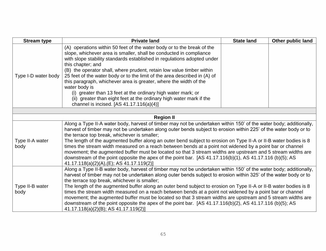
65
Stream type Private land State land Other public land
Type I-D water body
(A) operations within 50 feet of the water body or to the break of the slope, whichever area is smaller, shall be conducted in compliance with slope stability standards established in regulations adopted under this chapter; and (B) the operator shall, where prudent, retain low value timber within 25 feet of the water body or to the limit of the area described in (A) of this paragraph, whichever area is greater, where the width of the water body is
(i) greater than 13 feet at the ordinary high water mark; or (ii) greater than eight feet at the ordinary high water mark if the channel is incised. [AS 41.17.116(a)(4)]
Region II
Type II-A water body
Along a Type II-A water body, harvest of timber may not be undertaken within 150’ of the water body; additionally, harvest of timber may not be undertaken along outer bends subject to erosion within 225’ of the water body or to the terrace top break, whichever is smaller; The length of the augmented buffer along an outer bend subject to erosion on Type II-A or II-B water bodies is 8 times the stream width measured on a reach between bends at a point not widened by a point bar or channel movement; the augmented buffer must be located so that 3 stream widths are upstream and 5 stream widths are downstream of the point opposite the apex of the point bar. [AS 41.17.116(b)(1), AS 41.17.116 (b)(5); AS 41.17.118(a)(2)(A),(E); AS 41.17.119(2)]
Type II-B water body
Along a Type II-B water body, harvest of timber may not be undertaken within 150’ of the water body; additionally, harvest of timber may not be undertaken along outer bends subject to erosion within 325’ of the water body or to the terrace top break, whichever is smaller; The length of the augmented buffer along an outer bend subject to erosion on Type II-A or II-B water bodies is 8 times the stream width measured on a reach between bends at a point not widened by a point bar or channel movement; the augmented buffer must be located so that 3 stream widths are upstream and 5 stream widths are downstream of the point opposite the apex of the point bar. [AS 41.17.116(b)(2), AS 41.17.116 (b)(5); AS 41.17.118(a)(2)(B); AS 41.17.119(2)]
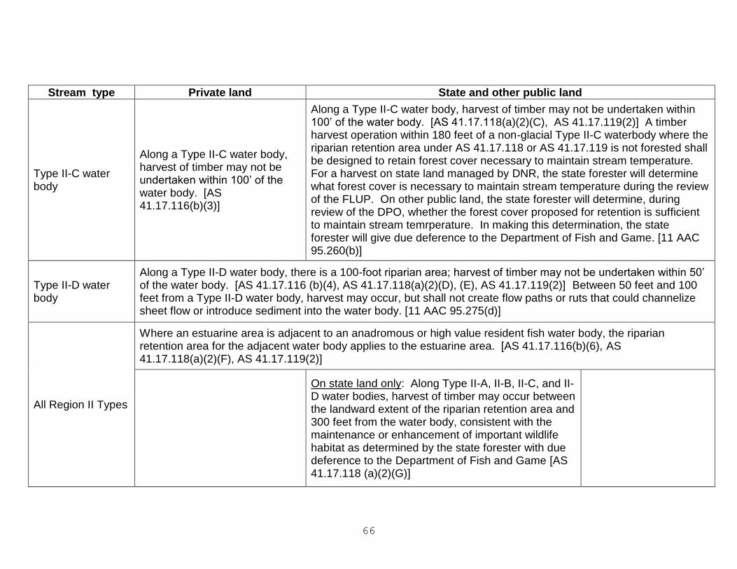
66
Stream type Private land State and other public land
Type II-C water body
Along a Type II-C water body, harvest of timber may not be undertaken within 100’ of the water body. [AS 41.17.116(b)(3)]
Along a Type II-C water body, harvest of timber may not be undertaken within 100’ of the water body. [AS 41.17.118(a)(2)(C), AS 41.17.119(2)] A timber harvest operation within 180 feet of a non-glacial Type II-C waterbody where the riparian retention area under AS 41.17.118 or AS 41.17.119 is not forested shall be designed to retain forest cover necessary to maintain stream temperature. For a harvest on state land managed by DNR, the state forester will determine what forest cover is necessary to maintain stream temperature during the review of the FLUP. On other public land, the state forester will determine, during review of the DPO, whether the forest cover proposed for retention is sufficient to maintain stream temrperature. In making this determination, the state forester will give due deference to the Department of Fish and Game. [11 AAC 95.260(b)]
Type II-D water body
Along a Type II-D water body, there is a 100-foot riparian area; harvest of timber may not be undertaken within 50’ of the water body. [AS 41.17.116 (b)(4), AS 41.17.118(a)(2)(D), (E), AS 41.17.119(2)] Between 50 feet and 100 feet from a Type II-D water body, harvest may occur, but shall not create flow paths or ruts that could channelize sheet flow or introduce sediment into the water body. [11 AAC 95.275(d)]
All Region II Types
Where an estuarine area is adjacent to an anadromous or high value resident fish water body, the riparian retention area for the adjacent water body applies to the estuarine area. [AS 41.17.116(b)(6), AS 41.17.118(a)(2)(F), AS 41.17.119(2)]
On state land only: Along Type II-A, II-B, II-C, and II-D water bodies, harvest of timber may occur between the landward extent of the riparian retention area and 300 feet from the water body, consistent with the maintenance or enhancement of important wildlife habitat as determined by the state forester with due deference to the Department of Fish and Game [AS 41.17.118 (a)(2)(G)]
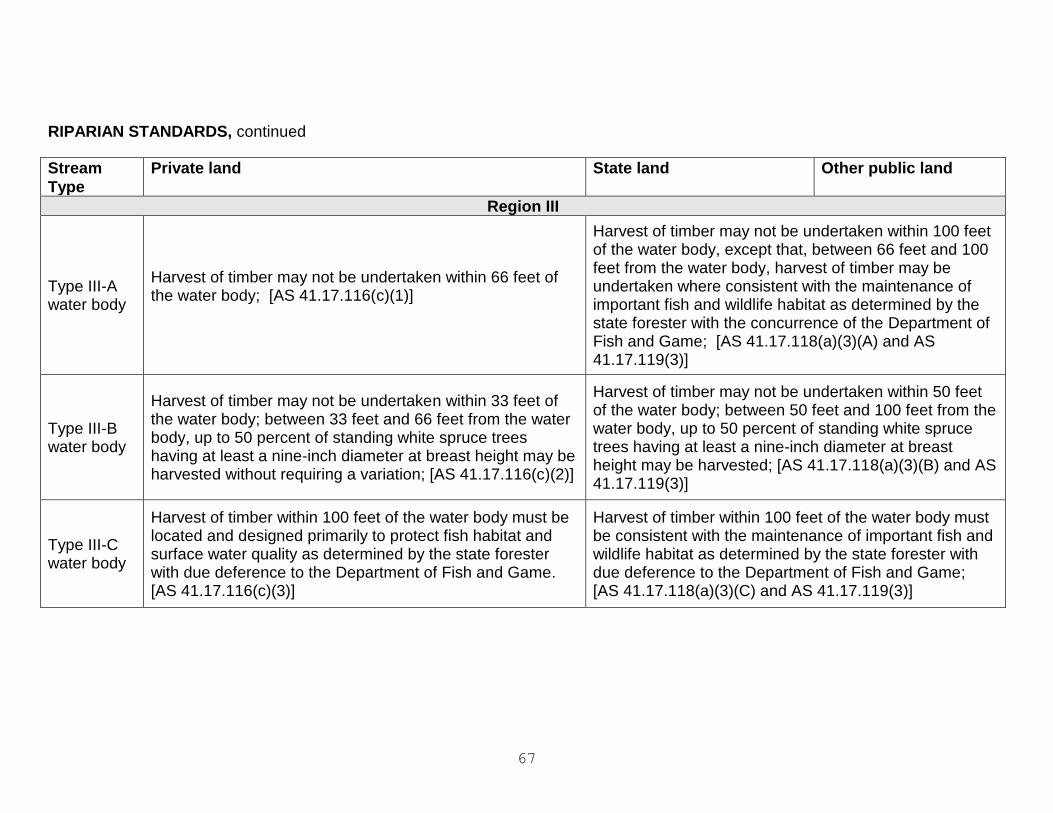
67
RIPARIAN STANDARDS, continued
Stream
Type
Private land State land Other public land
Region III
Type III-A water body
Harvest of timber may not be undertaken within 66 feet of the water body; [AS 41.17.116(c)(1)]
Harvest of timber may not be undertaken within 100 feet of the water body, except that, between 66 feet and 100 feet from the water body, harvest of timber may be undertaken where consistent with the maintenance of important fish and wildlife habitat as determined by the state forester with the concurrence of the Department of Fish and Game; [AS 41.17.118(a)(3)(A) and AS 41.17.119(3)]
Type III-B water body
Harvest of timber may not be undertaken within 33 feet of the water body; between 33 feet and 66 feet from the water body, up to 50 percent of standing white spruce trees having at least a nine-inch diameter at breast height may be harvested without requiring a variation; [AS 41.17.116(c)(2)]
Harvest of timber may not be undertaken within 50 feet of the water body; between 50 feet and 100 feet from the water body, up to 50 percent of standing white spruce trees having at least a nine-inch diameter at breast height may be harvested; [AS 41.17.118(a)(3)(B) and AS 41.17.119(3)]
Type III-C water body
Harvest of timber within 100 feet of the water body must be located and designed primarily to protect fish habitat and surface water quality as determined by the state forester with due deference to the Department of Fish and Game. [AS 41.17.116(c)(3)]
Harvest of timber within 100 feet of the water body must be consistent with the maintenance of important fish and wildlife habitat as determined by the state forester with due deference to the Department of Fish and Game; [AS 41.17.118(a)(3)(C) and AS 41.17.119(3)]
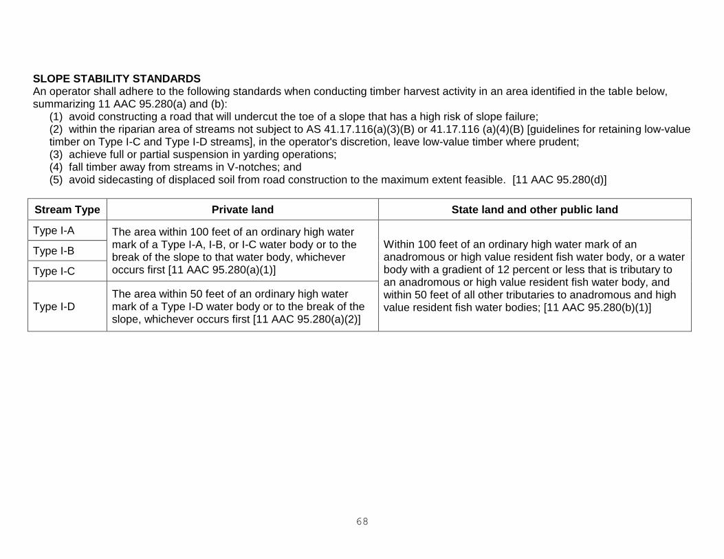
68
SLOPE STABILITY STANDARDS An operator shall adhere to the following standards when conducting timber harvest activity in an area identified in the table below, summarizing 11 AAC 95.280(a) and (b):
(1) avoid constructing a road that will undercut the toe of a slope that has a high risk of slope failure; (2) within the riparian area of streams not subject to AS 41.17.116(a)(3)(B) or 41.17.116 (a)(4)(B) [guidelines for retaining low-value timber on Type I-C and Type I-D streams], in the operator's discretion, leave low-value timber where prudent; (3) achieve full or partial suspension in yarding operations; (4) fall timber away from streams in V-notches; and (5) avoid sidecasting of displaced soil from road construction to the maximum extent feasible. [11 AAC 95.280(d)]
Stream Type Private land State land and other public land
Type I-A The area within 100 feet of an ordinary high water mark of a Type I-A, I-B, or I-C water body or to the break of the slope to that water body, whichever occurs first [11 AAC 95.280(a)(1)]
Within 100 feet of an ordinary high water mark of an anadromous or high value resident fish water body, or a water body with a gradient of 12 percent or less that is tributary to an anadromous or high value resident fish water body, and within 50 feet of all other tributaries to anadromous and high value resident fish water bodies; [11 AAC 95.280(b)(1)]
Type I-B
Type I-C
Type I-D The area within 50 feet of an ordinary high water mark of a Type I-D water body or to the break of the slope, whichever occurs first [11 AAC 95.280(a)(2)]

69

Notes
_____________________________________________
_____________________________________________
_____________________________________________
_____________________________________________
_____________________________________________
_____________________________________________
_____________________________________________
_____________________________________________
_____________________________________________
_____________________________________________
_____________________________________________
_____________________________________________
_____________________________________________
_____________________________________________
_____________________________________________
_____________________________________________
_____________________________________________
_____________________________________________
_____________________________________________
_____________________________________________
_____________________________________________
_____________________________________________
_____________________________________________
_____________________________________________
_____________________________________________
_____________________________________________
_____________________________________________
_____________________________________________
_____________________________________________