Embed Size (px)
Citation preview
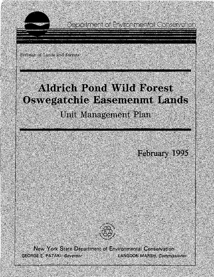
ALDRICH POND WILD FOREST
OSWEGATCHIE EASEMENT LANDS
UNIT MANAGEMENT PLAN
NYS DEPARTMENT OF ENVIRONMENTAL CONSERVATION
George E. Pataki Governor
Langdon Marsh Commissioner
MEMORANDUM FROM LANGDON MARSH, Commissioner
New York State Department of Environmental Conservation
TO: The Record
FROM: Langdon Marsh
RE: Unit Management Aldrich Pond
FEB 3 1995
~l
The Unit Management Plan for the Aldrich Pond Area has been completed. The Plan is consistent with the guidelines and criteria of the Adirondack Park State Land Master Plan, the State Constitution, Environmental Conservation Law, and Department rules, regulations and policies. The Plan includes management objectives for a five-year period and is hereby approved and adopted.

IN MEMORIUM
On November 5, 1992, Roderick D. Fraser of Star Lake died at the age of 66 from a cancer which was discovered shortly after his retirement as supervisor of the DEC ~rail crew in 1990. An expert woodsman, Rod had a very strong empathy for persons of lesser ability and constantly applied his considerable energy and abilities toward creating amenities to encourage them to experience the outdoors which he loved so much. This feeling was so strong that, in his final months, he spent considerable energy convincing his many friends and neighbors to participate in the planning process. This plan1 while not able to directly embrace all of Rod's ideas, hopefully expresses his influence.
DEC TASK FORCE
John Kramer - Task Force Leader
John Hurlbut - Lands & Forests
Howard Graham - Lands & Forests
Edward {Ted) Smith - Fish & Wildlife
Bill Gordon - Fish & Wildlife
OTHER DEC CONTRIBUTORS
Roger Hutchinson Tom Brown
Barbara Durin Denise Richardson
Bernard Davies Glen Roberts
Paul Toohey Tom Wolfe
Burrell Buffington Walt Sabin
Michael Lewis Dave Smith
-i-

TABLE OF CONTENTS
BACKGROUND v LOCATION MAP vi
I. INTRODUCTION A. AREA DESCRIPTION 1
1. General Location 1 2. Acreage 1
ACQUISITION HISTORY MAP 2 3. Unclassified Parcels 4 4. · Access 5
B. HISTORY 7
II. INVENTORY, USE AND CAPACITY TO WITHSTAND USE A. NATURAL RESOURCES 8
1. Physical 8 a. Geology 8 b. Soils 8 c. Terrain 8 d. water s
GEOLOGICAL MAP 9 e. Wetlands 10
2. Biological 10 a. Vegetation 10 b. Wildlife 11 c. Fisheries 13
PUBLIC STREAM FISHING RIGHTS - MAP 15 3. Visual 16 4. Unique 16 5. Critical Habitat 16
B. EXISTING FACILITIES 16 C. CULTURAL 19 D. ECONOMIC 20
1. Impact of state Ownership on Adjacent Private Lands 20
2. Impact of Adjacent Private Lands on State Lands 20
E. PUBLIC USE 20 F. CAPACITY OF THE RESOURCE TO WITHSTAND USE 24
III. MANAGEMENT AND POLICY A. PAST MANAGEMENT B. RELATIONSHIP OF MANAGEMENT OF AREA
TO ADJACENT STATE LANDS C. ADMINISTRATION OF CONSERVATION
EASEMENTS D. ISSUES AFFECTING THE PLANNING AREA
1. Wild, Scenic & Recreational Rivers 2. All Terrain & Motor Vehicle Use
PUBLIC MOTOR VEHICLE AND ATV ACCESS MAP 3. Access
BALD MOUNTAIN ROAD EXTENSION MAP -ii-
24
25
25 26
Act 26 30 31 32 33
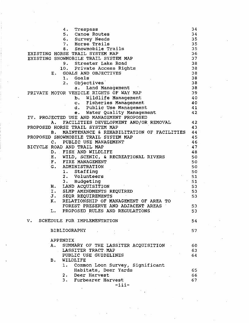
4. Trespass 34 5. Canoe Routes 34 6. Survey Needs 35 7. Horse Trails 35 8. snowmobile Trails 35
EXISTING HORSE TRAIL SYSTEM MAP 36 EXISTING SNOWMOBILE TRAIL SYSTEM MAP 37
9. Streeter Lake Road 38 10. Private Access Rights 38
E. GOALS AND OBJECTIVES 38 1. Goals 38 2. Objectives· 38
a. Land Management 38 PRIVATE MOTOR VEHICLE.RIGHTS OF WAY MAP 39
b. Wildlife Management 40 c. Fisheries Management 40 d. Public Use Management 41 e. Water Quality Management 42
IV. PROJECTED USE AND MANAGEMENT PROPOSED A. FACILITIES DEVELOPMENT AND/OR REMOVAL 42
PROPOSED HORSE TRAIL SYSTEM MAP 43 B. MAIN~ENANCE & REHABILITATION OF FACILITIES 44
PROPOSED SNOWMOBILE TRAIL SYSTEM MAP 45 C. PUBLIC USE MANAGEMENT 46
BICYCLE ROAD AND TRAIL MAP 47 D. FISH AND WILDLIFE 48 E. WILD, SCENIC, & RECREATIONAL RIVERS 50 F. FIRE MANAGEMENT 50 G. ADMINISTRATION 50
1. Staffing 50 2. Volunteers 51 3. Budgeting 51
H. LAND ACQUISITION 53 I. SLMP AMENDMENTS REQUIRED 53 J. SEQR REQUIREMENTS 53 K. RELATIONSHIP OF MANAGEMENT OF AREA TO
FOREST PRESERVE AND ADJACENT AREAS 53 L. PROPOSED RULES AND REGULATIONS 53
V. SCHEDULE FOR IMPLEMENTATION
BIBLIOGRAPHY
APPENDIX A. SUMMARY OF THE LASSITER ACQUISITION
LASSITER TRACT.MAP PUBLIC USE GUIDELINES
B. WILDLIFE 1. Common Loon Survey, Significant
Habitats, Deer Yards 2. Deer Harvest 3. Furbearer Harvest
-iii-
54
57
60 63 64
65 66 67
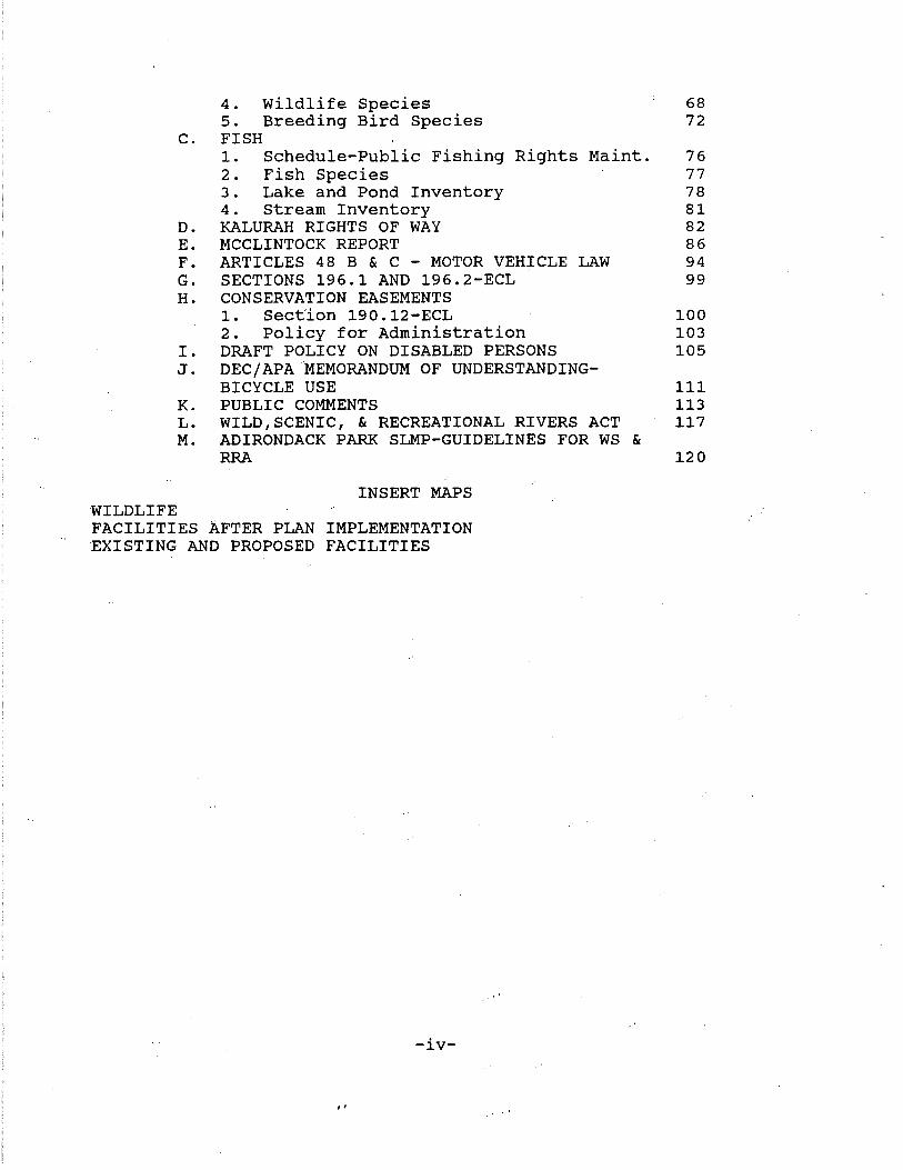
4. Wildlife Species 68 5. Breeding Bird Species 72
C. FISH 1. Schedule-Public Fishing Rights Maint. 76 2. Fish Species 77 3. Lake and Pond Inventory 78 4. Stream Inventory 81
D. KALURAH RIGHTS OF WAY 82 E. MCCLINTOCK REPORT 86 F. ARTICLES 48 B & C - MOTOR VEHICLE LAW 94 G. SECTIONS 196.1 AND 196.2-ECL 99 H. CONSERVATION EASEMENTS
1. Section 190.12-ECL 100 2. Policy for Administration 103
I. DRAFT POLICY ON DISABLED PERSONS 105 J. DEC/APA MEMORANDUM OF UNDERSTANDING-
BICYCLE USE 111 K. PUBLIC COMMENTS 113 L. WILD,SCENIC, & RECREATIONAL RIVERS ACT 117 M. ADIRONDACK PARK SLMP-GUIDELINES FOR WS &
RRA 120
INSERT MAPS WILDLIFE FACILITIES AFTER PLAN IMPLEMENTATION 'EXISTING AND PROPOSED FACILITIES
-iv-
,,
BACKGROUND
In 1972, Governor Nelson A. Rockefeller approved the Adirondack Park Agency Master Plan for state-owned lands in the Adirondack Park. This culminated many years of work by several legislative study groups and, ultimately, the Temporary Study Commission on the Future of the Adirondacks, appointed by the Governor in 1968.
The Temporary Study Commission on the Future of the Adirondacks made nearly 200 specific recommendations regarding the Adirondack Park·. Among its recommendations were:
- The creation of the Adirondack Park Agency
- The preparation of a Master Plan for state-owned lands
by the Agency.
- The classification of these lands "according to their characteristics and capacity to withstand use" and
- A set of extensive guidelines for the care, custody and control of state-owned lands under the Master Plan with particular emphasis on proposed wilderness and primitive areas.
The Temporary Study Commission also prepared legislation in final draft form, not only establishing the agency, but providing a comprehensive framework for land use, both.public and private.
The final legislative mandate provided for the Agency's Master Plan for State-owned lands in the Adirondack Park. A revised master plan, in accordance with Section 816 of the Adirondack Park Agency Act, Article 27 of the Executive Law, was signed by Governo"r Mario Cuomo on November 4, 1987. This plan has been prepared by the New York State Department of Environmental Conservation with the State Land Master Plan setting the parameters and interested citizens providing additional review.
-v-
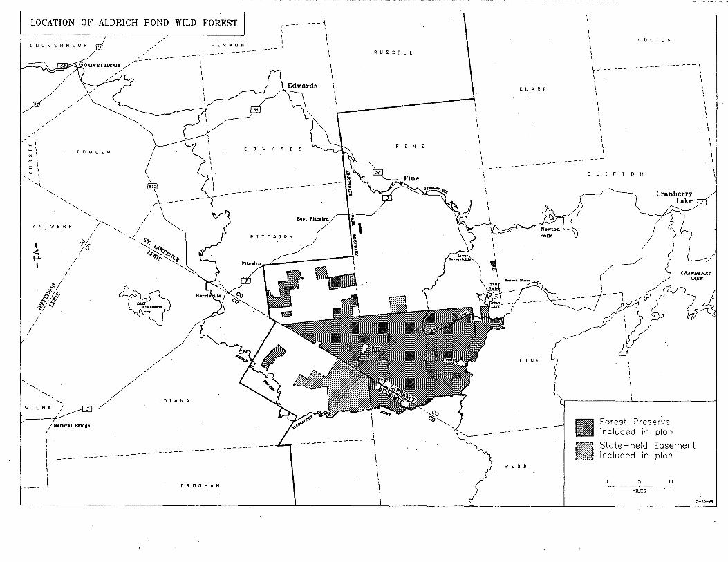
I LOCATION OF ALDRICH POND WILD FOREST r-------; L~=-~~~~~~~~-,-~~~~~~~,,.-~~~~~:--::--::--~~ I I I I
GOUVERNEUR 71 ,, I \
,,,,/ HER M ':..~-------' \
,,,,/ --------T------ \ ,,,_--- I I ouverneur ,,,, 1
1 ,, I \ ,, ,::JL.,, I \
/
/ /
,,_ I \
RUSSELL
C L A R E
I \ I I I I I I I I I
/ /
/ /
/ /
/
71
/
" ,,,,I wl _1 "'I
I "'I 0 .\
°' I '---, I
/
"--' '---'---
AN!'W'ERP
I
I ~ ..... I
~1 ,~,,,,
~i:f I
'---'---
'JI L NA 7
I
fO\JLER
'--- r I
I '-._ I ''r--._ I
I '- I , '-._, I
I '-<-,<SJ: 4f
'J& ~+;~~e ' ' I
~
D I A N A
( Natural Bride•
'
L--------1 '
-------
I I I I \ I I \• I I
ED'JARDS
.L----------
Z.st Pitealrn
PITCAIRN
-------
___ J CROGHAN
i' _,\
I
-------1' ' \ ' \ ' \ ' I
f I N E
I I I I I I I
~-----1 I \ \ I I \ I \
f I N E
........__ __________ _
\I E B B
I I I I I
COLTON
--------·
C L I r r a N
•
Cranberry Lake
Forest Preserve included in plan
State-held Easement included in plan
0 ~ w ~~s
\ I \ I \ \ I \ \ I \ \ I I
' ' I \ \
~-23-94
\
' I
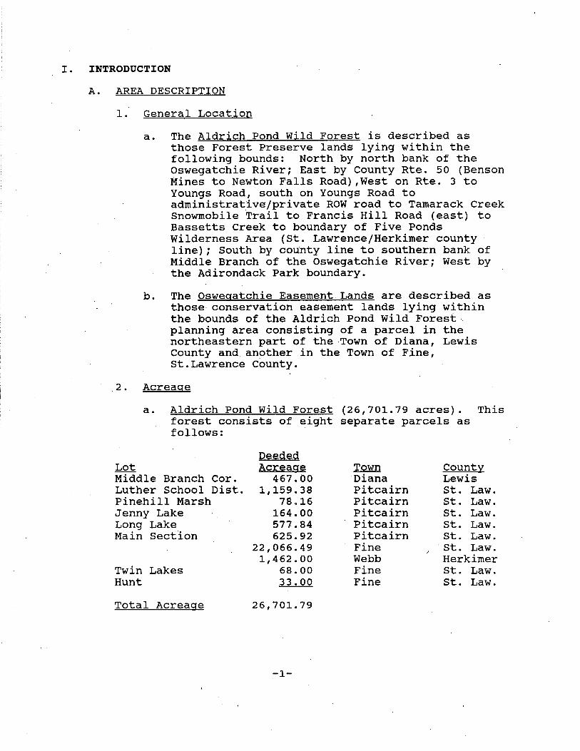
I. INTRODUCTION
A. AREA DESCRIPTION
1. General Location
a. The Aldrich Pond Wild Forest is described as those Forest Preserve lands lying within the following bounds: North by north bank of the Oswegatchie River; East by County Rte. 50 (Benson Mines to Newton Falls Road) ,West on Rte. 3 to Youngs Road, south on Youngs Road to administrative/private ROW road to Tamarack Creek Snowmobile Trail to Francis Hill Road (east) to Bassetts creek to boundary of Five Ponds Wilderness Area {St. Lawrence/Herkimer county line); South by county line to southern bank of Middle Branch of the Oswegatchie River; West by the Adirondack Park boundary.
b. The Oswegatchie Easement Lands are described as those conservation easement lands lying within the bounds of the Aldrich Pond Wild Forest . planning area consisting of a parcel in the northeastern part of the Town of Diana, Lewis County and another in the Town of Fine, st.Lawrence County .
. 2. Acreage
a. Aldrich Pond Wild Forest {26,701.79 acres). This forest consists of eight separate parcels as follows:
Deeded Lot Acreage Town County Middle Branch Cor. 467.00 Diana Lewis Luther School Dist. 1,159.38 Pitcairn st. Law. Pinehill Marsh 78.16 Pitcairn St. Law. Jenny Lake 164.00 Pitcairn st. Law. Long Lake 577.84 Pitcairn st. Law. Main Section 625.92 Pitcairn St. Law.
22,066.49 Fine st. Law. 1,462.00 Webb Herkimer
Twin Lakes 68.00 Fine st. Law. Hunt 33.00 Fine st. Law.
Total Acreage 26' 701. 79
-1-
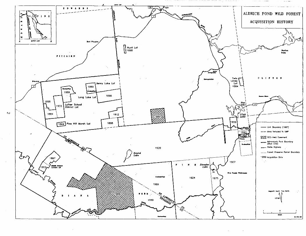
A MATCHLK 8
N "" 1884
""
ID1'AllDS -----------------
PITCAlllN
I I I I
Long
§i} Pine Hiii Marsti Loi
--~~~---·
~
i
~ ,s
n Hunt Loi u 1898
1920
p ~ -----------~.
Uftdonln.d 1924
"" 1989
'"" 1' I I B
1989
"" -
I I I ALDRICH POND WILD FOREST I I I I I I I I I
"" ...... WU..,....
ACQUISITION HISTORY
-· Fallo
CLIFTON
-·- un;t Boundory (1987)
• • •• Area Included In UMP
~ DEC-held Easement
__ Adirondack Pork Boundary (Slue line)
-- State Hi9hway
_ _ _ _ F' or Ht Preterve Parcel Boundary
1989 Acqui.;tton Dote
-.:~--
..... ~-13-14
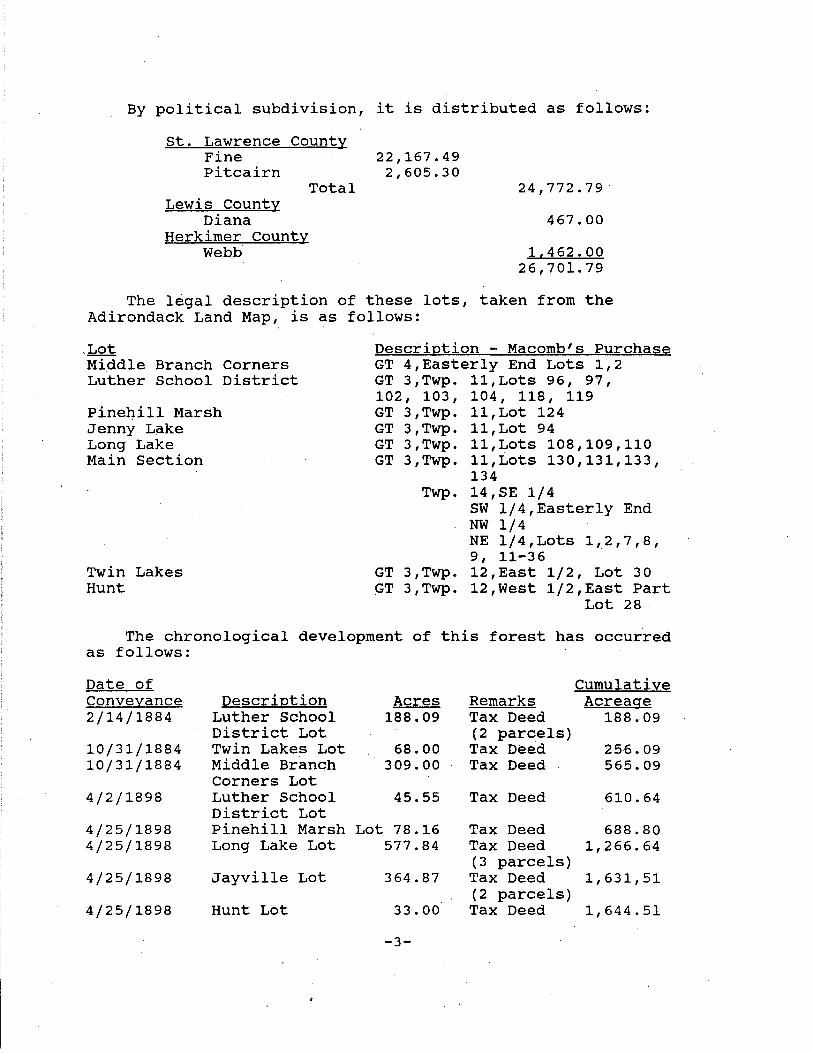
By political subdivision, it is distributed as follows:
St. Lawrence County Fine Pitcairn
Lewis County Diana
Herkimer County Webb
Total
22,167.49 2,605.30
24,772.79
467.00
1.462.00 26 I 701. 79
The legal description of these lots, taken from the Adirondack Land Map, is as follows:
.Lot Middle Branch Corners Luther School District
Pinehill Marsh Jenny Lake Long Lake Main Section
Twin Lakes Hunt
Description - Macomb's Purchase GT 4,Easterly End Lots 1,2 GT 3,Twp. 11,Lots 96, 97, 102 t 103 f 104 t 118 t 119 GT 3,Twp. 11,Lot 124 GT 3,Twp. 11,Lot 94 GT 3,Twp. 11,Lots 108,109,110 GT 3,Twp. 11,Lots 130,131,133,
134 Twp. 14,SE 1/4
SW 1/4,Easterly End NW 1/4 NE 1/4,Lots 1,2,7,8, 9, 11-36
GT 3,Twp. 12,East 1/2, Lot 30 .GT 3,Twp. 12,West 1/2,East Part
Lot 28
The chronological development of this forest has occurred as follows:
Date of Cumulative Conveyance Description Acres Remarks Acreage 2/14/1884 Luther School 188.09 Tax Deed 188.09
District Lot (2 parcels) 10/31/1884 Twin Lakes Lot 68.00 Tax Deed 256.09 10/31/1884 Middle Branch 309.00 Tax Deed 565.09
Corners Lot 4/2/1898 Luther School 45.55 Tax Deed 610.64
District Lot 4/25/1898 Pinehill Marsh Lot 78.16 Tax Deed 688.80 4/25/1898 Long Lake Lot 577.84 Tax Deed 1,266.64
(3 parcels) 4/25/1898 Jayville Lot 364.87 Tax Deed 1,631,51
(2 parcels) 4/25/1898 Hunt Lot 33.00 Tax Deed 1,644.51
-3-

5/16/1907 7/2/1912
11/15/1920
11/24/1920 11/24/1924
12/22/1926 2/1/1933
8/9/1962
11/14/1967
4/2/1975
6/16/1978
3/29/1983 4/20/1984 6/14/1989
Coffin Lot Jayville Lot
Mecca Lumber Co. Tract Aldrich Pd. Tract Middle Branch Timber Co. Tract Aldrich Pd. Tract Luther· School District Lot Middle Branch corners Lot 2 Rights of Way
Braman Mfg. Co. Tract Bossuot Lot
Aldrich Pd. Tract Aldrich Pd. Tract Lassiter Purchase (North of river)
44.00 1,708.51 261. 05 Litigation 1,969.56
(2 parcels)
7,335.69 2 parcels 9,305.25
5,952.81 27 Lots 15,258.06 3,506.00 Town of 18,764.06
Fine 200.00 Lot 9 18,964.06 407.74 2 parcels 19,371.80
158.00 19,529.80
From 19,529.80 Kalurah
1,7.95.00 21,324.80
82.59 Copperbolt Corner 21,407.39
88.37 Lot 3 21,495.76 75.03 Lot 2 21,570.79
5,131.00 Fee 26 I 701. 79 Purchase
b. Oswegatchie Easement Lands (4,115.30 acres). These lands consist of two parcels (Ref er to Acquisition History Map) obtained·in the Lassiter/Nature Conservancy Purchase of 6/14/89 which border the Main Section in the north and the southwest as follows:
Macomb's Deeded Purchase Acreage Town County Parcel GT 3,Twp 12, Lots 73,80 355.00 Fine st. Law. Northern
GT 4,Easterly End,Lots 13, 17-24
Total
3 .
3,760.30 Diana Lewis SW
4,115.30
Unclassified Parcels
There are four parcels within this planning area which were purchased in 1989, but have not yet been classified by the Adirondack Park Agency (Refer to Acquisition History Map). Acreage for three of these parcels has been included in this forest while the remaining parcel, which lies to the west of the Youngs Road, has not because the existence of the private right-of-way, existing snowmobile trail and
-4-
adjacent wilderness area create the possibility of dual classification for this 72.8 acre parcel.
These lands will be administered on an interim basis in a manner consistent with the character of the land and its capacity to withstand use and which will not foreclose options for eventual classification.
4. Access
a. Public access to each of the eight parcels presently occurs as follows:
Middle Branch Corners Lot ~ The purchase of the southernmost part of this Lot in 1962 provided public motorized access from the Bryants Bri~ge Road. Adequate parking is available at the end of a .2 mile access road leading north from this town road.
Jenny Lake Lot - This 164 acre lot is.not accessible and it is very unlikely that access can be obtained.
Hunt Lot - This lot has an old road leading to it; however, the lot itself has never been located with a survey.
Twin Lakes Lot - Foot access to this small (68 acre) lot is available along the New York Central Railroad bed.
Luther School District Lot·- The purchase of 0.76 acres in 1965, in the southwest corner of this lot, provided public access to a previously landlocked parcel. It.has been maintained as a parking lot for access from the Goose Pond Road. This parking lot lies outside of the Adirondack Park. Access to this lot is also available from the Jayville Road across lands acquired in the Lassiter Purchase.
Pinehill Marsh Lot - This lot is inaccessible. In the report of John Y. Mcclintock to the Forest Preserve Board contained in Appendix E, it is stated that the old road to Jayville crossed the lot but that it had reverted to a woods road by 1900.
Long Lake Lot - This lot is effectively inaccessible. Although an old road crosses the eastern end, it is not driveable. Users of the
-5-
area must park their vehicles along the public road at Jayville and walk through the yard of a private camp .4 mile to reach the southwest corner of the lot.
Main Section - Public motorized access to this section is primarily from the north. Historically, public access to the western and eastern ends have been hampered by private ownership. To alleviate this situation in the western end, the State of New York appropriated two 33 ft. rights-of-way leading from Kalurah in 1967 (Appendix D) . The first consisted mostly of the old Mecca Lumber Company railroad bed which follows the South Creek Lake Road southerly to the state boundary line while the other branches southeasterly along an existing road (Dodds Rd.) to provide access to the westerly portion of the Jayville area. Funds have never been available · to improve these routes and they are consequently in poor condition. A third means of motorized access from Kalurah is the Jayville Road (town ·road) .
From Aldrich, an old railroad bed (Streeter Lake Road) provides good motorized access to Streeter Lake.
From Star Lake, the lands of this forest adjoin two town roads. The purchase of Lots 2 and 3 in the Aldrich Pond Tract in 1983 and 1984 provided good access from the Youngs Road. At Lake Street there is not adequate parking, but a ski trail constructed by the Youth Conservation.Corps leads into the existing trail system. At the Youngs Road there is an existing parking lot to accommodate horse trailers and the road is wide enough to provide. roadside parking as well.
b. Public access to the portion of the Oswegatchie Easement Lands which borders the southwestern part of ~he Main Section is very restricted. The Mullins Flow Road, which is located partly on New York State held conservation easement lands which are not included in this planning.unit and partly on other fee land of Lassiter's, provides public access only for purposes of transporting canoes and canoeists to the Oswegatchie Easement Lands or to other New York State held conservation easement lands which are not a part of this planning unit, where the same may be launched. No other use may be made by the public of this
-6-

B. HISTORY
roadway; in no event may any vehicles be parked along the roadway as the same passes over the lands of the owner of the easement lands.
Relevant historical occurrences that directly affected the planning area are as follows:
1854 The Jayville property was opened for iron ore by z. H. Benton (Leonard & Buddington, 1964)
1886 The Carthage and Adirondack Railroad reached Jayville and the Jayville mining interests were bought by the Magnetic Iron Ore Company (Leonard & Buddington, 1964).
1888 The Jayville iron mine was abandoned in favor of the Benson Mines deposit (Newland, 1908}.
1889 star Lake was stocked with 40,000 brook trout fry from the Caledonia Hatchery becoming the first
·body of water in the state to be stocked.
C.1890 In the early 1890's the Post and Henderson Company opened a sawmill at Jayville (Palmer, 1970).
C.1898 The Post and Henderson Company built a large · sawmill at Benson Mines and, later, one on the Little River to the south (Palmer, 1970}.
1903 The Mecca Lumber Company built a sawmill at Little Mill which the company renamed.Kalurah in honor of the Masonic Lodge in Binghamton. A logging railroad was constructed from this mill to the Scuttle.Hole (Palmer, 1970).
C.1905 The Post and Henderson Company built a railroad south out of Benson Mines (Palmer, 1970).
C.1910 The Mecca Lumber Company moved from Kalurah to New Hampshire (Palmer, 1970).
1941 Jones and Laughlin Steel Corporation made surveys of the Jayville iron deposits. Eight inclined holes with a total depth of 2,336 feet were drilled. It was determined, however, that a commercial venture was not feasible (Leonard & Buddington, 1964}.
-7-
II. INVENTORY, USE AND CAPACITY TO WITHSTAND USE
A. NATURAL RESOURCES
1. Physical
a. Geology
This forest is primarily located in the Fall Zone, which is identified by Buddington (1962) as a monocline separating the Childwold Terrace and the Grenville Lowlands in this vicinity. The maximum relief within this zone is 300' to 400'. A relatively small part of this forest south of Streeter Lake is in the Childwold Terrace. The primary feature o~ this area which qualifies it for such inclusion is an abundance of swamps.
b. Soils
A review of the general soils maps for this area confirms the fact that the roads and trails on the eastern part of the main section of this forest are mostly on well drained gravely soils (Colton Association) and those on the westerly part are on soils on which drainage is more critical (Berkshire-Dixmont, Potsdam-Crary and Canaan-Rock Outcrop Associations).
Site specific soils inf.qrmation will be determined as necessary to implement management activities.
c. Terrain
There are no named elevations on either the state lands or the conservation easement lands. Generally, the terrain is relatively flat in the southeastern part (Childwold Terrace) and steeper in the remainder (Fall Zone) .
d. Water
Within the planning unit there are 27 streams and rivers (56 miles), and 28 lakes and ponds (846 acres) (see River and Stream and Lake and Pond inventories in appendix C). Most of these waters lie on state-owned or easement lands. Five privately-owned lakes are included due to the~r fishery and recreational importance to the area.
-8-

)
·~
;...o ~
.:.r..,. ST LAWR
Taken From:
-9-
"R egiona~ ~eo~ogv .. St L .J VJ.. l..UC
. . awrence Count District NorthwestyAMd~gnetite irondacks
Water quality is generally excellent, with low productivity and fertility levels typical to Adirondack waters. Acid precipitation impacts are noticeable, with four (30 acres, 4%) of the area's lakes and ponds classified in the acidified range (pH levels below 5.0). An additional ten (236 acres, 28%) have pH levels in the threatened range (between 5.0 and 6.0). Two streams (M. Branch Oswegatchie River and Mullins Marsh Creek) are also considered acid. These conditions limit the abilities of waters to support fishlife. At least three of the area's lakes and two streams are known to be fishless. The water chemistry of Long Lake (p 162) is maintained at satisfactory pH levels (over 6.0) by periodic lime treatments. Another waterbody, Silver Dawn Lake, is proposed for liming. Its brook trout fishery, as well as three other unit waters are maintained by annual stocking.
e. Wetlands
A wetland is identified as any land that is annually subject to periodic or continual inundation by water and commonly ref erred to as a bog, swamp, or marsh. They are inventoried, mapped and protected under the New York State Freshwater Wetlands Act of 1975 by the Department of Environmental Conservation and the Adirondack Park Agency. The core wetlands are indicated on a map which was originally prepared by the United States Fish and Wildlife service.
2. Biological
a. Vegetation
All of this forest has been modified in various degrees by the harvest of forest products. The previously mentioned Mcclintock report (Appendix E) provides a . graphic illustration of the initial impact on the Luther Schoo.l District and Pinehill Marsh Lots. Other descriptions of logging activities may be found in Beahan (1984), Kudish (1985), and Palmer (1970)~ ·
The Lassiter Purchase lands consist of a variety of forest stands in various stages of succession to provide a diversity not generally found on forest preserve lands.
-10-
Tree species are mostly northern hardwood with coniferous swamps occurring primarily in the southeastern part. Spruce and balsam plantations have been established in the vicinity of Streeter Lake and Pansy Pond outlet. The evidence of past fires is most obvious on the thin soils south of Jayville and cultivation of seed potatoes east of Streeter Lake has left this area in an early stage of plant succession.
A large bog south of Streeter Lake is one 0£ five Adirondadk bogs in the 150-250 acre range. Hitchens, Sevey and two bogs in Deer Pond Marsh are the others. The only bogs larger than these are Spring Pond, Bloomingdale and Grass River which are each in excess of 500 acres.
The only known rare or endangered plant known to be on this forest is bog aster (Aster nemoralis) which is considered rare in this part of its range.
b. Wildlife
This forest is categorized as being primarily within the Western Adirondack Foothills Ecological Zone. (Will, Stumvole, Gotie, and smith, 1982). The. area. is at a lower elevation with somewhat milder winters than is typical for the Central Adirondacks. Consequently, populations of white-tailed deer are generally higher than in the Central Adirondacks. The Aldrich Pond Wild Forest is located in Deer Management Unit 25.
The N.Y.S. Deer Calculation Program can proportion township data to enable biologists to look at historical deer records on a Deer Management Unit (DMU) or split town basis. The harvest of white-tailed deer ·has averaged 1.4 bucks per square mile since 1980. The total deer kill has ranged from a low of 15 in 1971 (after three severe winters in a row), to a high of 128 in 1967 (during the peak of the Park Permit years). Harvest data for the area is shown in Appendix B.
All or parts of eight deer wintering areas are located within this forest in association with softwood cover, stream drainages and wetlands.
-11-
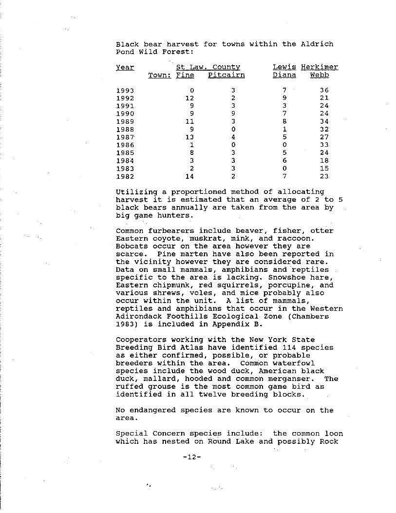
Black bear harvest for towns within the Aldrich Pond Wild Forest:
Year st Law. County Lewis Herkimer Town: Fine Pitcairn Diana Webb
1993 0 3 7 36 1992 12 2 9 21 1991 9 3 3 24 1990 9 9 7 24 1989 11 3 8 34 1988 9 0 1 32 1987' 13 4 5 27 1986 1 0 0 33 1985 8 3 5 24 1984 3 3 6 18 1983 2 3 0 15 1982 14 2 7 23
Utilizing a proportioned method of allocating harvest it is estimated that an average of 2 to 5 black bears annually are taken from the area by big game hunters.
Common furbearers include beaver, fisher, otter Eastern coyote, muskrat, mink, and raccoon. Bobcats occur on the area however they are scarce. Pine marten have also been reported in the vicinity however they are considered rare. Data on small mammals, amphibians and reptiles specific to the area is lacking. Snowshoe hare, Eastern chipmunk, red squirrels, porcupine, and various shrews, voles, and mice probably also occur within the unit. A list of mammals, reptiles and amphibians that occur in the Western Adirondack Foothills Ecological Zone (Chambers 1983) is included in Appendix B.
Cooperators working with the New York State Breeding Bird Atlas have identified 114 species as either conf irrned, possible, or probable breeders within the area. Common waterfowl species include the wood duck, American black duck, mallard, hooded and common merganser. The ruffed grouse is the most common game bird as identified in all twelve breeding blocks.
No endangered species are known to occur on the area.
Special Concern specie~ include: the common loon which has nested on Round Lake and possibly Rock
-12-
'•
Lake, the common raven, and Eastern bluebird. Non breeding adult common loons have also been seen on Streeter Lake and Long Pond.
The red-shouldered hawk is the. only threatened specie identified as possibly nesting on the area. Many additional bird species while not confirmed as breeding utilize the area during migration.
c. Fisheries
Most of the lakes and ponds in the Aldrich Pond Wild Forest support fish life (see Appendix C Lake and Pond Inventory). Brown bullhead is the most common species, present in a least 18 of the area's waters. Brook trout is the most common gamefish species, reported in 15 waters. Four of these (Long, Round, Silver Dawn and Streeter Lakes), obtain their brook trout from annual stocking. Several of the remaining waters have histories of stocking, but are currently supporting natural spawning brook trout populations. other fish species found in the area's waters include native Adirondack species such as white sucker, creek chub, and northern redbelly dace, and non-native species such as yellow perch and golden shiner. A complete f~sh species list is in Appendix c. One of the stocked waters, Streeter Lake (p 285), has a reputation as an excellent trout fishery. It was stocked in the 1930's and through most the 1940's when stocking was terminated. Until recently, the lake's brook trout exhibited good reproductive s~ccess and was managed as a self-sustaining population. Reports of low catch rates due to increased angler pressure led to the initiation of annual stocking in the late 1980's to supplement natural recruitment. At present Streeter Lake is stocked (via truck) with 1,000 fall-fingerling Little Tupper strain brook trout per year.
Round Lake (p 161), Long Lake (p 162) and Silver Dawn Pond (p 154), all remote ponds, offer quality brook trout angling experience within the Aldrich Pond Unit. All are stocked annually. Long Lake is limed periodically to maintain its pH within satisfactory limits. Silver Dawn is proposed for a initial lime treatment in 1995. These waters are stocked via helicopter.
-13-
Star Lake, the largest water in the planning unit (208 acres), has a long history of fishery management. Historically it supported self-sustaining lake and brook trout populations. As of a 1990 survey, its fish community included brown, lake and rainbow trout, rainbow smelt, brown bullhead, pumpkinseed, yellow perch, white sucker, and recently introduced (illegally) small and largemouth bass. The present management strategy includes annual stocking of rainbow trout. Public access is a significant issue on Star Lake at this time. DEC policy dictates that stocking is permitted only in waters open to public access. A small informal fishing access site exists on Star Lake.· Acquisition of a formal site and its development are high pri.ority needs to insure access in the future.
South Creek Lake, a 57 acre waterbody, located on the western boundary of the Main Section, also has a long history of fishery management. Stocking with brook trout as early as 1932 led to its reputation as a productive fishery through the 1960's. Declines in survival and growth of stocked brook trout probably due to expanding populations of competing fish species such as brown bullhead, white sucker and creek chub, precipitated a stocking change to brown trout in 1976. In 1977, brown trout stocking was terminated in favor of establishing a naturally spawning (NSA) largemouth bass population in the lake. This was accomplished by the early 1980's. At present, the lake supports a moderate largemouth bass fishery, along with what appears to be a low density self-sustaining brown trout population. Due to the lack of adequate public access, angler use of the lake is very low. Development of the acce~s road to permit vehicle access to the lake is recommended to expand the potential for public use of the lake's fishery resource.
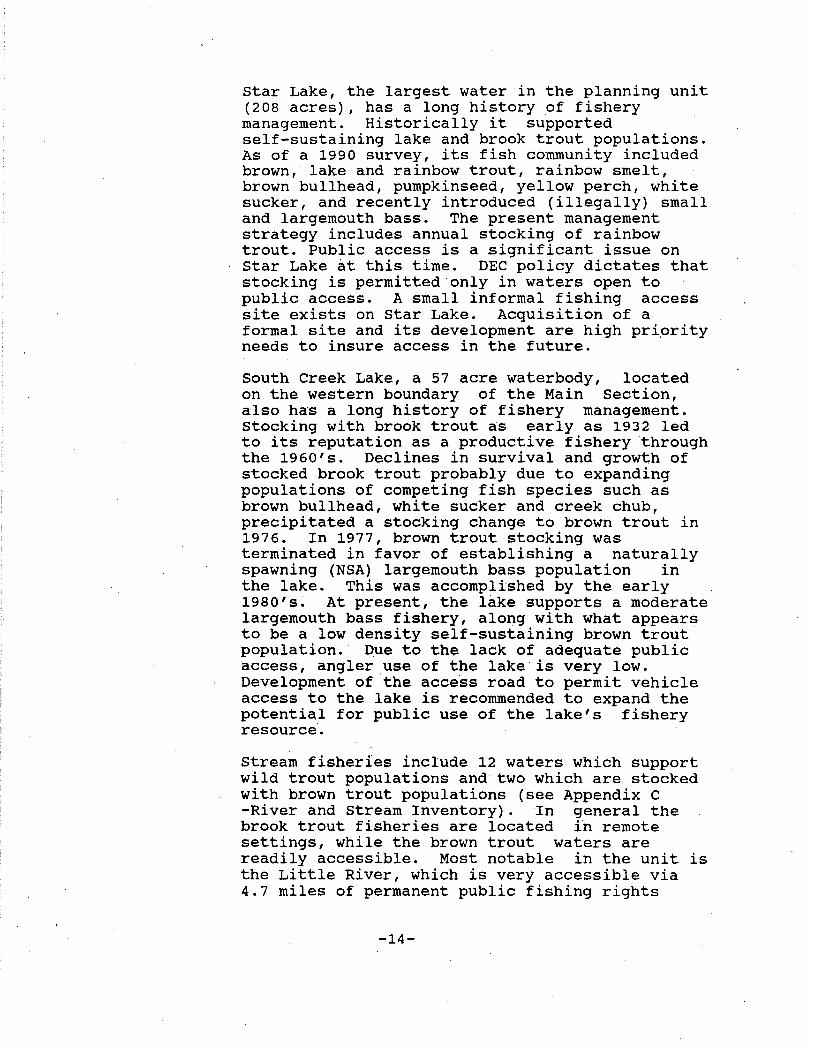
Stream fisheries include 12 waters which support wild trout populations and two which are stocked with brown trout populations (see Appendix c -River and Stream Inventory). In general the brook trout fisheries are located in remote settings, while the brown trout waters are readily accessible. Most notable in the unit is the Little River, which is very accessible via 4.7 miles of permanent public fishing rights
-14-
FISHING RIGHTS LITTLE RIVER and TWIN LAKES OUTLET
c=:::J Fishing Rights
Fishing Access Trail 0
m Fisherman Parking
SUCKER
1/~ 1/2
Miles
.:..
-"" ""' ""'
)
FOREST PRESERVE
""' ""' ""'
""' ""'
""' "
""' ""- ""'
""'- ""'-
15
I 0 Readway n
Pds I
I FOREST \PRESERVE\
\ I
\ \
\ \ \ \ \· I \
\ FORj \PRES.\
\
J-2-92
easement. The lower stretch of the Little River is stocked annually with yearling brown trout, while the upper reaches support a native brook trout population.
3. Visual
Much of the aesthetic appeal of this forest may be attributed to the three rivers which flow through it and the many bodies of water within it. Gulf Stream, at the head of the gorge to the east of the parking lot on the South Creek Lake road, contains some pleasing cascades.
4. unique Areas
Crystal Lake is a very unique body of water. Its watershed is estimated to be only 100 yards from the shoreline with no discernable inlet or outlet. It contains no fish and very little vegetation. The water is clear, acid and warm (74 degrees to a depth of 13 feet as measured on July 26, 1984).
The Adirondack Park State Land Master Plan lists "The Gulf" as a Natural Special Management Area (p. 75). It is presumed that the reference is to The Gulf contained in the main section of this forest. If so, no particular management · activities are proposed at this time.
5. Critical Habitat
None known - the only significant wildlife habitats are the deer wintering areas shown on the Wildlife map and the common loon nesting site on Round Lake.
B. EXISTING FACILITIES
Gates (8) Aldrich South Creek Lake Road South Creek Lake Streeter Lake Youngs Road (4)
Area Signs (6) Middle Branch Corners Lot Luther School District Lot (2) Kalurah
-16- ..

Aldrich Youngs Road
Fishing Access Signs (2) Route 3 Coffins Mills Road
Parking Lots (8) Middle Branch Corners Lot (9 cars} Luther School District Lot (9 cars} South Creek Lake Road (2 cars} Dodds Road (2 cars} Jayville (2 cars} Streeter Lake (4 cars} Youngs Road (9 cars} Schuler Gate (9 cars}
Boundary Lines(49.61 mi.+) Main Section (inc. Lassiter Purchase} Long Lake Lot Luther School District Lot Jenny Lake Lot Twin Lakes Lot Middle Branch Settlement Lot Oswegatchie Easement Lands Hunt Le>t
28.02 mi. 5.28 mi. 8. 69 mi. 2. 03 mi. 1. 36 mi. 4. 23 mi.
Undetermined Undetermined
Bridges (4) Mud Creek (27'} Little River (154'} Bassett's Creek (22'} Tamarack Creek (12'}
Shared Maintenance (4) Dodds Road (22'} South Creek Lk. Rd.(18'-posted 4T} Mink Cree~ (26'} Middle Branch (42'}
Designated Campsites (16) Streeter Lake Road
Leantos Cl} (with pit priyy) Streeter Lake
Pit Privies (2) Intersection of Jackworks Trail and Streeter Lake Road.
Gravel Pits (4) Streeter Lake Lassiter Purchase (3}
Roads - Public Use - Maintained (7.5 miles)
Aldrich to Streeter Lake (Streeter Lake Road}
so. creek Lake Road ROW
-17-
4. 5 mi.
1. 4 mi.

Kalurah ROW (Dodds Road) Jayville to Parking Lot Youngs Road to Parking Lot Middle Branch Corners Lot
1. O mi. . 3 mi. .1 mi. .2 mi.
Roads - Public Use - Restricted Access (16.2 mi.)
For. Cons. Pres. Ease. Total
Tyler Road 3.7 mi. 3.7 mi. Silver Dawn Road (E) • 6 mi.. .5 mi. 1.1 mi. Mullins Flow Road 2.8 mi. .5 mi. 3.3 mi. Shannon Road .8 mi. .8 mi.
.Southeast Corner Road 1. 0 mi. 1. 0 mi. Frenchman's Road .8 mi. .8 mi. Silver Dawn Road (W) .6 mi. • 6 mi. Fish Creek Road .5 mi. .5 mi. Long Lake Road .8 mi. 3.6 mi. 4.4 mi.
10. 5 mi. 5. 7 mi. 16. 2 mi.
Roads - Public Use -Unmaintained (7.9 mi.}
Jackworks Road Maple Hill Road
6. 9 mi. 1. o mi.
Roads,Unimproved-Public Use-Restricted Access (7.5 mi.)
For. Pres.
Shannon Trail Long Lake Trail (S) Long Lake Trail (E) Long Lak.e Trail (W) Tyler Creek Trail Silver Dawn Lake Trail
1. 0 1.2
.1
.5
.1
mi. mi. mi. mi. mi.
Silver Dawn Trail Middle Branch Trail Fish Creek Trail Mink Creek Trail .5 mi.
3. 4 mi.
Roads - Private ROW (9.8 miles} Jayville (assumed) South Creek Lake (assumed) Youngs Road west to private land
(Northern Route) (assumed) Youngs Road west to private land
(Southern Route) (assumed) Aldrich to Schuler Mausoleum
-18-
Cons. Ease.
.9 mi.
2.0 mi. .7 mi. .5 mi.
4.1 mi.
.4 mi.
.4 mi. 1. 6 mi.
1. 2 mi.
6.2 mi.
Roads - Administrative Use Only (6.1 miles) Francis Hill Rd. (Streeter Lake to 6.1 mi.
Bassetts Creek)
Foot Trails (.8 mile) Round Lake Snowmobile Trail Bypass Coffins Mills Fishing Access
Snowmobile Trails (33.5 miles) Aldrich to Kalurah (Round Lake Trail) South Creek Lake Spur Trail Wag·onbox Corner Trail Round Lake Trail to Jackworks
(Jackworks Trail) Jackworks Trail to Middle Branch
(Maple Hill Road) Jackworks Trail to Bossuo.t Camp
(Francis Hill Trail) Youngs Road to Streeter Lake
(Tamarack Creek Trail) Wagonbox Corner Trail
Ski Trail - Advanced (3.0 miles) Lake Road to Streeter Lake (YCC Trail)
(no state maintenance) ·
Public Fishing Rights (7.45 miles) Twin Lakes Outlet Black Creek Little River Sucker Lake Outlet Trib. 12
Repeater Site (1) Panther Mountain (rented)
Private Camps (18)
Herkimer County Lewis County St. Lawrence County
C. CULTURAL
.5 mi. • 3 mi.
10.9 mi. . 6 mi. .9 mi.
6.9 mi.
1. 0 mi.
8.4 mi.
4.2 mi.
.6 mi.
3.0 mi.
1.54 mi. .31 mi.
4.70 mi. .65 mi. .25 mi.
Removal Date
1 6
11 7/1/2000
The cultural value of this forest lies primarily in its use as a resource to aid people in an understanding of the natural world. The existence of the foundation of an old blast furnace in the Jayville area provides a physical link to the activities of our predecessors as well as many relics of the extensive logging history of these lands. The Beahan articles in the bibliography provide an insight into this later activity.
-19-
D. ECONOMIC
The economic significance of this area could be estimated if public usage data were available. Unfortunately, the types and the pattern of use on this area do not lend themselves to the accumulation of such data without significant expenditure.
A more easily identified economic factor is the annual tax bill which amounted to $139,043.38 or $6.51/acre for the 1986 school tax and the 1987 town and county tax year on 21,348.2 acres of this forest in st. Lawrence and Lewis counties. This figure has not been updated because it is only being used as a general indication of part of the annual cost of public ownership.
1. Impact of State Ownership on Adjacent Private Lands
An abundance of hunting camps in Kalurah, Jayville and Aldrich bear testimony to the value of small lots adjacent to large areas of public lands, especially when public access is restricted. It is doubtful if many of these camps would have been built had not the public lands been available. The impact on the local tax base is significant for lots that would otherwise be taxed as woodlands. An Adirondack landowner survey (Kay 1985) has determined that "proximity" to state owned Forest Preserve.can boost the value of single family homes by almost $6,000 from the median, and by $2,000 for parcels without the homes."
2. Impact of Adjacent Private Lands on State Lands
The economic impact of adjacent private lands is concerned with increasing demands for amenities, especially snowmobile and ATV trails, and with an increasing need for law enforcement to prevent incidences of trespass.
E. PUBLIC USE OF THE AREA
The primary public use of this area is hunting, with fishing, trapping.and snowmobiling also being common. Skiing, camping, hiking and horseback riding are currently minor activities with the exception of camping throughout the hunting season which is very popular.
1. Hunting
Aldrich Pond Wild Forest: Public hunting on that portion of the Main Section described as the Lassister Purchase (5,131 acres), is not permitted
-20-'•
during the period of September 1 thru December 31 of each year through and including December 31, 1999.
Oswegatchie Easement Lands: Public hunting on the Oswegatchie Easement Lands is not permitted during the period September 1 thru December 31 of each year through and including December 31, 2019.
While public hunting is permitted throughout the season on the remaining public lands it has historically been limited by poor access. The Pinehill Marsh and Jenny Lake lots are blocked by private ·1ands while the Long Lake Lot has awkward foot access through the yard of a private camp and the Hunt Lot must first be located with a survey. The main section has poor to nonexistent public . access at Kalurah and 1,300 inaccessible acres north of the Little River.
Seasonal deer hunting camps have been established on the main section for many years. They are permitted and must be removed at the end of the season. These camps are most prevalent along the corridors of public motorized use; however, an unique situation
· exists along the Francis Hill Road where hunters bring in their camping gear with horses or hand carts and must often rely on snowmobiles for removal.
As town snowplowing does not extend beyond Aldrich and Kalurah, two of the primary access corridors to the main section can be effectiv~ly denied to hunters after heavy snowfalls.
2. Fishing
Quantitative data relative to angler use of the fisheries resource specifically within the Aldrich Pond Wild Forest is limited at this time. Based on aerial counts angler use of Long and Round Lakes was estimated at 3.5 angler trips per acre per year (91
·trips total) and 2.6 angler trips per acre per year (2.3 total)·, respectively (Gordon 1993). Applying these estimates to all the unit's brook trout ponds suggests they support 1,600 angler days of recreation per year. Based on Pfeiffer's (1979) estimate that Adirondack brook trout ponds generally provide ten angler trips per acre per year, the use estimate for the Aldrich Pond Unit's brook trout ponds increases to approximately 3,000 angler days per year. In either case, use is low and generally concentrated during the months of April# May, June and September when brook trout pond fishing is traditionally the
-21-

most productive. Star Lake's coldwater and warmwater fisheries support approximately 2,000 angler days per year. The bulk of the use of Star Lake occurs during the spring and summer months, but a considerable amount of effort is expended at ice-fishing. Star Lake is one of five lakes in Region 6 where ice fishing for salmonids is permitted.
Generally, streams in the area receive light angler use. Some of the remote waters are fished at very low levels, while accessible waters such as the public f i9hing rights (PFR) section of the Little River, are fished at moderate levels. A small section of Twin Lakes outlet is also open to public fishing through PFR agreement.
Two privately owned waters, Twin Lakes (p 267-268) and sucker Lake (p 274) provided angling opportunity in the past· via Fish and Wildlife Management Act (FWMA} public access agreements. While open to the public they were intensively managed, and supported noteworthy trout fisheries. The need for public access to these waters is being pursued. Star Lake, also privately owned, has also experienced problems with public access. DEC management (i.~. stocking) will continue only with the presence of adequate public access to the lake. Acquisition and development of permanent fishing access to Star Lake will be addressed within the five year period of this plan.
3. Camping
Most of the camping on this area occurs during the hunting season and much of this is along the Streeter Lake Road. Sixteen campsites have been designated along this corridor and two pit privies established to accommodate this use. During the 1990 hunting season, 26 camping.permits were issued for this forest for 118 persons as follows:
Streeter Lake Road Jackworks Trail Scuttle Hole Other
-22-
Permits
13 3 3 1
26
Persons
47 23 17 31
118

These figures obviously do not represent the total hunting use of the area, but merely serve to show the general distribution of hunter camping in 1990.
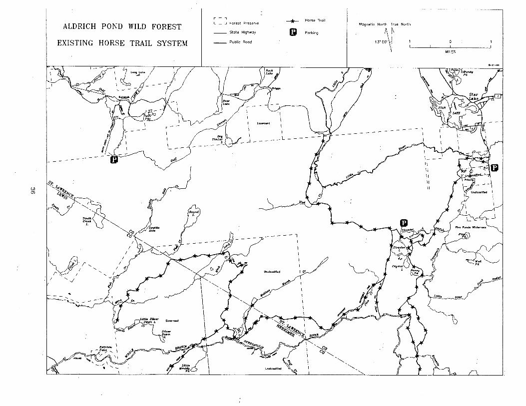
4. Horse Trails
All trails on forest preserve and easement lands within this area except the Round Lake Snowmobile Trail Bypass (foot trail) may be utilized by horseback riders although they might not be desirable for such use. In the 1960's the road system on the main section was included in the department's horse trail brochure, but this resulted in little use. Although this area has been deleted from the present horse trail brochure, horseback use has increased in recent years. The primary reason for this increased use was the purchase of access from the Youngs Road which opened up a significant addition of usable trail and provided good road access with parking.
5. Bicycle Trails
As there are no significant foot trails within this forest, virtually all roads and trails have been available for bicycle use.
6. Snowmobile Trails
The ·snowmobile trail system on this area presently links the communities of Star Lake, Aldrich, Kalurah and Harrisville. Although the trail south of Bassetts Creek ends before reaching a corner of the Five Ponds Wilderness Area, some illegal crossings of this wilderness and the Middle Branch result in a route to Belfort. This problem will likely be rectified by the discontinuance of department maintenance south of Bassett's Creek.
7. All Terrain Vehicles
Pending the development of a department policy and/or appropriate rules and regulations, all terrain vehicles have been allowed to use all roads open for public motorized use.
8. Day Use Area
Because of the warm water and sandy beach at crystal Lake, it has become a popular swimming area. The overuse of the limited space at this beach by a large group of campers in July 1993 underscored the need to manage it as a day use area only so that campers
-23-
could not restrict this established use. To encourage the transition, mowing will cease and appropriate signs will be placed.
F. CAPACITY OF THE RESOURCE TO WITHSTAND USE
overall public use of this area is very light and within the limits of the environment to absorb it as evidenced by physical inspection and user feedback. The heaviest use is seasonal (hunting) and occurs along the corridors of public motorized access, generally within 1 to 1 1/2 miles of the roadside. Although an improvement of this access might initially result in increased use, anticipated pressure on the environment should be alleviated through the development of designated campsites and better distribution of users throughout the area.
Recent survey data provides no evidence to suggest over-fishing is a problem with any of the waters in the Aldrich Pond unit (Gordon 1993). In general fishing pressure is light, especially on the area's streams which are capable of supporting increased angler use.
III. MANAGEMENT AND POLICY
A. PAST MANAGEMENT
The initial management of the lands comprising this forest is illustrated in J. Y. McClintock's field inspection of the Luther School District and Pinehill Marsh Lots in 1900 (Appendix E) . (;r'adually, as boundary lines were established, the protection of these lands became more feasible and a long period of custodial management eyolved.
Probably the earliest ~isheries management practice on the forest preserve lands was the stocking of 7,000 brook trout in Streeter Lake in 1929. Although discontinued in this body of water in 1940, stocking has continued to be an active practice on other bodies of water within this forest.
Besides stocking, regulations have been the most notable past fisheries management strategy in the Aldrich Pond Wild Forest. Within the area, Statewide Angling Regulations apply at this time. By species, these are as follows:
-24-

Open Min. Daily Season Length Limit
Trout (brook & brown) 4/1-9/30 none 10
Largemouth & Smallmouth 3rd Sat. 12 II 5 bass in June-
Nov. 30 Bullhead, yellow perch All year none any #
The exception to the above is Star.Lake, where trout fishing is allowed'all year (including ice fishing) by special regulation. Lake trout must be at least 21 inches to be creeled, while other trout species must be at least nine inches.
Public use management became active in the 1960's primarily with an effort to improve public access (see Appendix D) and the designation and maintenance of snowmobile and horse trails.
B. RELATIONSHIP OF MANAGEMENT OF AREA TO ADJACENT STATE LANDS
Adjacent to the eastern boundary of the main section of this forest is the 106,547 acre Five Ponds Wilderness Area. In the development of the initial unit management plan for that area (July, 1986), five types of users were examined in respect to their relationship 'to wilderness management. The fifth group was identified as "those who go into the wilderness primarily·as a social excursion seeking the company of others and facilities where they might congregate." It was determined that users within this classification "are not seeking wilderness or the experience of it" and that "their needs are primarily being addressed in the present management of the adjacent Cranberry Lake Wild Forest, Aldrich Pond Wild Forest and Independen6e River Wild Forest." Most of the ·1ands to the south of the main section are unclassified Forest Preserve lands. The effect of the management of this forest on these lands is dependent on their eventual ~lassif ication.
C. ADMINISTRATION OF CONSERVATION EASEMENTS
Department policy .NR90-1 (Appendix H) establishes responsibility and procedures necessary for the proper administration of conservation easement lands. When implemented, the annual reports for the Oswegatchie Easement Lands will be appended to this plan.
-25-
D. ISSUES AFFECTING THE PLANNING AREA
The following issues must be addressed within the five year period of this plan to provide adequate management of this forest:
1. Wild, Scenic and Recreational Rivers Act
The designation of a significant portion of the Middle Branch of the Oswegatchie River as a wild 'river under the Wild, Scenic and Recreational Rivers Act (Appendix L} in 1975 obligated the department to take measures to protect and enhance its wild character. The one half mile river area generally required by the Wild, Scenic and Recreational Rivers Act, and the one quart.er mile minimum river area required by the Adirondack Park State Land Master Plan (Appendix M) affect the following roads within this forest:·
a. Francis Hill Road (6.1 mi.) Streeter Lake gate to the clearing south of Bassetts Creek. Two branches near Francis Hill converging north of Bassetts Creek.
History -The 1918 topographic map shows only the western
branch generally following the present route to the former site of Bossuot's Camp and continuing southerly across the Middle Branch as a trail.
-state purchase of the property in 1975 yielded. essentially the same road system as presently exists. No major renovations have been undertaken.
Present Status -Administrative Use (2 WD) -Lightly used horse trail beyond the end of the road, across the Middle Branch to other state lands.
-Lightly used snowmobile trail to former Bossuot's Camp.
-Designated for motorized use for disabled persons.
Condition -Gravel base; very good condition.
Maintenance -since purchase in 1975, has only been graveled.in areas of beaver damage. Is mowed and brushed.
-26-

Unigue Uses -Designated in 1990, but not yet used, as a motor vehicle trail for disabled persons. (see Policy Statement in Appendix I) . Good condition of roadbed, light use and good accessibility make this a very good candidate for this use.
-Shortened access to Cage Lake by bicycling to the end of the road and bush-wacking to the lake.
-Seasonal hunting camps established by use of horses or hand carts. These must usually be removed at the end of the season with snowmobiles.
-Has been used as a release area for trapped bears.·
b. Jackworks Road (4.0 mi.) -Streeter Lake Roaq southwesterly to Lassiter Purchase.
History ~The 1918 topographic map shows the road as a railroad to the Jackworks and continuing as an unimproved road to the present Lassiter purchase.
-In 1922 the Railroad was abandoned and the tracks removed. (Kudish 1985) •
. -In 1924 the state purchased the lands.
Present status -Public motorized use (4 WD, ATV). -Snowmobile trail.
Condition -Typical railroad bed; no ditching, 3 foot ruts in places with old ties buried between them; several waterholes; only one of the three crossings of Pins Creek is bridged. Pins Creek swells in periods of heavy runoff to flood a good portion of the road.
Maintenance -No maintenance on roadbed. Only brushed out for
snowmobile use. Users have patched it up.
Unigue Uses -This is the only legal public motorized access to the 16.2 miles of gravel roads and 7.5 miles of access trails on the Lassiter Purchase and Oswegatchie Easement Lands except when canoeing.
-Seasonal hunting camps established by use of 4WD vehicles.
-The open vistas provide a scenic snowmobile route.
-27-

c. Maple Hill Road (1.0 mi.) -Jackworks Road southerly to Middle Branch.
History -Does not show on any maps. Probably a logging road used prior to the 1924 purchase.
Present Status -Public motorized use (4 WD, ATV}. -snowmobile trail.
Condition -several deep mudholes, heavy rutting, steep descent to river.
Maintenance -Brushed out mostly by users.
Unique Use -Two seasonal hunting camps established on and across the Middle Branch by use of motorized vehicles and rowboats.
d. Southeast Corner Road (1.0)
History -Logging road probably built by Diamond Match
Company in the early 60's.
Present Status -Public motorized use (2 WD, ATV}.
Condition -Good base. Could use some brushing.
Maintenance -Not yet initiated by department.
Unique Use -Possible route of egress for'canoeists from the river.
The plan management measures proposed reflect continuing motor vehicle access to a handful of long standing hunting campsites well within the 1/4 mile wild river corridor. This motorized access conflicts both with the Wild, Scenic and Recreational Rivers Act and the State Land Master Plan. These management measures reduce the existing degree of motorized access into and through the River Corridor and insure against any new motorized intrusions.
-28-
In the absence of a change of at least a portion of · the current river classification from "Wild" to "Scenic" (which raises an important policy question and would require legislative action), motor vehicle access into the River Corridor must be phased out. Fortunately, alternate campsites do exist at points just beyond the 1/4 mile River Corridor.
The issue of possible reclassification of a portion of the River Corridor can best be addressed in connection with the examination, now underway, of the appropriate delineation of the western boundary of the Five Ponds Wilderness Area in light of recent State purchases of new land both in fee and by way of conservation easement. In the meantime, the following protective measures will be undertaken: ·
(a) Francis Hill Road
The westerly branch will be barricaded at its northern juncture and 150 yards from its southern juncture. Maintenance of this segment will cease. The remaining branch will continue to be used as presently used.
(b) Jackworks Road
This will be gated at' the third crossing of Pins Creek. Permits will only be issued for the present campsite and no new motorized accessible campsites will be permitted beyond this gate. Permittees will be given a key to the gate. Permanent barriers .will be established at this campsite and at the western inte.rsection of the Jackworks Road with the new Pins creek Trail.
These restrictions will not be initiated until ATV access along the new Wagonbox Corner Trail is assured. This will provide for uninterrupted motorized access to the Lassiter Purchase.
(c) Maple Hill Road
This will be barricaded approximately 100 yards from the river at the present road intersection with the campsite to the east. The road to this site will be relocated by the Department to be further from the river than it presently is. The number of camping permits for sites in this vicinity within 1/4 mile of the river will be limited to the two existing sites This road will be gated 1/4 mile from the river with keys given to permittees utilizing these sites.
-29-
(d) Southeast Corner Road
This will be retained as a motor vehicle possible means of egress from the river. for a foot trail to accommodate this use investigated.
road as a The need
will be
2. All Terrain and Motor Vehicle Use
The rules for operation of all terrain vehicles (ATV's) are contained in Article 48C of the Motor Vehicle Law (Appendix F). As section 2403.2 of that law requires the designation and posting of public lands av~ilable for the use of these vehicles, past management of this area has been undertaken with the assumption that the following routes, posted for public motorized use, have conformed with the requirements of the law:
Streeter Lake Road 4.5 mi. South Creek Lake Rd. ROW 1.4 mi. Kalurah ROW (Dodds Rd~) 1. 0 mi. Jayville to Parking Lot . 3 mi. Youngs Rd. to Parking Lot . 1 mi. Jackworks Road 6.9 mi. Maple Hill Road 1. 0 mi.
15.2 mi.
To allow existing motorized uses to continue on the Lassiter Purchase and Oswegatchie Easement Lands the following roads and trails have also been posted:
Lassiter Purchase
Tyler Road 3.7 mi. Silver Dawn Rd. (E) .• 6 mi. Mullins Flow Rd. 2.8 mi. Shannon Rd. .8 mi. Southeast Cor. Rd. 1. 0 mi. Frenchman's Road .8 mi. Silver Dawn Rd. (W) Long Lake Road 1.8 mi. Shannon Trail 1. 0 mi. Long Lake Trail(S) 1.2 mi. Long Lake Trail(E) .1 mi. Long Lake Trail(W) .5 mi. Tyler Creek Trail .1 mi. Silver Dawn Lake Tr. Silver Dawn Trail
-30-
Oswegatchie Easement
• 5 mi. . 5 mi.
• 6 mi. 3.6 mi.
.9 mi. 2. o mi.
UJ
ALDRICH POND WILD FOREST
PUBLIC MOTOR VEHICLE AND ATV ACCESS
~~<r
r,
~·
I
EXISTING
--11--- Existing Public Motor Vehicle Access
--@--- Existing Public ATV Access
--@--- Existing Public 4 WD Access
--@--- Existing Handicapped Public ATV Access
0 Existing Parking Lot .... Existing Gate ... Existing Barricade
- :-\ _,..... ___ ~
- - -1-
- 1
F
\ ~ ® t·---·---.) __ ·---·--·-+-,
N E ~ /fstreGt•r
L
'
~ ~
If; l " ~ ti; l
~ ' ,;;>( < ' = ~ ,
@Jft ok ,1:_ , / @,
' / ~ ~~
®,
I I I I - ,,:_' J
i-1--" 11 11 11
'1 \j---------/'
~ (
' r1> "--, C'o
~-'-.... "~~·
'?,;;.
ott~,.
Fish Creek Trail Middle Branch Trail Mink Creek Trail .5 mi.
14. 9 mi.
.5 mi.
.7 mi.
9.3 mi.
At the public meeting concerning the draft of this plan considerable testimony and a petition were presented in support of more ATV routes. These additional 24.2 miles of roads and trails will more than double the mileage available for this use without disrupting other established uses. However, the Jackworks Road is presently the only existing motorized link to ·this network without the access for canoeing purpoi~s only stipulation necessary for use of the Bryants Bridge {Mullins Flow) Road. The loss of this road necessitates designation of the Wagonbox Corner Trail as an ATV trail to ensure continued ATV use of this resource.
Presently, the legality of this action is being questioned and department policy to allow conformance with the law is being addressed. Until such time as this policy is developed, management of this area will assume that these trails are legally posted. If further actions are deemed necessary to allow the continuation of this use, they will be undertaken as appropriate .
.. 3. Access
As previously addressed in section I A4 (p. 5) public access to this forest continues to be a problem of major importance which can be significantly reduced only .. by major road construction and acquisition. (Refer to Motor Vehicle Access Map).
Of particular importance is the improvement of public motorized access to the extensive road network on the Lassiter Purchase and Oswegatchie Easement Lands. Although ATV access will be provided by the new Wagonbox Corner Trail,. vehicular access will also be necessary to the Lassister Purchase Lands to allow for the continuation of traditional seasonal hunting camps when the hunting rights become public in the year 2000. To accomplish this, the department will attempt to purchase unrestricted motorized vehicle access from Bryants Bridge and will construct a one mile access road (Bald Mtn. Rd. Ext.) across conservation easement lands to the south. Construction of this road will likely begin in the
-32-

BALD MOUNTAIN ROAD
summer of 1994. Other projects necessary for the development of this resource include upgrading the Silver Dawn and Long Lake trails, construction of the Scuttle Hole Snowmobile/ATV Trail and rehabilitation of the South Creek Lake Road to the Scuttle Hole. The feasibility of extending the South Creek Lake Road into the Oswegatchie Easement Lands will be investigated for consideration in the next revision of this plan.
4. Trespass
Past incidences of tree theft are evident in the vicinity _of South Creek Lake. In the vicinity of Aldrich, an illegal road was constructed across forest preserve in 1989 to reach a landlocked private parcel, forest preserve· signs have been systematically removed by vandals and at least one person has been offered a camp lot for sale on forest preserve.
In past years both gates at South Creek Lake have been damaged to allow for illegal motorized use and the theft of firewood. Illegal ATV use is most prevalent in the vicinity of the Youngs Road; however, an illegal ATV trail is also used from the vicinity of private camps at the end of the Dodds Road to the vicinity of The Gulf.
5. Canoe Routes
During periods of relatively high water, the Little River is canoeable from the Youngs Road to Aldrich. However, a waterfall necessitates a carry across private lands. Acquisition of this parcel is essential to ensure public use of the route. Also canoeable during such periods are various stretches of the Middle Branch. The Windt (1987) reference describes an ambitious trip on this river beginning at Wanakena. The river is more readily accessed by the Long Pond Road from Belfort which is gated near the beginning of the wild river segment where the canoe route begins. This route could continue to the end of the wild river segment on the Lassiter Purchase where the Southeast Corner Road is available. Shorter segments downstream may also be canoeable as public motorized access to the Lassiter Purchase is available for this purpose. A more detailed description of this river may be found in Jamieson and Morris, 1991.
-34-
6. Survey Needs
Surveys of the Hunt Lot, Middle Branch Corners Lot and Lassiter Purchase are necessary to allow for responsible management and to alleviate potential trespass problems. Also necessary is a more aggressive boundary line maintenance program, especially in the vicinity of Aldrich and South Creek Lake.
7. Horse Trails
Presently, an extensive network of trails usable by horses exists because of the existence of the road system south of Streeter Lake which crosses the Middle Branch at the Copperbolt Corner. The discontinuance of Department maintenance on the trail south of Bassett's Creek will cause it to be eventually lost for this use unless volunteer help keeps it open. By that time, an alternate network should be established through the construction of the new.Wagonbox Corner Snowmobile/Horse/ATV Trail. With a new parking lot on the Streeter Lake Road, this trail will provide a vital link with the extensive road network on the Lassiter Purchase lands.
8. Snowmobile Trails
The Round Lake Snowmobile Trail necessitates a dangerous crossing of Round Lake which also curtails use of the trail before and after adequate· ice is present. The relocation of this route southerly across the Lassiter Purchase and Oswegatchie Easement Lands would alleviate both of these problems as well as reduce trail maintenance.
The maintenance of a trail spur ending at the state boundary· west of the Little River bridge serves no useful purpose and actually encourages illegal ATV use of the ski bridge.
The establishment of the deadend trail south of Bassetts Creek serves little snowmobile use except to encourage illegal continuation across wilderness. The entire trail system south of Streeter Lake is very lightly used.
The Jackworks Trail can no longer be used as a through route because it comes within the corridor of the wild river portion of the Middle Branch.
-35-
Gl Ol
ALDRICH POND
EXISTING HORSE
"'~
·v . "I V I ......, '....._
/'' I ' I '.J
~
WILD FOREST
TRAIL SYSTEM
r - ,
L ..J Forest Preserve --*--State Highway 0 Public Rood
EoHm«tl I I
- _ L
----- 1
UncSo••tn.d
y._of.I',
Horse Trail Magnetic North True North
Parking .J{ 0 1
MILES
$-21-94
\
- - - -
I c<.
~I!"-~ ...
Ott..,.
''-..... '-.....

(;J -..:i
":-..,,
ALDRICH POND WILD FOREST
EXISTING SNOWMOBILE TRAIL SYSTEM
---
v v
J>, I ' V I ',
/'' I ..._
I '.J
... ' - -
r - ,
L _ J Forest Preserve __._ Snowmobile Trail
Magnetic North True North
,J{ I 0 1
t.41LES
m Parking State Highway
Public Rood
(OHnMftl
\ \ \
- ..J - - - - _ l.-- - - -
Uncl1H•m.d I c<.
i..t ~ ...
ou..r
'-.__
'-.__
The northernmost part of the essential Wagonbox Corner Trail crosses a wide beaver swamp. Maintenance of this trail allows snowmobile use but ATV and horse use are impossible.
9. Streeter Lake Road
This "road" is a former railroad bed in severe need of upgrading to provide an all weather base, proper surf ace runoff and a maintainable surf ace so that annual maintenance costs can be reduced. It presently has to be gated at Aldrich in the spring to keep vehicles from sinking into a quagmire when the frost goes out. This presents a major problem for trout fishermen and trappers.
The town bridge crossing the Little River at Aldrich is posted for 4 tons which effectively stops town snowplowing at that point. This limit also severely curtails the ability of DEC crews to work on the road, especially in the hauling of gravel or concrete. Consequently, a major overhaul of this road would necessitate heavy use of the existing gravel pit east of Streeter Lake. The wooden bridge across Mud Creek is dangerous and in need of immediate replacement even though it is presently posted for 7 tons. In 1988, a horse trailer broke through it and sufficient funds have never been available to do more than patch it.
10. Private Access Rights
The. assumed private rights of way shown on the private motor vehicle rights of way map have been used traditionally for motorized access to the respective private .lands. This use will continue to be honored as long as legally possible.
E. GOALS AND OBJECTIVES
1. Goals
a. Protect the natural wild forest setting.
b. Provide a variety of outdoor recreation opportunities without degrading the resource or impairing the wild forest atmosphere.
2. Objectives
-38-
c..:> co
ALDRICH POND --@--- Private Right of Way
WILD FOREST PRIVATE MOTOR VEHICLE
RIGHTS OF WAY
--@--- Private Right of Woy (assumed)
ii,-::1 f ' ' ' , ' _, ,.-//
_-\,~ '
'
\ ,..//\\
, ' <" / ' ,
' ' \
~'~-4-lf-/}~-~:
I I
C'o
c
I 't5 ( \ lf E B B ($'--.,
~-r&;W:..-~--. $ " I r;;' I '
Silvor I ~' Daum I ,$' fil
L. SIL""' l / ~o• "'° -,
l ------
i
--1---
Unclosslfled
' ' $ :
~ ,-1/1
' ' // ~ : k_14.d \.
1. I
I·
F
Magnetic North True
»OO~
--®--. ~
' $ '--8---%--~-
-~---%---1!1-\g\
....... ___ ,
N E
... -·
;:,>-//~ ,
' ' ' ' ' . : l(stre.teri L
/; ' ' ' '
j ,-" ' ._,..,.. ! I
j',./"" ,../ i , ' ' ' , ' / c< ; ./
/ !I /,..... ./" : ,,-<\ I~ \ ,/ \,
,J \\ /' \ .. _\ _,, I f \
' ' ' ~~~~ '
' '
/"' \ ,..""
'\ @,,_ fil.~~f r,, ~ -~S ,.._,,,._ .. q ~ "!;I--=-} . ,.,,. ~~
./~ "'-~ C'o ,"'- '
North
0
MILES &-2•-94
~.l
ott~.,.
a. Land Management Objectives
1. Maintain all boundary lines to clearly identify public ownership.
2. Selectively acquire additional lands contiguous to the unit which will consolidate the state's holdings, simplify boundary lines, improve access and otherwise enhance the parcels. ·
3. "Adequately protect the unit from wild fire.
4. Eliminate non-conforming, man-made facilities ·· and incompatible uses which detract from the wild forest character of the unit.
5. Maintain and construct facilities (trails, parking areas, etc.) in conformance with DEC specifications and policies.
b. Wildlife Management Objectives
1. Maintain all native wildlife species at levels compatible with their natural .environment.
2. Maintain hunting, trapping and other wildlife-related recreational activities.
3. Improve access and provide additional parking for the above users. ·
4. Promote recreational use of the area by development of an Informational Brochure that (at least) identifies: ·access points, trails, attributes, regulations, etc.
5. Update the Inventory of Natural Heritage, Significant Habitats, Endangered, Threatened, and Special Concern Species on the recent acquisitions, and easement lands.
c. Fisheries Management Objectives
1. Perpetuate fish as part of the Adirondack environment.
Manage fish so that their numbers and occurrences ar~ compatible with their habitat and the public interest.
-40-
..

Maintain resource inventories for all waters.
2. Provide optimum opportunity for enjoyment and beneficial utilization of the fish resource by the user.
Continue to maintain trout populations by annual stocking in suitable ponds and monitor NSA waters through periodic surveys.
Maintain satisfactory pH of ponds as indicated for optimum fishery development, consistent with DEC liming policy.
Maintain balanced native fish populations in selected waters, as indicated by biological survey data, by reclamation, consistent with DEC policy.
d. Public Use Management Objectives
1 .. Provide for a variety of recreational pursuits that are compatible with the spirit of the wild forest concept as enumerated in the State Land Master Plan.
Encourage increased public use of this· forest by persons seeking amenities to compensate for the reduction in amenities in the Five Ponds Wilderness Area to the east of this forest. ·
Initiate an educational effort to keep the public abreast of the values, limitations and opportunities available in this forest. Trailhead information booths will be provided as necessary to accomplish this as well as a trail map similar to the "Trails of the Cranberry Lake Region" to the east.
2. Make public use of this forest as safe, enjoyable and nondestructive ·to the forest ecosystem as possible.
- Restrict camping in accordance with the rules and regulations, the State Land Master Plan and DEC policy, including the enforcement of ~he permit system.
-41-
Expand the campsite designation system.
Protect, maintain and improve long term motor vehicle access.
e. Water Quality Management Objectives
Reduce the direct impact of human activities on water quality by improving user awareness of the effect of polluting activities in appropriate communications, especially. in personal contacts with department personnel.
IV. PROJECTED USE AND MANAGEMENT PROPOSED
A. FACILITIES DEVELOPMENT AND/OR REMOVAL
1. Develop a .6 mile section of snowmobile/horse/ATV/ bike trail connecting the Streeter Lake Road with the Wagonbox corner Trail south of Mud Creek. This is necessary to maintain this essential trail without the difficult crossing of Mud Creek presently being used and to allow for the use of this trail by horses and ATV's. A parking lot to accommodate horse. trailers will be constructed at campsite #5 on the Streeter Lake Road. (Note: If further field investigation reveals a trail/parking lot location closer to Streeter Lak.e which will cause .less environmental disruption, it will be used instead).
2. Develop a 1 mile road connecting the Bald Mountain Road and the Mullins Pond Road (Bald Mountain Road Extension) •
3. Upgrade the Silver Dawn Trail (2 miles) and the Long Lake Trail (1.2 miles) to ensure a loop snowmobile/horse/ATV/bike route.
4. Phase out the ski trail. This trail was constructed by the Youth Conservation Corps in the late 1970's and has never been maintained. It is too dif.f icult for most skiers, lacks reasonable parking and necessitates an expensive 154 foot bridge across the Little River. In contrast, the snowmobile trail leading from the Youngs Road is more ·easily skied, is not heavily used by snowmobilers, has good parking and contains a much less expensive twelve-foot bridge across Tamarack Creek. Phaseout will consist of the immediate removal of the wooden sign on Lake Road and the removal of the bridge over the Little River.
-42-
""' (.J
ALDRICH POND WILD FOREST
PROPOSED HORSE TRAIL SYSTEM
~:...~ \ I~~~ !
":,
Iv v iJ: I'
~ I '' /'-.....::. I '
I '.J
.. ' - -
Rcrinl>-.i
I I
. ;/· ~~q.
r L
-, .J Forest Preserve
State Highway
Public Rood
co .. rnent'
__J
\ \
_L
--*--~
U"c.ki••lfkld
.e."·
Horse Trail
Parking
I c<.
"'-
Magnetic North True North
.J{
. i
{' -,
~~-~ I
"'-
'¥., \
I i{
I
0 1
MILES
•-22-14
~.t <>'!!"'
.....

A 10.3 mile ski trail system is presently being constructed on the Cranberry Lake Wild Forest in the vicinity of Peavine swamp.
5. Abandon the .6 mile snowmobile tra~l segment leading to the Little River bridge (Little River Spur).
6. Abandon the .5 mile foot trail bypassing the Round Lake Snowmobile Trail. Improved motorized access to South Creek Lake will provide closer access to Round Lake from the west to diminish the need to maintain this lightly used trail.
7. Abandon the Round Lake Snowmobile Trail. Convert the resulting 1.6 mile deadend trail to the west of Round Lake to a foot trail. Maintenance of this lightly used trail crossing a body of water (Round . Lake) is both too expensive for the benefits derived and too dangerous. Limited maintenance staff should be utilized on more heavily used trails.
· 8. Cons.truct a 1. 7 mile snowmobile/ATV /horse/bike trail from the Scuttle Hole southeasterly to connect with the existing log road network on the Oswegatchie Easement Lands (Scuttle Hole Trail). ·
9. The Jac~works Road and Shannon Trail wiil be joined by volunteers with a 1.5 mile snowmobile/ATV trail segment to form the Pins Creek Trail.
10. Construct a pit privy and picnic table at Crystal Lake.
B. MAINTENANCE AND REHABILITATION OF FACILITIES
1. Rehabilitate the Streeter Lake Road. Because of its dangerous condition the Mud Creek bridge will be replaced first. The Schuler gate will be removed to allow for expanded parking and adjacent campsites and parking areas will be resurfaced as necessary. The gate at Aldrich will no longer be needed and will be removed.
2. Rehabilitate the South Creek Lake Road to the Scuttle Hole (4.0 miles) and the right-of-way· along the Dodds Road(l.O mile). A cartop boat launch will be established at South Creek Lake with parking for nine cars and parking lots will be provided at the end of both roads.
3. Rehabilitate the road and parking lot at Jayville to accommodate six cars and gate the road at the
-44-

... (J1
ALDRICH POND WILD
PROPOSED SNOWMOBILE TRAIL
§'I>.~. ,,..,~
'};_,._~,,,(' ... ....,.~~,_____..
"'~ <:-,
'V v J' /''
· V I ' I',. I
I '.J
.. ' - -
IJ
I
I I <f
FOREST
SYSTEM
r L
, Snowmobile Trail
.J Fore$t Preserve ---o--- Magnetic North True North
State Highway
Public Rood
\
I ..J
[OHITl«lt \ \
~
_ L - - -
1 I
Parking
Undoulfl.t I Ct'.
*.&
.J{
___ ,
' ~ -·~·~{ : ~ I ~,-
~,,- I Clf(lK .?-----1 ~ ( '- ., . ____ ,e ~ ,_
.... 1 , ' .,.. ,.;;:,.. ---.,,, ~-------- ';;, 1r .•tr ·e--, "-----~ I v .., {
""-- \. (j}r-~Rf' ~ ...
• {.!! '-,...0: . ', \ .V 4~~~~. I ', ;l-7 . ~~~"'(' \ ~
_,' ~-~ ( , I I
,-" I
¢ ~ ~
0 1
"41LES
f-22-'4
~~ a<!!."''
octrr
railroad tracks to protect the historic blast furnace.
4. Computerize boundary line maintenance records, post all lines and identify needed surveys~
5. Should debris left by the public on the Oswegatchie Easement Lands become significant, the owner and the department will meet to determine steps to alleviate the problem in accordance with their deeded obligations.
C. PUBLIC USE MANAGEMENT·
1. Expand the designated campsite system as necessary to minimize the detrimental effects of indiscriminate campsite use and to allow for administrative recordkeeping necessary for further evaluations.
2. Include the road system on the Lassiter Purchase lands in the existing snowmobile trail system. The Wagonbox Corner Trail is the only remaining connector to these lands, making its upgrading.of paramount importance.
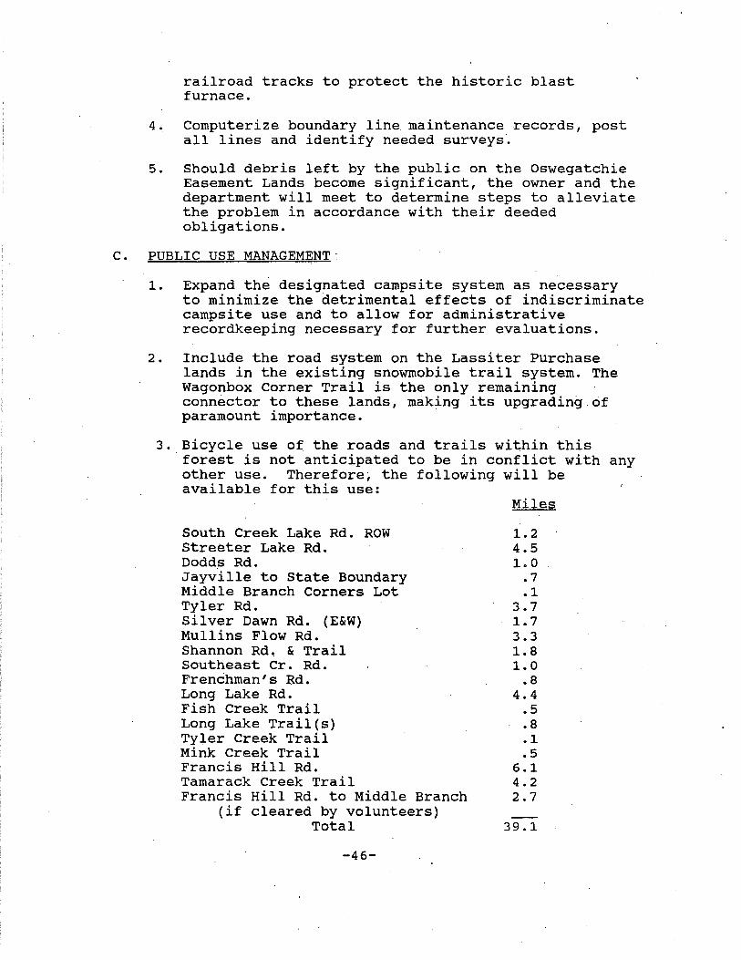
3. Bicycle use of the roads and trails within this forest is not anticipated to be in conflict with any otner use. Therefore; the following will be available for this use:
South Creek Lake Rd. ROW Streeter Lake Rd. Dodd~ Rd. Jayville to State Boundary Middle Branch Corners Lot Tyler Rd. Silver Dawn Rd. (E&W) Mullins Flow Rd. Shannon Rd. & Trail Southeast Cr. Rd. Frenchman's Rd. Long Lake Rd. Fish Creek Trail Long Lake Trail(s)
. Tyler Creek Trail Mink Creek Trail Francis Hill Rd. Tamarack Creek Trail Francis Hill Rd. to Middle Branch
(if cleared by volunteers) Total
-46-
Miles
1.2 4.5 1. 0
.7
.1 3.7 1. 7 3.3 1.8 1. 0
.8 4.4
.5
.8
.1
.5 6.1 4.2 2.7
39.1
>l>--J
ALDRICH
BICYCLE
"' ~~
v v J' /' '
V I '
(' ' I I --.. ...)
' - -
POND WILD
ROADS AND
I
<}'
IJ
r - .,
FOREST L J Forest Preserve -.\- Present Bicycle Troll Magnetic North True
TRAILS
State Highway
Public Rood
..J
--6--
\ L
I] ®
New Bicycle Trail
Existing Parking Lot
Proposed Parking Lot
lf'!-..i;_/ ;. ,'
;r,"1' - _ _,,,,_ ,-Yl
-es-' I
''?'~ """\.,er-:.""', .........
Ji ,t';f
Undoum.d
"'-.. /~ -~ .,.~~
1
I c<
*"-.....
- - - -
I\> I r'"'-.... SU£" I twtw "" J,,
- I ~•!/.!.(;/~--~ . ,
~,,,., \ ~.(lf
L'W• Mou~
,~,--,--t;.----, ;tJ I / I 4\_ I )-) I ,-Bl"o' ·~, '"·""'" ~ A'l:I, ,.~;,,:; ~ .... ·.
-·
.. . ~---,'---.. \ _, ' , ----;-t0-·'
I .~- ~-----~ I l ,/~ , "-:-.S-,., I
:\l ~ ·~ <'(~~~~. i >'. \},~~~~-!'~~('~
'---.. "'-..
D'OO~ North
0 1
"41LES
•-21-'4
i~ I>'!!-"''
Oftlt1"

Use of the following is dependent on the level of beaver activity and general soil moisture:
Jackworks Rd. South Creek Lake Road ROW South Creek Lake Rd. Maple Hill Rd.
Total
Miles
6.9 .2
1. 6 1. 0
9.7
Use of the'following is dependent on proposed relocation:
Miles
Wagonbox Corner Trail .9
D. FISH AND WILDLIFE
.Regional fisheries personnel will continue to monitor and assess waters in the Aldrich Pond Wild Forest. These surveys are necessary to provide data for management decisions to carry out and update this plan. These include water chemistry evaluations such as pH and dissolved oxygen, and biological surveys to monitor growth and survival.of fish stocks.
Specific fish management activities which will be carried out within this forest are described below:
a. Annual Stocking
Round Lake P-161 Star Lake P-281 Long Lake P-162 · Streeter Lake P-285 Little River . Silver Dawn Lake
b. Pond Liming
ST-1400 FF RT-3400 9 11 SY ST-1000 FF ST-1000 FF BT-3100 SY ST-400 FF
Long Lake (p 162) was limed in 1987 as part of a continuing management commitment and in accordance with the Division of Fish and Wildlife Liming Policy and the Final Generic Environmental Impact Statement on the New York State DEC · Program of Liming Selected Ac~dif ied Waters
-48-

(Simonin 1990). Long Lake's water chemistry will be monitored annually. When its pH drops below 6.0 (or ANC below 25 ueq/l), it will be scheduled for reliming. Pending results from its 1994 water chemistry check, Long Lake will need reliming late that year. Silver Dawn Lake (p. 154) is proposed for an initial lime treatment during 1995.
c. survey and Inventory
Surveys of all will be done on a rotation type basis dependent on funding, staff, and specific needs of each water's fish populations. Waters supporting sportf isheries waters will be surveyed most often, as current species composition, . habitat and water quality data is needed as a basis management decisions.
d. Access
Acquisition and development of permanent angler access to Star Lake is proposed. Development includes a 5 to 10 car parking area designated for canoe and car-top boat launching. The developed site will enhance angler opportunities on the lake but, due to its small size, is not expected to increase angler use substantially.
As noted previously under Maintenance and Rehabilitation of Facilities, a plan to rehabilitate the South Creek· Lake Road ·to allow vehicle access to South Creek Lake is proposed. A nine car parking area at the lake is also included in the proposal. This will greatly enhance public access to the lake, which is currently limited to a 1. 7 mile snowmobile trail. Following this development angler use of the lake is expected to increase to a maximum of 250 angler days per year. This level of use is considered light however, and will not adversely effect ·the lake's naturally spawning fish stocks.
In addition, public access should be obtained on the following waters: Twin Lakes, Sucker Lake, Jenny Lake. ·
2. Wildlife
Wildlife Management activities within the area are limited to special projects such as the Loon Survey, or Breeding Bird Atlas. Game species are managed
-49-
through the state-wide framework of season lengths and bag limits. No specific special projects are planned for this forest at this time. It is important to maintain access for big game hunters for both white-tailed deer and black bear.
Softwood shelter is important for the integrity of deer wintering areas. To preserve the integrity of thes~ critical areas on the easement lands, a cooperative timber management plan should be developed to replace acre for acre any softwood trees
"harvested from areas within or adjacent to designated deer wintering areas. An alternate for consideration would be to purchase an additional easement to preserve important softwood shelter areas.
E. WILD, SCENIC, AND RECREATIONAL RIVERS
The part of the Middle Branch of the Oswegatchie River from the southeast corner of this forest to the vicinity of Wolf Creek outlet is designated as a wild river under the Wild, Scenic and Recreational Rivers Act while the remainder of the river is designated as a scenic river. (Appendix L).
The river area shall generally extend to one-quarter mile from the mean high water mark within this forest, with possible exceptions as enumerated in the issues section (III Dl) .
F. FIRE MANAGEMENT
Fire presuppression activities will consist of public education by the integration of fire safety awareness in appropriate public communications, the maintenance of fire rings and active patrol during periods of high fire danger. Suppression and presuppression activities will be enhanced by the improved access provided by this plan.
G. ADMINISTRATION
1. Staffing
Department staffing would be adequate for the continued management of this area providing that sufficient maintenance funding was available to support a permanent four-person trail crew. Presently the crew consists of two persons.
-50-

2. Volunteers
Considerable maintenance has been conducted on this area by mostly unknown volunteers. Tasks such as litter removal and trail maintenance have been undertaken by responsible persons who take pride in these public lands and attempt to improve them.
In recent years the professional staff has attempted to formalize these volunteer efforts through an adoption process to encourage more participatory ·management by users, to maximize the effect of these efforts·and to assist these people whenever possible. To date, this formalized effort has consisted in the adoption of snowmobile trails by clubs in 1988 and 1989 and the adoption of the Streeter Lake leanto every year since 1988~
A special effort will be made to allow interested persons to adopt any trails being proposed for abandonment in this plan as well as to construct the proposed Pins Creek T.rail.
3. Budgeting
Estimated project expenses to be incurred by the implementation of this plan will be as follows:
1994
1995
Project
Road, Trail & Faci+ity Maintenance
Boundary Line Marking & Record Computerization
Wagonbox Corner Trail Relocation/Parking Lot
Fish Survey & Inventory Water Quality Monitor
Fish Stocking
Road, Trail & Facility Maintenance
Lime Long Lake
Silver Dawn Tra~l/ Long Lake Trail
-51-
Estimated Cost
$5,000
$8,000
$40,000
$1,000
$6,000 $60,000
$5,500
4,000
$15,000
1996
Fish Survey & Inventory Water Quality Monitor
Bald Mountain Road Ext.
Snowplowing
Fish stocking
$1,000
$60,000
$2,000
$6,000
Middle Branch Corners Lot, $35,000 Hunt Lot, Lassiter Purchase Surveys
south Creek Lake, Dodds $100,000 and Jayville Roads/ Rehabilitation
Star Lake Angler Access 7,500 Development
Scuttle Hole Snowmobile Tr. $20,000 $256,000
Road, Trail and Facility Maintenance
Trail Map
Youngs Road Parking Lot
Fish Survey & Inventory· Water Quality Monitor
Snowplowing
Fish Stocking
Lime Silver Dawn Lake
Streeter Lake Rd. Rehab
$7,000
1,000
10,000
$1,000
3,000
6,000
3,000
$70,000 $101,000
1997-98 Road, Trail & Facility Maintenance
$7,000
Fish Survey & Inventory Monitor Water Quality
Snowplowing
Fish Stocking
-52-
$1,000
$4,000
$6,000 $18,000/yr.
H. LAND ACQUISITION
To fulfill the objectives of this plan, the following acquisitions should be undertaken:
1. Right-of-way easement or fee purchase along the Mink Creek Road and Mullins Pond Road to the Oswegatchie Easement Lands and the Lassiter Purchase easement lands to the south respectively.
2. The former Schuler property on. the Little River.
3. Available properties which would provide access to· the Long Lake Lot, Jenny Lake Lot, Pinehill Marsh Lot, and the inaccessible 1,300 acre portion of the Main Section. ·
I. SLMP AMENDMENTS REQUIRED
The State Land Master Plan should include a description of this forest.
J. SEQR REQUIREMENTS
An environmental assessment form {EAF) and a negative declaration have been prepared for this plan.
K. RELATIONSHIP OF MANAGEMENT. OF AREA TO FOREST PRESERVE AND ADJACENT AREAS
This.area contains one of five wild forests which ring the Five Ponds Wilderness Area. North of this wilderness is the Cranberry Lake Wild Forest; to the east is the Horseshoe Lake Wild Forest; to the south is the Independence River Wild Forest; and to the west is both the Watsons Triangle Wild Forest and this forest. All of these lands provide the amenities not generally found in wilderness areas to better serve that segment of the user public which desires them.
The improvement of public access is one such amenity which, when adopted on this area, will reduce the relatively exclusive use of public lands enjoyed by adjacent landowners.
L. PROPOSED RULES AND REGULATIONS
1. Article 48C, Section 2405.1 of the Motor Vehicle Law requires State agencies to adopt rules and regulations to allow the use of all terrain vehicles on highways under their jurisdiction.
-53-
2. Department rules and regulations are being revised to allow for the same degree of protection on the Lassiter Acquisition and Oswegatchie Easement Lands that exists on adjacent forest preserve lands.
V. .SCHEDULE FOR IMPLEMENTATION
The following schedule is included as a general guide. It should be noted that factors such as budget constraints and unforeseen developments will necessitate deviations in the schedule.
1. Improve the boundary line maintenance records and identify unmarked lines.
2. Upgrade the trail and facility inventory.
3. Abandon maintenance of the following:
- Ski Trail.
- Snowmobile trail segment to Little River bridge.
Round Lake Snowmobile Trail, including the foot trail bypass.
4. Post the 1.6 mile segment of the Round Lake Snowmobile Tr.ail between the Scuttle Hole and Round Lake as a foot .trail.
5. Amend the snowmobile trail bulletin to include the trails on the Lassiter Purchase and post these trails for snowmobile use.
6. Begin construction of the Bald Mountain Road Extension.
7. Relocate the Wagonbox Corner Trail.
8. survey Silver Dawn Lake.
9. Monitor water chemistry of Long Lake.
10. survey (fish) South Creek Lake.
11. Pursue Access Improvement - Star Lake.
-54-
1. Survey the Middle Branch Corners Lot, Hunt Lot and Lassiter Purchase (Western boundary of Oswegatchie Easement Lands) .
2. Rehabilitate the South Creek Lake, Jayville and Dodds Roads.
3. Construct the Scuttle Hole Snowmobile Trail.
4. Monitor water chemistry of Long and Silver Dawn Lakes.
5. Pursue access to sucker Lake.
6. Lime Long Lake (p. 162).
7. Develop Star Lake Angler Access Site.
8. Rehabilitate the Silver Dawn and Long Lake Trails to accommodate snowmobiles, ATV's, horses and bicycles.
9. Finish construction of the Bald Mountain Road Extension.
1. Rehabilitate the Youngs Road parking lot, construct a corral and drive a point for water.
2. Rehabilitate the Streeter Lake Road.
3. Repost the 7.45 miles of public fishing rights.
4. Monitor water chemistry of Long Lake and Silver Dawn Lake.
5. Survey (fish) Little River.
6. Pursue access to Twin Lakes.
7. Develop and print a trail map for the planning area.
8. Lime Silver Dawn Lake (p. 154).
1. Monitor water chemistry of Long Lake and Silver Dawn Lake.
2 . sur.vey 2 - 3 ponded waters .
-55-

1. Monitor water chemistry of Long Lake and Silver Dawn Lake.
-56-
BIBLIOGRAPHY
A Biological Survey of the Osweoatchie and Black River systems. Supplement to Twenty-first Annual Report, 1931. State of New York Conservation Department.Biological Survey (1931), No. VI. Burlington Printing Company. New York. 1932.
Adirondack Lakes Survey Corporation. Adirondack Lakes Survey -1984 Report. NYS Dept. of Environmental Conservation. July, 1985.
Adirondack Lakes Survey Corporation (ALSC) 1984-1987 Reports. Vol. 1-18. NYS Dept. of Environmental Conservation.
Adirondack Park State Land Master Plan. Adirondack Park Agency, Raybrook. 1989.
Andrle, R. F. and J. R. Carroll, eds. The Atlas of Breeding Birds in New York State. Cornell University Press, Ithaca, New York. 1988.
Beahan, Larry and Larry Beahan II, "Sons of the Despoiler~." Adirondac. October/November 1984.
Beahan, Larry. "Camp on th.e Little River." Adirondac. April 1988.
Buddington, A. F. Reoional Geoloov of the St. Lawrence county Magnetite District, Northwest Adirondacks. New York. U.S. Geological Survey Prof. Paper 376. 1962.
Chambers, Robert E. Integrating Timber and Wildlife Management .. SUNY College of Environmental Science and Forestry, & NYS Department of Environmental Conservation. October 1983.
Clarke, John M. Geology of the Northern Adirondack Region. NYS Museum Bulletin No. 95. Albany, NY 1904.
cranberry Lake Wild Forest Unit Management Plan. NYS Department of Environmental Conservation. April, 1985.
Dale, Nelson c. Geoloov of the Oswegatchie Quadrangle. New York State Museum Bulletin 302. Albany, New York. 1935.
Final Environmental Imoact Statement on Public Use Development Activities of the Department of Environmental Conservation Division of Fish and Wildlife. NYS Department of Environmental Conservation. January 26, 1979.
-57-

Five Ponds Wilderness Area/Buck Pond Primitive Corridor/ Wanakena Primitive Corridor Unit Management Plans. NYS Department of Environmental Conservation. July, 1987.
Gordon, W.H. Region 6 Adirondack Brook Trout Angler Use Survey, 1992. NYSDEC Administrative Report, March 1993.
Greely, J.R. A Biological Survey of the Osweaatchie and Black River System. Chapter II. Fishes of the Area. State of New York Conservation Department Annual Rep_ort. 1931.
Jamieson, Paul and Donald Morris. Adirondack Canoe Waters: North Flow. The Adirondack Mountain Club. Glens Falls, New York. 1991.
Kay, David. The Adirondack Land Market: The Land, Its Value, Its Buyers (1968-1983). A. E. Research Paper 85-18. Dept. of Ag. Economics. Cornell University. 1985.
Kellogg, Louise M. All-Terrain Bicycle Use in the Adirondack Park: A Survey of Land Use Management Techniques and Issues. Independent Study Project. Middlebury College. Middlebury, VT December, 1991.
Kudish, Michael. Where Did the Tracks Go. The Chauncy Press. Saranac Lake, New York. 1985.
Leonard, B. F. and A. F. Buddington. Ore Deposits of the st. Lawrence County Magnetite District, Northwest Adirondacks, New York. U.S. Geological Survey Prof. Paper 377. 1964.
Major, Michael J. "Managing Off-The-Road Vehicles". Journal of Forestry. November 1987.
Mcintyre, J. w. Biology and Behavior of the common Loon with Reference to its Adaptability to a Man-Altered Environment. Phb Thesis. University of Minnesota, st. Paul, MN. 1975.
Newland, David H. Geoloav of the Adirondack Magnetic Iron Ores. NYS Museum Bulletin 119. Albany. 1908.
O'Shea, Peter V. "Discover the Schuler Tract." Adirondac. September 1982.
Palmer, Richard F. "Logging Railroads in the Adirondacks, Part II." The Northern Logger and Timber Processor. March, 1970.
-58-
Parker, Karl E., Robert L. Miller and Selma Isil. Status of the Common Loon in New York State. NYS Department of Environmental Conservation. 1986.
Pearce, John. The Effect of Deer Browsina on Certain Western Adirondack Forest Tvoes. NYS College of Forestry at Syracuse, New York. Roosevelt Wildlife Bulletin. Vol. 7, No. 1 October, 1937.
Pepperbox Wilderness Area Unit Management Plan. NYS Department of Environmental Conservation. February, 1985.
Pfeiffer, Martin H. A Comprehensive Plan for Fish Resource Management Within the Adirondack Zone. NYS Department of Environmental Conservation. 1979 .
. Pfeiffer, M. and P. Festa. Acidity status of Lakes in the Adirondack Region of New York in Relation to Fish Resources. NYS Department of Environmental Conservation. 1980.
Simonin, H. Final Generic Environmental Impact Statement on the New York State Dept. of Environmental Conservation Program of Liming Selected Acidified Waters. NYSDEC Oct. 1990.
State of New York Snowmobile Trail Master Plan (Draft). NYS Office of Parks, Recreation and Historic Preservation. 1989.
Titus, James R. and Larry W. VanDruff. Response of the Common Loon to Recreational Pressure in the Boundary Waters Canoe Area, Northeastern Minnesota. The Wildlife Society. Wildlife Monograph No. 79. Louisville, Kentucky. October 1981.
Two Towns - Two Centuries. Compiled and edited by Jeanne Reynolds and Besie Decosse. MRS Press, Gouverneur, N~w York. 1976.
VanValkenburgh, N.J. The Adirondack Forest Preserve. The Adirondack Museum. Blue Mountain Lake, New York. 1979.
VanValkenburgh, N.J. Catskill Center.
Land Acquisition for New York State. Arkville, New York 1985.
Will, G.R., Stumvole, R., R. Gottie and E. Smith. The Ecological Zones of Northern New York. New York Fish and Game Journal. Vol. 29, No. 1, January, 1982.
Windt, Tom. "Canoeing the Headwaters of the Oswegatchie." Adirondac. June 1987
-59-
The
APPENDIX A
SUMMARY BY PARCEL OF THE LASSITER ACQUISITION
LOCATION: Luther School District Lot (Eastern Part)
ACQUIRED: Fee Title - 681.84 acres of land
CONVEYED TO THE STATE OF NEW YORK: All of Lots 94, 97 and 104 and that portion of Lot 96 lying west of the KalurahPi tcairn Road, Township 11, Great Tract 3, Macomb's Purchase, Town of Pitcairn.
RESERVED BY LASSITER:
1. Exclusive hunting rights from 9/1 to 12/31 for the years 1989 thru and including 1999.
2. Hunting Camp No. 48.
3. ·The exclusive right to occupy, use, repair, maintain, but not expand or extend structures, outbuildings, facilities and dams that now exist. This reservation terminates when the Hunting Rights Reservation terminates in 1999~
LOCATION: Main Section (Southern·Part - St. Lawrence County)
ACQUIRED: Fee Title - 2,987 acres
CONVEYED TO THE STATE OF NEW YORK: Fee title to 2,987 acre tract, west side of Township 14, south half Great Tract 3, Macomb's ~urchase, Town of Fine.
RESERVED BY LASSITER:
i. Exclusive hunting rights from 9/1 to 12/31 for the years 1989 thru and including 1999.
2. Hunting camps Nos. 57 thru 63 and.67 thru 69.
3. The exclusive right to occupy, use, repair, maintain, but not expand or extend structures, outbuildings, facilities and dams that now exist; reservation expires with the termination of the Hunting Rights in 1999.
LOCATION: Main Section (Southern Part - ·Herkimer County)
ACQUIRED: Fee Title - 3,750 acres
CONVEYED TO THE STATE OF NEW YORK: Fee title to 3,750 acres,
-60-
Macomb's Purchase, Great Tract 4, Triangle Lots No. 20, 23, 24, 25, 26, and 27.
RESERVED BY LASSITER:
1. Exclusive hunting rights from 9/1 to 12/31 for the years 1989 thru and including 1999.
2. Hunting camp No. 56.
3. The exclusive right to occupy, use,. repair, maintain, but'not expand or extend structures, outbuildings, facilities and dams that now exist. This reservation terminates with the expiration of the Hunting Rights Reservation.
LOCATION: Main Section (Northern.Part)
ACQUIRED: Conservation Easement - 355.04 acres of land
CONVEYED TO THE STATE OF NEW YORK: Recreation and Development Rights on all of Lots 73 and 80, Township 8, Great Tract 3, Macomb's Purchase, Town of Fine.
RESERVED BY LASSITER:
1. Exclusive hunting rights from 9/1 to 12/31 for the years 1989 thru and including 2019.
2. The exclusive right to occupy, use, repair, maintain, but not expand or extend structures, outbuildings, facilities and.dams that now exist. (Note: There are no hunting camps on this parcel)
3. Fee title, timber rights and mineral rights.
LOCATION: Southwest of main section
ACQUIRED: Conservation Easement - 6,473 acres, Lots 13, 17, 18, 19, 20, 21, 22, 23, 24,· 26, Great Tract 4, Macomb's Purchase, Town of Diana.
CONVEYED TO THE STATE OF NEW YORK:
1. Conservation Easement consisting of Recreation and Development Rights.
2. Public easement to canoe the Oswegatchie River from Herkimer-Lewis County line downstream to Bryant's Bridge.
3. Public easement for ingress and egress over easterly
-61-

extension of Bryant's Bridge Road for purposes of canoe access only.
RESERVED BY LASSITER:
1. Exclusive hunting rights from 9/1 to 12/31 for the years 1989 thru and including 2019.
2. Hunting Camps Nos. 54, 55, 64, 65, 66 and 74.
3. The exclusive right to occupy, use, repair, maintain, but not expand or extend structures, outbuildings, facilities and dams that now exist.
4~ Fee title, timber rights and mineral rights.
-62-
I (]\ L>J I
: i f
I
. . THE LASSITER TRACT
LEWIS. HERKIMER ANO ST. LAWRENCE COUNT·IES
O.E.C. FOREST PRESERVE ANO CONSERVATION EASEMENTS
© © © 0
LEWIS COUNTY EASEMENT• 10,S 96 oc.
Bold Mr./ Slut Swamp Troe ts. Tn. of Crogba,,_
tllnling Prohbittd Stpt· ~- lhltil 12/31/2019
LEWIS COUNTY EASEMENT - 8853 o" Aldrich Tract. Tn. of Diano H.iiling Prcflibiltd Stpf.·Dec. Ultil IZ/31/2019
ST. LA~RENCE COUNTY'. f'ff •2987oc.
Tn. of fine · Hunting ~bittd Stpt.·Dtc. Until 12/31/99
HERKIMER COUNTY FEE-3750oc.
111.of Webb tMting Frohibiftd Stpt.-Drc. Until 12/31/99
SCALE OF MILES
0 I 2 ~
LEGEND ------·-·-· .......... " ........... . --·-······----1-----~
'-"""" -,_ -'""'"'"'---·
COUNTY LINE TOWN LINE STATE REFORESTATION AREA PUBLIC ROAD TOWN ROAD ACCESS ROAD FOR CANOEIST ONLY PRIVATE ROAO,NO PUBLIC ACCESS SNOMOBILE TRAIL SEASONAL GATE POND/LAKE RIVER
STREAM
·.
t~ Soulfl Cl'•k'
L ,, I , /FOREST ..f
,. ..... TO HAR~ILL( .;-~t/ . , ~\:.,. ..
~ ~ . . ~, :I' L. Pvt.· • ·: ' ,,:- ,/ c.!Y.""' , '-• ,l:;} ' . a/ ' ~ / , '·"'"'- ,I ,. / G) .•~-.._. • ~ , 'j7 I' t·-··"'· ,,..-~, c.':rT., ,.-- • ~f I ,. c>·-'' ...... , i • l ,• :.'y... .. ti _,. l··-Pi4 , if\,. ,..1· tad•,... \ 2--·---.. ,.... r ... - ... ~--,-© , R,;t;;.-" ... ) ··~., ·-·-" --·· . ,. 2 . '\ • / ~
. \ Pvt. ,'"' ·-·· ' • ~ ., . !f" ~ -l I I !I LIHlt SiJver Down L. l \ J ... '~-~ ~~'--·• vr .... lit . ,.............. '< ~,, ,-.. ..... ... ~J· • t t / · • f I k) I .,..,. - ,-,.
., • Slf•ef ~ • Silver Dawa L 1 ,.11;, t ' .. ~·" U , . . -r',.r .. .:.._l'f1~
N 7 Pd. i ,. •• +~•• · Q_S'fi[GA"TC~ ..... ..[.; ,-· /'~·~It -. .1 °'"f', . , ... ~, ·~~NCH /-· ···-. .;-·' /~~- ~---l \ .i "";} \I I ,.,._ •• / "" ,, . :o ·- , "' t.-' .. ~· ..... ·--·"'\.:!/\ /' ~ ~ •, ,.4 N.'f.I. L. ...... ~ "'°''.. ', ,"LittlcMoulJ~ 1 4 ( .. t ~ ..... (··AEFORESTATION ::r"''\·.... · \ ........... ::::~-~-.,PIS.,lD . © r r ,..
t AREA dee ". Ponf Rd. Moutdr f'li. S ,->.... ___ __... \(
~.~ _, , -
... (. _,... "'-· - Cf. ,.·,.-· ( . .,.. -. ., ... _. .. - "' ~ ' I
.-
I ~ .• q J .. Pvt tt;,<i';.f':.~ E ( "'...- ' • •.- ._ afDiano • · ..J:"·~' U. r· '. --It_ -- a.7C#~- · -. :_-=,r.-.-7-(' .If FOREST PRESERVE ·-
./} ---· . .~ . ., \ p '· /
'* Pvt . ,-, ) ~ ·"" / .-.. 1011<~0 • .i . !.-"'\ _.,.·
t;-. •• ,; -·· ,I'
J ~,-...... · /7\ a:: oo'•:J ';. "#1 I ' \~ ' \....,··' ,,....,· ._!I. '4 : \ ~...... ( ~-,;l·!'I -"\.._/ / ! ' a I • l '\ \ ,, \ _/ a ,Y ,... z: Rf J ··-" , __ ........
--4T; .. _ _, k_.. ~ , l1
,. .:r-,c:;... I ,,tRO!lf ~, .... .,.:~- ~,, I C _,,,. CJ r FALLS ( l /'' f . ~ / Dttr Pd/ lD n..&f \ . • ' ( 1'1...-,
Pwt. I /71 ~ ,' l ) •.I Jl . ~ , , E.' •,'' f.t-.. -·
.. · ~~, .. / ....,. . .. ~ l /ll'out L " ' :m ~, .,. .. , I ~ ~ ,• "'
.•'f· 'lf ... t__/'""'I j~ •7~,. .... ~ cos~E:G-."TcH•e: '-. "' "
~ I>• eargrona ..... ,
C• . •'f(T CleOri11t 1 fUV[R '•' . IEL~~ .,t.-. • .,cz,~l,. lyE.L.SJkff 11/9
N.
I PYt.
-
I (j\
.i:--1
I I 1 · I
;;
Public Use Guides - The Lassiter Tracts LEWIS, HERKIMER AND ST. UWRENCE.COUNTI!S
l>EC FOREST fR!:SERVE AND COtlSERVATION EASEMENTS
The 1986 Environmental OUality Bond Act provided funds to purchase 6,737 acres of Forest freserve ln St. Lawrence and Berkimeir Counties, and 17,749 acres of contiguous Conservation Easeml!nts ln the Northeast _corner of Lewis County, from Lassiter Properties Inc. On both of these categories, the followlng:public rights exist:
I· Cetting to the Lands
Public access to the properties aay be gained by foot frC111 the adjacent Mew York State Reforestation Area, east of the Jerden rall• lload and Blanchard Creek truck trail and Mew York State Forest I' reserve lands. Additionally, . foot and •ehicle access 1111y be gained by utilldng the Bald llountain or Bear Pond Roads. Restricted motor vehicle and foot access for recreational canoeing only 11 allowable along the llullins l'low ltoad, an extension of the Bryant •a lridge lload. '!be llullins Flow ltoad vill be gated closed in the apring (as will tllie lear Pond ltoad) until frost-out to protect it fron damage, tiut will then be open throughout the recreational_ canoellig aeason. 'J'he e.-nt property begins at 1.5 111les inside the llullins l'low atoad ple and no parU119 la pendtted until 70\l enter the ease111ent lands.
n. Mlle Use on the t.ands
a. hblic access across the properties by foot, anowshoe1, alia aN! 1lorae1 1111restr1cted.
1>. VeWcular Use
1) On the Jtasement, vehicular access i• allewed only over l'resently established roads. Access from t:be aouth along t:be aald llountain Road ends at the Croghan•J>iana !'owll line. •o aff road use by nhlclea la penaitted.
2) ~ehicles are clldined a1 all 90tor nhlclea, ~ieycles,.· eDC1111110blles, all terrain. •ehicles, and aWlar fonu of 9%ansport • .....
c. Trwftl Oil any navigable atrea111 crossing the properties ls a11owee 11f canoe and other aean1 of non-110torited travel w acceH. Canoeav (hcludir19 the right to portage around obstacles When meceslllll"]') ii allowed on the lliddle llranch of the Oswegatchie 11et- tile western edge of the easement and Bryant• Bridge.
.e. c:..pi119 ls allciWec! at aites at least 150' from any road, trall •pring. stream, pond or any body of water. CllJ!lping at one location four e11: aore nights or in a group of 10 or aore requires a penn.\ t CrOCI! tie locd forest ranger • llichael V. l.evis, Convent Street, Croghn, llew York 13327, phone 315-346-1040.
•· l'ilhlng an4 Trapping are allowed on the property.
f. Bunting
1) Bunting on the Ber'killler and St. Lawrence portions of this 11roperty is allowed only between January lat thru august 31 of each rear through 2000. Bunting rights fr0111 September through December are reserved by Lassiter Properties, Inc. until December Jl, 1999.
2) Bunting on the Lewis County easement portions of this property la allowed only between January 1 thru august J1 of each rear until 2020. Bunting rights frar. September through Decenber are reserved by Lassiter Properties, Inc. until December Jl, 2019.
J) all lluntlng, filhlng and trapping aust lie in accordance with 1>.E.C. re91Jlations.
·g. l'irewooc! 1111y be gathered only from dead and do;rnell trees, and cinly for on-site use 1 for cooking and warmth.
•· L1tterl119 la prohibited.
1. Lassiter Properties, Inc. retains t:he right to harvest Umber on eue111ents. Areas in Lftrls County undergoing active harvest or road ·construction •Y lie aignell as closed by Lani ter, in the interests of &Nblic aafety.
,..·:..···
• .
rOR N>DITION.>.L DETAILS, ln'S D.E.C~ llD J, ate. 112, llox 22A J.owvllle, ~ev York 13367 l'bonei 315-376-3521
11114/90
~'

APPENDIX B-1
DEC COMMON LOON SURVEYS
Nonbreeding Chicks Adults 1/2 Adult Size
LAKE POND# 1979 1985 1979 1985
Streeter Lake 04-0285 0 2 0 0 Long Lake 04-0162 0 4 0 0 Round Lake 04-0161 2 1* 0 2 Twin Lakes (S) 04-0268 0 2 0 0 South Ck .. Lake 04-0146 0 0 0 0 sucker Lake 04-0274 0 0 0 0 Star Lake 04-0281 0 0 0 0
Total 2 9 0 2
*In addition to at least one breeding pair.
SIGNIFICANT HABITATS-NATURAL HERITAGE
# 44 075 11 #2 44 075 12 #1 44 075 12 #2
Number
45-156 45-157 45-159 45-160 25-105 25-106 22-176 22-104
Aste.rnemoralis Rock Lake - Loon Resting Round Lake - Loon Nesting
DEER WINTERING AREAS
Name
Dry Timber Lake Aldrich Pond crystal Lake Little River Cedar Swamp Fish Creek Oswegatchie The Tunnel
-65-
County
St. Lawrence St. Lawrence St. Lawrence
·. St. Lawrence Lewis Lewis Herkimer Herkimer

APPENDIX B-2
CALCULATED DEER KILL FOR ALDRICH POND WILD FOREST LAND AREA (SQUARE MILES) : 42.9
-------APPROXIMATE CALCULATED KILL------- AD FEMA/ ADMALE YEAR AD MALE FN MALE AD FEMA FN FEMA TOTAL AD MALE SQ MI 1954 74 3 11 3 91 0.15 1. 7 1955 47 0 0 0 47 0.00 1.1 1956 47 0 0 0 47 0.00 1.1 1957 . i50 3 8 3 74 0.13 1. 4 1958 51 2 7 2 62 0.13 1.2 1959 52 13 38 12 115 0.73 1.2 1960 54 4 30 3. 91 0.56 1. 3 1961 46 6 28 6 86 0.62 1.1 1962 49 6 34 5 94 0.70 1.1 1963 41 6 28 6 81 0.68 0.9 1964 49 7 28 6 90 0.58 1.1 1965 61 7 28 7 103 0.46 1.4 1966 54 8 36 8 106 0.67 1.3 1967 68 10 40 10 128 0.58 1.6 1968 62 11 40 10 123 0.65 1.4 1969 43 9 35 8 95 0.82 1.0 1970 ·21 3 14 3 41 0.69 0.5 1971 15. 0 0 0 15 0.00 0.3 1972 19 0 0 0 19 0.00 0.4
'' 1973 25 0 0 0 25 o.oo 0.6 1974 28 0 0 0 28 0.01 0.7 1975 38 0 0 0 38 0.00 0.9 1976 40 0 0 0 40 0.00 0.9 1977 36 0 0 0 36 0.00 0.8 1978 28 0 0 0 28 o.oo 0.7 1979 22 0. 0 0 22 . 0. 01 0.5 1980 39 0 1 0 40 0.02 0.9 1981 43 0 0 0 43 0.00 1. 0 1982 43 1 1 1 46 0.02 1. 0 1983 46 1 1 0 48 0.02 1.1 1984 55 1 1 1 58 0.02 1. 3 1985 63 1 ·1 1 66 0.01 1.5 1986 62 1 2 1 66 0.03 1.5 1987 67 1 2 1 71 0.03 1. 6 1988 86 1 4 2 93 . 0. 05 2.0 1989 70 1 4 1 76 0.05 1. 6 1990 63 1 3 1 68 . 0. 05 1. 5 1991 69 2 10 2 83 0.14 1. 6 1992 60 3 16 2 81 0.26 1. 5 1993 56 2 16 2 76 0.38 1.4
-66-
APPENDIX B-3
REPORTED FURBEARER TAKE FOR ALDRICH POND WILD FOREST LAND AREA (SQUARE MILES): 42.9
----------APPROXIMATE REPORTED TAKE----------YEAR BEAVER BOBCAT COYOTE FISHER OTTER 1958 59 0 0 3 3 1959 0 0 0 2 1 1960 0 0 0 0 2 1961 0 0 0 5 2 1962 0 0 0 3 1 1963 0 0 0 1 2 -1964 0 0 0 0 2 1965 0 0 0 5 1 1966 31 0 0 4 1 1967 26 0 0 4 1 1968 54 0 0 3 2 1969 17 0 0 3 1 1970· 8 0 0 5 1 1971 26 0 0 7 1 1972 60 0 0 5 1 1973 27 0 0 4 2 1974 50 0 0 6 4 1975 80 0 0 9 4 1976 58 0 0 2 4 1977 34 0 0 0 1 1978 68 1 0 6 4 1979 72 0 3 13 3 1980 44 0 1 4 3 1981 23 0 1 3 1 1982 40 0 1 3 2 1983 22 0 1 0 2 1984 18. 0 0 0 1 1985. -40 0 0 6 2 1986 33 0 0 4 6 1987 48 1 1 2 3 1988 40 1 1 3 3 1989 44 0 1 2 4 1990 31 .0 0 0 2 1991 19 0 3 0 2 1992 38 1 0 2 2
-67-

Status, occurrence by ecozone, home range, forest iype, forest stage and special habitat needs of New York mammals which inhabit' forest growth, forest openings and/or forested riparian habitats.
SPECIES
Virginia Opossum (01delohis viroiniana\ Masked Shrew (Sorex cinereusl Smoky Shrew (Sorex fumeus\ Longtail Shrew (Sofex disoarl Northern Water Shrew (Sorex oalustnsl Pygmy Shrew (M1crosorex hoyi)
Least Shrew (Crvptot1s parval Shorttail Shrew (Blarina brevicauda\ Starnose Mole (Condvlura cristata) Eastern Mole (Scalopus aauaticus) Hairytail Mole (Parascalops breweri)
Little Brown Myotis (Mvotis lucifuaus) Keen Myotis IMvotis keenii\
STATUS'
Hunted Traooed
Indiana Myotis Endangered" IMvotis sodalis\ Small-footed Myotis . Special (Myotis subulatis) Concern Silver-haired Bat (Lasionycteris noctivagans-) Eastern Pipistrelle (Pipistrellus subflavus) Big Brown Bat ( Eptesicus fuscus) Red Bat (lasil.frus borealis) Hoary Bat (lasiurus cinereus) Black Bear Hunted (Ursus americanus) Raccoon (Procyon lotor) Marten (Martes americana)
Hunted Trapped Trapped
SOUTHERN-WESTERN ECOZONES (SUBZONES)
NORTHERN ECOZONES
APPENDIX B-3
0.25-58.0A
0.50-1.26A
0.99A
0.69-2.70A
0.25A
15 mi rad.
0.5 m1 rad.
0.25-1.0 mi'
Fisher Trapped I 4.0-7.4 mi ~(M-'=a~rt~e~s~p~e~n~n~a~n~ti~)~~~~~-=,.--~~~~}-+-+-+-+-l--l--l-+-+-+..:...1---1-11--l-+-+-+-+-l--l-+-+-+..:...t-11--l-+-+-+-+--+--l--l-+-+-+..:...+..:...t-11--l-~ad.~ Shorttail Weasel Trapped 30.0-40.0A (Mustela erminea) Lonatail Weasel (Mustela trenata)
Trapped I 30.0-40.0A I
Mink Trapped 1 0.5-5.0 mi (Mustela v1son) I rad River Otter Trapped I 1.0-15.0 mi
~(L=u=t~ra=-=c~a~n~a=d=e~n=si~sL)~~~~~~~~~~li--11-1-+-+-+-+-+--t--t--+-+-+-t-t-11-1-+-+-+-+--t--t--t-+-+-t-11-1-+-+-+-+-+--t--t-+-+-+-+-i-'-r=ad=·~~~ Striped Skunk Hunted 0.23-5.0 mi' (Mephihs mephit1s) Trapped Coyote Hunted (Canis latrans) Trapped
6.2-26.2 mi'
1.5mirad. Red Fox Hunted (Vulpes fulva) Trapped
Gray Fox Hunted 0.5-2.5 mi (Urocyon cinereoargenteus) Trapped rad.
Bopcat Hunted 2.0-7.0 mi (Lynx rufus) Trapped rad. Woodc·huck Hunted 0.12-D.25m1
~(M-=:a~rm~o~ta"-'-m~o~n~a=x~)~~~~~~~~~~~1-11--l-+-+-+-+--+--+--t-+-+-+..:...l---l-11--l-+-+-+--+--l--l-+-+-+-t-1i-1-+-+-+-+--+--l-+-+-+-+-+-f-c.!rad Eastern Chipmunk 0.5-1.0A (Tam1as stnatus\
'1nhab1t = includes as part of home range on part- or fullt1me basis.
'Status= s·,atus in New York State. ·Also fedfffal status.
-68-
Gray Squirrel (Sciurus carolinensis) Fox Squirrel (Sciurus niger) Red Squirrel (Tamiasciurus hudsonicus) Southern Flying Squirrel (Glaucomvs volans) Northern Flying Squirrel <Glaucomvs sabrinus) Beaver (Castor canadensis) Deer Mouse (Peromyscus maniculatus) White-footed Mouse · (Peromyscu~ leucopusl Eastern Woodrat (Neotoma flondana) Southern Bog Lemming (Synaptomys cooperi) Boreal Red-backed Vole (Clethrionomvs qapperi) Meadow Vole (Microtus pennsvlvanicusl Yellownose Vole (M1crotus chrotorrhinus) Pine Vole (Pitymys pinetoruml Muskrat IOndatra zibethica) Meadow Jumping Mouse (Zapus hudsonius) Woodland Jumping Mouse (Napaeozapus 1ns1gnis) Porcupine
Hunted
Threatened
Trapped
-.•. :.. i
'· .. ,. . ·:-~
:• .. ·: :.::~
.. '.._ ~-,
.;: ..
'·' .. ~< :-:< :: ~- ,· .. :.
.';' :;:. J •• : ._,
>1 ~,~-: ~ ~~ j~. ~·.:- ;; '·:. ~ ~-;
·.--:.· r:· ~:..-· ... ..
-- --:. .·. : ..... "
-.. ·.··
·.• -...
· ..
, .. :·
APPENDIX B-3
NORTHERN ECOZONES
I·
.·
.. . .:.· . ·- ..
. :
~: ..
1 2-6.9A
1.0-6.0A
0.42-0.52A
200yd. rad.
0.05-0.54A
0.25-3.5A
0.05-0.22A
0.25A
200yd. rad.
0.37-0 91A
~
6 0-36.0A
(E_rethizon dorsa:::t;.;;u.:.:m-'-')'----------+-+-+-t-HH-+-+-· .. +·+++-++-+-+-H-+-+-++++<++-+-t-HH-+-+-+-++++-+--1-------Snowshoe Hare Hunted (Leous amencanus) Eastero Cottontail (S1·lvilaqus flondanus) New England Cottontail (Sylvilagus transitionalis) White-tailed Deer (Odocoileus virginianus)
Hunted
Hunted Special concern
Hunted ...
'Status= Status in New York State. ·Also tederal status.
4.0-25.0A
0.5-40.0A
0.5-8.4A
·.;. 40.0-300A
-69-
APPENDIX B-3 Status. occurrence by ecozone, home range. forest type, forest stage and special habitat needs of New York reptiles which
inhabit' forest growth, forest openings and/or forested riparian habitats.
SPECIES Common Snapping Turtle (Chelydra serpentina) Stinkpot (Sternotherus odoratus) Eastern Mud Turtle (Kinosternon subrubrum) Spotted Turtle (Clemmvs auttatal Bog Turtle (Clemmvs muhlenbergi) Wood Turtle (Clemmvs insculota) Eastern Box Turtle (Terrapene Carolina) Map Turtle (Graotemvs aeoaraohical Eastern Painted Turtle (Chrysemys picata) B1anding's Turtle (Emvdoidea blandinail
STATUS'
Threatened
Special Concern Endangered
Special Concern
Threatened
Eastern Spiny Softshell ~ '!'' !!'." 1~ (Trionvx spiniferus) ef. lz: :.'.:: 1:;
Shorthead Garter Snake (Thamnophis brachvstoma) 'Eastern Ribbon Snake (Thamnophis sauritusl Eastern Hognose Snake (Heterodon platvrhinos) Northern Ringneck Snake (D1adophis punctatus edwardsi)
Special Concern
;;~ :::: ' .. _..,,.~ ~: . ' ..
NORTHERN ECOZONES
:~\Ti' ~..,. .,~ .,_:: ,. .. ~: ·;_~I .... -~ -i' ~-
: . ...- . :;· ; :: ~".:_ ..
;- :.;·
?!1· :';. ~.
. ,.. . . .;... ~·
. ':: >>
... ·=.(:.:
.4-;;~
· ... .. ... ... , ...
I
0.5-0. 12A
0.12-0.13A
0.02 - 3.7 A
56.3 yd rad
10.0 - 30.0 yd
5.0 - 34.6 A
Eastern Worm Snake Special 0.05 - 0.25 (Carohoohis amoenus) Concern ::·. ~ A Northern Black Racer .. 150.5 yd.
1·=c~o~lu_b_e~r~c_o_n_s~tr~i~ct~o_r~)--:::--~~~~~~~~~-;-t-+-+-+-+--+-+-+-+-+--+-+-:l-l-4-+-+-l--l-+-+--!-+-!-;l-l-4....+-l--+..+.-l-+-+-+--!--l--i-;'-l~-~r..a.d...~. ~ Eastern Smooth Green Snake . -15 yd. (Opheodrvs vernails) rad. Black Rat Snake ·:· ". 273-326 yd
~(E::-:-la~p~h~e~o~b~s~o~l~et~a~):::-~~~~~~~~~~~~-t=-+-+-+-+-t--l-l--l-t-t-t-l--t--l-+-+-+-1-11-i-t-+...+-1--t-+.,+-+-+-+-!-,f-l-.-1-t-+...+-1-~ _IJ!d~ Eastern Milk Snake ... •. . ~ (lampropeltis triangulum) 1-•> ' _, •• • • 1.. - .
Northern Copperhead 6.4-24.0 A IAakistrodon contortnx mokasen) if:" _ -' · .,. , .. ::; ;:-Eastern Massasauga Endangered (S1strurus catenatus) Timber Rattlesnake Threatened '•·· ., -(Crotalus horridus)
'inhabit • includes as part of 'Status= Status in New York State. home range on "Also federal status. part- or full-time basis.
'• -70-
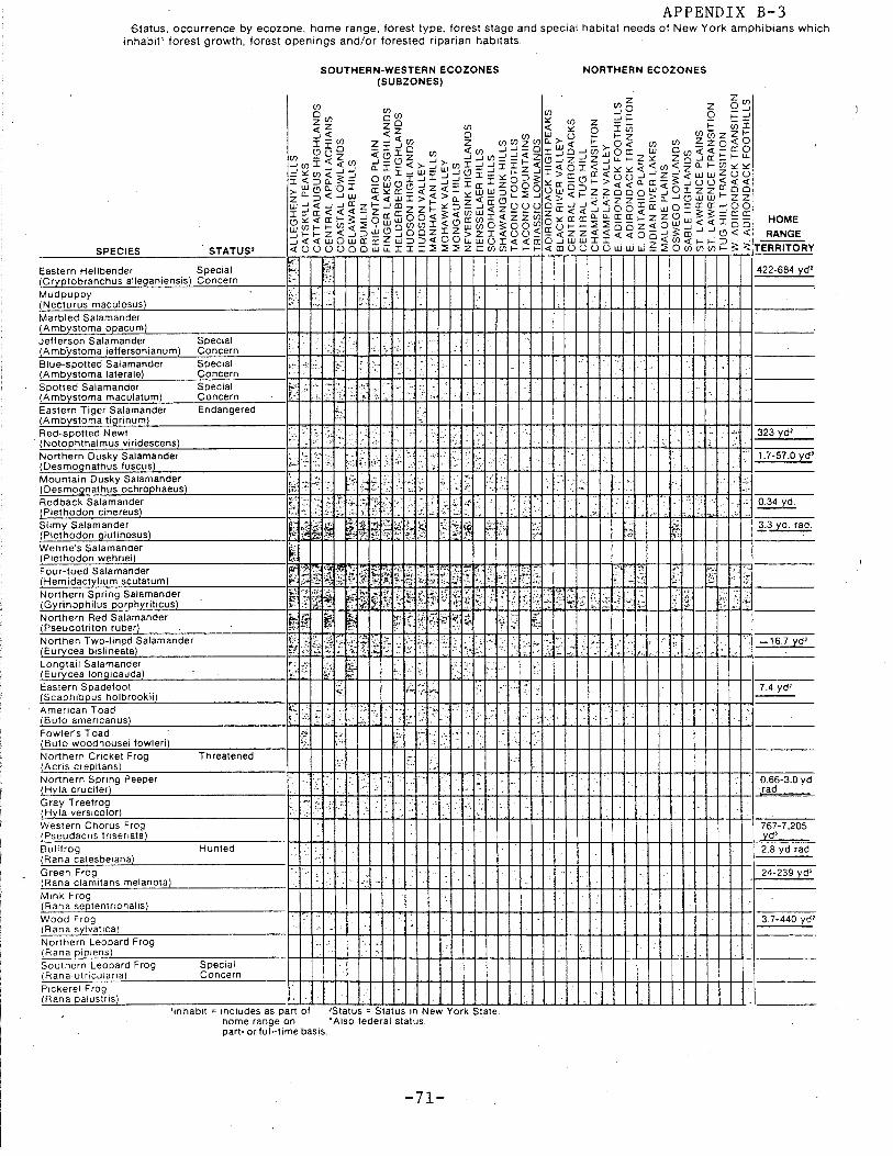
APPENDIX B-3 Status. occurrence by ecozone, home range, forest type, forest stage and special habitat needs of New York amphibians which
inhabit' forest growth, forest openings and/or forested riparian habitats.
SPECIES . STATUS'
Eastern Hellbender Special (Cryptobranchus alleganiensis) Concern Mud puppy (Necturus maculosus) Marbled Salamander (Ambystoma opacum) Jellerson Salamander (Amb'ystoma jeffersonianum) Blue-spotted Salamander (Ambystoma laterale) Spotted Salamander (Ambystoma maculatum) Eastern Tiger Salamander (Ambystoma tigrinum) Red-spotted Newt
· (Notophthalmus viridescens) Northern Dusky Salamander (Desmognathus fuscus) Mountain Dusky Salamander (Desmognathus ochrophaeus)
Special Concern Special Concern Special Concern Endangered
t~ ..
~"'-
.. .. •·
~·~,
,. ·"'-
!:...;·' ,~.
-~ ...
.-~h·
·;~ •..
~.:: ~:
SOUTHERN-WESTERN ECOZONES (SUBZONES)
. .
I·
-:::
~~
- ..
.
-;.~
.~ ...
NORTHERN ECOZONES
....
323 yd'
1.7-57 .0 yd'
... Redback Salamander ~·' · •.•. :·~ •. ~ ;;; :~ f;; .'. ··.. , . .: .. . . · ·• 0.34 yd. ~(P~l~e~th~o~d~o~nc:.....::c~in~e~r~e~u~s)'-------------~c-t-~~:~·~:~~4·~~~·'+"'\.~;~)~'.~>~.,-+-~·~-~··~·~i:-i-'-4-+~'"+-+-4""+"'+-f.;.;.J~··-+-:+-+-~-l""'-l-"-!~.o...+~"'4-:..l-·~··!-"-'l .. -----
T~11';t~~J~~mg~~~;~sus) ~1£11~~ ~~~i§~U1.~ ~ j~ f-:} ~ r?,. Wehrle's Salamander i;: (Plethodon wehrlei) I:'<· Four-toed Salamander (Hemidactylium scutatum) Northern Spring Salamander (Gyrinophilus porphyriticus) Northern Red Salamander (Pseudotriton ruber) Northen Two-lined Salamander (Eurycea bislineata) Longtail Salamander (Eurycea longicauda) Eastern Spadefoot (Scaphibpus holbrookii) American Toad (Bufo americanus) Fowler's Toad (Bufo woodhousei fowleri) Northern Cricket Frog (Acris crepitans) Northern Spring Peeper (Hyla crucifer) Gray Treefrog (Hyla versicolor)
Threatened
.· .... '·
· .. ..
...
-----
·l-16.7yd'
7.4 yd'
0.66-3.0 yd ·rad
Western Chorus Frog 767-7,205 (Pseudacris triseriata) yd' Bullfrog Hunted 2.8 yd rad
~(R:..:..:::a~n~a~c~a~te~s~b~e~1~an~a~)'-------------1:-l':--1-+-+-+-+-+-t--t-+-+-+-+-l-l-+-+-+-+-t--t-+-+-+-l-ll-l-+-+-+-+-t--t--+-+-+-+-+-I- ----Green Frog 24-239 yd' (Rana clamitans melanota) Mink Frog (Rana septentrionalis) Wood Frog (Rana sylvatica) Northern Leopard Frog (Rana pip1ens) Southern Leopard Frog IRana.utricularta) Pickerel Frog (Rana palustris)
Special Concern
'inhabit = includes as part of 'Status= Status in New York State. home range on •Also federal status. part- or full-time basis.
-71-
3.7-440 yd'
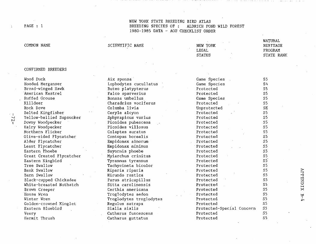
PAGE 1
COMMON NAME
CONFIRMED BREEDERS
Wood Duck Hooded Merganser Broad-winged Hawk American Kestrel Ruffed Grouse Killdeer Rock Dove
I Belted Kingfisher -.....) Yellow-bellied Sapsucker N Downy Woodpecker I
Hairy Woodpecker Northetn Flicker Olive-sided Flycatcher Alder Flycatcher Least Flycatcher Eastern Phoebe Great Crested Flycatcher Eastern Kingbird Tree Swallow Bank Swallow Barn Swallow Black-capped Chickadee White-breasted Nuthatch Brown Creeper House Wren Winter Wren Golden-crowned Kinglet Eastern Bluebird Veery Hermit Thrush
NEW YORK STATE BREEDING BIRD ATLAS BREEDING SPECIES OF : ALDRICH POND WILD FOREST 1980-198S DATA - AOU CHECKLIST ORDER
SCIENTIFIC NAME
Aix sponsa Lophodytes cucullatus Buteo platypterus Falco sparverius Bonasa umbellus Charadrius vociferus Columba livia Ceryle alcyon Sphyrapicus varius Picoides pubescens Picoides villosus Colaptes auratus Contopus borealis Empidonax alnorum Empidonax minimus Sayornis phoebe Myiarchus crinitus Tyrannus tyrannus Tachycineta bicolor Riparia riparia Hirundo rustica Parus atricapillus Sitta carolinensis Certhia americana Troglodytes aedon Troglodytes troglodytes Regulus satrapa Sialia sialis Catharus fuscescens Catharus guttatus
NEW YORK LEGAL STATUS
Game Species Game Species Protected Protected Game Species Protected Unprotected Protected Protected Protected Protected Protected Protected Protected
·Protected Protected Protected Protected Protected Protected Protected Protected Protected Protected Protected Protected Protected Protected-Spec{al Concern Protected Protected
NATURAL HERITAGE PROGRAM STATE RANK
SS S4 SS SS SS SS SE SS SS SS SS SS SS SS SS SS SS SS SS SS SS SS SS SS SS SS SS SS SS SS
~ '"t1 '"t1 tr:1 z: t:' H :><:
tf J>
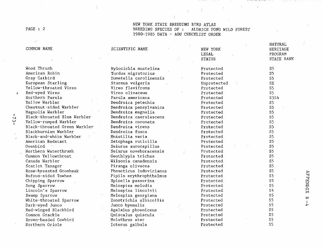
NEW YORK STATE BREEDING BIRD ATLAS PAGE : 2 BREEDING SPECIES OF : ALDRICH POND WILD FOREST
1980-198S DATA - AOU CHECKLIST ORDER
NATURAL COMMON NAME SCIENTIFIC NAME NEW YORK HERITAGE
LEGAL PROGRAM STATUS STATE RANK
Wood Thrush Hylocichla mustelina Protected SS American Robin Turdus migratorius Protected SS Gray Catbird Dumetella carolinensis Protected SS European Starling Sturnus vulgaris Unprotected SE Yellow-throated Vireo Vireo flavif rons Protected SS
.· Red-eyed Vireo Vireo olivaceus Protected SS Northern Parula Parula americana Protected S3S4 Yellow Warbler Dendroica petechia Protected SS Chestnut-sided Warbler Dendroica pensylvanica Protected SS Magnolia Warbler Dendroica magnolia Protected SS
I Black-throated Blue Warbler Dendroica caerulescens Protected SS -...J w Yellow-rumped Warbler Dendroica coronata Protected SS I
Black-throated Green Warbler Dendroica virens Protected SS Blackburnian Warbler Dendroica fusca Protected SS Black-and~white Warbler Mniotilta varia Protected SS American Redstart Setophaga ruticilla Protected SS O.venbird Seiurus aurocapillus Protected SS Northern Waterthrush Seiurus noveboracensis Protected SS Common Yellowthroat Geothlypis trichas Protected SS Canada Warbler Wilsonia canadensis Protected SS Scarlet Tanager Piranga olivacea Protected SS Rose-b_reasted Grosbeak Pheucticus ludovicianus Protected SS ~ Rufous-sided Towhee Pipilo erythrophthalmus Protected SS '"d
'"d Chipping Sparrow Spizella passerina Protected SS tr:l
Song Sparrow Melospiza melodia Protected SS z t:::1
Lincoln's Sparrow Melospiza lincolnii Protected S4 H :><:
Swamp Sparrow Melospiza georgiana Protected SS White-throated Sparrow Zonotrichia albicollis Protected SS to
I Dark-eyed Junco Junco hyemalis Protected SS ~
Red-winged Blackbird Agelaius phoeniceus Protected SS Common Grackle Quiscalus quiscula Protected SS Brown-headed Cowbird Molothrus ater Protected SS Northern Oriole Icterus galbula Protected SS
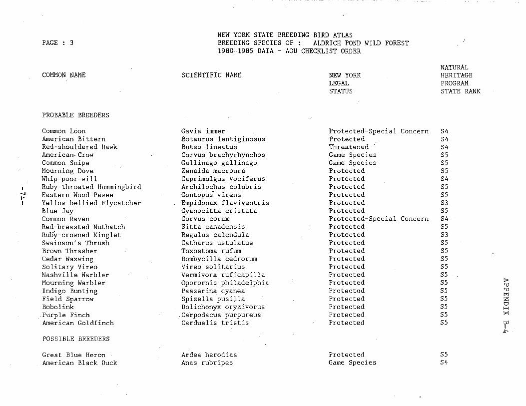
PAGE 3
COMMON NAME
PROBABLE BREEDERS
Common Loon American Bittern Red-shouldered Hawk American-Crow Common Snipe Mourning Dove Whip-poor-will
I Ruby-throated Hummingbird -.J Eastern Wood-Pewee .i::--I Yellow-bellied Flycatcher
Blue Jay Common Raven Red~breasted Nuthatch Ruoy-crowned Kinglet Swainson's Thrush Brown Thrasher Cedar Waxwing Solitary Vireo Nashville Warbler Mourning Warbler .Indigo Bunting Field Sparrow Bobolink
.- Purple Finch American Goldfinch
POSSIBLE BREEDERS
Great Blue Heron American Black Duck
NEW YORK STATE BREEDING BIRD ATLAS BREEDING SPECIES OF : ALDRICH POND WILD FOREST 1980-1985 DATA - AOU CHECKLIST ORDER
SCIENTIFIC NAME
Gavia immer .Botaurus lentiginosus Buteo lineatus Corvus brachyrhynchos Gallinago gallinago Zenaida macroura Caprimulgus vociferus Archilochus colubris Contopus- virens Empidonci.x flaviventris Cyanocitta cristata Corvus corax Sitta canadensis Regulus calendula Catharus ustulatus Toxostoma rufurn Bombycilla cedrorurn Vireo solitarius Vermivora ruficapilla Oporornisphiladelphia Passerina cyanea Spizella ~usilla Dolichonyx oryzivorus
_ Carpodacus purpureus Carduelis tristis
Ardea herodias Anas rubripes
NEW YORK LEGAL STATUS
Protected-Special Conc~rn Protected Threatened Game Species Game Species Protected Protected Protected Protected Protected Protected Protected-Special Concern Protected Protected Protected Protected Protected Protected Protected Protected Protected Protected Protected Protected Protected
Protected Game Species
NATURAL HERITAGE PROGRAM STATE RANK
S4 S4 S4 SS SS SS S4 SS SS S3 SS S4 SS S3 SS SS SS SS SS SS SS SS SS SS SS
SS S4
::i>-"ti "ti tr:l z t::1 H >::: t:d I
.i::--
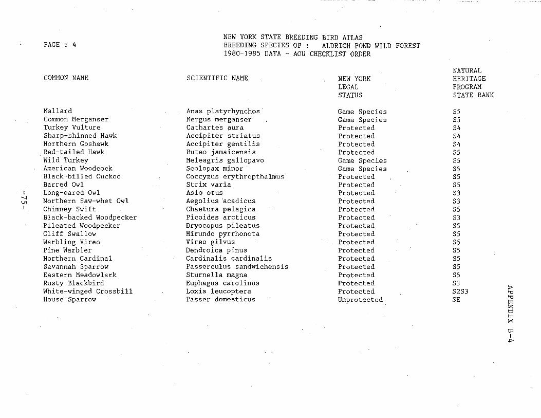
I -..._J
Vl I
PAGE 4
COMMON NAME
Mallard Common Merganser Turkey Vulture Sharp-shinned Hawk Northern Goshawk Red-tailed Hawk Wild Turkey American Woodcock Black-billed Cuckoo Barred Owl Long-eared Owl Northern Saw-whet Owl Chimney Swift Black-backed Woodpecker Pileated Woodpecker Cliff Swallow Warbling Vireo Pine Warbler Northern Cardinal Savannah Sparrow Eastern Meadowlark Rusty Blackbird White-winged Crossbill House Sparrow
NEW YORK STATE BREEDING BIRD ATLAS BREEDING SPECIES OF : ALDRICH POND WILD FOREST 1980-198S DATA - AOU CHECKLIST ORDER
SCIENTIFIC NAME
Anas platyrhynchos Mergus merganser Catharte·s aura Accipiter striatus Accipiter gent{lis Buteo jamaicensis Meleagris gallopavo Scolopax minor · Coccyzus erythropthalmus Strix varia Asio otus Aegolius ·acadicus Chaetura pelagica Picoides arcticus Dryocopus pileatus Hirundo pyrrhonota Vireo gilvus Dendroica pinus Cardinalis cardinalis Passerculus sandwichensis Sturnella magna Euphagus carolinus Loxia leucoptera Passer domesticus
NEW YORK LEGAL STATUS
Game Species Game.Species Protected Protected Protected Protected Game Species Game Species Protected Protected Protected Protected Protected Protected Protected Protected Protected Protected Protected Protected Protected Protected Protected Unprotected
NATURAL HERITAGE PROGRAM STATE RANK
SS SS S4 S4 S4 SS SS SS SS SS S3 S3 SS S3 SS SS SS SS SS s~ SS S3 > S2S3 '"d
SE '"d trj z t::' H :x b:l I
.p..
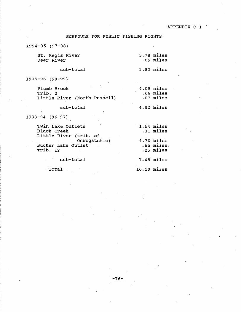
APPENDIX C-1 .
SCHEDULE FOR PUBLIC FISHING RIGHTS
1994-95 (97-98)
St. Regis River Deer River
sub-total
1995-96 (98-'99)
Plumb Brook Trib. 2 Little River (North Russell)
sub-total
1993-94 (96-97)
Twin Lake Outlets Black Creek Little River (trib. of
Oswegatchie) Sucker Lake Outlet Trib. 12
sub-total
Total
-76-
3.78 miles .05 miles
3.83 miles
4.09 miles .66 miles .07 miles
4.82 miles
1. 54 miles .31 miles
4.70 miles .65 miles. .25 miles
7.45 miles
16.10 miles
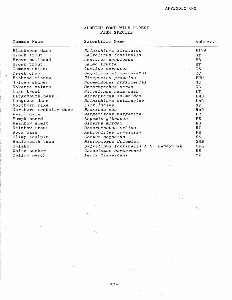
Common Name
Blacknose dace Brook trout Brown bullhead Brown trout Common shiner Creek chub Fathead minnow Golden shiner Kokanee salmon Lake trout Largemouth bass. Longnose dace Northern pike Northern redbelly dace Pearl dace Pumpkinseed Rainbow smelt Rainbow trout Rock bass Slimy sculpin Smallmouth bass Sp lake White sucker Yellow perch
APPENDIX C-2
ALDRICH POND WILD FOREST FISH SPECIES
Scientific Name
Rhinichthys atratulus Salvelinus fontinalis Ameiurus nebulosus Salmo trutta Luxilus cornutus Semotilus atromaculatus Pimephales promelas Notemigonus crysoleucas Oncorhynchus nerka Salvelinus namaycush Micropterus salmoides Rhinichthys cataractae Esox lucius Phoxinus eos Margariscus margarita Lepomis gibbosus Osmerus mordax Oncorhynchus mykiss Ambloplites rupestris Cottus cognatus Micropterus dolomieu Salvelinus fontinalis X S. namaycush Catostomus commersoni Perea f lavescens
-77-
Abbrev.
Blkd ST BB BT cs cc FHM GS KS LT LMB LnD NP RbD PD PS RS RT RB SS SMB SPL ws YP

I -..J CP I
lEY M l WATERSHED POND RAKE
P161 OW Round Lake
Pl62 OW Long Lake
P168 OW Mullins Flow
P267 OW Twin Lakes North
P268 OW Twin Lakes South
P2H OW Sucker Lake
P280 OW Readvay Pond
P281 OW Star Lake
P282* OW Unna11ed Pond
P283* OW Unnamed Pond
P284* OW Unnamed Pond
ALDRICH POND VILD FOREST - LAlE AMO PORO IRVEMTORY
ACRES VATER QUAJ.ITY FISH SPECIES PRESENT
18 Fair, pH 5.54 ST,BB,GS
68 Good, pH 6.09 ST,BB,GS
13 Acid I pH 4. 6 ST,DD,CC
32 Good, pH 6. 1 ST,RT,KS,BD,CC,FHH
14 Good, pH 6. 1 ST I RT I KS I B.B,CC,FHK
100 Good, pH 5.5 ST,BT,BB,CC,PS,WS
3 Unknown Unknown
208 Good, pH 6.4 BT,LT,RT,RS,BB,RB,PS,YP, LKB,WS
1 Bog,acid,pH 4.5 None
l Unknown Unknown
7.5 Unknown Unknown
Octobe~ 1993
llANAGEHEMT PAST PRES EMT FUTURE
1990 DEC Sa11e Same Stocked
1987 DEC Sa11e Li11e 1994 Stocked Limed 1987
1986 ALSC NSA ST Same Stocked until 1982
1985 ALSC Private Reestablish public Privately access stocked Reclaimed 1960 l 70
1986 ALSC Sue as P26 7 Sue as P267 Sue as P267
1978 DEC Private Reestablish public Stocked access, stocking Reclai1ed 1968 l 73
None None
1990 DEC Private, coldwater Sa1e, 11aintain public Stocked l war11water,stocked access
1986 ALSC None
None None
None None
~ "'Cl "'Cl t<:1 z t:l H :><:
Cl I
VJ

I -.I
'° I
lKY H l VATRRSHKD POND HAKE
p 118 ow Hills Pond
P130 OW Long Lake
P131 OW Twin Pond East
P132 OW Twin Pond West
Pl33 OW Spider Pond
P135 OW The Gulf
PI3row Dry Timber Lake
Pl38 OW Jenny Lake
Pl44b OW Unnamed Pond
PH6 OW South Creek Lake
Pl53 OW Little Silver Dawn Lake
Pl54 OW Silver Dawn Lake
Pl57 OW Lower Scuttlehole.·Pond
ALDRICH POND VILD FOREST - LAlE AND POND INVENTORY
ACRES VATKK QUALITY FISH SPECIES PRESENT
3 Fair, pH 5 .4 PD,BB
21 Good, pH 6.0 ST(rare),CC~RbD,BB,WS,GS,PS
3 Fair, pH 5.5 ST,CS,RbD,GS,BB,WS,PS,CC
16 Fair, pH 5.5 ST,CS,RbD,GS,BB,WS,PS,CC
1 Bog, pH 5.5 BB,PS
2.5 Good, pH 5.9 ST,BB,CC
21 .Bog, fair, pH 5.2 None pH 5.2
21 Good, pH 6.3 ST,PS,WS,BB,CC
58 Unknown Unknown
57 Good, pH 6.4 BT,BB,LKB
6 Good, pH 5.6 ST
8 Good, pH 5.8 ST, RbD
13 Good, pH 6.3 BB,GS,CC,RbD, ST reported
October 1993
KAMAGKKKNT PAST PRKSKllT FUTURK
1984 ALSC . None Possible stock ST
1984 ALSC None Possible stock ST
1991 DEC NSA resident : Sa11e Stocked species until 1971
Sa11e as Sue as Pl31 Sa11e as Pl31 P131
1986 ALS.C None
1984 ALSC . NSA ST Possible stock
1984 ALSC None Stocked until 196?
1984 ALSC Private, NSA ST Secure public access Stocked until 1953
None None Needs survey
1984 ALSC NSA resident Sa11e Stocked species until 1966
1986 ALSC None Stock Stocked in 1950's
1986 ALSC Stocked Li11e 1995 Stocked
1984 ALSC NSA resident species Sa11e
::r> .,, .,, t:r1 z t:::l H :><:
0 I
VJ

ALDRICH POND VILD FOREST - LAIE AND POND INVENTORY October 1993
IEY N l UNAGEllENT WATERSHED POND NAllE ACRES VATER QUALITY FISH SPKCIKS PRESENT PAST PRESENT FUTURE
P285 OW Streeter Lake 68 Good, pH 6.4 ST,WS,BB 1992 DEC Stocked ST Sa11e Stocked (Little Tupper
Strain J
P288 OW Pansy Pond 2 Acid, pH 4.4 BB 1984 ALSC None
P289 OW Crystal Lake 14 Acid, pH 4.4 None 1984 ALSC None
P5146 OW Unnamed Pond 6 Unknown Unknown None None Partly private Survey 1993
' IEY: OW - Oswegatchie River watershed~ NSA - Natural spawning adequate; *Ponds 282, 283 l 284 are connected and 11ake up one water body. Cf) C) I
;:i::.. '"tl '"tl tr1 z t:i H :><:
0 I
VJ
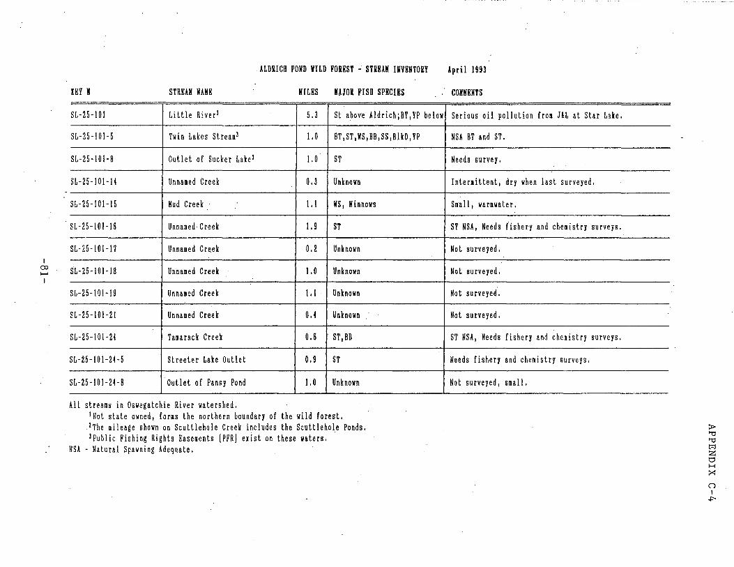
I CXl 1--' I
ALDRICH POND VILD FOKEST - STKKAH INVENTORY
IRY N STREAK MAHE HILES HA10K FISU SPECIES
SL-25-101 Little Riverl 5.3 St above Aldrich;BT,YP below
SL-25-101-5 Twin Lakes Streaml !. 0 BT,ST,WS,BB,SS,BlkD,YP
SL-25-101-8 Outlet of Sucker Lakel 1.0 ST
SL-25-101-14 Unnalled Creek 0.3 Unknown
SL-25-101-15 Kud Creek 1.1 llS, Kinnows
SL-25-101-15 Unna11ed Creek 1.9 ST
SL-25-101-17 Unnamed Cre.ek 0.2 Unknown
SL-25-101-18 Unnalled Creek !. 0 Unknown
SL-25-101-19 Unnamed Creek 1.1 Unknown
SL-25-101-21 Unnalled Creek 0.4 Unknown
SL-25-101-24 Tamarack Creek 0.6 ST,BB
SL-25-101-2<-5 Streeter Lake Outlet 0.9 ST
SL-25-101-24-8 Outlet of Pansy Pond 1. 0 Unknown
All streams in Oswegatchie River watershed. INot state owned, for11s the northern boundary of the wild forest .
. 2The mileage shown on Scuttlehole Creek includes the Scuttlehole Ponds. lPublic Fishing Rights Easements (PFRJ exist on these waters ..
NSA - Natural Spawning Adequate.
April 1993
COHHKNTS
Serious oil pollution frail J&L at Star Lake.
NSA BT and ST.
Needs survey.
Interllittent, dry when last surveyed.
Sllal l, warmwater,
ST NSA, Needs fishery and che11istry surveys.
Not surveyed.
Not surveyed.
Not surveyed.
Not surveyed.
ST NSA, Needs fishery and che11istry surveys.
Needs fishery and chemistry surveys.
Not surveyed, s11all.
~ 'U 'U t:°"l z t:l H ::-:: 0 I
,J::-
Map and Oeicription of Pe1manent Eaiement through Lots ll4, 128, l29, 13~ and 136
Township 11, Great Tract No •. 3, Macomb'i Purchase, Town of
Pitcairn, St. Lawrence County
(Clayton Powell, Charle& Greiner and Di&lllOnd International Corp., reputed owner)
APPENDIX D
Pursuant to Section l-0503 of the Conservation Law, I, R. Stewart Kilborne,
r.oniervation Commii&ioner of the State of New York, have cauied to be made and
certified an accurate map and description prepared from an accurate iurvey of
a parcel of land hereafter ducribed, over which I deem + t neceiury to acquin
a permanent eaiement for ~ravel by the public on foot, snowshoes, skis and
· horseback or motor vehiclu i11cluding the right to enter adjacent land& of the
owners with teams, trucks and other equipnent neceuary to const:riJct, improve
and maintain a road over and across said premises and the right to ~emove trees,
stumps, rocks and other materials which the State may deem hazardous to th•
public in the u•• of th• eaaement herein acquired and th• furth•r ri~ht to ua•
any and all such materials in the construction, improvement and maintenance of
said road and the further right to inake minor cha09es, from time to time as &hall
be deemed desirable.
All n!AT CERTAIN PIECE OR PARCEL OF LA~D, lituate, lyillljjl •nd bei09
in the Town of Pitcairn, St. t..wrence County being part of and :riJnni09
through Lots 114,- 126, 129_, l~:i and 136 of Township ll, Great Tract No.
3, Macolllb 1 1 Purchaae, being a right•of·way O.:ioc> chains or 33 feet in
width, lying o.~ Ch&ins or l~.:i feet bo•.h sides of the centerline of
an existing road, which centerline is- bout".dt:d and ducribed a& follow&1
B£GINNI~ at a point in the center. of an old road known as the
South Creek Lake Road where the ~ intersects the division line
between the Town of Pitcairn on the North and Town of fine on th• .South
bei09 also on th• Northerly bounds of the lands of th• State of Mew York
and the Southerly U.ne of Lot 13~, Township ll, Great Tract No. 3, Macolllb' 1
Purc:har.,, said point alao being distant 0.060 chain1 on a courr.e of
N. 620 20' w. from the co111DOn Southerly
-···--·---
-82-
~
'APPENDIX D
corner of Lota 135 and 136 being marked.by a Sa.they ~ker
and runs thence along the centerline of said old road, as
it runs aero&& said Lot 135 and 136 the following nine (9)
courses and distances&
l. N 16° 41 1 E - l.446 chains
2. N 2lo 36 1 E.,. 7.391 chains
3. N 36° 33' E - 9.679 chains
4. N 29° ~· E • 3.780 chains
~. N ::28° 49' E • 4.918 chain&
6. N 4?0° 09' s - 3. 741 chains
7. N ::28° 05 '· s - 6.166 chains
a. N 30° 51' E - 7.2.28 chains
9 .. H 35° 50' s - 0.536 chairu 'to a point
on the line between Lota 1::28 and 135 in said Town&hip ll,
located on a COl.U:'&e of S 80° 45 1 1:1 16.~ chain& from a Bat.nay
Marker and atone& marking the coumon corner of l.ot& 127, 1:28,
13!:1 and 1361 thence continuin9 along a•id centerline •• it runs
acron aaid Lot 1::28 and l.ot ll4, the followin9 twenty (~) co\.i.raea
and distancHa
l. N ~" :io• E ~ 3.125 chaina
2. H 390 41' E• 3.9i9 chains
3. N e0.~3' E - :i.692 chains
4. H 37° 16' E• 3.346 chains
. ~. N 320 ll' E• 3.949 chains
6. N 16° 04' E - 2.:io2 cbi.ins
., . N 04° 18' E• l.931 cbi.iru
8. H 08° 22' ·- 3.005 chains.
9. N 10° 06 1 ·- ~.010 chains
lO. N 02° 07' E - 3~ 7~ chains
11. N 170 17' E - a.a:i2 chains
12· N ~7° 36' E - 1.0!>3 chains
13. H 81° l:i' E• l.74'6 c:haina
14. N :io0 00' E• l.7S:i chains
----------83-
. : ..
l!>. N l!> 0 l8' ~ - :>.448 chain11
APPENDIX l6. N 29° 23' E - 4.068 c:haina
l7. N 33° 44 1 E - 4 •. 877 chain5
is. s 76° 03' E - 3.l22 chains
l9. N 61° 24' E - 2.063 chains
20. s 80° 03' E·- l.505 chains to a point
where the ~aid old road intersects another old road lea(;iin9
5outheasterly to lands of the State of New York1 thance le~vin9
said South Creek lake.Road, following the centerline of said other
old road leadin9 southeasterly to lands of the State of New Yor.k
as it winds and turns across Lots 114, 1:28 and 129 the following
twenty- fi v• (25) courses and distances&
l. S l7° Ol' E - 2.169 chains
2. s 03° l9 1 E - l.6!)0 chain•
3. s 120 31 t E - 2.409 chaina
4. s 16° 23' w - 2.120 ch&ina
5. s 39o.01 1 lf - 2.104 chains
6. s X7° 00' E - 3.137 chains
7. s 070 12' E • 6.~ chains
s 23° 14' E - 2.114 chains .. ..
B.
9. s 46° 41' E - 1.631 ch&ina
10. s 76° ~· E .• 1.849 chains
ll. s 17° 55 1 E • 2.X75 chains
12. s 62° 16' E • 5.585 chains
13. s 330 24' E .. 2. 743 chains .
14. S 600 19' E - 4.244 cha.i.ns
l~. s 25° ~· E• l.183 ch&ins
16. s 52° ~· E• 6.006 chaina
17. s 25° 34' E .. 2.063 chaif\6
18. s 60° 15' E • B.023 chains
19. s 7~0 57' E - 2. 738 chaina
2). s 74°.40 1 E - 2.429 chains
21. . s 43° 13' E • l.465 c:h&ina
22. S ~o 09' E • 3.305 c:h&ina
,....--·· ---- ---·-----·- -
-84- · 1
D
•
APPENDIX ·D 23. S 2:1° 55' E - 0.471 chains
24. S 49° 40 1 E - l.234 chains
25. S 40° 06' E - l.492 chains to a ·point
on the line between Lots 129 and 130 of said Township ll, located
on a course of N 05° 01' E, l0.822 chains from a 3/4" iron rod in
a pile of stones marking the co1I111on corner of Lots 129, 130, 133
and 134.
Bearings are with reference to Magnetic Meridian 1965.
AF. shown on a map entitled "Map of lands to be acquired under
the Park<nd Recreation Land Acquisition Bond Act, By appropriation
under Section l-0~3 of the Conservation Law, St, Lavaence Forest
Preserve Access, Projects St. Lawr~nce 93 and 94, E.asement over and
across the road conmonly known as South Creek l.ake Road and an"un
named road, Clayton Powell, Charles Greiner and DiilllOnd International
Corp., reputed owners, situate in Lots ll4 1 1:26 1 129 1 135 and 136,
Township ll, Great Tract Ne. 3, Macomb' s Purchaae, ·Town of Pitcairn,
st. Lawrence County •• ciated March 7 I 1967 by George A Cook, Forest
SW'veyor 1 Reg, Ne • .4Q~, ·and filed in the office of the Con&uvation
Department at Albany, New York a& Map Ne. 7177.
That pursuant to Section l-~3 of the Conurvation Law, this
mcp and description of pr0perty to be acquired by the People of the
State of New York and are hereby officially approved and this description
and the original tracing of this map are officially filed in the office
of the Conurvation Department at Albany, New York on NUV 1 4 1S67
,..
Dated a tw·v 1 ~ 1367
-85-
R. STEWART KII.BCRNE Conservation Coamissioner
...
By
·~~~-"'w-~~<-::~.:w. D.M~ Director of Landa and Fon&;t.5
APPENDIX E
STATE OF NEW .YORK
jf orest ©reser\?e· :fBoarb -···-- ......
---~~----·--H. Y.,._2~_,;~~ _'{;;o I •, ..
1Report of .. -..... / .. 1 .... fe.L .... 'm. .. ~-::--. ·---:····--·····-···~, describini. ·
Lot No. I .2 Lf-.-.; Tract or Patent, .. ·: ... ~ .... , ... : .......... .:. ............. _;.. __ ~ Township ..... LL .. _._
T(!wn of ..... JO~K..-.. ........... --··-·-County of~~·_ Number of acres in the whole lot,_·-··--· . ·---
Number of acres offe;ed for sale,_ .. ~.~ 7 3 % """--~ ..M ._-<.. -.. ... _ .......
-
Date when this lot was personally examined,~-~ I {l o_.Q _______ _
How timbered, thickly or partially ?··--···----:--.I?~- -----.:.....--.. ----..,.. .................................................... ____________ _ --·---
Any cleared land: if so, how many acres?-----~----~---··--------
Any swamp land; if soi how many acres.? .................... --.. -··--·-··· ... ~ ...... _ .. _ ................... _____ .... _.· .. ..
Any waste land, or land whose productiveness has been injured by fire ? __ .J'__..-G_4,__ ___ _
Any wild meadow land-; if so, how many acres L_ .... at.,wi::_ ... ./.O._ ... ~-- .. ~-·A· l .~ ...... ~-!'S~ . .
Name the Kinds of timber in the order of quantity.~ .. h-~ .. ~ ¥-r···~
,.. .. ~-r~-"9~~42-.,·:&.··-------. How much of this lot is virgin fore.st? . .. ~'ric::--------
How much is second g~owth? ~--l..J .. -::... ... &r..~~ ... --· --:-· -·--.. ··-··
Has the lot been burned over; if so~ how 1
mar;iy acres were burned L~-·~:p __ ..
Has the lot been lumbered over?. · · · ~-~ . · ·
If so, what kind of timber was cut ?._f?~.,....~ ...... ~ ...... ~ .. -~ ... .
Who is, at the present ~ime, lumbering in that vicinity ?_rr/.f.~.L!&..~-.L..$...,J ___ _
s the timber there now, large, medium or small? , . . ~-. ---. -----
" · .. -··------~----:--~ -86-
Is there any merchantable spruce on. this lot; lf :so, how .much to the acre?--···-~--'-----
--·-·-······-················-.. ·--···-·-----·:~-~ ·-----· -·····-····-·····"•''"'''"'-·-·· .. ····-···-·-·-·· -· ·• rs there any merchantable hemlock on this lot.; if ~o, how much to the acre?_ .. : ... ~ ............. -
•••-••••••••••••-•••••-••••••••••••••••••••o••••-•••••••••••••noo•-•-··------.. ---..... -•••--U--•·-•-••••••••••-·----·~••-.--·•-••----••-••••••••-•-•••-•n•-•-••--•••••000000
Is ·the.re any merchantable white pine; if so, is it first or second growth L-.... :.~···-··- ·
How much white pine to the acre? .... :.a ... M·-·····~·····-~--·----····-······ . . ..... ' • . . ' f • • •• • . '
Arc the corners of this lot plainly marked? ·-·---------· ·,. . .
. H O\V are they marked ? ............................ : .................... -,.. .... ·-·--·----···-·-····--·:::-··-............ -···-······-·--··-·- ....... - ·-·-... __ .. . .. , ... _ .. · ...
Are the boundary lines marked, and· how? .... __________ ._ .. ~--·-··_' ·-···--- .. .:-· _:.. ·'·-----····-.:.:..~ : ..... _. ___ _
What kind of soil is on .this lot ? ... ~ .. -~/.-.-~.~ .. '.;,. ..... ~ ... ~~~~ic.~--~··--.. -
Is the ground rocky, or well covered ?.-~.~~ .. L •• da.:1.-..~""-~'~Y. ~. Is there.any stream o~ tpis lot? if so, s~te the ?ame,~_::_· ~-··---- .. · ---
Wh~t is the average width and depth?----------··-··-· .. ·--·· .. -· .. ·--------
Is there any dam on this stream within this lot?------~---·-:···-----:-··--·
Is there JLny back tiow, or drowned land ? ________ . ___ ...... _7 __ ·~·-···-~
Ifs-:>, how large an area Js flooded?...,..._· _ _.._.__..,... _____ ..;.__;..._ ___ _
Do any 1oads cross this \ot ?-~···~~· ~-1-~-~~ .. ~:!.f. .. ~ .. ~.!! .. '!.f~~ ~· ' '
Are they highways or ••wood roads?"~~---~--~~~=-·~' •
Arc the!e any· buildings on thi~ .lot ?f.~ . ..u./,J..._.~ .. .& ....... 7:.~/,...~.JV..._Y,.- .... 1 .. ·~ Describe the lay of the l~nd on this l~t ?_.~~- . . ·-..--~ ... ....:it.'':{%>?
' '
'!.+ w. ~ ..... ~ . .l ••. ~.J... .. ~ .... ).~~..1~-1~---./_~~ - -~-~-. ' . r:~··-:-.··:~: .. ·c. . .. r·- ' -;--7 ·~····· . . .
If occupied by residents, give their name~· ------/l::rt.V1'"""-----· ----·------Are there any camps on this lot? ____ . ------~--~--~~~'----------Arc th~ shanties in good condition? ·· ~ .: ., .. · ' ~:...-~------------
..... Are the surrounding lands f or~t or farm lands ?•_.....:...:_-:~~~L.:C.:..:t~U..-:r.'.~~~~-P'
~
·---- ····-
-87-. . . '

. Please add here any additional information which you may have, and which may be necessary to ·a full and complete description of this lot •. . .
. ~.Y1- 1·-'·~~:··~ ... "f'-.. ···~: .. ~ ......... '~ ..... 4q~ ...... 4~~ u{,! . L .... ~. -L~ ..... ~ .............. ~ .... ;.,,, ......... c> --~---·~········ ... ~ !: ... -. .. °!...: __ ~----- fJO -Vt II ~- - -·· . ~-·-···-H••••· . ~·~-
........... lv-t-:C.. ...... L~ ...... ~~---·~··-·+··=-·~····-~·-··~-····~--·····~ ··~·-·-·~···:·.·~~---·······-··-····-·················-···-----·-·---··-
·• ... .".~: ..... ~ .... ~ ...... ~ ... , .... ~ .. , .... .1-/:. .. r ... ~ .. 4 .• ~--· ·
. . . --· -~··r·-- .. ~-·t····~~····i·-~·rdf·•···~::.44..4. ... ............ ~ •••• ~ .... , .•. ~ .. : .. ~~.A ... ~ .... ,._./-7~~....:;,...-I?_
-~~•••~·A•~-•••l.~•--•~·•-•~•••••~0000000••~-• ··---... ~e.?...11.~ .... ~-·-·-= .. ----··-·· ... --.. -.. ----·-·---·--- .
-·-lf-····r·····-~--·~-·~___;:d;z-~~ L,=-
---····~·-~~~;_,~ . _____ , _ __, ___ _
·----·-----·------------------------·---------------------,.----··-··---
--.---·~--··---·-------...---
---,·------·------------------·-------
. .
)ate:L--------;"----~
-88--.~- .... . "
. . .
. · .. · :·: ..
I ; , .. I
I I
. .. '· '
~ield Notes o!' e.xamination o!' 3ta.te lands from Rarris'7ille TJeYiis co. .. Jany.13th. 1000; Tom Yl111bur, Agent. of the .International ?a.per Cq.
says that· Johnson uses the saw mill of the I.?.Co. at ~enson .. M:'tne:s to saw hardwood, of whii:h he boue-ht 800. 000 feet from the co.
11ay1ng :()2. per M. stumpage, a.nd ~l.25 per M. for use of m111~ I.?.I.co>s lumbering contracts ar~ let at prices ranging from ~2.05 rer cord ·to ~~2. 50 , cut a.nd ,put in stream~ One· j'ob is n.t oc 'r=ts·~- •····
7 ·' .per lll'3..rket. There is a. 'l'an.nery in oper-.ation at Ha.rrisv1lle which ~--· ri<l.YS .20 cts._p1:11· hun.d.r·ecl. for b~li::. i'lilbur drov-o .m~ out. to si:id ·
•
':t J) ::l.zJ
.Glc:i.dsby who lives t.i.bout .5 miles .from villia.ge on lot r.is3. He vrt:i.s employed for 0 years in cha.rge of lands and lUmoering o.r· ti:.e :\.em- .... -· 1ngton ?aper Cc.. He snys they h.-..d. their lines o.ll :plainly· ma.rl~-0d and the blases on the trees p.~inted red. Jany. 15th.- ·I employed Eugene Hathtl.way o.t: Harrisville to hel11 me. ::.tarting f::·om tile hotel drove north o. re'r h\mdred feet , thence oa.sterly a.bout".2 and one h.o.l.f m1les too. school house on the· northw0st. corner of lot 183., thence southerly a.bout one mile to a. hemlo
. ck U"ee on the county .line and · on the· . east corner o.f lot 337. a.nd . tho ea.st corne~ o.f 52 a.ere lot belonging to Ha.tbaway containing o. maple ordirl.l"cl with 1200 trees. 'l.1his , .. orner is on the ·north ba.nk ~f a stream abC?ut 30 feet 1'1'1de .~9-. a. few 1n1".'hes deep running: N. rJ.
. -:ih"U11ce we went. -·ba.clt north a.bout. throe 'lUn.rte~ of n. ·mile to. b.Q\i~e ( .J)' ·of Martin· Lutl}er. on lot 123.. thence. easterly a.bout 2500 :ceet e..long
. ·~1.b~done'l Jayv~lle roo.d,through land lumbered cle,)Sa.n a.nd burned.lo.st. (.q) year. 3ome bu~hes left and blue. beech· and· so.ft ma.:ple 1n. l~w spots,· .
· Y · !:l'ut on the hig"i\ ground it 1s burned clean to rocks. ·. ··---· ·· This poi::.t 1.s ~bout--o.n the line of lot 124. Thenco on s:'.I!le course.
(s) J rioo :feet to ·ald boi\I-d. 1oi;g1ng shanty of'· ?a.yhuti (?yo) which is on ta·~• north part :o.r lot. On the· le.ft it is burn~d clean, on the ~1ght is a. st:"c::a.1;:: of' :timbor. Thc;:nco south 1n the timber ;.;p. on to ~.ne ridge.
. . •, .. --. ...._ · .. - -- ~om:posi ti on of' forest; -
l-") !:i6 "oaech 4" I to is It e e a birch 6 ft I 28 hn.I'd ma.pl~ 3'~ to 7." 0
thicJ;:: brush .or· hard maple o.nd. beech. 28 hemlock' .stumps •ffi th logs 8 srh::-uce stumps. one map+e and one basswood·blown over~ ..... • . " No Dia.rl:s of' fire. . • . . . · "".
;,· (7
1 'J:hence 2.E. 500; .feet t~ top o!'~r1dga. burned clecWl. In· spots a.r~ · ·•·· ~ . clumps· o.f ha.rd a.nd sort· mo.ple. .Much f'a.llen timber. mostly ~emloc~::··-'·,
from pee ling but s om"· ho.rd wood bt ·r1re •··. .. . : Thence east 5oo reet·a.long·top ~'.~id~e, 1n marl.ts or lignt fire, with everything lumbered oft .• · · 1
\V Com:posi ti on or. roro~t _:per o.cre; 60 ho.rd m.o.ple· 6". to ::!0". or which the . d 4" ;L4" , 12 ironw_oo
J
t \
small one.s a.re good, a ba.sta.rd ~elm ·S" to ·"
. : ~ . . ·, . •,' ·.·· . :· .
.. . . . -89-
.. . .
....
. _,,,.--. /·.·· .
. . . ..
. !
t,:·• •. 2
4 sprue~ 4", 68 beech 3" to 14" stralght and t..111, th<;i brush isbirch Some l)eech C1J1d m.aplo is blown down, 8 b:1:~ch stumps· small. 'l'he wood is. in stroal;:s with open burned ground hotween. Thence on same coursr 1000 feet do'WD. into· a vall0y and up on to another ridg:0. Narrow stri.p of timber in 1n·valley with a few gooO. water elm, blacl;: u.sh, basswood and hemlocl;:. From this ,point the norhh. .pa.rt of the lot lool;:s ,pretty bo.re with· . strea.l;:s o!' brush and sparse timber. ·-· ·· --· .. · · There 1s a beqver meo.dow in the S.~. cornerof lot of ~bout 10 acr~s. This lot was ·called ?inehil~ marsh lot, .from the pines sta::di~g a.bout this marsh. Thence .North 1000 feet into beit of smn.11 timber in low .ground. 6Qm~psmcillofi 11 o:eoroi'es::b p:er acre;
(11} 64 spruce 2 11 to 6_"- 24 hemlock 2" to 4" - 44· birch 3 11 to 8". 44 w. a::;h 2" to ~d' - 48 B. ash l" to 3" - 8 .pin cherry 2 11 -..,
\ '·
4 s.rnr.ple 5 11 - 4 . basswood 1411 a.nd tall - 32 black beechl" to 3 11 -
Erush is a.ll beec~.
. 'l'hence on same co\u-se 200 feet to old pine stump 24". W1 tl~ ~ lOS'S · cut and piled a.nd left. Thence we circled round to the norhh and baclc to· logg1n'1' ehn,nt.y. There is some good young growth ~d.some fine water elm~~ i:i.,nd stra.ight·, worth a.y present $8 per M. a.t the ·R. R.. ~ .estii:n.ate more tl'lan one~ the lot to be ba.r.e or soil, wbich hat. ·
· b~en burned o!'f b¥ .recent fires. ·· · · · · Thence we .went .ba.(:1t: .. :t.o M. Luther's house and ate our luncheon. ....--~··-~-.. . .. ---··.. ~' . .··· .,. . --~ -Luther says there area. few pine left on the state la.nd in spots
{Ji) a..'1.d t£lR-t. th~y a.re 12 "-in dimeter a.nd tall. Re says the loggillg shanty is on north ha.l.t' or lot 124 and a.bout 30 rods f'ro north line ...... .. of sto.t.e land. · · ·-· Thencei-:nor:t.li·::abou~-.1000 !'eet to the south line o!' lot ll9 800 !'eet east from s. VT. corner. . · . .
VV The whole south part or lot is rough and hilly a.n~ is completelY. bo.re, With once in a.whil·e a.. ·a. 'little bunch o~ brush.· ... "". Thence ea.st1000, :f'bgtma.:ny large old pine. stumps . . . ·•
[./ From this point looking eo.st to· lot line, 1 t. is ·rough and hilly ~) nea.rly. clean of :woods, With a. rew ~ca.ttez:ing_ Sl>ruce,. heml.ock, ma.lple
basswood and birch. · . · · · · , . Thence north 600 feet into na.r~ow bel ~ or timb~r. · ·
(IS) Composition of forest ,per acre; . ~2" .. ~8· hemlock 2" to. 8" -28 s.maple .7 11 to 20"' ~ 40 birch· 4" to .. - '. . . . . .
..l
28 B. ash 5" to 10". . 12" -8 hemlock stumps 12".' S B.a.sh stumps la.r;;-,S~aprucia stumps 10" to · ·
.-· .. ,. ·/.· . -; ~
. . ..
.. .
..... ·-· ::.·.
. '
. .. . ... . ..............
... ------
-90-
' I ' · ....
\ . ,.
·· ....
.. ~
...
..... ,J
..I 'f. :
. . ' . 3 all cut Witi;iin "3 or 4 years, showing r.obber'y of '1ot. Luther must l:.now who tool:: this timber, as it necessarily co.me outby his house. There were also 8 old pine stumps. 1
Thence on s.::une course 100 feet to· soft maple , pine ~d. bi~ch stumps 'cut within. 3 Or 4 years. Thence on same·course 200 feet to edge ·or woods. Th~nce on same course 300 feet •
. (I') i'Doillingiwe~oint lool.: looldng ea.st it i~ burned bare tor ha.l!' milo, ··-·-- . . . lool.:ing west it appears bare for h.::i..lf a mil~, a.hec:.d on left is tim
b0r, lool::ing N.E. ca.n see 11 large pine. (11) Thence on sa.me course400 feet to smc:.11·· beaver meadow, cu~ this yeo.r.
Thence on same course 300 feet. Here I counted in ri. bunch 104 large·. -old pine stumps. I'-d.ght here are 8 tall pine trees; except them 1 t is all bare in every direction except west wi}ere some woods s~ow. Stumps are all burned. Thence on same ·course 600 feet a.long old road to beaver meadow on
. {IV lef't or a.bout 4 ~eras, with brush. picked up a.nd piled. On west side .of meadow is a qlump of good sized spruce, with. one tall l'ine,· a.nd 'Vlest or there is :a thick growth· or timber. . . . Thence west across beaver mead.ow ·.~00 feet into woods ment1onod,W1th bare land to the :µ.orth.a.nd south.
U1J Composition or forest; 24 bi:-ch 6" to lS" - 44 s.rna.j>le 8" to 14"- 20 SlJruce 4" to 14" 20 hemloclt 4" to ~5" - 1 pine 18" . . many sma.11 · hemlocl::, spruce, birch, S.ma.ple a.nd blue beech.
:hence nortn 400 feet. Outside ·or the little meadows a.nd narrow v~l ·( .a leys with -vrooci, ~~e surf~ce is ridgy wit.h big detached rocks, .r...nd.
J. "1.1 is burned clean. iool;ing west 1 t is bare f'or one ~uarter o!' ·a ~le . "IT1 th a. little brush; ea.st it is bare for a. third Of a mile With .
some small second.'· growth. 'l'honcc· (ill E;;aJD.O course soo·. feet. to beaver mea.dow 600 feet wide. T 'l1hence· on samm co\µ-se 600 feet a.cross mead.ow. . On· east· side or m~a.dow is a. fine growth or large ta.ma.rack. On west.. side· it is a.11 b~e. On north side is a. thiclt growth o!' large pine. The.mep.dow ·.s 0.11 ·carefully cleared ud ,shoWing that so:11eono cuts it. On nor-th edge of" meadow noted one lS" pine stump cut this. yea:r. . \'h;, c oiinted 56 lJ.rge tall ,pine in a c.lump on .north side or meadow. .. Thence" west 200. rf;etto old road a..nd pile ·onr f'la.t stones 4by. ~ by kt- feet high. Six .small pine. . Stre~ lOOfeet tf25~etgg[t£{0rth ·,;. .
• Thence on sa.me .course 200: 1'eet. From. this .point . {1. .U1s a. barn , newly repaired,· into which ,.proba.b1.y , the ha.y f'rom the
meo.d.ow i'Oes. West. f'rom. th~ barn 509 !'eet is a. !'1ne clump o-r large · · _pine. As nearly as I ca.n judi'e , the mead.ow a.nd ma.ny o!' the l~ge
..
Pine ~e upon the st.ate la:nd · '. .. · . .. : .. :· ·. · ·. · · · · ly . . • . 'l'he lines SlltlUld be ruµ .out. o.nci ' nla.in.
m~ke<i •. · '
! . . :· ....... ~·._:·.·.· ....... . . . ·; .... '•'. . . : . . . . . •, r .. ,·
.. ·- -···-··- . .. . . . . . .·. -91-
.. . -
! .••.
f· ... · ..• ,.· .. J : .. ·. > .. . . I ·•· ,, . . r . I
I 'l'hcnce on s.:i.m.e course 700feet· through b.:i.re .burning, to .. top high rocl~. t\ · · 2.) .F'rom here !'oUr fifths of lot app.z:ar to "ue bare with tho ·:roo!:l.S J~
11 ttly stren.i::s. . .At this point a.re a few a.ere~ or small lJOpla.r · . a.nd pin. cnerry. .
Thence on s.:i.me colirse 300 feet to top o~ bare steep reel~. From here it is burned bG.re west 2000 feet , and looking north 1 t is 1000 .feet to edgo of woods. . ; . '
1 (,;. J) Th~nc e south 800 feec:t through cl~rui burning ,:wi ti:. nothi~ :bu~~.s~l~r--:
I poplar, to a. little cl.ump .. of trees... ·. ~ · -. : · ·
L Composition o~.,rorest per acre; 24 birch 611 to 18" -4 W. a.sh 14 11 • - 36 ba.ssYrood 4" to l~ "- -r-. 4 B. a.sh 12" -24. H.ma.ple 3" ·to. ·5u .. ~ 16 beech 4.11 to 7" ···--·-· ...... '. .... -4 W. elm 6 " • ,
I
r:.oui:;:h ground w1 th great boulders. . The1ice on same course· 600 feet in thick sma.ll growth ; ·
{..L'l)Composition o!' forest; . 24 hemloclt 2" to 12"· -16 spruce 2" to 8 11
- 12 s. ma.plelO" to 12" .-4 ·B. o.sh 10" -20 ~birch 4 11 to Ia~·· -36 ·oeech 4" to 8" -12 hemloclt stumPS:: .12" cut rl thin4 yea.rs.
.. :
\l :n 'l'hence on same cqurse 900 fee:t: through thick sma.ll grow~ o:f' ha.rd·. and so.ft nm.ple, b~ech birch rock elm, pin cherry and hn.rcU.n.al;', : · 32 hemloclc stump~ old a.nd ·a ~clwood stumps old.
. Thence on. SQ.me course 100 feet. to edge ·of woods. l'hence on sc.me cqurse 800 feet to edge or cleo.red !'ield 400 f'oet,, : .
; J,,YN'ide n.nd conta.lning some.4 acres. s1tuo.ted int.he 3·. \1. coi:tner o~ lot .. 2 Thenc~ on so.me course 400 !'eet t9 the south line o.f lot 4•~· CJ'l~ ·
~00 !'~et eazt !'roin corner. · · · · · \ . ?rom ~he schoibl hpuje the roa.d runs south 1000 feet a.nc1 thence ea.,t. , i ·/Coing .;·;ost along ti.ighwa.y from the corner of lot 'by th.~ __ _,Z.choolhoust i.H . ..:; · 300 !'eet to house· on cleared .fa.rm on the north. ~:Zaet . · · Q,;a,.1~00 .!\~et to hou~e on cl·eo..red . .fa.rm on the south. : f=z_o~ 200 .. r~et to a roaA,. on the. right on west side of Coose Tond N. l-5 ~. 21.::.l 1400 • ;}et to hous~ on south side. · . . · · · j.J~o?._ 200 re~t··t_o- apparQnt lot line . · . . . J ~,1f' 1200 !'~et . to County line· by 'big pointed boulder close to· roa.d· on · '\ north· side, a.nd at: corner o.f sta.te land in lotl21. · · [' · · M. Luther paid 'tor s~umP\.i.ge or beech \:Jld maple on lot 337 $3 perM~_. . . ~. a.nd of.fared Ha.thaWi3.Y, t.he same ;price t:or hi~ lila.ple or~h.a.rd. on lot. 537':
·,
\· i
{ I I
De:f'encio1 .. !' o!' Carthai;re is .. lumbering on lot 125. . · . · · · · Ja.mes Brownc~l o!' Carthage mad.e survey a.nd map. Of.' Beu.ch' s lo.nd. · ··.'
. on lots 1 a.nd · 2, a.nd a.lso · ra.n· out the state la.nq .ill' lo.t .. ~90.
· · , ~: : ,: · · ; ~ -· / .:·. ::::, :~ / .. '.: ~-(~;~:_.?· 0t · :;:~ .. :-':::::.:::: .x_ .. }'. · ·~ >-} _· ·.· < .. ::. , • •:•. : o • •• ' I • • ::. • 0: •• • • • ''" "; :• ' '• 0 ·,.' .. I
. . . . . . : . . .: . . ... . . .... . . . ' .. : . . ' : ..
....
. . ..
. . . .
.. . ..... . ..
. ' . ...
# . • •
. .. .. ·.:. · .. ~:: ......... • .. ,, . .. . ..
~ , . .. . '" . ..: .· . . ..
\ -~ . .-. . .
·--· -92-
. . ·- .
. /' ..
/. J ~
r .\\·."".\\:;::.'·: .'·<~ i.~·: .. ,\~.\ ~\:-~. ~"\~·,··<·, .. \ ··,·." . ... • STATE :i:..Alm IN ?ITCAL~~ .ST.LAWRENCE CO. SC.ALE 1 INCE e·ciuai'.20 CHAINS.
. ""·' .
'.
.. ,..,
I I•
! ,.
"
. . . . ...
The dotted~ lines. sh.ow. :route·'.. taken on .Jan .• 15th.'!900. · . ., ." \ . . . .. " · \ ••• ·, • • • ... t •• \ • • . · •. , • •. ~ ' • ' • • . ~ • ... I . . . . . ' . . . . 'Z'> • • • \ I.'.\.. . . .. . ,, .
" ... \·. ,\" ., .. , \
\ I LOT 103 LOT 101
. .
.. LOT 120' .. •• 4 •'
.,
· ..
... ~ i, ~
3 .. -·-:=.:.'==~"'-:..::..,.::..":'."'.:.·~-· . ,13~~~~".= ~ ME"QO\
TOWN OF DIANA
.. ,.... .• .
. . . \I"'
..
. . ... ~ . •'
I
• . I .. .
. t~;1~-; .· .i .... .
. ,. . . .. ., . """ · .
.' .. ·. t~ ... ' .
•, ·· ... , .
. '• . ,. -93-
( ' '
ARTICLE 48-B
REGISTRATION OF ALL TERRAIN VEHICLES
APPENDIX F
Section 2280. Jurisdiction of department. 2281. Definitions. 2282. Registration and permit. 2283. Display of registration. 2284. Registration record. 2285. Certificate of. registration. 2286. Licensing by municipalities. 2287. Special events. 2288. Responsibility for operation by minors. 2289. Refusal to renew registrations. 2290. Rules and regulations. 2291. Disposition of fees.
§2280. Jurisdiction of department. 1. The registration of all terrain vehicles shall be under the jurisdiction of the department of motor vehicles.
2. Except as ·01herwise e.'Cpressly provided herein, all of the provisions of this chapter shall apply to a~ _terrain vehicles.
§2281. Definitions. For the purposes of this anicle: 1. (a) "All terrain vehicle" or "ATV" means any self-propelled vehicle which
is manufactured for sale for operation primarily on off-highway trails or offhighway competitions and only incidentally operated on public highways providing that such vehicle does not exceed sixry inches in width, or eight hun- · .. _ dred pounds dry weight.· Provided, however, this defintion shall not include a "snowmobile" or other self-propelled vehicles manufactured for off-highway use which utiiize an endless belt tread.
(b) Notwithstanding the provisions of paragraph (a) of this subdivision, the term "all terrain vehicle" or '~TV" shall not include any vehicle used for agricultural purposes or for snowplowing, other than for hire, provided, however, that any such vehicle shall register as an "all terrain vehicle" or '~TV" pursuant to the provisions of this article if such vehicle is used or is intended to .b.e used for any purpose other than agricultural purposes or for snowplowing and shall be regulated in accordance with provisions governing the operation of "all terrain vehicles" or '/\TV's" _while in such use.
2. "Dealer" means any person engaged in the business of selling ATVs at wholesale or retail.
§2232. Registration and permit. 1. Except as hereinafter provided, no person shall operate any ATV within the state unless such ATV has been registered and numbered in accordance with the provisions of this article, and the rezisrration number for such ATV is in full force and effect and displayed as provided under this article and regulations promulgated thereunder.
2. The commissioner is authorized to· register an ATV, issue a registration certificate and assign a registration number to such ATV. All such registrations shall be valid for a period prescribed by the commissioner unless, prior m expirarion of the period prescribed by the commissioner, it is surrendered, cancelled, revoked or suspended pursuant to the provis.ions of this article.
3. Unless otherwise ·prescribed by regulation of the commissioner; a number once assigned under this section shall remain with the registered ATV until the ATV is destroyed, abandoned or permanently removed from the state, or until changed or terminated by the com".Ilissioner.
4. Fees. Fees for registration of ATVs to be collected by the commissioner under this article are as follows.
(a) An annual fee of ten dollars for each individual resident registration. (b) An annual fee of ten dollars for each individual nonresident
registration. · (c) An annual fee of twenty-five dollars for each dealer registration. ( d) A.n annual fee of five dollars for each additional dealer demonstrator
registration number. · (e) A fee of rhree dollars for replacement of a lost, mutilated or desiroyed
ce;-1:ificare. -94-
c.o c.o 0 r 0 0 c.o c:i
~ :::.i
:! ... ~-·
-ca 0 ¢) !;I)
0 0
..J c:o c:o a> ....
u- '"-' .....
ARTICLE 48-C •
RULES FOR OPERATION OF ALL TERRAIN VEHICLES (Efflll/87,Ch.402,L.1986)
Section 2400. 2401. 2402. 2403. 2404. 2405. 2406. 2407. 2408. 2409. 2410. 2411. 2412.
2413.
ugislative purpose. Definitions. Rules and· regulations. Operation of ATVs; where permitted. Operating rules. Designation of highways and public lands for travel by ATVs. Equipment. · Liability insurance. Special events. ATV safety course and safety certificate. Operation by minors. Liability for negligence. Service on nonresidents and certain residents, administrators or executors. Accidents; reports.
§2400. Legislative purpose. It is the purpose of this article to promote the safe and proper use o( ATVs for [e~reation and com_merce in this state, to ensure the safety and well-being of all persons concerning the use of ATVs, to minimize detrimental effects of such use upon ·the environment, and. to provide a method whereby municipalities shall consider the designation of appropriate public lands for ATV use and regulation thereof.
§2401. Definitions. As used in this article, unless the context requires otherwise:
1. "Governmental agency" means any agency of the state of New York and all municipalities within the state.
2. "All terrain vehicle" or "ATV" means an all terrain vehicle or ATV as · defined in section twenty-two hundred eighty-one of this chapter.
3. ''Owner" means any person having a title to an ATV. If an ATV is sold under a contract of conditional sale whereby the title remains in the vendor, such vendor or his assignee shall not, after delivery of such ATV, be deemed an owner within the provisions of this section, but the vendee or his assignee, ·upon receipt of possession thereof, shall be deemed such owner notwithstanding the terms of sue~ contract, until the vendor or his assignee shall retake possession. A person holding only a security interest in an ATV shall not be deemed an owner unless such person also has possession of such ATV.
-95-
.\ ". :r
\
~ .
' ~ .
... .!
' ' ' i l -~.
j ~: J
312
4. "Operate" means to ride in or on, other than as a passenger, or use or control the operation of an ATV in any manner, whether or not said ATV is under way. · 5. "Operator" means every person who operates or is in actual physical
control of an ATV. · 6. "Special event" shall mean an organized rally, race, exhibition or
demonstration of limited duration which is conducted according to a prearranged schedule and in which general public interest is manifested.
7. ''Authorized emergency ATV" shall mean an ATV designated as such in writing by the chief executive officer of any duly organized volunteer ambulance company, fire department, or paid fire department, operated by a member thereof and equipped with emergency lights as provided in section twenty-four hundred six of this article.
8. "Authorized polic.e ATV" shall mean an ATV operated by a police or other peace officer while engaged in the performance of his official duties within the area of his territorial jurisdiction.
9. ''Authorized civil defense ATV" shall mean an ATV designated as such in writing by the chief executive officer of a municipality and operated by a member of a civil defense organization of the municipality and equipped with emergency lights as provided in section twenty-four hundred six of this article.
10. "Operation as emergency vehicle" shall mean the operation or parking of an authorized emergency ATV, police or civil defense ATV, including attendant equipment, displaying emergency lights as provided in section twerityfour hundred six of this article and which ATV is engaged in transporting a sick or injured person to the nearest medical facility or appropriate site for transfer to an ambulance as defined in article thirty of the public health law, transporting emergency medical services, personnel and equipment to sick or injured persons, pursuing an actual or suspected violator of the law or responding to, or working or assisting at the scene of an accident, disaster, police call, alarm or other emergency but shall not include returning from such service.
§24-02. Rules md regulations. With a view of achieving .enjoyable and proper use of ATVs and minimizing the detrimental effect thereof upon the environment, rules and regulations relating to, but not limited to, the following may be adopted and promulgated as herein provided.
1. The commissioner may adopt rules and regulations: (a) for conducting special events as provided in section twenty-four hundred
eight of this article; · (b) for the administration and enforcement of the provisions of section
twenty-four hundred seven of this article relating to liability irisurance; (c) establishing a comprehensive ATV information and safety education and
training program or programs induding provision for issuance of ATV safety certificates for operation of ATVs by y0uthful operators;
(d) with respect to uniform signs or markers to be used by governmental agencies which are necessary or desirable to control, direct or regulate the operation and use of ATVs. Such signs as may be designated for use on highways shall also be approved by the commissioner of transportation; and
(e) with respect to such other matters as may be necessary or desirable to provide for the effective administration and enforcement of the provisions of this article.
2. ·Any state agency may adopt rules and regulations not inconsistent with tpe provisions of the vehicle and traffic law in a manner appropriate to such agency to permit or regulate the use of ATVs on specifically designated land, inciuding highways, under its jurisdiction. ·
-96-
.... <.O co Q
r-0 0 c.o Cl)
al = -
::" .- ·-·
...

.) J..) §2404
§2403. Operation of ATVs; where permitted. I. Highways. No person shall operate an ATV on a highway except as provided herein. •
(a) An ATV may make a direct crossing on a highway other than an interstate highway or a controlled access highway, provided:
(i) the crossing is made at an angle of approximately ninety degrees to the direction of the highway and at a place where no obstruction prevents a quick and safe crossing;
(ii) the vehicle is brought to a complete stop before crossing the shoulder or main travelled way of the highway;
(iii) the driver yields the right-of-way to all oncoming traffic that constitutes an immediate hazard;
(iv) in crossing a divided highway, the crossing is made only at an intersection of the highway with another public street or highway, and
(v.). if the crossing is made between the hours of one-half hour after sunset to one-half hour before sunrise or in conditions of reduced visibility, only if both front and rea-r lights are lighted.
(b) An ATV may be operated on any highway which has been designated and posted as open for travel by ATVs in accordance with the provisions of section twenty-four hundred five of this article.
2. Public lands other than highways. No person shall operate an ATV on any public lands, waters and property other than a highway, except that an ATV may be operated on any such lands which have been designated and posted for travel-by.ATVs in accordance with the provisions of section twentyfour hundred five of this article.
3. Private property. No person shall operate an ATV on the private property of another without the consent of the owner or lessee thereof.
§2404 .. Operating rules. 1. No person shall operate an ATV: (a) at a rate of speed greater than is reasonable and prudent under the con
ditions and having regard to the actual and potential hazards then existing; · '(b) in a careless, reckless or negligent manner so as to unreasonably en
danger the person or property of another or cause injury or damage _thereto; (c) on the tracks or right-of-way of an operating railroad; (d) in any tree nursery or planting in a manner that damages or destroys
growing stock, or creates a substantial risk thereto; (e) while pulling a person on skis or drawing or towing a sleigh, sled,
toboggan or trailer which carries or transports any person unless attached by a rigid support, connection or towbar;
(f) on the frozen surface of public waters: within one hundred feet of any person other than a person riding on an ATV except at the minimum speed required to maintain forward',movement of the ATV, nor within one hundred feet of a fishing shanty or shelter except at the minimum speed required to maintain forward movement of the ATV nor on an area which has been cleared of snow for skating purposes unless the area is necessary for access to the public water; .
(g) withiri one hundred feet of a dwelling between midnight and six a;m., a·t a speed greater than minimum required to maintain forward movement of the ATV;
(h) on public lands, other th:fo highways, or on private property of another while in an intoxicated condition or under the influence of narcotics .or drugs.
2. The operator of an ATV shall: · (a) stop and yield to an authorized ambulance,. civil defense, or police ATV
or police vehicle being operated as an emergency vehicle and approaching from any direction; ·
(b) comply with any lawful order or direction of an_y police officer or other person duly empowered to enforce the laws relating to ATVs.
-97-
3. No person shall ride on or in a sleigh, sled, toboggan or trailer which is being towed or trailed by an ATV unless attached by a rigid support, connec-tion or towbar. •
4. A person operating an ATV shall ride only upon the permanent and regular seat attached thereto, and such operator shall not carry any other person nor shall any other person ride on an ATV unless such ATV is designed to carry more than one person, in which event a passenger may ride upon the permanent and regular seat if designed for two persons, or upon another seat firmly attached to the ATV at the rear or side of the operator.
5. For the purposes of title seven of this chapter, an ATV shall be a motor vehicle and the provisions· of such title shall be applicable to ATVs.
6. Local laws and ordinances. Nothing contained in this article shall be deemed to limit the authority of a county, city, town or village from adopting or amending a local law or ordinance which imposes stricter restrictions and conditions on the operation of ATVs than are provided or authorized by this section so long as such ·local law or ordinance is consistent with its authority to protect the order, conduct, health, safety and general welfare of persons or property.
§2405. Design:1tlon of highways and public lands for tnivel by ATVs. 1. Highways. Except with respect to interstate highways or controlled access highways, the department of transportation with respect to state highways, maintained by the state and any other governmental agency with respect to highways, including bridge and culvert crossings, under its jurisdiction may designate and post any such public highway or portion thereof as open for travel by ATVs when in the. determination of the governmental agency concerned, it is otherwise impossible for ATVs to gain access to areas or trails adjacent to the highway. Such designations by a state agency shall be by rule ·or regulation, and such designations by any municipality other than a state agency shall be by local law or ordinance..
2. Public lands other than highways. A governmental agency other than a municipality, by regulation or order, and a municipality, by ordinance or local law, may designate any appropriate public lands, waters and properties other than highways under its jurisdiction a5 a place open for travel by ATVs upon written request for such designation by any person, and may impose restrictions and conditions for the regulation and safe operation of ATVs on such public property, such as travel on designated trails and hours of operation. In addition thereto, such agency or municipality may not require the operator of an ATV to possess a motor vehicle operator's license.. A municipality may charge a fee for use of ATVs on such public lands.
3. Signs and markers. (a) Such designated highways or portions thereof or designated lands shall be identified by markers in such manner as may be provided by rules and regulations of the commissioner.
(b) All signs or markers shall be erected at the expense of the state or municipality, provided, however, that the municipality may accept funds or contribution.; therefor from private persons, clubs or associations interested in the promotion of ATVs. .
4. Any regulation, order, local law or ordinance which designates a highway or portion thereof or designated lands which may be used for ATV operations may include rules and impose restrictions and conditions for the regulation and safe operation of ATVs on the highways and lands so designated, such as travel on design·ated trails and hours of operation. Any restriction or condi-tion not contained in this chapter must be posted. .
5. Copies of orders, regulations, local laws or ordinances adopted by governmental agencies pursuant to this section shall be filed with the commissioner.
I'
-98-
·~
....... ·· _:.·-~
I I

Sec.
PART 196 APPENDIX G
OPERATION OF MOTORIZED VEIIlCLES, VESSELS AND AIRCRAFT IN THE FOREST PRESERVE
(Statutory authority: Environmental Conservation Law, §§ 1-0101, 3-0301, 9-0105)
Sec. 196.1 Operation of motorized vehicles in the for
est preserve 196.4 ·Operation of mechanically propelled ves
sels and aircraft in the forest preserve 196.2 Use of snowmobiles on State lands within
the forest preserve 196.3 Operation of motor vehicles on the Lime
kiln Lake-Cedar River Road
196.5 Operation of mechanically propelled vessels on certain bodies of water
196.6 Operation of mechanically propelled vessels on the Oswegatchie River
Historical Note Part filed April 28, 1972; amds. filed: June 28, 1973; Feb. 11, 1977 eff. immediately.
Amended Part title.
Section 196.1 Operation of motorized vehicles in the forest preserve. (a) No person shall operate a motorized vehicle in the forest preserve except as permit~ed in subdivisions (b) and ( c) of this section.
.. (b) Operation of motorized vehicles is permitted on roads: .
(1) that are under the jurisdiction of the State Department of Transportation or a town or county highway department, in accordance with applicable. State and local laws;
(2) where a temporary revocable permit has been issued by the department. for motorized vehicle use by those persons to whom the permit has been issued and only in the .accomplishment of the purpose of the permit;
( 3) specifically marked. by the department for motorized vehicle use;
( 4) on public campgrounds operated by the department, in accordance with regulations for use of motorized vehicles at such facilities; or
( 5) where a legal right-of-way exists for public or private use.
( c) Operation of motor vehicles is permitted on the Limekiln Lake - Cedar River Road in accordance with section 196.3 of this Part.
Historical Note Sec. filed April 28, 1972; amds. filed: Feb. 11, 1977; Sept. 26, 1977; July 23, 1982;
repealed, new filed June 6, 198!$; amd; filed April 9, 1987 eff. April 9, 1987. Amended (b )(2).
196.2 Use of snowmobiles on State lands within the forest preserve. (a) The use of snowmobiles on State lands within the forest preserve is hereby permitted:
(1) on trails designated and marked by the Department of Environmental Conservation as a "SNOWMOBILE TRAIL," when the trail traveled is completely covered with snow or ice; an~
(2) on frozen lakes and ponds, when access to same may be gained by public highways or by trails designated arid marked by the Department of Environmental Conservation as a "SNOWMOBILE TRAIL."
(b) The use of snowmobiles on State lands within the forest preserve other than as set forth in subdivision (a) of this section is hereby prohibited.
-99-
NYS Register/April 27, 1994
(6) Local Government Mandates: This rule making will not impose any programs, services, duties or
responsibilities on any county, city, town, village, school district or fire district.
(7) Duplication: The proposed rule is not the same as or inconsistent with any existing
state or Federal regulations (50 CFR Part 652) in effect for the surf clam and ocean quahog fisheries in the EEZ.
(8) Alten;iatives: A no action alternative was the only alternative considered relative to
weekly harvest limits and quarterly quota amounts. A lack of action would result in a repeat of events experienced during the last quarter of 1993 when an annual quota and weekly per vessel harvest limits were first put into effect. The quota for the lase quarter of 1993 was taken in little more than one month. As a result, the fishery could have been closed for the remaining two months of the quarter if the Depar.tment did not direct chat a small additional quantity of 50,000 bushels be available to be taken at a greatly reduced weekly rate of harvest. A prolonged closure of two months ·duration, expected if no action is taken to reduce weekly per vessel harves.t limits and distribute the annual quota evenly among quarters, would be disruptive to markets and disadvantageous to all those who derive a livelihood from the harvesting and processing of this resource.
(9) Federal Standards: There are federal government standards for the surf clam and ocean
quahog fisheries in effect for th.e Federal waters of the EEZ (50 CFR Part 652). There are no federal government standards in effect for the surf dam and ocean quahog fisheries in New York's territorial seas within three miles of the coastline.
(10) Compliance Schedule: Compliance with the proposed regulation is required upon the effective
date of the regulation. Regulatory Flexibility AnaJ.ysis
Effects On Small Business: Shellfish harvesters utilizing mechanical means to undertake the har
vest of surf clams from the waters of the Atlantic Ocean within three miles of shore and surf clam processors in New York will be affected. Under the terms of the rule making, weekly per vessel harvest limits will be decre:i.sed and the established annual quota will be evenly distributed among the four calendar quarters. The annual harvest quota will not be changed. Owners, Captains and crews of harvesting vessels will experience reduced weekly income as a result of decreased weekly harvest limits. However, annual income will not decrease, as fishing opportunity will continue through more of each calendar quarter before quotas are met. Some fishermen may be advantageously affected by the consistency provided by spreading the same income over a longer period of time, while others will be disadvantaged by being· unable to most efficiently make use of longer periods of fishery closure to pursue other employment opportunities. Surf clam processing plants in New York State will be advantaged by being assured of a more even supply of surf clams through more of each quarter throughout the year. Such extension of the time in which fishing opportunity is available will be advantageous to employees· of New York processing plants by maintaining jobs for a longer period, and of minimizing the time during which companies might lay offworkers due to raw product for processing being unavailable.
Compliance Requir,;.ments: · . . Regulated parties wishing to harvest surf clams from New York's At
lantic Ocean will be required to comply with reduced weekly per vessel harvest limits. ·
Professional Services: No professional services will be needed for ·small business to comply
with the proposed rule. Compliance Costs: There is no capital cost associated with compliance with the proposed
rule. Fishing interests will experience reduced weekly income, which will be offset by being afforded fishing opportunity through more of each calendar quarter. The duration of any fishery closures, during which time there is no revenue from harvest or processing operations, will be significantly reduced.
Small Business Participation: Public comment received during the review of a related proposed rule
making to impose limits on the entry of new vessels into the fishery
-100-
APPENDIX H-1 Rule Making Activities
overwhelmingly supports regulatory measures which will prolong the fishing season and minimize the duration of any fishery closures which may be necessary.
Minimizing Adverse impact: There will be no adverse impact on small businesses as a resutt of this
rule making. A reduction in the quantity of surf clams which may be landed in a weekly period will serve to prolong the time during which surf clams may be Harvested before quarterly quotas are met and fishing must be suspended until the next quarter. Surf clam harvesters, processing plant owners and processing plant employees will benefit by longer term employment resulting from extended harvesting time periods. The time period of unemployment which would result from fishery closure will be reduced by the extension of rhe fishing season resulting from this rule making that serves to slow down the harvest by reducing the quantity which may be taken in any weekly period.
NOTICE OF ADOPTION Conservation Easement Lands
l.D. No. ENV-41-93-00020-A Filing No. 643 Filing date: April 8, 1994 Effective date: April 27. 1994
PURSUANT TO THE PROVISIONS OF THE State Administrative Procedure Act, NOTICE is hereby given of che following action: Action taken: Amendment of section 190.0 and addition of section 190.12 to.Title 6 NYCRR. Statutory authority: Environmental Conservation Law, sections 3-0301(l)(d), 3-0301(2)(m) and 9-0105(1), (3) and (15) Subject: Public use of conservacion easemenc lands. Purpose: To control public use of lands encumbered by Art. 49 conservation casements. Text of final rule: Subdivision 190.0(a) is amended to read as follows:
Section 190.0 Introduction. (a) The provisions of this Part shall apply to all persons entering upon or using State lands which [is] are subject to the provisions of article 9, [or) article 45, or article 49 of the Environmental Conservation Law or defined as [an) "unique areas", [or] "environmentally sensitive lands" or "conservation easements" in this section.
A new paragraph 190.0(b)(lO) is added to read as follows: (10) "Conservation easement" means an easement, covenant, re
striction or other interest in real property, which limits or restricts development, management or use of such real property for the purpose of preserving or maintaining the scenic, open, his1oric, archaeological, architectural, or natural condition, charac/er, significance or amenities of the real property in a manner consistent with the public policy and purpose set forth in section 49-0301 of 1he Environmental Conser1ation Law.
A new section 190.12 is added to read as follows: 190.12 Conservation Easemen1s. (a) Applicability. This sec/ion applies
only to conservation easement lands to which the public has a right of access. Unless specified otherwise in this section, the following sections of Part 190 apply to persons using conservation easement lands under the jurisdiction of the Department's Lands and Forests Division: Sections 190~0. 190./, 190.2, 190.3, 190.4 and 190.8.
(b) General. Unless specified otherwise in this section, the following regulations also apply to persons using conservation easement lands.
(I) No.person shall deface, mutilate, remove or destroy any sign or structure of the landowner, lessee or the Department.
(2) No person shall erect any sign, structure, gate, barrier or other improvement unless specifically authorized in the conservation easement.
(3) No person other than .the landowner, its invitees, or lessees, or the Department shall operate a motor vehicle or snowmobile on any roads or trails except those roads and trails posted for such use.
(4) No person other than the landowner, its invitees, or lessees, or the Department shall occupy any structure except in conjunction with temporary camping.
(c) Specific regulations for individual conservation easement lands are set forth in the following subdivisions of this section and supersede the above general regulations in subdivisions (a) and (b) of this section in thf! event of a conflict.
,<ule Making Activities
(d) Lyons Falls Pulp and Paper. Conservation easements have been acquired over the following three parcels of land as follows:
(1) North Lake Tract. Those lands located in the Town .of Ohio, Herkimer County by indenture to the Nature Conservancy dated May 25, 1990 and recorded in Herkimer County on May 29, 1990 in Uber ,775 of Deeds, Page 600, and subsequenlly assigned to The People of the State of New York acting through the Deparcment by assignment dated December 19, 1990 and recorded in Herkimer County on January 17, 1991 in Liber 782 of Deeds, Page 668.
(2) John Brown Tract. Those lands located in the Town of Webb, Herkimer County and the Town of Croghan, Lewis County by indenture to The Nature Conservancy dated May 25, 1990 and recorded in Herkimer County on May 29, 1990 in Liber 77S of Deeds, Page 663, in Lewis County on May 25, 1990 in Liber 521 of Deeds, Page 209, and in Oneida County on Moy 29, 1990 in Liber 2528 of Deeds, Page 301, and subsequently assigned to The People of the State of New York accing through the Department by assignment dated December 19, 1990 and recorded in Herkimer County on January 17, 1991 in Liber 782 of Deeds, Page 668; in Lewis County on January 17, 1991 in Liber 531 of Deeds, Page 137, and in Oneida county of January 17, 1991 in Uber 2566 of Deeds, page 265.
(3) Three Lakes Tract. Those lands located in the Town of Webb, Herkimer County by indenture to rhe Nature Conservancy dated May 25, 1990 and recorded in Herkimer County on May 29, 1990 in Uber 775 of Deeds, Page 571, and subsequently assigned to The People of the State of New York acting through the Department by assignment dated December 19, 1990 and recorded in Herkimer County on January 17, 1991 in Liber 782 of Deeds, Page 668.
(4) Definitions (i) "Landowner" shall mean Lyons Falls Pulp and Paper, Inc. or
its successors or assigns. (ii) "Motor Vehicle" shall mean automobiles, trucks, vans, jeeps,
busses and mobile camping units but does not include all-terrain vehicles, s'nowtriobiles, bulldozers, skidders, timber harvesters, or other mechanized devices used for the harvest of forest prod.ucls.
(5) Prohibitions (i) Parking is prohibited on these lands except at designated park
ing areas. (ii) No person other than the Department or Landowner in con
junction with administrative duties shall operate an all-terrain vehicle or motorcycle on the lands described in this section at any lime.
(iii) The use of aircraft or motorized watercraft for the purpose of ingress or egress on the following bodies of water is prohibited:
John Brown Tract• USGS Quadrangle (15' Series) McKeever N43°30' W75°00' Town of Webb County of Herkimer
"Name" "Latitude" Gull Lake 43°40' N
"North Lake Tract"
"Longitude" 75°05' w
USGS Quadrangle (15' Series) Old Forge N43°30' W74°45' Town of Ohio County of Herkimer
'.'Name" "Latitude" Hardscrabble Lake 43• 33 • N
"Three Lakes Tract"
"Longitude" 74°53' w
USGS Quadrangle ( 15' Series) Number Four N43°45' w15°00· Town of Webb County of Herkimer
"Name" "Latitude" Hitchcock Pond 43°47' N Grass Pond 43°47' N Moose Pond Blue Pond
43°47'N 43°48' N
"Longitude" 75°05' w 75•04• w 75°04' w 75°06' w
(iv) No person shall enter into any area which is posted closed by the Landowner for the purpose of forest management activities, except:
(a) for traversing certain Department marked and maintained trails found in areas· designated as buffer zones, or
NYS Register/April 27, 1994
(b) for walk-in camping in the buffer zones around Hardscrabble Lake on the North Lake Tract; Gull Lake on the John Brown Tract and Hitchcock Pond, Grass Pond, Moose Pond and Blue Pond on the Three Lakes Tract. ·
(v) The lessees on the five (5) acre reservation on the Three Lakes Tract and on the five (5) acre reservation on the J. P. Lewis Tract are subject to these regulations except that the lessees may engage in activities permilled by their lease.
(vi) Unless accompanied by a parent or guardian, no person under 21 years of age shall possess alcoholic beverages.
(vii) The occupancy of designated primitive campsites will be limited to a maximum of three rents and eight people.
(viii) .Open fires for any purpose are prohibited in harvested areas for a period of three years following the completion of harvesting.
(e) Yorkshire Timber. A conservation easement has been acquired over the following land:
(I) Those lands located in the Towns of Piercefield, Clifton and Colton, St. Lawrence County by deed from Yorkshire Timber to the People of the State of New York dated December 19, 1990 and recorded January 14, 1991 at Book 1046 of Deeds, Page 666 in the St. Lawrence County Clerks office.
(2) Definition. Landowner shall mean Yorkshire Timber Company or its successors assigns or lessees.
(3) Prohibitions (i) No person other than the Landowner, its invitee or its lessee
shall hunt during the period of September 1 through December 31 each year until after December 31, 2004.
(ii) No person other than the landowner, irs invitee, its lessee or the Department shall operate a motor vehicle or snowmobile except on roads or trails specifically posted for such use; enter onto the property during the period beginning with the opening of the rifle season for deer and ending after December 31 each year until Dece'niber 31, 2004; or enter into a closure zone posted by the landowner for logging purposes.
{f) Lassiter Properties. Conservation easements have been acquired over the following lands:
(1) "Aldrich East-Bald Mountain-Blue Swamp Tract." Those lands located in the Towns of Croghan and Diana, Lewis County by indenture to the Nature Conservancy by a deed dated December.23, 1988 and recorded December 30, 1988 in Book 504, Page 267 in the Lewis County Clerk's Office and by a subsequent Assignment from the Nature Conservancy to The People of the State of New York dated June 12, 1989 and recorded June 15, 1989 at Book 509 of Deeds, Page 310 in the Lewis County C/etk 's office.
(2) "Kildare North and Kildare South." Those lands located in the Towns of Colton and Hopkinton, St. Lawrence County by indenture to The Nature Conservancy dated December 23, 1988 and recorded December 30, 1988 at Book 1025 of Deeds, Page 812 in the St. Lawrence County Clerk's Office and by the subsequent Assignment from the Nature Conservancy to The People of the Slate of New York dated June 12, 1989 and recorded June 15, 1989 at Book 1030, Page 16 in the SI. Lawrence County Clerk's Office.
(3) "Roaring Brook Tract." Those lands located in the Town of Colton, St. Lawrence County by the Deed from Lassiter to The People of the State of New York dated December 23, 1988 and recorded December 30, 1988 al Book 1025 of Deeds, Page 874 in the St. Lawrence County Clerk's Office.
(4) "Aldrich Tract." Those lands located in the Town of Fine, St. Lawrence County by indenture to The Nature Conservancy dated December 23. 1988 and recorded December 30, 1988 at Book 1025 of Deeds, Page 814 in the St. Lawrence County Clerk's Office and by the subsequent Assignment of the Nature Conservancy lo The People of the State of New York dated June 12, 1989 and recorded June 15, 1989 at Book 1030 of Deeds, Page 16 in the St. Lawrence County Clerk's Office.
(5) "Preston Lot." Those lands located in the Town of Parishville, St. Lawrence County by the conveyance to The Nature Conservancy dated December 23, 1988 and recorded December 30, 1988 at Book 1025, Page 812 in the St. Lawrence County Clerk's Office and by the subsequent' 'Assignment from The Nature Conservancy to The People of the State of New York dated June 12, 1989 and recorded June 15, 1989 at Book 1030 of Deeds, Page 16 in' the St. Lawrence County Clerk's Office.
(6) "Webb-Beers and Cool Brook Tract." Those lands located in the Town of Edwards, St. Lawrence County by indenture to The Nature
'• -101-
I~
NYS Register/April 27, 1994.
Conservancy dated December 23, 1988 and recorded December 30, 1988
01 Book 1025 of Deeds, Page 812 in the St. Lawrence County Clerk's Office and by the subsequent Assignment by the Nature Conservancy to the People of the State of New York dated June 12, 1989 and recorded June /5, /989 at Book 1030 of Deeds, Page 16 in the St. Lawrence County Clerk's Office.
(7) "Cranberry Pond Tract. " Those lands located in the Town of Edwards, St. Lawrence County by indenture to The Nature Conservancy dated December 23. 1988 and recorded December 30, 1988 at Book 1025 of Deeds, Page 812 in the St. Lawrence County Clerk's Office and by the subsequent Assignment by the Nature Conservancy to the People of the State of New York dated June 12, 1989 and recorded June 15, 1989 at Book 1030 of Deeds, Page 16 in the Sf. Lawrence County Clerk's Office. ·
(8) Definitions: (i) "Landowner" shall mean Lassiter Properties, Inc. or its suc
cessors or assigns, /easees or invitees. (ii) "Vehicle" shall mean all motor vehicles, bicycles, snowmo
biles, all-terrain vehicles and other similar forms of transport. (9) Prohibitions ·
(i) No person shall expand or extend any existing structures, outbuildings, facilities, or dams or construct new ones.
(ii) No person shall operate a vehicle at any location other than on roads existing as of the date of the recording of the easement or roads constructed by the Department, except the Landowner when involved in business activities.
(iii) No person other than the Landowner,. its invitee or its lessee shall hunt during the period of September I through December 31 each year until after December 31, 2019.
(iv) No person other than the Landowner, its invitee or its lessee or the Department shall enter onto a closure zone posted by the Landowner for logging purposes. Final rule as compared with last published rule: Nonsubstantive revisions were made in Part 190. Text of rule, the revised regulatory impact statement, if any, the revised regulatory flexibility analysis, if any, and the assessment of public comment, if any, may be obtained from: Tom Wolfe, Department of Environmental Conservation, 50 Wolf Rd., Rm. 412, Albany, NY 12233-4255, (518) 457-7433 Additional matter required by statute: A negative declaration has been prepared in compliance with Art. 8 of the Environmental Conservation Law. · Regulatory Impact Statement and Regulatory F1exibility Analysis Minor changes were made in the text of the proposed regulation. These changes were made to clarify the intent of the proposed regulation. All changes arc minor and do not materially change the substance of the proposed regulation. Therefore, it was not necessary to revise the regulatory impact statement. A regulatory flexibility analysis was not done because the regulation will not have any adverse economic impact on nor impose any record keeping requirements on small businesses. Assessment of Public Comment
The Adirondack Fairness Coalition objected to the fact that the proposed regulations were derived from the .terms of conservation easements that had been negotiated absent public input. The Fairness Coalition would have preferred that the conservation easements that are the subject of this regulation were negotiated in a public forum.
The Fairness Coalition maintains that this sort of public negotiation is required by the enabling legislation of the 1990 Environmental Quality Bond Act. The Fairness Coalition recognized, however, that the conservation easements that are the subject of this regulation were all negotiated and finalized prior to the passage of this legislation. Discussions with the organization's Executive Director confirmed that the organization's comments expressed what it would have preferred; the organization recog· nized that the department was under no obligation to negotiate the terms of the conservation easements in public. ·
NOTICE OF ADOPTION Weekly Per Vessel Harvest of Surf Clams I.D. No. ENV-02-94-00026-A Filing No. 667 Filing date: April 12, 1994 Effective date: April 27, 1994
PURSUANT TO THE PROVISIONS OF THE State Administrative Procedure Act, NOTICE is hereby given of the following action: Action taken: Amendment of Subpart 43-2 of Title 6 NYCRR.
Rule Making Activities
Statutory authority: Environmental Conservation Law, section 13-0309, subd. 12, as amended by ch. 218, L. 1993 Subject: Weekly per vessel harvest of surf clams. Purpose: To provide for a more consistent surf clam fishery at a reduced rate of harvest which will miriimize the duration of any fishery closure which might be necessary if.quarterly quotas are met. Text was published in the nolice of emergency/proposed rule making, l.D. No. ENV-02-94-00026-EP, Issue of January 12, 1994. Final rule as compared with last published rule: No changes. Text of rule, the revised regulatory impact statement, if any, the revised regulatory flexibility analysis, if any, and the assessment of public comment, if any, may be obtained from: Richard E. Fox, Department of Environmental Conservation, Bldg. 40, State University of New York, Stony Brook, NY 11790-2356, (516) 444-0481 Assessment of Public Comment The agency received no public commenl.
NOTICE OF ADOPTION Control and Eradication of Tuberculosis in White-Tailed Deer 1.0. No. ENV-05-94-00024-A Filing No. 669 Filing date: April 12, 1994 Effective date: April 27, 1994
PURSUANT TO THE PROVISIONS OF THE State Administrative Procedure Act, NOTICE is hereby given of the following action: Action taken: Amendment of Part 153 of Title 6 NYCRR. Statutory authority: Environmental Conservation Law, section 11-1905 Subject: ·Detection, control and eradication of the disease tuberculosis. Purpose: To· ensure that all captive deer herds held under a license issued by the department are in compliance with all regulations promulgated by the Department of Agriculture and Markets to detect, control or eradicate tuberculosis to protect the people, domestic livestock and wild whitetailed deer herd in New York. Text was published in the notice of proposed rule making, l.D. No. ENV-05-94-00024-P, Issue of February 2, 1994. Final rule as compared with last published rule: No clianges. Text of rule, the revised regulatory impact statement, if smy, the revised regulatory flexibility analysis, if any, and the assessment of public comment, if any, may be obtained from: Mary Kerwin, Special Licenses Unit, Department of Environmental Conservation, 50 Wolf Rd., Albany, NY 12233-4752, (518) 457-0689 . Assessment of Public Comment The agency received no public ·comment.
PROPOSED RULE MAKING HEARING(S) SCHEDULED
Pestici~e Products I.D. No. ENV-17-94-00014-P
PURSUANT TO THE PROVISIONS OF THE State Administrative Procedure Act, NOTICE is hereby given of the following proposed rule: Proposed action: Amendment of Part 326 of Title 6 NYCRR. Statutory authority: Environmental Conservation Law, Art. 33, titles 3 and 7 Subject: Pesticide products. Purpose: To enabl.e app!ica'nts for pesticide product registration or exemptions from federal registration to know, prior to submitting an application, exactly what information is required by the department to adequately review the application. Public hearing(s) will be held at: 1 :00 p.m. on June 14, 1994, at De· partment of Environmental Conservation, Region 3 Sub-office, 200 White Plains Rd., 5th Fl., Tarrytown, NY; and 1:00 p.m. on June 15, 1994, at Colonie Town Library (William K. Sanford Library), 629 Albany-Shaker Rd., Loudonville, NY. Accessibility: All public hearings have been scheduled at places reasonably accessible to persons with a mobility impairment. Interpreter Service: Interpreter services will be made available to deaf persons, a,~ no cha.rge, upon writt~n request submitted within reasonable
-102-
I r ' I l l i
r f I·

MEMORP..NDUM FROM HERBERT E. DOIG, Assistant Commissioner
Fish, Wi/Cfife end Merine Resources
New York State Deportment of Environmental Conservation
APPENDIX H-2
TO: Ken Wich, Gordon Colvin, Gregory Savas, Robert Bathrick, Gil Burns & Regional Supervisors of ·Natural Resources
SUBJECT: NR 90-1 Policy for the Administration of Conservation Easements FINAL POLICY
----BACKGROUND----·---~-· _______ _
Conservation easements are a viable option for use by_ the State to acquire interests in real property. They are used when
---a fee ~uichase is not~desired, not feasible or not negotiable. -·--.. -.-----.----=--=-:c··-=·-·"""·-=· ==
Each easement is negotiated between the landowner and_ the State and-subsequently each one is different in its own right. The l986 Bond Act authorizes the purchase of easements and since its passage has resulted in 4b,OOO acres.plus of conservation/ development easements being purchased by DEC.
POLICY
Natural Resource Supervisors are responsible for the annual inspection of all lands under DEC jurisdiction over which DEC owns an easement. These inspections may be field inspections, aerial inspections or via other means deemed appropriate to
:-rec-ord ·the land use at that point in time. More frequent inspections are authorized as needed.
Immediate local ·action must be taken on violations and the appropriate program Division Director.must be simultaneously notified of the issue.
IMPLEMENTATION
Administrative procedures is.re attached as a supplement to this policy guideline.
J>..t tachmen t
Ass stant Commissioner Wildlife & M~...;..n::::.--Ri:>~
-103-
Fish, rces
APPENDIX H-2
Procedure for the Administration of Conservation and Scenic Easements
1. The Director of the Division of Lands and Forests shall by January 31 of each year notify each landowner, upon whose lands the Depar~ment is the grantee of a conservation easement, that the regional staff will be contacting him/her to ar=a~ge for an eas~ment inspection.
. . 2. Copy of each notification will direct the Regional Supervisor
of Natural Resources or his/her designee to cau~e an inspection to be performed of each property encumbered by a conservation or scenic .easement.
__ , --3. - .. -Ir:ispections .. to determine grantor_ .. adherence to affirmative rights I grant or compliance with declared re·striCtions and --------·.-:.. ---grant or activities that do not exceed the scope of his/her
--· .. - . -- .
reserved rights,· should generally be carried out by the ·- -·-'-·:.: __ :---.«-Forest Ranger within whose district -the encumbered . ·-:-· -:-::-::;;·:"'c;~:=...:.~:::. property ( ies) · 1ay .... The-- Regional land manager will ·pr-O'vide --:-_-__ -~- -
... the ranger with copies of the easement ~--'original inspection ····.·.·>----•·with photos and with the name, address and phone number of
.. :-::- ~
· the landowner contact.
4. Prope.rties that are encumbered by easements calling for specific natural reso~ce management activities shall
~.be inspected for compliance, by the Regional Forestry/ . Wildlife Manager or other appropriate person.:-
In .the case of tidal wetlands, such inspection shall be performed by a pe~son designated by the Division of Marine Resources.
5. The Regional Supervisor of Natural Resources shall prepare a. report which summarizes the results of the easement inspection(s) and shall transmit said r~port to the Director of the Division .of Lands and Forests .. n9 later than December 31 of the same year.
.J:.
. - - -- -- .. -- -·- - - . - .. -- - - - ·-- ---·· . - .. -- .. · .. , - .. - ·~·- ··- ···-- . --- .. -: .. ~-- ... ,._..:.--: .. .:..··-- --·· - _ ..... --···
I
-104-
TO:
RE:
APPENDIX I
ORA\, r~-r . r_ . Regional Directors
Natural Resources - NR-93-2 REVISION DRAFT TOPIC: Public Motorized Access to State Lands Under Jurisdiction of the Department of Environmental Conservation for Mobility Impaired Persons
NOTE: text added is underlined; text deleted is in [brackets].
PURPOSE:
The purpose of this policy is to establish parameters under which mobility impaired individuals may access State lands under jurisdiction of the Department of Environmental Conservation.
BACKGROUND:
The issue of providing access for mobility impaired persons to State lands has been a subject of contention since the early 1970's. This issue arose in part as a result of the Adirondack Park State Land Master Plan's restrictions on mechanized access into forest preserve Wilderness, Primitive and canoe areas. Additionally, the preceding two decades have been witness to increased social, political and legal efforts to mainstream people with disabilities into all aspects of society.
In the deveioped recreational facilities that it manages, such as campgrounds, the Department has been active in improving access for people with disabilities.
Generally speaking, on lands such as Reforestation and Multiple Use Areas, Wildlife Management Areas and the Forest Preserve, progress towards creating or improving recreational opportunities for people with disabilities has been achieved at a more gradual pace. To a large extent, this· is due to two factors. The first is that the population of people with disabilities seeking recreational access to undeveloped Department lands is significantly smaller than that of people with disabilities wishing to avail themselves of the Department's developed facilities: Secondly, undeveloped Department lands present physical and, in the case of Forest Preserve lands, legal and policy conflicts in identifying. and creating opportunities for enjoyment by people, with disabilities.
Forest Preserve lands, due to their constitutional "forever wild" status, present a particular challenge when confronted with requests by mobility impaired individuals for access by motor vehicles. Forest Preserve lands classified as Wild Forest and Intensive Use, however, do offer selected opportunities to allow for this type of access.
"
-105-
APPENDIX I
With this policy, the department is taking another step toward making those lands under its administration more accessible to all people and increasing the recreational opportunities for them. For both the department and the people for whom this policy is written, there is also an increase in the responsible stewardship of department lands. It should be understood by the applicant and the issuing department staff that all conditions of this policy and procedure are directed for the protection of the applicant, the staff of the department and the resource.
DEFINITIONS:
For the purposes of this document, the following definitions shall apply:
a. Certification/Certified means a signed statement by a licensed physician, on his/her letterhead, or from a hospital, clinic or medical facility on its letterhead, certifying that the applicant has one or more impairments, disabilities or conditions which document the need for the [mobility impaired] applicant to use a motor vehicle [mechanized aid] and the nature, degree and term of the physical disability.
A physician's statement from out-of-state is acceptable provided it includes the physician's license or certification number and specifies the state in which the physician practices.
A photocopy of the physician's statement is acceptable.
All oriqinal and photocopies of original statements must be dated within one year prior to the date of application, unless previous letters or documents have proven that the disability is permanent.
At the discretion of the Regional land manager, the approval of the application and the issuance of the: Temporary Revocable Permit may be made without a physician's certification of disability provided that
-L06-

ORAET APPENDIX I
the disability is an obvious, visually identifiable· permanent disability: for example, the loss of all or a portion of a leg. In this instance, a statement of compliance with certification requirements should be made by the Regional land manager ..
The possession by the applicant of a Nonambulatory Hunter Permit/Non-ambulatory Hunter Deer Permit is considered proof of certification. These documents are issued by the Special Licenses Unit of the department. See Appendix.
The possessibn of valid Disabled Person passenger vehicle license plates may also be considered proof of certification. This provision includes vans and pick-up trucks that are not used for commercial purposes. The vehicle.must be registered in the name of the applicant.
~ Department means the Department of Environmental Conservation.
£. Mechanized Aid means a non-motorized or motorized wheelchair [or other mechanically powered assistance
·device] designed for indoor as well as outdoor.use by an.individual with mobility impairment.
g. Motor Vehicle means every wheeled or tracked vehicle or other device, other than a mechanized aid as defined herein, operated by any power other than muscle power, and includes, but is not limited to, automobiles,. trucks, motorcycles, tractors, recreational vehicles (RV's), all-terrain vehicles (ATV's), motorboats, snowmobiles, snow travelers, electric propelled carts and scooters whether licensed by the Department of Motor Vehicles or other state agency or not ahd operated either on or off the public highway.
g. Mobility Impaired Person means an individual who is non-ambulatory, except with the use of a mechanized aid, or is permanently unable to move-except for short distances (less than 50 feet) without assistance from another person or without the use of a mechanized aid, a motor vehicle, or other artificial aids. It also means "non-ambulatory", "handicapped" or "disabled" in this policy and procedure.
-107-
APPENDIX I
POLICY
It shall be the policy of the department to allow certified mobility impaired individuals access by a motor vehicle or mechanized aid to lands outside the Forest Preserve under its jurisdiction and to certain Forest Preserve lands. Those persons who want to access State land by motor vehicle can do so only through the issuance of a Temporary Revocable Permit.
On lands outside the Forest Preserve and on Forest Preserve lands classified as Wild Forest or Intensive Use, such use shall only be allowed on roads and established trails where, in the opinion of the Regional land manager, the use of motor vehicles will not have a deleterious effect on the road or trail or the area's natural character, is not in opposition to the contents of the State Land Master Plan for the Adirondack Park or will not unnecessarily conflict with other uses.
A Temporary Revocable Permit is not required to access State lands under this department's iurisdiction by a mechanized aid, as defined herein.
Such use shall be allowed on Tidal Wetlands pursuant to a permit issued per 6NYCRR, Part 46.
The riders shall be limited to the mobility impaired person and one other individual where permitted by the vehicle's design and where safe, prudent and legal. In general, ATV's may not be ridden by more than one person.
If the intent is to drive a road vehicle licensed by the Department of Motor Vehicles, the vehicle must have valid handicapped person plates issued to the mobility impaired person or the mobility impaired person must have been issued a "Special Vehicle (Handicapped) Identification Parking Permit", MV664, pursuant to Section 1203a of the Vehicle and Traffic Law. The applicant must also present certification of their mobility impaired status. The operator of the vehicle must possess a valid driver's license.
The operators of other types of vehicles must possess proof that they have met the statutory requirements for their operation. ·
If the intent is to hunt from a motor vehicle, the applicant must have a permit issued under rules and regulations 6NYCRR 170.5 and Environmental Conservation Law, Section 11-0931(2) to possess a· loaded firearm in or on a motor vehicle. He/she-must also have a Non-ambulatory Hunter Permit, 41-10-2 and 82-20-162). If the individual also intends to take deer, a Non-ambulatory Hunter Deer Permit is required in addition to a 'Non-ambulatory
-108-
APPENDIX I
DRAr~~1~
Hunter Pennit or a "Pennit to Possess a Loaded Fireann in a Motor Vehicle".
The approved permit must be carried by the mobility impaired person. If appropriate, a copy must be displayed in the vehicle being used by the mobility impaired person or that which transported the mobility impaired person and the other motor vehicle or mechanized aid to be used by the mobility impaired person to the area described in the application.
If an ATV or mechanized aid is used to transport deer, only that deer legally obtained by the permittee shall be allowed. A pennittee may not use an ATV to transport another person(sl (unless one other person is reguired to assist the mobility impaired person in movement .off the ATV and where pennitted by the vehicle's design and where safe, prudent and legal) and another person's goods. An ATV may not be used as a general purpose vehicle by another person(s) when operated by the mobility impaired person. An ATV may be used to transport a mobility impaired person and any deer he/she legally obtains. An ATV'. may not be operated without the presence of the pennittee.
PROCEDURE:
1. A mobility impaired individual requesting permission to use a motor vehicle on Department lands, roadways or trails where such use is ordinarily not permitted must obtain a Temporary Revocable Permit.
2. The applicant must present certification of his/her mobility impairment. A copy of the certification or statement of compliance with certification shall be attached to the application and made a part of the Pennit.[a copy of either a "Special Vehicle (Handicapped)" identification parking permit, its equivalent from another state or a mobility impaired hunter permit (82-20~i62) and Card ID (41-10-2).]
3. The applicant must complete the Application for a Temporary Revocable Permit. In addition to the standard information required, the applicant will provide a description and [detailed) sketch map of the area in which the mobility impaired person wishes to travel. The applicant shall submit the application to the Regional land manager(s) for the area(s) on which the applicant wishes to travel.
4. The applicant fee and liability insurance required of usual recipients of Temporary Revocable Permits shall be waiv~d by the Regional land manager, unless the
"
-109-
APPENDIX I
applicant is involved in, promoting or managing a competitive event. In that case, the standard application fee for a Temporary Revocable Permit shall be charged.
5. When hunting from a motor vehicle is the intent, the applicant will provide a copy of a Non-ambulatory Hunter Permit 82-20-162 and Card ID 41-10-2 see Appendix. The requirement for pictures will be waived when the applicant presents the card ID. When re(!uested by the applicant's doctor, the applicant release (a liability release) must be completed.
6. Additional restrictions or stipulations may be imposed as necessary by the Regional land manager [offi~e].
7. The Regional land manager shall forward the application., package along with the appropriate recommendation to the Central Off ice for requests involving Forest Preserve lands. The application packagefor other lands shall be processed (approved] at the regionaloffice.
~ If the applicant wishes to travel by mechanized aid or motor vehicle in more than one region on State land under the jurisdiction of the department and appropriate for such use, he/she shall obtain approval from each region in which the applicant wishes to travel. The initial regional office issuing a permit shall facilitate this process.
~ The Temporary Revocable Permit may be approved for a period not to exceed one year from date of issue.
10. The Temporary Revocable Permit may be renewed without. re-certifying the disability provided that the disability has been documented as permanent or is within the term of the disability as described in the original certification. In both of these cases, the request for renewal must be made prior to the expiration· date of the Permit.
Deputy Commissioner
cc: Natural Resources Division Directors Regional Supervisors of Natural Resources
-110-

AddendUJl to Memorandum of Undarstandinq
Between the Adirondack Park Aqancy
and the Departlll.ent of Environmental conservation
APPENDIX J
WHEREAS, the Adirondack Park State Land Master Plan was amended in 1986 to include guidelines for use of all-terrain bicycles on State land classified Wilderness, Primitive, Canoe, and Wild Forest, and; ·
WHEREAS, uniform implementation of the guidelines was to be accomplished through the completion of unit management plans and promulgation of appropriate rules and regulations, and;
WHEREAS, the completion of Wild Forest Unit Management Plans has not progressed as fast as anticipated and thus designation of bicycle trails has also not progressed as fast ·as anticipated, and;
WHEREAS, the lack of specific guidelines or criteria for .designation of bicycle trails will further delay unit management plan completion, and;
WHEREAS, there is a need to clarify to the public where bicycles can and cannot legally be used.
NOW, THEREFORE, THE.AGENCY AND THE DEPARTMENT AGREE AS FOLLOWS:
. ~ 1. The Department shall move forward with a regulation
prohibiting bicycle use in Wilderness areas and limiting use in Primitive and Canoe areas to Unit Management Plan approved designated roads as per the requirement of the State Land Master Plan.
2. The Department shall pu.biish a list of roadways on Forest Preserve land opened to motorized use and thus also open to use of bicycles.
3. The Department shall submit a combined Unit Management Plan amendment designating bicycle trails for those Wild Forest areas which have completed plans.
4. For Wild Forest areas without unit management plans, bicycles will be allowed on existing trails and roads unless specifically prohibited due' to environmental damage, u~er conflicts or safety concerns for a period of three years ending December 31, 1995.
-111-
Addendum to APA/DEC MOU January 4, 1993 Page 2
APPENDIX J
5. Such use will allow the Department to study bicycle use in the Adirondack Forest Preserve and fully assess the environmental and social impacts of bicycles, as well as the physical constraints on their safe use.
6. The Department will also assess use patterns, use level and user preferences.
7. The result of the study will be a set of guidelines or criteria for trail designation which will be jointly adopted by the Agency and the Department, and a network of trails which meet these criteria.
8. The work program for this study will be developed by the Department in consultation wjth A<;rency ~t~!f.
9. To the extent possible public, semi-public and private interest groups will be encouraged to assist the Department in undertaking this study.
This Addendum to the April 1985 MOU between the Adirondack Park Agency and the Department of Environmental Conservation will take effect upon its execution by the Commissioner of the Department of Environmental Conservation and the Chairman of the Adirondack ParkZency. , /'l ,~/ _,,,-;--:/; /' -;" 1··--:J /,,:..::;/;.· /
1 A ·1 p ; .-· .0··· I ... " . _..,,- _,. //.... . _,. ,. • ·:A:r,•/ , 11 '/ .c·-::>
·~ .. - ";' ,/\ - ·- ... :,.~-..- ·-9" ·- :" .. ··.- .:-:1/J~·_. 1 \,.. ·_//f/:lifyt__.C/ ,-:<r-..A I /'::::)
<:rohn R. Collins, Jr., Chairman / ·w~ /.) Date Adiro ack Park Agency ~ . 1
'
~~ (( /IJ] I
ssioner Date tal Conservation ..
, .. ;.
!'. :!l
-112-
"
APPENDIX K
PUBLIC COMMENTS
A considerable amount of public input was received as a result of the August 1992 draft plan. Although every relevant issue was considered in the preparation of this plan, the following comments need clarification beyond that which could be provided in the· text of the plan. The replies are offered as a clarification of the reasoning underlying the decisionmaking process and should not be misconstrued as criticism.
Parking Lots/Deer Yards
Some concern was expressed concerning the location of the proposed new parking lots on the Streeter Lake Road (campsite 5) and at South Creek Lake as they are adjacent to or near deer yards. In the first instance the writer seemed concerned with a possible reductionof browse while no reason was given for the second.
Reply: In both cases, the small lots are located on unplowed roads which would negate any use of the facility during that part of the year when their use would be in conflict with deer survival. The reduction of browse would be minimal due to the mature ove.rstory presently at each site, the small size of the lots (600 sq. ft. at the most) and the actual increase in available browse caused by the construction due to the creation of more edge. Using the generally accepte~ ~igure of 16 1/2 lbs. of necessary browse per adult deer per day puts this concern into perspective.
South Creek Lake Road
1. A cost analysis should be developed.
Reply: Projects included in a unit management plan are intended to meet management goals. The cost effectiveness of a project is more appropriately considered in the prioritization of projects in the budgetary process.
Although $80,000 is a significant amount {plus $10,000 each for the Dodds Road and Jayville Road), the proposal to perform this level of work at one time is meant to be more cost effective than a piecemeal approach. Once these roads are brought up to acceptable standards, annual maintenance should be possible within traditional budgetary limitations.
-113-
2. The road is not needed.
Reply: The development of motorized access to this part of the forest after 72 years of public ownership is intended to accomplish the following:
Administrative Uses
a. Law Enforcement. Curtailment of:
- illegal ATV use. - further theft of firewood - vandalism
illegal camps - fishing and hunting law violations
b. Maintenance
- boundary lines (an expensive resurvey of the boundary lines at South Creek Lake had to be undertaken in 1991-92 because the original 1920 survey was not kept up).
- repair acts of vandalism (in past years the gates at South Creek Lake and on the South Creek Lake Road.were left damaged for long periods of time due to the difficult access).
- Scuttle Hole snowmobile/ATV Trail. - Round Lake Foot Trail. - General cleanup.
c . Management
- DEC staff must have access to undertake fishery, wildlife and public use management activities.
Public Uses
a. Provide fishing access to South.Creek Lake, Round Lake, the Gulf, Scuttlehole Pond, Fish Creek and Gulf Stream.
b. Provide hunting access to the interior of the area instead of along the periphery where the potential for conflict with adjacent owners is greater. This access will serve a much greater area when the reserved hunting rights expire on the Oswegatchie Easement Lands in 2019.
c. Hiking access to Round Lake, the Gulf and the Oswegatchie Easement Lands.
d. Canoe access to Round Lake and Fish Creek.
-114-
e. Camping, trapping, snowmobile and bicycle access to the Oswegatchie Easement Lands and Lassiter Purchase.
3. The risk of fire will be increased.
Replies: Probably not, because camping will become more supervised and law enforcement will increase with improved access.
Fire suppression will become possible.
4. Private camps will be subject to theft and vandalism.
Replies: Hopefully this probability will be diminished by the increased presence of witnesses and law enforcement personnel.
A gate will be installed at the turnoff to the camps at South Creek Lake to help screen them.
The road will be extended to the Scuttle Hole to lessen the congregation of users at South Creek Lake.
5. More trash will be· left on the area.
Reply: With access, it can be removed.
6. South Creek Lake will be polluted.
Reply: With the concurrence of adjacent property owners, DEC would develop regulations to prohibit the use of motors on the lake to improve its overall quality.
7. South Creek Lake cannot withstand additional fishing pressure.
Reply: With public ac;::cess to the lake it becomes more feasible to increase fish management in the lake.
8. The area will become overhunted.
Reply: Present game.laws, properly enforced, should minimize this possibility.
9. The loons and ducks on South Creek Lake will be disrupted.
Replies: If the adjacent landowners concur with the prohibition on motors, this situation should improve.
(Refer to the Titus and VanDruff and Mcintyre references in the bibliography for a definitive study of this sµbject) •
-115-

. 10. Approximately thirty years ago this proposed road was closed by DEC because of the increased use of gasoline engines and their impact on the forest preserve, yet the number and types of vehicles that would be used today is much greater.
Replies: The closure of this road was more likely caused by a lack of maintenance funding as well as questionable public access rights which were clarified by appropriation in 1967.
Refer to the State Land Master Plan's basic guideline 6 for wild forests (page 26) which states: "When public access to and enjoyment of the wild forest areas are inadequate, appropriate measures may be undertaken to provide improved access to encourage public use consistent with the wild forest character."
11. The Kalurah Road is too unsafe to carry the additional traffic which the opening of this road will create.
R~ply: It is hoped that the Town of Pitcairn will continue to upgrade this.road to minimize this risk.
Foot Trails
Comments concerning the need for foot trails have been deferred until the five year revision of this plan as it was felt that the pattern of public motorized access had to be established before feasible foot trails could be located and constructed.·
Canoeing
1. DEC really needs a recreation plan for use of the Middle Branch covering access and campsites. Then the UMP's would be written to conform to this plan.
Reply: canoeing is presently a minor recreational activity withi.n this forest •. Access to the Middle Branch and campsite designation have been addressed within the context of ove~all management activities. ·
2. The management plan· should specify some approximate dates when the Bryants Bridge gate will be opened/ closed ..
Reply: DEC does not control this private gate. The date for opening in the spring is determined by frost conditions and it is generally closed in the fall prior to the. opening of big game season.
-116-

APPENDIX L §15-2707 ENVIRONMENTAL CONSERVATION 298
§15-2707. Classes of river areas includable in system, criteria; management objectives.
1. The following types of river areas are eligible for inclusion in the system. All state agencies are hereby directed to pursue policies with respect to their respective activities, functions, powers and duties which are designated to enhance the conditions of designated rivers in accordance with the criteria set forth for such rivers in this section.
2. All rivers in the system shall be relatively free of pollution and the water quality thereof of a standard sufficiently high to meet the primary management purposes enumerated herein.
a. Wild river. Those rivers or sections of rivers that are free of diversions and impoundments, inaccessible to the general public ·except by water, foot or horse trail, and with river areas primitive and undeveloped in nature and with development, if any, limited to forest management and foot bridges.
(1) The minimum length of any one section shall be five miles. (2) In general, the minimum distance from the river shore to a public highway
or a private road open to the public for motor vehicle use, shall be one-half mile except where a physical barrier exists which effectively screens the sight and sound of motor vehicles.
(3) Management of wild river areas shall be directed at perpetuating them in a wild condition as defined herein. ·
b. Scenic river. Tho~e rivers, or sections of rivers, that are free of diversions or impoundments except for log dams, with limited ro~d access and with river areas largely primitive and largely undeveloped or which are partially or predominantly used for agriculture, forest management and other dispersed human activities which do not substantially interfere with public use and enjoyment of the rivers and their sh QC es.
ll) There shall be no minimum length of any one section. (2) Management of scenic river areas shall be directed at preserving and restor
ing the natural scenic qualities of such rivers. c. Recreational river. Those rivers, or sections of rivers, that are readily accessi
ble by road or railroad, that may have development in their river area and that · may have undergone some impoundment or diversion in the past.
(1) There shall be no minimum length of any one section. · (2) Management shall be directed at preserving and restoring the natural scenic
and recreational qualities of such river areas. d. Exceptions. Limited existing exceptions to the criteria for all three classes of
rivers will not automatically excJude rivers from designation. Rather, the river area shall be examined as a whole wun its overall worthiness for inclusion being the deciding factor.
§ 15-2709. Administration of the system. 1. The wild, scenic and recreational rivers system shall be administered in accor
dance with their respective jurisdictions by the commissioner or the agency according to policies and criteria set forth in this title upon establishment of the boull' daries of each river area in accordance with section 15-2711 of this chapter. The commissioner or agency shall make and enforce regulations necessary for the management, protection, and enhancement of and control of land use and development in the wild, scenic and recreational river areas. No regulations shall be promulgated unless a publicized public hearing is held in the environmental conservation region encompassing the affected area by the commissioner or agency. In such administration, primary emphasis shall be g·iven to protecting ecological, recreational, aesthetic, botanical, scenic, geological, fish and wild life, historical, cultural, archeological and scientific features of the area In connection with such administration, the commissioner or the agency may provide for the preparation and
-117-
.... I Cl r-0 0 : I -
C . ..,_ .
\_
(/)
c: 0
299 ENVIRONMENTAL CONSERVATION APPENDIX L
§15-2709
implementation of management plans for individual river areas or significant portions thereof.
2. After inclusion of any river in the wild, scenic and recreational rivers system, no dam or other structure or improvement impeding the natural flow thereof shall be constructed on such river except as expressly authorized in paragraphs b and c of this subdivision. Notwithstanding anything herein contained to the contrary, existing land uses within the respective classified river areas may continue, but may not be altered or expanded except as permitted by the respective classifications, unless the commissioner or agency orders the discontinuance of such existing land use. In the event any land use is so directed to be discontinued, adequate compensation therefor shall be paid by the state of New York either by agreement with the real property owner, or in accor-da.nce with condemnation proc~edings thereon. The following land uses shall be allow-
-§ ed or prohibited within the exterior boundaries of designated river areas depending on a.. - -the classification of such areas: ~ a. In wild river areas, no new structures or improvements, no development of any :: kind and no access by motor vehicles shall be permitted other than forest management ~ pursuant to forest management standards duly promulgated by regulations. -~ b. In scenic river areas, the continuation of present agricultural practices, the pro-0 pagation of crops, forest management pursuant to forest management standards duly .3 -_promulgated by regulations, limited dispersed or cluster residential developments and ('t")
~ stream improvement structures for fishery management purposes shall be permitted. ~ There shall be no mining, excavation, or construction of roads, except private roads @ necessary for residential, agricultural or forest management purposes, and with the fur
ther exception that public access through new road construction may be allowed, provided that there_ is no other such access within two land miles in_ either direction.
c. In recreational river areas, the lands may be developed for the full range of --agricultural uses, forest management pursuant to forest management standards duly pro
mulgated by regulations, stream improvement structures for fishery management purposes, and may include small communities as well as dispersed or cluster residential developments and public recreational areas. In addition, these river areas may be readily accessible by roads or railroads on one or both banks of the river, and may also have several bridge crossing and numerous river access points.
3. In addition to the provisions of article 70 of this chapter and rules and regulations adopted thereunder, the rules and regulations adopted by the department pursuant to this title to implement its processing of permit applications, modifications, suspensions and revocations shall govern permit administration by the department under this title.
§15-2710. Moratorium on development along the Beaverdam Creek. _(REPEALED, Eff.6121193,Ch.119,L.1993)
-118-
APPENDIX L
301 ENVIRONMENTAL CONSERVATION §15-2714
2. Scenic rivers a. Ampersand brook--Approximately eight miles from Ampersand pond to the
confluence with the Raquette river. b. Ausable river--Approximately nine miles from Marcy swamp to St. Hubert's. c. Boreas river--Approximately eleven and one-half miles from Cheney pond to
the confluence with the Hudson river. d. Bouquet river--Approximately six miles of the North Fork from the head
waters on Dial mountain to the bridge on route 73. Approximately five and onehalf miles of the South Fork from the headwaters to the bridge on route 73.
e. Cedar river--Approximately five miles from the Hamilton County line to the confluence with the Hudson river.
f. Hudson river--Approximately nine miles from the hamlet of Newcomb to the confluence with the Cedar river and approximately four miles from the confluence with the Boreas river to a point one mile north of the hamlet of North river.
g. South branch of the Moose river--Approximately eighteen miles from the east boundary of the state land· immediately west of Little Moose lake to the west boundary of state land near Rock Dam and approximately six and one-half miles from the east boundary of state land just north of Woodhull mountain downstream to the state land boundary near the confluence with the middle branch of the Moose nver.
3. Recreational rivers a. West branch of Ausable river--Approximately five miles from the state boun
dary along the River road east of Big Cherry Patch pond downstream to the state boundary immediately west of High Falls.
§ 15-2714. Additional designations. In addition to the rivers designated in section 15-2713 of this chapter, the following
rivers are included in the system, being classified by the criteria stated in section 15-2707:
1. Wild rivers a. Cedar river - Approximately seven and three-tenths miles from the outlet of
Cedrar lakes to a point where a road crosses the river approximately one and onehalf miles upstream of Cedar river flow.
b. Kunja.muk river - Approximately eight miles from the outlet of South pond to a fish barrier dam near the southwest boundary of lot 9, township 31, Gorton Tract.
c. Main branch of the Oswegatchie river - Approximately eighteen and one-half miles from the Partlow Mill dam to the southernmost boundary between private and state land at Inlet.
d. Middle branch of the Oswegatchie river - Approximately fourteen and onehalf miles from the north boundary of lot 27, Watson's East Triangle to a point one mile downstream of the confluence with Wolf creek.
e. Piseco outlet - Approximately four and one-fifth miles from a point one-half mile east of the route 10 bridge crossing to the confluence with the West Branch of the Sacandaga river. .
f. West branch of the Sacandaga river - Approximately nine miles from the source near Silver lake mountain to the Silver lake wilderness boundary near route 10 and approximately two and seven-tenths miles from the confluence with Cow creek to the confluence with Piseco outlet.
g. South branch of the West Canada creek - Approximately five and nine-tenths miles from the headwaters near T-Lake falls to a footbridge crossing located approximately one mile upstream of the Floe.
2. Scenic rivers a. Black river - Approximately seven and eight-tenths miles from the point where
Farr road crosses the river to the point where the river intersects the Adirondack park boundary.
-119-

·\
APPENDIX M
ADIRONDACK PARK STATE LAND MASTER PLAN
GUIDELINES FOR MANAGEMENT AND USE
Basic guid~lines
1. No river or river area will be managed or used in a way that would be less restrictive iu nature than the statutory requirements of the Wild, Scenic and Recreational Rivers Act, Article 15, title 27 of the Environmental Conservation Law, or than the guidelines for the management and use of the land classification within which the river area lies, but the river or river area may be administered in a more restrictive manner.
2. Rivers will be kept free of pollution and the water quality thereof kept sufficiently high to meet other management guidelines contained in this section.
3. No dam or other structure impeding the natural flow of a river will be constructed on a wild, scenic or recreational· river, except for stream improvement structures for fisheries management purposes which are permissible on recreational and scenic rivers only.
4. The precise boundaries of the river area will be determined by the Department of Environmental Conservation, will be specified in the individual unit management plans for the river area or the unit of state land through which the river flows, and will normally be one-half mile from the mean high water mark of the river, but in any case will not be less than one-quarter mile.
Wild rivers
1. Wild rivers and their river areas will be managed in accordance with the guidelines for wilderness areas except that no new, reconstructed or relocated structures or improvements will be permitted other than: foot and horse trails, foot trail bridges constructed of natural materials, primitive tent sites with fire rings, and pit privies. Existing lean-tos in wild river areas may be maintained for the balance of their useful lives. Such lean-tos will not be reconstructed or replaced and will ultimate-
-120-
ly be phased out in favor of primitive tent sites ~s specified in indi-tidual unit management plans.
2. Such structures and improvements, other than foot and horse trails and foot trail })ridges, will be located so as to be cumpi,~tely screened by vegetation or topography from view from the river itself.
3. The wild character of the river and its immediate shoreline will be preserved and enhanced.
· 4. l..1otorboat usage of wild rivers will be prohibited.
Seen ic rh~rs
1. Scenic rivers and their river areas will be managed in accordance with the guidelines for the management of wild forest areas (except where such rivers flow through wilderness, primitive ·or canoe -' areas, where the more restrictive guidelines .. -of the particular area will apply) and with the following additional guidelines.
2. Access points to the river shore or crossings of the river by roads, fire truck trails or other trails open to motor vehicle use by the public or administrative personnel will nprmally be located at least two miles a~rt.
3. Other motor vehicle roads or trails in the river area will not be encouraged and, where permitted, will normally be kept at least 500 feet from the river shore and will be screened by vegetation or topography from view from the river itself.
4. The natural character of the river and its immediate shoreline will be preserved.
5. The following structures and improvements may be located so as to be visible from the river itself:· -- fishing and waterway access sites; -- f.oot and horse trails and foot and horse
trail bridges crossing the river; and, · -- motor vehicle bridges crossing the river.
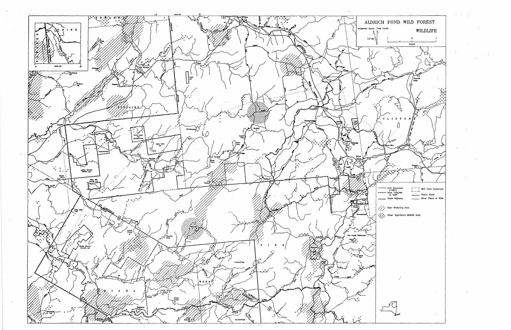
----------
\ ALDRICH POND WILD FOREST
~09netic North True North
""W~
-- Unit Boundary (1987)
---- Area included in UMP
-- State HiQhwoy
0 Deer Wintering Area
WILDLIFE
0
c:=:J DEC-held Easement
-- Public Rood
--- Other Rood or ROW
~ other Significant WikHife Area
•···
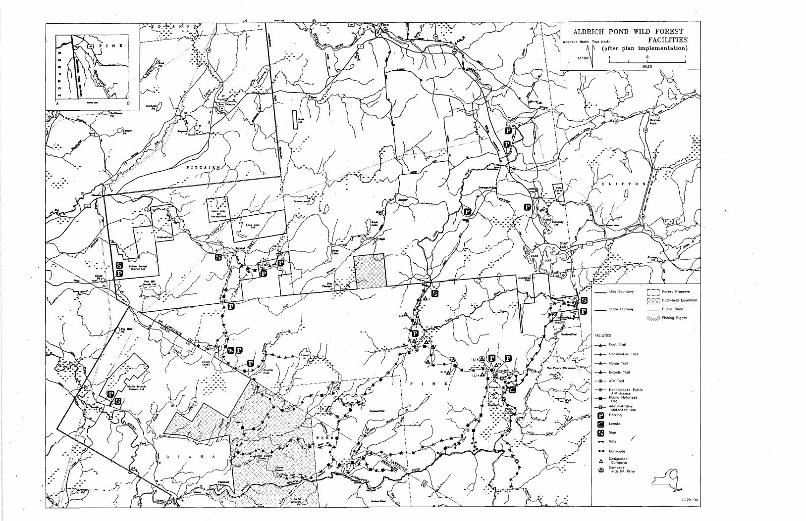
. . ~ . . . .
•• -5?).
. --____ :...:...-·-- ALDRICH POND North
WILD FOREST FACILITIES
(after plan implementation)
0
Fool Trail
Snowmobile Trail
Horse Troll
Bicycle Trail
AN Trail
Handicapped Public ATV Access
Public Motorized Use
Administrative Motorized Use
Parking
Leon to
Sign
I .... Gote
- Barricade
A Designated Campsite
@ Campsite with Pit Pri....y
r·-·-, Forest Preserve i....._._i
f2'.:ZJ DEC-held Easement
Public Rood
Fishing Rights
7-29-94
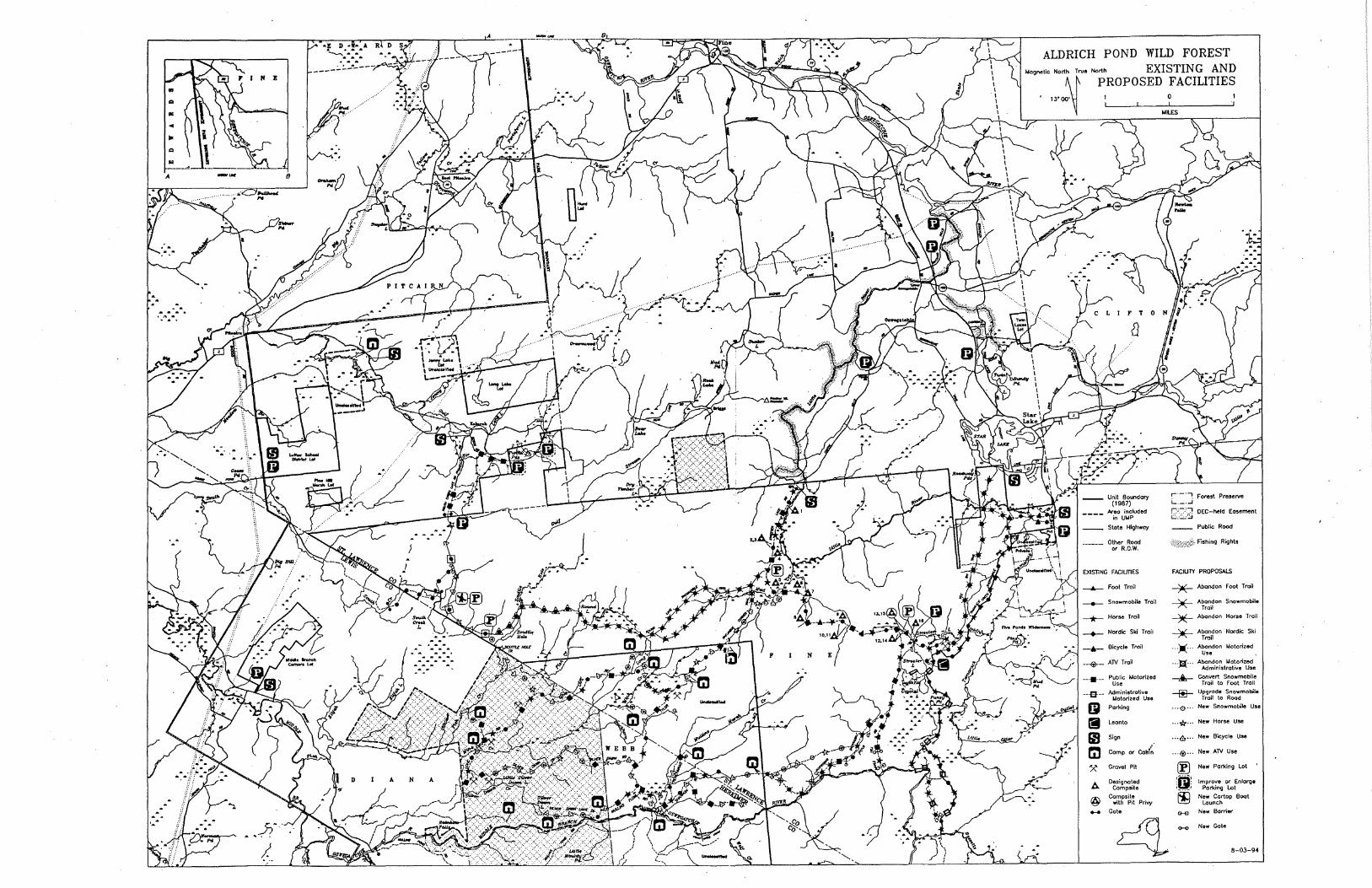
'•
.. .. . . . . ~ -. -.
--~- .. /
8
~o
--------------
~
.-
·.c,J,(
ALDRICH POND WILD FOREST
'~~;,.::~·· North EXISTING AND
PROPOSED FACILITIES
____ kea included in UMP
State Hi9hwoy
Other Rood or R.O.W.
Foot Trail
Snowmobile Trail
Horse Trail
Nordic Ski Trail
Bicycle T roil
---fir- ATV Trail
--•- Public Motorized Use
Administrative Motorized Use
Parking
Leonto
Sign
Comp or eaef~
'X Gravel Pit
/;,,,. Designated Campsite
@ Campsite with Pit Privy .... Gate
0
q
. . Foreat Preserve L.- . ..J
f2:2'.;J DEC-held Easement
Public Rood
Fishing Rights
FACILITY PROPOSALS
-jlE- Abandon Foot T roil
--)E- Abandon Snowmobile Trail
~ Abandon Horse Trail
~ Abandon Nordic Ski Trail
··)(·· ~r:on Motorized
· · ·:t;l· · · A~~i~~st~o~~eriz~e --db- Convert Snowmobile
Trail to foot Trail
~ Upgrade Snowmobile Trail to Rood
... 0 •• . New Snowmobile Use
... tf... New Horse Use
... 6... Now BK:yclo U""
... ®··· New ATV Use
® New Parking Lot
!i}! Improve or Enlarge
·~· Parking Lot
New Cortop Boot Launch
CHl New Barrier
....., New Gote
8-03-94