Embed Size (px)
Citation preview
AN EXCEPTIONALLY WARM DAY IN JANUARY
By I. T. LYALL Newark, Nottinghamshire
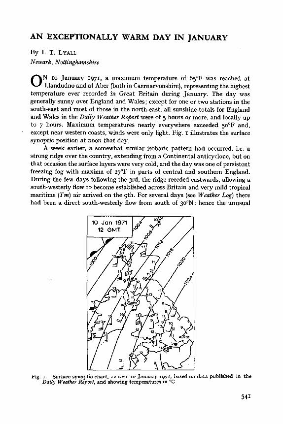
N 10 January 1971, a maximum temperature of 65°F was reached at 0 Llandudno and at Aber (both in Caernarvonshire), representing the highest temperature ever recorded in Great Britain during January. The day was generally sunny over England and Wales; except for one or two stations in the south-east and most of those in the north-east, all sunshine-totals for England and Wales in the Daily Weather RePort were of 5 hours or more, and locally up to 7 hours. Maximum temperatures nearly everywhere exceeded 50°F and, except near western coasts, winds were only light. Fig. I illustrates the surface synoptic position at noon that day.
A week earlier, a somewhat similar isobaric pattern had occurred, i.e. a strong ridge over the country, extending from a Continental anticyclone, but on that occasion the surface layers were very cold, and the day was one of persistent freezing fog with maxima of 27°F in parts of central and southern England. During the few days following the 3rd, the ridge receded eastwards, allowing a south-westerly flow to become established across Britain and very mild tropical maritime (Tm) air arrived on the 9th. For several days (see Weather Log) there had been a direct south-westerly flow from south of 30"N: hence the unusual
'
Fig. I. Surface synoptic chart, IZ GMT 10 January 1971, based on data published in the Daily Weather RejJovt, and showing temperatures in O C
541
iiiiltlnrss ol tlw 7'nc air. On 9 January, temperatures reached bo"F around the Moray Firth and also in parts of North Wales - including 63°F at Aber. These temperatures were doubtless due to fohn effects in the lee of the Grampians and Snowdonia respectively.
TEXII'I~RATURES I N N O K I H \VALES O N I0 JANC'AKY
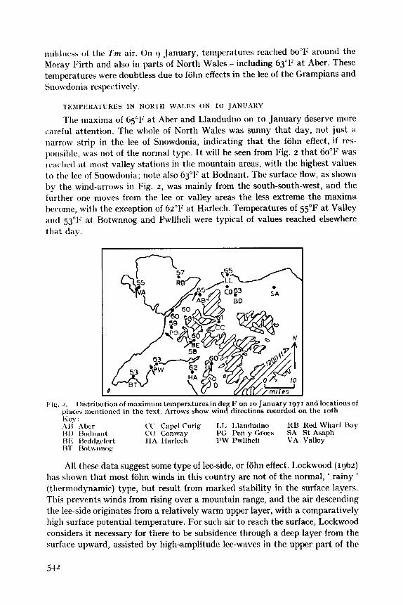
Tlie maxima of 65°F at Aber and Llandudno on 10 January deserve more cxreful attention. The whole of North Wales was sunny that day, not just a narrow strip in the lee of Snowdonia, indicating that the fohn effect, if res- ponsiit)lc, was not of the normal type. I t will be seen from Fig. z that 60~1' was rr;wlictl at most valley stations in tlie mountain areas, with tlie highest values to tlic lee of Snowdonia; note also 63°F a t Bodnant. The surface flow, as shown by the wind-arrows in Fig. 2, was mainly from the south-south-west, and tlie further one moves from the lee or valley areas the less extreme the maxima become, with the exception of 62°F a t Harlech. Temperatures of 55°F a t Valley and 53'1; at Hotwnnog and Pwllheli were typical of values reached elsewhere that day
l'ig. 2 . 1)istribution of maximum tcmperatures in deg F on 10 January I971 and locations of placcs nicntioncd in the tcxt. Arrows show wind directions recorded on the 10th
;\I3 Alwr C'C Capel Curig 1.1, 1,landutlno I<U Red Wharf Bay 131) I.3otln;lnt C O Conwav PG Pen y Grow SA St Asaph HI< I3cddgclcrt 1lA I-larlech 1'W I'wllhcli VA Vallcy HT 13otwnnog
Iicy :
All these data suggest some type of lee-side, or fohn effect. Lockwood (1962) has shown tliat most fohn winds in this country are not of the normal, ' rainy ' (thermodynamic) type, but result from marked stability in the surface layers. This prevents winds from rising over a mountain range, and the air descending the lee-side originates from a relatively warm upper layer, with a comparatively high surface potential-temperature. For such air to reach the surface, Lockwood considers it necessary for there to be subsidence through a deep layer from the surface upward, assisted by high-amplitude lee-waves in the upper part of the
stable surface-layer, together with wind speeds of not less than 15 kt in the first 10 ooo ft.
At Valley at noon, the dry-bulb reading was 54°F with a dew-point of 39°F. If this can be taken as typical of air reaching the area from the south that afternoon, then that reaching Aber would have had to cross the Snowdonia massif which reaches approximately I km above sea level. However, since the saturation level was near 800 m, any ' rainy ' fohn effect would have been most unlikely. In addition, it is worth noting the sounding taken from the nearest up-wind radiosonde station - Camborne in Cornwall. This indicated a near- isothermal layer up to 850 mb at 46-5o0F, whilst a sharp drop in dew-point with height suggested the presence of anticyclonic subsidence. In short, taken with the fact that the extreme west was windier than the rest of :the country, the conditions approximate to Lockwood's criteria.
The Snowdon peaks would lie within the isothermal layer (if we assume the Camborne sounding is applicable there) and air at, say, 48°F would, in descending I km, be adiabatically warmed to 66"F, very close to the recorded value.
Before leaving discussion of the relevance of the fohn effect, it might be worth considering some recent comments by Brinkmann (1971). In discussing the problem of defining a fohn, she takes three criteria: (a) an abrupt rise in temperature, (b) a simultaneous decrease in humidity, and (c) wind from the mountain range. Throughout 9-10 January, winds at Aber blew from the direction of Snowdonia. Table I shows hourly values of temperature and humidity on the afternoon of 9 January; temperatures then remained above 56°F and relative humidities below 60% until late on the 10th. Whilst Brinkmann's criteria were not met in a clear-cut fashion, it seems fairly obvious that the locally-high maxima on the 10 January were due to an ' anticyclonic ' fohn effect.
TABLE I . Temperature and humidity at Abcr, 5) January 1971
Relative Time Temperature humidity GMT OF Y O
I I 0 0 53 74 I200 53 82 I 300 52'5 S2 I 400 53 73 I 500 5 4 53 I 600 56.5 54
I t is interesting to note some temperatures recorded on the evening of the 10th by Mr K. G. Ledson, making a car journey,eastward. At zoh, it was still 61°F at Aber, but he recorded 52°F at Conway and 38°F at St Asaph. This contrast of 23 deg F occurred within 25 miles. It is interesting to speculate that the chilling at St Asaph, lying as it does in the north-south oriented Clwyd valley, may well have been enhanced by a katabatic effect, in which case this remarkable contrast was due to the juxtaposition of two thermally-opposed orographic effects.
543
I1 J A N U A R Y I N NORTH WALES
As would be expected during fine weather in mid-winter, temperatures fell noticeably by 11 January in parts of Snowdonia. Thus, maxima fell from 65T to 49'1; at Aber and from 63°F to 47°F a t Bodnant. Against this, some valley stations were nearly as warm (Beddgelert, Cape1 Curig and Pen y Groes for example) and at Red Wharf Bay on Anglesey the maximum on the 11th was 59"F, compared with 57°F the previous day. Winds over North Wales on 11 January were easterly so that, for example, Pen y Groes on the western side of Snowdonia would be much more favourably placed than Bodnant, to the east. The value at Red Wharf Bay seems a little curious but probably indicates that one should take tlie geostrophic direction (south-easterly rather than that of the surface Aow.
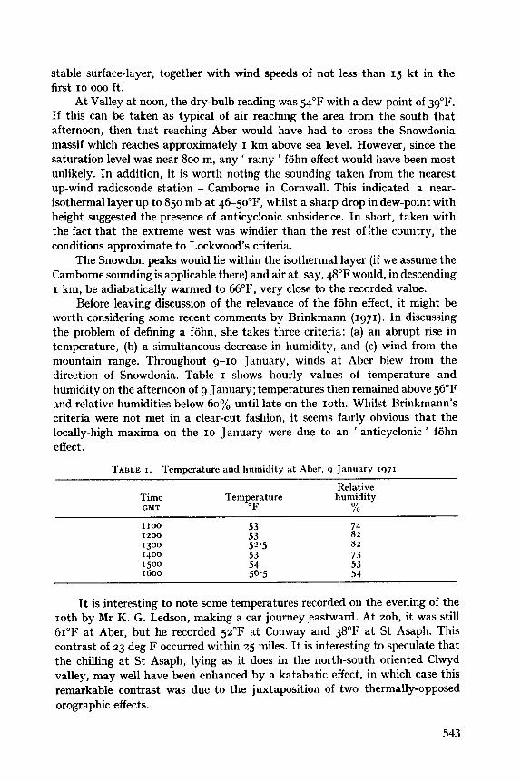
I?&. 3 . 500-nib contour chart, 00 GMT I I January 1971, taken from the Daily Aerological Hrcwd
THE SYNOI'IIC SITUATION A N D CHILLING ON I1 JANUARY
Fig. 3 shows the 5oo-mb contour chart for ooh on 11 January, clearly indicating the development o f a ' warm high '. Indeed, the synoptic situation of 9-11 January closely resembles those favourable for the development of early warm spells (Lyall 1971). In this case, the highest temperatures were in a fohn situation, for Tm air cannot maintain its warmth under clear skies and light winds in January. Table z illustrates this point with data from the Daily
TABLE L. Data for Elmdon from the Daily Wealhev Report
Temperature Wind speed Low cloud Sunshine ("C) (kt) (oktas) (hr)
c) Jan Izh I 2 '3 8 r8h I 0 '5 7
10 Jan ooh 9 14 7 06h 7 9 7 night min 4
day mas I 3 I I Jan ooh 3 2 nil
06h 0 7 6 night min 0
3 7 3 rzh I8h 2 6 I
day max 5 2.8
day max I 2 nil
Izh I 0 I 1 nil r8h 6 Calm nil
544
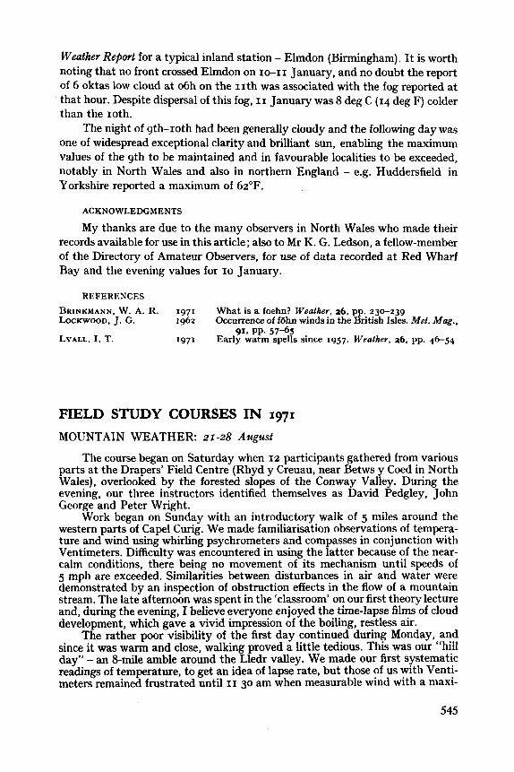
Weather Report for a typical inland station - Elmdon (Birmingham). It is worth noting that no front crossed Elmdon on 10-11 January, and no doubt the report of 6 oktas low cloud at 06h on the 11th was associated with the fog reported at that hour. Despite dispersal of this fog, 11 January was 8 deg C (14 deg F) colder than the 10th.
The night of 9th-10th had been generally cloudy and the following day was one of widespread exceptional clarity and brilliant sun, enabling the maximum values of the 9th to be maintained and in favourable localities to be exceeded, notably in North Wales and also in northern England - e.g. Huddersfield in Yorkshire reported a maximum of 62°F.
ACKNOWLEDGMENTS
My thanks are due to the many observers in North Wales who made their records available for use in this article; also to Mr K. G. Ledson, a fellow-member of the Directory of Amateur Observers, for use of data recorded at Red Wharf Bay and the evening values for 10 January.
REFERENCES
BRINKMANN, W. A. R. 1971 LOCKWOOD, J. G. 1962
LYALL, 1. T. 1971
What is a foehn? Weather, 26, pp. 230-23g Occurrence of f6hn winds in the British Isles. Met. Mag.,
Early warm spells since 1957. Weather, 26, pp. 46-54 9x8 PP. 57-65
FIELD STUDY COURSES IN 1971 MOUNTAIN WEATHER: 21-28 Azcgust
The course began on Saturday when 12 participants gathered from various parts a t the Drapers’ Field Centre (Rhyd y Creuau, near Betws y Coed in North Wales), overlooked by the forested slopes of the Conway Valley. During the evening, our three instructors identified themselves as David Pedgley, John George and Peter Wright.
Work began on Sunday with an introductory walk of 5 miles around the western parts of Cape1 Curig. We made familiarisation observations of tempera- ture and wind using whirling psychrometers and compasses in conjunction with Ventimeters. Difficulty was encountered in using the latter because of the near- calm conditions, there being no movement of its mechanism until speeds of 5 mph are exceeded. Similarities between disturbances in air and water were demonstrated by an inspection of obstruction effects in the flow of a mountain stream. The late afternoon was spent in the ‘classroom’ on our first theory lecture and, during the evening, I believe everyone enjoyed the time-lapse films of cloud development, which gave a vivid impression of the boiling, restless air.
The rather poor visibility of the first day continued during Monday, and since it was warm and close, walking proved a little tedious. This was our “hill day” - an 8-mile amble around the Lledr valley. We made our first systematic readings of temperature, to get an idea of lapse rate, but those of us with Venti- meters remained frustrated until 11 30 am when measurable wind with a maxi-
545