Embed Size (px)
Citation preview
Tst
Qvr
Tsg
Qvt
Qyal
Qyal
Tn
To
Qvt
Qvt
Qvt
TKwa
Tsg
Qvt
Qvt
Qvt
Tmp
Tst
Qvt
Tmp
Qvr
Qvi
Qvr
Qvt
Tv
Qag
Tmp
Qvt
Qvi
Tn
Qvr
Qvt
Tpt
TKwa
Qag
Qvt
Qag
Qvt
Qvr
Qag
Tmp
Qag
Tpt
Qag
Qag
Qvt
Tmp
TKwa
Qvr
Trr
To
Qf
Tmp
Qag
Qvi
Qvr
Qvr
Tig
Qva
TKwg
Qvt
Qag
Tv
TKwg
Qvr
Qvt
Qvt
Qyal
Qag
TstQvt
TKwg
Qyal
QagQf
Qvr
Qf
TKwa
Qf
TKwa
Qvim
Qvr
Qvim
Qvi
Qyal
Qva
Tpt
Tsg
Qvr
Qag
Qag
Qag
TKwg
Tst
Tsg
Tss
Qva
Qf
Tig
Qag
Tig
TKwa
TKev
TKwa
TKwa
Qyal
Tv
Tv
Qag
Qvt
Qvi
Qag
Qvr
Qoal
Qvt
Qtb
gb
Qyal
Qtb
Qvi
Qvr
Qvr
Qag
Tmp
Tmp
Tp
Qf
Qyal
Qvt
Qvt
TKwa
Qvim
Tst
Qvt
TKe
Qag
Qag
Qls
Qvi
Qvi
TigTmp
Qtb
Qvr
m
Qvi
Qls
Tmp
Ked
Qmw
Qvt
Qvt
Qvr
Qvt
Qf
TKwaTmp
Qvt
Qvt
Qag
Qag
Qag
Qva
Tmp
Qvr
Qvr
Qvr
Qvt
Tig
Qvr
Qag
Tmp
Tp
Qvr
Qag
Qvt
Qvt
Qvr
Qvr
Tv
Tptm
Qag
Tmp
Qvt
Qmw
Qvr
Qvr
Ti
Qvr
Qf
Tig
Qoal
Qva
Qvr
Qvt
Qvr
Ti
Qvr
Qvr
Qag
Qvt
Qvr
Qtb
Qf
Qf
Qag
gl
Tmp
Qf
Qag
Qva
TKev
Qag
Qpf
Qmw
Qf
QvrQva
Qva
Qpf
Qvt Qag
Tp
TKev
Tmp
Qvr
Qvu
Qvi
Qva
Qag
Qvr
Tmp
Qf
Tst
Qyal
QfQmw
Qpf
Tpt
Qls
TKev
Qvr
Qvr
Qvr
Qvt
Tp
Qls
Qls
Qvr
TKwv
Qvt
Qvr
Qf
Tmp
TKwa
TKwa
TKwa
QvtQpf
Qf
Qvr
Qag
Qgt
TKwa
Qt
Qvr
Qvi
Qvr
Qf
Qgt
Qtb
Qf
Qls
TKev
TKwg
Qls
TKwa
m
Qag
Tmp
Qag
TKwg
Qf
Qvt
Qt
Tmp
QfQtb
TKwg
Qls
Qf
Tv
TKwg
Tmp
Qmw
Qyal
Qvu
Qf
Qag
Qt
Qpf
Qvt
Qvr
Qag
Qt
Tst
TKwa
Qtb
Qt
Qdu
Qvr
Tmp
Qvt
Qls
Qvi
Qag
Qf
Qvu
Qoal
Qf
Qvi
Qf
Qyal
Tpt
Tst
Tv
Qf
Qtb
Qt
Qvt
Qvt
Qpf
Tst
Tmp
Qls
Tmp
Qvt
Qls
Qtu
Qf
gl
TKwa
Tmp
Tmp
Qf
Qf
Qvt
Qpf
Qvr
Qt
Qvr
Qls
Tmp
Qf
TKwa
Qls
Qvt
Qvr
Qt
Qvi
Qls
Qag
Qf
Qag
Qvt
Qoal
Qpf
Qvr
Qvr
Qt
Qls Qt
Qvt
TptmTptm
Qvr
TKwa
Qt
Trr
Qvr
Qt
Qvr
Qf
Qf
Qvr
Qf
Qob
Qls
Qag
Qf
Qvr
Qvr
Qvu
Qva
Qmw
Qag
Qag
m
Qva
Qf
Qtb
Qvi
Qva
TKwa
Qt
Qag
Tig
QagQag
Tn
Tst
Qt
Qt
Tmp
TKwa
Qvr
Qf
TKwa
Qvu
Qt
Qvt
Tmp
TstQf
Qf
TKwa
Tmp
Qf
Trr
Qag
Qvt
Qgt
Qpf
Qt
TKwa
Qtb
Qls
gl
Tpt
TKe
Qf
Qls
TKwa
Qvt
Qva
TKwa
Qf
Tp
Qmw
Qtb
gl
Qt
Qyal
Qmw
Qf
Tp
Qmw
TKwg
Qf
Qvt
Tptm
Qyal
Qvu
Qt
Qvt
Qt
Qyal
Qvr
Qt
TKwa
Qvr
Qf
Tst
Qf
Qpf
Qmw
Tmp
Qyal
Qf
Qf
Qt
Qvt
Tptm
Qt
Qt
TKwa
Qvr
Qtb
Qvr
Qt
TKwa
Qvt
TKe
Qf
Qf
Qyal
Tmp Qf
TpQt
Qf
Qvr
Qvr
QtTKwa
Qvt
Qls
TKwa
Qva
Qf
Qvr
Qls Qf
Qvr
Qf
Qvu
Qvr
Qoal
Tmp
Qag
Qyal
Qt
Tst
Qf
Qls
Qls
QyalQob
TKwa
Qt
Tmp
Qvu
Qvt
Qf
Qvu
Qmw
Qf
Qls
Tmp
Qt
TmpQvu
Qgt
Qvr
Qva
TKwa
Qpf
Qvr
Tpt
Qyal
Qt
Qyal
Tig
Qt
Qvt
To
Qvt
Tst
Qvr
Qls
Qyal
Qvr
Qf
Qf
Qls
Qvr
TKwa
Qvt
Qvr
Qoal
Qyal
TiQvr
Qf
Qvu
Qt
Tmp
Qyal
Qls
Qag
TKwa
Qpf
Tmp
TKwa
Qag
Qva
Qw
TmpQyal
Qf
Qvt
Qva
TKwg
Qvt
Qvr
Qvr
Qvu
Qt
TKwa
Qvu
Qpf
Qvr
Qls
TKwa
Qva
Qf
Qt
Qag
Tmp
TKwa
Qtb
TKwa
Qf
Qf
Qt
Qva TKwg
Qf
Qpf
Qtu
Qw
Qvr
Tmp
Qva
Qvu
Tmp
Qf
Qpf
Qf
Qvr
Tmp
Tp
Qag
TKwa
Qyal
Qvu
Qva
Qf
Qf
TKe
TKwa
Qvu
Tmp
Qf
Tmp
Qvu
Ti
Qvt
gl
Qf
Qvr
Tmp
Tmp
Qvu
Qvr
Tpt
Qyal
Qtb
Tpt
Tst
Qls
Qvt
Qf
Qag
Ti
Qvu
Qf
Qpf
Qvt
TKwa
Ts
Qpf
TKwa
Qf
Qva
Tpt
Tmp
Qls
Qvu
Qf
Qls
Tmp
Tmp
Qvu Tig
Tn
Tmp
Qf
Tmp
Qvu
Qf
Qob
TKwa
Qva
Qt
TKwa
Tptm
Qf
Tptm
TKwa
Tmp
Qgt
Qpf
Qva
Qyal TKwa
TKwg
Qvr
Tmp
Qvu
QfQf
TKwa
Qag
TKwaTptm
TKwa
Tmp
TKwa
Tmp
QvuQpf
Qvu
Tmp
Qvr
Tptm
Qvr
Qf
Qf
Qf
Tmp
Tmp
Qvr
Tmp
Qf
Qls
TKe
Qpf
Qvu
QfQvr
Qoal
Tmp
Tmp
Qoal
Tmp
Qf
Qvu
Qpf
Qvr
Qag
Tmp
Qls
TKwa
Qf
Qw
Qva
Qvu
Qvt
Qmw
Qag
Qt
Qvu
Qvu
Tmp
Qvt
Tmp
Qls
TKwg
Qf
TKwa
Qf
Qtb
Qls
Qvu
Qvt
Qvu
Tmp
QvtTmp
Tmp
Qvu
Qf
Qpf
Qvt
Qvu
Qvu
Tpt
Qw
TKwa
Tmp
TKwa
Tmp
Tmp
TKwa
TKwa
Tmp
Tmp
TKwa
Qoal
TKwa
Qvu
Qva
Qpf
TKwa
Qvr
Tmp
Tmp
TKwg
Tmp
Tmp
TKwa
Tmp
Tpt
Tmp
Qls
Tmp
TKwa
TKwa
Qvu
Tsg
Qvt
TKwa
TptTptQls Tpt
Tpt
Tpt
The information included on this map has been compiled from a variety of sources and is subject to change without notice. King County makes no representations or warranties, express or implied, as to accuracy,
completeness, timeliness, or rights to the use of such information. King County shall not be liable for any general, special, indirect, incidental, or consequential damages including, but not limited to, lost revenues or lost profits
resulting from the use or misuse of the information contained on this map.Any sale of this map or information on this map is prohibited except by written permission of King County.
Data Sources: Booth, D.B., Haugerud, R.A., and Sackett, J., in press, Geologic Map of King County, Washington: U.S. Geological Survey Miscellaneous Field Investigation
File Name: 0312snoGEOLgeneralized.ai wgab Prepared by: King County DNRP/WLR GIS and Visual Communications & Web Unit
Department of Natural Resources and ParksWater and Land Resources Division
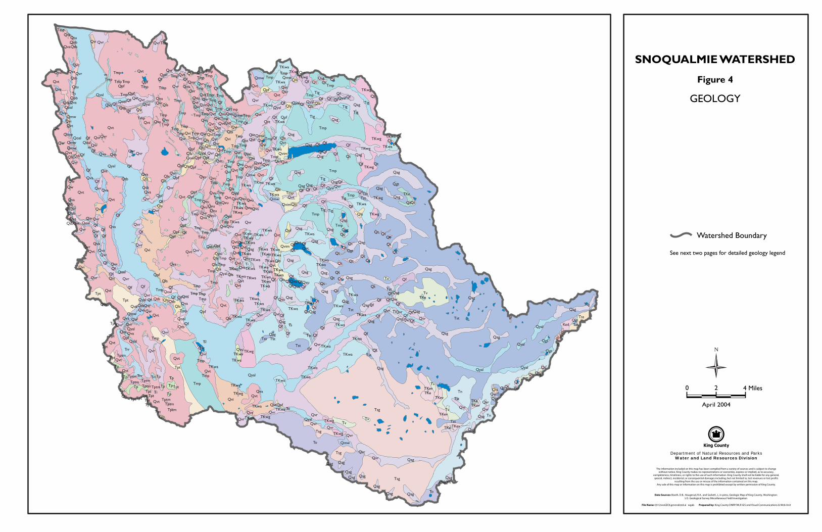
SNOQUALMIE WATERSHED
Figure 4
GEOLOGY
Watershed Boundary
See next two pages for detailed geology legend
0 2 4 Miles
April 2004
N
File Name: 0401snoGEOLdescriptions.ai wgab Prepared by: King County DNRP/WLR GIS and Visual Communications & Web Unit
Department of Natural Resources and ParksWater and Land Resources Division
SNOQUALMIE WATERSHED
Figure 4 (continued)
GEOLOGIC MAP DESCRIPTIONS
Quaternary
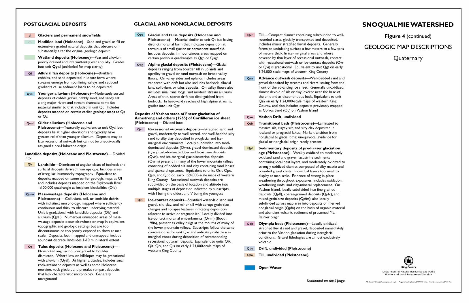
POSTGLACIAL DEPOSITS
Glaciers and permanent snowfields
Modified land (Holocene)—Sand and gravel as fill or extensively graded natural deposits that obscure or substantially alter the original geologic deposit.
Wetland deposits (Holocene)—Peat and alluvium, poorly drained and intermittently wet annually. Grades into unit Qyal (unlabeled for map clarity)
Alluvial fan deposits (Holocene)—Boulders, cobbles, and sand deposited in lobate form where streams emerge from confining valleys and reduced gradients cause sediment loads to be deposited
Younger alluvium (Holocene)—Moderately sorted deposits of cobble gravel, pebbly sand, and sandy silt along major rivers and stream channels; some fan material similar to that included in unit Qt. Includes deposits mapped on certain earlier geologic maps as Qa or Qal
Older alluvium (Holocene and Pleistocene)—Texturally equivalent to unit Qyal but deposits lie at higher elevations and typically have greater relief than younger alluvium. Deposits may be late recessional outwash but cannot be unequivocally assigned a pre-Holocene origin
Landslide deposits (Holocene and Pleistocene)— Divided into:
Landslide—Diamicton of angular clasts of bedrock and surficial deposits derived from upslope. Includes areas of irregular, hummocky topography. Equivalent to deposits mapped on some earlier geologic maps as Ql and includes deposits mapped on the Skykomish River 1:100,000 quadrangle as incipient blockslides (Qib)
Mass-wastage deposits (Holocene and Pleistocene)— Colluvium, soil, or landslide debris with indistinct morphology, mapped where sufficiently continuous and thick to obscure underlying material. Unit is gradational with landslide deposits (Qls) and alluvium (Qyal). Numerous unmapped areas of mass-wastage deposits occur elsewhere on map in equivalent topographic and geologic settings but are too discontinuous or too poorly exposed to show at map scale. Deposits, both mapped and unmapped, include abundant discrete landslides 1-10 m in lateral extent
Talus deposits (Holocene and Pleistocene)— Nonsorted angular boulder gravel to boulder diamicton. Where low on hillslopes may be gradational with alluvium (Qyal). At higher altitudes, includes small rock-avalanche deposits as well as some Holocene moraine, rock glacier, and protalus rampart deposits that lack characteristic morphology. Generally unvegetated
GLACIAL AND NONGLACIAL DEPOSITS
Glacial and talus deposits (Holocene and Pleistocene)— Material similar to unit Qt but having distinct morainal form that indicates deposition at terminus of small glacier or permanent snowfield. Includes deposits in mountainous areas mapped on certain previous quadrangles as Qgp or Qagt
Alpine glacial deposits (Pleistocene)—Glacial deposits ranging from boulder till in uplands and upvalley to gravel or sand outwash on broad valley floors. On valley sides and uplands includes areas veneered with drift but also includes bedrock, alluvial fans, colluvium, or talus deposits. On valley floors also includes small fans, bogs, and modern stream alluvium. Areas of thin, sparse drift not distinguished from bedrock. In headward reaches of high alpine streams, grades into unit Qgt
Deposits of Vashon stade of Fraser glaciation of Armstrong and others (1965) of Cordilleran ice sheet (Pleistocene)— Divided into:
Recessional outwash deposits—Stratified sand and gravel, moderately to well sorted, and well-bedded silty sand to silty clay deposited in proglacial and ice-marginal environments. Locally subdivided into sand-dominated deposits (Qvrs), gravel-dominated deposits (Qvrg), silt-dominated lowland lacustrine deposits (Qvrl), and ice-marginal glaciolacustrine deposits (Qvrm) present in many of the lower mountain valleys consisting of bedded silt and clay containing sand lenses and sparse dropstones. Equivalent to units Qsr, Qpo, Qpv, and Qpd on early 1:24,000-scale maps of western King County. Recessional outwash deposits are subdivided on the basis of location and altitude into multiple stages of deposition indicated by subscripts, with I being the oldest and V being the youngest
Ice-contact deposits—Stratified water-laid sand and gravel, silt, clay, and minor till with abrupt grain-size changes and collapse features indicating deposition adjacent to active or stagnant ice. Locally divided into ice-contact morainal embankments (Qvim) (Booth, 1986), present as valley plugs at the mouths of many of the lower mountain valleys. Subscripts follow the same convention as for unit Qvr and indicate probable ice-marginal zones during deposition of corresponding recessional outwash deposit. Equivalent to units Qik, Qit, Qiv, and Qis on early 1:24,000-scale maps of western King County
Till—Compact diamict containing subrounded to well-rounded clasts, glacially transported and deposited. Includes minor stratified fluvial deposits. Generally forms an undulating surface a few meters to a few tens of meters thick. In ice-marginal areas and where covered by thin layer of recessional outwash, contact with recessional-outwash or ice-contact deposits (Qvr or Qvi) is gradational. Equivalent to unit Qgt on early 1:24,000-scale maps of western King County
Advance outwash deposits—Well-bedded sand and gravel deposited by streams and rivers issuing from the front of the advancing ice sheet. Generally unoxidized; almost devoid of silt or clay, except near the base of the unit and as discontinuous beds. Equivalent to unit Qsa on early 1:24,000-scale maps of western King County, and also includes deposits previously mapped as Colvos Sand (Qc) on Vashon Island
Vashon Drift, undivided
Transitional beds (Pleistocene)—Laminated to massive silt, clayey silt, and silty clay deposited in lowland or proglacial lakes. Marks transition from nonglacial to glacial time; unequivocal evidence for glacial or nonglacial origin rarely present
Sedimentary deposits of pre-Fraser glaciation age (Pleistocene)—Weakly oxidized to moderately oxidized sand and gravel, lacustrine sediments containing local peat layers, and moderately oxidized to strongly oxidized diamict composed of silty matrix and rounded gravel clasts. Individual layers too small to display at map scale. Evidence of strong in-place weathering throughout exposures, includes oxidation, weathering rinds, and clay-mineral replacement. On Vashon Island, locally subdivided into fine-grained deposits (Qpff), coarse-grained deposits (Qpfc), and mixed-grain-size deposits (Qpfm); also locally subdivided across map area into deposits of inferred nonglacial origin (Qpfn) on the basis of organic material and abundant volcanic sediment of presumed Mt. Rainier origin
Olympia beds (Pleistocene)—Locally oxidized, stratified fluvial sand and gravel, deposited immediately prior to the Vashon glaciation during interglacial conditions. Gravel lithologies are almost exclusively volcanic
Drift, undivided (Pleistocene)
Till, undivided (Pleistocene)
Open Water
Qag
Qdu
Qf
Qgt
Qls
Qmw
Qoal
Qob
Qpf
Qt
Qtb
Qtu
Qva
Qvi
Qvr
Qvt
Qvu
Qyal
gl
m
Continued on next page
File Name: 0401snoGEOLdescriptions.ai wgab Prepared by: King County DNRP/WLR GIS and Visual Communications & Web Unit
Department of Natural Resources and ParksWater and Land Resources Division
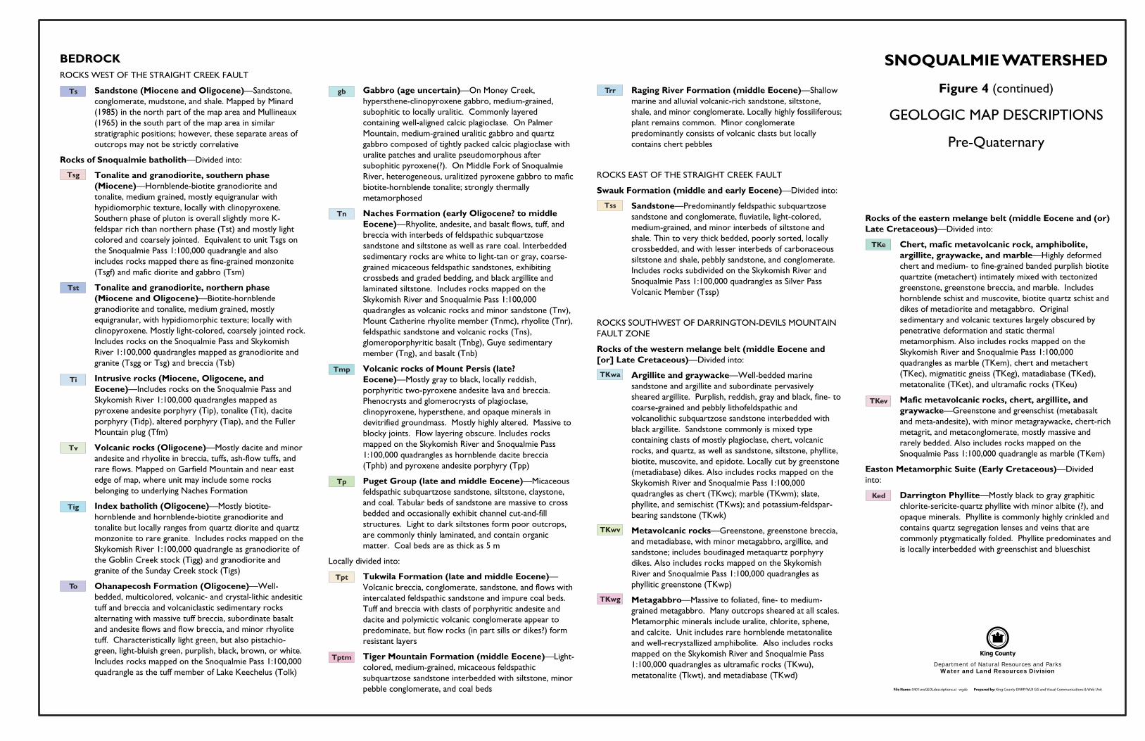
BEDROCKROCKS WEST OF THE STRAIGHT CREEK FAULT
Sandstone (Miocene and Oligocene)—Sandstone, conglomerate, mudstone, and shale. Mapped by Minard (1985) in the north part of the map area and Mullineaux (1965) in the south part of the map area in similar stratigraphic positions; however, these separate areas of outcrops may not be strictly correlative
Rocks of Snoqualmie batholith—Divided into:
Tonalite and granodiorite, southern phase (Miocene)—Hornblende-biotite granodiorite and tonalite, medium grained, mostly equigranular with hypidiomorphic texture, locally with clinopyroxene. Southern phase of pluton is overall slightly more K-feldspar rich than northern phase (Tst) and mostly light colored and coarsely jointed. Equivalent to unit Tsgs on the Snoqualmie Pass 1:100,000 quadrangle and also includes rocks mapped there as fine-grained monzonite (Tsgf) and mafic diorite and gabbro (Tsm)
Tonalite and granodiorite, northern phase (Miocene and Oligocene)—Biotite-hornblende granodiorite and tonalite, medium grained, mostly equigranular, with hypidiomorphic texture; locally with clinopyroxene. Mostly light-colored, coarsely jointed rock. Includes rocks on the Snoqualmie Pass and Skykomish River 1:100,000 quadrangles mapped as granodiorite and granite (Tsgg or Tsg) and breccia (Tsb)
Intrusive rocks (Miocene, Oligocene, and Eocene)—Includes rocks on the Snoqualmie Pass and Skykomish River 1:100,000 quadrangles mapped as pyroxene andesite porphyry (Tip), tonalite (Tit), dacite porphyry (Tidp), altered porphyry (Tiap), and the Fuller Mountain plug (Tfm)
Volcanic rocks (Oligocene)—Mostly dacite and minor andesite and rhyolite in breccia, tuffs, ash-flow tuffs, and rare flows. Mapped on Garfield Mountain and near east edge of map, where unit may include some rocks belonging to underlying Naches Formation
Index batholith (Oligocene)—Mostly biotite-hornblende and hornblende-biotite granodiorite and tonalite but locally ranges from quartz diorite and quartz monzonite to rare granite. Includes rocks mapped on the Skykomish River 1:100,000 quadrangle as granodiorite of the Goblin Creek stock (Tigg) and granodiorite and granite of the Sunday Creek stock (Tigs)
Ohanapecosh Formation (Oligocene)—Well-bedded, multicolored, volcanic- and crystal-lithic andesitic tuff and breccia and volcaniclastic sedimentary rocks alternating with massive tuff breccia, subordinate basalt and andesite flows and flow breccia, and minor rhyolite tuff. Characteristically light green, but also pistachio-green, light-bluish green, purplish, black, brown, or white. Includes rocks mapped on the Snoqualmie Pass 1:100,000 quadrangle as the tuff member of Lake Keechelus (Tolk)
Gabbro (age uncertain)—On Money Creek, hypersthene-clinopyroxene gabbro, medium-grained, subophitic to locally uralitic. Commonly layered containing well-aligned calcic plagioclase. On Palmer Mountain, medium-grained uralitic gabbro and quartz gabbro composed of tightly packed calcic plagioclase with uralite patches and uralite pseudomorphous after subophitic pyroxene(?). On Middle Fork of Snoqualmie River, heterogeneous, uralitized pyroxene gabbro to mafic biotite-hornblende tonalite; strongly thermally metamorphosed
Naches Formation (early Oligocene? to middle Eocene)—Rhyolite, andesite, and basalt flows, tuff, and breccia with interbeds of feldspathic subquartzose sandstone and siltstone as well as rare coal. Interbedded sedimentary rocks are white to light-tan or gray, coarse-grained micaceous feldspathic sandstones, exhibiting crossbeds and graded bedding, and black argillite and laminated siltstone. Includes rocks mapped on the Skykomish River and Snoqualmie Pass 1:100,000 quadrangles as volcanic rocks and minor sandstone (Tnv), Mount Catherine rhyolite member (Tnmc), rhyolite (Tnr), feldspathic sandstone and volcanic rocks (Tns), glomeroporphyritic basalt (Tnbg), Guye sedimentary member (Tng), and basalt (Tnb)
Volcanic rocks of Mount Persis (late? Eocene)—Mostly gray to black, locally reddish, porphyritic two-pyroxene andesite lava and breccia. Phenocrysts and glomerocrysts of plagioclase, clinopyroxene, hypersthene, and opaque minerals in devitrified groundmass. Mostly highly altered. Massive to blocky joints. Flow layering obscure. Includes rocks mapped on the Skykomish River and Snoqualmie Pass 1:100,000 quadrangles as hornblende dacite breccia (Tphb) and pyroxene andesite porphyry (Tpp)
Puget Group (late and middle Eocene)—Micaceous feldspathic subquartzose sandstone, siltstone, claystone, and coal. Tabular beds of sandstone are massive to cross bedded and occasionally exhibit channel cut-and-fill structures. Light to dark siltstones form poor outcrops, are commonly thinly laminated, and contain organic matter. Coal beds are as thick as 5 m
Locally divided into:
Tukwila Formation (late and middle Eocene)— Volcanic breccia, conglomerate, sandstone, and flows with intercalated feldspathic sandstone and impure coal beds. Tuff and breccia with clasts of porphyritic andesite and dacite and polymictic volcanic conglomerate appear to predominate, but flow rocks (in part sills or dikes?) form resistant layers
Tiger Mountain Formation (middle Eocene)—Light-colored, medium-grained, micaceous feldspathic subquartzose sandstone interbedded with siltstone, minor pebble conglomerate, and coal beds
Raging River Formation (middle Eocene)—Shallow marine and alluvial volcanic-rich sandstone, siltstone, shale, and minor conglomerate. Locally highly fossiliferous; plant remains common. Minor conglomerate predominantly consists of volcanic clasts but locally contains chert pebbles
ROCKS EAST OF THE STRAIGHT CREEK FAULT
Swauk Formation (middle and early Eocene)—Divided into:
Sandstone—Predominantly feldspathic subquartzose sandstone and conglomerate, fluviatile, light-colored, medium-grained, and minor interbeds of siltstone and shale. Thin to very thick bedded, poorly sorted, locally crossbedded, and with lesser interbeds of carbonaceous siltstone and shale, pebbly sandstone, and conglomerate. Includes rocks subdivided on the Skykomish River and Snoqualmie Pass 1:100,000 quadrangles as Silver Pass Volcanic Member (Tssp)
ROCKS SOUTHWEST OF DARRINGTON-DEVILS MOUNTAIN FAULT ZONE
Rocks of the western melange belt (middle Eocene and [or] Late Cretaceous)—Divided into:
Argillite and graywacke—Well-bedded marine sandstone and argillite and subordinate pervasively sheared argillite. Purplish, reddish, gray and black, fine- to coarse-grained and pebbly lithofeldspathic and volcanolithic subquartzose sandstone interbedded with black argillite. Sandstone commonly is mixed type containing clasts of mostly plagioclase, chert, volcanic rocks, and quartz, as well as sandstone, siltstone, phyllite, biotite, muscovite, and epidote. Locally cut by greenstone (metadiabase) dikes. Also includes rocks mapped on the Skykomish River and Snoqualmie Pass 1:100,000 quadrangles as chert (TKwc); marble (TKwm); slate, phyllite, and semischist (TKws); and potassium-feldspar-bearing sandstone (TKwk)
Metavolcanic rocks—Greenstone, greenstone breccia, and metadiabase, with minor metagabbro, argillite, and sandstone; includes boudinaged metaquartz porphyry dikes. Also includes rocks mapped on the Skykomish River and Snoqualmie Pass 1:100,000 quadrangles as phyllitic greenstone (TKwp)
Metagabbro—Massive to foliated, fine- to medium-grained metagabbro. Many outcrops sheared at all scales. Metamorphic minerals include uralite, chlorite, sphene, and calcite. Unit includes rare hornblende metatonalite and well-recrystallized amphibolite. Also includes rocks mapped on the Skykomish River and Snoqualmie Pass 1:100,000 quadrangles as ultramafic rocks (TKwu), metatonalite (Tkwt), and metadiabase (TKwd)
Rocks of the eastern melange belt (middle Eocene and (or) Late Cretaceous)—Divided into:
Chert, mafic metavolcanic rock, amphibolite, argillite, graywacke, and marble—Highly deformed chert and medium- to fine-grained banded purplish biotite quartzite (metachert) intimately mixed with tectonized greenstone, greenstone breccia, and marble. Includes hornblende schist and muscovite, biotite quartz schist and dikes of metadiorite and metagabbro. Original sedimentary and volcanic textures largely obscured by penetrative deformation and static thermal metamorphism. Also includes rocks mapped on the Skykomish River and Snoqualmie Pass 1:100,000 quadrangles as marble (TKem), chert and metachert (TKec), migmatitic gneiss (TKeg), matadiabase (TKed), metatonalite (TKet), and ultramafic rocks (TKeu)
Mafic metavolcanic rocks, chert, argillite, and graywacke—Greenstone and greenschist (metabasalt and meta-andesite), with minor metagraywacke, chert-rich metagrit, and metaconglomerate, mostly massive and rarely bedded. Also includes rocks mapped on the Snoqualmie Pass 1:100,000 quadrangle as marble (TKem)
Easton Metamorphic Suite (Early Cretaceous)—Divided into:
Darrington Phyllite—Mostly black to gray graphitic chlorite-sericite-quartz phyllite with minor albite (?), and opaque minerals. Phyllite is commonly highly crinkled and contains quartz segregation lenses and veins that are commonly ptygmatically folded. Phyllite predominates and is locally interbedded with greenschist and blueschist
SNOQUALMIE WATERSHED
Figure 4 (continued)
GEOLOGIC MAP DESCRIPTIONS
Pre-Quaternary
Ked
TKe
TKev
TKwa
TKwg
TKwv
Ti
Tig
Tmp
Tn
To
Tp
Tpt
Tptm
TrrTs
Tsg
Tss
Tst
Tv
gb
AN OVERVIEW OF THE GEOLOGY AND GEOMORPHOLOGY OF THE SNOQUALMIE RIVER WATERSHED
4.0 Glacial History The Snoqualmie River watershed has been subject to two distinctly separate (although substantially contemporaneous) types of glacial activity. Continental glaciers originating in the highlands of the Canadian Coast Range and Vancouver Island merge and flow south forming the Puget lobe of the Cordilleran Ice Sheet. The Cordilleran Ice Sheet has advanced and retreated multiple times during the Pleistocene Era (between two million and ten thousand years ago). The most recent of these advances has been named the Vashon stade of the Fraser glaciation. This continental glacial advance filled the Puget Lowland from the Cascade Mountains to the Olympic Mountains, and extended south as far as the vicinity of the present-day city of Olympia. It reached its maximum extent approximately 14,000 years before present (bp). In the vicinity of the Snoqualmie River watershed, continental glacial ice reached an elevation of 2400 to 3300 feet (750 to 990 meters) on the Cascade Mountains (Thorson, 1979). Sediments deposited by continental glacial advances underlie most of the ground surface in the Snoqualmie River watershed west of the Cascade foothills.
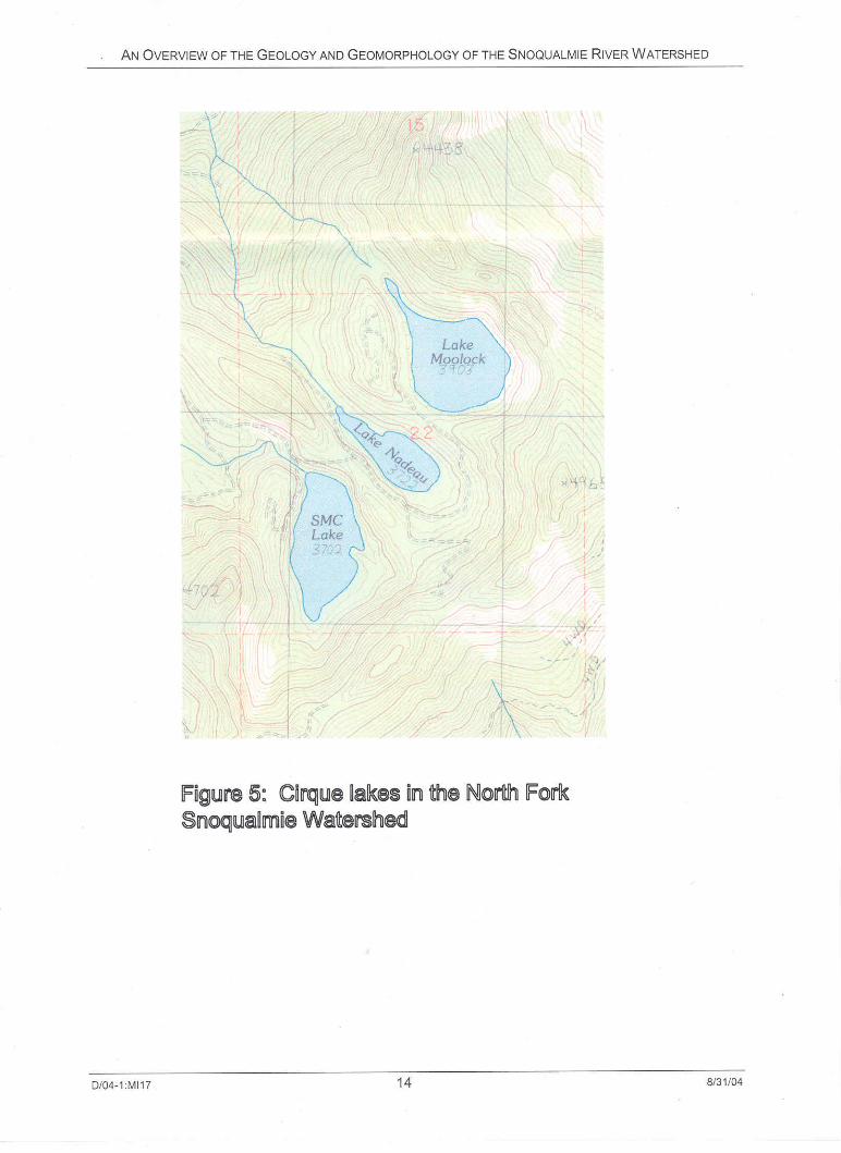
The climatic conditions that lead to growth of continental glaciers also caused mountain, or alpine glaciers to develop and expand. Alpine glaciers from the high Cascades extended down mountain valleys to the Cascade foothills. The most recent major alpine glaciation was the Evans Creek stade of the Fraser glaciation. This advance reached a maximum approximately 20,000 years bp, and these glaciers had retreated significantly by the time of the Vashon continental maximum 6000 years later. In the Snoqualmie watershed, major alpine glaciers developed in the valleys of each of the three forks of the Snoqualmie River, both forks of the Tolt River, and in many of the tributaries to these rivers. Most of the Alpine lakes in the Snoqualmie watershed are cirque lakes, scoured by glacial erosion at the heads of these alpine glaciers (Figure 5). Reconstruction of the alpine glacier profile indicates that the maximum ice thickness in the Middle Fork Snoqualmie Valley was 2100 feet (645 meters) (Williams, 1971). Sediment deposited by the subsequent Vashon advance into the Puget Lowland covered the down-valley deposits of the Evans Creek alpine advance. For that reason, glacial deposits marking the maximum down-valley extent of these alpine glaciers are not exposed to the modern ground surface.
4.1. Glacial Deposits Over the course of a glacial advance and retreat, a variety of sediments is deposited in and near the glacier. Many of these distinct glacial deposits are present in the Snoqualmie watershed. Their extent and geometry provide a rich record of glacial history. The properties of these deposits strongly influence modern geomorphic processes in the watershed.
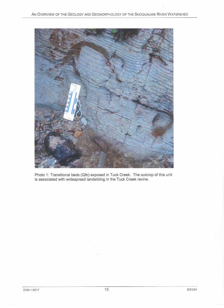
Transitional beds: When the Puget lobe of the Cordilleran Ice Sheet advanced into the Puget Lowland, the lobe blocked drainage from the Puget Lowland to the Strait of Juan de Fuca. With blockage of sea-level drainage to the north, a freshwater proglacial lake formed in the Puget Lowland and rose until it spilled south into the Chehalis Valley. The earliest sediments deposited during a glacial advance into the Puget Lowland are lake-bottom
D/04-1:MI17 12 9/03/04
AN OVERVIEW OF THE GEOLOGY AND GEOMORPHOLOGY OF THE SNOQUALMIE RIVER WATERSHED
sediments deposited in this proglacial lake. These deposits are typically horizontally laminated silts and clays (Photo 1). They are referred to as transitional beds because they mark the transition from non-glacial to glacial conditions. At a given point in the Puget Lowland, transitional beds are the first, and therefore stratigraphically the lowest sediments marking a glacial sequence. Transitional beds are identified as Qtb on Figure 4.
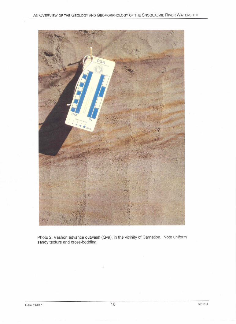
Advance outwash: Glacial outwash is fluvial sediment deposited by streams flowing from the glacier, or by streams diverted by the glacier. Outwash can be deposited during glacial advance and retreat. Outwash deposits laid down during the glacial advance and subsequently overridden by glacial ice are called advance outwash. As the glacier advanced southward into the ice-dammed lake, a wedge of coarser sediment was deposited immediately in front of the advancing ice. Most of this sediment was probably carried in or on the glacial ice and released by melting at the snout of the glacier. These deposits are generally gravelly sand, crudely stratified, often showing cross-bedding (Photo 2). Advance outwash can contain lenses of coarse, well-sorted sediment, probably indicating relict channels, and lenses of very poorly sorted sediment, probably recording mass-waste events as the sediment was being deposited. In the Puget Lowland, advance outwash is often the thickest unit in the Vashon stratigraphic section, and makes up most of the volume of constructional glacial landscapes (Booth, 1994). Advance outwash is identified as Qva on Figure 4.
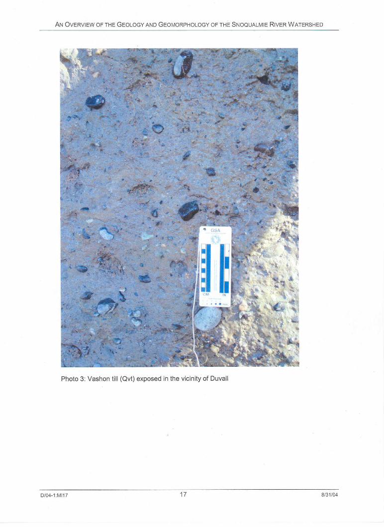
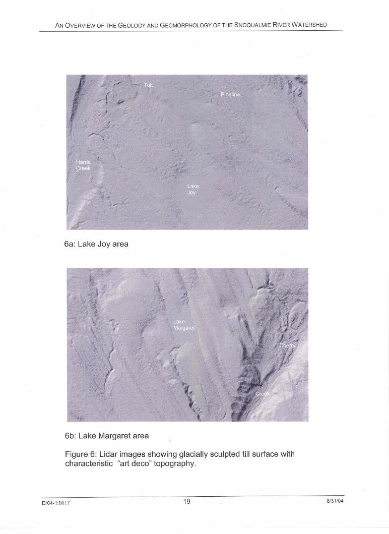
Glacial till: Glacial till is a sediment deposited directly at the base of a glacier. In the Puget Lowland, till generally occurs as dense silty, gravelly sand. Gravel clasts in glacial till are typically not in contact, but are supported by the finer-grained matrix (Photo 3). A layer of glacial till a few tens of feet (several meters) thick directly underlies much of the ground surface on the rolling glacial uplands of the lower Snoqualmie Valley. The distinctive streamlined “Art Deco” topography typical of glacially sculpted till uplands is clearly evident in many parts of the lower Snoqualmie Valley (Figure 6). Glacial till is identified as Qvt on Figure 4.
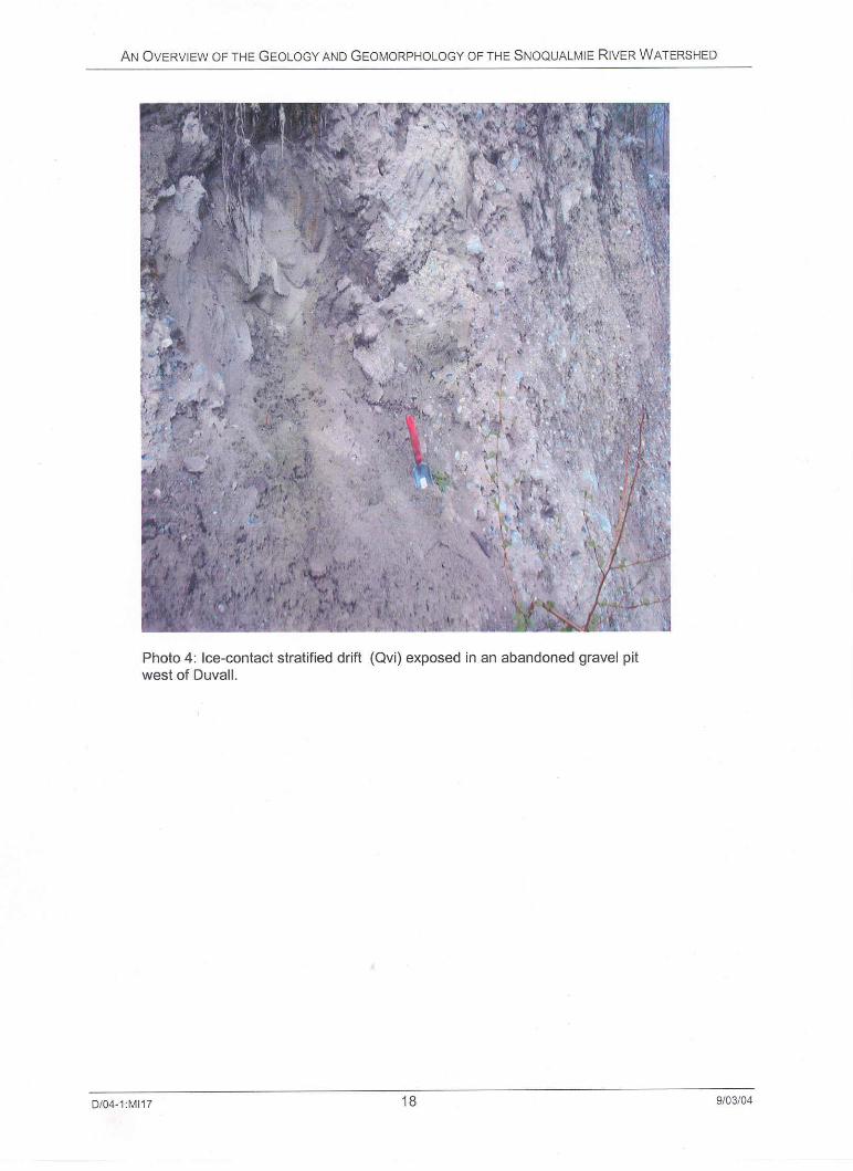
Ice-contact deposits: The lower Snoqualmie Valley is a glacially scoured trough that was occupied by a lobe of ice during late deglaciation. Locally, wedges of sediment accumulated between this ice lobe and the adjacent valley walls. These wedges now form ice-contact or “kame” deposits seen as irregular terraces along the lower valley walls. A kame terrace is especially well-developed and continuous on the east side of the lower valley between Carnation and Fall City. Ice-contact deposits have a heterogeneous texture, but most often are composed of loose to medium dense gravelly silty sand with crude, discontinuous stratification (Photo 4). On Figure 4, ice-contact deposits are labeled Qvi.
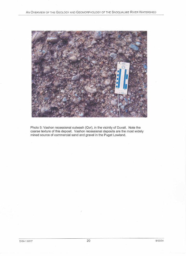
Glacial recessional outwash: Recessional outwash is fluvial sediment deposited during the glacial maximum, and during glacial retreat. Recessional outwash is present in relict outwash channels and deltas throughout the Snoqualmie watershed. These deposits are typically stratified gravelly sand and are often mined for sand and gravel (Photo 5). Recessional outwash is identified as Qvr on Figure 4.
D/04-1:MI17 13 9/03/04

AN OVERVIEW OF THE GEOLOGY AND GEOMORPHOLOGY OF THE SNOQUALMIE RIVER WATERSHED
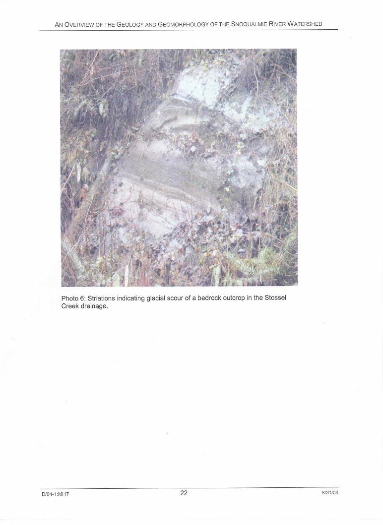
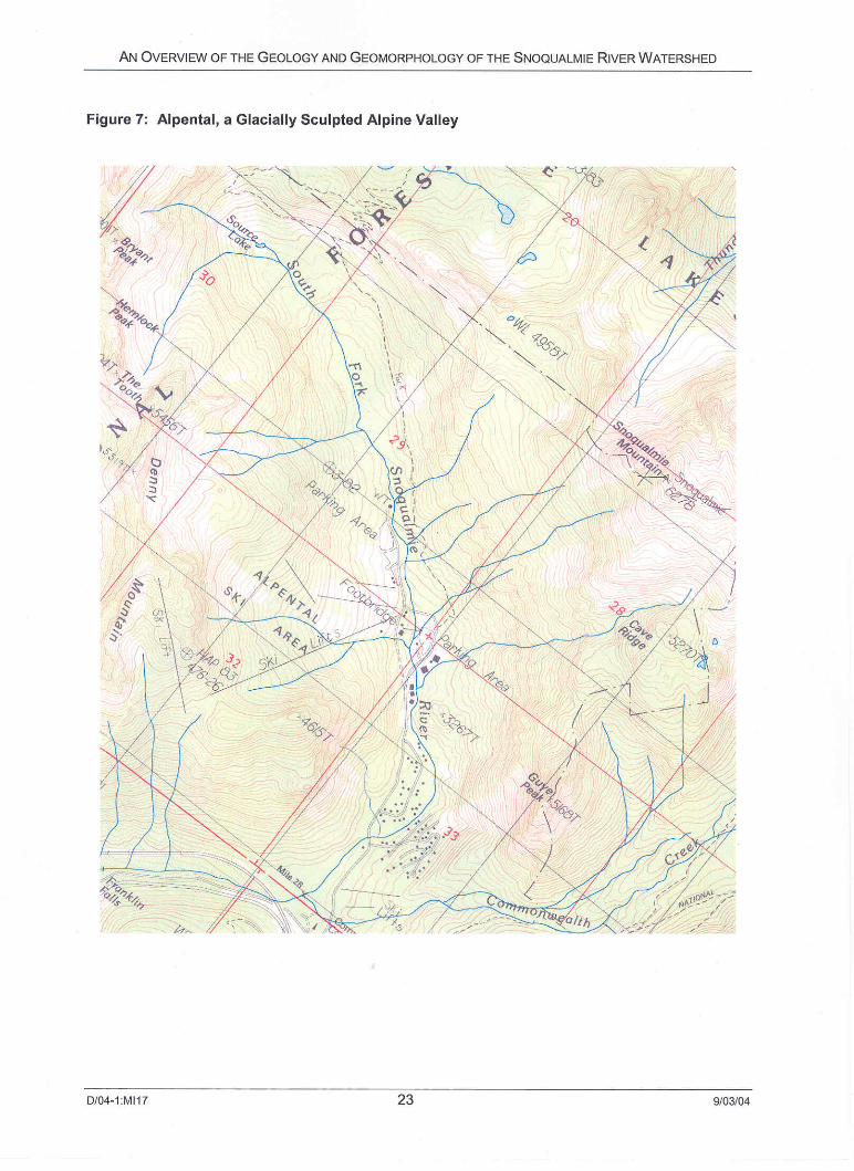
4.2. Glacial Erosion In addition to depositing large volumes of sediment, the continental ice sheet and associated processes were responsible for extensive erosion in the Puget Lowland. The most obvious mechanism of glacial erosion is ice scour; there is clear evidence of ice scour in the Snoqualmie Valley. Photo 6 shows well-developed glacial striations on a bedrock exposure near Stossel Creek. These striations are a direct product of erosion by sliding glacier ice. The effects of ice scour are also evident in the numerous cirque lakes (Figure 5) and glacially carved valleys (Figure 7) in the Cascade Mountains.
However, the bulk of glacial erosion was not due to ice scour but was rather erosion by water flowing in meltwater channels underneath the active glacier (Booth and Hallet, 1993). Such subglacial fluvial erosion is responsible for excavation of the large north-south trending troughs that dominate Puget Lowland topography. Puget Sound, Lake Washington, and Lake Sammamish occupy such troughs; the lower Snoqualmie Valley is the easternmost of these major troughs.
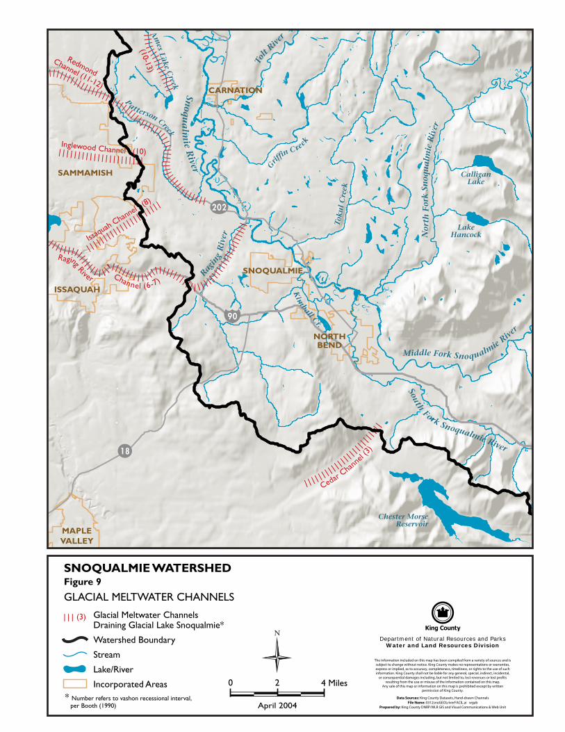
In addition to scouring these large troughs, erosion by subglacial meltwater streams is responsible for eroding a network of smaller channels that are prominent topographic features in the area east of the Lower Snoqualmie Valley and west of the Cascade Mountains. These distinctive features, termed “channelways” by Booth (1990), are steep-sided and often eroded into bedrock. The longitudinal profile along the center of these features is typically quite flat and often has reaches with adverse gradient. As a result, many of these channelways contain wetlands or open water lakes. Many of the modern streams draining this portion of the Snoqualmie watershed occupy portions of these channelways. Figure 8 shows a series of these channelways now occupied by Tokul Creek and its tributaries.
4.3. Drainage Patterns During Most Recent Glaciations When the Puget lobe of the Cordilleran ice sheet reached its maximum lateral extent in the Puget Lowland, it also reached its highest elevation on the flanks of the Cascade Range. The glacier blocked preglacial drainage courses which flowed northwest from the Snoqualmie watershed, as they do today. During the ice maximum, meltwater from the glacier as well as streams from the Cascade Range were diverted to the south, along and beneath the margin between the glacier and the Cascade Range. As the glacier retreated from the Snoqualmie watershed, a series of progressively lower drainage divides became exposed, and each one for a time acted as the primary outlet for the Snoqualmie watershed area. Booth (1990) numbered these various outlets in order to simplify correlation between the various outlet locations and the associated outwash deposits. Figure 9 shows the location of each of these drainage channels and their associated drainage interval.
D/04-1:MI17 21 9/03/04

Snoq
ua
lmie
River
South
Fork Snoqualmie River
Middle Fork Snoqualmie
River
Nor
thF
ork
Snoq
ua
lmie
Riv
er
Ragin
gR
iver
Tolt
River
CalliganLake
LakeHancock
Chester MorseReservoir
Tok
ul
Cre
ek
Grif
finCree
k
Kim
ball Cr.
Ames
Lake
Creek
P
atterson Creek
SNOQUALMIE
NORTHBEND
CARNATION
SAMMAMISH
ISSAQUAH
MAPLEVALLEY
202
18
90
The information included on this map has been compiled from a variety of sources and is subject to change without notice. King County makes no representations or warranties, express or implied, as to accuracy, completeness, timeliness, or rights to the use of such information. King County shall not be liable for any general, special, indirect, incidental,
or consequential damages including, but not limited to, lost revenues or lost profits resulting from the use or misuse of the information contained on this map.
Any sale of this map or information on this map is prohibited except by written permission of King County.
Data Sources: King County Datasets, Hand-drawn Channels File Name: 0312snoGEOLriverFACIL.ai wgab
Prepared by: King County DNRP/WLR GIS and Visual Communications & Web Unit
Department of Natural Resources and ParksWater and Land Resources Division
SNOQUALMIE WATERSHEDFigure 9
GLACIAL MELTWATER CHANNELS
Glacial Meltwater Channels Draining Glacial Lake Snoqualmie*
Watershed Boundary
Stream
Lake/River
Incorporated Areas* Number refers to vashon recessional interval, per Booth (1990)
0 2 4 Miles
N
(3)
April 2004
CedarCha
nnel
(3)
RagingRiver Channel (6-7)
Issaquah
Channel(8)
RedmondChannel (11-12)
Inglewood Channel (10)
(10-13)
AN OVERVIEW OF THE GEOLOGY AND GEOMORPHOLOGY OF THE SNOQUALMIE RIVER WATERSHED
D/04-1:MI17 26 9/03/04