Embed Size (px)
Citation preview

Pocatello, Idaho Levee Analysis and Mapping Plan i
Analysis and Mapping Plan Pocatello Idaho Levee Bannock County
Idaho
September 30, 2014
Draft Final

Pocatello, Idaho Levee Analysis and Mapping Plan ii
Table of Contents
1 Introduction ...............................................................................................................................1
1.1 Background ...................................................................................................................... 1
1.2 Purpose ............................................................................................................................. 1
2 Levee System Description ...........................................................................................................1
3 Stakeholder Engagement and Data Collection ............................................................................3
3.1 Stakeholder Engagement .................................................................................................. 3
3.2 Data Collection ................................................................................................................. 4
3.3 Stakeholder Coordination and Data Collection Meeting ................................................. 5
4 Initial Data Analysis ...................................................................................................................7
4.1 Potential Reach Approaches............................................................................................. 7
4.2 Potential Ranges of Special Flood Hazard Area Extent and Depth ................................. 8
5 Local Levee Partnership Team ....................................................................................................8
6 Expected Additional Data ......................................................................................................... 10
7 Modeling and Mapping Approach ............................................................................................ 10
8 Path Forward ........................................................................................................................... 13
9 Appendix – Associated Files ...................................................................................................... 14

Pocatello, Idaho Levee Analysis and Mapping Plan 1
1 Introduction
1.1 Background
FEMA previously identified flood hazards behind non-accredited levees utilizing its “without levee” approach and with little communication to levee stakeholders. In February 2011, members from both the U.S. House of Representatives and the U.S. Senate wrote letters requesting that FEMA discontinue the “without levee” approach for analyzing levee systems and mapping the areas impacted by the levee systems when those levee systems do not fully comply with the NFIP regulatory requirements cited at 44CFR65.10.
In July of 2013 FEMA issued its revised Levee Analysis and Mapping Procedures (LAMP). The new procedures feature a more interactive stakeholder engagement process, more options for analyzing and mapping a levee. These new procedures are now being applied to the Pocatello Idaho Levee System.
The area behind the Pocatello Idaho Levee System is currently shown as providing protection because the levee system was provisionally accredited by FEMA on the first time countywide maps for Bannock County dated July 7, 2009. The provisional accreditation expired in June 26, 2009. FEMA has received a package certifying the Reach 1 of the levee system. This package was reviewed and accepted by FEMA. The other levee reaches of the system have yet to show compliance with 44CFR65.10.
1.2 Purpose
The purpose of this report is to present the results of and findings from the initial activities of the LAMP process. The report also outlines the resulting work plan for future mapping in accordance with LAMP. If new information becomes available prior to FEMA initiating a mapping project this plan will be updated accordingly.
2 Levee System Description
The Portneuf River Flood Reduction Project, Systems 1, 2, 3, 4 and 5, which is operated and maintained by the City of Pocatello, was originally constructed on Sept. 19, 1967. Pocatello System 1 begins as an unrevetted left bank spur levee adjacent to the east side of Indian Hills Elementary School on the Portneuf River on the south side of Pocatello, Idaho. The spur levee is approximately 0.5 miles long. At Cheyenne Avenue, the system becomes a revetted left bank levee. The system continues northwest downstream through the City of Pocatello for an additional approximate 1.7 miles. The downstream end of the system is located upstream from Sue Road. The entire length of Pocatello System 1 is approximately 2.2 miles.
System 2 begins upstream of Cheyenne Avenue Bridge as a revetted channel. The system continues downstream of Cheyenne Avenue Bridge as a revetted right bank levee. The system proceeds northwest downstream through the City of Pocatello as a right bank levee where it ties into the concrete channel (Pocatello System 5) approximately 230 feet upstream of West Halliday Street. The entire length of the Pocatello System 2 is approximately 3.1 miles.
System 3 begins approximately 245 feet downstream of Sue Road as a revetted left bank levee. The system proceeds northwest downstream for approximately 0.9 miles as a revetted left bank levee through the City of Pocatello where it becomes an unrevetted spur levee that continues approximately 450 feet in a westerly direction to connect with Grant Avenue. The entire length of the Pocatello System 3 is approximately 1 mile.
Pocatello, Idaho Levee Analysis and Mapping Plan 2
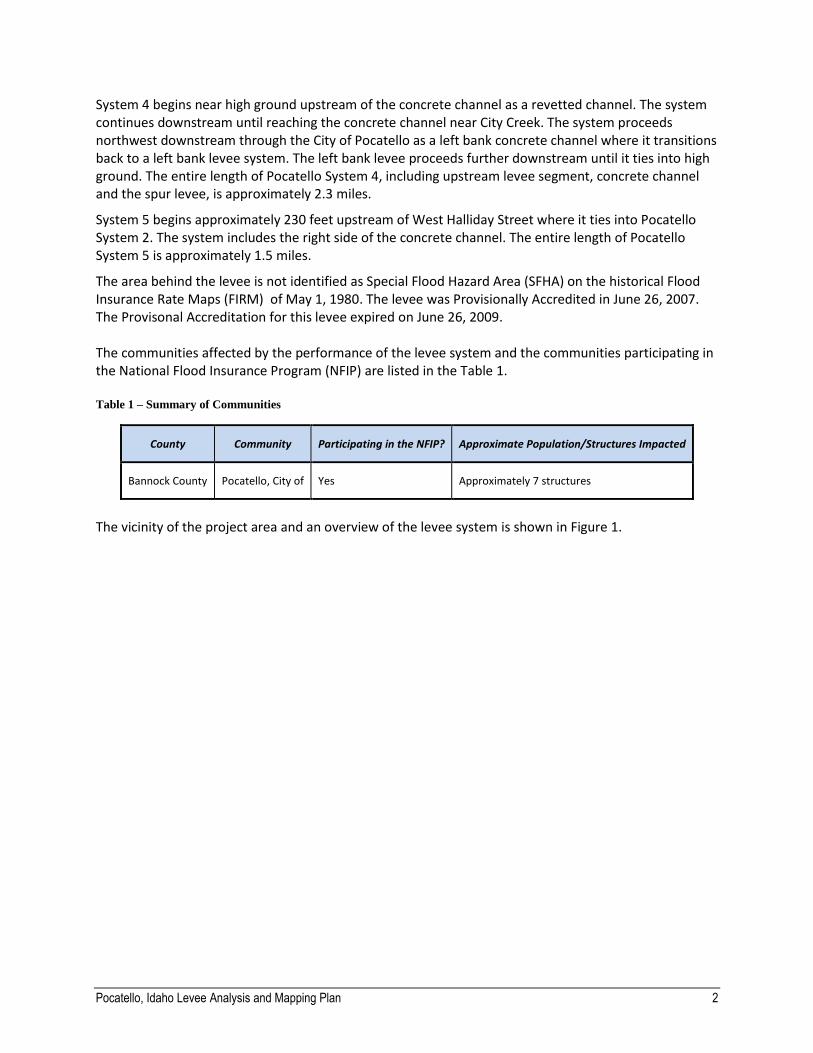
System 4 begins near high ground upstream of the concrete channel as a revetted channel. The system continues downstream until reaching the concrete channel near City Creek. The system proceeds northwest downstream through the City of Pocatello as a left bank concrete channel where it transitions back to a left bank levee system. The left bank levee proceeds further downstream until it ties into high ground. The entire length of Pocatello System 4, including upstream levee segment, concrete channel and the spur levee, is approximately 2.3 miles.
System 5 begins approximately 230 feet upstream of West Halliday Street where it ties into Pocatello System 2. The system includes the right side of the concrete channel. The entire length of Pocatello System 5 is approximately 1.5 miles.
The area behind the levee is not identified as Special Flood Hazard Area (SFHA) on the historical Flood Insurance Rate Maps (FIRM) of May 1, 1980. The levee was Provisionally Accredited in June 26, 2007. The Provisonal Accreditation for this levee expired on June 26, 2009. The communities affected by the performance of the levee system and the communities participating in the National Flood Insurance Program (NFIP) are listed in the Table 1. Table 1 – Summary of Communities
County Community Participating in the NFIP? Approximate Population/Structures Impacted
Bannock County Pocatello, City of Yes Approximately 7 structures
The vicinity of the project area and an overview of the levee system is shown in Figure 1.
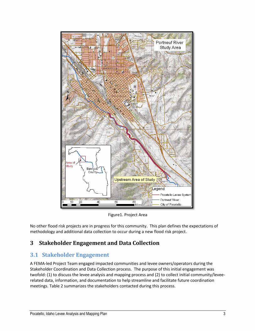
Pocatello, Idaho Levee Analysis and Mapping Plan 3
Figure1. Project Area
No other flood risk projects are in progress for this community. This plan defines the expectations of methodology and additional data collection to occur during a new flood risk project.
3 Stakeholder Engagement and Data Collection
3.1 Stakeholder Engagement
A FEMA-led Project Team engaged impacted communities and levee owners/operators during the Stakeholder Coordination and Data Collection process. The purpose of this initial engagement was twofold: (1) to discuss the levee analysis and mapping process and (2) to collect initial community/levee-related data, information, and documentation to help streamline and facilitate future coordination meetings. Table 2 summarizes the stakeholders contacted during this process.
Pocatello, Idaho Levee Analysis and Mapping Plan 4
Table 2 – Summary of Stakeholder Contact
Stakeholder Contacted Role Date Contacted
Deirdre Castillo City Engineer, City of Pocatello 03/27/2014
Randy Ghezzi Ex-Street Superintendent, City of Pocatello 03/27/2014
The Project Team initiated a kickoff meeting with stakeholders to introduce LAMP and to get a better understanding of the levee system. This will allow FEMA to tailor a modeling and mapping approach for the levee system that meets the needs of the community and recognizes the available data, information, and documentation, as well as the history of the levee system. Details on the kickoff meeting conducted during the Stakeholder Coordination and Data Collection process are provided in Appendix A.
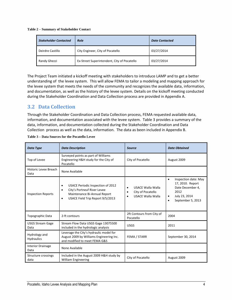
3.2 Data Collection
Through the Stakeholder Coordination and Data Collection process, FEMA requested available data, information, and documentation associated with the levee system. Table 3 provides a summary of the data, information, and documentation collected during the Stakeholder Coordination and Data Collection process as well as the data, information. The data as been included in Appendix B.
Table 3 – Data Sources for the Pocatello Levee
Data Type Data Description Source Date Obtained
Top of Levee Surveyed points as part of Williams Engineering H&H study for the City of Pocatello
City of Pocatello August 2009
Historic Levee Breach Data
None Available
Inspection Reports
USACE Periodic Inspection of 2012
City’s Portneuf River Levee Maintenance Bi-Annual Report
USACE Field Trip Report 9/5/2013
USACE Walla Walla
City of Pocatello
USACE Walla Walla
Inspection date: May 17, 2010. Report Date December 4, 2012
July 23, 2014
September 5, 2013
Topographic Data 2-ft contours 2ft Contours from City of Pocatello
2004
USGS Stream Gage Data
Stream Flow Data USGS Gage 13075500 included in the hydrologic analysis
USGS 2011
Hydrology and Hydraulics
Leverage the City’s hydraulic model for August 2009 by Williams Engineering Inc. and modified to meet FEMA G&S
FEMA / STARR September 30, 2014
Interior Drainage Data
None Available
Structure crossings data
Included in the August 2009 H&H study by William Engineering
City of Pocatello August 2009
Pocatello, Idaho Levee Analysis and Mapping Plan 5
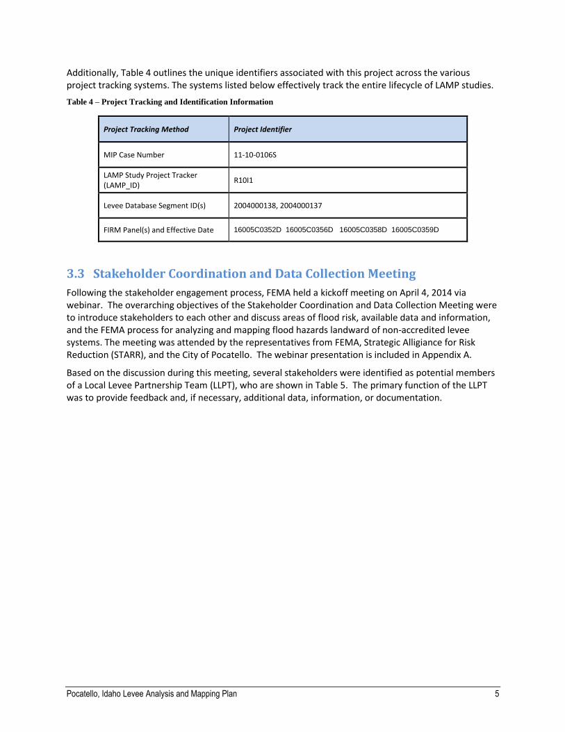
Additionally, Table 4 outlines the unique identifiers associated with this project across the various project tracking systems. The systems listed below effectively track the entire lifecycle of LAMP studies.
Table 4 – Project Tracking and Identification Information
Project Tracking Method Project Identifier
MIP Case Number 11-10-0106S
LAMP Study Project Tracker (LAMP_ID)
R10I1
Levee Database Segment ID(s) 2004000138, 2004000137
FIRM Panel(s) and Effective Date 16005C0352D 16005C0356D 16005C0358D 16005C0359D
3.3 Stakeholder Coordination and Data Collection Meeting
Following the stakeholder engagement process, FEMA held a kickoff meeting on April 4, 2014 via webinar. The overarching objectives of the Stakeholder Coordination and Data Collection Meeting were to introduce stakeholders to each other and discuss areas of flood risk, available data and information, and the FEMA process for analyzing and mapping flood hazards landward of non-accredited levee systems. The meeting was attended by the representatives from FEMA, Strategic Alligiance for Risk Reduction (STARR), and the City of Pocatello. The webinar presentation is included in Appendix A.
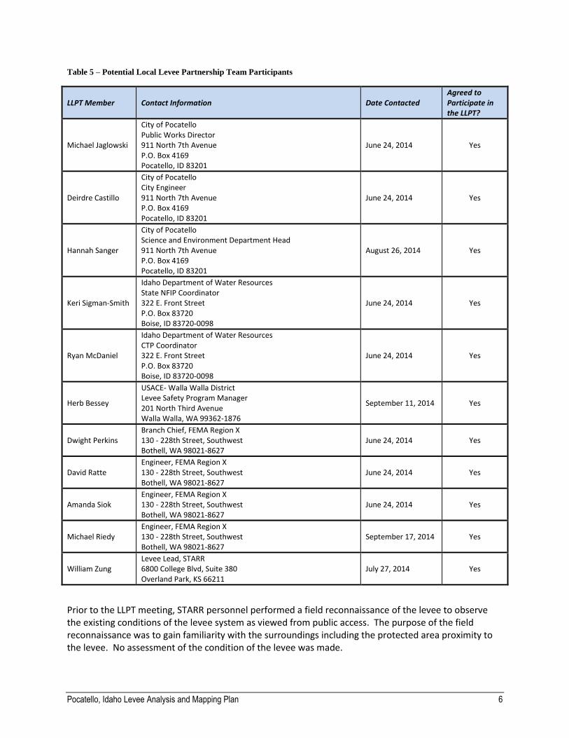
Based on the discussion during this meeting, several stakeholders were identified as potential members of a Local Levee Partnership Team (LLPT), who are shown in Table 5. The primary function of the LLPT was to provide feedback and, if necessary, additional data, information, or documentation.
Pocatello, Idaho Levee Analysis and Mapping Plan 6
Table 5 – Potential Local Levee Partnership Team Participants
LLPT Member Contact Information Date Contacted Agreed to Participate in the LLPT?
Michael Jaglowski
City of Pocatello Public Works Director 911 North 7th Avenue P.O. Box 4169 Pocatello, ID 83201
June 24, 2014 Yes
Deirdre Castillo
City of Pocatello City Engineer 911 North 7th Avenue P.O. Box 4169 Pocatello, ID 83201
June 24, 2014 Yes
Hannah Sanger
City of Pocatello Science and Environment Department Head 911 North 7th Avenue P.O. Box 4169 Pocatello, ID 83201
August 26, 2014 Yes
Keri Sigman-Smith
Idaho Department of Water Resources State NFIP Coordinator 322 E. Front Street P.O. Box 83720 Boise, ID 83720-0098
June 24, 2014 Yes
Ryan McDaniel
Idaho Department of Water Resources CTP Coordinator 322 E. Front Street P.O. Box 83720 Boise, ID 83720-0098
June 24, 2014 Yes
Herb Bessey
USACE- Walla Walla District Levee Safety Program Manager 201 North Third Avenue Walla Walla, WA 99362-1876
September 11, 2014 Yes
Dwight Perkins Branch Chief, FEMA Region X 130 - 228th Street, Southwest Bothell, WA 98021-8627
June 24, 2014 Yes
David Ratte Engineer, FEMA Region X 130 - 228th Street, Southwest Bothell, WA 98021-8627
June 24, 2014 Yes
Amanda Siok Engineer, FEMA Region X 130 - 228th Street, Southwest Bothell, WA 98021-8627
June 24, 2014 Yes
Michael Riedy Engineer, FEMA Region X 130 - 228th Street, Southwest Bothell, WA 98021-8627
September 17, 2014 Yes
William Zung Levee Lead, STARR 6800 College Blvd, Suite 380 Overland Park, KS 66211
July 27, 2014 Yes
Prior to the LLPT meeting, STARR personnel performed a field reconnaissance of the levee to observe the existing conditions of the levee system as viewed from public access. The purpose of the field reconnaissance was to gain familiarity with the surroundings including the protected area proximity to the levee. No assessment of the condition of the levee was made.
Pocatello, Idaho Levee Analysis and Mapping Plan 7
4 Initial Data Analysis
The Project Team analyzed the collected data, information, and documentation to prepare for the LLPT Meeting. Project team examined the hydrologic, hydraulic, topographic and structural data available for the Portneuf River and Pocatello Levee.
Hydrologic studies of Portneuf River near Pocatello were performed by the USACE in 1964, 1987, and 2011. The 2011 study by USACE was performed concurrently with this hydrologic analysis. The results of these analyses have a 1% annual chance discharge lowered by 40.9% from 5500 cubic feet per second down to 3250 cubic feet per second. Full details of the hydrologic analysis are provided in Appendix C.
The modelling approach for this study used the Natural Valley reach analysis procedure and Accredited Levee simulations to determine water surface elevations and floodplains for each condition. The hydraulic model used for this flood study is the U.S. Army Corps of Engineers (USACE) Hydraulic Engineering Center River Analysis System (HEC-RAS), version 4.1.0. The William’s Engineering HEC-RAS model was leveraged and used as a basis to develop the 10-, 4-, 2-, 1-, and 0.2-percent-annual-chance flood events.
The results of the hydraulic analysis lowered the base flood elevation to the range of 2.2 feet at the upstream end of the levee to 5 feet at the downstream end of the levee. Full details of the hydraulic analysis are provided in Appendix C.
4.1 Potential Reach Approaches
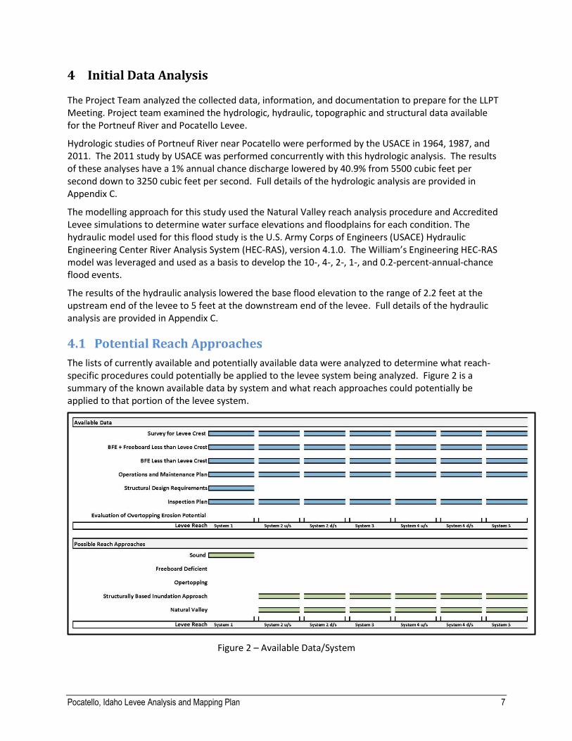
The lists of currently available and potentially available data were analyzed to determine what reach-specific procedures could potentially be applied to the levee system being analyzed. Figure 2 is a summary of the known available data by system and what reach approaches could potentially be applied to that portion of the levee system.
Figure 2 – Available Data/System

Pocatello, Idaho Levee Analysis and Mapping Plan 8
4.2 Potential Ranges of Special Flood Hazard Area Extent and Depth
As a preparation for the LLPT meetings, the Project Team developed an analysis to provide baseline estimates and expected ranges of the SFHA extent and depth. This included:
1. Accreditation
2. Natural Valley Approach
3. Structural Based Inundation
System 1 was been certified to comply with the 44CFR65.10. System 1 was considered accredited so no further analysis landward of the levee was performed for this system.
The Sound Reach, Freeboard Deficient and Overtopping Approach require information on structural integrity of the levee. This information was not available for systems 2, 3, 4, or 5 of this flood protection project. With consideration to the available data and the data that is likely to be available, only the approaches listed above were considered feasible for this levee.
The natural valley approach assumed the levee does not provide protection and allowed flooding on both river side and landward side of the levee. Due to the new lower discharge, much of the leveed area has a higher ground elevation than the new base flood elevation thus containing the base flood inside the stream channel. The With Levee analysis and the Natural Valley analysis results were nearly identical. Only a portion of System 2 resulted in flooding landward of the levee with a BFE of 4452 and 4451.
Given the Natural Valley analysis resulted in nearly no landward flooding, and the With Levee analysis has a similar BFE as the Natural Valley, the structural based analysis was not performed. A breaching analysis would not result in any difference in BFE greater than 0.5 feet than the Natural Valley analysis.
The project team produced maps to exhibit the results of these analyses and potential BFEs and flood zone designations for each of the approaches are applied to establish flood hazard data within the land ward area of the levee. Since the survey and topographic data suggests it is unlikely the levee will be overtopped during the 1% annual chance event, the Project Team did not produce maps of the Sound reach or Freeboard Deficient scenarios as the inundation boundary will match the Natural Valley results but attributed with a different zone label.
It should be noted, however, that these analyses are draft in nature and the final mapping may change once more detailed methods are applied. The initial data analysis is meant to provide a general sense of what the final mapping may look like under the different procedures.
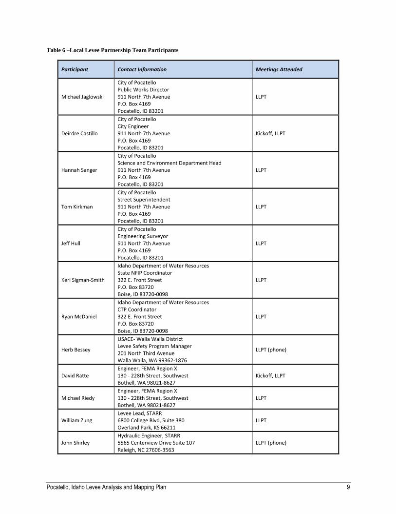
5 Local Levee Partnership Team
A LLPT was formed to provide data and input to FEMA, including commenting on the creation of levee
reaches and the procedures to be used for analyzing and mapping the reaches based on local levee
conditions. A LLPT meeting was held at the City Hall of the City of Pocatello on September 22, 2014. The
stakeholders that participated in the LLPT for this project are listed in Table 6. Additional information on
the LLPT participants and the meetings held with the LLPT members is provided in Appendix D.
Pocatello, Idaho Levee Analysis and Mapping Plan 9
Table 6 –Local Levee Partnership Team Participants
Participant Contact Information Meetings Attended
Michael Jaglowski
City of Pocatello Public Works Director 911 North 7th Avenue P.O. Box 4169 Pocatello, ID 83201
LLPT
Deirdre Castillo
City of Pocatello City Engineer 911 North 7th Avenue P.O. Box 4169 Pocatello, ID 83201
Kickoff, LLPT
Hannah Sanger
City of Pocatello Science and Environment Department Head 911 North 7th Avenue P.O. Box 4169 Pocatello, ID 83201
LLPT
Tom Kirkman
City of Pocatello Street Superintendent 911 North 7th Avenue P.O. Box 4169 Pocatello, ID 83201
LLPT
Jeff Hull
City of Pocatello Engineering Surveyor 911 North 7th Avenue P.O. Box 4169 Pocatello, ID 83201
LLPT
Keri Sigman-Smith
Idaho Department of Water Resources State NFIP Coordinator 322 E. Front Street P.O. Box 83720 Boise, ID 83720-0098
LLPT
Ryan McDaniel
Idaho Department of Water Resources CTP Coordinator 322 E. Front Street P.O. Box 83720 Boise, ID 83720-0098
LLPT
Herb Bessey
USACE- Walla Walla District Levee Safety Program Manager 201 North Third Avenue Walla Walla, WA 99362-1876
LLPT (phone)
David Ratte Engineer, FEMA Region X 130 - 228th Street, Southwest Bothell, WA 98021-8627
Kickoff, LLPT
Michael Riedy Engineer, FEMA Region X 130 - 228th Street, Southwest Bothell, WA 98021-8627
LLPT
William Zung Levee Lead, STARR 6800 College Blvd, Suite 380 Overland Park, KS 66211
LLPT
John Shirley Hydraulic Engineer, STARR 5565 Centerview Drive Suite 107 Raleigh, NC 27606-3563
LLPT (phone)

Pocatello, Idaho Levee Analysis and Mapping Plan 10
During the LLPT meeting, FEMA Region X set the foundation by providing the background information of the project that lead up to the meeting. STARR then presented the review of meeting objectives, background information of the mapping projects, LAMP procedures, and an estimated project timeline. During the presentation, the working group discussion took place to view maps of the conceptual results of each procedure, discuss existing conditions of the levee, discuss additional data requirements for various LAMP procedures, discuss the ability to obtain additional supportive data, and address questions or concerns.
Areas of further consideration primarily related to:
1. System 2 may be able to be split into two reaches given the natural valley results shows no inundation landward of the levee along much of the reach;
2. Assess the results of the new hydraulic analysis along the concrete lined channel and the non-accredited levee portions of System 4 and System 5; and
3. On-going watershed studies potential impact to the flood study process.
Full meeting notes are included in Appendix D.
6 Expected Additional Data
During the Stakeholder Coordination and Data Collection and LLPT processes, stakeholders identified time needed to assess the results of the new hydraulic analysis to identify what impacts the lower BFE has to the levee system’s natural valley protected area. The analysis will be submitted to the LLPT members as part of this LAMP Plan submittal. This assessment will allow the City to decide where to pursue further certification efforts. The LLPT members agreed to a follow up conference call in the middle of January 2015 to discuss results of the City’s assessment.
7 Modeling and Mapping Approach
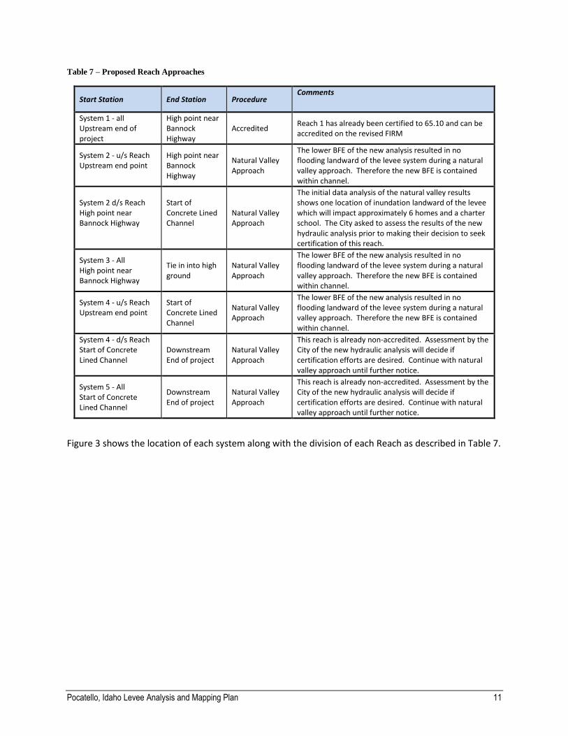
Based on the discussions during meetings with LLPT members and review of the data, information, and documentation collected, the approaches outlined in Table 7 will be used to model and map the flood hazards landward of the levee systems. The following non regulatory products can also be prepared to support floodplain management.
1% Annual Chance Natural Valley Water Surface Elevation: This can be used by the community as a resource for determining the water surface elevations used to develop the Special Flood Hazard Area extents.
1% Annual Chance Natural Valley Depth Grid: This can be used by the community as a resource for determining the depth of flooding during a natural valley 1% annual chance event for use with floodplain management and community engagement.
Pocatello, Idaho Levee Analysis and Mapping Plan 11
Table 7 – Proposed Reach Approaches
Start Station End Station Procedure Comments
System 1 - all Upstream end of project
High point near Bannock Highway
Accredited Reach 1 has already been certified to 65.10 and can be accredited on the revised FIRM
System 2 - u/s Reach Upstream end point
High point near Bannock Highway
Natural Valley Approach
The lower BFE of the new analysis resulted in no flooding landward of the levee system during a natural valley approach. Therefore the new BFE is contained within channel.
System 2 d/s Reach High point near Bannock Highway
Start of Concrete Lined Channel
Natural Valley Approach
The initial data analysis of the natural valley results shows one location of inundation landward of the levee which will impact approximately 6 homes and a charter school. The City asked to assess the results of the new hydraulic analysis prior to making their decision to seek certification of this reach.
System 3 - All High point near Bannock Highway
Tie in into high ground
Natural Valley Approach
The lower BFE of the new analysis resulted in no flooding landward of the levee system during a natural valley approach. Therefore the new BFE is contained within channel.
System 4 - u/s Reach Upstream end point
Start of Concrete Lined Channel
Natural Valley Approach
The lower BFE of the new analysis resulted in no flooding landward of the levee system during a natural valley approach. Therefore the new BFE is contained within channel.
System 4 - d/s Reach Start of Concrete Lined Channel
Downstream End of project
Natural Valley Approach
This reach is already non-accredited. Assessment by the City of the new hydraulic analysis will decide if certification efforts are desired. Continue with natural valley approach until further notice.
System 5 - All Start of Concrete Lined Channel
Downstream End of project
Natural Valley Approach
This reach is already non-accredited. Assessment by the City of the new hydraulic analysis will decide if certification efforts are desired. Continue with natural valley approach until further notice.
Figure 3 shows the location of each system along with the division of each Reach as described in Table 7.

Pocatello, Idaho Levee Analysis and Mapping Plan 12
Figure 3: Levee Reaches
Pocatello, Idaho Levee Analysis and Mapping Plan 13
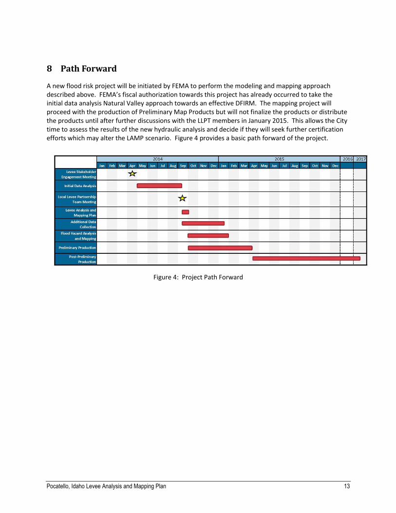
8 Path Forward
A new flood risk project will be initiated by FEMA to perform the modeling and mapping approach described above. FEMA’s fiscal authorization towards this project has already occurred to take the initial data analysis Natural Valley approach towards an effective DFIRM. The mapping project will proceed with the production of Preliminary Map Products but will not finalize the products or distribute the products until after further discussions with the LLPT members in January 2015. This allows the City time to assess the results of the new hydraulic analysis and decide if they will seek further certification efforts which may alter the LAMP scenario. Figure 4 provides a basic path forward of the project.
Figure 4: Project Path Forward
Pocatello, Idaho Levee Analysis and Mapping Plan 14
9 Appendix – Associated Files
The appendices are stored digitally under their respective folders on the CD that accompanies this report. Appendix A – Stakeholder Engagement Meeting Data
Meeting Presentation Appendix B – Collected Data
FEMA Effective FIRM and FIS
USACE Design Memo
USACE Inspections
USACE Top of Levee Survey Data Appendix C – Initial Data Analysis
Hydrologic Analysis Data
Hydraulic Analysis Data Appendix D – Local Levee Partnership Meeting Data
Meeting Invitation
Meeting Agenda
Meeting Presentation
Meeting Maps
Meeting Fact Sheets