Embed Size (px)
Citation preview

Analysis of effects on validation of
spatiotemporal changes in cropping
at agriculture-dominant watershed
Jiwon Lee, Donghyuk Kum, Bomchul Kim,
Seong Joon Kim, John Tenhunen,
Kyoung Jae Lim
1

What is the Hydrologic models ?
2

SWAT
3

Limitation of SWAT model

The objectives of this study
Weather 2009
Landuse 2009
Parameters in Year 2009
Weather 2010
Validation Calibration
Landuse 2010
Parameters in Year 2010
5
Calibration

Study Area
Soyanggang-dam Watershed
Mandae watershed 6
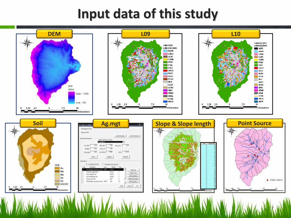
Input data of this study DEM
Soil
L09 L10
Ag.mgt Slope & Slope length Point Source
7

Ag. Land L09(%) L10(%)
Pumpkin 5.69 9.88
Cabbage 7.75 5.21
Corn 2.63 0.99
Orchard 4.68 8.60
Pepper 0.98 0.04
Potato 12.25 11.73
Rice 46.37 46.39
Radish 11.58 7.39
Soybean 8.08 9.76
SUM 100 100 AREA(km2) 18.45 17.15
Comparison of landuse 2009/2010
8

Spatial changes in cropping
L09 L10
9

Please remember this Terms
Obs10
W10 L10
W09
Obs09
L09 Weather 2009 Landuse 2009
Weather 2010 Landuse 2010
Observed Data 2009, 2010

Methodologies
L10
W10
Scenario3
Obs10
W09
Scenario1
Obs09
W10
Scenario2
Obs10
L09 Parameters Scenario 1
Parameters Scenario 3
11
However, there might be differences in parameters if parameters derived under
different weather data were used for other weather condition.

Results of Scenario 1
StreamFlow NSE = 0.662
SS NSE = 0.688
Calibration
W09
Scenario1
Obs09
L09
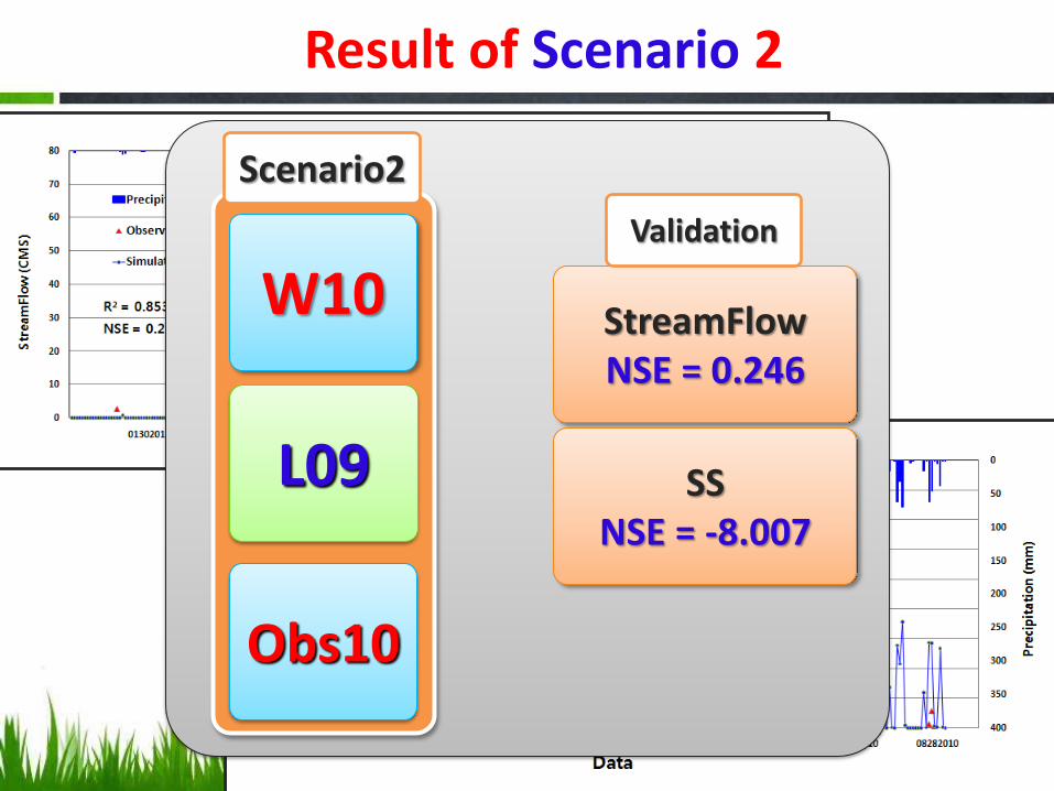
Result of Scenario 2
StreamFlow NSE = 0.246
SS NSE = -8.007
Validation
W10
Scenario2
Obs10
L09
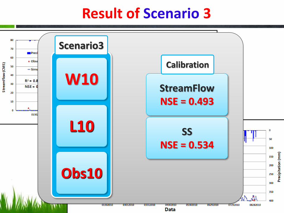
Result of Scenario 3
StreamFlow NSE = 0.493
SS NSE = 0.534
Calibration
L10
W10
Scenario3
Obs10

Scenario2 vs. Scenario3
-35%
1.3%
56.7%
28%
14.9%
30.8%
-16.8%
478%
-6.4%
20%
-22.5%
-12%
291.4% -36%
15
vs. L09
W10
Parameters
Scenario1
L10
W10
Parameters
Scenario3
Scenario2 Scenario3

vs. L09
W10
Parameters
Scenario1
L10
W10
Parameters
Scenario3
Scenario2 Scenario3
Scenario2 vs. Scenario3
Scenario2 1.931 (CMS)
Scenario3 1.998 (CMS)
Scenario2 1,117.1 (mg/l)
Scenario3 332.7 (mg/l)
16

L10
W10
Scenario3
W09
Scenario1
W10
Scenario2
L09
Parameters used in this study
File Parameter Scenario1 Calibration
Scenario2
Validation
Scenario3 Calibration
.BSN SPCON 0.001 0.001 0.0002
W09 Precip 1,258 mm
W10 Precip 970 mm
17
Some parameters should be changed with changes in other parameters throughout the simulation period.
In the current SWAT, the SPCON parameter should be dynamically
changed during the model run depending on hydrologic condition.

New Scenario 4
L10
W10
Scenario3
W10
Scenario4
L09
Parameters used In Scenario3
18

Scenario3 vs. Scenario4
19
R2 = 0.993
R2 = 0.917
Do you have any idea why the sediment loads at the main outlet are similar although there are
differences in estimated sediment for each subbasins ?

Scenario3 vs. Scenario4
Outlet
L10
W10
Parameters
Scenario3
Scenario3 Scenario4
W10
L09
Parameters
Scenario3
vs.
This comparison shows effects of land use change are not negligible.
We can infer that the SWAT model evaluations should be performed at several
outlet as well as main outlet.

Scenario2 vs. Scenario4
Outlet
L09
W10
Parameters
Scenario1
Scenario2 Scenario4
W10
L09
Parameters
Scenario3
vs.
Model parameters should be dynamically changed depending on other conditions in
the watershed.

We strongly recommend SWAT model should be calibrated for several locations (outlets) as well as main outlet in the watershed
However, some model parameters depending on various field/weather condition should be dynamically changed for better estimation of what has been occurring at the watershed through calibration / validation period.
If changes in land use (cropping) and weather are not negligible, what is your strategy to evaluate model performance?
(any good idea/comments ?)
Conclusions
22

![STUB Engine Documentation · [Scenario2] Where the scenario names are the filenames of your user scenarios. So in this case you would have Scenario1 and Scenario2 BSF files from the](https://img.pdfslide.net/doc/110x75/5f7b16517366325d3e431665/stub-engine-scenario2-where-the-scenario-names-are-the-filenames-of-your-user.jpg)