Embed Size (px)
Citation preview
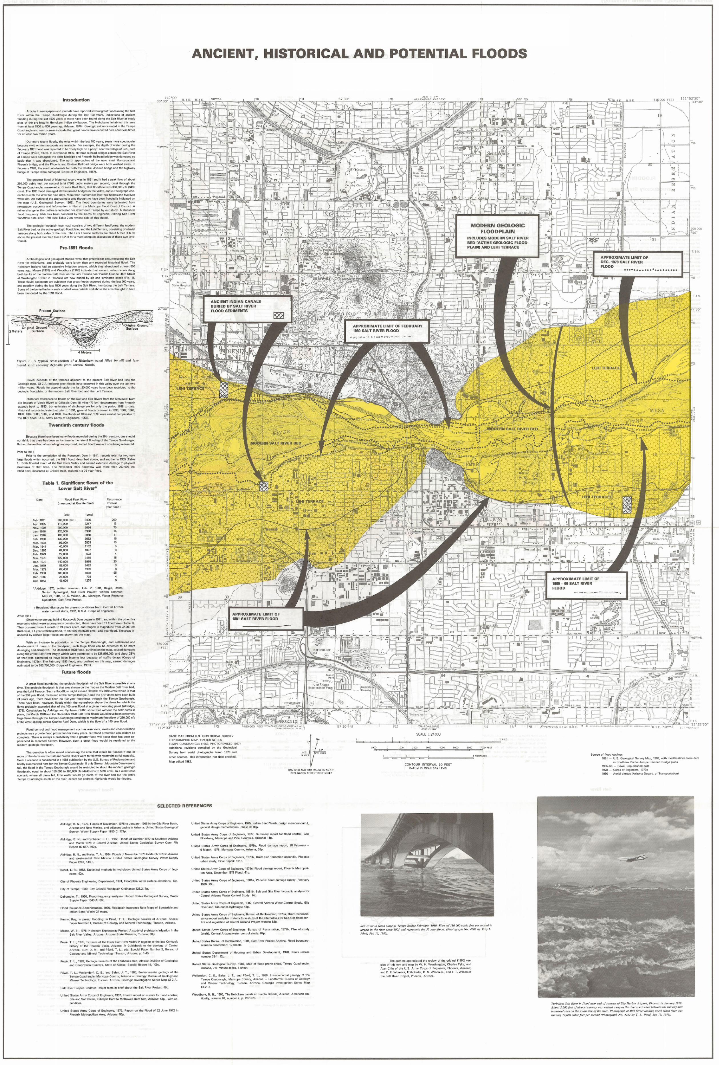
ANCIENT, HISTORICAL AND POTENTIAL FLOODS
Introduction
Arbeles In ne Nsoapers and Journa ls have reported several !lreat floods along The 5011
RI'Itlr within thll Ternve Quadrangle dur ng the last 100 yeats Indications of anCient floorllng dUring thn 19"T 1500 yearn or more h1:lve O~rl found <110119 II \:I SCllt Rrvl::H (II study
sites of the pre histone Hohokarn Indian clvlllzat on Tile Hohok(lm~ mhnh tr~rl Ih ~ ;'Irr.o 110m at least l!.iOO to GOO years ago (Masse 1976) GeologiC eVidence noted n the Tempe
OUflrlmnglc nnd nc,Huy ilrt);;" IfHJI(;(l\t: I Ii~t yrwt lIoods hal/e occu rred hera countless times
for at least two m lion )oMtS
OIH 1\ me rece llt floods tile ones Within the las t 100 years seem more spectacu lar because VIVid WI uen accounts are al/mlnhle For {)xClmplc thr. dp.pth of ""Htl r dunng Ih~ February 1891 flooc was reported to be belly h gh on a pony near the vllla!]e of l eh! east of TerTlllelPewe 1978) In November 19O!.i all three railroad bridges across the Salt River at Tempe were dnm[l!]cn t he olner M mr:lpi and Piluellill R<Jlliuat.ilmt.il:l€ Wil~ t.iililliltjetl so badly t hat It was aMndoned The north approaches of · he new steel Maricopa and PIiO!:lfllll lmtlye alltl Ihe PhoenlJ( and Eastern Railroad bridge were both washed awa~ In Fohmar,192(l thc south abutments fot both tht:; C!:Intnti AV\:HIU!:l lJrnj ytl <JlIlj thtl i llyl ""ay bridge at Tempe \0\ ere damaged (Corps of En!] lneers 1957)
The greatest flood of h sto r cil l rccord V'/iI~ Irl 1891 <llld II hatl a ,:It;Iak 1I0w of about
260 000 cubiC feet per second (cb) (7363 cub c met() r~ per seeonc1 ems) thrOllgh th r. Telllpe Uuadrangfe me[lsured at Granite Reef Dam, that f loodflow was 300 000 cis (8495 ems) The lB!)1 flood dJrnnOed III thr r IIlrlJarl br dgH~ Ifl II e Valley am] c ut tel€\jraph con nectlo ns wrth the West for nine days More than 100 families lost their homes anc1 f \ e lives ",ele lost An outline ot t he approximate area thought to ha\e been flooded IS indicated on
the map (U S Genlngl('~~1 ~url'('y 19691 Tile flood uounuaJles were estmlated flom newspaper accounts and infOrmation In f iles 6t t he Mar cope Flood Control District A minor ehlmgc III til ~ outline IS Ildlca ted tor downto\o\n Tempe by our study A statistical
f lood frequency wble hns hr.r.n compiled by the Corps of Engineers ut Ilzlng Sa lt Rlvt:;r f loodflow data s nce 1891 (see Tab le 2 on reverse Side of thiS sheet)
The geolonlc f loodpl!lln Isee map I con~ StS of two d ffcrent londfarms the modern Salt R .er beel or the act.e geologiC f loodpl,lIn and the Lehl Terrace conSlstlnp of alluvml tp-rrlcer illong but ll sdtlli 01 the lIver The leh l Terrace surfaces are about 5 feet (1 6 ml abo"e the present nver bed Isee GI 2 D for (I mnrc r mnpl! te dl~GU~~IU I of tllese two land
lurrli!»
Pre-1891 floods
Arc hooluglGal alld geological stud es reveal that great floods occurred along the Salt
River for millen ums ~nd probably were larger theln 1:Iny rt:lcordl:ld f1ll:;tuTII.;i:l 1 fluou Tile Hohokam Ind ans had an extens ve Irt gatlon system which they abandoned at least 500 y, ilf'~ ilgU Ma~ (19761 and Woodbu ry (1960) rn dlcate that anCient Indian canals along both bank~ of the modem Salt River on the lehl TtJrrace near PuelJlo GTande 11I6th Stleet at Washington Street In Phoen x) are now bl rlerJ hy s IT and Iflm natp.d sands (Fig 11 These flU Vial sediments are eVidence t hat great floods occurred dur ng the last SOO yeers
and posslhly dUrinG the II .. t 1500 yeilr~ alonll tile Sail Rver lI1undat ng tha Leh Terrace Some of the bUried Indian canals studied were OUtslc1C nnd <lho..,e the ;mm thoullht to h<lvr'
been Ilundated by the 1891 flood
4 Meiers
Figure 1 A tVPlcal cross ~ect!()n of a Huhukum canal filled by SIlt and lammated sand showmg d'pIJ!;tl, {rom seueral {loads
FlUVial tlepcslts of the ler ra ces adjacent to tha present Sa lt River bed (sea the GeologiC map GI2 A)lndlc(lte great floods h<lve occurred In thiS I/alley o~ e r the lost 1'.\0
million years Floods for apprOlllmately the last 20 000 yeats have been restricted to the \jeolu\j!G fiuodpl(ilfl ur tile mUUtH I Sail RI\el betl and the Lehl Terrace
H stotlcal references to floods on the Salt and GIlt! RIVers from the McDowell Dam 5 te Imouth of Verde River) to Gillespie Dam 48 m les (77 kml downstream from PhoeniX extends back to 1833 b ut estl1nale~ uf du;{.;har\jtl are fur orlly tht:; J,lenoC lasS to da te H SlOr cal records Ind cate that prior to 1891 general flnod .. occurred In t833 1862 1869 1880 lB84 1886 1009 and 1890 The floods of 1B84 and 1890 were almost comparable to thc 1891 flood (U S Arrny Corp~ uf Erl\jlflel;l(~ 1957)
Twentiet h century floods
Because there have been many f loods recorded dunng the 20th century one should not th ink that there has been an ncrC<lSO In the r<llr. of f lolld ng nf t he Tempe Qundrangle Rather the method of record ng has Improved and all floodflow'S are now being measured
Pnor to 1911 Pr or to the comp letion of the Roosevelt Dam n 1911 records ellist for two very
larye floods w hich occurred the 1891 flood descr bed abo\a and another In 1905 (Table 1) Both flooded much of rhe Snit Rlvcr V.IIII y lnd clIused e)(\{'n~ ll/P' dam<lgt:; to phy~ cill structures of that time The November 1905 floodflo", was more than 200 000 r.fs 15e63 cmsl me(isur!:ld ~t Gr~flIte R~I makmg It a 75 vear f lood
After 1911
Table 1, Significant flows of the Lower Salt River-
Date
Feb 1891
Apr 1905 Nov 1905 Jan 1916 Jan 1916 Feb 1920 Mar 1938 Mar 1941
Dec 1965 Feb 1973 Mar 1978
Dec 197B Jan 1979 Mar 1979 Feb 1960 Dec 1982 Oct 1963
Flood Peak Flow (measured at Granite Reefl
300 000 (est )
115000 200 000 120000 102000
130000 99000 40,000 67000 22 000
122 000 140000
BB 000 67 400
100000 25 000 45 oM
(emsl
8496 3257 5664 3398 2889 36112 2603 1132 1897
6Zl 3455 3965
24"" 1909 5098 708
1275
Recurrence Interval
yeAr flnnrJ +
200 13 75
" 11 16 10 , 8 4
" 20 , B
55 4
5
'Aldridge, 1970 w lltten commu n Feb 21 1984, Reigle Dallas Senior Hydrologist Salt River Pro]1 r t wntten cummun May 23 1984 D S Wilson J r Manager WAter Resource
Operations Salt River Project
+ Regulatad discharges for present cond nons from Central Arl70n J
water control study 1982 USA Corps of Engineers
Sillce water storage behind Roosevelt Dam began In 1911 and Nlthln the other f ive reservOlr~ wh ch were suuselluerilly I.:o rlst uctad there have been 17 floodtlows ITable 1 )
They occurred from 1 month til 24 years apart and rangt:;d In rnalJrllludtl frurn 22 000 cis (623 cms) a 4 year statistIcal f lood to 180 000 cfs (5098 cmsl n 55 yea rflooo Thc nrca~ In undated by I.:€rta lll large tloods are shown on the map
With !In ncrease In population 10 the Tempe QIJlldrangle and settlement and development of more ot the f loodplain each large f lood can be expected to be more damaging and dlsruptlvp- Tht, DecernLltlr 19781100d outlined on the map c[lused damages
along the entire Sa lt River length which were estimated to be $38,956,000 and Clbout 33% Ilf that was estimated to hav1::l UeI:Hl Iflcome lost because of t raffiC delays (Corps of Engineers 197!)cl The February 1980 flooc1 ",1[,0 outlil1t:;d uti ttll ~ ma~ Gaused damages estimated to be $63 700 000 (Corps of Engineers W81 f
Future floods
A great flood Inundotmg th,' geolOYlc lIoodplam of the Sat! Rver IS pOSSible at any ltme 1 he geologiC floodplain IS t hat area shown on the map as the Modern Sellt Rlv{'r bed plus the l ehl TerrdGe Sudl a floodllow m ight exceed 300 000 cfs (6495 ems) which s thAt of the 200 year flood mc I urI rJ 111 tim Tempe Blidge Since the SRP dams have been bUilt
74 years ago there have been no 100 year floodflows through tim Tempe Quadl ang le There h<lvtJ ul;leu 110wever floods With n the watersheds above the dams for whIch the flows probably eKcecded that of thl:l 100 yl;I8r Ilood at a given measunng POint (A ldridge 1979) CalculatIOns by Aldndne anc! EychHner 119A2f ~haw Ihilt w thout the SRP dams In
plll( P. II e March 1978 and the December 1978 Salt Rlverfloods would have been OXTmmely larOe floW!'!. thtflllgh the Tempe Quatlr<lIIy la lesultlng In mallimum floodflow of 260 000 c15 (1363 cms) spilling across Gran te Reef DAm wh c h s the f low of il 140 year flood
ll2
I ,I
'7'3C) " f--
II
ANCIENT INDIAN CANALS BURIED BY SALT RIVER FLOOD SEDIMENTS
APPROXIMATE LIMIT OF 1891 SALT RIVER FLOOD
Flood control HM floml mllnagemellt such as reservOirs levees and channelizatlon
prOjects may prOVide flood protection for mHny yC'~'lrs But flood pruttlC t un can seltlom be complete There IS always a probab Illy that a greater f lood Will occur than hflg been ex penenced In rccordcd hl[,1:ory However, such a great flood would be restncted to the
modern geologiC floodplain
BASE MAP FROM U S GEOLOGICAL SURVEY TOPOG RAP HIC MAP 1 24 OOIJ ::;:IERIES
Thr. question IS often rdlti!:ld cOllcernlllg the area that would be flooded If one or
more of the dam9 on the Salt nnd Vcrdc Rivers were to fa ll w th 1!:I~I:HVOlr!> at l ull capacity Sud I a tiCBnariO s conSidered In a 1984 publlcetlon by the U S BUrOal1 nf Rccl lmatlon and briefly summarized here for thc TernJ,le Quadrangle If only Stewart Mountalll Dam were to
fal l the f lood In the Tempe QU8c1rangle wlluld be re.,tm;ted to alJou L tile modem geologiC floodplain equal to about 150 000 to 180 000 cfs 14248 cms to 5097 emsi In a worst case scenario where all dllfTI5 fall little water would go north of the ri ver bed but the ent re T empe Quadrangle south of the rl~er ellcept for bcdrm k 11Ighlal d~ would be lIooded
TEMPE. OLJADRANGLE (1952 PHOTOREVISE D 1967)
Additional revIsions compiled by the Geological
Survr.y from aer al photograpll!> takt:ltl 1978 and
other sources ThiS Informst on not field checked
MlIp edrt!:ld 1962
U·M <:~ D AND 1981 !>.'!AGNEr C NC R IH C:C.INATION AT CE "' T~f'. C' S"EE-
SELECTED REFERENCES
Aldrld!1e B N 1 ~70 Flood~ of Novelnber 1975 to January 1966 III the Gila R vet BaSin Arizona and New Me)(lco and adlaccnt baSinS n Amun .. Umted Sta tes Geological
Survey Water Supply Paper 1850-C 179p
Aldridge B N and Eychaner J H 1982 FI()ud~ 01 Odooor 1977 In Southern Arizona and March 1978 In Central Arl~ona Un ted States GeolO!]!cal Survey Opcn Fill
Rilport B2687 167p
Altlrldge B N and Hales T A ,1984 Floodsof November 1978to Morch 1979 In Ar zonil and west ccnlfil l NtlVII Meltlco Umted States Geological Survey Water Supply
Paper 2241 149 P
Beard L R 1962 Stiltl~t C<ll methods n hydrology Un ted States Army Corps of Engl
nears 62p
City of PhoeniX En!]lneenn[J Dop.'lrtmcnt 1974 Floodplain wat!:lr SurlaG9 elevatIOns 13p
City rl f Tempc 1900 City CounCil Floodp lain Ordinance 828 2 7p
Dalrymple T 1960 Flood frequency nn~lyse~ United States Geological Survl:lY, Wa l!:lr
Supply Paper 154J.-A 80p
Flood Insurance Administration 1976 Flnodplaln Insurance R~ te Map~ of Sl.:otltidale alld Ind ian Bend Wash 24 maps
Kenny Ray In press Flooding In Pcwc T l Getllog lc hazard~ of A rI.<ona SpeCIa l Paper Number 4 Bureau of Geology and Minerai Technology Tucson Am~ona
Masse W B 1976 Huhok 1m E)('lm5~wllY Project A study of preh stOTIC mgatlon In the Sat! Rver Valle\ Anzona AnZOM Stme Museu m Tucson 88p
Pevle T l 1978 Terracc" of the lower S(ilt Rver Valley III relatlcn to the late CenOWlc hls·ory of the PhoeniX Besln Ar170n~ In Gu debook to tht:t geGlugy uf Central Arzuna Burt D M and PeNe T L eds SpeCial Paper Number 2 BureOll of
Geology end Mlnerol Technology Tuc~orJ ArI<:ona p 1 45
PI w{ T l 1982 GeologIC hazards of the Fa rbanks erea A laska Dll/lSlOn nf Gr.1l10glC'n11
end Geoph\'sr.<l1 SlJrvry~ Stille of Alaska !jpeclal Report 15 l09p
Pewa T l Wt:llltJrldOI I C 5 and Bales J T 19S6 Env ronmp.ntAI geology of hc Tempe Qll ac1r mgltl MlInGu~a Countv Arizona - Geology Uureau of GeolO!=lY end Minerai Technology TUC9011 Ar zona Geolnglt InvH~ lIgal 011 Senes Map GI 2 A
SalT River Project undated M ajor f<lt;\~ 111 ullef about t ile Salt River Pro ject 40p
Umted States Atmy Corps of Engmeers 1957 Interim report on survey for flooc1 control Gila alltl Salt Rivers GlliesPle Oam to M cDowell Dam Site Arizona 54p \o\ lth ap
pend ceg
Umt! d State~ Army COlPS of Eng neers 1972 Report on the Flood of 22 J une 1972 In
Phoemx Met ropolitan Aren Am:ooa 55p
United States Atmy Cnrfl!1 Ilf Eng nr.crs 1975 Ind ian Br.nd Wasn dr.slgn memorandum I general deSign memorandum phase II 80p
Unltoo Stales Army Corps of En!=)lnoors 1977 Summary report for f lom] ( untrul G la Floodway ManGopa and Pilla! Count es Arizona 14p
United States Army Corps of Engmeers 1979a Flood c1amngc r1'port 28 February
6 March 1978 Maflcopa Counly, Arizona 3Bp
United States Anny Corps of Engineers 1979b Dto ft plrln formation appendlll Phoen Il , rb~n study F nill Rtlport 101p
Umtl:ld State!> Army Corps of Elg lneers 1979c Flood dsmagll report Phocnill Mctropcll
tan A rea Deccmher 1978 Flood 41p
Unrtcd St<ltt:;~ Army Corps of EIlglneers 1981a Phoen II f lood damage survey February
1980 29p
Umttd States Army Corps of Engineers 19B1b Salt and Gila R I/er h~drHulic im"lysl~ 101 Central A rlzonil Water Control Siudy 14p
UllIted States Army Corps of Engmeers 19S2 Central Anzona Water Control Study Gila
River ond Tr bU tllfltlH hydrology 43p
United States Army Corps of Eng ineers Bureau of Rflr.lamatlon 1979a Dr,,1t reCOlinalS ~<lnce report and plan of study tor a study of the alternatl~es for Salt GilD flood con
tro l and regulotlnn of Centr II Anzmlil Project wate rs 113p
Un ted Sla t l:lS Army COlPS of Eng illeets Bureau of Reclamation 1979h Plan of study
(draft) Central A rizona water contro l study 87p
United Sl.<lteti Bureau of Reclamat on 1984 Salt River Project Amona Flood boundilry
scenArio de!lcnptlon 12 sheets
United Slates Department of HOUSing and Urban Development 197B New~ release
number 78 1 12p
Un Led States Geological Survey 1969 Map of flood prone m (l<lS Tr.mpe Quadrangle
Arizona, 7'h mlnuttl ~t:lres 1 ~heet
Wellendorf C S Bales J T cmd Pewa T l 1986 EnVironmentAl genlogy of the Tempe Quadrangle Maricopa Cour ty Arl<:l)lIa - Landforms Bureau of Geolo('1\ and Minerai TechnolCiJY Tucson An70nfl (;r nloglf IrJve~tlgatlon Sar es Map
GI 2 D
Woodbury R B 196[) Thr. Hohokam ean1:lls at PUl;lblo Grande Anzona Amencan An
t qUlty volume 26 number 2 p 267270
' 11
MODERN GEOLOGIC FLOODPLAIN
INCLUDES MODERN SALT RIVER
' 16 FE!:.I
z o
111"5230' 33~30
llU~
T 2 N BED (ACTIVE GEOLOGIC FLOOD- J~)~~~~~~~~i~~~~ PLAIN) AND LEHI TERRACE
!!"'I_oI APPROXIMA-T-E;;'L-IM-IT-O-F--.li.---· --
31
I o
• • -.'
tOO) l W J LLT
CONTOUR INTERVAl 10 FE ET OATUM IS ~EAN S EA LE"E
Sail Rjver III (Iooo sraf{1? al Tempe Bfldgl? Febmory, !9fW Fro)\; oj 180000 w/m; jeel pel secO!ld 15
f(lr"l:'sl UI Ille IHel 5111ce 1905 a! d represe/ls the 55 )ear f700d (f>h()[()grapl1 "10 4502 h} TrU\ L
P/>w/>, FI'/' 16 19110)
The autho~ <1rprecatr.d the revl8w 01 the ungmal (1980) I/er
s on of th s text and map bv Vol H Worthln\1ton Charlc~ Pyk, lInd Alln Chin uf the U!j Army Corps of Eng neers PhoeniX Ar zone ano D E WomAr.k ErJ b Klrdar 0 S Wilson Jr and T T Wilson of
the Salt Rver Project PhoeniX Arizona
"Ie
DEC, 1978 SALT RIVER FLOOD
•••••••••••• •••••••••
T1N
:L~!h ' 30"
APPROXIMATE LIMIT OF 1965 - 66 SALT RIVER FLOOD -----------
T I'
rCWN to 7 IVI E 33 Q 22 ~O"
111 Q 5230"
Source of f lood olltl n~ 1891 - US GeoloQlcal Su rvey Map 1969 With moo lf lr.ntlons from doro
In Southern PaCifiC Tempe Railroad Ur dge plans
1965 66 - P6we Ilnflubll r hr d diltil 1978 - Corps of Engilleers 1979c 1980 - Atlr al J,l1 1 0 10~ (A r £(lIla Depa rt of Transpottat lon )
TllrhuMnl ~a{ RI er 1/ fluud neur I!nd ()( flWl1'a y oj SA. j. HmbO! AlfpOJ/ Phon I). III Jail /U'r} /9 79 Abour 2500 feet of mrporl runway "'as wo ~h((l away III Iht rlYtr I Lfo'Vlltd beilleefl the IWI1\ay alld mdustllal sites 011 thesollih ~/ae of the nver Phorograpl1 a 40111 Street lookrnf!, north \then f/w'r wal nmnmg 72,000 (ub" j~r:1 per sewm) (P!IO'Qgluph i'\Io 4J52 by T L Ptwe, Jan 19, 1979)