Embed Size (px)
Citation preview
ILLINOIS STATE GEOLOGICAL SURVEY Interior Cratonic Basins, 1991, edited by M. W. Leighton, D. R. Kalata, D. F. Oltz, and J. J. Eidel: American Association of Petroleum Geologists Memoir 51,819 p.
Reprint Series 1991 - T26
CHAPTER 26
Long-Range Petroleum Migration in the Illinois Basin CRAIG M. BETHKE University of Illinois Urbana, Illinois
JACKIE D. REED ARCO Oil and Gas Company Plano, Texas
Editor's note: No treatment of oil and gas in the Illinois basin would be complete without an overview of hydrocarbon migration. The following is a condensed version, made especially for this volume, of an article that will appear in the American Association of Petroleum Geologists Bulletin in 1991.
INTRODUCTION The distribution of petroleum production from the
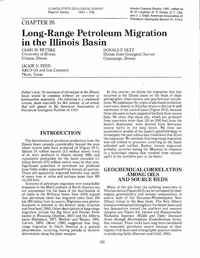
Illinois basin extends considerably beyond the area where source beds have produced oil (Figure 26-1). Almost 24 million barrels (3.5 million metric tons) of oil were produced in Illinois during 1988, and cumulative production for the basin exceeded 4.1 billion barrels (570 million metric tons) by that year. Significant quantities of petroleum are produced from fields widely separated from known oil sources. These oils apparently migrated laterally over paths of many tens of miles and perhaps more than 100 mi (150 km).
Accounts of petroleum migration over remarkable distances in the Mid-Continent of North America are not uncommon. On the basis of the distribution of oil fields in the Williston basin, Dow (1974) argued that petroleum there has migrated more than 150 km (100 miles) from its source. Migration over similar distances is inferred in the Denver basin (Clayton and Swetland, 1980). Other descriptions of long-range migration include the Big Horn and Powder River basins in Wyoming (Sheldon, 1967) and the Alberta basin (Demaison, 1977; Moshier and Waples, 1985; Garven, 1989). Oliver (1986) suggested that longrange migration in North America is a general phenomenon, occurring during periods of tectonic deformation along the plate margins.
DONALD F. OLTZ Illinois State Geological Survey Champaign, Illinois
In this section, we define the migration that has occurred in the Illinois basin on the basis of shale petrographic observations and geochemical correlations. We emphasize the origin of oils found in shallow reservoirs, mostly in Silurian strata to the north and northwest of the central basin (Figure 26-2), because these oils seem to have migrated farthest from source beds. We show that these oils, which are produced from reservoirs more than 125 mi (200 km) from the basin's depocenter, were derived from Devonian source rocks in the deep basin. We then use quantitative models of the basin's paleohydrology to investigate the past subsurface conditions that drove the migration. We conclude that long-range migration was not related to processes occurring as the basin subsided and infilled. Rather, lateral migration probably occurred during the Mesozoic in response to a hydrologic regime that resulted from tectonic uplift in the southern part of the basin.
GEOCHEMICAL CORRELATION AMONG OILS
AND SOURCE BEDS
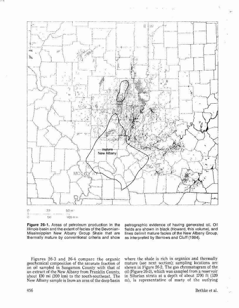
Many of the oils from the outlying reservoirs in Silurian strata (Figure 26-2) can be correlated by their organic geochemistry and isotopic compositions to source beds of the Devonian-Mississippian New Albany Group in the deep basin. The New Albany Group is widespread throughout the deeper basin and has depocenters toward the southern and western margins (see Figure 8-6, Devera and Hasenmueller, Kaskaskia Sequence: Middle and Upper Devonian Series through Mississippian Kinderhookian Series, this volume). These rocks have long been considered an important petroleum source because of their organic-rich facies and stratigraphic position relative to producing fields (Barrows and Cluff, 1984).
455
i 00 krn
Figure 26·1. Areas of petroleum production in the Illinois basin and the extent of facies of the DevonianMississippian New Albany Group Shale that are thermally mature by conventional criteria and show
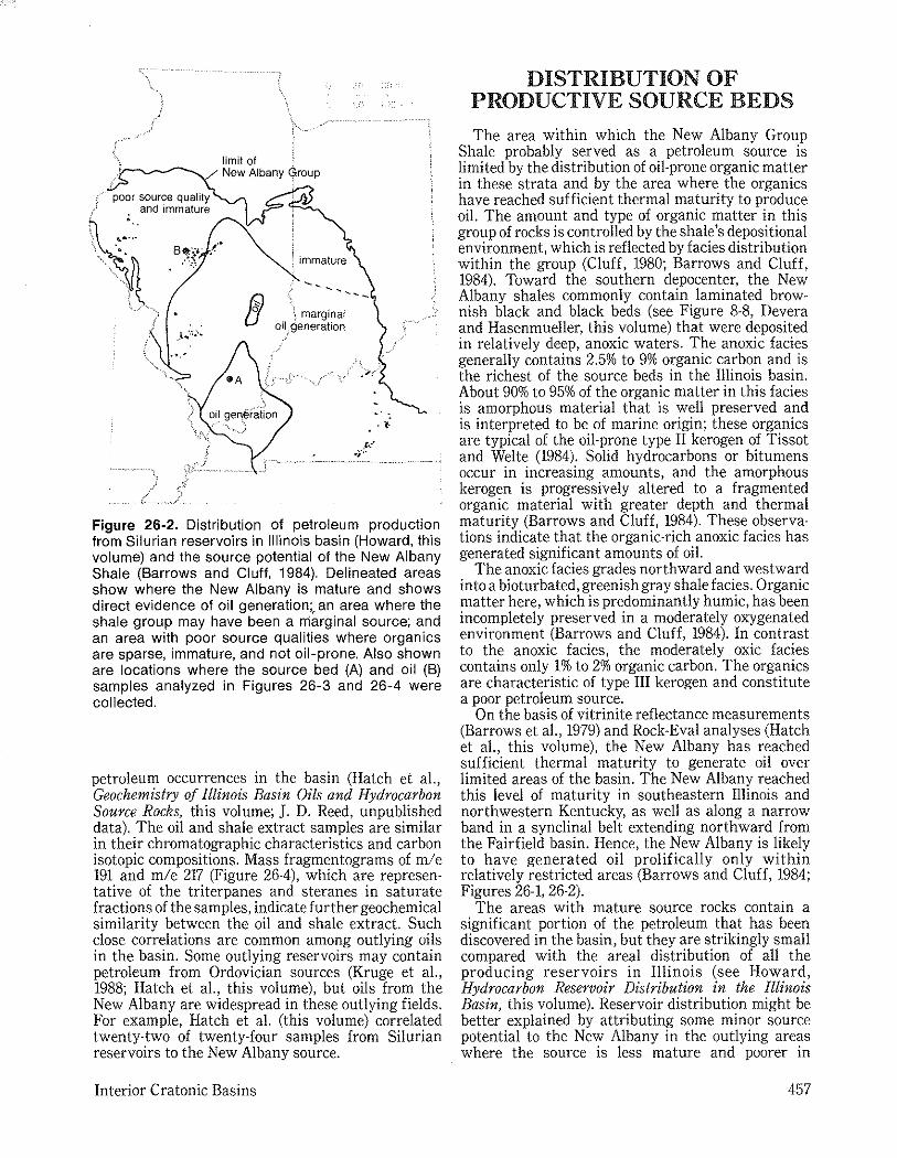
Figures 26·3 and 26·4 compare the organic geochemical composition of the saturate fraction of an oil sampled in Sangamon County with that of an extract of the New Albany from Franklin County, about 130 mi (200 km) to the south·southeast. The New Albany sample is from an area of the deep basin
456
petrographic evidence of having generated oil. Oil fields are shown in black (Howard, this volume), and lines delimit mature facies of the New Albany Group, as interpreted by Barrows and Cluff (1984).
where the shale is rich in organics and thermally mature (see next section); sampling locations are shown in Figure 26·2. The gas chromatogram of the oil (Figure 26·3), which was sampled from a reservoir in Silurian strata at a depth of about 1700 ft (520 m), is representative of many of the outlying
Bethke et al.
limit of i New Albany <froup
\ marginal oil,generation
-' . ••
Figure 26-2. Distribution of petroleum production from Silurian reservoirs in Illinois basin (Howard, this volume) and the source potential of the New Albany Shale (Barrows and Cluff, 1984). Delineated areas show where the New Albany is mature and shows direct evidence of oil generation;. an area where the shale group may have been a marginal source; and an area with poor source qualities where organics are sparse, immature, and not oil-prone. Also shown are locations where the source bed (A) and oil (B) samples analyzed in Figures 26-3 and 26-4 were collected.
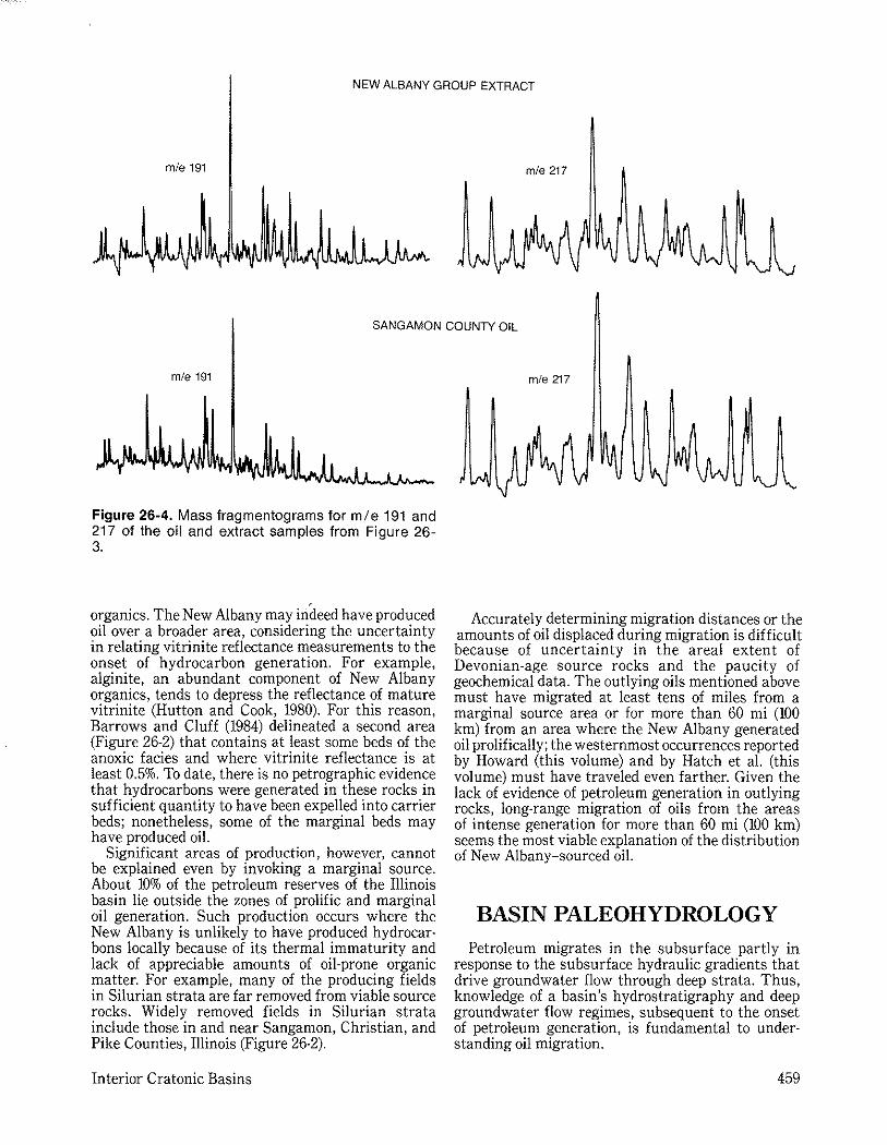
petroleum occurrences in the basin (Hatch et aI., Geochemistry of Illinois Basin Oils and Hydrocarbon Source Rocks, this volume; J. D. Reed, unpublisbed data). The oil and shale extract samples are similar in their chromatographic characteristics and carbon isotopic compositions. Mass fragmentograms of mle 191 and mle 217 (Figure 26-4), which are represen· tative of the triterpanes and steranes in saturate fractions of the samples, indicate further geochemical similarity between the oil and shale extract. Such close correlations are common among outlying oils in the basin. Some outlying reservoirs may contain petroleum from Ordovician sources (Kruge et aI., 1988; Hatch et aI., this volume), but oils from the New Albany are widespread in these outlying fields. For example, Hatch et al. (this volume) correlated twenty·two of twenty·four samples from Silurian reservoirs to the New Albany source.
Interior Cratonic Basins
DISTRIBUTION OF PRODUCTIVE SOURCE BEDS
The area within which the New Albany Group Shale probably served as a petroleum source is limited by the distribution of oil·prone organic matter in these strata and by the area where the organics have reached sufficient thermal maturity to produce oil. The amount and type of organic matter in this group of rocks is controlled by the shale's depositional environment, which is reflected by facies distribution within the group (Cluff, 1980; Barrows and Cluff, 1984). Toward the southern depocenter, the New Albany shales commonly contain laminated brownish black and black beds (see Figure 8·8, Devera and Hasenmueller, this volume) that were deposited in relatively deep, anoxic waters. The anoxic facies generally contains 2.5% to 9% organic carbon and is the richest of the source beds in the Illinois basin. About 90% to 95% of the organic matter in this facies is amorphous material that is well preserved and is interpreted to be of marine origin; these organics are typical of the oil-prone type II kerogen of Tissot and Welte (1984). Solid hydrocarbons or bitumens occur in increasing amounts, and the amorphous kerogen is progressively altered to a fragmented organic material with greater depth and thermal maturity (Barrows and Cluff, 1984). These observations indicate that the organic· rich anoxic facies has generated significant amounts of oil.
The anoxic facies grades northward and westward into a bioturbated, greenish gray shale facies. Organic matter here, which is predominantly humic, has been incompletely preserved in a moderately oxygenated environment (Barrows and Cluff, 1984). In contrast to the anoxic facies, the moderately oxic facies contains only 1% to 2% organic carbon. The organics are characteristic of type III kerogen and constitute a poor petroleum source.
On the basis of vitrinite reflectance measurements (Barrows et aI., 1979) and Rock·Eval analyses (Hatch et aI., this volume), the New Albany has reached sufficient thermal maturity to generate oil over limited areas of the basin. The New Albany reached this level of maturity in southeastern Illinois and northwestern Kentucky, as well as along a narrow band in a synclinal belt extending northward from the Fairfield basin. Hence, the New Albany is likely to have generated oil prolifically only within relatively restricted areas (Barrows and Cluff, 1984; Figures 26-1, 26-2).
The areas with mature source rocks contain a significant portion of the petroleum that has been discovered in the basin, but they are strikingly small compared with the areal distribution of all the producing reservoirs in Illinois (see Howard, Hydrocarbon Reservoir Distribution in the Illinois Basin, this volume). Reservoir distribution might be better explained by attributing some minor source potential to the New Albany in the outlying areas where the source is less mature and poorer in
457
NC14
Ne14
I i NC16
I I
I f
Ne16
NC18
I I
I NelS
SANGAMON COUNTY OIL
1)13C = -29.8
I NC22
I i NC26
NC22
NC26
NC28
NC28
I
NEW ALBANY SHALE EXTRACT (FRANKLIN COUNTY)
1)13C = -29.6
Figure 26·3. Comparison of chromatog ram and with analysis of the saturate fraction ofthe New Albany carbon isotopic compOSition of saturate fraction of Shale from Franklin County in southern Illinois. an oil sample from Sangamon County in central Illinois
458 Bethke et al.
NEW ALBANY GROUP EXTRACT
m/e 191 m/e 217
SANGAMON COUNTY OIL
m/e 191
Figure 26-4. Mass fragmentograms for mle 191 and 217 of the oil and extract samples from Figure 26-3.
organics. The New Albany may indeed have produced oil over a broader area, considering the uncertainty in relating vitrinite reflectance measurements to the onset of hydrocarbon generation. For example, alginite, an abundant component of New Albany organics, tends to depress the reflectance of mature vitrinite (Hutton and Cook, 1980). For this reason, Barrows and Cluff (1984) delineated a second area (Figure 26-2) that contains at least some beds of the anoxic facies and where vitrinite reflectance is at least 0.5%. To date, there is no petrographic evidence that hydrocarbons were generated in these rocks in sufficient quantity to have been expelled into carrier beds; nonetheless, some of the marginal beds may have produced oil.
Significant areas of production, however, cannot be explained even by invoking a marginal source. About 10% of the petroleum reserves of the Illinois basin lie outside the zones of prolific and marginal oil generation. Such production occurs where the New Albany is unlikely to have produced hydrocarbons locally because of its thermal immaturity and lack of appreciable amounts of oil· prone organic matter. For example, many of the producing fields in Silurian strata are far removed from viable source rocks. Widely removed fields in Silurian strata include those in and near Sangamon, Christian, and Pike Counties, Illinois (Figure 26·2).
Interior Cratonic Basins
m/e 217
Accurately determining migration distances or the amounts of oil displaced during migration is difficult because of uncertainty in the areal extent of Devonian·age source rocks and the paucity of geochemical data. The outlying oils mentioned above must have migrated at least tens of miles from a marginal source area or for more than 60 mi (100 km) from an area where the New Albany generated oil prolifically; the westernmost occurrences reported by Howard (this volume) and by Hatch et al. (this volume) must have traveled even farther. Given the lack of evidence of petroleum generation in outlying rocks, long· range migration of oils from the areas of intense generation for more than 60 mi (100 km) seems the most viable explanation of the distribution of New Albany-sourced oil.
BASIN PALEOHYDROLOGY
Petroleum migrates in the subsurface partly in response to the subsurface hydraulic gradients that drive groundwater flow through deep strata. Thus, knowledge of a basin's hydrostratigraphy and deep groundwater flow regimes, subsequent to the onset of petroleum generation, is fundamental to understanding oil migration.
459
Hydrostratigraphy The Illinois basin began to subside slowly and infill
with sediments during Cambrian time and continued to do so through the Pennsylvanian and into the Permian (Kolata and Nelson, Tectonic History of the Illinois Basin, this volume). During the Paleozoic, the developing basin was a trough-shaped embayment that trended northeasterly and was open to the sea along its southern margin. Six major unconformities mark hiatuses in deposition during this time interval. More than 13,000 ft (4 km) of sedimentary rocks are preserved in the basin within Illinois, and more than 23,000 ft (7 km) occur in the Rough Creek graben in western Kentucky.
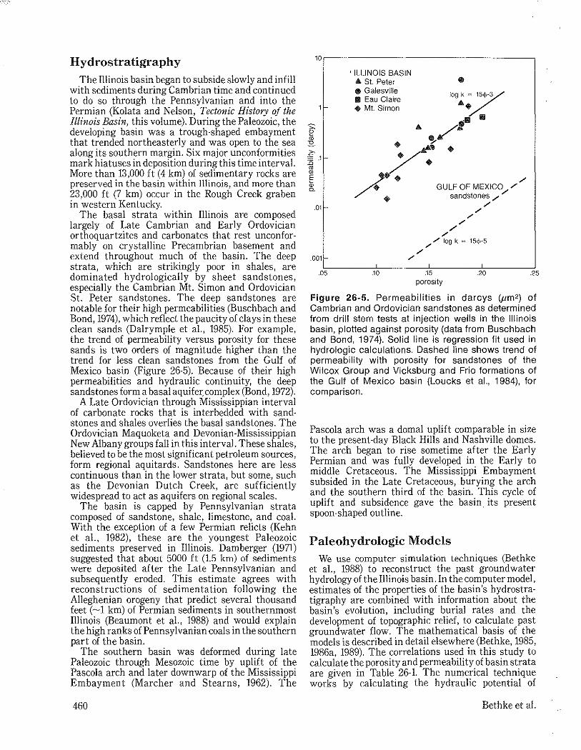
The basal strata within Illinois are composed largely of Late Cambrian and Early Ordovician orthoquartzites and carbonates that rest unconformably on crystalline Precambrian basement and extend throughout much of the basin. The deep strata, which are strikingly poor in shales, are dominated hydrologically by sheet sandstones, especially the Cambrian Mt. Simon and Ordovician St. Peter sandstones. The deep sandstones are notable for their high permeabilities (Busch bach and Bond, 1974), which reflect the paucity of clays in these clean sands (Dalrymple et aI., 1985). For example, the trend of permeability versus porosity for these sands is two orders of magnitude higher than the trend for less clean sandstones from the Gulf of Mexico basin (Figure 26-5). Because of their high permeabilities and hydraulic continuity, the deep sandstones form a basal aquifer: complex (Bond, 1972).
A Late Ordovician through Mississippian interval of carbonate rocks that is interbedded with sandstones and shales overlies the basal sandstones_ The Ordovician Maquoketa and Devonian-Mississippian New Albany groups fall in this interval. These shales, believed to be the most significant petroleum sources, form regional aquitards. Sandstones here are less continuous than in the lower strata, but some, such as the Devonian Dutch Creek, are sufficiently widespread to act as aquifers on regional scales_
The basin is capped by Pennsylvanian strata composed of sandstone, shale, limestone, and coal. With the exception of a few Permian relicts (Kehn et aI., 1982), these are the youngest Paleozoic sediments preserved in Illinois. Damberger (1971) suggested that about 5000 ft (l.5 km) of sediments were deposited after the Late Pennsylvanian and subsequently eroded. This estimate agrees with reconstructions of sedimentation following the Alleghenian orogeny that predict several thousand feet (-1 km) of Permian sediments in southernmost Illinois (Beaumont et aI., 1988) and would explain the high ranks of Pennsylvanian coals in the southern part of the basin.
The southern basin was deformed during late Paleozoic through Mesozoic time by uplift of the Pascola arch and later downwarp of the Mississippi Embayment (Marcher and Stearns, 1962). The
460
10r---------------------------------~
'1-
.011-
.001
.05
, ILLINOIS BASIN ... St. Peter • Galesville II Eau Claire .. Mt. Simon
Jogk = 15(hY
4t..~ .fIj fIj
fA / .. ~A(" . ~ ...
/+ ~
~. / • GULF OF MEXICO /
.. sandstones ,/ ,/
'" .10
/ /
/ /
/
/
;"./ log k = 15dl-5
/
I
.15 .20 porosity
.25
Figure 26-5. Permeabilities in darcys (,um2) of Cambrian and Ordovician sandstones as determined from drill stem tests at injection wells in the Illinois basin, plotted against porosity (data from Buschbach and Bond, 1974). Solid line is regression fit used in hydrologic calculations. Dashed line shows trend of permeability with porosity for sandstones of the Wilcox Group and Vicksburg and Frio formations of the Gulf of Mexico basin (Loucks et aI., 1984), for comparison.
Pascola arch was a domal uplift comparable in size to the present-day Black Hills and Nashville domes. The arch began to rise sometime after the Early Permian and was fully developed in the Early to middle Cretaceous. The Mississippi Embayment subsided in the Late Cretaceous, burying the arch and the southern third of the basin. This cycle of uplift and subsidence gave the basin its present spoon-shaped outline.
Paleohydrologic Models We use computer simulation techniques (Bethke
et aI., 1988) to reconstruct the past groundwater hydrology ofthe Illinois basin. In the computer model, estimates of the properties of the basin's hydrostratigraphy are combined with information about the basin's evolution, including burial rates and the development of topographic relief, to calculate past groundwater flow. The mathematical basis of the models is described in detail elsewhere (Bethke, 1985, 1986a, 1989). The correlations used in this study to calculate the porosity and permeability of basin strata are given in Table 26-l. The numerical technique works by calculating the hydraulic potential of
Bethke et al.
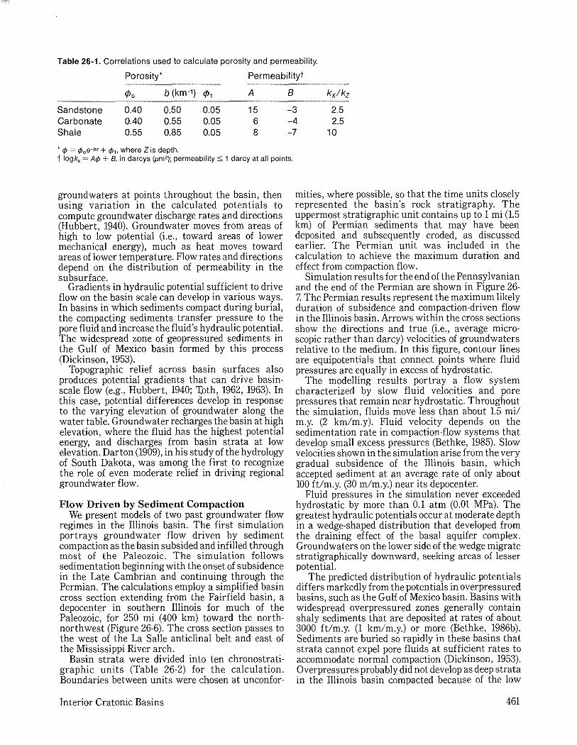
Table 26·1. Correlations used to calculate porosity and permeability.
Porosity' Permeability'
1>0 b (km-1) 1>, A B kxlkz
Sandstone 0.40 0.50 0.05 15 -3 2.5 Carbonate 0.40 0.55 0.05 6 -4 2.5 Shale 0.55 0.85 0.05 8 -7 10
• 1> = ¢oe-bz + ¢l, where Z is depth. t logkx = A¢ + Bt in darcys (,um2); permeability S; 1 darcy at all points.
ground waters at points throughout the basin, then using variation in the calculated potentials to compute groundwater discharge rates and directions (Hubbert, 1940). Groundwater moves from areas of high to low potential (i.e., toward areas of lower mechanical energy), much as heat moves toward areas of lower temperature. Flow rates and directions depend on the distribution of permeability in the subsurface.
Gradients in hydraulic potential sufficient to drive flow on the basin scale can develop in various ways. In basins in which sediments compact during burial, the compacting sediments transfer pressure to the pore fluid and increase the fluid's hydraulic potential. The widespread zone of geopressured sediments in the Gulf of Mexico basin formed by this process (Dickinson, 1953).
Topographic relief across basin surfaces also produces potential gradients that can drive basin· scale flow (e.g., Hubbert, 1940; '])Jth, 1962, 1963). In this case, potential differences develop in response to the varying elevation of groundwater along the water table. Groundwater recharges the basin at high elevation, where the fluid has the highest potential energy, and discharges from basin strata at low elevation. Darton (1909), in his study of the hydrology of South Dakota, was among the first to recognize the role of even moderate relief in driving regional groundwater flow.
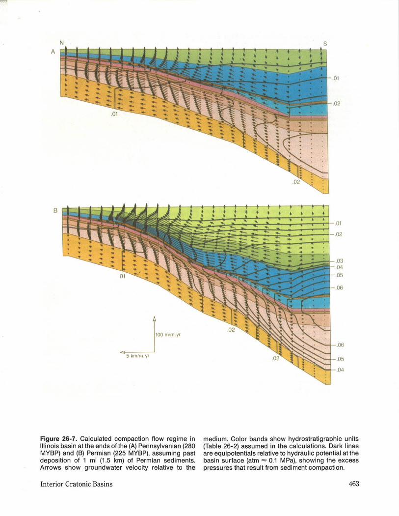
Flow Driven by Sediment Compaction We present models of two past groundwater flow
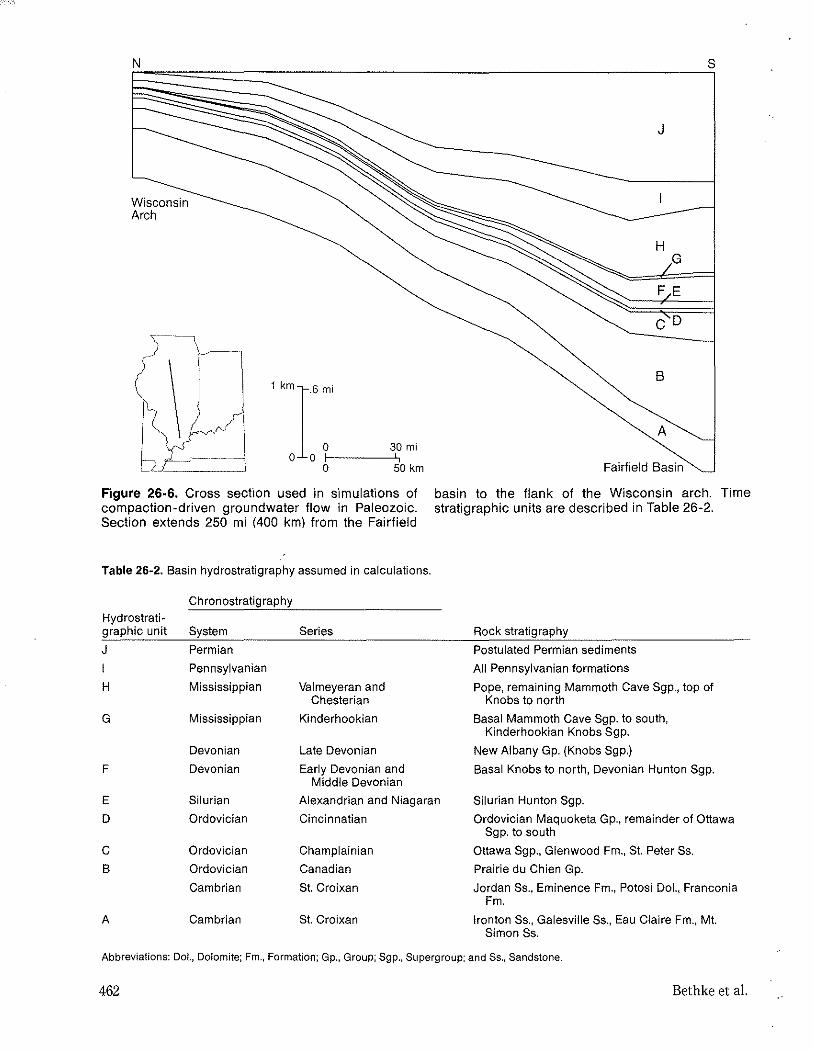
regimes in the Illinois basin. The first simulation portrays groundwater flow driven by sediment compaction as the basin subsided and infilled through most of the Paleozoic. The simulation follows sedimentation beginning with the onset of subsidence in the Late Cambrian and continuing through the Permian. The calculations employ a simplified basin cross section extending from the Fairfield basin, a depocenter in southern Illinois for much of the Paleozoic, for 250 mi (400 km) toward the north· northwest (Figure 26·6). The cross section passes to the west of the La Salle anticlinal belt and east of the Mississippi River arch.
Basin strata were divided into ten chronostratigraphic units (Table 26-2) for the calculation. Boundaries between units were chosen at unconfor-
Interior Cratonic Basins
mities, where possible, so that the time units closely represented the basin's rock stratigraphy. The uppermost stratigraphic unit contains up to 1 mi (1.5 km) of Permian sediments that may have been deposited and subsequently eroded, as discussed earlier. The Permian unit was included in the calculation to achieve the maximum duration and effect from compaction flow.
Simulation results for the end of the Pennsylvanian and the end of the Permian are shown in Figure 26-7. The Permian results represent the maximum likely duration of subsidence and compaction-driven flow in the Illinois basin. Arrows within the cross sections show the directions and true (i.e., average microscopic rather than darcy) velocities of groundwaters relative to the medium. In this figure, contour lines are equipotentials that connect points where fluid pressures are equally in excess of hydrostatic.
The modelling results portray a flow system characterized by slow fluid velocities and pore pressures that remain near hydrostatic. Throughout the simulation, fluids move less than about 1.5 mil m.y. (2 km/m.y). Fluid velocity depends on the sedimentation rate in compaction-flow systems that develop small excess pressures (Bethke, 1985). Slow velocities shown in the simulation arise from the very gradual subsidence of the Illinois basin, which accepted sediment at an average rate of only about 100 ftlm.y. (30 m/m.y.) near its depocenter.
Fluid pressures in the simulation never exceeded hydrostatic by more than 0.1 atm (0.01 MPa). The greatest hydraulic potentials occur at moderate depth in a wedge-shaped distribution that developed from the draining effect of the basal aquifer complex. Groundwaters on the lower side of the wedge migrate stratigraphically downward, seeking areas of lesser potential.
The predicted distribution of hydraulic potentials differs markedly from the potentials in overpressured basins, such as the Gulf of Mexico basin. Basins with widespread overpressured zones generally contain shaly sediments that are deposited at rates of about 3000 ft/m.y. (1 km/m.y.) or more (Bethke, 1986b). Sediments are buried so rapidly in these basins that strata cannot expel pore fluids at sufficient rates to accommodate normal compaction (Dickinson, 1953). Overpressures probably did not develop as deep strata in the Illinois basin compacted because of the low
461
N
Wisconsin Arch
1 km
r·6 moi
30 mi o 0 f-I ----','
o 50 km
Figure 26·6. Cross section used in simulations of compaction-driven groundwater flow in Paleozoic. Section extends 250 mi (400 km) from the Fairfield
Table 26·2. Basin hydrostratigraphy assumed in calculations.
Chronostratigraphy Hydrostrati-graphic unit System
J Permian
I Pennsylvanian
H Mississippian
G Mississippian
Devonian
F Devonian
Series
Valmeyeran and Chesterian
Kinderhookian
Late Devonian
Early Devonian and Middle Devonian
S
J
H G
F E
CD
B
A
Fairfield Basin
basin to the flank of the Wisconsin arch. Time stratigraphic units are described in Table 26-2.
Rock stratigraphy
Postulated Permian sediments
All Pennsylvanian formations
Pope, remaining Mammoth Cave Sgp., top of Knobs to north
Basal Mammoth Cave Sgp. to south, Kinderhookian Knobs Sgp.
New Albany Gp. (Knobs Sgp,)
Basal Knobs to north, Devonian Hunton Sgp,
E Silurian
D Ordovician
Alexandrian and Niagaran
Cincinnatian
Silurian Hunton Sgp,
Ordovician Maquoketa Gp" remainder of Ottawa
C Ordovician
B Ordovician
Cambrian
A Cambrian
Champlainian
Canadian
St. Croixan
St. Croixan
Sgp. to south
Ottawa Sgp., Glenwood Fm., St. Peter Ss.
Prairie du Chien Gp.
Jordan Ss., Eminence Fm" Potosi Dol., Franconia Fm,
Ironton Ss., Galesville Ss., Eau Claire Fm., Mt. Simon Ss.
Abbreviations: DoL, Dolomite; Fm., Formation; Gp., Group; Sgp., Supergroup; and 8s., Sandstone.
462 Bethke et aL
N
A
B
.-J.ro "".
5 km/m.yr
Figure 26-7. Calculated compaction flow regime in Illinois basin at the ends of the (A) Pennsylvanian (280 MYBP) and (B) Permian (225 MYBP), assuming past deposition of 1 mi (1.5 km) of Permian sediments. Arrows show groundwater velocity relative to the
Interior Cratonic Basins
s
.01
.02
.01
;,-.:-;-::;::;;;;:;;a: .03 .04 .05
.06
.05
.04
medium. Color bands show hydrostratigraphic units (Table 26-2) assumed in the calculations. Dark lines are equipotentials relative to hydraulic potential at the basin surface (atm '" 0.1 MPa), showing the excess pressures that result from sediment compaction.
463
burial rate of 100 ft/m.y. (:S30 m/m.y.), the low shale content of <10% in deep strata, and the widespread sandstone aquifers with relatively high permeabilities (Figure 26-5).
Flow Driven by Topographic Relief The second paleohydrologic model simulates
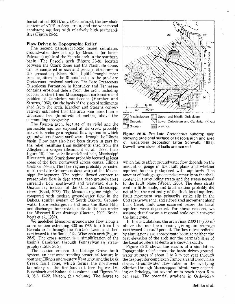
groundwater flow set up by Mesozoic (or latest Paleozoic) uplift of the Pascola arch in the southern basin. The Pascola arch (Figure 26-8), located between the Ozark dome and the Nashville dome, can be compared in size and perhaps structure to the present-day Black Hills. Uplift brought most basal aquifers in the Illinois basin to the pre-Late Cretaceous erosional surface. The Late Cretaceous Tuscaloosa Formation in Kentucky and Tennessee contains erosional debris from the arch, including cobbles of chert from Mississippian carbonates and pebbles of Cambrian sandstones (Marcher and Stearns, 1962). On the basis of the sizes of sediments shed from the arch, Marcher and Stearns conservatively estimated that the arch rose more than a thousand feet (hundreds of meters) above the surrounding topography.
The Pascola arch, because of its relief and the permeable aquifers exposed at its crest, probably served to recharge a regional flow system in which groundwaters flowed northward through the Illinois basin. Flow may also have been driven in part by the relief resulting from sediments shed from the Alleghenian orogen (Beaumont et aI., 1988, their figure 15). The La Salle anticlinal belt, Mississippi River arch, and Ozark dome probably focused at least some of the flow northward across central Illinois (Bethke, 1986a). The flow regime probably persisted until the Late Cretaceous downwarp of the Missis· sippi Embayment. The regime flowed counter to present-day flow in deep strata: deep groundwaters currently flow southward and westward due to Quaternary incision of the Ohio and Mississippi rivers (Bond, 1972). The Mesozoic regime might be compared with modern groundwater flow in the Dakota aquifer system of South Dakota. Ground· water there recharges in and near the Black Hills and discharges hundreds of miles to the east under the Missouri River drainage (Darton, 1909; Bredehoeft et aI., 1982).
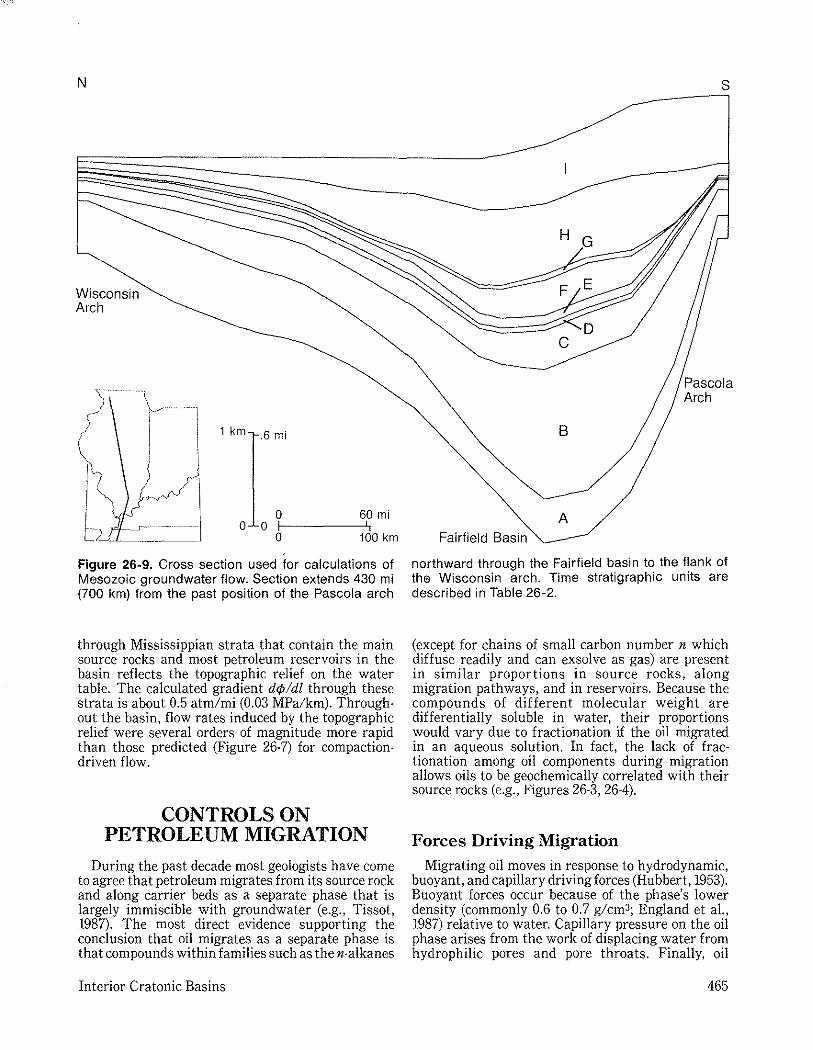
We modelled Mesozoic groundwater flow along a cross section extending 430 mi (700 km) from the Pascola arch through the Fairfield basin and then northward to the flank of the Wisconsin arch (Figure 26·9). The cross section is a simplification of the basin's Cambrian through Pennsylvanian stratigraphy (Table 26-2).
The section crosses the Cottage Grove fault system, an east·west trending structural feature in southern Illinois and western Kentucky, and the Lusk Creek fault zone, which forms the northwest boundary of the Reelfoot rift (see Figure 1·6, Buschbach and Kolata, this volume, and Figures 16-3, 16-6, 16-22, Nelson, this volume). The degree to
464
KY
o 3,0 60 mi o~1 --5:1:'Oc-~160 km
o Mississippian 0 Upper and Middle Ordovician
TN
c o ~ o C. <D '0 os :g .Q os g F
H::::-:\·:::l Devonian [S3 Lower Ordovician and Cambrian (Knox) rn Silurian Gill preKnox
Figure 26·8. Pre-Late Cretaceous subcrop map showing erosional surface of Pascola arch and area of Tuscaloosa deposition (after Schwalb, 1982). Downthrown sides of faults are marked.
which faults affect groundwater flow depends on the amount of gouge in the fault plane and whether aquifers become juxtaposed with aquitards. The amount of fault gouge depends primarily on the shale content in surrounding strata and the stress normal to the fault plane (Weber, 1986). The deep strata contain little shale, and fault motion probably did not affect the continuity of the thick basal aquifers. Fault movement was primarily strike slip in the Cottage Grove zone, and rift-related movement along Lusk Creek fault zone occurred before the basal aquifers were deposited. For these reasons, we assume that flow on a regional scale could traverse the fault zone.
In the calculations, the arch rises 2300 ft (700 m) above the northern basin, giving an average northward slope of 1 per mil. The flow rates predicted by simulations are approximate because neither the past elevation of the arch nor the permeabilities of the basal aquifers at depth are known exactly.
Figure 26-10 shows the results of a simulation. Topographic relief across the basin drives groundwater at rates of about 1 to 2 m per year through the deep aquifer complex in Cambrian and Ordovician strata. Groundwater flow rates in the overlying Silurian through Mississippian strata vary depending on lithology, but several units reach about 5 m per year. The potential gradient in Ordovician
Bethke et a1.
N
Wisconsin Arch
I J
1 km .6 mi
o 60 mi o 0 1-1 ------",',
o 100 km
Figure 26-9. Cross section used for calculations of Mesozoic groundwater flow. Section extends 430 mi (700 km) from the past position of the Pascola arch
through Mississippian strata that contain the main source rocks and most petroleum reservoirs in the basin reflects the topographic relief on the water table. The calculated gradient d¢/dl through these strata is about 0.5 atm/mi (0.03 MPa/km). Throughout the basin, flow rates induced by the topographic relief were several orders of magnitude more rapid than those predicted (Figure 26-7) for compactiondriven flow.
CONTROLS ON PETROLEUM MIGRATION
During the past decade most geologists have come to agree that petroleum migrates from its source rock and along carrier beds as a separate phase that is largely immiscible with groundwater (e.g., Tissot, 1987). The most direct evidence supporting the conclusion that oil migrates as a separate phase is that compounds within families such as the n-alkanes
Interior Cratonic Basins
s
A Fairfield Basin
northward through the Fairfield basin to the flank of the Wisconsin arch. Time stratigraphic units are described in Table 26-2.
(except for chains of small carbon number n which diffuse readily and can exsolve as gas) are present in similar proportions in source rocks, along migration pathways, and in reservoirs. Because the compounds of different molecular weight are differentially soluble in water, their proportions would vary due to fractionation if the oil migrated in an aqueous solution. In fact, the lack of fractionation among oil components during migration allows oils to be geochemically correlated with their source rocks (e.g., Figures 26-3, 26-4).
Forces Driving Migration Migrating oil moves in response to hydrodynamic,
buoyant, and capillary driving forces (Hubbert, 1953). Buoyant forces occur because of the phase's lower density (commonly 0.6 to 0.7 g/cm3; England et aI., 1987) relative to water. Capillary pressure on the oil phase arises from the work of displacing water from hydrophilic pores and pore throats. Finally, oil
465
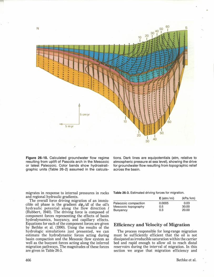
Figure 26-10. Calculated groundwater flow regime resulting from uplift of Pascola arch in the Mesozoic or latest Paleozoic. Color bands show hydrostratigraphic units (Table 26-2) assumed in the calcu la-
migrates in response to internal pressures in rocks and regional hydraulic gradients.
The overall force driving migration of an immis· cible oil phase is the gradient d</>oldl of the oil's hydraulic potential along the flow direction I (Hubbert, 1940). The driving force is composed of component forces representing the effects of basin hydrodynamics, buoyancy, and capillary effects. Equations for each of the component forces are given by Bethke et a1. (1990). Using the results of the hydrologic simulations just presented, we can estimate the hydrodynamic forces acting during basin compaction and the Mesozoic flow system as well as the buoyant forces acting along the inferred migration pathways. The magnitudes of these forces are given in Table 26·3.
466
tions. Dark lines are equipotentials (atm, relative to atmospheric pressure at sea level), showing the drive for groundwater flow resu lting from topographic relief across the basin.
Table 26·3. Estimated driving lorces lor migration.
Paleozoic compaction Mesozoic topography Buoyancy
E (atm/mi) (kPa / km) 0.0005 0.03 0.5 30.00 0.3 20.00
Efficiency and Velocity of Migration The process responsible for long·range migration
must be sufficiently efficient that the oil is not dissipated as irreducible saturation within the carrier bed and rapid enough to allow oil to reach distal reservoirs during the interval of migration. In this section we argue that migration efficiency and
Bethke et a1.
velocity are greatest when the oil flows through just a small fraction of the carrier bed.
The efficiency of oil migration through a carrier bed is the amount of oil that reaches traps or discharges from the bed relative to the amount that remains in the bed's pore space as irreducible saturation. A significant amount of oil may be required to achieve irreducible saturation in a sediment. England et al. (1987), for example, tested various sandstones and found that the saturations required for oil to flow ranged from 18% to 91%; the average value in these tests was about half the pore volume of the rock. Studies that balance the volumes of oil generated in source rocks with the amount that could be lost to irreducible saturation during migration (e.g., England et aI., 1987) indicate that oil must migrate through just a small fraction of the carrier bed. If the entire bed served as a migration pathway, vast quantities of oil would remain within the bed's pore structure. The loss of oil in this latter case would be sufficient to preclude migration over long distances.
Migration is most rapid when oil moves through a small fraction of the carrier bed. A single fluid flowing through an aquifer at a given rate of discharge moves at a velocity that varies inversely with the aquifer's porosity. In other words, at a given rate of discharge, fluid traverses greater distances through rocks of low porosity. Groundwater, for example, moves rapidly through fractured granites even at modest discharge rates because the fraction of the rock occupied by connected pore space (the fractures) is very small. By the same principle, the velocity of petroleum migration depends on the fraction of the carrier bed through which the oil is mobile. Hence, migration is most rapid when the oil moves through a saturated pathway that occupies a small portion of the carrier bed.
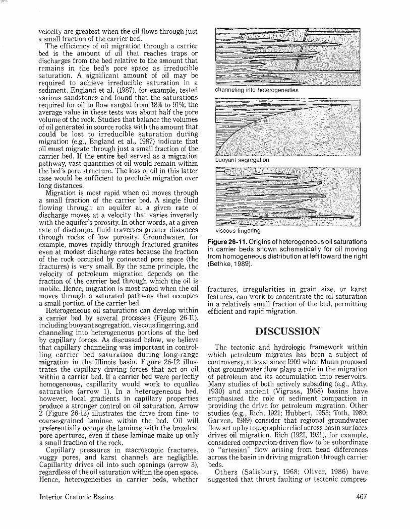
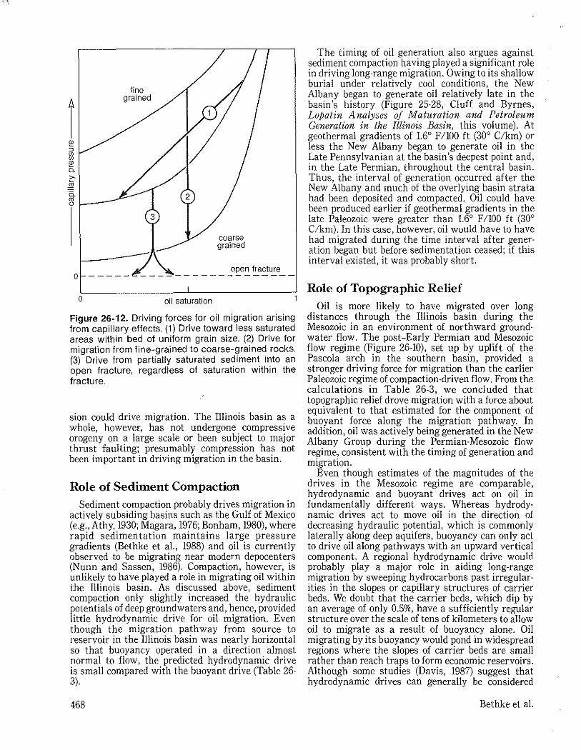
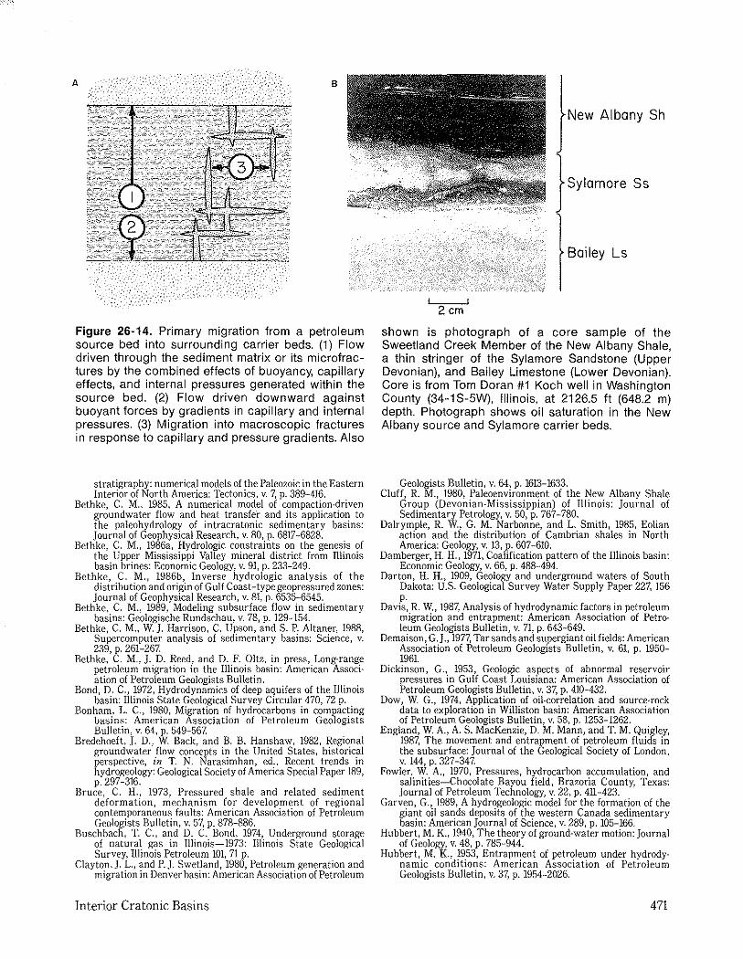
Heterogeneous oil saturations can develop within a carrier bed by several processes (Figure 26-11), including buoyant segregation, viscous fingering, and channeling into heterogeneous portions of the bed by capillary forces. As discussed below, we believe that capillary channeling was important in controlling carrier bed saturation during long-range migration in the Illinois basin. Figure 26-12 illustrates the capillary driving forces that act on oil within a carrier bed. If a carrier bed were perfectly homogeneous, capillarity would work to equalize saturation (arrow 1). In a heterogeneous bed, however, local gradients in capillary properties produce a stronger control on oil saturation. Arrow 2 (Figure 26-12) illustrates the drive from fine· to coarse-grained laminae within the bed. Oil will preferentially occupy the laminae with the broadest pore apertures, even if these laminae make up only a small fraction of the rock.
Capillary pressures in macroscopic fractures, vuggy pores, and karst channels are negligible. Capillarity drives oil into such openings (arrow 3), regardless of the oil saturation within the open space. Hence, heterogeneities in carrier beds, whether
Interior Cratonic Basins
channeling into heterogenelties
buoyant segregation
viscous fingering
Figure 26-11. Origins of heterogeneous oil saturations in carrier beds shown schematically for oil moving from homogeneous distribution at left toward the right (Bethke, 1989).
fractures, irregularities in grain size, or karst features, can work to concentrate the oil saturation in a relatively small fraction of the bed, permitting efficient and rapid migration.
DISCUSSION
The tectonic and hydrologic framework within which petroleum migrates has been a subject of controversy, at least since 1909 when Munn proposed that groundwater flow plays a role in the migration of petroleum and its accumulation into reservoirs. Many studies of both actively subsiding (e.g., Athy, 1930) and ancient (Vigrass, 1968) basins have emphasized the role of sediment compaction in providing the drive for petroleum migration. Other studies (e.g., Rich, 1921; Hubbert, 1953; Toth, 1980; Garven, 1989) consider that regional groundwater flow set up by topographic relief across basin surfaces drives oil migration. Rich (1921, 1931), for example, considered compaction-driven flow to be subordinate to "artesian" flow arising from head differences across the basin in driving migration through carrier beds.
Others (Salisbury, 1968; Oliver, 1986) have suggested that thrust faulting or tectonic com pres-
467
r i" " '" '" i" ">-jjj '6. ~ '---
fine grained
coarse grained
open fracture o ----- ------------------
o oil saturation
Figure 26-12. Driving forces for oil migration arising from capillary effects. (1) Drive toward less saturated areas within bed of uniform grain size. (2) Drive for migration from fine-grained to coarse-grained rocks. (3) Drive from partially saturated sediment into an open fracture, regardless of saturation within the fracture.
sian could drive migration. The Illinois basin as a whole, however, has not undergone compressive orogeny on a large scale or been subject to major thrust faulting; presumably compression has not been important in driving migration in the basin.
Role of Sediment Compaction Sediment compaction probably drives migration in
actively subsiding basins such as the Gulf of Mexico (e.g., Athy, 1930; Magara, 1976; Bonham, 1980), where rapid sedimentation maintains large pressure gradients (Bethke et a!., 1988) and oil is currently observed to be migrating near modern depocenters (Nunn and Sassen, 1986). Compaction, however, is unlikely to have played a role in migrating oil within the Illinois basin. As discussed above, sediment compaction only slightly increased the hydraulic potentials of deep groundwaters and, hence, provided little hydrodynamic drive for oil migration. Even though the migration pathway from source to reservoir in the Illinois basin was nearly horizontal so that buoyancy operated in a direction almost normal to flow, the predicted hydrodynamic drive is small compared with the buoyant drive (Table 26· 3).
468
The timing of oil generation also argues against sediment compaction having played a significant role in driving long·range migration. Owing to its shallow burial under relatively cool conditions, the New Albany began to generate oil relatively late in the basin's history (Figure 25·28, Cluff and Byrnes, Lopatin A nalyses of Maturation and Petroleum Generation in the Illinois Basin, this volume). At geothermal gradients of 1.6° F 1100 ft (300 C/km) or less the New Albany began to generate oil in the Late Pennsylvanian at the basin's deepest point and, in the Late Permian, throughout the central basin. Thus, the interval of generation occurred after the New Albany and much of the overlying basin strata had been deposited and compacted. Oil could have been produced earlier if geothermal gradients in the late Paleozoic were greater than 1,GO F /100 ft (300
C/km). In this case, however, oil would have to have had migrated during the time interval after gener· ation began but before sedimentation ceased; if this interval existed, it was probably short.
Role of Topographic Relief Oil is more likely to have migrated over long
distances through the Illinois basin during the Mesozoic in an environment of northward groundwater flow. The post-Early Permian and Mesozoic flow regime (Figure 26-10), set up by uplift of the Pascola arch in the southern basin, provided a stronger driving force for migration than the earlier Paleozoic regime of compaction-driven flow. From the calculations in Table 26-3, we concluded that topographic relief drove migration with a force about equivalent to that estimated for the component of buoyant force along the migration pathway. In addition, oil was actively being generated in the New Albany Group during the Permian-Mesozoic flow regime, consistent with the timing of generation and migration.
Even though estimates of the magnitudes of the drives in the Mesozoic regime are comparable, hydrodynamic and buoyant drives act on oil in fundamentally different ways. Whereas hydrodynamic drives act to move oil in the direction of decreasing hydraulic potential, which is commonly laterally along deep aquifers, buoyancy can only act to drive oil along pathways with an upward vertical component. A regional hydrodynamic drive would probably play a major role in aiding long-range migration by sweeping hydrocarbons past irregularities in the slopes or capillary structures of carrier beds. We doubt that the carrier beds, which dip by an average of only 0.5%, have a sufficiently regular structure over the scale of tens of kilometers to allow oil to migrate as a result of buoyancy alone. Oil migrating by its buoyancy would pond in widespread regions where the slopes of carrier beds are small rather than reach traps to form economic reservoirs. Although some studies (Davis, 1987) suggest that hydrodynamic drives can generally be considered
Bethke et a!.
subordinate to buoyancy, we stress the importance of considering hydrodynamic forces in driving migration along the nearly horizontal carrier beds within cratonic basins.
Carrier Beds for Long-Range Migration
The carrier beds through which the oil migrated to reach the outlying reservoirs still need to be identified. Because the New Albany-sourced oils are found today in reservoirs within the Niagaran Series of the Silurian, they must have migrated either downward out of the New Albany or across a fault plane into older strata.
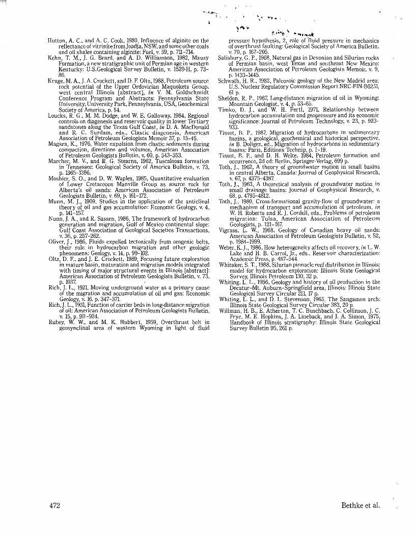
The most suitable beds for long-range migration are probably the Devonian and Silurian strata that lie beneath the New Albany. As described previously, petroleum migrates most efficiently and rapidly through thin beds or through strata with heterogeneous capillary structures, such as fractured rocks or karstic limestones. The Upper Devonian Sylamore Sandstone, which is immediately below the source beds of the New Albany Group, is sporadically present in central and western Illinois (Willman et aI., 1975). The sand is rarely more than 5 ft (1.5 m) thick and is generally just a few inches (cm) thick, making it a candidate for carrying oil (Oltz and Crockett, 1989).
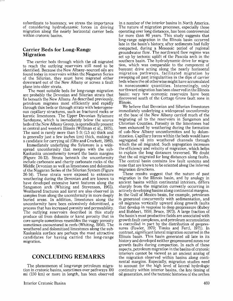
Immediately underlying the Sylamore is a widespread unconformity that merges with the subKaskaskia unconformity toward the basin margins (Figure 26-13). Strata beneath Jhe unconformity include carbonate and cherty carbonate rocks of the Middle Devonian as well as limestones and dolomites of the Niagaran Series of the Silurian System (Figure 26-14). These strata were exposed to extensive weathering during the Devonian and are known to have developed extensive karst features along the Sangamon arch (Whiting and Stevenson, 1965). Weathered fractures and karst are also observed in samples from along the unconformity in more deeply buried areas. In addition, limestones along the unconformity have been extensively dolomitized, a process that has increased porosity and permeability. The outlying reservoirs described in this study produce oil from dolomite or karst porosity that in core sample sometimes resembles the vuggy porosity sometimes encountered in reefs (Whiting, 1956). The weathered and dolomitized limestones along the subKaskaskia surface are perhaps the most attractive candidates for having carried the long-range migration.
CONCLUDING REMARKS
The phenomenon of long-range petroleum migration in cratonic basins, sometimes over pathways 100 mi (150 km) or more in length, has been observed
Interior Cratonic Basins
in a number of the interior basins in North America. The nature of migration processes, especially those operating over long distances, has been controversial for more than 80 years. This study suggests that long-range migration in the Illinois basin occurred late in the basin's history, after sediments had fully compacted, during a Mesozoic period of regional groundwater flow. The northward flow regime was set up by tectonic uplift of the Pascola arch in the southern basin. The hydrodynamic drive for migration, which was comparable to the component of buoyant drive acting along the nearly horizontal migration pathways, facilitated migration by sweeping oil past irregularities in the dips of carrier beds where the oil otherwise might have accumulated in noneconomic quantities. Interestingly, only northward migration has been observed in the Illinois basin: very few economic reservoirs have been discovered south of the Cottage Grove fault zone in Illinois.
We believe that Devonian and Silurian limestones immediately underlying a widespread unconformity at the base of the New Albany carried much of the migrating oil to the reservoirs in Sangamon and Christian Counties. Porosity in the limestones had been enhanced by weathering during the formation of sub-New Albany unconformities and by dolomitization. Capillary forces within the beds would have segregated oil into weathered channels through which the oil migrated. Such segregation increases the efficiency and velocity of migration, which helps to explain the long distances traversed. We doubt that the oil migrated for long distances along faults. The central basin contains few fault systems and none that are known to be oriented along the inferred migration directions.
These results suggest that the nature of past migration in the Illinois basin, and by analogy in ancient basins within continental interiors, differs sharply from the migration currently occurring in actively developing basins along continental margins. In the Gulf of Mexico basin, for example, petroleum is generated concurrently with sedimentation, and oil migrates vertically upward along growth faults that develop in response to deep geopressure (Rubey and Hubbert, 1959; Bruce, 1973). A large fraction of the basin's most productive fields are associated with growth fault complexes, and petroleum accumulation is controlled in part by the distribution of geopressures (Fowler, 1970; Timko and Fert!, 1971). In contrast, significant lateral migration occurred in the Illinois basin. This basin generated oil late in its history and developed neither geopressured zones nor growth faults during compaction. In each of these aspects, petroleum migration in the basins of cratonic interiors cannot be viewed as an ancient analog of the migration observed within basins along continental margins. Especially, migration studies need to account for the high level of lateral hydrologic continuity within interior basins, the late timing of oil generation, and the tectonic histories of the arches
469
N
Fe n Gte
200 mI6oooft-
10 20 mi o 0 1f----,l,'--o"I!
o 15 30 km
Figure 26·13. Structural cross section from the deep Illinois basin to the area of production from Silurian reservoirs, showing strata surrounding the New Albany Group (drawn by S. T. Whitaker, after Whitaker, 1988). Cross section shows Tippecanoe (Ordovician) and later strata plotted relative to the present surface. Line of section is shown in inset. Wavy lines indicate
along basin margins whose movements affect basin hydrodynamics_
ACKNOWLEDGMENTS
This study was funded by National Science Foundation grants EAR 85-52649 and EAR 86-01178 and through the generosity of ARCO Oil and Gas Company, Amoco Production Company, Exxon Corp., Texaco USA, and Shell Oil Company_ We thank ARCO for permission to publish its proprietary data.
470
Pennsylvanian
s
~~~~~~~~ c
\<. .~ Clear cree §
Bac\<. one > Grass Knob 8'
positions of erosional unconformities, including the sub-Kaskaskia unconformity at the base of Middle Devonian strata. Cross section is constructed from data from wells in (south to north) Williamson, Franklin, Marion, Montgomery, and Sangamon Counties.
REFERENCES CITED
Athy, L. F., 1930, Compaction and oil migration: American Association of Petroleum Geologists Bulletin, v. 14, p. 25-35.
Barrows, M. H., and R. M. Cluff, 1984, New Albany Shale Group, (Devonian-Mississippian) source rocks and hydrocarbon generation in the Illinois basin, in G. Demaison and R. J. Murris, eds., Petroleum geochemistry and basin evaluation: Tulsa, American Association of Petroleum Geologists, p. 111-138.
Barrows, M. H., R. M. Cluff, and R. D. Harvey, 1979, Petrology and maturation of dispersed organic matter in the New Albany Shale Group of the Illinois basin: Proceedings of the Third Eastern Gas Shales Symposium, U.S. Department of Energy, METC/SP-79/6, p_ 85-95.
Beaumont, C, G. Quinlan, and J. Hamilton, 1988, Orogeny and
Bethke et al.
A B
Figure 26-14. Primary migration from a petroleum source bed into surrounding carrier beds. (1) Flow driven through the sediment matrix or its microfractures by the combined effects of buoyancy, capillary effects, and internal pressures generated within the source bed. (2) Flow driven downward against buoyant forces by gradients in capillary and internal pressures. (3) Migration into macroscopic fractures in response to capillary and pressure gradients. Also
stratigraphy: numerical models of the Paleozoic in the Eastern Interior of North America: Tectonics, v. 7, p. 389-416.
Bethke, C. M., 1985, A numerical model of compaction-driven groundwater flow and heat transfe'r and its application to the paleohydrology of intracratonic sedimentary basins: Journal of Geophysical Research, v. 80, p. 6817-6828.
Bethke, C. M., 1986a, Hydrologic constraints on the genesis of the Upper Mississippi Valley mineral district from Illinois basin brines: Economic Geology, v. 91, p. 233-249.
Bethke, C. M., 1986b, Inverse hydrologic analysis of the distribution and origin of Gulf Coast-type geopressured zones: Journal of Geophysical Research, v. 81, p. 6535-6545.
Bethke, C. M., 1989, Modeling subsurface flow in sedimentary basins: Geologische Rundschau, v. 78, p. 129-154.
Bethke, C. M., w.). Harrison, C. Upson, and S. P. Altaner, 1988, Supercomputer analysis of sedimentary basins: Science, v. 239, p. 261-267.
Bethke, C. M .. ). D. l<eed. and D. F. Oltz. in press, Long·range petroleum migration in the Illinois basin: American Associ· ation of Petroleum Geologists Bulletin.
Bond, D. C., 1972, Hydrodynamics of deep aquifers of the Illinois basin: Illinois State Geological Survey Circular 470, 72 p.
Bonham, L. C., 1980, Migration of hydrocarbons in compacting basins: American Association of Petroleum Geologists Bulletin, v. 64, p. 549-567.
Bredehoeft, ). D., W. Back. and B. B. Hanshaw, 1982. Regional groundwater flow concepts in the United States, historical perspective, in T. N. Narasimhan, ed., Recent trends in hydrogeology: Geological Society of America Special Paper 189, p.297-316.
Bruce, C. H., 1973, Pressured shale and related sediment deformation, mechanism for development of regional contemporaneous faults: American Association of Petroleum Geologists Bulletin, v. 57, p. 878-886.
Buschbach, T. C., and D. C. Bond, 1974, Underground storage of natural gas in l11inois-1973: Illinois State Geological Survey, Illinois Petroleum 101, 71 p.
Clayton, J. L., and P. J. Swetland, 1980, Petroleum generation and migration in Denver basin: American Association of Petroleum
Interior Cratonic Basins
New Albany Sh
Bailey Ls
2cm
shown is photograph of a core sample of the Sweetland Creek Member of the New Albany Shale, a thin stringer of the Sylamore Sandstone (Upper Devonian), and Bailey Limestone (Lower Devonian). Core is from Tom Doran #1 Koch well in Washington County (34-1 S-5W), Illinois, at 2126.5 ft (648.2 m) depth. Photograph shows oil saturation in the New Albany source and Sylamore carrier beds.
Geologists Bulletin. v. 64, p. 1613-1633. Cluff, R. M., 1980, Paleoenvironment of the New Albany Shale
Group (Devonian·Mississippian) of Illinois: Journal of Sedimentary Petrology. v. 50, p. 767-780.
Dalrymple, R. W., G. M. Narbonne, and L. Smith, 1985, Eolian action and the distribution of Cambrian shales in North America: Geology, v. 13, p. 607-610.
Damberger, H. H., 1971, Coalification pattern of the Illinois basin: Economic Geology, v. 66, p. 488-494.
Darton, H. H., 1909, Geology and underground waters of South Dakota: U.S. Geological Survey Water Supply Paper 227, ]56 p.
Davis, R. W" 1987, Analysis of hydrodynamic factors in petroleum migration and entrapment: American Association of Petro· leum Geologists Bulletin, v. 71. p. 643-649.
Demaison, G.J., 1977, Tar sands and supergiant oil fields: American Association of Petroleum Geologists Bulletin, v, 61, p, 1950-1961.
Dickinson, G., 1953, Geologic aspects of abnormal reservoir pressures in Gulf Coast Louisiana: American Association of Petroleum Geologists Bulletin, v. 37, p. 410-432.
Dow, W. G., 1974, Application of oil-correlation and source·rock data to exploration in Williston basin: American Association of Petroleum Geologists Bulletin, v, 58, p. 1253-1262.
England, W. A., A. S. MacKenzie, D. M. Mann, and T. M. Quigley, 1987, The movement and entrapment of petroleum fluids in the subsurface: Journal of the Geological Society of London, v. 144, p. 327-347.
Fowler, W. A" 1970, Pressures, hydrocarbon accumulation, and salinities-Chocolate Bayou field, Brazoria County, Texas: Journal of Petroleum Technology, v, 22, p. 411-423,
Garven, G" 1989, A hydrogeologic model for the formation of the giant oil sands deposits of the western Canada sedimentary basin: American Journal of Science, v, 289, p, 105-166,
Hubbert, M. K., 1940, The theory of ground-water motion: Journal of Geology. v. 48, p. 785-944.
Hubbert, M, K, 1953, Entrapment of petroleum under hydrody' namic conditions: American Association of Petroleum Geologists Bulletin, v. 37, p. 1954-2026.
471
Hutton, A. c., and A. C. Cook, 1980, Influence of alginite on the reflectance of vitrinite fromjoadja, NSW, and some other coals and oil shales containing alginite: Fuel, v. 59, p. 711-714.
Kehn, T. M., J. G. Beard, and A. D. Williamson, 1982, Mauzy Formation, a new stratigraphic unit of Permian age in western Kentucky: U.S.Geological Survey Bulletin, v. 1529·H, p. 73-86.
Kruge, M. A., J. A. Crockett, and D. F. Oltz, 1988, Petroleum source rock potential of the Upper Ordovician Maquoketa Group, west central Illinois [abstract], in V. M. Goldschmidt Conference Program and Abstracts: Pennsylvania State University, University Park, Pennsylvania, USA, Geochemical Society of America, p. 54.
Loucks, R. G., M. M. Dodge, and W E. Galloway, 1984, Regional controls on diagenesis and reservoir quality in lower Tertiary sandstones along the Texas Gulf Coast, in D. A. MacDonald and R. C, Surdam, eds., Clastic diagenesis, American Association of Petroleum Geologists Memoir 37, p. 15-45.
Magara, K., 1976, Water expulsion from clastic sediments during compaction, directions and volumes, American Association of Petroleum Geologists Bulletin, v. 60, p. 543-553.
Marcher, M. v., and R. G. Stearns, 1962, Tuscaloosa formation in Tennessee: Geological Society of America Bulletin, v. 73, p. 1365-1386.
Moshier, S, 0., and D. W. Waples, 1985, Quantitative evaluation of Lower Cretaceous Manville Group as source rock for Alberta's oil sands: American Association of Petroleum Geologists Bulletin, v. 69, p. 161-172.
Munn, M. ]., 1909, Studies in the application of the anticlinal theory of oil and gas accumulation: Economic Geology, v. 4, p. 141-157.
Nunn,]. A., and R. Sassen, 1986, The framework of hydrocarbon generation and migration, Gulf of Mexico continental slope: Gulf Coast Association of Geological Societies Transactions, v. 36, p. 257-262.
Oliver, J., 1986, Fluids expelled tectonically from orogenic belts, their role in hydrocarbon migration and other geologic phenomena: Geology, v. 14, p. 99-102.
Oltz, D. F., and j. E. Crockett, 1989, Focusing future exploration in mature basin, maturation and migration models integrated with timing of major structural events in Illinois [abstract]: American Association of Petroleum Geologists Bulletin, v. 73, p. 1037.
Rich,]. L., 1921, Moving underground water as a primary cause of the migration and accumulation of oil and gas: Economic Geology, v. 16, p. 347-371.
Rich,]. L., 1931, Function of carrier beds in long-distance migration of oil: American Association of Petroleum Geologists Bulletin, v. 15, p. 911-924.
Rubey, W W, and M. K. Hubbert, 1959, Overthrust belt in geosynclinal area of western Wyoming in light of fluid
472
, ..... ~.t~.:e. I. .......... t
pressure hypothesis, 2, role of 'fluid pressure in mechanics of overthrust faulting: Geological Society of America Bulletin, v. 70, p. 167-205.
Salisbury, G. P., 1968, Natural gas in Devonian and Silurian rocks of Permian basin, west Texas and southeast New Mexico: American Association of Petroleum Geologists Memoir, v. 9, p. 1433-1445.
Schwalb, H. R., 1982, Paleozoic geology of the New Madrid area: U.S. Nuclear Regulatory Commission Report NRC-FIN·B6251, 61 p.
Sheldon, R. P., 1967, Long·distance migration of oil in Wyoming: Mountain Geologist, v. 4, p. 53-65.
Timko, D. ]., and W H. Fertl, 1971, Relationship between hydrocarbon accumulation and geopressure and its economic significance: journal of Petroleum Technology, v. 23, p. 923-933.
Tissot, B. P., 1987, Migration of hydrocarbons in sedimentary basins, a geological, geochemical and historical perspective, in B. Doligez, ed., Migration of hydrocarbons in sedimentary basins: Paris, Editions Technip, p. 1-19.
Tissot, B. P., and D. H. Welte, 1984, Petroleum formation and occurrence, 2d ed: Berlin, Springer' Verlag, 699 p.
Toth, ]., 1962, A theory of groundwater motion in small basins in central Alberta, Canada: journal of Geophysical Research, v. 67, p. 4375-4387.
Toth, ]., ]963, A theoretical analysis of groundwater motion in small drainage basins: journal of Geophysical Research, v. 68, p. 4795-4812.
Toth, ]., 1980, Cross·formational gravity-flow of groundwater: a mechanism of transport and accumulation of petroleum, in W. H. Roberts and R.]. Cordell, eds., Problems of petroleum migration: Tulsa, American Association of Petroleum Geologists, p. 121-167.
Vigrass, L. W" 1968, Geology of Canadian heavy oil sands: American Association of Petroleum Geologists Bulletin, v. 52, p. 1984-1999.
Weber, K.j., 1986, How heterogeneity affects oil recovery, in L. W. Lake and H, B. Carrol, jr., eds., Reservoir characterization: Academic Press, p. 487-544.
Whitaker, S. T, 1988, Silurian pinnacle reef distribution in Illinois: model for hydrocarbon exploration: Illinois State Geological Survey, Illinois Petroleum 130,32 p.
Whiting, L L, 1956, Geology and history of oil production in the Decatur-Mt. Auburn-Springfield area, Illinois: Illinois State Geological Survey Circular 211, 17 p.
Whiting, L L., and D. L. Stevenson, 1965, The Sangamon arch: Illinois State Geological Survey Circular 383, 20 p.
Willman, H. B., E. Atherton, T. C. Buschbach, C. Collinson,]. C. Frye, M. E. Hopkins, ]. A. Lineback, and]. A. Simon, 1975, Handbook of Illinois stratigraphy: Illinois State Geological Survey Bulletin 95, 261 p.
Bethke et al.


![The American Association of Petroleum Geologists …foundation.aapg.org/documents/AnnualReport2012web.pdf · [foundation.aapg.org] 1 here education public outreach uniersit students](https://img.pdfslide.net/doc/110x75/5ac32d607f8b9aae1b8c1166/the-american-association-of-petroleum-geologists-1-here-education-public-outreach.jpg)