Embed Size (px)
Citation preview

1www.srbc.net
Annual Report 2010
Susquehanna River Basin Commission

22
Table of ContentsWater Supply .........................................................Water Quality ........................................................Flooding ...............................................................Ecosystems ...........................................................Chesapeake Bay ....................................................Coordination, Cooperation & Public Information ....Awards/Fiscal Year 2010 Summary ........................SRBC Staff ..............................................................
p. 4p. 6p. 8p. 10p. 11p. 12p. 14p. 15
Executive Director’s Message
Paul O. Swartz
About the ReportThis report highlights 2010 accomplishments and activities under SRBC’s six major programmatic areas: Water Supply; Water Quality; Flooding; Ecosystems; Chesapeake Bay; and Coordination, Cooperation and Public Information. These six areas are the foundation of SRBC’s updated Comprehensive Plan adopted in December 2008. Long-term goals for each of the priority management areas are listed at the top of each program area.
December 24, 2010 marked an important milestone in the history of interstate,
watershed management. It was forty years ago that day when President Richard M. Nixon signed into law the Susquehanna River Basin Compact.
The compact joined the federal government and the states of New York, Pennsylvania and Maryland as equal partners to wisely manage the
water resources of the Susquehanna basin. It also authorized the formation of the Susquehanna River Basin Commission thirty days after the compact went into law.
In looking back at other important milestones in 2010, the list of “firsts” for our agency is long and one for which we are very proud.
SRBC partnered with the U.S. Environmental Protection Agency and others to produce the first-ever State of the Susquehanna report. We identified and reported on the following seven indicators as being among the key factors influencing the Susquehanna watershed in 2010: Water Use and Development, Floods and Droughts, Stormwater, Abandoned Mine Drainage, Sediment and Nutrients, Human Health and Drinking Water Protection, and Habitat and Aquatic Resources.
2010 was also the year we significantly enhanced the agency’s transparency by launching the Water Resources Portal to allow all interested parties to view approved projects and to find the status of pending applications and to view many of them. We also made data from our state-of-the-art Remote Water Quality Monitoring Network available on the web site so people can see real-time water quality conditions.
We could not have successfully fulfilled our commitment to enhanced transparency, especially in such a short timeframe, had it not been for the decision to significantly ramp up our information technology capabilities in 2010.
On matters of flood mitigation, the Commission partnered with the National Weather Service to provide 54 “Turn Around, Don’t Drown” signs to participating counties in New York and Pennsylvania. The purpose of this successful pilot project was to urge people not to drive on flooded roadways. We also completed innovative, web-based flood inundation maps for communities in southern tier New York.
Information on all of these “firsts” and our other programs and projects is provided in this annual report. I hope you find it informative. And as always, we look forward another productive and rewarding year serving the citizens of the Susquehanna watershed.
Cover Photo Credit: Nicholas A. Tonelli, Round Island Run Falls, Sproul State Forest, Clinton County, Pa.

33
Commander & Division Engineer North Atlantic Division, U.S. Army Corps of Engineers
United States: Brigadier General Peter A. DeLuca
Assistant Commissioner for Water ResourcesNew York State Department of Environmental Conservation
New York: James M. Tierney, Chair
Acting Secretary Maryland Department of the Environment
Maryland: Dr. Robert M. Summers
Secretary Pennsylvania Department of Environmental Protection
Pennsylvania: John Hanger, Vice Chair
Alternate (photo): Colonel David D. Anderson Baltimore District
2nd Alternate:David J. Leach
Alternate (photo): Kenneth P. Lynch
2nd Alternate:Peter Freehafer
Alternate: Herbert M. Sachs
Alternate (photo): John T. Hines
2nd Alternate: Glenn H. Rider II
2010 Commissioners

4
Water Supply
Natural Gas Drilling: SRBC in the FieldDuring 2010, SRBC continued to refine and improve its regulatory program governing water withdrawal and consumptive water use by the natural gas drilling industry. In addition to modifying its project review regulations, SRBC expanded its staff to keep pace with the compliance activities as a result of project approvals.
SRBC hired 18 new permanent, full-time staff to handle the growing technical, administrative, information technology and compliance needs associated with natural gas drilling projects. SRBC also opened its first field office in May 2010 in Sayre, Pa., a location strategically placing SRBC’s compliance staff in and around the most active drilling areas in the upper basin region.
Creating a strong field presence to effectively monitor the Marcellus Shale operations was a critical accomplishment in 2010. In addition to requiring daily metering and quarterly reports of monitoring data, SRBC employs field inspectors who are regularly on patrol ensuring program requirements are met by project sponsors. SRBC inspections occur during regular business hours, as well as non-standard work hours including evenings, weekends and holidays. Inspections are conducted at random for both drilling pads and water withdrawal points. Meters must be certified for accuracy, and compliance with signage requirements is documented through photographs provided to SRBC. Field inspectors also respond to complaints received from the public. Field staff are encouraged to educate the general public about SRBC’s role in regulating the natural gas industry.
SRBC has the authority to take enforcement action against companies that fail to gain SRBC approval or violate the terms and conditions of approvals. During 2010, SRBC ordered two natural gas companies to stop all water-related work at drilling sites in Cameron and Tioga counties for failure to obtain SRBC approval prior to drilling.
Natural Gas Water StatsConsumptive water use:During 2010, SRBC received 1,033 Notices of Intent (NOI) — double the 519 NOIs received in 2009.
Water withdrawals and use:During 2010, SRBC approved water withdrawals totaling approximately 79 million gallons per day at 133 locations and consumptive water use at approximately 1,000 drilling pads.
Water Sources:Records show that about 62 percent of the water used in hydrofracturing has been provided through approved surface water withdrawals and 38 percent by public water suppliers.
During 2010, SRBC approved about 30 public water suppliers for use by gas companies (approvals have a term of one year).
Marcellus shale underlies approximately 72 percent of the Susquehanna basin.
SRBC field staff inspect metering and intake equipment at an approved surface water withdrawal point on Bowman’s Creek, Wyoming County, Pa.
5
Water Supply
Consumptive Use Mitigation SRBC and the U.S. Army Corps of Engineers completed a preliminary technical assessment of plans aimed at optimizing the use of Commission-owned water storage at Cowanesque Lake (Tioga County, Pa.) and Curwensville Lake (Clearfield County, Pa.). A number of plans were found to be potentially viable, subject to further analysis and public input in the next phase of investigation.
During critical low flow periods, large consumptive water users are required to compensate for their water use. Most consumptive water users pay a fee to SRBC to have water released on their behalf from water storage reservoirs at which SRBC has purchased predetermined quantities of water. Since 1990, limited water supply releases have been made three times using a total quantity of approximately 4,600 acre-feet of storage or about 16 percent of the total storage available at both the Cowanesque and Curwensville reservoirs.
Findings from the technical investigation indicated that revised low flow regulation at Cowanesque and Curwensville Lakes may more effectively mitigate for downstream consumptive water uses without causing significant adverse impacts. In addition, modified releases from the reservoirs during low flows could benefit downstream aquatic ecosystems. Further technical analyses and public involvement, followed by a National Environmental Policy Act (NEPA) assessment, are necessary before selecting a specific plan for managing water supply releases from the reservoirs. Plans retained for further analysis may have recreation and environmental impact modification features to offset potential impacts.
Drought ManagementIn mid-July, SRBC convened its interagency Drought Coordinating Committee to assess water resource conditions throughout the Susquehanna basin as a result of an early summer dry weather pattern. SRBC’s Drought Coordinating Committee assesses five main parameters to determine emerging drought conditions: precipitation deficits, stream flows, groundwater levels, soil moisture and water-supply reservoir levels.
The interagency drought committee is coordinated by SRBC and includes representatives of water management agencies from the federal government and the states of Pennsylvania, Maryland and New York. Committee members exchange technical information, assess current hydrologic conditions throughout the Susquehanna basin and offer management recommendations as appropriate.
Subsequent rains provided much needed, but temporary relief, for stressed streams and groundwater resources in the upper basin, as SRBC continued to monitor conditions in the lower basin. Drought declarations were eventually issued for Pennsylvania counties by the state’s environmental agency.
Lower stream flows led to SRBC’s passby conditions kicking in by June 2010 for gas extraction and related hydrofracing operations. Many withdrawals were temporarily discontinued.
WATER SUPPLY GOAL:
To meet immediate and future water needs of the people of the basin for domestic, municipal, commercial, agricultural and industrial water supply and recreational activities, in order to maintain sustainable economic viability, protect instream uses, and ensure ecological diversity through regulation and planning.
A preliminary study for how to best use water from Curwensville Lake as “make-up” for consumptive water use has narrowed the list to several alternative plans. Additional investigation is underway.

6
Water Quality
SRBC initiated the Remote Water Quality Monitoring Network (RWQMN) in response to concerns about the potential for impact of natural gas drilling in areas including the pristine headwaters of the Susquehanna River Basin.
In 2010, the New York State Energy Research and Development Authority (NYSERDA) provided additional funding for the expansion of the network into the New York portion of the basin. SRBC is covering the ongoing maintenance costs for the entire network. The network will ultimately consist of 50 monitoring stations in New York and Pennsylvania by summer 2011.
The primary parameter of interest will be conductivity, since this is the parameter most likely to rise if natural gas development activities impact local streams.
SRBC’s RWQMN provides early warnings to help environmental protection officials respond more rapidly and better pinpoint causes if water quality conditions change. Data also will be used by local universities working on watershed research.
Funding for this initiative was provided by East Resources, Inc. and NYSERDA. Additional funding is expected from the Pennsylvania Department of Conservation and Natural Resources for stations to be installed in 2011 on state forest lands.
Monitoring and Assessment Studies Completed f Interstate Streams Water Quality Network data collection and report f Susquehanna Large River Assessment Project data collection and report f Subbasin survey-related projects for Middle Susquehanna and West
Branch Susquehanna
Monitoring Network Expands to Protect Remote Streams in Northern Basin
Technical Reports are available online at www.srbc.net/pubinfo/techdocs/Publications/techreports.htm
Each monitoring station includes a datasonde and data platform, powered by a solar panel or other power source, which then transmits data to SRBC’s web site. The web site interface provides user-friendly access to real-time data and other critical information and tools, such as tables, graphs, maps and statistics. Visit mdw.srbc.net/remotewaterquality/.

7
SRBC Supports TMDL DevelopmentThe federal Clean Water Act requires states to list all waters that do not meet their water quality standards even after pollution controls required by law are in place. For these waters, the state must calculate how much of a substance can be put in the water without violating a particular standard — called a Total Maximum Daily Load or TMDL — and then distribute that quantity among all the sources of the pollutant in that watershed.
Since 2000, SRBC has been responsible for developing TMDLs for about 70 named watersheds in the Pennsylvania portion of the Susquehanna basin and assisting Maryland in determining sources of impairments in several interstate watersheds. During 2010, SRBC was instrumental in completing seven TMDLs and helping to initiate 11 new ones (see list at right).
Additionally, SRBC has strengthened state TMDL efforts through coordinating efforts with the many stakeholder groups interested in the outcome of TMDL determinations. These efforts have included educating the public on TMDL issues, providing technical support to citizen groups and local government for implementation and encouraging information exchanges between member jurisdictions on analytical methods, as well as providing support for new TMDL method development.
SRBC Completes Paxton Creek Stormwater ProjectSRBC and partners completed a four-year, $1.55 million stormwater demonstration project in the Paxton Creek Watershed, Dauphin County, Pa. With funds from the U.S. Environmental Protection Agency’s Targeted Watershed Grant Program and partners, SRBC and key-partner Paxton Creek Watershed and Education Association developed innovative stormwater management solutions for public, residential and commercially controlled lands.
Five demonstration sites tested the efficiency of bioretention gardens and streamside buffer plantings in treating runoff from paved areas. Education and outreach were key components of the project. Partners conducted workshops and field tours on stormwater issues for property owners, municipal officials and practitioners to raise awareness and offer solutions for improving stream water quality both locally and for the greater Chesapeake Bay region.
Two stormwater demonstration projects at the State Farm Show Complex will educate more than 1 million visitors annually.
WATER QUALITY GOAL:
To support the existing and designated uses of all water bodies by achieving water quality that meets or exceeds standards.
Water Q
uality
TMDL Work in 2010TMDLs Completed (all address agriculture impairments unless otherwise noted):
f Johnson Creek f Little Shamokin Creek f Lower Little Swatara Creek f Little Swatara Creek f Yellow Creek f Mud Creek f East Branch Fishing Creek
(atmospheric deposition) TMDLs Started (all address agriculture impairments unless otherwise noted):
f Kishacoquillas Creek f Little Kishacoquillas Creek f Hungry Run f Soft Run f Chillisquaque Creek f Warriors Mark Run f Delaware Run f Muddy Run f Mahoning Creek f Headwaters Lycoming Creek
(atmospheric deposition) f Cedar Run (urban stormwater)
TMDLs Ongoing (integrated with Source Water Protection activities):
f Conestoga River — two rounds of data collection, in addition to other activities (addresses a range of impairments)
f Octoraro Creek — three rounds of data collection, in addition to other activities (specifically focuses on drinking water use impairments for nitrate — caused mostly by agriculture)
Flooding
Stream and rain gages provide real-time data for determining when and where flooding will occur. This station is at Owego, N.Y.
8
SRBC Coordinates Support for SFFWSSince 1985, the Susquehanna Flood Forecast and Warning System (SFFWS) has provided timely and accurate flood forecasts with a benefit-to-cost ratio estimated at 20 to 1. The system significantly improves the ability of communities to prepare for and respond to flooding.
At the heart of the SFFWS is a system of radar and a network of stream and rain gages that provide data used by the National Weather Service (NWS) to forecast river levels and issue more timely and accurate early warnings. A federal government appropriation must be approved each year for the operation and maintenance of this system.
As coordinator of the SFFWS, SRBC once again provided leadership. During 2010, SRBC communicated to Congress the need to support a $2.4 million appropriation request for federal fiscal year 2011.
The SFFWS is a multi-agency partnership that also includes the National Weather Service (NWS) and the U.S. Geological Survey, among other agencies. The SFFWS is credited with reducing damages in the Susquehanna basin by tens of millions of dollars each year.
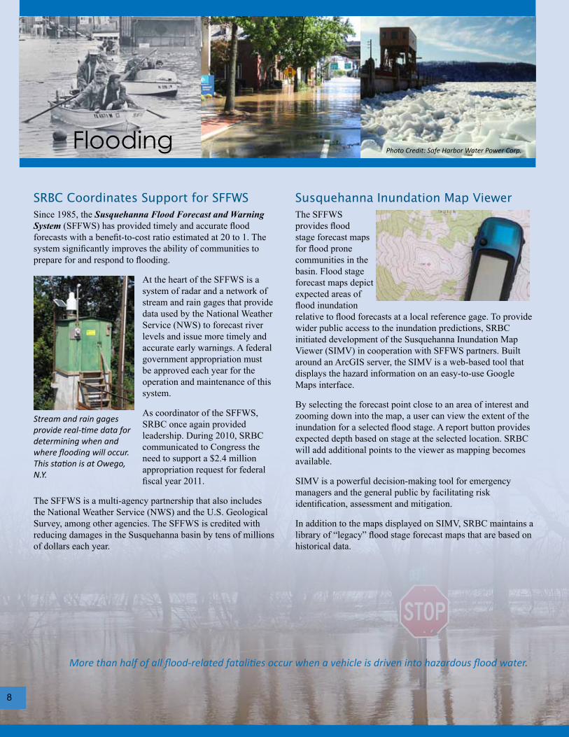
Susquehanna Inundation Map Viewer The SFFWS provides flood stage forecast maps for flood prone communities in the basin. Flood stage forecast maps depict expected areas of flood inundation relative to flood forecasts at a local reference gage. To provide wider public access to the inundation predictions, SRBC initiated development of the Susquehanna Inundation Map Viewer (SIMV) in cooperation with SFFWS partners. Built around an ArcGIS server, the SIMV is a web-based tool that displays the hazard information on an easy-to-use Google Maps interface.
By selecting the forecast point close to an area of interest and zooming down into the map, a user can view the extent of the inundation for a selected flood stage. A report button provides expected depth based on stage at the selected location. SRBC will add additional points to the viewer as mapping becomes available.
SIMV is a powerful decision-making tool for emergency managers and the general public by facilitating risk identification, assessment and mitigation.
In addition to the maps displayed on SIMV, SRBC maintains a library of “legacy” flood stage forecast maps that are based on historical data.
More than half of all flood-related fatalities occur when a vehicle is driven into hazardous flood water.
Photo Credit: Safe Harbor Water Power Corp.

A “Turn Around, Don’t Drown” sign warns drivers of potential flooding danger in Tunkhannock Borough, Wyoming County, Pa.
Flooding
Major flooding involving the main stem of the Susquehanna has occurred fourteen times since 1810 – about every 15 years, on average. The Susquehanna basin also is vulnerable to frequent, localized flash floods every year. These flash floods, usually affecting smaller tributaries, can occur with little advance warning.
9
“Turn Around, Don’t Drown” Pilot ProjectSRBC partnered with the National Weather Service on a “Turn Around, Don’t Drown” (TADD) signage program in an effort to deter citizens from attempting to drive through flooded portions of roads, which can often result in injuries or deaths.
The pilot project provided 54 TADD signs to three southern New York counties (Broome, Steuben and Tioga) and two northern tier Pennsylvania counties (Susquehanna and Wyoming).
FLOODING GOAL:
To prevent loss of life and significantly reduce future damages from floods within the basin through an integrated system of structural and nonstructural flood damage reduction measures.
1810 1955 Hurricanes Connie & Diane1865 19641889 1972 Tropical Storm Agnes1894 1975 Tropical Storm Eloise1935 1996 January Basinwide Flash
Flood1936 St. Patrick’s Day 2004 Tropical Storm Ivan (Sept.)1946 2006
Major Floods Since 1810
Photo Credit: Donna Lupardo
Photo Credit: Steve Bailey
Photo Credit: Wyoming County Emergency Management Agency
TADD is a NOAA National Weather Service campaign to warn people of the hazards of walking or driving a vehicle through flood waters. The sign project was part of National Flood Safety Awareness Week on March 15-19, 2010.
Eastern Region Flash Flood ConferenceSRBC provided significant assistance to the National Weather Service for its June 2010 Eastern Region Flash Flood Conference in Wilkes-Barre, Pa. Nearly one hundred seventy flood professionals and local government officials attended sessions that reflected three themes: (1) Focus on Flash Flood Operations, (2) Science of Flash Flood Detection and Forecasting, and (3) Delivery of Technology and Flood Services to Users.
As a result of the Eastern Region Flash Flood Conference, held June 2-4, 2010, several short-term needs and resulting actions were identified by attendees. These generally fell into one of four categories: Science, Training, Operations and Service.Photo Credit: NOAA National Weather Service

10
Ecosystems
ECOSYSTEM GOAL:
To achieve healthy ecosystems that provide groundwater and surface water of sufficient quality and in adequate supply to support abundant and diverse populations of aquatic, riparian, and terrestrial organisms, as well as human use.
Ecosystems
Study Examines Ecosystem Flow Needs
The Commission is moving toward a more environmentally protective management
system based on ecological flows.
SRBC and the U.S. Army Corps of Engineers (USACE) continued to work with The Nature Conservancy (TNC) in a study aimed at assessing ecosystem flow needs in the Susquehanna River Basin.
The goal of the project is to provide information on recommended flows for ecosystem health that will be used by SRBC in regulating water use and USACE in operating reservoirs. Management considerations include long-term changes to flow release schemes for basin reservoirs, environmental restoration, flows to better sustain aquatic habitat, and conservation strategies to offset water demands.
Many aquatic plants and animals are sensitive to increased rates of change between high and low flow events. Rapid changes can strand fish, destabilize banks, scour streambeds, and have other ecological impacts. For
example, extreme low flows increase the risk of exposure and predation of mussel beds.
TNC provided technical expertise in defining specific ecological functions and indicators associated with the Susquehanna River ecosystems’ different flow types – including high flows, seasonal flows and low flows.
Flow recommendations developed by TNC are based on published literature, existing studies, hydrologic analyses and expert consultation. These recommendations are under review by an interdisciplinary team and will be refined for further use in agency programs and additional low flow studies.
For more information on river flows and stream ecology, check out the State of the Susquehanna feature article Ecological Flows at www.srbc.net/stateofsusq/features.htm/.
Summer 2010 saw low flows throughout the Susquehanna River Basin, but particularly in northern Pennsylvania, where many of the withdrawals associated with the natural gas industry are located. To be responsive to public concerns regarding use of water by the natural gas industry during low flow conditions, especially in small, headwater and/or special protection streams, SRBC expanded its assessment of aquatic communities at proposed water withdrawal locations. The new protocol will be evaluated over a two-year period of data collection.
Passby flows — a prescribed quantity of stream flow that must be allowed to pass a specific point downstream from a water supply intake — are currently part of most withdrawal approvals. The expanded assessment of what is known as Aquatic Resource Surveys (ARS) will provide more details on sensitive aquatic taxa or habitat, allowing staff to recommend appropriate protective measures to circumvent potential impacts. Staff have conducted ARS at 85 sites and are planning to revisit ARS work at 30 sites over the next two years.
Data will be collected for those parameters most likely to be impacted by water withdrawals, including the following: (1) field chemistry, such as dissolved oxygen, pH, specific conductance and temperature; (2) habitat assessments; (3) fish community assessments; (4) macroinvertebrate
sample collections; (5) laboratory water chemistry analyses for parameters associated with natural gas development; (6) discharge measurements; (7) invasive species searches; and (8) periphyton sample collections.
Aquatic Resource Surveys to Explore Impacts of Water Withdrawals
SRBC staff collect aquatic sample using kick net.

11
Chesapeake Bay
CHESAPEAKE BAY GOAL:
To manage the water resources of the Susquehanna River Basin to assist in restoring and maintaining the Chesapeake Bay so it meets or exceeds applicable water quality standards and supports healthy populations ofliving resources, including oysters, crabs, fish, waterfowl, shore birds, and underwater grasses.
Chesapeake B
ay
Water quality monitoring in the Susquehanna watershed is vitally important because it allows SRBC and other water resource managers in New York, Pennsylvania, Maryland and the Chesapeake Bay Program to determine trends, helps them target restoration work to where it is most needed, and helps document real progress in the Bay restoration effort.
Since 1985, SRBC has monitored changes in the amounts of nutrients (phosphorus and nitrogen) and sediment within the Susquehanna River Basin. In addition to the six major river sites first established, SRBC added 17 sites within the basin in 2004 and 2005. These sites monitor the concentrations of
nitrogen, phosphorus, total organic carbon, suspended sediment and several other nutrient-related parameters.
The data collected have several uses, including with computer models to predict the effects of management actions that are occurring in the watershed and to quantify the actual amounts of nutrients and suspended sediment that are being carried in the river at the various sites.
SRBC analyzes monitoring data for trends in total nitrogen (TN), total phosphorus (TP) and suspended sediment (SS) over the period from 1985 to the current year. These trends analyses utilize various methods to attempt to remove the effects of flow in order to identify actual changes in nutrient and sediment loads that are likely a result of reduction efforts. The most recent analysis shows that trends that were adjusted for flow are downward (improving) for all three parameters at all six long-term sites except for TP at Towanda.
Lancaster County grows approximately 100,000 acres of corn, the highest amount of any county in Pennsylvania. The nitrogen load at Marietta for 2009 would provide enough nitrogen to grow those acres in corn for seven years without any additional nitrogen fertilizer. The 2009 suspended sediment load at Marietta would be enough sedimentto fill 220 Olympic-size swimming pools.
Site Total Nitrogen
Total Phosphorus
Suspended Sediment
Towanda 8,375 915 343,838Danville 14,067 1,282 496,920Lewisburg 7,723 438 159,765Newport 6,084 256 107,008Marietta 46,817 2,085 1,211,126Conestoga 3,846 148 43,984
2009 TN, TP and SS Loads in Tons
Long-Term Monitoring of River Basin Critical to Understanding Bay Pollution

12
Water Resources ProgramCoordination is extremely important to SRBC, which strives to ensure that agencies are not duplicating efforts. This spirit of coordination and cooperation was evident in the Commission’s adoption of its Water Resources Program for 2010/2011.
Section 14.2 of the Susquehanna River Basin Compact requires the Commission to annually adopt a water resources program that describes the projects and facilities SRBC and its partners will undertake over a 2-3 year period to implement the long-term Comprehensive Plan. SRBC received input from 11 federal agencies, 8 state agencies, 12 regional, county and local agencies and 17 non-governmental organizations and businesses. The Water Resources Program reflects the extensive network of water resource agencies and the degree to which they strive to coordinate the multitude of new and ongoing projects that protect the Susquehanna River Basin’s natural resources.
Coordination, Cooperation & Public Information
Federal Coordination SummitSRBC worked with the U.S. Army Corps of Engineers to conduct the September 2010 Federal Coordination Summit, which focused on Energy and Water. The goals of this summit, which involved ten federal agencies and SRBC, were: (a) To provide for ongoing coordination among federal agencies and SRBC; (b) To identify
regulatory functions and responsibilities of the federal agencies and the Susquehanna River Basin energy-related projects; and (c) To identify relevant actions in the Comprehensive Plan to be implemented through the Water Resources Program, determine which federal agencies can provide assistance in implementing the actions, and recommend action items to be considered for and included in the Water Resources Program.
Outreach on Remote Water Quality Monitoring NetworkOn July 20, 2010, SRBC and the New York State Energy Research and Development Authority hosted a free, public workshop in Owego, N.Y., to explain and get input on SRBC’s expansion of the Remote Water Quality Monitoring Network in Southern Tier New York. Also, SRBC conducted a successful press event in December to showcase an actual installation of a remote water quality monitoring station.
SRBC Restoration and Protection Manager, Andrew Gavin, explains the RWQMN at a press event along Apalachin Creek, Tioga County, N.Y.
First State of the Susquehanna Report LaunchedSRBC and partners released the first-ever State of the Susquehanna report in 2010. The report covers the threats, opportunities, partnerships and successes in seven key areas influencing the Susquehanna River Basin’s water resource needs and conditions today.
The 2010 report is comprised of two main components, a publication that provides a snapshot of seven indicators, and the web site that includes additional data, maps, information and feature stories submitted by a host of renowned scientists and authors who tell their part of the story of the Susquehanna basin.
NOAA’s National Weather Service Eastern Region Director Chris Strager highlights his agency’s coordination efforts.

13
COORDINATION, COOPERATION AND PUBLIC INVOLVEMENT GOAL:
To maximize available human resources and achieve common and complementary management objectives by the Commission, its member jurisdictions and others; to promote the planning and management of the basin’s water resources in the most efficient manner possible; to inform the public on the Commission’s water management responsibilities; and to enhance the public’s access to Commission information and decision making procedures.
Enhanced Web Site Improves Access to InformationSRBC continued to invest in web site technologies that increase access to project information and SRBC activities.
Water Resources Portal (www.srbc.net/wrp/default.aspx): In April 2010, SRBC launched its Water Resources Portal that gives the public access to SRBC-approved projects and pending applications. Through this portal, you will: (1) find the status of pending and approved projects; (2) be able to view and download certain pending applications; (3) be able to view and download all SRBC approvals; and (4) find the list of approved water sources for the natural gas industry, by project sponsor.
The user-friendly web site allows viewers to locate information using an interactive map or through search functions, including names of project sponsors. Users can also sign up via RSS Feed to receive electronic notices of pending projects.
On-line Applications (www.srbc.net/forms/index.htm): SRBC made available an improved on-line consumptive water use application and plans to unveil online applications for surface water and groundwater withdrawals in 2011.
Remote Water Quality Monitoring Network (mdw.srbc.net/remotewaterquality/): Data from the remote monitoring stations are available to the public via the web site. This web site interface also provides user-friendly access to other critical information and tools, including tables, graphs, maps and statistics.
Susquehanna Flood Forecast and Warning System (www.susquehannafloodforecasting.org/): SRBC unveiled this significantly updated and enhanced web site to serve as a one-stop for the public to access information about the system and river forecasts and also mapping resources.
Public Information
WQAC Tackles Aquatic Invasives IssueThe purpose of the SRBC Water Quality Advisory Committee (WQAC) is to coordinate and share information on water quality activities to help promote partnerships, avoid duplication of effort and promote consistency of water quality-related activities in the Susquehanna River Basin. The WQAC meets during the spring and fall of each year. The fall meeting covers a wide range of new initiatives and discussion topics, while the spring meeting has a sharper focus on a specific issue in the basin.
At the 2010 spring meeting, the WQAC conducted an extensive session on the issue of aquatic invasive species. Current threats to the Susquehanna River Basin include the zebra and quagga mussel, flathead catfish and rusty crayfish.
One of the WQAC meeting outcomes was the distribution of a worksheet to help facilitate the development of aquatic invasive species management plans. Attendees brainstormed ideas on critical control points and control measures.
SRBC considers the potential spread of invasive species when evaluating project review applications for diversions and transfers of untreated water from one waterbody to another. SRBC also participates in the Mid-Atlantic Panel on Aquatic Invasive Species, monitors for zebra mussels and provides educational materials to help prevent the inadvertent spread of invasive species.
Recreational angler pulled this 37.5 inch flathead catfish near the mouth of the Octoraro Creek. Anglers are directed to not transport flathead catfish to any other body of water or to return the fish to the water. Source: www.dnr.state.md.us.
Invasive species are the greatest threat to freshwater biodiversity worldwide.
Photo credit: Virginia Tech Virtual Aquarium

14
Fiscal Year 2010 Summary *
Revenues Expenditures
Total Revenue $12,376,368 Total Expenditures $10,026,495
SRBC awarded its 7th Frederick L. Zimmermann Award to Congressman Tim Holden (PA District 17). SRBC presents the Zimmermann award periodically to honor elected officials who demonstrate excellence in water resources management by promoting and advancing watershed management and interstate cooperation.
Congressman Holden’s achievements included the restoration of federal funding in FY-09 for SRBC and the Delaware and Potomac river basin commissions, and the passage of the 2007 Farm Bill that contained stronger conservation provisions in support of agriculture, the Susquehanna basin and the Chesapeake Bay.
Frederick L. Zimmermann (1906-1993) was a native of Brooklyn, N.Y., who initiated the formation of the Susquehanna River Basin Compact and co-authored The Law and Use of Interstate Compacts.
Frederick L. Zimmerman Award
Annual Excellence Award
Andrew Gavin, Manager Restoration and Protection
2010 SRBC Staff Awards
Awards
Congressman Holden (right) receives award from SRBC Executive Director Paul Swartz.
Aristotle
Signatory Members,
$1,439,200
Grants & Projects,
$4,693,164
Fees & Others,
$6,244,004
Salaries & Benefits,
$4,536,464
Capital Outlay, $703,222
Operating, $4,786,809
I n the arena of human life the honors and rewards fall to those who show their good
qualities in action.
Aw
ards
* associated with General Fund only
Quarterly Spotlight Award1st QuarterDawn Hintz
Environmental Scientist
2nd QuarterRobert Pody
Senior Commission Scientist
3rd QuarterJohn Balay, Manager
Planning and Operations
4th QuarterBret Wagner
Database Analyst

15
SRBC Staff
Commission Staff
For a staff listing, refer to the online staff directory at www.srbc.net.
A Year of Program Growth
Staff
EXECUTIVE STAFFPaul O. SwartzExecutive Director
Thomas W. BeauduyDeputy Executive Director & Counsel
Marcia E. RynearsonDirector, Administration and Finance
James Richenderder, Ph.D, P.G. Director, Technical Programs
Stephanie L. RichardsonSecretary to the Commission
Susan S. ObleskiDirector, Communications
MANAGERSJohn W. Balay, P.H.Planning and Operations
Paula B. Ballaron, P.G.Policy Implementation and Outreach
Andrew D. Dehoff, P.E.Project Review
Andrew J. GavinRestoration and Protection
David W. HeicherGrants and Research
Jennifer L.R. HoffmanMonitoring and Assessment
Gordon D. LaugerAccounting
Brydon H. Lidle IIIInformation Technology
Amy E. MyersHuman Resources
Eric R. RoofCompliance and Enforcement
Duane A. Friends (center) retired as SRBC’s Chief Administrative Officer after serving the Commission for 25 years. Commission members presented Mr. Friends with a resolution
recognizing and honoring his quarter century of dedicated service and extending wishes for a fulfilling retirement. Mr. Friends played a pivotal role in improving the management and administration of the Commission in a host of important areas, including budgeting, acquisition, information technology, human resources, internal operations and property supervision.
Executive Director Paul Swartz appointed Marcia E. Rynearson, MBA, as the new Chief Administrative Officer. Rynearson has
26 years of professional experience, recently serving as Chief Executive Officer and partner of ActionCOACH of Central Pennsylvania, a small business coaching firm. She also worked in the health care industry for nearly 20 years, where she held several executive level positions.
Friends Retires as CAO
Staff numbers increased in 2010 due to growing technical, administrative and information technology demands, some of which are due to the program demands associated with natural gas drilling. The opening of a field office in Sayre, Pa., was critical to maintaining the field presence necessary for natural gas drilling inspections and communication with the public and natural gas company representatives.

Susquehanna River Basin Commission1721 North Front StreetHarrisburg, PA 17102Phone: 717-238-0423
Fax: 717-238-2436Web: www.srbc.netEmail: [email protected]
Printed on recycled paper.
protecting your watershed for today and tomorrow
A Yellow Leg flies over the mud flats of the Susquehanna River Photo Credit: Dennis Small