Embed Size (px)
Citation preview

European Spatial Data Research
Annual Report 2018
www.eurosdr.net

|1|
About EuroSDR EuroSDR - formerly known as OEEPE - is a not-for-profit organisation linking National Mapping and Cadastral Agencies with Research Institutes and Universities in Europe for the purpose of applied research in spatial data provision, management and delivery. The result is a network of delegates, effectively and practically addressing Europe’s spatial data research requirements. EuroSDR also organizes, in collaboration with related organisations, international workshops and courses which address key issues in a timely and focused manner.
Vision EuroSDR is the recognised provider of research-based knowledge to a Europe where citizens can readily benefit from geographic information. Our mission is to develop and improve methods, systems and standards for the acquisition, processing, production, maintenance, management, visualization, and dissemination of geographic reference data in support of applications and service delivery.
Our Member States and their Prime Delegates (2018)
Austria
Michael Franzen
Bundesamt für Eich- und Vermessungswesen
Belgium Eric Bayers Institut Géographique National Belgique
Croatia Ivan Landek Državna Geodetska Uprava
Cyprus Andreas Sokratous Tmima Ktimatologiou Kai Chorometrias
Denmark Thorben Hansen Styrelsen for Dataforsyning og Effektivisering
Finland Juha Hyyppå Maanmittauslaitos
France Bénédicte Bucher Institut National de l’Information Géographique et Forestière
Germany Hansjörg Kutterer Bundesamt für Kartographie und Geodäsie
Ireland Paul Kane Ordnance Survey Ireland
Norway Jon Arne Trollvik Statens Kartverket
Poland Piotr Woźniak Główny Geodeta Kraju
Slovenia Dalibor Radovan Geodetski Inštitut Slovenije
Spain Julián D. Hernández Instituto Geográfico Nacional
Sweden Tobias Lindholm Lantmäteriet
Switzerland André Streilein Bundesamt für Landestopographie
The Netherlands Jantien Stoter Technische Universiteit Delft and Kadaster
United Kingdom Sally Cooper Ordnance Survey Great Britain
Our Associate Members and their Representatives (2018)
Esri
Nick Land
Informatie Vlaanderen Jo Van Valckenborgh

|2|
Contents About EuroSDR ........................................................................................................................................ 1 Vision ...................................................................................................................................................... 1 Our Member States and their Prime Delegates (2018) .......................................................................... 1 Our Associate Members and their Representatives (2018) .................................................................... 1 Message from the President ................................................................................................................... 3 Message from the Vice-President ........................................................................................................... 5 Interesting examples of real life practices at NMCAs based on results of existing applied research .... 7
1. Generation of 3D Scenes of National Parks of Spain with PNOA Images .................................. 7 2. Raster Lidar Map: A New Raster Product from Classified 3D Point Clouds ............................... 8 3. Positional Accuracy Improvement of Digital Cadastre Index Maps in Slovenia ...................... 10 4. Building Reference Databases ................................................................................................. 12 5. Automatic Generalization from the National Map Database .................................................. 13 6. Stéréopolis: A Versatile Mobile Mapping Platform for Continuous Innovation ...................... 16
Report by the Secretary-General .......................................................................................................... 17 Commission I: Data Acquisition ............................................................................................................ 22 Commission II: Modelling and Processing ............................................................................................ 25 Commission III: Updating and Integration ............................................................................................ 28 Commission IV: Information Usage ...................................................................................................... 32 Commission V: Business Models and Operation .................................................................................. 38 Commission VI: Knowledge Transfer .................................................................................................... 44 Workshops ............................................................................................................................................ 46 Publications ........................................................................................................................................... 46

|3|
Message from the President Paul Kane It is my pleasure to introduce the 2018 EuroSDR Annual Report, the first for myself as acting President. Prior to any consideration of the year ahead, we should briefly reflect upon achievements for 2018. As with every summation of activities it provides opportunity to acknowledge the vast amount of project work, workshops, publications and tasks undertaken and completed by the organisation as a whole through the commitment and work of the Commission chairs, Secretariat, Delegates and the Executive. Every year brings new ideas, opportunities and indeed faces, and in 2018 we welcomed New Delegates, Changes to the Executive Board, and sadly we had several retirements. We must acknowledge the dedication and contribution of:
Antonio Arozarena, Prime Delegate of Spain Thorben Brigsted Hansen, Past President and Prime Delegate of Denmark Hansjörg Kutterer, Prime Delegate of Germany
Collectively they contributed to almost 30 years of representing their respective agencies at EuroSDR. We express our sincere thanks and wish them well in their future endeavours. It is also my pleasure to welcome the new delegates who will take over for:
Spain: Julián Delgado Hernández Denmark: Jesper Weng Haar, we anticipate will join us at the next Board of Delegate’s meeting in Vienna, we look forward to that, and finally we await the announcement of the successor to Hansjörg as Prime Delegate for Germany.
I would also like to take the opportunity to welcome Andreas Hadjiraftis as Third Delegate of Cyprus. I must of course give a special mention to Jantien Stoter who completed her term as Commission 2 Chair, and express our thanks to Norbert Haala who has agreed and accepted to take over the appointment. Jantien was one of the first people whom I had the pleasure to meet with as part of the EuroSDR 3D special interest group a few years ago, before becoming Prime Delegate for Ireland, and I can say she truly is an ambassador for the warm welcome and general positive engagement that the wider EuroSDR group extends. Of course I must also express my thanks to my mentor, the previous President Eric Bayers who stepped down at the 132 BOD meeting. Thank you for representing the organisation so professionally and diligently throughout your term. A word of thanks also to the organisers of the two delegate meetings held in 2018 at Ljubljana and Berlin. A brief mention of the successful workshops held in 2018, which ranged from Spatial Data Quality, Point Cloud Processing, National Elevation Models, Linked Data, Use of Sentinel data in Europe, and Inspire Data past and future experiences, all of which will be elaborated upon by the Commission Chairs in their respective reports.

|4|
It is with anticipation that I look forward to the coming year, the rapidly changing and emerging technologies that are now driving the geospatial industry towards not simply the capture and representation of geometry but increasingly to providing location based digital geography. These new alternative technologies will continue to demand our attention and will provide opportunities to safeguard the future for National Mapping Agencies and ensure that EuroSDR will be tasked with researching a wider and ever increasing list of problems that require solutions. And I’m sure that through the work of the Executive and Commission chairs, Fabio, Jon, Norbert, Bénédicte, Jon Arne, Markéta, Joep and Tatjana, we will progress on interesting and important topics, such as SDI’s, Single Photon Lidar, Linked Data, Geo-Bim, Standards, 3D Smart City initiatives, Time Machine, Machine Learning, and of course continuous professional development through knowledge exchange and learning. Already in 2019 we have had a very successful workshop on Single Photon and Geiger-Mode Lidar, through Commission 1, with thanks to Jon and all of those involved in the preparation and organisation of the event. When I took over the role of President I did express the desire to represent the organisation as fully and committed as I can and to try to ensure that EuroSDR is fulfilling its role and achieving on the goals that the National Mapping Agencies, Delegates and the Organisation requires. I do hope we will continue and be successful in that endeavour. In 2019 we also look forward to the expansion of the EuroSDR community through new memberships and Associate members. I look forward to the year ahead and meeting you all in Vienna and Cyprus. Paul.

|5|
Message from the Vice-President Fabio Remondino 2018 was another intense and prosperous year for EuroSDR. The organisation confirmed its leaderships and presence through many practical achievements in an increasing heterogeneous and complex research environment. The developments initiated and performed by EuroSDR are achieved by common tests, workshops, benchmarks, cooperation with partner organisations and the exchange of experiences. The main research activities of EuroSDR in this year dealt with: • rapid technical development (acquisition sensors, data processing, etc.), • growing demand for up-to-date spatio-temporal, 3D, multi-scale data and services, • data integration and quality issues, • historical data and processes. Many projects have been finalized and new projects have been launched, often based on the open tackled questions from workshops or Board of Delegates Meetings. In Commission 1 the activities were focused on the new laser technology SPL (Single Photon LiDAR) or Geiger-mode LIDAR. A questionnaire was prepared and more than 100 organization replied, some initial data processing was performed and a workshop is planned for March 2019 in Barcelona. Within Commission 2, after a long, fruitful and successful period, Jantien Stoter stepped down and Norbert Haala was elected as the new chair. The focus of the Commission will now be more on the geometric processing of the geospatial data, although the on-going activities related to building modelling will continue. In particular, the GeoBIM activities are still proceeding, with various activities and meetings planned till 2020. Commission 3 activities dealt on the Sentinel data and missions (including the organization of a workshop), better use of national DEM (including the organization of a workshop) and on the finalization of a report on “Archival aerial images: current status in Europe”. A workshop of this latter topic will follow in 2019. Commission 4 continued its activities on the exploitation of historical data, mapping places for digital natives and the link to the FET Flagship project “TimeMachine”, with the organization of various international workshops. Commission 5 focused on various topics: crowdsourcing in national mapping with an envision workshop titled VGI Map of Europe, sustainable open-data business model for NMCAs, open SDI (including a course within EduServ 16 and 17), use and needs of SDI, and authoritative data. In terms of Commission 6 and knowledge transfer, knowledge is disseminated via the Educational Service EduServ. The 16th series of the EuroSDR Educational Service (EduServ16) was offered in spring 2018, with the pre-courses organized at the Technical University of Braunschweig, Germany, thanks to the support of Prof. Markus Gerke. The four two-week e-learning courses were followed by more than 40 people. The courses had the following topics: Oblique Aerial Camera Systems for Mapping Purposes (F. Remondino, I. Toschi, M. Gerke, F. Nex), Terrestrial Point Cloud for Forest Modelling (X. Liang, J. Hyyppä, Y. Wang), Topographic Maps through Description and Classification of Remotely Sensed Imagery and Cartographic Enhancement (J. Höhle, S. Lefèvre, B. Bhushan Damodaran) and Open Spatial Data Infrastructures (J. Crompvoets, B. van Loenen). Finally, the evaluation commission for the 2018 EuroSDR Award for the best PhD thesis related to Geoinformation Science awarded the
|6|
work of Mengmeng Li from the University of Twente (The Netherlands) titled “Urban land use extraction from very high resolution remote sensing images”. Many of the activities, exchange of ideas and opinions, generation of new ideas and projects are performed in workshops. It is typical for EuroSDR workshops that these take place as joint events together with other relevant scientific organizations. To mention just a few: Use of algorithms on big DEM’s (Tønsberg, Norway, April 2018), Special session at ISPRS Technical Commission II Symposium (Riva del Garda, Italy, June 2018), Data linking by indirect referencing (Paris, France, September 2018), Preparation for Sentinel-2 in Europe (Oslo, Norway, October 2018), two sessions with NMCAs related papers at the 3D Geoinfo conference (Delft, Netherlands, October 2018), Use of INSPIRE data (Warsaw, Poland, November 2018), etc. In terms of publications, there have been many scientific and state-of-the-art papers produced during the year. Amongst these, an official publication of EuroSDR “Preserving the Geographical Production Process” (publication no. 69) and two workshops reports: “Crowdsourcing in National Mapping” and “Mapping places for digital native and other generations”. In conclusion, 2018 was a very productive and successful year for EuroSDR with many more new research activities, events and educational courses planned for 2019!

|7|
Interesting examples of real life practices at NMCAs based on results of existing applied research 1. GENERATION OF 3D SCENES OF NATIONAL PARKS OF SPAIN WITH PNOA IMAGES
IGN SPAIN
In 2004, the National Geographic Institute of Spain (IGN) decided to launch the Spanish National Plan for Aerial Orthophoto (PNOA). Since then the aim of PNOA is to cover the whole national territory each 3 years with aerial digital photographs with 22 or 45 cm of mean pixel size, depending of the area. On the other hand Spain has 15 National Parks and the IGN provides information about them through its website (http://parquesnacionales.ign.es/). In order to improve the information and the service of the Spanish National Parks provided by IGN, a pilot project was carried out in two of them to obtain realistic 3D scenes using the images collected by PNOA, namely Los Picos de Europa National Park (647 km2) and Ordesa y Monte Perdido National Park (156 km2). The 3D scenes performed have been made available to users through 3D web viewers with different query options. The stereoscopic pairs of the PNOA project, with forward overlap of 60% and side overlap of 30%, were used to generate the general background of the scenes. The 3D scenes were produced using super-dense correlation algorithms. Images of areas of special interest were captured by drones for photogrammetric works to obtain a higher resolution (2 - 3 cm) e.g.: churches, shelters, etc. and the 3D scenes derived from them were integrated in the general 3D scenario. The integration of images collected by different technologies and with different resolutions has resulted in realistic high-resolution 3D scenes of the areas of interest. The main challenge to accomplish this demanding pilot project was the huge amount of data to be managed so different software were tested to choose the most suitable one and also very powerful hardware was used, especially in terms of processors, RAM, GPU and data storage. The 3D viewer of each National Parks is:
Picos de Europa National Park.
Ordesa y Monte Perdido National Park.
Figure 1. Basilica of Covadonga
In addition to these 3D viewers, a series of 360º and Virtual Reality videos of the generated 3D scenes have been made, which allow the immersion in the scenes in a very realistic way.

|8|
2. RASTER LIDAR MAP: A NEW RASTER PRODUCT FROM CLASSIFIED 3D POINT CLOUDS IGN SPAIN
The Spanish National Geographic Institute (Instituto Geográfico Nacional, IGN) directs and coordinates PNOA-LiDAR Project. The aim of this project is to measure the whole Spanish territory by an aerial laser scanner (ALS) every 6 years. This project started in 2008 and in 2015 the first national coverage was completed. Currently, the second coverage is being measured. The density of the registered 3D point clouds is around 1 point/m2, with a precision of 20cm in z component. Over the last few months, a methodology to produce a new raster product created from LiDAR data that can be used as a base map and as a source to consult the heights of buildings and vegetation has been developed. Dataset used as input are those point clouds that correspond to the first national coverage of the PNOA-LiDAR Project. LiDAR files in LAS format are automatically classified and coloured in RGB by means of an orthophoto simultaneously registered with the LiDAR point cloud. Each point of the cloud is labelled as building, vegetation or bare soil in accordance with the land cover that it represents. Once the point cloud is properly classified, the following raster sub products are produced:
a) Hillshaded Digital Surface Model (DSM), produced from LiDAR data.
b) Vegetation and building normalized Digital Surface Model (nDSM). The altimetric information of buildings and vegetation categories is rasterized with a spatial resolution of 2.5m.
c) Water bodies layer, obtained by means of the rasterization of the Geospatial Reference Information of Hydrography with a spatial resolution of 2.5m.
Raster LiDAR Map results from the combination of these three layers. A visualization style is created and vegetation, building and water surfaces layers are respectively represented with a green, red and blue colour palette (Figure 1). Since the distribution and visualization of 3D point clouds is complex, this Raster LiDAR Map eases it. The generation of this product has already begun in the Spanish IGN and by the middle of 2019 this data will be accessible to any user through a web map service (WMS). This product can be also complemented by means of other WMS as directions or transport network (Figure 2).
Figure 1. Aerial orthophoto of the Spanish city of Madrid (PNOA Project) (a) and raster lidar map of the same scene (b) (a) (b)

|9|
Figure 2. Raster LiDAR map, superimposed with a directions and transport network WMS
|10|
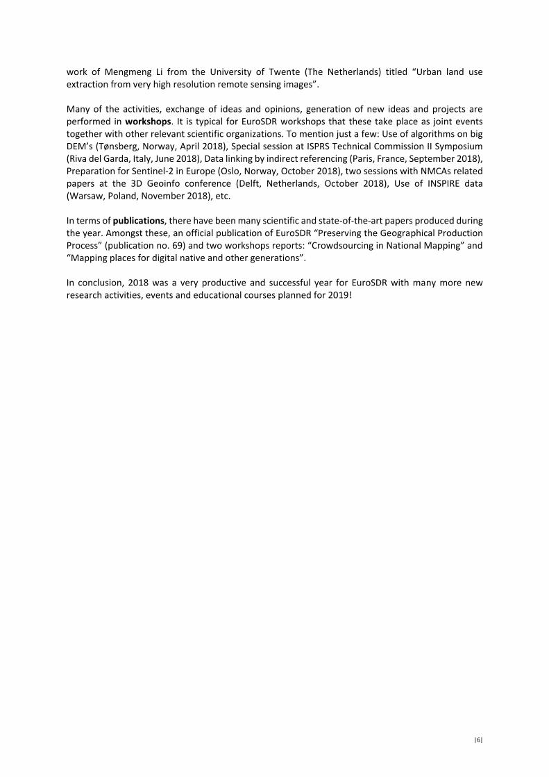
3. POSITIONAL ACCURACY IMPROVEMENT OF DIGITAL CADASTRE INDEX MAPS IN SLOVENIA UNIVERSITY OF LJUBLJANA, FACULTY OF CIVIL AND GEODETIC ENGINEERING, GEODETIC INSTITUTE OF SLOVENIA - MARJAN ČEH
In Slovenia, as well as in the comparable traditional cadastral societies, a digital land cadastre index map is a composition of digitized analogue land cadastre maps of various origins and measurement data sets with different positional accuracy, depending on the scale of the map and on the methodology (quality) of data acquisition. The growing role of spatial data quality for Spatial Data Infrastructure (SDI) including spatial decisions, as well as the needs of advanced Land Administration Systems (LAS), calls for improvement of the geometrical quality of land cadastre index maps, which is being associated also with the problem of heterogeneity of graphical land cadastre data. NMCA of Slovenia has initiated applied research with public partner organizations University of Ljubljana, Faculty of Civil and Geodetic Engineering (UL, FGG) and Geodetic Institute of Slovenia (GIS) These organisations introduced and analysed various methods for the Positional Accuracy Improvement (PAI) of the land cadastre index map. They applied the membrane method as one of the approaches to geometrical quality, based on additional surveying measurements, where the basic principles of geodetic profession are to be strongly respected (redundant observations, methods of the coordinate geometry, topology, adjustments, error propagation law, etc.). The membrane method has been applied to analyse how heterogeneous parts of the cadastral index map fitted to the “real” positions by the use of positions of identical points, relative measurements and geometrical constraints. Research results confirmed the possibility of incremental improvements of homogeneity of the cadastral index maps in Slovenia with additional subset of measurements, introduced into the adjustment process, as most efficient solution to the given problem.
Figure 1. TIN membrane, based on cadastral boundary points and shifting vectors of positional improvement by membrane adjustment and homogenisation (source: UL, FGG)

|11|
Figure 2. Analytical hillshading resolution comparisons for the tie points identification in the less valuable rural areas and cadastral index map (source: GIS)

|12|
4. BUILDING REFERENCE DATABASES HEAD OFFICE OF GEODESY AND CARTOGRAPHY (GUGIK)
With the aim of increasing user’s access to spatial databases, during 2018 GUGiK conducted a number of activities aimed at building reference databases for the entire country. GUGiK carried out activities as a result of which:
1. 3D Models of buildings in LoD2 for the 61% of the country area (189 000 km² and over 8 732 000 building models) were developed. This task assumed the development of 3D models of buildings based on a central topographic database and ALS data.
2. High-resolution DTM (mesh 1m) and DSM (mesh 1m outside cities, 0.5m mesh in cities) in ALS technology for the 33 618 km² was developed or updated. Thanks to this we have obtained coverage with ALS data for the entire country.
3. Process for automatic generalization and cartographic editing of topographic objects (BDOT10k) database to DCM model at the scale of 1:25 000 was developed. 15 sheets of maps at this scale were generated.
4. The ASG-EUPOS hardware and software was upgraded to be ready to provide multi GNSS (GPS/Glonass/Galileo/Beidou) RTK/RTN services. Also the reference station network densification project was prepared to guarantee high accurate positioning services.
5. In the national geodetic network registry, the Head Office of Geodesy and Cartography started the preparation for a new levelling campaign in Poland, which should be launched around 2020. Actually a field inspection of geodetic fundamental and base control network points is realised. Simultaneously, the PL-EVRF2007-NH is being implemented by local authorities. According to polish law, EVRF2007 solution should be implemented locally by the end of 2019 at the latest.

|13|
5. AUTOMATIC GENERALIZATION FROM THE NATIONAL MAP DATABASE NORWEGIAN MAPPING AUTHORITY - IDA HOPE BARTH
The first acceptable map made by automatic generalization was produced just a few years ago. Since then, several National Mapping Authorities (NMAs) around Europe have been working with automatic generalization, with promising results. As a National Mapping Authority we always work towards higher efficiency and improvement of our established production lines. Since Norway lacks the 1:100 000 scale and perceives the potential for more efficient map production, we started the project “AG N100” at the beginning of 2018. The map data source used in the project has the scale 1: 50 000 (N50 map data), and is the largest scale covering all of Norway with equal quality. However, a feasibility study completed in 2017 pointed out some problems regarding the source data’s suitability for automatic generalization. Since the problem with collapse of polygon to line still is not solved for complex lakes, the N50 map data had to be upgraded from single rivers into a river network. The idea was to create a network of rivers that would automatically replace the collapsed lakes. A river network was created for the N50 map data with help from The Norwegian Water Resources and Energy Directorate (NVE). NVE created a network of rivers based on the N50 map data already in 2002. However, it took nearly 2 years to update the consisting river network to fit the far more accurate N50 map data of 2018 (Figure 1).
Figure 1. The two maps illustrate the difference between single rivers and a river network. Left map: N50 map data without river-network. Right map: N50 map data with a river network. The generalization process can be divided in two main parts: model generalization and cartographic generalization. The first part, “model generalization”, removes map information that can be deleted for the particular scale. The second part, “cartographic generalization”, displaces map objects relative to each other, when the map symbols are scaled for the maps purpose. Tools are used in a different order using ESRI’s ModelBuilder in ArcGIS Pro along with different parameters. The challenge is to find the right combinations of premade tools with the right parameters for the particular generalization problem. The models are executed manually with different parameters until an acceptable result is

|14|
achieved, a “try and fail” method. An automatic optimization process may increase the quality of the result in the future. The original plan was to only use Modelbuilder, an interface easy to use for a nonprogrammer. However, for some models it was easier to use Python rather than ModelBuilder. The overall model so far is a combination between python codes and ModelBuilder, which works very well together. Efficiency is the main motivation for automatic generalization; however there may be other benefits from establishing an automated map production. A map, regardless of the generalizations rules, depends strongly on the cartographers’ interpretation and experience. With automation, the independent interpretation is absent, which means that every part of the map is treated with the same degree of generalization. A consistent map is preferred. Nevertheless, in some way it is also a disadvantage. Since Norway is an elongated country with a large variety of landscape, the level of details in the map should also depend on how important a specific object is to recognise a particular area. This local adaption is easy to create for a cartographer, impossible for an automatic generalization process. According to the project plan, the first version of the N100 map data will be ready for internal testing in September 2019. It has been more time consuming to change parts of the map data source, than actually create the models. However, the establishment of an updated river network also benefits others, and we still think it is worth the time spent. To make automatic generalization less dependent on the structure of map data source, the tools available have to improve. Nevertheless, we are satisfied with the result so far (Figure 2, 3 and 4).
Figure 2. The two maps are illustrating the differences between contour lines for N50 and N100 map data. The left map is from N50 map data. The right map is from the N100 map data. N100 map data is not entirely finished, so there are features missing in this map.

|15|
Figure 3. The two maps are illustrating the differences between land cover surface for N50 and N100 map data. The left map is from N50 map data. The right map is from the N100 map data. N100 map data is not entirely finished, so there are features missing in this map.
Figure 4. The two maps are illustrating the differences between roads for N50 and N100 map data. The left map is from N50 map data. The right map is from the N100 map data.

|16|
6. STÉRÉOPOLIS: A VERSATILE MOBILE MAPPING PLATFORM FOR CONTINUOUS INNOVATION IGN FRANCE - JULIEN L’HARIDON
Mobile mapping technology involves the digitization at very high spatial resolution of complex environments using a mobile terrestrial platform. The aim is to acquire very precise and very accurate georeferenced data of objects of interest for applications that require this level of geometric precision (3D city modelling, pedestrian and vehicle detection for autonomous navigation, digitizing roadway property, archaeological excavations, etc.). This raises challenges in sensors design and integration, in the fine positioning of the moving device on which sensors are attached, and also in the processing of the volume of raw data acquired in order to prepare them for further processes required to achieve a tractable model. Since 2000, IGN France had been designing in its laboratory MATIS various mobile mapping research prototypes on cars, on an electric wheelchair and in a backpack (Miled et al. 2016). Five years ago, it was decided to transfer the MATIS prototypes to our production teams through a development project and to maintain a development platform to work on centimetric accuracy localization techniques. This platform is now operated, not only by research teams, but also by experimental productions teams.
Figures. Mobile mapping system development platform at IGN and the digitization of sewers.
During our development project, many mobile mapping commercial solutions have been released and IGN had the opportunity to benchmark some of them. While they seem to offer good performance on open-skies terrain, high accuracy on GNSS challenging area (indoor or very dense urban area) is harder to obtain. It was therefore decided to focus on the trajectory processing using, not only IMU, GNSS and DMI fusion but also including photogrammetry as an additional positioning system. Thanks to the combination of these results with the acquisition of raw images with our photogrammetric camera that is adapted to all environments, even with little light [Souchon and Meynard 2017], promising results have been obtained on sewers or metro stations. Miled, M, Soheilian, B., Habets, E., Vallet. B., 2016, Hybrid online mobile laser scanner calibration
through image alignment by mutual information. ISPRS Annals of Photogrammetry, Remote Sensing and Spatial Information Sciences, vol. 3 (1), pp. 25-31, ISPRS Congress, Prague, Czech Republic, 12-19 July 2016
Souchon, J.-P., Meynard, C., 2017, A new ultra-light and high resolution digital camera for photogrammetry, EuroSDR Annual Report 2016

|17|
Report by the Secretary-General Joep Crompvoets 2018, the year that EuroSDR/OEEPE exists for 65 years. This report reviews the annual Board of Delegates meetings happening in the framework of EuroSDR in 2018, the appointments of (new) delegates, the activities related to our partner associations and some logistics. Meetings The 132nd EuroSDR Board of Delegates meetings took place in Ljubljana, Slovenia, from 23rd until 25th May 2018. These meetings were hosted by Dalibor Radovan (Geodetic Institute of Slovenia), Tomaž Petek (The Surveying and Mapping Authority of the Republic of Slovenia) and Mojca Kosmatin Fras (University of Ljubljana). 35 persons from 18 countries attended this event. BOD 132 started with an overview of excellent examples of Geographical Information research, education and professional activities in Slovenia. The highlights of the meetings were 1) the keynote presentation about the future collaboration between EuroGeographics/ICA and EuroSDR by Mick Cory and Menno-Jan Kraak, respectively, 2) the H2020 presentations on Slice3D and Landsense by Anka Lisec and Bénédicte Bucher, and 3) the keynote presentation about Leica by Poul Nørgård. The Secretary-General of EuroGeographics and the President of ICA presented some areas of common interest between EuroGeographics/ICA and EuroSDR. Some examples were: 3D, crowdsourcing and disruptive technologies (EuroGeographics) and multi-scale & generalisation, crowd sourcing, user demand analysis, open data and education (ICA). Both Anka Lisec and Bénédicte presented the main goals of the Horizon 2020 projects called Slice3D (Slovenian Centre of Excellence on 3D geodata) and Landsense. The keynote presentation by Poul Nørgård, Product Officer of Leica Geosystems, focused on the Hexagon content program, fuse sensors, developments in camera technology and LiDAR. The topics of the breakout sessions were “Partner collaboration” and “How can NMCAs be on track about hardware development?”.
Figure 1. Group photo at the 132nd Board of Delegates meeting in Ljubljana, Slovenia

|18|
Figures 2-5. Presentations by Anka Lisec, Bénédicte Bucher, Menno-Jan Kraak and Mick Cory
The 133rd EuroSDR Board of Delegates meetings took place in Berlin, Germany, from 14th until 16th November 2018 and was hosted by Michael Hovenbitzer from the Bundesamt für Kartographie und Geodäsie (BKG). 38 persons from 19 countries attended the meetings which started with an overview of relevant innovations happening in Germany. The highlights of the meeting were 1) the presentation of Mengmeng Li (University of Twente), the winner of the 2018 EuroSDR Award, titled “Urban land use extraction from very high resolution remote sensing images”, 2) the keynote presentation “Large scale DSM, True Ortho and Mesh production – Challenges and solutions” by Konrad Wenzel (nFrames), 3) the keynote presentation “Flagship Time Machine” by Frédéric Kaplan (EPFL), 4) the keynote presentation about GNSS by Terry Moore (University of Nottingham), and 5) the keynote presentation “ISPRS activities - Do the results live up to the promises?” by Christian Heipke (ISPRS).
The dissertation, awarded with the 2018 EuroSDR Award, focused on extracting urban land use in an object-based image analysis setting, by means of analyzing urban land cover obtained from VHR images. The CEO of nFrames, Konrad Wenzel, presented his company which is headquartered in Stuttgart, Germany. nFrames creates new ways for businesses to customize their image surface reconstruction workflows. Frédéric Kaplan gave further information on The Time Machine FET Flagship which aims at building a Large Scale Historical Simulator mapping 2000 years of European History. Terry Moore presented the Global Navigation Satellite Systems and Christian Heipke described the structure and activities of ISPRS, which has been partnering with EuroSDR for many years.

|19|
Figure 6. Group photo at the 133rd Board of Delegates meeting in Berlin, Germany
Figures 7-11. Presentations by Mengmeng Li, Konrad Wenzel, Frédéric Kaplan, Terry Moore and Christian Heipke

|20|
In preparation for these two Board of Delegates meetings, the Executive Team met twice in 2018: at the Institute of Geodesy and Photogrammetry – Technical University of Braunschweig on 26 and 27 February 2018 (Braunschweig, Germany) and at Bologna University – School of Engineering and Architecture on 6 September 2018 (Bologna, Italy). Delegates At the 132nd Board of Delegates meeting, the delegates appointed Julián Delgado Hernández (IGN Spain) as Prime Delegate of Spain and Norbert Haala (Institute of Photogrammetry, University of Stuttgart) as the new Chair of Commission 2. They succeeded Antontio Arozarena and Jantien Stoter, respectively. This Board of Delegates meeting was also the last one for Eric Bayers to act as President as he passed the torch to Paul Kane. Paul is Remote Sensing and Geodesy Manager at Ordnance Survey Ireland. An important decision made at the 133rd Board of Delegates meeting was the approval of the Estonian membership and the termination of the Greek membership. Bénédicte Bucher was re-appointed for her second term as Commission Chair 4 “Information Usage” and Andreas Hadjiraftis has been appointed as third Delegate of Cyprus. Partnerships In 2018, EuroSDR continued collaborating with its key partner associations, e.g. EuroGeographics, Association of Geographic Information Laboratories for Europe (AGILE), Open Geospatial Consortium (OGC), International Society for Photogrammetry and Remote Sensing (ISPRS), Council of European Geodetic Surveyors (CLGE) and International Cartographic Association (ICA). Some examples indicating our successful collaborations with our partner associations are the following:
- 2nd International workshop ‘Spatial Data Quality’ (Valetta, Malta, 6 – 7 February 2018) - Extraordinary General Assembly of EuroGeographics (Leuven, Belgium, 15 – 17 May 2018) - ISPRS Tech Comm II Symposium ‘Towards Photogrammetry 2020’ (Riva del Garda, Italy, 4 – 7
June 2018) - The fifth Plenary Meeting to UN-GGIM: Europe (Brussels, Belgium, 6 – 7 June 2018) - The 21st AGILE conference on Geo-Information Science (Lund, Sweden, 12 – 15 June 2018) - INSPIRE Conference (Antwerp, Belgium, 18 – 21 September 2018) - 10th SDI Days 2018 / 14th International conference on Geoinformation and Cartography
(Zagreb, Croatia, 28 – 30 September 2018) - International 3D Geoinfo Conference (Delft, the Netherlands, 1 – 2 October 2018) - ISPRS Tech Comm IV Symposium ‘3D Spatial Information Science – The Engine of Change’
(Delft, the Netherlands, 1 – 5 October 2018) - General Assembly of EuroGeographics (Prague, Czech Republic, 7 – 10 October 2018) - ISPRS Tech Comm I Symposium ‘Innovative Sensing – From Sensors to Methods and
Applications’ (Karlsruhe, Germany, 9 – 12 October 2018) - TimeMachine 2018 conference (Lausanne, Switzerland, 30 – 31 October 2018) - Use of INSPIRE Data: Past experiences and scenarios for the future (Warsaw, Poland, 27 – 28
November 2018) Logistics Regarding the associated logistics, the Secretariat was among others strongly involved in preparing the meetings, processing the meetings’ minutes, decisions and actions, registering for EuroSDR events (e.g. workshops, EduServ), editing the annual report, financial accounting, auditing, managing the website, etc.

|21|
On behalf of the Secretariat, I would like to express that we really look forward to continue cooperating with our members, Commission Chairs, President, Vice-President, representatives of our partner associations and those that are simply interested in the activities of EuroSDR in the (near) future.

|22|
Commission I: Data Acquisition Jon Mills Mission: To explore, test and validate platforms, sensors and algorithms to acquire geospatial data, with emphasis on accuracy, reliability and standardization of data processing procedures. 2018 was something of a transition year for Commission 1, with Jon Mills taking over from Fabio Remondino as Chair. One of the first acts of the new Chair was to garner opinion on potential topics of interest to delegates via an on-line questionnaire that was ran over the summer of 2018 and was reported at the Berlin BoD meeting in November. The questionnaire was distributed via EuroSDR and ISPRS networks, and garnered 120 responses from 42 different countries across six continents, including 20 replies from NMCAs. Following earlier suggestions, the questionnaire included a substantive section on single photon lidar (SPL) technologies (see below). Respondents to the questionnaire were also asked to suggest potential topics of interest, with unmanned aerial vehicles (UAVs) being amongst the most popular response received (see Figure 1). The questionnaire results are most helpful in guiding Commission 1 activity going forwards.
Figure 1. Word cloud of suggested future Commission 1 topics.
Regarding SPL, of the 120 questionnaire responses received, only 51 (43 %) respondents claimed to be aware of this new technology. This figure rose to 70 % when only NMCA responses were considered. Of the 51 respondents that were aware of the technology, only 12 (24 %) had any experience whatsoever in its acquisition or application, with the figure rising to 43 % amongst NMCA replies. Various perceived advantages and disadvantages of the technology were cited by respondents, but responses often admitted to being confused and / or lacking in absolute clarity. Further questions related to, for example, the perceived applications of the technology and which characteristics of systems were deemed to be most important (Figure 2), with analysis broken down into different classes of respondent. All respondents were positive in their enthusiasm to see EuroSDR conduct further investigations in the area of single photon technology.

|23|
Figure 2. NMCA questionnaire responses on important characteristics of SPL.
In parallel to the questionnaire, a January 2017 SPL dataset of Easton in the USA, kindly provided by Leica Geosystems, was analyzed. Analysis showed that there were very few “flying” points evident, suggesting the dataset to be generally clean, but it was not known what pre-processing had been performed. Moreover, with no ground truth information available, rigorous analysis into the accuracy of the dataset was not possible, but geometric and radiometric investigations did take place into: (a) point density and distribution - for each flight line (each containing 350 million points) a mean density of > 50 points / m2 was observed over land, whilst points were sparse over water; (b) precision of the data over various land cover types - based on a local plane fitting exercise, mean fit was demonstrably better than 3 cm on all but steep rooftops; (c) vegetation and water penetration (e.g. Figure 3) - the off-nadir green wavelength laser that is utilized displayed particular potential for penetrating shallow water bodies. Overall results were promising, indicating the potential of such systems for territorial mapping. Following this promising pre-analysis, as well as feedback received in the questionnaire responses on the need for more detailed analysis and understanding into the capabilities of SPL, two further activities into the topic were proposed and approved at the Berlin BoD meeting in November: (1) a one-day workshop, to be held in Barcelona on 6th March 2019, and (2) a two-year SPL benchmarking project, to commence at the workshop.
Figure 3. Examination of potential for through-water penetration in the Leica SPL100 Easton dataset.
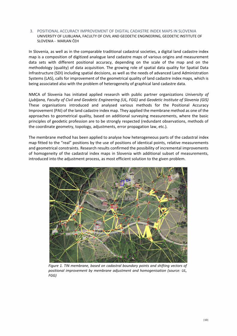
EuroSDR held a well-attended joint technical session together with the VOLTA project at the ISPRS Commission II Symposium in Riva del Garda, Italy, during June 2018 (Figure 4). Presentations on the topic of 3D mapping included an invited talk from Professor George Vosselman of the University of Twente, entitled “Point clouds and derivatives for nationwide geospatial information”. Commission 1 also supported the ISPRS Commission I Symposium in Karlsruhe, Germany, held from 9th to 12th October, 2018.
|24|
Figure 4. Commission 1 held a joint technical session at the ISPRS Commission II Symposium.
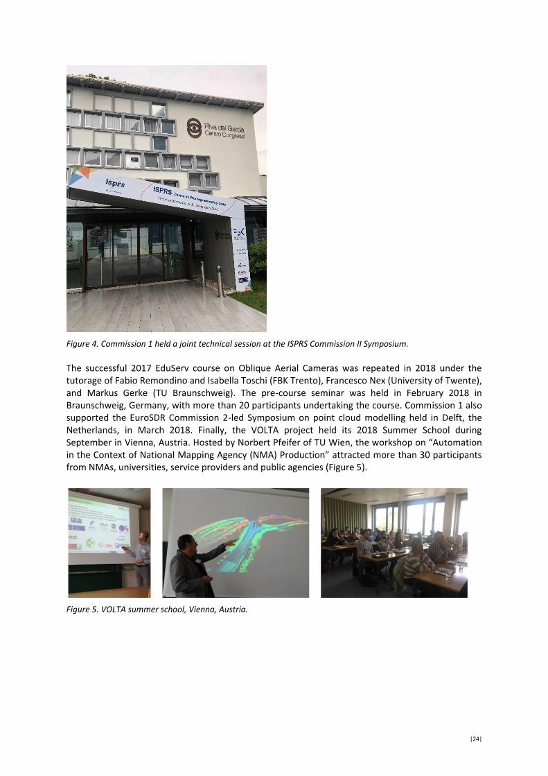
The successful 2017 EduServ course on Oblique Aerial Cameras was repeated in 2018 under the tutorage of Fabio Remondino and Isabella Toschi (FBK Trento), Francesco Nex (University of Twente), and Markus Gerke (TU Braunschweig). The pre-course seminar was held in February 2018 in Braunschweig, Germany, with more than 20 participants undertaking the course. Commission 1 also supported the EuroSDR Commission 2-led Symposium on point cloud modelling held in Delft, the Netherlands, in March 2018. Finally, the VOLTA project held its 2018 Summer School during September in Vienna, Austria. Hosted by Norbert Pfeifer of TU Wien, the workshop on “Automation in the Context of National Mapping Agency (NMA) Production” attracted more than 30 participants from NMAs, universities, service providers and public agencies (Figure 5).
Figure 5. VOLTA summer school, Vienna, Austria.

|25|
Commission II: Modelling and Processing Jantien Stoter & Norbert Haala Mission: To contribute to advanced ways of modelling and processing spatial information by investigating, demonstrating, evaluating and documenting new ways of structuring, maintaining, processing and distributing spatial information. EuroSDR 3D SIG Since autumn 2013 the National Mapping Agencies of EuroSDR are working together in the EuroSDR 3D Special Interest Group (3D SIG) to a) define and coordinate the long-term 3D research agenda of EuroSDR based on experiences and developments of both research institutes and NMAs; b) to carry out research projects on topics of common interest, and c) to organise workshops and knowledge exchange sessions on relevant topics. The EuroSDR 3D SIG members meet 2-3 times a year. Project on “Economic Value of 3D geo-information for NMAs” In 2017, we finalised the research project on “Economic Value of 3D geo-information for NMAs” (with Commission 5). The final report of the study has been published in the EuroSDR publication series. In 2018, we have written a Journal article (Land journal) containing a further analysis of the outcomes, entitled: 3D Geo-information Innovation in Europe’s Public Mapping Agencies: A Public Value Perspective. In addition, Commission Chairs 2 & 5 were interviewed for GIM International on the outcomes of the project: https://www.gim-international.com/content/article/the-search-for-the-economic-value-of-3d-geoinformation International Point Cloud Processing Symposium (PCP 2018) On Tuesday 13th of March 2018, EuroSDR co-organised the international Point Cloud Processing symposium. PCP2018 was a joint event with ERC, the VOLTA project, EuroSDR and Geonovum on the latest developments in point cloud processing. The objective of this seminar was to share knowledge on recent developments in point cloud processing. Topics of interest were:
acquisition & visualisation data structures & management, segmentation & classification, object detection & reconstruction, applications & use-cases from practice.
On this day experts from academia, government and industry gathered to talk about these topics. With over 150 registrations and 17 speakers the event was a great success. The presentations are available on the symposium website: https://3d.bk.tudelft.nl/events/pcp2018/#id-program GeoBIM project Several EuroSDR members expressed interest to repeat the successful funding structure of the study of “economic value of 3D data” to a new EuroSDR project on a topic of common interest. This way of funding (and collaboration) is specifically useful for topics that still need more focus and understanding and that can benefit from a cross-country approach. Therefore, we decided to start a new co-funded project on Geo-data and BIM data integration.
|26|
The partners in this project (besides EuroSDR) are: Lantmäteriet Sweden; GUGiK Poland, NLS, Finland; Kartverket, Norway; Agency for Data Supply and Efficiency, Denmark; Kadaster, NL; Swisstopo, Switzerland; Ordnance Survey, UK; Ordnance Survey, Ireland; IGN, France, ICGC, Catalonia; and Geodetic Institute, Slovenia. Apart from co-funders, these organisations are active partners in the project and they will carry out parts of the project. Also a few universities and research institutes are partners in the project, i.e. University College London, Dublin Institute of Technology, Lund University, University of Ljubljana and the Delft University of Technology. See https://3d.bk.tudelft.nl/projects/eurosdr-geobim/ The main aim of the project is to detail both the needs and the issues of GeoBIM integration, studied from use cases as well as from existing experiences in the participating countries. The project was divided into two phases. In the first phase (November 2017-June 2018) we have made an inventory of the GeoBIM state-of-play in the participating countries (by means of a questionnaire). Based on the outcomes, we wrote a paper for the yearly international 3D Geoinformation conference (1&2 October 2018, Delft)1. The paper can be found here: https://www.int-arch-photogramm-remote-sens-spatial-inf-sci.net/XLII-4-W10/19/2018/ The second phase (started in September 2018) focuses on analysing the data workflow and identifying the specific requirements of the data for better use of Geo and BIM information within two specific use cases: Use case 1 - Workflow from global design to building permission issuing (with the aim of improving
the automation of building permit process) Use case 2 - Life-cycle support in asset-management. A researcher from 3D Geoinformation research group Delft, is coordinating this research. She presented the project at the international GeoBIM conference, 1&2 November, Amsterdam. EuroSDR track at the international 3D GeoInfo conference The EuroSDR 3D SIG co-organised a specific track at the yearly, international 3D GeoInfo conference which took place on 1&2 October 2018, hosted in Delft, Netherlands. In the joint EuroSDR/3DGeoinfo track, we scheduled presentations on 3D topics that were of specific interest for National Mapping and Cadastre Agencies. Presenters from research, practice and industry presented their papers in this session. The conference welcomed about 200 people across Europe and beyond. See also https://3dgeoinfo2018.nl ISPRS-EuroSDR GeoBIM benchmark: reference study on software support for open standards of city and building models In November 2018, we have submitted a proposal to ISPRS for a Benchmark study. EuroSDR is one of the submitting partners as well several EuroSDR members. The project was awarded in January 2019. The project will investigate available technical solutions for the integration and interoperability of data
1 Investigating the state of play of geobim across Europe. C. Ellul, J. Stoter, L. Harrie, M. Shariat, A. Behan and M. Pla. In Ken
Arroyo Ohori, Anna Labetski, Giorgio Agugiaro, Mila Koeva and Jantien Stoter (eds.), 13th 3D Geoinfo Conference, ISPRS
Annals of the Photogrammetry, Remote Sensing and Spatial Information Sciences IV-4(W6), ISPRS, Delft, The Netherlands,
October 2018, pp. 19–26.

|27|
concerning 3D geoinformation and 3D building information models (BIM). This is the first project that will provide insight into the state of implementations of the open standards in the 3D geo and BIM domain and of the integration of both types of data, also identifying remaining issues. See https://3d.bk.tudelft.nl/projects/geobim-benchmark/ The setup of the project and initial tests will be published in a paper presented at the ISPRS Geospatial week in Enschede (June 2019). 2018 also witnessed the end of Jantien Stoter’s term of office as the Commission II Chair and the appointment of Norbert Haala as her successor.

|28|
Commission III: Updating and Integration Jon Arne Trollvik Mission: To contribute to advanced ways of updating and integration of spatial information. The task of automated updating and automated integration of external data sources will become more important in the future. The focus is moving from data acquisition to integral data updating and data integration from various sources, while maintaining the level of quality of the data sets. In 2018, activities within Commission 3 cover two workshops in addition to an initiative on archival and processing of historical images.
Workshop on Lidar – “Use of algorithms on big DEM’s” The workshop “Use of algorithms on big DEM’s” was organized in the beginning of April in Tønsberg, Norway. The main idea with this workshop was to share experiences and knowledge gained when using different algorithms on height data. As always with the EuroSDR workshops also try identify potential fields of future cooperation and research. It was a various program with a mix of presentations and breakout sessions, and the 31 participants had lively discussions during the two day workshop. Nationwide generation of height data is an ongoing task within most European national mapping agencies. Using the national elevation databases for large scale feature extraction and analysis are being carried out by various mapping agencies. IGN Spain have developed workflows for large scale automatic river network extraction and powerline/obstacle mapping from their LiDAR datasets. Automatic feature registration benefits highly from additional information such as return intensity and the acquisition of multispectral LiDAR and co-registration with hyperspectral imagery. A pure pointcloud based analysis approach are computational challenging and the research on a more efficient mathematical representation, such as spline, will potentially make the analysis more computer efficient.
Figure 1. Co-registration between LiDAR and hyperspectral imagery (Aarsten, Terratec AS)

|29|
Workshop recommendations for further work
Investigate models and methods for normalizing the intensity values and produce a more homogenous reflectance map.
Testing what density is optimal for LOD1, LOD2 and LOD3 city modelling. Program, presentations and the workshop report is available from the EuroSDR homepage.
Figure 2. LiDAR Workshop participants (Photo: Per Anders Bjørklund)
3rd workshop on “Preparations for Sentinel-2 in Europe” The 3rd workshop on “Preparations for the Sentinel-2 in Europe” was completed at the Norwegian Space Centre in Oslo October, with more than 50 participants from 14 countries. As the title says, it was the 3rd workshop in a series of workshops held on preparations for the Sentinel-2. We started in 2014, where we had presentations focussed on plans for Copernicus and Sentinel-2. The second workshop gave us the first user experiences, and the early start of the National Ground Segments throughout Europe. We have now reached a phase where both Sentinel-2 satellites are in orbit and are delivering data. The main reason for having this workshop was to give the users of Sentinel-2 data the latest information from ESA Ground Segment and their archive and distribution services, but also knowledge about the Copernicus Data and Information Access Services (DIAS). In addition to experience gained from different national Collaborative Ground Segments (CGS), there were also several presentations from operational use of Sentinel-2 data. A break out session focused on Quality on DEMs used for ortho-rectification of Sentinel-2 data, and on a discussion of the role for DIAS vs. the national initiatives on Collaborative Ground Segments.
Figure 3. Participants at the Sentinel-2 workshop. Photo: Marianne Moen, Norwegian Space Centre

|30|
Of particular interest for the Nordic countries (and other countries with a big relief), is ESA’s choice of DEM for ortho rectification of Sentinel-2 data. A fear is that the future DEMs that are planned for use can have a bad quality in areas with a big relief, and that the time is running out if we want to influence on ESA/Copernicus in this respect.
Figure 4. Calculated displacement of two Sentinel-2 scenes with different relative orbits (August 27. and September 3. 2017, Børgefjell area, Norway). When the two different scenes are ortho-rectified with the weak PlanetDEM90, we notice large lateral movement, up to 40 m. (Klingenberg, Norwegian Mapping Authority).
Figure 5. The figure above shows how we can improve the Geometric accuracy using the national 10 m DEM to ortho-rectify Sentinel-2 images compared to PlanetDEM90 (Klingenberg, Norwegian Mapping Authority).

|31|
A discussion of the need and future of DIAS took place and some participants highlighted the need of getting “closer” to the data and the availability of virtual processing without downloading any data. The discussion and the different presentations was indeed necessary, as many participants were unknown to the real need and use of DIAS. Workshop recommendations
With the fast growing archive size of Sentinel-2, users are recommended to use their algorithm on the server side, minimalizing the amount of downloaded data
NCGS should go towards generating analysis ready data (ARD), on national grid, (higher-level products)
A hub for Sentinel-2 Level 1B (L1B) should be provided for experts users
Water (quality) is an important issue in many European countries. Sentinel-2 is opening up many new possibilities. Sentinel 2 and 3 are used by many organizations for water quality monitoring, science and other applications. Of that reason, topics and use cases focussing on water quality should be put on the agenda for future workshops
Several participants proposed again a follow-up workshop in two year time to report national status, progress, and discuss common challenges (and turn the title from “preparation” to “operational”)
Archival of aerial images: Current status in Europe The French National Institute for Geographic and Forest Information (IGN-France) with the help of Swisstopo made a report based on the outputs of a poll sent out in 2017 regarding archiving of aerial images. More and more countries have digitized or are currently digitizing their archives of aerial images. They are a unique and relatively unexplored means to chronicle land-cover information over the past 100 years with very high spatial resolution. Such data provide a relatively dense temporal sampling of the territories. 3D information can even be retrieved since many surveys were performed under photogrammetric conditions. Therefore, many long-term environmental monitoring studies can be based on the analysis of these very rich time series of images. We have noticed in the last years an increasing number of scientific papers processing archival airborne images. In a timely manner, it appears necessary to evaluate the current status of the archive digitization process in Europe, up to the distribution policy. The report is a first step towards the identification of the main contributors in the digitization and diffusion process of archival airborne images in Europe. In order to foster the adoption of archival aerial data for the automatic chronicling of territory dynamics at large scales, main effort should now be:
Making explicit the main common issues towards the definition of an automatic and fast photogrammetric pipeline, and in particular orthoimages;
Generating in-between first datasets over the largest period of time in order to stimulate first thematic use-cases;
Organizing workshops in order to gather people interested in methodological and thematic developments;
Refining such survey with additional institutions and questions dedicated to practitioners. As a follow up of the report, there will be arranged a workshop beginning of June 2019 in Paris, focusing on the different aspects of archival of historical images.

|32|
Commission IV: Information Usage Bénédicte Bucher Mission: To explore, demonstrate and contribute to further increase in access to authorized geodata. To contribute to the development of better mechanisms for dissemination of geodata from database to end user. To investigate, evaluate and document developments in the technologies for data integration, service-level interoperability and delivery of all forms of geoinformation, data and services. Commission 4 tackles information usage, information infrastructures, interoperability and visualization. Within this perimeter, three themes have emerged during former delegates meetings: historical and time stamped data, information infrastructures, digital natives. Theme 1: Historical and time stamped data Historical data addressed in theme 1 are data that have been replaced by newer ones, including very old data, usually archived, but also current time-stamped data. The objectives of this theme have been stated as follows after two first workshops (December 2014, September 2017): to consolidate a EuroSDR historical data group, to reach out users, and to improve reusability and interoperability between technologies developed or used by members in this domain. In order to consolidate a EuroSDR historical data group, the Commission Chair has investigated solutions to create a platform for discussion and collaborative work. Basecamp has proven in the past a successful solution but is expensive ; we are still investigating. Yet, as the commission has invested in a server with a mediawiki on it, a historical data infolab2 has been set up in order to share information about reusable components developed or used by participants (software, services, data products, use pattern). A call for participation to the historical data group will be launched early 2019 and a first webinar will be devoted to decide how to work together and what platform is needed and available. A survey had been launched to identify how national mapping agencies develop new usages of aerial pictures archives and has been analyzed during 2018. It is reported in Commission 3 as the techniques involved refer to Commission 3 expertise. Last but not least, as decided in 2017, Commission 4 investigated in 2018 the connections with the FET Flagship Time Machine proposal, https://timemachineproject.eu . The general idea of the TimeMachine project is to organize the cultural heritage of Europe into a “big data of the past” available to improve our knowledge of our common history and prepare the future of Europe. It should have a strong impact in scientific fields like digital humanities where the TimeMachine shared technologies will leverage silos. It should also have tremendous impact on artificial intelligence to train machine learning algorithms with newer data. Operational application domains are also targeted like education, museums, tourism, smart cities and land use policies. The motivation for the involvement of Commission 4 was presented at the 131st and 132nd board of delegates: valorization of NMCA’s archives, reaching out more users, designing a European information infrastructure for spatio-temporal data with a strong focus on preserving semantics and managing heterogeneities. The TimeMachine consortium is mainly composed of historians, computer scientists, national and city archives or libraries, museums and industrial partners like Naver Labs, Iconem, Indra, Ubisoft. At the time of the 132nd EuroSDR board of delegates (spring 2018, Ljubljana), 5 members of the EuroSDR
2 http://geometadatalabs.eu/HistoricalAndTimeStampedData

|33|
board were among the set of 33 institutions who funded the Time Machine proposal preparation: EPFL (project leader), IGN-F, TU Dresden, TU Wien, TU Delft. Even though these are not always the same persons in these organisations that participate to EuroSDR boards of delegates and to TimeMachine’s assemblies, it is an opportunity to make EuroSDR competences and topics even more visible in the project. The Time Machine network currently gathers 253 members from 33 countries in Europe.
Figure 1. ©IMA Sputnik. Some technologies to be included in the TimeMachine stack are the digitization of cultural patrimony and the design of immersive reality experiences where 3D models are enhanced with dynamic artefacts (dust, birds) and noise to recreate a feeling of place, here by Iconem and Ubisoft.
The year 2018 was devoted to the preparation of a coordination support action proposal (CSA), which is the required preliminary step to apply for a FET Flagship. 33 organizations participate to this CSA proposal. During this preparation, Commission 4 involvement firstly targeted the promotion of competences, data and technologies held by national mapping and cadastral agencies of Europe so that even if a NMCA is not a member of the pre-project, it can contribute to it and benefit from it. A specific stake identified was to connect the different portals designed for digital humanities to national geoportals and geo-platforms as well as European ones like EuroGeographics European Location Service. On May 30th to June 1st 2018, Bénédicte Bucher presented EuroSDR activities at the Time Machine General Assembly in Nüremberg, not limited to Commission 4. Besides, a specific exploitation domain was added to the Time Machine proposal that was the general domain of Land cover and land use models definition and the elaboration of territorial policies. This was a follow up from the Land Use/ Land Cover workshop co-organized with EuroGeographics KEN INSPIRE on 2017. In September 2018, EuroSDR became an associated program of the Time Machine project with Bénédicte Bucher as a contact person who reports to the executive management team. The Time Machine project leader, Frederic Kaplan from EPFL was invited to share his vision during the 133rd EuroSDR Board of Delegates (winter 2018, Berlin).

|34|
Only 6 CSA proposals are funded by the Commission and the CSA TimeMachine is one of them. It will run from march 1st 2019 until February 29th 2020 with a budget of 1M€. Its main deliverable is the submission file for a flagship project that would run from 2021 to 2030 with a budget of 1B€. Theme 2: Information infrastructures (INSPIRE, Geoweb, Linked data) Addressing unsolved issues in information infrastructures requires collaboration with new communities like Linked Data, or Information Retrieval. These new communities can be either solution providers to our issues or new users of the solutions national mapping and cadastral agencies develop. In both cases, a challenge is to establish a true dialogue with these. Theme 2 also requires collaboration with complementary data providers to national mapping and cadastral agencies. The workshops of this theme have welcomed participants from national libraries, statistical institutes, geological survey, museums, and more recently collaborative web content like wikidata. In order to challenge new communities with unsolved issues, generic pending problems in digital spatial information infrastructures were identified early 2017. Since then, our work has concentrated on specifying them into more precise problems illustrated with data which reveals a much more complex task than initially expected. This has led to postpone the organization of a 1-year challenge initially planned in 2018.Instead, a series of workshops were needed to progress in the identification of shareable challenges. To establish or reinforce connection between scientific communities and practitioners on the design of a European spatial information infrastructure that reuses national data, joint events between EuroSDR Commission 4 and EuroGeographics KEN INSPIRE are frequently organized. During 2018, a particular attention was devoted to the production of a pedagogic EuroSDR report of the joint EuroGeographics KEN INSPIRE and EuroSDR workshop on INSPIRE Data Extension that took place in 2017. This workshop tackled difficulties encountered during the implementation of INSPIRE data infrastructure. Minutes have been produced and shared on EuroGeographics platform. Besides these, IGN France and Geonovum co-authored a EuroSDR report with much care for his legibility from non-specialists of INSPIRE3. Constructive reviews were performed from EuroSDR colleagues from UCL and Dutch Kadaster to achieve early 2019 a published report. A workshop on the Use of INSPIRE Data: experiences from the past and scenarios for the future4, was co—organized with EuroGeographics KEN INSPIRE in Warsaw in November 2018, hosted by GuGik. It welcomed 40 participants from data providers, research, industry, European Environment Agency, Eurostat. Presentations are available on the workshop website and a EuroSDR report is prepared to complement EuroGeographics workshop minutes. Some presentations tackled European usages, from EuroGeographics, Here, research in intelligent transport systems, research in urban climate services, as well as requirements expressed by Eurostat and by the European Environment Agency. Others focused on national usages, for instance for transport planning, digging planning, real estate, and also on giving a general overview of national situations with respect to the usage of INSPIRE data. Among scenarios for the future, several proposals targeted the protocols used to deliver data (WFS, WCS). An highlight on how to adopt a more user-centered governance of INSPIRE was made by research. A very brief summary of the conclusions is that using INSPIRE data require some preprocessing to integrate the data from different providers. Even if the INSPIRE data specifications
3 Bucher, B., Laurent, D., Janssen, P., 2019, Preserving semantics, tractability and evolution on a multi-scale geographic information infrastructure : cases for extending INSPIRE data specifications, Report of EuroGeographics-EuroSDR workshop on INSPIRE Data Extension, EuroSDR 4 https://EuroGeographics.org/calendar-event/use-of-inspire-data-past-experiences-and-scenarios-for-the-future/

|35|
ease this task, this requires nevertheless specific resources which users do not always have. A brokering component is missing on the current INSPIRE infrastructure. The discovery platform http://inspire-geoportal.ec.europe.eu is a very important component on a European infrastructure and needs more resources and functionalities. Among follow up actions identified is the benchmarking of brokering solutions that reuse INSPIRE data when they exist and other data otherwise like OpenStreetMap data. Designing brokering solutions of heterogeneous vector data could be a motivating challenge for scientists and developers.
Figure 2. Participants to the workshop Use of INSPIRE Data: past experiences and scenarios for the future, Warsaw, November 2018.
A workshop on Data Linking by Indirect Spatial Referencing Frameworks: place names and other core data5 was organized in Paris in September 2018 by National Land Survey (Finland), Kartverket (Norway), and IGN-F (France). It gathered 19 participants from 7 countries and EuroGeographics KEN INSPIRE was associated to it. Participants came mainly from national mapping and cadastral agencies and from the industry. The first day of the seminar covered key results and issues on data linking and referencing with place names. A keynote by Elise Acheson from Zürich University presented state of the art text-to-space methods, remaining challenges and requirements in terms of indirect spatial referencing systems. This requires three generic steps: identifying placenames, grounding them and representing them in a geographic information system.
Figure 3. Linking text to space is a 3-step processing pipelines, where each step can use gazetteers (© Acheson)
5 http://www.eurosdr.net/workshops/data-linking-indirect-spatial-referencing-frameworks-places-names-and-other-core-data

|36|
It was followed by presentations from projects and organisations in charge of designing and distributing placenames databases. Some presentations targeted national scope with a priority on the usability of authoritative frameworks. Others targeted the European or international scope where national gazetteers are highly heterogeneous, with a concern for reusability and interoperability. Second day enlarged the scope to other core data, like buildings, including linear referencing systems.
Figure 4. A http data card from the Finnish pilot
The workshop evidenced that usages of the abundant assets of data available are still partial and restricted and data linking is a substantial way forward but not only. Advances in ontologies are also needed as well as adapting our data services to the requirements of new communities like the text-to-space communities. The report should be published around may 2019.
Figure 5. Participants to the workshop Data Linking by Indirect Reference Systems, Paris, September 2018
This Data Linking workshop has led to identify several categories of challenges within the generic issue of interconnection and multiple representation. 1. Ontology design, knowledge representation
- Place ontology design: cataloguing, exploring common ontologies (incl. Wikidata). Modelling named place types to address heterogeneities in national gazetteers.

|37|
- Ontologies for digital assets: o New concepts to replace the notion of data product, data series, data set. o Propose more semantics to links, that can also be useful for deciding if the links must
be precomputed or computed on the fly, and for the maintenance of the links. 2. Alignment, interconnexion
- Alignments of place ontologies - Automatic interconnection of schemas –incl. INSPIRE specifications, incl. OSM tags - Automatic interconnection of data related to buildings - Connecting INSPIRE data with important web content like Wikidata, Wikipedia, OSM - Updating links - Migration methods between linear and absolute referencing
3. Relevance, similarity, ranking
- Assessing relative importance to named places: the challenge consists in documenting a specific property for a place that: its importance in a given context. This property will be used to choose how to portray it in a map when zooming in and out.
- Adapt a datacard to a context : portray only relevant metadata, recommend relevant additional resources
- Proposing similarity measures between places 4. Technology readiness assessment in NMCA context
- Benchmarking Linked Data software with large amount of data and full SPARQL support - Benchmark about various practices of linear referencing, developing more or better
methodologies and tools to migrate data from one system to another one) A follow-up of the Data linking workshop was the creation of a Linked Data technical group, which was decided during the 133rd board of delegates (Winter 2018, Berlin) and launched early 2019. The kick off webinar, initially planned December 2018, was postponed early February 2019. The attendees to the webinar, from OSGB, University of Ljubljana, National Land Survey Finland, Geodetic Institute of Slovenia and IGN-France identified common objectives:
- exchange information about mature enough solution to publish our data as linked data, - design harmonization solution for linked data and using linked data, typically to bridge the gap
between current SDI components and usage, - reach out users of our data served as Linked data.
We hope for more participants to join the group. Theme 3: Digital natives In this domain the work has concentrated on the finalization of the report of the 2017 workshop which has been published early 20186
6 Bucher, B., Schlieder, C., Cantat, F., Kavouras, M., Streilein, A., Severo, M., 2018, Mapping places for digital natives and
other generations, workshop report, EuroSDR
|38|
Commission V: Business Models and Operation Joep Crompvoets Mission: To contribute to the development and implementation of business models describing the rationale of how mapping and cadastre agencies can create, deliver, and capture value, in economic, legal, social, governance, cultural or other contexts. As chair of Commission V ‘Business Models and Operation’, it is my pleasure to contribute to the EuroSDR annual reports series. This commission was established at the 126th Board of Delegates meeting in Tønsberg (Norway, May 2015). In the fourth year of the existence of the Commission, it run the following projects:
- Crowdsourcing and National Mapping - Sustainable Open Data Business Models for NMCAs - Open SDI EduServ course - EuroSDR/EuroGeographics project Authoritative Data in an European context - Future research topics on Spatial Data Infrastructures
The objective of the Commission V is to contribute to the development and implementation of business models in terms of describing the rationale of how mapping and cadastre agencies can create, deliver, and capture value, in economic, legal, social, governance contexts. Crowdsourcing and National Mapping As part of the second phase of this project, a workshop was organized at the Irish College in Leuven from 3-4 April 2017. More than 60 people participated this successful workshop. The Workshop report “Crowdsourcing and National Mapping” (Peter Mooney, Joep Crompvoets & Rob Lemmens) is recently be published.
- Mooney, P., Crompvoets, J., and Lemmens, R., 2018. Crowdsourcing in National Mapping. European Spatial Data Research network Official Publication. Workshop report. 26 pgs.
During the 131st Board of Delegates meetings, the delegates approved the organisation of a follow-up workshop. The intention is to organize the workshop in June 2019. As a focus or theme for the next workshop the idea is to focus on ‘VGI map of Europe/State of Play’. The workshop should strive to make an output which is very visible, e.g. an online catalogue system? This could help push other NMCAs to actually become involved in Crowdsourcing if they see a ‘gap’ in their jurisdiction/area. It could also help to identify the less ‘famous’ examples of crowdsourcing being used by NMCAs in Europe. It could potentially give the crowdsourcing/VGI community a boost? In this context, there is a need to consider what are the key indicators/measures to define the state of play of VGI in Europe. There are good opportunities here for academic research – there are academic challenges around how to do the sampling for this map/state of play, how to present this information, update and maintain it going forward, etc. An output of the workshop might be a small booklet which introduces the initiatives by the various agencies around Europe. This would make dissemination about the results and success of the workshop much easier. Sustainable Open Data Business Models for NMCAs This project refers to the development of business models for Open Data at National Mapping and Cadastral Agencies as the main data providers across Europe. A first workshop was organized in Delft (The Netherlands, 18-19 September 2017). Follow-up actions include the setting up of a repository on existing Open Data reports, the execution of a relevant survey under joint supervision of EuroSDR and EuroGeographics, and the organization of a workshop in 2019.

|39|
Open SDI EduServ course Universities Delft University of Technology (The Netherlands) and KU Leuven (Belgium) run the EduServ 2018 course on “Open Spatial Data Infrastructures” (SDI). This introductory course aimed to provide a comprehensive overview on the state-of-the art in Open SDI and its key components, and introduce participants to the underlying principles of Open SDI, and let them experience hands-on what it means to establish and maintain an Open SDI. A number of topics will be tackled: spatial data infrastructures as well open data principles, key standards, architectures, (network) services, relevant EU-regulations and policies, governance strategies, and key institutions. At the end of the course, participants are: informed about Open SDI strategies around the world, aware of the main strengths, weaknesses, opportunities and threats of Open SDI, familiar with the latest technological developments, capable to facilitate the opening of open data using latest developed tools, and able to evaluate Open SDIs. This course will be repeated in 2019 as part of EduServ17 series. EuroSDR/EuroGeographics project Authoritative Data in an European context Societies are increasingly digitalising more and more aspects of daily life. The basic building block for digitalization is the data. This data is being integrated within and across public administrations, but also across borders and across the public, private and not-for-profit sectors. High quality data is a necessary basis to ensure the quality of both public and private digital services and to drive innovation. The recognition and organization of data as authoritative data7 should be vital not only for ensuring the quality of data, but also to foster trust between public sector organizations, between different sectors and across borders. Especially in the context of geospatial data, the exchange and integration of authoritative data has advanced significantly, but important challenges still need to be addressed. The goal of this initiative is to contribute to a better understanding of the definition of authoritative data, its rationale, added value, dimensions, and the organisation of authoritative geospatial data across Europe. A two-step methodology was applied: 1) a survey with the members of EuroGeographics was undertaken during the Summer 2019 to get an overview of opinions about the current status of authoritative data across Europe, and 2) Focus groups meetings with the members of EuroGeographics were organised during the General Assembly of EuroGeographics (Prague, 8 October) building upon the findings of the survey and delving into the challenges and opportunities concerning the organization of authoritative data. It is the intention that the project report will be finalised in the beginning of 2019. The first results of the project underline the need for a systematic and harmonized approach towards authoritative data. The survey revealed the following conclusions:
1. There are a variety of definitions and approaches applied by the different member organizations of EuroGeographics, as well as different opinions on which data should be considered as authoritative.
2. Most of the EuroGeographics Member organizations underlined that their country has a formalised approach towards authoritative data, as well as an obligation to use authoritative data.
3. The survey results indicated that there is consensus concerning the central role of public organizations in the organization and use of authoritative data.
7 Tentative definition: Data provided by or on behalf of a public body (authority) which has an official mandate to provide it.

|40|
The following two figures presents some of the survey results.
Figure 1. Geospatial data (sets) that should always be/remain authoritative
Figure 2. Restrictions related to practical management of authoritative geospatial data (sets) (in %)
Through the focus groups, the results of the survey were corroborated and several additional elements could be added on the topic of authoritative data. The main conclusions of the focus groups are the following:
1. From a methodological point of view it is important to underline that the key conclusions of the survey, as described above, were indeed confirmed.
2. Related to the first conclusion, it is necessary to underline that several additional conditions and characteristics of authoritative data were added to the (existing) organizational conditions for authoritative data mentioned in the survey: Legally binding, accountability,
58,8
91,279,4
67,6
94,1
58,8
91,2
55,9PER
CEN
TAG
E
AUTHORITATIVE DATASETS
35,3
17,6
35,3
32,4
41,2
47,1
47,1
55,9
A C C E S S
A U T H O R I T Y
F U N D I N G
Q U A L I T Y
I N T E L L E C T U A L P R O P E R T Y R I G H T S
L I C E N S I N G
P R I V A C Y
N A T I O N A L S E C U R I T Y
PERCENTAGE
RESTRICTIONS

|41|
uniqueness, having a mandate, mandatory use (within the public sector), liability, official, (public) authority provision, reference data, trust, harmonization and standardization, continuity, high quality, the need for adequate quality management system, certification, traceability, maintenance, use and understanding.
3. The NMCAs underlined that data that is validated as authoritative data is considered to be of very high quality. This does, in turn necessitates adequate resources for ensuring data quality and up-to-dateness.
4. It was also underlined that the obligation to use authoritative data depends on the situation at hand. More effort should be put in making authoritative data available and recognizable by other public organizations as well as private actors.
5. The participating NMCAs underlined that there is a need for organizations within the public sector to take up a central role in the governance of authoritative data.

|42|
Future research topics on Spatial Data Infrastructures In the first half of 2018, it was decided to end the Global Spatial Data Infrastructure (GSDI) Association. This association was dissolved as a legal entity in October 2018. Since its inception over 20 years ago, GSDI has delivered 15 World Conferences, provided funding for Small Projects developing Spatial Data Infrastructures in nations around the globe, facilitated extensive knowledge-sharing across an international network of geospatial professionals, and published SDI news appreciated by many thousands of readers globally. In this context, Open Geospatial Consortium and EuroSDR are exploring if there is a specific need for a follow-up initiative focusing on the knowledge sharing aspect concerning the developments of spatial data infrastructures. A first start of this exploration was the development of a survey consisting of four questions. This short questionnaire was sent to the delegates of EuroSDR and was briefly introduced during the Commission 5 reporting at the 133rd Board of Delegates meeting in Berlin (15 November 2018). The delegates had the time to respond until 10 December 2018. The four questions were the following: 1) What are the current key research topics in the context of Spatial Data Infrastructures? 2) What are the expected future key research topics in the context of Spatial Data Infrastructures? 3) Is there a need for an independent network organization focusing on SDI knowledge transfer? 4) What follow-up actions do you recommend?
Seventeen responses were received. The results are summarised per question; Question 1: A long list of current key research topics in the context of Spatial Data Infrastructures was provided with a very wide range of topics including issues related to technology, standards, legislation, quality, management, finances, and usages. The most outstanding topics specifically refer to research issues related to Standardisation and Linked Data. Other research topics frequently mentioned are: Process Management, INSPIRE implementation, Metadata, Volunteered Geographic Information/Crowdsourcing, Geodata on the Web, APIs, 3D data, GeoBIM interoperability, Open Data, Privacy, Security, Smart Cities, SDI-use and visualisation. Question 2: A very long list of expected future key research topics in the context of Spatial Data Infrastructures was provided with even a wider range of topics than presented under Question 1. The future research topics that stand out refer to Linked Data, Open Data, 3D data (modelling), Time management (including time series, real time), Smart Cities and User-centricity. It is remarkable that most given topics are only mentioned once. Question 3: The answers to this question were very mixed. Several answers explicitly expressed a need for an independent network organization focusing on SDI knowledge transfer, meanwhile other answers explicitly expressed that there is no need. Other answers were not explicit if there is a need for such organization or not. In the scope of the development of spatial data infrastructures, Europe benefited a lot by the adoption of the INSPIRE EU Directive. As such Europe stands out in comparison with other regions worldwide. It is very likely that other regions are more in favour of such an independent network organisation for SDI knowledge transfer. Question 4: The recommendations for follow-up actions are very diverse ranging from the organisation of workshops, focus on specific user groups/topics, collection of good practices, discussion on a redefinition of the SDI-concept, setting up relevant governance structures to monitoring the INSPIRE implementation. It is remarkable that half of the recommendations refer to be more user-centric or to widen the scope of user community. The results were briefly presented at the OGC University Domain Working Group (UDWG) meeting (Charlotte (USA), 12 December 2018). They partly formed the basis for discussion. The main outcome

|43|
of that meeting was to continue the discussion with a more formal discussion during the next UDWG meeting in Leuven (Belgium) being part of OGC TC/PC meetings (24-28 June 2019) regarding how to formalize OGC/EuroSDR initiatives to sustain the academic focus on SDI research. This will allow to consider where EuroSDR and OGC activities might align to advance common objectives – given the many topics in the survey that currently overlap OGC areas of emphasis.

|44|
Commission VI: Knowledge Transfer Markéta Potůčková Mission: To provide education services in order to support the transfer of knowledge from EuroSDR research projects to NMCAs, academia and industry and to fulfil specific NMCAs demands for knowledge update. To collect and disseminate methodologies, developed tools and other research outcomes in the form of EuroSDR’s official publications and via EuroSDR’s homepage. To contribute to the development of curricula in GI. The Educational Service (EduServ) nowadays belongs to a well-established and an acknowledged EuroSDR’s activity that annually contributes to updating and deepening knowledge of participants from NMCAs, industry, and academia in different fields of geo(infor)matics. Its 16th series attended 51 participants from 18, mostly European, countries. It focused on following topics:
Oblique Aerial Camera Systems for Mapping Purposes (5th – 16th March 2018) Tutors: Fabio Remondino and Isabella Toschi (FBK Trento), Francesco Nex (ITC/University of Twente), Markus Gerke (TU Braunschweig)
Topographic maps through description and classification of remotely sensed imagery and cartographic enhancement (9th – 20th April 2018) Tutors: Joachim Höhle (Aalborg University), Sébastien Lefèvre & Bharath Bhushan Damodaran (Université Bretagne Sud)
Terrestrial Point Cloud for Forest Modelling (14th – 25th May 2018) Tutors: Liang Xinlian, Yunsheng Wang & Juha Hyyppä (National Land Survey of Finland)
Open Spatial Data Infrastructures (28th May – 8th June 2018) Tutors: Bastiaan van Loenen (TU Delft), Joep Crompvoets (KU Leuven)
The EduServ traditionally started with a pre-course seminar. In 2018 it was hosted by prof. Markus Gerke at the Technical University of Braunschweig from 26th to 27th February. Though only 27 of registered participants attended the seminar, their feedback was favourable and showed importance of this event. A possibility of meeting the teachers and exchanging experience with other colleagues as well as a high level of presentations make the seminar attractive. The participants’ feedback on e-learning courses was in general also positive; the workload of some courses was the issue some participants were concerned about. It has been discussed with tutors of the next series of EduServ.
Figure 1. Group photo from the EduServ pre-course seminar in Braunschweig

|45|
A call for the EuroSDR Award for the best PhD thesis related to Geoinformation Science was announced in March 2018. Only six candidates applied. Their theses covered a wide range of topics: national 3D mapping, evaluation of geospatial data quality using web services, 3D dense models for cultural heritage documentation, topological analysis of geospatial big data or analysis of big data for social sciences. The thesis of dr. Mengmeng Li from ITC, University of Twente titled “Urban land use extraction from very high resolution remote sensing images” was finally selected by the evaluation committee as the winner. The thesis was presented and the Award was handed out on 15th November 2018 during the 133rd EuroSDR Board of Delegates meeting in Berlin.

|46|
Workshops o Seminar ‘Mapping Places for Digital Natives – Literature, practical experiences, perspectives’
(Paris, France, 19 January 2018) o 2nd International workshop ‘Spatial Data Quality’ (Valetta, Malta, 6 – 7 February 2018) o International symposium ‘Point Cloud Processing’ (Delft, the Netherlands, 13 March 2018) o Workshop ‘Use of Algorithms on big DEM’s – Better Utilization of National Detailed Elevation
Models’ (Tønsberg, Norway, 4 – 5 April 2018) o Seminar ‘Data Linking by Indirect Spatial Referencing’ (Paris, France, 4 – 5 September 2018) o 3rd Workshop ‘Preparations for Sentinel-2’ (Oslo, Norway, 9 – 10 October 2018) o Workshop ‘Use of INSPIRE Data: Past Experiences and Scenarios for the Future’ (Warsaw,
Poland, 27 – 28 November 2018)
Publications WR Mooney, P.; Crompvoets, J.; Lemmens, R.: Crowdsourcing in National Mapping. 2018, 26 pages. WR Bucher, B.; Schlieder, C.; Cantat, F.; Kavouras, M.; Streilein, A.; Severo, M.: Mapping Places for
Digital Natives and Other Generations. 2018, 16 pages. 69 Kruk, R. W.; Demaeyer, P.; Decoene, K.: Preserving the Geographical Production Process. 2018,
24 pages. 68 Coote, A.; Knight, P.; Colding, T.S.; Home, R.; Fröjdenlund, J.; Lysell, G.; Streilein, A.; Kane, P.;
Brady, K.; Wozniak, P.; Plá, M.; Bayers, E.; Ilves, R.; Tuokko, J.; Rijsdijk, M.; Witmer, R.; Cantat, F.; Crompvoets, J.; Stoter, J: Assessing the Economic Value of 3D Geo-Information. 2017, 128 pages.
67 Donker, F.W.; Crompvoets, J.; van Loenen, B.: Adapting NMCAs Business Models to Open Data Supply: the Survey Results. 2017, 36 pages.
WR Bucher, B.; Golay, F: Graphical Interfaces for Historical Data. 2017, 16 pages. 66 EuroSDR contributions to the ISPRS Congress XXIII, Special Session 12 – EuroSDR, 12 – 19 July
2016, Prague, Czech Republic. 2017, 129 pages. 65 Crompvoets, J.; Streilein, A.; Masser, I.: How should NMCAs adapt to alternative sources for
NMCA data? 2016, 9 pages.
All publications can be downloaded on the EuroSDR website (www.eurosdr.net).

EuroSDR secretariatKU Leuven Public Governance InstituteParkstraat 45 bus 36093000 LeuvenBelgium
www.eurosdr.net