Embed Size (px)
Citation preview

- Appendix 2 - Compendium of Regional Templates on the Status of Temperate Grasslands
Conservation and Protection
Prepared for The World Temperate Grasslands Conservation Initiative Workshop Life in a Working Landscape: Towards a Conservation Strategy
for the World's Temperate Grasslands
Hohhot, China June 28-29, 2008
S u i t e 3 0 0 – 3 0 0 W e s t G e o r g i a S t r e e t , V a n c o u v e r , B C , V 6 B 6 B 4 , C A N A D A
Temper a te Gra s s l a nd s Conser va t i on In i t i a t i ve
Photo by Chris Harris

LIFE IN A WORKING LANDSCAPE AUGUST 2008
i REGIONAL TEMPLATES ON THE STATUS OF TEMPERATE GRASSLANDS CONSERVATION AND PROTECTION
PREPARED FOR THE JUNE 2008 HOHHOT, CHINA WORKSHOP
TABLE OF CONTENTS
1. Introduction .............................................................................................................................1 2. Equatorial Africa (High Altitude)..........................................................................................3
3. Southern Africa......................................................................................................................22
4. China.......................................................................................................................................38
5. Daurian Steppe ......................................................................................................................46
6. Iran..........................................................................................................................................62
7. Kazakhstan ............................................................................................................................68
8. Mongolia ................................................................................................................................76 9. Russia - Amur River Basin ...................................................................................................82 10. Russian Steppes......................................................................................................................87 11. Ukraine (information not received at time of report production) ...................................................100 12. Uzbekistan............................................................................................................................101 13. Southeastern Australia........................................................................................................108 14. New Guinea (information not received at time of report production).............................................118 15. New Zealand.........................................................................................................................119 16. Bulgaria/Romania................................................................................................................126 17. North America .....................................................................................................................130 18. South America......................................................................................................................140 18.1 Northern Andes.............................................................................................................140 18.2 Central Andean Grasslands ..........................................................................................148 18.3 Río de la Plata Grasslands ............................................................................................160 18.4 Patagonian Steppes .......................................................................................................172

LIFE IN A WORKING LANDSCAPE AUGUST 2008
1 REGIONAL TEMPLATES ON THE STATUS OF TEMPERATE GRASSLANDS CONSERVATION AND PROTECTION
PREPARED FOR THE JUNE 2008 HOHHOT, CHINA WORKSHOP
1. INTRODUCTION
The mission of the Grasslands Protected Areas Task Force of the World Commission on Protected Areas is:
To promote and facilitate the establishment of new or expanded grassland protected areas throughout the grasslands biome, with a priority on temperate grasslands, toward a goal of protecting 10% of the temperate biome by the year 2014, and to provide for the protection, restoration and wise use of grassland protected areas through the development of best management practices and guidelines.
In 2005, the J.M. Kaplan Fund invited expressions of interest designed to enhance international communication and cooperation for the protection and conservation of the world's temperate grasslands. The Grasslands Protected Area Task Force submitted a proposal and in 2006 was awarded a grant - as a result the Temperate Grasslands Conservation Initiative (TGCI) was born.
To this end the TGCI scheduled a workshop on June 28-29, 2008 as part of the joint International Range Congress and International Grasslands Congress in Hohhot, China. The goals of this workshop were: � To establish a global strategy and two regional-specific action plans for increased protection by 2014. � To develop a mechanism for improving international communications and cooperation for the
continued conservation, protection and management of the world's temperate grasslands. � To establish a Steering Committee to help guide the Project Team and implement the global strategy
and region-specific action plans. � To confirm South America and East Asia as the two priority pilot regions for the project. � To discuss the potential for and benefits of transboundary protected areas. This compendium is Appendix Two of the report Life in a Working Landscape: Towards a Conservation Strategy for the World's Temperate Grasslands, a record of the Temperate Grasslands Conservation Initiative workshop in Hohhot China June 28-29, 2008. Description of Temperate Grasslands
For the purposes of this workshop the following description of indigenous temperate grasslands was used in an effort to achieve a consistent approach:
Indigenous Temperate Grasslands: Grass and graminoid-dominated indigenous ecosystems, where seasonal climates and soils favour the dominance of perennial grasses and other graminoids; these ecosystems occur mainly in the middle latitudes and also in areas of tropical and temperate high mountains above the regional tree line where generally similar environments and temperate biogeographic affinities occur.
At Hohhot there was also a discussion about an ecosystem-transboundary approach to protecting temperate grasslands. It is important that our analysis not be country-by-country, and instead present the various world regions to ensure the approach to protecting temperate grasslands isn't limited by country boundaries.

LIFE IN A WORKING LANDSCAPE AUGUST 2008
2 REGIONAL TEMPLATES ON THE STATUS OF TEMPERATE GRASSLANDS CONSERVATION AND PROTECTION
PREPARED FOR THE JUNE 2008 HOHHOT, CHINA WORKSHOP
Identified Temperate Grassland Regions
The TGCI felt it was important to provide initial inventory and status information on the priority temperate grassland regions to the workshop participants. A participant from each region was therefore contacted and requested to complete a description and background template document on their particular grassland region. The various descriptions of the grassland templates vary from the continental level, to country to the regional level, depending on the ecosystem configuration. The 17 templates have been brought together in this compendium. The templates have been grouped together by continent, as below1:
Africa Equatorial Africa (High Altitude)
Southern Africa Asia
China Daurian Steppe Iran Kazakhstan Mongolia Russia: Amur River Basin Russian Steppes Ukraine* Uzbekistan
Upon reading this compendium a 'world perspective' on temperate grasslands emerges. This context will assist in developing both a global strategy and regional approaches in East Asia and South America.
This project and the progress to date would not be possible without the generous funding from the J.M. Kaplan Fund.
Report compiled by: Bob Peart Project Coordinator, World Temperate Grasslands Conservation Initiative 11166 Willow Road Sidney, British Columbia CANADA V8L 5K6 phone: 250-655-0250 fax: 250-655-0297 email: [email protected] If you are reading this compendium separate from the full Life in a Working Landscape: Towards a Conservation Strategy for the World's Temperate Grasslands Hohhot China workshop report and wish to receive a copy of the report please contact Bob Peart.
1 Upon publication of this report the templates from the Ukraine and New Guinea had not yet been received.
Australasia Southeastern Australia New Guinea* New Zealand Europe Bulgaria/Romania North America Canada, Mexico, United States
South America Northern Andes Central Andean Grasslands Río de la Plata Grasslands Patagonian Steppes

LIFE IN A WORKING LANDSCAPE AUGUST 2008
3 REGIONAL TEMPLATES ON THE STATUS OF TEMPERATE GRASSLANDS CONSERVATION AND PROTECTION
PREPARED FOR THE JUNE 2008 HOHHOT, CHINA WORKSHOP
2. TEMPERATE GRASSLAND REGION: EQUATORIAL AFRICA (HIGH ALTITUDE)
Lead Author: Karsten Wesche: [email protected]; Tel. 0049 551 395723, Fax 0049 551 393501; postal: Dept. of Ecology and Ecosystems Research, Albrecht-von-Haller-Institute for Plant Sciences, University of Goettingen, Untere Karspuele 2, D-37073 Goettingen, Germany
Other Contributors: Yoseph Assefa: Department of Biology, Addis Ababa University, P.O. Box 10067, Addis Ababa, Ethiopia Henrik von Wehrden: Institute of Biology - Geobotany and Botanical Garden, Martin-Luther-University Halle-Wittenberg, Am Kirchtor 1, D-06108 Halle, Germany / Research Institute of Wildlife Ecology, Savoyen Strasse 1, Vienna, 1160 Austria
2.1 Major Indigenous Temperate Grassland Types
Temperate grasslands in tropical Africa – a biogeographical perspective Sub-Saharan Africa is estimated to comprise some 12-14 Mio. km² of grasslands (White et al. 2000). Approximately a third of these is situated in equatorial Africa and are mostly Savannas or other tropical grasslands. They differ widely from temperate grasslands; not only in terms of climate (warm-hot), but also in terms of their corresponding biogeographical affinities. Common grasses are represented by mainly tropical genera such as Andropogon, Hyparrhenia or Eragrostis (White 1983), while northern and temperate elements are restricted to high-mountain regions (Fig. 1). Vegetation above the alpine treeline is constituted by a mixture of shrub- and grasslands, which are predominantly built by northern-hemispheric grass genera such as Festuca, Koeleria, Poa, Deschampsia; at moist sites Carex spp. largely replace Cyperus spp. White (1978; 1983) sharply distinguished the tropical lowlands from the “afromontane-archipelago-like regional centre of endemism” referring to the montane forests and the “afroalpine-archipelago-like region of extreme floristic impoverishment” mainly situated above the treeline. The afromontane flora is rich in plant species (~4000) and is characterised by a high level of endemic, often woody taxa. Although less rich in species, the afroalpine flora shows many similarities with the afromontane flora, and differences are not always clear (Grimshaw 2001). Approximately 80% of the afroalpine species can be considered endemic and, even on a species-group level (genus and similar), endemics account for one third of the afroalpine flora; with another third being pantemperate (e.g. Senecio, Ranunculus) and 13% northern-hemispheric taxa (e.g. Arabidopsis thaliana; Hedberg 1986). Ethiopia’s (sub-) alpine habitats are particularly rich in endemic, and often threatened taxa (see Table 2 in the appendix for some examples). Abiotic background: Climate and soils During the ice ages, much of Africa’s high mountains were glaciated and vegetation belts were depressed by 400-800 m. Although gaps between high-altitude grassland sites were considerably diminished they probably never came into direct contact (Hedberg 1969; White 1981). The present climate of the afroalpine grasslands is cool due to the high elevation, but it is nonetheless widely different from mid-latitude regions. Temperatures show diurnal, rather than seasonal fluctuations (“winter every night, summer every day”, Hedberg 1964). Annual mean temperatures are typically between 5 and 8°C near the treeline; under clear skies temperatures in afroalpine grasslands may range between +13.5 and -3°C in the same day (weather hut at 3750 m asl., +200 cm above ground, Wesche 2003; Wesche et al. 2000). Frosts may occur on occasion down to about 3000 m asl. (Wesche 2002). The precipitation regime is usually semi-humid, as most African mountains experience one or two pronounced dry seasons. Annual total precipitation is usually between 800 and 2000 mm, but droughts may occur on virtually all mountains. High levels of radiation and evaporation result in rapid desiccation of the vegetation, often causing severe fires.
AUTHORS

LIFE IN A WORKING LANDSCAPE AUGUST 2008
4 REGIONAL TEMPLATES ON THE STATUS OF TEMPERATE GRASSLANDS CONSERVATION AND PROTECTION
PREPARED FOR THE JUNE 2008 HOHHOT, CHINA WORKSHOP
Typical tropical soil types like ferralsols or nitosols are not found on upper montane or alpine sites (Hamilton & Perrott 1980; Schmitt 1991; Speck 1982), whereas luvisols are developed on morainic substrates, and andosols are widespread on volcanic ashes. Even histosols are common. Soils thus often have huge mineral-organic top horizons. Classification schemes – major grassland types Temperate grasslands in equatorial Africa are common above the treeline, i.e. in the afroalpine (or tropical-alpine) belt (Hauman 1955) between 3700/3800 to 4500 m asl. At 3000 – 3800 m, the ericaceous belt constitutes the treeline ecotone. The ericoid-leaved trees and shrubs burn easily, and the vegetation usually represents a mosaic of remnant forests, scrub and secondary grassland (Miehe & Miehe 1994a; Schmitt 1991; Wesche 2006). For the current survey we will therefore concentrate on altitudes ranging from 3000 m to 4500 m asl., above which vegetation cover becomes very sparse in equatorial Africa. In the last two decades detailed surveys of high-altitude vegetation have been published which cover most of the larger eastern African mountains (Table 3, appendix). However, knowledge on mountains along the Albertine Rift (Rwanda, Sudan, especially Congo) is much more limited, and few of the Ethiopian mountains have been studied in great detail. Moreover, there is no updated synoptic classification of afromontane and afroalpine vegetation which includes grasslands. In his continental overview, White (1983) distinguished “afromontane & afroalpine shrublands”, “afromontane & afroalpine grasslands”, and “mixed afroalpine communities”. In spite of the detailed classification however units in the accompanying map were combined into only one class. In his much more detailed account, Knapp (1973) distinguishes afroalpine grasslands from upper montane/subalpine grasslands where temperate grasses intermingle with more tropical elements. Most of the respective stands are in fact replacement communities of various types of ericaceous vegetation.
Table 1: Major vegetation types of the high-altitudes in tropical Africa
(Hedberg 1964; Knapp 1973)
Typical genera Physiognomy Subalpine communities Ericaceous scrub Erica, Stoebe, Hypericum, Cliffortia Shrubs between 0.5 and 5 m Subalpine grassland Andropogon, Exotheca, Sporobulus Usually dense grassland, bunches small
Alpine communities Afroalpine scrub Alchemilla, Helichrysum Partly very dense shrubs 0.5-1.5 m Dendrosenecio woodland Dendrosenecio, Lobelia Open woodland with Tree Groundsels (≤ 5 m) Tussock grassland Poa, Avenae, Festuca, Koeleria Large tussocks (≤ 1 m) with open space between Bogs Carex, Scirpus sl. Large tussocks (≤ 1 m)
The benchmark works of Hedberg (1951; 1964) provide a sufficiently simple classification that is largely followed here. Among the subalpine communities, we distinguish between ericaceous scrub and subalpine grasslands (Table 1). The afroalpine vegetation was classified into bogs, tussock grassland and Dendrosenecio woodland. The latter may have a field layer of grasses, but more commonly of Alchemilla shrubs. We deviated from Hedberg by uniting Alchemilla scrub and Helichrysum scrub as they were usually not separated in the available vegetation maps. All these community groups can be rapidly interchanged by fire or grazing (Hemp 2006a; Wesche 2002), with grasslands usually replacing woody vegetation under high fire frequency. Scrub communities are especially widespread in the mountains of southern and central Ethiopia and the general flora there also differs somewhat from sites in equatorial Africa. However, we refrained from establishing separate units as data on Ethiopian (sub-) alpine vegetation are far from comprehensive (see Table 3 in the appendix for a general overview).

LIFE IN A WORKING LANDSCAPE AUGUST 2008
5 REGIONAL TEMPLATES ON THE STATUS OF TEMPERATE GRASSLANDS CONSERVATION AND PROTECTION
PREPARED FOR THE JUNE 2008 HOHHOT, CHINA WORKSHOP
2.2 Impact of Human Settlement
Human impact differed considerably between the mountains within Ethiopia and between those of Cameroon and East Africa. The highlands of Ethiopia have been settled for Millennia, and even altitudes well above 3000 m may be under agriculture. Ethiopia is one of the Vavilov centres mainly because it is the centre of origin and diversity for unique high-altitude crops including Enset (Musa ensete) and Tef (Eragrostis tef). Tef and indigenous strains of barley are cultivated well into the (former) ericaceous belt, and thus lie within the potential range of temperate grasslands. At even higher altitudes, afroalpine vegetation is used in partly transhumant animal husbandry. Permanent settlements are found up to 3700 m asl., even in the main national parks (Bale, Simen). Here, people still cultivate vegetables, but mainly rely on livestock rearing. Ethiopia has the largest livestock population of any country in Africa and the tenth largest in the world (c. 30 million cattle, 42 million sheep and goats, 7 million equines, >53 million chickens, Alemneh 2003). The majority of the population lives in the highlands where many temperate crops can be grown and animal parasites (e.g. Tse-Tse flies) are relatively rare. Intense land use led to an almost complete replacement of montane forests but grassland cover also declined (Gete & Hurni 2000; Hurni et al. 2005). Today, most of Ethiopia’s high altitude natural vegetation is long gone, to the extent that the state of the potential natural vegetation is often unknown (Miehe & Miehe 1994b). Many of the former natural grassland sites may nonetheless still show some kind of grass cover, but communities are often heavily modified and can not be compared to original grasslands or grasslands elsewhere on tropical African mountains. Ericaceous forest was almost completely replaced by heterogeneous scrub communities and unique meadow-like heavily grazed Erica stands which are only 40 cm high. Tussock grasslands are comparatively rare in the southern Ethiopian mountains, where afroalpine Helichrysum scrubs are more common instead. Whether grazing, repeated fires or the impact of burrowing rodents (especially in the Bale Mts.) has favoured scrub over tussock grassland is not clear (Miehe & Miehe 1994b). Bogs are, however, still relatively intact in protected regions. Compared to Ethiopia, human settlements at the treeline in equatorial Africa have been very limited. Farming is a more recent introduction there (Maxon 1994) and poses a major threat to the montane forest, but not to sites at the treeline ecotone and above. Permanent settlements have usually been restricted to well below 3000 m, an exception being the Elgony tribe who already raised cattle on treeline sites of Mt. Elgon when the first Europeans arrived (Cotton 1932; Scott 1998). The Elgonys were evicted from the park due to conservation efforts in the 1980s. In several sites of the Kenyan (Mau escarpment, Kinangop grasslands) and the Interlacustrine highlands (Virunga Mts. - Rwanda, Congo) human settlements have climbed up to altitudes of around 3000 m, but these are exceptions restricted to the lower boundary of high-altitude grasslands in tropical Africa. Farming is thus of practically no importance there, and even livestock grazing only locally reaches 3000 m in East Africa. On Mt. Cameroon, where Bantu tribes had settled much earlier than in East Africa, farming and livestock grazing did not extend above the montane belt (Hall 1973; Richards 1963). Nonetheless, hunters have moved to Mt. Cameroon’s high-altitudes and lit fires to promote open vegetation and growth of fresh foliage. This practice had already become well established by the 1930s (Maitland 1932) and has continued ever since. One of the main consequences has been a depression of the treeline by several hundred metres, heavy fragmentation of ericaceous vegetation, and a spreading of open vegetation, being mainly tussock grasslands. Much of the current grassland vegetation on Mt. Cameroon thus represents a fire-maintained, pseudo-climax community (Hall 1973; Richards 1963) that has persisted due to regular fires from frequent lava outbreaks and, more recently, human impact. Fires are equally common on other African mountains (including Ethiopia, Table 5, appendix). Poachers and bee hunters move to the ericaceous and afroalpine belt and light fires, thereby increasing fire frequency (Hemp 2006a; Wesche 2002). Here, the treeline has also lowered by 300 - 800 m, and broad-leaved upper montane forest has been replaced by ericaceous vegetation and subalpine grasslands (Hemp 2005, 2006a). Most ericaceous species can survive occasional fires, but they usually resprout slowly and from dormant

LIFE IN A WORKING LANDSCAPE AUGUST 2008
6 REGIONAL TEMPLATES ON THE STATUS OF TEMPERATE GRASSLANDS CONSERVATION AND PROTECTION
PREPARED FOR THE JUNE 2008 HOHHOT, CHINA WORKSHOP
buds near the surface (Hemp & Beck 2001; Miehe & Miehe 1994a; Wesche et al. 2000). As a consequence, much of the ericaceous vegetation is currently scrub rather than forest. In contrast, tussock grasses such as the widespread Festuca pilgeri resprout within days of fire (Beck et al. 1986; Wesche 2006) and can be considered fire-resistant (Hedberg 1964). Afroalpine Alchemilla and Helichrysum scrub also needs only 5-10 years to recover from fire (Beck et al. 1986), but the grass Deschampsia flexuosa was observed to cover a former Alchemilla stand within one year after burning (Wesche 2002). Thus, grasslands appear to be favoured by the current widely human controlled high fire frequency (Bader 1976; Hedberg 1964; Knapp 1973). In drier regions (Mt. Kilimanjaro, Bale Mts.), Helichrysum scrub, rather than grasslands, may be the principal replacement community under high fire frequency; as this often has –in contrast to the tussock grasslands– limited biomass not offering sufficient fuel for regular fires (Hemp 2005). The Helichrysum communities seem to expand at the expense of tree heathers and other ericaceous formations (Masresha et al. 2006; Miehe & Miehe 1994b).
2.3 Current Status
Spatially explicit assessments of current grassland status suffer from two constraints: The high fire frequency results in pronounced temporal dynamics where a given community can change its distribution by >200% in 25 years (Hemp 2005). This makes it necessary to assess all stages of the potential successional system. Moreover, precise spatial information is widely lacking as vegetation maps have only been produced for some of the sites. We have thus supplemented the available data with estimates based on the potential habitat defined by the area at a given altitude taken from a digital elevation model (SRTM data, Jarvis et al. 2006). These were combined with published information on the relative importance of vegetation types and personal field experience. Table 4 in the appendix summarizes the results.
2.3.1 Natural state
The maximum potential extent of (sub-) alpine vegetation can be estimated with respect to the 3000 m asl. contour line. According to Table 4 (appendix), major potential grassland regions >3000 m cover c. 19000 km² in tropical Africa, afroalpine regions in the stricter sense (>3500 m asl.) total 5000 km². Of these, 75 and 65% respectively are found in Ethiopia. The following countries of importance are Kenya (12/15%), Uganda (5/10%) and Tanzania (4/8%). The relatively larger importance of East Africa for the higher altitudinal belt relates to the more pronounced uplift in the equatorial part of the Rift Valley. Detailed estimates for different grassland types are hard to give for Ethiopia outside of the national parks (Table 4), but the Bale Mts. NP and the Simen Mts. region host some 800 km² of ericaceous scrub, ~200 km² of subalpine grassland, ~550 km² of alpine Helichrysum scrub, 550 km² of tussock grassland and 100 km² of alpine bog. Our estimates for equatorial Africa give a total of 1200 km² ericaceous scrub, 300 km² subalpine grasslands, 650 km² afroalpine scrub and Dendrosenecio woodland; tussock grasslands cover some 400 km² and Carex bogs some 200 km². This is slightly more than half of the potential habitat above 3000 m asl. in East Africa (the rest is largely forest and some open sites such as rocks). Mount Cameroon is included in this figure because it has some importance for subalpine grassland (~50 km²) and ericaceous scrub (~22 km²). Due to its successional character and a lack of precise data for Ethiopia, the total remaining extent of near natural grasslands cannot be estimated with any certainty. Based on available data, about 50% of the total former potential (sub-) alpine vegetation seem to be relatively intact (though by no means always pristine), with figures for Ethiopia (35%), Sudan (30%) and Cameroon (80%) being much lower than for the other tropical African Mountains (>90%).

LIFE IN A WORKING LANDSCAPE AUGUST 2008
7 REGIONAL TEMPLATES ON THE STATUS OF TEMPERATE GRASSLANDS CONSERVATION AND PROTECTION
PREPARED FOR THE JUNE 2008 HOHHOT, CHINA WORKSHOP
2.3.2 Formal Protection
According to available information (Tables 4 & 5), about 45% of the regions above 3000 m are subject to some form of legal protection. Figures for Ethiopia are considerably lower with a total protected area of only 30%, while other sites in East Africa benefit from between 90 and 100% protection. In Congo, only 50% of the habitats >3000 m asl. are protected, mainly as a consequence of the poor protection in the Itombwe mountains, which do however hardly reach into truly afroalpine elevations. Thus, protection of sites in Congo >3500 m asl. is better. This is also true in terms of the total area >3500 m asl., as the relatively well-managed national parks of East Africa account for a disproportionally large share of this altitudinal belt (35%). Even in Ethiopia, c. 1400 km² (i.e. a more than a third) of the total area >3500 m asl. are protected by the two relatively effective and functional national parks in the Simen and Bale Mts. (Table 4). Although most of the above figures are based on somewhat rough calculations, much of tropical Africa’s true afroalpine grasslands have apparently been designated as reserves, and even a fair share of the more heavily used subalpine regions have, at least on paper, some conservation status. Thus, the situation in tropical Africa is better than in some other temperate grassland regions such as North America or Middle Asia (Henwood 1998, 2003). A major drawback, however, is the fact that few of these PAs are truly free from human impact. Fires occur at virtually all sites (see Table 5), but burning may be at least partly beneficial for grassland vegetation. Poaching does pose a serious threat to mammal and bird biodiversity however, and it is effectively excluded only in a limited number of parks in Kenya, Tanzania, Uganda and Rwanda. Park administrations have limited facilities in parts of Ethiopia and in several forest reserves throughout tropical Africa including Mt. Cameroon. General lack of security adds to these problems in Congo and Sudan. Given that even small sites often host endemic taxa (e.g. >100 plant species are confined to a single mountain or mountain group; Hedberg 1992), conservation of single sites, and not only of a sufficient overall share, is important. Thus, in certain circumstances and localities, conservation and protection measures are more imperative than implied by our summary figures.
2.4 Opportunities for Improving the Level of Protection
and Conservation in the Region Only a few improvements are needed in the national parks of Kenya and Tanzania (Table 5). In Kenya, protection status of the Cherangani Mts. and for parts of the Mau escarpment is insufficient, and unrest and insecurity have repeatedly been an issue in the Elgon region. Park management in Uganda has improved tremendously over the last two decades, and prospects for Rwenzori (east side) and Mt. Elgon are good, though both regions have suffered (and may suffer again) from insecurity and/or rebel activity. Protection in Mgahinga Gorilla NP seems to be adequate, while conservation activities on Mt. Moroto and Mt. Kadam are very limited. Here, lack of funds and security issues continue to hamper any efforts. While we are aware that political instability usually hinders traditional conservation efforts, the Kenya Wildlife Service has demonstrated that a determined park administration can tremendously improve the general security situation. Conservation in Rwanda has continued even through one of Africa’s darkest periods, and at least the high-elevation sites of the Rwandan Virungas can now be considered relatively well protected. The chief problems in the East African region are concentrated in eastern Congo, where the political situation is far from stable, rendering even surveying activities difficult at the moment. There are certainly problems even in the two great NPs Virunga and Kahuzi-Biéga, though the consequences for the high-altitude grasslands may be not as severe as in the montane forest. Here, law enforcement and even designation of new reserves (Itombwe Mts.) remains a major challenge. The political situation in southern Sudan is better but is still far from stable, and despite being urgently needed, gazetting of a national park in the Imatong Mts. as well as the establishment of conservation measures in the area have not moved beyond the stage of initial planning.

LIFE IN A WORKING LANDSCAPE AUGUST 2008
8 REGIONAL TEMPLATES ON THE STATUS OF TEMPERATE GRASSLANDS CONSERVATION AND PROTECTION
PREPARED FOR THE JUNE 2008 HOHHOT, CHINA WORKSHOP
The level of protection for Mt. Cameroon has remained low, but the conservation project at Limbe is currently striving to improve not only coverage of protected area but also effectiveness and conservation management within the existing forest reserves. The problem is again certainly more pronounced for the montane forest than the grasslands.
The greatest challenges (spatially) are possibly found it Ethiopia, where the long-lasting and intense human activity has put grassland sites under pronounced pressure. Even the prominent NPs are relatively poorly managed compared to e.g. Kenyan and Tanzanian national parks, and many of the other sites hardly have any formal protection. Forest cover is still lost at a high rate (Gessesse & Kleman 2007) and although grasslands are less heavily affected, there are also severe threats of agricultural encroachment (e.g. Bezuayehu & Sterk 2008). Ethiopia is rich in endemic species, and a surprisingly high number seem to tolerate moderately intense land use (e.g. the “grazing weed” Kniphofia foliosa). Thus, much of the biodiversity is not (as yet) extinct, but improved and enforced management is needed in virtually all high-altitude grasslands of Ethiopia.
2.5 Constraints Against Improving the Level of Protection and Conservation in the Region
The perhaps most difficult constraint in Africa is political instability, which is the principal problem in Congo but also in parts of Uganda and Sudan, locally in Kenya (conflicts in the Elgon region in 2007/2008) and to some extent in Ethiopia (mainly in the Oromiya region Southeast and south-west). Lack of funds, general poverty and an inappropriate policy approach which completely separates local communities from the resources they depend on for their livelihoods all add to political problems. Ethiopia is one of the poorest countries in the world, yet is the single most important country in terms of temperate grasslands in tropical Africa. Conservation is notoriously underfinanced, and there is limited hope for improvement unless international funding is forthcoming. Future prospects are hard to predict with respect to the current political situation. Many of the required measures such as strengthening of the overall administration and security level are beyond usual conservation efforts.
The local effects of global climatic change represent another aspect that can only be mitigated, but not controlled by local conservation activities. Temperatures in tropical Africa are rising, as they are elsewhere, and there is evidence that precipitation is decreasing, at least locally (Hemp 2005; Mote & Kaser 2007). Trends are debated, but the IPCC predicts generally stable or even increasing precipitation for the region (IPCC 2007). It seems however likely that fire frequency will remain high, even under global change, which will benefit grasslands in most sites (but not in all - for a contrasting example see Hemp 2005). At present, we can see no immediate danger of uprising vegetation belts “squeezing” out high-altitude grasslands on mountains; although small ranges such as the Cherangani Mts. and the Mau escarpment may face problems in the future. Ongoing changes in land use are likely to have more immediate impacts on high-altitude grasslands than possible effects of climatic change (see summaries provided by CDE & MRI 2008).
2.6 Suggested Next Steps and Action Plan
Conservation in Africa faces so many problems that temperate grasslands are unlikely to be in the general focus. Still, several steps are both realistic and straightforward. Ethiopia has to continue improving its conservation efforts. The government is challenged here, particularly in terms of enforcing protection in some of the more poorly administered reserves. Conserving the Ethiopian highlands is also of utmost importance in terms of watershed management (Hurni et al. 2005); as e.g. 8 major rivers originate in the Bale Mts. alone with 12 million people in Ethiopia and neighbouring Somalia depending on this water supply. The importance of non-governmental projects such as the Ethiopian Wolf Conservation Project (EWCP) can not be overstated. A similar local role may be envisioned by the Mount Cameroon Project hosted at Limbe Botanical and Zoological Gardens. Their success depends on the continued commitment of private and public stakeholders and international donors.

LIFE IN A WORKING LANDSCAPE AUGUST 2008
9 REGIONAL TEMPLATES ON THE STATUS OF TEMPERATE GRASSLANDS CONSERVATION AND PROTECTION
PREPARED FOR THE JUNE 2008 HOHHOT, CHINA WORKSHOP
Legal protection of the Cherangani Mts. (and to a lesser extent of the Mau Escarpment) in Kenya needs to be improved. The area has a high potential for ecotourism and the ongoing –mainly private– activities need support by a general promotion of tourism in western Kenya, a repeatedly mentioned long-term goal of involved institution including the Kenya Wildlife Service. Special problems are posed by mountain ranges located at interstate boundaries. Plans for a transboundary management system have been implemented on Mt. Elgon (Muhweezi et al. 2007), and cooperation seems to work reasonably well in the Rwandan and Ugandan Virungas.
The greatest challenge is posed by eastern Congo. Political unrest on the Congolese part of the Rwenzori has affected security in the region to the extent that the Ugandan Park also had to be closed for several years. The latter has been reopened now, but the situation in the Congolese Parks is still unclear. As the security situation hopefully improves, national, and more importantly international support for the reserves needs to be bolstered, although institutions such as the GTZ are active in the region. There is also a need to designate further PA’s, but in the first place detailed surveys, some of which have already commenced, are needed to assess the current state of affairs. Moreover, most of the existing management plans must be reviewed and improved. Similar steps are needed in southern Sudan, where the political situation has improved somewhat, but where constraints still demonstrate the particular challenges conservation efforts in Africa face today.
2.7 Appendices
Map 1: Regional map illustrating the location of important mountain regions with sub-alpine grasslands in tropical Africa
(site selection in Ethiopia follows largely the proposal of EWCP - http://www.ethiopianwolf.org/wolves/ EWdistirbution_ clip_image002.gif; altitudinal data were taken from SRTM tiles)

LIFE IN A WORKING LANDSCAPE AUGUST 2008
10 REGIONAL TEMPLATES ON THE STATUS OF TEMPERATE GRASSLANDS CONSERVATION AND PROTECTION
PREPARED FOR THE JUNE 2008 HOHHOT, CHINA WORKSHOP
Table 2: Examples of important high-altitude endemics occurring in the Ethiopian highlands (all data according to www.iucnredlist.org)
Taxon Distribution Red
List Status
Vascular Plants Lobelia sect. rhynchopetalum (Giant lobelias) 21 vicariant endemics on mountains of East Africa
and Ethiopia (Knox 1998) - 1
Echinops spp. Several endemic species on mountains of East Africa and Ethiopia (Mesfin 2004) - 1
Kniphofia foliosa (Ethiopian ret hot poker) Several endemic species on mountains of eastern Africa - 1
Mammals Canis simensis (Ethiopian wolf) Ethiopian mountains (mainly Bale) EN Tragelaphus buxtoni (Mountain Nyala) Ethiopian mountains (mainly Bale) EN Capra walie (Walia Ibex) Northern Ethiopian mountains CR Tachyoryctes macrocephalus (Giant mole rat) Bale Mts. Ethiopia VU Arvicanthis blicki (Blick’s grass rat) Bale Mts. Ethiopia NT Crocidura lucina (Morrland shrew) 2 mountain sites in southern Ethiopia VU Theropithecus gelada (Gelada) Ethiopia Lr/nt Cercopithecus aethiops djamdjamensis (Bale monkey) Bale Mts. Ethiopia DD Birds Rougetius rougetii (Rouget rail) Mountains of Ethiopia and Eritrea NT Cyanochen cyanoptera (Blue-winged goose) Ethiopia NT Zavattariornis stresemanni (Ethiopian bush-crow) Southern Ethiopia VU Hirundo megaensis (White-tailed swallow) Ethiopia VU Tauraco ruspolii (Prince Ruspoli's turaco) South Ethiopia near Yabello VU Serinus ankoberensis (Ankober serin) Ethiopia VU Sarothrura ayresi (White-winged flufftail) Ethiopia and South Africa EN
1levels of assessment in vascular plants are generally poor

LIFE IN A WORKING LANDSCAPE AUGUST 2008
11 REGIONAL TEMPLATES ON THE STATUS OF TEMPERATE GRASSLANDS CONSERVATION AND PROTECTION
PREPARED FOR THE JUNE 2008 HOHHOT, CHINA WORKSHOP
Table 3: Mountain ranges with extensive afromontane/afroalpine vegetation in tropical Africa (according to Table 1 - altitudinal ranges are given in m asl.)
Region Abbreviation Main high-altitude open vegetation types (detailed spatial estimates in km²
if available)
Source
Ethiopia Simen Mts. Simen Short-grass Danthonia-Festuca-Poa steppe, long-
grass Danthonia-Festuca-Alchemilla steppe, Carex bogs
Nievergelt et al. 1998
Mt. Choke Choke Erica scrub, Alchemilla & Helichrysum scrub, Festuca grassland, Carex-Festuca bog
Hurni et al. 2005, own observation
Mt. Guna Guna Pennisetum grassland, some tussocks, shrubland very rare (Erica)
Own observation, Melku 2004
Abune Yosef Yosef Hardly any woody vegetation left, some grassland Own observation Denkore, Gugutu Denkore Ericaceous scrub, tussock grassland Abate et al. 2006 Central Shewa Highlands
Shewa Ericaceous, Festuca grassland, afroalpine scrub, some bogs
Own observation, Fishpool & Evans 2001
Arsi Highlands / Mt. Kaka
Arsi Highly degraded, fragments of vegetation similar to Bale Mts.
Own observation
Gurage Highlands
Gurage Tussock and subalpine grassland, Carex bogs Unpublished report, Fishpool & Evans 2001
Bonga Bonga Ericaceous vegetation, afroalpine vegetation small, Carex bogs relatively extensive
Own observation
Bale Mts. Bale Erica scrub, Alchemilla scrub, Helichrysum scrub, Festuca grassland, Carex-Festuca bog
Menassie & Masresha 1996; Miehe & Miehe 1994b
Gamo Highlands Gamo Very limited afroalpine, mostly subalpine grasslands Own observation, Scott 1952
Gara Mulata Mulata Erica scrub and some limited tussock grassland, Carex bogs
Demel 1996, Uhlig & Uhlig 1990b
Kenya Mt. Kenya Kenya Ericaceous scrub, Dendrosenecio-Alchemilla
woodland, Festuca-Alchemilla tussock grassland, Dendrosenecio-Carex moorland/bog
Rehder et al. 1988
Aberdare Mts. Aberdare subalpine scrub (Erica, Stoebe, Cliffortia) subalpine grasslands (Exotheca, Cyperus kerstenii), alpine grassland (Alchemilla-Festuca), alpine scrub (Alchemilla)
Schmitt 1991
Kipipiri (W Aberdares)
Kipipiri According to satellite image hardly any open or (sub) alpine vegetation
Schmitt 1991
Mau Escarpment Mau Unspecified “montane grassland”, with respect to altitude unlikely to host “temperate”(sub-) alpine vegetation
Ndang'ang'a et al. 2003
Cherangani Mts. Cherang. Small (sub-)alpine zone >3300: mainly ericaceous belt, some Dendrosenecio woodland, moorland small (Festuca), small bogs (Carex),
Mabberley 1975
Mt. Elgon (E-side)
ElgonE Subalpine Exotheca & Andropogon grassland, Erica-Stoebe scrub, Alchemilla scrub, Dendrosenecio-Alchemilla woodland, Festuca-Koeleria grassland, Carex bogs
Wesche 2002
Tanzania Mt. Kilimanjaro Kilimanj. Erica bushlands, Helichrysum scrub, (sub-) alpine
Festuca grassland, Carex bogs Hemp 2005, 2006b
Mt. Meru Meru ericaceous scrub 3000-3700, “steppe like” tussock grassland with Pentaschistis, no bogs, very limited Alchemilla srub, some Helichrysum scrub
Hedberg 1951, 1964
Mt. Hanang Hanang Ericaceous scrub mainly between 2900 – 3200, 3000 – 3400 Helichrysum moorland with Andropogon, Pentaschistis, Koeleria, Anthoxanthum
Greenway 1955
Ngorongoro Ngoro. Ericaceous scrub with Artemisia afra and Erica arborea, subalpine grassland with Pennisetum and Eleusine (not temperate)
Herlocker & Dirschl 1972

LIFE IN A WORKING LANDSCAPE AUGUST 2008
12 REGIONAL TEMPLATES ON THE STATUS OF TEMPERATE GRASSLANDS CONSERVATION AND PROTECTION
PREPARED FOR THE JUNE 2008 HOHHOT, CHINA WORKSHOP
Region Abbreviation Main high-altitude open vegetation types (detailed spatial estimates in km²
if available)
Source
Uganda Mt. Elgon (W-side)
Elgon-W Subalpine Exotheca & Andropogon grassland, Erica-Stoebe scrub, Alchemilla scrub, Dendrosenecio-Alchemilla woodland, Festuca-Koeleria grassland, Carex bogs
van Heist 1994; Wesche 2002
Mt. Moroto Moroto no high altitude grassland Thomas 1943 Mt. Kadam Kadam >3200 subalpine “moorland” with Exotheca
abyssinica & Eragrostis lasiantha and shrubby moorland with Eragrostis volkensii & Erica, no proper afroalpine grassland
Thomas 1943
Rwenzori Mts. RwenzE Erica scrub, Helichrysum scrub, Dendrosenecio woodland, Alchemilla scrub, Festuca-Poa tussock grassland, Carex bog
Osmaston 1965; Schmitt 1985, 1998
Mgahinga / Virunga
Mgahinga 3300 – 3500: ericaceous vegetation, 3500 – 4100: Dendrosenecio woodland, Helichrysum scrub common, Alchemilla scrub very common, Festuca tussock grassland rare, few bogs
Hedberg 1964; Karlowski 1995
Rwanda Virunga Volcanoes
Volcano 3300 – 3500: ericaceous vegetation, 3500 – 4100: Dendrosenecio woodland, Helichrysum shrub common, Alchemilla scrub very common, Festuca tussock grassland rare, few bogs; vegetation sparse above 4300
Fischer & Hinkel 1992; Hedberg 1964
Dem. Rep. Congo
Virunga Virunga 3300 – 3500: ericaceous vegetation, 3500 – 4100: Dendrosenecio woodland, Helichrysum shrub common, Alchemilla scrub very common, Festuca tussock grassland rare, few bogs; vegetation sparse above 4300
Hedberg 1964
Rwenzori Mts. RwenzW Erica scrub, Helichrysum scrub, Dendrosenecio woodland, Alchemilla scrub, Festuca-Poa tussock grassland, Carex bog
Osmaston 1965
Kahuzi-Biega Mts.
Kahuzi Erica scrub, Dendrosenecio woodland (with grasses), Deschampsia mats on summit
Fischer 1996
Itombwe Mts. Itombwe No temperate grasslands, only montane grassland (“high prairie”) and bamboo forest
Doumenge 1998; Ilambu et al. 1999
Cameroon Mt. Cameroon Cameroon >2500 montane Andropogon / Sporobolus
grassland, above 3000 partly Festuca / Bulbostylis grassland, some ericaceous thicket, >3250 only Deschampsia-Festuca (sub-)alpine grassland
Hall 1973; Maitland 1932; Richards 1963
Mt. Oku Oku Only some Hypericum-Adenocarpus scrub (max 3010 m asl).
Sudan Imatong Mts. Imatong > 2900 ericaceous scrub, some subalpine Exotheca
& Festuca grassland (small), no afroalpine grassland Jackson 1956

LIFE IN A WORKING LANDSCAPE AUGUST 2008
13 REGIONAL TEMPLATES ON THE STATUS OF TEMPERATE GRASSLANDS CONSERVATION AND PROTECTION
PREPARED FOR THE JUNE 2008 HOHHOT, CHINA WORKSHOP
Table 4: List of legally protected grassland areas in the region by country, mountain region (cf. Table 3), grassland type and size Names of Protected Areas follow IUCN listings wherever possible, those not given in the IUCN layer are underlined. The IUCN layer was also used to estimate fraction of a given (sub-) alpine region (>3000 m asl.) covered by the PA. SRTM data were used to estimate potential extent of (sub-) alpine vegetation (i.e. area above 3000 m asl) and extent of afroalpine zone (3500 – 4500 m asl). Whenever possible, these data were compared against spatial extent of main vegetation types derived from published vegetation maps; figures in italics refer to own estimates based on information in Table 3, own field observations and information from the Digital Elevation Model. Several publications gave only a total amount of (sub-)afroalpine vegetation for the given region; these figures are additionally listed as “unspecified” to allow comparison with our estimates on the level of vegetation types.
Region Name PA Potential spatial Extent (km²)
Vegetation types – subalpine
Alpine estimated according
to >3000 >3500 >4000 >4500 ericaceous subalpine
grassland Alchemilla / Helichrysum
Dendro--
senecio
tussock bogs unspe-cified
% protected (>3000 m)
% near natural
Ethiopia
Simen Simen Mts. NP 1374 552 115 0.1 246.6 164.4 55.2 0.0 469.2 27.6 24 40 Nievergelt et al. 1998
Choke Mt. Choke NFP2 993 246 4 0 95 20 60 0.0 20 10 ~30 20 Own observation
Guna No protection 569 82 10 0 1 25 10 2 0 5 Own observation
Yosef Abune Yosef3 2215 307 0 0 200 40 120 40 0 20 Own observation
Denkore Denkore NFP3, Gugutu1
2203 410 17 0 360 40 35 8 201 20 Abate et al. 2006
Shewa Wof Washa NFP, Ankober NFP, Menz NFP, Gosh Meda NFP2
1275 24 0 0 105 35 20 95 ~30 20 Own observation, Fishpool & Evans 2001
Arsi Arsi Highlands / Mt. Kaka GR
1867 423 24 0 95 2 165 95 15 ~40 20 Own observation
Gurage Butajir NFP 727 7 0 0 ? 5 5 35 6 1 5-10 Own observation
Bonga Bonga NFP 64 0 0 0 4 12 23 90 60 Own observation
Bale Bale Mts. NP, HR, WR, FR
2856 1198 216 0 535 470 85 43 1250 75 80 Miehe & Miehe 1994b
Gamo Gamo Highlands 181 0.3 0 0 20 160 34 20 Anonymous 2006
Mulata NFP does not reach highlands
12 0 0 0 1 1 2 1 0 40 Uhlig & Uhlig 1990a
Kenya
Kenya Mt. Kenya NP & FR 743 368 122 11 40 40 35 20 100 98 Beck et al. 1990

LIFE IN A WORKING LANDSCAPE AUGUST 2008
14 REGIONAL TEMPLATES ON THE STATUS OF TEMPERATE GRASSLANDS CONSERVATION AND PROTECTION
PREPARED FOR THE JUNE 2008 HOHHOT, CHINA WORKSHOP
Region Name PA Potential spatial Extent (km²)
Vegetation types – subalpine
Alpine estimated according
to >3000 >3500 >4000 >4500 ericaceous subalpine
grassland Alchemilla / Helichrysum
Dendro--
senecio
tussock bogs unspe-cified
% protected (>3000 m)
% near natural
Aberdare Aberdares NP & FR 608 122 0 0 120 20 15 40 40 60 94 95 Schmitt 1991
Kipipire Kipipiri FR 18 0 0 0 0.5 89 95 Schmitt 1991
Mau Grasslands unprotected
57 0 0 0 57 140 0 30 Ndang'ang'a et al. 2003
Kiptaberr FR 260 0.3 0 0 50 Cherang.
Kipkunurr FR 0 0 0 0
110
15 5 5 5 44
Mt. Elgon NP 670 253 41 0 98 ElgonE
Chepkitale NR 0 0 0 0
50 40 40 120 20 270 98
Neville 2001
Tanzania
Mount Kilimanjaro NP 624 385 191 61 98 Kilimanj
Mt. Kilimanjaro FR 0 0 0 0
257 218 34 10 99
Hemp 2001, 2005
Meru Arusha NP(GR, FR) 48 19 4 0 30 5 2 5 5 <30 100 98 Hedberg 1951, 1964
Hanang Hanang FR 72 0 0 0 100 98 Greenway 1955
Ngoro. Ngorongoro CA 100 2 0 0 190 5 3 100 95 Herlocker & Dirschl 1972
Uganda
ElgonW Mt. Elgon NP 348 154 26 0 53 50 48 10 100 95 van Heist 1994
Moroto Mt. Moroto FR 0.2 0 0 0 0.2 0 100 20 Thomas 1943
Kadam Mt. Kadam FR 0 0.1 0 0 0.1 100 20 Thomas 1943,
RwenzE Rwenzori Mts. NP 589 322 123 11 110 50 60 40 70 100 99 van Heist 1999
Mgahinga Mgahinga Gorilla NP 9 2 0.1 0 7 1 1 0.5 0.5 <30 100 99 Hedberg 1964; Karlowski 1995
Rwanda
Volcano Parc Nacional des Volcans
80 26 2 0 25 15 5 2 100 95 Fischer & Hinkel 1992; Hedberg 1964

LIFE IN A WORKING LANDSCAPE AUGUST 2008
15 REGIONAL TEMPLATES ON THE STATUS OF TEMPERATE GRASSLANDS CONSERVATION AND PROTECTION
PREPARED FOR THE JUNE 2008 HOHHOT, CHINA WORKSHOP
Region Name PA Potential spatial Extent (km²)
Vegetation types – subalpine
Alpine estimated according
to >3000 >3500 >4000 >4500 ericaceous subalpine
grassland Alchemilla / Helichrysum
Dendro--
senecio
tussock bogs unspe-cified
% protected (>3000 m)
% near natural
Dem. Rep. Congo
Virunga Virunga NP 49 13 2 8 7 2 2 1 100 95 Hedberg 1964
RwenzW Virunga NP 162 83 35 5 40 8 15 7 20 100 95 Hedberg 1964
Kahuzi Parc Nacional Kahuzi-Biéga
3 0 0 0 4 2 2 8 100 95 Fischer 1996
Itombwe No PA 224 0 0 0 150 75 550 0 90 Doumenge 1998; Ilambu et al. 1999
Cameroon
Cameroon Mokoko River FR, Bomboko Fr, Southern Bakundo FR
46 10 0.1 0 22 54 27 103 70 80 LBZG 2002
Sudan
Imatong Imatong Mts. FR 2 0 0 0 1 1 100 30 Jackson 1956
Abbreviations: “NP” National Park, “HR” Hunting Reserve, “WR” Wildlife Reserve, “FR” (National) Forest Reserve, “NA” Nature Reserve, “CA” Conservation Area, “GR” Game Reserve / Controlled Hunting Area, “NFP” National Forest Priority Area 1 PA not listed by IUCN, but there is an NFP, and the area is well protected due to inaccessibility and a church being present 2 PA-listings by IUCN for Ethiopia are incomplete 3 PA proposed 4The entire high-altitude belt above 3000 m is considered sacred implying some level of conservation

LIFE IN A WORKING LANDSCAPE AUGUST 2008
16 REGIONAL TEMPLATES ON THE STATUS OF TEMPERATE GRASSLANDS CONSERVATION AND PROTECTION
PREPARED FOR THE JUNE 2008 HOHHOT, CHINA WORKSHOP
Table 5: List of major threats to grassland vegetation by area (according to published sources and own field experience)
General level of protection was subjectively estimated on an ordinal scale ranging from ‘0’; ‘1’ only “paper park”; ‘2’ moderately effective; to ‘3’ complete protection. Two numbers are given were PA quality differs in a region. Fire is indicated as a threat but may have both positive and negative effects on grasslands.
Region Threats Conserva- tion
Source
Ethiopia Simen Heavy grazing, hunting, settlements inside park 0+1 Fishpool & Evans 2001; Nievergelt et al. 1998 Choke Heavy grazing, expansion of agriculture, fire 2 Gete & Hurni 2000, own observations Guna Extreme overgrazing, agriculture, erosion 0 Hurni et al. 2005, own observations Yosef Heavy grazing, agriculture 16 Own observations Denkore Heavy grazing, agriculture, fires, hunting 1 Fishpool & Evans 2001 Shewa Traditional rotational grazing, system partly broken
down, locally hardly any natural vegetation left 1+2 Fishpool & Evans 2001
Arsi Heavy grazing, agriculture, fire 0 Own observations Gurage Heavy threatened with conversion to agriculture 0+1 Own observations Bonga Heavy grazing, tree plantation 1 Own observations Bale Grazing, fire, encroachment - agriculture 2 FZS 2007; Miehe & Miehe 1994b; Wesche et al. 2000 Gamo Grazing, some agricultural encroachment 1 Own observations, Anonymous 2006 Mulata Heavy grazing, agriculture 0 Own observations Kenya Kenya Fire, very locally high impact by tourist activities 3 Bennun & Njoroge 1999; Kokwaro & Beck
1987; Paulsch & Scholze 1999 Aberdare Fire, very locally high impact by tourists 3 Bennun & Njoroge 1999 Kipipiri Fire 3 Bennun & Njoroge 1999 Mau Grazing, encroachment of agriculture 0 Bennun & Njoroge 1999; Ndang'ang'a et al. 2003 Cherang. Encroachment, degazettement, grazing, fire 2 (1?) Bennun & Njoroge 1999 ElgonE Fire, poaching, some security 3 (2?)1 Bennun & Njoroge 1999; Neville 2001 Tanzania Kilimanj. Fire, encroachment from lower slopes, locally
heavy impact by tourism 3 Hemp 2005, 2006b
Meru Fire 3 Hanang ? 2? Ngoro. Spreading agriculture in montane belt, fire 3 Fishpool & Evans 2001 Uganda ElgonW Poaching, fire, grazing very limited 2 Wesche 2002 Moroto Poaching, heavy overgrazing, fire 1 Fishpool & Evans 2001; Thomas 1943 Kadam Overgrazing, fire, poaching 1 Mugisha 2002 RwenzE Poaching, encroachment, poor tourism
management, general insecurity 32 Fishpool & Evans 2001; McCall 1998
Mgahinga Poaching, some grazing and encroachment from lower slopes upwards
3 Fishpool & Evans 2001; Karlowski 1995
Dem. Rep. Congo Virunga / RwenzW
Rapid population growth, encroachment, general insecurity - partly inaccessible to administration
1? Fishpool & Evans 2001
Kahuzi Poaching, fire, general lack of security and administrative power
2 (1?)3 Fischer 1996; Fishpool & Evans 2001
Itombwe No legal protection, massive agricultural encroachment, pastoral incursions
0 (1?)4 Doumenge 1998; Ilambu et al. 1999
Rwanda Volcano Poaching, some encroachment, feral dogs 3 Fishpool & Evans 2001 Cameroon Cameroon “effectively unprotected”, severe fires,
encroachment 1 (2)5 Fishpool & Evans 2001; LBZG 2002
Oku Grazing, fire (a Bird Life International Project is active)
0 (2) Fishpool & Evans 2001
Sudan Imatong Fires, agriculture is rising upwards 1 Fishpool & Evans 2001
12007/2008 unrest in the region; 2 potentially instable due to recurrent rebel activity in the area in the last two decades; situation still not stabilised after war in the last decade but conservation projects operate in the area (gtz); 4IUCN lists a PA in the region but recent sources indicate total lack of legal protection; 5ongoing efforts for improvement by Mt. Cameroon Project (Limbe); 6Biosphere reserve proposed

LIFE IN A WORKING LANDSCAPE AUGUST 2008
17 REGIONAL TEMPLATES ON THE STATUS OF TEMPERATE GRASSLANDS CONSERVATION AND PROTECTION
PREPARED FOR THE JUNE 2008 HOHHOT, CHINA WORKSHOP
Acknowledgements
Our fieldwork in eastern Africa in the last decade has benefited from support by a large number of people and institutions including the following (among others): Masresha Fetene (Addis Ababa), B. Mogole & S. Gibaba (Mbale), G. & S. Miehe (Marburg), A. Hemp (formerly Moshi), G. Neville (formerly Mbale), A. Nelson (formerly Dinsho); Kenya Wildlife Service, Uganda Wildlife Authority, Bale Mts. National Park and the Ethiopian Wolf Conservation Project. Financial support was obtained from the German Science Foundation (DFG), the German Ministry for International Cooperation (BMZ), the German Academic Exchange Service (DAAD), and the Global Mountain Biodiversity Assessment (GMBA). Work of H. von Wehrden is funded by the FWF, Austria. D. McCluskey corrected the English.
References
Abate, A., Tamrat, B. & Sebsebe, D. 2006. The undifferentiated afromontane forest of Denkoro in the central highland of Ethiopia: a floristic and structural analysis. Sinet: Eth. J. Sci. 29: 45-56. Alemneh, D. 2003. Integrated natural resources management to enhance food: The case for community-based Approaches in Ethiopia. FAO (http://www.fao.org/docrep/005/y4818e/y4818e00.HTM), Rome. Anonymous 2006. An agroecological assessment of the Gamo highland of Ethiopia, Addis Ababa. Bader, F.J.W. 1976. Vegetationsgeographie-Ostafrika, Afrika-Kartenwerk, Serie E, Beiheft zu Blatt 7. Borntraeger, Berlin, Stuttgart. Beck, E., Rehder, H. & Kokwaro, J.O. 1990. Classification and mapping of the vegetation of the alpine zone of Mount Kenya (Kenya). Geographica Bernensia African Studies Series A8. Mt. Kenya Area: 41-46. Beck, E., Scheibe, R. & Schulze, E.D. 1986. Recovery from fire: Observations in the alpine vegetation of western Mt. Kilimanjaro (Tanzania). Phytocoenologia 14: 55-77. Bennun, L. & Njoroge, P. 1999. Important bird areas of Kenya. Nature Kenya/ The East African Natural History Society, Nairobi. Bezuayehu, T. & Sterk, G. 2008. Hydropower-induced land used change in Fincha's Watershed, Western Ethiopia: Analysis and impacts. Mt. Res. Dev. 28: 72-80. Cotton, A.D. 1932. The arborescent Senecios of Mount Elgon. Bulletin of Miscellaneous Information Kew 10: 465-475. Demel, T. 1996. Floristic composition of Gara Muleta and Kundudo mountains, south-eastern Ethiopia: implications for the conservation of biodiversity. In: van der Maesen, L.J.G., van der Burgt, X.M. & van Medenbach de Rooy, J.M. (Eds.) The Biodiversity of African Plants: Proceedings, XIVth AETFAT Congress, 22, pp. Springer, Heidelberg. Doumenge, C. 1998. Forest diversity, distribution and dynamique in the Itombwe Mountains, South Kivu, Congo Democratic Republic. Mt. Res. Dev. 18: 249-264. Fischer, E. 1996. Die Vegetation des Parc National de Kahuzi - Biega, Sud Kivu, Zaire. Franz Steiner Verlag, Stuttgart. Fischer, E. & Hinkel, H. 1992. Natur Ruandas. Ministerium des Innern und für Sport, Rheinland-Pfalz, Mainz.

LIFE IN A WORKING LANDSCAPE AUGUST 2008
18 REGIONAL TEMPLATES ON THE STATUS OF TEMPERATE GRASSLANDS CONSERVATION AND PROTECTION
PREPARED FOR THE JUNE 2008 HOHHOT, CHINA WORKSHOP
Fishpool, L.C. & Evans, M.I. (Eds.) 2001. Important bird areas in Africa and associated islands: Priority sites for conservation. Pisces Publications and Birdlife International, Newbury & Cambridge. FZS (Ed.) 2007. Bale Mountains National Park - General Management Plan. Frankfurt Zoological Society, Addis Ababa. Gessesse, D. & Kleman, H. 2007. Patterns and magnitude of deforestation in the South Central Rift Valley Region of Ethiopia. Mt. Res. Dev. 27: 162-168. Gete, Z. & Hurni, H. 2000. Implications of land use and land cover dynamics for mountain resource degradation in the northwestern Ethiopian highlands. Mt. Res. Dev. 21: 184-191. Greenway, P.J. 1955. Ecological observations on an extinct East African volcanic mountain. J Ecol 43: 544-563. Grimshaw, J. 2001. What do we really know about the Afromontane Archipelago? Systematics and Geography of Plants 71: 949-957. Hall, J.B. 1973. Vegetational zones of the southern slopes of Mount Cameroon. Vegetation 27: 19-69. Hamilton, A.C. & Perrott, R.A. 1980. The vegetation of Mt. Elgon. Dept. of Env. Science, Univ. of Ulster, Londonderry. Hauman, L. 1955. La "region afroalpine" en phytogeographie centro africaine. Webbia XI: 467-489. Hedberg, O. 1951. Vegetation belts of the East -African mountains. Svensk Bot. Tidskr. 45: 141-196. Hedberg, O. 1964. Features of afro-alpine plant ecology. Acta Phytogeographica Suecica 49: 1-144. Hedberg, O. 1969. Evolution and speciation in a tropical high mountain flora. Bio. J. Linn. Soc. 1: 135-148. Hedberg, O. 1986. Origins of the afroalpine Flora. In: Vuilleumier, F. & Monasterio, M. (Eds.) High altitude tropical biogeography, pp. 443-468. Oxford University Press, New York. Hedberg, O. 1992. Afroalpine vegetation compared to paramo: convergent adaptations and divergent differentiation. In: Balslev, H. & Luteyn, J.L. (Eds.) Paramo: An Andean ecosystem under Human Influence, pp. 15-29. Academic Press, London. Hemp, A. 2001. Ecology of the pteridophytes on the southern slopes of Mt. Kilimanjaro. Part II: Habitat selection. Plant Biology 3: 493-523. Hemp, A. 2005. Climate change-driven forest fires marginalize the impact of ice cap wasting on Kilimanjaro. Global Change Biol 11: 1013-1023. Hemp, A. 2006a. The impact of fire on diversity, structure, and composition of the vegetation on Mt. Kilimanjaro. In: Spehn, E.M., Liberman, M. & Körner, C. (Eds.) Land use change and mountain biodiversity, pp. 51-68. CRC Press, Boca Raton, FL. Hemp, A. 2006b. Vegetation of Kilimanjaro: hidden endemics and missing bamboo. Afr. J. Ecol. 44: 305-328.

LIFE IN A WORKING LANDSCAPE AUGUST 2008
19 REGIONAL TEMPLATES ON THE STATUS OF TEMPERATE GRASSLANDS CONSERVATION AND PROTECTION
PREPARED FOR THE JUNE 2008 HOHHOT, CHINA WORKSHOP
Hemp, A. & Beck, E. 2001. Erica excelsa as a fire-tolerating component of Mt. Kilimanjaro's forests. Phytocoenologia 31: 449-475. Henwood, W. 1998. The world's temperate grasslands: a beleaguered biome. Parks 8: 1-2. Henwood, W. 2003. The IUCN-WCPA Grasslands Protected Areas Task Force. Mt. Res. Dev. 23: 194-195. Herlocker, D. & Dirschl, H.J. 1972. Vegetation of the Ngorongoro Conservation Area, Tanzania. Canadian Wildlife Service, Ottawa. Hurni, H., Kebede, T. & Gete, Z. 2005. The Implications of changes in population, land use, and land management for surface runoff in the Upper Nile basin area of Ethiopia. Mt. Res. Dev. 25: 147-154. Ilambu, O., Hart, J.A., Butynski, T.M., Birhashirwa, N.R., M'Keyo, Y., Bagurubumwe, N., Upoki, A., Bengana, F. & Bashonga, M. 1999. The Itombwe Massif, Democratic Republic of Congo: biological surveys and conservation, with an emphasis on Grauer's gorilla and birds endemic to the Albertine Rift. Oryx 33: 301-322. IPCC 2007. Climate Change 2007: Synthesis Report. IPCC, [Core Writing Team, Pachauri, R.K and Reisinger, A. (eds.)] Geneva. Jackson, J.K. 1956. The vegetation of the Imatong Mts., Sudan. J Ecol 44: 341-374. Jarvis, A., Reuter, H.I., Nelson, A. & Guevara, E. 2006. Hole-filled SRTM for the globe Version 3. CGIAR ICT. Karlowski, U. 1995. Sekundäre Sukzession im afromontanen Nebelwald: Dynamik, Mechanismen und Schutz der Biodiversität in zwei Habitaten des Berggorillas (Mgahinga Gorilla- und Bwindi Impenetrable-Nationalpark) und im Echuya Forest, Uganda. PhD thesis. Mathematisch Naturwissenschaftliche Fakultät, Rheinische Friedrich Wilhelms Universität, Bonn. Knapp, R. 1973. Die Vegetation von Afrika unter Berücksichtigung von Umwelt, Entwicklung, Wirtschaft, Agrar- und Forstgeographie. G. Fischer, Jena. Knox, E.B. 1998. Chloroplast DNA evidence on the origin and radiation of the Giant Lobelias in Eastern Africa. Systematic Botany 23: 109-149. Kokwaro, J.O. & Beck, E. 1987. The animal threat to Mount Kenya's Afro-alpine plants. Swara 10: 30-31. LBZG 2002. Mount Cameroon. Limbe Botanical & Zoological Gardens, Limbe. Mabberley, D.J. 1975. Notes on the vegetation of the Cherangani Hills, N.W. Kenya. J. E. Afr. Nat. Hist. Soc. Nat Mus. 15: 1-11. Maitland, T.D. 1932. The grassland vegetation of the Cameroon Mountain. Bulletin of miscellaneous information, Royal Botanical Gardens, Kew 9: 417-435. Masresha, F., Yoseph, A., Menassie, G., Zerihun, W. & Beck, E. 2006. Diversity of the afroalpine vegetation and ecology of treeline species in the Bale Mountains, Ethiopia and the influence of fire. In: Spehn, E.M., Liberman, M. & Körner, C. (Eds.) Land use change and mountain biodiversity., pp. 25-38. CRC Press, Boca Raton FL, USA. Maxon, R.M. 1994. East Africa. An introductory history. West Virginia University Press, Nairobi.
LIFE IN A WORKING LANDSCAPE AUGUST 2008
20 REGIONAL TEMPLATES ON THE STATUS OF TEMPERATE GRASSLANDS CONSERVATION AND PROTECTION
PREPARED FOR THE JUNE 2008 HOHHOT, CHINA WORKSHOP
McCall, D.R. 1998. Conservation & Management. In: Osmaston, H., Basalirwa, C. & Nyakaany, J. (Eds.) The Rwenzori Mountains National Park, Uganda, pp. 198-209. Makarere University, Kampala. Melku, M. 2004. Ecological investigation on the afroalpine vegetation of Guna Mountain South Gondar. MSc thesis. Addis Ababa University, Addis Ababa. Menassie, G. & Masresha, F. 1996. Plant communities of the afroalpine vegetation of Sanetti Plateau, Bale Mountains, Ethiopia. Sinet 19: 65-86. Mesfin, T. 2004. Flora of Ethiopia and Eritrea. National Herbarium Ethiopia, Dept of Systematic Botany, Addis Ababa, Uppsala. Miehe, G. & Miehe, S. 1994a. Zur oberen Waldgrenze in tropischen Gebirgen. Phytocoenologia 24: 43-110. Miehe, S. & Miehe, G. 1994b. Ericaceous forests and heathlands in the Bale Mountains of South Ethiopia - Ecology and man's impact. Stiftung Walderhaltung in Afrika, Hamburg. CDE & MRI 2008. Workshop report: Global change research network for African mountains. University of Bern, Bern. Mote, P.W. & Kaser, G. 2007. The shrinking glaciers of Kilimanjaro: can global warming be blamed? American Scientist 95: 318-325. Mugisha, A.R. 2002. Evaluation of community-based conservation approaches: management of protected areas in Uganda. PhD thesis. University of Florida. Muhweezi, A.B., Sikoyo, G.M. & Chemonges, M. 2007. Introducing a transboundary ecosystem management approach in the Mount Elgon region: The need for strengthened institutional collaboration. Mt. Res. Dev. 27: 215-219. Ndang'ang'a, K., Mulwa, R. & Gichuki, P. 2003. A survey of the highland grassland endemics in Mau Narok/Molo Important Bird Area, Kenya. Bulletin of the African Bird Club 10. Neville, G. 2001. Aerial photography and landcover mapping of Mt. Elgon. Mt. Elgon Conservation and Development Project, Kitale. Nievergelt, B., Good, T. & Güttinger, R. 1998. A survey on the flora and fauna of the Simen Mountains National Park. Walia (special issue): 1-109. Osmaston, H. 1965. The past and present climate and vegetation of Ruwenzori and its neighbourhood. thesis. University of Oxford, Oxford. Paulsch, A. & Scholze, W.A. 1999. Comparison of floristic composition and vegetation damage in three valleys of Mt. Kenya under different touristic influence. In: BITÖK (Ed.) Bayreuther Forum Ökologie, pp. 55-63. BITÖK, Bayreuth. Rehder, H., Beck, E. & Kokwaro, J.O. 1988. The afroalpine plant communities of Mt. Kenya (Kenya). Phytocoenologia 16: 433-463. Richards, P.W. 1963. Ecological notes on west African vegetation III. The upland forests of Cameroon Mountain. J Ecol 51: 529-554.
LIFE IN A WORKING LANDSCAPE AUGUST 2008
21 REGIONAL TEMPLATES ON THE STATUS OF TEMPERATE GRASSLANDS CONSERVATION AND PROTECTION
PREPARED FOR THE JUNE 2008 HOHHOT, CHINA WORKSHOP
Schmitt, K. 1985. Die afroalpine Vegetation des Ruwenzori Gebirges. Diplomarbeit Universität Bayreuth, Bayreuth. Schmitt, K. 1991. The Vegetation of the Aberdare National Park Kenya. Wagner, Innsbruck. Schmitt, K. 1998. The biodiversity of the Rwenzori Mountains. In: Osmaston, H., Basalirwa, C. & Nyakaany, J. (Eds.) The Rwenzori Mountains National Park, Uganda, pp. 91-102. Makarere University, Kampala. Scott, H. 1952. Journey to the Gughe Highlands (Southern Ethiopia), 1948-9: biogeographical research at high altitudes. Proceedings of the Linnean Society of London 163: 85-189. Scott, P. 1998. From conflict to collaboration. People and forests at Mount Elgon, Uganda. IUCN, Nairobi. Speck, H. 1982. Soils of the Mount Kenya Area. Their formation, ecology, and agricultural significance. Mt. Res. Dev. 2: 201-221. Thomas, A.S. 1943. The vegetation of the Karamoja District, Uganda. J Ecol 31: 149-177. Uhlig, S.K. & Uhlig, K. 1990a. Die Höhenstufen der Vegetation am Gara Mulatta, Äthiopien. Fed. Repert. 101: 651-664. Uhlig, S.K. & Uhlig, K. 1990b. The floristic composition of a natural montane forest in southeast Ethiopia. Fed. Report. 101: 85-88. van Heist, M. 1994. Accompanying report with the land unit map of Mount Elgon National Park. Mount Elgon Conservation and Development Project, Kampala. van Heist, M. 1999. Land unit map the Ruwenzori Mts. National Park. WWF-RMCDP, Fort Portal. Wesche, K. 2002. The high-altitude environment of Mt. Elgon (Uganda/Kenya) - Climate, vegetation and the impact of fire. Ecotropical Monographs 2: 1-253. Wesche, K. 2003. The importance of occasional droughts for afroalpine landscape ecology. J Trop Ecol 19: 197-208. Wesche, K. 2006. Is afroalpine plant biodiversity negatively affected by high-altitude fires? In: Spehn, E.M., Liberman, M. & Körner, C. (Eds.) Land use change and mountain biodiversity., pp. 39-49. CRC Press, Boca Raton FL, USA. Wesche, K., Miehe, G. & Kaeppelli, M. 2000. The significance of fire for afroalpine ericaceous vegetation. Mt. Res. Dev. 20: 340-347. White, F. 1978. The Afromontane Region. Werger, M. J. A. Biogeography and ecology of southern Africa: Junk. White, F. 1981. The history of the Afromontane archipelago and the scientific need for its conservation. Afr. J. Ecol. 19: 33-54. White, F. 1983. The vegetation of Africa. A descriptive memoir to accompany the UNESCO / AETFAT / UNSO vegetation map of Africa. UNESCO, Paris. White, R. P., Murray, S. & Rohweder, M. 2000. Pilot Analysis of Global Ecosystems. Grassland Ecosystems. World Resource Institute, Washington.
LIFE IN A WORKING LANDSCAPE AUGUST 2008
22 REGIONAL TEMPLATES ON THE STATUS OF TEMPERATE GRASSLANDS CONSERVATION AND PROTECTION
PREPARED FOR THE JUNE 2008 HOHHOT, CHINA WORKSHOP
3. TEMPERATE GRASSLAND REGION: SOUTHERN AFRICA
Clinton Carbutt 1, Mahlodi Tau2 and Anthea Stephens3
1Scientific Services, Ezemvelo KZN Wildlife, PO Box 13053, Cascades, 3202, South Africa. Tel: +27 33 845 1468 [email protected] 2 & 3 South African National Biodiversity Institute, National Grassland Biodiversity Programme, Private Bag X101, Pretoria, 0001, South Africa [email protected] [email protected]
Continent: Africa Region: southern Africa (in the narrowest sense) Countries: South Africa, Lesotho and Swaziland Extent: c. 360,589 km2; synonymous with the Grassland Biome of southern Africa (mostly grasslands of the central Highveld, Drakensberg Mtns and the sub-Escarpment) Total contribution to biomes of southern Africa: c. 28 % (i.e. the second-largest biome after the 33% contributed by the Savanna Biome) Latitude: 25° S to 33º S; longitude: 24° E to 31º E Elevation: 300 m to 3482 m (Thabana Ntlenyana - the highest mountain in southern Africa) Centres of plant endemism (CE): Three: Drakensberg Alpine CE; Wolkberg CE; Midlands CE (proposed). Three other centres are shared with the Savanna Biome: Barberton CE; Sekhukhune CE; and Soutpansberg CE Major grassland units: four bioregions (composite spatial terrestrial units based on similar biotic and physical features and processes at the regional scale) Minor vegetation types: 72 vegetation types (resulting from the correlation of floristics and environmental factors) Formal conservation: very low (c. 2%) Transformation: high (c. 34%) Red Lists: The Grassland Biome has 640 Red Listed species, excluding species categorized as ‘not threatened’. Some 136 are threatened with extinction; six already extinct. Only nine species of grass occupy the list (Hilton-Taylor 1996).
3.1 Major Indigenous Temperate Grassland Types
A. Background and approach
In southern Africa, global cooling during the late Tertiary was accompanied by continental uplift that began in the Early Miocene and culminated in significant uplift of up to 900 m in some parts of the subcontinent during the Pliocene. This uplift moved a core area into a cool, high-altitude climate, more suitable for grasslands than savannas. Uplift towards the west was less pronounced, resulting in the sloping east-west gradient. The effect of this gradient, enhanced by the east-west moisture gradient across the subcontinent, is believed to have determined the limits of grassland on our subcontinent (Mucina & Rutherford 2006). The temperate grassland region of southern Africa (southern Africa in this context is defined as the region encompassing the countries South Africa, Lesotho and Swaziland) is congruent with the region’s Grassland Biome2 (therefore used interchangeably), one of nine biomes identified in our region (see Mucina & Rutherford 2006). The biomes are further subdivided into bioregions (lower-ranking sub-units
2 According to the latest National Vegetation Map (see Mucina & Rutherford 2006). However, this was not always so (compare with Rutherford & Westfall 1986, Low & Rebelo 1996). The humid sub-tropical grasslands, the edaphic grasslands of Maputaland and Pondoland, and the Ngongoni grasslands (all previously of the Grassland Biome) have now been shifted to either the Savanna Biome or the Indian Ocean Coastal Belt Biome.
AUTHORS

LIFE IN A WORKING LANDSCAPE AUGUST 2008
23 REGIONAL TEMPLATES ON THE STATUS OF TEMPERATE GRASSLANDS CONSERVATION AND PROTECTION
PREPARED FOR THE JUNE 2008 HOHHOT, CHINA WORKSHOP
of a biome), which in turn are subdivided into vegetation units (the lowest ranking, most basic units of vegetation mapping), defined as ‘a complex of plant communities ecologically and historically, both in spatial and temporal terms, occupying habitat complexes at the landscape scale’ (Mucina & Rutherford 2006). Each vegetation unit shares similar vegetation structure and floristic composition, coupled with similar climate and disturbance. According to the most updated National Vegetation Map / Atlas of southern Africa (Mucina & Rutherford 2006), the temperate grasslands3 (~ Grassland Biome) are represented by 72 vegetation units, and four bioregions.
B. General overview of the temperate grasslands
The Grassland Biome of southern Africa (Appendix 1A), covering an area of c. 360,589 km2, occupies the high central plateau of South Africa (‘highveld’), the inland areas of the eastern seaboard, the mountainous areas of Lesotho, and the high-lying ground of KwaZulu-Natal, Eastern Cape, and Mpumalanga (provinces of South Africa) (Low & Rebelo 1996). The topography ranges from flat or undulating, to rugged mountain escarpment. Elevation ranges from 300 m to 3482 m a.s.l. (Thabana Ntlenyana - the highest mountain in southern Africa). Winters are generally cold and dry, with frequent frosts and snow falls in the higher reaches. Rainfall varies spatially from 400 mm to 2,500 mm per annum, corresponding to the MAR in other parts of the world where similar vegetation is found. Rainfall is strongly seasonal (summer) and the growing season lasts approximately half the year (Mucina & Rutherford 2006).
The temperate grasslands of our region are structurally fairly conservative; they comprise relatively simple, short-growing, single-layered herbaceous communities of tussock (or bunch / tufted) graminoids (predominantly perennial grasses of the Family Poaceae), as well as a forb component of mostly long-lived perennials that mostly reproduce vegetatively. Many such forbs have significant below-ground biomass; either as corms, rhizomes, tubers or bulbs. Biomass is mostly attributed to the grass component (Family Poaceae), whist the diversity is attributed mostly to the forb component. Woody plants are rare (usually low to medium-sized shrubs) or absent. Most woody plants are confined to specific habitats serving as fire refugia (rocky hilltops, drainage lines etc.). Grassy ‘fynbos’ (heathland-like vegetation) occurs at the higher elevations and in higher rainfall areas, often on steep, highly leached slopes protected from fire. C4 grasses dominate most of the Biome, except at the higher elevations (e.g. Maloti-Drakensberg Mtns), where C3 grasses predominate (Low & Rebelo 1996). Canopy cover of the grasslands is moisture-dependent and decreases with low MAR. Cover is also influenced by intensity and type of grazing, as well as by fire (seasonality, intensity) and by minimum temperature (implications for frosts). The temperate grasslands of southern Africa are subdivided into moist (dependent on fire for maintaining structure) and dry types (not dependent on fire for maintaining structure) (Mucina & Rutherford 2006).
C. Major vegetation units (~ Bioregions; refer to Appendix 1B)
i) Drakensberg Grasslands (42,177 km2 or 11.7% of the Grassland Biome; represented by 10 of the 72 minor vegetation types)
The moist temperate grasslands of this bioregion are loosely congruent with the Drakensberg Alpine Centre (DAC) (Van Wyk & Smith 2001, Carbutt & Edwards 2004, Carbutt & Edwards 2006). This centre of endemism (CE) is also southern Africa’s only true alpine region (Linder 1990) and is recognized as one of southern Africa’s eight ‘hotspots’ of plant diversity (Myers 1988, Carbutt 2005). This is the highest-lying bioregion in southern Africa with the fewest number of vegetation types (10), extending from the highlands of the Eastern Free State in the north, through the rugged Maloti Mnts of Lesotho, the KwaZulu-Natal and Eastern Cape Drakensberg, and southwards to the Stormberg and Amathole Mtns of the Eastern Cape. The high rainfall (> 600 mm MAR) renders the grasslands as ‘sourveld’ (a vegetation type dominated by grasses with a low nutritional value, particularly during
3 Defined according to similar vegetation structure, macroclimate (mainly the amount of summer rainfall, minimum winter temperatures and frost), and disturbance (frequent fire and grazing).

LIFE IN A WORKING LANDSCAPE AUGUST 2008
24 REGIONAL TEMPLATES ON THE STATUS OF TEMPERATE GRASSLANDS CONSERVATION AND PROTECTION
PREPARED FOR THE JUNE 2008 HOHHOT, CHINA WORKSHOP
winter when the grasses withdraw nutrients to their below-ground storage organs, and have a high fibre content), tending to occur on infertile, acidic, leached soils. Sour grasses have a low nitrogen-to-carbon ratio, making them indigestible to livestock (Low & Rebelo 1996, Mucina & Rutherford 2006). The Lesotho plateau and high Drakensberg support extensive grasslands, dwarf shrublands, heathlands (in fire refugia, generally on rocky outcrops or steep, highly leached slopes), and peat-forming bogs in poorly drained depressions. Life forms here are predominantly xeromorphic, reflecting the severity of this climate. Rainfall is generally very high (up to 2000 mm per annum); intense summer thunderstorms and orographic mists predominate in summer, while cold fronts bring drizzle in winter. Winter snow and frosts are common at the higher elevations, and winter temperatures are generally cool to very cold (Mucina & Rutherford 2006). ii) Mesic Highveld Grasslands (125,044 km2 or 34.7% of the Grassland Biome; represented by 29 of the 72 minor vegetation types) The moist temperate grasslands of this bioregion occur in the eastern Highveld, extending in the north-easterly direction to the northern escarpment of the Mpumalanga Drakensberg and western Swaziland. This bioregion is the largest of the four bioregions with the most diverse suite of vegetation types (29/72), attributed to geology and other substrate properties, elevation, topography and rainfall (Mucina & Rutherford 2006). The grasslands are dominated by ‘sour’ andropogonoid grasses (as above) due to the high MAR. Embedded within this grassland matrix are shrublands on rocky outcrops, where soils tend to be more nutrient-rich and protected from fire and herbivory. A unique feature of this bioregion is the summit grasslands (extrazonal sourveld vegetation occurring on the summits of the northern mountain ranges embedded within the Savanna Biome north of 25°S; see Mucina & Rutherford 2006). iii) Sub-escarpment Grasslands (75,615 km2 or 21% of the Grassland Biome; represented by 18 of the 72 minor vegetation types) These moist grasslands occupy the rolling foothills of the Drakensberg Range, from the KwaZulu-Natal Uplands and Midlands to the Eastern Cape. A strong rainfall gradient of decreasing rainfall from north-east (c. 961 mm MAR) to south-west (c. 423 mm MAR) is prevalent across this region. The sub-escarpment grasslands, with strong floristic links to the grasslands of the Drakensberg, are believed to result from the cold streams of winter air that descend from the high escarpment of the Drakensberg, thereby creating severe climatic (Drakensberg-like) conditions that support frost-tolerant grasslands rather than savannas. Regular mists are also a feature of these grasslands, due to the orographic influence of the rising landscape (Mucina & Rutherford 2006). A putative centre of plant endemism has been proposed for the KwaZulu-Natal Midlands (C. R. Scott-Shaw, unpublished data). iv) Dry Highveld Grasslands (117,753 km2 or 32.6% of the Grassland Biome; represented by 15 of the 72 minor vegetation types) The dry temperate grasslands of this bioregion are restricted to the extensive central plateau (western ‘highveld’) of South Africa, where the MAR is below 600 mm. Topography ranges from gently undulating to hilly, with occasional small mountains (‘koppies’) and incised river valleys. The major driver of vegetation pattern is annual rainfall, with an east to west gradient of decreasing moisture characterizing this Bioregion (Mucina & Rutherford 2006). The grasslands are ‘sweetveld’ (a vegetation type dominated by grasses that retain their nutritional value during winter, often occurring on richer, more alkaline soils and have a lower fibre content) and dominated by chloridoid types. These are mostly plains grasslands distinguished primarily on substrate characteristics (nutrient-rich soils that are water-limited), but also include topographically complex, steep mountain grasslands of the Karoo Escarpment. Shrublands occur on rocky slopes and outcrops, where soils are shallow and often have a high surface rockiness (Mucina & Rutherford 2006).

LIFE IN A WORKING LANDSCAPE AUGUST 2008
25 REGIONAL TEMPLATES ON THE STATUS OF TEMPERATE GRASSLANDS CONSERVATION AND PROTECTION
PREPARED FOR THE JUNE 2008 HOHHOT, CHINA WORKSHOP
3.2 Impact of Human Settlement
The Grassland Biome contains the economic heartland of South Africa and is home to most South Africans. South Africa’s largest urban centre, the conurbation of Johannesburg and Pretoria, is located within the grasslands as are production landscapes that make a significant contribution to the country’s economy through agriculture, forestry, mining and industry. However, these activities also constitute the main threat to grasslands biodiversity.
The main economic sectors operating in the Grassland Biome include plantation forestry, rangeland and cultivated agriculture, and mining, particularly coal (see Table 1).
Table 1: Major land uses in the grassland biome (Reyers et al. 2005)
Land Use in the Grasslands
km2
(% of Grassland Biome)
Cultivated areas 75,833 (22.1%) Forest plantations 9,932 ( 3%) Mines and quarries 933 ( 0.3%) Degraded lands 22,041 (6.4%) Urban and industrial areas 5,843 (1.7%)
An indication of the economic contribution of activities in the Grassland Biome is provided in the following figures: the Gauteng economy, which is located fully within the Biome generates 33.9% of South African’s GDP; the value of grassland ecosystem services such as water production, carbon storage, nutrient cycling is estimated at R9.7 billion per annum; the total output value of plantation forestry is R5.4 billion/year; from 1993 to 2002, the market value of the total biome farm output increased from R11.2 billion to R58.4 billion, or R31 billion value in real terms (i.e. the market value discounted by inflation).
Economic activities such as these put the biome under a huge amount of development pressure (Kirkman 2006, O’Connor & Kuyler 2005). This biome is one of the most threatened in southern Africa, because out of the 72 vegetation types in the biome, one is listed as critically endangered, 14 are endangered and 24 are classed as vulnerable (Reyers et al. 2005). Economic activities have also impacted on aquatic ecosystems, with 83% of the 42 river ecosystems in the biome ranked as threatened, and 48% ranked as critically endangered (Reyers et al. 2005). As natural habitat is lost or degraded in an ecosystem, its functioning is increasingly compromised, leading eventually to the collapse of the ecosystem and its associated ecosystem services, and to losses of species associated with that ecosystem.
A study by O’Connor & Kuyler (2005) assessed the impact of different land uses on the biodiversity of the Grassland Biome (see Figure 1).
Figure 1: Findings of the relative impact of land uses on grasslands (O’Connor & Kuyler 2005)
11.4
1.9
2.4
3.43.6 3.6
4 4.14.5
4.7
0
0.5
1
1.5
2
2.5
3
3.5
4
4.5
5
cons
ervati
on
game
livesto
ck
tour
ism
dry c
rops
rura
l
irrigate
d cro
psda
iry
timber
mining
urba
n
Land use
Rel
ativ
e im
pac
t %

LIFE IN A WORKING LANDSCAPE AUGUST 2008
26 REGIONAL TEMPLATES ON THE STATUS OF TEMPERATE GRASSLANDS CONSERVATION AND PROTECTION
PREPARED FOR THE JUNE 2008 HOHHOT, CHINA WORKSHOP
Land cover data indicates that almost 30% of the grasslands biome of South Africa has been permanently transformed, primarily as a result of the land uses mentioned above (Fairbanks et al. 2000). Furthermore, ground surveys of land cover in areas of the Eastern Cape with dense rural populations indicate that up to 80% of the natural grasslands may be old fields. This suggests that at least in some of the worst affected areas of South Africa, as little as 15% of the natural grassland is still in its natural state. Of additional concern is that those areas of grassland that are untransformed are highly fragmented and some areas of grassland may be composed of fragments as small as a few hectares in extent. This is particularly the case in Gauteng whereby the dominant vegetation types are ecosystems are classified as threatened (Mucina & Rutherford 2006). 3.3 Current Conservation Status
A meager 2% of the region’s temperate grasslands are conserved within PAs (see Table 2). This level of protection is less than half of the global average of 4.6 % (see Chape et al. 2003). This also falls short of the IUCN target of 10% formal protection by 2013, and at a local (national) scale, way short of the 12% target4 by 2028 (or an additional ± 42,500 km2) set by South Africa’s National Protected Area Expansion Strategy (NPAES) (SANBI & DEAT 2008).
Table 2: The conservation status of temperate grasslands in southern Africa
Broad Vegetation
Unit
(~ Bioregion)
Total
Area
(km2)
Area in
PAs
(km2)
Protected
(%)
Transformed
(km2)
Transformed
(%)
Drakensberg Grasslands
42,177 2,477.48 5.87 8,222 22.30
Dry Highveld Grasslands (*)
117,753 1,785.57 1.52 32,717 31.51
Mesic Highveld Grasslands (*)
125,044 1,996.70 1.60 51,689 42.91
Sub-escarpment Grasslands (*)
75,615 1,080.19 1.43 27,547 39.60
Total for
Grassland Biome 360,589 7,339.94 2.04 120,175 33.33
An assessment of conservation priorities in the Grassland Biome identified that 36.7% of the biome is important for biodiversity conservation (Reyers et al. 2005). The nature of biodiversity in the Grassland Biome is that there are high levels of fragmentation and much of this land is located within the production landscapes mentioned above. The difference between the national PA expansion target (12%) and the grasslands biodiversity target (36.7%) arises due to the criteria used to select land suitable for protected area expansion. This difference highlights the importance of a conservation strategy for grasslands that includes the expansion of land under formal protection, as well as conservation stewardship and biodiversity mainstreaming. All broad temperate grassland types are below target, although the Drakensberg Grasslands are the most protected (see Table 2) as a result of the Maloti-Drakensberg Transfrontier Project [comprising the Ukhahlamba-Drakensberg Park5 (UDP) in South Africa and Sehlabathebe National Park in Lesotho]. 4 This is the largest addition of land to formal protection across all of South Africa’s biomes in order to meet the target. However, this target only includes large intact and un-fragmented areas suitable for the creation or expansion of large (> 5,000 ha) PAs. 5 The UDP occupies some 243,000 hectares (in 12 PAs and four Wilderness Areas). It was enlisted as a World Heritage Site for both its outstanding cultural and biodiversity assets. The Grassland Biome harbours a further two World Heritage Sites, namely the Cradle of Humankind and the Vredefort Dome.

LIFE IN A WORKING LANDSCAPE AUGUST 2008
27 REGIONAL TEMPLATES ON THE STATUS OF TEMPERATE GRASSLANDS CONSERVATION AND PROTECTION
PREPARED FOR THE JUNE 2008 HOHHOT, CHINA WORKSHOP
Furthermore, some 70% of the minor vegetation types within the bioregions have no or very little (< 2 %) legal protection! As a result, a number of the minor vegetation types in the biome are listed as critically endangered, endangered or vulnerable (see Reyers et al. 2005). At a coarser level, priority should be given to Dry- and Mesic Highveld Grasslands, and Sub-escarpment grasslands. Ironically, the bioregions with the most PAs (e.g. Mesic Highveld Grasslands; Sub-escarpment Grasslands) conserve some of the smallest areas per bioregion, highlighting the futility of small reserves in fulfilling conservation targets (see Appendix 2). Values (area) relating to the PAs available for grassland conservation are also generally overestimates due to the prevalence of forests within these areas, reducing the overall area for grassland conservation.
3.4 Opportunities for Improving the Level of Protection
and Conservation in the Region
Current biodiversity conservation initiatives in the Grassland Biome The National Protected Area Expansion Strategy (2008 – 2012) has identified the Grasslands biome as the biome that requires the largest additional land to reach its conservation target6. However, given the difference between the protected area expansion target and the biodiversity target, it is apparent that formal protection alone, nor agencies working in isolation, will succeed in conserving the biodiversity of the Grasslands Biome. Conservation strategies need to incorporate a variety of approaches to biodiversity management, including stewardship and biodiversity mainstreaming. Furthermore, given the high turnover of biodiversity across the biome, these initiatives need to be implemented across the extent of the biome. The National Grasslands Biodiversity Programme (NGBP) The NGBP, otherwise known as the Grasslands Programme, is a 20 year initiative which aims to contribute ‘to securing the biodiversity and associated ecosystem services of the grasslands biome for the benefit of current and future generations’. Hosted by the South African National Biodiversity Institute (SANBI), the Programme is a strategic partnership between the three spheres of government, the private sector, civil society and the academic sector. In its first five years, the Programme is focusing on a strategy to mainstream conservation objectives into major production sectors operating on the biome. This strategy includes interventions to integrate biodiversity compatible land uses into agriculture; to ensure a direct contribution by the forestry sector to biodiversity conservation; to mainstream biodiversity into Gauteng’s economy and to secure biodiversity management in the coal mining sector. The Grasslands Programme recognizes that promoting off-reserve conservation on privately or communally owned land has to form a major component of a grasslands conservation strategy. Given the conservation targets above, the Grasslands Programme has set to achieve 4% conservation target by 2012 and 22.3% target over 20 year period. Grassland National Park The Grassland Biome is South Africa’s only biome that is not represented by a national park. Within the context of the National Protected Area Expansion Strategy and the biodiversity priority areas of the Grassland Biome, there are opportunities for the creation of a national park which can serve as a core for eco-tourism driven economic development in the grasslands containing iconic landscapes (such as the Drakensberg), cultural and heritage sites (such as Vredefort dome) and species (such as SA’s national bird, the Blue Crane). The identification and establishment of the park will be initiated by Department of Environment and Tourism (DEAT) in partnership with the South African National Parks and the Grasslands Programme. 6 About 10,624 km2 (3%) is required over 5 year period and about 42424 km2 (12%) is required to meet the 20 year conservation target (SANBI & DEAT 2008).

LIFE IN A WORKING LANDSCAPE AUGUST 2008
28 REGIONAL TEMPLATES ON THE STATUS OF TEMPERATE GRASSLANDS CONSERVATION AND PROTECTION
PREPARED FOR THE JUNE 2008 HOHHOT, CHINA WORKSHOP
Ekangala Grasslands Project The Ekangala Grasslands Trust is aimed at establishing mechanisms for conserving and maintaining a million hectares of high altitude moist grasslands extending across Mpumalanga, Free State and KwaZulu-Natal. The Ekangala Grassland Trust acts as a platform for facilitating co-operation between stakeholders to jointly implement priority projects (DEAT 2005). The NGBP is partnering with the Ekangala Grassland Trust around the implementation of demonstration project to secure the priority grassland areas within the Ekangala project area. Threatened species initiatives The most significant conservation work being undertaken outside major conservation areas in the grasslands of southern Africa is often focused on highly threatened species such as blue swallow, various crane species, black and white rhinos. The basis for these conservation efforts is the awareness that managing habitats are the key to managing the threats to these species since habitat loss is the primary reason for their decline. The World Wide Fund for Nature (WWF) plays a critical role in supporting these initiatives. Protected Area proclamations and expansions The Maloti-Drakensberg Transfrontier Project (MDTP) aims to conserve temperate grasslands and associated biodiversity in the Maloti-Drakensberg region. The Maloti Mountains of Lesotho in particular are poorly protected, as this region is characterized by communal land tenure (see Appendix 1C & 1D). Studies have shown that species richness in such communally grazed areas is significantly lower when compared to conservation areas nearby (Everson & Morris 2006). Currently, only 0.21% of Lesotho’s total area of c. 30,355 km2 is under protection (Letšela et al. 2003, Everson & Morris 2006). The establishment of the Tsehlanyane National Park (53.33 km2) and the Bokong Nature Reserve (19.72 km2) will double the area in Lesotho under protection. Linking the two areas through a biosphere reserve as proposed by the Lesotho Highlands Development Authority (LHDA), will extend the area under conservation even further (Letšela et al. 2003). This initiative provides an opportunity to use Community Conservation Areas which recognizes opportunity to use the potential compatability of communal resource use and management conservation.
3.5 Constraints Against Improving the Level of Protection and Conservation in the Region
1. High population levels and high utilization by the agricultural industry (both for cropping and as rangelands), mining, and forestry. Refer to point 3.2 above for more information.
2. PAs within the Grassland Biome are relatively few, generally small and highly fragmented (see Appendices 1C, 1D & 2). Opportunities for expansion into biologically meaningful, contiguous, mega-reserves (to sustain ecological processes) appear few, particularly given point (1) above. High gamma-diversity across our grasslands means that PAs also need to be located across the full extent of the biome, and not clustered into certain areas to ensure conservation representative of grasslands biodiversity.
3. Detailed information relating to informal conservation areas is sorely lacking. No national registry or spatial database exists of these areas. These areas may be contributing meaningfully toward conservation goals and targets, but to what extent is currently unknown. No national standard for the certification and management of these areas has been set, so one cannot assume that all are well managed and therefore adequately safeguarding biodiversity.

LIFE IN A WORKING LANDSCAPE AUGUST 2008
29 REGIONAL TEMPLATES ON THE STATUS OF TEMPERATE GRASSLANDS CONSERVATION AND PROTECTION
PREPARED FOR THE JUNE 2008 HOHHOT, CHINA WORKSHOP
4. Strategies to meet the conservation targets of the Grassland Biome need to recognize the complexities of implementing conservation actions across this landscape. The biome covers a vast area which straddles national boundaries, as well as several provincial and numerous local government boundaries. Much of the important biodiversity of the biome is on land that is privately or communally owned or under production. Currently transfrontier conservation initiatives are hindered by politics and lack of funding.
3.6 Suggested Next Steps and Action Plan
� Plug the gaps: This assessment made used of a strict definition of southern Africa as explained above. However, if a broader, more conventional delineation of southern Africa is required, this assessment should be expanded to include the eastern highlands of Zimbabwe (Chimanimani-Nyanga Centre of plant endemism7, part of the Afromontane Region; Van Wyk & Smith 2001). Threats here include agriculture, commercial afforestation, lack of fire, and alien invasive plants (Van Wyk & Smith 2001). The conservation status of the temperate grasslands of this region is unknown. The assessment should also include the temperate grasslands of south-central Africa, in particular Mt. Mulanje (64,000 ha; Sapitwa Peak at c. 3001 m) and the Nyika Plateau (180,000 ha; Nganda Hill at 2607 m) of southern and northern Malawi respectively.
� Further develop and continue the implementation of the strategies and programmes outlined in 3.4
above. Of critical importance is to strengthen the integration of biodiversity management into production sectors, private and communal land uses currently operating (or dependent) in the Grassland Biome. Meeting the biodiversity targets for the Grassland Biome requires a concerted conservation strategy that all balance conservation and development outcomes.
7 Mt. Binga - 2440 m, Chimanimani National Park (17,110 ha); Mt. Inyangani - 2593 m, Nyanga National Park (47,100 ha).

LIFE IN A WORKING LANDSCAPE AUGUST 2008
30 REGIONAL TEMPLATES ON THE STATUS OF TEMPERATE GRASSLANDS CONSERVATION AND PROTECTION
PREPARED FOR THE JUNE 2008 HOHHOT, CHINA WORKSHOP
3.7 Appendices
Map A: The distribution of temperate grasslands in southern Africa
Map B: The broad vegetation units of southern Africa’s temperate grasslands .

LIFE IN A WORKING LANDSCAPE AUGUST 2008
31 REGIONAL TEMPLATES ON THE STATUS OF TEMPERATE GRASSLANDS CONSERVATION AND PROTECTION
PREPARED FOR THE JUNE 2008 HOHHOT, CHINA WORKSHOP
Map C: The protected areas of southern Africa (according to the latest National Protected Area
Expansion Strategy) and their location relative to the temperate grasslands of southern
Africa
Map D: A close-up of the grassland biome showing its constituent broad units of vegetation and
their location relative to the PAs of southern Africa

LIFE IN A WORKING LANDSCAPE AUGUST 2008
32 REGIONAL TEMPLATES ON THE STATUS OF TEMPERATE GRASSLANDS CONSERVATION AND PROTECTION
PREPARED FOR THE JUNE 2008 HOHHOT, CHINA WORKSHOP
Appendix 2 - Table 3: Bioregional classification of the legal protection of
temperate grasslands in southern Africa
‘Total PA’ refers to the total extent of the PA, regardless of Bioregion; ‘PA in Bioregion’ refers to the fact that some PAs straddle more than one bioregion; the extent of the PA within the bioregion is therefore included and used in the calculations (See Table 2).
1. Drakensberg Grasslands
No. Protected Area
Total PA
(ha)
PA in Bioregion
(ha)
1 Cathedral Peak State Forest 25350.996 23518.318
2 Cobham State Forest 46664.786 42160.961
3 Garden Castle State Forest 35197.490 33536.626
4 Giants Castle Game Reserve 42352.338 39182.616
5 Golden Gate Highlands National Park 32701.559 11845.666
6 Highmoor State Forest 15094.060 14649.009
7 Kamberg Nature Reserve 6612.751 5777.112
8 Lotheni Nature Reserve 4866.049 4797.023
9 Malekgonyane (Ongeluksnek) Wildlife Reserve 13861.767 11975.520
10 Mkhomazi State Forest 28938.405 26903.336
11 Monks Cowl State Forest 17838.693 13963.737
12 Poccolan/Robinson's Bush 70.675 65.573
13 Royal Natal National Park 6338.882 6146.332
14 Rugged Glen Nature Reserve 419.698 249.642
15 Sehlabathebe National Park 6928.141 6928.141
16 Sterkfontein Dam Nature Reserve 18489.936 5784.381
17 Vergelegen Nature Reserve 1541.824 263.569
Total 301726.226 247747.56
2. Dry Highveld Grasslands
No. Protected Area
Total PA
(ha)
PA in Bioregion
(ha)
1 Abe Bailey Provincial Nature Reserve 5093.992 5093.992
2 Barberspan Bird Sanctuary 3165.467 3165.467
3 Bloemhof Dam Nature Reserve 16656.300 7820.748
4 Boskop Dam Nature Reserve 3084.883 3002.651
5 Botsalano Game Reserve 5688.594 5577.910
6 Caledon Nature Reserve 5053.315 5053.315
7 Cradle of Humankind World Heritage Site 51414.274 25473.596
8 Doringkloof 9814.034 9814.034
9 Faan Meintjies Nature Reserve 893.924 49.505
10 Groenkloof National Park 581.836 131.363
11 Hendrik Verwoeddam Nature Reserve 46823.883 46116.439
12 Kalkfontein Dam Nature Reserve 5246.261 3720.554
13 Krugersdorp Municipal Nature Reserve 1351.976 583.078
14 Lichtenburg Game Breeding Centre 5155.294 5155.294
15 Mafikeng Game Reserve 4625.444 4625.444
16 Molemane Nature Reserve 6452.348 6452.348
17 Oviston Nature Reserve 34393.489 4784.585
18 Rolfontein Nature Reserve 13353.468 13353.468
19 Rondebult Bird Sanctuary 99.511 99.511

LIFE IN A WORKING LANDSCAPE AUGUST 2008
33 REGIONAL TEMPLATES ON THE STATUS OF TEMPERATE GRASSLANDS CONSERVATION AND PROTECTION
PREPARED FOR THE JUNE 2008 HOHHOT, CHINA WORKSHOP
20 Rustfontein Nature Reserve 2488.255 2488.255
21 Sandveld Nature Reserve 25057.206 15.643
22 Schoonspruit Nature Reserve 4324.482 4324.482
23 Soetdoring Nature Reserve 7925.039 7925.039
24 Voortrekker Monument Private Nature Reserve 273.230 5.403
25 Willem Pretorius Nature Reserve 12738.214 11608.625
26 Wolwespruit Nature Reserve 1756.843 1756.843
27 Wurasdam Nature Reserve 359.093 359.093
Total 273870.655 178556.685
3. Mesic Highveld Grasslands
No. Protected Area
Total PA
(ha)
PA in Bioregion
(ha)
1 Balele/Enlanzeni Valley Game Park 3073.714 855.616
2 Barberton Nature Reserve 350.505 350.505
3 Bill Stewart Municipal Nature Reserve 65.736 65.736
4 Blougat Municipal Nature Reserve 152.946 61.785
5 Blouswaelvlakte 427.012 289.429
6 Boschkop Municipal Nature Reserve 4.062 4.062
7 Boskop Dam Nature Reserve 3084.883 82.232
8 Bronkhorstspruit Municipal Nature Reserve 882.546 882.502
9 Buffelskloof Private Nature Reserve 1458.110 1280.375
10 Coetzeestroom 1579.408 1254.584
11 Cradle of Humankind World Heritage Site 51414.274 5650.238
12 Cythna Letty Nature Reserve 6.845 6.845
13 Dr Hamilton Nature Reserve 17.493 17.493
14 Emlwane Game Park 2579.469 1150.961
15 Ezemvelo Private Nature Reserve 7566.458 3561.745
16 Flora Nature Reserve 63.750 9.407
17 Glen Austin Bird Sanctuary 20.193 20.193
18 Golden Gate Highlands National Park 32701.559 20855.893
19 Gustav Klingbiel Nature Reserve 2220.832 2220.832
20 Hartebeesvlakte 1969.946 1969.946
21 Klipriviersberg Municipal Nature Reserve 632.906 26.266
22 Kloofendal Municipal Nature Reserve 120.106 2.124
23 Korsman Bird Sanctuary 45.324 45.324
24 Krugersdorp Municipal Nature Reserve 1351.976 768.898
25 Kwaggavoetpad Nature Reserve 7239.940 4767.187
26 Lone Hill Municipal Nature Reserve 10.503 10.503
27 Makobulaan Nature Reserve 1083.130 847.401
28 Malalotja Nature Reserve 16922.764 12663.789
29 Marievale Bird Sanctuary Provincial Nature Reserve 1011.964 1011.964
30 Melville Koppies Municipal Nature Reserve 48.090 3.613
31 Mlilwane Game Sanctuary 4195.446 1864.259
32 Morgenzon 4055.370 4055.370
33 Motlatse Canyon National Park 53777.976 23308.476
34 Mount Anderson Catchment Nature Reserve 13486.085 13486.085
35 Mountainlands Nature Reserve 16704.483 8870.079
36 Mt Anderson Properties 1285.241 1285.241
37 Nelsberg 541.807 541.807
38 Nelshoogte Nature Reserve 279.842 279.842
39 Nkomazi Wilderness 17654.757 4224.081

LIFE IN A WORKING LANDSCAPE AUGUST 2008
34 REGIONAL TEMPLATES ON THE STATUS OF TEMPERATE GRASSLANDS CONSERVATION AND PROTECTION
PREPARED FOR THE JUNE 2008 HOHHOT, CHINA WORKSHOP
40 No Name 3 1216.613 1153.353
41 Nooitgedacht Dam Nature Reserve 2986.892 2986.892
42 Ohrigstad Dam Nature Reserve 2508.827 2508.827
43 Overvaal Nature Reserve 401.183 373.362
44 Paardeplaats Nature Reserve 2425.819 2425.819
45 Phongola Bush Nature Reserve 883.223 883.223
46 Pumula Private Nature Reserve 46.696 46.696
47 Queensriver 1652.403 1652.403
48 Rhenosterpoort Private Nature Reserve 779.991 277.845
49 Rietfontein Ridge Municipal Nature Reserve 26.472 26.472
50 Rietvlei Dam Municipal Nature Reserve 4480.268 4480.268
51 Ruimsig Municipal Nature Reserve 13.238 13.238
52 Songimvelo Nature Reserve 49127.530 32260.372
53 Starvation Creek Nature Reserve 521.315 218.030
54 Sterkfontein Dam Nature Reserve 18489.936 11282.683
55 Sterkspruit Nature Reserve 2338.821 2338.821
56 Suikerbosrand Provincial Nature Reserve 19761.495 6206.424
57 Thorncroft Nature Reserve 16.599 16.599
58 Tinie Louw Nature Reserve 9.192 9.192
59 Tullach-Mohr Private Nature Reserve 771.960 619.299
60 Tweefontein 516.278 516.278
61 Vaaldam Nature Reserve 538.673 76.511
62 Verloren Valei Nature Reserve 5991.130 5991.130
63 Vertroosting Nature Reserve 32.075 32.075
64 Vryheid Mountain Nature Reserve 744.641 676.421
65 Vulture Conservation Area 1961.578 556.424
66 Wakkerstroom Wetland Nature Reserve 633.345 633.345
67 Walter Sisulu National Botanical Garden 286.354 8.588
68 Willem Pretorius Nature Reserve 12738.214 1129.589
69 Witbad Nature Reserve 1079.499 717.650
70 Witbank Nature Reserve 889.142 889.142
71 Wonderkloof Nature Reserve 829.353 10.595
Total 384786.206 199670.254
4. Sub-escarpment Grasslands
No. Protected Area
Total PA
(ha)
PA in Bioregion
(ha)
1 Balele/Enlanzeni Valley Game Park 3073.714 2218.097
2 Blinkwater Nature Reserve 685.721 685.721
3 Cathedral Peak State Forest 25350.996 1832.678
4 Chelmsford Nature Reserve 5984.118 5984.118
5 Cobham State Forest 46664.786 4503.825
6 Coleford Nature Reserve 1282.338 1282.338
7 Commando Drift Nature Reserve 5826.141 2717.193
8 Doreen Clark Nature Reserve 8.403 8.403
9 Emlwane Game Park 2579.469 1428.508
10 Fort Nottingham Nature Reserve 130.130 130.130
11 Garden Castle State Forest 35197.490 1660.864
12 Giants Castle Game Reserve 42352.338 3169.723
13 Highmoor State Forest 15105.946 456.937
14 Himeville Nature Reserve 42.517 42.517
15 iGxalingenwa Nature Reserve 1517.406 1517.406

LIFE IN A WORKING LANDSCAPE AUGUST 2008
35 REGIONAL TEMPLATES ON THE STATUS OF TEMPERATE GRASSLANDS CONSERVATION AND PROTECTION
PREPARED FOR THE JUNE 2008 HOHHOT, CHINA WORKSHOP
16 Impendle Nature Reserve 8753.940 8753.940
17 Indhloveni Nature Reserve 29.777 29.777
18 Ingelabantwana Nature Reserve 341.716 341.716
19 Isandlwana 781.462 201.686
20 Ithala Game Reserve 29393.384 19497.110
21 Kamberg Nature Reserve 6612.751 835.639
22 Karkloof Nature Reserve 2083.087 2083.087
23 Kwa Yili Nature Reserve 695.907 695.907
24 Lotheni Nature Reserve 4866.049 69.026
25 Malekgonyane (Ongeluksnek) Wildlife Reserve 13861.767 1886.248
26 Marutswa Nature Reserve 267.655 267.655
27 Marwaqa Nature Reserve 357.185 357.185
28 Mbona Mountain Estate 732.028 732.028
29 Midmar Nature Reserve 2840.793 2840.793
30 Minerva Nature Reserve 1018.442 1018.442
31 Mkhomazi State Forest 28938.405 2035.068
32 Monks Cowl State Forest 17885.751 3922.015
33 Moor Park Nature Reserve 288.651 288.651
34 Mount Currie Nature Reserve 1769.762 1769.762
35 Ncandu Nature Reserve 1858.328 1858.328
36 Nduli Luchaba Nature Reserve 8720.890 2057.105
37 Ntinini Training Centre 747.864 692.448
38 Ntsikeni Wildlife Reserve 9289.531 9289.531
39 Poccolan/Robinson's Bush 1300.927 1288.725
40 Qudeni Forest Reserve 2358.410 2358.410
41 Queen Elizabeth Park Nature Reserve 92.959 22.579
42 Royal Natal National Park 6314.130 192.550
43 Rugged Glen Nature Reserve 419.698 170.056
44 Soada Forest Nature Reserve 496.345 51.703
45 Spioenkop Nature Reserve 5438.857 5438.857
46 Sterkfontein Dam Nature Reserve 18489.936 1422.872
47 The Swamp Nature Reserve 231.892 231.892
48 Tsolwana Nature Reserve 7906.187 2185.759
49 Tugela Drift Nature Reserve 34.553 25.258
50 Umgeni Vlei Nature Reserve 956.911 956.911
51 Umvoti Vlei Nature Reserve 460.936 460.936
52 Utrecht Town Park 1300.116 1300.116
53 Vergelegen Nature Reserve 1541.824 1278.255
54 Vryheid Mountain Nature Reserve 744.641 68.220
55 Wagendrift Nature Reserve 733.849 733.849
56 Xotsheyake Nature Reserve 98.277 98.277
57 Zinti Valley 575.534 572.275
Total 377432.620 108019.105

LIFE IN A WORKING LANDSCAPE AUGUST 2008
36 REGIONAL TEMPLATES ON THE STATUS OF TEMPERATE GRASSLANDS CONSERVATION AND PROTECTION
PREPARED FOR THE JUNE 2008 HOHHOT, CHINA WORKSHOP
Acknowledgements
Boyd Escott and Dominic Wieners are thanked for GIS assistance.
References
Carbutt, C. 2005. The Maloti-Drakensberg Bioregion: An International Biodiversity Asset. MDTP News 1(4): 2-3. Carbutt, C. & Edwards, T. J. 2004. The flora of the Drakensberg Alpine Centre. Edinburgh Journal of Botany 60(3): 581-607. Carbutt, C. & Edwards, T. J. 2006. The endemic and near-endemic angiosperms of the Drakensberg Alpine Centre. South African Journal of Botany 72: 105-132. Chape, S., Blyth, L., Fish, L., Fax, P. & Spalding, M. (compilers). 2003. United Nations List of Protected Areas (for 2003). IUCN, Gland, Switzerland and UNEO-WCMC, Cambridge, UK. pp.1-44. Everson, T. M. & Morris, C. D. 2006. Conservation of Biodiversity in the Maloti-Drakensberg Range. In Land Use Change and Mountain Biodiversity. Spehn, E.M., Liberman, M. and Körner, C. (eds). Taylor & Francis, Florida, USA. pp. 285-291. Ezemvelo KZN Wildlife, 2008. KZN Biodiversity Stewardship Operations Manual. Grassland Programme, undated. Grasslands - living in a working landscape. P/Bag X101 Pretoria 0001. Henwood, W. D. 2006. Linking the World’s Grasslands: Enhancing International Cooperation for Protection and Conservation of the World’s Temperate Grasslands. IUCN and the World Commission on Protected Areas. Hilton-Taylor, C. 1996. Red Data list of southern African plants. Strelitzia 4. National Botanical Institute, Pretoria. Kirkman, K. 2006. Strategic review of the coal mining industry with regard to grassland biodiversity and identification of opportunities for the development of interventions with the coal industry to address biodiversity. Report for the South African National Biodiversity Institute’s National Grasslands Biodiversity Programme. Letšela, T., Witkowski, E. T. F. & Balkwill, K. 2003. Plant resources used for subsistence in Tsehlanyane and Bokong in Lesotho. Economic Botany 57(4): 619-639. Linder, H. P. 1990. On the relationship between the vegetation and floras of the Afromontane and the Cape regions of Africa. Mitteilungen aus dem Institut für Allgemeine Botanik Hamburg 23: 777-790. Low, A. B. & Rebelo, A. G. (eds). 1996. Vegetation of South Africa, Lesotho and Swaziland. Department of Environmental Affairs and Tourism, Pretoria. Meter, E. B., Edwards, T. J., Rennie, M. A. & Granger, J. E. 2002. A checklist of the plants of Mahwaqa Mountain, KwaZulu-Natal. Bothalia 32(1): 101-115. Mucina, L. & Rutherford, M. C. (eds). 2006. The Vegetation of South Africa, Lesotho and Swaziland. Strelitzia 19. SANBI, Pretoria.

LIFE IN A WORKING LANDSCAPE AUGUST 2008
37 REGIONAL TEMPLATES ON THE STATUS OF TEMPERATE GRASSLANDS CONSERVATION AND PROTECTION
PREPARED FOR THE JUNE 2008 HOHHOT, CHINA WORKSHOP
Myers, N. 1988. Threatened biotas: ‘hotspots’ in tropical forests. The Environmentalist 8: 1-20. O’Connor, T. G. & Kuyler, P. 2005. National Grasslands Initiative: Identification of Compatible Land Uses for Maintaining Biodiversity Integrity. Report for the South African National Biodiversity Institute’s National Grasslands Biodiversity Programme. Reyers, B., Nel, J., Egoh, B., Jonas, Z. & Rouget, M. 2005. National Grasslands Biodiversity Programme: Grassland Biodiversity Profile and Spatial Biodiversity Priority Assessment. Report for the South African National Biodiversity Institute’s National Grasslands Biodiversity Programme. Rutherford, M. C. & Westfall, R. H. 1986. Biomes of Southern Africa - an objective categorization. Memoirs of the Botanical Survey of South Africa 54: 1-98. SANBI & DEAT. 2008. South African National Protected Area Expansion Strategy (2008 - 2012): A framework for implementation (unpublished draft copy). Van Wyk, A. E. & Smith, G. F. 2001. Regions of Floristic Endemism in Southern Africa. Umdaus, Pretoria.

LIFE IN A WORKING LANDSCAPE AUGUST 2008
38 REGIONAL TEMPLATES ON THE STATUS OF TEMPERATE GRASSLANDS CONSERVATION AND PROTECTION
PREPARED FOR THE JUNE 2008 HOHHOT, CHINA WORKSHOP
4. TEMPERATE GRASSLAND REGION: CHINA
Luo Peng ([email protected], +86 28 85220065, Chengdu Institute of Biology, CAS, Chengdu) Wu Ning , Lu Tao
4.1 Major Indigenous Temperate Grassland Types
With a total area of 320 million ha, grassland accounts for about 41.41% of China’s land area. Among these grasslands, around 61% or 196 million ha falls into temperate grassland according to the proposed criterion, which can be categorized into following six types:
Temperate meadows are distributed naturally in the transitional zones from temperate forest to the temperate steppe areas in most of China’s Northeastern and Northwestern provinces. With mean precipitation between 350-550 mm, they are believed to be one of the best grassland types in temperate China in terms of its primary productivity (mean above ground biomass is 1450kg per ha (dry matter). Around 350-400 vascular plant species were found in this type and the mean vegetation coverage and the height is about 70-90% and 35-50 cm respectively. Besides the dominant tuft graminoids such as Leymus chinensis, Stipa baicalensis, and Cleistogene polyphylla, forbs (mostly composita species) cover 30-40% of the land. Based on the land topographies and the soil substrates, this type can be further classified into three sub-types: temperate plain and hilly meadow, temperate mountain meadow, and temperate sandy meadow. Temperate steppes ranges between N32-45, E104-115, where is typically the temperate semi arid zone in China. In the arid Northwestern China, they also distribute in the higher altitude in mountain areas. With mean vegetation coverage around 30-50%, and community height around 14-25 cm, the above ground biomass of this type mostly between 1200 to 1600 kg ha-1. Because of the high variation in climate, soil substrates and landforms, the species composition, land coverage, and biomass are highly diversified from place to place. Stipa spp., Leymus chirensisi, Artimisia spp., Aropyron cristatum, Cleistogenes squarrossa, Allium polyrrhizum, Thymus serpyllum etc. are commonly dominant species in the plant communities. Temperate deserts are found in the center and West of Inner Mogolia, North of Ningxia, center of Gansu, South of Tibet and Xijiang, where the annual rainfall ranges from 150-250mm. Despite its horizontal zonal distribution, it is also situated in the Northwestern Mountains above the temperate mountain steppes. Land coverage, community height and above ground biomass of this type are 10-40(50%), 10-30cm, and 300-1000kg ha-1. The plant communities are dominated by dwarf tuft graminoids like Stipa klemenzii, S. breviflora, S. caucasica, S. glreosa, S. gobica and xero subshrubs such as Artemisia, Ajania, Hippolytia, Seriphidium, Psammochloa, Glycyrrhiza species. High meadows are naturally located in the West and Southwest mountain areas (including the mountains on Tibetan Plateau) of China above the timber lines(3800 to 4500m), but can also be found at lower altitudes in the mountains of Northern, Northeastern, and Eastern China. With mean temperature from 2— -4�, and annual rainfall from 300-800mm, the mean above ground biomass is about 2500 kg ha-1, containing over 800 species in total. Dominant species include tuft graminoids and rhizome sedges such as carex and kobresia species. Aster, potentilla, Taraxacum, andorosace, polygonum, Arenaria etc. are the common associated genus.
AUTHORS

LIFE IN A WORKING LANDSCAPE AUGUST 2008
39 REGIONAL TEMPLATES ON THE STATUS OF TEMPERATE GRASSLANDS CONSERVATION AND PROTECTION
PREPARED FOR THE JUNE 2008 HOHHOT, CHINA WORKSHOP
High steppes are mainly referred to the steppes in the high altitude areas with dryer and cooler climate than that of high meadows. They are mostly distributed in the middle and Eastern Tibetan Plateau, but can also be found in the high mountains of Northwestern China above the high steppes. With annual temperature 0 to-4� and annual rainfall 100-300mm, the plant life forms are primarily deciduous shrubs, dwarf subshrubs, tuft and rhizome grasses, containing many cushion and rossete species. Growth season for this type is often less than four months. The community height varies from 5-15(40cm), vegetation coverage from 10-50%, and mean above biomass from 100-700kg ha-1. Dominant species including Orinus, Stipa, Carex, Potentilla, and Artemisia species. High deserts are found mainly in the high mountains of Tibetan, Xijiang and Gansu. Compared with high steppes, they distribute mostly on the sunny or sub-sunny slopes, where the habitat is relatively dryer (100-200mm), and the community height, coverage and above ground biomass is lower. Besides the graminoid species (Stipa spp.), they contains many xero forbs and shrubs like Seriphidium, Ceratoides, Salsola, Reaumuria, Sympegma, Caragana, and Ammopiptanthus species.
4.2 Impact of Human Settlement
About 110 million people live on the temperate meadow areas in China, including 45 million herders and farmers. The major impacts of human settlement are: � Changes of land uses because of urbanization, agriculture expansion, mining and infrastructure
development. About 8 million ha of indigenous temperate meadows were turned to farmland. � Degradation owning to overgrazing: increasing of soil erosion and reduction of primary productivity
and land coverage. � Loss of biodiversity: forest clearance, wildlife extinction, wetland shrinking. Some 54 million people live on temperate steppes and temperate deserts; about half of them are purely herders. Around 0.5 million indigenous temperate steppes were used as farmland, and over one million were turned to be the “artificial grassland”. Besides the human impacts mentioned above, desertification and land salinization caused by over grazing and climate changes is the major concern for these two types.
The temperate deserts and high steppes and high deserts in Western Inner-Mongolia, Northern Gansu and Qinghai as well as in Xinjiang are dwelled by some 20 million people and over 55 million livestock. In past four decades, these areas were suffered from desertification, frequent droughts because of over grazing, and have been believed to be the major source of sand storms that strike Beijing almost every year. There are some 12 million people living on the high meadow, high steppe and high desert areas in and around Tibetan Plateau, together with around 75 million livestock. Rangeland degradation (include woody invasion) caused by overgrazing, over-collection (for fuel and commercial collection of medicinal plants), as well as wild life extinction owning to illegal, hunting and infrastructure development, which are also believed to be the major human threats to the natural grassland in this area.

LIFE IN A WORKING LANDSCAPE AUGUST 2008
40 REGIONAL TEMPLATES ON THE STATUS OF TEMPERATE GRASSLANDS CONSERVATION AND PROTECTION
PREPARED FOR THE JUNE 2008 HOHHOT, CHINA WORKSHOP
4.3 Current Status
4.3.1 Natural State
Most of the indigenous grasslands are subjected to human uses, i.e., for grazing or for agricultural or industrial uses. Some of the lands have not been used because of their geographically remoteness and inaccessibility. Exact figures for the area of the grasslands and the percentage of the area “in a natural state” are not available. Many of indigenous grasslands are changed or degraded because of grazing. The following table summarizes the total area, percentage of degraded area, the percentage of “unavailable area”, and the percentage of farmland area. The estimation was made on the basis of the authors’ experiences and recalculated with data from many government reports.
Table 1: Grasslands overview
Grassland
Type Total
area1(ha) Degraded area2 (%)
Unavailable area3 (%)
Farmland (%)
Other uses (%)
Estimated natural
grassland4 (%)
Temperate meadow
14,519,331 48 12 5.6 5.0 64
Temperate steppe
51,769,989 65 12 3.7 / 47
Temperate desert
23,428,418 52 11 1.7 / 59
High meadow
70,586,243 55 13 / / 58
High steppe
41,623,171 55 17 / / 62
High desert
17,693,769 46 21 75
Total 195,592,503 62.7 15.7 53
Note: 1: recalculated with data from Liao et al. 1996 2: recalculated from various government reports in 1990-2007, here degraded area refers to degraded grazed area. Percent of grazed area=1-unavailable area% 3: recalculated with data from Liao et al. 1996. Unavailable area refers to the grassland inaccessible to be grazed. 4: percent grassland in natural state=( (1- degraded area%)+unavailable area%)×100%
According to our estimation, about 53% or 103,664,026 ha of the indigenous temperate grassland is still kept in a state of nature in China, while about 47% has been visibly changed by human uses. On the other hand, according to a SEPA (state environment protection administration) report, over 95% of the grassland in China is subjected to certain degree of degradation. Temperate steppe, high meadow and high steppe are the most threatened types.

LIFE IN A WORKING LANDSCAPE AUGUST 2008
41 REGIONAL TEMPLATES ON THE STATUS OF TEMPERATE GRASSLANDS CONSERVATION AND PROTECTION
PREPARED FOR THE JUNE 2008 HOHHOT, CHINA WORKSHOP
4.3.2 Formal Protection
Up to end of 2006, there are 2,349 natural reserves in China. Total area of the natural reserves is 149.95 million ha, occupying around 15% of the Country’s land area. Among the natural reserves, 87 natural reserves at various levels are established on temperate grassland, which, surprisingly covers about 80, 946,142 ha or 42% of the grassland. Some of the reserves such as Xinluhai in Sichuan and Mt. Arkin in Xinjiang shown in Appendix contain not only the grassland ecosystems, but also vast area of forests. However, we can still reasonably assume that no less than 35% of the temperate grassland area is formally protected in China, in principle. One of the reasons is that China has established many new reserves since the beginning of 21th Century, some of them are extremely huge, e.g., Qiangtang Natural Reserve in Tibet covers a land area of almost 300 thousand square kilometers, and the area of Sanjiangyuan (water head areas of Yangtze, Yellow and Lancang Rivers) Natural Reserve in Qinghai is around 150 thousand square kilometers. These two reserves alone, with temperate grassland as their main vegetation type, account for over 23% of the temperate grassland in China. In addition, besides these two giants, there are nine other nature reserves with respective area over ten thousand square kilometers (see Appendix).
Ironically, estimated with also many government reports, over 62% of China’s temperate grassland is suffering from land degradation, which means that many of the officially protected areas are not effectively protected, in practice.
A number of the reserves even haven’t done any scientific research or vegetation inventory, thus, precise estimation of the protected areas for each grassland types is not available.
4.4 Opportunities for Improving the Level of Protection and Conservation in the Region
There are enormous opportunities to strengthen the protection and conservation in China, especially in recent decade, which can be summarized as follows:
1. Increasing public awareness for environment protection. As China enjoys rapid economic development, people are more aware of environment issues such as land degradation and biodiversity loss. Because the temperate grasslands mainly distribute in Western China and Tibetan Plateau, where are also the waterhead areas of China’s major rivers or the major source of the duststorm that frequently strikes the industrialized areas in Northern and Eastern China, protecting the natural ecosystems and rehabilitating the degraded lands have being drawing great concerns only not of the governments and scientists, but of people from many other sectors in the society.
2. Favorable government policies for grassland protection and sustainable development. In the national strategy of “Great Western Development”, promoting natural conservation was taken as one of the priorities to achieve sustainable development. Establishment of nature reserve and other forms of protected areas is highly encouraged. Because overgrazing is considered as the most important driver of grassland degradation, realizing “balance between the grassland and the livestock” becomes the major government policy recently for grassland protection and sustainable development in the Western pasturing area.
3. Improved legal framework for natural protection. Since 1980s, China has developed a series of laws
and administrative regulations for nature conservation and grassland management, e.g., Law of grassland management (1985, revised in 2002), Law of wildlife protection(1988), Law of environment protection (1989), Byelaw of nature reserve (1994) and land management in nature reserve (1995), Implementation statute of teressetial wildlife protection (1992), Statute of wild medicinal resources (1987), statute of wild endanger plant protection (1996). Among these, Law of grassland management is in its legislative process for the second revision, and byelaw of nature reserve will be uplifting to a national law.

LIFE IN A WORKING LANDSCAPE AUGUST 2008
42 REGIONAL TEMPLATES ON THE STATUS OF TEMPERATE GRASSLANDS CONSERVATION AND PROTECTION
PREPARED FOR THE JUNE 2008 HOHHOT, CHINA WORKSHOP
4. Preferable government fund and programme supports to grassland conservation and development. Besides the Wildlife Protect and Nature Reserve Programme(2001), which has been implemented across the country with aims to establish or strengthen nature reserves to protect 16% of the land area that covers at least the country’s 90% species and ecosystems in ten years, Natural Grassland Protection Programme and Pastureland Protection Programme (Tui Mu Huan Cao Gong Cheng) were designed specially for grassland areas in Western China. These two programmes, starting in 2003 and with total investment over tens of billion RMB, aim to restore most of the degraded rangeland with integrative approach.
4.5 Constraints Against Improving the Level of Protection and Conservation in the Region
1. Knowledge and technology gaps. In many of the protected areas, there has not been scientific research or vegetation inventory. In protection improvement, lack of necessary baseline information is common to most of the reserves. Although research were carried out in some of the reserves and for some grassland types, they are either not sufficient or without cross-scale checking. In general, the knowledge of ecosystem dynamics, drivers and effects for the temperate grasslands is very much in need. Moreover, scientifically and culturally based technologies or approach suitable to the Western grassland areas for rangeland monitoring, assessment and management are specially needed to be developed.
2. Conflict between conservation and development. In the grassland areas, land degradation and poverty
are usually concurrent. Up to now, majority of local people still solely rely on grassland for their livelihood and development. Lack of alternative livelihood is the major constrain to nature protection. When conservation is strengthened, livelihood of local people is often affected. Approach of rangeland co-management and a better institutional arrangement for benefit sharing should be developed and promoted.
3. Insufficient coordination and participation in grassland management. Many government agencies are
responsible for grassland management. And the protected areas can be managed by different government sectors even they are all grassland. The problem caused by the land tenure issues and conflicts among different laws, statutes and policies are adding more complication to grassland conservation. Furthermore, top-down decision making in project/policy designing and implementation makes many governmental projects, including the major programmes mentioned above, less effective both ecologically and economically in some areas.
4. Low capacities at local level. Many protected areas are both understaffed and poorly equipped. The
management staffs usually don’t have the basic knowledge and technique for monitoring and working with local communities. About one third of the protected area management agencies don’t have any infrastructure, some of them even don’t have full time staffs.
5. Shortage of fund or unstable fund support. Although huge amount of money has been invested to
nature reserve establishment and to grassland conservation, according to a government report however, the annual investment for nature reserve is only 250 RMB or 35 USD per square kilometers, comparing with 2,000 USD in developed countries and around 250 USD in the other developing countries in average. As protected areas for grassland in Western China are usually much larger than other type, the mean investment is even less. To mitigate this problem, the governments encourage a diversity of financing channels for protected area development, e.g., getting loan from bank and donation from NGOs, company and individuals. In 2004, for instance, about 32% of the fund for nature reserve establishment in Tibet was from non-governmental sources. The multi-financing is good but usually not stable.

LIFE IN A WORKING LANDSCAPE AUGUST 2008
43 REGIONAL TEMPLATES ON THE STATUS OF TEMPERATE GRASSLANDS CONSERVATION AND PROTECTION
PREPARED FOR THE JUNE 2008 HOHHOT, CHINA WORKSHOP
4.6 Suggested Next Steps and Action Plan
As there has already been high percent of area being zoned as protected area for temperate grassland in China, it is suggested that strengthening and improving the existing framework be the focused purpose of next step.
To fulfill the purpose, the following actions are proposed:
1. An ecological assessment for the current status of temperate grassland to identify the most critical types at country level.
2. A review on related decision-making process at various levels to identify the problems and the potentials for collaborative management and adaptive management for the protected areas.
3. A joint study on impacts of the major current policies and programmes and/or climate changes to evaluate the environmental and/or socio-economic effects on the grassland, and to make policy or technique suggestions to decision makers.
4. A joint research on technologies for grassland monitoring that are suitable to the temperate grassland areas in Western China.
5. A demonstration of sustainable conservation and development for important or chosen critical temperate grassland.
4.7 Appendices
Map 1: Temperate grasslands and their distributions in China

LIFE IN A WORKING LANDSCAPE AUGUST 2008
44 REGIONAL TEMPLATES ON THE STATUS OF TEMPERATE GRASSLANDS CONSERVATION AND PROTECTION
PREPARED FOR THE JUNE 2008 HOHHOT, CHINA WORKSHOP
Table 2: Legally Protected Areas in China
Province Name of natural
reserve area(hm2) Grassland type
Inner Mongolia Tumuji 94830 Temperate steppe
Inner Mongolia Xilingol 1078600 Temperate meadow
Inner Mongolia Western Erduos 555849 Temperate meadow
Inner Mongolia Wulate 68000 Temperate desert
Inner Mongolia Ejina 26253 Temperate desert
Sichuan Zoige 166571 High meadow and peatland
Sichuan Chaqingsongduo 143683 High meadow
Tibet Mt.Everest 3381000 High steppe, high meadow, high desert
Tibet Qiangtang 29800000 High steppe, high meadow and high desert
Gansu West lake Dunhuang 660000 Temperate desert
Gansu Anxi 800000 Temperate desert
Gansu Liangu 389883 Temperate desert
Qinghai Kekexili 4500000 High meadow, high steppe
Qinghai Longbao 10000 High meadow and peatland
Qinghai Sanjiangyuan 15230000 High meadow and peatland
Ningxia Shapotou 13722 Temperate steppe and temperate desert
Ningxia Baijitan 81800 Temperate desert
xinjiang Mt.Arkin 4500000 High steppe and high desert
xinjiang Luobupo 7800000 Temperate desert
xinjiang Ganjiahu 54667 Temperate desert
Inner Mongolia Bayinhangai 49650 Temperate desert and temperate steppe
Inner Mongolia Alukerqin 136794 Temperate steppe and wetland
Inner Mongolia Weinahe 125564 Temperate steppe and temperate meadow
Inner Mongolia Baerhu 528388 Temperate steppe
Inner Mongolia Gurigesitai 544600 Temperate meadow and temperate steppe
Inner Mongolia Caimushan 42477 Temperate meadow
Inner Mongolia maogaitu 83246 Temperate steppe and high steppe
Inner Mongolia Etuoke 144762 Temperate desert
Inner Mongolia Bayineeger 36000 Temperate desert
Inner Mongolia Kubuqi 15000 Temperate desert
Inner Mongolia Wushen 19148 Temperate desert
Inner Mongolia Hatengtaohai 60490 Temperate desert
Inner Mongolia East Alasan 1071549 Temperate desert
Inner Mongolia Tengri 1006454 Temperate desert
Inner Mongolia Tamusu 25000 Temperate steppe
Inner Mongolia Yabulai 152700 Temperate steppe
Jilin Yaojinzi 23800 Temperate steppe and temperate meadow
Heilongjiang Yueya lake 5130 temperate meadow
Sichuan Kaqiu Lake 19200 High meadow and wetland
Sichuan Gexigou 7975 High meadow and wetland
Sichuan Xinlu Lake 16875 High meadow and wetland
Sichuan Luoxu 155350 High meadow
Sichuan Changshagongma 669800 High meadow
Ningxia Mt.Yunwu 4000 Temperate steppe
Xinjiang Qitai 38600 Temperate steppe and desert
Xinjiang Mt Kunlun 3200000 High meadow and high steppe
Xinjiang Tashkurgan 1500000 High meadow and high steppe
Xinjiang Xinyuan 65300 High meadow

LIFE IN A WORKING LANDSCAPE AUGUST 2008
45 REGIONAL TEMPLATES ON THE STATUS OF TEMPERATE GRASSLANDS CONSERVATION AND PROTECTION
PREPARED FOR THE JUNE 2008 HOHHOT, CHINA WORKSHOP
Province Name of natural
reserve area(hm2) Grassland type
Xinjiang Tacheng 1500 Temperate steppes
Xinjiang Jintasi 56700 High meadow
Xinjiang Burgen 5000 Temperate meadow
Inner Mongolia Wulanbutong 31550 Temperate meadow
Inner Mongolia Denglonghe 14100 Temperate meadow and wetland
Inner Mongolia Kerqin 7020 Temperate desert
Inner Mongolia Huitengxile 16000 Temperate meadow
Sichuan Nanmodan 10486 High meadow and wetland
Sichuan Mt.Yanboyeze 442519 High meadow
Sichuan Dangling 47219 High meadow
Sichuan Duopugou 22102 High meadow
Inner Mongolia Gonger 101900 Temperate meadow
Inner Mongolia Chenbarhu 510200 Temperate meadow
Inner Mongolia Herhonde 48296 Temperate meadow
Inner Mongolia Huahusuo 34000 Temperate meadow
Inner Mongolia Mt.Qinglong 7200 Temperate and high meadow
Inner Mongolia Harijiaobao 1107 Temperate meadow
Inner Mongolia Summer campus 9000 Temperate meadow
Inner Mongolia Holingol 700 Temperate meadow
Inner Mongolia Gericaolu 10000 Temperate meadow
Inner Mongolia Hairihan 1833 Temperate meadow
Inner Mongolia Wangyeshan 6667 Temperate meadow
Inner Mongolia Aguidong 2500 Temperate meadow
Inner Mongolia Abaxia 45000 Temperate meadow
Inner Mongolia Wuherqin-aobao 139300 Temperate meadow
Inner Mongolia Aguimiao 107 Temperate desert
Inner Mongolia Eqisuosuolin 66667 Temperate desert
Liaoning Namuslai 7103 Temperate desert and wetland
Heilongjiang Qinsecaoyuan 12564 Temperate meadow
Heilongjiang Daheishan 21000 Temperate meadow
Heilongjiang Yixin 136 Temperate meadow
Heilongjiang Lixin 333 Temperate meadow
Heilongjiang Laohugang 667 Temperate meadow
Heilongjiang Sifangshan 12000 Temperate meadow
Heilongjiang Songzhan 14666 Temperate meadow
Heilongjiang Hepingqinglong 6500 Temperate meadow
Sichuan Riganqiao 122400 High meadow and peatland
Shaanxi Dalishayuan 6540 Temperate desert
Gansu Wuweishadi 850 Temperate desert

LIFE IN A WORKING LANDSCAPE AUGUST 2008
46 REGIONAL TEMPLATES ON THE STATUS OF TEMPERATE GRASSLANDS CONSERVATION AND PROTECTION
PREPARED FOR THE JUNE 2008 HOHHOT, CHINA WORKSHOP
5. TEMPERATE GRASSLAND REGION: DAURIAN STEPPE
Lead Author: Tatiana Tkachuk - [email protected]. Russia. 672016, Chita-16. District Peschanka. House 634, Apartment 28. Tel. 7-3022-44-88-27, Mobile: 7-914-4559845 Other Contributors: Olga Kiriliuk, Evgeny Simonov.
5.1 Major Indigenous Temperate Grassland Types
5.1.1 Daurian steppes
Daurian steppe belongs to Central Asian Sub-region of Eurasian Steppe Region (Lavrenko, 1970). Most of the Daurian steppe area is found in north and North-East China and East Mongolia, Russian part is confined to Zabaikalsky Krai and Buryat Republic. In Russia other grasslands of Central Asian Steppe Sub-region lie in Tuva Republic, Khakasia Republic, Irkutsk Province, Krasnoyarsk Krai. In terms of WWF Terrestrial Ecoregions of the World Dauria Steppe covers Nenjiang River Grassland, Daurian forest Steppe, Mongol-Manchurian Steppe, Selenge-Orkhon forest-steppe ecoregions (Olson, Dinerstein, 1998). These grassland areas are united by geographic location, annual and multi-year rythms of ecological factors, structure and composition of communities. Annual precipitation varies from 144 to 330 millimeters west of Great Hinggan, exceeding 400 mm in Nenjiang Grasslands and barely reaching 57 mm at the fringes of Gobi. Average altitude is 1000-1500 meters, with – 25° C mean January temperature in Russian part, deep freezing of soils and formation of permafrost pockets. This favors cryophytic character of Daurian steppes. Broad distribution of stony soils causes important role of long-root herbs not only in meadow steppe, but also in true steppe communities. Spring is cold and dry, while most of rainfall coincides with highest annual temperatures during second half of the summer. This leads to absence of spring-time ephemeroid plants, highly intensive cycling of nutrients in short summer period and as a result formation of primarily poor shallow soils. In arid mountains stony steppes often intermingle with stony tundras, since forest belt is often absent, thus forming cryo-xerophitic tundra-steppe landscapes. Central Asian Steppe Subregion has flora notably different from steppes west of it, with such endemic genera as Cymbaria, Saposhnikovia, Filifolium, Panzeria, Schisonepeta, Stellera, Lespedeza, etc. Feather grasses (Stipa sp) dominating Daurian steppes belong to Capillatae section, different from those of western steppes. Communities dominated by Filifolium sibiricum, Leymus chinensis, Stipa baicalensis are not found in other grassland areas. Higher abundance of bird taxa, including multitude of rare and endangered species is also a typical feature of Dauria. They find luxuriant habitats near rivers and numerous small lakes.
Climate, geology and geomorphology indicate that this region has a great spatial diversity of ecosystems. However, most striking characteristic of Daurian landscape is thorough adaptation well-pronounced multi-year climate cycle. Fluctuating climate adds considerably to temporal diversity, changing the species/communities distribution and composition over time in a cyclical manner. The region is outstanding for the connectivity that remains among habitats, of essential importance for migrating species of wildlife. Cycle manifests itself in regular changes in appearance and species composition of plant communities, gradually moving borders of communities and ecosystems, alternating breeding areas of millions of birds and changing migration patterns in hoofed animals, all of which depends on regular precipitation changes. Depending on the phase in the climate cycle the same plot in steppe may change from “meadow-steppe” to “true –steppe” and back. Its one of evidence why traditional sub-division of steppe into “meadow-steppe”, “true-steppe” and “dry steppe” does not work really well for Dauria, although is still used by botanists.
AUTHORS
LIFE IN A WORKING LANDSCAPE AUGUST 2008
47 REGIONAL TEMPLATES ON THE STATUS OF TEMPERATE GRASSLANDS CONSERVATION AND PROTECTION
PREPARED FOR THE JUNE 2008 HOHHOT, CHINA WORKSHOP
Gramineous grassland communities are intermingled other vegetation types (wetlands, solonchaks, forest groves, bush, etc.) and should be described and preserved only in broader landscape context. These cyclical changes are even more evident in steppe lakes, generally following a long 30-year cycle, and less pronounced in large stream valleys that are sustained by influx of water from mountains even in some dry years. Droughts have influence on water flow, mosaics of wetland vegetation, and chemical composition of water. Since the sources of Erguna and its tributaries are in Great Hinggan Mountains, while Dalai and Buir Lakes are fed both from the Great Hinggan and Henty Mountains of Mongolia, water abundant and water-deficient years do not coincide in different sub-basins of the Daurian ecoregion. Therefore waterbirds and other wildlife in different years may move to different habitat clusters, which at that moment have more favorable conditions. Most rare species populations use territory of at least two adjacent countries. Probably, this complex cyclical drought is the most pronounced ecological process influencing local ecosystem dynamics in Dauria. Therefore for the DIPA area, coordinated protection measures should cover the Argun River valley in steppe and forest-steppe zones, major lake systems (Dalai, Buir, Torey) and extend to the forest-steppe zone in the Onon valley in Russia. Such coverage may guarantee that in any given stage in the drought cycle, sufficient suitable habitat is under appropriate protection.
5.1.2 Major indigenous vegetation types
Meadow-steppes Form a fringe along foothills of Henti, Great Hinggan and other mountain ranges, often forming so-called “exposition forest-steppe”, where grasslands and shrubs occupy southern slopes, while Larix forests, etc. cover northern slopes. Stipa baicalensis steppes are found in eastern parts along Argun river and tributaries, while steppes dominated by rhizome graminoid Leymus chinensis are more abundant in lake depressions, southern valleys of Zabaikalie. Also characteristic formation is Filifolium sibiricum steppe. This species form both meadow and true steppe communities. True steppes Occupy vast areas in all three countries - Filifolium (thatch-needle grass) steppes are dominated by Filifolium sibiricum and occupy mountain slopes mostly in forest-steppe landscapes. Petrophytic steppes have many co-dominant species e.g. Artemisia commutata, Potentilla acervata, P.tanacetifolia, Filifolium sibiricum, Lespedeza juncea and found in upper parts of mountain forest-steppe. Small tussock steppes dominated by Festuca litvinovii, F.valesiaca, Poa botryoides, P.attenuata are widely distributed both in forest-steppe and steppe landscapes. Large-tussok steppe dominated by Stipa krylovii occupies plains in the south of Zabaikalie and North-east Mongolia. Bush-steppe communities with Ulmus macrocarpa, Spiraea aquilegifolia, S.media, S.pubescens, Armeniaca sibirica and clear to them Artemisia gmelinii communities are derivatives of broad-leaf forests of past geological periods and peculiar to contemporary forest-steppe landscapes. Grass layer them is formed by both xerophytic and mesophitic species, which have prevalence in years with different humidity. Such dual composition is typical for several types of plant communities in Dauria. Dry steppes (desertified steppes) Form continuous belt only in Central-southern Mongolia. In Russian Dauria found only in the driest parts of landscape: bare hill tops, southern slopes, etc. Formed par excellence by gramineous species of dry steppe Stipa krylovii, Agropyron cristatum, Cleistogenes squarrosa, Koeleria macrantha, Artemisia frigida as well as species of desert-steppe: Stipa klementzii, S.glareosa, Cleistogenes songorica, etc.

LIFE IN A WORKING LANDSCAPE AUGUST 2008
48 REGIONAL TEMPLATES ON THE STATUS OF TEMPERATE GRASSLANDS CONSERVATION AND PROTECTION
PREPARED FOR THE JUNE 2008 HOHHOT, CHINA WORKSHOP
Steppe wetlands Floodplain wetlands in river valleys and brackish wetland complexes in thousands of lake depressions are equally important part of Dauria steppe landscape. Grass (Calamagrostis sp.) and sedge (Carex sp.) meadows prevail in floodplains, halophytic Ahnatherum splendens steppes, meadows with Puccinellia sp., Hordeum sp. and Iris lactea at lake edges. Also along the shores of the lakes and in floodplains are reed (Phragmites australis) groves, willow and several species of wild fruit trees (Crataegus sp, Padus avium, etc). Carex-Phragmites and halophytic Carex- marshes are found in low, wet depressions. Solonchacks are covered by Suaeda sp. and other halophytic species. Due high variation in precipitation during 30-year climate cycle borders between steppe communities and mesic communities of floodplains/lake depressions constantly move recreating greater habitat diversity. Forest-steppe tree groves Equally important parts of landscape are forest groves that create Daurian “exposition forest-steppe”. Besides larch, birch and aspen have prominence in forest steppe, while Scotch pine may form island forests on sandy dunes along river valleys. In Nengjiang Grasslands sparse Elm trees form savanna-like landscapes.
5.1.3 Daurian fauna
Faunal diversity High diversity of fauna is probably due to several factors: diversity of regional landscapes and historic dispersion corridors, overlap of several zoogeographic zones (Daurian- Mongolian, East Siberian, Manchurian, etc), and high cyclical variations of climate conditions triggering wide migrations in many species populations. 5.1.4 Daurian wildlife
Grasslands are rich in small mammals such as scilly shrew (Crocidura sauveolens), harvest mouse (Micromys minutus), long-tailed souslik (Citellus undulatus), Maximovich’s vole (Microtus maximowiczii), Daurian pika (Ochotona daurica), Tolai hare (Lepus tolai), a number of hamster species (Phodopus spp.), Daurian zokor (Myospalax aspalax), Manchurian zokor (Mysospalax epsilanus). Rodents play exceptional role in forming soil, plant communities and erosion patterns in Daurian landscapes. Predators include wolf (Canis lupus), fox (Vulpes vulpes), polecat (Vormela pereguzna), Eurasian badger (Meles meles), and Pallas’ cat (Otocolobus manul). Some high-profile mammals such as musk deer, Siberian moose, raccoon dog, Eurasian otter, lynx, registered in Mongolia’s Red Data Book are found on forest-steppe borders and adapt here to much more open landscapes than in forest zone. Breeding bird species diversity is high (altogether well over 300 species), especially in such groups as bird of prey, cranes, waders, geese and ducks, etc. At least 20 bird species are listed in IUCN RDB. Region lies on major flyways, steppe wetlands and especially lakes are globally important stop-over sites for millions of birds. Following tables provides examples of bird species depending on Daurian ecoregion.

LIFE IN A WORKING LANDSCAPE AUGUST 2008
49 REGIONAL TEMPLATES ON THE STATUS OF TEMPERATE GRASSLANDS CONSERVATION AND PROTECTION
PREPARED FOR THE JUNE 2008 HOHHOT, CHINA WORKSHOP
Table 1: Importance of Daurian ecoregion for conservation of some rare bird species (After Goroshko et al. 2006)
Species Number in the region
Individuals number
% of world population
Swan Goose (Cygnopsis cygnoides) 41000 75 Great Bustard (Otis tarda. dybowski) 1050 66 Demoiselle Crane (Anthropoides virgo) 73000 37 White-naped Crane (Grus vipio) 1400 29 Relict Gull (Larus relictus) 2430 20 Red-crowned Crane (Grus japonensis) 275 13 Hooded Crane (Grus monacha) 1200 13 Asiatic Dowitcher (Limnodromus semipalmatus) 300 2
Table 2: Importance of Dauria ecoregion for conservation of some migrant bird species
(After Goroshko,et al. 2006)
Species Number of birds (individuals)
% of birds migrating along East Asia-Australian flyway
Grey Plover (Pluvialis squatarola) 6500 40 Lesser Golden Plover (Pluvialis fulva) 48000 50 Wood Sandpiper (Tringa glareola) 12000 20 Rufous-necked Stint (Calidris ruficollis) 150000 32 Broad-billed Sandpiper (Limicola falcinellus) 4500 16
Other rare bird species that breed here are Oriental White Stork (Ciconia boyciana, IUCN Endangered), Black-headed Ibis (Threskiornis aethiopicus melanocephalus), Mandarin Duck (Aix galericulata), and Eurasian Spoonbill (Platalea leucorodia), Black Stork (Ciconia nigra), Whooper Swan (Cygnus cygnus), Baikal Teal (Anas formosa, Baer’s Pochard (Athya baery), Golden Eagle (Acquila chisaetus), White-tailed Sea-Eagle (Haliaeetus albicilla),etc.. Dauria hosts at least six of the world’s 15 crane species. The three species that breed here include red-crowned crane (Grus japonensis, IUCN Endangered), white-naped crane (G. vipio, IUCN Vulnerable), and Demoiselle crane (Anthropoides virgo). Three species stage here prior to migrating to their breeding habitat, the common crane (G. grus) Siberian crane (G. leucogeranus, IUCN Critically Endangered), and hooded crane (G. monacha, IUCN Vulnerable). Depending on the particular phase of the local climatic cycle, birds regularly move between different breeding areas and this poses very peculiar requirements to protected areas planning in the region.
Mongolian gazelle (Procapra gutturosa) This is the last part of Eurasia sustaining migration of multi-thousand herds of ungulates. The Mongolian Gazelle is the main representative of the eastern Mongolian dry feather-grass steppe, although present distribution across many grassland types is dictated mainly by competition with domestic livestock. Around 1 million Mongolian Gazelles inhabit the eastern Mongolian steppe. The bulk of the population is located in Mongolia while a small resident herd has been reestablished in Russia after complete local extinction Migration and distribution are thought to relate to drought cycles and other climatic phenomena. Gazelles no longer migrate to China because a fence was constructed along the Mongolian border leaving few openings for gazelles to cross. On the China side, suitable range for gazelle is fragmented by fences and herders’ camps. The population in China is severely fragmented in small groups and probably reaches several hundred individuals, roaming mostly along the border with Mongolia. One group of 10-13 gazelles is regularly observed near Hulungou Station of Dalai Lake Biosphere Reserve.

LIFE IN A WORKING LANDSCAPE AUGUST 2008
50 REGIONAL TEMPLATES ON THE STATUS OF TEMPERATE GRASSLANDS CONSERVATION AND PROTECTION
PREPARED FOR THE JUNE 2008 HOHHOT, CHINA WORKSHOP
There are only 4-5 principal major herds of gazelle in Eastern Mongolia; on these herds, the well being of the species depends. They roam widely and intermix in winter, but in summer calving season each herd concentrates in a particular calving ground. Gazelles are especially vulnerable to overgrazing, infrastructure development and other activities in the vicinity of calving grounds. Presently herds south of Kherlen River have lost most of their winter range due in part to construction of China/Mongolia boundary fence. In addition, grass resources of their summer range are exhausted by overgrazing by livestock and grass-fires. And migration paths are blocked by mineral extraction activities and road construction. Poor placement of new yurts and wells in the calving grounds is also a major factor adding to the continuing population decrease in the past few years. During autumn and spring migration and in winter gazelles are usually widely distributed and often penetrate into the Chita region of Russia. During the last 10 years distribution of Mongolian gazelles shifted northwards to the southern border of the forest steppe across the Kherlen River (Kiriluk and Tseveenmyadag 1999). In the early 2000s, mostly due to drought, some gazelles from a maternity group in the north Kherlen population began to move to the northeast where a new large calving ground was formed near the China-Russia border. In April 2008 more than 5000 animals were trying to cross barb-wire fence dividing Mongolia from Russia near the place where three counties meet. See Map 1 for distribution of Mongolian Gazelle and location of calving grounds (data from V.Kiriliuk.2007).
Map 1: Distribution of Mongolian gazelle and calving grounds location

LIFE IN A WORKING LANDSCAPE AUGUST 2008
51 REGIONAL TEMPLATES ON THE STATUS OF TEMPERATE GRASSLANDS CONSERVATION AND PROTECTION
PREPARED FOR THE JUNE 2008 HOHHOT, CHINA WORKSHOP
5.2 Impact of Human Settlement
All Daurian grasslands are affected by some human activities. Five leading impacts are fires, overgrazing, conversion to arable land, mining and infrastructure and overexploitation of water resources. Fires are most common impact factor in Russia, which related to traditional pasture management practices. Spring burning often goes out of control and leads to catastrophic consequences, especially in drought years, and fires of 2008 is a good example. Fires exterminate dry grass that serves as thermo isolator, helps retention of moisture, and slows wind velocity near surface. This leads to desiccation, erosion and change in temperature regime. Recurrent fires change species composition in plant communities favoring species with buds below soil surface. They also exterminate some breeding birds and other animals. Fires severely affect both steppe and wetland components of regional landscapes and facilitate extermination of forest component from forest-steppe. Grazing impacts depend on intensity. Moderate grazing is important factor in nutrient cycling, seed dissemination, etc. Overgrazing by livestock, especially sheep, leads to soil degradation and change in plant composition with higher share of xerophitic unedible plants (Artemisia frigida, Cleistogenes squrrosa, Thermopsis lanceolata etc.). It is most severe in China portion of Dauria. In Mongolia shift from nomadic grazing to stationary and semi-stationary grazing system leads to high pressure in areas with settlements and water-sources. During drought livestock concentration near steppe wetlands severely limits living space for other fauna and virtually destroys riparian communities. Water-well building in dry areas one of leading threats to remaining gazelle populations. In Russia due to decline in livestock numbers pressure was removed from many areas recently and huge grassland areas recovered during last two decades. Conversion to arable lands exterminates grassland ecosystems and recovery of steppe plant communities on abandoned fields takes 30-50 years. This has been important factor in Russia, which slowed down due to drought and economic turmoil. Most lands converted in socialist times are now abandoned and under some stage of natural succession. Forest-steppe areas in foothills have much greater conversion rate in all countries. In China expansion of arable land mainly in forest-steppe zone is supported by irrigation projects. Mining has complex profound impacts on Dauria landscapes, as well as transportation infrastructure and settlements associated with mining industry. Steppes around Haranor mines are degrading under aerosol pollution. Mining is a growing industry in grasslands of all three countries. Water consumption and associated infrastructure development is highly threatening factor in this water-deficient region, especially in China. Water tables are lowering fast in china section and many ambitious water-diversion projects are proposed like transfer from Argun-Erguna River to Dalai Lake. One of underlying reasons is that many settlements and industries are placed in areas where there is not enough water to support them during dry phase of climate cycle.
5.3 Current Status
5.3.1 Natural State
At the Regional Level This estimate is based on expert judgments and Chita (Zabaikalie) region statistics and relates only to Russian part. Total area of steppe and forest-steppe landscapes in Zabaikalsky Krai is roughly 10 million hectares. Out of those 7,5 million are not used by industry, urban areas and transportation. Arable lands cover 0,5 million ha, abandoned fields 0,7 million ha, pastures 4,5 million ha. The remaining 1,8 million ha should be considered unused and therefore more or less natural. Lands of state reserve along national border (approx. 0,1 million ha) and lands covered by existing strict protected areas ( 7 846 ha) should be added to this figure.

LIFE IN A WORKING LANDSCAPE AUGUST 2008
52 REGIONAL TEMPLATES ON THE STATUS OF TEMPERATE GRASSLANDS CONSERVATION AND PROTECTION
PREPARED FOR THE JUNE 2008 HOHHOT, CHINA WORKSHOP
Total estimate comes to 1,9 million ha of unused grasslands and 5 million ha of moderately used and recovering grasslands (pastures and abandoned fields). However, except for some southern slopes in forest-steppe (none of which is protected) all other regional grasslands are not intact and were used by humans at some point in history. For each grassland type According to traditional classification (by V.B.Sochava) there are 40-45 landscape types in forest-steppe and steppe zones of Dauria. Among them: in forest-steppe landscapes climax vegetation is about 62-67% types; in steppe landscapes – 68-70%. Sub-climax vegetation types are about 8-10% in forest-steppe and near 5% in steppe. Serial vegetation types are 22-25% in forest-steppe and about 25% in steppe. Most of serial landscapes are concentrated in floodplains (and they are serial by their ever changing nature), and less – in abandoned arable lands.
Table 3: Landscape types of Dauria (in Russia)
Category Steppe (number of types) Forest-steppe (number of types) Climax 68-70% 62-67% Sub-climax 5% 8-10% Serial 25% 22-25%
5.3.2 Formal Protection
Protected Areas in Russian portion of Dauria (Zabaikalsky Krai) Due to lack of time we can present such estimate only for Zabaikalsky Krai of Russia. The rest of available data on Daurai is available only in GIS format, where acreage of protected areas could be easily calculated, but consistent groundtruthing presents difficulties. Therefore we attach a list of more than 120 PAs known to us in Russia, Mongolia and China (see attachment), but cannot quickly make a credible estimate on what portion of grassland communities is protected.
Table 4. Protected areas in natural zones of Zabaikalsky Krai (after T.Strizhova, O.Kiriliuk 2007)
Protected areas by zone Protected areas as % of zone area in Zabaikalski region
% of total Protected areas coverage in the Zabaikalski region
Forest steppe: 5,5 13
Wildlife refuges 4,23 15
Nature monuments 0,04 5,7
Nature Reserves 1,23 89,6
Steppe: 5,64 19
Zapovednik (Strict nature reserves, including their buffer zones)
3,22 45,9
Wildlife refuges 2,39 12,7
Nature monuments 0,03 35,5

LIFE IN A WORKING LANDSCAPE AUGUST 2008
53 REGIONAL TEMPLATES ON THE STATUS OF TEMPERATE GRASSLANDS CONSERVATION AND PROTECTION
PREPARED FOR THE JUNE 2008 HOHHOT, CHINA WORKSHOP
Landscape types representation From all protected areas only 7896 hectares in Daursky Zapovednik (Strict nature reserves –core zone) is fully excluded from any economic activity. Therefore only 7-10 types of steppe landscapes are under strict protection (2- climax, 2-subclimax and the rest- serial types)
Forest-steppe landscape types are protected only in wildlife refuges and other lower level PAs. Many key landscape types are not represented in any PAs: Montane Daurian steppes, floodplains, South-siberian and Amur-Sakhalin forest-steppes, etc. All categories of protected areas in Russian Dauria include about 25 landscape types in two zones or 55% of total landscape diversity.
Plant community representation Out of 23-24 actual steppe and forest-steppe types of plant communities, 18 types are found in some protected areas. However, except for core zones of zapovedniks and national park these communities could be subject to overgrazing and other impacts.
In fully strictly protected core zone only the following communities of steppe zone are present: � Steppes dominated with tussok grasses Stipa krylovii, S. baicalensis, Agropyron cristatum, Leymus
chinensis, Cleistogenes squarrosa, Koeleria cristata � Steppes dominated with Filifolium sibiricum in complex with steppe shrubberies and stepped meadows � Caragana-Leymus-Stipa steppes combined with Festuca and Cleistogenes steppes � Meadows and hydropytic communities, including reeds
The following communities with high biodiversity value typical of forest-steppe zone are not represented in any protected areas: � Forest-steppe landscapes with elements of Far East (Amur-Sakchalin) flora and vegetation, including
groves of dahurian birch (Betula dahurica), reach herbatious meadow steppes and shrubberies of manshurian species
� West-Transbaikalian moutain forest-steppes (birch groves, Filifolium steppes, steppe meadows and steppe shrubberies)
� South-siberian small-tussok steppes with steppe shrubs � Central-asian meadow and hydrophytic communities (Phragmites australis, Caslamagrostis sp.,
Carex sp., Equisetum sp.) in Argun River floodplain and floodplain vegetation in Onon River floodplain (meadows, Salix sp. communities, Populus suaveolens forests)
5.4 Opportunities for Improving the Level of Protection and Conservation in the Region
5.4.1 Major factors influencing Dauria ecosystem conservation and development of ecological network
1. Active dynamic change of Dauria ecosystems is dictated by regular climate cycle and trends in climate change. 2. Region is the key habitat for many globally endangered species, especially birds. 3. Many local ecosystems are interconnected even over large distances by migration patterns of
wildlife, hydrological phenomena and other processes. In the Daurian ecoregion, protection of single wetland-steppe clusters makes relatively little sense, since most of the charismatic fauna migrates among different areas in the course of climate cycles. In humid periods, the steppe with large lakes and multiple small shallow pools becomes optimal habitat for most wildlife. In dry periods forest-steppe and some floodplains of rivers with permanent flow provide smaller and sub-optimal but relatively stable habitat, while most of the steppe becomes highly inhospitable to wildlife (Goroshko, Kiriliuk 2006).
4. Coordinated protection is needed for steppes, forest-steppes and wetland areas. Many species use all three during different phases of life-cycle and climate cycle. Borders between those zones and ecosystem types are subject to change due to climatic fluctuations.

LIFE IN A WORKING LANDSCAPE AUGUST 2008
54 REGIONAL TEMPLATES ON THE STATUS OF TEMPERATE GRASSLANDS CONSERVATION AND PROTECTION
PREPARED FOR THE JUNE 2008 HOHHOT, CHINA WORKSHOP
5. Forest –steppe ecosystems have the lowest level of protection, not present in national-level protected areas in Russia, but have more stable conditions and host highest landscape and species diversity (contact zone for Siberian, Mongolian, Manchurian flora and fauna)
6. Economy of the region is increasingly dependent on natural resource extraction, especially mining 7. “Water shortages” increase throughout the region due to natural climate cycles and climate change,
and shortsighted development of industries with high water intake and high water pollution, well beyond carrying capacity of regional ecosystems during dry phase of climate cycle. This triggers serious ecosystem degradation and huge engineering schemes to redistribute regional waters. Competition for water resources between three countries is accelerating and poses severe threats to the region as a whole, international coordination in resource use is not well developed.
8. Local human communities, mostly engaged in agriculture, are highly dependent on conditions in local steppe and wetland ecosystems.
9. Since 1994 three countries established trilateral nature reserve ( Dauria International Protected Area –DIPA) as means to coordinate biodiversity conservation efforts and it has been effectively covering key portions of Dauria by conservation research, monitoring and education efforts. DIPA could serve as a good basis for further development of transboundary ecological network and species conservation programs.
5.4.2 Conservation strategy
Transboundary ecological network based on provincial, national and international protected areas should be developed by coordinated effort of Mongolia, Russia and China. International Level Objectives: Securing areas important for large-scale ecological processes: breeding and migration of key species (e.g. gazelle, cranes), ecosystem resilience during hydrological and climatic cycles, etc. Developing protected areas on both sides of the border when it crosses important natural area (e.g. Middle Argun river valley). Ensuring that increase in resource use (first of all water) is coordinated, and does not severely affect key ecosystem process and areas of high biodiversity value.
Mechanisms: Three countries developed comprehensive set of treaties and international institutions to address biodiversity issues, but most of those mechanisms are yet to be utilized to their full potential. Bilateral agreements and relevant working groups exist at national level, Argun River Basin is subject to comprehensive Sino-Russian inter-provincial agreement, trilateral reserve is governed by trilateral interagency agreement. Expansion of DIPA and development of new inter-governmental agreement, trilateral World Heritage Site, Ramsar Site and Bioshpere reserve is a crucial component of any future cooperation. Planning of transboundary ecological network and species recovery programs is possible under existing agreements if handled properly. However to secure well-being of natural areas key resource extraction policies (e.g. water resources management, etc) should also become a subject to trilateral coordination in transboundary region. (see action plan for details on specific areas)
National Level (Russia example, since national situations differ) Objectives: Forming large high-profile PAs that encompass full gradient of local ecosystem conditions from plateau steppe to floodplain wetlands. Expanding PA coverage to ecosystem types not represented on national-level PAs, forest-steppe ecosystems being priority. Upgrading management of existing national protected areas and enlarging their area (Daursky, Sokhondinsky Biosphere reserves). Changing status of several Pas from provincial to national (e.g. Aginskaya steppe). Including key habitats of endangered species into PA network.
Means: According to Government Decree from 23.03.2008 all provinces are to develop “spatial planning schemes” within a year. At the same time “National PA Scheme until 2020” is developed by Ministry of Natural Resources and Environment. To come into effect any expansion and upgrade should be incorporated into those documents.

LIFE IN A WORKING LANDSCAPE AUGUST 2008
55 REGIONAL TEMPLATES ON THE STATUS OF TEMPERATE GRASSLANDS CONSERVATION AND PROTECTION
PREPARED FOR THE JUNE 2008 HOHHOT, CHINA WORKSHOP
Provincial Level (Zabaikalsky Krai example) Objectives: Ensure delineation and gazetting of new local protected areas in conjunction with new large-scale development plans focused on resource-extraction (e.g. forestry concessions, new mining areas, etc). Secure areas sustaining local environmental conditions and supporting traditional lifestyles of rural communities and development of low-impact tourism. Link ecological network planning/development with compatible means to support local rural populations, which rely on agriculture and are deprived from means of existence during droughts. Focus efforts of habitats of species listed in Provincial Red Data Book, unique natural phenomena and objects, areas with high recreational and healing values, etc.
Means: Cooperation with key businesses, burdening them with responsibility to support ecological network development in areas where they plan to expand extractive activities. Instituting calm zones that protect certain habitats during critical periods of natural cycles. Developing spatial planning schemes. Improving management of provincial protected areas presently fragmented between several agencies. Educating regional decision-makers regarding role of ecological network in sustainable development of Zabaikalie.
5.5 Constraints Against Improving the Level of Protection and Conservation in the Region
Dynamic nature of Daurian ecosystems presents key conceptual and management constraint to development of stationary protected areas network In the course of a climate cycle with a 25-40 year span, ecosystems of the Daurian ecoregion are subject to drastic changes. Vivid example is Dalai Lake that can cover 2300 sq. kilometers and reach a depth of 7 meters, but in 1904 and then again in 1940s was naturally reduced to a small chain of shallow 1m deep pools. Thousands of smaller steppe lakes dry completely in water-deficient periods, while flow of Argun/Erguna river at the Sino-Russian border fluctuates from 1.5 cubic kilometers per year to more than 6 cubic km per year. Many smaller streams dry completely or flow only during rainy periods. Unlike many other regions here responsible conservationist is from the start deprived of an illusion that a single protected area could be big enough to sustain key processes and succession stages over long period of time. Key species migrate over thousand kilometers and plant communities reoccur at different locations. Competition for resources in dry periods is concentrated in “biodiversity hotspots” Livestock is concentrated in small river valleys, competing with wildlife and exterminating plant communities; water consumption constitutes significant share of available water resource, etc. Nomadic traditions are ceasing and new agricultural practices so far are unsustainable. While Russia is temporarily blessed with decline in agriculture, China and Mongolia undergo serious crises livestock breeding sustainability. Distribution of Mongolian Gazelle is presently dictated by rangelands and migratory corridors not yet occupied by herders, rather than by any preference to particular landscapes or plant communities. Linear growth of regional economy vs cyclic nature of ecosystem process From planning perspective, increasing amount of infrastructure in the areas with such obvious climatic fluctuations (and pronounced aridization trend added to it) will inevitably lead to huge environmental and economic risks and losses. Presence of major trade corridor through which resources are pumped from Russia to China provokes further growth in population, transport infrastructure and local industries. Both China and Russia could revise development plans and relocate investment and some import-export flows to the areas better suited for massive development. Areas where water is abundant, ecosystems more resilient and fluctuations in biological productivity of landscape less pronounced.

LIFE IN A WORKING LANDSCAPE AUGUST 2008
56 REGIONAL TEMPLATES ON THE STATUS OF TEMPERATE GRASSLANDS CONSERVATION AND PROTECTION
PREPARED FOR THE JUNE 2008 HOHHOT, CHINA WORKSHOP
In this respect water resources management policies are of key concern, since relatively inexpensive engineering efforts may lead to catastrophic change in water regime all over Dauria (plans to transfer waters of Hailaer-Argun to Dalai, Kherlen River to Gobi, Khakh River to Xilingol, etc.) Very low environmental consciousness In all three countries national parts of Dauria are viewed as places to expand resource extraction. Local communities have ever increasing share of newcomers, especially in China. Traditional lifestyles somehow adapted to regional ecosystems are rapidly replaced with absolutely unsustainable practices. New society does not see connection between climate fluctuation and affordable/appropriate lifestyles, and tries to overcome this “difficulty” by engineering and increased competition for dwindling resources. Land privatization already occurred de-facto in all countries Reserving land for PAs is increasingly difficult and costly task.
5.6 Suggested Next Steps and Action Plan
Objective Action Stages/Outcomes
INTERNATIONAL ACTIVITIES 1. Secure natural water regime through trilateral coordination.
Harmonizing bilateral and trilateral water use in region with high climate variations. Establish and enhance trans-boundary PA network and support PA developmental priority Middle-Argun valley. -Lay technical foundation for harmonizing trilateral water management policies; Formulation of water management guidelines for the region; Assessment of proposed water transfers; -Design of additional protected areas
2008-Develop report on Argun river ecological water requirements and possible impacts of water transfer, dykes, increase in water use. 2009-10 develop draft action plan and enlist allies in national agencies 2010- 11- introduce strategy elements into negotiation processes and domestic planning.
2. Spatial planning/climate adaptation in Dauria
Address such issues as equitable and sustainable use of water resources, management of transboundary wetlands and steppes, conservation of migratory flag species (cranes, geese, bustard, gazelle, etc.), adaptation of reserve network and management to climate change, etc. It should develop DIPA’s capability to predict and confront problems related to biodiversity conservation on the basis of advanced remote sensing techniques combined with focused fieldwork. Development of “adaptation for climate change” blueprint for the Dauria region and a set of local interventions aimed to develop model solutions to common problems: fluctuating availability of water, recurrent wild-fires, overgrazing, placement of infrastructure and new mining.
2008 general proposal to trilateral Committee. Getting approval 2009-2010 –supporting individual reserve expansion 2010-2011 –support establishment of trilateral transboundary world heritage Site (var.MAB reserve/var.Ramsar Wetland) development of common management plan.
3. DIPA expansion Dauria International Protected Area expansion and upgrade: Coordinated expansion of nature reserves comprising DIPA in several high-priority areas and trilateral WHS establishment: a) Erguna/Argun wetlands section has critical value for protection of wetlands and waterbirds of Dauria; b) Gazelle Steppe section is most important for the restoration of Mongolian Gazelle populations and steppe fauna; and c) Buir Nur Lake section is an internationally listed Ramsar wetland, critically important for protection of waterbirds of Dauria. Adjacent steppe has high biodiversity value. d) Establishment of trilateral UNESCO-MAB biosphere reserve, or the first trilateral World Natural Heritage site, or/and a trilateral Ramsar wetland. Develop and implement Transboundary Management Plan e) Upgrading trilateral 1994 interagency agreement to intergovernmental treaty.

LIFE IN A WORKING LANDSCAPE AUGUST 2008
57 REGIONAL TEMPLATES ON THE STATUS OF TEMPERATE GRASSLANDS CONSERVATION AND PROTECTION
PREPARED FOR THE JUNE 2008 HOHHOT, CHINA WORKSHOP
Objective Action Stages/Outcomes 3.1 Argun River Midflow and adjacent steppe in Russia.
Support to planning and establishment of the Erguna/Argun cluster of Daursky and corresponding cluster of Dalaihu Biosphere reserves. a) Priargunsky (Argun Midflow) cluster of Daursky Zapovednik in border zone (Russia). b) Daursky Biosphere reserve experimental transition zone and regular transition zone linking steppe habitats between Argun River and Torey Lakes. c) Upgrade protection and expand Erka Nature Reserve, Huliyetu Nature Reserve and Erguna Wetlands Nature Reserve, thus forming uninterrupted protection band in wetlands and steppe of Argun river valley on china river bank. Append this cluster to Dalai Lake Biosphere Reserve.
2009- Gazetting completed at provincial level 2010-11 Obtaining national approval. 2009 –on –support to on-site fire-control and community relations. 2010-2011 establishment of transition zone connecting Daursky and Argun midflow
3.2 Gazelle conservation PAs
Trilateral effort building on success of Mongolian gazelle recovery in Russia: a) Expand and solidify steppe clusters around Daursky Bisphere reserve.(Russia) b) Protect South Hohnuur calving grounds of Mongolian Gazelle and append this valuable area to Mongol Daguur Biosphere Reserve. (Mongolia) c) Reorganize Toson-Hulstai Nature reserve, which borders need adjustment and its protection regime needs a significant upgrade. One of the possibilities is to change its status to Strictly Protected Area, probably by appending it to Mongol-Daguur Biosphere Reserve(Mongolia) d) Establish one or several clusters of PA to protect calving grounds south of Kherlen river.(Mongolia) e) Establish gazelle recovery station in Hulungou core area of Dalai Lake Bioshpere Reserve (China)
2008 Communication of success-story in Russia and wider needs for conservation. Proposing plan. 2009. International Workshop on Gazelle PAs in Mongolia. 2010 Assisting preparation for PA gazetting 2011 Gazetting PAs in Russia and Mongolia 2009-2011 Developing recovery station for Gazelle in Dalaihu, China.
3.3 Swan goose conservation
Swan-goose conservation strategy supported by field projects. Supporting planning and lobbying of Buir Lake protection as part of Mongol Daguur BR and DIPA. Establishment of Buir Lake PA cluster with two core zones and buffer area. PA should include nearby Tashgain Tavan Nur area rich in biodiversity.
4. Developing “Source of Amur PA”
Transboundary PA is planned on Mongolian-Russian border in forest-steppe and mountain forest zones. It will include 4 existing protected areas and expand to new areas such as:
a) Onon River Valley (Russia) b) Buffer zone of Sokhondinsky Biosphere Reserve
with meadow steppe ecosystems (Russia) c) Solidified territory of Onon-Baldj NP with buffer
zone (Mongolia)
5. Professional training for PA managers
Hold regular training workshops and field practice for staff of Dauria PAs. Could be best organized on DIPA basis.
6. Conservation of Forest steppe areas along Lower Argun river.
Design several PAs on Russian side that would complement existing and planned PAs along Argun/Erguna on China side.

LIFE IN A WORKING LANDSCAPE AUGUST 2008
58 REGIONAL TEMPLATES ON THE STATUS OF TEMPERATE GRASSLANDS CONSERVATION AND PROTECTION
PREPARED FOR THE JUNE 2008 HOHHOT, CHINA WORKSHOP
Objective Action Stages/Outcomes NATIONAL LEVEL (Russia) Development of PA component of spatial planning scheme for Zabaikalsky Krai
Critical precondition for PA development according to new Russian regulations. Requires GIS mapping, field surveys, analysis of land-use plans.
2008 –draft 2009- confirmation with authorities
Upgrading PA status to national level
Aginskaya Steppe Provincial Wildlife Refuge.
Establishment of new national-level PAs in forest steppe
a) Urulunguy River Valley b) Nerchinsky Forest-Steppe c) Urov and Gazimur rivers headwaters d) Watershed areas between Uriyumkan and Shilka rivers
NATIONAL LEVEL (some examples from other countries)
Grassland conservation in national nature reserves in China
Most grasslands are protected in “experimental zones” of NR, which does not give reserve managers any real rights to prevent deterioration, except for participation in EIA. Therefore huge grassland areas in Huihe NNR and Dalai Lake NNR would benefit from adjustment of existing zoning schemes, bringing them into core or buffer areas.
Moergol River Valley in Hulunbeier, China
20 000 ha wetland of highest value for breeding and migrating birds (4 cranes, 3 geese, bustard, etc). 25 km from Hailaer –capital of the area. Weak wildlife conservation management, extensive egg collection, bird poisoning, overgrazing. Need to establish protection station, nature reserve and community co-management projects.
Gazelle migration corridor planning in Mongolia
Spatial planning. Coordinate drilling of new water wells, location of new stationary herding camps and mining leases with necessity to preserve sufficient space for gazelle migration.

LIFE IN A WORKING LANDSCAPE AUGUST 2008
59 REGIONAL TEMPLATES ON THE STATUS OF TEMPERATE GRASSLANDS CONSERVATION AND PROTECTION
PREPARED FOR THE JUNE 2008 HOHHOT, CHINA WORKSHOP
5.6 Appendices
(Note: In providing these maps, the authors make no judgments regarding exact locations of international borders and configuration of national territories.)
Map 2: Nature reserves comprising DIPA in 2007
Map 3: Dauria transboundary region and its protected areas in 2007

LIFE IN A WORKING LANDSCAPE AUGUST 2008
60 REGIONAL TEMPLATES ON THE STATUS OF TEMPERATE GRASSLANDS CONSERVATION AND PROTECTION
PREPARED FOR THE JUNE 2008 HOHHOT, CHINA WORKSHOP
Map 4: Proposed expansion of national parts of DIPA
Map 5: New configuration of protected areas in Dauria after proposed DIPA expansion

LIFE IN A WORKING LANDSCAPE AUGUST 2008
61 REGIONAL TEMPLATES ON THE STATUS OF TEMPERATE GRASSLANDS CONSERVATION AND PROTECTION
PREPARED FOR THE JUNE 2008 HOHHOT, CHINA WORKSHOP
Acknowledgements
Authors express gratitude for advice and materials on Mongolian Gazelle provided by Dr.Vadim Kiriliuk of Daursky Bioshpere Reserve. References
Goroshko, O., O. Kiriliuk, and V. Kiriliuk. 2006. DIPA – Dauria International Protected Area –10 years of cooperation. Chita. Russia. 2006. Goroshko O., N. Kochneva, I. Mikheev. 2006. Technical report to Chita Province Government . Feasibility study for regional nature reserve establishment in Middle Argun River Valley Parts 1-4. Daursky Zapovednik. Chita Institute of Natural resources of Russian Academy of Science. Chita 2006. Goroshko O. 2007. Global ornithological importance of upper part of the Argun River and problems of its conservation. In Proceedings “Cooperation in nature conservation between Chita Province and Inner Mongolia Autonomous Region.” October 29-31.2007. Chita. Goroshko, O. 2008. Rare birds in Argun/Erguna wetlands on China/Russia border. China Crane News 2008 (in press). Hulunbeier Forestry Planning Department. 2006. Conservation plan for important wetland areas. Hulunbeier. Inner, Mongolia. August 2006. Kiriliuk, V. 2007. The results and perspectives of Mongolian Gazelle restoration in Russia. Express Publishers. Chita, Russia. Li Xiaomin. 2001. Cranes and conservation in Hureet, Inner Mongolia., China. Chinese Journal of Zoology 36(2). Ma Jianzhang, and E.Simonov. 2007. Protected areas network of Argun River Basin and international efforts to conserve transboundary ecosystems. In proceedings “Cooperation in nature conservation between Chita Province and Inner Mongolia Autonomous Region.” October 29-31.2007. Chita, Russia. DIPA. 2006. PROTOCOL of the IV-th Meeting of the Joint Commission of the Chinese-Mongolian-Russian Dauria International Protected Area. Chita City, March 14-17, 2006 Simonov, E., O. Goroshko, D. Hanisch; X.Wang, Y. Guo, Z. Luo, and S. Zozulia. Wetlands of the Erguna/Argun River Basin. 2007. Report and presentation at International Riversymposium. Sept 6, 2007. Brisbane, Australia. Working Group. 2007. Working Group meeting notes and 2007-2008 Workplan. Sino-Russian Working Group on Biodiversity Conservation and Transboundary Protected Areas (official arm of Commission on Environmental Cooperation). May 2007. Harbin, China. Contains pledge to design expansion of Dauria International Protected Area into Middle Argun/Erguna and other areas. T.Strizhova, O.Kiriliuk Protected areas of Zabaikalsky Krai. Moscow. NIA Prirodnye Resursy 2007.

LIFE IN A WORKING LANDSCAPE AUGUST 2008
62 REGIONAL TEMPLATES ON THE STATUS OF TEMPERATE GRASSLANDS CONSERVATION AND PROTECTION
PREPARED FOR THE JUNE 2008 HOHHOT, CHINA WORKSHOP
6. TEMPERATE GRASSLAND REGION: IRAN
Jalil Noroozi Department of Plant Sciences, School of Biology, University of Tehran, Tehran, Iran E-mail: [email protected] Phone: 0098-02155738365
6.1 Major Indigenous Temperate Grassland Types
Iran is a mountainous country. The Alborz stretches along NW to NE in the south shore of Caspian Sea and Zagros lies along NW to SE of country (Map 1). Both of them are rather continues mountain chains. There are many mountain peaks in Iran with an elevation higher than 4,000 m. The high mountain areas (subalpine and alpine zone) exhibit a strong continental climate. High mountain steppes of Iran are kind of temperate grasslands. These sites are characterized by high level of endemic and narrow distributed plant species (Noroozi et al. 2007). Iran is situated within the dry belt of Asia: Zonobiom III (hot deserts) in the south, Zonobiom VII (rIII) in the north (Breckle 2002). Only the Hyrcanian forests located in the South Caspian Sea characterized a humid climate with a rich vegetation of lowland and montane deciduous forests (Akhani 1998). Under natural conditions potential timberline in Iran should be—according to climate— always above 3,000 m; if below, it is certainly because of longlasting (hundreds of years) anthropogenic influence, deforestation, grazing etc.
6.1.1 Subalpine shrubby grasslands
In most places there is a transition between oak forest of north slopes of Central Alborz and true alpine vegetation consisted of Juniperus communis subsp. nana in lower limit, mixed sometimes with shrubs like Acer hyrcanum, Carpinus orientalis, Crataegus spp. and Lonicera spp. In upper limit this transition zone ends to Juniperus sabina (Akhani 1998, 2005). In some parts of southern slopes of Alborz and Kopet Dagh and Khorassan Mountains the timberline is composed of Juniperus excelsa. However, in most parts of Alborz there is no tree or shrubby vegetation apparently due to long-term land use and degradation of original vegetation. In some places there are still scattered remnants of Amygdalus spp., Rosa spp. Cotoneaster spp. and Crataegus spp. shrubs. One of the most important threats of these habitats has been collecting shrubs and trees for fuel or other purposes especially in the last century. 6.1.2 Large herbs and the umbelliferous plants
Large parts of Alborz, Zagros and Kopet Dagh subalpine areas are covered by the umbelliferous plants (2,500–3,500 m a.s.l.). The physiognomy of these communities is governed by the large herbs and the umbelliferous species (ca. 1 to 2 m). These vegetation types which may be composed of different tall umbelliferous genera like Prangos, Ferula and Leutea are very conspicuous in the subalpine zone of Iran mountains (Zohary 1973, Klein 1988, Noroozi & Akhani 2006, Noroozi et al. 2007). Vegetation cover is ca. 65% and between 1 to 2m high. These habitats are one of the most heavily grazed zones. Grazing under these conditions can be categorized as overgrazing and it starts from mid spring to autumn, leading to the degradation of the pastures and increasing soil erosion. Also some herbs are collected in great masses from the slopes to feed and medicine purposes.
AUTHOR

LIFE IN A WORKING LANDSCAPE AUGUST 2008
63 REGIONAL TEMPLATES ON THE STATUS OF TEMPERATE GRASSLANDS CONSERVATION AND PROTECTION
PREPARED FOR THE JUNE 2008 HOHHOT, CHINA WORKSHOP
6.1.3 Tragacanthic heathlands
Windswept areas of the subalpine–alpine zone of Alborz and Zagros (3,300–3,600 m) are occupied by dense tragacanthic and thorn-cushion formations. (Zohary 1973, Ku¨rschner 1986, Klein 1987, Noroozi & Akhani in press). The important species of these communities are from grasses and tragacanthic species of Astragalus, Acantholimon, Onobrychis, Cousinia and some other genera. These areas are free of snow for a longer period than the surrounding vegetation. Vegetation cover is ca. 45–60%. Grazing is heavy in these habitats but thorn-cushion species protect other species from grazing and trampling. 6.1.4 Alpine desert grasslands
The alpine xerophytic areas which are located at hill tops, ridges, and windswept areas are covered by grasses such as Bromus tomentosus, Poa araratica, Alopecurus textilis, and cushion forming species such as Asperula glomerata, Arenaria insignis, Ziziphora clinopodioides, Acantholimon demavendicum, Astragalus macrosemius, Trachydium depressum, Erigeron heterotrica and Jurinella frigida. Vegetation cover is ca. 50% and the average height is ca. 50-60 cm. These vegetations are summer pastures. Altitudinal range of these grasslands is ca. 3500 to 4000 m. 6.1.5 Alpine meadow grasslands
The physiognomy of alpine meadow grasslands is characterized by incompact cushion forms of Astragalus and short (10cm) and high (50cm) grasses. This formation is distributed in altitudinal range of ca. 3400 to 4000 m. The snow cover remains until late June. In Central Alborz Piptatherum laterale, Catabrosella parviflora, Bromus tomentosus and Allium tuchalence are dominant grasses. Plant cover is ca. 60–80% with 50-60 cm high. These habitats represent sufficient food potential for livestock. They are used as summer pastures. Overgrazing favors the growth of thorny and cushion forms like Cousinia crispa and Astragalus iodotropis in Central Alborz. 6.1.6 Snowbed short-tussock grasslands
This formation occurs on depressed places where snow cover remains to mid summer and growth period is very short. This formation is scattered and fragment in alpine areas. They are usually covered by small tussock of Catabrosella parviflora with 10 to 15 cm tall. The life forms of most of the species here are rosettes. The species richness is poor and vegetation cover is between 50 and 100%. Snow cover and melted water in these vegetations remain until mid summer and grazing effect is lower than previous habitats. Global warming is threatening this fragment and scattered vegetations. 6.1.7 Subnival scree steppes
Scree habitats govern steep high alpine and subnival areas. Some species occur on mobile screes with very low cover. The species richness of these habitats is very low. These species also can be found in the nival zone (above 4,000 m). In stabilized screes size of stones is larger, steepness is lower and soil is more developed than mobile screes. Elymus longaristatus, Bromus tomentosus and Poa araratica are common grasses in these habitats in Central Alborz. Because of difficult terrain and steep slopes, most areas of these habitats are not accessible to livestock. Global warming could be the most important factor that threatens endemic species of these habitats.

LIFE IN A WORKING LANDSCAPE AUGUST 2008
64 REGIONAL TEMPLATES ON THE STATUS OF TEMPERATE GRASSLANDS CONSERVATION AND PROTECTION
PREPARED FOR THE JUNE 2008 HOHHOT, CHINA WORKSHOP
6.1.8 Narrow distributed and endangered plant species in these habitats
The high percentage of endemism and rare species in the alpine zone and the fragile ecosystems are good arguments for particular attention to stop future loss of biodiversity in high mountain regions. Based on the evaluation of published data from 682 known alpine species, ca. 160 species have been known only based on one record and 110 species based on 2–3 records. From 394 endemic species, 87 species have been known only based on type location (Noroozi et al. 2007). Many of these plants are potentially endangered and vulnerable species. 6.2 Impact of Human Settlement
The alpine zones in Iran have been less affected by humans in comparison to the lowland ecosystems. The harsh conditions and physical barrier limit human settlements and intensive agricultural activities. However, in recent years strong grazing impact is increasingly threatening the fragile subalpine and alpine ecosystems in Iran, even in legally protected areas. The overgrazing leads to the destruction of the vegetation, loss of biological diversity and erosion of soil. The dominance of thorn-cushion formations is obviously one of the consequences of long-term overgrazing and land use in Iranian plateau. The severe overgrazing in most parts of high altitudes in recent years resulted in a spread of poisonous and spiny species such as Euphorbia sp. in Sahand Mts., Colchicum tryginum in Talesh Mts., Gundelia tournefortii in Bozgush and Central Alborz and Cousinia crispa in Central Alborz. An important threat to the alpine ecosystems of Iran in recent years is road construction in many mountain areas. Littering and man made fires are two damages in many high mountains in Iran. According to climatic data from meteorological stations around Central Alborz we can see increasing temperature in this area during the recent decades that is threatening endemic alpine and subnival species. 6.3 Current Status
A series of protected areas, most of which embrace high mountain steppes and grasslands, have been established periodically over time since 1967 until now and formally protected and managed by the Department of Environment of Iran. There are 172 protected areas in Iran with 12103897ha that 23 protected areas cover high mountain grasslands with 1416903 ha (ca. 12% of whole protected areas of country). Ca 36% of them is concentrated to Central Alborz (Map 1, Table 1 and 2). Iranian protected areas have been classified into four groups of national parks, national natural monuments, wildlife refuges and protected areas which are conformed to the IUCN classes and are known as the four areas. 6.4 Opportunities for Improving the Level of Protection and Conservation in the Region
According to our researches there are several areas which are really important for more protection and conservation because they embrace different types of indigenous grasslands and recognized as hotspot of biodiversity in terms of species richness and high rate of endemism. For example below mountain ranges are suggested for establishment new protected areas: 1- Sabalan Mountains in NW of country, highest point 4844m (map 1. 24) 2- Sahand Mountains in NW of country, highest point 3707m (map 1. 25) 3- Lalezar Mountains in SE of country, highest point 4465m (map 1. 26) 4- Shahvar Mountains in Eastern Alborz, highest point 3945m (map 1. 27) 5- Zard Kuh Mountains in Central Zagros, highest point 4221m (map 1. 28)

LIFE IN A WORKING LANDSCAPE AUGUST 2008
65 REGIONAL TEMPLATES ON THE STATUS OF TEMPERATE GRASSLANDS CONSERVATION AND PROTECTION
PREPARED FOR THE JUNE 2008 HOHHOT, CHINA WORKSHOP
6.5 Constraints Against Improving the Level of Protection and Conservation in the Region
Insufficient knowledge about ecology, biodiversity and size of indigenous grasslands, inappropriate grazing management even in legally protected areas, economical interests, impact of development activities, lack of knowledge and awareness among rural people about the importance of grasslands, and also insufficient fund for protection are the main constraints against improving the level of protection and conservation in the region.
6.6 Suggested Next Steps and Action Plan
Some suggestions for protection of these vulnerable habitats could be strongly concerned: 1. The high steppes and grasslands of Iran is weakly known and needs more studies and researches
botanically, ecologically and biogeographically.
2. The size of the livestock and grazing intensity should be controlled in all parts of these habitats.
3. In spite of concentration many endemic and narrow distributed plant species, there are no data specific to report threatened plant species of these habitats. It is strongly necessary to assess the threatened status of Iranian alpine plants according to IUCN categories and criteria.
4. We strongly recommend the establishment of long-term climate and vegetation monitoring programmes in several representative sites in Alborz and Zagros integrated with the GLORIA network (http://www.gloria.ac.at). One target region for GLORIA was chosen and field work for setting up of stations has been started in 2007 on Central Alborz. We are eager to expand it to other mountain ranges.
5. Expanding protected areas in regions that embrace indigenous grasslands with high rate of endemism. Therefore, the protection and management of rangelands in these zones—as in all other vegetation types in Iran—needs to be considered.

LIFE IN A WORKING LANDSCAPE AUGUST 2008
66 REGIONAL TEMPLATES ON THE STATUS OF TEMPERATE GRASSLANDS CONSERVATION AND PROTECTION
PREPARED FOR THE JUNE 2008 HOHHOT, CHINA WORKSHOP
6.5 Appendices
Table 1: Size and number of protected areas in Iran which embrace mainly high altitude of Iran in comparison to whole protected areas of country
Embrace High Altitudes Whole Country Hectares
Number Hectares Number
Kind of Protected Areas
27798 1 1756533 19 National Parks
1277374 17 6451756 98 Protected Areas 96952 1 3874701 35 Wildlife Refuges
14779 4 20907 20 National Natural Monuments 1416903 23 12103897 172 Total
Table 2: Selection of protected areas of Iran that embrace mainly high mountainous areas
Protected Areas Hectares Province Mountain
Chain Altitudinal Range (m)
Year of Establishmen
t Aras Sistan PA 112714Khorasan Kupet Dag 900-3330 1999 Haraz PA 15481Mazandaran Alborz 500-3520 2001 Varjin PA 26907Tehran Alborz 1700-3900 1982 Central Alborz PA 398853Tehran-
Mazandaran Alborz -10-4300 1967
Vaz PA 9646Mazandaran Alborz 800-3420 2001 Chahar Bagh PA 19482Mazandaran Alborz 770-3460 2001 Sarvelat Javaherdasht PA
21254Mazandaran Alborz 0-3550 1999
Anguran PA 91280Zanjan Zagros 1240-3320 1970 Bistoon PA 39000Kermanshah Zagros 1300-3380 1967 Sefid Kuh PA 68776Lorestan Zagros 1120-3870 1990 Alvand PA 8618Markazi Zagros 2040-3080 2002 Oshtoran Kuh PA 98407Lorestan Zagros 1300-4080 1970 Kuhe Helen PA 40231Chaharmahal
Bakhtiari Zagros 1100-3200 1997
Sabz Kuh PA 54291Chaharmahal Bakhtiari
Zagros 1300-3860 1980
Dena PA 93660Kohkiluye boyerahmad
Zagros 1360-4413 1990
Denaye Sharghi PA 28792Kohkiluye boyerahmad
Zagros 1820-4220 1999
Khabr PA 149982Kerman Zagros 1040-3860 1971 Lar NP 27798Tehran Alborz 2500-4200 1976 Kiamaki WR 96952Azarbayjane
Sharghi Alborz 540-3414 1973
Damavand Peak NNM
2978Tehran Alborz 3500-5670 2002
Alam Kuh NNM 4077Mazandaran Alborz 3950-4850 2002 Sabalan Peak NNM 7500Ardabil Alborz 3540-4844 2002 Taftan Peak NNM 224Sistan Makran 3700-4110 2002
NP= National Park; PA= Protected Area; WR= Wildlife Refuge; NNM= National Natural Monument

LIFE IN A WORKING LANDSCAPE AUGUST 2008
67 REGIONAL TEMPLATES ON THE STATUS OF TEMPERATE GRASSLANDS CONSERVATION AND PROTECTION
PREPARED FOR THE JUNE 2008 HOHHOT, CHINA WORKSHOP
Map 1: The map illustrates high altitudes of Iran and protected areas and proposal protected areas (PPA) in these altitudes
1. Aras Sistan PA 2. Haraz PA 3. Damavand NNM 4. Lar NP 5. Varjin PA 6. Vaz PA 7. Central Alborz 8. Chaharbag PA 9. Alam Kuh NNM 10. Sarvelat Javaherdasht PA 11. Sabalan NNM 12. Kiamaki WR 13. Anguran PA 14. Bistoon PA 15. Sefid Kuh PA 16. Alvand PA 17. Oshtoran Kuh PA 18. Helen PA 19. Sabz Kuh PA 20. Dena PA 21. Denaye Sharghi PA 22. Khabr PA 23. Taftan NNM 24. Sabalan PPA 25. Sahand PPA 26. Lalezar PPA 27. Shahvar PPA 28. Zard Kuh PPA
References
Akhani H (1998) Plant biodiversity of Golestan National Park. Stapfia 53:1–411
Akhani H (2005) The illustrated flora of Golestan National Park, Iran, vol 1. Tehran University Publications, Berlin, Heidelberg
Breckle S-W (2002) Walter’s vegetation of the earth. The ecological systems of the geo-biosphere. Springer,
Klein JC (1991) Endemisme l’etage alpin de l’Alborz (Iran). Flora et Vegetatio Mundi 9:247–261
Klein, J.C. (1988) Les groupements grandes ombelliferes et a xerophytes orophiles: Essai de synthese a l’echelle de la region irano-touranienne. Phytocoenologia. 16: 1-36.
Ku¨rschner H (1986) The subalpine thorn-cushion formation of western South-West Asia: ecology, structure and zonation. Proc Royal Soc Edinb 89B:169–179
Noroozi J, Akhani H. The alpine plant diversity and vegetation of Tuchal Mountains (N. Tehran, Iran). In: Proceedings of Stelvio Seventy Conference (in press)
Noroozi, J., Akhani, H., Breckle, SW. (2007) Biodiversity and phytogeography of the alpine flora of Iran. Biodiversity and Conservation. DOI 10.1007/s10531-007-9246-7
Zohary M (1973) Geobotanical foundations of the Middle East, vol 2, Fischer, Stuttgart

LIFE IN A WORKING LANDSCAPE AUGUST 2008
68 REGIONAL TEMPLATES ON THE STATUS OF TEMPERATE GRASSLANDS CONSERVATION AND PROTECTION
PREPARED FOR THE JUNE 2008 HOHHOT, CHINA WORKSHOP
7. TEMPERATE GRASSLAND REGION: KAZAKHSTAN
Eva Klebelsberg, Association for the Conservation of Biodiversity of Kazakhstan (ACBK), Email: [email protected], Phone: +7-727-2203877 Other Contributors: Sergey Sklyarenko, ACBK, Email: [email protected], Phone: +7-727-2203877 Steffen Zuther, ACBK, Email: [email protected], Phone: +7-7172-910044
7.1 Major Indigenous Temperate Grasslands Types
Kazakhstan’s steppe area is a part of the extensive Eurasian steppe zone which stretches from the Black Sea region to Mongolia. Within Eurasia, Kazakhstan plays a special role in the steppe conservation as it possesses most of the remaining natural steppe. There are different communities of steppe type vegetation which cover large areas of plains, plateau, slopes of hills and mountains. Steppes are also found in all mountain areas of Kazakhstan from Altai in the East of the country to Karatau in the South. Kazakhstan’s steppe habitat may be broken into four main sub-types, which become progressively dryer towards the south, eventually transforming into semi-desert and then desert. The forest steppe in northern Kazakhstan is characterized by forbs-feather grass steppes with islands or larger areas of trees. Mainly aspen-birch groves are typical for this zone. Further south, the trees disappear in the zone of the meadow steppe. The natural habitat here consists of a forbs and feather grass steppe, sometimes in combination with fescue, or bunch grass instead of feather grass. The most important aspect of this zone is the very fertile chernozem soil, which provides large areas suitable for agriculture. In contrast, agricultural use of dry steppe further south is sharply restricted by less rain and less fertile kastanozem soils. The natural vegetation of different types of feather grass steppe in northern parts and fescue-feather grass steppe in the south, partly in complex with sagebrush communities and halophytic vegetation in depressions, is consequently still widely spread or regenerates on abandoned agricultural lands. Finally, the most southern, desertified steppe is characterized by mainly sagebrush-short feather grass steppe, sometimes combined with fescue or replaced by areas of orach communities. Overall, sagebrush communities increase to the South, grasses are higher and combined with more forbs northwards. In all zones, shrubs or even trees occur along rivers or on sandy territory. As noted, the frequency of trees increases from South to North. In some classifications, the northern parts of steppe are also called long-grass steppe (common steppe, partly forest steppe), the southern short-grass steppe (dry steppe, desertified steppe). Among steppe plant communities should be mentioned shrub steppes (Caragana and Spiraea) with an unique structure, which are only found in Kazakhstan, bunch-grass steppes with Peucedanum morisonii, dry steppes with xerophytes, desert shrub-bunch-grass steppes and original stony steppes characterized by rare and endemic petrophylic species. Among relict steppes, which are the result of more damp and cold periods, there are meadow steppes with a set of mountain-steppe (sub alpine) species situated on tops of low mountain groups in Central Kazakhstan. The vegetation of Kazakhstan’s steppes differs both from western steppes of Black Sea region (or Pontian steppes) and from eastern steppes (Mongolian) (Rachkovskaya, Ogar & Marynich 1999). In some classifications, traditional in Europe, it is described as Pontian steppe. During the 1950s and 1960s, Kazakhstan lost an area of natural steppe comparable to half the size of Spain due to ploughing. Conversion of steppe took place mainly in the less dry, northern areas, on so-called ‘meadow steppe.’ Other northern steppe areas – namely dry and forest steppe – were less affected.
AUTHORS

LIFE IN A WORKING LANDSCAPE AUGUST 2008
69 REGIONAL TEMPLATES ON THE STATUS OF TEMPERATE GRASSLANDS CONSERVATION AND PROTECTION
PREPARED FOR THE JUNE 2008 HOHHOT, CHINA WORKSHOP
Today, Kazakhstan holds an estimated 60-80% of the world's remaining natural Pontian grasslands (or 100% of unique Kazakhstan’s steppe). Regions of natural steppe are mainly located in Central Kazakhstan – which was less affected by the agricultural conversions of earlier years.
7.2 Impact of Human Settlement
The Soviet Union’s Virgin Lands Campaign was aimed at opening up vast tracts of previously unfarmed lands in the area which is nowadays northern Kazakhstan. Beginning in 1954, the campaign turned large areas of pristine steppe in Kazakhstan into intensive agricultural land. Up until 1961, about 255,000 km2 of natural steppe was ploughed, increasing the total area of arable land to more than 300,000 km2. Following the collapse of the Soviet Union, the grain fields lay fallow since dry-land farming remained unprofitable without large subsidies. The current ecological conditions – particularly the lack of grazing ungulates – do not allow for the natural restoration of wild steppe habitat (Dieterich 2000).
It is likely that grain production is going to be expanded and abandoned areas to be ploughed again due to the raising prices on the world market. In 2007, a total of 222.6 million ha. across Kazakhstan were classified for agricultural use. However, about 85% of this was grazing land. Today, Kazakhstan’s agricultural policy calls for both expansion and intensification of agricultural production. For example, from 2005-2007, the area of wheat production increased by 246,900 ha., representing a moderate two per cent increase (Ministry of Agriculture of the Republic of Kazakhstan 2007).
Drier steppe zones are mainly used for livestock production (mainly cattle, sheep, horses and camels). Livestock numbers have decreased since the end of the Soviet Union and are relatively low nowadays. Overgrazing in specific areas of the steppe, e.g., near settlements, causes substantial damage to the natural steppe vegetation (Ward 2006). In the northern regions of the steppe zone (moderate dry and dry steppe), cattle numbers have exceeded the pasture loads of the limited grassland areas, and year-round grazing has caused the rapid degradation of vegetation cover resulting in soil compaction, which alters the soil’s physical and chemical characteristics, and also contributes to the loss of some species.
First of all the nowadays endangered characteristic feathergrass (Stipa spp.), wild tulips and other typical flowering plants, followed by other steppe grasses like Festuca spp., disappear. This leads to an incrimination of Poa bulbosa, which can be considered as a typical grass species of overgrazed areas. Finally these are being encroached by Artemisia austriaca, which is not found in natural steppe (NBSAP Kazakhstan 1999, Walter & Breckle 1994).
The drastic decline of wild ungulates, especially the Saiga Antelope (Saiga tatarica tatarica), together with changes in livestock numbers and distributions, may have contributed to substantial ecological changes across Kazakhstan’s steppe zone. The lack of cyclic grazing leads to changes in the vegetation, invasion of weeds and the development of an inhomogeneous vegetation cover.
7.3 Current Status
Table 1: Kazakhstan’s Main Ecosystem Types Main ecosystem type
Total size (ha) Estimated remaining area of natural habitat
Forest steppe 7,683,000 1,000,000 Meadow steppe 18,157,000 3,000,000 Dry steppe 49,041,000 41,000,000 Desertified steppe 38,419,000 32,000,000 Steppe semi-desert 47,242,000 46,000,000 Desert 55,704,000 52,000,000 Mountains 40,520,000 35,000,000 Others (rivers, lakes, forests, solonchaks)
15,734,000 12,000,000
Totals 272,500,000 181,000,000 Source: Calculations based on GIS data of GEF-UNEP-WWF- «ECONET Central Asia»; estimation of natural area based on expert knowledge

LIFE IN A WORKING LANDSCAPE AUGUST 2008
70 REGIONAL TEMPLATES ON THE STATUS OF TEMPERATE GRASSLANDS CONSERVATION AND PROTECTION
PREPARED FOR THE JUNE 2008 HOHHOT, CHINA WORKSHOP
Table 2: Protected Area System Coverage, by ecozone Main
ecosystem type
Estimated remaining area of natural habitat
# protected areas *
# ha protected
Protected area, as % of remaining area of natural
habitat ** Forest steppe 1,000,000 8 620,068 62.0 Others (rivers, lakes, forests, solonchaks)
12,000,000 34 2,336,645 19.5
Desert 52,000,000 12 9,837,990 18.9 Mountains 35,000,000 30 6,553,771 18.7 Meadow steppe 3,000,000 15 446,448 14.9 Steppe semi-desert
46,000,000 6 976,042 2.1
Dry steppe 41,000,000 16 481,689 1.2 Desertified steppe
32,000,000 13 165,781 0.5
* PAs often consist of different ecosystems and thereby might be counted more than once here. ** The assumption was made, that PAs consist of 100% natural habitat. Source: The area of PAs is based on calculations with GIS data of GEF-UNEP-WWF- «ECONET Central Asia»
Table 3: Protected Areas Within the Steppe Ecological Zone, by PA and ecosystem type
Est. target habitat coverage [ha] PA Type
# PAs*
Total
area [ha]
Meadow steppe
Dry steppe
Desertified steppe
Steppe semi-desert
State Nature Reserves 3 118,973 0 109,548 7,756 0 State National Nature
Parks 3 192,068 172,594 18,587 887 0
State Nature Rezervats 3 885,028 3,211 143,630 66,899 671,288 State Natural Sanctuaries
(Zakazniks) 22 872,835 270,643 209,924 90,239 302,029
State Reserved Zones 1 1,057 0 0 0 1,057 Totals 32 2,069,961 446,448 481,689 165,781 976,042
* PAs often consist of different ecosystems and thereby might be counted more than once here. Source: Calculations based on GIS data of GEF-UNEP-WWF- «ECONET Central Asia»
7.4 Opportunities for Improving the Level of Protection and Conservation in the Region
Several large scale projects are planned or being implemented: 1. The Altyn Dala Conservation Initiative (ADCI) is a large scale project to conserve the northern
steppe, semi desert and desert ecosystems and their critically endangered flagship species like the Saiga Antelope (Saiga tatarica tatarica) or the Sociable Lapwing (Vanellus gregarius). ADCI is implemented by the Kazakh government, the Association for the Conservation of Biodiversity of Kazakhstan (ACBK), the Frankfurt Zoological Society (FZS), the Royal Society for the Protection of Birds (RSPB) – BirdLife in the UK and the WWF International. The German Center for International Migration and Development (CIM) is supporting the project through the integration of two long term experts working for the Association for Conservation of Biodiversity in Kazakhstan since beginning of 2007. The 2006 initiated ADCI focuses on an area of about 55 Million hectare (the size of France) which is the range of the Betpakdala population of the migratory Saiga Antelope. The main objectives of the Altyn Dala Conservation Initiative are:
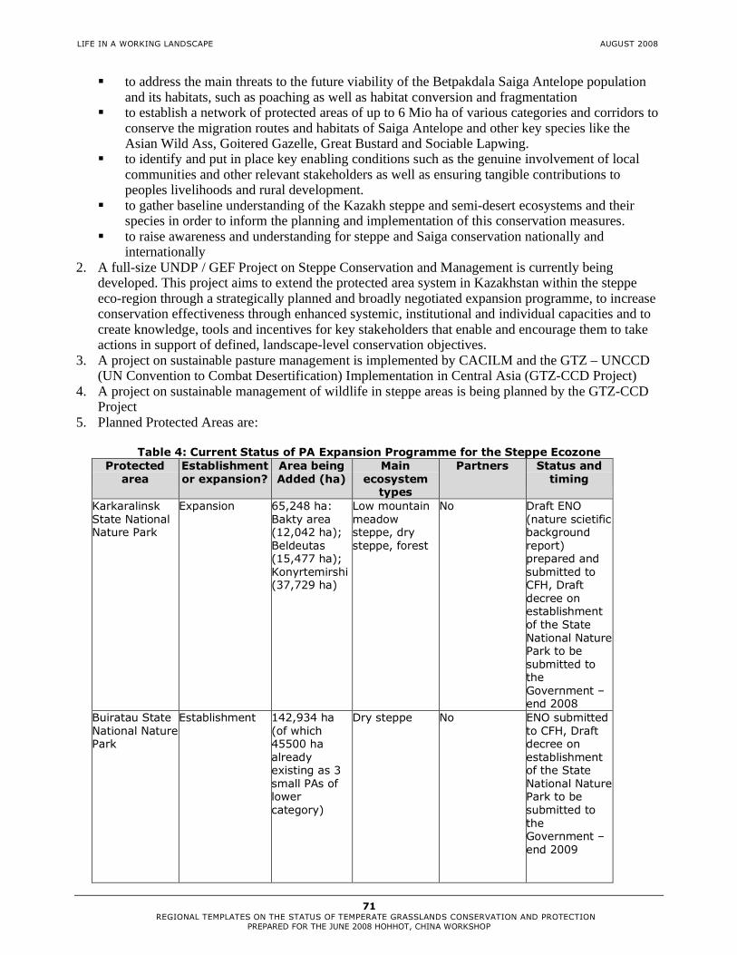
LIFE IN A WORKING LANDSCAPE AUGUST 2008
71 REGIONAL TEMPLATES ON THE STATUS OF TEMPERATE GRASSLANDS CONSERVATION AND PROTECTION
PREPARED FOR THE JUNE 2008 HOHHOT, CHINA WORKSHOP
� to address the main threats to the future viability of the Betpakdala Saiga Antelope population and its habitats, such as poaching as well as habitat conversion and fragmentation
� to establish a network of protected areas of up to 6 Mio ha of various categories and corridors to conserve the migration routes and habitats of Saiga Antelope and other key species like the Asian Wild Ass, Goitered Gazelle, Great Bustard and Sociable Lapwing.
� to identify and put in place key enabling conditions such as the genuine involvement of local communities and other relevant stakeholders as well as ensuring tangible contributions to peoples livelihoods and rural development.
� to gather baseline understanding of the Kazakh steppe and semi-desert ecosystems and their species in order to inform the planning and implementation of this conservation measures.
� to raise awareness and understanding for steppe and Saiga conservation nationally and internationally
2. A full-size UNDP / GEF Project on Steppe Conservation and Management is currently being developed. This project aims to extend the protected area system in Kazakhstan within the steppe eco-region through a strategically planned and broadly negotiated expansion programme, to increase conservation effectiveness through enhanced systemic, institutional and individual capacities and to create knowledge, tools and incentives for key stakeholders that enable and encourage them to take actions in support of defined, landscape-level conservation objectives.
3. A project on sustainable pasture management is implemented by CACILM and the GTZ – UNCCD (UN Convention to Combat Desertification) Implementation in Central Asia (GTZ-CCD Project)
4. A project on sustainable management of wildlife in steppe areas is being planned by the GTZ-CCD Project
5. Planned Protected Areas are:
Table 4: Current Status of PA Expansion Programme for the Steppe Ecozone Protected
area Establishment or expansion?
Area being Added (ha)
Main ecosystem
types
Partners Status and timing
Karkaralinsk State National Nature Park
Expansion 65,248 ha: Bakty area (12,042 ha); Beldeutas (15,477 ha); Konyrtemirshi (37,729 ha)
Low mountain meadow steppe, dry steppe, forest
No Draft ENO (nature scietific background report) prepared and submitted to CFH, Draft decree on establishment of the State National Nature Park to be submitted to the Government – end 2008
Buiratau State National Nature Park
Establishment 142,934 ha (of which 45500 ha already existing as 3 small PAs of lower category)
Dry steppe No ENO submitted to CFH, Draft decree on establishment of the State National Nature Park to be submitted to the Government – end 2009

LIFE IN A WORKING LANDSCAPE AUGUST 2008
72 REGIONAL TEMPLATES ON THE STATUS OF TEMPERATE GRASSLANDS CONSERVATION AND PROTECTION
PREPARED FOR THE JUNE 2008 HOHHOT, CHINA WORKSHOP
Protected area
Establishment or expansion?
Area being Added (ha)
Main ecosystem
types
Partners Status and timing
Korgalzhyn State Nature Reserve
Expansion 284,208 ha Moderately dry, dry and desertified steppe, aquatorial areas, wetlands
UNDP/GEF Draft decree on expansion to be submitted to the Government – end 2008
State Nature Rezervat “Altyn Dala”
Establishment 489,774 ha Desertified steppe, dry steppe, lakes
Altyn Dala Conservation Initiative (ADCI), ACBK
ENO approved by CFH, submitted to Ministry of Environmental Protection for EIA
7.5 Constraints Against Improving the Level of Protection and
Conservation in the Region
The main constraints to effective steppe conservation in Kazakhstan are: (i) Systemic, institutional and individual capacity for steppe conservation and management: Protected areas are managed in isolation from the surrounding landscapes and there is no or insufficient cooperation between conservation agencies, development sectors and land-use planning authorities at national and regional (oblast) levels; (ii) Knowledge and management barriers: Steppe ecology and interactions between habitats and species are not yet fully understood; (iii) governmental development strategy aims to expand wheat production in arable lands (especially chernozems).
7.6 Suggested Next Steps and Action Plan
1. Establishment and expansion of a network of steppe protected areas (including temporary protected areas) and ensuring their interconnection through ecological corridors and adapted land use types.
2. Improvement of the wildlife management and protected area policy.

LIFE IN A WORKING LANDSCAPE AUGUST 2008
73 REGIONAL TEMPLATES ON THE STATUS OF TEMPERATE GRASSLANDS CONSERVATION AND PROTECTION
PREPARED FOR THE JUNE 2008 HOHHOT, CHINA WORKSHOP
7.7 Appendices
Map 1: Protected Area System in Kazakhstan

LIFE IN A WORKING LANDSCAPE AUGUST 2008
74 REGIONAL TEMPLATES ON THE STATUS OF TEMPERATE GRASSLANDS CONSERVATION AND PROTECTION
PREPARED FOR THE JUNE 2008 HOHHOT, CHINA WORKSHOP
Table 5: List of Steppe Protected Areas in Kazakhstan
Protected area
Size (ha)
Korgalzhynskiy State Nature Reserve 258963 Naurzumskiy State Nature Reserve 191381 Alakolskiy State Nature Reserve 19713 State National Nature Park "Burabai" 83511 Baianaulskiy State National Nature Park 141024 Karkaralinskiy State National Nature Park 90323 Irgiz-Turgaiskiy State Nature Rezervat 763550 State Nature Rezervat "Cemey Ormany" 662167 State Nature Rezervat "Ertys Ormany" 277961 State Natural Sanctuary "Poima Reki Irtysh" 377133 Atbasarskiy State Natural Sanctuary 75100 Bektauatinskiy State Natural Sanctuary 500 Belodymovskiy State Natural Sanctuary 3000 Belagashskiy State Natural Sanctuary 1500 Budarinskiy State Natural Sanctuary 80000 Bulandinskiy State Natural Sanctuary 93500 Vostochniy State Natural Sanctuary 100000 Ereymentauskiy State Natural Sanctuary 35000 Zhaltyrkulskiy State Natural Sanctuary 19000 Karaagashskiy State Natural Sanctuary 6800 Kirsanovskiy State Natural Sanctuary 61000 Kogashikskiy State Natural Sanctuary 15000 Kuvskiy State Natural Sanctuary 33500 Kysylaraiskiy State Natural Sanctuary 18200 Mikhailovskiy State Natural Sanctuary 76800 Novinskiy State Natural Sanctuary 45000 Sarykopinskiy State Natural Sanctuary 51200 Smirnovskiy State Natural Sanctuary 240000 Tounsorskiy State Natural Sanctuary 35000 Turgaiskiy State Natural Sanctuary 348000 Ulytauskiy State Natural Sanctuary 19300
Note: These PAs all include parts of steppe but not all of them are completely located in the steppe zone

LIFE IN A WORKING LANDSCAPE AUGUST 2008
75 REGIONAL TEMPLATES ON THE STATUS OF TEMPERATE GRASSLANDS CONSERVATION AND PROTECTION
PREPARED FOR THE JUNE 2008 HOHHOT, CHINA WORKSHOP
References
Dieterich, T. 2000. Landschaftsökologische Untersuchungen an Ackerbrachen im zukünftigen Biosphärenreservat „Tengis See“ in Zentralkasachstan und ihr Regenerierungsvermögen zur Steppe. Diploma thesis. University of Greifswald. 145 pp. (in German) Ministry of Agriculture of the Republic of Kazakhstan 2007. http://www.minagri.kz/agro/?ID=1442, 21.07.2008 NBSAP (National Strategy and Action Plan on Conservation and Sustainable Use of Biological Diversity) in the Republic of Kazakhstan, Ministry of Natural Resources and Protection of Environment of the Republik of Kazakhstan. Kokshetau 1999. Rachkovskaya, E.I., Ogar, N.P., Marynich, O.V. 1999, Redkie pastitelnye soobshchestva stepej Kazakhstana i ikh okhrana. Stepnoj Buletin: Novosibirsk. 3-4, pp 41-46. (in Russian) Walter, H. and Breckle, S.W. 1994: Spezielle Ökologie der Gemäßigten und Arktischen Zonen Euro-Nordasiens. Stuttgart, UTB, Gustav Fischer. 726 pp. (in German) Ward, D. 2006. Long-term effect of herbivore on plant diversity and functional types in arid ecosystems. In: Conservation Biology 11, Large Herbivore Ecology, Ecosystem Dynamics and Conservation, ed. K. Danell, P. Duncan R. Bergström & J. Pastor. Cambridge University Press. 506 pp. The History of the Kazakh SSR: From the most ancient times to present days. In five volumes. Volume V. – Alma-Ata, “Nauka” KazSSR, 1980. pp. 265-402. (In Russian)

LIFE IN A WORKING LANDSCAPE AUGUST 2008
76 REGIONAL TEMPLATES ON THE STATUS OF TEMPERATE GRASSLANDS CONSERVATION AND PROTECTION
PREPARED FOR THE JUNE 2008 HOHHOT, CHINA WORKSHOP
8. TEMPERATE GRASSLAND REGION: MONGOLIA
Lead Author: Tumurbaatar Enebish, email: [email protected] Contributor: Namkhai.A
8.1 Major Indigenous Temperate Grassland Types
Mongolia possesses a wide range of grasslands. The territories with the steppes vegetation extend from the western up to the eastern frontiers of the country (from 900 up to 1200E longitude), while in the south they reach 440 20’N latitude. Flora of Mongolian steppes is represented by 5 large geographic groups, which are divided into more fractional geoelements: 1. South-Eastern Siberia-North Mongolian 2. Proper Mongolian 3. Central Asian 4. West Palaearctic-West Mongolian 5. East Asian (Manchurian, Daguur-Mongolian, Daguur-East Mongolian) (Karamysheva, Khramtsov, 1995). The South-Eastern Siberia-North Mongolian steppe consisting of the cryoxerophytic forb-bunch-grass and cushion-bunch-grass are found on the higher mountains such as Mongol Altai, Gobi Altai, Khangai and east Khentii. The Proper Mongolian steppes composed of Caragana microphylla (Pall), Cleistogenes squarrosa (Trin) and Cymbaria dahurica L. occupy of the central part of Mongolia. The Central Asian steppes consist of Anabasis brevifolia C.A.Mey, Stipa gobica Rochev, Cleistogenes songorica Ohwi and Allium mongolicum Regel. This steppe vegetation occupies the basin of Hyargas, Khar us, Boontsagaan, Orog and Taats lake and the desert steppe region. The West Palaearctic-West Mongolian steppes consisting of Veronica pinnata L, Allium galanthum Kar, Stipa pennata and Spiraea hyericifolia occupy the basin of Uvs lake, Hovd, Zavkhan, Bulgan River Watershed and Khan-khokhii Mts. The East Asian steppes composed of Iris dichotoma Pall, Paeonia lactiflora Pall, Filifolium sibiricum (L), Clematis hexapetala Pall, Spiraea aquilegifolia Pall, and Bupleurum scorzonerifolium Willd occupy the eastern and northern part of the country.
AUTHORS

LIFE IN A WORKING LANDSCAPE AUGUST 2008
77 REGIONAL TEMPLATES ON THE STATUS OF TEMPERATE GRASSLANDS CONSERVATION AND PROTECTION
PREPARED FOR THE JUNE 2008 HOHHOT, CHINA WORKSHOP
8.2 Impact of Human Settlement
The grassland degradation is now considered one of the most pressing problems for Mongolia. Causes of degradation vary, overgrazing in areas close to markets and water points due to the failure to manage and maintain deep water wells; mining operation, especially gold mining, coupled with the lack of land rehabilitation and infrastructure development (road construction).
8.3 Current status
8.3.1 Natural state
At the regional level, according to our calculation, the grassland area occupies 70.2% of the country’s total land.
7.7% of the grassland area is covered by South Eastern Siberia-North Mongolian steppe, 6.6% is covered by Proper Mongolian steppe, 15.4% is covered by Central Asian steppe, 10.2% is covered by West Palaearctic-West Mongolian steppe, 30.3% is covered by East Asian steppe (see Figure 1).
70.2
7.7
6.6
15.4
10.2
30.3
0 10 20 30 40 50 60 70 80
Regional level
SES-NM
PM
CA
WP-WM
EA
Figure 1: Proportion of major grassland types
8.3.2 Formal Protection
At the regional level, at present 10.3% of the country’s total grassland area is taken under state protection.
South Eastern Siberia-North Mongolian steppe has 18.6% of PA cover, Proper Mongolian steppe has 1.5% of PA cover, Central Asian steppe has 19.3% of PA cover, West Palaearctic-West Mongolian steppe has 7.8% of PA cover while East Asian steppe has 6.4% of PA cover (see Figure 2).
10.3
18.6
1.5
19.3
7.8
6.4
0 5 10 15 20 25
Regional level
SES-NM
PM
CA
WP-WM
EA
Figure 2: Proportion of Protected Area coverage by major grassland types

LIFE IN A WORKING LANDSCAPE AUGUST 2008
78 REGIONAL TEMPLATES ON THE STATUS OF TEMPERATE GRASSLANDS CONSERVATION AND PROTECTION
PREPARED FOR THE JUNE 2008 HOHHOT, CHINA WORKSHOP
8.4 Opportunities for Improving the Level of Protection and Conservation
� Much of the grasslands in Mongolia remain in a natural state. Table 1 lists the important grassland areas with potential to improve the level of protection in the region and proposed grassland protected areas.
Name of grassland areas
%
remaining
areas
% PA
coverProposed grassland PA
Sangilen Mts steppe 100 0.0 Shavariin gol, Jugnai nuurUilgan forest steppe 99 1.0 Uilgan river watershedEg-Selenge forest steppe 96.7 3.3 Zed-Hantai-Buteel, Burengiin nuruu North West Hentii forest steppe 100 0.0 Honin nugaNuuruudiin hondii desert steppe 100 0.0 Boon Tsagaan nuur, Orog nuurSouthern Hangai Mts steppe 100 0.0 Galuutiin havtsal, Oshgogiin nuruuBulnai Mts steppe 100 0.0 Bulnain nuruu
Orhon-Hanui steppe 99.8 0.2Tunel, Dulaan haan uul, Olon goliin belchir
Tuul-Tarna steppe 96.2 3.8 Ogii nuurUlz watershed 95.9 4.1 Ugtam uul Natural Reserve extensionDundad khalkh plain upland 100 0.0 Nyalgiin tal, Sum hoh burdOndorhaan-Baruun urt steppe 100 0.0 Sansar uulMenen steppe 100 0.0 Menengiin tal, Buir nuur, Jaran togoon tal Mandal ovoo-Huld desert steppe 96.2 2.8 Delger hangai uul
Table 1: List of the important grassland areas in Mongolia
� Mongolia has a strong conservation policy. Conservation policy of Mongolia is outlined in documents, including the National Program on Protected Areas and the Millennium Development Goals (2000-2015) to increase coverage of protected areas up to 30 percent of its land.
� Mongolia has a population of only 2.5 million people. The country has a low population density of
1.5 persons per km2. � Much of the land is owned by the State.
� Mongolians have unique traditions for grasslands conservation.
8.5 Constraints Against Improving the Level of Protection and Conservation in the Region
� The important and proposed grassland areas have been included in the areas under licenses for exploration minerals and mining Mining is primary economic activity in Mongolia. As of 2007 more than 30% of GDP and about 80% of the country’s total exports have been contributed by the mining industry. Currently, the areas under lease for exploration minerals and mining occupy almost 30% of the country’s total land.
� Compensation for land taken under state special protection
According to the Law on Mineral Resources of Mongolia the state administrative organization which made decision taken land under state special protection shall provide compensation to license possessor.
� Lack of financial capacity for protection and conservation
The financial capacity of the special protected areas of the country is very low. Special protected areas taken under state protection get US$4 per square km (Special Protected Areas of Mongolia, 2007).

LIFE IN A WORKING LANDSCAPE AUGUST 2008
79 REGIONAL TEMPLATES ON THE STATUS OF TEMPERATE GRASSLANDS CONSERVATION AND PROTECTION
PREPARED FOR THE JUNE 2008 HOHHOT, CHINA WORKSHOP
� Lack of human and technical resources for grassland conservation The state protected areas, which comprised 3.6% in 1990, were increased to 13.1% in 2000 and further to 13.3% in 2006. This rapid increase of the protected areas in the region requires more trained people to work for them.
� Lack of incentives to protect and conserve grassland
Restricted use rights upon local people and business entities.
� Grassland areas have been abandoned Due to the open access pastureland use system, the grassland areas of the region have been abandoned.
8.6 Suggested Next Steps and Action Plan
� Establish a study team to prepare a proposal for establishing new grassland protected areas in the region
� Prepare a proposal for establishing new grassland protected areas � Consultation with local herders, local and central government, mining companies, and NGOs � Workshops for decision makers � Submit a final proposal to the Ministry of Nature and Environment � Support to train young grassland experts in developed countries to get qualifications and academic
degrees � Experience sharing study tours to grassland areas of other temperate grassland region � Support herder cooperation for sustainable grassland management � Support well rehabilitation and new well construction in the region � Promote trans-frontier initiative � Support conservation the grasslands through culture
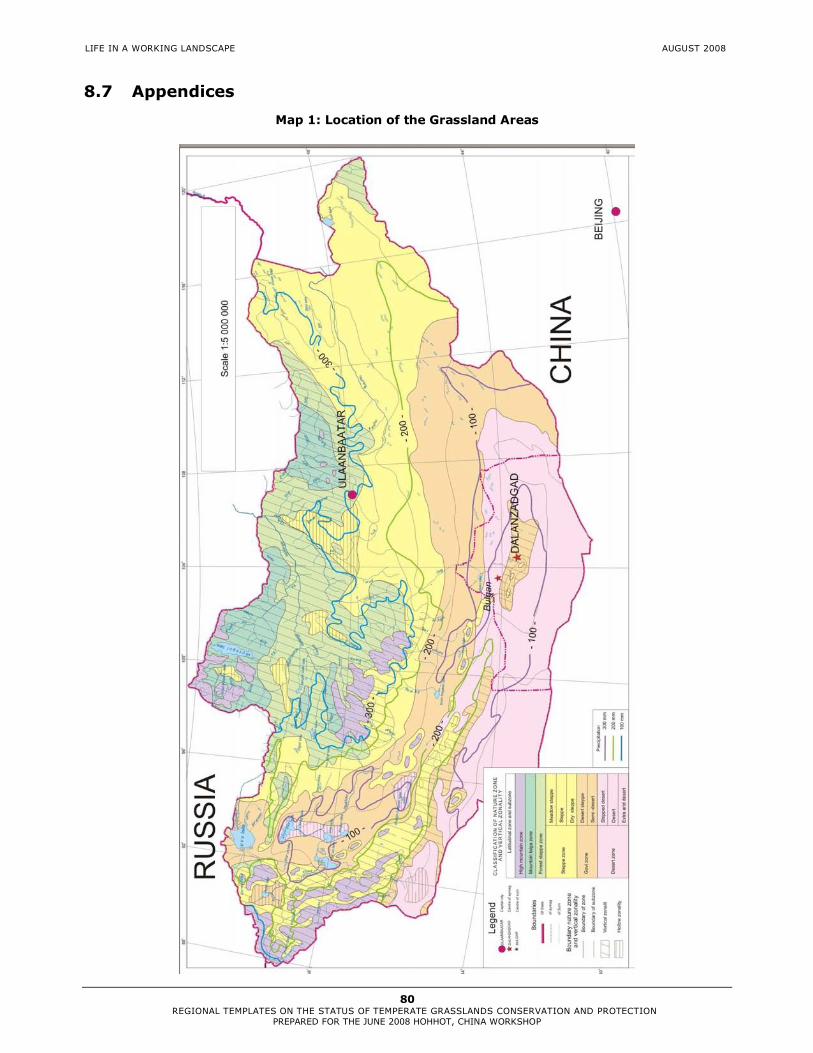
LIFE IN A WORKING LANDSCAPE AUGUST 2008
80 REGIONAL TEMPLATES ON THE STATUS OF TEMPERATE GRASSLANDS CONSERVATION AND PROTECTION
PREPARED FOR THE JUNE 2008 HOHHOT, CHINA WORKSHOP
8.7 Appendices
Map 1: Location of the Grassland Areas

LIFE IN A WORKING LANDSCAPE AUGUST 2008
81 REGIONAL TEMPLATES ON THE STATUS OF TEMPERATE GRASSLANDS CONSERVATION AND PROTECTION
PREPARED FOR THE JUNE 2008 HOHHOT, CHINA WORKSHOP
Table 2: List of Grassland Protected Areas in Mongolia
Major Grassland Types Name of PA Area ha
1
South-Eastern Siberia-
North Mongolian Hoh Serh SPA 65,920Otgontenger SPA 95,510Siilhem NP part A 68,300Altai tavan bogd NP 636,161Monkhhairhan NP 300,446Myangan ugalzat NP 63,212Noyonhangai NP 59,088Hangai nuruu NP 888,455Burhan buudai NR 52,110Huisiin naiman nuur NM 11,500Total 2,240,702
2 Proper Mongolian Hogno-Tarna NP 83,612Hustain nuruu NP 50,620Bathaan NR 21,850Total 156,082
3 Central Asian Hasagt hairhan SPA 27,448Gobi gurvan saihan NP 2,694,737Har us lake NP 850,272Hyargas lake NP 332,800Sharga-Manhan NR 390,071Ih Nart NR 43,740Zagiin us NR 273,606Ih gazriin chuluu NR 34,094Total 4,646,768
4
West Palaearctic-West
Mongolia Uvs nuuriin ai sav SPA 712,545Siilhem NP part B 74,400Han Hohii NP 220,500Tsambagarav NP 110,960Bulgan gol NR 7,657Tesiin gol orchim NR 102,897Devel NR 10,300Total 1,239,259
5 East Asian Bogdhan SPA 41,651Mongol Daguur SPA 103,016Dornod Mongol SPA 570,374Nomrog SPA 311,205Gorhi-Terelj NP 293,168Onon-Balj NP 415,752Har yamaat NR 50,594Lkhachinvandad uul NR 58,800Bulgan uul NM 1,840Uran-Togoo-Tulga uul NM 5,800Shiliin bogd NM 17,935Horgiin hondii NM 6,041Total 3,044,369Grand total 11,327,180
SPA-specific protected area, NP-national park, NR-natural reserve, NM-natural monument

LIFE IN A WORKING LANDSCAPE AUGUST 2008
82 REGIONAL TEMPLATES ON THE STATUS OF TEMPERATE GRASSLANDS CONSERVATION AND PROTECTION
PREPARED FOR THE JUNE 2008 HOHHOT, CHINA WORKSHOP
9. TEMPERATE GRASSLAND REGION: RUSSIA - AMUR RIVER BASIN
Eugene Simonov ([email protected]), Virtual Amur Information Center (VICAR) 9.1 Major Indigenous Temperate Grassland Types
Actual steppe in the east extends to the border of the areas with monsoon climate. Further east outside of Steppe Region other grassland communities develop in much more humid conditions and are confined to large river (Amur, Zeya, Bureya, Ussury, Suiphun-Razdolnaya) and lake valleys (Lake Khanka) and alluvial plains: Lower Amur Valley, Amur Meadow Steppe, and Suiphun-Khanka forest meadows ecoregions . Each of those ecoregions contains extensive graminoid communities, but in common classifications they are usually treated only as fringes of wetlands. Total area with high proportion of grassland and forest-steppe ecosystems is roughly between 100 000 and 200 000 square kilometers, out of which more than 10 000 sq. km is occupied by floodplains and the rest belongs to adjacent alluvial plains and river terraces. Amur river system is a major historic dispersion corridor for fauna and flora, with mind-boggling mix of Daurian, Manchurian, Siberian and Okhotsk-Beringian species. Therefore remnant steppe, steppe-meadow and forest-steppe areas along river valleys are evidence of evolutionary dispersal of steppe and grassland flora in north-East Asia. Upper Amur valley Amursky Province of Russia and Heilongjiang Province of China hosts small, but very species rich patches of steppe vegetation on slopes with high proportion of species from regional red lists (V.Starchenko, Amur Botanical Garden. 2005, 2007). Below City of Blagoveshensk on Russian side Zeya-bureya Plain hosts vast variety of meadow types from dry steppe meadows and forest-meadows to floodplain meadows, collectively known as “Amur prairie”. Typical dominants of these meadows are Calamagrostis purpurascens, C.epigeios with wide array of forbs including lilies, orchids, ragworts, cinquefoils, etc. Upper terraces between Zeya and Bureya feature savanna-like of groves Quercus mongolica, Betula davhurica surrounded by true steppe grass species including fescue and feather-grass, Filifolium sibiricum, Sophora flavescens, Picris davurica, Clematis hexapetala, Leymus chinensis. (Taran 2005). Downstream from Hinggan gorge (Evreiskaya Autonomous Province, Khabarovsky Province in Russia and Heilongjiang Province of China Calamagrostis langsdorfii is a dominant species in Amur floodplain shaping a belt of gramineous communities 1600 kilometers long all the way to the Pacific coast. (Akhtyamov M. 2000) This floodplain ecosystem is very dynamic, due to unique accumulation process that constantly raises the river bed (instead on cutting deeper down), which leads to stable dynamic prevalence of grasslands over shrubbery and trees (Makhinov A.N. 2006). Surrounding alluvial planes also feature many graminous communities and forest-meadow formations. Khanka lowlands in Primorsky Province of Russia and Heilongjiang Province of China along with transboundary stretch of Ussury River also host notable grasslands. Lower parts are covered with reed beds and Zizania, reed and sedge meadows. Upper parts affected by agriculture still have remnant relic steppe communities with Cleistogenes chinensis, Stipa baicalensis, onions, wormwood, asters, irises, etc. Some well-drained areas dominated by Arudinella anomala have resemblance with North-American prairie. Forest fringes with Quercus mongolica, Betula davhurica also have unusual forest-steppe communities with Manchurian and Siberian apricots forming canopy and steppe grasses and forbs in groundcover. (Taran 2005).
AUTHOR

LIFE IN A WORKING LANDSCAPE AUGUST 2008
83 REGIONAL TEMPLATES ON THE STATUS OF TEMPERATE GRASSLANDS CONSERVATION AND PROTECTION
PREPARED FOR THE JUNE 2008 HOHHOT, CHINA WORKSHOP
These areas are globally important habitats of Red-Crowned Crane, White-Naped Crane, Oriental White Stork and a number of other globally endangered species. Great Bustard (Otis tarda) was common in the Khanka lowland and Amur prairie less than 100 years ago, but not seen in last decades. Roe deer is the most common ungulate species, famous for massive seasonal migrations in the area. 9.2 Impact of Human Settlement
Except for Lower Amur downstream from Khabarovsk City the whole area is severely affected by agriculture. For well understandable reasons mesic grasslands were first choice for placing croplands ever since agriculture started here. Khanka Lowlands, Sanjiang plain in China, Zeya-Bureya Plain in Russia are areas with highest rates of agricultural conversion. Conversion to rice-paddies is the most radical ecosystem alteration common in Khanka Lowlands and Sanjiang plain. Human-induced fires are a major factor in all abovementioned ecosystems. Anywhere from 30 to 80% of grass-cover in Russian part is affected by fires annually, significantly influencing species composition and productivity. In China fires are more under control, but at least 80% of grasslands converted into croplands. Hydro-power plants on Zeya, Bureya and to less extent Songhua influence flood regime and sedimentation patterns in floodplains, leading to major changes in ecosystems. Plans to build HPP on Amur main stem is the main threat to floodplain ecosystems. Settlements and transportation infrastructure are confined to upper slopes of river values, therefore also first affecting communities in question. 9.3 Current Status
9.3.1 Natural State
Current status estimates depend on how you treat fire impacts. Only 5-10 % of grasslands are affected by fires less than once in 5 years, which is probably as “natural” as you can get. Lower Amur valley downstream from Khabarovsk City is affected by other factors much less than other grasslands described. However, here is the opposite problem of growing area of secondary grasslands in place of forests exterminated by fires and logging. Khanka Lowlands, Sanjiang plain in China, Zeya-Bureya Plain have highest rates of agricultural conversion and thus only from 5 to 20 % of grasslands+wetlands in near-natural state. In each of areas steppe meadows and forest meadows are more affected by human impacts than floodplain wetlands.
LIFE IN A WORKING LANDSCAPE AUGUST 2008
84 REGIONAL TEMPLATES ON THE STATUS OF TEMPERATE GRASSLANDS CONSERVATION AND PROTECTION
PREPARED FOR THE JUNE 2008 HOHHOT, CHINA WORKSHOP
9.3.2 Formal Protection
Total Area – my estimate is 5 %, mostly protected wetlands. Amur floodplain meadows – approx 2% Khanka Lowland meadows and wetlands – 10-20% (not accounting for experimental zones of reserves in China) Zeya-Bureya plain meadows and wetlands – 10-15 % Upper Amur Valley -- cannot estimate. Ussury River floodplain meadows and valley slopes – 50% in China and 1% in Russia. 9.4 Opportunities for Improving the Level of Protection
and Conservation in the Region Policy -- Supporting new Russia-China biodiversity and transboundary PAs working group that is tasked to develop joint conservation strategy for transboundary ecosystems. PA assessment --- Promote establishment of green Belt of Amur-Heilong – transboundary network of protected areas. The existing network of protected areas must be thoroughly assessed to provide uniform data for Ecological network design. Uniform GAP analysis made possible by use of standard methodology and basin-wide databases. Lobbying national governments for establishment of higher number of national-level PAs along the border and probably enacting special legislation supporting this process Border issues --Assessment of border area in terms of potential biodiversity value, present degree of human impacts and actual and potential threats. Major communication effort on national and bilateral levels to enlist conservation as and important issue of national security (environmental security), which could be solved by concerted bilateral efforts. Development of proposals for additional protected areas in the border zone based on assessment exercise and preliminary negotiation with responsible authorities. Communication effort directed both to the commanding staff of border guards and lay-units to achieve understanding that conservation is already part of their agenda and performance in this field could be greatly improved with the help of conservation NGOs. Fire control--Exploit China’s success in fire control and measure its actual influence on ecosystems and species; Develop regular communication between nature reserve managers engaged in fire-control and help them to access advanced world-wide programs (WWF_TNC alliance, etc) to provide opportunities to upgrade their thinking and technology. Conduct actual assessment of fire frequency and impacts on ecosystems in selected transboundary river valleys. Model projects -- Reviving Ussury\Wusuli Project of 1996 to promote coordinated transboundary land-use planning and establishment of Ussury\Wusuli River Basin commission by provincial governments. (In 1998 MOU was signed between three provinces) Flagship species -- Activities to protect Oriental Stork: Develop species-range –wide monitoring system and maps of stork density/dynamics. Stork –best model species for Sino-Russian habitat conservation plan. Establish new nature reserves, nest protection and construction program, conduct regular counts, support reintroduction programs in parts of stork’s former range, etc)

LIFE IN A WORKING LANDSCAPE AUGUST 2008
85 REGIONAL TEMPLATES ON THE STATUS OF TEMPERATE GRASSLANDS CONSERVATION AND PROTECTION
PREPARED FOR THE JUNE 2008 HOHHOT, CHINA WORKSHOP
9.5 Constraints Against Improving the Level of Protection and Conservation in the Region
� All ecosystems, except for Lower Amur Valley divided by national border, conservation efforts poorly coordinated and low on national agenda for bilateral cooperation.
� Ecology of local grasslands poorly studied, including natural and human-induced dynamics. � Fire not controlled in Russia due to weak enforcement, lack of responsibility and long-standing
tradition of grass-burning � Agricultural reclamation speeding up in China and migrant Chinese farmers leasing land on Russian
bank. � Military border protection policies have poorly defined ecosystem conservation component. Many
areas are inaccessible for surveys and conservation work, but accessible for economic exploitation. 9.6 Suggested Next Steps and Action Plan
Table 1: Next Steps
Activity Description 1. KHANKA-WUSSULI ECOREGION PROTECTED AREAS CORRIDOR
Covers full 200 km stretch of the border from Lake Khanka to Raohe/Bikin on Middle Ussuri River. Prime Stork habitat. Due to strong China wetland conservation policies Khanka ecoregion is plastered with 6-7 large protected areas in China. So far it has little symmetric response from Russia which makes river floodplain/valley ecosystems unprotected in a longer term. In Amur Basin this is the best ecoregion to try to use conservation/ecological network policies in one country (China) to improve cooperation and initiate complementary policies in another country. Issues range from floodplain wetland and river valley ecosystem conservation (reportedly one of two most species rich places in whole basin) to protection of key habitat for oriental stork, tiger conservation, transboundary reserve enhancement.
2. Comprehensive forest/wetland habitat conservation planning.
Develop comprehensive conservation program addressing forest and wetland-grassland landscape conservation in Ussury/Wusuli watershed, where the same network of protected areas is managed as wetland corridor and as migration corridor for large mammals (tiger, prey). Dongfanghong nature reserve seem to be most promising model site to launch this approach. This will combine goals of wetland conservation in Suifen-Khanka ecoregion and forest conservation in top-priority Ussury Forests ecoregion, making one local model project address key issues in two Global 200 ecoregions.
3. Species/wetland habitat protection Inventory of important habitats
Identify and plan protection measures in habitats of key species: rare bird breeding areas, fish spawning areas and turtle breeding beaches. Oriental stork inventory. Assessment and conservation mapping of wetlands in transboundary river valleys of Ussury and Songacha as a basis for PA planning. Identify, map and secure key forest-steppe areas as corridors between Khanka lake, river valleys and surrounding mountains
Oriental stork Oriental white stork-Protection of key nesting areas along Ussury and tributaries, fire control, artificial nesting
LIFE IN A WORKING LANDSCAPE AUGUST 2008
86 REGIONAL TEMPLATES ON THE STATUS OF TEMPERATE GRASSLANDS CONSERVATION AND PROTECTION
PREPARED FOR THE JUNE 2008 HOHHOT, CHINA WORKSHOP
Activity Description 4. PA adjustment and expansion
Develop the Econet as the system of protected areas connected by the buffer zones and ecological corridors: --improve the environmental regime in buffer zone of Khankaiskii nature reserve on army testing range and implement other measures to solidify reserve territory and protection regime; --improve the protection regime of Xinkaihu nature reserve on China side, expand core zone to Songacha and no-fishing core zone across the lake; --support establishment and management of reserves along important wetland corridors on Wussuli/Ussuri and Songacha.
5. Trans-boundary Management Plan for International Reserve
Improve the collaboration within Russian-China Khankaiskii/Xinkaihu transboundary nature reserve and extend it to other wetland reserves of Siufen-Khanka forest meadow ecoregion: --elaborate the Trans-boundary Management Plan (for Ramsar wetlands) and conduct the International Conference to adopt these TMP
6. Analysis of reviving agriculture and env impacts.
Khanka Lakes Lowland. The area is relatively small, even if the whole lake watershed is considered. International management of transboundary waterbody and resolving conflict between agriculture and conservation.
7. Capacity building for transboundary conservation
Conduct joint training for nature reserve staff of wetland nature reserves of the ecoregion: Russia-China Khankaiskii/Xinkaihu, Zhenbaodao, Dongfanghong, etc. Elaborate and implement the program of artificial nesting of Oriental Stork in all PAs ; Support the fire-fighting brigades, joint planning and mutual training in fire-control; --Involve the boundary guards to control poaching/illegal fishing along the border
9.7 Appendices
References
Taran Aleksander. It is not only the Forests. You have to see beyond the trees: Grasslands of Southern Far East. Pp.155-166. (In Facets of Grassland Restoration. Biodiversity Conservation Center. Moscow. 2005.) Makhinov A.N. Present relief formation in the conditions of alluvial accumulation. Valdivostok. Dalnauka 2006. Ahtyamov Midkhat. Meadow communities of Lower Amur . ( Taxonomy of communities). Starchenko V. (Ed) Red Book of Plants of Amursky Province.

LIFE IN A WORKING LANDSCAPE AUGUST 2008
87 REGIONAL TEMPLATES ON THE STATUS OF TEMPERATE GRASSLANDS CONSERVATION AND PROTECTION
PREPARED FOR THE JUNE 2008 HOHHOT, CHINA WORKSHOP
10. TEMPERATE GRASSLAND REGION: RUSSIAN STEPPES
Ilya Smelansky ([email protected] , +7-383-3630059, +7-913-4530601, NGO Siberian Environmental Center, P.O. Box 547, Novosibirsk 630090 Russia) Eugene Simonov ([email protected])
10.1 Major Indigenous Temperate Grasslands Types
Along with steppes Russia has many other grassland ecosystem types occupying vast areas. These are different kinds of dry meadows (both serial and edaphic), floodplain and coastal meadows, alpine meadows and alpine lawns, high-mountainous grasslands dominated with Cobresia spp., salt and freshwater marshes, halophytic grasslands in inland and coastal salt habitats, etc. This template describes only steppes proper (and one additional template is filled for Amur river basin floodplain meadows).
Accurate inventory of total steppe area in Russia has not been done yet; neither has it existed for total area of all temperate grasslands here. Approximate estimation of total grasslands area based on land-use data would yield 670,000 sq.km (with mountainous grasslands are underestimated and without polar tundra). By this method the steppes area is estimated at 500,000 sq.km (Figure 1). Steppe grasslands are presented at 36 administrative provinces of Russia lying south from N55°. From these 15 provinces are situated in the core of Eurasian Steppe Region and formerly were almost entirely covered with steppe grasslands, while recently each of them keeps from 10 to 30+% grasslands area only (Figure 2). In several southern provinces (Kalmykia, Astrakhan, and flat part of Daghestan) the natural semiarid grasslands take up to 50-70% of whole territory, but there is a complex of steppes, semideserts, and sagebrush deserts. Share of each ecosystem type is unsteady here, their ratio dramatically changes during last decade.
Huge Eurasian steppe biome is divided along latitudinal/altitudinal and longitudinal gradients, which leads to many subdivision schemes recognized by different authors (Kucheruk 1959; Lavrenko et al. 1991; Mordkovich 1982; Chibilyov 1998; Nikolaev 1999; Korolyuk 2002). Here we only describe common basic gradients and characteristics used for such zoning.
Latitudinal and Altitudinal Zoning According to zoning by E.M.Lavrenko (1970, 1991) most accepted in post-Soviet countries, the steppe zone in the Eurasian plains is split into 4 latitudinal bands. All those have analogous zones describing altitudinal changes in the mountains in the south of Russia. In general from north to south (as well as down-up along altitudinal gradients) there is decreasing species richness, total biomass, share of aboveground biomass (from 1/8 to 1/30 within the whole gradient), productivity (by 100 times), vegetation coverage density, etc. Number and diversity of small burrowing mammals as well as other burrowers increase from north to south. 1) Meadow steppes are the least dry and the most mesophytic steppe grasslands, typically form grassland component of forest-steppe landscapes and intermingle with tree and bush groves even on plain watersheds. Grass canopy is dense and colorful, dominated with many species of loose-bunch grasses and forbs. The vegetation species richness (up to 80 species per are), evenness, coverage (about 100%), total biomass (15-30 t/ha), and productivity (18-25 t/ha) are high. The relatively high share of biomass is above-ground. Many blossom waves alternate non-stop one after another from April to October. Characteristic species are: Phleum phleoides, Poa stepposa, Helictotrichon schellianum, Calamagrostis epigeios, S. pennata, Carex humilis, etc. The most thick Chernozem soils are formed under meadow steppes.
AUTHORS

LIFE IN A WORKING LANDSCAPE AUGUST 2008
88 REGIONAL TEMPLATES ON THE STATUS OF TEMPERATE GRASSLANDS CONSERVATION AND PROTECTION
PREPARED FOR THE JUNE 2008 HOHHOT, CHINA WORKSHOP
2) Genuine forbs-bunchgrass steppes. Dominated by xero-mesophytic graminoids (Stipa zalesskii, S. tirsa, S. pulcherrhima, Helictotrichon desertorum are characteristic), and have significant share of xero-mesophytic and even mesophytic forbs. Blossom waves are not so numerous; vegetation development is interrupted with short summer pause while not every year. Typical Chernozem soils are formed under these grasslands. 3) Genuine (dry) bunchgrass steppes are even more droughty grassland type. Dominated by xerophytic and meso-xerophytic graminoids (e.g. Stipa lessingiana, S. krylovii, Festuca valesiaca, Koeleria cristata, Agropyron pectinatum), with xerophytic semi-shrubs (Artemisia spp., some other Asteraceae, Chenopodiaceae, etc.). Vegetation is not dense; the main biomass is placed belowground. The characteristic soils (in Russian classification) are Southern Chernozem, Dark Kastanozem, and Kastanozem. Many authors combine the types (2) and (3) into a more large genuine steppes unit. 4) Desertified and desert steppes are the driest types. Vegetation is rather sparse; no more than 20% of the ground is covered with plants while belowground root systems are densely packed. Typical dominants are Stipa sareptana, S. glareosa, S. caucasica, S. gobica, Cleistogenes squarrosa. The characteristic soils are Light Kastanozem, and Kastanozem. Desertified steppes form a steppe component of semi-desert landscapes, where they are intermingled with desert dwarf shrubs communities, salt habitats, and xerophytic shrubs communities. 5) Special mountainous steppes. Mountains have many additional steppe formations not found on plains. Especially noteworthy are cold cryophytic steppes in Altay, Dauria, Siberian Beringia (including tundra-steppes communities), where temperate grasslands directly contact and intermingle with alpine tundras. Another type is “subtropical steppe” with Andropogon ischaemum, some species of Elytrygia etc., presented in Caucasus Mountains and also found in mountains of Central Asia. Longitudinal Zoning There are two major sub-regions of the Steppe Region of Eurasia: Pontic-Kazakh Steppe Subregion and East Siberia - Inner Asian (Daurian-Mongolian) Steppe Subregion (Lavrenko et al. 1991; Korolyuk 2002) dividing roughly at Altay Mountains and Enissey river. More detailed, the Steppe zone in Russia could be divided into 5 longitudinal sectors (and 7 ones are recognized for the whole continent). The Subregions differ in many characters. Flora of each Steppe Subregion is notably different from another one. Distribution of many plant genera is restricted to only one steppe subregion: Cymbaria, Saposhnikovia, Filifolium, Panzeria, Schisonepeta, Stellera, Lespedeza, etc. may be recorded in Eastern steppes only while Trinia, Seseli, Crambe, Salvia, Verbascum, Tulipa, Ornithogalum, etc. are inhabited only Western ones. Feather-grasses (Stipa spp. from Stipa and Barbata sections) specifying the habit of Western steppes are not represented in Inner Asia while all species of Stipa dominating Eastern steppes belong to the needle-grasses, Capillatae (=Leiostipa) section, and Smirnovia section. Many plant and invertebrate species are endemic for only one subregion. Pontic-Kazakh Steppe Subregion is rich with spring ephemeroids while late-summer annuals are characteristic for Daurian-Mongolian steppes due to very different precipitation regime. Communities dominated with Filifolium sibiricum, Leymus chinensis, Stipa baicalensis are not found in Western half of the Steppe Region, and communities dominated with Stipa lessingiana, S. zalesskii, S. ucrainica, Artemisia austriaca and Artemisia spp. from Seriphidium section are not found in Eastern one. Desert steppes type is represented only in Eastern Steppe Subregion.

LIFE IN A WORKING LANDSCAPE AUGUST 2008
89 REGIONAL TEMPLATES ON THE STATUS OF TEMPERATE GRASSLANDS CONSERVATION AND PROTECTION
PREPARED FOR THE JUNE 2008 HOHHOT, CHINA WORKSHOP
Edaphic variants Depending on specific substrate steppes form many types of edaphic variants. The sand (psammophytic) steppes, stony (petrophytic) steppes, different variants of salt steppes, and calcareous steppes are recognized generally. Near all the variants present in every latitudinal band and each Subregion (only sand steppes are restricted to the Western Subregion).
Shrub steppes Shrub species are common component of steppe vegetation in all latitudinal bands and longitudinal sectors. Many shrubs are characteristic for steppe biome as species of Caragana (C. frutex and many other), Chamaecythisus, Calophaca, Spiraea (especially S. crenata, S. hypericifolia, S. trilobata), Amygdalus, Prunus, Cerasus, Armeniaca; Ulmus, etc. Sometimes shrubs has especially important role and define certain steppe community types – they are recognized as special shrub steppes.
Steppe landscape complexes with other ecosystems In most cases steppes are linked with other ecosystem types forming typical landscape of grassland zone. Two most obvious examples are forest-steppe and semi-desert. Both landscapes are regular mosaic of steppe communities with other types.
Throughout vast plains of Western Siberia, Dauria, and to a smaller extent the Russian Plain and Middle Siberia the steppes are combined with salty and freshwater wetlands, salt grasslands, halophytic succulents communities, and are dotted with birch and aspen groves.
Many communities of these landscape complexes are found only or primarily in steppe zone landscapes (characteristic ravine forests and shrubs, steppe wetlands, “rocky steppe” petrophytic dwarf shrubs, etc.). For conservation purposes and any landscape planning these “additional ecosystems” should be treated together with “steppe ecosystem” as holistic landscape complex.
Succession series Dynamic steppe ecosystem is always experiencing extensive and strong disturbances. Therefore all steppe types listed above have their serial and degraded variants. Some kinds of disturbances are common and characteristic for steppes. These are mainly grazing and fire intimately interacting. Another characteristic disturbance is digging activity of burrow-inhabited mammals. Some serial communities have a wide distribution and compose an important part of the steppe biodiversity (e.g. steppes dominated by Stipa capillata and Andropogon ischaemum in Caucasus foothills). 10.2 Impact of Human Settlement
Greatest threat/impact is conversion of steppe into cropland and to far less extent mining, urban growth and transportation infrastructure development. Other most common while not so dangerous impacts include overgrazing, hay cutting, burning. Historically all steppes of Russia have been extensively used by nomadic herders for sheep, horse, camel, and cattle breeding. European crop-based agricultural development started in north-west corner of most productive European meadow-steppes in the 17th century. It was expanding east and south to reach desertified steppes near Caspian Sea by end of the 19th century and arid steppes of Tyva only by 1940-1950s. Meadow steppes and more mesic part of genuine steppes (types (1) and (2) listed above) were massively turned into arable land for production of crops and fodders as early as before the end of 19th century. Forest-steppe zone also has highest population density in Russia and is most affected by infrastructure, industry and urban sprawl. Both types are affected by afforestation that has public support and strong backing of agricultural and forest sciences and agencies. Meadow steppes, at least in European part, are more often plowed to cultivate fodder-crops, rather than used as pastures.

LIFE IN A WORKING LANDSCAPE AUGUST 2008
90 REGIONAL TEMPLATES ON THE STATUS OF TEMPERATE GRASSLANDS CONSERVATION AND PROTECTION
PREPARED FOR THE JUNE 2008 HOHHOT, CHINA WORKSHOP
Genuine dry bunchgrass steppes (type 3) were massively reclaimed into croplands in the 1950s. But their use as croplands is not sustainable due to climate fluctuations, lower soil fertility, lack of moisture, widespread salinity, etc. Therefore many of these croplands were abandoned after 1991, and recently are a scene of old-field succession. This type of steppes is widely used as seasonal pastures. In some southern mountains still sustain nomadic grazing (South-East Altay, Tyva). Desertified and desert steppes could become croplands only through costly irrigation. They are mostly used as rangelands for seasonal grazing. High-mountainous cryophytic steppes are used as seasonal and nomadic rangelands only. It had never been plowed at all. Stony slopes, sand steppes, and the salt habitats cannot be converted into croplands and often remain the only untouched pieces of steppe grassland in meadow steppe and genuine steppe. At the same time they are most vulnerable to overgrazing. Water infrastructure affects steppe wetlands and surrounding areas subject to irrigation and reclamation. Therefore it is most threatening in dryer areas, where water is more scarce and irrigation/water diversion has more dramatic effect on ecosystems. Shrub steppe communities are most vulnerable to fire in all zones. The same threat is even more severe for any forest-steppe and steppe landscapes with tree and shrubbery groves. Intensity of fires in most places is increasing with decrease in grazing pressure. Therefore effects of presently observed decrease in livestock numbers are very controversial for such landscape types. Serial steppe communities on abandoned lands are result of the old-field succession. Fires and grazing affect them as well, but these disturbances actually may suppress ruderal vegetation, and favour to increase succession rate. In general agriculture activities selectively exterminate certain steppe communities, while only moderately alter other community and ecosystem types.
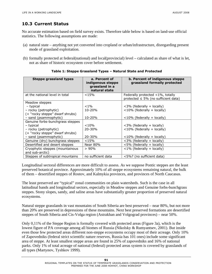
LIFE IN A WORKING LANDSCAPE AUGUST 2008
91 REGIONAL TEMPLATES ON THE STATUS OF TEMPERATE GRASSLANDS CONSERVATION AND PROTECTION
PREPARED FOR THE JUNE 2008 HOHHOT, CHINA WORKSHOP
10.3 Current Status
No accurate estimation based on field survey exists. Therefore table below is based on land-use official statistics. The following assumptions are made: (a) natural state – anything not yet converted into cropland or urban/infrastructure, disregarding present
mode of grassland exploitation. (b) formally protected at federal(national) and local(provincial) level – calculated as share of what is let,
not as share of historic ecosystem cover before settlement.
Table 1: Steppe Grassland Types – Natural State and Protected
Steppe grassland types a. Percent of indigenous steppe grassland in a natural state
b. Percent of indigenous steppe grassland formally protected
at the national level in total <15% Federally protected <1%, totally protected ≤ 5% (no sufficient data)
Meadow steppes – typical
<1%
<3% (federally + locally)
– rocky (petrophytic) (+ “rocky steppe” dwarf shrubs)
10-20% <10% (federally + locally)
– sand (psammophytic) 10-20% <10% (federally + locally) Genuine forbs-bunchgrass steppes – typical
<10%
<3% (federally + locally)
– rocky (petrophytic) (+ “rocky steppe” dwarf shrubs)
20-30% <10% (federally + locally)
– sand (psammophytic) 20-30% <10% (federally + locally) Genuine (dry) bunchgrass steppes <15% <3% (federally + locally) Desertified and desert steppes Near 80% <5% (federally + locally) Cryophytic steppes (mountainous and sub-arctic)
> 90% <1% (federally + locally)
Steppes of subtropical mountains no sufficient data <5%? (no sufficient data) Longitudinal sectoral differences are more difficult to assess. As we suppose Pontic steppes are the least preserved botanical province. Approximately 10% of all steppe ecosystems remaining natural, the bulk of them – desertified steppes of Rostov, and Kalmykia provinces, and provinces of North Caucasus. The least preserved are “typical” zonal communities on plain watersheds. Such is the case in all latitudinal bands and longitudinal sectors, especially in Meadow steppes and Genuine forbs-bunchgrass steppes. Stony slopes, sandy, and saline areas have substantially greater proportion of preserved natural ecosystems. Natural steppe grasslands in vast mountains of South Siberia are best preserved – near 80%, but not more than 20% are preserved in depressions of these mountains. Next best preserved formations are desertified steppes of South Siberia and Cis-Volga region (Astrakhan and Volgograd provinces) – near 50%. Only 0,11% of the Steppe Region is formally covered with protected areas (Figure 3a), which is the lowest figure of PA coverage among all biomes of Russia (Nikolsky & Rumyantsev, 2001). But inside even those few protected areas different non-steppe ecosystems occupy most of their acreage. Only 10% of Zapovedniks (federal strict scientific nature reserves, Russia has 101 ones) include some significant area of steppe. At least smallest steppe areas are found in 25% of zapovedniks and 16% of national parks. Only 1% of total acreage of national (federal) protected areas system is covered by grasslands of all types (Martynov, Tyshkov 1999).

LIFE IN A WORKING LANDSCAPE AUGUST 2008
92 REGIONAL TEMPLATES ON THE STATUS OF TEMPERATE GRASSLANDS CONSERVATION AND PROTECTION
PREPARED FOR THE JUNE 2008 HOHHOT, CHINA WORKSHOP
10.4 Opportunities and Constraints for Improving the Level of Protection and Conservation in the Region
The main part of Russia’s steppes is situated on agricultural land, which is either private property or municipal property, many of there lands leased. Therefore steppes are strongly depending on agricultural land-use practices, first of all on grazing and burning practices. Russian legislation and legal practices so far lack clear workable mechanisms for nationalization of private property to establish protected areas. Neither there is proven legal mechanisms to protect steppe on private lands without PA establishment.
In the last two years several new (or renewed) threats to steppe have been rapid-growing. First, this is turning lands to non-pastoral use, presumably for mining, oil and gas production. Another new threat is re-ploughing old-fields and even ploughing virgin steppe remnants induced by recent Global Food Crisis and Global Biofuel Boom.
At the same time Russia has huge acreage of still unprotected good-conditioned steppe landscapes, and there are several different means to preserve such ecosystems:
a) Establishment of protected areas without changing land-ownership. b) Developing system of conservation easements and restrictions based on agreement between
authorities (or responsible NGOs) and land-owner. c) Expansion and change of conservation management regime of existing steppe PAs (since present
regime does not help to conserve grassland).
During last year “National PAs development Scheme until 2020” is being developed by WWF Russia on demand of Russian Ministry of Natural Resources and Environment. More than 120 locations suggested for establishment of new national PAs contain steppe ecosystems (list attached, and see Figure 3b).
10.5 Suggested Next Steps and Action Plan
The key problem is to make Russian society and authorities recognize value of steppe and its protection, which is a basic precondition for a multitude of specific policy, management, economic and other measures.
Today preservation of steppes could be addressed as preservation of biodiversity on agricultural lands and the following concrete steps are very desirable:
1. Inventory of major remaining natural and semi-natural steppe ecosystems, their land-use regime and legal status.
2. Delineation of the most important biodiversity areas that should be hotspots for conservation: IBAs, IPAs, HNVF (High Nature Value Farming) areas, etc.
3. Policy formation to recognize multiple values of agricultural land, including ecosystem services and necessity to support provision of such services provide to public via governmental programs. In particular it should lead to: - adding conservation to management activities allowed on agricultural lands (Russian legislation
prescribes very narrow rules for these lands use and so far conservation formally is not allowed) - rethinking priority of arable land over other land-use practices - development of legal and management means to use easements and other legal tools on privately held land - develop tax-easement for supporting biodiversity hotspots on private agricultural land; - special national policy on biosphere reserves that could be most adequately used for steppe preservation
4. Increase representation of steppe ecosystems at all levels of protected areas network, which requires
new methodology and new sources of funding.

LIFE IN A WORKING LANDSCAPE AUGUST 2008
93 REGIONAL TEMPLATES ON THE STATUS OF TEMPERATE GRASSLANDS CONSERVATION AND PROTECTION
PREPARED FOR THE JUNE 2008 HOHHOT, CHINA WORKSHOP
5. Expand Russia’s participation in international programs on agricultural biodiversity conservation within the framework of CBD themes (on Agricultural Biodiversity, on Biodiversity of dry and sub-humid lands), European programs on biodiversity of agricultural lands, PEEN, Emerald network, Important Bird Areas, Important Plant Areas, Prime Butterfly Areas and so on. Expand Russia’s participation in FAO, yet unsigned conventions (Bonn), etc.
10.6 Appendices
Table 2: Rough summary of impact factor significance Scale from “5” – major impact to “0” – absence of impact
IMPACT FACTOR (THREATS / DISTURBANCES) Steppe and
related ecosystems type
Ploughing / Conversion to cropland
Mining Infrastructure and urban development
Over-grazing
Forest and shelterbelt plantation
Fire Water infrastructure
(1) Meadow-steppes – typical
5 2 3 1 5 2 1
Forest-steppe – tree groves
4 1 3 2 0 5 0
(2) Genuine forbs-bunchgrass steppes – typical
5 3 2 3 4 2 1
– stone steppe (petrophytic)
1 4 2 2 3 1 0
– sand steppe (psammophytic)
1 3 1 4 4 2 1
(3) Genuine (dry) bunchgrass steppes
3 1 1 2 1 2 1
Halophytic steppe types
1 1 1 4 1 2 2
(4) Desertified and desert steppes
1 1 1 3 1 1 2
Different shrub steppes
1-5 1-4 1-3 1-3 1-5 5 0-1
Old field succession serials
5 1-2 1 0 4 0 0-1
Steppe-wetland complexes
2 4 3 3 1 4 4

LIFE IN A WORKING LANDSCAPE AUGUST 2008
94 REGIONAL TEMPLATES ON THE STATUS OF TEMPERATE GRASSLANDS CONSERVATION AND PROTECTION
PREPARED FOR THE JUNE 2008 HOHHOT, CHINA WORKSHOP
Figure 1: Main types of steppe grassland ecosystems of Russia

LIFE IN A WORKING LANDSCAPE AUGUST 2008
95 REGIONAL TEMPLATES ON THE STATUS OF TEMPERATE GRASSLANDS CONSERVATION AND PROTECTION
PREPARED FOR THE JUNE 2008 HOHHOT, CHINA WORKSHOP
Figure 2: Steppe Value of Federal Provinces of Russia (based on number, extent, and quality of large steppe tracts)
Note: The lack of the accurate data is the problem of top-priority in steppe conservation in Russia. We are collecting available information on the greatest and the best conditioned steppe tracts – but only several of them are known recently. Only several provinces have the good inventory data (either our data or published ones). Therefore we have no possibility to map important grassland areas for Russia as a whole. The map only we can provide to date is the steppe value of Russian provinces (Figure 2). We divide all the provinces by (1) number of large steppe tracts (>10 sq.km), and (2) total area of steppe grasslands (that is estimated by the method described above).

LIFE IN A WORKING LANDSCAPE AUGUST 2008
96 REGIONAL TEMPLATES ON THE STATUS OF TEMPERATE GRASSLANDS CONSERVATION AND PROTECTION
PREPARED FOR THE JUNE 2008 HOHHOT, CHINA WORKSHOP
There are three level of PAs in Russia: national (federal), provincial, and local ones. The accurate data are available for federally protected areas only. Making a complete list of steppe protected provincial PAs is a high priority task for us.
Table 3: Steppes in national level (Federal) protected areas
Federal PAs Land area, ha Province
Zapovedniks (Federal state strict nature reserve, IUCN Ia category)
A. Protecting steppe grasslands at more than 25%
of the reserve’ area
Belogorye 2,131 Belgorod
Daurskiy (Biosphere Reserve, Dauria Transboundary Reserve) 45,790 Chita (Zabaikalskii Krai)
Orenburgskiy 21,653 Orenburg
Privolzhskaya Lesostep’ 8,373 Penza
Rostovskiy (Biosphere Reserve) 9,532 Rostov/Don
Ubsunurskaya Kotlovina (Biosphere Reserve, UvsNuur Transboundary Reserve) 323,198 Tyva Republic
Khakasskiy 267,565 Khakassia Republic
Centralno-Chernozemny (Tsentral'nochernozem Biosphere Reserve) 5,287 Kursk
Chernye Zemli (Biosphere Reserve) 121,482 Kalmyk Republic
Galichya Gora 231 Lipetsk
B. Protecting only small pieces of steppe grasslands (at <10% of the reserve area)
Azas 333,884 Tyva Republic
Altaiskiy 871,212 Altai Republic
Astrakhanskiy (Astrakhanskiy Biosphere Reserve) 56,619 Astrakhan
Baikalo-Lenskiy 660,000 Irkutsk
Bashkirskiy 49,609 Bashkortostan Republic
Bogdinsko-Baskunchakskiy 18,525 Astrakhan
Voroninskiy 10,320 Tambov
Zhigulevskiy 23,157 Samara
Katunskiy (Biosphere Reserve) 151,678 Altai Republic
Prioksko-Terrasnyi (Biosphere Reserve) 4,945 Moscow Province
Prisurskiy 9,148 Chuvash Republic
Sayano-Shushenskiy (Biosphere Reserve) 390,368 Krasnoyarsk
Sokhondinskiy (Biosphere Reserve) 210,985 Chita (Zabaikalskii Krai)
Shulgan-Tash 22,531 Bashkortostan Republic
Jerginskiy 238,088 Buryat Republic
Tighirekskiy 41,415 Altaiskiy Krai
Totally steppe Zapovedniks (A group) 764,031
Total area of Zapovedniks including small steppe
plots (B group) 3,092,484

LIFE IN A WORKING LANDSCAPE AUGUST 2008
97 REGIONAL TEMPLATES ON THE STATUS OF TEMPERATE GRASSLANDS CONSERVATION AND PROTECTION
PREPARED FOR THE JUNE 2008 HOHHOT, CHINA WORKSHOP
National Parks (IUCN II category)
Steppe grasslands <10% of the park area only
Samarskaya Luka 134,000 Samara
Khvalynskiy 25,514 Saratov
Bashkiria 82,300 Bashkortostan Republic
Pribaikalskiy 418,000 Irkutsk
Zabaikalskiy 267,177 Buryat Republic
Tunkinskiy 1,183,662 Buryat Republic
Alkhanai 138,234 Chita (Zabaikalskii Krai)
Total area of NPs with small steppe plots 2,248,887
Federal Wildlife Refuges (Zakazniks, IUCN IV and VI categories)
A. Protecting steppe grasslands at more than 25% of the Refuge area
Tsimlyanskiy 44,998 Rostov/Don
Kharbinskiy 163,900 Kalmyk Republic
Sarpinskiy 195,925 Kalmyk Republic
Mekletinskiy 102,500 Kalmyk Republic
Saratovskiy 44,302 Saratov
B. Steppe grasslands <10% of the Refuge area
Tsasucheiskiy Bor 57,867 Chita (Zabaikalskii Krai)
Stepnoy 75,000 Omsk
Starokulatkinskiy 20,166 Ulyanovsk
Kurganskiy 31,846 Kurgan
Kirzinskiy 119,808 Novosibirsk
Kamennaya Step’ 5,232 Voronezh
Beloozerovskiy 17,850 Tyumen
Bairovskiy 64,831 Omsk
Altacheyskiy 60,000 Buryat Republic
Kabanskiy 12,100 Buryat Republic
Totally steppe Wilflife Refuges (A group) 551,625
Total area of Wilflife Refuges including small steppe plots (B group) 464,700

LIFE IN A WORKING LANDSCAPE AUGUST 2008
98 REGIONAL TEMPLATES ON THE STATUS OF TEMPERATE GRASSLANDS CONSERVATION AND PROTECTION
PREPARED FOR THE JUNE 2008 HOHHOT, CHINA WORKSHOP
Figure 3a: Steppes in national level (Federal) protected areas
Figure 3b: Recently proposed (WWF Russia) national level (Federal) protected areas

LIFE IN A WORKING LANDSCAPE AUGUST 2008
99 REGIONAL TEMPLATES ON THE STATUS OF TEMPERATE GRASSLANDS CONSERVATION AND PROTECTION
PREPARED FOR THE JUNE 2008 HOHHOT, CHINA WORKSHOP
Acknowledgements
We are grateful to Dr. A. Korolyuk (Central Siberian Botanical Garden, SB RAS, Novosibirsk) for useful discussion, to Ms. Alexandra Egorova and Ms. Anna Barashkova for valuable GIS assistance, and to Ms. Irina Onufrenya (WWF Russia, Moscow) for kindly putting at our place the most recent version of the map of proposed federal PAs. References
Kucheruk V.V. 1959. Steppe faunistic complex of mammals and its place in Palaearctic fauna. In: Geography of terrestrial animals’ population and methods of its investigation. Moscow, Publishing of AS USSR. 45-87. (in Russian) Lavrenko E.M. 1970a. Provincial division of Pontic-Kazakhstanian Subregion of Steppe Region of Eurasia // Botanicheskiy Jurnal. 55 (5). 609-625. (in Russian) Lavrenko E.M. 1970b. Provincial division of Central-Asian Subregion of Steppe Region of Eurasia // Botanicheskiy Jurnal. 55 (12). 1734-1747. (in Russian) Lavrenko E.M., Karamysheva Z.V., Nikulina R.I. 1991. Steppes of Eurasia. Leningrad, Nauka.146 pp. (in Russian) Mordkovich V.G. 1994. Originality of Siberian steppes, level of their disturbance and safety // Siberian Ecological Journal. 1(5). 475-481. (in Russian) Chibilyov A.A.1998. Basics of steppe science. Orenburg, Publisher House DIMUR. 120 pp. (in Russian) Nikolaev V.A. 1999. Landscapes of Asiatic steppes. Moscow, Publishing of Moscow State University. 288 pp. (in Russian) Korolyuk A.Yu. 2002. Vegetation. In: Gadjiev I.M. et al. Steppes of Inner Asia. Novosibirsk, SB RAS Publisher. 45-94. (in Russian) Nikolsky A.A., Rumyantsev V.Yu. 2002.Zonal representativeness of the Zapovedniks system of Russian Federation. In: Scientific issues of ecological problems of Russia. Proc. of National Conference ad memoriam A.L. Yashin. 1. Moscow, Nauka. 160-165. (in Russian)

LIFE IN A WORKING LANDSCAPE AUGUST 2008
100 REGIONAL TEMPLATES ON THE STATUS OF TEMPERATE GRASSLANDS CONSERVATION AND PROTECTION
PREPARED FOR THE JUNE 2008 HOHHOT, CHINA WORKSHOP
11. UKRAINE
Template information was not received at time of report production.

LIFE IN A WORKING LANDSCAPE AUGUST 2008
101 REGIONAL TEMPLATES ON THE STATUS OF TEMPERATE GRASSLANDS CONSERVATION AND PROTECTION
PREPARED FOR THE JUNE 2008 HOHHOT, CHINA WORKSHOP
12. UZBEKISTAN
Dr. Muhtor Nasyrov email: [email protected], tel/fax 998662 33 54 83 Samarkand State University, Deapertment of Plant Physiology and Microbiology, Katta-Kurganskaya,1 Samarkand 703008 Uzbekistan Other Contributors: Tolib Mukimov, Bakhtiyor Mardonov, Tashpulat Rajabov, Makhmud Muminov, Shodier Sindarov
12.1 Major Indigenous Temperate Grassland Types
Waste areas of grasslands mostly characterize the territory of Uzbekistan. It is used as a grazing area for small ruminant domestic animals, while some territories converted into croplands to grow rainfed wheat and barley. Only 10% of the total territory is suitable for irrigated farming, which becomes very costly due to salinization and erosion. Grasslands provide local population with food and are principal domain where they make their living via different activities. Continuous economic changes, population growth and overgrazing necessitate the development of economically sustainable and ecologically friendly technologies for the utilization of natural resources. Grasslands of Uzbekistan are divided as follows: plains (arid) comprise 83.4 percent , foothills 12.8 percent , mountains 2.4 percent and alpine pastures 1.3 percent. The total grassland area is represented by four types: ephemeral-ephemeroidal, shrub-grass, subshrub-ephemeral and salty grass vegetation according to Amelin (1943) and Morozova (1946). Ephemeral-ephemeroidal grasslands (about 1,500,000 ha). There are vegetation communities found among all types of arid grazing lands which consist of annual and perennial grasses covering loess foothills and plains in the the Central Asian republics. In Uzbekistan they are close to adyr of Surkhandarya, Kashkadarya, Samarkand and Jizak regions. Carex pachystylis and Poa bulbosa, forming a solid sward, are the basis of the vegetation cover of this type. In addition, in the herbage of ephemeral pastures Anisanta tectorum, Bromus spp, Eremopyrum orientale, Trigonella noeana grow. Among large plants Alhagi pseudoalhagi, Cousinia resinosa, and Ferula asafoetida are found. In favorable years the height of the ephemeral herbage reaches 50-60 cm, and in normal years 20-30 cm; in lean years vegetation may not be higher than 8-20 cm. The fodder capacity of ephemeral-ephemeroidal grazing varies greatly by year and season of the year and on average is 400-700 kg of dry matter. The total number of ephemeras, long vegetating annual grasses, in years with different weather, can vary from some species up to 40-65 and more. However, the extent of development and specific weight of a particular fodder in the community differ depending on the weather conditions and spring period. Shrub-grass grasslands grasslands (about 9,000,000 ha), the most widespread type, which occupies a vast area is typical of sandy deserts. It occupies the greater part of the Kizilkum desert (most of the grazing lands of Bukhara, Navoi regions and the Republic of Karakalpakstan); here and there it prevails in Kashkadarya, Jizak and Samarkand regions. Shrub-grass lands of sandy desert areas are exceptionally valuable grazing. Variety of life forms (here there are all life forms of desert plants), different seasons and quite long growing period or absence of summer interruption in plant growth, the seasonal character of forage etc. allow them to be used for sheep grazing practically the whole year round. The many-tiered formation of vegetative cover is common: trees and bushes make up the upper layer exceeding 2 metres; sub shrubs and some perennial long vegetating grasses make up the middle layer (0.5-1.5 m high), and the lower layer often is formed of ephemeroids - Carex physodes, Poa bulbosa and
AUTHORS

LIFE IN A WORKING LANDSCAPE AUGUST 2008
102 REGIONAL TEMPLATES ON THE STATUS OF TEMPERATE GRASSLANDS CONSERVATION AND PROTECTION
PREPARED FOR THE JUNE 2008 HOHHOT, CHINA WORKSHOP
a multitude of ephemerals. By the duration of vegetation the vegetative cover of this type is formed of ephemeras (annual and perennial) of spring-summer, summer-autumn, long vegetating kind and one evergreen kind. Haloxylon persicum, Haloxylon aphyllum, Salsola paletzkiana, Salsola richteri, kinds of Calligonum, Astragalus (3 kinds), Carex physodes, Poa bulbosa, Anisanta tectorum, Eremopyrum orientalis, etc are the most valuable fodder plants of sandy deserts (Melnikova, 1973). Schematically, the feed for sheep in shrub-grass grazing is as follows: spring - period of rapid growth and eating of ephemerals and ephemeroids; animals are provided with exceptionally vitamin-rich, green fodder. By summer due to cessation of growth of the grass layer, dry fodder from ephemerals, kinds of calligonums, and dry annual salty grass vegetation are the main components of feed for the sheep. In autumn the available feed is slightly better owing to their eating shrub-subshrub fodder, dry Carex physodes, and small grasses. Shrub-subshrub pastures accumulate a stock of phytomass in summer; ephemeras and ephemeroids in spring; and annual halophytes by the autumn. Ridges, hill tops and slopes are often low yielding while plains yield more; fixed areas of sands are not only easy to use, but are the highest yielding. Average yield of shrub-grass grazing varies by year from 200 to 700 kg/ha of dry mass. Subshrub-grass type of grasslands (total area 6,700,000 ha) prevails on sierozems, brown-brown soils, condensed sands in practically all the regions of the republic where the Karakul sheep are kept. The herbage of this type is usually two-tier: sub shrubs (kinds of Artemisia, Salsola orientalis, Halotamnus subophyllus, Salsola gemmascens, Astragalus willosissima) are in the upper tier. In compacted sands in this area Iris, Aristida, Ferula asafoetida, etc. may grow. The lower tier is formed of ephemeras and ephemeroids, Carex pachystylis, Poa bulbosa, seldom Carex physodes and other ephemeras of crucifers, legumes and other genera. This economically important type is represented by a large number of options. But Artemisia-ephemeral and wormwood-halophyte-ephemeral options are the commonest. The forage capacity of these lands ranges from 300 to 600 kg of dry matter, per ha mostly from Artemisia diffusa and Artemisia turanica (65-70 percent ). The share of other kinds is about 30-35 percent : various grasses accumulate the most fodder in spring and sub shrubs in summer and autumn. Salty grass vegetation (halophyte) grasslands with a total area of about 1,500,000 ha is localised, with small patches on almost all types of soil salinized to different extents. The vegetation cover is sparse and consists, in general, of: Climacoptera lanata (Pall.), Gamanthus gamacarpus (Mog.), Salsola sclerantha, etc. have a great importance (Akjigitova, 1982). The yield of salty grass vegetation grazing varies, within the limits of 50-600 kg/ha of dry mass. They are good grazing lands before and during mating (autumn) periods. The nutritive value of the main kinds of vegetation varies with the seasons of representative kinds of grass: in spring 23 fodder units; shrub-subshrub kinds 25-28; in summer 47-52; in autumn 36-38 and in winter 30-33 fodder units. From the grazing point of view salty grass vegetation pastures are found on two types of land: annual salty grass vegetation and perennial salty grass vegetation. Of the annual halophyte, morphologically divided into rich and dry kinds, Climacoptera lanata and Gamanthus gamocarpus, etc. have great importance and prevail in Kizilkum. The above kinds alone or in a mixture with one another often grow in blind saline hollows, depressions, dried up lake beds, takirs (local), old river-beds, etc. Of the annual halophyte kinds Agriophyllum latifolium, Galimoknemis spp. , Salsola paulsenii, and of shrub kinds - Haloxylon persicum, Salsola richteri mixed with annual halophyte groups prevail in the sandy part of deserts in the form of islets or larger areas. A distinguishing peculiarity of Kizilkum halophyte grazing is that more often subshrub are kinds of Salsola orientalis, Salsola gemmescens, Halothamnus subaphyllus and shrub kinds of Haloxylon aphyllum, Haloxylon persicum, Salsola richteri, Salsola paletzkiana. The distinguishing biological peculiarity of salty grass vegetation, representing the main fodder in this type of land, is a quite long growing period of 200-236 days with only a few exceptions. The content of digestible protein per 1 kg of halophyte fodder ranges within the limits of 20-50 g. Fruit and leaves containing 7-13 percent of protein and a little cellulose (10-16 percent ) are deemed to be the most nutritive part of the fodder.

LIFE IN A WORKING LANDSCAPE AUGUST 2008
103 REGIONAL TEMPLATES ON THE STATUS OF TEMPERATE GRASSLANDS CONSERVATION AND PROTECTION
PREPARED FOR THE JUNE 2008 HOHHOT, CHINA WORKSHOP
Most feed of Climacoptera lanata and other halophytes (70-80 percent) becomes available in autumn; the best season for their use is autumn and early winter. Alternation of sheep grazing on annual halophyte with other types of vegetation improves the effective use of the fodder. For camels halophyte lands can be used at all seasons as they eat halophyte practically the whole year round. The main reason for eating rich halophyte by other animals during the growing period is their high content (37.7-55 percent) of mineral salts. In terms of seasons of use the pastures of the republic are distributed unequally: over 50 percent of them are good for all-the-year-round use, about 20 percent for spring-summer use; the rest can only be grazed only during a short season. At the beginning of 1993 a farm had in average 209,300 ha of grazing land. However, depending on the region, the rangeland area also is distributed unequally. Thus, the number of farms having agricultural land area of up to 50,000 ha was 18; 50,100-10,000 ha - 23; 100,100-200,000 ha - 14; 200-500,000 ha - 18; over 500,000 ha - 12. Currently establishing organizational and economic structures of astrakhan sheep production have considerably changed such distribution of grazing land to farms, which now tend to break up into smaller farms. The average weighted yield of rangelands of the republic is 121 kg/ha of fodder units. In years of average weather, provision of the stock with grass fodder is 80 percent, in lean years - 55-60 percent , in extremely dry, unfavourable years falls to 30-40 percent . In years unfavourable for the development of vegetation the farms have to buy concentrated fodder and emergency stocks of coarse fodder, or by first using their own laid-in stock in order to properly maintain the livestock population. The low yield of natural grazing, the low and uneven pastoral water supply which causes a continuous shortage of water, the need for ecologically balanced land useare some of the key topics presently being discussed. Of course, effective use of natural pasture is the basis for maintaining and supporting the natural potential of arid grazing, the botanical variety of the herbage, as well as raising their productivity. As has been proven by science, in Karakul sheep production the main and determining element of effective use of arid zone pasture is seasonal and annual change of grazing areas with removal of annual growth of fodder mass not exceeding 65-70 percent. In this way the duration of using an area in time is achieved with an optimal load of sheep. Following a seasonal use pattern promotes the self-restoration and self-regulation of the vegetative cover. 12.2 Impact of Human Settlement
Population growth and associated expansion and intensification of agricultural activity in many areas of the Central Asia have caused increased rates of land degradation. The region faces a serious challenge with regard to its natural resource base. Croplands, grasslands and mountains are getting degraded. The reduced availability of agricultural inputs, and feed and fodder is resulting in a decline in livestock numbers. Water scarcity and misuse is compounding the threat to food security, human health, and ecosystems. These grasslands are rich in medicinal and industrial plants, and represent a “hot spot” for the conservation of unique flora and fauna. However, the vegetation of these lands is under pressure due to an increasing need for food and feed. Overgrazing and uprooting of shrubs for fuel wood are particularly threatening the precious biodiversity found in these lands, and the livelihoods of the people who live there.

LIFE IN A WORKING LANDSCAPE AUGUST 2008
104 REGIONAL TEMPLATES ON THE STATUS OF TEMPERATE GRASSLANDS CONSERVATION AND PROTECTION
PREPARED FOR THE JUNE 2008 HOHHOT, CHINA WORKSHOP
Table 1: Grasslands resources of Uzbekistan
Without Water Supply
Regions Total grazing land,
thousand ha
Thousand ha %
Republic of Karakalpakstan
3461.1 430.9 12.4
Bukhara 2416.0 439.7 18.2
Jizak 582.9 205.5 35.2
Kashkadarya 1011.9 122.5 12.1
Navoi 9245.8 110.3 12.0
Samarkand 633.2 124.9 19.73
Surkhandarya 407.9 64.6 15.84
Total 17,758.8 2,498.4 14.0
12.3 Suggested next steps and action plan
Taking into account that limited financial resources are available, we choose the following activities from a wide-ranging problem: 1. Researching land use change and drylands degradation with Remote Sensing and GIS, focusing on
Karnap Chul and Bakhmal areas and potential for up-scaling to larger areas;
2. Calculation of NDVI and other vegetation indexes and comparison with ground measured data on biomass, chlorophyll content so as to make a better calibration limited by and caused by dusts, clouds and others;
3. Researching revegitation of degraded rangelands with manure coated seeds; Feed blocks, containing seeds of different fodder plants, can feed small ruminant animals. Domestic animals will disseminate this seeds and they will germinate.
4. Researching vegetable and ornamental plants farming in dryland conditions with efficient use of scarce water resources of artesian wells;
5. Income generating activities (small-scale carpets, ecological tourism etc). Measures and activities Environmental data collection Socio-economic data collection Income generating Regional planning workshops Publications

LIFE IN A WORKING LANDSCAPE AUGUST 2008
105 REGIONAL TEMPLATES ON THE STATUS OF TEMPERATE GRASSLANDS CONSERVATION AND PROTECTION
PREPARED FOR THE JUNE 2008 HOHHOT, CHINA WORKSHOP
Expected outputs The results of this work will help scientists understand trends in local biodiversity degradation and will give ideas for their improved management, and will help identify particularly dynamic, resourceful, and resilient components used by villagers.
On the basis of this research it will be possible to create an “Electronic Atlas of Grasslands of Uzbekistan” for further use.
12.4 Appendices
Map 1: Regional map
Table 2: The dynamics of livestock in Uzbekistan ( 1990-2005) (FAOSTAT, 2006)
Years Species
1990 1995 2000 2001 2002 2003 2004 2005
cattle (,000)
4580 5848 5268 5344 5478 5879 6243 5400
(Including cows ,000)
1856 2336.9 2305.2 2364 2293.2 2556.7 2704 2.800
Sheep and goats (,000)
9230 10,049 8886 8930 9234 9929 10580 10500
Horses (,000)
120 144.8 155.0 150.0 145.0 145.0 145.0 145.0
Pigs (,000)
716 350.4 80.0 89.0 75.4 89.9 86.7 90.0
Poultry (,000)
26,473 18,500 14,787 14,800 15,725 18,053 19,184 18.350

LIFE IN A WORKING LANDSCAPE AUGUST 2008
106 REGIONAL TEMPLATES ON THE STATUS OF TEMPERATE GRASSLANDS CONSERVATION AND PROTECTION
PREPARED FOR THE JUNE 2008 HOHHOT, CHINA WORKSHOP
References
Akjigitova, N. I. (1982). Halophylic vegetation of Middle Asia and its indicative characteristics. Tashkent, Publishing House "Fun", 192. Amelin, I. S (1943). Pasture rotations in the karakul sheep breeding of Middle Asia. Publishing House AURIKSB, Samarkand, 1943, 107. Anon (1983) Adaptation of fodder plants of the conditions of arid zone of Uzbekistan.Tashkent, "Fun", (1983),304. Anon.(1982).Recommendations for improvement of pastures in arid zones of Middle Asia and South Kazakhstan .M., 31. Babushkin, L. N., Kogai, N. A. and Zakirov, Sh.S. (1985). Agroclimatic conditions of agriculture of Uzbekistan. Tashkent, Publishing House «Mekhnat», 160. Balashova, V. N., Sabinina, I.G. and Semenova, O.A. (1961). Climatic description of Kizilkums - Proceedings of Tashkent hydrometeorological observatory, Issue 1, Tashkent, 5-69. Burigin, V. A., Zakirov, K. Z., Zaprometova N. S. and Pauzner, L. E. (1956). Botanical principles of South Kizilkum pastures’ reconstruction. Tashkent, Publishing House AS UzSSR, 232. Butskov, N.A. and Nasirov,Y.M. (1971). Soils of South-West Kizilkums. Tashkent, «Fun», 322. Genusov, A.Z.,Gorbunov, B.V. and Kimberg, N.V. (1960). Soil-climatic regionalization of Uzbekistan in agricultural purposes. Tashkent. 117. Glazirin, G.E., Shanicheva, S.C. and Shub, V.E. (1999). Brief description of Uzbekistan climate. Tashkent, 30. Granitov, I.I. (1964). The vegetative cover of South-West Kizilkums. 1.1. Tashkent, Publishing House "Nauka" UzSSR, 335. Khasanov, O. Kh., (1995). Analysis of fodder resources of Uzbekistan. Collection of urgent problems of botany, Tashkent, 148. Korovin, E.P. (1961). The vegetation of Middle Asia and South Kazakhstan. Publishing House As UzSSR, Tashkent. 432. Kurochkina, L.Y. (1968). Psammophylic vegetation of Kazakhstan. Alma-Ata. "Nauka", 272. Larin, I.V., Agababyan, Sh.M., Rabotnov, T.A., Lyubskaya, A.F., Larina, V.K. and Kasimenko, M.A.(1950-1956). The fodder plants of hay fields and pastures of SSSR.. v.1-3. Agriculture Publishing House, M-L., 947. Lobova, E.V. (1960). Soils of desert zone of SSSR. Publishing House AS SSSR, M-L., 364. Makhmudov, M.M. (1972).Biology-ecological principles of introduction into the crop Salsola orientalis S.G. Gmel. In South-West Kizilkum. Vegetative resources, v.8, issue 1,81-87.

LIFE IN A WORKING LANDSCAPE AUGUST 2008
107 REGIONAL TEMPLATES ON THE STATUS OF TEMPERATE GRASSLANDS CONSERVATION AND PROTECTION
PREPARED FOR THE JUNE 2008 HOHHOT, CHINA WORKSHOP
Makhmudov, M.M.(1998). Agrobiological bases and technology of improvement of Kizilkum’ pastures. Author’s essay of doctor’s thesis.,Tashkent, 52. Makhmudov, M.M. and Khaitov, R. (2000). Effective use of steppe pastures and recommendations for raising productivity. Tashkent, ICARDA, 26. Melnikova, R.D. (1973). Psammophylic vegetation Psammophyta // Vegetational cover of Uzbekistan. V.2. Tashkent, 4-80. Momotov, I.F. (1973). Hypsophylic vegetation.// vegetative cover of Uzbekitan. V.2.Tashkent "Fun", 81-191. Morozova, O.I. (1946). Pasture management in the karakul sheep breeding of Middle Asia., Publishing House World Book, 299. Nechaeva, N.T. and Prikhodko, S.Y.(1966). Artificial winter pastures in foothill pastures of Middle Asia. Ashkhabad, Publishing House Turkmenistan, 228. Nechaeva, N.T.(1974). The influence of of the vital form composition on yield of desert pastures. Pastures and hay fields of SSSR.,M,"Kolos", 111-123. Nosirov, U., Zaripov, B.D. and Jasimov, F.(2000). Condition and tendency of the development of livestock of Uzbekistan. News of agrarian science of Uzbekistan, 2,65-69. Rabotnov, T.A. (1960). About floristical and cenotic incompleteness of cenosis.Reports of AS SSSr, v. 130, issue 3, 671-673. Shamsutdinov, Z. Sh. (1975). The creation of perennial pastures in arid zone of Middle Asia.Tashkent, "Fun", 164. Shamsutdinov, Z. Sh. and Ibragimov, I.O. (1983) Perennial pasture agrophytocenosis in arid zone of Uzbekistan Tashkent, "Fun", 176. Zakirov, K.Z. (1955). Flora and vegetation of Zeravshan river basin.p.1, Tashkent, 206. Since the drafting of this profile a major book on Uzbekistan's rangelands has been published (Gintzburger et al., 2003) FAO link for further information on Uzbekistan
LIFE IN A WORKING LANDSCAPE AUGUST 2008
108 REGIONAL TEMPLATES ON THE STATUS OF TEMPERATE GRASSLANDS CONSERVATION AND PROTECTION
PREPARED FOR THE JUNE 2008 HOHHOT, CHINA WORKSHOP
13. TEMPERATE GRASSLAND REGION: SOUTHEASTERN AUSTRALIA
Louise Gilfedder1, Dick Williams 2, Ian Lunt 3, Oberon Carter 1, John Morgan4, Keith McDougall5
1 Department of Primary Industries and Water, P.O. Box 44 Hobart Australia 7001, Ph + 61 3 62338538, [email protected] 2 CSIRO Sustainable Ecosystems, PMB 44 Winnellie, Northern Territory, Australia 0822, Ph + 61 8 89448426, [email protected] 3 Institute for Land, Water and Society, Charles Sturt University, PO Box 789 Albury NSW 2640, Australia. Ph + 61 2 6051 9624, [email protected] 4 Department of Botany, La Trobe University, Bundoora Victoria 3083, Australia. Ph +61 3 9479 2226, [email protected] 5 NSW Dept of Environment and Climate Change, PO Box 2115, Queanbeyan NSW 2620, Australia, Ph +61 2 6298 9729, [email protected]
13.1 Major Indigenous Temperate Grassland Types
Natural temperate grasslands in Australia occur in the southern, temperate per-humid sections of the continent. The dominant grass species are tussock-forming, and occur from sea level to alpine regions. The grasslands sensu strictu have a relatively small area, but they form a floristic continuum with temperate grassy woodlands, which are widespread in southern and eastern Australia. Together they occur in a wide arc from Adelaide in South Australia to Armidale in New South Wales (Moore 1970), and are found in 11 of the 85 bioregions (Environment Australia 2000). They are one of the highest conservation priorities in the country.
Australia’s temperate tussock grasslands consist of a mix of perennial C3 genera (Poa, Austrodanthonia, Austrostipa) and a widespread C4 grass Themeda triandra. There are numerous species of dicotyledonous herbs (forbs), and few woody species. The major grassland types are: � Lowland Themeda triandra tussock grassland � Lowland Poa tussock grassland � Lowland Austrodanthonia-Austrostipa tussock grassland � Lowland Lomandra tussock grassland � Upland (alpine and subalpine) Poa tussock grassland
Australia also has extensive tropical and subtropical grasslands and grassy woodlands. However these ecological communities have not been the subject of this report. Much of these grasslands are part of Australia's extensive rangelands and are poorly represented in the protected area system.
13.2 Impact of Human Settlement
The current distribution of grasslands and grassy woodlands is highly fragmented, and the ground layer composition of both grasslands and grassy woodlands has been highly modified due to 200 years of European land use – mainly grazing of domestic livestock on native and exotic pastures, and clearing for cropping. Broad-scale conversion of the natural grasslands for crop production continues to pose the largest single threat to this community. More recently, changes in technology such as pivot irrigators and access to water have allowed irrigated cropping to occur in dryland agricultural regions, and this has led to an acceleration of clearance and conversion. Energy development is an emerging threat, in particular wind power and biofuels.
AUTHORS

LIFE IN A WORKING LANDSCAPE AUGUST 2008
109 REGIONAL TEMPLATES ON THE STATUS OF TEMPERATE GRASSLANDS CONSERVATION AND PROTECTION
PREPARED FOR THE JUNE 2008 HOHHOT, CHINA WORKSHOP
Future threats to biodiversity conservation in temperate grasslands include: 1. Intensification of grazing and agricultural land uses, resulting in the replacement of diverse native
ecosystems by species-poor exotic-based systems. 2. Nutrient additions, both intentional and unintentional (which also reduce native plant diversity and
promote exotics). 3. Global warming (impacts on interactions amongst native and exotic species under different
disturbance and grazing regimes are unknown). 4. Competition from exotic species, including ongoing commercial development of new cultivars of
existing pasture species (e.g. for increased drought tolerance), plus newly introduced species such as woody fodder species.
5. Losses of diversity in small populations in fragmented landscapes. 6. Urban and infrastructure development (particularly peri-urban expansion in the Australian Capital
Territory, Victoria, and more recently Tasmania). 7. Development for recreation and tourism. Subalpine grasslands are natural areas for the establishment
of tourism facilities including winter snow sports. 8. Tree planting including the establishment of commercial plantations, carbon planting and biofuels. 9. Inappropriate fire regimes, particularly lack of burning. 10. Shrub and tree invasion.
13.3 Current Status
13.3.1 Natural State The current analysis undertaken for this assessment report finds the current extent of lowland temperate grasslands to be 87,850 hectares, with 192,000 hectares of upland grasslands (Table 1 & Map 1). Regional analyses have been difficult to compile at a national level as there is no consistent grassland classification approach between the States. Carter et al. (2002) undertook a detailed analysis of Australia's temperate lowland grasslands at the bioregional level, compiling information provided by each of the States. They estimated a pre-1750 distribution of c. 6 million hectares, with <100,000 hectares remaining (<2%). More recently the National Vegetation Information System (NVIS) has compiled data from each of the States and Territories on the current extent and estimated pre-1750 distribution of Australia's native vegetation, and classified it into 67 major vegetation subgroups (DEWHA, 2008; NLWRA, 2001). NVIS reports an original pre-1750 extent of c. 5.5 million hectares of temperate grassland in Australia of three major types (temperate tussock grassland, other tussock grassland and wet tussock grassland) (Map 2). However, the NVIS current extent of 3.4 million hectares (62% of pre-1750 extent) is problematic and reflects inconsistent classification of data at the State level. This over-estimation arises for four reasons. (1) Many highly degraded lowland grasslands (now exotic-dominated) have been retained in the estimate. (2) The estimate includes many derived or secondary grasslands that result from the removal of the tree layer in woodlands or forests from eucalypt dieback, tree harvesting and/or failure to regenerate because of heavy stock grazing and/or burning. These are not considered natural indigenous grasslands for the purposes of conservation reporting. (3) Semi-arid and arid grasslands may also be reported in these figures for some bioregions, and the figures also include wet grasslands that are inundated for more than a month and are more commonly classified as wetlands. (4) Source maps in some regions had a resolution coarser than the NVIS target scale of 1:100,000 (DEWR, 2007). Additionally, in some regions (e.g. NSW Riverina) it is difficult to know which areas were dominated by native grasslands before European settlement, and which areas have been derived (owing to rapid destruction of dominant shrubs) since settlement, and this issue makes reporting difficult in many regions. The National Reserve System Program relies on NVIS data for reporting on native vegetation reservation levels in the protected area system.

LIFE IN A WORKING LANDSCAPE AUGUST 2008
110 REGIONAL TEMPLATES ON THE STATUS OF TEMPERATE GRASSLANDS CONSERVATION AND PROTECTION
PREPARED FOR THE JUNE 2008 HOHHOT, CHINA WORKSHOP
13.3.2 Formal Protection Temperate grasslands and grassy woodlands are one of Australia’s most under-represented biomes in the national conservation estate, with one notable exception – alpine and subalpine grasslands which, not withstanding their small areal extent, are well-represented in Australia’s reserve system (Williams et al. 2006). It is estimated that <2% of the lowland temperate grasslands remain in most Australian regions (Kirkpatrick et al. 1997; Carter et al. 2002), with much of this area in private ownership. Approximately 140,000 hectares of temperate grasslands are protected in the Protected Area system (21,000 hectares of lowland temperate grassland (25% in Protected Areas) and >120,000 hectares of upland grasslands (>90% in Protected Areas). These figures represent both formal reserves managed by State conservation agencies, and informal perpetual reserves on private land.
13.4 Opportunities for Improving the Level of Protection and Conservation
Temperate lowland grasslands and woodlands represent one of the major challenges to biodiversity conservation in Australia, and have triggered the development of many innovative policies and practices aimed at promoting biodiversity conservation in privately-owned, production grazing landscapes. There has been an increasing emphasis on best practice management, including the development of grazing management guidelines for the sustainable use of native indigenous grasslands as pasture (for example, McIntyre et al. 2002, Mokany et al. 2006). These new approaches have great potential to greatly enhance the conservation of these threatened ecosystems. Recent conservation efforts on private land have largely focused on facilitating landholder stewardship, with financial incentives paid to secure conservation agreements that enshrine sustainable natural resource management. Most approaches to grassland conservation are voluntary and often focus on whole-of-property planning, enabling landowners to negotiate management of natural resources in the context of their whole property. Approaches to conservation management agreements on commercial agricultural businesses have attempted to remove disincentives for engagement. Fixed-term rather than perpetual agreements have increased uptake of this policy instrument, as has a shift from strict conservation objectives to allowing more broadly for the sustainable management of natural resources, including biodiversity. Increasing use of outcomes-based approaches to monitor the impact of stock grazing on commercial grazing properties that are to be protected under conservation management agreements has shifted the emphasis away from prescriptive approaches that are a disincentive to many landholders.
Market-based approaches are increasingly seen as an incentive for private landowners to engage in conservation activities, including stewardship payments for the provision of ecosystem services. There are many successful examples in operation (e.g. Levitt, 2005). Recently in Australia new programs have offered a conservation auction or tender-style of approach to securing conservation management, whereby the landowner puts in a sealed competitive bid or tender (Stoneham et al., 2003). One such program has successfully conserved significant areas of lowland temperate grassland (Buchan, 2006). Work is underway with the wool and cattle industries on environmental accreditation to provide market rewards for good management practices. Consumers worldwide are increasingly asking questions about the environmental credentials of the products they purchase and also want verification of producer claims. Environmental accreditation and eco-labelling of sustainable land management practices, biodiversity protection, animal welfare, wildlife-friendly management practices and organic certifications are some of the emerging schemes, but “willingness to pay” is a key factor that will determine the future success of these approaches.

LIFE IN A WORKING LANDSCAPE AUGUST 2008
111 REGIONAL TEMPLATES ON THE STATUS OF TEMPERATE GRASSLANDS CONSERVATION AND PROTECTION
PREPARED FOR THE JUNE 2008 HOHHOT, CHINA WORKSHOP
In a new initiative in Tasmania, farming families have initiated an approach to protect some of the best remaining examples of lowland grassland in the state. These farmers wish to formalize a long-term partnership with government to protect their grasslands rather than enter into permanent conservation covenants. They have identified that conservation should provide them with an annual income stream and are establishing a trust fund to manage conservation investment funds that they hope to attract from both the government and the philanthropic sector. They have developed an innovative legal instrument that provides an evergreen or alliance contract. This initiative advocates a performance-based approach to conservation management agreements, leaving landholders (rather than governments) to settle how to get the agreed results.
13.5 Constraints Against Improving the Level of Protection and Conservation in the Region
Few opportunities exist on public land to improve the level of protection and conservation in most regions, therefore efforts must focus on privately-owned land. Lowland native grasslands are found on arable fertile soils so the opportunity costs of agricultural land uses other than extensive grazing are attractive to landowners, leading to clearance and conversion. It is difficult for conservation incentives programs to provide attractive incentives to compete with these lost opportunity costs. Regulation of the clearance and conversion of grasslands has proven very difficult to implement.
13.6 Suggested Next Steps and Action Plan
1. Improve information systems and national data compilation, including ability to report on the level of reservation. A national workshop is proposed to develop consistent classification and reporting approaches in the States.
2. Promotion and establishment of informal reserves. Whilst the aim of achieving 10% of the current extent in the protected area system is laudable, the significant levels of loss of temperate grassland demand that approaches be developed to secure protection of as much of remaining areas as possible. There needs to be more emphasis on the sympathetic conservation management of the 90% of temperate grasslands not in conservation networks.
3. In perpetuity protection of public land such as Travelling Stock Reserves, cemeteries, local government reserves that could add to the levels of protection. Many of these small reserves have extremely high conservation values, by virtue of long-term livestock exclusion. Additionally, linear roadside and stock reserves provide important landscape connectivity.
4. Enhanced management of grasslands, especially those on public land, to promote biodiversity, especially using targeted burning and grazing regimes. The conservation values of many important remnants have declined due to a lack of appropriate disturbances.
5. Restoration and regeneration of important grassland remnants. Recent research has focused on restoration techniques to deplete exotic plant species and promote natives (for example, Cole & Lunt 2005, Prober & Thiele 2005).
6. Improved public understanding and appreciation of the value of indigenous grasslands.

LIFE IN A WORKING LANDSCAPE AUGUST 2008
112 REGIONAL TEMPLATES ON THE STATUS OF TEMPERATE GRASSLANDS CONSERVATION AND PROTECTION
PREPARED FOR THE JUNE 2008 HOHHOT, CHINA WORKSHOP
13.7 Appendices
Map 1: Current extent of indigenous temperate grassland types in Australia

LIFE IN A WORKING LANDSCAPE AUGUST 2008
113 REGIONAL TEMPLATES ON THE STATUS OF TEMPERATE GRASSLANDS CONSERVATION AND PROTECTION
PREPARED FOR THE JUNE 2008 HOHHOT, CHINA WORKSHOP
Map 2: Estimated pre-1750 distribution of indigenous temperate grassland in Australia

LIFE IN A WORKING LANDSCAPE AUGUST 2008
114 REGIONAL TEMPLATES ON THE STATUS OF TEMPERATE GRASSLANDS CONSERVATION AND PROTECTION
PREPARED FOR THE JUNE 2008 HOHHOT, CHINA WORKSHOP
Table 1: Original and current extent of temperate grasslands in Australia, area in conservation reserves
State Region Grassland Type
Original extent
(hectares)
Current extent
(hectares)
% extent
Conservation Reserves (hectares)
South
Australia
South Australia Lomandra
multiflora,
Lomandra effusa
lowland tussock
grassland
1,500,000 1 5,000 1, 2 0.33 unknown
Victorian Volcanic
Plain
Themeda
triandra, Poa
labiliardierei,
Austrodanthonia,
Austrostipa
lowland tussock
grassland
257,000 1 5,000 2, 3 0.3 2,097 3
Victorian Wimmera Austrodanthonia-
Austrostipa,
Themeda triandra
lowland tussock
grassland
100,000 1 -
400,000 2
100 1 0.1 0 1
Victorian Riverina Austrodanthonia
tussock grassland
1,000,000 1 10,000 3 1 2,9033
Victoria
Victorian Gippsland
Plains
Themeda triandra
and/or Poa
labiliardierei
lowland tussock
grassland
36,0003 -
60,000 1
25-30 3 0.4 213
NSW Riverina Austrodanthonia,
Austrostipa,
lowland tussock
grassland
(including that
derived from
shrublands)
2,500,000 1 22,500 2 -
25,000 1
1 c. 15,000
NSW/ACT Southern
Highlands (incl.
Monaro)
Themeda
triandra, Poa
labiliardierei,
Austrodanthonia,
Austrostipa
lowland tussock
grassland
270,000 1 1,400 2 -
3,500 1
1.3 6 1
New
South
Wales
NSW/Vic Australian
Alps
Upland Poa
tussock grassland
125,000 2 125,000 2 100% majority

LIFE IN A WORKING LANDSCAPE AUGUST 2008
115 REGIONAL TEMPLATES ON THE STATUS OF TEMPERATE GRASSLANDS CONSERVATION AND PROTECTION
PREPARED FOR THE JUNE 2008 HOHHOT, CHINA WORKSHOP
State Region Grassland Type
Original extent
(hectares)
Current extent
(hectares)
% extent
Conservation Reserves (hectares)
NSW Liverpool
Plains/Moree
Austostipa
aristiglumis
lowland tussock
grassland
270,000 1 25,0001 9.3 unknown
Tasmanian
Midlands
Themeda triandra
and/or Poa
labiliardierei
lowland tussock
grassland
130,000 4 14,000 4 9.0 1,604 4 Tasmania
Tasmanian Central
Highlands
Poa labiliardierei
upland tussock
grassland
unknown 22,000 4 majorit
y
16,500 4
Total Lowland tussock grassland 5.5 million 2
– 6 million1
87,850
(<100,000 1
- 144,000 2)
<2%1, 2 21,631 Total
Total Upland tussock grassland >125,000 2 146,000 2 c. 90% >120,000
Source: 1 Carter et al. (2002) 2 National Vegetation Information System, DEWHA, 2008 3 Vanessa Craigie, Dept. Sustainability & Environment, Victoria (pers. comm.)
4 Dept. of Primary Industries & Water, 2007 unpublished data)

LIFE IN A WORKING LANDSCAPE AUGUST 2008
116 REGIONAL TEMPLATES ON THE STATUS OF TEMPERATE GRASSLANDS CONSERVATION AND PROTECTION
PREPARED FOR THE JUNE 2008 HOHHOT, CHINA WORKSHOP
Acknowledgements A number of individuals and organizations helped with the data compilation and mapping. They include: Vanessa Craigie (Department of Sustainability and Environment, Victoria), Felicity Faulkner (Department of Primary Industries and Water, Tasmania), Tim Bond (National Reserve System Program of the Australian Government’s Department of the Environment, Water, Heritage and the Arts), Sarah Sharp (Conservation and Lands Territory and Municipal Services, ACT), Matt Bolton and Brad Moore (ERIN Vegetation Team, DEWHA) & Ron Avery (NSW Parks & Wildlife Service).
References
Buchan, A. 2006. VVP Plains Tender: Investing in Biodiversity on the Victorian Volcanic Plains. Victoria Australia: Department of Sustainability & Environment. Carter, O., Murphy, A.M, Cheal, D. (2002) Flora Ecology Research Section, Arthur Rylah Research Section, Dept. Natural resources & Environment, Victoria, Australia. Cole, I., Lunt, I.D. (2005) Restoring Kangaroo Grass (Themeda triandra) to grassland and woodland understoreys: a review of establishment requirements and restoration exercises in south-east Australia. Ecological Management & Restoration 6, 28-33. Department of the Environment and Water Resources (2007) Background to the National Vegetation Information System. In: Australia’s Native Vegetation: A summary of Australia’s Major Vegetation Groups, 2007, Australian Government, Canberra, ACT, 42pp. & compact disk. DEWHA (2008) NVIS products for use at a national scale. Department of the Environment, Water, Heritage and the Arts. URL: http://www.environment.gov.au/erin/nvis/mvg/index.html (sighted 24 April, 2008). Environment Australia 2000. Revision of the Interim Biogeographic Regionalisation for Australia (IBRA) and development of Version 5.1 - Summary Report. Environment Australia, Canberra. Kirkpatrick, J.B., McDougall, K., Hyde, M., 1995. Australia's most threatened ecosystem - the southeastern lowland native grasslands. Surrey-Beatty/WWFA, Sydney, 116 pp. Levitt, J. 2005. From Walden to Wall Street: Frontiers of Conservation Finance. Washington DC: Island Press. Lunt, I.D., Eldridge, D.J., Morgan, J.W., Witt, G.B., 2007. Turner Review No. 13. A framework to predict the effects of livestock grazing and grazing exclusion on conservation values in natural ecosystems in Australia. Australian Journal of Botany 55, 401-415. NLWRA (2001) Australian Native Vegetation Assessment 2001. National Land and Water Resources Audit, Canberra, 332pp. Mokany, K., Friend, D., Kirkpatrick, J.B., Gilfedder, L. 2006. Managing Tasmanian Native Pastures – A Technical Guide for Graziers. Hobart: Tasmanian Institute of Agricultural Research. McIntyre, S., McIvor, J.G., Heard, K.M. (Eds.). 2002 Managing and Conserving Grassy Woodlands. CSIRO Publishing, Australia. Moore, R.M. (1970)(Ed.) Australian Grasslands. Australian National University Press, Canberra.

LIFE IN A WORKING LANDSCAPE AUGUST 2008
117 REGIONAL TEMPLATES ON THE STATUS OF TEMPERATE GRASSLANDS CONSERVATION AND PROTECTION
PREPARED FOR THE JUNE 2008 HOHHOT, CHINA WORKSHOP
Prober, S.M., Thiele, K.R. (2005) Restoring Australia's temperate grasslands and grassy woodlands: integrating function and diversity. Ecological Management & Restoration 6, 16-27. Stoneham, G., Chaudhri, V,, Ha, A., Strappazzon, L. 2003, Auctions for conservation contracts: an empirical examination of Victoria’s BushTender trial. Australian Journal of Agricultural and Resource Economics 47, 477-500. Williams, R.J, McDougall, K, Mansergh, I.M, Wahren, C.H, Rosengren, N.J, Papst, W.A. (2006) Alpine landscapes. In ‘Ecology : an Australian Perspective’ . (Eds by P.M. Attiwill, B.A. Wilson). 2nd ed. Oxford University Press, Oxford, pp 557-572

LIFE IN A WORKING LANDSCAPE AUGUST 2008
118 REGIONAL TEMPLATES ON THE STATUS OF TEMPERATE GRASSLANDS CONSERVATION AND PROTECTION
PREPARED FOR THE JUNE 2008 HOHHOT, CHINA WORKSHOP
14. NEW GUINEA
Template information was not received at time of report production.

LIFE IN A WORKING LANDSCAPE AUGUST 2008
119 REGIONAL TEMPLATES ON THE STATUS OF TEMPERATE GRASSLANDS CONSERVATION AND PROTECTION
PREPARED FOR THE JUNE 2008 HOHHOT, CHINA WORKSHOP
15. TEMPERATE GRASSLAND REGION: NEW ZEALAND
Alan F Mark 1, Katharine JM Dickinson1, PascalePascalePascalePascale MichelMichelMichelMichel1, BruceBruceBruceBruce McLennanMcLennanMcLennanMcLennan2
1 Botany Department & Ecology Programme, University of Otago, PO Box 56, Dunedin, New Zealand. Ph. +64 3 4797577; [email protected]; [email protected] 2 AgResearch, Invermay Research Centre, Mosgiel, New Zealand (deceased)
15.1 Major Indigenous Temperate Grassland Types
New Zealand Region: 267,840 km2, located in the SW Pacific; 34-47°S; 167-178°E Three main islands (North, South, Stewart) with indigenous grasslands Elevation to 3764 m (Mt Cook) New Zealand was one of the few countries that evolved without indigenous terrestrial mammals and also one of the last major land masses to be settled by humans. The extent and dominance of grasslands fluctuated over the Quaternary and Holocene, reflecting climatic conditions. With the arrival of people (Polynesian Maoris ~1200 AD), fires became more frequent and extensive, with some associated extinctions. Plant-herbivore relationships, which had evolved over millennia, were disrupted and sometimes decoupled. The biota was still essentially indigenous until the 1840s when European settlement and many alien plants and animals, both herbivores and predators, further transformed the land and its associated ecosystems. Changing plant-herbivore-fire relationships and ecosystem transformations since settlement, makes establishing the nature and distribution of vegetation types immediately prior to settlement somewhat faught, especially given that a significant component of the fauna from those times is now extinct. In this context, 1840 (immediately pre-European) was chosen as the most appropriate baseline for assessing indigenous grassland types and status: they were then at their maximum extent (82,432km2; ~31% of the mainland area). The five major grassland types were mapped by Mark & McLennan (2005a; see also 2005b) as follows: a. Low-alpine (~1200-1800m) tall snow tussock grassland (dominated by Chionochloa spp.): ~13% b. Montane-subalpine (~400-1200m) tall snow tussock grassland (Chionochloa spp. dominant): ~18% c. Montane-low-alpine (~400-1800m) tall red/copper tussock grassland (C. rubra dominant): ~23% d. Montane-subalpine (~400-1200m) short tussock grassland (Festuca-Poa dominant): ~44% e. Lowland (to ~400m) mixed sward grassland (mixed dominance): ~2% Note: Areas where indigenous grasses were assumed to have attained at least local dominance in 1840 were mapped as grassland by Mark & McLennan (2005a). High-alpine areas above the limits of low alpine snow tussock grassland (~3.2%), as well as the nival zone (0.5%) were similarly assessed (Fig. 1).
AUTHORS

LIFE IN A WORKING LANDSCAPE AUGUST 2008
120 REGIONAL TEMPLATES ON THE STATUS OF TEMPERATE GRASSLANDS CONSERVATION AND PROTECTION
PREPARED FOR THE JUNE 2008 HOHHOT, CHINA WORKSHOP
15.2 Impact of Human Settlement
With European settlement there was almost immediate and considerable modification of the grasslands, especially in the lowland-montane zones, regardless of grassland type. The most remote western, wet, high mountain regions were grazed locally but later mostly protected for their landscape and conservation values, and now contribute much of the ~31% of the land area managed by the Department of Conservation. The lower hills and plains were cleared, cultivated, or converted to exotic pasture and grazed, regardless of plant cover. Moderately sloping areas followed somewhat later. Less accessible uplands were used as rangeland for pastoralism, with burning and grazing as the only forms of management. Stock management suffered with inadequate fencing and high stock densities, and overgrazing was rife, especially in the early years. At lower altitudes rabbit plagues ensued. Altogether, serious degradation soon became apparent. Most of the rangelands (~10% of the mainland area) remained in government ownership because of their general vulnerability though pastoral use was vested in the lessees who have permanent rights of lease renewal. Leases are a tradable commodity. There have been periodic attempts to address rangeland management issues with subsidies and legislative amendments to encourage more sustainable management of this leasehold land but with limited success. All grassland areas are now variously modified or degraded. Government recently introduced a tenure review process whereby pastoral lessees can renegotiate their lease tenure and obtain freehold title to the more productive, mostly lower altitude parts of their leases in exchange for returning mostly higher altitude, more vulnerable lands, to full government control and management for soil and water conservation, biodiversity, recreational and landscape values. This process is on-going; to date about 20% of the original 340 leases have completed the reforms and ~200,000 ha have become conservation lands. An additional ~100,000 ha have been acquired through outright purchase of leasehold titles by the Government for the same purposes. 15.3 Current Status
Mark & McLennan (2005a) assessed the indigenous grassland status in each of five main types, as at Sept. 2002 (Fig. 2) These were estimated for four major geographic regions (Fig. 3): i) North Island, where the grasslands are more limited and variable; ii) the South Island wet western non-rangeland region (now mostly formally protected); iii) the South Island rangeland region (the central uplands, in the rainshadow of the Southern Alps); and iv) the South Island eastern lower altitude non-rangeland region. Only indigenous grasslands in the South Island rangeland region have changed in status from the 2002 assessment to 2007 (Fig. 4), with increases in conservation lands associated with the tenure review (mainly at higher elevations) and some outright property purchases by the Government. . In the period to July 2008, seven new conservation parks have been created (Korowai/Torlesse (20,328 ha), Te Papanui (20,591 ha), Ahuriri (46,655 ha), Ruataniwha (37,221 ha), Eyre Mountain/Taka Ra Haka (65,160 ha), Hakatere (39,138 ha), Ka Whata Tu O Rakihouia/Kaikoura (88,066 ha), and two have been formally proposed, Hawea (105,000 ha) and Oteake (64,950 ha). These parks comprise mostly indigenous grasslands and mosaics, and the areas involved were mostly previous conservation land, so have had little effect on the total area protected. In this period, protected areas in the rangeland region have increased from 9.1 to15.2% of the baseline area of 47,286 km2 (Fig. 4). For the country as a whole this represents an increase from 12.3% to15.4% of the original baseline grassland area.
LIFE IN A WORKING LANDSCAPE AUGUST 2008
121 REGIONAL TEMPLATES ON THE STATUS OF TEMPERATE GRASSLANDS CONSERVATION AND PROTECTION
PREPARED FOR THE JUNE 2008 HOHHOT, CHINA WORKSHOP
15.4 Opportunities for Improving the Level of Protection and Conservation
Significant opportunities for increasing protection and conservation of indigenous grasslands remain only in the central South Island rangeland region where the Government is continuing with tenure reviews, although this remains optional with leaseholders. Government’s policy is to create up to 23 conservation parks in this region through continued tenure review and perhaps some more whole-property purchases. 15.5 Constraints Against Improving the Level of Protection
and Conservation in the Region
Virtually no unprotected indigenous grasslands remain other than in the South Island rangeland region. Continued tenure review of pastoral leasehold properties is likely to achieve satisfactory protection for the upland grasslands which, apart from other values, are known to contribute significantly to water production (Mark & Dickinson 2008). The remaining lower elevation montane to subalpine grasslands are rapidly being lost to development (viticulture, dairying, subdivision), following their privatization. Government has recognized the limitation of tenure review, in inadequate retention of representative indigenous biodiversity and some other public-interest values, and has undertaken to address it but the methods remain unclear. 15.6 Suggested Next Steps and Action Plan
1. Continue to encourage the Government to fulfill its policies on achieving adequate conservation of the indigenous grasslands through continued tenure review and purchase of leasehold rangeland properties, and achieving protection of adequately representative indigenous grassland ecosystems at all elevations.
2. Convince New Zealand authorities to register the protected indigenous grasslands in the IUCN
category of Temperate Grasslands since, being a small country, it has been decided to register all of the protected natural areas in a single category: Subtropical/Temperate Rainforests/Woodlands. With protected grasslands now comprising ~17% of New Zealand’s conservation lands, they should be registered as such with the IUCN.

LIFE IN A WORKING LANDSCAPE AUGUST 2008
122 REGIONAL TEMPLATES ON THE STATUS OF TEMPERATE GRASSLANDS CONSERVATION AND PROTECTION
PREPARED FOR THE JUNE 2008 HOHHOT, CHINA WORKSHOP
15.7 Appendices
Map 1: Mainland New Zealand, showing assumed baseline distribution of the five major indigenous grassland types at the time of European settlement in the 1840s
(Ecological region boundaries are also shown. Reproduced from Mark & McLennan, 2005a)

LIFE IN A WORKING LANDSCAPE AUGUST 2008
123 REGIONAL TEMPLATES ON THE STATUS OF TEMPERATE GRASSLANDS CONSERVATION AND PROTECTION
PREPARED FOR THE JUNE 2008 HOHHOT, CHINA WORKSHOP
Map 2: Map showing distribution and extent of the same grassland types as in Map 1, at December 2007, together with areas formally protected and managed by the Department of Conservation
(Revised from Mark & McLennan, 2005a)

LIFE IN A WORKING LANDSCAPE AUGUST 2008
124 REGIONAL TEMPLATES ON THE STATUS OF TEMPERATE GRASSLANDS CONSERVATION AND PROTECTION
PREPARED FOR THE JUNE 2008 HOHHOT, CHINA WORKSHOP
Map 3: Mainland New Zealand, showing the four main geographic regions from this exercise, and distribution of the 77 mainland ecological regions which have been similarly assessed
Table 1: Area extent of the five major indigenous grassland types in each of the four main geographic regions (see Map 3), with values for the baseline (1840), current (2007) extents,
and that formally protected in Sept. 2002 and 2007

LIFE IN A WORKING LANDSCAPE AUGUST 2008
125 REGIONAL TEMPLATES ON THE STATUS OF TEMPERATE GRASSLANDS CONSERVATION AND PROTECTION
PREPARED FOR THE JUNE 2008 HOHHOT, CHINA WORKSHOP
Acknowledgements
The Conservation Department provided a CD of their conservation lands, as at December, 2007. Staff of the University of Otago’s Surveying Department provided technical support. References
Mark A, Dickinson K, Patrick B. 2003. Indigenous grassland protection in New Zealand. Frontiers in Ecology and the Environment 1: 290-291. Mark AF, McLennan B. 2005a. The conservation status of New Zealand’s indigenous grasslands. N. Z. J. Botany 43: 245-270. Mark AF, McLennan B. 2005b. http://www.botany.otago.ac.nz/tussockconservation/

LIFE IN A WORKING LANDSCAPE AUGUST 2008
126 REGIONAL TEMPLATES ON THE STATUS OF TEMPERATE GRASSLANDS CONSERVATION AND PROTECTION
PREPARED FOR THE JUNE 2008 HOHHOT, CHINA WORKSHOP
16. BULGARIA/ROMANIA
Koen De Rijck High Nature Value farming Expert for WWF Danube Carpathian Programme, based in Sofia/Bulgaria, +359 2 964 05 46, [email protected]
16.1 Major Indigenous Temperate Grassland Types
Grasslands form a significant group of habitat types with an enormous value for biodiversity in the region. In accordance with the differences in climate conditions grasslands show a great variety across Central and Eastern Europe. In South-Eastern Europe, grasslands are still well represented and four main types are distinguished: dry grasslands, mesophilous grasslands, high-mountain grasslands and wet grasslands. Due to historical reasons, a high percentage of local and regional endemics in the flora and vegetation are characteristic for the Balkan Peninsula. Bulgaria and Romania are characterized by a temperate climate, a variety of relief forms and a remarkable diversity of vegetation on a relatively small territory. In Bulgaria and Romania, the main zones of natural and semi-natural vegetation are correlated with latitude and altitude as follow: (1) latitudinal units (steppe zone, forest-steppe zone and oak tree forests zone), (2) altitudinal units (nemorose level, boreal level, sub-alpine and alpine levels). Typical for the temperate zone are the predominant presence of deciduous forests. Steppic bioclimatic influence flows in from the northeast and determines the presence of steppe plant communities and their elements in the vegetation cover. The Black Sea basin in the east conditions the Pontic bioclimatic influence and the Pontian elements of vegetation related to it. South Euxinian bioclimatic influence comes in from the southeast of Bulgaria and conditions the formation of some unique European plant communities, with a strong presence of South Euxinian elements, which are characteristic for the Caucasus. In the South of Bulgaria, along the valley the rivers Struma, Mesta and Maritsa, and partially along the Black Sea coast, some typical Mediterranean and Sub-Mediterranean elements of the flora and vegetation are observed as a result of the Mediterranean bioclimatic influence. Dry grasslands This includes among others dune grasslands, pontic salin grasslands, semi-mediterranean grasslands and steppes. Dry grasslands are less managed than the other three grassland types. They are low productive and are in general managed by grazing. In particular steppes were historically well represented in the East Danube plain (Northeast-Bulgaria/Southeast-Romania) and the Moldavian Plane (East-Romania). Steppes become increasingly scattered due to anthropogenic influence. Semi-dry forest-steppes with a rich grass cover are still relatively well represented. In Bulgaria, dry grasslands are more significant grasslands type than Romania with dry and half-dry grasslands with Mediterranean and Sub-Mediterranean elements of the flora and vegetation occurring widely in South-Bulgaria. Mesophilous grasslands The significant part of the pastures and meadows are mesophilous grasslands (in Romania the most significant type, in Bulgaria about 30% of the grasslands) and they can be found at lower and middle mountain level and in hilly regions. Among them are the more productive grasslands in the region, some of them are manured. Alternation of mowing and aftermath grazing is their typical management, with mowing done two or three times per year. Most of these grasslands are privately owned. In altitude, they correlated with the extensive nemorose zone, and the boreal zone covering less extensive areas in some of the mountain areas with semi-natural grasslands over 1600-1850m altitude.
AUTHOR
LIFE IN A WORKING LANDSCAPE AUGUST 2008
127 REGIONAL TEMPLATES ON THE STATUS OF TEMPERATE GRASSLANDS CONSERVATION AND PROTECTION
PREPARED FOR THE JUNE 2008 HOHHOT, CHINA WORKSHOP
High-mountain grasslands Alpine and subalpine grasslands (roughly above 1800-2000 m) remain very close to a natural state and exhibit a high biodiversity that includes many endemic species. Grazing is a frequent management practices, taking place when the climatic conditions allow it (summer). High-mountain grasslands are covered by short grass pastures, sometimes in complex with short shrubs vegetation or accompanied by open woodlands. Most high-mountain pastures are state-owned. Wet grasslands Wet grasslands include fen, marsh and reed vegetations as well as grass-covered strips among streams and in valleys in mountainous and hilly regions. The most significant category of this type are however the floodplain grasslands which occur along all rivers in the region. Grazing is the most common farming practices, but in particular in floodplain habitats mowing plays an important role. Ownership is typically private, with extensive farming taking place without fertilizers. 16.2 Impact of Human Settlement
Ultimately, the combined influence of natural, historical and anthropogenic factors has led to the rich diversity of environmental conditions and, hence, to the great diversity of flora and vegetation in the region. Disturbance by humans (in particular low-intensity farming practices) is recognized as the key-factor for the species richness of grasslands. In Romania, according an inventory that mapped about 10% of the Romanian grasslands in 2001-2003, 77% of mapped grasslands are managed, 8% are not managed and there are no data about the management for another 15%. The dry grasslands are 60% managed, especially by grazing (35%) but also by mowing (25%) and 30% are not managed. The mesophilous grasslands are 85% managed, especially by mowing (48%) but also by grazing (37%). The high mountain grasslands are 85% managed by grazing. The wet grasslands are 80% managed, 60% by grazing and 20% by mowing. In Bulgaria data (from 2001-2004) is not available per grassland type. Abandonment is the main threat to 21% of the grasslands, while 17% suffer from intensification (ploughing up). 44% has an unchanged management. 16.3 Current Status
According to the existing, incomplete data, 11% of the Romanian’s total area is covered with grasslands, with a significant floristic diversity and value. Some of them are less disturbed semi-natural habitats and exhibit a high floristic diversity. In Bulgaria about 30% of the farmland is believed to be of high importance for nature conservation objectives, that is -excluding arable farmland and permanent crops- probably about 10% of the country. Most grasslands in the region, with the exception of alpine zones, are semi-natural and have taken over the place of natural grasslands of another type after the latter’s destruction by natural or anthropogenic factors. Reference is made here to the forest glades, hay meadows and pastures in the central and lower mountain belts and parts of the hay meadows and most of the pastures in the hilly and flatland regions. There is no data on the level of formal protection of the grasslands. In particularly for dry, mesophilous and wet grasslands estimates are difficult to make. A very significant part of these semi-natural grasslands is in Natura 2000 and are protected under the Habitat and Bird Directives of the European Commission. Land owners and users have to comply with a set of management prescriptions and get financial compensation; however these schemes are still to be elaborated. Most alpine and subalpine pastures are situated in protected areas, e.g. National and Nature Parks.

LIFE IN A WORKING LANDSCAPE AUGUST 2008
128 REGIONAL TEMPLATES ON THE STATUS OF TEMPERATE GRASSLANDS CONSERVATION AND PROTECTION
PREPARED FOR THE JUNE 2008 HOHHOT, CHINA WORKSHOP
16.4 Opportunities for Improving the Level of Protection and Conservation in the Region
Within the framework of the protected territories, grassland should not be placed under a strict protection regime applicable in the reserves. With the exception of the high-mountain regions, such a regime would lead to natural succession replacement with shrub and forest communities. In the National and Nature Parks moderate grazing is recommendable, in order to maintain the high biological diversity in the pastures. The fate of natural and semi-natural meadows and pastures is directly bound to the system of their use. Traditionally intended to provide fodder for livestock breeding, their ways of utilization, total area and practical maintenance measures obliges the Government to develop new directions for management of these grassland areas for livestock breeding. Funding for high nature value farming practices, mountain transhumance and rare livestock breeds is available as part of the European Common Agriculture Policy. Another way of supporting these farming systems is more related to marketing, e.g. labelling of products, promotion of region, etc. In both countries enlargement of existing or establishment of new protected areas is proposed. However at least as important is raising awareness among existing park administrations of the benefits of certain, low-intensity farming practices for the conservation of species-rich grasslands, e.g. through their management plans and the work with local farmers. In general for our region, not so much the delineation new protected areas but the improving the socio-economical situation of these marginal farmers to keep farmers on the land and have grasslands grazed under a low or moderate grazing pressure is seen as the way forward. 16.5 Constraints Against Improving the Level of Protection
and Conservation in the Region
With the accession to the European Union, legal frameworks are improving in both countries. The development of agriculture since 1990 induced different and even contrasting damages to the natural environment, ranging from intensification to abandonment. Therefore improving the level of protection and conservation is a complex matter. In the European Union, this is addressed in two ways. Firstly by increasing the baseline of environmental services for all agricultural land, mainly targeting more intensive farming systems to become more environmental sound businesses, and secondly by offering farmers who are producing public goods such as biodiversity compensation payments and other types of support. Measures to support farmers are often well targeted and designed, however many farmers don’t receive payments as they are not eligible for various reasons, e.g. not meeting certain eligibility criteria or bumping on administrative obstacles. In general, profitability of extensive livestock rearing is low, as is the farmer’s education and social status. This is an important constraint to attract young people in the farming business.

LIFE IN A WORKING LANDSCAPE AUGUST 2008
129 REGIONAL TEMPLATES ON THE STATUS OF TEMPERATE GRASSLANDS CONSERVATION AND PROTECTION
PREPARED FOR THE JUNE 2008 HOHHOT, CHINA WORKSHOP
16.6 Suggested Next Steps and Action Plan
On the ecological side, improve the understanding of the relation between farming system and biodiversity (in particular for meadow and pastures) and identify indicator species for monitoring of the ecological quality of grasslands. On the economical side, improve the economy of these farming systems by making sure that targeted EU funding is reaching these farmers and by marketing their products. This requires intensive partnerships with a range of stakeholders from government, business and civil society at all levels in order to make the most of opportunities and overcome bottlenecks. On the social side, improve education and social status of marginal farming and improve the quality of life in rural areas in the region. 16.7 APPENDICES
References
Data is based on two main sources:
The Joint European Grassland Inventory Project, a series of national grassland inventory projects in Central and Eastern Europe, mostly funded by the Government of The Netherlands, started in 1999 and ongoing. More information and all national reports and maps (also for Bulgaria and Romania) can be found on http://www.veenecology.nl. WWF’s work in the Danube-Carpathian region focused on ensuring the continued (and sustainable) management of grasslands and other farmlands of High Nature Value, achieved through a mixture of European agriculture policy funding and market support. More information can be found on http://www.panda.org/dcpo.
Detailed grasslands inventory reports from several countries in Central and Eastern Europe can be found on http://www.veenecology.nl Pictures of high nature value farmlands in the region can be found on http://www.flickr.com/photos/vlahi_volunteer/collections/72157604651411448/

LIFE IN A WORKING LANDSCAPE AUGUST 2008
130 REGIONAL TEMPLATES ON THE STATUS OF TEMPERATE GRASSLANDS CONSERVATION AND PROTECTION
PREPARED FOR THE JUNE 2008 HOHHOT, CHINA WORKSHOP
17. TEMPERATE GRASSLAND REGION: NORTH AMERICA
Ed B Wiken, [email protected], CPRC Fellow, (613) 291-3109, P.O. Box 59012, Ottawa Ontario, K1G 5T7, Canada David A. Gauthier. Ph.D., [email protected] Vice-President (Research and International), 5th Floor Administration / Humanities (ADHUM) Building 3737 Wascana Parkway, University of Regina, Regina, Saskatchewan, Canada S4S 0A2 Tel.: (306) 585-5350; Fax: (306) 585-5255// Anne M. Schrag, Climate Research Program Officer, Northern Great Plains Program, World Wildlife Fund, Phone: 1.406.585.3486 Email: [email protected] Jürgen Hoth World Wildlife Fund Chihuahuan Desert Program, Coronado 1005, Col. Centro Chihuahua, Chih. 31000, Mexico +52 (614) 415 7526 ext 111 [email protected] Carlos Aguirre Facultad de Zootecnia, Universidad Autónoma de Chihuahua, +52 (614) 415 8137 [email protected] Dr. Alberto Lafón, Facultad de Zootecnia, Universidad Autónoma de Chihuahua .+52(614 ) 434 0887 [email protected]
Other Contributors: Harold Moore, GeoInsight, Ottawa; Claudia Latsch, Wildlife Habitat Canada, Ottawa; Robert Helie, Canadian Council on Ecological Areas/Canadian Wildlife Service, Hull
17.1 Major Indigenous Temperate Grasslands Types
The Grasslands of North America are largely found in the central west of the continent. There are two generic Grassland divisions used here in this paper: the Central Grasslands, including the Great Plains; and the Intermontane Grasslands (Map 1) that covers the Chihuahua desert. These Grassland regions are relatively continuous regions, covering about 5 841 675 km2 and extending longitudinally for about 1 500 km. The intermontane plains and most westward grasslands reach from lower British Columbia, south through the Columbia Plateau in the USA and onwards into the Mexican plateau in northern and central Mexico. To the east of the Pacific Mountain Ranges, the central plains start in the lower regions of the Prairie provinces in Canada, extend south through the Great Plains of the United States and further into northern Mexico, into states such as Chihuahua and Coahuila. In their natural states, these grassland areas are known as having distinguishing features such as relatively little relief, deep soils, grassland communities and semi-arid climates. The boundaries of the two main Grasslands regions merge in various ways into neighbouring desert and forest ecosystems. The mix of stands of deciduous trees and grasslands communities in the Aspen Parklands are examples. In general physical terms, the Grasslands range mainly from smooth to hilly plains that are of low to moderate relief (100-175 m); the central plains are generally lower (800-1200 m above sea level [asl]) than the intermontane plains (1200 – 2400 m asl) or basins. The Grasslands do occasionally extend into the mountains and valleys. The soils are commonly deep and were derived from glacial moraine and lacustrine deposits as well as from eolian and residuum sources, while the origin of the Chihuahan desert soils are marine. The climatic regimes are dry and continental, characterized by hot summers and cold winters. These semi-arid areas have about 200-650 mm of annual rainfall (typically drier in the western and southern parts), and mean temperatures ranging from 12 to 20°C (typically warmer in the southern areas). The areas are subject to periodic, intense droughts and frosts. The Grasslands lack significant numbers of water bodies. Most of the rivers that are associated with the Grasslands have their origins in the Rockies and Sierra Madres outside the Grasslands; rivers commonly flow eastwards in the central plains and westwards from the intermontane plains. Closed basins and their pools in the form of potholes in the north and, lakes and playas toward the south are of crucial importance for migratory species, especially waterfowl.
AUTHORS

LIFE IN A WORKING LANDSCAPE AUGUST 2008
131 REGIONAL TEMPLATES ON THE STATUS OF TEMPERATE GRASSLANDS CONSERVATION AND PROTECTION
PREPARED FOR THE JUNE 2008 HOHHOT, CHINA WORKSHOP
The initial wealth of biological assets in the grasslands was strongly influenced by physical factors such as climate. For instance, following temperature and rainfall trends, in the central plains, the native short-grass communities occur more in the west sides, in the rain shadow of the mountains, with mixed-grass prairie in the central plains and tall-grass prairie in the wetter eastern reaches. More to the south, prickly scrub and grassland vegetation dominates the landscape. For the Chihuahuan desert its 15% of grasslands are primarily found towards the west and north of this ecoregion with shrublands dominating the rest. For the intermontane plains, grasslands and sagebrush steppes were once common in the northern parts and these communities become more dominated by sagebrush, cacti and scrub in the far southern regions. The Grasslands were productive home grounds for bison, pronghorn antelope, elk, mule deer, grizzlies, wolves, birds and reptiles. However, many native habitats have been radically transformed and many Grassland species have been reduced owing to agricultural developments. At a North American scale the decline of grasslands has resulted in grassland birds being the guild showing in the last 40 years a decline of 60%, steeper compared to bird guilds related to any other habitat, 17.2 Impact of Human Settlement
The long-term periods of human activities and land/water uses have led to the impoverishment of native Grasslands and biodiversity at all levels. Ironically, human activities and land/water uses are the critical ingredients to stabilize and rebuild the natural assets. Over several centuries, the original Grasslands have been replaced by some of the most extensive farming and ranching areas of the Earth. Most of the Grasslands are now under private ownership and control. They range from being 94 % privately owned in Mexico to 30% in Canada. The valued agricultural activities and pursuits have, in particular, placed cumulative stresses on natural grassland areas and less than 15-20 % of the natural grassland areas remain with these communities, with the tall grass areas being impacted the most. The Grasslands with the greatest potential for agriculture (i.e. tall and mixed grasslands) have been disrupted primarily by croplands. Crop types vary from north to south owing to the differences in growing seasons and temperatures. Spring wheat and other grain crops such as barley and oats are common in the north. Corn is grown along the eastern, and moister northern and central portions, whereas winter wheat and sorghum predominate in the central and southern parts. Ranching has disrupted the drier grasslands largely through continuous and excessive grazing. Agricultural developments have introduced what is considered to be the highest density of road networks (e.g. often more than 8 000- 11 000 km/ km2) in the continent. These roads have provided people with ready access to the Grasslands landscapes and often dissected natural pathways, interfering with water flow patterns and migration routes. Many of the drier and historically low productivity areas have been temporarily “improved” through largely unsustainable irrigation measures. This has placed expanding threats on the conversion of natural areas and on limited surface and underground water resources While the Grassland landscapes are extensively used, the number of people living in there and number of large cities is low compared many other areas. About 13 million people reside in the central plains for instance. People tend to be concentrated increasingly in urban centers. Rural depopulation is a continuing trend in Canada and the United States and is often linked to the reduction of small family farms and the growth of larger agribusiness operations. Conversely, native populations inhabiting the plains are on the increase. Often affecting the land surfaces less so than agriculture, oil & gas and mining are other important economic sectors that alter native grassland resources. Exploration activities and site operations associated with these sectors affect Grasslands. Along with the service industries (e.g. transportation, computer and communication networking, water and electrical supplies) that support them, these sectors have caused marked population growth in urban centres and expansion of urban areas.

LIFE IN A WORKING LANDSCAPE AUGUST 2008
132 REGIONAL TEMPLATES ON THE STATUS OF TEMPERATE GRASSLANDS CONSERVATION AND PROTECTION
PREPARED FOR THE JUNE 2008 HOHHOT, CHINA WORKSHOP
Today, the continuance of prosperous but largely unsustainable agricultural activities throughout the grassland plains faces various problems. While these problems vary in degree and kind from region to region, they include increasingly lose of land from growing heavily subsidized biofuels, reduced nutrient potential in soils, use of genetically modified grains/crops increasing salinity, diseases, water shortages, unsound grazing practices, urbanization, oil and gas developments, and susceptibility to wind and water erosion. While serving many economic and social needs well, the agricultural and related resource development industries have displaced or removed a disproportionate high number of grassland species and habits. The grasslands continue to have some of the highest species/habitats at risk. 17.3 Current Status
Protected area achievements and gaps are used to illustrate the status of native Grasslands. In North America (NA), many terms may be used to describe protected areas---parks, wilderness, refuges, conservation areas, reserves, sanctuaries, wildlife areas. Depending on their management purposes, they afford various forms of protection. To provide a brief summary of the status of protected areas in NA, this analysis at the level of North America is based only on federal, provincial and state parks and the central plains grasslands. Parks are fairly exemplary of other types of protected areas. Protected areas (PAs) are one avenue to protect natural diversity and resources. The level of protection that is given these areas, their sizes and the types of adjacent land/water uses are important considerations. North Americans have been encouraged over centuries to use and exploit grasslands for agricultural purposes. Consequently, few natural areas now exist throughout the continent. For example, less than 20% of natural grasslands in the central plains (2 850 327 km2) remain on average, and less than 15% of the Chihuahuan desert 629,000 km2. Using parks as representative benchmarks on how well PAs have been employed in the central plains, 5.9% has been protected overall with the USA, Canada and Mexico at respectively 6.7%, 3.5% and less than 0.1%. These PAs have many inherent limitations as few areas are large and few have adequate levels of protection to readily sustain their natural biodiversity and integrity. About 26 % of Canada’s park protected areas are greater than 1 000 ha; USA has more than 74% and Mexico has less than 0.1% (Table 1). The distribution of the sites is quite uneven. In Canada, Saskatchewan contains the greatest amount (5%) of the central plains protected in areas >1 000 ha in size; within the U.S., states such as South Dakota (24.6 %), Montana (15.5%) and North Dakota (10.9%) have substantially greater amounts protected than other states Of these large PAs, approximately 5% of them fall within the International Union for Nature (IUCN) categories I – III, and therefore are not managed for high degrees of protection. Most PAs are linked to IUCN category VI. As a synopsis of PAs, they are generally too few areas, too small, too under protected and mired in surrounding agricultural land uses. It is urgent to protect the remaining quality grasslands and critical to further engage agricultural land owners and managers into effective conservation and resource protection partnerships.

LIFE IN A WORKING LANDSCAPE AUGUST 2008
133 REGIONAL TEMPLATES ON THE STATUS OF TEMPERATE GRASSLANDS CONSERVATION AND PROTECTION
PREPARED FOR THE JUNE 2008 HOHHOT, CHINA WORKSHOP
Table 1: Large park-based protected areas (>1,000 ha) in the Central Grasslands according to countries and the continent
Country Area of country (km2)
Area (km2) and percent
of the country that is in the Central
Grasslands
% of central plains in each
country
Number of protected areas
>1,000 ha (%)
Area (km2) of protected areas
(% of grasslands in
Central Grasslands of each country
that is protected)
Canada 9 970 610 457 308 16 159 15 874 (5) (26%) (3.5) United States 7 825 161 2 287 486 80 444 153 856
(not including Alaska or
Hawaii) (29) (74%) (6.7)
Mexico 1 958 201 105 532 4 0 0 (5)
TOTAL (Continent)
1 9753 972 2 850 327 100 603 169 730
(14) (100) (5.9)
17.4 Opportunities and Constraints for Improving the Level of Protection and Conservation in the Region
In the Grasslands, the key opportunities, barriers and challenges for the short through to the long term periods will vary to a degree between Mexico, USA and Canada owing to their cultures, laws and interests. As well, variations will arise due to the array of smaller jurisdictional authorities (e.g. 4 provinces, 21 states and many districts/regions) within each country. There will also be differences based on the various types of remaining native grasslands ecosystems and their particular status. Despite the differences, there are many commonalties that can be addressed and several fundamental conservation measures that require a more inclusive approach amongst partners and jurisdictions Biodiversity: The primary biodiversity issues have been related to the declines in the types and numbers of species and habitats. The extensive application of agricultural activities in the Grasslands has removed and impoverished the native biodiversity through direct impacts and fragmentation of natural areas. Fortunately, international/national through to regional/local action plans and strategies for biodiversity have been recently developed in many areas. Supporting these newer and more inclusive initiatives (e.g. Convention on Biological Diversity; Biodiversity Action Plans) as well as the more traditional initiatives (e.g. protected area programs, wildlife management plans,) has provided continued opportunities for conservation actions. Land-use practices and management: Issues of common high priority embrace demands for water, insufficient areas of Grasslands receiving protection, inappropriate agricultural practices, draining and filling of wetlands, impacts of resource exploration and development activities, overgrazing, poor pasture management and water depletion aquifers. There are inherently many scales over which actions should take place from the farm gate to the continent order. Improving land /water use practices requires engaging many stakeholders, interest groups and partners as the Grasslands are largely privately owned and devoted mainly to economic interests.
LIFE IN A WORKING LANDSCAPE AUGUST 2008
134 REGIONAL TEMPLATES ON THE STATUS OF TEMPERATE GRASSLANDS CONSERVATION AND PROTECTION
PREPARED FOR THE JUNE 2008 HOHHOT, CHINA WORKSHOP
Prairie Conservation Action Plans (PCAP) developed by each Canadian province; several bird conservation Grasslands Joint Ventures reaching from the USA into Canada and Mexico; and the Strategy for the Conservation of Chihuahuan Desert grasslands (ECOPAD) are examples of action-oriented plans that were driven by diverse partnerships. Many groups representing industry, multi-sector federal and provincial agencies and non-government organizations, and universities are involved in the partnership ventures. The vision of the plans is basically that the native Grasslands be sustained in a healthy state in which natural and human values are respected through goals such as to: sustain a healthy native prairie grazing resource; conserve the remaining native grasslands; maintain native prairie biological diversity; promote complementary sustainable uses of native grasslands; and increase awareness and understanding of native grasslands and its values. These plans require the use of incentives, best managements practices, policies and commitments. Older plans and actions that have been geared to local and continental scales such as the North American Waterfowl Management Plans and the Bird Conservation Action Programs are also considered as complementary pillars oriented to more specific conservation goals and partnerships. Policies and socio-economic issues: The common concerns are about the general lack of incentives for conservation, restoration and sustainable use of grasslands and lack of productive and economic alternatives that would support desired lifestyles and grasslands conservation. Other shared concerns include global subsidies and government support policies for cash crops, increasingly related to biofuels at the expense of grasslands and lack of integration of policies related to overall economic and ecological systems. The three North American countries have other issues in common, ranging from lack of confidence in the planning process, on policies, programs, regulation and enforcement; lack of adequate participation by stakeholders and non-traditional sectors in planning for grasslands conservation; lack of better connections between concerns over private property rights in relation to grasslands conservation and of fully understanding the threats to the future economic security of agricultural producers. Other policy and socio-economic concerns involve the lack of incentives and alternatives for proper range management, and the lack of linkages between production and conservation policies and between producers and specialists that would foster rangeland conservation. Demographics: Factors such as rural population declines, aging, and the deterioration of rural services and infrastructure are concerns throughout rural communities in North America. When fewer people live in or rely on rural areas, and have no direct contact with rural conditions, then it is difficult to have effective representation in planning and assessment discussions about grassland conservation. Education and Communication: Another shared concern is the general lack of awareness among the population about the worth of environmental services provided by grasslands; the lack of grasslands conservation programs, inadequate communication among stakeholders and inadequate knowledge or appreciation of specific regional problems. Outreach programs, general reports and publications, interactive workshops, educational films, etc. are important tools to be further developed to reach a wider public. Sharing practical experiences in conservation efforts, practices and tools are much required as well. This could be amongst conservationists but it is increasingly important to have sessions with a variety of the stakeholders and land owners so the sharing can come from different perspectives. Research and Monitoring: A wide array of needs for research and monitoring that would be useful in targeting conservation issues, and providing knowledge to further enhance conservation guidelines and goals. These included: increase the number and extent of permanent areas for Grasslands conservation research; focus on wildlife and habitat for their recovery; improve assessment measures (indicators) of policies and programs; focus on impacts of invasive species land use change and climate change; identify threats/stressors at different spatial and temporal scales; and focus on integrated ecological, economic and social assessments.

LIFE IN A WORKING LANDSCAPE AUGUST 2008
135 REGIONAL TEMPLATES ON THE STATUS OF TEMPERATE GRASSLANDS CONSERVATION AND PROTECTION
PREPARED FOR THE JUNE 2008 HOHHOT, CHINA WORKSHOP
17.5 Suggested Next Steps and Action Plan
The conservation of native Grassland resources falls under the scrutiny of many groups --- private landholders, governments, industries, conservationists, native communities, etc. Endangered species considerations have moved to the forefront of many of their discussions regarding grasslands conservation issues and initiatives. However, they are all faced with underlying habitat health and integrity issues that are much broader. Based upon key cooperative ventures and experiences related to Grassland conservation throughout North America, it is clear that successes will be dependent upon using an integrated focus that at least: � further combines partnerships and skills among governments, First Peoples/Native Americans,
industries, conservationists, private landowners and others in land stewardship; � adopts hierarchical spatial and temporal development approaches based on habitat and ecological
principles; � sets measurable objectives and goals, and provides a means to monitor them; � integrates biophysical, socio-economic, cultural and political considerations into planning and
resource management decision-making; and � operates according to principles of sustainable resource use, adaptive management and ecosystem
based planning. Managing Grassland regions for both conservation and traditional business reasons in a sustainable cooperative fashion is a type of contract that must be encouraged. Any such agreement should allow participants to meet their own needs without seriously compromising both the rights and needs of others and as well allows them to care for the basic environmental quality and biodiversity of the Grasslands. Its three principal goals should consider sustaining: (1) ecosystem integrity, (2) human health and well-being, and (3) natural resource conservation. Sustainability cannot be achieved without achieving all of those elements. Ecosystem management is a key approach to achieving the goals. It requires people to shift their focus from primarily being interested in the production of goods and services to the maintenance and viability of ecosystems that are necessary to deliver goods and services. This approach when applied requires the commitment of all levels of government, businesses, industries, and all citizens to think, plan and act in terms of ecosystems. Approaches to resolving the endangerment of wildlife habitats and their associated species, should be seen as an integral component of an overall ecosystem management strategy for natural and modified areas.

LIFE IN A WORKING LANDSCAPE AUGUST 2008
136 REGIONAL TEMPLATES ON THE STATUS OF TEMPERATE GRASSLANDS CONSERVATION AND PROTECTION
PREPARED FOR THE JUNE 2008 HOHHOT, CHINA WORKSHOP
17.6 Appendices
Map 1: North American Grasslands

LIFE IN A WORKING LANDSCAPE AUGUST 2008
137 REGIONAL TEMPLATES ON THE STATUS OF TEMPERATE GRASSLANDS CONSERVATION AND PROTECTION
PREPARED FOR THE JUNE 2008 HOHHOT, CHINA WORKSHOP
References This report is based on many sources of literature, especially from the North American Commission for Environmental Cooperation and its partners in Mexico, United States and Canada. It is also based on some recent country level summaries which were presented at a recent workshop at the University of Regina. As a short generic summary, many details on achievements made at the more regional and local scales get omitted. The country level reports and the reference contained here and in those reports are excellent resources for readers wishing to pursue specific details. Canada
Ecosystem Working Group. 1997. Ecological Regions of North America: Towards a Common Perspective. Commission for Environmental Cooperation, Montreal, Quebec H2Y 1N9. ISBN 2-922305-18-X. 71 pgs. www.cec.org Gauthier, D.A., Lafon, A., Toombs, T., Hoth, J., and E Wiken. 2003. Grasslands: Towards a North American Conservation Strategy. Co-published by the Commission for Environmental Cooperation (Montreal) and the Canadian Plains Research Center (Regina). ISBN 2-922305-90-2. Montreal Quebec H2Y 1N9. 99 pgs. Gauthier, D., L. Patino and L. Langford. 1998. Mapping conservation lands in Saskatchewan. In: Linking Protected Areas with Working Landscapes Conserving Biodiversity, Proceedings of the Third International Conference on Science and Management of Protected Areas, 12-16 May 1997, edited by N.W.P. Munro and J.H.M Willison, Science and Management of Protected Areas Association, Wolfville, Nova Scotia, pp. 724-741. Gauthier, D., E Wiken and B. Delesalle. 2008. Grassland Country Report for Canada/TGCRI. TGCRI North America Workshop, Regina, Saskatchewan. IUCN Commission on National Parks and Protected Areas. 1994. Guidelines for Protected Area Management Categories. IUCN, Gland, Switzerland. Johnson, Marc(compiler). 2006. Canadian Protected Areas Status Report 2000 -2005: Progress and Opportunity. Environment Canada, Ottawa, Ontario. 74 pgs. www.ccea.org Wiken, E., C. Latsch (WHC), Dr. D. Gauthier (Canadian Plains Research Center), H. Moore (GeoInsight Corporation), Dr. A. Lafón (Universidad Autónoma de Chihuahua, México), T. Toombs (Environmental Defense, Colorado), and J. Hoth (Commission for Environmental Cooperation). 2003. Stewardship in Fostering Grassland Conservation: The North American Central Plains. Paper (25 pgs.) prepared for The Leading Edge: Stewardship and Conservation in Canada Conference, Victoria, British Columbia, July 3-6, 2003. www.whc.org
Wiken, Ed B., W. G. B. Smith, Jean Cinq-Mars and David Gauthier. 2003. Habitat Integrity in Canada: Wildlife Conservation at the Crossroads. WHC background paper for the National Conference on Guidelines and Tools for the Evaluation of Natura 200 Sites in France, Montpellier, March 3-5, 2003
Wiken, E., and D.A. Gauthier. 1998. Ecological Regions of North America. In: Linking Protected Areas with Working Landscapes Conserving Biodiversity, Proceedings of the Third International Conference on Science and Management of Protected Areas, 12-16 May 1997, edited by N.W.P. Munro and J.H.M Willison, Science and Management of Protected Areas Association, Wolfville, Nova Scotia, pp. 114-129. Wildlife Habitat Canada. 2001. The Status of Wildlife Habitats in Canada’s Agricultural Landscapes. ISBN 0-921553-30-7. pp53-67. Ottawa, Ontario K1Y 4P1. www.whc.org

LIFE IN A WORKING LANDSCAPE AUGUST 2008
138 REGIONAL TEMPLATES ON THE STATUS OF TEMPERATE GRASSLANDS CONSERVATION AND PROTECTION
PREPARED FOR THE JUNE 2008 HOHHOT, CHINA WORKSHOP
United States Forrest, S.C., H. Strand, W.H. Haskins, C. Freese, J. Proctor and E. Dinerstein. 2004. Ocean of grass: a conservation assessment for the northern Great Plains. Northern Plains Conservation Network and Northern Great Plains Ecoregion, WWF-US, Bozeman, MT. Homer C., J. Dewitz, J. Fry, M. Coan, N. Hossain, C. Larson, N. Herold, A. McKerrow, J.N. Van Driel, J. Wickham. 2007. Completion of the 2001 National Land Cover Database for the conterminous United States. Photogrammetric Engineering and Remote Sensing 73:337-341. IPCC. 2007. Climate change 2007: the physical science basis. Contribution of Working Group I to the Fourth Assessment Report of the Intergovernmental Panel on Climate Change [Solomon, S., D. Qin, M. Manning, Z. Chen, M. Marquis, K.B. Averyt, M. Tignor and H.L. Miller (eds.)]. Cambridge University Press, Cambridge, United Kingdom and New York, NY, USA, 996 pp. Forrest, S.C., H. Strand, W.H. Haskins, C. Freese, J. Proctor and E. Dinerstein. 2004. Ocean of grass: a conservation assessment for the northern Great Plains. Northern Plains Conservation Network and Northern Great Plains Ecoregion, WWF-US, Bozeman, MT. Homer C., J. Dewitz, J. Fry, M. Coan, N. Hossain, C. Larson, N. Herold, A. McKerrow, J.N. Van Driel, J. Wickham. 2007. Completion of the 2001 National Land Cover Database for the conterminous United States. Photogrammetric Engineering and Remote Sensing 73:337-341. IPCC. 2007. Climate change 2007: the physical science basis. Contribution of Working Group I to the Fourth Assessment Report of the Intergovernmental Panel on Climate Change [Solomon, S., D. Qin, M. Manning, Z. Chen, M. Marquis, K.B. Averyt, M. Tignor and H.L. Miller (eds.)]. Cambridge University Press, Cambridge, United Kingdom and New York, NY, USA, 996 pp. Omernik, J.M. 1987. Ecoregions of the conterminous United States. Annals of the Association of American Geographers 77(1): 118-125. Schrag, A. 2008. Grassland Country Report for USA/TGCRI. TGCRI North America Workshop, Regina, Saskatchewan. Mexico Carreón, H. E., J. Guzmán-Aranda y A. Lafón T. 2007. Análisis de Cambios Multi-temporales en la Ecoregión Desierto Chihuahuense. Protección de la Fauna Mexicana, A.C (Profauna). en colaboración con World Wildlife Fund (WWF). Informe Técnico Final. WWF Convenio KE40. Chihuahua, Chih., México. 79pp. (Unpublished report.) CEC and TNC. 2005. North American Grassland Priority Conservation Areas: Technical Report and Documentation. Eds. Karl, J and J. Hoth. North American Commission for Environmental Cooperation and The Nature Conservancy. Montreal, Québec. www.cec.org/files/PDF/BIODIVERSITY/GPCA_Technical_Report_en.pdf Cotera, M., E. Guadarrama, J. Brenner, A.M. Arango, M.E. García G., A. Ganem, G. Bell, S. Yanoff, T. Sullivan, S. Najera, P. Gronemeyer, J. Weigel, J. Karges, B. McCready, D. Mehlman, J. Bergan, J. King, M. Gallyoun, D.L. Certain, R. Potts, J. Wrinkle, J. Bezaury, H.M. Arias, J. Atchley, and I.E. Parra. 2004. Ecoregional conservation assessment of the Chihuahuan Desert. Pronatura Noreste, The Nature Conservancy, World Wildlife Fund. www.worldwildlife.org/wildplaces/cd/science.cfm

LIFE IN A WORKING LANDSCAPE AUGUST 2008
139 REGIONAL TEMPLATES ON THE STATUS OF TEMPERATE GRASSLANDS CONSERVATION AND PROTECTION
PREPARED FOR THE JUNE 2008 HOHHOT, CHINA WORKSHOP
Dinerstein, E., D. Olson, J. Atchley, C. Loucks, S. Contreras-Balderas, R. Abell, E. Iñigo, E. Enkerlin, C.E. Williams, and G. Castilleja (eds.), 2000. Ecoregion-Based Conservation in the Chihuahuan Desert: A Biological Assessment. World Wildlife Fund, CONABIO, The Nature Conservancy, PRONATURANoresteandITESM. www.worldwildlife.org/wildplaces/cd/pubs/bioassess.pdf ECOPAD, 2007. Aguirre, C., J. Hoth y A. Lafón (Editores). Estrategia para la Conservación de los Pastizales del Desierto Chihuahuense. Chihuahua, México. 23 pp. www.wwf.org.mx/wwfmex/archivos/dc/Ecopad_2007.pdf Gori, D.F., and C.A.F. Enquist. 2003. An Assessment of the Spatial Extent and Condition of Grasslands in Central and Southern Arizona, Southwestern New Mexico and Northern Mexico. The Nature Conservancy, Arizona Chapter. 28 pp. Hoth, J., C. Aguirre and A. Lafon. 2008. Grassland Country Report for Mexico/TGCRI. TGCRI North America Workshop, Regina, Saskatchewan. Panjabi, A. 2007. Wintering Bird Inventory and Monitoring in Priority Conservation Areas in Chihuahuan Desert Grasslands in Mexico: 2007 pilot results. Rocky Mountain Bird Observatory. Final technical report. 52pp. RGJV, 2007. Rio Grande Joint Venture/Alianza Regional de Conservación del Río Bravo. Draft Implementation Plan 12-13-2007. 84 pp. See also www.tpwd.state.tx.us/publications/pwdpubs/media/pwd_bk_w7000_1177.pdf Velazquez, A.Velázquez, A. 2001. Situación de México con respecto a la conservación de los pastizales abiertos: mapas. Comisión de Cooperación Ambiental (CEC). Universidad Nacional Autónoma de México. Velázquez, A., J.F. Mas, J.R. Díaz-Gallegos, R. Mayorga-Saucedo, P.C. Alcántara, R. Castro, T. Fernández, G. Bocco, E. Ezcurra y J.L. Palacio, 2002. Patrones y Tasas de Cambio de Uso del Suelo en México. Instituto Nacional de Ecología (INE), México. Gaceta Ecológica, No. 62. www.ine.gob.mx/ueajei/publicaciones/gacetas/62/velasquez.html

LIFE IN A WORKING LANDSCAPE AUGUST 2008
140 REGIONAL TEMPLATES ON THE STATUS OF TEMPERATE GRASSLANDS CONSERVATION AND PROTECTION
PREPARED FOR THE JUNE 2008 HOHHOT, CHINA WORKSHOP
18. TEMPERATE GRASSLAND REGION: SOUTH AMERICA
18.1 Northern Andes (Venezuela, Colombia, Ecuador, northern Perú)
Authors: Francisco Cuesta C.1 & De Bievre, Bert.1 (1). Consorcio para el Desarrollo Sostenible de la Ecorregión Andina (CONDESAN). http://www.condesan.org [email protected] ; [email protected] Presentation in Hohhot: Andrea V. Michelson2 & Robert Hofstede2 (2) UICN Sur. Calle Quiteño Libre E12-15 y la Cumbre. Quito, Ecuador. [email protected]
18.1.1 Major Indigenous Temperate Grasslands Types
The tropical Andes region tops the list of worldwide hotspots for endemism and species/area ratio (Myers et al. 2007). A major contributor to the rich biodiversity and endemism of the tropical Andes is the páramo, a neotropical alpine ecosystem covering the upper parts of the tropical Andes from Venezuela south to northern Peru (6°30” S). Two isolated systems are located in the Sierra Nevada de Santa Marta in Colombia and in Costa Rica. The páramo extends between the upper tree line and the perennial snow border (about 3200 - 5000 m altitude) reflecting a sort of island archipelago. Its total area is estimated at 35770 km2 (Josse et al. 2008). The isolated and fragmented occurrence of tropical mountain wetlands promotes high speciation and an exceptionally high endemism at the species and genera level (Sklenář and Ramsay 2001). At the regional and landscape scales, factors such as climate, geological history, habitat diversity and also human influence determine páramos´ biota diversity (Simpson 1974; Vuilleumier and Monasterio 1986; Luteyn 1992). Local climatic gradients further complicate within-mountain diversity patterns, with spatial community changes often occurring over short distances (Cleef 1981; Ramsay 1992; Sklenář and Balslev 2005). The páramo ecosystem hosts 3595 species of vascular plants distributed in 127 families, and 540 genera (Sklenar et al. 2007). About , 14 of these genera and 60% of these species are endemic to the Northern Andes (Luteyn 1999), and adapted to the specific physio-chemical and climatic conditions, such as the low atmospheric pressure, intense ultra-violet radiation, and the drying effects of wind (Luteyn et al. 1992). The physiognomy of tropical alpine vegetation varies within and between regions but certain features are shared such as similar growth forms of the dominant plants (Coe 1967; Cleef 1978; Cuatrecasas 1968; Hedberg 1964; Monasterio & Vuilleumier 1986; Smith 1994; Smith 1977; Smith & Young 1987). Previous works that describe the páramo vegetation (i.e. Acosta-Solis 1986; Cuatrecasas 1958; Harling 1979; Cleef 1981; Acosta-Solís 1984; Ramsay 1992; Jørgensen y Ulloa 1994) define three main páramo units above the treeline, according to the physiognomy and structure of the vegetation: (1) the sub-páramo or shrub páramo, (2) grass páramo or pajonal – frequently dominated by stem rosettes of the genus Espeletia or Puya - and (3) super-páramo. Polylepis woodlands, probable remnants of more extensive upper Andean forest in the past (Fjeldså 1992; Lægaard 1992), also contribute to the mosaic of páramo habitats The sub-páramo covers the ecotone between the transition of the upper montane forest and the treeline, and in many cases is dominated by upright shrub (e.g. Valeriana microphylla) and prostrate shrubs (e.g. Pernettya prostrata) of the genera Valeriana, Gynoxys, Diplostephium, Pentacalia, Monticalia, Chuquiraga, Berberis, Hypericum, Gnaphalium, Lupinus, Loricaria, Calceolaria and Hesperomeles. The grass páramo appears gradually as the effects of elevation and climate lessen the shrubby growth-forms and the dominance of the tussock grasses (i.e. Festuca, Calamagrostis and Stipa) is evident together with stem rosettes (e.g. Espeletia, Puya), small patches of upright shrubs of the genera Diplostephium,
AUTHORS

LIFE IN A WORKING LANDSCAPE AUGUST 2008
141 REGIONAL TEMPLATES ON THE STATUS OF TEMPERATE GRASSLANDS CONSERVATION AND PROTECTION
PREPARED FOR THE JUNE 2008 HOHHOT, CHINA WORKSHOP
Hypericum and Pentacalia (Ramsay and Oxley 1997), and patches of monotypic or mixed forest of Polylepis, Gynoxis or Buddleja. The super-páramo vegetation is primarily found in Ecuador and Colombia, on the slopes of the highest mountains at 4100–4800 m altitude. This category can be divided in two altitudinal belts (Sklenar 2000). The lower super-páramo has a closed vegetation of postrate shrubs (i.e. Loricaria, Pentacalia), cushions (Plantago rigida, Xenophyllum spp., Azorella spp.), acaulescent rosettes (Hypochaeris, Oritrophium), and tussock grasses (Calamagrostis, Festuca). The upper super-páramo at 4400–4800 m lacks postrate shrubs and tussock grasses and plant cover is patchy. Recent observations indicate that floristic composition of the super-páramo depends on site-specific water availability, which in turn is highly correlated with precipitation pattern of each mountain area (Sklenar & Lægaard 2003; Sklenar et al. 2008). Topographic variations at site scale result in azonal habitats (cushion bogs, mires and aquatic vegetation) at perhumid areas, and even finer scale differences within these habitats (Cleef 1981; Bosman et al. 1993). This ecosystem plays a fundamental role in sustaining the livelihoods of millions of people, providing essential ecosystem services such as water production for urban use, irrigation and hydropower generation (Buytaert et al. 2006; Bradley et al. 2006). The generation and preservation of these services strongly depend on the integrity of the ecosystem, which is expressed as a delicate inter-dependency amongst three key elements: a) hydro-physical properties of the soil, b) vegetation structure, and c) water cycle. The maintenance of these properties allows the existence of different elements of this rich biodiversity aggregated at different spatial scales.
18.1.2 Impact of Human Settlement
Human activities in the páramo have increased drastically over the last two decades (Gondard 1988; de Koning et al. 1998). The páramo is progressively more used for intensive cattle grazing, afforestation with exotic species, cultivation and human inhabitance (Buytaert et al. 2006). There are strong scientific evidences that these activities have a drastic impact on the integrity of the ecosystem. Land use practices have a significant, negative effect on composition and structure of the vegetation (Hofstede 1995; Ramsay and Oxley 1997; Suárez and Medina 2001), on their above-below ground biomass ratio (Hofstede et al. 1995; Ramsay and Oxley 2001), on hydrological behaviour of the system - in particular water production and regulation capacity - (Farley et al. 2004; Buytaert et al. 2006, 2007), and on chemical/physical properties of the soils (Poulenard et al. 2001, 2004; Podwojewski et al. 2001).
18.1.3 Current Status
Natural State: This is a very tricky question. Páramos have been described by various authors as a cultural landscape, which means extensive human use has occurred there for centuries. It is very difficult to define a boundary that allows differentiation between “natural” páramos from “transformed” ones. Nevertheless, at least 60% of the “original” páramo extension remains (F. Cuesta com.pers.). This figure includes the páramo that has been “used” for centuries. The question still to be answered is how much of that 60% can be classified as really “natural”.

LIFE IN A WORKING LANDSCAPE AUGUST 2008
142 REGIONAL TEMPLATES ON THE STATUS OF TEMPERATE GRASSLANDS CONSERVATION AND PROTECTION
PREPARED FOR THE JUNE 2008 HOHHOT, CHINA WORKSHOP
Formal Protection: In total, 43.4% of páramo biome is formally protected. This protection is distributed within the different countries, as shown in Table 1.
Table 1: Protected Areas Within the Countries
Country Total páramo area (Ha)
Formally protected area (Ha)
Percent of protection
(%)
Colombia 1,405,765 621,768 44.2 Ecuador 1,835,834 719,262 39.2
Perú 95,346 5,381 5.6 Venezuela 239,854 205,109 85.5
Total 3,576,798 1,551,520 43.4
18.1.4 Opportunities for Improving the Level of Protection and Conservation in the Region
The opportunities are high due to the increasing awareness of the importance of páramo in the four countries as water providers for the major Andean Cities and for irrigation. However, the creation of protected areas (such as national parks) is not the only means for improving the level of protection within the region. Conservation agreements at Municipalities and community scales to protect specific páramo areas are much more feasible nowadays. For instance, Proyecto Páramo Andino, a major UNEP-GEF initiative, is contributing to this purpose and identifying this local strategy as one of the most effective ways to protect páramo areas. It needs to be mentioned that agreements of this kind already taking place are not included in the official statistics of protected areas given above (item 5bii).
18.1.5 Suggested Next Steps and Action Plan
To define key areas for páramo protection based on a conservation planning framework.

LIFE IN A WORKING LANDSCAPE AUGUST 2008
143 REGIONAL TEMPLATES ON THE STATUS OF TEMPERATE GRASSLANDS CONSERVATION AND PROTECTION
PREPARED FOR THE JUNE 2008 HOHHOT, CHINA WORKSHOP
18.1.6 Appendices
Map 1: Important existing and proposed páramo areas are highlighted in yellow

LIFE IN A WORKING LANDSCAPE AUGUST 2008
144 REGIONAL TEMPLATES ON THE STATUS OF TEMPERATE GRASSLANDS CONSERVATION AND PROTECTION
PREPARED FOR THE JUNE 2008 HOHHOT, CHINA WORKSHOP
Table 2: List of legally protected grassland areas in the region and size Extracted from: Cuesta F., K. Beltrán, B. De Bievre. In press. Los páramos de los Andes del Norte. Mecanismo
de Información de Páramos. Proyecto Paramo Andino. CONDESAN, GEF-PNUMA.
COUNTRY
Protected Area Area occupied by páramo ecosystem (ha)
Antisana 62,810 Cajas 28,722 Cayambe Coca 159,734 Chimborazo 50,296 Cotacachi Cayapas 27,449 Cotopaxi 32,011 El Angel 15,371 El Boliche 41 ILinizas 30,030 LLanganates 93,788 Pasochoa 252 Podocarpus 23,964
Ecuador
Sangay 194,793 Chingaza 36,321 Complejo Volcanico Dona Juana 6,144 Cordillera de los Picachos 3,709 El Cocuy 140,437 Galeras 2,642 Guanenta-Alto Rio Ponce 2,672 Iguaque 2,677 Isla de la Corota 3,045 Las Hermosas 62,702 Los Farallones de Cali 888 Los Nevados 49,503 Munchique 131 Nevado del Huila 40,549 Paramillo 953 Perija 34 Pisba 11,346 Purace 24,217 Serrania de los Yariguies 428 Serrania de Minas 103 Sierra Nevada de Santa Marta 120,556 Sumapaz 106,350 Tama 4,303
Colombia
Tatama 1,993 Dinira 3,150 El Tama 1,326 Juan Pablo Penialosa en los Paramos Batallon y la Negra 14,113 Perija 10,859 Sierra La Culata 88,553 Sierra Nevada 73,308 Tama 103 Teta de Niquitao-Guirigay (Sector A) 7,397
Venezuela
Teta de Niquitao-Guirigay (Sector B) 6,369 Perú Tabaconas Namballe 5,381 TOTAL 1,551,523

LIFE IN A WORKING LANDSCAPE AUGUST 2008
145 REGIONAL TEMPLATES ON THE STATUS OF TEMPERATE GRASSLANDS CONSERVATION AND PROTECTION
PREPARED FOR THE JUNE 2008 HOHHOT, CHINA WORKSHOP
Table 3: Type of páramo ecosystem, size, protected surface and percent of protection Extracted from: Cuesta F., K. Beltrán, B. De Bievre. In press. Los páramos de los Andes del Norte.
Mecanismo de Información de Páramos. Proyecto Paramo Andino. CONDESAN, GEF-PNUMA.
Ecosystem type (páramo)
Total area of
ecosystem type (Ha)
Surface within
Protected Area (Ha)
Ecosystem protection
(%)
Arbustales Bajos y Matorrales Altoandinos Paramunos 170,660 46,097 27.0 Arbustales y Frailejonales Altimontanos Paramunos 1,394,549 685,324 49.1
Bofedales Altimontanos Paramunos 333,800 187,730 56.2 Bofedales Altoandinos Paramunos 14,836 3,419 23.0 Bosque de Polylepis Altimontano Pluvial de los Andes del Norte 1,144 1,115 97.4 Nieve/Glaciares 23,073 22,421 97.2 Pajonales Altimontanos y Montanos Paramunos 1,277,754 435,469 34.1 Pajonales Arbustivos Altimontanos Paramunos 199,920 41,561 20.8 Pajonales Edafoxerofilos Altimontanos Paramunos 74,125 30,400 41.0 Vegetacion Geliturbada y Edafoxerofila Subnival Paramuna 98,552 93,392 94.8 Vegetacion Palustre y Acuatica Altoandina Paramuna 12,766 4,592 36.0
TOTAL 3,601,179 1,551,520 43.08
References
Acosta-Solis, M. 1985. El Arenal del Chimborazo, ejemplo de puna en el Ecuador. Revista Geográfica 22: 115–122. Acosta-Solis, M. 1986. Los páramos del Ecuador. Cultura: revista del Banco Central del Ecuador 8(24a). Pp 221-220. Quito. Bosman, A.F., P. C. van der Molen, R. Young, and A. M. Cleef. 1993. Ecology of a páramo cushion mire. Journal of Vegetation Science 4: 633–640. Bradley, R. S., M. Vuille, H. F. Diaz, W. Vergara. 2006. Threats to water supplies in the tropical Andes. Science 312: 1755–1756. Buytaert, W., R. Celleri, B. De Bièvre, R. Hofstede, F. Cisneros, G. Wyseure, and J. Deckers. 2006. Human impact on the hydrology of the Andean páramos. Earth-Science Reviews 79: 53–72. Buytaert, W., V. Iñiguez, and B. De Bièvre. 2007. The effects of afforestation and cultivation on water yield in the Andean páramo. Forest Ecology and Management xx: xxx-xxx. Cleef, A.M. 1981. The vegetation of the Páramos of the Colombian Cordillera Oriental. Dissertationes Botanicae 61. J. Cramer, Vaduz.

LIFE IN A WORKING LANDSCAPE AUGUST 2008
146 REGIONAL TEMPLATES ON THE STATUS OF TEMPERATE GRASSLANDS CONSERVATION AND PROTECTION
PREPARED FOR THE JUNE 2008 HOHHOT, CHINA WORKSHOP
Cuatrecasas 1979. Growth forms of the Espeletiinae and their correlation to vegetation types of the high tropical Andes. pages. Pp. 397–410. In: Larsen, K. & Holm-Nielsen, L. B. (eds), Tropical Botany. Academic Press, New York. Cuatrecasas, J. 1968. Páramo vegetation and its life forms. Colloquium Geographicum 9: 163–186. De Koning, A. Veldkamp, L. O. Fresco. 1998. Land use in Ecuador: a statistical analysis at different aggregation levels. Agriculture, Ecosystems and Environment 70: 231-247 Fjeldså, J. (1992) Biogeography of the birds of the Polylepis woodlands of the Andes. Páramo: an Andean ecosystem under human influence (ed. By H. Balslev and J.L. Luteyn), pp. 31–44. Academic Press, London. Gondard P. 1988. Land use in the Andean region of Ecuador: from inventory to analysis. Land Use Policy 5: 341–348. Farley K. A., E. F. Kelly, and R. G. M. Hofstede. 2004. Soil organic carbon and water retention after conversion of grasslands to pine plantations in the Ecuadorian Andes. Ecosystems 7: 729–739. Harling, G. 1979. The vegetation types of Ecuador – a brief survey. Pp. 165–174. In: Larsen, K. & Holm-Nielsen, L. B. (eds), Tropical Botany. Academic Press, New York. Hedberg, O. 1964. Features of Afroalpine Plant Ecology.Acta Phytogeographic Suecica 49. Hofstede, R., Segarra, P., Mena, P. V., 2003. Los Páramos del Mundo. Global Peatland Initiative/NC-IUCN/EcoCiencia, Quito. Hofstede R.G.M. 1995. Effects of Burning and Grazing on a Colombian Páramo Ecosystem. Ph.D. thesis, University of Amsterdam, Amsterdam. Hofstede R.G.M., E.J. Chilito and E.M. Sandoval. 1995. Vegetative structure, microclimate, and leaf growth of a páramo tussock grass species, in undisturbed, burned and grazed conditions. Vegetatio 119: 53-65. Jørgensen, P.M. and C. U. Ulloa. 1994. Seed plants of the high Andes of Ecuador — a checklist. AAU Reports 34, 1–443. Josse C., Cuesta F., Navarro G., Barrena V., Cabrera E., Chacón-Moreno E., Ferreira W., Peralvo M., Saito J. y Tovar A. 2008. Ecosistemas de los Andes del Norte y Centrales. Bolivia, Colombia, Ecuador, Peru y Venezuela. CAN, Programa Regional ECOBONA, CONDESAN-Proyecto Páramo Andino, Programa BioAndes, EcoCiencia, NatureServe, LTA-UNALM, IAvH, ICAE-ULA, CDC-UNALM, RUMBOL SRL. Lima. Lægaard, S. 1992. Influence of fire in the grass páramo vegetation of Ecuador. Páramo: an Andean ecosystem under human influence (ed. by H. Balslev and J.L. Luteyn), pp. 151–170. Academic Press, London. Luteyn, J. L., 1992. Páramos: why study them? In: Balslev, H., Luteyn, J. L. (Eds.), Páramo: an Andean ecosystem under human influence. Academic Press London, pp. 1-14.

LIFE IN A WORKING LANDSCAPE AUGUST 2008
147 REGIONAL TEMPLATES ON THE STATUS OF TEMPERATE GRASSLANDS CONSERVATION AND PROTECTION
PREPARED FOR THE JUNE 2008 HOHHOT, CHINA WORKSHOP
Luteyn, J.L. 1999. Páramos: A Checklist of Plant Diversity, Geographical Distribution, and Botanical Literature. The New York Botanical Garden Press, New York. Myers, N., Mittermeier, R. A., Mittermeier, C. G., da Fonseca, G. A. B., Kent, J., 2000. Biodiversity hotspots for Podwojewski P., J. Poulenard, T. Zambrano, R. Hofstede. 2002. Overgrazing effects on vegetation cover and properties of volcanic ash soil in the páramo of Llangahua and La Esperanza (Tungurahua, Ecuador). Soil Use and Management 18: 45–55. Poulenard J, Podwojewski P, Janeau JL, Collinet J. 2001. Runoff and soil erosion under rainfall simulation of andisols from the Ecuadorian páramo: effect of tillage and burning. Catena 45: 185–207. Poulenard, J., Michel, J.C., Bartoli, F., Portal, M., Podwojewski, P., 2004. Water repellency of volcanic ash soils from Ecuadorian páramo: effect of water content and characteristics of hydrophobic organic matter. European Journal of Soil Science 55, 487–496. Ramsay P.M. 1992. The Páramo Vegetation of Ecuador: The Community Ecology Dynamics and Productivity of Tropical Grasslands in the Andes. Ph.D. thesis, University of Wales, Bangor. Ramsay P. M. and E.R.B. Oxley. 1997. The growth form composition of plant communities in the Ecuadorian páramos. Plant Ecology 131: 173 –192. Sklenář P., and P. M. Ramsay. 2001. Diversity of páramo plant communities in Ecuador. Diversity and Distribution 7: 113 –124. Sklenář P and H. Balslev H 2005. Superpáramo plant species diversity and phytogeography in Ecuador. Flora 200: 416 –433. Sklenář, P., and S. Lægaard. 2003. Rain-shadow in the high Andes of Ecuador evidenced by pa´ ramo vegetation. Arctic Antarctic and Alpine Research, 35, 8–17. Sklenar, P., J. Bendix, and H. Balslev. 2008. Cloud frequency correlates to plant species composition in the high Andes of Ecuador. Basic and Applied Ecology xx: xx-xx. Simpson, B.B. (1974). Glacial migrations of plants: Island biogeographical evidence. Science, 185, 698–700. Suárez E., and G. Medina. 2001. Vegetation Structure and Soil Properties in Ecuadorian Páramo Grasslands with Different Histories of Burning and Grazing. Arctic, Antarctic, and Alpine Research 33: 158-164. Vuilleumier, F. & Monasterio, M. (1986) High altitude tropical biogeography. Oxford University Press, Oxford. Smith, A. P. 1994. Introduction to tropical alpine vegetation. Pp. 1–19. In: Rundel, P. W., Smith, A. P. & Meinzer, F. C. (eds), Tropical Alpine Environments: Plant Form and Function. Cambridge University Press, Cambridge. Smith, A. P. & Young, T. P. 1987. Tropical alpine plant ecology. Ann. Rev. Ecol. Syst. 18: 137–158.

LIFE IN A WORKING LANDSCAPE AUGUST 2008
148 REGIONAL TEMPLATES ON THE STATUS OF TEMPERATE GRASSLANDS CONSERVATION AND PROTECTION
PREPARED FOR THE JUNE 2008 HOHHOT, CHINA WORKSHOP
18.2 Central Andean Grasslands (central and southern Perú, western Bolivia, northern Chile and northwestern Argentina)
Stephan Halloy1, Stephan G. Beck2, Juan Carlos Ledezma1
(1) Conservación Internacional Bolivia. Calacoto, Calle 13, Nº 8008. La Paz - Bolivia [email protected]; [email protected] (2) Instituto Ecología Bolivia. [email protected]
Presentation in Hohhot: Andrea V. Michelson3 & Robert Hofstede3 (3) UICN Sur. Calle Quiteño Libre E12-15 y la Cumbre. Quito, Ecuador. [email protected]
18.2.1 Major Indigenous Temperate Grasslands Types
Introduction: Here we describe the Central Andean Grasslands, understood in a broad way as open vegetation, mostly dominated by grasses, herbs and sometimes shrubs, without, or with sparse, tree cover, in the high Andes, mostly above 3000 m. The geographic delimitation is to some degree arbitrary and practical. The northern Andean grasslands of the páramos are treated in a separate chapter (Venezuela, Colombia, Ecuador, northern Peru). For the Central Andes we include here a variety of physiognomic and floristic types south of the northern páramos and extending along the Andes through central and southern Perú, western Bolivia, northern Chile and northwestern Argentina. Origin and nature of grasslands discussed: As the purpose of this work is to identify conservation priorities, it must include a discussion about the origin and nature of these ‘grasslands’, an issue still hotly debated and far from definitely resolved. In summary, the debate relates to whether these grasslands are ‘natural’ (i.e. original, pre-human), or anthropically determined. What does emerge from this debate is that there is no single answer, either for the whole region, or for one of its vegetation types. Rather there will be particular answers for particular areas. Some areas now in grasslands were previously woodlands. Through fire and grazing, they have become grasslands. Conservation of these areas must therefore consider the human history of use, and define priorities based on landscape values, flora and fauna, endemism and unique representativeness. Classification and percentage protected: There are many ways to classify the ‘grasslands’ within the geographic region defined above. In such a short treatment we can only superficially deal with the huge real heterogeneity, without doing justice to the abundant literature and expert opinions on the subject. In addition, whatever classification is used, mapping these categories has not been done for the whole region at a reasonable scale. Here we have therefore had to make some rough educated guesses about the equivalence of ground based classifications (such as those based on floristic and physiognomic elements described below) with satellite based large scale mapping exercises such as those of (Eva et al., 2002). One of us (Juan Carlos Ledezma) superimposed the Eva et al. (2002) classification with the IUCN protected areas shapefiles for South America to arrive at the percentages of each category under some form of protection. General grassland types: The Central Andean grasslands are classified into types by physiognomy, floristics and bioclimates. Within the area defined, moister, denser grasslands on the eastern fringes of the Andes are called páramos, páramo yungueño or Andean pastures (pastizal andino). These are a southern extension of the northern Andean páramos, floristically and physiognomically related, extending from the northern páramos, through Perú, Bolivia and northwestern Argentina south to the mountains of Córdoba province.
AUTHORS
LIFE IN A WORKING LANDSCAPE AUGUST 2008
149 REGIONAL TEMPLATES ON THE STATUS OF TEMPERATE GRASSLANDS CONSERVATION AND PROTECTION
PREPARED FOR THE JUNE 2008 HOHHOT, CHINA WORKSHOP
To the west and in rainshadow areas, páramos are replaced by progressively drier vegetation types broadly encompassed in the term Puna. The term puna encompasses diverse ecosystems of the high Central Andes above 3400 m from northern Peru to northern Argentine. Troll (Beck, 1985; Ruthsatz, 1983; Troll, 1959; Troll, 1968) distinguished between moist puna, dry puna, thorn puna and desert puna. The term covers high dense grassland with some shrubs in the moist puna and transition to the páramo yungueño, open grassland, cushion vegetation (Azorella, Pycnophyllum) and tolares (evergreen resinous shrublands of Baccharis and Parastrephia) in the dry puna and thorn puna. The desert puna is dominated by the huge salt lakes with scattered halophytes around and in the depressions. The thorn puna may be included as a type of desert puna in the SW. New terms and delimitations for the puna of Bolivia were recently proposed by (Ibisch et al., 2003; Navarro, 2002). The highest reaches above puna and páramo (mostly above 4200 m depending on areas) belong to a phytogeographically distinct unit called the High-Andean (altoandino) region (e.g. (Cabrera, 1976; Cabrera and Willink, 1973). Here grasses become sparser but cushions and cryptofruticetum become dominant, with a larger number of endemic species (Halloy, 1985). Each one of these broad types can be subdivided into distinct categories, some or which are briefly discussed below. I) Páramo The páramo yungueño is found on the Eastern fringe of the Andes, above present day treeline, and conditioned by extremely moist and cloudy conditions (perhumid). It extends from northern Perú to central Argentina (Beck, 1998; Halloy, 1997; Rangel Ch., 2004; Troll, 1959) The vegetation is a tall tussock grassland with Cortaderia, Deyeuxia (sometimes included in Calamagrostis), Festuca and Poa, “chusqueales” with bamboos of the genus Chusquea, undescribed species of Neurolepis rare herbaceous gramineae such as Aphanelytrum procumbens and Hierochloe redolens. Between the grasses are prostrate shrubs such as Miconia chionophylla, herbs such as Arcytophyllum, Oritrophium, Laedstadia, Jamesonia ferns and occasionally the short arborescent fern Blechnum loxense (or related species). There are also shrubs and subshrubs of the compositae Baccharis, Gynoxys, Loricaria, Senecio (s.l.), and also Buddleja montana, Escallonia myrtilloides and Hypericum laricifolium. Overgrazed areas become short pastures. Ever-wet climatic conditions are unfavorable to stock, and the human population is low. There are however ancient Inca and pre-Inca roads, terraces and houses. Mining in colonial times also increased penetration. Occasional burns in exceptionally dry years (Laegaard, 1992) seem to maintain this ecosystem. Stock raising is still dispersed nonetheless, and mining as well as extraction of firewood and canes is still performed. The distribution of these páramos is naturally fragmented by topography and climate. Their total area is reduced. Being located in a transition between low and high areas, dry and wet, they are probably highly vulnerable to climate change and desiccation. They are also increasingly fragmented by roads, deforestation, mining and other activities. II) Puna The puna is dominated by grasses (Deyeuxia, Festuca, Poa) with prevalence in the dryer areas of Festuca orthophylla and several species of Stipa. Low herbaceous grasses of Muhlenbergia and Distichlis humilis together with halophytic shrubs cover the extended salt plains. Local fresh water cushion peat bogs or fens (bofedales or ciénagas) are dominated by vascular plants in the Juncaceae, Cyperaceae, and Asteraceae (García and Beck, 2006).

LIFE IN A WORKING LANDSCAPE AUGUST 2008
150 REGIONAL TEMPLATES ON THE STATUS OF TEMPERATE GRASSLANDS CONSERVATION AND PROTECTION
PREPARED FOR THE JUNE 2008 HOHHOT, CHINA WORKSHOP
The aquatic flora of the numerous lakes is diverse with a few endemic species; playing an important role for human use (boats, handicrafts) and cattle fodder. Few trees besides Polylepis and Buddleja grow nowadays in the Puna. Human habitation is widespread in the puna, tending to increase toward the moister eastern areas. Large areas of the central puna are cultivated with native tubers and grains. Practically all of the puna is grazed in some form or other by sheep, alpaca and llamas, with cattle, horses, donkeys and pigs in localized moister areas. Grazing is typically migratory, with extensive grasslands/shrublands used during moister parts of the year and stock concentrated in the ciénagas/bofedales in the drier part of the year. Grazing is accompanied by fire as a management tool. In spite of altitude and extreme climatic conditions the Puna is home to about 1500 plant species with about 40 endemic genera. Most of the genera known from the Parámo and Jalca are also found in the Puna. As described above, the puna covers an area of more than 10 degrees latitude and up to 300 km wide with a large diversity of subtypes. The following physiognomic types can be distinguished, in addition to the climatic types distinguished by Troll: � Praires or pastures, dominated by grasses and other herbs � Tolares or resinous shrublands, dominated by evergreen resinous shrubs (Baccharis and
Parastrephia, also Chersodoma and other genera) � Bosquecillos de Polylepis or open Polylepis woodlands (these woodlands raise the issue mentioned
above of what the original vegetation was, e.g. (Ellenberg, 1966; Kessler and Driesch, 1993) � Salt soils and salt flats in the central and southern endorheic basins with halophytes � Ciénagas, bofedales, fresh water peat bogs or fens (Ruthsatz, 1993; Ruthsatz, 1995; Ruthsatz, 2000) � Aquatic vegetation
The latter two, although of small extension, are a conservation priority. They concentrate high levels of biodiversity, endemism, provide pasture for stock, and are critical for water regulation and availability. They have also shown clear signs of vulnerability to climate change and to poor management practices (Alzérreca A. et al., 2003; Flores Cartagena, 2002; Yager et al., 2007).
Many puna areas are modified, to different degrees, depending on proximity of human settlement. Extensive grazing (with the adjunct of fire) is most widespread and threatens pastures, shrublands and woodlands, as well as being concentrated in ciénagas and at the edges of wetlands in the dry season. More locally, puna areas are affected by mining and mine tailings, by agriculture, and by urban development and waste disposal. However, the millennial development of agriculture in the northern moist puna has become part of the hybrid or comensal human-nature landscape, with large areas developed over centuries into terraced hills. This landscape itself, with its attendant sustainable agricultural methods, is worthy of preservation (Halloy et al., 2005).
III) High Andean Above the puna region, between around 4200 or 4500 m and the highest limit of vegetation, grows a sparse vegetation dominated by a few grasses (Deyeuxia, Poa, and endemics such as Anthochloa lepidula, Dielsiochloa floribunda, Dissanthelium calycinum, D. trollii and D. macusaniense (Beck, 1998; Renvoize, 1998) and a large number of cushion, plaque, rosette and dwarf shrubs (Azorella, Pycnophyllum, Nototriche, Werneria, Xenophyllum). At lower altitudes (4400- 4800 m), denser grass swards develop with Deyeuxia (Deyeuxia minima), Agrostis, Poa and Stipa. Within the graminoid mosaic there are also Luzula racemosa and Gentianella (Beck, 1988) and cyperaceae of the genus Trichophorum and the endemic Oreobolopsis tepalifera, together with mostly perennial herbs. Most common families include Asteraceae, Caryophyllaceae, Geraniaceae, and Malvaceae (Gonzales Rocabado, 1997).

LIFE IN A WORKING LANDSCAPE AUGUST 2008
151 REGIONAL TEMPLATES ON THE STATUS OF TEMPERATE GRASSLANDS CONSERVATION AND PROTECTION
PREPARED FOR THE JUNE 2008 HOHHOT, CHINA WORKSHOP
Peat bogs and lakes also form large wetlands in the high Andean. These are critical areas, although small, for their inordinately large diversity, concentration of bird fauna, and water regulation for lower regions. Being more remote, and mostly above the limits of human habitation, the high-andean has only sparse grazing impacts. However it has suffered from targeted harvesting of particular species of animals and plants (particularly medicinal plants and firewood). And given slow regeneration rates due to cold temperatures and low atmospheric pressure, combined with the insular nature of the high altitude sites, small populations of restricted endemics are threatened. Climate change has already meant a rise in the limits of cultivated plants into this region and a rise in the range of grazing camelids (Seimon et al., 2007a; Seimon et al., 2007b). 18.2.2 Impact of Human Settlement
The landscape has been modified in the past and is changing under man's action as shown by the pre-Hispanic settlements, terraces and the present intensive farming activities (Ellenberg, 1979). A lot of the humid puna has been converted in farming ground, the steeper areas and the fallow land are used for grazing by cattle, sheep, lama and alpaca, in the southern more arid areas only lama survive under hard environment conditions. Recently more areas of the dry puna in the south of Oruro are converted in mechanized quinua cultivation. Numerous edible tubercles of Solanum, Oxalis, Ullucus and Tropaeolum are originated in the Puna, beside the pseudo cereals Chenopodium quinoa (quinua) and Ch. pallidicaule (cañahua) and many medicinal plants known by the Aymara and Quechua. Stock grazing and attendant fire management is one of the main threats in the three broad grassland types described. This is clearly more obvious in the drier areas, where desertification has progressed over wide areas (dry puna, shrubland, and in bofedales)(Alzérreca A. et al., 2003). 18.2.3 Current Status
Conservation efforts are still poor and locally concentrated in a few protected areas. Percentage of surface included in Protected Areas when considering the whole Puna ecoregion is minimum (Map 1 and Table 1).
Table 1: Percent of indigenous vegetation formally protected for the whole puna ecoregion according to Eva et al. (2002). (See map references for vegetation type specifications)
Ecosystem type Total Area of Ecosystem type (km2)
Surface within Protected Area (km2)
Ecosystem protection
(%)
Moorlands / heathlands 2.748 620 22,55 Closed montane grasslands 102.141 4.814 4,71 Open montane grasslands 120.278 6.053 5,03 Closed steppe grasslands 11.333 1.759 15,52 Open steppe grasslands 84.808 4.746 5,60 Sparse desertic steppe shrub /grasslands 191.622 12.532 6,54 Barren / bare soil 277.927 32.851 11,82 Desert 174.296 2.663 1,53 Closed shrublands 267.184 27.536 10,31 Open shrublands 122.800 8.826 7,19 TOTAL
1.355.135 102.401 8%

LIFE IN A WORKING LANDSCAPE AUGUST 2008
152 REGIONAL TEMPLATES ON THE STATUS OF TEMPERATE GRASSLANDS CONSERVATION AND PROTECTION
PREPARED FOR THE JUNE 2008 HOHHOT, CHINA WORKSHOP
18.2.4 Opportunities for Improving the Level of Protection and Conservation in the Region
Apparently in a few areas migration of people to the urban centers reduced pressure, but mostly overgrazing and agricultural goes on. All activities must be coordinated with the local people, who are getting more interested if they find other opportunities of income. 18.2.5 Constraints Against Improving the Level of Protection and Conservation in the Region
Growing population, opening of new roads, mining activities. 18.2.6 Suggested Next Steps and Action Plan
Uniform inventory and mapping activities in the 4 countries, select areas with good conservation status and concentration of endemics and vulnerable species.

LIFE IN A WORKING LANDSCAPE AUGUST 2008
153 REGIONAL TEMPLATES ON THE STATUS OF TEMPERATE GRASSLANDS CONSERVATION AND PROTECTION
PREPARED FOR THE JUNE 2008 HOHHOT, CHINA WORKSHOP
18.2.7 Appendices
Map 1: Protected areas of whole Puna ecoregion (adapted from Eva et al. 2002)
Land classification system (Eva et al. 2002)
Vegetation types definitions: Moorlands / heathlands: Ciénagas, bofedales, fresh water peat bogs or fens (too small to see in the map) Closed montane grasslands: Paramos, partially Open montane grasslands: Interandean valleys, mostly, little grassland Closed steppe grasslands: Moist Puna Open steppe grasslands: Moist Puna, partially Sparse desertic steppe shrub /grasslands: Altoandino, rocky dry puna with thorn shrubs, partially Barren / bare soil: Dry and desertic Puna Desert: Only a reduced surface may be included Closed shrublands: different areas, some prepuna and interandean valleys, also Polylepis woodlands Open shrublands: NO PUNA, dry forest? MISSING SURFACE: Mosaic agriculture/degraded vegetation: Moist Puna, partially, sometimes converted to agriculture

LIFE IN A WORKING LANDSCAPE AUGUST 2008
154 REGIONAL TEMPLATES ON THE STATUS OF TEMPERATE GRASSLANDS CONSERVATION AND PROTECTION
PREPARED FOR THE JUNE 2008 HOHHOT, CHINA WORKSHOP
Table 2: List of legally protected grassland areas in the region by both grassland type and size
Country Protected Area Area (km2)
Argentina Baritú 1866
Calilegua 763
Campo de los Alisos 7257
Copo 2081
El Leoncito 600
El Rey 446
Iberá 1250
Iguazú 493
Ischigualasto 532
Laguna Brava 3811
Laguna de los Pozuelos 1131
Laguna de los Pozuelos BioRes (National) 831
Los Andes 2539
Los Cardones 655
Olaroz-Caucharí 2202
Río Pilcomayo 513
San Guillermo 8074
Talampaya 1925
Urugua-í 878
Valle Fértil 7382
Bolivia Aguarague 1091
Amboró 12651
Apolobamba 4745
Carrasco 6964
Cavernas del Repechón 212
Cordillera de Sama 1054
Cotapata 617
Eduardo Avaroa 6854
El Palmar 606
Estación Biológica del Beni 1352
Iñao 2646
Isiboro Sécure 1026
Kaa-Iya Del Gran Chaco 6347

LIFE IN A WORKING LANDSCAPE AUGUST 2008
155 REGIONAL TEMPLATES ON THE STATUS OF TEMPERATE GRASSLANDS CONSERVATION AND PROTECTION
PREPARED FOR THE JUNE 2008 HOHHOT, CHINA WORKSHOP
Madidi 9289
Manuripi 7567
Noel Kempff Mercado 1612
Otuquis 10352
Pilón Lajas 4012
Sajama 1005
San Matías 2993
Tariquia 2482
Toro Toro 1683
Tunari 3292
Chile Bosque de Fray Jorge 8989
La Chimba 3303
La Portada 26
Las Chinchillas 4281
Las Vicuñas 2081
Lauca 1404
Llanos de Challe 458
Llullaillaco 3796
Los Flamencos 738
Nevado de Tres Cruces 1701
Pampa del Tamarugal 996
Pan de Azúcar 3177
Pichasca 117
Pingüino de Humboldt 330
Rapa Nui (or Easter Island) 1653
Salar de Surire 1742
Volcán Isluga 1676
Peru A.B. Canal Nuevo Imperial 18
Algarrobal El Moro 308
Allpahuayo Mishana 584
Alto Mayo 2092
Alto Purús 2510
Amarakaeri 4023
Ampay 3865
Ashaninka 1856
Aymara Lupaca 3207
Bahuaja Sonene 2329

LIFE IN A WORKING LANDSCAPE AUGUST 2008
156 REGIONAL TEMPLATES ON THE STATUS OF TEMPERATE GRASSLANDS CONSERVATION AND PROTECTION
PREPARED FOR THE JUNE 2008 HOHHOT, CHINA WORKSHOP
Bosque de Pomac 6097
Calipuy 5256
Cerros de Amotape 985
Chacamarca 2462
Chancaybaños 2854
Cordillera Azul 1372
Cordillera de Colan 656
Cordillera Huayhuash 688
Cutervo 2572
El Angolo 681
El Sira 6219
Gueppi 6203
Huascarán 3467
Huayllay 6869
Junín 533
Lachay 5226
Lagunas de Mejía 720
Laquipampa 9502
Machiguenga 2199
Machu Picchu 374
Manglares de Tumbes 3100
Manu 1696
Megantoni 2161
Nor Yauyos-Cochas 2243
Otishi 3077
Pacaya Samiria 2192
Pagaibamba 2084
Pampa de Ayacucho 302
Pampa Galeras Barbara D' Achille 8074
Pampa Hermosa 9694
Pantanos de Villa 268
Paracas 3407
Pucacuro 6458
Pui Pui 540
Puquio Santa Rosa 307
Purús 2020
Río Abiseo 2776

LIFE IN A WORKING LANDSCAPE AUGUST 2008
157 REGIONAL TEMPLATES ON THE STATUS OF TEMPERATE GRASSLANDS CONSERVATION AND PROTECTION
PREPARED FOR THE JUNE 2008 HOHHOT, CHINA WORKSHOP
Río Rímac 538
Salinas y Aguada Blanca 3688
San Matias San Carlos 1506
Santiago Comaina 1682
Sub Cuenca del Cotahuasi 4919
Sunchubamba 625
Tabaconas Namballe 348
Tambopata 2776
Tingo María 4847
Titicaca 9951
Tumbes 819
Yanachaga-Chemillen 1118
Llaneza 3199
TOTAL 344,291
References
Alzérreca A., H., Luna Ch., D., Prieto C., G. and Céspedes E., J., 2003. Estudio de la Capacidad de Carga en Bofedales para la Cría de Alpacas en el Sistema Titicaca, Desaguadero, Poopó y Salar de Coipasa (T.D.P.S.), Asociación Integral de Ganaderos en Camélidos de los Andes Altos (AIGACAA), La Paz. 290 pp. Beck, S.G., 1985. Florula ecológica de Bolivia: Puna semiárida en el Altiplano Boliviano. Ecología en Bolivia, 6: 1-41. Beck, S.G., 1988. Las regiones ecológicas y las unidades fitogeográficas de Bolivia. In: C. de Morales (Editor), Manual de Ecología. Instituto de Ecología, Universidad Mayor de San Andrés, La Paz, pp. 233-271. Beck, S.G., 1998. Ecología y fitogeografía de las gramíneas de Bolivia. In: S.A. Renvoize (Editor), Gramíneas de Bolivia. Royal Botanic Garden, Kew, pp. 1-10. Cabrera, A.L., 1976. Regiones Fitogeográficas Argentinas. Enciclopedia Argentina de Agricultura y Jardinería, Vol II, Fascículo 1, segunda edición. ACME, Buenos Aires, 85 pp. Cabrera, Á.L. and Willink, A., 1973. Biogeografía de America Latina. OEA, Washington, D.C. Ellenberg, H., 1966. Leben und Kampf an den Baumgrenzen der Erde (Vida y lucha en los limites de crecimiento arbóreo de la tierra). Naturwiss. Rundschau, 19: 133-139. Ellenberg, H., 1979. Man’s influence on tropical mountain ecosystems in South America. The second Tansley Lecture. Journal of Ecology, 67: 401-416. Eva, H.D. et al., 2002. A Vegetation Map of South America. European Commission Joint Research Center, Luxembourg, 48 pp.

LIFE IN A WORKING LANDSCAPE AUGUST 2008
158 REGIONAL TEMPLATES ON THE STATUS OF TEMPERATE GRASSLANDS CONSERVATION AND PROTECTION
PREPARED FOR THE JUNE 2008 HOHHOT, CHINA WORKSHOP
García, E. and Beck, S.G., 2006. Punas. In: M. Moraes R., B. Øllgaard, L.P. Kvist, F. Borchsenius and H. Balslev (Editors), Botánica Económica de los Andes Centrales. Universidad Mayor de San Andrés, Plural Editores, La Paz, pp. 51-76. Gonzales Rocabado, M.J., 1997. Comunidades vegetales de morenas pleistocénicas y holocénicas de los nevados Huayna Potosí, Mururata e Illimani (Cordillera Real, La Paz, Bolivia), Universidad Mayor de San Andrés, La Paz, 159 pp. Halloy, S.R.P., 1985. Climatología y Edafología de Alta Montaña en Relación con la Composición y Adaptación de las Comunidades Bióticas (con especial referencia a las Cumbres Calchaquíes, Tucumán), #85-02967. University Microfilms International publ.(UMI), Ann Arbor, Michigan, 839 pp. Halloy, S.R.P., 1997. Anconquija Region, North-western Argentina. In: S.D. Davis, V.H. Heywood, O. Herrera-MacBryde, J. Villa-Lobos and A.C. Hamilton (Editors), Centres of Plant Diversity - A guide and strategy for their conservation. WWF, IUCN, Cambridge, UK., pp. 478-485. Halloy, S.R.P., Seimon, A., Yager, K. and Tupayachi Herrera, A., 2005. Multidimensional (climate, biodiversity, socio-economics, agriculture) context of changes in land use in the Vilcanota watershed, Peru. In: E.M. Spehn, M. Liberman Cruz and C. Körner (Editors), Land Use Changes and Mountain Biodiversity, 2005. CRC Press LLC, Boca Raton FL, USA, pp. 323-337. Ibisch, P.L., Beck, S.G., Gerkmann, B. and Carretero, A., 2003. Ecoregiones y ecosistemas. In: P.L. Ibisch and G. Mérida (Editors), Biodiversidad: La riqueza de Bolivia, Estado de conocimiento y conservación. Ministerio de Desarrollo Sostenible. Edit. FAN, Santa Cruz de la Sierra, Bolivia. Kessler, M. and Driesch, P., 1993. Causas e historia de la destrucción de bosques altoandinos en Bolivia. Ecología en Bolivia, 21: 1-18. Laegaard, S., 1992. Influence of fire in the grass paramo vegetation of Ecuador. In: H. Balslev and J. Luteyn (Editors), Páramo - an Andean Ecosystem Under Human Influence. Academic Press, London, pp. 151-170. Navarro, G., 2002. Vegetación y unidades biogeográficas de Bolivia. In: G. Navarro and M. Maldonado (Editors), Geografía Ecológica de Bolivia. Vegetación y Ambientes Acuáticos. Fundación Simón I. Patiño, Cochabamba, pp. 1-500. Rangel Ch., J.O., 2004. Patrones de riqueza y diversidad en la flora paramuna. Boletín de la Sociedad Argentina de Botánica, 39: 307-314. Renvoize, S.A., 1998. Gramíneas de Bolivia. Royal Botanic Gardens, Kew. Ruthsatz, B., 1983. Der Einfluss des Menschen auf die Vegetation semiarider bis arider tropischer Hochgebirge am Beispiel der Hochanden. Berichte Deutschen Botanischen Gesellschaft, 96: 533-576. Ruthsatz, B., 1993. Flora und ökologische Bedingungen hochandiner Moore Chiles zwischen 18000’ (Arica) and 400 30’ (Osorno) suedl. Phytocoenologia, 23: 157-199. Ruthsatz, B., 1995. Vegetation und Ókologie tropischer Hochgebirgsmoore in den Anden Nordchiles. Phytocoenologia, 25: 185-234. Ruthsatz, B., 2000. Die Hartpolster-Moore der Hochanden und ihre Artendiversitaet. Berichte der R. Tuexen-Gesellschaft (RTG), 12: 351-371.

LIFE IN A WORKING LANDSCAPE AUGUST 2008
159 REGIONAL TEMPLATES ON THE STATUS OF TEMPERATE GRASSLANDS CONSERVATION AND PROTECTION
PREPARED FOR THE JUNE 2008 HOHHOT, CHINA WORKSHOP
Seimon, A., Halloy, S.R.P. and Seimon, T.A., 2007a. Global High-altitude Limits for Aquatic Vascular Plants. Arctic, Antarctic, and Alpine Research, 39: 340-341. Seimon, T.A. et al., 2007b. Upward range extension of Andean anurans and chytridiomycosis to extreme elevations in response to tropical deglaciation. Global Change Biology, 13: 288-299. Troll, C., 1959. Die Tropischen Gebirge, ihre dreidimensionale klimatische und pflanzen-geographische Zonierung. Bonner geogr. Abhandlungen, Bonn, 25: 1-93. Troll, C. (Editor), 1968. Geo-ecología de las regiones montañosas de las Américas tropicales. Proceedings of the UNESCO Mexico Symposium (Aug 1-3, 1966); Colloquium Geographicum 9: 1-223. Ferd. Dümmlers Verlag, Bonn.

LIFE IN A WORKING LANDSCAPE AUGUST 2008
160 REGIONAL TEMPLATES ON THE STATUS OF TEMPERATE GRASSLANDS CONSERVATION AND PROTECTION
PREPARED FOR THE JUNE 2008 HOHHOT, CHINA WORKSHOP
18.3 Río de la Plata Grasslands (Argentina, Uruguay and Brazil)
Fernando Miñarro 1, Ulises Martinez 1, David Bilenca2, Fernando Olmos3 1 Fundación Vida Silvestre Argentina, Defensa 251, 6º K, (C1065AAC), Ciudad Autónoma de Buenos Aires, Argentina. [email protected] ; [email protected] 2 Departamento de Ecología, Genética y Evolución; Facultad de Ciencias Exactas y Naturales, Universidad de Buenos Aires. [email protected] 3 Instituto Nacional de Investigación Agropecuaria (INIA). Tacuarembó, Uruguay. Ecofisiología de Pasturas. [email protected] Other Contributors: Joaquín Aldabe4 4Aves Uruguay - BirdLife International. [email protected]
Presentation in Hohhot: Andrea V. Michelson5 & Robert Hofstede5 (5) UICN Sur. Calle Quiteño Libre E12-15 y la Cumbre. Quito, Ecuador. [email protected]
18.3.1 Major Indigenous Temperate Grasslands Types
The Río de la Plata grasslands are the largest complexes of temperate grasslands ecosystems in South America, comprising an area of approximately 750,000 km2 (Soriano et al. 1992). These grasslands include the Pampas ecoregion of Argentina (540,000 km2) and the Campos ecoregion of Uruguay, northeastern Argentina and southern Brazil (Miñarro and Bilenca 2008). Most of the Río de la Plata grasslands occur over a vast plain, the Pampas, formed by thick Quaternary loess deposits that have experienced varying degrees of local reworking. Exceptions to this general pattern are most of the Uruguayan and Brazilian portions of the region, where a diverse array of rocks such as Precambrian granite, Carboniferous sandstone, and Jurassic basalt is exposed to surface and soil-forming processes (Paruelo et al 2007). Pampas and Campos have a conspicuous and unique biodiversity, with thousands species of vascular plants, including more than 550 different grass species. Mesothermic grasses prevail in this region of mild climate (mean annual temperature of 10 to 20◦C) and a mean annual rainfall between 400 and 1600 mm (Soriano et al. 1992). Pampas grasslands were formerly dominated by tussock grasses that covered most of the ground. Dominants comprise several warm-season (C4) and cool-season (C3) grasses in approximately similar proportion. The most common genera among the grasses are Stipa, Piptochaetium, Paspalum and Bothriochloa. Shrubs are little represented, but in some places, probably as a result of disturbance, one of several species of Baccharis and Eupatorium may become locally dominant (Paruelo et al. 2007). Campos grasslands are dominated by grasses of the genera Andropogon, Aristida, Briza, Erianthus, Piptochaetium, Poa, Stipa, Paspalum, Axonpus and Panicum (León 1991). Species composition in Northern Campos is even more enriched in subtropical species (Andropogon) (Paruelo et al. 2007). There are about 450-500 bird species -60 of them are strict grassland dwellers- and nearly 100 species of mammals (Bilenca and Miñarro 2004). The community of grassland birds that make use of the southern cone grassland biome is really diverse and abundant. There are several threatened species, and the main reason of this decline is habitat loss. Perhaps the most emblematic species is the Eskimo Curlew (Numenius borealis), which is probably extinct, owed to habitat loss and sport hunting during late 1800s. Other species are endemic to southern
AUTHORS

LIFE IN A WORKING LANDSCAPE AUGUST 2008
161 REGIONAL TEMPLATES ON THE STATUS OF TEMPERATE GRASSLANDS CONSERVATION AND PROTECTION
PREPARED FOR THE JUNE 2008 HOHHOT, CHINA WORKSHOP
cone grassland, and deserve special attention. It is important to note that among bird grassland dwellers, several grassland shorebirds that migrate from the arctic to the southern cone have suffered important global declinations owed (at least partially) to habitat loss in this region. In this sense, BirdLife partners in the region, in the framework of the Alliance for Grassland Biodiversity Conservation, is about to publish a report on the 20 most important sites for neartic-neotropical grassland shorebirds (J.Aldabe com.pers.). Both Pampas and Campos have good aptitude for agriculture and cattle breeding (Miñarro and Bilenca 2008). 18.3.2 Impact of Human Settlement
After European colonization, Río de la Plata Grasslands have progressively become one of the most important areas of beef and grain production in the world (Miñarro and Bilenca 2008). The introduction of cattle, sheep and horses during the XVI century, and the introduction of agriculture by the end of the XIX century have deeply modified the original landscape, which led to a great loss of grassland habitat, at least in its pristine form (Soriano et al. 1992). Habitat loss, hunting pressures, zoonotic diseases and introduced alien species have threatened many native species. For example, the emblematic Pampas deer (Ozotoceros bezoarticus) is the most threatened mammal species of the region (Bilenca and Miñarro 2004). During the last 40 years, human intervention in Río de la Plata Grasslands has become more intense, which has been reflected in an increase in the cultivated area, especially in the Pampas (Viglizzo et al. 2006). Between 1988-2002, over 900,000 hectares of natural or semi-natural grasslands of Pampas ecorregion have been lost (Paruelo et al 2005). More recently, agricultural expansion has been led by soybean crop (Miñarro and Bilenca 2008). In the early 1970s, soybean was a marginal crop that represented less than 3% of the sown area. Now it has become the main crop in Argentina, covering nearly 40% of the sown area (i.e., more than 14 million ha in 2003/2004; Paruelo et al. 2005). In 1996, a transgenic soybean cultivar resistant to the herbicide glyphosate was introduced on the market and rapidly adopted by farmers, so that the growth of the sown area of soybean has increased even further (Martínez-Ghersa & Ghersa 2005). Due to these changes, strict grassland dwellers like the Greater Rhea (Rhea americana) or the Elegant Crested-Tinamou (Eudromia elegans) have shown important retractions in their distributions. Other consequences of recent agricultural intensification and expansion in the Pampas were the re-allocation of livestock to areas with less agricultural aptitude, and an increased grazing pressure in typical cattle breeding areas (Rearte 2007). Influence of agriculture has been lower in the Southern Campos, although floristically very similar to some portions of Pampa ecoregion. This is probably due to relatively shallow soils (Paruelo et al 2007, Miñarro y Bilenca 2008). Only 1/3 of Uruguayan Campos and 20% of Argentinian Campos have been modified for agricultural purposes and timber plantation (Miñarro and Bilenca 2008, MGAP 2008, Olmos com.pers.). Although Campos ecoregion has been used less intensively than Pampas, it has suffered an important biodiversity and habitat loss. This was due to the accelerated process of agricultural expansion started in 1970´s (and which continues at the present days). More recently, this was aggravated with the current plans of converting vast areas of Campos into monocultures of exotic afforestation. From 1970 to 1996, Brazil Campos area has reduced from 14 to 10,5 million ha, which represents a 25% conversion (MMA-SBF 2007; Bilenca and Miñarro 2004).

LIFE IN A WORKING LANDSCAPE AUGUST 2008
162 REGIONAL TEMPLATES ON THE STATUS OF TEMPERATE GRASSLANDS CONSERVATION AND PROTECTION
PREPARED FOR THE JUNE 2008 HOHHOT, CHINA WORKSHOP
Livestock breeding is one of main economic activities in Brazilian Campos, due to the great diversity of plants with high foraging value. As a consequence, intensive grazing has become an important cause of degradation in this ecoregion (MMA-SBF 2007). In Uruguay, livestock grazing has demonstrated to produce the greatest impact on natural grasslands productivity, which can reach almost 20% of the original output (Olmos y Godron 1990). An equivalent drop of productivity can be obtained after an agricultural period followed by 10 years of rest. 18.3.3 Current Status
Natural State: Nowadays, only around 30% of the Pampas in Argentina are covered by natural or semi-natural grasslands. On the contrary, up to 80% of Argentinian and 65% of Uruguayan Campos remain in a natural or semi-natural state (Miñarro y Bilenca 2008; MGAP 2008). By year 1995, 48% of Campos surface in Rio Grande do Soul, Brasil (21.800.887 ha) corresponded to natural grasslands (Bilenca y Miñarro 2004). Formal Protection: In Argentina, only 1.05% of the Pampas and 0.15% of the Campos are included within any kind of protected area (Burkart 2006, Moreno et al. 2008, en Miñarro y Bilenca 2008). In Uruguay, 7 of the 35 officially protected areas include natural grasslands communities only partially. These areas occupy 35.000 ha, which represents only 0,21% of uruguayan territory (Bilenca y Miñarro 2004). In Brazil, conservation units in Campos region occupy 62.000 ha, which represents only 0,36% of regional surface. If the 320.000 ha of sustainable use units are taken into account, protection rises up to 2,23% of the region (Bilenca y Miñarro 2004). 18.3.4 Opportunities for Improving the Level of Protection and Conservation in the Region
During recent years, two major efforts have been carried out in order to diagnose the conservation status of temperate grasslands and to perform a conservation strategy for temperate grasslands in Argentina (Miñarro y Bilenca 2008): � The inventory of Valuable Grassland Areas (VGAs), developed by Fundación Vida Silvestre
Argentina (Bilenca & Miñarro 2004), and � The inventory of Important Bird Areas (IBAs), developed by Aves Argentinas and BirdLife
International (Di Giacomo et al. 2007) These inventories revealed that there is still a great potential for the conservation of Pampas and Campos in Argentina by both the creation and/or enlargement of existing protected areas, as well as by performing conservation strategies at eco-regional scale. In addition, many of the VGAs and IBAs are in private lands, reinforcing the idea that the ranching community has a crucial role in grassland/rangeland conservation (Miñarro y Bilenca 2008). In Uruguay, a Protected Areas law has been recently approved (Law Nº 17.234, year 2000; Bilenca and Miñarro 2004; F. Olmos com.pers.). A law on Land Use Planning is currently being discussed by the Parliament, and there are two law proposals about Use and Conservation of Natural Grasslands and about

LIFE IN A WORKING LANDSCAPE AUGUST 2008
163 REGIONAL TEMPLATES ON THE STATUS OF TEMPERATE GRASSLANDS CONSERVATION AND PROTECTION
PREPARED FOR THE JUNE 2008 HOHHOT, CHINA WORKSHOP
Genetic Resources. Legal improvement around conservation matters could setup the basis for the enhancement of conservation status of Uruguayan grasslands. Also, Uruguay society is currently more sensitive to conservation issues (F. Olmos com.pers.) In Brazil, an effort conducted by the Environmental Ministry has led to the identification and updating of priority areas and actions for conservation, sustainable use and biodiversity benefit sharing for Campos sulinos. As a result, a map with 105 areas has been generated, among which 17 were already protected and 88 were new suggested areas. Priority areas occupy more than a half of the biome (52,9%), from which 49,3% are new areas, and only 3,6% are already under some protection regime (MMA-SBF 2007). By this effort it was revealed the aspiration of local society to improve habitat and diversity protection of Campos ecoregion by the creation of new conservation units. It was also shown their urge to revert degradation by rehabilitation of degraded areas and populations, the promotion of sustainable economic activities and the creation of ecological corridors. An opportunity for improving the level of temperate grasslands protection is given by meat certification procedures. By this process, meat produced under practices that conserve native grassland and biodiversity have a higher price, raising producers’ profit while promoting grassland protection. Aves Uruguay and Wetlands International have already worked on this alternative and documented their results (available upon request; J. Aldabe com.pers.). Currently there is an international grassland conservation project headed by BirdLife named the Alliance Initiative in the Southern Cone (www.pastizalesdelconosur.org).
18.3.5 Contraints Against Improving the Level of Protection and Conservation in the Region
Introduction of exotic plants along with poaching and illegal trade are the most frequent threats to the conservation of the Río de la Plata Grasslands. These are followed by other threats which act over great extensions, such as the expansion of agriculture and the substitution of grasslands by forest plantations. In Uruguay, expected increase in timber plantations and agricultural expansion threat the possibility of improving grassland protection. As in Argentina, the current tendency in agricultural expansion is led by soybean crop. Although Uruguay has approved a Protected Areas, there is a lack of prepared human and financial resources, and of proper rules for law implementation (Olmos 2006).

LIFE IN A WORKING LANDSCAPE AUGUST 2008
164 REGIONAL TEMPLATES ON THE STATUS OF TEMPERATE GRASSLANDS CONSERVATION AND PROTECTION
PREPARED FOR THE JUNE 2008 HOHHOT, CHINA WORKSHOP
18.3.6 Suggested Next Steps and Action Plan
Suggested action plan is based on the following seven main actions (Viglizzo et al. 2006, Miñarro and Bilenca 2008, MMA-SBF 2007): 1. Protected areas in public and private lands: To create new protected areas and to provide support
to existing ones within some priority areas already identified.
2. Land use planning in rural areas: To prevent degrading uses of the grassland ecosystem. Land planning could be done through an insightful evaluation of goods and services provided by different ecological units (ecosystem, landscape, etc.). Economic and social activities that are very degrading should be placed outside the boundaries of vulnerable grassland areas with high provision of these good and services. Regulation is also stated as a key issue to prevent degradation and misuse of natural resources. To promote the creation of ecological corridors and mosaics.
3. Grassland management: To establish grassland stewardship and sustainable ranching, by encouraging and facilitating the promotion of both productive and conservation-friendly management options among ranchers. To evaluate the use of conservation-friendly policies and incentives (v.g., management agreements, conservation easements). To restore degraded grassland areas and to apply good management practices in protected and not protected areas.
4. Conservation and sustainable use of flagship species: To reduce the extinction risk of flagship grassland species, assuring viable wild populations of these threatened species in a sustainable farmland context. One of the main goals of working with flagship species is to sensitize both urban and rural communities on grassland conservation issues.
5. Training, education and communication: To promote and develop training, education and communication activities in order to inform and sensitize stakeholders, decision makers and public opinion on grassland conservation issues.
6. Exchange of experience: To strengthen links with local, regional and international experts involved in grassland conservation.
7. Research, biological inventories: to develop biological monitoring and inventories. To carry out local detailed studies to complement other actions as protected areas creation or degraded areas restoration.

LIFE IN A WORKING LANDSCAPE AUGUST 2008
165 REGIONAL TEMPLATES ON THE STATUS OF TEMPERATE GRASSLANDS CONSERVATION AND PROTECTION
PREPARED FOR THE JUNE 2008 HOHHOT, CHINA WORKSHOP
18.3.7 Appendices
Map 1: Valuable Grassland Areas (VGAs) and Important Bird Areas (IBAs) identified
in the Pampas and Campos of Central and North Eastern Argentina Classified by eco-region and by sub-regional units (Bilenca & Miñarro 2004, Di Giacomo et al. 2007).
Extracted from: Miñarro and Bilenca 2008.
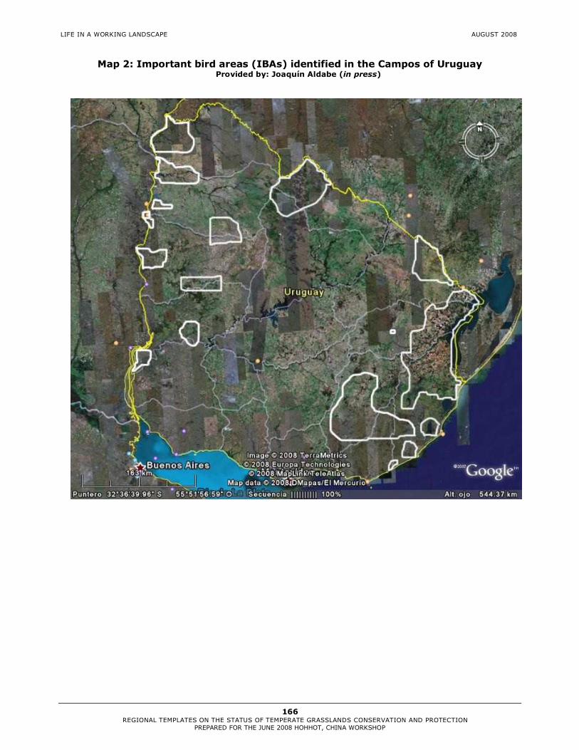
LIFE IN A WORKING LANDSCAPE AUGUST 2008
166 REGIONAL TEMPLATES ON THE STATUS OF TEMPERATE GRASSLANDS CONSERVATION AND PROTECTION
PREPARED FOR THE JUNE 2008 HOHHOT, CHINA WORKSHOP
Map 2: Important bird areas (IBAs) identified in the Campos of Uruguay Provided by: Joaquín Aldabe (in press)

LIFE IN A WORKING LANDSCAPE AUGUST 2008
167 REGIONAL TEMPLATES ON THE STATUS OF TEMPERATE GRASSLANDS CONSERVATION AND PROTECTION
PREPARED FOR THE JUNE 2008 HOHHOT, CHINA WORKSHOP
Map 3: Valuable Grassland Areas (VGAs) identified in Campos of Uruguay and South Brazil. (Red, orange and white areas and dots)
Extracted from: Bilenca & Miñarro 2004

LIFE IN A WORKING LANDSCAPE AUGUST 2008
168 REGIONAL TEMPLATES ON THE STATUS OF TEMPERATE GRASSLANDS CONSERVATION AND PROTECTION
PREPARED FOR THE JUNE 2008 HOHHOT, CHINA WORKSHOP
Map 4: Priority Areas identified for Campos Sulinos, Brazil Extracted from: MMA-SBF 2007

LIFE IN A WORKING LANDSCAPE AUGUST 2008
169 REGIONAL TEMPLATES ON THE STATUS OF TEMPERATE GRASSLANDS CONSERVATION AND PROTECTION
PREPARED FOR THE JUNE 2008 HOHHOT, CHINA WORKSHOP
Table 1: List of legally protected grassland areas in the Río de la Plata region The preliminary list provided below is under review. Most of the protected areas listed here do not have grasslands conservation among their priorities. References: Viglizzo et al. 2006; Bilenca and Miñarro 2004; APN-SIB; J.Aldabe com.pers.
Country Protected Area Total PA
Surface (ha)
Parque Nacional el Palmar 8,500 Parque Nacional Campos del Tuyú* 3,040 Refugio de Vida Silvestre La Aurora del Palmar
1,093
Reserva Natural Las Tunitas 300 Refugio de Vida Silvestre Las Dos Hermanas
1,055
Res. Nat. Las Tunas 16,000 Res. Ecológica Laguna la Salada 200 Res. Municipal Los Robles 1,000 Res. Nat. Selva Marginal Hudson 1,200 Res. Fund. E. S. de Pearson 1,500 Res. Nat. Integral Dunas Atlántico Sur 1,650 Res. Municipal Faro Querandí 5,575 Res. Nat Sierra de Tigre 140 Parque Prov. Ernesto Tornquist 6,678 Res. Nat. Prov. Limay Mahuida 4,983 Res. Nat. Prov. La Reforma 5,000 Res. de Biosfera Parque Costero del Sur 23,500 Sitio Ramsar Bahía de Samborombón 147,200
Argentina
Res. de Biosfera Parque Atlántico Mar Chiquito
26,488
Refugio de Vida Silvestre Morro Santana 370 Brazil Campos de la Frontera Oeste 770,000
Refugio de Fauna Laguna de Castillos 8,185 Parque Nacional y Reserva de Fauna y Flora El Potrerillo de Santa Teresa
715
Monumento Histórico y Parque Nacional Fuerte San Miguel
1,553 Uruguay
Área de Protección de la Naturaleza Lunarejo
25,000
TOTAL 1,060,925
*Currently in process of being approved as a national park

LIFE IN A WORKING LANDSCAPE AUGUST 2008
170 REGIONAL TEMPLATES ON THE STATUS OF TEMPERATE GRASSLANDS CONSERVATION AND PROTECTION
PREPARED FOR THE JUNE 2008 HOHHOT, CHINA WORKSHOP
References
Administración de Parques Nacionales (APN) - Sistema de Información de Biodiversidad (SIB). www.sib.gov.ar Bilenca, D. & F. Miñarro. 2004. Identificación de Áreas Valiosas de Pastizal (AVPs) en las Pampas y Campos de Argentina, Uruguay y sur de Brasil. Fundación Vida Silvestre Argentina, Buenos Aires. (Available at: http://www.vidasilvestre.org.ar/programaPublicaciones.php?idSeccion=30). Burkart, R. 2006. Las áreas protegidas de la Argentina. In: Brown, A., U. Martínez Ortíz, M. Acerbi & J. Corcuera (Eds.). La Situación Ambiental Argentina 2005. Fundación Vida Silvestre Argentina. Buenos Aires. Pp. 399-403. (Available at: http://www.vidasilvestre.org.ar/descargables/libro_imperdible/Conservacion%20y%20uso%20sust.pdf). Di Giacomo, A.S., M.V. De Francesco & E.G. Coconier (eds.). 2007. Áreas importantes para la conservación de las aves en Argentina. Sitios Prioritarios para la conservacion de la biodiversidad. Temas de Naturaleza y Conservación 5:1-514. CD-ROM. Edición Revisada y Corregida. Aves Argentinas/Asociación Ornitológica del Plata, Buenos Aires. (available at www.avesargentinas.org.ar). León, R.. 1991. Vegetation. In: Soriano, A. y R. Coupland (eds.). Natural Grasslands: Introduction and Western Hemisphere, Ámsterdam, Elsevier. Pp. 380-387. Martínez-Ghersa, M.A., Ghersa, C.M., 2005. Consecuencias de los recientes cambios agrícolas. Ciencia Hoy 15 (87), 37–45. Ministerio de Ganadería, Agricultura y Pesca (MGAP), Uruguay. 2008. www.mgap.gub.uy Ministerio do Meio Ambiente, Secretaria de Biodiversidade e Florestas (MMA-SBF). 2007. Áreas Prioritárias para Conservação, Uso Sustentável e Repartição de Benefícios da Biodiversidade Brasileira: Atualização. Portaria MMA n°9, de 23 de janeiro de 2007. Brasília: MMA, 2007. Série Biodiversidade, 31.
Miñarro, F. & Bilenca, D. 2008. The Conservation Status of Temperate Grasslands in Central Argentina. Special Report. Fundación Vida Silvestre Argentina. Buenos Aires.
Moreno, M, A Carminati, N Machain & M Roldán. 2008. Reseña sobre las reservas privadas en la Argentina. In: Voluntad de Conservar : Experiencias seleccionadas de conservación por la Sociedad civil en Iberoamérica. – 1 ed. – San José, C.R. Asociación Conservación de la Naturaleza . Pp. 7-33.
Olmos, F. y Godron. 1990. Relevaminetos fito-ecológicos en la región noreste. In: II Seminario Nacional de Campo Natural. Tacuarembó. Ed. H. Sur.
Olmos F., J. Franco y M. Sosa. 2005. Impacto de las prácticas de manejo en la productividad y diversidad de pasturas naturales. In: Seminario de Actualización Técnica en Manejo de Campo Natural INIA 2005.
Olmos, F. 2006. Propuesta metodológica para el uso, conservación y recuperación de las pasturas naturales. In: XXI Reunión del Grupo Técnico en Forrajeras del Cono Sur. Grupo Campos. Pelotas. Brasil.
Paruelo, J.M., Guerschman, J.P., Verón, S.R., 2005. Expansión agrícola y cambios en el uso del suelo. Ciencia Hoy 15 (87), 14-23. Paruelo J. M., Jobbágy, E.G, Oesterheld M., Golluscio R.A. and Aguiar M.R.. 2007. The grasslands and steppes of Patagonia and the Rio de la Plata plains. In T. Veblen, K. Young and A. Orme (eds.). Chapter 14. The Physical Geography of South America. The Oxford Regional Environments Series, Oxford University Press. Pp 232-248.
LIFE IN A WORKING LANDSCAPE AUGUST 2008
171 REGIONAL TEMPLATES ON THE STATUS OF TEMPERATE GRASSLANDS CONSERVATION AND PROTECTION
PREPARED FOR THE JUNE 2008 HOHHOT, CHINA WORKSHOP
Rearte, D. 2007. Programa Producción de Carnes. INTA. (http://www.inta.gov.ar/info/doc/rearte.pdf; accessed Sept 15th, 2007). Soriano, A., R. J. C. León, O. E. Sala, R. S. Lavado, V. A. Deregibus, M. A. Cahuepé, O. A. Scaglia, C. A. Velazquez & J. H. Lemcoff. 1992. Río de la Plata grasslands. In: Coupland, R.T. (ed.) Ecosystems of the world 8A. Natural grasslands. Pp. 367-407. Elsevier, New York.
Viglizzo, E.F., F.C. Frank y L. Carreño. 2006. Situación Ambiental en las Ecorregiones Pampa y Campos y Malezales. Pp. 261-278. In: Brown, A., U. Martínez Ortiz, M. Acerbi and J. Corcuera (eds.). La Situación Ambiental Argentina 2005. Fundación Vida Silvestre Argentina, Buenos Aires.

LIFE IN A WORKING LANDSCAPE AUGUST 2008
172 REGIONAL TEMPLATES ON THE STATUS OF TEMPERATE GRASSLANDS CONSERVATION AND PROTECTION
PREPARED FOR THE JUNE 2008 HOHHOT, CHINA WORKSHOP
18.4 Patagonian Steppes (Argentina and Chile)
Andrea Michelson1 (1) UICN Sur. Quito, Ecuador.
18.4.1 Major Indigenous Temperate Grasslands Types
The Patagonian steppes occupy a vast area in the southern tip of the continent, between latitudes 39° and 55°S. These steppes cover more than 800,000 km2 of Chile and Argentina, and are framed by the Andes to the west and the Atlantic coast to the east and south (Paruelo et al. 2007). Patagonia has relatively low mean annual precipitation (150–500 mm MAP), 46% of total precipitation falling in winter (Jobbágy et al., 1995). Mean annual temperature is also low (0 to 12°C) (Adler et al. 2006). The grasslands and steppes of Patagonia are very heterogeneous, both physiognomically and floristically. This high heterogeneity contradicts the common perception of Patagonia as a vast desert at the southern end of the world. Vegetation types range from semi-deserts to humid prairies with a large variety of shrub and grass steppes in between. Vegetation heterogeneity at a regional level reflects the constraints imposed by the climatic, topographic, and edaphic features (Paruelo et al. 2007). Grass steppes characterize the most humid portions of the region, which are dominated by grasses of the genus Festuca, accompanied by several other grasses, highly preferred by native and exotic herbivores, and sometimes by shrubs. In some portions of the steppe shrubs seem to be indicative of degradation by grazing (i.e. Mulinum spinosum, Senecio filaginoides and Acaena splendens) (León and Aguiar 1985; Bertiller et al. 1995), whereas in other districts shrubs are common constituents of the grass steppe (i.e. Nardophyllum bryoides, Chilliotrichum diffusum and Empetrum rubrum) (Collantes et al. 1999). At a finer grain, heterogeneity is due to altitude, slope, and exposure (Jobbágy et al. 1996, Paruelo et al. 2004). There are 1,378 recorded vascular plant species in arid and semi -arid Patagonia (Correa 1971), almost all of which are angiosperms and close to 30 percent of which are endemic species. Vegetation is characterized by the dominance of xerophytes, which have evolved remarkable adaptations to cope with severe water deficit (León et al. 1998). The native vertebrate fauna is poor (Soriano, 1983). Guanacos (Lama guanicoe) are the only large native ungulate (Soriano, 1983) and although the region has generally been considered to have evolved under light grazing pressure (Milchunas, Sala and Lauenroth, 1988), pre-European numbers of guanacos may have been higher than previously thought (Lauenroth, 1998); recent counts show populations are fairly stable at approximately 500 000 (Amaya et al., 2001). The lesser rhea (Pterocnemia pennata pennata) and the upland goose (Cloephagapicta) are the most conspicuous birds. The Patagonian hare (Dolichotis patagonum) and the small armadillo (Zaedyus pichyi), together with the lesser rheas , are important zoogeographical indicators (Soriano, 1983). There are significant numbers of predators , such as red foxes (Dusicyon culpaeus), grey foxes (Ducisyon griseus), pumas (Felis concolor) and skunks (Conepatus humboldtii) (Soriano, 1983).
AUTHOR

LIFE IN A WORKING LANDSCAPE AUGUST 2008
173 REGIONAL TEMPLATES ON THE STATUS OF TEMPERATE GRASSLANDS CONSERVATION AND PROTECTION
PREPARED FOR THE JUNE 2008 HOHHOT, CHINA WORKSHOP
18.4.2 Impact of Human Settlement
The main economic activities in Patagonia are sheep husbandry and oil exploration and extraction. Oil industry activities are the most intensive disturbance in Patagonia, though restricted in extent (Paruelo y Aguiar, 2003). They cause extremely severe and irreversible damage in focal areas because they remove all vegetation cover, and often entire soil layers (Paruelo et al. 2007). Sheep farming is almost a monoculture in the arid and semi -arid steppes. Intensive agricultural activities such as fruit and horticultural crops are important in a few irrigated valleys, but are almost absent on sheep farms (Borrelli et al., 1997). Cattle production has become important on mountain ranges near the Andes, where sheep farming is more difficult due to the presence of forests, steep landscapes and losses to predators (Cibils and Borrelli 2005). Grazing affects almost all the region, but nowhere has it completely eliminated plant cover (Paruelo et al. 2007). It has been perceived to be the main agent of desertification in Patagonia (Soriano and Movia, 1986; Ares et al., 1990). Patagonian vegetation is generally described as having few adaptations to cope with grazing by domestic ungulates, since the entire region is thought to have evolved under conditions of light grazing by native ungulates (Milchunas, Sala and Lauenroth, 1988). Although this notion has recently been challenged by Lauenroth (1998), there is general consensus that vegetation throughout most of Patagonia has been modified significantly by sheep over the last century, particularly in the last 40–50 years (Golluscio et al. 1998). Deterioration of grazed vegetation has usually been demonstrated by replacement of palatable grasses by unpalatable woody plants (Bertiller, 1993a, Cibils and Borrelli 2005, Paruelo et al. 2007). The impact of grazing varies widely among vegetation units. The grass-shrub steppes of the Occidental District (45°S, 70°W) show in general no major changes in vegetation physiognomy due to grazing (Perelman et al. 1997). In contrast, the grass steppes of Subandean District (45°S, 71°W) have experienced dramatic physiognomic changes due to grazing. Shrub encroachment is sometimes the final stage of grazing degradation of the grass steppes. Such changes reduce primary production (Paruelo et al., 2004) and modify water dynamics and herbivore biomass (Aguiar et al., 1996). In both vegetation units plant diversity is higher in ungrazed areas. European settlement in Patagonia´s steppe and introduction of cattle only began at the end of the nineteenth century (Barbería 1995). Sheep numbers had two phases, one growing till middle of XX century (over 21 million in 1952) and the latter gradually decreasing (about 8.5 million in 1999) (Golluscio et al. 1998; Méndez Casariego, 2000).This reduction have been interpreted as the result of productivity decay and desertification of Patagonia´s steppes due to overgrazing (Soriano y Movia, 1986; Ares et al., 1990). Impacts of sheep on this landscape have become more extensive during the past decade due to a reduction in wool prices, the lack of productive alternative land uses, and the absence of an environmental policy from federal and state agencies and governments (Cibils and Borrelli 2005).

LIFE IN A WORKING LANDSCAPE AUGUST 2008
174 REGIONAL TEMPLATES ON THE STATUS OF TEMPERATE GRASSLANDS CONSERVATION AND PROTECTION
PREPARED FOR THE JUNE 2008 HOHHOT, CHINA WORKSHOP
18.4.3 Current Status
Natural state: Although grazing affects almost all the region, nowhere has it completely eliminated plant cover (Paruelo et al. 2007). There is not information available on the percentage of indigenous grasslands in natural state. Formal Protection: There are twenty protected areas in Patagonia Steppe, covering around 2.500.000 ha (aproximately 5% of the ecoregion). However, this surface is considered insufficient to attain the level of protection for this ecoregion. Also, only 10 of these areas (less than 1% of ecorregion) have an acceptable and effective regime of protection (Paruelo et al. 2006). 18.4.4 Opportunities for Improving the Level of Protection and Conservation in the Region
There is a significant amount of research going on in Patagonian steppe (Cibils and Borrelli 2005). The need for management tools to regulate grazing and slow down rates of vegetation deterioration has led to the development of a number of vegetation-based pasture assessment routines over the past decade. Most of these (developed primarily by INTA) are being used in almost all provinces of Argentinian Patagonia, either by government agencies or private consultants (Borrelli and Oliva, 1999; Nakamatsu et al. 2001; Bonvissuto 2001; Siffredi et al., 2002). TNC has recently launched a conservation initiative in Argentina that aims to achieve protection of 10% temperate grasslands in Patagonia Steppe, Monte Bajo, Espinal and Pampa ecoregions. This objective will be accomplished by consolidation of existing and future protected areas, the creation of natural reserves within private lands, and the application of sustainable livestock management (especially ovine; G. Iglesias com.pers.). 18.4.5 Constraints Against Improving the Level of Protection and Conservation in the Region
Almost the whole ecoregion is included within private properties, with less than 1% being within state jurisdiction. Environmental regulations are hard to implement within these private lands (Paruelo et al. 2006). Probably one of the most important threatens to patagonic ecosystems is the lack of knowledge of land managers.
The reduction of cattle numbers will not allow the reduction of desertification. This can be explained by the fact that herbivores are selective in their diet, and thus it cannot be guaranteed that certain flora species are not to be consumed. 18.4.6 Suggested Next Steps and Action Plan
In order to promote best management practices for Argentinian Patagonia grasslands, Cibils and Borrelli (2005) recommend for the next five years to involve developing or adapting technology for: sustainable sheep farming systems (including the development of eco-certification protocols); management and reclamation of degraded grazing land, in particular areas that have been severely disturbed by mining or oil extraction; regional GIS to develop Decision Support Systems; genetic improvement of ultra-fine Merino sheep and Angora goats (including the use of biotechnology); and improvement of wildlife use (guanacos and rheas). Also, Paruelo et al. 2006 recommend to design monitoring programmes for protected areas to evaluate impacts of global change through these factors: CO2 atmospheric concentrations, N2 deposition, land use changes, climatic change and biotic exchanges.

LIFE IN A WORKING LANDSCAPE AUGUST 2008
175 REGIONAL TEMPLATES ON THE STATUS OF TEMPERATE GRASSLANDS CONSERVATION AND PROTECTION
PREPARED FOR THE JUNE 2008 HOHHOT, CHINA WORKSHOP
18.4.7 Appendices
Map 1: The location of important existing and proposed grassland areas Extracted from: Paruelo et al.2006

LIFE IN A WORKING LANDSCAPE AUGUST 2008
176 REGIONAL TEMPLATES ON THE STATUS OF TEMPERATE GRASSLANDS CONSERVATION AND PROTECTION
PREPARED FOR THE JUNE 2008 HOHHOT, CHINA WORKSHOP
Table 1: List of legally protected grassland areas in Patagonia Steppe ( Paruelo et al. 2006; APN-SIB)
Country
Protected Area
Total PA Surface (ha)
Parque Nacional y Res. Nacional Laguna Blanca (Sitio Ramsar)
11,263
Monumento Nacional Bosques Petrificados
61,228
Parque Nacional y Res. Nacional Perito Moreno
115,000
Parque Nacional Monte León 60,800 Res. Nat. de Fauna Laguna Llancanelo (Sitio Ramsar)
40,000
Res. Provincial de Flora Domuyo 3,620 Parque Provincial El Tromen 24,000 Parque Público Turístico Laguna Carri Laufquen
700
Área Natural Protegida Meseta de Somuncurá
1,600,000
Res. Nat. Turística Objetivo Específico Laguna Aleusco
1,200
Res. Nat. Turística Objetivo Integral Península de Valdés
360,000
Res. Nat. Turística Punta Delgada 2,829 Res. Nat. Turística Objetivo Integral Cabo Dos Bahías
160
Res. Nat. Cabo Blanco No data Res. Nat. Provincial Ría de Puerto Deseado
10,000
Res. Provincial Península de San Julián 10,400
Argentina
Res. Provincial Cabo Vírgenes 1,230 TOTAL 2,302,430
References Adler, P.B., M.F. Garbulsky, J.M. Paruelo, and W. K. Lauenroth, 2006. Do abiotic differences explain contrasting graminoid functional traits in sagebrush steppe, USA and Patagonian steppe, Argentina? Journal of Arid Environments, 65, 62-82. Aguiar, M.R., J.M. Paruelo, O.E. Sala, and W.K. Lauenroth, 1996. Ecosystem consequences of plant functional types changes in a semiarid Patagonian steppe. Journal of Vegetation Science, 7, 381–390. Amaya, J.N., von Thüngen, J. &Delamo, D.A. 2001. Relevamiento y distribución de guanacos en la Patagonia : Informe Final. Comunicación Técnica, No.111. Area Recursos Naturales-Fauna 111. INTA, Bariloche. Administración de Parques Nacionales (APN) – Sistema de Información de Biodiversidad (SIB). www.sib.gov.ar Ares, J., A. Beeskow, M. Bertiller, M. Rostagno, M. Irrisarri, J. Anchorena, G., Defosse, and C. Merino, 1990. Structural and dynamics characteristics of overgrazed lands of northern Patagonia, Argentina. In: Managed Grasslands, Elsevier Science Publishers, Amsterdam, 149–175.

LIFE IN A WORKING LANDSCAPE AUGUST 2008
177 REGIONAL TEMPLATES ON THE STATUS OF TEMPERATE GRASSLANDS CONSERVATION AND PROTECTION
PREPARED FOR THE JUNE 2008 HOHHOT, CHINA WORKSHOP
Barbería, E. 1995. Los dueños de la tierra de la Patagonia Austral:1880–1920. Río Gallegos, Argentina : Universidad Federal de la Patagonia Austral. Bertiller, M.B. 1993a. Catálogo de estados y transiciones: Estepas subarbustivo herbáceas de Nassauvia glomerulosa y Poa dusenii del centro-sur del Chubut. pp. 52–56, in: Paruelo et al., 1993, q.v. Bertiller, M.B., N. Elissalde, M. Rostagno, and G. Defosse, 1995. Environmental patterns and plant distribution along a precipitation gradient in western Patagonia. Journal of Arid Environments, 29, 85–97. Bonvissuto, 2001; Borrelli, G., Oliva, G., Williams, M., Gonzalez, L., Rial, P. & Montes, L. (eds). 1997. Sistema Regional de Soporte de Decisiones. Santa Cruz y Tierra del Fuego. Proderser (Proyecto de Prevención y Control de la Desertificación en Patagonia ), Río Gallegos, Argentina. Borrelli, P. & Oliva, G. 1999. Managing grazing: experiences from Patagonia. pp. 441–447 (Vol. 1), in: Proceedings of the 6th International Rangeland Congress. Townsville, Queensland, Australia, 19–23 July 1999. Cibils, A.F. and P.R. Borrelli. 2005. Grasslands of Patagonia. pp. 121–170. In: J.M. Suttie, S.G. Reynolds and C. Batello (eds). Chapter 4. Grasslands of the World. FAO, Rome. Collantes, M.B., J. Anchorena, and A.M. Cingolani, 1999. The steppes of Tierra del Fuego: Floristic and growth form patterns controlled by soil fertility and moisture. Plant Ecology, 140, 61–75. Correa, M.N. (ed). 1971. Flora Patagónica. Buenos Aires, Argentina: Colección científica del INTA. Golluscio, R.A., V.A. Deregibus & J.M. Paruelo. 1998. Sustainability and range management in the Patagonian steppes. Ecologia Austral, 8: 265–284. Jobbágy, E.G., J.M. Paruelo, and R.J.C. León, 1995. Estimación de la precipitación y de su variabilidad interanual a partir de información geográfica en el NW de Patagonia, Argentina. Ecología Austral, 5, 47–53. Jobbágy, E.G., J.M. Paruelo, and R.J.C. León, 1996. Vegetation heterogeneity and diversity in flat and mountain landscapes of Patagonia (Argentina). Journal of Vegetation Science, 7, 599–608. Lauenroth, W., 1998. Guanacos, spiny shrubs, and evolutionary history of grazing in the Patagonian steppe Ecología Austral, 8, 211–216. León, R.J.C., and M.R. Aguiar, 1985. El deterioro por uso pasturil en estepas herbáceas patagónicas. Phytocoenologia, 13, 181–196. León, R.J.C., D. Bran, M. Collantes, J.M. Paruelo, and A. Soriano, 1998. Grandes unidades de vegetación de la Patagonia extra andina. Ecología Austral, 8, 125–144. Méndez Casariego, H. 2000. Sistema de soporte de decisiones para la producción ganadera sustentable en la Provincia de Río Negro (SSD-Río Negro). INTAGTZ. Centro Regional Patagonia Norte. EEA Bariloche. EEA Valle Inferior. Proyecto Prodesar.1 CD-ROM. Milchunas, D.G., O.E. Sala, and W.K. Lauenroth, 1988. A generalized model of the effects of grazing by large herbivores on grassland community structure. American Naturalist, 132, 87–106.

LIFE IN A WORKING LANDSCAPE AUGUST 2008
178 REGIONAL TEMPLATES ON THE STATUS OF TEMPERATE GRASSLANDS CONSERVATION AND PROTECTION
PREPARED FOR THE JUNE 2008 HOHHOT, CHINA WORKSHOP
Nakamatsu, V.B., Escobar, J.M. & Elissalde, J.M. 2001a. Evaluación forrajera de pastizales naturales de estepa en establecimientos ganaderos de la provincia de Chubut (Patagonia, Argentina), Resultados de 10 años de trabajo. pp. 19–20, in: Resúmenes del taller de actualización sobre métodos de evaluación, monitoreo y recuperación de pastizales naturales patagónicos. IV Reunión del Grupo Regional Patagónico de Ecosistemas de Pastoreo. INTA-INIA-FAO. Esquel, Argentina, 26–27 June 2001. Paruelo, J. M. y M. R. Aguiar. 2003. El impacto humano sobre los ecosistemas: el caso de la desertificación en Patagonia. Ciencia Hoy, 13, pp. 48-59. Paruelo, J. M., R. Golluscio, J. Guerschman, A. Cesa, V. Jouve y M. Garbulsky. 2004. Regional scale relationships between ecosystem structure and functioning: the case of the Patagonian steppes. Global Ecology and Biogeography, 13, pp. 385-395. Paruelo, J.M., R.A. Golluscio, E.G. Jobbágy, M. Canevari and Martín R. Aguiar. 2006. Situación Ambiental en la Estepa Patagónica. Pp. 302-320. In: Brown, A., U. Martínez Ortiz, M. Acerbi and J. Corcuera (eds.). La Situación Ambiental Argentina 2005. Fundación Vida Silvestre Argentina, Buenos Aires, 2006. Paruelo J. M., Jobbágy, E.G, Oesterheld M., Golluscio R.A. and Aguiar M.R.. 2007. The grasslands and steppes of Patagonia and the Rio de la Plata plains. In T. Veblen, K. Young and A. Orme (eds.). Chapter 14. The Physical Geography of South America. The Oxford Regional Environments Series, Oxford University Press. Pp 232-248. Perelman, S.B., León, R.J.C. & Bussacca, J.P. 1997. Floristic changes related to grazing intensity in a Patagonian shrub steppe. Ecography, 20: 400–406. Siffredi, G., Becker, G., Sarmiento, A., Ayesa, J., Bran, D. & López, C. 2002. Métodos de evaluación de los recursos naturales para la planificación integral y uso sustentable de las tierras. p. 35, in: Resúmenes del taller de actualización sobre métodos de evaluación, monitoreo y recuperación de pastizales naturales patagónicos. IV Reunión del Grupo Regional Patagónico de Ecosistemas de Pastoreo. INTA-INIA-FAO. Esquel, Argentina , 26–27 June 2001. Soriano, A. 1956b. Aspectos ecológicos y pastoriles de la vegetación patagónica, relacionados con su estado y capacidad de recuperación”, Revista de Investigaciones Agropecuarias, 10, pp. 349-372. Soriano, A. 1983. Deserts and semi-deserts of Patagonia . pp. 423–460, in: N.E. West (ed). Ecosystems of the World - Temperate Deserts and Semi-Deserts. Amsterdam, The Netherlands: Elsevier Scientific. Soriano, A., and C. Movia, 1986. Erosión y desertización en la Patagonia. Interciencia, 11, 77–83.