Embed Size (px)
Citation preview

Palm Paper Limited Appendices
Environmental Statement – Palm Paper PP3 CCGT
Appendix 5-1 Scoping Report-
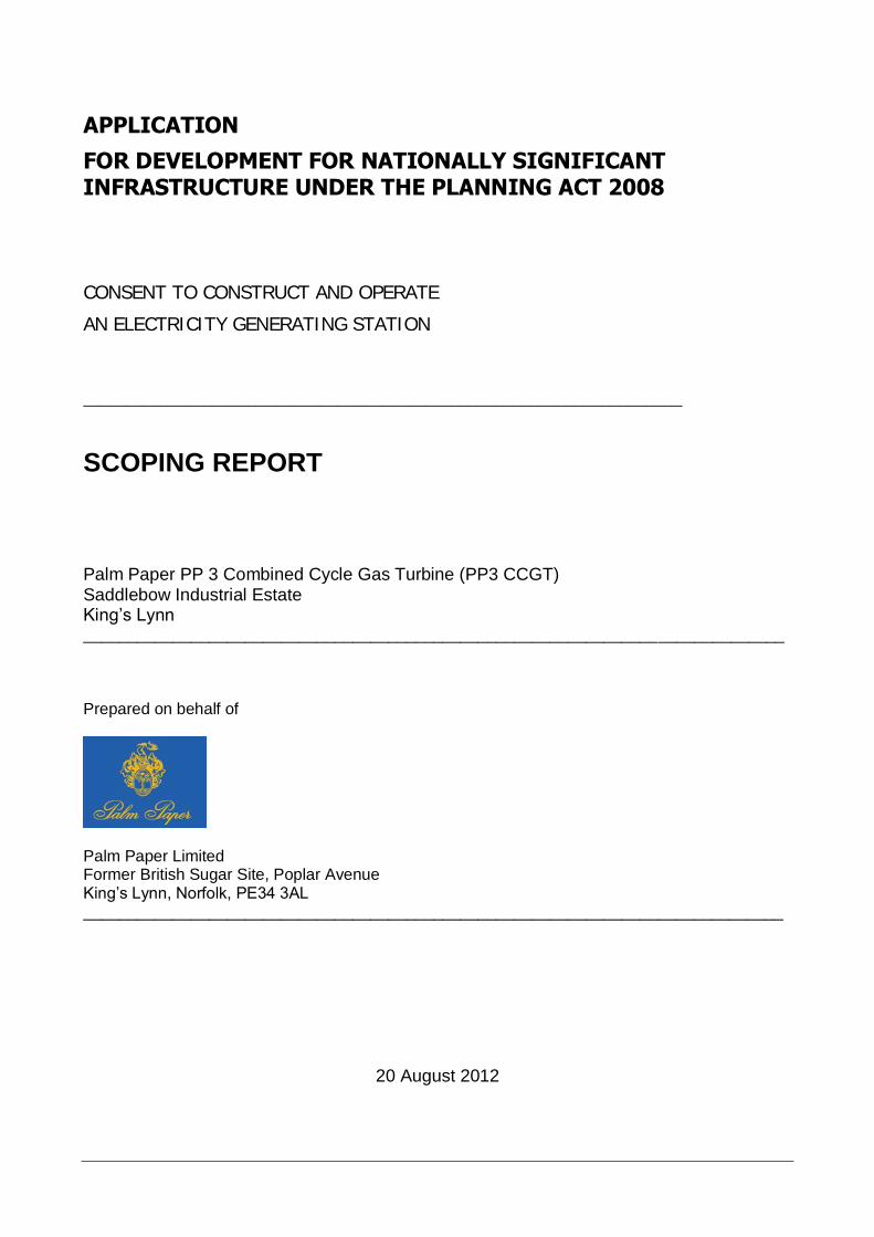
APPLICATION
FOR DEVELOPMENT FOR NATIONALLY SIGNIFICANT INFRASTRUCTURE UNDER THE PLANNING ACT 2008
CONSENT TO CONSTRUCT AND OPERATE
AN ELECTRICITY GENERATING STATION
___________________________________________________________________________________________________________________________________________________________________
SCOPING REPORT
Palm Paper PP 3 Combined Cycle Gas Turbine (PP3 CCGT) Saddlebow Industrial Estate King’s Lynn ______________________________________________________________________________ Prepared on behalf of
Palm Paper Limited Former British Sugar Site, Poplar Avenue King’s Lynn, Norfolk, PE34 3AL ______________________________________________________________________________
20 August 2012
Palm Paper Limited PCU
Scoping Report Palm Paper PP 3 CCGT
www.pcu..de August 2012
2
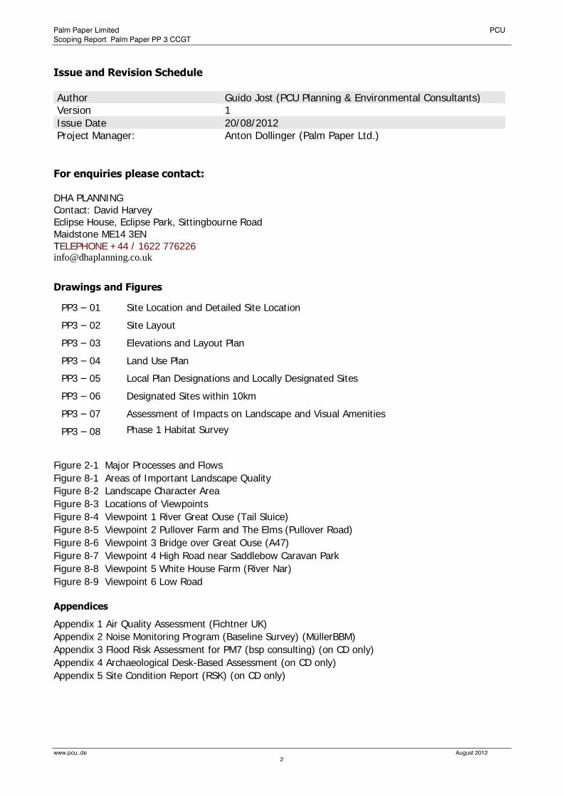
Issue and Revision Schedule
Author Guido Jost (PCU Planning & Environmental Consultants) Version 1
Issue Date 20/08/2012 Project Manager: Anton Dollinger (Palm Paper Ltd.)
For enquiries please contact: DHA PLANNING Contact: David Harvey Eclipse House, Eclipse Park, Sittingbourne Road Maidstone ME14 3EN TELEPHONE +44 / 1622 776226 [email protected]
Drawings and Figures
PP3 – 01 Site Location and Detailed Site Location
PP3 – 02 Site Layout
PP3 – 03 Elevations and Layout Plan
PP3 – 04 Land Use Plan
PP3 – 05 Local Plan Designations and Locally Designated Sites
PP3 – 06 Designated Sites within 10km
PP3 – 07 Assessment of Impacts on Landscape and Visual Amenities
PP3 – 08 Phase 1 Habitat Survey
Figure 2-1 Major Processes and Flows
Figure 8-1 Areas of Important Landscape Quality
Figure 8-2 Landscape Character Area
Figure 8-3 Locations of Viewpoints
Figure 8-4 Viewpoint 1 River Great Ouse (Tail Sluice)
Figure 8-5 Viewpoint 2 Pullover Farm and The Elms (Pullover Road)
Figure 8-6 Viewpoint 3 Bridge over Great Ouse (A47)
Figure 8-7 Viewpoint 4 High Road near Saddlebow Caravan Park
Figure 8-8 Viewpoint 5 White House Farm (River Nar)
Figure 8-9 Viewpoint 6 Low Road
Appendices
Appendix 1 Air Quality Assessment (Fichtner UK)
Appendix 2 Noise Monitoring Program (Baseline Survey) (MüllerBBM)
Appendix 3 Flood Risk Assessment for PM7 (bsp consulting) (on CD only)
Appendix 4 Archaeological Desk-Based Assessment (on CD only)
Appendix 5 Site Condition Report (RSK) (on CD only)

Palm Paper Limited PCU
Scoping Report Palm Paper PP 3 CCGT
www.pcu..de August 2012
3
List of Contents
1.0 INTRODUCTION ................................................................................................................................. 8
1.1 The Developer .........................................................................................................................8
1.2 The Proposed Development ...................................................................................................8
1.3 The Site ....................................................................................................................................8
1.4 Rationale for Development .....................................................................................................9
1.5 Project Team ...........................................................................................................................9
1.6 Regulatory Context / Legislative Regime ...............................................................................9
1.6.1 The Infrastructure Planning (EIA) Regulations 2009 .................................................... 9 1.6.2 Planning Act 2008 .................................................................................................... 10 1.6.3 Environmental Permit ............................................................................................... 10 1.6.4 Combined Heat and Power (CHP) ............................................................................ 10 1.6.5 Greenhouse Gas Emissions Permit .......................................................................... 10 1.6.6 Water Abstraction Licence ........................................................................................ 10 1.6.7 Discharge Consent ................................................................................................... 11 1.6.8 Control of Major Accident Hazards (COMAH) and Hazardous Substances Consent
(HSC) 11 1.6.9 Gas Pipeline Construction Authorisation ................................................................... 11 1.6.10 Conservation of Natural Habitats and of Wild Fauna and Flora (the Habitats
Directive) 11
1.7 The Need for Environmental Impact Assessment and the Purpose of this Scoping Report11
1.7.1 Screening................................................................................................................. 11 1.7.2 Scoping ................................................................................................................... 12
2.0 Description of the Proposed Development ........................................................................................ 13
2.1 Overview ................................................................................................................................ 13
2.2 Plant Layout ........................................................................................................................... 14
2.3 Process Description and Technical Data ............................................................................. 14
2.3.1 Gas Receipt and Metering Compound ..................................................................... 15 2.3.2 Gas Compression facilities ....................................................................................... 15 2.3.3 Air Intake and Filters ................................................................................................. 15 2.3.4 Gas Turbine Intake Silencer ..................................................................................... 15 2.3.5 Gas Turbine and Gas Turbine Generator .................................................................. 15 2.3.6 Heat Recovery Steam Generator (HRSG) ................................................................. 16 2.3.7 Steam turbine and Steam Turbine Generator............................................................ 16 2.3.8 Air Cooled Condenser (ACC) ................................................................................... 16 2.3.9 Transformers ............................................................................................................ 17 2.3.10 Closed Cycle Cooling Water (CCCW) System .......................................................... 17 2.3.11 Emergency Diesel Generator (EDG) ......................................................................... 17 2.3.12 Fire Protection .......................................................................................................... 17 2.3.13 Water Treatment Plant .............................................................................................. 17 2.3.14 Surface Water Drainage System ............................................................................... 17 2.3.15 Stack Height............................................................................................................. 17
2.4 Plant Dimensions .................................................................................................................. 17
2.5 Plant Operation ..................................................................................................................... 18
2.6 Operational Releases ............................................................................................................ 18
2.6.1 Air Emissions ........................................................................................................... 18 2.6.2 Emissions to Water................................................................................................... 20 2.6.3 Releases to Land ...................................................................................................... 20 2.6.4 Noise ....................................................................................................................... 20
2.7 Fuel supply ............................................................................................................................ 21
2.8 Plant Efficiency ...................................................................................................................... 21
Palm Paper Limited PCU
Scoping Report Palm Paper PP 3 CCGT
www.pcu..de August 2012
4
2.9 Construction Phase ............................................................................................................... 21
2.10 Alternatives ............................................................................................................................ 22
2.11 Materials Usage ..................................................................................................................... 22
2.11.1 Natural Gas .............................................................................................................. 22 2.11.2 Water Use (process water) ....................................................................................... 22 2.11.3 Chemicals ................................................................................................................ 23 2.11.4 Waste Arisings ......................................................................................................... 24
2.12 Environmental Management Systems .................................................................................. 24
3.0 Description of the Development Site and its Surroundings ................................................................ 24
3.1 Development Site .................................................................................................................. 24
3.2 Development Site Surroundings ........................................................................................... 25
3.3 Physical Setting ..................................................................................................................... 26
3.3.1 Geology and Soils .................................................................................................... 26 3.3.2 Hydrogeology and Groundwater Use ....................................................................... 26 3.3.3 Surface Water Resources ......................................................................................... 26 3.3.4 Ecology - Protected Sites & Sites of Conservation Importance ................................. 27 3.3.5 Human Population & Socio-Economic Setting .......................................................... 28
4.0 Legislative Planning Policy Context ................................................................................................... 29
4.1 Context .................................................................................................................................. 29
4.2 Legislative Context ................................................................................................................ 29
4.3 Development Plan ................................................................................................................. 30
4.4 Regional ................................................................................................................................. 30
4.4.1 Local ........................................................................................................................ 30
4.5 National Planning Policy Framework.................................................................................... 30
4.6 National Policy Statement - Overarching Energy (EN-1) ..................................................... 31
4.7 National Policy Statement - Fossil Fuels (EN-2) .................................................................. 31
4.8 King’s Lynn and West Norfolk Core Strategy (2011) ........................................................... 32
4.9 King’s Lynn and West Norfolk Local Plan (1998) ................................................................. 32
4.10 King’s Lynn and West Norfolk Site Specific Allocations and Policies (emerging) ............. 32
5.0 Assessment Methodology ................................................................................................................. 34
5.1 Overview ................................................................................................................................ 34
5.2 Assessment Methodology of the Environmental Statement ................................................ 34
6.0 Air Quality ......................................................................................................................................... 38
6.1 Introduction and Scope ......................................................................................................... 38
6.2 Air Quality Standards, Objectives and Guidelines ............................................................... 38
6.3 Baseline Conditions .............................................................................................................. 40
6.3.1 Background Air Quality ............................................................................................ 40 6.3.2 Summary ................................................................................................................. 44 6.3.3 Location of Sensitive Receptors ............................................................................... 45 6.3.4 Emission Sources and Emissions Data..................................................................... 46
6.4 Assessment Methodology and Significance Criteria ........................................................... 47
6.4.1 Dispersion Modelling (Operational Phase) ................................................................ 47 6.4.2 Construction Phase .................................................................................................. 49
6.5 Assessment of Effects .......................................................................................................... 51
6.5.1 Dispersion Modelling Results (70m-stack) ................................................................ 51 6.5.2 Dispersion Modelling Results (80m-stack) ................................................................ 55 6.5.3 Sensitivities .............................................................................................................. 57 6.5.4 Sensitive Environmental Receptors .......................................................................... 60
Palm Paper Limited PCU
Scoping Report Palm Paper PP 3 CCGT
www.pcu..de August 2012
5
6.5.5 Plume Visibility ......................................................................................................... 63 6.5.6 Combined Impact Assessment King’s Lynn Power Station ....................................... 64 6.5.7 Construction Phase .................................................................................................. 67
6.6 Mitigation Measures .............................................................................................................. 67
6.6.1 Operational Phase .................................................................................................... 67 6.6.2 Construction Phase .................................................................................................. 67
6.7 Conclusions ........................................................................................................................... 68
6.7.1 Operational Phase .................................................................................................... 68 6.7.2 Construction Phase .................................................................................................. 68
7.0 Noise and Vibration........................................................................................................................... 69
7.1 Introduction and Scope ......................................................................................................... 69
7.2 Baseline Condition ................................................................................................................ 69
7.2.1 Site and Area Description ......................................................................................... 69 7.2.2 Noise Sensitive Locations (NSL) ............................................................................... 70 7.2.3 Baseline Noise Monitoring ........................................................................................ 70 7.2.4 Major Noise Sources ................................................................................................ 72
7.3 Assessment Methodology and Significance Criteria ........................................................... 72
7.3.1 Construction Noise and Vibration ............................................................................. 73 7.3.2 Operational Noise .................................................................................................... 74
7.4 Assessment of Effects .......................................................................................................... 75
7.4.1 Assessment of Construction Noise and Vibration ..................................................... 75 7.4.2 Assessment of Operational Noise ............................................................................. 79
7.5 Mitigation Measures .............................................................................................................. 80
7.5.1 Construction Noise and Vibration ............................................................................. 80 7.5.2 Operational Noise .................................................................................................... 80
7.6 Summary and Conclusion ..................................................................................................... 81
8.0 Landscape and Visual Effects ........................................................................................................... 81
8.1 Introduction and Scope ......................................................................................................... 81
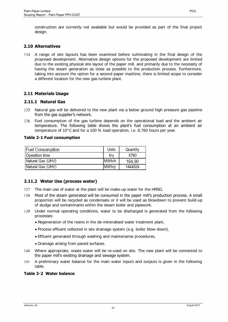
8.2 Baseline Conditions .............................................................................................................. 81
8.2.1 Landscape Designations .......................................................................................... 81 8.2.2 The Development Site .............................................................................................. 82 8.2.3 Context of the Development ..................................................................................... 83 8.2.4 The Study Area ........................................................................................................ 83 8.2.5 Landscape Character ............................................................................................... 84
8.3 Assessment Methodology .................................................................................................... 87
8.3.1 General Approach and Data Gathering ..................................................................... 87 8.3.2 Desk Study............................................................................................................... 88 8.3.3 Baseline Survey ....................................................................................................... 88 8.3.4 Field Survey / Assessment ....................................................................................... 88
8.4 Assessment Criteria .............................................................................................................. 89
8.4.1 Sensitivity of the Landscape to Change .................................................................... 89 8.4.2 Sensitivity of visual receptors.................................................................................... 89 8.4.3 Magnitude of Visual Change..................................................................................... 90 8.4.4 Significance Criteria ................................................................................................. 91
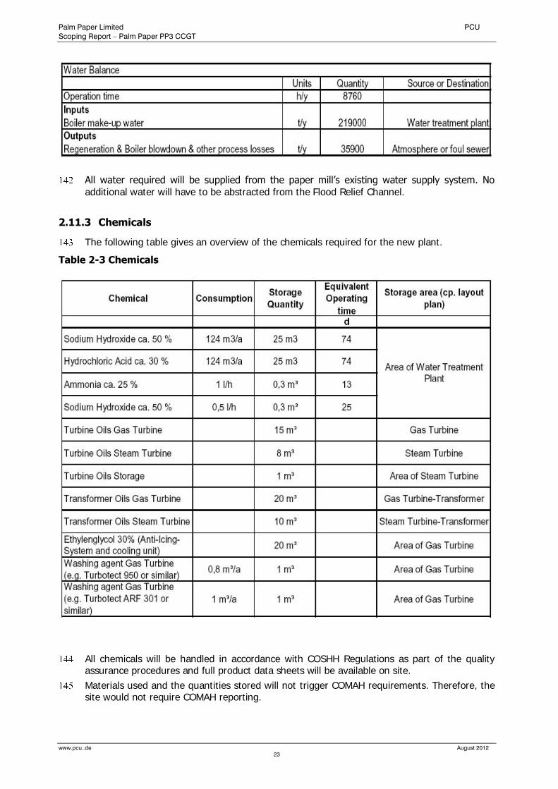
8.5 Assessment of Effects .......................................................................................................... 91
8.5.1 Assessment of Effects on Landscape Character Areas ............................................. 92 8.5.2 Visual Impact Assessment ........................................................................................ 94
8.6 Mitigation Measures .............................................................................................................. 97
8.6.1 Colour ...................................................................................................................... 98 8.6.2 Planting .................................................................................................................... 98
Palm Paper Limited PCU
Scoping Report Palm Paper PP 3 CCGT
www.pcu..de August 2012
6
8.6.3 Lighting .................................................................................................................... 98
8.7 Summary of Residual Effects................................................................................................ 98
8.7.1 Existing Situation ...................................................................................................... 98 8.7.2 Effects on Landscape Character ............................................................................... 99
8.8 Conclusion ............................................................................................................................ 99
9.0 Ecology and Nature Conservation ................................................................................................... 100
9.1 Introduction and Scope ....................................................................................................... 100
9.2 Baseline Data ...................................................................................................................... 100
9.2.1 General Considerations .......................................................................................... 100 9.2.2 The Development Site ............................................................................................ 100 9.2.3 Protected Sites & Sites of Conservation Importance in the surrounding .................. 101
9.3 Ecological Impacts .............................................................................................................. 102
9.4 Conclusion .......................................................................................................................... 104
10.0 Flood Risk and Drainage ................................................................................................................. 104
10.1 Introduction and Scope ....................................................................................................... 104
10.2 Baseline Conditions ............................................................................................................ 104
10.2.1 Overall Catchment Context ..................................................................................... 105 10.2.2 Flood Levels ........................................................................................................... 105 10.2.3 Environment Agency Web Site ............................................................................... 106
10.3 Approach and Assessment Methodology .......................................................................... 106
10.4 Assessment Criteria ............................................................................................................ 107
10.4.1 Flood Zones ........................................................................................................... 107 10.4.2 Vulnerability ........................................................................................................... 109
10.5 Assessment of Effects ........................................................................................................ 110
10.5.1 Sources of Flooding ............................................................................................... 110 10.5.2 Flood Defences ...................................................................................................... 111 10.5.3 Run-off Assessment ............................................................................................... 111 10.5.4 Sustainable Urban Drainage Systems (SUDS) ........................................................ 111 10.5.5 Proposed Site Development Levels ........................................................................ 112 10.5.6 Floodplain Encroachment ...................................................................................... 112 10.5.7 Climate Change ..................................................................................................... 112 10.5.8 Flood Warning........................................................................................................ 113 10.5.9 Vulnerability Classification ...................................................................................... 113
10.6 Mitigation and Residual Risks ............................................................................................ 113
10.6.1 Breaching of defences ........................................................................................... 113 10.6.2 Failure of Hydraulic Structures ............................................................................... 114 10.6.3 Overtopping of Flood Defences .............................................................................. 114 10.6.4 Flooding from Sewers ............................................................................................ 114 10.6.5 Conclusions and Recommendations ...................................................................... 114
11.0 ARCHAEOLOGY AND CULTURAL HERITAGE................................................................................. 116
11.1 Introduction and Scope ....................................................................................................... 116
11.2 Baseline Conditions ............................................................................................................ 116
11.2.1 Geology and Topography ...................................................................................... 116 11.2.2 Designations .......................................................................................................... 117 11.2.3 Archaeological and Historical Background ............................................................. 118
11.3 Assessment Methodology and Assessment Criteria ......................................................... 120
11.3.1 Criteria of Importance (Sensitivity) .......................................................................... 120 11.3.2 Magnitude of Impact .............................................................................................. 121 11.3.3 Significance of Impact ............................................................................................ 121
11.4 Assessment of Effects ........................................................................................................ 121
Palm Paper Limited PCU
Scoping Report Palm Paper PP 3 CCGT
www.pcu..de August 2012
7
11.4.1 Buried Archaeological Deposits .............................................................................. 121 11.4.2 Designated Features / Built Heritage ...................................................................... 122
11.5 Mitigation Measures ............................................................................................................ 122
11.6 Summary and Conclusion ................................................................................................... 122
12.0 Water Resources and Water Quality ................................................................................................ 123
12.1 Introduction and Scope ....................................................................................................... 123
12.2 Baseline Conditions ............................................................................................................ 123
12.2.1 Potential Impacts on Surface and Groundwater ...................................................... 123 12.2.2 Site Hydrology ....................................................................................................... 124
12.3 Assessment Methodology and Assessment Criteria ......................................................... 126
12.4 Assessment of Effects ........................................................................................................ 127
12.5 Mitigation Measures ............................................................................................................ 128
13.0 Traffic and Transportation ............................................................................................................... 129
13.1 Introduction and Scope ....................................................................................................... 129
13.2 Baseline Conditions ............................................................................................................ 129
13.2.1 Site Location .......................................................................................................... 129 13.2.2 Walking and cycling ............................................................................................... 129 13.2.3 Public Transport ..................................................................................................... 129 13.2.4 Vehicular Access .................................................................................................... 129
13.3 Assessment Methodology and Assessment Criteria ......................................................... 130
13.4 Assessment of Effects ........................................................................................................ 130
13.4.1 Construction Phase ................................................................................................ 130 13.4.2 Operational Phase .................................................................................................. 130 13.4.3 Mitigation Measures ............................................................................................... 130
13.5 Summary and Conclusion ................................................................................................... 131
14.0 Socio-Economics ............................................................................................................................ 131
14.1 Introduction ......................................................................................................................... 131
14.2 Baseline Condition .............................................................................................................. 131
14.3 Assessment Methodology .................................................................................................. 132
14.4 Assessment of Effects ........................................................................................................ 132
14.5 Mitigation Measures ............................................................................................................ 132
14.6 Conclusions ......................................................................................................................... 132
15.0 Geology and Ground Conditions .................................................................................................... 133
15.1 Introduction and Scope ....................................................................................................... 133
15.2 Baseline Condition .............................................................................................................. 134
15.2.1 Geology and Hydrogeology ................................................................................... 134 15.2.2 Pollution History ..................................................................................................... 135 15.2.3 Ground Condition Baseline Data ............................................................................ 136
15.3 Mitigation Measures ............................................................................................................ 136
15.4 Assessment of Residual Impacts ....................................................................................... 137
15.5 Conclusions ......................................................................................................................... 137
16.0 Other Considerations ...................................................................................................................... 137
17.0 Conclusions .................................................................................................................................... 138
18.0 References...................................................................................................................................... 141
19.0 Drawings and Figures ..................................................................................................................... 142
20.0 Appendices..................................................................................................................................... 143
Palm Paper Limited PCU
Scoping Report – Palm Paper PP3 CCGT
www.pcu..de August 2012
8
1.0 INTRODUCTION
1.1 The Developer
Palm Paper Limited (PPL) is the UK subsidiary of Papierfabrik Palm headquartered in Aalen-Neukochen (Baden-Württemberg), Germany. Papierfabrik Palm is an independent, family-owned company, founded in 1872. Since that time the company has remained a family business and grown considerably. It now operates 20 production facilities - 4 paper mills and 16 box plants. Three paper mills are in Germany, one in the United Kingdom. In addition Papierfabrik Palm operate a range of electricity and steam generating plants which include 1 sludge combustor and 2 gas turbines.
PPL received consent in November 2007 to build a new paper mill for newsprint at the Former British Sugar Site at the Saddlebow Industrial Estate in King’s Lynn. Construction was completed in December 2009. The consent includes the construction and operation of an Effluent Treatment Plant, a Sludge Combustor (5 MWe), a Package Gas Boiler (156 MWth), and the abstraction of freshwater from the Flood Relief Channel. Currently, Palm Paper Ltd. produces approximately 500,000 to 600,000 tons of newsprint paper per year by 200 employees.
PPL is committed to bringing further inward investment to the King’s Lynn area through the development of the proposed plant in an environmentally acceptable and sustainable manner.
The office and contact address for the proposed PP 3 CCGT project is:
Palm Paper Limited
Former British Sugar Site
Poplar Avenue
King’s Lynn, Norfolk, PE34 3AL
To contact the project team by e-mail use:
1.2 The Proposed Development
Palm Paper Limited (PPL) proposes to construct and operate a 162 MW Combined Cycle Gas Turbine (CCGT) Power Station to be known as Palm Paper 3 CCGT. The new CCGT will burn natural gas only and it will provide electricity and steam for the paper mill.
1.3 The Site
The location of the proposed plant is within the existing Palm Paper site, situated near King’s Lynn. The site location and the proposed application site boundary are shown in drawing PP3–01. The Ordnance Survey (OS) Grid Reference of the centre of the site is approximately 561015, 317750. The new development would be located on land adjacent to the existing Paper machine building between the reject storage and the retention basin (see drawing PP3 – 02).
Palm Paper Limited PCU
Scoping Report – Palm Paper PP3 CCGT
www.pcu..de August 2012
9
1.4 Rationale for Development
The paper mill consumes significant amounts of energy in the form of electricity and steam within the recycling and production processes. The mill requires at least 56 MW of electricity and 100 t/h of steam under normal operating conditions and 60 MW of electricity and 130 t/h of steam during short term ‘peak’ loads.
The supply of electricity is currently provided by importing power from the local electricity network. The connection of the mill to the local network is required irrespective of on-site generation to maintain the security of electricity supplies to site. The connection is made via an EdF-substation adjacent to the Kings Lynn power station.
With the new CCGT Palm Paper seeks to reduce its dependency from imported energy.
1.5 Project Team
Palm Paper Limited is the promoter for this project.
The project team undertaking the EIA for the proposed development is as follows:
Palm Paper Ltd. – Management of the Master Planning process, involvement in the planning and community consultation process;
PCU Planning & Environmental Consultants Ltd.- EIA and Environmental Permit application preparation, baseline data, providing input to planning strategy, planning application and regulatory consultation;
DHA Planning & Development Consultants Ltd. – Planning Agent, planning advice, planning strategy, planning application, community involvement, and regulatory consultation;
Eproplan – Architecture and plant design;
bhm Ingenieure - Design of the surface drainage system;
MüllerBBM – Noise modelling and noise impact assessment;
Fichtner Consulting Engineers Ltd - Air quality modelling;
1.6 Regulatory Context / Legislative Regime
The report will consider all relevant legislation and guidance as appropriate including that of the United Kingdom (UK) and the European Community (EC). The new plant will require several different consents, which are summarised below.
1.6.1 The Infrastructure Planning (EIA) Regulations 2009
The development is a Schedule 2 development. Development in Schedule 2 requires EIA if it is likely to have significant effects on the environment by virtue of factors such as its nature, size or location;
The relevant authority before adopting a screening opinion for Schedule 2 developments to the effect that the development is EIA development, must take into account the selection criteria (as relevant) in Schedule 3 of the EIA Regulations. In order for the relevant authority to judge the likelihood of significant effects of the project it must consider the characteristics of the development (including cumulation with other development) and the environmental sensitivity of the location.
Palm Paper Limited PCU
Scoping Report – Palm Paper PP3 CCGT
www.pcu..de August 2012
10
1.6.2 Planning Act 2008
The construction or extension of a generating station with a capacity of more than 50 megawatts is within section 14(1)(a) of the Planning Act 2008. Consent under this Act (“development consent”) is required for development to the extent that the development is or forms part of a nationally significant infrastructure project.
1.6.3 Environmental Permit
A permit from the Environment Agency (an “Environmental Permit or EP”) will be required to operate an installation in which combustion activities of over 50 MW thermal rated capacity are carried out, under the Environmental Permitting (England and Wales) Regulations 2010. This permit would authorise exhaust gas emissions to the air, the use of cooling water, its discharge along with other process discharges to the River Great Ouse, as well as regulating other matters including raw material use (including water), noise and waste.
An application for an Environmental Permit would be made parallel to the application for development consent and it will be necessary for the application to demonstrate that the design and choice of technology is BAT or the Best Available Technology which minimises impacts to the environment.
The pre-application discussions with the Environment Agency will commence as soon as the details of the plant’s design have been finalised. These discussions will focus on the BAT (Best Available Techniques) cases that need to be agreed in respect of the technology choices and emission parameters.
1.6.4 Combined Heat and Power (CHP)
Combined Heat and Power, is the process whereby a power generating plant supplies heat, in the form of steam or hot water to another user (usually for an industrial process). A CHP plant can, under the right conditions, achieve a higher overall thermal efficiency compared with power generation alone. As part of the consenting process, CHP opportunities will be investigated. The plant will be designed so that it does supply heat or steam to the existing paper mill.
1.6.5 Greenhouse Gas Emissions Permit
For the purposes of the European Union Emissions Trading Scheme, a Greenhouse Gas Emissions Permit is required from the Environment Agency under the Greenhouse Gas Emissions Trading Scheme Regulations 2005 (as amended) where combustion activities are carried out at an installation with a rated thermal input exceeding 20 MW.
It is likely that the application for this permit will be made concurrent with the EP application.
1.6.6 Water Abstraction Licence
Under the Water Resources Act 1991, a licence is required from the Environment Agency for the abstraction of water from any sources of supply. Palm Paper Ltd. has an existing licence to abstract freshwater from the nearby Flood Relief Channel. This was granted in June 2009 (Licence No. 6/33/56/*S/0300) under the Water Resources Act 1991 (as amended).
All water required for the proposed development will be included in the existing abstraction licence. No additional water will need to be abstracted from the Flood Relief Channel.
Palm Paper Limited PCU
Scoping Report – Palm Paper PP3 CCGT
www.pcu..de August 2012
11
1.6.7 Discharge Consent
Under sections 85 and 88 of the Water Resources Act 1991 (as amended), it is an offence to cause or knowingly permit the discharge of any poisonous, noxious or polluting matter or any solid waste matter to enter controlled waters except in accordance with a discharge consent or an Environmental Permit (or certain other types of authorisation which are not relevant in this case).
The Environmental Permit would cover discharges from CCGT operations, but this would not extend to surface water drainage and dewatering discharges during construction.
Separate discharge consents to cover any such discharge would be applied for in time for the consents to be available when required early in the construction period.
1.6.8 Control of Major Accident Hazards (COMAH) and
Hazardous Substances Consent (HSC)
Given that there would be no storage of natural gas on the site, the quantity of gas present at any one time would be below the minimum quantity for which hazardous substances consent would be required.
Materials used and the quantities stored will not trigger COMAH requirements.
1.6.9 Gas Pipeline Construction Authorisation
The proposed CCGT will require a new dedicated gas pipeline that would be the subject of a separate application for consent. This would be accompanied by an Environmental Statement as required by the Pipeline Works (Environmental Impact Assessment) 2000 Regulations.
1.6.10 Conservation of Natural Habitats and of Wild Fauna and Flora
(the Habitats Directive)
The Conservation (Natural Habitats, etc) Regulations 1994, as amended (the Habitats Regulations) implemented the EU Habitats and Birds Directives in the UK.
This requires an appropriate assessment to be conducted by the ‘competent authority’ before a plan or project that is likely to have a significant effect on designated or candidate Special Protection Areas (SPA) or Special Areas of Conservation (SAC), can be given consent, permission or authorisation.
The proposal site is about 6km km from an SPA/SAC and thus there is a potential requirement for an appropriate assessment. This assessment has been undertaken as part of the air quality assessment which forms part of this Scoping Report (see section 6 and Appendix 1).
1.7 The Need for Environmental Impact Assessment and the Purpose of this Scoping Report
1.7.1 Screening
Screening is the process whereby the need for EIA is determined and agreed. Some projects, by their size and nature are subject to mandatory EIA as listed in Schedule 1 of the EIA Regulations 2009, while for others the decision is made by the relevant planning authority as listed under Schedule 2.
Prior to commencing pre-application consultation and in line with the requirements of the new legislation, the applicant may seek a screening opinion under section 6 of the EIA
Palm Paper Limited PCU
Scoping Report – Palm Paper PP3 CCGT
www.pcu..de August 2012
12
Regulations 2009 referred to above. The proposed development is a Schedule 2 development under these regulations.
No screening opinion has been sought by the applicant. However, the applicant accepts that the description of development proposed falls within paragraph 3a of Schedule 2 of the EIA Regulations 2009, and in light of the likely significant effects, the development proposals constitute EIA development within the meaning of the EIA Regulations and so should be subject to an EIA.
1.7.2 Scoping
Environmental Impact Assessment is required for the proposed development as it is a Schedule 2 development under the Infrastructure Planning (EIA) Regulations 2009.
The primary purpose of this scoping report is to set out the proposed environmental evaluations that will be carried out to establish baseline conditions for the site and to provide sufficient information to allow the Planning Inspectorate and its consultees to give an opinion on the scope of information to be supplied in the Environmental Statement (ES).
This document forms part of a formal request to the Planning Inspectorate to provide a Scoping Opinion under Regulation 8(1) of the Regulations and includes information as required under Regulation 8(3).
This Scoping Report contains the following:
Plans and drawings sufficient to identify the site which is the subject of the proposed development;
A description of the nature, location and purpose of the proposed development and of its possible effects on the environment;
The policy context relating to the proposed development and
The proposed scope and methodology for undertaking the Environmental Impact Assessment (EIA).
The second key purpose of a scoping report is to inform and seek feedback from consultees on the development proposals, describe potential environmental effects and the means by which it is proposed to address them as part of the design and EIA process.
Palm Paper Limited PCU
Scoping Report – Palm Paper PP3 CCGT
www.pcu..de August 2012
13
2.0 Description of the Proposed Development
2.1 Overview
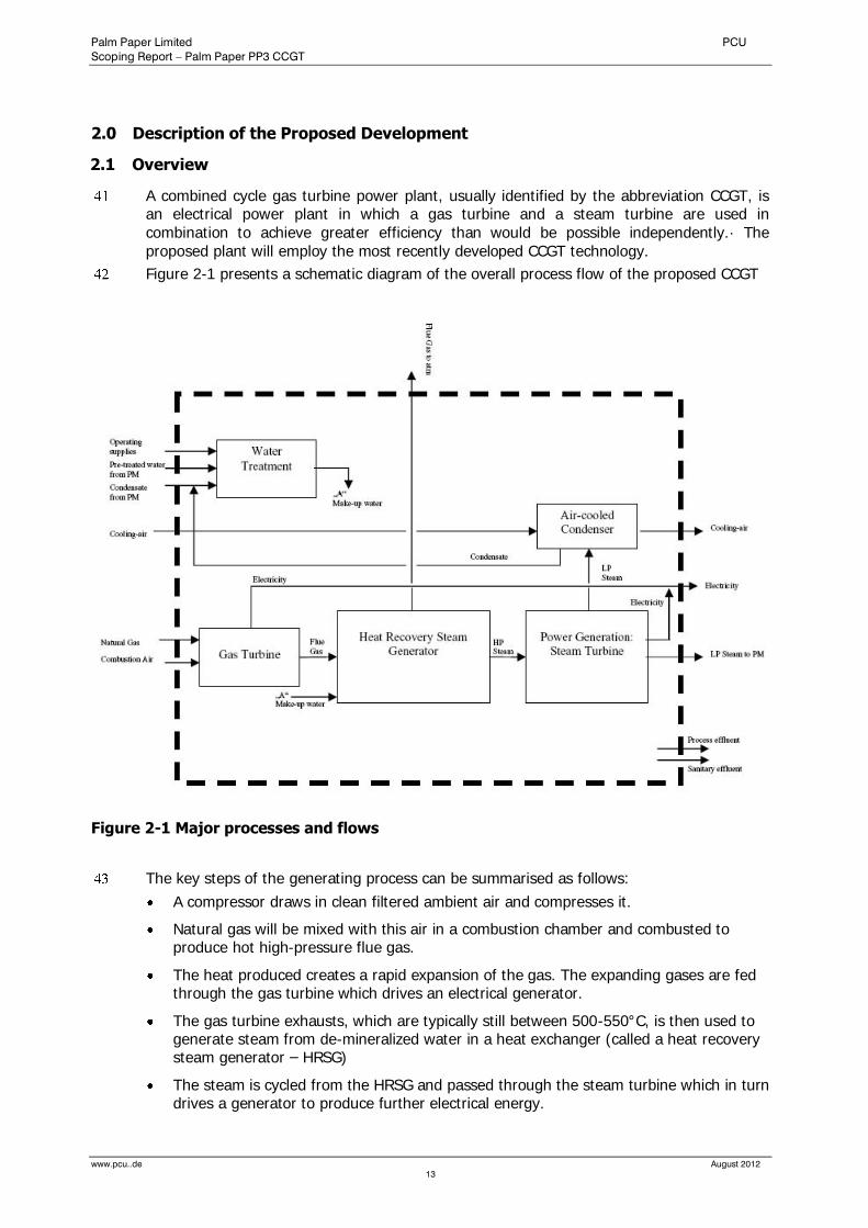
A combined cycle gas turbine power plant, usually identified by the abbreviation CCGT, is an electrical power plant in which a gas turbine and a steam turbine are used in combination to achieve greater efficiency than would be possible independently.· The proposed plant will employ the most recently developed CCGT technology.
Figure 2-1 presents a schematic diagram of the overall process flow of the proposed CCGT
Figure 2-1 Major processes and flows
The key steps of the generating process can be summarised as follows:
A compressor draws in clean filtered ambient air and compresses it.
Natural gas will be mixed with this air in a combustion chamber and combusted to produce hot high-pressure flue gas.
The heat produced creates a rapid expansion of the gas. The expanding gases are fed through the gas turbine which drives an electrical generator.
The gas turbine exhausts, which are typically still between 500-550°C, is then used to generate steam from de-mineralized water in a heat exchanger (called a heat recovery steam generator – HRSG)
The steam is cycled from the HRSG and passed through the steam turbine which in turn drives a generator to produce further electrical energy.
Palm Paper Limited PCU
Scoping Report – Palm Paper PP3 CCGT
www.pcu..de August 2012
14
The high-pressure steam will only be expanded in the steam turbine generator to a degree for it can be used for the paper machine and its ancillary systems.
If the steam is used for heat (e.g. process heat for production purpose), the plant is called a cogeneration plant or a CHP (Combined Heat and Power) plant.
The final exhaust gases are discharged through a stack to the atmosphere in accordance with emission limits of the Large Combustion Plant Directive (LCPD)
2.2 Plant Layout
The new development would be constructed within Palm Paper premises at the existing paper mill site. There is sufficient space for the new gas turbine plant to be built whilst the paper mill is fully operational.
The total area of the CCGT site is 5,000m² approximately and it is expected that the area occupied by the plant’s buildings will be approximately 2,500m².
The general layout and the design details of the development illustrated in drawing PP3 – 02 (layout) and drawing PP3 – 03 (elevations and layout plan) are indicative and based on Palm Paper’s experience of designing two similar plants at its German sites.
Further design details will be provided after consent has been granted and contracts placed with the equipment suppliers.
2.3 Process Description and Technical Data
This section contains brief descriptions of the principal individual unit operations.
The new development uses Combined Cycle Gas Turbine (CCGT) technology, with gas as its primary fuel, and has a lower environmental impact than older stations. CCGT technology is one of the cleanest and most efficient forms of power generation.
The new development will have a main plant capacity of approximately 162 megawatts (MW). The station is expected to achieve an efficiency of up to 85%, in line with other new CCGT plants that have been developed. The plant will be built according to Best Available Techniques (BAT).
The principal components of the proposed gas turbine power station will include the following:
Fuel supply
Gas turbine-generator set
Heat Recovery Steam Generator (HRSG)
Steam turbine and condenser
Water treatment plant including associated ancillary systems.
Transformers
Switchyard
Fire protection system
Palm Paper Limited PCU
Scoping Report – Palm Paper PP3 CCGT
www.pcu..de August 2012
15
2.3.1 Gas Receipt and Metering Compound
Natural gas from the National Transmission System (NTS) enters via underground pipework into the Above Ground Installation (AGI). The AGI is part of the national grid and is under the operational control of the gas supplier. The AGI is not within the definition of the proposed installation. Fiscal metering of the gas supply to the station also takes place at the gas supplier’s compound.
The gas pressure reduction station gas provides gas to the gas turbine with a constant pressure of 30bar. The gas pressure reduction station is equipped with filters and monitoring equipment. No chemicals are known to be used in this area. The gas supply remains un-odorised.
From the gas pressure reduction station a new underground gas pipeline to the building of the gas turbine will be installed.
Before entering the turbine hall the gas is pre-heated in a heat exchanger. The heat required for preheating the natural gas is taken from the heating system of the gas turbine.
2.3.2 Gas Compression facilities
To operate the gas turbine a back pressure of 30bar is required. The natural gas will be provided by the gas supplier at the pressure suitable for direct use within the gas turbine. A natural gas compressor is therefore not required on site.
2.3.3 Air Intake and Filters
The Air Intake system which is mounted on top of the roof of the gas turbine building draws in air from the surroundings. A multi-stage filter system removes airborne contamination present such as dirt and grit which could damage the compressor or contribute to fouling which reduces efficiency.
At the air inlet of the filter chambers there are heater batteries which are heated through a intermediate circulation (water/glycol mixture). They remove condensation from the air – therefore preventing the formation of ice (de-icing system). Ice formation could lead to filter failure or compressor damage and this must be avoided.
The air from the air intake system is forwarded to the compressor where it is compressed by the combined effect of rotating blades and stationary vanes.
2.3.4 Gas Turbine Intake Silencer
An air intake silencer is located downstream of the air filters in the intake path of the gas turbine. It is designed to limit the escape of turbine noise from the air intake to the local environment to ensure compliance with permitted sound power levels.
2.3.5 Gas Turbine and Gas Turbine Generator
The gas turbine converts the heat energy produced by burning the fuel into mechanical power to drive the generator.
The gas turbine consists of two components mechanically connected by a shaft – the compressor and the power turbine. The compressor draws in large volumes of filtered air. The air is compressed, then mixed with natural gas and passed into an annular combustion chamber where gas burners heat it up to around 1,100°C.
The compressed, heated air is ignited and expands through the blades of the power turbine to produce mechanical power. Mechanical power is used to drive the compressor of the

Palm Paper Limited PCU
Scoping Report – Palm Paper PP3 CCGT
www.pcu..de August 2012
16
turbine and to turn the generator and produce electrical energy. The exhaust gases leave the gas turbine at around 500-550°C and is guided into a heat recovery steam generator (HRSG).
The gas turbine-generator set is a standardised aggregate including all necessary auxiliary systems. The gas turbine employs DLN burners resulting in low emissions of oxides of nitrogen, or NOx.
A three-phase generator converts the mechanical energy from the gas turbine into electrical power. The generator is connected to the gas turbine via a gearbox. The generator is cooled with an internal cooling system connected with a central water / glycol cooling circuit.
A Bypass stack is not fitted in the gas turbine exhaust so it is not possible to operate in ‘open cycle’ mode.
Lubricating Oils: The turbine requires lubricating oils both for lubrication and cooling. Lubrication oils will be supplied to standard specifications offered by main suppliers. All materials will be handled in accordance with COSHH Regulations as part of the quality assurance procedures. Lubricating oil is replaced as necessary and is disposed of the site by a qualified contractor.
Washing: at regular intervals, the turbine requires washing with water and detergents to remove contaminants from the rotor blades. This is undertaken to avoid efficiency loss. The wash water including detergents will be collected and removed from site via a road tanker.
Effluent deriving from spillages of lubricating oils, wash water etc are collected in a separate drainage system and forwarded to the existing Effluent Treatment Plant.
2.3.6 Heat Recovery Steam Generator (HRSG)
The gas turbine is directly connected with a HRSG where hot exhaust gases from the gas turbine are used to produce steam. Water for the HRSG is initially drawn from the water cycle of the paper mill, is treated in the water treatment plant to achieve high purity and is then stored prior to use. The steam generated in the HRSG is supplied through interconnecting pipework to the steam turbine.
2.3.7 Steam turbine and Steam Turbine Generator
The high-pressure steam will be expanded in the steam turbine to a degree for it can be used for the paper machine / production and its ancillary systems.
The steam leaving the steam turbine plant will either be forwarded to the paper mill or will pass to a condenser where it will be condensed.
The work released by the expansion of steam is used for power generation. In the cases where the steam from the new plant can not be used for the paper production, e.g. during brief downtimes of the paper machine, the excess steam is conducted into an auxiliary condenser.
The mechanical energy from the steam turbine is used to drive the steam turbine generator to produce further electric power. The generator is air/water cooled.
The electricity generated is fed into the mill’s power supply system.
2.3.8 Air Cooled Condenser (ACC)
The condenser comes on stream only when the paper production is interrupted and does not consume steam. The condensate will be returned to the HRSG for reuse.

Palm Paper Limited PCU
Scoping Report – Palm Paper PP3 CCGT
www.pcu..de August 2012
17
2.3.9 Transformers
The electricity generated is fed to oil immersed transformers where the voltage is stepped up for transmission. The power will flow from these transformers either to the paper mill’s electrical network or to the local network which then supplies the national electricity grid.
2.3.10 Closed Cycle Cooling Water (CCCW) System
A closed cycle cooling water (CCCW) system provides cooling water for equipment requiring cooling water.
Cooling water is used to condense the steam used in the steam turbine element of the combined cycle. The steam is condensed to hot water, which is then recirculated to the HRSG. The cooling water will be abstracted from the paper mills water cycle and following its use it will be returned to the system in a slightly warmer condition.
To prevent ice formation a water/glycol mixture is used.
2.3.11 Emergency Diesel Generator (EDG)
There will be no installation of an additional emergency diesel generator. The existing EDG in the paper machine building provides electricity to support essential services if a major power failure occurs.
2.3.12 Fire Protection
Fire protection: passive and active fire protection measures will be provided in accordance with best practice and following a detailed risk assessment as to the hazards and consequences prevailing.
2.3.13 Water Treatment Plant
The water treatment plant removes all dissolved ions from the process water to prevent corrosion of the steam turbine. This is achieved via reverse osmosis and an ion exchange system (resin beds). The ion exchange system has to be periodically regenerated using dilute hydrochloric acid and diluted sodium hydroxide solution to strip the ions accumulated from the raw water from the resin beds. The waste water containing chemicals and salts is neutralised and forwarded to the existing effluent treatment plant of the paper mill.
2.3.14 Surface Water Drainage System
The surface water drainage system of the new development will be connected to the existing drainage system of the paper mill. The drainage system includes oil separators to prevent hydrocarbon contamination and several storm water retention basins to provide for the collection and storage of rainwater.
2.3.15 Stack Height
Emissions will be released from a separate, single stack with a proposed height of 80m.
2.4 Plant Dimensions
Dimensions given below are regarded as maxima and height dimensions in particular may be reduced depending on the outcome of the planning process and depending on the equipment of the contractor selected.
Palm Paper Limited PCU
Scoping Report – Palm Paper PP3 CCGT
www.pcu..de August 2012
18
The main plant dimensions are displayed on drawing PP3-03. The main enclosures are expected to be approximately 55m long x 33m wide and between 15m and 25m high. Some staircases and technical equipment on the roof will be several metres higher.
A pipe bridge will connect the CCGT building with the sludge incinerator and the paper machine building. The bridge will be constructed as steel structure covered with trapezoidal metal sheets and will carry pipes and cables for electricity, steam, condensate, etc.).
The pipe bridge imay be accessed for maintenance works and allows employees to access the existing sprinkler tank roof where the new condenser for the CCGT will be located.
The structural form of buildings will be made of pre-cast concrete façade panels. From 1m above ground up to the top the building will have a trapezoidal sheet metal cladding. Cladding will be similarly coloured as the cladding of the existing mill.
The façade between ground level and +1m will be mainly made of exposed curtain panels or brickwork with an exposed surface.
Floors within the buildings will be reinforced concrete. Roofs will be constructed of reinforced concrete roof slabs and will be flat or shallow pitched.
External personnel and escape doors will generally comprise metal flush doors and mild steel frames. Fire doors will comply with BS 476 Part 22, 1987.
The area where the condenser is located will be approximately 16m long x 13m wide. Supporting structure for condenser will be made as steel structure on the existing concrete roof slab of the sprinklers.
An exhaust stack could be about 4.0m diameter with a discharge approximately 80m above ground. The stack will be fabricated from painted insulated carbon steel.
2.5 Plant Operation
Normal operation of the plant will be as a combined cycle power station fuelled with natural gas. It is expected that the plant will operate continuously i.e. 24 hours per day, 365 days per year and will be staffed on the same shift basis as the paper mill. An average annual load factor of approximately 100%, i.e. 8,760 hours per year, is expected for the plant with the non-operational balance of hours being downtime for maintenance.
2.6 Operational Releases
This section describes the emissions that arise from the new development. For more details on the existing environment, the environmental impact of the emissions and the mitigation factors, refer to the relevant sections of this report.
The plant will utilise advanced CCGT technology and will meet the UK and EU emission limit values for new, high efficiency CCGT plant. The Palm Paper CCGT will burn natural gas which is a mixture of gases, with methane (CH4) predominating.
2.6.1 Air Emissions
The main products of combustion released to atmosphere will be carbon dioxide (CO2), carbon monoxide (CO), water vapour (H2O) and oxides of nitrogen (NOx). In addition, the combustion of natural gas produces only trace amounts of sulphur oxides and particulate matter.
An Air Quality Assessment was carried out to evaluate the potential contribution of the plant to ambient levels of NOx, CO and SO2 in the surrounding area. The assessment took into account the combined effect of existing site operations and the proposed additional emissions from the proposed Gas Turbine.
Palm Paper Limited PCU
Scoping Report – Palm Paper PP3 CCGT
www.pcu..de August 2012
19
As the proposed plant will burn natural gas, which is a relatively clean fuel, when compared to oil and coal, NOx- and CO2-emissions per unit of electricity and heat generated are comparatively low.
2.6.1.1 Nitrogen Dioxide
All combustion processes produce nitric oxide (NO) and nitrogen dioxide (NO2), known by the general term of NOx. They are formed due to the high temperature oxidation of atmospheric nitrogen. In general, the majority of the NOx released is in the form of NO, which then reacts with ozone in the atmosphere to form NO2. Of the two compounds, nitrogen dioxide is associated with adverse effects on human health, principally relating to respiratory illness. The World Health Organisation (WHO) has stated that “many chemical species of nitrogen oxides (NOx) exist, but the air pollutant species of most interest from the point of view of human health is nitrogen dioxide (NO2).”
The major sources of NOx in the UK are road transport and power stations. According to the most recent annual report from the National Atmospheric Emissions Inventory (NAEI), road transport accounted for 37% of UK emissions, with power stations accounting for a further 27%. High levels of NOx in urban areas are almost always associated with high traffic densities.
The gas turbine employs dry low NOX premix burners, (DLN-burners), resulting in low emissions of NOx. For new gas turbines, DLN burners are considered Best Available Techniques (BAT).
2.6.1.2 Carbon Oxides
Carbon Monoxide is produced by the incomplete combustion of fuels containing carbon. By far the most significant source is road transport, which produces 67% of the UK’s emissions. At high levels carbon monoxide can cause health problems. Concentrations in the UK are well below levels at which health effects can occur. Combustion in the gas turbines produces comparatively low levels of carbon monoxide (CO). Emissions of carbon monoxide from gas turbine plants are normally very low with significant levels emitted only during periods of low temperature operation such as start-up or abnormal operational conditions. During the normal combustion process almost all the fuel carbon (>99.5%) is converted to CO2. Consequently the amount of carbon monoxide generated is very low.
Carbon dioxide, a greenhouse gas, is an unavoidable product of combustion of fossil fuels. The carbon dioxide production of a gas-fired combined-cycle plant on a unit output basis is much lower than that of other fossil fuel technologies.
2.6.1.3 Sulphur Oxides and Particulate Matter (PM10)
The combustion of natural gas, when compared to oil and coal, produces only negligible emissions of SO2 and PM10 because of the low content of sulphur in natural gas and due to efficient burnout and low ash content in the CCGT.
It is not intended to use oil as a back-up fuel as this would produce greater quantities of such substances.
2.6.1.4 Odours
None of the air emissions from the proposed plant will give rise to odours beyond the boundary of the sites.
Palm Paper Limited PCU
Scoping Report – Palm Paper PP3 CCGT
www.pcu..de August 2012
20
2.6.2 Emissions to Water
There will be no direct releases to controlled waters from the gas turbine plant. All aqueous discharge will be forwarded to the existing Effluent Treatment Plant complying with the existing Discharge Consent.
2.6.3 Releases to Land
Deposition to land of pollutants as a result of air emissions is considered in the air quality assessment in Appendix 1. There will be no solid residues formed that will be disposed of to land. All waste would be returned to the original supplier where possible or removed by a licensed contractor.
2.6.4 Noise
A complete and detailed baseline noise survey was carried out for the site and has been submitted to the Council as part of the discharge of a condition from the Planning Permit for the paper mill.
As part of a requirement from the Planning Permit for the paper mill, a complete and detailed baseline noise survey was conducted for the site in March and April 2010 after the construction of the paper mill had been completed and the mill had reached normal operational conditions. As part of this noise monitoring programme continuous noise monitoring took place at two sensitive receptor locations, the Caravan Park (NSL 1) and South Lynn (NSL 2) (see Figure 8-1).
The results were discussed with the local Environmental Health Officer. A summary of the results of the report is included as Appendix 2. This would be used as baseline data for the new development.
Detailed noise emission and dispersion modelling will be conducted in the course of the environmental impact assessment. The results of the model will specify how noise emissions associated with the operation of the new plant have to be controlled in order not to exceed the limits prescribed in ‘Planning Guidance and Standards BS4142’.
The normal operation of a gas fuelled power plant typically results in steady environmental noise emissions. The main potential noise sources introduced to the development site are as follows:
Gas Turbine
The generation of noise originates in the air inlet and flue gas exhaust. Strong tonal components are associated with the inlet while the exhaust results in high levels of low frequency noise.
Expansion silencers will be used to control such noise emissions to acceptable levels. The gas turbine itself will be enclosed in a building made of solid concrete sandwich panels with at least 10 cm sound insulation to attenuate emitted sound levels according to acceptable levels.
Heat steam recovery generator (HRSG)
Venting of steam will occur, during start up and blow-downs of the HRSG. This is usually controlled by suitable silencers. Boiler safety valves are tested on a regular basis for insurance certification. Outside of such testing, operation of safety valves will only occur for very short periods under abnormal conditions.
They will be fitted with suitable silencers but may be audible beyond the site boundary. For safety reasons this noise cannot be avoided totally.
Steam Turbine
Palm Paper Limited PCU
Scoping Report – Palm Paper PP3 CCGT
www.pcu..de August 2012
21
The steam turbine, including a range of auxiliary plant, is a potential source of noise.
This is attenuated by the acoustic design of the turbine enclosure. It includes the use of suitable building materials such as cast concrete panels in construction, rather than steel.
Transformers
Fans on generators and transformers are provided for cooling purposes. The transformers will be enclosed or insulated to minimise noise emissions. The ventilation system will be fitted with silencers, if required. They will not be audible beyond the site boundary.
Construction Noise
Noise levels during construction will be expected to be consistent with noise levels typically associated with any major construction works.
Noise emissions may be particularly elevated during piling works, which will occur early in the construction process and only for a short period of time.
Noise impacts during construction will be managed based on a Site Environmental Management Plan that will specify appropriate hours within which specific construction tasks are permissible.
The impact of construction noise is not expected to be significant due to the distances between the development site and the closest noise sensitive receptors.
2.7 Fuel supply
The Palm Paper CCGT will burn natural gas. The natural gas to be used as fuel at the CCGT site will be taken from an Above Ground Installation (AGI) of the gas supplier. Currently, the site is not served by a suitable high pressure gas pipeline. It is anticipated that a new pipeline will connect the new plant to the local gas pipeline network. Any pipeline infrastructure works will be part of a separate application for a Pipeline Construction Authorisation.
There would be no storage of natural gas on the site other than the relatively small volume of gas in the incoming pipeline and the pipework feeding gas to the gas turbine.
2.8 Plant Efficiency
The plant will have an efficiency of approximately 85% and this means that 85% of the chemical energy contained within the fuel is converted into electrical energy or heat / steam. The plant will employ technology considered Best Available Techniques for power production on the proposed scale. The high efficiency will lead to lower emissions to the environment compared to any other plant burning fossil fuels.
2.9 Construction Phase
As part of the engineering design work, a detailed programme for the development will be determined. Subject to planning permission, construction work is planned to start in 2013. The construction and commissioning phases of the proposed plant are expected to last approximately 12 months.
During the construction phase it will be necessary to use adjoining land to the gas turbine for temporary construction areas. At this stage it is intended to use parts of the land identified as “Future Production Line” for temporary construction compounds and temporary storage areas.
Standard construction techniques as previously used for buildings, roads and pavements, lighting, utility services and telecommunications will be adopted. The full details on site
Palm Paper Limited PCU
Scoping Report – Palm Paper PP3 CCGT
www.pcu..de August 2012
22
construction are currently not available but would be provided as part of the final project design.
2.10 Alternatives
A range of site layouts has been examined before culminating in the final design of the proposed development. Alternative design options for the proposed development are limited due to the existing physical site layout of the paper mill, and primarily due to the necessity of having the steam generation as close as possible to the production process. Furthermore, taking into account the option for a second paper machine, there is limited scope to consider a different location for the new gas turbine plant.
2.11 Materials Usage
2.11.1 Natural Gas
Natural gas will be delivered to the new plant via a below ground high pressure gas pipeline from the gas supplier’s network.
Fuel consumption of the gas turbine depends on the operational load and the ambient air temperature. The following table shows the plant’s fuel consumption at an ambient air temperature of 10°C and for a 100 % load operation, i.e. 8,760 hours per year.
Table 2-1 Fuel consumption
2.11.2 Water Use (process water)
The main use of water at the plant will be make-up water for the HRSG.
Most of the steam generated will be consumed in the paper mill’s production process. A small proportion will be recycled as condensate or it will be used as blowdown to prevent build-up of sludge and contaminants within the steam boiler and pipework.
Under normal operating conditions, water to be discharged is generated from the following processes:
Regeneration of the resins in the de-mineralised water treatment plant,
Process effluent collected in site drainage system (e.g. boiler blow-down),
Effluent generated through washing and maintenance procedures,
Drainage arising from paved surfaces.
Where appropriate, waste water will be re-used on site. The new plant will be connected to the paper mill’s existing drainage and sewage system.
A preliminary water balance for the main water inputs and outputs is given in the following table.
Table 2-2 Water balance
Palm Paper Limited PCU
Scoping Report – Palm Paper PP3 CCGT
www.pcu..de August 2012
23
All water required will be supplied from the paper mill’s existing water supply system. No additional water will have to be abstracted from the Flood Relief Channel.
2.11.3 Chemicals
The following table gives an overview of the chemicals required for the new plant.
Table 2-3 Chemicals
All chemicals will be handled in accordance with COSHH Regulations as part of the quality assurance procedures and full product data sheets will be available on site.
Materials used and the quantities stored will not trigger COMAH requirements. Therefore, the site would not require COMAH reporting.
Palm Paper Limited PCU
Scoping Report – Palm Paper PP3 CCGT
www.pcu..de August 2012
24
2.11.4 Waste Arisings
The principal waste arising from the operation of the plant include:
Filters on air intakes will require changing periodically,
Lighting units replaced as required,
Waste from staff rooms etc.,
Oily sludge from cleaning of oil interceptors,
Waste oils and lubricants; oil residues arising from maintenance activities,
Spent ion exchange resins from the water treatment,
Packaging waste (timber, cardboard, plastic etc.).
Waste generated during annual outages varies according to the scope of the outage work, and consist mainly of oil residues and scrap metals.
The quantities of waste generated are relatively low. Waste will be segregated and stored in labelled containers until disposal off-site by a qualified contractor.
2.12 Environmental Management Systems
The new CCGT will employ state of the art technology and conform to Best Available Techniques for environmental management, pollution control, and abatement.
The existing paper mill in King’s Lynn is accredited to BS EN ISO14001 and a Quality Management System which is certified to BS EN ISO 9001:2000 already exists.
The construction and the operation the new gas turbine plant will be included in this established EMS.
3.0 Description of the Development Site and its Surroundings
In the case of the Palm Paper site at Saddlebow Estate an Environmental Impact Assessment had been completed for a previous development proposal, the Saddlebow Paper Mill, and much of the baseline assessment remains unchanged and will be reused in the assessment of the new proposal.
3.1 Development Site
The site is located approximately 2.5km to the south of King’s Lynn town centre, in an area bound to the north by the A47 road, to the west by the River Ouse, to the south east by Saddlebow Industrial Estate, and to the south by a gas fired Centrica power station.
The development site covers a total area of around 1 hectare and is centred on approximate National Grid Reference X: 561000, Y: 317800, as shown on Drawing PP3–02. It is situated along the eastern ring road of the existing paper mill site between the retention basin and the reject storage. To the east of the new plant there is an area designated as ‘Future Production Line’. This area is currently covered by open grassland.
The site accesses the local road network with a junction on to High Road, with traffic generally proceeding north towards the A47/A148 Saddlebow junction on the King’s Lynn bypass. Saddlebow junction forms a grade separated roundabout with the A47 which has good links with the wider road network. The road network to the south of the site is less suitable for major traffic.
Palm Paper Limited PCU
Scoping Report – Palm Paper PP3 CCGT
www.pcu..de August 2012
25
3.2 Development Site Surroundings
Land use at the site and its surroundings is shown on drawing PP3-04. The paper mill site is bordered to the north by the A47 trunk road and to the south and east by industrial buildings and hard-standing on the Saddlebow Industrial Estate. The River Great Ouse runs to the west of the site, bordered by high flood banks. The town of King’s Lynn lies immediately to the north of the A47. Farmland adjacent to the river is drained by a large network of artificially dug ditches and drains.
The immediate surrounding area is mainly low-lying intensively farmed arable land. Woodland cover in the area is generally sparse, mainly confined to lining roads and around villages. To the east and south east of the site lie the River Nar and a number of other areas of important habitat including lowland grazing marshes and lakes. Further to the east lie a number of more extensively wooded areas, sand and gravel pits. Beyond the A47 road to the north, land use is a mixture of residential and commercial/industrial. There are various commercial/industrial properties immediately to the north of the A47, and approximately 2km to the north east, where there is a large industrial/commercial area, centred on the junction of the A10 and A47 roads. Land to the south and east is largely open apart from the Centrica power station site to the south, which covers an area of approximately 10ha. The River Nar runs north-south, approximately 1.5km to the east of the site.
The drawings PP3-05 and PP3-06 illustrate all sites designated of special environmental importance within 10km of the site.

Palm Paper Limited PCU
Scoping Report – Palm Paper PP3 CCGT
www.pcu..de August 2012
26
3.3 Physical Setting
3.3.1 Geology and Soils
Reference to British Geological Survey records for the area indicates that the site is underlain by Made Ground, Alluvium and Kimmeridge Clay successively with depth. Made Ground is mapped beneath the bulk of the King’s Lynn area, although that shown beneath the site is separate from that beneath the centre of King’s Lynn, except for a narrow strip along the bank of the River Ouse, which forms a flood defence embankment. The exact origin of the Made Ground beneath the site is not clear from the geological map, although it is entirely contained by the former railway lines to the north and east, and does not extend beyond the factory buildings to the south. Therefore it is considered most likely that the Made Ground is associated with the operations of the former sugar factory.
Alluvium is a recent deposit, which covers large tracts of land in this area. A section on the geological map indicates the Alluvium to be around 10m thick. It is likely to contain a variable mixture of soft clay and silt, with thick peat bands also possible.
Kimmeridge Clay is comprehensively described in the British Geological Survey publication, “Geology of the country around King’s Lynn and The Wash’. A general description of the Kimmeridge Clay is given – “The Kimmeridge Clay is made up of soft shelly mudstones, calcareous or kerogen rich (oil shales) in part, with small amounts of silty mudstone, siltstone, and muddy limestone. Pyrite is present throughout and phosphatic pebble beds occur at a few horizons.”
The geological map shows the outcrop (beneath more recent deposits) of four cementstone beds (K1-K4), identified by seismic reflection in The Wash and in boreholes on land. The band K2 is shown running approximately north-south, through the centre of the northern portion of the site. The detailed records for the Kimmeridge Clay describe K2 as a ‘persistent tabular cementstone band’ of relatively limited thickness. Boreholes on the eastern side of the site are likely to intercept this bed, and the beds immediately above, which mainly comprise mudstones. Immediately below bed K1, there is an approximately 3.6m thick layer of oil-shale rich mudstone, with further mudstones below.
3.3.2 Hydrogeology and Groundwater Use
The 1:100,000 scale Environment Agency Groundwater Vulnerability Map of the area indicates that the site lies on a non-aquifer of negligible permeability. This classification applies to the underlying Kimmeridge Clay. Non aquifers are formations that are generally regarded as containing insignificant quantities of groundwater.
According to the Environment Agency, the site does not lie within a currently defined source protection zone for public water supply.
Groundwater will be present within the alluvial deposits. Such shallow groundwater, although not typically exploited by abstraction boreholes, could act as a pathway by which mobile contaminants could travel.
3.3.3 Surface Water Resources
The site is located in the North West Norfolk CAMS area as designated by the Environment Agency. The major water-course in the North West Norfolk CAMS is the tidal reach of the River Great Ouse, which flows north from Denver Sluice to the Wash just north of Kings Lynn. The river is tidal upstream as far as Earith.
The Relief Channel flows parallel to the Great Ouse from Denver, rejoining the main river just south of King’s Lynn. The Channel carries water from the Ely Ouse system during periods of

Palm Paper Limited PCU
Scoping Report – Palm Paper PP3 CCGT
www.pcu..de August 2012
27
medium to high flow, when Denver Sluice is running at capacity. Discharge of water from the Relief Channel to the Tidal River is controlled by the Tail Sluice and occurs at low tide.
To the west of the Great Ouse lies an area of fenland. This area is drained, but has little in the way of water resources. That which is present tends to be of poor quality and unsuitable for irrigation or drinking water. To the east of the Great Ouse, the Sandringham Sands and Chalk outcrops are cut by east-west flowing rivers and drains.
The river east of the site is the River Nar. This is notable as a Chalk river although the upper most headwaters flow from Clay and are therefore derived from surface run-off. However, springs to the east of Litcham contribute to form a rapidly flowing shallow Chalk river. Below Narborough the river is modified to the tidal sluice which marks the confluence of the Nar with the Great Ouse at King’s Lynn.
The proposal site lies in a low-lying area that is generally drained under the control of the East of Ouse, Polver and Nar Internal Drainage Board (EOPNIDB). All surface water drainage in the vicinity of the Site flows to the Flood Relief Channel ia the North Sea Bank Drain.
3.3.4 Ecology - Protected Sites & Sites of Conservation Importance
A number of statutory protected sites and other sites of conservation importance are present in the immediate local area (drawing PP3-06). These are summarized below:
Within 2km: The Saddlebow Reedbeds, a designated County Wildlife Site (CWS), is an area of reedbed approximately 400m north of the proposed development. Reedbed habitat is listed as a priority habitat in the UK Biodiversity Action Plan. The CWS provides a particularly important habitat for birds, including species listed on Schedule 1 of the Wildlife and Countryside Act 1981. CWS are also given special consideration in the Norfolk County Council Structure Plan Policies.
The River Nar is the only statutorily designated area of ecological importance within 2km of the proposal site. The entire river is designated a SSSI. Adjacent to the site is the tidal River Great Ouse. At low tide, mudflats along the banks of the river are exposed, providing feeding habitat for wading birds. Mudflats are listed as a priority habitat in the UK Biodiversity Action Plan.
Within 5km: A further three sites lie within 5km of the site, two of these being sites of palaeoecological importance. A brief summary of each statutory protected area within 5km of the site is given in Table 3-1.
Table 3-1 Statutorily designated sites of ecological importance within 5km of the site
Name Location Distance from site
Summary description
Wiggenhall St. Germans SSSI TF 588 139 3.7 km One of the first sites in Britain to be investigated for sea-level studies using
pollen and foraminifera analyses. The site is important both historically and for future research.
Islington Heronry SSSI TF 568189 3.8 km Small isolated stand of mature oaks surrounded by fenland which supports the largest colony of Grey Herons Ardea cinerea in Norfolk.
Setchey SSSI TF 633132 4.3 km Important for studies of Flandrian sea-level change.
Within 10km: There are numerous designated sites within a 10km radius. Particularly notable is the Wash which lies approximately 6.5km to the north of the site and is the largest estuary in the UK. It is composed of a number of important marine habitats, including saltmarsh, intertidal banks of sand and mud, shallow water and deep channels. The Wash is classified as
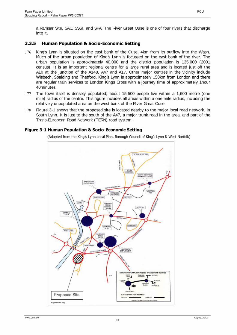
Palm Paper Limited PCU
Scoping Report – Palm Paper PP3 CCGT
www.pcu..de August 2012
28
a Ramsar Site, SAC, SSSI, and SPA. The River Great Ouse is one of four rivers that discharge into it.
3.3.5 Human Population & Socio-Economic Setting
King’s Lynn is situated on the east bank of the Ouse, 4km from its outflow into the Wash. Much of the urban population of King’s Lynn is focussed on the east bank of the river. The urban population is approximately 40,000 and the district population is 135,000 (2001 census). It is an important regional centre for a large rural area and is located just off the A10 at the junction of the A148, A47 and A17. Other major centres in the vicinity include Wisbech, Spalding and Thetford. King’s Lynn is approximately 150km from London and there are regular train services to London Kings Cross with a journey time of approximately 1hour 40minutes.
The town itself is densely populated; about 15,500 people live within a 1,600 metre (one mile) radius of the centre. This figure includes all areas within a one mile radius, including the relatively unpopulated area on the west bank of the River Great Ouse.
Figure 3-1 shows that the proposed site is located nearby to the major local road network, in South Lynn. It is just to the south of the A47, a major trunk road in the area, and part of the Trans-European Road Network (TERN) road system.
Figure 3-1 Human Population & Socio-Economic Setting
(Adapted from the King’s Lynn Local Plan, Borough Council of King’s Lynn & West Norfolk)
Palm Paper Limited PCU
Scoping Report – Palm Paper PP3 CCGT
www.pcu..de August 2012
29
3.3.5.1 Existing Local Employment / Economic Profile
Figures from the 1991 Census of Employment are referenced in the most recent Local Plan for King’s Lynn1. The Plan states that employment in the town is concentrated in two main
areas: the Central Area with about 8,400 jobs (31% of the town’s total) and the Hardwick locality (covering Hardwick, Hardwick Narrows and Saddlebow industrial estates together with the shopping areas on Hardwick Road) which has about 8,300 jobs (30% of the total). There are no other employment localities of this significance: the next biggest is the Docks/North Lynn area (2,700 jobs, 10%). The Queen Elizabeth Hospital is the town’s biggest single employer (2,100 jobs, 7%).
The Central Area includes a shopping centre, a selection of independent and chain retail stores, and contains facilities for community and cultural functions. The Central Area lies within the mediaeval walled town and consequently an attraction for tourists and other visitors. The Central Area is generally considered the focus of the community area, and this area is accessible to the community at large. Many homes and jobs are close to these employment areas. As previously discussed, almost half of King’s Lynn’s homes are to be found within 1,600 metres (one mile) radius of the Central Area and/or the Hardwick locality. Traffic is regulated by a road network, designed in a cellular fashion, which prevents through-traffic in residential areas, leaving these areas relatively traffic free. The layout of this network is therefore such that road journeys between any two given points are frequently longer, and slower, than the corresponding foot or cycle journey. The latter journeys are aided by the town’s predominantly flat terrain.
4.0 Legislative Planning Policy Context
4.1 Context
A brief summary of the relevant policies of the current development plan, together with the legislative context for the scheme in question, is provided below. A full assessment of the policy context of the scheme will be provided as part of any Environmental Impact Assessment and planning application prepared for the project.
The proposed CCGT is intended to serve the continued operation of the Palm Paper Lynn PM7 mill. As such those policies which relate to economic development are considered relevant, together with those considering more general elements of design and the environment. The proposed CCGT is a Combined Heat and Power plant which creates higher levels of efficiency than are possible within typical fossil fuel power generation facilities. The National Planning Policy Framework (NPPF) defines ‘Low carbon technologies’ as ‘those that can help reduce emissions compared to conventional use of fossil fuels’. As such policies relating to the use of low carbon technologies are also relevant to the proposed project.
4.2 Legislative Context
The key planning legislation which underpins the planning process is the Town and Country Planning Act 1990 and the Planning Compulsory Purchase Act 2004.
The Infrastructure Planning Commission was established through the Planning Act 2008, with Localism Act 2011 then abolishing the Infrastructure Planning Commission and transferring its decision making powers to the Secretary of State. A second tier of legislation also applies to the operation of the IPC and includes the Infrastructure Planning (National Policy Statement Consultation) Regulations 2009 and the Infrastructure Planning (Environmental Impact Assessment) Regulations 2009.
The EIA aspect of the project is governed by the Town and Country Planning (Environmental Impact Assessment) Regulations 2011.
1 (http://online.west-norfolk.gov.uk/local_plan/written/cpt1.htm

Palm Paper Limited PCU
Scoping Report – Palm Paper PP3 CCGT
www.pcu..de August 2012
30
4.3 Development Plan
National
In this case the national planning policy context is established by the National Planning Policy Framework (‘the NPPF’) which is a material consideration in planning decisions. The NPPF states that it does not contain specific policies for nationally significant infrastructure projects, as these are covered by national policy statements which are also material considerations when deciding planning applications. All six Energy National Policy Statements received designation on the 19th July 2011. The ‘Overarching Energy’ and ‘Fossil Fuels’ NPS’s are relevant to the project in question.
4.4 Regional
The Government has signalled its clear intention to revoke Regional Spatial Strategies, including the East of England Plan. On the 25th July the Department of Communities and Local Government (DCLG) published the Strategic Environmental Assessment of the Revocation of the East of England Regional Strategy for consultation until the 20th September 2012. The East of England Plan therefore at present remains part of the development plan for the area, but the Government’s continued intention to revoke this document and the advanced nature of the revocation process means that this is unlikely to still be part of the development plan when the application for a Development Consent Order for the proposed project is considered. The policies within the Plan are therefore considered to have very limited weight and have not been considered within this summary.
4.4.1 Local
At the Local the Borough Council of King’s Lynn and West Norfolk have been undertaking a review of their 1998 Local Plan by producing their Local Development Framework. A number of policies of the plan were saved following the Planning and Compulsory Purchase Act 2004. The Borough Council then adopted their Core Strategy in July 2011, which replaced the majority of these saved policies within the 1998 Local Plan. Some Local Plan policies do remain part of the development plan until they are replaced with further Development Plan Documents.
An Issues and Options version of the Council’s Site Specific Allocations and Policies Development Plan Document was released for consultation in September 2011, with a Preferred Options version of this document anticipated in Autumn 2012. The emerging policies within this document have been considered but will not form part of the development plan until their adoption.
4.5 National Planning Policy Framework
The NPPF states that the purpose of the planning system is to contribute towards achieving sustainable development and in this respect has an economic, social and environmental role. Within its economic role the NPPF states that the planning system should contribute to building a strong, responsive and competitive economy which includes the provision of infrastructure to meet development requirements. The NPPF notes that the three facets of sustainable development should be sought jointly and simultaneously.
A ‘presumption in favour of sustainable development’ is established, where development proposals which accord with development plans are approved without delay and where, in the case of a development plan being absent, silent or out of date, permission is granted unless the adverse impacts would outweigh the benefits or where specific policies within the NPPF indicate that development should be restricted.
One of the Core Planning Principles within the NPPF states that planning should proactively drive and support sustainable economic development. The effective use of previously development land is encouraged, provided it is not of significant environment value. The

Palm Paper Limited PCU
Scoping Report – Palm Paper PP3 CCGT
www.pcu..de August 2012
31
NPPF seeks to build a strong, competitive economy, with the planning system doing everything it can to support sustainable economic growth.
Section 10 of the NPPF addresses climate change, flooding and coastal change. It supports the delivery of low carbon energy which is seen as central to the economic, social and environmental dimensions of sustainable development. This requires Councils to have a positive strategy to promote and maximise energy from low carbon sources whilst ensuring that any adverse impacts such as landscape and visual effects are satisfactorily addressed. The NPPF states that opportunities should be identified where development can draw its energy supply from decentralised low carbon energy supply systems.
When determining applications the NPPF states that Authorities should approve applications for energy development where the impacts are or can be made acceptable. It states that climate change over the longer term, including flood risk, should be addressed and the natural and historic environment protected and enhanced. Within this aim the effective use of brownfield land is promoted.
4.6 National Policy Statement - Overarching Energy (EN-1)
The Overarching Energy NPS sets out a number of key reasons for seeking new electricity Nationally Significant Infrastructure Projects. These include the need to meet energy security and carbon reduction objectives, the need to replace closing electricity generating capacity, the need for more electricity capacity to support an increased supply from renewables, and the need to meet future increases in energy demand and an urgent need for additional electricity capacity.
Alternatives to increased provision, and the role which can be played by renewable sources of energy, are considered. However it is also noted that fossil fuel electricity generation will play a vital role, particularly as these are constructed to meet more stringent and demanding climate change goals.
In assessing new development the NPS notes that the potential benefits of a proposed scheme should be considered together with any potential adverse impacts and measures used to avoid, reduce or compensate for these effects. An Environmental Statement should consider appropriate alternatives and the design of a scheme, whilst limited by the functional nature of energy development, should have regard to the principles of good design.
The NPS specifically considers Combined Heat and Power, noting that this allows less fuel to be used to generate the same amount of heat and power, thereby reducing emissions. Paragraph 4.6.4 identifies that for industrial purposes intensive heat users such as paper mills will be appropriate for this type of technology.
A number of issues such as climate change and grid connection are considered within both the Overarching Energy and Fossil Fuels NPS’s and are dealt with in full within the Scoping Opinion Request. A number of Generic Impacts are also identified, with the Fossil Fuels NPS focusing on those of specific relevance to the type of scheme in question and the Scoping Opinion providing a full consideration of those relevant to the project proposed.
4.7 National Policy Statement - Fossil Fuels (EN-2)
The NPS for Fossil Fuels (EN-2 – July 2011) addresses gas-fired electricity generating infrastructure of 50MW or over and notes that these can be configured to produce Combined Heat and Power.
EN-2 addresses a number of site selection issues which include land use, transportation infrastructure, water resources, and grid connection. These are all addressed within this Scoping document and are dealt with by the location of the proposed CCGT as an ancillary development to the main Palm Paper Lynn PM7 facility.
Section 2.3 addresses various policy criteria for fossil generating fuel stations and notes the importance attached by the Government to CHP systems, which is proposed in this case. The use of Carbon Capture Readiness is not applicable to this scheme as it falls below the
Palm Paper Limited PCU
Scoping Report – Palm Paper PP3 CCGT
www.pcu..de August 2012
32
threshold established by EN-2. The document also sets out the need to address climate change adaptation and good design.
A number of impacts of fossil fuel generating stations are set out within Section 2.4 of the document. These comprise, for gas facilities;
Air emissions
Landscape and visual
Noise and vibration
Water quality and resources.
The document notes the need for applicants to consider all likely significant effects and this is addressed in full within this Scoping Request.
4.8 King’s Lynn and West Norfolk Core Strategy (2011)
Policy CS01 sets out an overarching spatial strategy for the borough and encourages economic growth and inward investment, whilst placing the emphasis on the development of brownfield land. King’s Lynn is identified as an economic driver within the borough and, as noted in Policy CS02, a sub-regional centre.
Policy CS03 specifically addresses King’s Lynn and establishes a strategy for growth which includes the creation of at least 3,000 new jobs. The policy notes that development throughout the urban area which contributes to the regeneration of the town should be encouraged where it has no detrimental impact on flood protection strategies, the transportation network, local services and facilities, significant trees, wildlife or historic assets, enjoyment of the public realm and crime prevention.
Policy CS08 considers Sustainable Development and establishes the need for good design. It also directly promotes the reduction of site emissions through the generation of cleaner energy. The policy also establishes the need for new development to address climate change and flood risk. Policy CS10 then states that the local economy will be developed sustainably.
Policy CS11 addresses transport issues in new development, This includes the need to achieve improvements in King’s Lynn where there are air quality issues. CS12 deals generally with environmental assets and establishes the need to protect and enhance the historic environment together with landscape character, biodiversity and geodiversity. It states that development should avoid, mitigate or compensate for any adverse impacts on these receptors.
4.9 King’s Lynn and West Norfolk Local Plan (1998)
Saved Local Plan Policy 4/25 addresses disused railway trackbeds and routes, including the Harbour Junction- South Lynn, which runs through the north of the paper mill site. Appropriate steps were taken during the planning of the Lynn PM7 facility to make provision for the future use of this disused trackbed. The CCGT proposal will not have any impact upon this element and so will accord with this policy.
Policy 9/11 identifies the A47 to the north of the mill site as a Primary Corridor of Traffic Movement and notes that development on side roads connecting to these primary corridors will be resisted where the traffic generated would have an adverse impact of the traffic carrying function and capacity. The proposed CCGT facility would not have any perceptible impact on traffic generation.
There are no other Local Plan policies of relevance to the site or proposed scheme which remain saved after the adoption of the Core Strategy.
4.10 King’s Lynn and West Norfolk Site Specific Allocations and Policies (emerging)
According to the emerging proposals maps the Palm Paper facility and proposal site lie within the proposed development boundary of King’s Lynn but is not covered with any other
Palm Paper Limited PCU
Scoping Report – Palm Paper PP3 CCGT
www.pcu..de August 2012
33
allocations or area specific policies. The emerging policy within the SSAP document deals mainly with proposed employment allocations within the town,
DM9 addresses disused trackbeds and will replace existing Local Plan Policy 4/25 and Policy DM10 addresses Primary Corridors of Movement, currently dealt with by Policy 9/11. This has been addressed within the Local Plan section above.

Palm Paper Limited PCU
Scoping Report – Palm Paper PP3 CCGT
www.pcu..de August 2012
34
5.0 Assessment Methodology
5.1 Overview
An Environmental Statement will be prepared under the Infrastructure Planning (EIA) Regulations 2009. It will document the findings of the EIA which will be undertaken to determine any likely significant environmental impact with regard to the proposed development.
Part I and II of Schedule 4 of the EIA 2009 Regulations set out that an ES should include, as a minimum, the following information:
Description of the development,
An outline of the main alternatives
A description of the aspects of the environment likely to be significantly affected by the development,
A description of the likely significant effects of the development on the environment,
A description of the measures envisaged to prevent, reduce and where possible offset any significant adverse effects on the environment.
An indication of any difficulties (technical deficiencies or lack of know-how) encountered
General reference has been made to the following documents in preparation of this Scoping Report:
The Department of Environment’s “Preparation of Statements for Planning Projects that Require Environmental Assessment: A Good Practice Guide 1995”;
The Institute of Environmental Management and Assessment’s “Guidelines for EIA”, 2004;
The Department of Transport Design Manual for Roads and Bridges, Volume 11: Environmental Assessment.
5.2 Assessment Methodology of the Environmental Statement
The methodology described in this section is designed to ensure that the EIA process and the Environmental Statement is a valid and robust assessment of the likely effects of the development proposals on the environment having regard to its nature, size and location. The assessment methodology will be based on the best practice guidelines for each topic and therefore may differ slightly between chapters.
In the absence of a recognised assessment methodology general levels of significance using criteria defined in DMRB Volume 11 – Environmental Assessment (2009) are frequently employed (see Table 5-1). This is the case for example in assessing the significance of effect on the landscape. These levels of significance apply to both adverse and beneficial effects. In some instances the category of ‘no impact’ may be used.
For some environmental topics where it is very difficult to quantify the magnitude of the effect (e.g. socio economics or hydrology) a simple descriptor – beneficial, neutral or adverse is used to describe the significance of the effect.
The DMRB, Volume 11, uses the following tables to determine the significance of environmental effects.
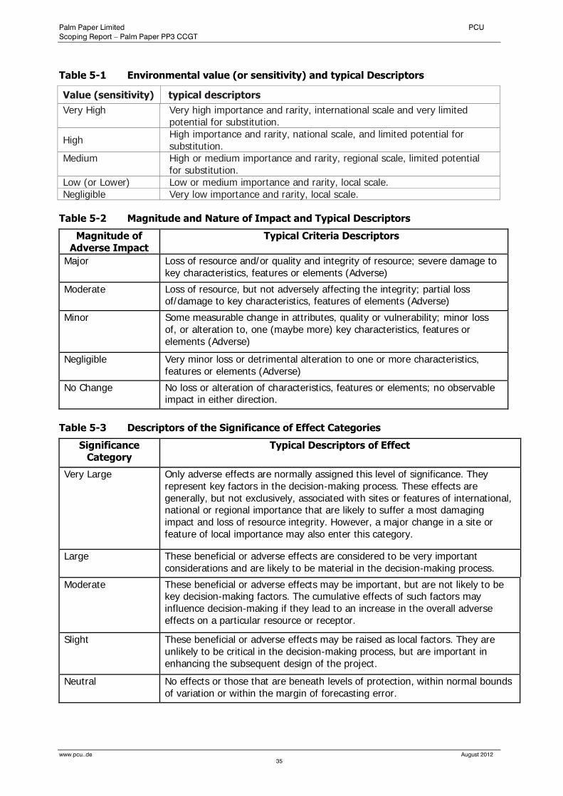
Palm Paper Limited PCU
Scoping Report – Palm Paper PP3 CCGT
www.pcu..de August 2012
35
Table 5-1 Environmental value (or sensitivity) and typical Descriptors
Value (sensitivity) typical descriptors
Very High Very high importance and rarity, international scale and very limited potential for substitution.
High High importance and rarity, national scale, and limited potential for substitution.
Medium High or medium importance and rarity, regional scale, limited potential for substitution.
Low (or Lower) Low or medium importance and rarity, local scale. Negligible Very low importance and rarity, local scale.
Table 5-2 Magnitude and Nature of Impact and Typical Descriptors
Magnitude of Adverse Impact
Typical Criteria Descriptors
Major Loss of resource and/or quality and integrity of resource; severe damage to key characteristics, features or elements (Adverse)
Moderate Loss of resource, but not adversely affecting the integrity; partial loss of/damage to key characteristics, features of elements (Adverse)
Minor Some measurable change in attributes, quality or vulnerability; minor loss of, or alteration to, one (maybe more) key characteristics, features or elements (Adverse)
Negligible Very minor loss or detrimental alteration to one or more characteristics, features or elements (Adverse)
No Change No loss or alteration of characteristics, features or elements; no observable impact in either direction.
Table 5-3 Descriptors of the Significance of Effect Categories
Significance Category
Typical Descriptors of Effect
Very Large Only adverse effects are normally assigned this level of significance. They represent key factors in the decision-making process. These effects are generally, but not exclusively, associated with sites or features of international, national or regional importance that are likely to suffer a most damaging impact and loss of resource integrity. However, a major change in a site or feature of local importance may also enter this category.
Large These beneficial or adverse effects are considered to be very important considerations and are likely to be material in the decision-making process.
Moderate These beneficial or adverse effects may be important, but are not likely to be key decision-making factors. The cumulative effects of such factors may influence decision-making if they lead to an increase in the overall adverse effects on a particular resource or receptor.
Slight These beneficial or adverse effects may be raised as local factors. They are unlikely to be critical in the decision-making process, but are important in enhancing the subsequent design of the project.
Neutral No effects or those that are beneath levels of protection, within normal bounds of variation or within the margin of forecasting error.
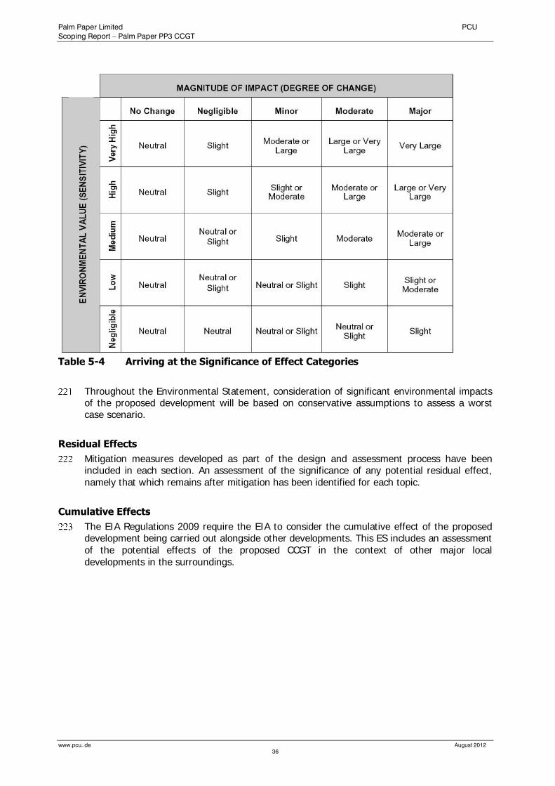
Palm Paper Limited PCU
Scoping Report – Palm Paper PP3 CCGT
www.pcu..de August 2012
36
Table 5-4 Arriving at the Significance of Effect Categories
Throughout the Environmental Statement, consideration of significant environmental impacts of the proposed development will be based on conservative assumptions to assess a worst case scenario.
Residual Effects
Mitigation measures developed as part of the design and assessment process have been included in each section. An assessment of the significance of any potential residual effect, namely that which remains after mitigation has been identified for each topic.
Cumulative Effects
The EIA Regulations 2009 require the EIA to consider the cumulative effect of the proposed development being carried out alongside other developments. This ES includes an assessment of the potential effects of the proposed CCGT in the context of other major local developments in the surroundings.

Palm Paper Limited PCU
Scoping Report – Palm Paper PP3 CCGT
www.pcu..de August 2012
37
Environmental Topics
The order of presentation has been chosen according to their relevance in order to aid comprehension. This Scoping Report contains the following environmental topics:
Air Quality
Noise and Vibration
Landscape and Visual Effects
Ecology and Nature Conservation
Flood Risk and Drainage
Archaeology and Cultural Heritage
Water Resources and Water Quality
Traffic and Transportation
Socio-Economics
Geology, Hydrology and Land Contamination
The following sections are presented in a grouped format structure with each environmental category being considered under the separate headings.
Identification of Environmental Baseline
Description of the development and Identification of Potential Impacts
Assessment criteria and methodology,
Evaluation of potential impacts of the development,
Mitigation (where appropriate), and
Conclusions (where appropriate).
Palm Paper Limited PCU
Scoping Report – Palm Paper PP3 CCGT
www.pcu..de August 2012
38
6.0 Air Quality
6.1 Introduction and Scope
The proposed development has the potential to affect local air quality. As part of the Environmental Statement for the proposed development, it is therefore necessary to assess the impact of the atmospheric emissions of the plant on the air quality in the surrounding area.
This section outlines the relevant air quality management policy and legislation, describes the existing or ‘baseline’ air quality situation in the vicinity of the proposed development, and assesses the potential changes in air quality arising from the construction and operation of the development.
Operational Impacts
The operational effects will be quantified where possible and compared against applicable air quality standards to determine their significance. For all evaluated effects, their significance has been determined by the extent of people affected, the duration and frequency of the effects, and their likelihood of occurring. Where any potentially adverse effects on air quality may occur, mitigation measures are outlined to ensure they are avoided or minimised.
A quantitative Air Quality Assessment has been undertaken by Fichtner UK (Appendix 1), which provides partially a basis for the following sections.
Construction Impacts
There is the potential for dust to be generated during construction activities on the site. The main dust generating activities are aggregate handling, foundation piling and site traffic on paved and unpaved roadways.
Where any potentially adverse effects on air quality may occur, mitigation measures are outlined to ensure they are avoided or minimised.
6.2 Air Quality Standards, Objectives and Guidelines
In the UK, air quality standards and objectives for major pollutants are described in The Air Quality Strategy for England, Scotland, Wales and Northern Ireland 2007 (known as the National Air Quality Strategy or NAQS). This document builds on the previous NAQS, published in 2000, and a 2003 Addendum to the NAQS.
The NAQS defines “standards” and “objectives”, as defined in paragraph 17 of the NAQS:
“For the purposes of the Strategy:
standards are the concentrations of pollutants in the atmosphere which can broadly be taken to achieve a certain level of environmental quality. The standards are based on assessment of the effects of each pollutant on human health including the effects on sensitive subgroups or on ecosystems
objectives are policy targets often expressed as a maximum ambient concentration not to be exceeded, either without exception or with a permitted number of exceedences, within a specified timescale.”
The status of the objectives is clarified in paragraph 22 of the NAQS, which also emphasises the importance of European Directives.
The air quality objectives in the Air Quality Strategy are a statement of policy intentions or policy targets. As such, there is no legal requirement to meet these objectives except in as far as these mirror any equivalent legally binding limit values in EU legislation. Where UK standards or objectives are the sole consideration, there is no legal obligation upon regulators, to set Emission Limit Values (ELVs) any more stringent than the emission levels associated with the use of Best Available Techniques (BAT) in issuing permits under the PPC Regulations. This aspect is dealt with fully in the PPC Practical Guides.

Palm Paper Limited PCU
Scoping Report – Palm Paper PP3 CCGT
www.pcu..de August 2012
39
Both AQOs and EALs are set at levels well below those at which significant adverse health effects have been observed in the general population and in particularly sensitive groups.
Standards and objectives for the protection of sensitive ecosystems are discussed in section 6.5.4.2.
Nitrogen Oxides
All combustion processes produce nitric oxide (NO) and nitrogen dioxide (NO2), known by the general term of NOx. In general, the majority of the NOx released is in the form of NO, which then reacts with ozone in the atmosphere to form NO2. Of the two compounds, nitrogen dioxide is associated with adverse effects on human health, principally relating to respiratory illness. The World Health Organisation (WHO) has stated that “many chemical species of nitrogen oxides (NOx) exist, but the air pollutant species of most interest from the point of view of human health is nitrogen dioxide (NO2).”
The major sources of NOx in the UK are road transport and power stations. According to the most recent annual report from the National Atmospheric Emissions Inventory (NAEI), road transport accounted for 37% of UK emissions, with power stations accounting for a further 27%.3 High levels of NOx in urban areas are almost always associated with high traffic densities.
The NAQS includes two objectives to be achieved by 31st December 2005. Both of these objectives are included in the Air Quality Directive, with an achievement date of 1st January 2010.
A limit for the one-hour mean of 200 µg/m³, not to be exceeded more than 18 times a year (equivalent to the 99.79th percentile.)
A limit for the annual mean of 40 µg/m³.
In addition, the NAQS includes an objective for the protection of sensitive vegetation and ecosystems of 30 µg/m³ for the annual mean concentration of nitrogen oxides.
Sulphur Dioxide
Sulphur dioxide is predominantly released by the combustion of fuels containing sulphur. Around 68% of UK emissions in 2004 were associated with power stations, with much of the remainder associated with other combustion processes. Emissions of SO2 have reduced by 87% since 1970, due to the reduction in coal combustion, the installation of flue gas desulphurisation plants on a number of large coal-fired power stations and the reduction in sulphur content of liquid fuels.
The NAQS contains three objectives for the control of SO2:
A limit for the 15 minute mean of 266 µg/m³, not to be exceeded more than 35 times a year (the 99.9th percentile), to be achieved by 31st December 2005.
A limit for the one hour mean of 350 µg/m³, not to be exceeded more than 24 times a year (the 99.73rd percentile) to be achieved by 31st December 2004.
A limit for the daily mean of 125 µg/m³, not to be exceeded more than 3 times a year (the 99.2nd percentile), to be achieved by 31st December 2004.
The hourly and daily objectives are included in the Air Quality Directive.
In addition, the NAQS includes two objectives for the protection of vegetation and ecosystems. These are a concentration of 20 µg/m³ as an annual mean and as a winter average.
Carbon Monoxide
Carbon Monoxide is produced by the incomplete combustion of fuels containing carbon. By far the most significant source is road transport, which produces 67% of the UK’s emissions. Carbon monoxide can interfere with the processes that transport oxygen around the body, which can prove fatal at very high levels.

Palm Paper Limited PCU
Scoping Report – Palm Paper PP3 CCGT
www.pcu..de August 2012
40
Concentrations in the UK are well below levels at which health effects can occur. The NAQS includes the following objective for the control of carbon monoxide, which is also included in the Air Quality Directive:
A limit for the 8-hour running mean of 10 mg/m³, to be achieved by 1 January 2005.
Table 6-1 below summarises the air quality objectives and guidelines used in the air quality assessment. For further details and discussion refer to the full report.
Table 6-1 Air Quality Standards (AQS) and Environmental Assessment Levels (EALs)
Pollutant Limit Value (µg/m³)
Averaging Period Frequency of exceedence
Nitrogen Dioxide 200 1 hour 18 times per year (99.79th%ile)
40 Annual -
Sulphur Dioxide 266 15 minutes 35 times per year (99.9th%ile)
350 1 hour 24 times per year (99.73rd%ile)
125 24 hours 3 times per year (99.18th%ile)
Carbon Monoxide 10,000 8 hours, running -
6.3 Baseline Conditions
The paper mill is located on Saddlebow Industrial Estate in an area known as Saddlebow, lying approximately 0.7 km south west of South Lynn, and 2.0 km south west of King’s Lynn. Located less than 1 km south west of the site is King’s Lynn Power Station which is owned and operated by Centrica. To the immediate west of the site lies The River Great Ouse.
The proximity of the plant to King’s Lynn Power station means that background concentrations of those pollutants which are normally associated with power generation (oxides of nitrogen) may be slightly higher than expected for a semi-urban location.
6.3.1 Background Air Quality
6.3.1.1 Automatic Monitoring Stations
There is limited air quality monitoring carried out in the vicinity of the Palm Paper facility. The closest relevant continuous monitoring stations considered were as follows:
Wicken Fen, a rural monitoring site, located 48km south the site.
Cambridge Roadside, a roadside site, located 62km south of the site.
Table 6-2 Automatic Monitoring Results, Near King’s Lynn

Palm Paper Limited PCU
Scoping Report – Palm Paper PP3 CCGT
www.pcu..de August 2012
41
The nitrogen dioxide annual mean concentration at the Cambridge Roadside site exceeds the air quality objectives for all years. However, this is a roadside site, with the inlet very close to the road. Therefore the site is unlikely to be representative of the area around the new development. The 99.79%-iles of hourly means at both sites are below the air quality objectives.
6.3.1.2 National Nitrogen Dioxide Survey Results
There were no suitable diffusion tubes located close to the paper mill site that monitored nitrogen dioxide (NO2) concentrations as part of DEFRA’s national NO2 diffusion tube survey between 1st January 2005 and 31st December 2006.
6.3.1.3 National Modelling Data
In order to assist councils with their responsibilities under Local Air Quality Management (LAQM), NETCEN have modelled the background concentration of pollutants throughout the UK on a 1 km by 1 km grid. This model is based on known pollution sources and background measurements. The predicted concentrations closest to the site stack location (at 561500, 317500) were as follows:
Nitrogen dioxide 10.61 µg/m³ for 2010
Sulphur dioxide 2.47 µg/m³ for 2001
Carbon monoxide 0.273 mg/m³ for 2001
All of these predicted concentrations are below the relevant air quality objectives.
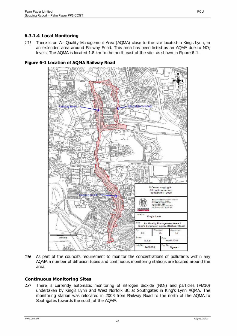
Palm Paper Limited PCU
Scoping Report – Palm Paper PP3 CCGT
www.pcu..de August 2012
42
6.3.1.4 Local Monitoring
There is an Air Quality Management Area (AQMA) close to the site located in Kings Lynn, in an extended area around Railway Road. This area has been listed as an AQMA due to NO2 levels. The AQMA is located 1.8 km to the north east of the site, as shown in Figure 6-1.
Figure 6-1 Location of AQMA Railway Road
As part of the council’s requirement to monitor the concentrations of pollutants within any AQMA a number of diffusion tubes and continuous monitoring stations are located around the area.
Continuous Monitoring Sites
There is currently automatic monitoring of nitrogen dioxide (NO2) and particles (PM10) undertaken by King’s Lynn and West Norfolk BC at Southgates in King’s Lynn AQMA. The monitoring station was relocated in 2008 from Railway Road to the north of the AQMA to Southgates towards the south of the AQMA.
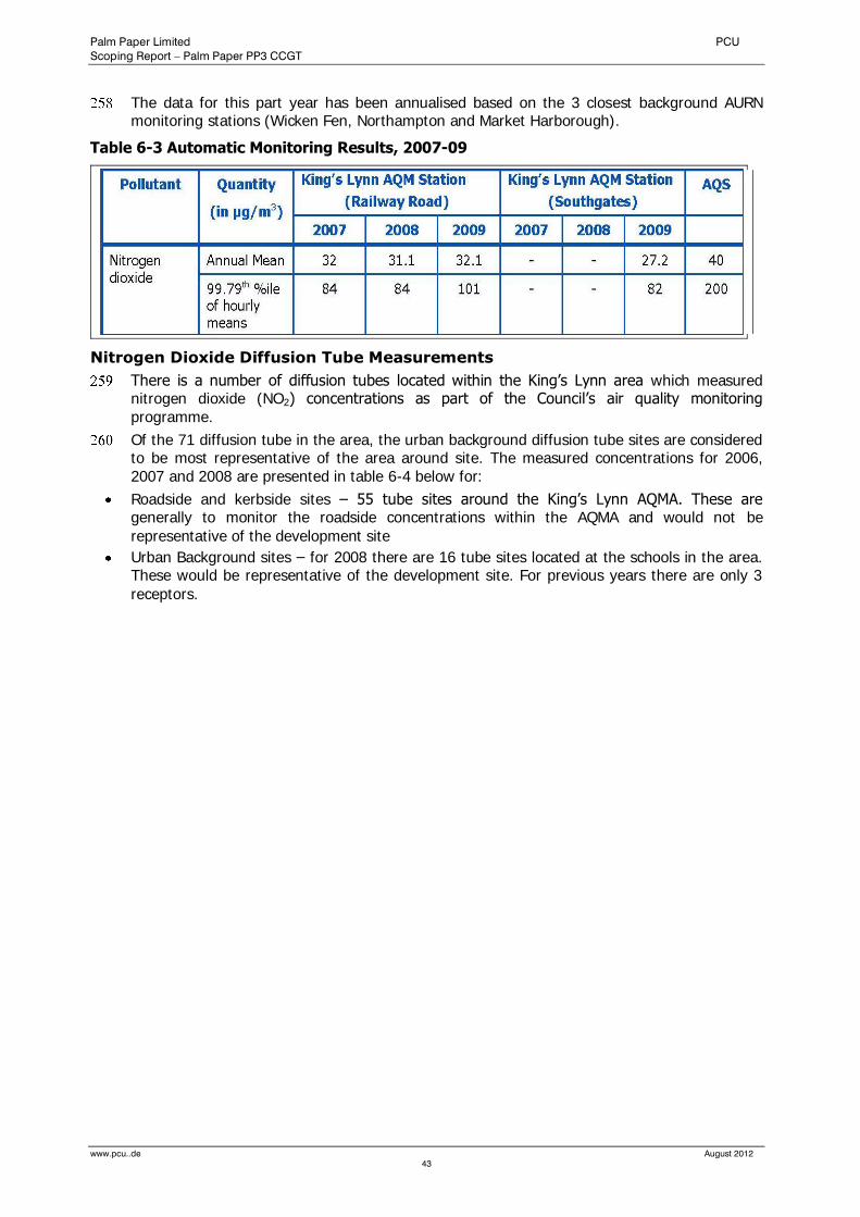
Palm Paper Limited PCU
Scoping Report – Palm Paper PP3 CCGT
www.pcu..de August 2012
43
The data for this part year has been annualised based on the 3 closest background AURN monitoring stations (Wicken Fen, Northampton and Market Harborough).
Table 6-3 Automatic Monitoring Results, 2007-09
Nitrogen Dioxide Diffusion Tube Measurements
There is a number of diffusion tubes located within the King’s Lynn area which measured nitrogen dioxide (NO2) concentrations as part of the Council’s air quality monitoring programme.
Of the 71 diffusion tube in the area, the urban background diffusion tube sites are considered to be most representative of the area around site. The measured concentrations for 2006, 2007 and 2008 are presented in table 6-4 below for:
Roadside and kerbside sites – 55 tube sites around the King’s Lynn AQMA. These are generally to monitor the roadside concentrations within the AQMA and would not be
representative of the development site
Urban Background sites – for 2008 there are 16 tube sites located at the schools in the area. These would be representative of the development site. For previous years there are only 3
receptors.
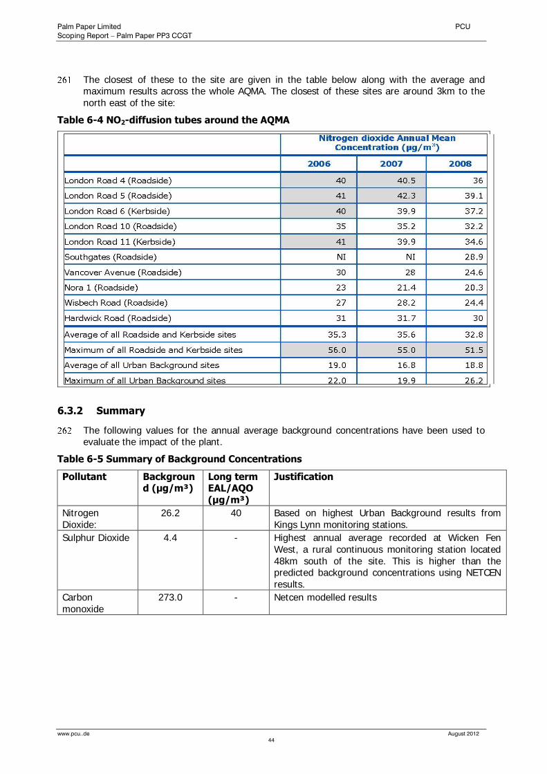
Palm Paper Limited PCU
Scoping Report – Palm Paper PP3 CCGT
www.pcu..de August 2012
44
The closest of these to the site are given in the table below along with the average and maximum results across the whole AQMA. The closest of these sites are around 3km to the north east of the site:
Table 6-4 NO2-diffusion tubes around the AQMA
6.3.2 Summary
The following values for the annual average background concentrations have been used to evaluate the impact of the plant.
Table 6-5 Summary of Background Concentrations
Pollutant Background (µg/m³)
Long term EAL/AQO (µg/m³)
Justification
Nitrogen Dioxide:
26.2 40 Based on highest Urban Background results from Kings Lynn monitoring stations.
Sulphur Dioxide 4.4 - Highest annual average recorded at Wicken Fen West, a rural continuous monitoring station located 48km south of the site. This is higher than the predicted background concentrations using NETCEN results.
Carbon monoxide
273.0 - Netcen modelled results
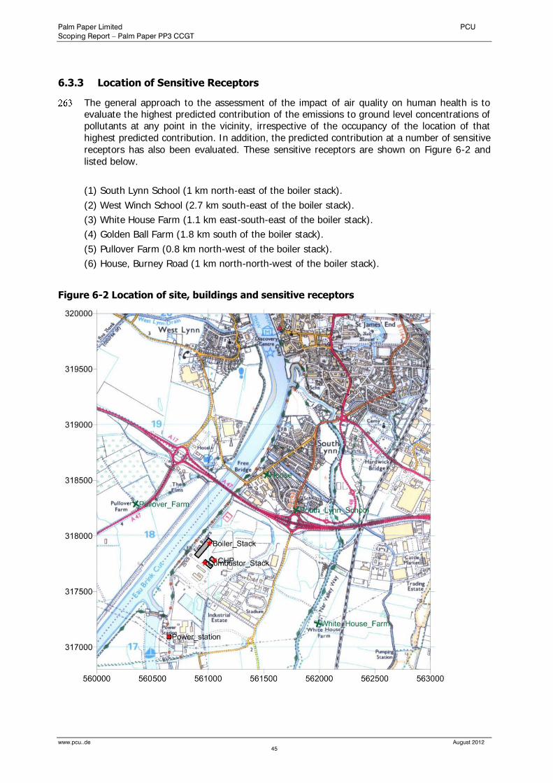
Palm Paper Limited PCU
Scoping Report – Palm Paper PP3 CCGT
www.pcu..de August 2012
45
6.3.3 Location of Sensitive Receptors
The general approach to the assessment of the impact of air quality on human health is to evaluate the highest predicted contribution of the emissions to ground level concentrations of pollutants at any point in the vicinity, irrespective of the occupancy of the location of that highest predicted contribution. In addition, the predicted contribution at a number of sensitive receptors has also been evaluated. These sensitive receptors are shown on Figure 6-2 and listed below.
(1) South Lynn School (1 km north-east of the boiler stack).
(2) West Winch School (2.7 km south-east of the boiler stack).
(3) White House Farm (1.1 km east-south-east of the boiler stack).
(4) Golden Ball Farm (1.8 km south of the boiler stack).
(5) Pullover Farm (0.8 km north-west of the boiler stack).
(6) House, Burney Road (1 km north-north-west of the boiler stack).
Figure 6-2 Location of site, buildings and sensitive receptors

Palm Paper Limited PCU
Scoping Report – Palm Paper PP3 CCGT
www.pcu..de August 2012
46
6.3.4 Emission Sources and Emissions Data
6.3.4.1 Facility Emissions
The emissions released from the stack are shown in Table 6-6 below.
Table 6-6 Source and Emissions Data
Palm Paper Limited PCU
Scoping Report – Palm Paper PP3 CCGT
www.pcu..de August 2012
47
6.3.4.2 Traffic
The proposed development will not result in a significant additional traffic flow. It is expected that only approximately 1-2 HGV delivering chemicals and other materials.
This addition is negligible when compared to the daily flow on the adjacent A47/A10 of approximately 33,000 vehicles per day. Consequently it is reasonably unlikely that the development generated traffic will result in any significant air quality impacts, and, therefore, will not be assessed further.
6.3.4.3 Construction Impacts
There is the potential for dust to be generated during construction activities on the site. The main dust generating activities are aggregate handling, foundation piling and site traffic on paved and unpaved roadways.
6.3.4.4 Odour
None of the air emissions from the proposed plant will give rise to odours beyond the boundary of the sites. Therefore, an assessment of impacts by odour will not be required.
6.4 Assessment Methodology and Significance Criteria
6.4.1 Dispersion Modelling (Operational Phase)
The assessment of operational effects contains the following sections:
A statement of the current air quality standards, objectives and guidelines which apply to the pollutants which will be released from the plant;
An assessment of the current air quality in the vicinity of the site, using results from national networks and monitoring stations operated by the local council;
A description of the methodology used in the air dispersion modelling, including assumptions and data used;
A description of the results of the air dispersion modelling, including dispersion diagrams;
An assessment of plume visibility;
An assessment of the emissions in combination with other sources of pollution in the area;
Discussion of other influences on the emissions; and
Conclusions.
6.4.1.1 Stack Height Calculation
For this assessment, the effect of different stack heights, 70m and 80m, have been evaluated This is discussed in more detail in section 6.5.
6.4.1.2 Model Inputs
Selection of Model
The detailed flue gas dispersion modelling was carried out using the computer model ADMS 4.2, developed and supplied by Cambridge Environmental Research Consultants (CERC). This is a new generation dispersion model, which characterises the atmospheric boundary layer in terms of the Monin-Obukhov length and the boundary layer depth. In addition, the model uses a skewed Gaussian distribution for dispersion under convective conditions, to take into account the skewed nature of turbulence. Modules within the model take account of nearby buildings. ADMS 4.2 has been used on many occasions for the modelling of emissions for planning and Environmental Permitting purposes and air quality assessments using ADMS have generally been accepted by the Environment Agency.

Palm Paper Limited PCU
Scoping Report – Palm Paper PP3 CCGT
www.pcu..de August 2012
48
Chemistry
The plant would release nitric oxide (NO) and nitrogen dioxide (NO2) which are together referred to as NOx. In the atmosphere, NO will be converted to NO2 in a reaction with ozone which is influenced by solar radiation. Since the air quality objectives are expressed in terms of NO2, it is important to be able to assess the conversion rate of NO to NO2. ADMS 4.2 includes a chemistry module, which models the progress of this reaction in the atmosphere. This module requires the background concentrations of NO2, NO and ozone to be provided. Since there is no continuous monitoring data close to the facility, chemistry has not been used in the general assessment. The concentrations from the dispersion model assume that all of the NOx released from the plant is oxidised to NO2 immediately. In reality, at the distances from the stack at which the peaks occur, the atmospheric oxidation process will not be completed, so that the actual concentrations of NO2 will be lower than those predicted by the model. A conversion factor has therefore been applied to the outputs from the ADMS modelling as recommended by the Environment Agency. The long term NO2 results are multiplied by 0.7 to calculate the expected ratio of NO2 to NO and the short term results are multiplied by 0.35.
Source and Emissions Data
The principal inputs to the model with respect to the releases from the gas CHP, combined cycle gas turbine (CCGT) stack are shown in Table 7-5 along with the other permitted emissions from the facility. The emissions from the gas CHP have been modelled using a variable emissions profile as the output emissions from a gas CHP are dependant on the ambient air temperature. The emissions profile can be seen in Figure 2 of the full report (Appendix 1).
Terrain
The land surrounding the site is fairly flat and as such the effects of terrain have not been accounted for in the dispersion modelling. A surface roughness length of 0.2 metres has been used in the model which is a minimum value representative of agricultural areas. This is considered to be the most suitable roughness length to take account of the combination of flat land and light building density.
Meteorological Data
The impact of weather data was taken into account by using data from the Meteorological Office for the years 2005-2009 from the Marham weather station, located around 15 km south east of the site. Wind roses for each year can be found in Figure 3, Appendix A, and show that the winds are predominantly from the south west. Five years of data were used to ensure that fluctuations in weather conditions would be accounted for.
Buildings
The presence of adjacent buildings can significantly affect the dispersion of the atmospheric emissions in various ways:
Wind blowing around a building distorts the flow and creates zones of turbulence. The increased turbulence can cause greater plume mixing.
The rise and trajectory of the plume may be depressed slightly by the flow distortion. This downwash leads to higher ground level concentrations closer to the stack than those
which would be present without the building.
It is generally accepted that building effects are only significant for buildings which are taller than one third of the stack height.
A number of buildings associated with the paper mill development are located within a few hundred metres of each stack. However these buildings are not close enough to significantly affect the reliability and accuracy of the results. For this reason, only the paper machine building, the sludge combustor building, FGT building and gas CHP building have been

Palm Paper Limited PCU
Scoping Report – Palm Paper PP3 CCGT
www.pcu..de August 2012
49
considered. The details of which are shown in Table 6-7 below. The locations of the stacks and buildings are displayed on drawing PP3 – 02.
Table 6-7 Building Details
Item Unit Paper Machine
Sludge Plant
FGT Plant Gas CHP
Building Height m 25 40 30 27
Building Length m 195 63 33 54
Building Width m 45 32 17 33
Position of centre (Eastings,
Northings)
m, m 560957, 317892
561014, 317746
561036, 317785
561042, 317786
Angle of building to north (clockwise)
° 40 130 40 130
6.4.1.3 Assessment Criteria
According to the Environment Agency’s Technical Guidance Note EPR-H1, the contribution to air quality is considered to be insignificant if the short-term contribution is less than 10% of the air quality objective and the long-term contribution is less than 1% of the air quality objective.
6.4.2 Construction Phase
The significance of atmospheric emissions from construction activities would depend on a combination of the potential for emission (the type of activities), the duration of the construction activities and the effectiveness of control measures. In general terms, there are two sources of emissions that would need to be controlled to minimise the potential for adverse environmental effects:
traffic emissions (exhaust emissions from site plant, equipment and vehicles); and
dust emissions from site activities.
6.4.2.1 Traffic Emissions
The operation of vehicles and equipment powered by internal combustion engines results in the emission of waste exhaust gases containing the pollutants NOx, PM10, VOCs, and CO. The quantities emitted depend on factors such as engine type, service history, pattern of usage and composition of fuel. The operation of site equipment, vehicles and machinery would result in emission to the atmosphere of unquantified levels of waste exhaust gases but such emissions are unlikely to be significant - particularly in comparison to levels of similar emissions from road traffic on the adjacent A47 (AADT of approx 33,000 vehicles).
The traffic effect of construction of the proposed development is limited to a finite period (approx. one year) and will be along the traffic routes employed by haulage vehicles, construction vehicles and employees’ vehicles (particularly Saddlebow Road/High Road, Poplar Avenue). The principal construction activities with transportation implications are:
removal of excavated material,
delivery of materials for new development, and
movement of heavy plant.
The maximum predicted flow of construction traffic is 50 vehicles per day, for a period of approximately one year. This temporary addition is minimal when compared to the daily flow
Palm Paper Limited PCU
Scoping Report – Palm Paper PP3 CCGT
www.pcu..de August 2012
50
on the adjacent A47 of approximately 33,000 vehicles per day. Therefore, such emissions are considered to be insignificant.
Consequently it is highly unlikely that the onsite machinery will result in any significant air quality impacts. It is anticipated that impacts of the proposed development on air quality will be negligible, and will not be assessed further.
6.4.2.2 Dust Emissions
Dust emissions from construction activities are likely to be variable and would depend upon type and extent of the activity, soil conditions (soil type and moisture) road surface condition and weather conditions. Soils are inevitably drier during the summer period and periods of dry weather combined with higher than average winds have the potential to generate the most dust.
However, it is very difficult to quantify such emissions. It is thus not possible to predict changes to soiling rates with any confidence. In these circumstances, it is common practice to provide a qualitative assessment based largely on experience elsewhere, as well as focusing on proposing mitigation measures to minimise emissions.
The main activities which have been assessed as likely to cause dust are:
dust from haul roads;
excavation and transportation (excavators, dozers, dump trucks)
loading of lorries;
building construction
landscaping
6.4.2.3 Critical Receptors
Locations sensitive to dust emitted during construction will be places where members of the public are regularly present.
Residential and recreational areas and commercial operations close to the site will be those most sensitive to construction dust. Any sensitive vegetation or ecology that is very close to dust sources might also suffer some negative effects. Sensitive receptors downwind of the prevailing wind may be more at risk of dust impacts than those upwind.
The wind rose for the development site indicates that the predominant wind direction is from the south west. Properties most at risk from increased deposition and PM10 concentrations during construction will be those to the north-east of the site (Caravan Park and residential areas of South Lynn).
6.4.2.4 Assessment Criteria
There are no statutory objectives for dust. It is therefore common practice to provide a qualitative assessment based largely on experience elsewhere, as well as focusing on proposing mitigation measures to minimise emissions.
Any dust incidents will be highly dependent on the weather, requiring dry conditions and winds blowing towards a receptor. Thus sensitive receptors downwind of the prevailing wind (south west) would be more at risk of dust impacts than those upwind. This will also need to be combined with an activity creating dust close to that receptor. The combination of conditions to allow significant dust soiling at any sensitive location should therefore be very infrequent. It is also noteworthy that the existing farming activities west of the development site may also be associated with occasional dust generation and thus some of the potential impacts described might happen with or without the development.
It should also be noted that research undertaken for the United States Environmental Protection Agency (US EPA) concluded that large particulate matter (particles over 30 µm in
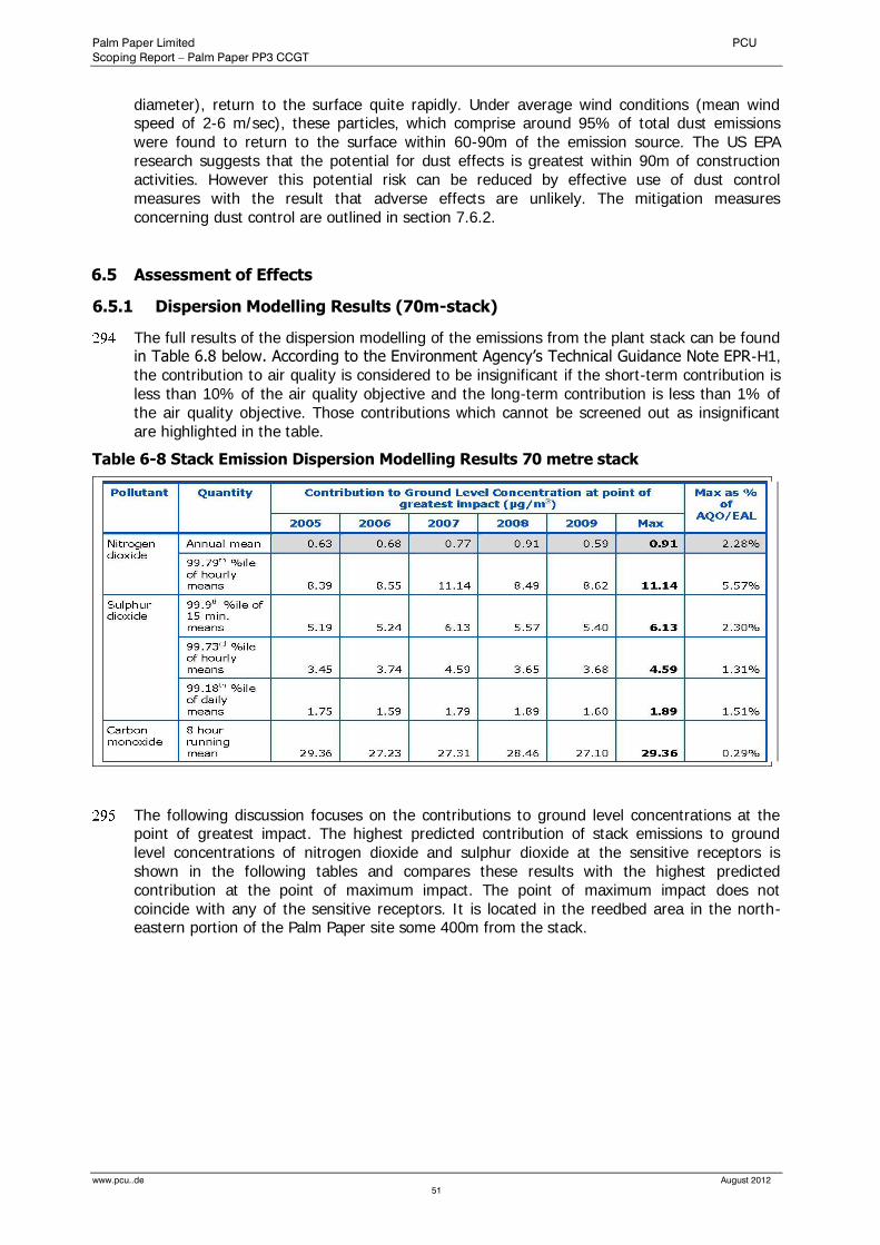
Palm Paper Limited PCU
Scoping Report – Palm Paper PP3 CCGT
www.pcu..de August 2012
51
diameter), return to the surface quite rapidly. Under average wind conditions (mean wind speed of 2-6 m/sec), these particles, which comprise around 95% of total dust emissions were found to return to the surface within 60-90m of the emission source. The US EPA research suggests that the potential for dust effects is greatest within 90m of construction activities. However this potential risk can be reduced by effective use of dust control measures with the result that adverse effects are unlikely. The mitigation measures concerning dust control are outlined in section 7.6.2.
6.5 Assessment of Effects
6.5.1 Dispersion Modelling Results (70m-stack)
The full results of the dispersion modelling of the emissions from the plant stack can be found in Table 6.8 below. According to the Environment Agency’s Technical Guidance Note EPR-H1, the contribution to air quality is considered to be insignificant if the short-term contribution is less than 10% of the air quality objective and the long-term contribution is less than 1% of the air quality objective. Those contributions which cannot be screened out as insignificant are highlighted in the table.
Table 6-8 Stack Emission Dispersion Modelling Results 70 metre stack
The following discussion focuses on the contributions to ground level concentrations at the point of greatest impact. The highest predicted contribution of stack emissions to ground level concentrations of nitrogen dioxide and sulphur dioxide at the sensitive receptors is shown in the following tables and compares these results with the highest predicted contribution at the point of maximum impact. The point of maximum impact does not coincide with any of the sensitive receptors. It is located in the reedbed area in the north-eastern portion of the Palm Paper site some 400m from the stack.
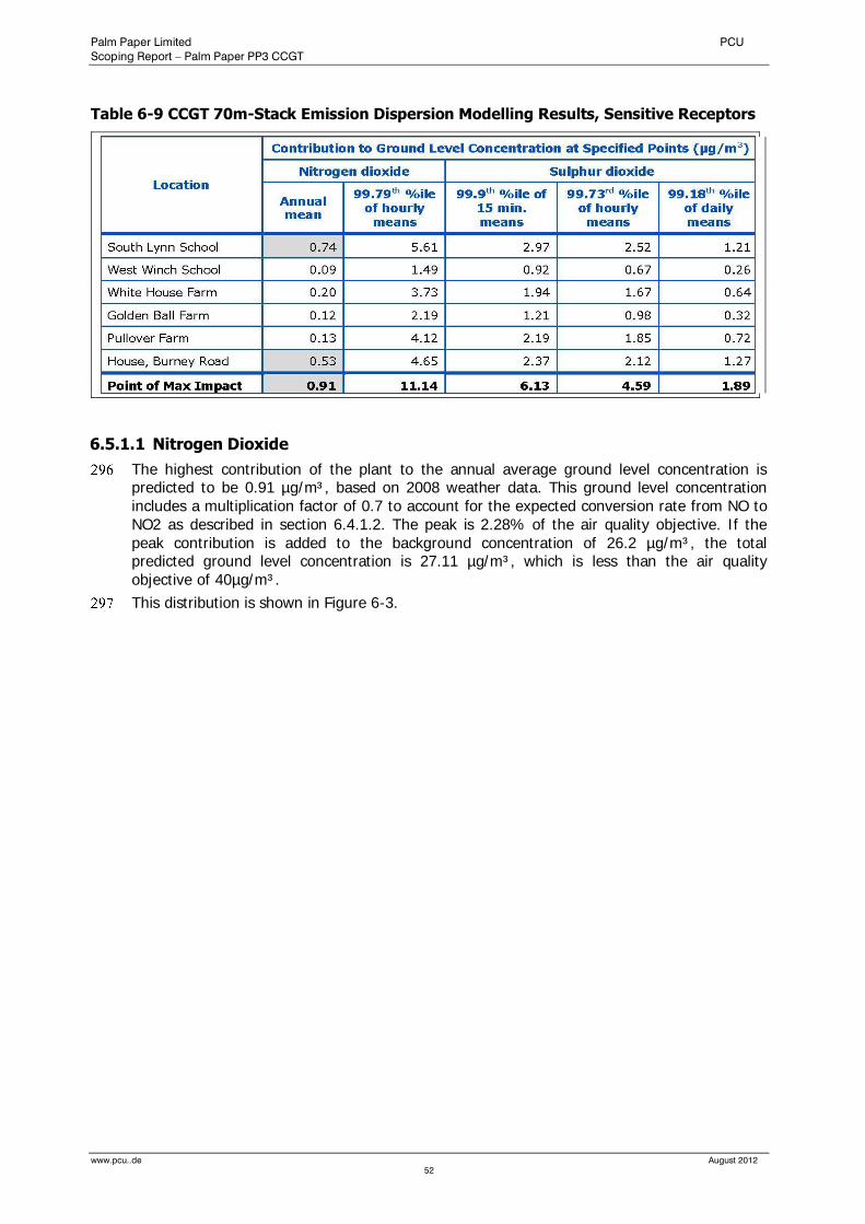
Palm Paper Limited PCU
Scoping Report – Palm Paper PP3 CCGT
www.pcu..de August 2012
52
Table 6-9 CCGT 70m-Stack Emission Dispersion Modelling Results, Sensitive Receptors
6.5.1.1 Nitrogen Dioxide
The highest contribution of the plant to the annual average ground level concentration is predicted to be 0.91 µg/m³, based on 2008 weather data. This ground level concentration includes a multiplication factor of 0.7 to account for the expected conversion rate from NO to NO2 as described in section 6.4.1.2. The peak is 2.28% of the air quality objective. If the peak contribution is added to the background concentration of 26.2 µg/m³, the total predicted ground level concentration is 27.11 µg/m³, which is less than the air quality objective of 40µg/m³.
This distribution is shown in Figure 6-3.

Palm Paper Limited PCU
Scoping Report – Palm Paper PP3 CCGT
www.pcu..de August 2012
53
Figure 6-3 Annual average ground level concentration of NO2, stack emissions 2008 weather data (stack height 70m)
The highest contribution of the plant to the 99.79th percentile of hourly average ground level concentrations is predicted to be 11.14µg/m³, based on 2007 weather data. This ground level concentration includes a multiplication factor of 0.35 to account for the expected conversion rate from NO to NO2 as described in section 6.4.1.2. The peak is 5.57% of the air quality objective.
It would not be correct to add the peak short-term contribution from the plant to the highest recorded background concentration, since the two peaks would not be coincident in time or space. Instead, the Environment Agency recommends in Technical Guidance Note EPR-H1 that the short-term process contribution should be added to twice the long-term ambient concentration. If the short-term peak is added to two times the highest annual average concentration, the total predicted ground level concentration is 65.5µg/m³, which is less than a third of the AQO of 200 µg/m³.
Overall, the contribution of the stack emissions to the short term nitrogen dioxide levels in the atmosphere can be considered insignificant. The contribution of the plant to the long term nitrogen dioxide levels in the atmosphere cannot be considered insignificant but no breaches of air quality standards or objectives are anticipated.

Palm Paper Limited PCU
Scoping Report – Palm Paper PP3 CCGT
www.pcu..de August 2012
54
At sensitive receptors, the highest contribution to long term nitrogen dioxide concentrations is only 1.4% of the air quality objective.
An air quality management area has been declared in King’s Lynn for an extended area around Railway Road. Section 6.3.1 discusses the background pollutant levels within this area. Figure 6-1 shows the extent of the AQMA.
The impacted of the proposed facility within the AQMA was considered as part of this air quality assessment. Figure 6-4 shows the AQMA overlaid onto an OS Map along with the ground level concentration of nitrogen dioxide. As can be seen the ground level impact is less than 1% of the AQO of nitrogen dioxide inside the AQMA.
Figure 6-4 Long term ground level concentration of NO2 with Railway Road AQMA overlaid, stack emissions 2008 weather data (stack height 70m)
6.5.1.2 Sulphur Dioxide
The highest contribution to the 99.9th percentile of 15-minute means of ground level concentration of sulphur dioxide is predicted to be 6.13µg/m³, based on 2007 weather data. This peak is 2.3% of the air quality objective. If this short-term peak is added to twice the annual average background concentration of 4.4µg/m³, the total predicted peak is 14.93µg/m³, which is less than the air quality objective of 266µg/m³. The highest contribution to the 99.73rd percentile hourly average ground level concentration of sulphur

Palm Paper Limited PCU
Scoping Report – Palm Paper PP3 CCGT
www.pcu..de August 2012
55
dioxide from the plant is predicted to be 4.59µg/m³, based on 2007 weather data. This peak is 1.31% of the air quality objective. If this short-term peak is added to twice the annual average background concentration, the total predicted peak is 13.39µg/m³, which is less than the air quality objective of 350µg/m³. The highest contribution to the 99.18th percentile daily average ground level concentration of sulphur dioxide is predicted to be 1.89µg/m³, based on 2008 weather data. This peak is 1.51% of the air quality objective. If this short-term peak is added to twice the annual average background concentration, the total predicted peak is 10.69µg/m³, which is less than the air quality objective of 125µg/m³. Overall, the contribution of the plant to sulphur dioxide levels in the atmosphere can be considered insignificant. Since the contribution is so low, no diagram for the dispersion is included.
6.5.1.3 Carbon monoxide
The highest contribution of stack emissions to the eight-hourly running mean ground level concentration is predicted to be 29.36µg/m³ which is 0.03% of the EAL. Therefore, the plant will not make a significant contribution to carbon monoxide levels in the atmosphere. Since the contribution is so low, no diagram for the dispersion is included.
6.5.2 Dispersion Modelling Results (80m-stack)
The impact on the ground level concentrations of NO2 at the point of maximum impact from an 80 metre high stack is 0.45 µg/m3, which is 1.1% of the air quality objective of 40 µg/m3. The maximum impact is reduced by 0.46 µg/m3 from the maximum contribution with a 70 metre stack of 0.91 µg/m3. The impact still cannot be screened out as being insignificant under the EA criteria of significance for all weather years with a 80 metre stack.
At sensitive receptors, the highest contribution to long term nitrogen dioxide concentrations is reduced to a maximum of 0.45 µg/m3 (1.1% of the air quality objective) at South Lynn School with a 80 metre stack, compared to a maximum contribution of 0.74 µg/m3 (1.8% of the air quality objective) with a 70 metre stack.
At the closest point in the air quality management area in King’s Lynn (around the southern end of Railway Road), the maximum impact of the facility to the long term nitrogen dioxide ground level concentration within the AQMA was 0.29 µg/m3, 0.74% of the air quality objective with a 70 metre stack. This is reduced to 0.25 µg/m3, which is 0.63% of the air quality objective, with a 80 metre stack. Hence, the ground level impact is reduced within the AQMA by 0.04 µg/m3 (0.1% of the air quality objective) by increasing the stack height from 70 metres to 80 metres.
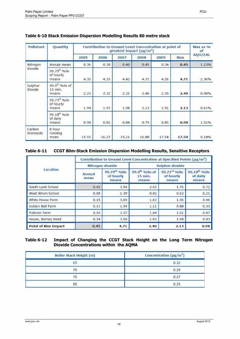
Palm Paper Limited PCU
Scoping Report – Palm Paper PP3 CCGT
www.pcu..de August 2012
56
Table 6-10 Stack Emission Dispersion Modelling Results 80 metre stack
Table 6-11 CCGT 80m-Stack Emission Dispersion Modelling Results, Sensitive Receptors
Table 6-12 Impact of Changing the CCGT Stack Height on the Long Term Nitrogen Dioxide Concentrations within the AQMA
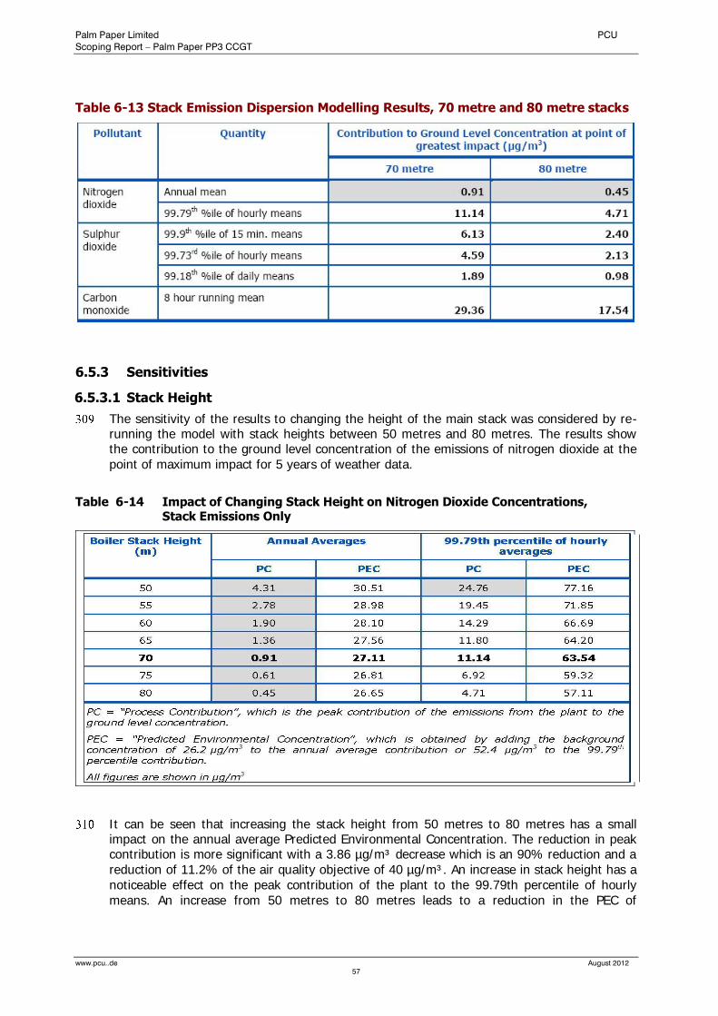
Palm Paper Limited PCU
Scoping Report – Palm Paper PP3 CCGT
www.pcu..de August 2012
57
Table 6-13 Stack Emission Dispersion Modelling Results, 70 metre and 80 metre stacks
6.5.3 Sensitivities
6.5.3.1 Stack Height
The sensitivity of the results to changing the height of the main stack was considered by re-running the model with stack heights between 50 metres and 80 metres. The results show the contribution to the ground level concentration of the emissions of nitrogen dioxide at the point of maximum impact for 5 years of weather data.
Table 6-14 Impact of Changing Stack Height on Nitrogen Dioxide Concentrations, Stack Emissions Only
It can be seen that increasing the stack height from 50 metres to 80 metres has a small impact on the annual average Predicted Environmental Concentration. The reduction in peak contribution is more significant with a 3.86 µg/m³ decrease which is an 90% reduction and a reduction of 11.2% of the air quality objective of 40 µg/m³. An increase in stack height has a noticeable effect on the peak contribution of the plant to the 99.79th percentile of hourly means. An increase from 50 metres to 80 metres leads to a reduction in the PEC of
Palm Paper Limited PCU
Scoping Report – Palm Paper PP3 CCGT
www.pcu..de August 2012
58
20.05µg/m³ which is a 26% reduction and a reduction of 10.02% of the air quality objective of 200 µg/m³.
A stack height has not yet been decided on. The stack height to be chosen will have to represent a balance between the visual impact and air the quality impact.
Planning permission has already been obtained for the sludge incinerator located close to the proposed CCGT, which will have a 70m stack.
6.5.3.2 Roughness
The sensitivity of the results to the surface roughness length has been assessed by re-running the model using 2007 weather data and a roughness length of 0.1, 0.2 and 0.3 metres. The results for nitrogen dioxide were as follows:
The contribution to the annual average ground level concentration increased with increasing roughness length. The results were 0.63, 0.77 and 0.86 µg/m³ respectively for the three roughness lengths.
The contribution to the 99.79th percentile of the hourly ground level concentration decreased with increasing roughness length. The results were 9.2, 11.14 and 10.69 µg/m³ respectively for the three roughness lengths.
The variation in roughness causes a negligible difference to the short term ground level concentrations and a slight difference to the long term concentration. The selected roughness length of 0.2 metres is representative of agricultural land and is therefore considered to be representative of the area around the site.
6.5.3.3 Impact of Palm Paper’s Existing Operations
The results of the dispersion modelling of the Palm Paper’s existing operations (permitted sludge incinerator and existing boiler) alone, without the proposed CCGT plant, are shown below. The results are only shown for nitrogen dioxide, because this has the most significant impact.
Table 6-15 Palm Paper’s Existing Operations Station Dispersion Modelling Results
The predicted contribution of Palm Papers existing operations to the long term nitrogen dioxide levels in the atmosphere is significant, but the short term contribution can be considered insignificant. However, since the conservative background concentration of nitrogen dioxide is 26.2µg/m³ and 52.4µg/m³ for the long term and short term respectively, no breaches of air quality objectives are predicted.
6.5.3.4 Impact of CCGT and Existing Paper Mill Operations
The results of the dispersion modelling of the CCGT and the paper mill operations (permitted sludge combustor and existing boiler) in combination requires careful analysis. This is because the highest contributions from the two plants do not occur at the same place or under the same weather conditions.
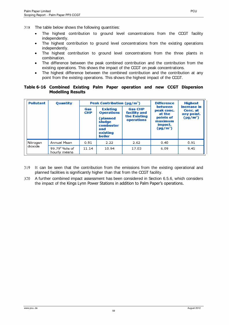
Palm Paper Limited PCU
Scoping Report – Palm Paper PP3 CCGT
www.pcu..de August 2012
59
The table below shows the following quantities:
The highest contribution to ground level concentrations from the CCGT facility independently.
The highest contribution to ground level concentrations from the existing operations independently.
The highest contribution to ground level concentrations from the three plants in combination.
The difference between the peak combined contribution and the contribution from the existing operations. This shows the impact of the CCGT on peak concentrations.
The highest difference between the combined contribution and the contribution at any point from the existing operations. This shows the highest impact of the CCGT.
Table 6-16 Combined Existing Palm Paper operation and new CCGT Dispersion Modelling Results
It can be seen that the contribution from the emissions from the existing operational and planned facilities is significantly higher than that from the CCGT facility.
A further combined impact assessment has been considered in Section 6.5.6, which considers the impact of the Kings Lynn Power Stations in addition to Palm Paper’s operations.
Palm Paper Limited PCU
Scoping Report – Palm Paper PP3 CCGT
www.pcu..de August 2012
60
6.5.4 Sensitive Environmental Receptors
6.5.4.1 Location of Sensitive Environmental Receptors
One Site of Special Scientific Interest (SSSI) is located close to the site, the River Nar SSSI (about 1.5 km to the east of the site). This SSSI follows the river and runs in a south-to-north direction to the east of the proposed development.
Two Special Areas of Conservation (SAC) are close to the site:
1(1) The Wash and North Norfolk Coast SAC (about 6 km from the site). This is a large SAC, coving some 62,000 hectares, which has been designated due to the presence of a number of Annex 1 habitats, including sandbanks, mudflats and sandflats, large shallow inlets and bays, reefs, atlantic salt meadows, Salicornia and other annuals colonising mud and sand and Mediterranean and thermo-Atlantic halophilous scrubs. It also contains the largest colony of common seals in the UK. A grid of 950 receptor points has been used to determine the average and maximum concentration in the Wash and Norfolk Coast SAC. 2(2) Royden Common and Dersingham Bog SAC (about 7 km from the stack). This is a much smaller SAC, covering some 353 hectares. It is designated due to the presence of two Annex 1 habitats: Northern Atlantic wet heaths with Erica tetralix and Depressions on peat substrates of the Rhynchosporion. A grid of 300 receptor points has been used to determine the average and maximum concentration in Royden Common and Dersingham Bog.
6.5.4.2 Assessment Criteria
The emissions from the proposed plant could lead to four potential impacts on the protected habitats. Appendix B to Annex F of the Environment Agency Horizontal Guidance Note EPR-H1 sets out the air quality standards or Critical loads for each of the potential impacts, these are considered below.
(1) Atmospheric Nitrogen Oxides- The limit for the protection of sensitive ecosystems of 30µg/m³ as an annual average ground level concentration of nitrogen oxides (as nitrogen dioxide). (2) Atmospheric Sulphur Dioxide - The limit for the protection of sensitive ecosystems of 20µg/m³ as an annual average and winter average ground level concentration of sulphur dioxide. A lower limit of 10µg/m³ as an annual mean for the protection of vegetation and ecosystems is considered where lichens & bryophytes are an important part of the ecosystem’s integrity (3) Eutrophication - This is measured by the sensitivity to the deposition of nutrient nitrogen. The APIS Database contains the following Critical Loads for the specific habitats present in the SACs.
(1) The Wash and North Norfolk Coast-Many of the habitats are not sensitive to eutrophication. Those that are sensitive can be grouped as “pioneer and low-mid salt marshes, with a Critical Load of 30-40 kg N/ha/yr
(2) Roydon Common and Dersingham Bog a) 10-25 kg N/ha/year for North Atlantic wet heaths b) 10-20 kg N/ha/year for Depressions on peat substrates of the Rhynchosporion.
(3) The River Nar, includes the habitat types acid grassland and calcareous grassland. The APIS Database contains the following limit values for these habitats: a) 10-25 kg N/hectare/year for acid grasslands b) 15-25 kg N/hectare/year for calcareous grasslands
(4) Acidification - This is the sensitivity to acidic deposition. It is assessed by comparison with a Critical Load function, considering the relationship between acidic sulphur and acidic nitrogen deposition. a) None of the habitats in The Wash and Norfolk Coasts SAC are sensitive to
acidification.
Palm Paper Limited PCU
Scoping Report – Palm Paper PP3 CCGT
www.pcu..de August 2012
61
b) The most sensitive habitat to acidification in the Royden Common and Dersingham Bog SAC is the depression on peat substrates of the Rhynchosporion. The Atlantic wet heaths habitat is also sensitive to acid deposition, but the range of sensitivity is much greater. The figure below shows the minimum, and maximum Critical Load Functions for both habitats, taken from the Apis database. In order to assess the significance, the radial distance is calculated from the origin of the graph through the modelled deposition point to the critical function line. The distance from the origin to the modelled deposition point is then divided by the radial distance to give a percentage.
It should be noted that acid deposition is measured in the number of equivalent H+ ions, with units of keq/he/year.
The contribution of the emissions from the facility to the ground level atmospheric concentrations and deposition rates within the sensitive environmental receptors have been compared with these assessment levels. In accordance with the Environment Agency’s “EU Habitats and Birds Directive Handbook”, Appendix 7.1, “Where the concentration within the emission footprint in any part of the European site(s) is less than 1% of the relevant long-term benchmark (EAL, Critical Level or Critical Load), the emission is not likely to have a significant effect alone or in combination irrespective of the background levels.”
Therefore, if the contribution from the plant is less than 1% of the benchmark for all relevant pollutants in a given European Site, then the contribution from the plant is insignificant.
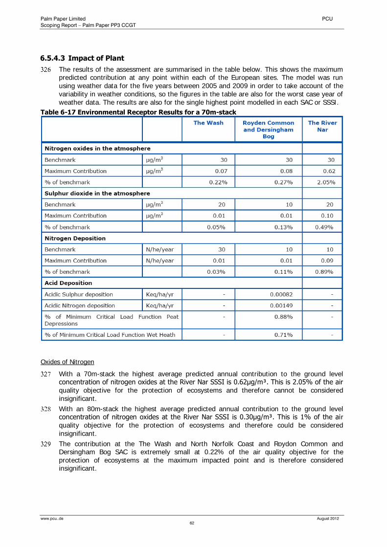
Palm Paper Limited PCU
Scoping Report – Palm Paper PP3 CCGT
www.pcu..de August 2012
62
6.5.4.3 Impact of Plant
The results of the assessment are summarised in the table below. This shows the maximum predicted contribution at any point within each of the European sites. The model was run using weather data for the five years between 2005 and 2009 in order to take account of the variability in weather conditions, so the figures in the table are also for the worst case year of weather data. The results are also for the single highest point modelled in each SAC or SSSI.
Table 6-17 Environmental Receptor Results for a 70m-stack
Oxides of Nitrogen
With a 70m-stack the highest average predicted annual contribution to the ground level concentration of nitrogen oxides at the River Nar SSSI is 0.62μg/m³. This is 2.05% of the air quality objective for the protection of ecosystems and therefore cannot be considered insignificant.
With an 80m-stack the highest average predicted annual contribution to the ground level concentration of nitrogen oxides at the River Nar SSSI is 0.30μg/m³. This is 1% of the air quality objective for the protection of ecosystems and therefore could be considered insignificant.
The contribution at the The Wash and North Norfolk Coast and Roydon Common and Dersingham Bog SAC is extremely small at 0.22% of the air quality objective for the protection of ecosystems at the maximum impacted point and is therefore considered insignificant.
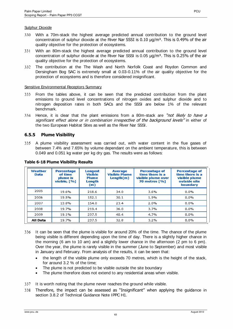
Palm Paper Limited PCU
Scoping Report – Palm Paper PP3 CCGT
www.pcu..de August 2012
63
Sulphur Dioxide
With a 70m-stack the highest average predicted annual contribution to the ground level concentration of sulphur dioxide at the River Nar SSSI is 0.10 μg/m³. This is 0.49% of the air quality objective for the protection of ecosystems.
With an 80m-stack the highest average predicted annual contribution to the ground level concentration of sulphur dioxide at the River Nar SSSI is 0.05 μg/m³. This is 0.25% of the air quality objective for the protection of ecosystems.
The contribution at the The Wash and North Norfolk Coast and Roydon Common and Dersingham Bog SAC is extremely small at 0.03-0.11% of the air quality objective for the protection of ecosystems and is therefore considered insignificant.
Sensitive Environmental Receptors Summary
From the tables above, it can be seen that the predicted contribution from the plant emissions to ground level concentrations of nitrogen oxides and sulphur dioxide and to nitrogen deposition rates in both SACs and the SSSI are below 1% of the relevant benchmark.
Hence, it is clear that the plant emissions from a 80m-stack are “not likely to have a significant effect alone or in combination irrespective of the background levels” in either of the two European Habitat Sites as well as the River Nar SSSI.
6.5.5 Plume Visibility
A plume visibility assessment was carried out, with water content in the flue gases of between 7.4% and 7.65% by volume dependant on the ambient temperature, this is between 0.049 and 0.051 kg water per kg dry gas. The results were as follows:
Table 6-18 Plume Visibility Results
It can be seen that the plume is visible for around 20% of the time. The chance of the plume being visible is different depending upon the time of day. There is a slightly higher chance in the morning (6 am to 10 am) and a slightly lower chance in the afternoon (2 pm to 6 pm). Over the year, the plume is rarely visible in the summer (June to September) and most visible in January and February. From analysis of the results, it can be seen that:
the length of the visible plume only exceeds 70 metres, which is the height of the stack, for around 3.2 % of the time;
The plume is not predicted to be visible outside the site boundary The plume therefore does not extend to any residential areas when visible.
It is worth noting that the plume never reaches the ground while visible.
Therefore, the impact can be assessed as “Insignificant” when applying the guidance in section 3.8.2 of Technical Guidance Note IPPC H1.
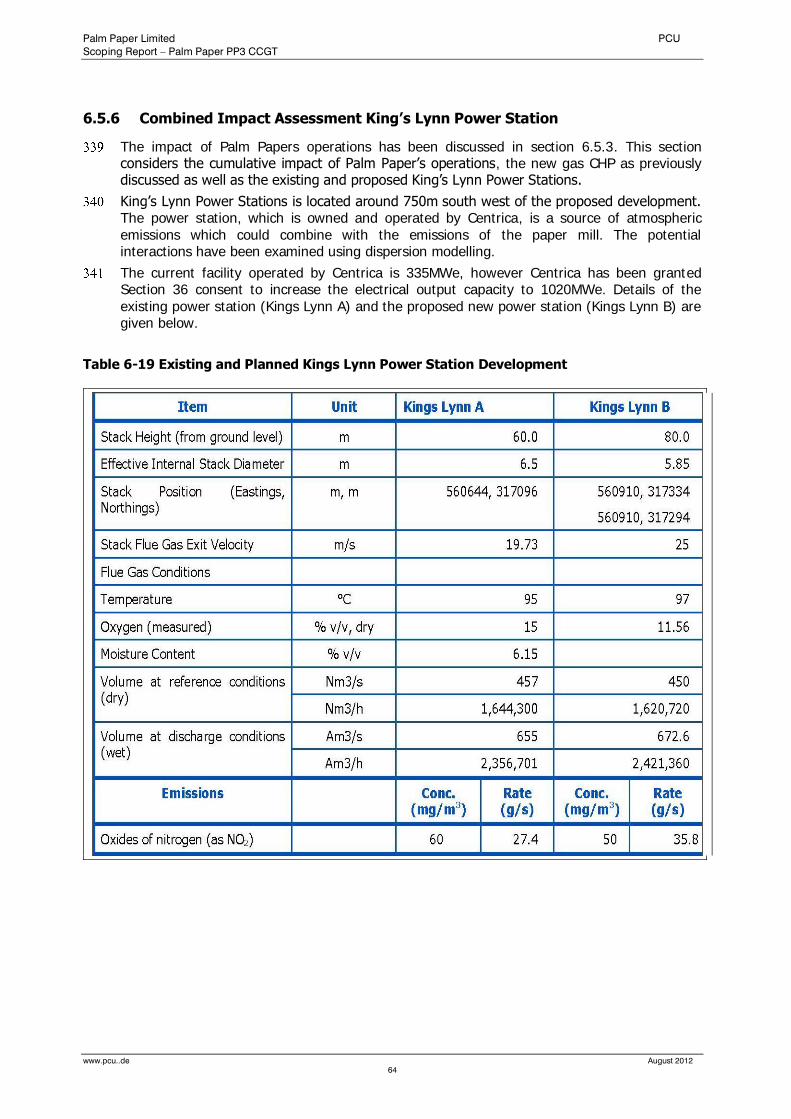
Palm Paper Limited PCU
Scoping Report – Palm Paper PP3 CCGT
www.pcu..de August 2012
64
6.5.6 Combined Impact Assessment King’s Lynn Power Station
The impact of Palm Papers operations has been discussed in section 6.5.3. This section considers the cumulative impact of Palm Paper’s operations, the new gas CHP as previously discussed as well as the existing and proposed King’s Lynn Power Stations.
King’s Lynn Power Stations is located around 750m south west of the proposed development. The power station, which is owned and operated by Centrica, is a source of atmospheric emissions which could combine with the emissions of the paper mill. The potential interactions have been examined using dispersion modelling.
The current facility operated by Centrica is 335MWe, however Centrica has been granted Section 36 consent to increase the electrical output capacity to 1020MWe. Details of the existing power station (Kings Lynn A) and the proposed new power station (Kings Lynn B) are given below.
Table 6-19 Existing and Planned Kings Lynn Power Station Development
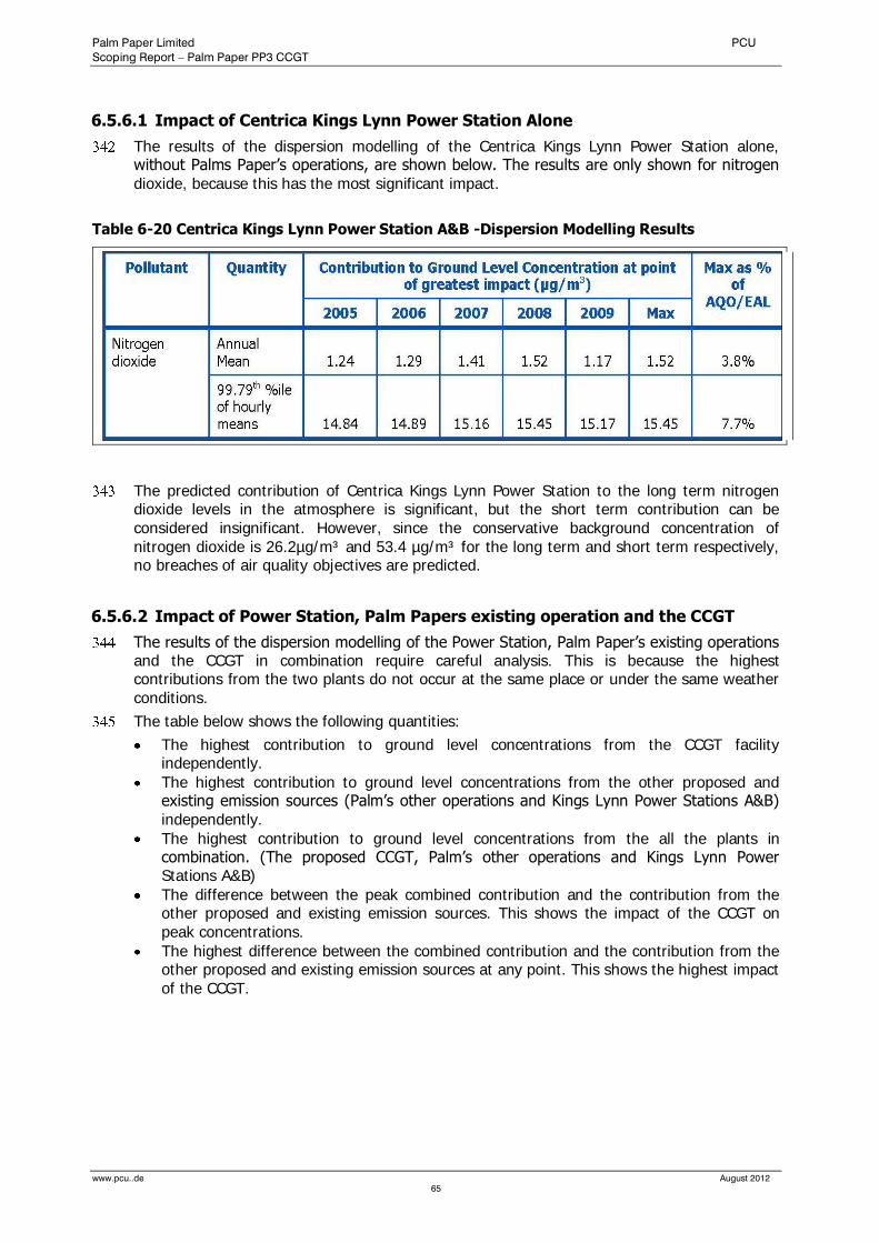
Palm Paper Limited PCU
Scoping Report – Palm Paper PP3 CCGT
www.pcu..de August 2012
65
6.5.6.1 Impact of Centrica Kings Lynn Power Station Alone
The results of the dispersion modelling of the Centrica Kings Lynn Power Station alone, without Palms Paper’s operations, are shown below. The results are only shown for nitrogen dioxide, because this has the most significant impact.
Table 6-20 Centrica Kings Lynn Power Station A&B -Dispersion Modelling Results
The predicted contribution of Centrica Kings Lynn Power Station to the long term nitrogen dioxide levels in the atmosphere is significant, but the short term contribution can be considered insignificant. However, since the conservative background concentration of nitrogen dioxide is 26.2µg/m³ and 53.4 µg/m³ for the long term and short term respectively, no breaches of air quality objectives are predicted.
6.5.6.2 Impact of Power Station, Palm Papers existing operation and the CCGT
The results of the dispersion modelling of the Power Station, Palm Paper’s existing operations and the CCGT in combination require careful analysis. This is because the highest contributions from the two plants do not occur at the same place or under the same weather conditions.
The table below shows the following quantities:
The highest contribution to ground level concentrations from the CCGT facility independently.
The highest contribution to ground level concentrations from the other proposed and existing emission sources (Palm’s other operations and Kings Lynn Power Stations A&B) independently.
The highest contribution to ground level concentrations from the all the plants in combination. (The proposed CCGT, Palm’s other operations and Kings Lynn Power Stations A&B)
The difference between the peak combined contribution and the contribution from the other proposed and existing emission sources. This shows the impact of the CCGT on peak concentrations.
The highest difference between the combined contribution and the contribution from the other proposed and existing emission sources at any point. This shows the highest impact of the CCGT.
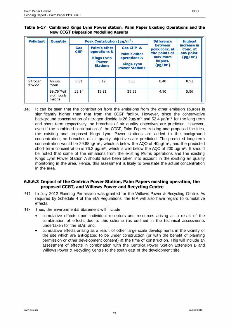
Palm Paper Limited PCU
Scoping Report – Palm Paper PP3 CCGT
www.pcu..de August 2012
66
Table 6-17 Combined Kings Lynn Power station, Palm Paper Existing Operations and the
New CCGT Dispersion Modelling Results
It can be seen that the contribution from the emissions from the other emission sources is significantly higher than that from the CCGT facility. However, since the conservative background concentration of nitrogen dioxide is 26.2µg/m³ and 52.4 µg/m³ for the long term and short term respectively, no breaches of air quality objectives are predicted. However, even if the combined contribution of the CCGT, Palm Papers existing and proposed facilities, the existing and proposed Kings Lynn Power stations are added to the background concentration, no breaches of air quality objectives are predicted. The predicted long term concentration would be 29.88µg/m³, which is below the AQO of 40µg/m³, and the predicted short term concentration is 76.2 µg/m³, which is well below the AQO of 200 µg/m³. It should be noted that some of the emissions from the existing Palms operations and the existing Kings Lynn Power Station A should have been taken into account in the existing air quality monitoring in the area. Hence, this assessment is likely to overstate the actual concentration in the area.
6.5.6.3 Impact of the Centrica Power Station, Palm Papers existing operation, the proposed CCGT, and Willows Power and Recycling Centre
In July 2012 Planning Permission was granted for the Willows Power & Recycling Centre. As required by Schedule 4 of the EIA Regulations, the EIA will also have regard to cumulative effects.
Thus, the Environmental Statement will include
cumulative effects upon individual receptors and resources arising as a result of the combination of effects due to this scheme (as outlined in the technical assessments undertaken for the EIA); and,
cumulative effects arising as a result of other large scale developments in the vicinity of the site which are anticipated to be under construction (or with the benefit of planning permission or other development consent) at the time of construction. This will include an assessment of effects in combination with the Centrica Power Station Extension B and Willows Power & Recycling Centre to the south east of the development site.

Palm Paper Limited PCU
Scoping Report – Palm Paper PP3 CCGT
www.pcu..de August 2012
67
6.5.7 Construction Phase
Taking into account that the main construction area of the proposed development is located in a distance of some 500m to the southern edge of South Lynn’s residential area, it is unlikely that a significant amount of dust emissions will impact on adjacent residential areas.
The Fen Rivers Way runs on the flood banks of the River Great Ouse in close distance (100m) to the western boundary. It is anticipated that dust emissions caused by the proposed development will not impact on those users of the Fen Rivers Footpath since the existing buildings have a screening effect.
It is considered that, given the adoption of the proposed mitigation measures detailed above, the potential impacts of dust from construction works would be minimised to such an extent as to be of temporarily ‘slight’ significance. Potential impacts from dust emissions will be managed via the implementation of mitigation measures as discussed in Section 6.6.
6.6 Mitigation Measures
6.6.1 Operational Phase
Mitigation for operational air quality impact has been built into the design of individual facilities. As a result of this, no air quality objectives are expected to be exceeded, therefore no further mitigation is required.
6.6.2 Construction Phase
The dust emitting activities outlined above respond well to appropriate dust control / mitigation measures and any adverse effects can be greatly reduced or eliminated. Effective dust mitigation measures prevent dust becoming airborne or contain dust within enclosures to prevent dispersion beyond the emission source.
Over-site hard standing, such as roads, should be retained wherever possible and should form the site haul road network;
If required, excavation of on-site concrete should be undertaken using techniques that do not result in the undue release of dust;
Materials, which arise from the preparation of the site, should be stockpiled and where possible used for the redevelopment process, thus reducing the number of off-site vehicles movements required to bring such material onto the site. Site roads should be swept and sprayed with water in prolonged spells of dry weather to prevent dust causing a nuisance off-site;
accumulation of dust on and off-site should be monitored regularly, if needed corrective actions should be undertaken;
roads around the site (e.g. Poplar Avenue) should be inspected for accumulations of dust and mud. All such depositions should be removed as soon as possible after they have been identified;
Handling areas should be maintained in a clean condition. Sprinklers will be employed wherever necessary.
These measures will be applied throughout the construction period to ensure that short and long term dust emissions are mitigated. Thus the construction activities would be controlled to reduce as far as possible the potential environmental impacts.
Palm Paper Limited PCU
Scoping Report – Palm Paper PP3 CCGT
www.pcu..de August 2012
68
6.7 Conclusions
6.7.1 Operational Phase
The methodology used in this assessment of the impact on air quality of the proposed gas CHP facility uses a number of conservative assumptions. These include the following:
(1) It is assumed that the plant will continually operate at the maximum emission limits allowed under the LCPD. In practice, this will not be the case and actual emissions will
be less than the limits.
(2) The maximum ground level concentrations are considered in each case. These
concentrations occur in small areas; in general, the concentration will be much lower.
(3) Even with the conservative assumptions listed above, no breaches of air quality objectives or guidelines are predicted and the impact on local people is predicted to be
negligible.
(4) The impact on the local AQMA is insignificant, being less than 1% of the AQO for
nitrogen dioxide
(5) The impact of atmospheric emissions on nearby sensitive environmental receptors has been evaluated and has been found to be insignificant for all the SACs, being less than 0.71% of the relevant air quality objectives and Critical Loads.
(6) For a 70m-stack the highest average predicted annual contribution to the ground level concentration of nitrogen oxides at the River Nar SSSI is 2.05% of the air quality
objective for the protection of ecosystems.
(7) For a 80m-stack the highest average predicted annual contribution to the ground level concentration of nitrogen oxides at the River Nar SSSI is 0.30μg/m³. This is 1% of the air quality objective for the protection of ecosystems and therefore could be considered
insignificant.
(8) The atmospheric emissions of the CCGT is unlikely to lead to a breach of the air quality
objectives or Critical Loads at any sensitive environmental receptor.
(9) The impact of the plant in combination with other local industrial sources has been
considered. No breaches of air quality objectives or guidelines are predicted so far.
(10) The Environmental Statement will assess cumulative effects arising as a result of other large scale developments in the vicinity of the site which are anticipated to be under construction (or with the benefit of planning permission or other development consent) at the time of construction. This will include an assessment of effects in combination with the Centrica Power Station Extension B and Willows Power & Recycling Centre to the
south east of the development site
6.7.2 Construction Phase
The findings for the construction phase concluded that the impacts from the proposed development are unlikely to be significant.
Overall, it can be concluded that the operational and construction impacts of the proposed development on the air quality of the general population and the local community will be minor.
Palm Paper Limited PCU
Scoping Report – Palm Paper PP3 CCGT
www.pcu..de August 2012
69
7.0 Noise and Vibration
7.1 Introduction and Scope
This chapter addresses the noise and vibration implications of the proposed development.
There is the potential for noise effects from the operation of the new plant, vibration effects to arise from the construction phase, together with construction-related traffic movements.
In the preparation of this section the environmental statement for the existing paper mill and subsequent noise monitoring programmes have been made available for reference.
Baseline conditions from noise surveys around the proposed development site are discussed based on noise measurements undertaken in the course of a Noise Monitoring Programme by Müller-BBM between 2008 and 2010.
The effects of the proposed development on the noise climate at the nearest identified sensible receptors are assessed.
Finally this section outlines mitigation measures as appropriate.
During normal operation of the proposed development vibrations and inadmissible low-frequent noise do not occur. Therefore, only construction vibrations have been considered further in this assessment.
7.2 Baseline Condition
7.2.1 Site and Area Description
The site is located within a designated Employment Land Site which include the commercial and industrial premises of Saddlebow Industrial Estate and King’s Lynn power station with the nearest residential areas being some 700m from the site boundary.
It is situated in immediate proximity of the existing paper mill. It should be noted that since commissioning of the existing plant in 2009 there has been no complaints relating to noise at the paper mill.
The land around the site is generally flat, low-lying and level with no outstanding topographical features.
There are several existing noise sources in the surrounding area of the new plant:
road traffic on Saddlebow Road, Poplar Avenue, A 47, and A 10;
the existing paper mill
King’s Lynn power station
commercial / industrial activity at Saddlebow Industrial Estate, The Narrows Trading Estate, and commercial premises of South Lynn
The Environmental Statement will assess cumulative effects arising as a result of other large scale developments in the vicinity of the site which are anticipated to be under construction (or with the benefit of planning permission or other development consent) at the time of construction. This will include an assessment of effects in combination with the Centrica Power Station Extension B and Willows Power & Recycling Centre to the south east of the development site
Palm Paper Limited PCU
Scoping Report – Palm Paper PP3 CCGT
www.pcu..de August 2012
70
7.2.2 Noise Sensitive Locations (NSL)
The locations of the critical noise sensitive receptors chosen were identified relative to potential noise impacts, and will therefore be considered within this assessment. The noise sensitive receptors for assessment in this report were selected as being those potentially worst affected by the construction and operation of the new development.
The positions had previously been agreed with the BCKLWN during the scoping process of the paper mill’s Environmental Impact Assessment.
The following two representative NSLs were selected and they are displayed on Figure 7-1:
NSL 1 Caravan Park
NSL 2 South Lynn
7.2.3 Baseline Noise Monitoring
The objective of the baseline noise surveys was to characterise existing noise levels in the locality, to provide baseline environmental noise data at selected locations close to the site to enable comparisons with future levels after construction of the proposed development.
The noise regime of the site and its surrounding has been surveyed for the Environmental Statement for the planning application of the paper mill in 2007. During the construction phase further continuous noise monitoring was carried out throughout the year 2008.
After completion of the paper mill several noise monitoring programmes were undertaken in 2009 and 2010 surveying ambient noise levels. The monitoring programmes included both operator-attended monitoring and an unattended automatic continuous monitoring station. Detailed reports of these measurements are presented as Appendix 2.
7.2.3.1 Continuous noise monitoring
Continuous monitoring was carried out between 22.03.2010 and 09.05.2010. The monitoring station was located opposite to NSL 1, approximately 35m west of High Road.
The unattended continuous monitoring station determined the following sound pressure levels:
LAeq A noise level index called the equivalent continuous A-weighted sound pressure level over a defined sample period. This is the parameter used for ambient and specific noise
levels.
L10 is the sound level that is exceeded for 10% of the sample period. It is typically used as a descriptor for traffic noise.
LAFmax The maximum sound level, Lmax (or LAmax if A-weighted) is the highest sound power level that occurs during a given event or time period
L90 is the sound level that is exceeded for 90% of the sample period. It is typically used as a descriptor for background noise
1 hour selected time interval for LAeq, LAFmax, L10 and L90
The results are presented in Appendix 2 and are summarised as follows:
The continuous noise monitoring revealed that the L90 ranges between 43 and 45 dB(A). It appears that it is completely independent from the plant’s downtime or normal operational conditions. Even during unfavourable downwind situations, i.e. southwesterly wind direction, no significant changes in noise levels could be recorded. Therefore, it was concluded that the NSLs were not significantly impacted by noise deriving from the paper mill.
Figure 7-2 shows the results of a representative measurement period.
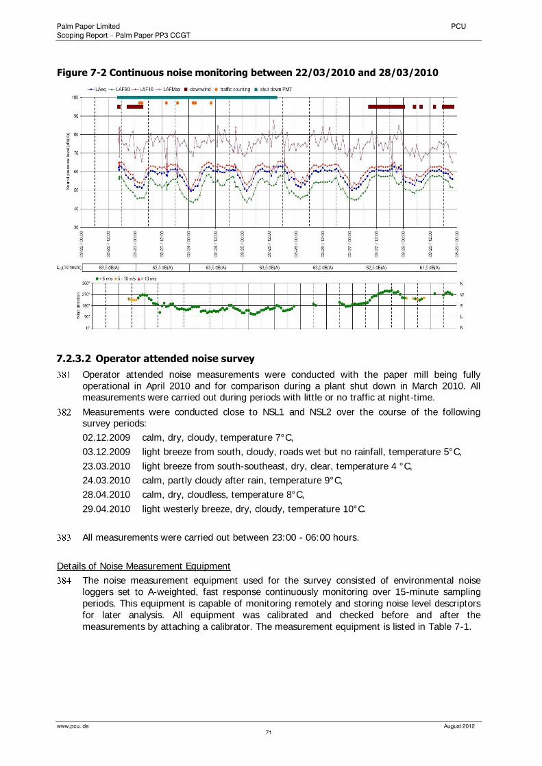
Palm Paper Limited PCU
Scoping Report – Palm Paper PP3 CCGT
www.pcu..de August 2012
71
Figure 7-2 Continuous noise monitoring between 22/03/2010 and 28/03/2010
7.2.3.2 Operator attended noise survey
Operator attended noise measurements were conducted with the paper mill being fully operational in April 2010 and for comparison during a plant shut down in March 2010. All measurements were carried out during periods with little or no traffic at night-time.
Measurements were conducted close to NSL1 and NSL2 over the course of the following survey periods:
02.12.2009 calm, dry, cloudy, temperature 7°C,
03.12.2009 light breeze from south, cloudy, roads wet but no rainfall, temperature 5°C,
23.03.2010 light breeze from south-southeast, dry, clear, temperature 4 °C,
24.03.2010 calm, partly cloudy after rain, temperature 9°C,
28.04.2010 calm, dry, cloudless, temperature 8°C,
29.04.2010 light westerly breeze, dry, cloudy, temperature 10°C.
All measurements were carried out between 23:00 - 06:00 hours.
Details of Noise Measurement Equipment
The noise measurement equipment used for the survey consisted of environmental noise loggers set to A-weighted, fast response continuously monitoring over 15-minute sampling periods. This equipment is capable of monitoring remotely and storing noise level descriptors for later analysis. All equipment was calibrated and checked before and after the measurements by attaching a calibrator. The measurement equipment is listed in Table 7-1.
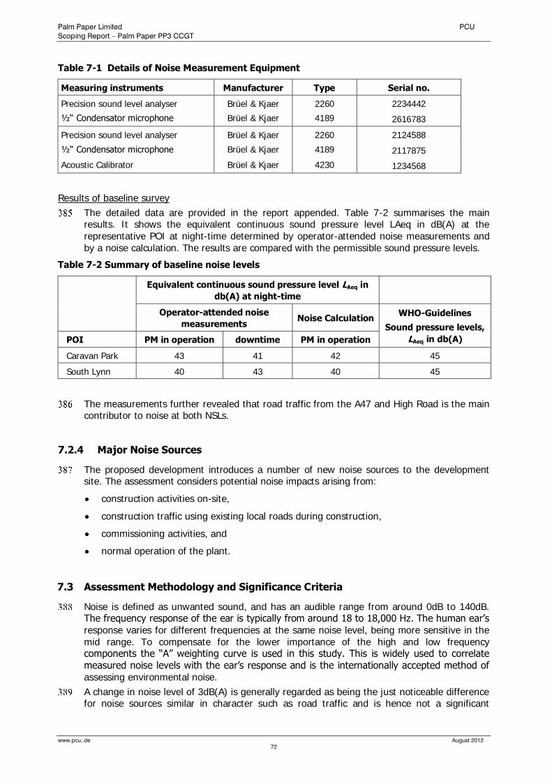
Palm Paper Limited PCU
Scoping Report – Palm Paper PP3 CCGT
www.pcu..de August 2012
72
Table 7-1 Details of Noise Measurement Equipment
Measuring instruments Manufacturer Type Serial no.
Precision sound level analyser Brüel & Kjaer 2260 2234442
½“ Condensator microphone Brüel & Kjaer 4189 2616783
Precision sound level analyser Brüel & Kjaer 2260 2124588
½“ Condensator microphone Brüel & Kjaer 4189 2117875
Acoustic Calibrator Brüel & Kjaer 4230 1234568
Results of baseline survey
The detailed data are provided in the report appended. Table 7-2 summarises the main results. It shows the equivalent continuous sound pressure level LAeq in dB(A) at the representative POI at night-time determined by operator-attended noise measurements and by a noise calculation. The results are compared with the permissible sound pressure levels.
Table 7-2 Summary of baseline noise levels
Equivalent continuous sound pressure level LAeq in
db(A) at night-time
Operator-attended noise
measurements Noise Calculation
WHO-Guidelines
Sound pressure levels,
LAeq in db(A) POI PM in operation downtime PM in operation
Caravan Park 43 41 42 45
South Lynn 40 43 40 45
The measurements further revealed that road traffic from the A47 and High Road is the main contributor to noise at both NSLs.
7.2.4 Major Noise Sources
The proposed development introduces a number of new noise sources to the development site. The assessment considers potential noise impacts arising from:
construction activities on-site,
construction traffic using existing local roads during construction,
commissioning activities, and
normal operation of the plant.
7.3 Assessment Methodology and Significance Criteria
Noise is defined as unwanted sound, and has an audible range from around 0dB to 140dB. The frequency response of the ear is typically from around 18 to 18,000 Hz. The human ear’s response varies for different frequencies at the same noise level, being more sensitive in the mid range. To compensate for the lower importance of the high and low frequency components the “A” weighting curve is used in this study. This is widely used to correlate measured noise levels with the ear’s response and is the internationally accepted method of assessing environmental noise.
A change in noise level of 3dB(A) is generally regarded as being the just noticeable difference for noise sources similar in character such as road traffic and is hence not a significant
Palm Paper Limited PCU
Scoping Report – Palm Paper PP3 CCGT
www.pcu..de August 2012
73
change. The perceived loudness of a noise is subjective, but it is generally accepted that a change of +10 dB(A) corresponds to a perceived doubling in loudness.
The design strategy for the proposed development is to avoid significant noise and vibration impacts by imposing noise limits on the design, which are identified below.
7.3.1 Construction Noise and Vibration
7.3.1.1 Construction Noise
Construction site noise is assessed differently to noise from permanent installations, as it is recognized that construction works are a transient operation. A qualitative assessment of the construction effects on the nearby noise and vibration sensitive receptors has been carried out with consideration given to:
duration of the planned construction activities;
timing of construction works;
proximity of the construction works relative to existing sensitive receptors (e.g. residential areas);
type of construction plant used; and;
vibration associated with construction.
Significance Criteria
In the UK, no fixed limits apply to the construction site noise exist.
However, advice and guidelines are given in British Standard BS 5228 and Department of the Environment (DoE) Advisory Leaflet (AL) 72 (4) “Noise Control on Building Sites”.
BS 5228 sets out techniques to predict the likely noise and vibration effects from construction works. These are based on detailed information on the type and number of plant being used, their location, and the length of time they are in operation. At this application stage, full details of the proposed construction methodology are not available. However, an estimate of the likely effects of noise from the construction phase has been made for the noise-sensitive receptors identified.
The Department of the Environment Advisory Leaflet (AL) 72 provides some guidance on acceptable levels of construction noise. The leaflet states that during daytime (defined as 07.00 to 19.00 hrs), noise levels outside the nearest occupied room should not exceed:
75 dB(A) in urban areas near to main roads in heavy industrial areas; or
70 dB(A) in rural, suburban and urban areas away from main road traffic and industrial noise sources.
The noise levels set out above are not aimed at providing noise limits for the construction phase, but are proposed as criteria for the assessment of the significance of noise impacts associated with construction activities.
Noise levels are generally taken as façade LAeq values.
Table 7-3 sets out the significance criteria used for the purpose of this assessment, based on the guidance in AL 72.
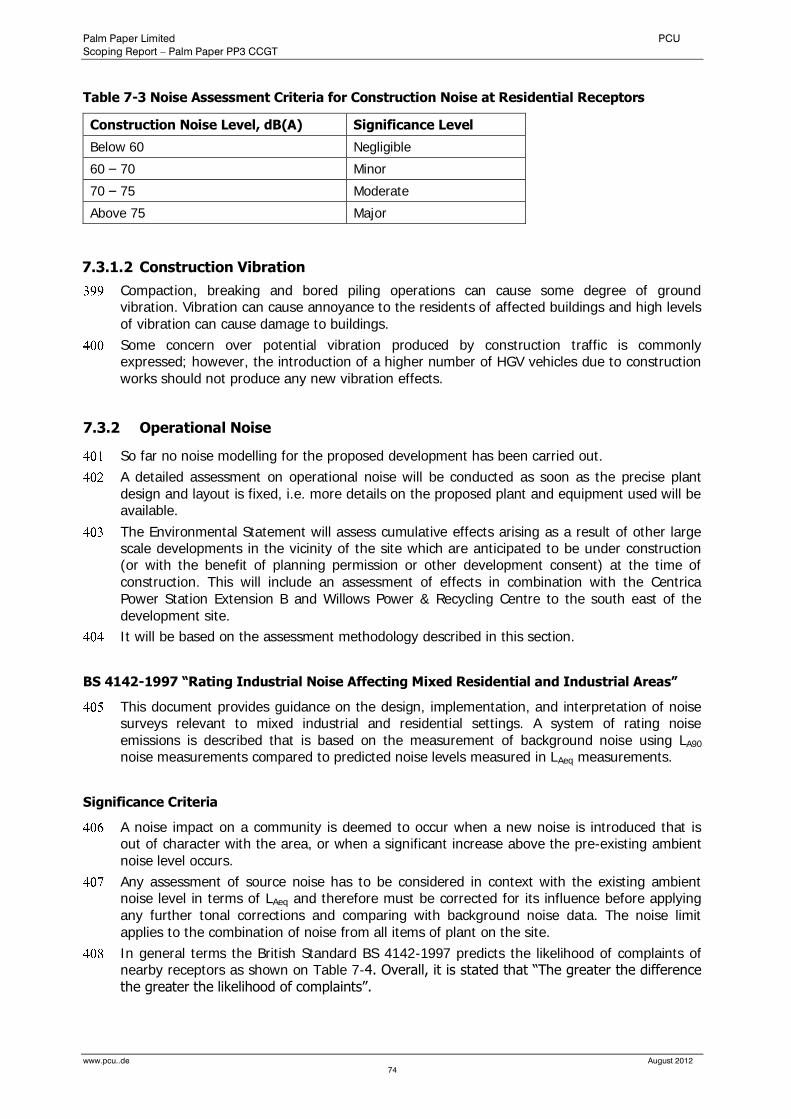
Palm Paper Limited PCU
Scoping Report – Palm Paper PP3 CCGT
www.pcu..de August 2012
74
Table 7-3 Noise Assessment Criteria for Construction Noise at Residential Receptors
Construction Noise Level, dB(A) Significance Level
Below 60 Negligible
60 – 70 Minor
70 – 75 Moderate
Above 75 Major
7.3.1.2 Construction Vibration
Compaction, breaking and bored piling operations can cause some degree of ground vibration. Vibration can cause annoyance to the residents of affected buildings and high levels of vibration can cause damage to buildings.
Some concern over potential vibration produced by construction traffic is commonly expressed; however, the introduction of a higher number of HGV vehicles due to construction works should not produce any new vibration effects.
7.3.2 Operational Noise
So far no noise modelling for the proposed development has been carried out.
A detailed assessment on operational noise will be conducted as soon as the precise plant design and layout is fixed, i.e. more details on the proposed plant and equipment used will be available.
The Environmental Statement will assess cumulative effects arising as a result of other large scale developments in the vicinity of the site which are anticipated to be under construction (or with the benefit of planning permission or other development consent) at the time of construction. This will include an assessment of effects in combination with the Centrica Power Station Extension B and Willows Power & Recycling Centre to the south east of the development site.
It will be based on the assessment methodology described in this section.
BS 4142-1997 “Rating Industrial Noise Affecting Mixed Residential and Industrial Areas”
This document provides guidance on the design, implementation, and interpretation of noise surveys relevant to mixed industrial and residential settings. A system of rating noise emissions is described that is based on the measurement of background noise using LA90 noise measurements compared to predicted noise levels measured in LAeq measurements.
Significance Criteria
A noise impact on a community is deemed to occur when a new noise is introduced that is out of character with the area, or when a significant increase above the pre-existing ambient noise level occurs.
Any assessment of source noise has to be considered in context with the existing ambient noise level in terms of LAeq and therefore must be corrected for its influence before applying any further tonal corrections and comparing with background noise data. The noise limit applies to the combination of noise from all items of plant on the site.
In general terms the British Standard BS 4142-1997 predicts the likelihood of complaints of nearby receptors as shown on Table 7-4. Overall, it is stated that “The greater the difference the greater the likelihood of complaints”.
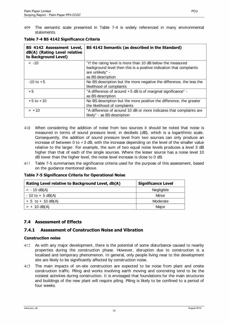
Palm Paper Limited PCU
Scoping Report – Palm Paper PP3 CCGT
www.pcu..de August 2012
75
The semantic scale presented in Table 7-4 is widely referenced in many environmental statements.
Table 7-4 BS 4142 Significance Criteria
BS 4142 Assessment Level,
dB(A) (Rating Level relative to Background Level)
BS 4142 Semantic (as described in the Standard)
< -10 "If the rating level is more than 10 dB below the measured background level then this is a positive indication that complaints are unlikely" - as BS description
-10 to +5 No BS description but the more negative the difference, the less the likelihood of complaints
+5 "A difference of around +5 dB is of marginal significance" - as BS description
+5 to +10 No BS description but the more positive the difference, the greater the likelihood of complaints
> +10 "A difference of around 10 dB or more indicates that complaints are likely" - as BS description
When considering the addition of noise from two sources it should be noted that noise is measured in terms of sound pressure level, in decibels (dB), which is a logarithmic scale. Consequently, the addition of sound pressure level from two sources can only produce an increase of between 0 to +3 dB, with the increase depending on the level of the smaller value relative to the larger. For example, the sum of two equal noise levels produces a level 3 dB higher than that of each of the single sources. Where the lesser source has a noise level 10 dB lower than the higher level, the noise level increase is close to 0 dB.
Table 7-5 summarises the significance criteria used for the purpose of this assessment, based on the guidance mentioned above.
Table 7-5 Significance Criteria for Operational Noise
Rating Level relative to Background Level, db(A) Significance Level
< - 10 dB(A) Negligible
- 10 to + 5 dB(A) Minor
+ 5 to + 10 dB(A) Moderate
> + 10 dB(A) Major
7.4 Assessment of Effects
7.4.1 Assessment of Construction Noise and Vibration
Construction noise
As with any major development, there is the potential of some disturbance caused to nearby properties during the construction phase. However, disruption due to construction is a localised and temporary phenomenon. In general, only people living near to the development site are likely to be significantly affected by construction noise.
The main impacts of on-site construction are expected to be noise from plant and onsite construction traffic. Piling and works involving earth moving and concreting tend to be the noisiest activities during construction. It is envisaged that foundations for the main structures and buildings of the new plant will require piling. Piling is likely to be confined to a period of four weeks.
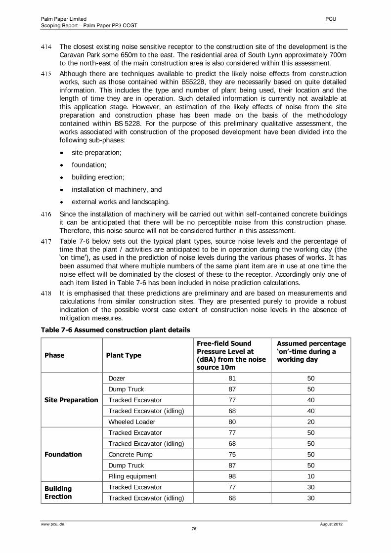
Palm Paper Limited PCU
Scoping Report – Palm Paper PP3 CCGT
www.pcu..de August 2012
76
The closest existing noise sensitive receptor to the construction site of the development is the Caravan Park some 650m to the east. The residential area of South Lynn approximately 700m to the north-east of the main construction area is also considered within this assessment.
Although there are techniques available to predict the likely noise effects from construction works, such as those contained within BS5228, they are necessarily based on quite detailed information. This includes the type and number of plant being used, their location and the length of time they are in operation. Such detailed information is currently not available at this application stage. However, an estimation of the likely effects of noise from the site preparation and construction phase has been made on the basis of the methodology contained within BS 5228. For the purpose of this preliminary qualitative assessment, the works associated with construction of the proposed development have been divided into the following sub-phases:
site preparation;
foundation;
building erection;
installation of machinery, and
external works and landscaping.
Since the installation of machinery will be carried out within self-contained concrete buildings it can be anticipated that there will be no perceptible noise from this construction phase. Therefore, this noise source will not be considered further in this assessment.
Table 7-6 below sets out the typical plant types, source noise levels and the percentage of time that the plant / activities are anticipated to be in operation during the working day (the ‘on time’), as used in the prediction of noise levels during the various phases of works. It has been assumed that where multiple numbers of the same plant item are in use at one time the noise effect will be dominated by the closest of these to the receptor. Accordingly only one of each item listed in Table 7-6 has been included in noise prediction calculations.
It is emphasised that these predictions are preliminary and are based on measurements and calculations from similar construction sites. They are presented purely to provide a robust indication of the possible worst case extent of construction noise levels in the absence of mitigation measures.
Table 7-6 Assumed construction plant details
Phase Plant Type
Free-field Sound Pressure Level at (dBA) from the noise source 10m
Assumed percentage ‘on’-time during a working day
Site Preparation
Dozer 81 50
Dump Truck 87 50
Tracked Excavator 77 40
Tracked Excavator (idling) 68 40
Wheeled Loader 80 20
Foundation
Tracked Excavator 77 50
Tracked Excavator (idling) 68 50
Concrete Pump 75 50
Dump Truck 87 50
Piling equipment 98 10
Building Erection
Tracked Excavator 77 30
Tracked Excavator (idling) 68 30

Palm Paper Limited PCU
Scoping Report – Palm Paper PP3 CCGT
www.pcu..de August 2012
77
Concrete Pump 75 50
Hand Held Circular Saw 91 10
Scaffolding 72 10
Fork Lift Truck 77 30
Compressor 72 90
Dump Truck 87 50
External Works and Landscaping
Asphalt Spreader 75 50
Road roller 81 50
Lorry Tipping Load 71 10
Lorry Pulling Up 77 10
Dozer 81 40
Grader 84 50
Dump Truck 87 50
It is to be noted that these activities are not coincidental so the noise is not additive.
Estimations have been made to determine the noise levels likely to be generated by each of the above operations. Estimated noise levels during each phase of the works at four key separation distances between the construction noise sources and receptor positions are given in table 7-7.
The noise levels presented in Table 7-7 are expressed in terms of the Equivalent Continuous Sound Level, LAeq,T over the core working day.
The range of noise levels presented illustrates the noise level when the works are at the boundary of the development site.
Table 7-7 Predicted Construction Noise Levels – Façade LAeq,T dB
Exemplary Separation Distance
(Source – Sensitive Receptor)
Noise Levels at Source
Site Preparation
Foundation Work
Building Construction
External Works
10m (worst case) 89 88 89 89
60m (typical proximate works) 73 72 74 74
150m (distance between construction compounds and boundary of Palm Paper premises)
65 64 66 66
300m (distance between construction area and existing commercial buildings at Saddlebow Ind. Estate)
59 58 60 60
Construction noise levels at sensitive locations which are 650m or more in distance from the site boundary will most likely remain well below both the existing ambient daytime noise levels and typical noise limits appropriate to such activities. Any possibility of local disturbance will be further limited by restricting piling work to daytime hours.
As stated before only one of each item listed in Table 7-6 has been included in noise prediction calculations. The results in Table 7-7 indicate that even in the event of a considerably larger number of construction plant the relatively large distances mean that noise levels during construction are not considered to be likely to effect sensitive receptors.
Overall, it is anticipated that the impact of the on-site construction machinery on noise climate will be ‘negligible’.
Palm Paper Limited PCU
Scoping Report – Palm Paper PP3 CCGT
www.pcu..de August 2012
78
Noise from construction traffic
Vehicular construction traffic serving the development site would make use of High Road, and the A 47. The principal construction activities with transportation implications are:
removal of excavated material;
delivery of materials for new plant; and
movement of heavy plant.
The maximum predicted flow of construction traffic is 50 HGV’s vehicles per day, for a period of approximately one year. The majority of HGV movements are anticipated to travel north along the A47/A10. Car movements are predicted at a similar level as during operation of the facility (50 movements).
This represents a small increase when compared to the daily flow on the adjacent A47 of approximately 33,000 vehicles per day (two-way).
With a 25% increase in traffic flow being required to increase traffic noise by a level of just +1dB, i.e. the smallest increment in noise increase that is generally regarded as being just discernible as a short term change, any % increase below this figure would be considered insignificant in terms of adverse impact.
Moreover, the effect of construction traffic is limited to a finite period (approx. one year) and will be along the traffic routes employed by haulage vehicles, construction vehicles and employees’ vehicles (particularly Poplar Avenue, High Road northwards, A 47). All roads likely to carry construction traffic are already major routes such that the ratio of construction traffic to existing traffic is relatively small.
Overall, it can be stated that additional noise emissions from construction traffic are expected to be insignificant.
Construction Vibration
During normal operation of the proposed development vibrations and inadmissible low-frequent noise do not occur. Operational vibrations therefore have not been considered in this assessment.
There are currently no British Standards that provide a methodology to predict levels of vibration from construction activities, other than that contained within BS 5228: Part 4, which includes a methodology relating to percussive or vibratory piling only.
However, it is generally accepted that for the majority of people, vibration levels in excess of between 0.15 and 0.3 mm/s peak particle velocity are just perceptible. Table 7-8 below details the distances at which certain construction activities relevant to the proposed development may give rise to a just perceptible level of vibration. These figures are based on historical field measurements at various similar construction sites.
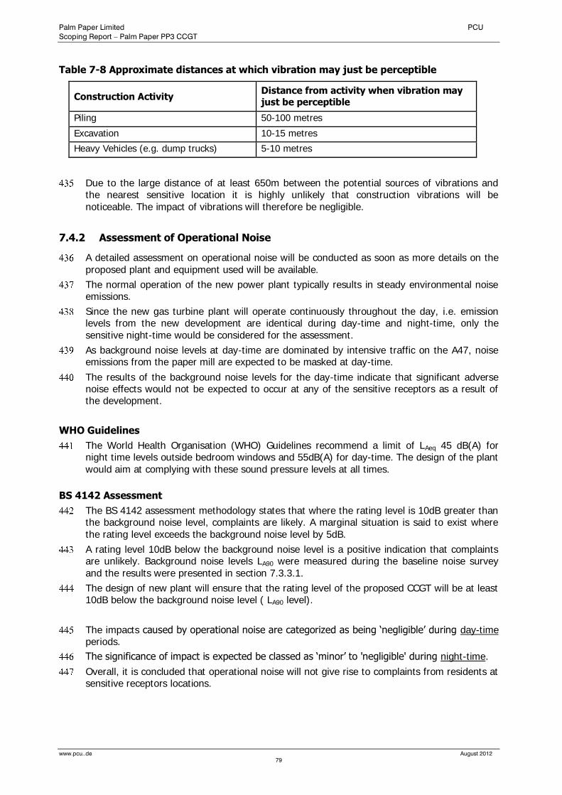
Palm Paper Limited PCU
Scoping Report – Palm Paper PP3 CCGT
www.pcu..de August 2012
79
Table 7-8 Approximate distances at which vibration may just be perceptible
Construction Activity Distance from activity when vibration may just be perceptible
Piling 50-100 metres
Excavation 10-15 metres
Heavy Vehicles (e.g. dump trucks) 5-10 metres
Due to the large distance of at least 650m between the potential sources of vibrations and the nearest sensitive location it is highly unlikely that construction vibrations will be noticeable. The impact of vibrations will therefore be negligible.
7.4.2 Assessment of Operational Noise
A detailed assessment on operational noise will be conducted as soon as more details on the proposed plant and equipment used will be available.
The normal operation of the new power plant typically results in steady environmental noise emissions.
Since the new gas turbine plant will operate continuously throughout the day, i.e. emission levels from the new development are identical during day-time and night-time, only the sensitive night-time would be considered for the assessment.
As background noise levels at day-time are dominated by intensive traffic on the A47, noise emissions from the paper mill are expected to be masked at day-time.
The results of the background noise levels for the day-time indicate that significant adverse noise effects would not be expected to occur at any of the sensitive receptors as a result of the development.
WHO Guidelines
The World Health Organisation (WHO) Guidelines recommend a limit of LAeq 45 dB(A) for night time levels outside bedroom windows and 55dB(A) for day-time. The design of the plant would aim at complying with these sound pressure levels at all times.
BS 4142 Assessment
The BS 4142 assessment methodology states that where the rating level is 10dB greater than the background noise level, complaints are likely. A marginal situation is said to exist where the rating level exceeds the background noise level by 5dB.
A rating level 10dB below the background noise level is a positive indication that complaints are unlikely. Background noise levels LA90 were measured during the baseline noise survey and the results were presented in section 7.3.3.1.
The design of new plant will ensure that the rating level of the proposed CCGT will be at least 10dB below the background noise level ( LA90 level).
The impacts caused by operational noise are categorized as being ‘negligible’ during day-time periods.
The significance of impact is expected be classed as ‘minor’ to 'negligible' during night-time.
Overall, it is concluded that operational noise will not give rise to complaints from residents at sensitive receptors locations.

Palm Paper Limited PCU
Scoping Report – Palm Paper PP3 CCGT
www.pcu..de August 2012
80
7.5 Mitigation Measures
7.5.1 Construction Noise and Vibration
Generic measures below are given to illustrate the range of control techniques available. The adoption of Best Practicable Means, as defined in the Control of Pollution Act 1974, is usually the most effective means of controlling noise from construction sites. In addition, the following measures should be considered, where appropriate:
Any compressors brought onto the development site should be silenced or sound reduced models fitted with acoustic enclosures;
All pneumatic tools should be fitted with silencers or mufflers;
Care should be taken when erecting or striking scaffolds to avoid noise from banging steel. All operatives undertaking such activities should be instructed on the importance of handling the scaffolding to reduce noise to a minimum;
Deliveries should be programmed to arrive during daytime hours only, if practical. Care should be taken when unloading vehicles to minimise noise. Delivery vehicles should be routed so as to minimise disturbance to local residents.
All plant items should be properly maintained and operated according to manufacturers’ recommendations in such a manner as to avoid causing excessive noise.
Where sheet piling is to be carried out it is assumed that the following techniques, which would depend on ground conditions, would be selected in order of preference:
a hydraulic pile press or “silent” pile rig;
piling with a vibrohammer;
impact driven piling (drop hammer).
The piling method would also depend on ground conditions. It is intended that a method that does not require a drop hammer will be used if practical.
No specific mitigation measures are required for noise associated with construction traffic movements from the development site since the change in flows associated with the construction vehicles on these roads will be negligible, as discussed above.
7.5.2 Operational Noise
Mitigation for plant noise and internal activity noise would be provided in the engineering and building design so that the noise limits are met and there is no major impact.
Even though the assessment indicates that operational noise from the proposed CCGT will be negligible at all sensitive receptors, specific technical mitigation measures for noise attenuation would be included in the design stage of the development.
Moreover, the design of the proposed CCGT will comply with the Environment Agency's BAT requirements for noise and vibration described within EPR 1.00. Consequently, no additional, specific mitigation is required.
It has been established that the effect of predicted increases in road traffic noise levels attributable to the proposed development will be ‘negligible’. Accordingly, noise mitigation measures related to traffic noise are not required. Existing traffic signage ensures that all facility related traffic leaving the development site is directed northwards.
The Environmental Statement will assess cumulative effects arising as a result of other large scale developments in the vicinity of the site which are anticipated to be under construction (or with the benefit of planning permission or other development consent) at the time of construction. This will include an assessment of effects in combination with the Centrica Power Station Extension B and Willows Power & Recycling Centre to the south east of the development site.
Palm Paper Limited PCU
Scoping Report – Palm Paper PP3 CCGT
www.pcu..de August 2012
81
7.6 Summary and Conclusion
An environmental baseline noise survey has been undertaken at the nearest residential populations to the order to enable the noise impact of the construction and operation of the facility to be established.
Baseline measurements were made at the nearest residential areas in South Lynn and the Caravan Park north-east of the development site.
Estimates have been made of likely noise and vibration levels due to construction of the facility and these have been assessed qualitatively. The impact of general construction noise has been assessed as ‘not significant’.
Noise impacts from the operation of the facility, including associated road traffic movements have been considered against otherwise prevailing conditions and have been shown to have an impact that is at worst ‘minor’, provided the mitigation techniques where stated are implemented. Using the BS 4142 methodology, complaints due to noise will be unlikely.
It is considered that the design of the proposed development constitutes ‘Best Available Technology’.
There will be no significant increase in the volume of road traffic on the A 47 and A 10. Effects associated with construction and operational traffic would be insignificant compared with existing traffic flow on the local road network and, therefore, a significant adverse noise effect would not occur.
8.0 Landscape and Visual Effects
8.1 Introduction and Scope
This chapter presents the results of the landscape and visual assessment for the proposed development. It commences with a description of relevant policies and guidelines at national, county and local scales, and then describes the baseline situation, noting the principal characteristics of the existing landscape. It considers the impacts which the development is likely to have, and suggests mitigation measures which form an integral part of the proposed development. Residual, significant impacts are then summarised at the end of the chapter.
This section includes all the text and the written assessment. All figures, plans, photographs and photomontages, which are referred to in the written assessment are included in the Appendix section.
8.2 Baseline Conditions
8.2.1 Landscape Designations
The site does not lie within an area designated as having any particular landscape sensitivity. The nearest national landscape designation is the Norfolk Coast AONB, approximately 8km to the north of the Site. The project is not considered likely to have any significant on this area due to distance.
The new CCGT is located within an area the Local Plan defines as being “Built Environment Type D”, an “modern industrial” landscape designation within the Local Plan.
However, as a result of a borough-wide landscape assessment the King’s Lynn and West Norfolk Borough Local Plan identified “Areas of Important Landscape Quality (AILQ)” (Figure 8-1) in close proximity to the south-west of the site. Policy 4/6 of the Local Plan states that in AILQ, development which damages the distinctive character or appearance of the landscape will not be permitted. This policy must therefore be addressed. Due to the site’s proximity to one of these areas, there is a potential to damage the character and appearance of locally important landscapes.
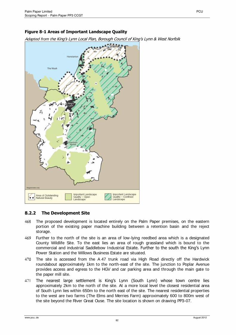
Palm Paper Limited PCU
Scoping Report – Palm Paper PP3 CCGT
www.pcu..de August 2012
82
Figure 8-1 Areas of Important Landscape Quality
Adapted from the King’s Lynn Local Plan, Borough Council of King’s Lynn & West Norfolk
8.2.2 The Development Site
The proposed development is located entirely on the Palm Paper premises, on the eastern portion of the existing paper machine building between a retention basin and the reject storage.
Further to the north of the site is an area of low-lying reedbed area which is a designated County Wildlife Site. To the east lies an area of rough grassland which is bound to the commercial and industrial Saddlebow Industrial Estate. Further to the south the King’s Lynn Power Station and the Willows Business Estate are situated.
The site is accessed from the A 47 trunk road via High Road directly off the Hardwick roundabout approximately 1km to the north-east of the site. The junction to Poplar Avenue provides access and egress to the HGV and car parking area and through the main gate to the paper mill site.
The nearest large settlement is King’s Lynn (South Lynn) whose town centre lies approximately 2km to the north of the site. At a more local level the closest residential area of South Lynn lies within 650m to the north east of the site. The nearest residential properties to the west are two farms (The Elms and Merries Farm) approximately 600 to 800m west of the site beyond the River Great Ouse. The site location is shown on drawing PP3-07.
Palm Paper Limited PCU
Scoping Report – Palm Paper PP3 CCGT
www.pcu..de August 2012
83
8.2.3 Context of the Development
The following description concentrates only on the aspects of the development with the potential to cause an effect on landscape and visual amenity of the area.
The whole area of the Palm Paper premises has a size of about 50ha. The construction site for the new plant will cover an area of approximately 1ha, including temporary roads and construction compounds.
For excavation works several excavators and dump trucks will be in operation. After the main excavation works boring machines for pile foundations will be on site for a period of approximately 4 weeks. During the construction phase several cranes and mobile cranes will be in operation. Mobile cranes will be mainly used for erection of pre-cast elements and steel structures. Trucks with trailers will transport heavy pre-cast elements to the site. Cranes will carry heavy loads as for example reinforcement, bricks, steel sheets, etc. to various areas and levels of the site.
The main enclosures are expected to be approximately 55m long x 34m wide and between 15m and 25m high. Some staircases and technical equipment on the roof will be several metres higher. The structural form of buildings will be made of pre-cast concrete façade panels. From 1m above ground up to the top, the building will have a trapezoidal sheet metal cladding. Cladding will be similarly coloured as the cladding of the existing mill. The façade between ground level and +1m will be mainly made of concrete sandwich panels with an exposed surface.
The sheet metal façade will be erected with scaffoldings or mobile lifting platforms. All materials required to construct the buildings will be delivered to the site by truck. All parts of the technical facilities will be also delivered to the site by truck. Some material for construction and erection of technical facilities will be stored temporarily in defined storage areas on site before it will be built-in. Within the construction compounds there will be offices for site supervisors, social facilities (toilets, etc.) and a storage area for containers with construction materials and equipment. The overall duration of the construction phase is anticipated to last approximately 12 months. The overall effect of this phase on landscape and visual amenity is only temporary. It should be noted that the construction phase, in comparison to the size of the project will be relatively short-term.
The colours of the sheet metal cladding will be defined in co-operation with the local authority, cladding will be in appropriate colour to minimise the visual impact of the building in the landscape.
The highest item of the plant would be an exhaust stack with a diameter of about 4.0m and a discharge approximately 70-80m above ground. The stack will be fabricated from painted insulated carbon steel.
Due to health and safety reasons all on-site roads of the mill site is lit at night with external lights fixed to buildings and light poles. The lights for the Proposal will be located in appropriate position to avoid dazzling effects for the neighbourhood.
8.2.4 The Study Area
Existing Landscape, Land Use and Landscape Elements
The study area for the landscape and visual assessment consists of a 2km radius circle centred on the proposed development, as shown on Figure 8-2.
The general surrounding to the west and the south is characterized by large areas of intensively farmed arable land. The landform of this area is largely open. Woodland cover is generally sparse, mainly confined to lining roads and around small settlements and individual farmsteads. Immediately to the south west of the site, the Flood Relief Channel joins the River Great Ouse. Both are enclosed by high flood banks.

Palm Paper Limited PCU
Scoping Report – Palm Paper PP3 CCGT
www.pcu..de August 2012
84
Beyond the A47 trunk road to the north and north east, land use is a mixture of residential and commercial / industrial. There are numerous commercial / industrial properties immediately to the north of the A47, and approximately 1.5km to the north east, where there is a large industrial/commercial area (The Narrows Trading Estate, Hardwick Employment), centred close to the junction of the A10 and A47 roads.
Immediately to the east of High Road, adjacent to the roundabout junction of the A47, a Caravan park is located.
To the east lies the established Saddlebow Industrial Estate. Further to the east lies the River Nar running north-south, approximately 1km to the east of the proposed development.
Cycle Network and Long Distance Footpaths
There are two Long Distance Footpaths routed through the study area.
The Nar Valley Way lies about 1.5km to the east of the proposed development. The Nar Valley Way is a 55km long walk, running from the historic port of King's Lynn to the Museum of Rural life at Gressenhall, and is contained almost entirely within the watershed of the River Nar. The route follows Public Rights of Way, tracks and minor roads, and also links with other long distance routes.
The Fen Rivers Way footpath, a permissive path used by agreement with the Environment Agency, runs along the high flood bank of the Great Ouse. This long distance path running for nearly 80km between Cambridge and King's Lynn, traces the course of rivers that drain across the Fens into the Wash. Entering Norfolk the Fen Rivers Way follows the River Great Ouse all the way to King's Lynn and the Wash. At King's Lynn, the Fen Rivers Way connects with the Nar Valley Way.
There is a National Cycle network route (No. 1) within the Study Area. The OS Explorer Map (sheet 236) identifies this traffic-free cycle route running along the eastern high flood bank of the River Great Ouse.
Waterways (Tourism and Recreation)
The development site is located near the confluence of the River Great Ouse and the Flood Relief Channel. The River Great Ouse is an important navigable waterway in the area. It is used by a number of boat clubs. The Flood Relief Channel is a navigable channel from the lock at Denver Sluice to Wiggenhall Bridge, just over two miles to the south of King's Lynn. It was built as a flood relief channel running parallel to the tidal Great Ouse and opened up to navigation by the building of a lock at Denver in July 2001.
8.2.5 Landscape Character
8.2.5.1 National and Regional Level
The Countryside Agency (now Natural England) has mapped England into 159 separate, distinctive character areas. The features that define the landscape of each area are recorded in individual descriptions, which explain what makes one area different from another and shows how that character has arisen and how it is changing. The character areas covering Norfolk were published by the Countryside Agency in 1999 in Countryside Character, Volume 6: East of England. These areas are generally referred to as Countryside Character Areas (CCA) and are seen as the top of the hierarchy used to describe character areas at county and district level.
At this national level the study area lies within CCA 46 “The Fens” as defined by the Countryside Commission. It describes the area as flat, low-lying, intensively farmed land with an empty, open landscape, occasionally punctuated by an isolated farmstead or cluster of trees. The embanked rivers and drains provide the only elevation. The hierarchy of field dykes and roads create a strongly geometric field pattern.
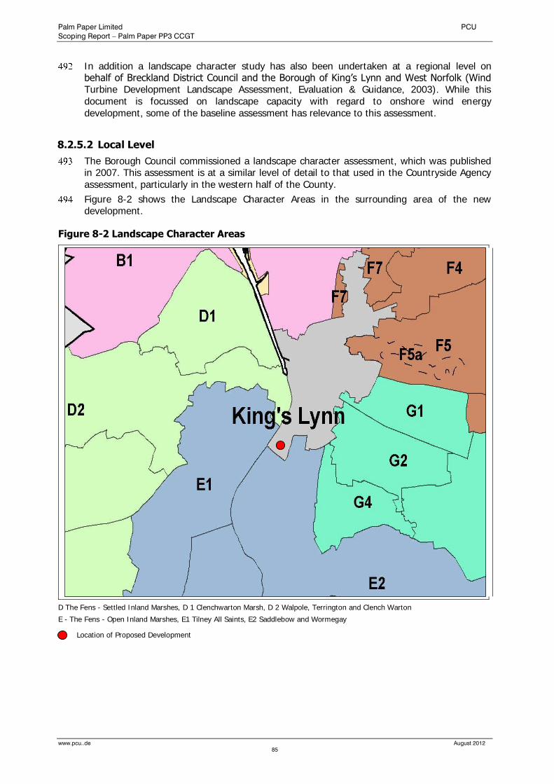
Palm Paper Limited PCU
Scoping Report – Palm Paper PP3 CCGT
www.pcu..de August 2012
85
In addition a landscape character study has also been undertaken at a regional level on behalf of Breckland District Council and the Borough of King’s Lynn and West Norfolk (Wind Turbine Development Landscape Assessment, Evaluation & Guidance, 2003). While this document is focussed on landscape capacity with regard to onshore wind energy development, some of the baseline assessment has relevance to this assessment.
8.2.5.2 Local Level
The Borough Council commissioned a landscape character assessment, which was published in 2007. This assessment is at a similar level of detail to that used in the Countryside Agency assessment, particularly in the western half of the County.
Figure 8-2 shows the Landscape Character Areas in the surrounding area of the new development.
Figure 8-2 Landscape Character Areas
D The Fens - Settled Inland Marshes, D 1 Clenchwarton Marsh, D 2 Walpole, Terrington and Clench Warton
E - The Fens - Open Inland Marshes, E1 Tilney All Saints, E2 Saddlebow and Wormegay
Location of Proposed Development
Palm Paper Limited PCU
Scoping Report – Palm Paper PP3 CCGT
www.pcu..de August 2012
86
8.2.5.3 Desk Study
The methodology used for this assessment of the local landscape characters is based on Landscape Character Assessment: Guidance for England and Scotland (2002) published by the Countryside Agency and SNH.
A desk study of the study area identified areas of shared character. Natural factors considered included geology, landform, river and drainage systems, soils and land use. The boundaries of the landscape character areas identified through the desk study were verified or adjusted following the field surveys.
However, it should be noted that the character assessment was limited to the study area. As all the character areas identified extend beyond the study area the outer boundaries of the identified character areas were not defined.
The boundaries for the local landscape character areas on drawing PP3-07 have been related to identifiable physical features on the ground. However, even at the local level the transition from one local landscape character area to another is rarely abrupt.
In the course of this landscape and visual assessment, the study area has been divided into different local landscape character areas.
8.2.5.4 Local Landscape Character Areas
The Fens – Open Farmland
The Fen landscape character area extends southwards and predominantly westwards from the study area, The Fen landscape type is characterised by low-lying, large-scale, flat open landscape with extensive vistas to level horizons and huge skies. Much of the fen landscape to the north and west is below sea level, although within the study area it is just above sea level. The fen landscape was reclaimed through pumping of surface water and the straight drainage ditches that were created, known as lodes, are characteristic of the fen landscape type. The reclaimed land comprises large rectilinear fields of black soil; and sparse woodland cover; occasional avenues to roads, shelter belts including poplar.
Settlements within the fen landscape type are dispersed. Farms are located on higher ground alongside the roads with dispersed ribbon development. Scattered farms are located on the higher ground alongside roads. The roads, which reflect the alignment of the lodes, generally run north to south.
The sensitivity of this character area to change associated with the proposed development taking place outside the character area is moderate. This reflects the long distant views that can be attained from this character area. However it is important to note that any development will be seen in the context of the urban edge of King’s Lynn with the established paper mill as well as the prominent King’s Lynn Power Station.
King’s Lynn Industrial and Commercial Estates
This character type covers the central part of the study area. The proposed development will be located within this character type. This area contains a mixture of established industrial and commercial use as well as the King’s Lynn Power Station. The Power Station’s main building has an elevation of 45m, and the stack is approximately 60m high. The highest buildings within the Saddlebow Industrial Estate are between 15m and 25m high.
The northern and eastern portion of the Palm Paper site currently consists of a large area of open scrub, reedbeds and grassland.
The sensitivity of this area to change associated with the proposed development is low.
Palm Paper Limited PCU
Scoping Report – Palm Paper PP3 CCGT
www.pcu..de August 2012
87
South Lynn (Residential Areas including urban renewal areas)
The closest large residential area to the site is South Lynn which lies to the north east. South Lynn forms a large area of built development within the study area with residential and industrial settlements. The residential area contains a mixture of housing styles and types. South Lynn primarily comprises semi-detached and terraced properties.
Due to the presence of the established commercial and industrial buildings the sensitivity of this character area is low.
Waterways
The Study Area comprises a number of waterways, with being The River Great Ouse and the Flood Relief Channel navigable.
The sensitivity of this character area is moderate. This reflects the immediate proximity and the importance of the River Great Ouse for recreational uses, however it acknowledges the setting of the development within an established industrial area with prominent elements such as the King’s Lynn Power Station and the existing paper mill.
8.2.5.5 Historic Features (Townscape)
The King’s Lynn & West Norfolk Local Plan was consulted and revealed that there were no registered ancient monuments, parks or gardens recorded on site or within 1,700m of the site boundary. Within the study area there were three listings of features and buildings identified in the Local Plan (see drawing PP3-07).
Table 8-1 Historic Features
Parish No. County Monument Title Grid Ref. Distance from Site
King’s Lynn 172 Greyfriars Tower TF 620 197 1,800m
King’s Lynn 174b The South Gate TF 622 191 1,700m
King’s Lynn 306 Medieval town walls TF 624 194 1,800m
8.3 Assessment Methodology
8.3.1 General Approach and Data Gathering
The landscape and visual assessment will be undertaken in accordance with relevant guidance provided in the following publications:
Landscape Character Assessment: Guidance for England and Scotland2
Guidelines for Landscape and Visual Impact Assessment3
It must be noted that where possible, the landscape and visual assessment has formed part of an interactive design / mitigation process. Thus, the assessment process has been used to inform aspects of the Development design in order to minimise adverse effects.
2 The Countryside Agency and SNH, 2002
3 Landscape Institute and Institute of Environmental Impact Assessment, 2. Edition, 2002 .
Palm Paper Limited PCU
Scoping Report – Palm Paper PP3 CCGT
www.pcu..de August 2012
88
8.3.2 Desk Study
As part of the desk study the baseline landscape and visual resource was defined within a 2 km radius study area and the main users of the area, key viewpoints and key features were identified.
Existing data such as Ordnance Survey Maps, detailed ordnance survey map data for the site, the Local Plan, plans, elevations and cross-sections of the proposed development were reviewed in order to identify suitable viewpoints. The size of the study area has been based on the scale and the likely visibility of the proposed development.
8.3.3 Baseline Survey
The existing landscape and visual baseline conditions have been identified from surveys of the site and its boundaries and of a broad range of views from outside the site.
8.3.4 Field Survey / Assessment
The assessment of potential effects has used information gathered from site visits, and site photographs. Photomontage impressions have been generated from a selection of these photographs to indicate the potential changes in views from selected locations.
Viewpoint Selection
An extensive photographic record has been taken of the development site from surrounding roads, bridges and public open space. From this record the visual envelope of the proposed development has been defined. This is the extent of the local area from which the proposed development can be seen, particularly during winter. In the summer when the extent of tree cover is greater, the potential visibility will be less prominent. This applies especially to views from the southern edge of South Lynn.
From the photo documentation conducted during field verification, a total of 6 viewpoints for development of photomontages were selected. The selection of viewpoints is based on the number and locations of viewpoint chosen for the Environmental Statement of the paper mill’s planning application and they had been discussed and agreed with the BCKLWN.
The criteria for selection were that they are:
representative of the dominant aspects of the proposed development from different directions,
from publicly accessible viewpoints where numbers of people might be expected to linger, or, if travelling, where the same view was held for some distance
In each case the direction of view from the viewpoint is that towards the new facility including, the existing paper mill in its entirety.
The photomontages indicate the location, scale and massing profile, without showing architectural details. The location, scale and massing relate directly to the information illustrated in the proposed development drawings accompanying this report.
Palm Paper Limited PCU
Scoping Report – Palm Paper PP3 CCGT
www.pcu..de August 2012
89
8.4 Assessment Criteria
In order to provide a level of consistency to the assessment, the prediction of magnitude and assessment of significance of the residual landscape and visual effects have been based on pre-defined criteria.
8.4.1 Sensitivity of the Landscape to Change
The capacity of the landscape to accept change of the type and scale proposed has to be assessed based on the vulnerability of each landscape character area to degradation through the introduction of new features, or through the loss of existing features. The sensitivity to change for various areas is illustrated within Table 8-2.
A three-point scale has been adopted which broadly defines landscape areas relative to their quality and their capacity to accept changes arising from the Proposed Development. The degree of sensitivity to change relates to exiting land use; the pattern and scale of the landscape, visual enclosure/openness of views and location of visual receptors, the scope for mitigation and the value placed on the landscape.
The scale is as follows:
Table 8-2 Sensitivity to Change Rating
Sensitivity Rating Mitigation Potential – to maintain the landscape quality and landscape character of the area
Highly sensitive to change
Where any development would greatly affect landscape character
and ‘sense of place’. Where mitigation required – effective mitigation difficult to achieve.
Moderately sensitive to change
Where some types of development would have an effect on landscape character and ‘sense of place’. Where mitigation required – effective mitigation is possible but results may take time to be effective.
Slight sensitivity to change
Where most types of development would be accommodated without affecting landscape character and ‘sense of place’. Where mitigation required – effective mitigation is readily achievable.
8.4.2 Sensitivity of visual receptors
The sensitivity of visual receptors is based on an interpretation of a combination of parameters as follows:
the location of the viewpoint
the context of the view
the activity of the receptor
frequency and duration of the view

Palm Paper Limited PCU
Scoping Report – Palm Paper PP3 CCGT
www.pcu..de August 2012
90
Table 8-3 Definition of Visual Receptor Sensitivity
High Users of outdoor facilities including recreational footpaths, cycle routes or rights of way, whose attention may be focused on the landscape; important landscape features with physical, cultural or historic attributes; the principal views from residential buildings; beauty spots and picnic areas
Moderate Other footpaths; secondary views from residential buildings; people travelling through or past the landscape on roads or other transport routes where higher speeds are involved and views sporadic and short-lived.
Low People engaged in outdoor sports or recreation where enjoyment of the landscape is incidental rather than the main interest; people in commercial buildings or commercially engaged pedestrians, whose attention may be focused on their work or activity rather than the wider landscape
Negligible People at their place of work, views from heavily industrialised areas
8.4.3 Magnitude of Visual Change
The following definitions of magnitude are taken from the Guidelines for Landscape and Visual Impact Assessment.4
Table 8-4 Definition of Magnitude of Visual Change
Magnitude Examples
Large The development would result in a prominent change in the existing view and/or would cause a prominent change in the quality and /or character of the view. The development would form prominent elements within the overall view and/or may be easily noticed by the observer or receptor. Standing out, striking, sharp, easily seen.
Moderate The development would result in a noticeable change in the existing view and/or would cause a noticeable change in the quality and/or character of the view. The development would form a conspicuous element within the overall view and/or may be readily noticed by the observer or receptor. Noticeable, distinct, catching the eye or attention, clearly visible, well defined, obvious.
Slight The development would result in a perceptible change in the existing view, and/or without affecting the overall quality and/or character of the view. The development would form an apparent small element in the wider landscape that may be missed by the observer or receptor. Visible, evident.
Negligible The development would result in a barely perceptible change in the existing view, and/or without affecting the overall quality and/or would form an inconspicuous minor element in the wider landscape that may be missed by the observer or receptor. Lacking sharpness of definition, not obvious, indistinct, not clear, obscure, blurred, indefinite.
4 Landscape Institute and Institute of Environmental Impact Assessment, 2. Edition, 2002.
Palm Paper Limited PCU
Scoping Report – Palm Paper PP3 CCGT
www.pcu..de August 2012
91
8.4.4 Significance Criteria
The significance of a landscape impact is a function of the sensitivity of the affected landscape and the magnitude of change that various areas will experience. It is by combining the magnitude with sensitivity in a systematic fashion that consistent conclusions on impact significance may be drawn.
Thus, the impacts on the landscape are determined according to a procedure where the magnitude of the change potentially caused by the proposed development is linked to the perceived sensitivity to change.
The significance thresholds of the impacts are derived according to the following matrix:
Table 8-5 Significance Thresholds (Impact)
Sensitivity of receptor to change
High Moderate Low
Magnitude of Change
Large Major Major/ Moderate Moderate
Moderate Moderate/ Major Moderate Slight/ Moderate
Slight Moderate Slight/ Moderate Slight
Negligible Negligible Negligible Negligible
Key significant Not significant
The description of the significance criteria is as follows:
• Major Effect – where the presence of the proposals causes a fundamental change to the existing landscape area;
• Moderate Effect – where the presence of the proposals causes a material but not fundamental change to the existing landscape area;
• Slight Effect – where the presence of the proposals causes a detectable but not material
change to the existing landscape area;
• Negligible – no discernible adverse change to the existing landscape area
Where the landscape or visual effects have been identified as major or major/moderate, this is considered to be a significant effect.
8.5 Assessment of Effects
The visual impact assessment gauges the degree of potential intrusion and obstruction relative to the existing situation including effects on key views and local, middle distance views from outside the site boundary.
This assessment is based on the potential change in the character and quality of the view and the significance of the change in view for the receptors in general areas and key receptor points. This takes into account the quality and extent of the existing view.
The change in view is indicated, as far as possible in a series of photomontage views which show the existing view and the existing view indicating the scale and massing of the proposed development.
Palm Paper Limited PCU
Scoping Report – Palm Paper PP3 CCGT
www.pcu..de August 2012
92
8.5.1 Assessment of Effects on Landscape Character Areas
8.5.1.1 The Fens – Open Inland Marshes
It is anticipated that the proposed development will not be clearly visible from the open agricultural land that lies between the A 47 and the development site. As the main building of the new CCGT has the same height as the existing De-Inking plant and the paper machine building, only the 70m-stack will overtop the existing paper mill buildings (Figures 8-6 and 8-7).
The new plant will not be seen from areas and locations beyond the A 47 due to the screening effect of the existing vegetation along the A 47. It can be anticipated that only a very small fraction of this character area will be affected by the development. Due to the lack of suitable footpaths and cycle paths the number of visitors using this part of The Fens is expected to be very small.
Moreover, it is important to note that the new development will be perceived in the context of the existing paper mill and the urban edge of King’s Lynn with its established industrial developments as well as the King’s Lynn Power Station.
The sensitivity of this landscape character is moderate.
The magnitude of change that would be experienced within this character area is considered to be slight, therefore, the effect will be slight to moderate.
8.5.1.2 King’s Lynn Industrial and Commercial Estates
The proposed development is located within the existing paper mill premises which are part of this character area. The construction of the new facility will be built on hard-standing areas, grassland or newly planted shrub
As mentioned before this character area is dominated by prominent industrial elements and features such as the Saddlebow Industrial Estate and the King’s Lynn Power Station (Figure 8-9). The location of the proposed development within an established industrial site will mean that the magnitude of change is considered slight.
The sensitivity of this area to change associated with the proposed development is low.
It is anticipated that the adverse effects on this character area will be slight.
8.5.1.3 South Lynn (Residential Areas including urban renewal areas)
The proposed development is located in a distance of some 650m to the southern edge of South Lynn’s residential area. The new development would be seen in the context of the existing paper mill buildings (Figure 8-7). The proposed development will be visible from certain parts of South Lynn, while in others visibility will be restricted by intervening buildings of the established commercial buildings between Hardwick junction and The River Great Ouse. There will be a variable effect with locally significant differences, ranging from no change within the more enclosed areas, to slight change in upper storeys of elevated properties.
Due to the presence of the established commercial and industrial buildings the sensitivity of this character area is low. Overall the effect on the landscape / townscape character area will be locally slight, but reducing to none.
Palm Paper Limited PCU
Scoping Report – Palm Paper PP3 CCGT
www.pcu..de August 2012
93
8.5.1.4 Waterways
The River Great Ouse and the Flood Relief Channel lie in immediate proximity to the proposed development. The area has been identified as being of significant value for recreation. The visibility will be very restricted by the existing paper mill buildings (Figures 8-4 and 8-5). As only the 70m-stack will be visible from the Great Ouse, the magnitude of change associated with the new development will be slight.
The sensitivity of this character area is moderate. Overall there will be a slight to moderate effect on this landscape character area, which recognises the setting in which the development will be perceived.
8.5.1.5 Designated Landscapes
There are no statutory designated sites within the study area therefore no impact occurs. However, the Adopted Local Plan identifies “Areas of Important Landscape Quality” which lie to the west of the development site. The effects on these areas have already been addressed through the assessment of the landscape character area “The Fens”.
8.5.1.6 Historic Features (Townscape)
Three historic features listed in the Local Plan lie within the study area; The South Gate (No. 174b), medieval town walls (No. 306), and Greyfriars Tower (No. 172). The policy associated with the conservation of these locations focuses on the immediate setting of the feature rather than the wider landscape the historic feature lies within. The proposed development is located at least some 1,700m away from the location of a historic feature. In addition, the intervening urban structures and vegetation restrict the visibility from any of the listed features.
It is anticipated that there will be no effects of the proposed development on historic features of the study area.
8.5.1.7 Long Distance Footpaths
The long distance footpath, which runs closest to the development site, is the Fen Rivers Way on the flood banks of the River Great Ouse. It is anticipated that the proposed development will have a localised low effect on those users of the Fen Rivers Footpath.
The Nar Valley Way is located approximately 1,000m east of the development site. The visibility of the proposed development will be entirely restricted by the vegetation and the flood banks that line the River Nar. There will be no noticeable effect.

Palm Paper Limited PCU
Scoping Report – Palm Paper PP3 CCGT
www.pcu..de August 2012
94
8.5.2 Visual Impact Assessment
8.5.2.1 Viewpoint Assessment
Set out below is a brief description of each view and the effect of the proposed development on that view.
The viewpoints described below were selected to illustrate typical views of the proposed project that will be available to representative viewer / user groups from the major landscape similarity zones and sensitive sites within the study area. The selected viewpoints also include a variety of viewer distances to illustrate the range of visual change that will occur with the project in place.
No viewpoints that required viewing the proposed development through tree branches and tree tops were selected, thus minimizing potential concerns regarding the need to conduct this study during the "leaves-off" season. The locations of the selected viewpoints in relation to the development are indicated in Figure 8-3. The direction of each view from the viewpoint is that towards the new facility including the existing paper mill in its entirety.
Key views
Photographs and photomontages showing both the existing view and the anticipated view incorporating the proposed development are set out in Figure 8-4 to Figure 8-9
The photographic simulations for 6 key views were developed by constructing a three-dimensional computer model based on facility specifications provided by the project developer, and the survey coordinates of the proposed facilities.
Locational details and the reasons for selection of each key viewpoint are described below.
Viewpoint 1: River Great Ouse (The Tail Sluice)
VP 1: view from the dam of the River Ouse, some 200m north of The Tail Sluice. The location was chosen to reflect views from footpath users on the Fen Rivers Way. It also provides an idea of the views that might be experienced from passing boats.
Existing View
The existing view illustrated in Figure 8-4 shows the relatively short distance and open view seen from this location due to the slight elevation provided by the flood banks. It is dominated by the existing paper mill buildings.
Photomontage
The proposed development will be situated to the right of the existing storage tanks, behind the pipe-bridge. It is anticipated that the main buildings of the proposed development will be clearly visible. However they will be perceived in the context of the existing industrial installations. From this viewpoint the Air Cooled Condenser (ACC) will not be visible at all. The 70m high stack will form a prominent element in this view.
Assessment of Effects
Due to the presence of existing buildings of the Saddlebow Industrial Estate and the King’s Lynn Power Station the magnitude of the change will be moderate, as the sensitivity of the view is moderate it is considered that the effect is moderate.
Viewpoint 2: Pullover Farm and Merries Farm (A 47, Pullover Road)
VP 2: view from farmland between Pullover Farm and Merries Farm. This is a view gained not only by residents of the settlements located along the A 47 but also by passing motorists. It is representative for all medium to long distance views potentially obtained from western directions. Moreover, this viewpoint has been chosen to represent a view seen by the

Palm Paper Limited PCU
Scoping Report – Palm Paper PP3 CCGT
www.pcu..de August 2012
95
residents of the scattered properties along the A47 as well as by visitors using the open farmland (fenland) for recreational purposes such as walking or cycling.
It should be noted that some of the properties are set behind this viewpoint and roadside vegetation (e.g. mature trees) and fencing partially obscure the view seen by these residents during certain times of the year.
Existing view
The existing view is illustrated in Figure 8-5, which shows the long distance view from this location. The foreground comprises large arable land. The structures of the existing paper mill and, to the left, King’s Lynn Power Station are present throughout this view.
Photomontage
The photomontage shown in Figure 8-5 simulates the potential view from this viewpoint. It shows that only the 70m-stack can be seen against the skyline but would not be observed or noticed by most people visiting the location. The new facility would be a minor element in this view.
Assessment of Effects
The sensitivity of the view to change is moderate, the magnitude of change will be slight.
The effect caused by the proposed development is considered slight/moderate.
Viewpoint 3: Bridge over the River Great Ouse (A 47)
VP 3: view from the Bridge along the A 47. The view is available to pedestrians and motorists for some distance as they travel west or eastwards. It is a similar view to that obtained from the southern edge of South Lynn.
Existing view
The existing view is illustrated in Figure 8-6, which shows the short distance and open view seen from this slightly elevated location. The County Wildlife Site lies at the left foreground of the view. The existing mill and the King’s Lynn Power Station lie throughout the background of the view.
Photomontage
The photomontage indicates that the proposed plant is visible in the form of the stack.
Assessment of Effects
The sensitivity of the view to change is moderate, the magnitude of change will be slight.
It is therefore considered the effect of the proposed development is slight to moderate.
Viewpoint 4: High Road near Saddlebow Caravan Park
VP 4: view from Saddlebow Road, in close proximity to the roundabout junction with the A 47. This view may be gained by residents of the Saddlebow Caravan Park only as they leave the Caravan Park and by motorists travelling southwards.
Existing view
The existing view is illustrated in Figure 8-7, which shows the short distance view seen from this elevated location. The foreground of this view on the right side comprises the County Wildlife Site. The existing paper mill lies throughout the background of this view.

Palm Paper Limited PCU
Scoping Report – Palm Paper PP3 CCGT
www.pcu..de August 2012
96
Photomontage
A photomontage in Figure 8-7 shows the predicted view towards the proposed development. The proposed plant is visible from the viewpoint in the centre left of the photomontage. The modelling predicts that the stack and larger buildings will have clear visibility from this viewpoint. The new development would be seen in the context of the existing paper mill.
The proposed development will not be visible from the Caravan Park itself due to the relatively high elevation of the road embarkment of High Road. The view from South Lynn will be obstructed by vegetation and the dam of the A47.
Assessment of Effect
Road users are considered to be of moderate sensitivity to change. The magnitude of change will be slight to moderate as even though the new development will be visible but will be seen in the context of the established paper mill and the King’s Lynn Power Station. The effect is considered slight to moderate.
Viewpoint 5: White House Farm
VP 5: view from White House Farm. This is a view gained by residents of the settlement as well as by visitors using the River Nar Valley for recreational purposes such as hiking and cycling.
Existing view
The existing view is illustrated in Figure 8-8, which shows the long distance view from this location. The view is clearly dominated by the lower industrial structures of Saddlebow Industrial Estate including the Norfolk Arena in the foreground. The existing paper mill is a prominent element in this view. To left lies the King’s Lynn power station.
Photomontage
Industrial premises of the existing Saddlebow Industrial Estate in the foreground, obscures the lower parts of the proposed development. In addition it will be perceived in the context of the existing industrial buildings and the King’s Lynn Power Station.
Much of the development will benefit from the screening effect of existing industrial buildings in such a way that only the stack and the top 10 to 15m of the main buildings can be seen.
Assessment of Effect
Occupiers of residential properties and visitors with recreational purposes are considered to be of high sensitivity.
Much of the development will benefit from the screening effect of existing industrial buildings, and will be perceived only as an additional industrial building roof line. The rating of magnitude of change is assessed to be slight.
The effect is considered slight to moderate.
Palm Paper Limited PCU
Scoping Report – Palm Paper PP3 CCGT
www.pcu..de August 2012
97
Viewpoint 6: Low Road
VP 6: view from Low Road. This is a representative view for highly sensitive visual receptors (users of open farmland of the southern study area for recreational purposes).
Existing view
The existing view is illustrated in Figure 8-9 which shows the long distance view from this location. From this location the existing tall industrial structures associated with the Power Station and Saddlebow Industrial Estate are evident on the skyline.
Photomontage
The new plant is barely visible from this location due in the most part to distance
The new development will merge and appear contiguous when seen within the same context as other existing vertical elements of the paper mill. At this distance, it would be such that the development forms a minor element in the wider landscape.
Assessment of Effect
Visitors with outdoor recreational purposes are considered to be of high sensitivity.
The development will benefit from the screening effect of existing industrial buildings, and visitors will perceive the development as an additional industrial building roof line. The rating of magnitude of change, is assessed to be negligible.
The effect is considered negligible.
The Environmental Statement will assess cumulative effects arising as a result of other large scale developments in the vicinity of the site which are anticipated to be under construction (or with the benefit of planning permission or other development consent) at the time of construction. This will include an assessment of effects in combination with the Centrica Power Station Extension B and Willows Power & Recycling Centre to the south east of the development site.
8.5.2.2 Visual Impacts during Construction
It can be anticipated that during the differing phases of the construction period, temporary visual impacts will be evident as a result of construction operations, including the use of tall cranes. The location of site compounds and laydown areas will be, wherever possible, chosen to minimise visual impacts resulting from materials storage, site accommodation etc.
Due to the presence of established industrial and commercial areas in the local landscape, the introduction of construction facilities is not an uncommon feature in the local landscape.
The sensitivity of the large majority of visual receptors in closest proximity to the proposed construction activities was classified as low (people at their place of work/industrial facilities), consequently, the potential magnitude of the temporary visual impact during the construction period can be assessed to be moderate and have an overall effect rating as slight to moderate.
8.6 Mitigation Measures
There are two forms of mitigation that may be considered.
The first form includes the broad scale planning of design elements of the project in order to mitigate potential significant effects. This is thus an iterative process whereby significant adverse effects are, as far as possible, ‘designed out’ of the proposals.

Palm Paper Limited PCU
Scoping Report – Palm Paper PP3 CCGT
www.pcu..de August 2012
98
In landscape and visual terms the second type includes the design of elements within the proposals that would help, for example, to screen views, reduce apparent heights of elements, and manipulate the skyline to positive effect etc.
Due to the flat nature of the study area and its surroundings, earthworks to provide high screening bunds would in itself result in unacceptable impacts on the landscape character and were therefore not considered as appropriate.
However, a limited number of solutions to reduce visual impact can therefore be adopted:
8.6.1 Colour
All project facilities including buildings, fencing, and signs, will be painted with the same colours as the existing paper mill buildings. The proposed colours should not unduly contrast with the surrounding landscape colours or industrial structures. All treatments will be in non-reflective colours.
8.6.2 Planting
Appropriate tree species will be planted along the east side of the development site to reduce the proportion of the facility and to more effectively blend the facility with the existing landscape.
In particular landscape planting proposals include:
Restoration of any grassland habitats disturbed by construction;
Tree screening belts adjacent to the boundaries of the development;
Thorn hedge planting together with occasional hedge trees such as Oak and Ash;
The proposed boundary planting will be designed of indigenous tree planting to reflect the existing character and comprise of species that are already found in the local area.
8.6.3 Lighting
The proposed development will not generate excessive levels of sky glow, light spill or glare, and therefore not significantly affect the existing surrounding area or sensitive receptors. The lighting installed at the development site, both during construction and operational phases, will accord with current best practice and design guidance to ensure that the residual effects on sensitive receptors will be within acceptable levels.
Except as required by security and worker safety requirements, night lighting will be hooded to direct illumination downward and inward toward the areas to be illuminated in order to minimize light spillage and glare, backscatter to the night-time sky, and visibility of lighting to motorists on the A 47 and the adjacent residential areas in South Lynn.
8.7 Summary of Residual Effects
8.7.1 Existing Situation
The development site is part of the existing paper mill within Saddlebow Industrial Estate north of the King’s Lynn Power Station. The development site is located entirely within the existing paper mill premises.
The approach to the landscape and visual assessment has been to consider the impacts on the character of the landscape and, the effects on the visual amenity of those experiencing views of the site. To assess the visual impact of the proposed development, a number of representative viewpoints were chosen.
Palm Paper Limited PCU
Scoping Report – Palm Paper PP3 CCGT
www.pcu..de August 2012
99
8.7.2 Effects on Landscape Character
Development Site
The direct effects on the landscape character of the development site will be very limited. The proposed development will be built mainly on existing hardstanding areas. The severity of this is not considered to be significant as the site lies within the established Saddlebow Industrial Estate, and no important landscape elements will be lost.
Study area
With regard to the perception of landscape character it is acknowledged that parts of the new development, in particular the 70m-stack, will be clearly seen from certain locations within the landscape of the study area. However, the setting of the proposed development in the context of the existing industry means that the perception of the landscape character will change only slightly.
Visual Effects
The viewpoint analysis arrives at the conclusion that some adverse effects on visual amenity will occur.
Views from the south are generally restricted by the prominent and considerably elevated King’s Lynn Power Station. From viewpoints to the west and the north the proposed development is significantly screened by the existing paper mill buildings. Only the stack will be clearly visible.
At all other sites the project will either not be visible, will be significantly screened by foreground vegetation and existing building structures, or will be distant enough that visual impacts will be insignificant.
Mitigation measures such as tree planting can reduce the proportion of the facility, and blend the facility with the existing building structures and the surrounding landscape to a certain extent.
Overall, it is acknowledged that impacts on the landscape character and visual amenity are reduced by the context of the existing industrial structures and the King’s Lynn Power Station.
8.8 Conclusion
In carrying out landscape and visual assessment, only if an effect is found to be major or moderate / major it is considered to be significantly adverse. In this assessment, in most cases this severity of effect arises not because of a high magnitude of change, but because the viewpoints are judged to be highly sensitive to change.
In terms of landscape character the development will not have a significant effect.
In terms of visual impact and of the viewpoints assessed so far, no viewpoints are effected to a significant degree.
Overall, it is concluded that the effect of this proposed development is acceptable in landscape and visual amenity. The site would appear to be eminently suitable in a number of ways for such a purpose, particularly given the existing industrial usage of the site.
The Environmental Statement will assess cumulative effects arising as a result of other large scale developments in the vicinity of the site which are anticipated to be under construction (or with the benefit of planning permission or other development consent) at the time of construction. This will include an assessment of effects in combination with the Centrica Power Station Extension B and Willows Power & Recycling Centre to the south east of the development site.

Palm Paper Limited PCU
Scoping Report – Palm Paper PP3 CCGT
www.pcu..de August 2012
100
9.0 Ecology and Nature Conservation
9.1 Introduction and Scope
This chapter presents information on baseline conditions and the nature conservation value of the application site and identifies the potential ecological effects of the proposed development. It goes on to provide an assessment of the significance of these potential ecological impacts after mitigation and compensation has been taken into consideration.
9.2 Baseline Data
9.2.1 General Considerations
It is impractical for this report to consider every individual habitat and species that may be affected by a development. Therefore, legally protected ecological receptors and other valued ecological receptors are focused on in this report.
Protected ecological receptors are those given statutory protection through UK legislation and the transposition of the provisions of international conventions and directives into UK law. Protected ecological receptors must be taken into account to avoid development activities resulting in an offence being committed. In addition, statutorily protected receptors are often receptors of particular ecological conservation value and concern. Protected ecological receptors are identified in accordance with the following statutory designations, directives and legislation:
Ramsar Sites
Special Protection Areas (SPAs)
Special Areas of Conservation (SACs)
Sites of Special Scientific Interest (SSSIs)
The Birds Directive
The Habitats Directive
Wildlife and Countryside Act 1981 (as amended)
Countryside and Rights of Way (CRoW) Act 2000
Conservation (Natural Habitats, &c.) Regulations 1994 (as amended)
Drawing PP3 - 04 shows the protected sites and sites of conservation importance.
9.2.2 The Development Site
A Phase 1 Habitat Survey of the site including an area expected to be used for construction compounds was conducted in July 2011. The habitat classifications of the site are shown in drawing PP3 - 08.
The proposed development site consists mainly of hardstanding areas and some smaller areas of tightly mown grass fields and rough grassland. The construction compounds are anticipated to be situated to the east of the new plant on open grassland.
The Phase 1 Habitat Survey suggested that the on-site habitats are not suitable for protected species. There are no records of protected species within the site boundary of the proposed CCGT and none were observed during the Phase 1 Habitat Survey.
Situated on the existing paper mill premises, the site is bordered to the east by open grassland, to the north by an existing retention basin, to the south by a reject storage area and to the west by industrial buildings of the established paper mill.
The immediate surrounding area of the site is mainly low-lying intensively farmed arable land. Woodland cover in the area is generally sparse, mainly confined to lining roads and around

Palm Paper Limited PCU
Scoping Report – Palm Paper PP3 CCGT
www.pcu..de August 2012
101
villages. To the east and south east of the site lie the River Nar and a number of other areas of important habitat including lowland grazing marshes and lakes. Further to the east lie a number of more extensively wooded areas, sand and gravel pits. Beyond the A47 road to the north, land use is a mixture of residential and commercial / industrial. There are various commercial/industrial properties immediately to the north of the A47, and approximately 2km to the north east, where there is a large industrial/commercial area, centred on the junction of the A10 and A47 roads. Land to the south and east is largely open apart from the Centrica power station site to the south, which covers an area of approximately 10ha. The River Nar runs north-south, approximately 1.5km to the east of the site.
9.2.3 Protected Sites & Sites of Conservation Importance in the surrounding
A number of statutory sites and other sites of conservation importance were identified within a 10 km radius of the Proposal Site (drawing PP3 – 04).
On-site: There are no protected sites within the boundary of the proposed development site.
Within 2km: The Saddlebow Reedbeds, a designated County Wildlife Site (CWS), is an area of reedbed approximately 400m north of the proposed development. Reedbed habitat is listed as a priority habitat in the UK Biodiversity Action Plan. The CWS provides a particularly important habitat for birds, including species listed on Schedule 1 of the Wildlife and Countryside Act 1981. CWS are also given special consideration in the Norfolk County Council Structure Plan Policies.
The River Nar is the only statutorily designated area of ecological importance within 2km of the development site. The entire river is designated a SSSI.
Adjacent to the site is the tidal River Great Ouse. At low tide, mudflats along the banks of the river are exposed, providing feeding habitat for wading birds. Mudflats are listed as a priority habitat in the UK Biodiversity Action Plan.
Within 5km: A number of sites lie within 5km of the site, two of these being sites of palaeo-ecological importance.
Within 10km: Additional statutory areas are also assessed due to their connectivity with the River Great Ouse. The Wash lies to the north of the site and is the largest estuary in the UK. It is composed of a number of important marine habitats, including saltmarsh, intertidal banks of sand and mud, shallow water and deep channels. The Wash is classified as a Ramsar Site, SAC, SSSI, and SPA. The River Great Ouse is one of four rivers that discharge into it. The Ouse Washes is also part of the River Great Ouse catchment. Though situated to the south, upstream of the site, the river is tidally influenced as far upstream as Brownshill Staunch (upstream of the Ouse Washes). Both these sites are designated Ramsar Sites, SACs, SPAs, SSSIs and are particularly important for wetland birds.
A brief summary of each statutory protected area within 10km of the site is given in Table 9-1

Palm Paper Limited PCU
Scoping Report – Palm Paper PP3 CCGT
www.pcu..de August 2012
102
Table 9-1 Statutorily designated sites of ecological importance within 10km of the site
Designation Name Distance from site
APIS Habitat Type
1 SSSI River Nar 1.5 km
2 SSSI Wiggenhall St Germans 4.4 km Geological One of the first sites in Britain to be investigated for sea-level studies using pollen and foraminifera analyses. The site is important both historically and for future research.
3 SSSI Islington Heronry 4.6 km Oak woodland Small isolated stand of mature oaks surrounded by fenland which supports the largest colony of Grey Herons Ardea cinerea in Norfolk.
4 SSSI Setchey 4.9 km Geological
5 SSSI Blackborough End Pit 6.7 km Geological
6 SSSI East Winch Common
9.0 km Lowland heathland Raised bog and blanket bog Oak woodland
7 SSSI Leziate, Sugar & Derby Fens
8.4 km Alkaline fen and reedbed, Calcareous grassland, Lowland heathland, Acid grassland, Birch woodland
8 NNR, SSSI, Ramsar, SAC
Roydon Common 8.2 km Raised bog and blanket bog Lowland heathland, alkaline fen and reedbed, Acid grassland, Oak woodland
9 NNR, SSSI, SAC
Dersingham Bog 11.6 km Fen, marsh and swamp – lowland, Dwarf shrub heath – lowland, Earth heritage
10 NNR Ramsar, SPA, SSSI
The Wash 6.5 km Grazing marsh, Saltmarsh
1 SAC The Wash and North Norfolk Coast
6.5 km Saltmarsh
12 SSSI Bawsey
7.7 km Geological
13 SSSI Grimston Warren Pit
7.2 km Geological
9.3 Ecological Impacts
As part of the Air Quality Assessment the impacts of the development on sensitive environmental receptors were assessed in section 7 of this report.
The results of the assessment are summarised in the table below. This shows the maximum predicted contribution at any point within each of the European sites. The model was run using weather data for the five years between 2005 and 2009 in order to take account of the variability in weather conditions, so the figures in the table are also for the worst case year of weather data. The results are also for the single highest point modelled in each SAC or SSSI.
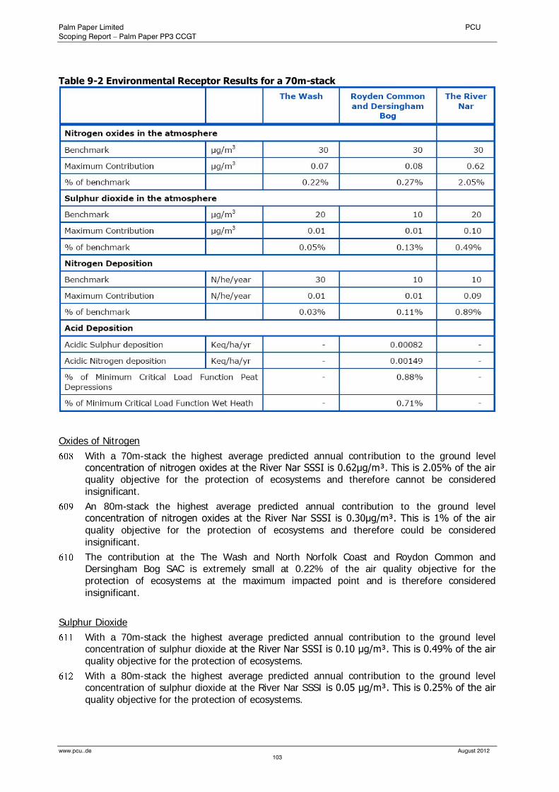
Palm Paper Limited PCU
Scoping Report – Palm Paper PP3 CCGT
www.pcu..de August 2012
103
Table 9-2 Environmental Receptor Results for a 70m-stack
Oxides of Nitrogen
With a 70m-stack the highest average predicted annual contribution to the ground level concentration of nitrogen oxides at the River Nar SSSI is 0.62μg/m³. This is 2.05% of the air quality objective for the protection of ecosystems and therefore cannot be considered insignificant.
An 80m-stack the highest average predicted annual contribution to the ground level concentration of nitrogen oxides at the River Nar SSSI is 0.30μg/m³. This is 1% of the air quality objective for the protection of ecosystems and therefore could be considered insignificant.
The contribution at the The Wash and North Norfolk Coast and Roydon Common and Dersingham Bog SAC is extremely small at 0.22% of the air quality objective for the protection of ecosystems at the maximum impacted point and is therefore considered insignificant.
Sulphur Dioxide
With a 70m-stack the highest average predicted annual contribution to the ground level concentration of sulphur dioxide at the River Nar SSSI is 0.10 μg/m³. This is 0.49% of the air quality objective for the protection of ecosystems.
With a 80m-stack the highest average predicted annual contribution to the ground level concentration of sulphur dioxide at the River Nar SSSI is 0.05 μg/m³. This is 0.25% of the air quality objective for the protection of ecosystems.
Palm Paper Limited PCU
Scoping Report – Palm Paper PP3 CCGT
www.pcu..de August 2012
104
The contribution at the The Wash and North Norfolk Coast and Roydon Common and Dersingham Bog SAC is extremely small at 0.03-0.11% of the air quality objective for the protection of ecosystems and is therefore considered insignificant.
Sensitive Environmental Receptors Summary
From the tables above, it can be seen that the predicted contribution from the plant emissions to ground level concentrations of nitrogen oxides and sulphur dioxide and to nitrogen deposition rates in both SACs and the SSSI are below 1% of the relevant benchmark.
Hence, it is clear that the plant emissions for a 80m-stack are “not likely to have a significant effect alone or in combination irrespective of the background levels” in either of the two European Habitat Sites as well as the River Nar SSSI.
9.4 Conclusion
No evidence of protected species has been found at the site, and due to the site location and habitats present, the presence of such species is not considered likely.
Considering the site’s low ecological value, the proposed CCGT is unlikely to have a significant effect on ecological features within the site boundary.
The plant emissions for a 80m-stack are “not likely to have a significant effect alone or in combination irrespective of the background levels” in any of the European Habitat Sites as well as the nearby River Nar SSSI.
The Environmental Statement will assess cumulative effects arising as a result of other large scale developments in the vicinity of the site which are anticipated to be under construction (or with the benefit of planning permission or other development consent) at the time of construction. This will include an assessment of effects in combination with the Centrica Power Station Extension B and Willows Power & Recycling Centre to the south east of the development site.
10.0 Flood Risk and Drainage
10.1 Introduction and Scope
This chapter considers the flood risk issues associated with the proposed development.
BspConsulting had been commissioned to undertake a Flood Risk Assessment for the EIA of the paper mill in 2007. As the new development lies entirely within the closer study area of that previous assessment, all findings of the former FRA also apply for the proposed CCGT.
The development site lies immediately to the south of the Nar Ouse Regeneration Area (NORA). The FRA therefore draws heavily on studies conducted for the NORA project.
The following information is excerpted from the Flood Risk Assessment prepared by bspConsulting. For full details refer to the report appended (Appendix 3).
10.2 Baseline Conditions
The development site has a steady rise in levels towards the north of the site. The south west corner of the site adjacent to the flood defences and existing buildings is at a level of about 3m AOD. The north western corner of the site is at a level of about 6m AOD. The site rises steeply at the extreme north to meet the A 47 at a level of about 8m AOD.
The levels of Saddlebow Road, running along the site to the east, are comparable to the site level, apart from where it rises more steadily to the north to meet the A47. The site is below
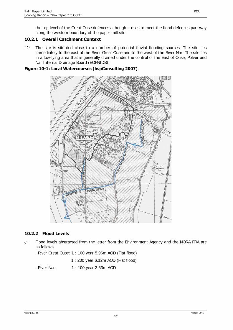
Palm Paper Limited PCU
Scoping Report – Palm Paper PP3 CCGT
www.pcu..de August 2012
105
the top level of the Great Ouse defences although it rises to meet the flood defences part way along the western boundary of the paper mill site.
10.2.1 Overall Catchment Context
The site is situated close to a number of potential fluvial flooding sources. The site lies immediately to the east of the River Great Ouse and to the west of the River Nar. The site lies in a low-lying area that is generally drained under the control of the East of Ouse, Polver and Nar Internal Drainage Board (EOPNIDB).
Figure 10-1: Local Watercourses (bspConsulting 2007)
10.2.2 Flood Levels
Flood levels abstracted from the letter from the Environment Agency and the NORA FRA are as follows:
· River Great Ouse: 1 : 100 year 5.96m AOD (Flat flood)
1 : 200 year 6.12m AOD (Flat flood)
· River Nar: 1 : 100 year 3.53m AOD

Palm Paper Limited PCU
Scoping Report – Palm Paper PP3 CCGT
www.pcu..de August 2012
106
10.2.3 Environment Agency Web Site
The Environment Agency Web Site (Figure 10-2) suggests that part of the paper mill site is in Flood Zone 3a and benefits from flood defences; it is therefore at risk of flooding should the defences that protect the site fail. The remainder of the paper mill site and in particular the location of the new CCGT is indicated as lying in Flood Zone 1 which comprises land assessed as having less than 1 in 1000 annual probability of river or sea flooding in any year (<0.1%). This data is included as it highlights the principle flood risks for the local area and is therefore reproduced for “information only” as this “high level” information is only intended to offer an indication of flood risk. The primary conclusion to be drawn from this data is that the entire site is at risk of flooding.
Figure 10-2: EA Indicative Floodplain Mapping
Site
10.3 Approach and Assessment Methodology
The development site is located to the south of the Nar Ouse Regeneration Area (NORA) scheme and as such the macro area flood risk has been assessed in two NORA flood risk assessments. These assessments concluded that there are sources of flood risk but that the current defences are as such the entire NORA scheme is protected to a satisfactory standard. As the development site slightly remote from the NORA site we will only use the NORA FRA
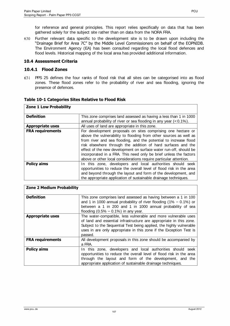
Palm Paper Limited PCU
Scoping Report – Palm Paper PP3 CCGT
www.pcu..de August 2012
107
for reference and general principles. This report relies specifically on data that has been gathered solely for the subject site rather than on data from the NORA FRA.
Further relevant data specific to the development site is to be drawn upon including the “Drainage Brief for Area 7C” by the Middle Level Commissioners on behalf of the EOPNIDB. The Environment Agency (EA) has been consulted regarding the local flood defences and flood levels. Historical mapping of the local area has provided additional information.
10.4 Assessment Criteria
10.4.1 Flood Zones
PPS 25 defines the four ranks of flood risk that all sites can be categorised into as flood zones. These flood zones refer to the probability of river and sea flooding, ignoring the presence of defences.
Table 10-1 Categories Sites Relative to Flood Risk
Zone 1 Low Probability
Definition
This zone comprises land assessed as having a less than 1 in 1000 annual probability of river or sea flooding in any year (<0.1%).
Appropriate uses All uses of land are appropriate in this zone.
FRA requirements
For development proposals on sites comprising one hectare or above the vulnerability to flooding from other sources as well as from river and sea flooding, and the potential to increase flood risk elsewhere through the addition of hard surfaces and the effect of the new development on surface water run-off, should be incorporated in a FRA. This need only be brief unless the factors above or other local considerations require particular attention.
Policy aims
In this zone, developers and local authorities should seek opportunities to reduce the overall level of flood risk in the area and beyond through the layout and form of the development, and the appropriate application of sustainable drainage techniques.
Zone 2 Medium Probability
Definition
This zone comprises land assessed as having between a 1 in 100 and 1 in 1000 annual probability of river flooding (1% – 0.1%) or between a 1 in 200 and 1 in 1000 annual probability of sea flooding (0.5% – 0.1%) in any year.
Appropriate uses
The water-compatible, less vulnerable and more vulnerable uses of land and essential infrastructure are appropriate in this zone. Subject to the Sequential Test being applied, the highly vulnerable uses in are only appropriate in this zone if the Exception Test is passed.
FRA requirements
All development proposals in this zone should be accompanied by a FRA.
Policy aims
In this zone, developers and local authorities should seek opportunities to reduce the overall level of flood risk in the area through the layout and form of the development, and the appropriate application of sustainable drainage techniques.
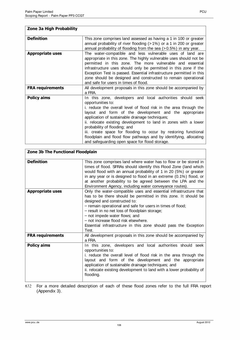
Palm Paper Limited PCU
Scoping Report – Palm Paper PP3 CCGT
www.pcu..de August 2012
108
Zone 3a High Probability
Definition
This zone comprises land assessed as having a 1 in 100 or greater annual probability of river flooding (>1%) or a 1 in 200 or greater annual probability of flooding from the sea (>0.5%) in any year.
Appropriate uses
The water-compatible and less vulnerable uses of land are appropriate in this zone. The highly vulnerable uses should not be permitted in this zone. The more vulnerable and essential infrastructure uses should only be permitted in this zone if the Exception Test is passed. Essential infrastructure permitted in this zone should be designed and constructed to remain operational and safe for users in times of flood.
FRA requirements
All development proposals in this zone should be accompanied by a FRA.
Policy aims
In this zone, developers and local authorities should seek opportunities to: i. reduce the overall level of flood risk in the area through the layout and form of the development and the appropriate application of sustainable drainage techniques; ii. relocate existing development to land in zones with a lower probability of flooding; and iii. create space for flooding to occur by restoring functional floodplain and flood flow pathways and by identifying, allocating and safeguarding open space for flood storage.
Zone 3b The Functional Floodplain
Definition
This zone comprises land where water has to flow or be stored in times of flood. SFRAs should identify this Flood Zone (land which would flood with an annual probability of 1 in 20 (5%) or greater in any year or is designed to flood in an extreme (0.1%) flood, or at another probability to be agreed between the LPA and the Environment Agency, including water conveyance routes).
Appropriate uses
Only the water-compatible uses and essential infrastructure that has to be there should be permitted in this zone. It should be
designed and constructed to: – remain operational and safe for users in times of flood; – result in no net loss of floodplain storage; – not impede water flows; and – not increase flood risk elsewhere. Essential infrastructure in this zone should pass the Exception Test.
FRA requirements
All development proposals in this zone should be accompanied by a FRA.
Policy aims
In this zone, developers and local authorities should seek opportunities to: i. reduce the overall level of flood risk in the area through the layout and form of the development and the appropriate application of sustainable drainage techniques; and ii. relocate existing development to land with a lower probability of flooding.
For a more detailed description of each of these flood zones refer to the full FRA report (Appendix 3).
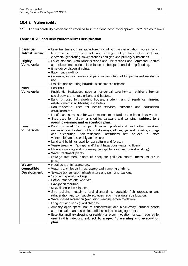
Palm Paper Limited PCU
Scoping Report – Palm Paper PP3 CCGT
www.pcu..de August 2012
109
10.4.2 Vulnerability
The vulnerability classification referred to in the flood zone "appropriate uses" are as follows:
Table 10-2 Flood Risk Vulnerability Classification
Essential Infrastructure
Essential transport infrastructure (including mass evacuation routes) which has to cross the area at risk, and strategic utility infrastructure, including electricity generating power stations and grid and primary substations.
Highly Vulnerable
Police stations, Ambulance stations and Fire stations and Command Centres and telecommunications installations to be operational during flooding.
Emergency dispersal points.
Basement dwellings. Caravans, mobile homes and park homes intended for permanent residential use.
Installations requiring hazardous substances consent.
More Vulnerable
Hospitals. Residential institutions such as residential care homes, children’s homes, social services homes, prisons and hostels.
Buildings used for: dwelling houses; student halls of residence; drinking establishments; nightclubs; and hotels.
Non–residential uses for health services, nurseries and educational establishments.
Landfill and sites used for waste management facilities for hazardous waste. Sites used for holiday or short-let caravans and camping, subject to a specific warning and evacuation plan.
Less Vulnerable
Buildings used for: shops; financial, professional and other services; restaurants and cafes; hot food takeaways; offices; general industry; storage and distribution; non–residential institutions not included in ‘more vulnerable’; and assembly and leisure.
Land and buildings used for agriculture and forestry. Waste treatment (except landfill and hazardous waste facilities). Minerals working and processing (except for sand and gravel working). Water treatment plants. Sewage treatment plants (if adequate pollution control measures are in place).
Water-compatible Development
Flood control infrastructure. Water transmission infrastructure and pumping stations. Sewage transmission infrastructure and pumping stations. Sand and gravel workings. Docks, marinas and wharves.
Navigation facilities. MOD defence installations. Ship building, repairing and dismantling, dockside fish processing and refrigeration and compatible activities requiring a waterside location.
Water-based recreation (excluding sleeping accommodation). Lifeguard and coastguard stations. Amenity open space, nature conservation and biodiversity, outdoor sports and recreation and essential facilities such as changing rooms.
Essential ancillary sleeping or residential accommodation for staff required by uses in this category, subject to a specific warning and evacuation plan.
Palm Paper Limited PCU
Scoping Report – Palm Paper PP3 CCGT
www.pcu..de August 2012
110
10.5 Assessment of Effects
10.5.1 Sources of Flooding
The potential sources of flooding in the vicinity of the site are as described below and in the letter from the Environment Agency included in Appendix C of the full FRA as follows:
The River Great Ouse
This is the primary source of flooding for the King's Lynn area. However King's Lynn is currently defended against the 1 in 200 year flood event (6.12m AOD flood level and 6.3m and 7.Om AOD hard and soft flood defence levels) and should be discounted as a source of flooding with an unacceptable risk.
River Nar
This river is situated to the east of the site and since construction of the Nar Sluice, the flood levels can be more easily regulated. The Nar now acts as a flood storage area in times of high tide. The banks of the River Nar at around 4.2m AOD are higher than the maximum possible water level of 3.53m AOD and therefore protect against the 1 in 100 year event. This absolute worst case level is the modelled result a 1 in 100 year storm coinciding with the flood diversion culvert being closed and a 6.0 metre high Spring tide event occurring in the Great Ouse. The combined probability of this coincident event is much less probable than 1 in 100. The banks close to the Sugar Beet Factory site have been walked to check for continuity and a spot level survey has been effected which indicated levels no less than 4.0m.
Saddlebow Road Spur Drain
This drain bounds the east of the site, albeit on the east side of Saddlebow Road, and is the responsibility of the East of Ouse, Polver and Nar Internal Drainage Board. It passes south from the site and flows into the North Sea Bank Drain at the northern end of Low Road. This drain is part of the IDB maintained drainage network which appears to be kept in good working order and does not therefore appear to represent an unacceptable flood risk to the site.
North Sea Bank Drain and Poplar Avenue Spur Drain
This drain flows from east to west along the southern side of the North Sea Bank and discharges out to the River Great Ouse Relief Channel.
The drains do not appear to represent an unacceptable flood risk to the site.
River Great Ouse Relief Channel
The Relief Channel is non tidal although it is tide locked at Tail Sluice. The Relief Channel is protected from flooding by the Tail Sluice and adjacent flood defences along the banks of the River Great Ouse. The EA have confirmed that the current modelled 1 in 100 year flood level of the relief channel is 2.12m at the tail sluice.
The Flood Relief Channel does not therefore appear to represent an unacceptable flood risk to the site.
Poplar Avenue Spur Drain
This drain starts just to the south of Poplar Avenue and flows south to join into the North Sea Bank Drain at the entrance to the Power Station. This drain is the responsibility of the East of Ouse, Polver and Nar Internal Drainage Board. This drain picks up an overflow pipe from the reservoir ponds at the south of the site but it should be noted that it does not currently appear to drain the site and is remote from the site by a narrow strip of land adjacent to "Marshlands" off Poplar Avenue.
This minor drain does not appear to represent an unacceptable flood risk to the site.
Anglian Water Sewers
These surface water sewers are only small networks that complement the IDB drainage ditches.

Palm Paper Limited PCU
Scoping Report – Palm Paper PP3 CCGT
www.pcu..de August 2012
111
These minor sewers are not considered to pose a significant flood risk to the site.
Localised Flooding from Impermeable Areas on Site
The existing impermeable site areas to the south of the site appear to drain to four main outfalls as follows:
There appears to be a minor perimeter drain to the west and north of the Saddlebow Industrial Estate
The main access road, Poplar Avenue, appears to constitute the low point of the northern site and this road appears to be positively drained out to the Saddlebow Road Spur Drain at the east of the site.
Historical mapping from 1928 suggests that a land drain from the site headed south across Poplar Avenue to what is now known as the Poplar Avenue Spur Drain.
There is documentary evidence to show that the former Sugar Beet Factory pumped surface water out into the River Great Ouse.
Localised flooding from impermeable areas on site does not represent an unacceptable flood risk to the site.
10.5.2 Flood Defences
There has been a large government investment over the years in flood defence at King’s Lynn and this is described in the NORA FRA.
The River Nar Outfall
The building of the barrier across the downstream end of the River Nar at its outfall with the River Great Ouse this river was tidal to a point about 1km upstream of the outfall. The building of the barrier, which includes two box culverts with flapped outfalls, has removed the need for tidal defences along this downstream section of river.
Flood Defences on the Nar.
The flood defences on the River Nar upstream of the old sluice, in the close vicinity of the site, are constructed to a minimum level of 4.0m AOD.
This section of the River Nar is not particularly susceptible to flood conditions because the upstream rural section of the river is liable to flood prior to any flooding in the town. Therefore, the upstream floodplains form part of the flood defences.
10.5.3 Run-off Assessment
Details of the Run-off Assessment are provided in the full FRA (Appendix 3).
The "Drainage Brief for Area 7C" by The Middle Level Commissioners on behalf of the East of Ouse, Polver and Nar Internal Drainage Board gives advice and costs for the potential connection of the development site to the drainage maintained by the IDB. The document sets out criteria and opens the discussion terms for a detailed design. A copy of this letter is included in Appendix 3.
10.5.4 Sustainable Urban Drainage Systems (SUDS)
Infiltration drainage options have been considered for this scheme however the nature of the sub-soils and the high water table prohibit the use of soakaways. There is a further complication regarding the promotion of infiltration drainage in that the sub-soils are anticipated to be contaminated in the region of the old factory buildings due to the previous uses of the site. There may be scope to use pond storage as a means of flow attenuation. It should be noted that the development brief specifically states that the water levels and quality in the nature reserve should not be affected by the development proposals. This will need to be considered further during the detailed design stage. There may be scope to utilize rainwater harvesting techniques as discussed above. This will be considered further during the detailed design stage.
Palm Paper Limited PCU
Scoping Report – Palm Paper PP3 CCGT
www.pcu..de August 2012
112
10.5.5 Proposed Site Development Levels
The development proposal is for a new CCGT, associated buildings and infrastructure. The site topographical survey along with typical cross sections is included in Appendix 3.
The Flood Risk Assessment assumed that the finished floor level will be no lower than 3m AOD.
If floor levels were to be set at this level then the defences to the River Great Ouse would be offering protection from approximately 3m head of water in a 1 in 200 year flood event. The cross sections and ordnance survey indicate that the raised defences start at a level of about 4.5m AOD with the peak level of the soft defences at about 7.Om AOD. The defences therefore offer a freeboard of about 0.88m and only 1.6m of the raised defences are subjected to the extreme flood waters.
The finished floor levels of the buildings of the proposed development will be between 3.5m AOD and 4.5m AOD. Consequently the defences of the River Great Ouse would offer even better flood protection than determined in the Flood Risk Assessment.
10.5.6 Floodplain Encroachment
The existing flood defence levels are higher than the respective river flood levels therefore the existing site is not floodplain wash lands. The site does not abut the banks of any watercourses therefore there is no scope for encroachment into any watercourses therefore there will be no requirement for floodplain compensation elsewhere on site.
10.5.7 Climate Change
Climate change is recognised as a factor for consideration in terms of its affects on flood risk. This issue affects the overall catchment from both coastal and fluvial sources. Specific issues, with regard to the proposed redevelopment of the Former Sugar Beet Factory site, are as follows:
10.5.7.1 River Great Ouse
The Environment Agency assessed the existing flood defences in 2000 to check if they met the 1 in 200 year protection required for Kings Lynn. At that time, they were deemed to meet the 1 in 200 year level of protection, as they had 180mm freeboard for the hard-defences (6.3m AOD). The soft defences therefore offer a free board of about 880mm (7.Om AOD).
It is estimated that the design lifetime of the plant will be forty years. This is based on the design life of the proposed CCGT. On the basis of the sea level rise contingency allowances stated in PPS 25 it appears as though the hard defences could be overtopped by a 0.5% probability event occurring after 2035 as the existing freeboard will have eroded to zero. The peak tidal surge level is predicted to rise to 6.47m AOD by 2057 at which time the soft defences adjacent to the site will still have approximately 500mm freeboard.
This increase in peak tidal surge levels puts the peak flood level 0.17m higher than the hard defences of the Tail Sluice at the end of the Relief Channel. The resulting flood waters overtopping the Tail Sluice would flow into the Relief Channel. We do not have sufficient data to prove that the relief channel has sufficient capacity to contain the overtopping volume during a peak tidal flood however we do know that the Relief Channel has a very large storage capacity at a much lower level than the River Great Ouse. It is likely therefore that the Relief Channel would provide protection to the site in a future peak flood event, allowing for climate change.
The maintenance of flood defences to sustain them at their current level is financed on a rolling programme. This programme does not guarantee that in the future as sea levels rise and the flood risk to the subject site increases that the level of the defences will be raised to maintain the current standard of protection. However, it is current EA policy to defend King’s Lynn and it is likely that the EA will receive funding to allow them to assess the risks faced over the next 20 years and consequently provide an adequate standard of protection. It is therefore anticipated that this policy position will be maintained for the lifetime of the
Palm Paper Limited PCU
Scoping Report – Palm Paper PP3 CCGT
www.pcu..de August 2012
113
development. In this way we can conclude that it appears reasonable to assume that the development will be safe for its design lifetime.
10.5.7.2 River Nar
The River Nar, in the region of the site, is very insensitive to increase in run-off rate because the upstream rural catchment floods first. For example the difference between the 1 in 50 and 1 in 100 year flood level, with a spring tide locking the outfall sluice, is approximately 50mm, therefore we would not expect that the increased rate of run-off, due to climate change, will be an issue for the River Nar.
10.5.8 Flood Warning
The site is located within the EA. flood warning area "the tidal River Great Ouse along King's Lynn river frontage". This means that the site will be covered by the new free warning service, called Floodline Warnings Direct. This service gives automated warnings by telephone, mobile, fax or pager, 24 hours a day. This is an elective scheme that requires the management to register to receive automated warnings in times of heightened flood risk.
However, to ensure that as many people as possible receive a flood warning, the Environment Agency can also use roof mounted loudhailer units on its vehicles to broadcast warning messages in flood risk areas. This acts as a back up for Floodline Warnings Direct to reach people who have not yet registered their details.
Floodline Warnings Direct has superseded the Automated Voice Messaging (AVM) warning system. Ms Denham, of the EA, has also confirmed that the outdated network of fixed site warning sirens, which are owned by the borough council, will be decommissioned this year as they are unserviceable and not targeted to meet the needs of the general public.
10.5.9 Vulnerability Classification
In accordance with the Flood Risk Vulnerability Classification, of PPS 25, the proposed is for "general industry" which is categorised as "less vulnerable". Less vulnerable proposals are considered suitable in flood zone 3a. It should also be noted that the site is "previously-developed land".
10.6 Mitigation and Residual Risks
The likely sources of flood risk to the proposed development have been noted in the previous section. Although these risks appear to be adequately protected against it should be noted that the following residual risks, in relation to 0.5% probability coastal and 1% probability fluvial flooding, still remain.
10.6.1 Breaching of defences
10.6.1.1 Tidal and River Great Ouse
The flood defences affecting the subject site can be defined as running along the bank of the River Great Ouse from the Tail Sluice to the A47 road bridge. If these flood defences failed during a tide greater than 5m AOD, there would be rapid inundation of the site. The speed of inundation would depend on the location and size of any failure; however it is likely to be very quick if the breach is to the full depth of the defences.
The likelihood of this breach/failure situation occurring is considered to be very remote for the following reasons.
The current flood defences have been properly constructed unlike the defences that failed in 1953.
The defences are currently believed to be in good condition and are inspected and maintained by the Environment Agency under a suitable maintenance regime; therefore any defects or likely causes of a breach should be identified long before a failure will occur.

Palm Paper Limited PCU
Scoping Report – Palm Paper PP3 CCGT
www.pcu..de August 2012
114
As the flood banks are stepped with large flood berms, it is unlikely that a breach would occur during a normal tidal range and the floodwater would have to be in the order of 4.5m to 5.0m AOD before it reached to the level of the final flood bank.
It should be noted that the possibility of a breach of the soft defences remains a residual risk and this risk will increase with climate change as the predicted top water level encroaches into the freeboard on the defences potentially exposing the upper drier sections of the defences to flood water.
10.6.1.2 River Nar
The 1 % probability flood level is only 0.5m above the minimum plot level and the river is remote from the site therefore the residual risk is negligible.
10.6.2 Failure of Hydraulic Structures
The probability of failure of the Nar Sluice to the River Great Ouse is considered to be very slight. The likely consequences for King's Lynn are considered to be less onerous than the 1978 floods.
In these floods the subject site was not affected therefore the residual risk is considered to be negligible
10.6.3 Overtopping of Flood Defences
Any flood water overtopping the hard defences of the Tail Sluice of the relief channel would be conveyed into the relief channel therefore the residual risk to the subject site is considered to be negligible.
In a section above it was confirmed that King’s Lynn is currently defended against the 1 in 200 year flood event (6.12m AOD flood level and 6.3m and 7.0m AOD hard and soft flood defence levels). On this basis it should be discounted as a source of flooding with an unacceptable risk. However it was also confirmed that, on the basis of the sea level rise contingency allowances stated in PPS 25, it appears as though the hard defences could be overtopped by a 0.5% event occurring after 2035 as the existing freeboard will have eroded to zero.
If we consider the effect of a 300mm rise in sea level occurring now then this will allow us to quantify the residual risk resulting from climate change with no change to the current hard defence levels. The soft defences will still have a freeboard of 600mm and are therefore not affected.
Based on the tidal flood profile (taken from the 1953 flood) the hard defences would be overtopped for approximately 1 hour. Assuming that the 1.5 km of concrete floodwall acts as a weir, the volume of water overtopping the defences would be in the order of 100,000 m3. This volume of water would be less than that which flooded the town in 1978 when the quay level of approximately 5m AOD provided flood protection. In these floods the subject site was not affected. Any flood water overtopping the hard defences of the Tail Sluice of the relief channel would be conveyed into the relief channel therefore the residual risk to the subject site is considered to be negligible.
10.6.4 Flooding from Sewers
The off-site discharge of surface water will be managed in a sustainable way following dialogue at the detailed design stage with the relevant consultees such as the Environment Agency, East of Ouse, Polver and Nar Internal Drainage Board and Anglian Water. On this basis the residual risk is considered to be negligible.
10.6.5 Conclusions and Recommendations
It is recommended that the flood defences continue to be maintained and improved as necessary by the Environment Agency and East of Ouse, Polver and Nar Internal Drainage Board. This will of course be subject to any improvements being justified, in accordance with Government guidelines.
Palm Paper Limited PCU
Scoping Report – Palm Paper PP3 CCGT
www.pcu..de August 2012
115
Site specific
The Environment Agency suggests that the subject site is at risk of flooding should the defences that currently offer protection fail.
The potential sources of flooding have been identified and shown to be currently defended against.
The flood defences are all maintained by recognised bodies such as the Environment Agency and East of Ouse, Polver and Nar Internal Drainage Board. These defences are shown to be regularly inspected and maintained good in condition.
The on-site sewers will be designed to the current standards and in line with good practice flood flow paths will be considered to indicate the lines of any overland flows to ensure that these do not adversely affect the proposed buildings. This will protect the buildings on site from flooding.
Floor levels and the site drainage strategy should be designed to work together in order that the risk of on-site flooding as a result of site run-off is minimised.
Storm water sewer calculations should be produced to show that the on-site drainage and hardstandings have the capacity to contain the 1 in 100 year storm prior to discharge to receiving watercourses at a sustainable rate.
Implications for areas outside of the site
The off-site discharge of surface water will be managed in a sustainable way following dialogue at the detailed design stage with the relevant consultees such as the Environment Agency, East of Ouse, Polver and Nar Internal Drainage Board and Anglian Water. As such there should be no increase in flood risk to areas beyond the site as a result of the proposals.
Climate Change
Allowing for climate change, it appears as though the relief channel has sufficient capacity to contain the overtopping volume caused by a peak tidal flood as the Relief Channel has a very large storage capacity at a much lower level than the River Great Ouse. It is likely therefore that the Relief Channel would provide protection to the site in a future peak flood event.
It is current EA policy to defend King’s Lynn and it is likely that the EA will receive funding to allow them to assess the risks faced over the next 20 years and consequently provide an adequate standard of protection. It is therefore anticipated that this policy position will be maintained for the lifetime of the development. In this way we can conclude that it appears reasonable to assume that the development will be safe for its design lifetime.
Flood Warning
The site is located in a well defended area in an extensive catchment where flooding, should it occur in a rare and extreme event, would be preceded by a prolonged period of heavy rainfall in combination with a particularly high surge tide. This should give ample opportunity for the met office and EA forecasting the event and for the warning of the site management and any evacuation deemed to be necessary.
It is recommended that the current "Floodline Warnings Direct" flood warnings scheme, which is provided by the Environment Agency, is maintained.
It is recommended that the developments management should register to receive the Environment Agency's "Floodline Warnings Direct" flood warnings.
Conclusion
Overall, the Flood Risk Assessment concludes that there is no increase in flood risk to areas beyond the site as a result of the proposed development.
Palm Paper Limited PCU
Scoping Report – Palm Paper PP3 CCGT
www.pcu..de August 2012
116
11.0 ARCHAEOLOGY AND CULTURAL HERITAGE
11.1 Introduction and Scope
The approach to this archaeological and cultural heritage assessment has been to evaluate the archaeological and cultural heritage potential of the development site and the wider study area, and to identify potential mitigation measures which would lead to the satisfactory accommodation of any archaeological or cultural heritage constraints within the context of the development proposal.
As the new development lies entirely within the closer study area of that previous assessment, all findings of the previous archaeological assessment also apply for the location of the proposed CCGT.
Following a review of all readily available sources of data, an assessment was made of the likely form, quality, extent and value of any archaeological and cultural heritage resources and the extent of past and post depositional impacts.
An assessment was made of the potential impact of the proposed development on any archaeological and cultural heritage resources within the study area of the development site.
An archaeological desk-based assessment had been researched and prepared by CgMs Consulting as part of the EIA for the established paper mill in 2007.
The results of the desk-based archaeological assessment will assist in minimising the impact of the proposed scheme on archaeological and cultural heritage resources.
The assessment comprises an examination of evidence in the Norfolk Historic Environment Record (HER), the Norfolk Record Office and Norfolk Heritage Centre, considers the results of nearby archaeological investigations, incorporates published and unpublished material and charts historic land-use through a map regression exercise.
11.2 Baseline Conditions
11.2.1 Geology and Topography
Geology
The British Geological Survey (Sheet 145: King’s Lynn and The Wash, 1978) shows the site underlain by Tidal Flat Deposits of clay and silt of Holocene age (defined as Marine Alluvium, Terrington Beds), capping clay deposits of the Kimmeridge Formation.
However, deposits of Made Ground are shown covering the bulk of the study site, dominating the western and northern areas, in the areas occupied by the settling tanks of the former sugar beet factory.
A geotechnical survey of the Palm Paper premises, in the form of boreholes (BH) and trial pits (TP), was carried out in April 2005. The six boreholes revealed Made Ground 1.5-6.2m thick, above Terrington Beds and Kimmeridge Clay deposits. Peat was observed in all of the boreholes, at a thickness of 0.6-1.1m, either within the Terrington beds or directly below the Made Ground, at a general depth of 3-4.4m below ground level (in BH6 the top of the peat was 7.3m below ground level).
Thirty trial pits were excavated across the Palm Paper premises, to a maximum depth of 4m. Made ground deposits were generally shallower in the area of the paper mill complex, and deeper across the northern and eastern parts of the site. Made ground was observed in almost all of the test pits, save for one test pit in the far north-east corner and one test pit east of the paper mill complex. Thicknesses of the Made Ground vary from 0.2m towards the centre of the site, to 3.3m in an area of former settling ponds, and 3.5m in an area of the established Effluent Treatment Plant to the south-west. The majority of the Made ground deposits were 0.5-2.2m thick.

Palm Paper Limited PCU
Scoping Report – Palm Paper PP3 CCGT
www.pcu..de August 2012
117
Terrington Beds were observed beneath Made ground, where applicable, with clay and silt below that.
After construction of the paper mill, the Made Ground of all built areas is at least 2-3m thick.
Deposits of Terrington Beds, Kimmeridge Clay and/or Barroway Drove Beds (defined as organic clay with plant remains) complete the general geological sequence below the Made Ground. Nordelph Peat was observed in all of the boreholes save for some boreholes, situated midway along the western boundary and towards the north-west and south-west corners respectively. Peat deposits varied from 0.2m thick, in the southwest, to 1.4m thick on the western boundary. Generally the deposits were 0.6-0.8m thick, and occurred at depths of between 3-4m and 6-8m, between the Terrington Beds and the Barroway Drove Beds/Kimmeridge Clay.
Topography
The study site can be divided into two discrete topographical areas. The buildings occupying the western paper mill site are generally level, and consist mainly of concrete hardstanding. Beyond them, to the north and east, the study area comprises undulating open rough grassland as well as flat reedbed areas surrounded by 3-4m high earth dams in the northern part of the premises.
Prior to the construction of the sugar beet factory in 1927, the study site is known to have lain within an area of former salt marsh, reclaimed during the Medieval period (EZZ45 1988: 23).
The Eau Brink Cut, an artificial channel of the River Ouse created in 1821, runs along the western boundary of the study site. The River Nar runs to the east of the study site.
No geological or topographical anomalies are known within the vicinity of the study site.
11.2.2 Designations
The known designated areas and features within c. 10 km of the proposed site are shown in drawing PP3 - 06.
11.2.2.1 Scheduled Ancient Monuments
The MAGIC website search showed no Scheduled Ancient Monuments within the immediate vicinity of the study area and its close surroundings.
The King’s Lynn & West Norfolk Local Plan was also consulted and revealed that there were no registered ancient monuments, parks or gardens recorded on site or within 2,200m of the site boundary. Within the wider study area (drawing PP3-06) there were several listings features and buildings identified.
The following table shows three listings which lie closest to the proposed CCGT. All these designated features are of highest value.
Table 11-2 Ancient Monuments in King’s Lynn
Parish No. County Monument Title Grid Ref. Distance from Site
King’s Lynn 172 Greyfriars Tower TF 620 197 2,200m
King’s Lynn 174b The South Gate TF 622 191 2,500m
King’s Lynn 306 Medieval town walls TF 624 194 2,200m
Palm Paper Limited PCU
Scoping Report – Palm Paper PP3 CCGT
www.pcu..de August 2012
118
No other Scheduled Ancient Monuments are recorded within 3 km of the Proposal Site. A further 22 SAM are located between 3 km and 10 km of the proposed CGT (see drawing PP3-06).
11.2.2.2 Listed Buildings
There are no Listed Buildings within the immediate vicinity of the proposal site. The closest registered Grade II Listed Buildings are farm buildings of the White House Farm which lie some 1,200m east of the new plant.
There are no Grade I Listed Buildings within 3 km of the site boundary.
11.2.2.3 Historic Parks and Gardens and Registered Battlefields
According to the NMR and SMR there are no Historic Parks and Gardens or Registered Battlefields in close proximity to the study area.
“The Walks”, a public park close to the town center of King’s Lynn is registered as a “Registered Park and Garden”. “The Walks” lie some 2.5km away.
11.2.3 Archaeological and Historical Background
11.2.3.1 Impact on the Buried Archaeological Deposits
Site Conditions
The study site currently comprises buildings formerly comprising part of the sugar beet factory in the southwest corner, in various uses including offices, a scaffold yard, timber yard and wood pulp store, surrounded by areas of concrete hardstanding. The remainder of the study site comprises overgrown grassland, with trees and shrubs along the northern boundary. A large pond is present towards the northeast corner, and a smaller pond is present on the western boundary. A derelict jetty stands on the Eau Brink Cut to the west, now isolated from the study site (Fig 18 and Plates 6-11 of Appendix 4).
The study site was formerly occupied by a sugar beet factory, in operation between 1927 and 1994. The factory buildings were concentrated to the southwest corner, with large settling tanks situated across the rest of the site at different periods throughout its history. Railway lines crossed the site from northeast to southwest, and a depot building formerly stood in the northeast corner.
The construction, and subsequent demolition, of the buildings associated with the sugar beet factory will have had a cumulative, destructive archaeological impact upon any below ground archaeological deposits present. Refurbishment of the factory complex appears to have taken place throughout its history, including a major expansion 1959-1966, which will have had a further negative archaeological impact.
The settling ponds which were excavated across the northern and western parts of the study site will have also had a severe and destructive impact upon below ground archaeological deposits.
Any agricultural activity prior to the site’s industrial development is likely to have had a moderate, widespread negative archaeological impact. The cutting and maintenance of drainage ditches is likely to have had a localised, severe negative archaeological impact.
The built area of the paper mill, which consists mainly of hardstanding, cover most of the western study site.
Palm Paper Limited PCU
Scoping Report – Palm Paper PP3 CCGT
www.pcu..de August 2012
119
11.2.3.2 Archaeological Potential
The archaeological heritage of the area can be broken down into a number of periods including:
Prehistoric
Palaeolithic 450,000 - 12,000 BC
Mesolithic 12,000–4,000 BC
Neolithic 4,000–2,300 BC
Bronze Age Age 2,300–700 BC
Iron Age 700 BC–A.D. 43
Historic
Roman A.D. 43–410
Anglo-Saxon A.D. 410–1066
Medieval A.D. 1066–1485
Post-medieval A.D. 1486–1900
Modern A.D. 1900-present
Prehistoric: Palaeolithic, Mesolithic, Neolithic, Bronze Age and Iron Age
No finds of Prehistoric date are known within a 1km radius of the study site.
Roman
A Roman coin of Constantius II (337-361 AD) was found in the garden of 71 Wisbech Road, northeast of the study site (SMR ref 14483-MNF14483, TF6175 1870). Given the paucity of Roman artefacts from the study area, a low potential is identified for this period at the study site itself.
Anglo-Saxon
The Domesday Survey mentions a surplus of salt produced by the local settlers on the Lynn. It is likely that the settlers harvested the salt on the marsh and lived on the sands and gravels to the east. Saxon or Medieval pottery, together with animal bones, daub and shells were identified northwest of the study site, on the opposite side of the Eau Brink Cut, close to the former bank of the River Ouse (SMR ref 15487-MNF15487, TF608 185). Given the paucity of Anglo-Saxon finds within a 1km radius of the study site, a low potential is identified for this period at the study site, although conceivably salt panning evidence may occur at depth.
Medieval
The site of the manor house of Scales Hooe or Howe, known in the early eighteenth century and possibly since its foundation in 1259, lies towards the centre of the study site (SMR ref 25327-MNF25327, TF6126 1805). The estate of Howe is known to have been flooded in 1288 when the sea defences failed, and the manor of Howe is known to have been worthless in 1369/70 as a result of sea flooding. These events may not have been exclusive, and are thought to suggest regular inundation (EAA45 1988: 22-23). It would therefore appear that during the Medieval period the study site lay within a reclaimed salt marsh which periodically flooded. The possible presence of the manor house of Scales Howe within the study site may suggest habitation and possible agricultural exploitation of the marshes during this period (EAA45 1988: 23). A high potential can therefore be established for the Medieval period at the study site. Features may include remains of sea defences, drainage ditches and salt working.
It would therefore appear that during the Medieval period the study site lay within a reclaimed salt marsh which periodically flooded. The possible presence of the manor house of
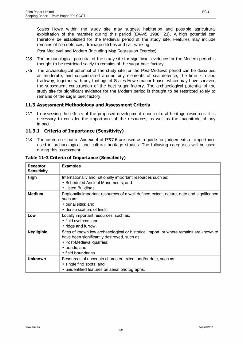
Palm Paper Limited PCU
Scoping Report – Palm Paper PP3 CCGT
www.pcu..de August 2012
120
Scales Howe within the study site may suggest habitation and possible agricultural exploitation of the marshes during this period (EAA45 1988: 23). A high potential can therefore be established for the Medieval period at the study site. Features may include remains of sea defences, drainage ditches and salt working.
Post Medieval and Modern (including Map Regression Exercise)
The archaeological potential of the study site for significant evidence for the Modern period is thought to be restricted solely to remains of the sugar beet factory.
The archaeological potential of the study site for the Post-Medieval period can be described as moderate, and concentrated around any elements of sea defence, the lime kiln and trackway, together with any footings of Scales Howe manor house, which may have survived the subsequent construction of the beet sugar factory. The archaeological potential of the study site for significant evidence for the Modern period is thought to be restricted solely to remains of the sugar beet factory.
11.3 Assessment Methodology and Assessment Criteria
In assessing the effects of the proposed development upon cultural heritage resources, it is necessary to consider the importance of the resources, as well as the magnitude of any impact.
11.3.1 Criteria of Importance (Sensitivity)
The criteria set out in Annexe 4 of PPG16 are used as a guide for judgements of importance used in archaeological and cultural heritage studies. The following categories will be used during this assessment:
Table 11-3 Criteria of Importance (Sensitivity)
Receptor
Sensitivity
Examples
High Internationally and nationally important resources such as:
• Scheduled Ancient Monuments; and
• Listed Buildings.
Medium Regionally important resources of a well defined extent, nature, date and significance
such as:
• burial sites; and
• dense scatters of finds.
Low Locally important resources, such as:
• field systems; and
• ridge and furrow.
Negligible Sites of known low archaeological or historical import, or where remains are known to
have been significantly destroyed, such as:
• Post-Medieval quarries;
• ponds; and
• field boundaries.
Unknown Resources of uncertain character, extent and/or date, such as:
• single find spots; and
• unidentified features on aerial photographs.
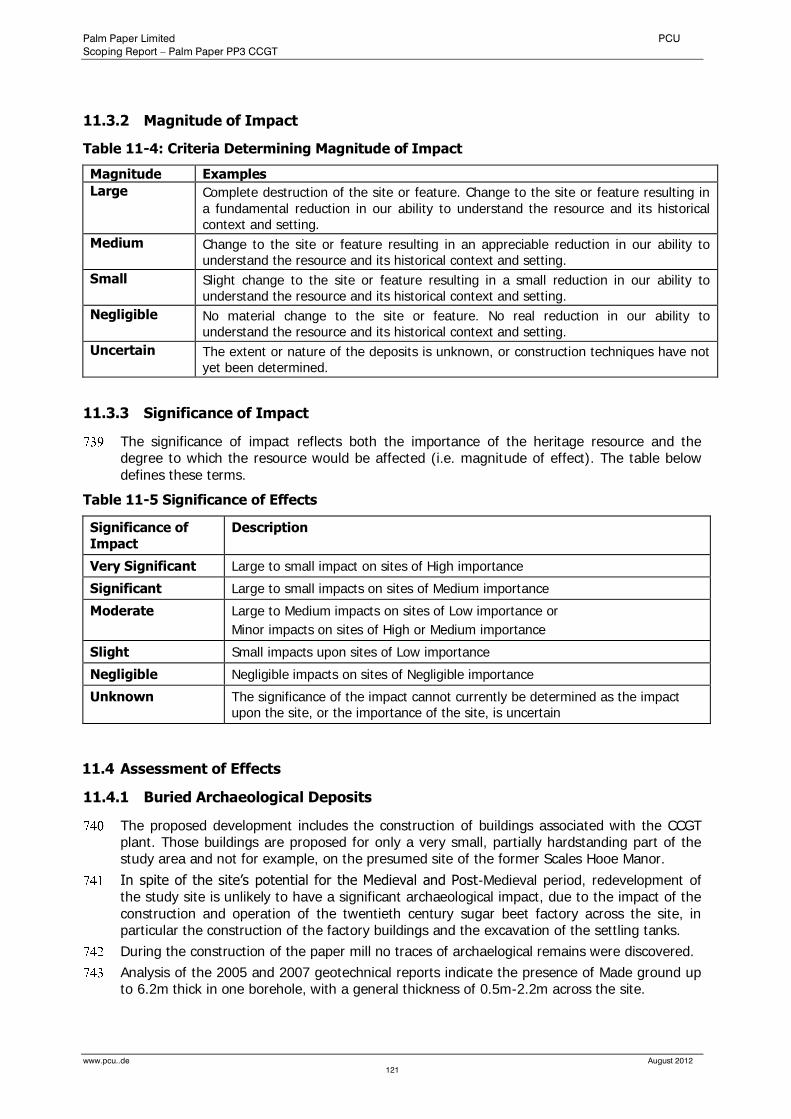
Palm Paper Limited PCU
Scoping Report – Palm Paper PP3 CCGT
www.pcu..de August 2012
121
11.3.2 Magnitude of Impact
Table 11-4: Criteria Determining Magnitude of Impact
Magnitude Examples
Large Complete destruction of the site or feature. Change to the site or feature resulting in a fundamental reduction in our ability to understand the resource and its historical context and setting.
Medium Change to the site or feature resulting in an appreciable reduction in our ability to understand the resource and its historical context and setting.
Small Slight change to the site or feature resulting in a small reduction in our ability to understand the resource and its historical context and setting.
Negligible No material change to the site or feature. No real reduction in our ability to understand the resource and its historical context and setting.
Uncertain The extent or nature of the deposits is unknown, or construction techniques have not yet been determined.
11.3.3 Significance of Impact
The significance of impact reflects both the importance of the heritage resource and the degree to which the resource would be affected (i.e. magnitude of effect). The table below defines these terms.
Table 11-5 Significance of Effects
Significance of Impact
Description
Very Significant Large to small impact on sites of High importance
Significant Large to small impacts on sites of Medium importance
Moderate Large to Medium impacts on sites of Low importance or
Minor impacts on sites of High or Medium importance
Slight Small impacts upon sites of Low importance
Negligible Negligible impacts on sites of Negligible importance
Unknown The significance of the impact cannot currently be determined as the impact upon the site, or the importance of the site, is uncertain
11.4 Assessment of Effects
11.4.1 Buried Archaeological Deposits
The proposed development includes the construction of buildings associated with the CCGT plant. Those buildings are proposed for only a very small, partially hardstanding part of the study area and not for example, on the presumed site of the former Scales Hooe Manor.
In spite of the site’s potential for the Medieval and Post-Medieval period, redevelopment of the study site is unlikely to have a significant archaeological impact, due to the impact of the construction and operation of the twentieth century sugar beet factory across the site, in particular the construction of the factory buildings and the excavation of the settling tanks.
During the construction of the paper mill no traces of archaelogical remains were discovered.
Analysis of the 2005 and 2007 geotechnical reports indicate the presence of Made ground up to 6.2m thick in one borehole, with a general thickness of 0.5m-2.2m across the site.

Palm Paper Limited PCU
Scoping Report – Palm Paper PP3 CCGT
www.pcu..de August 2012
122
The sole possible trace of Scales Hooe Manor House was the inclusion of a solitary brick within the Made Ground in a test pit, west of the known site of the Manor House. The 2007 Geotechnical Report did reveal that this brick was found within the Made Ground at a depth of approximately 1m. Neither the Geotechnical Survey from 2007 nor the construction works of the paper mill did reveal any deposits associated with the Manor House.
In addition, the peat lenses, usually considered to be of archaeological importance, have been analysed elsewhere in King’s Lynn as being indicative of a freshwater habitat unable to support habitation.
The sensitivity of the site is negligible due to the destructive archaeological impact of the construction and operation of the former sugar beet factory and the established paper mill. Since the presence of archaeological remains could not be ascertained the magnitude of impact is considered ‘negligible’.
It is therefore anticipated that the proposed development will have no impact on buried archaeological deposits during operation or construction of the project.
11.4.2 Designated Features / Built Heritage
The proposed development is located at least some 2,200m away from any designated site or building.
There is a slight degree of intervisibility between the SAM and the proposed development through undesignated and recent buildings or industrial development.
The magnitude of impact on the designated features referred to during the construction and operation of the new CCGT is considered slight. The effect of the proposed development on the Scheduled Ancient Monuments is assessed as being slight.
As only the stack of the proposed CCGT will be slightly visible, the overall significance of impacts of the proposed development on the Built Heritage is slight to negligible.
11.5 Mitigation Measures
A comprehensive review and analysis of the geotechnical survey data as well as observations during the paper mill's construction activities did not confirm the presence of trace of Scales Hooe Manor House within the development site.
On the basis of the available information any further archaeological mitigation measures at the study site are not required.
11.6 Summary and Conclusion
In accordance with central and local government policy, set out in PPG16 “Archaeology and Planning” a desk-based assessment has been undertaken to clarify the archaeological potential of the study site.
The study site can be shown to have a low potential for the Prehistoric periods, a low potential for the Roman and Anglo-Saxon periods, a high potential for the Medieval period, a moderate potential for the Post Medieval, and a low potential for the Modern period.
Past post-depositional deposits can be shown to have been severe and cumulative. The site was occupied by a sugar beet factory throughout the bulk of the twentieth century.
Redevelopment of this site is therefore unlikely to have a significant effect on below-ground archaeological deposits.
The overall impact of the proposed development on the built heritage is not significant.
Palm Paper Limited PCU
Scoping Report – Palm Paper PP3 CCGT
www.pcu..de August 2012
123
12.0 Water Resources and Water Quality
12.1 Introduction and Scope
This chapter considers the flood risk issues associated with the proposed development.The chapter assesses the potential significant hydrogeological and hydrological impacts of the proposed development. The assessment is based primarily on desk based surveys of the existing hydrogeological and hydrological conditions within the area, using information from published sources and specific investigations previously carried out for the Environmental Statement of the established paper mill PM7.
The sensitivity of receptors and magnitude of impacts are assessed and combined to determine the significance of impacts. Mitigation measures and the nature of any residual risks are also discussed.
12.2 Baseline Conditions
12.2.1 Potential Impacts on Surface and Groundwater
The potential hydrological and hydrogeological impacts of the proposed CCGT relate to following issues:
Erosion/Sediment Transport
Unmanaged erosion/sediment deposition and suspended solids from sediment contaminated run-off discharges and ground disturbance (particularly during construction), could result in modification to stream channel morphology and sedimentation of habitats. This in turn could affect both terrestrial and aquatic ecology, particularly fish spawning grounds.
Chemical/Effluent Pollution
Oil/fuel/chemical pollution (e.g. from accidental spillage, incorrect storage or disturbance of contaminated land during both construction and operation, and the presence of large volumes of potentially polluting waste materials during operation) could affect aquatic ecology and could also impact on the quality of water abstracted from both surface and groundwater for drinking supply.
Alteration of Flow
Any alteration of natural drainage patterns could disturb natural surface and subsurface water flows to either water dependent habitats or water supply abstraction points. Concrete hardstanding areas, buildings and bunds could provide new preferential pathways or prevent water ingress into soils and interfere with the retention of flows within catchments. Alteration of surface run-off due to increased areas of hardstanding could potentially cause flooding to both the Four Ashes site and receptors downstream of the site.
Water Supply and Foul Water Disposal
The proposed CCGT will have relatively low water requirements during operation as it will employ a closed system whereby water is recycled (see chapter 2.11.2). Specific water requirements will be dependent on the precise technology employed, however, some water will be required for system top-up and water will also be collected, cleaned and recycled. Air cooled condensers of the new CCGT will also mean that cooling water would not be required. Total usage of process water will amount to less than c. 1m³ per day.
All water required will be received from the paper mill’s established water supply system which abstracts freshwater from the Flood Relief Channel under an existing abstraction licence (22,000m³ per day). Therefore, no additional water will have to be abstracted from the Flood Relief Channel.
The facility will require water from the local water supply mains for normal domestic usage of showers, washrooms, toilets and kitchen sinks. Water supplied from the public mains supply
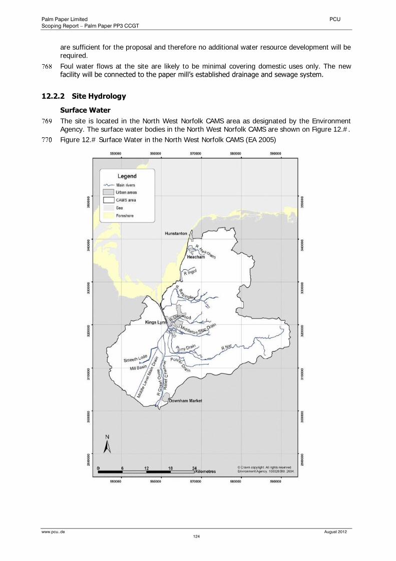
Palm Paper Limited PCU
Scoping Report – Palm Paper PP3 CCGT
www.pcu..de August 2012
124
are sufficient for the proposal and therefore no additional water resource development will be required.
Foul water flows at the site are likely to be minimal covering domestic uses only. The new facility will be connected to the paper mill’s established drainage and sewage system.
12.2.2 Site Hydrology
Surface Water
The site is located in the North West Norfolk CAMS area as designated by the Environment Agency. The surface water bodies in the North West Norfolk CAMS are shown on Figure 12.#.
Figure 12.# Surface Water in the North West Norfolk CAMS (EA 2005)
Palm Paper Limited PCU
Scoping Report – Palm Paper PP3 CCGT
www.pcu..de August 2012
125
The major water-course in the North West Norfolk CAMS is the tidal reach of the River Great Ouse, which flows north from Denver Sluice to the Wash just north of Kings Lynn. The river is tidal upstream as far as Earith.
The Relief Channel flows parallel to the Great Ouse from Denver, rejoining the main river just south of King’s Lynn. The Channel carries water from the Ely Ouse system during periods of medium to high flow, when Denver Sluice is running at capacity. Discharge of water from the Relief Channel to the Tidal River is controlled by the Tail Sluice and occurs at low tide.
To the west of the Great Ouse lies an area of fenland. This area is drained, but has little in the way of water resources. That which is present tends to be of poor quality and unsuitable for irrigation or drinking water. To the east of the Great Ouse, the Sandringham Sands and Chalk outcrops are cut by east-west flowing rivers and drains. There are five main river catchments. All are dominated by baseflow from the underlying aquifer.
The two most northerly rivers in this CAMS are the River Heacham and River Ingol. Both are less than 20km in length, rising as springs, and flowing west to the sea. They discharge via tidal flaps and so the lowest reaches of both are ponded during periods of high tide.
To the south of the Ingol, the River Babingley rises as Chalk springs above the villages of Flitcham, Hillington and Congham. Tributaries merge a short distance downstream where the underlying geology changes to sandstone. The lower river also receives tributary runoff from springs that rise on the Sandringham Sands.
Below this, the river character changes to that of a meandering lowland river. The lower most reaches are channelised, discharging to the tidal River Great Ouse via a tidal sluice.
The River Gaywood follows similar geological origins to the Babingley, arising from Chalk and flowing west over the Sandringham Sands. The lower reaches are elevated above the flood plain of the Gaywood Valley. The final reaches are heavily modified, flowing through King’s Lynn to a tide-locked confluence with the tidal Ouse.
The longest river of the five is the River Nar. This is notable as a Chalk river although the upper most headwaters flow from Clay and are therefore derived from surface runoff. However, springs to the east of Litcham contribute to form a rapidly flowing shallow Chalk river. Below Narborough the river is modified to the tidal sluice which marks the confluence of the Nar with the Great Ouse at King’s Lynn.
In addition to natural rivers, the area east of the Great Ouse also incorporates a number of drainage channels managed by Internal Drainage Boards. Most notable are the Middleton Stop Drain, south of the Gaywood, which flows east-west to King’s Lynn, and the Puny Drain which runs parallel to the latter reaches of the River.
There are no surface water features within the site boundary. There is a number of ponds and ditches north of the site which are part of the previously enhanced Saddlebow reedbeds. The current large scale mapping shows one body of water on the southern boundary of the paper mill premises which is within the boundary of the power station.
The mean high water level of the River Great Ouse runs approximately parallel to much of the western paper mill site boundary, 100m away. There is a sluice gate (The Tail Sluice) to the south-west of the site where the relief channel meets the Great Ouse.
The site is considered to have a low risk of flooding. The site is shown as being outside (above) the flood plain. Some parts of the paper mill site (southern/eastern portions) benefit from flood defences along the western site boundary from the River Great Ouse and the River Nar to the east. See the Appended Flood Risk Assessment and chapter 10 of this report for more details.
The surface water abstraction point lies approximately 100m south of the Tail Sluice, taking water from the Flood Relief Channel.
The discharge of treated effluent from the paper mill is to the tidal stretch of the Great Ouse. The Great Ouse is tidally influenced as far upstream as Earith, and approximately 10km downstream of the discharge the Great Ouse enters the wider Wash estuary.

Palm Paper Limited PCU
Scoping Report – Palm Paper PP3 CCGT
www.pcu..de August 2012
126
Groundwater
The 1:100,000 scale Environment Agency Groundwater Vulnerability Map of the area indicates that the site lies on a non-aquifer of negligible permeability. This classification applies to the underlying Kimmeridge Clay. Non aquifers are formations that are generally regarded as containing insignificant quantities of groundwater.
According to the Environment Agency, the site does not lie within a currently defined source protection zone for public water supply. There are numerous water abstractions within 2km of the site, as detailed subsequently. However these are all surface water or stream abstractions.
Groundwater will be present within the alluvial deposits. Such shallow groundwater, although not typically exploited by abstraction boreholes, could act as a pathway by which mobile contaminants could travel.
12.3 Assessment Methodology and Assessment Criteria
The sensitivity of the receptor and the magnitude of potential impact combine to determine the significance of that impact. Magnitude, sensitivity and significance criteria were developed for the conditions and environments prevailing at the site.
Magnitude
The criteria used to determine the magnitude of a potential impact are defined in the following table. Assessment of magnitude includes consideration of the amount and intensity of disturbance and duration (i.e. whether permanent or temporary).
Table 12-1 Criteria of Magnitude
Magnitude Definition
Negligible Unquantifiable or unqualifiable change in hydrological/hydrogeological conditions (including water quality).
Minor Detectable but minor change to hydrological/hydrogeological conditions. Water quality/quantity standards less than threshold and unlikely to affect most sensitive receptors.
Moderate Detectable change to hydrological/hydrogeological conditions resulting in non-fundamental temporary or permanent consequential changes. Some deterioration in water quality/quantity likely to temporarily affect most sensitive receptors.
High Fundamental change to hydrological/hydrogeological conditions (including deterioration in water quality/quantity) resulting in temporary or permanent consequential changes.
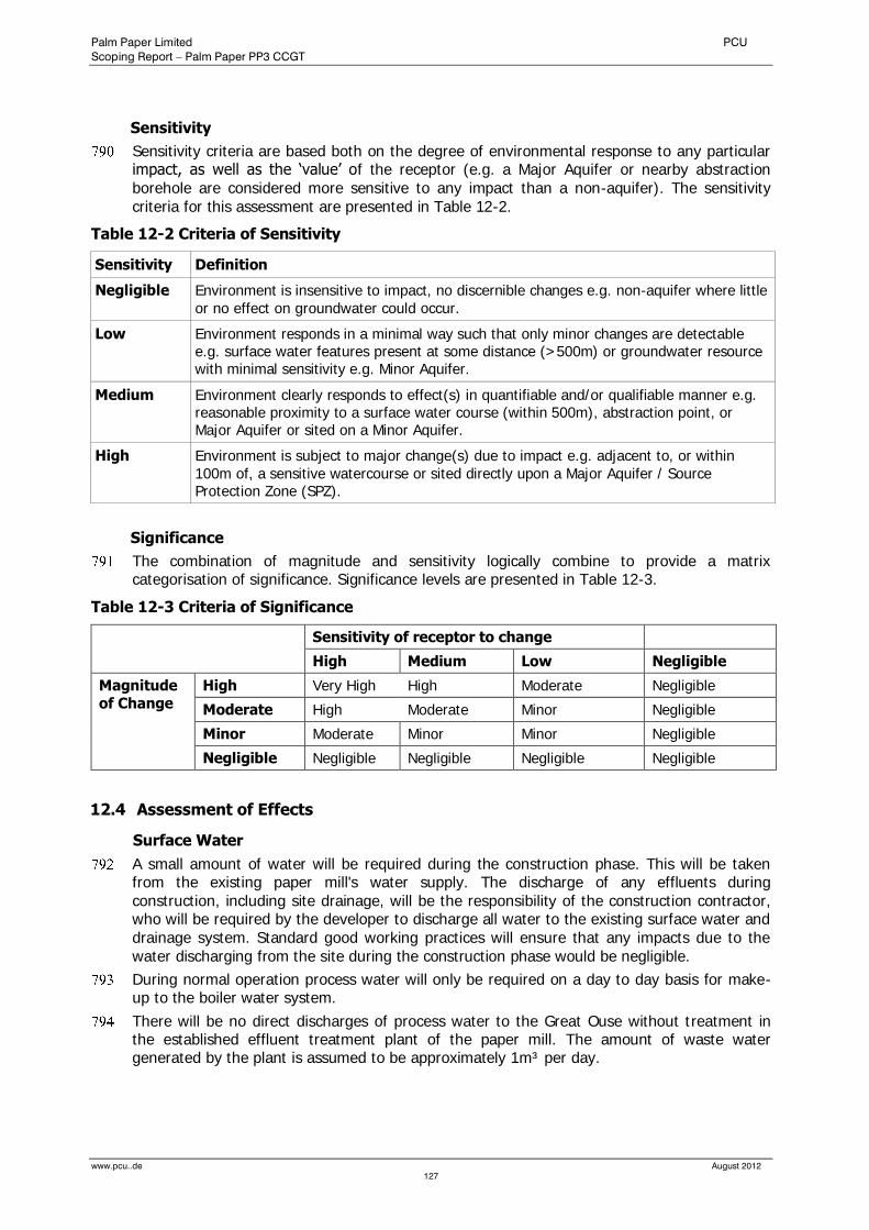
Palm Paper Limited PCU
Scoping Report – Palm Paper PP3 CCGT
www.pcu..de August 2012
127
Sensitivity
Sensitivity criteria are based both on the degree of environmental response to any particular impact, as well as the ‘value’ of the receptor (e.g. a Major Aquifer or nearby abstraction borehole are considered more sensitive to any impact than a non-aquifer). The sensitivity criteria for this assessment are presented in Table 12-2.
Table 12-2 Criteria of Sensitivity
Sensitivity Definition
Negligible Environment is insensitive to impact, no discernible changes e.g. non-aquifer where little or no effect on groundwater could occur.
Low Environment responds in a minimal way such that only minor changes are detectable e.g. surface water features present at some distance (>500m) or groundwater resource with minimal sensitivity e.g. Minor Aquifer.
Medium Environment clearly responds to effect(s) in quantifiable and/or qualifiable manner e.g. reasonable proximity to a surface water course (within 500m), abstraction point, or Major Aquifer or sited on a Minor Aquifer.
High Environment is subject to major change(s) due to impact e.g. adjacent to, or within 100m of, a sensitive watercourse or sited directly upon a Major Aquifer / Source Protection Zone (SPZ).
Significance
The combination of magnitude and sensitivity logically combine to provide a matrix categorisation of significance. Significance levels are presented in Table 12-3.
Table 12-3 Criteria of Significance
Sensitivity of receptor to change
High Medium Low Negligible
Magnitude of Change
High Very High High Moderate Negligible
Moderate High Moderate Minor Negligible
Minor Moderate Minor Minor Negligible
Negligible Negligible Negligible Negligible Negligible
12.4 Assessment of Effects
Surface Water
A small amount of water will be required during the construction phase. This will be taken from the existing paper mill's water supply. The discharge of any effluents during construction, including site drainage, will be the responsibility of the construction contractor, who will be required by the developer to discharge all water to the existing surface water and drainage system. Standard good working practices will ensure that any impacts due to the water discharging from the site during the construction phase would be negligible.
During normal operation process water will only be required on a day to day basis for make-up to the boiler water system.
There will be no direct discharges of process water to the Great Ouse without treatment in the established effluent treatment plant of the paper mill. The amount of waste water generated by the plant is assumed to be approximately 1m³ per day.
Palm Paper Limited PCU
Scoping Report – Palm Paper PP3 CCGT
www.pcu..de August 2012
128
These discharges will be controlled to limits set by the Environment Agency in the plant’s Environment Permit (EPR Permit) under the Environmental Permitting (England and Wales) Regulations 2010.
Any areas of the site that are likely to be contaminated with oil or process chemicals will drain to oil interceptors to prevent oil and chemicals discharging to the surface water drainage system. This surface water, with waters from non-contaminated areas, will be directed to the effluent treatment plant of the paper mill.
The sewage water will be collected in a separate sewer and discharged to the effluent treatment plant as well.
The sensitivity of the receiving water body to change associated with the anticipated discharge of the proposed development is low.
The magnitude of change that would be experienced in the receiving water body is considered to be negligible, therefore, the effect will be negligible.
Groundwater
As the site lies on a non-aquifer of negligible permeability the sensitivity of the area is low.
The development of the site will result in a small increase in impermeable area of approximately 3,500 m². This will not significantly influence the volume of surface water run-off nor will it significantly decrease potential infiltration. Therefore, the rating of magnitude of change, is assessed to be negligible.
Overall the effect on the groundwater will be negligible.
12.5 Mitigation Measures
As stated above, constructions impacts are considered temporary in nature.
Given the nature of the works it is possible, although unlikely, that the following potential impacts will require mitigation during the construction phase:
hydrocarbon spillages into surface or groundwater;
silty contaminated run-off into surface or groundwater;
increase in run-off due to gradual development and compaction of soils
increased sediment load within surface water flows;
A spill response plan, which all staff are made aware of, will be implemented in the event of an environmental incident. The appropriate incident response equipment will be available next to particularly sensitive activities (e.g. overpumping) or areas of the site (such as fuel storage areas). A supply of spill containment and treatment equipment and materials will be available near storage areas of hazardous materials at all times in sufficient quantities to deal with small-scale spillages and all staff will be aware of where this equipment is stored.
All on-site storage tanks will be placed on an impervious base within the construction compound. To reduce the risk of pollution via tank leakage, a secondary containment system such as a bund will be implemented. The base and bund walls would be impermeable to the material stored and able to contain at least 110% of the volume stored. Drip trays will be used under all plant during re-fuelling.
A number of measures will be put in place to minimise the potential for transport of silt into surface water features. It will be necessary to ensure that no stockpiling or other potentially polluting material is placed within drainage pathways. If necessary sediment traps or settling tanks will be installed; directing infiltration into adjacent vegetated ground to reduce silts and suspended solids.
The drainage system of the site will be constructed at an early stage. This will enable early control of discharges and management of accidental spillages.

Palm Paper Limited PCU
Scoping Report – Palm Paper PP3 CCGT
www.pcu..de August 2012
129
13.0 Traffic and Transportation
13.1 Introduction and Scope
This chapter assesses the potential effects of the proposed development on transport and traffic infrastructure issues.
A Transport Assessment has previously been prepared by T.A.Millard Ltd for the Environmental Statement of the paper mill in 2007 and forms the basis of this section. The objective of the Transport Assessment was to provide an analysis of the travel and transport implications.
The air quality and noise impacts arising from predicted traffic attributable to the proposed development are assessed in Chapters 6 and 7 respectively.
13.2 Baseline Conditions
13.2.1 Site Location
The development site is located to the south of King’s Lynn bound to the north by the A47(T), the east High Road, the river Great Ouse to the west and by Poplar Avenue to the south.
The development site accesses the local road network with a junction on to High Road, with traffic generally proceeding north towards the A47(T)/A148 Saddlebow junction on the King’s Lynn Bypass. Access to the established paper mill site is available from Poplar Avenue, which forms a simple priority junction with High Road. Saddlebow junction forms a grade separated roundabout with the A47(T) which includes facilities for cyclists to cross safely. The town of King’s Lynn lies immediately to the north of this junction via the recently completed Nar Ouse Relief Road (A148).
13.2.2 Walking and cycling
There is in 2009 newly constructed footway at the site access along Popular Avenue and High Road.
There are two Long Distance Footpaths and a National Cycle route in the vicinity of the development site. The Nar Valley Way and the Fen Rivers Way, running about 1.5km to the east and 100m to the west respectively. National Cycle Route Number 1 travels along the eastern high flood bank of the River Great Ouse. following Fen Rivers Way.
The facilities in the vicinity of the site are shown at Appendix #.
13.2.3 Public Transport
Bus services 46 and 47 pass the site travelling from March and Downham Market, respectively, to King’s Lynn and the Albion Street bus depot. The service frequencies vary between 30 and 120 minutes. Services to other areas of King’s Lynn can be accessed from the bus depot.
King’s Lynn railway station lies 4km to the north which is beyond walking and cycling limits. It would be accessible by bus for those travelling beyond King’s Lynn.
13.2.4 Vehicular Access
The site accesses the local road network with a junction on to High Road, with traffic generally proceeding north towards the A47(T)/A148 Saddlebow junction on the King’s Lynn bypass. Saddlebow junction forms a grade separated roundabout with the A47(T) which includes facilities for cyclists to cross safely. The town of King’s Lynn lies immediately to the north of this junction via the recently completed Nar Ouse Relief Road (A148). The road network to the south of the site is less suitable for major traffic.

Palm Paper Limited PCU
Scoping Report – Palm Paper PP3 CCGT
www.pcu..de August 2012
130
To the east of Saddlebow the A47(T) has a 2-way AADT flow of 15,891 (surveyed by the DfT in 2005, http://www.dft-matrix.net/) vehicles and is a dual lane all purpose trunk road up until its junction with the A10 and A149 (Hardwick). Hardwick roundabout was upgraded to provide a flyover for A47(T) traffic in 2003. The flyover and A47(T) to the east is of single carriageway standard. An additional roundabout on the A47(T) immediately east of the flyover provides an additional access to Hardwick roundabout for traffic travelling to/from the west. Destinations to the east on the A47(T) include Norwich and Great Yarmouth.
West of Saddlebow the A47(T) carries a 2-way AADT flow of 17,170 (surveyed by the DfT in 2005, http://www.dft-matrix.net/) vehicles across the river Great Ouse. Pullover roundabout on the west of the river is an at grade roundabout with the A47(T) and the A17. Traffic can proceed west towards Peterborough and Leicester on the A47(T) or north east on the A17 towards Lincoln and Newark. The A47(T) to the east is mixed dual and single carriageway and the A17 is a single carriageway.
Manual classified traffic counts have been undertaken at the site access junction of Poplar Avenue/High Road and the A47(T) Saddlebow junction on Tuesday 1st May 2007.
13.3 Assessment Methodology and Assessment Criteria
Details of the proposed assessment methodology are presented in the Transport Assessment (appended), which should be consulted for details.
13.4 Assessment of Effects
13.4.1 Construction Phase
It is expected that traffic relating to construction will be approximately 30 construction HGVs generated per day.
The average number of construction workers on site is estimated to be 35 per day. Based on an analysis of 2001 census modal split data for the ward of South and West Lynn, the number of two-way vehicle trips generated by the construction employees is expected to be 55 during the construction period and as such should bear no significant impact.
13.4.2 Operational Phase
It is anticipated that the additional pedestrian, cycle and bus use would be accommodated within the existing infrastructure.
It is expected that traffic relating to the operation of the new facility will be approximately 1 delivery HGV generated per day. The average number of employees on site is estimated to be 3 per day. Based on an analysis of 2001 census modal split data for the ward of South and West Lynn, the number of two-way vehicle trips generated by the employees is expected to be no more than 4 per day.
It, therefore, is expected that traffic generated by the development would have no significant impact upon the site access (Poplar Avenue/High Road) or the road network of the area.
With the absence of any accidents at the site access junction, the development is unlikely to have a significant impact on local road safety.
13.4.3 Mitigation Measures
It has been established that the effect of predicted increases in road traffic attributable to the proposed development will be ‘negligible’. Accordingly, mitigation measures are not required.
However, delivery vehicles would be routed so as to minimise disturbance to local residents. Traffic signage would be installed so as to ensure that facility related traffic leaving the development site will be directed northwards.

Palm Paper Limited PCU
Scoping Report – Palm Paper PP3 CCGT
www.pcu..de August 2012
131
13.5 Summary and Conclusion
Travel demands for proposals to build a new CCGT have been examined.
The site is within walking and cycling distance of southern King’s Lynn, with limited practical public transport opportunities. Sustainable travel demand could be accommodated by existing facilities.
Vehicular traffic has been assessed and can be accommodated into the transport networks existing capacity.
Accident data records for the area have been examined and no evidence of high propensity for severity was found. It is not anticipated that the proposed development would alter this situation.
Bearing the above in mind, it is concluded that so far there are no transportation issues preventing this development from taking place.
The Environmental Statement will assess cumulative effects arising as a result of other large scale developments in the vicinity of the site which are anticipated to be under construction (or with the benefit of planning permission or other development consent) at the time of construction. This will include an assessment of effects in combination with the Centrica Power Station Extension B and Willows Power & Recycling Centre to the south east of the development site.
14.0 Socio-Economics
14.1 Introduction
The potential impacts of the proposed development will be positive. It is expected that a total of 5 new direct jobs will be created. In addition, the inward investment to the area is estimated at £50M, which will further stimulate the local economy. Therefore, a detailed economic impact assessment has not been completed. An overview of the proposed project on employment in the area is summarized in this section.
14.2 Baseline Condition
The site is located on the Saddlebow Industrial Estate to the south of King’s Lynn. This is the location of the former British Sugar site, and is identified in the Local Plan as being targeted for commercial development.
King’s Lynn has an urban population of approximately 40,000 and a district population of 135,000 (2001 census). It is an important regional centre for a large rural area. Employment in King’s Lynn is concentrated in two main areas: the Central Area with about 8,400 jobs (31% of the town’s total) and the Hardwick locality (covering Hardwick, Hardwick Narrows and Saddlebow industrial estates together with the shopping areas on Hardwick Road), which has about 8,300 jobs (30% of the total). There are no other employment localities of this significance: the next biggest is the Docks/North Lynn area (2,700 jobs, 10%). The Queen Elizabeth Hospital is the town’s biggest single employer (2,100 jobs, 7%).
The proposed development will integrate closely with the objectives and planning for the Nar Ouse Regeneration Area (NORA). The Nar Ouse Regeneration Area is a so-called Millennium Community which is expected to meet environmental performance standards for its buildings that are more exacting than current building regulations. As a Millennium Community the NORA aims to meet objectives such as to minimise resource consumption, to protect and enhance environmental capital, to maximise design quality, and to achieve long-term economic viability.
The proposed site is located nearby to the major local road network, in South Lynn. It is just to the south of the A47, a major trunk road in the area, and part of the Trans-European Road Network (TERN) road system (www.dft.gov.uk).
Palm Paper Limited PCU
Scoping Report – Palm Paper PP3 CCGT
www.pcu..de August 2012
132
14.3 Assessment Methodology
A detailed economic impact assessment is not proposed for the project.
14.4 Assessment of Effects
The inward investment of the project is estimated at £50 million and there will also be substantial annual operating costs. These expenditures will result in economic benefit to the local and national economy. Overall, the potential impacts of the proposed development will be positive. It is expected that the proposed plant will provide long term employment for a total of 5 people.
Construction works to be carried out on site will include site preparation, provision of access roads within the site, piling, forming of foundations, erection of structural steel work, erection of cladding and roofing to structures, and mechanical and electrical works. There will be also be indirect employment associated with the manufacture of building materials and equipment used in construction.
During the construction phase accommodation will be required for all workers visiting the area. This will provide a strong trade for the temporary accommodation market in the region.
14.5 Mitigation Measures
Since the economic impacts of the project will be positive, no mitigation measures are warranted.
14.6 Conclusions
The proposed development will have a positive impact on the local economy.
Palm Paper Limited PCU
Scoping Report – Palm Paper PP3 CCGT
www.pcu..de August 2012
133
15.0 Geology and Ground Conditions
15.1 Introduction and Scope
Palm Paper have redeveloped the former Morston Sugar Site at Poplar Avenue, Kings Lynn into the Lynn PM7 paper mill. As part of the IPPC permitting process, a land condition report was provided to establish the existing ground conditions at the facility when the site permit became active (2009). This established baseline conditions prior to the operation of the paper mill, for future comparison to the ground conditions present in the future when the permit for the paper mill may be surrendered.
Four phases of site investigation were undertaken prior to the redevelopment of the site. The four phases of investigation (by several firms) were detailed in the following reports:
1. Land at Saddlebow Industrial Estate, Poplar Avenue, King’s Lynn. Combined Phase I Desk Study & Phase II Preliminary Exploratory Investigation, for Morston Sugar Limited. Geodyne Ltd Report Ref. 25042 dated 24 June 2005;
2. Site Investigation Lynn PM7, Morson Sugar Site, Poplar Ave, King’s Lynn for Palm Paper Ltd. RSK (with Evans & Langford) Report Ref. 50336-1(01) dated June 2007;
3. Lynn PM7 – Site Investigation for Water Treatment Works Area. Evans & Langford LLP Report Ref. D7912C/CPS dated 31 March 2008; and
4. Factual Site Investigation Report, Palm Paper, Kings Lynn (for intake/discharge pipelines). Harrison Geotechnical Engineering Report Ref. GN11828Fact dated April 2008.
This chapter draws on information presented in the above four reports. Therefore, this report presents selected extracts of data from the above reports, filtering out any data that is not within the permitted site’s boundary of the paper mill; the extents of the permitted site are provided on Figure 1 of Appendix 5. All information in these reports is pre-construction, i.e. before land was re-contoured for the mill/ETP construction. Following the initial investigations by RSK (on the former Sugar factory site only), a second phase of RSK investigation in early 2008 was combined with contamination remediation work in specific zones. Where relevant to this chapter (i.e. in pits dug in zones where no excavation / remediation was subsequently carried out), these second phase investigations were reported twice, alongside the remediation actions in the second reference:
5. Kings Lynn PM7 Site – Further Site Investigation. RSK Geoconsult Letter Report Ref. 50369/Lo5/rdc dated 19th August 2008;
6. PM7 Paper Mill, Ex-Morston Sugar Plant, Former Factory Site, Kings Lynn, Norfolk’ ‘Remediation Validation Report’, RSK Report Ref. 50369-R2(01) dated November 2008.
The comments given in this chapter are based on the ground conditions reported during the provided previous phases of site work. However, there may be conditions pertaining to the site that have not been disclosed by theses investigations and therefore could not be taken into account.
The chapter is drafted to address the following points:
summarise the environmental setting of the site;
summarise the historical land uses with respect to potential pollution history; and
provide baseline data on chemical ground conditions at permit issue.
No information is included herein on the specific land remediation works carried out in certain ‘zones’ beneath the paper mill footprint pre-construction; this is to be found in Report 50369-R2(01) – ref.6 above.
Palm Paper Limited PCU
Scoping Report – Palm Paper PP3 CCGT
www.pcu..de August 2012
134
15.2 Baseline Condition
15.2.1 Geology and Hydrogeology
Geological and hydrogeological information for the site was obtained from the Evans & Langford documents.
Geology
Reference to British Geological Survey records for the area indicates that the site is underlain by Made Ground, Alluvium and Kimmeridge Clay successively with depth. Made Ground is mapped beneath the bulk of the King’s Lynn area, although that shown beneath the site is separate from that beneath the centre of King’s Lynn, except for a narrow strip along the bank of the River Ouse, which forms a flood defence embankment. The exact origin of the Made Ground beneath the site is not clear from the geological map, although it is entirely contained by the former railway lines to the north and east, and does not extend beyond the factory buildings to the south. Therefore it is considered most likely that the Made Ground is associated with the operations of the former sugar factory.
Alluvium is a recent deposit, which covers large tracts of land in this area. A section on the geological map indicates the Alluvium to be around 10m thick. It is likely to contain a variable mixture of soft clay and silt, with thick peat bands also possible.
Kimmeridge Clay is comprehensively described in the British Geological Survey publication, “Geology of the country around King’s Lynn and The Wash’. A general description of the Kimmeridge Clay is given – “The Kimmeridge Clay is made up of soft shelly mudstones, calcareous or kerogen rich (oil shale’s) in part, with small amounts of silty mudstone, siltstone, and muddy limestone. Pyrite is present throughout and phosphatic pebble beds occur at a few horizons.”
The geological map shows the outcrop (beneath more recent deposits) of four cementstone beds (K1-K4), identified by seismic reflection in The Wash and in boreholes on land. The band K2 is shown running approximately north-south, through the centre of the northern portion of the site. The detailed records for the Kimmeridge Clay describe K2 as a ‘persistent tabular cementstone band’ of relatively limited thickness. Boreholes on the eastern side of the site are likely to intercept this bed, and the beds immediately above, which mainly comprise mudstones. Immediately below bed K1, there is an approximately 3.6m thick layer of oil-shale rich mudstone, with further mudstones below.
Hydrogeology
The 1:100,000 scale Environment Agency Groundwater Vulnerability Map of the area indicates that the site lies on a non-aquifer of negligible permeability. This classification applies to the underlying Kimmeridge Clay. Non aquifers are formations that are generally regarded as containing insignificant quantities of groundwater.
According to the Environment Agency, the site does not lie within a currently defined source protection zone for public water supply. There are numerous water abstractions within 2km of the site. However these are all surface water or stream abstractions.
Groundwater will be present within the alluvial deposits. Such shallow groundwater, although not typically exploited by abstraction boreholes, could act as a pathway by which mobile contaminants could travel.
The deeper confined groundwater found in granular deposits at the base of the Alluvium was sampled and analysed during the 2007 investigation (Report No. 2 above). The laboratory testing results found it to be unaffected by the previous uses at the sugar factory site, agreed by the EA groundwater consultee. It is not known if any of the Evans & Langford or Geodyne boreholes remain in place and useable, post-construction of the mill.
Palm Paper Limited PCU
Scoping Report – Palm Paper PP3 CCGT
www.pcu..de August 2012
135
15.2.2 Pollution History
Detailed soil sampling and analysis have been carried out for the original Planning Application for the site.
Based on the Phase I survey, a detailed intrusive Phase II site investigation was undertaken by Evans and Langford and RSK. This included investigation of soil, groundwater, and ground gas conditions. In addition, an intrusive site investigation had been previously undertaken by GeoDyne in 2006. The results of that survey have also been incorporated into the Phase II investigation tasks.
The complete Site Investigation reports for the Phase II SI tasks are given in the Appendix 5, and summarized below.
Soil Investigation
The Phase II Site Investigation work was carried out during the period 19th March 2007 and 10th April 2007. It included the sinking of 58 probe holes (many with pre-coring of concrete slabs) which were supervised and logged by an Engineer from RSK. The locations of probe holes are indicated in Drawing D7192/04A. This also shows the location of Geodyne trial pits and boreholes, together with other recent geotechnical work by Evans & Langford (E&L).
Representative samples were taken from the window sampling tubes and returned to the laboratory for analysis; field recording of vapours using a PID were carried out, on the opened liner barrels.
The ground conditions encountered during the investigation were in general agreement with the published geological records for the area and the GeoDyne 2005 site investigation report. Within the area of the former sugar plant buildings, concrete slab/ bituminous paving was encountered in all areas, in some areas below this loose gravel material overlying a second concrete slab. Beneath the concrete slab, where penetrated, Made Ground was encountered to depths between 0.13m and 1.80m comprising loose gravel in a silty matrix including occasional fragments of brick, ash, shell and timber.
Beneath this, firm becoming soft clay Alluvium with lenses of silt and bands of peat was encountered, to the full depths of the trial pit and probe hole investigation of between 3.00m and 4.00m.
Groundwater Investigation
E&L installed 12 wells for groundwater and gas monitoring purposes in May-June, and two of the GeoDyne wells (GBH4 & GBH6) were also monitored. RSK conducted groundwater sampling in the 12 E&L wells installed in their 21 deep boreholes; the permeable response zone in each well varied (see Summary sheet in Gas Assessment Report, or Logs in E&L Geotechnical Report).
Water levels in the standpipes were recorded using a dip meter. During this visit groundwater samples were recovered from all twelve installations. Three well volumes of water were removed from installations and water samples were taken using a disposable bailer. Samples were placed in airtight amber glass jars and/or vials and returned to the laboratory for analysis.
Ground Gas
Three rounds of ground gas monitoring were conducted by Harrison Group Environmental at each installation (17th May, 25th May, and 15th June 2007). Ground gas composition and flow was recorded at each location. Both flow (litres per hour) and composition (%) were measured using a GA2000 infra-red monitor, calibrated for methane, carbon dioxide & oxygen. Records were also taken of atmospheric pressure, and relative pressure. The results are presented in the appendix of the report on the relevant sheets.
During the construction of the paper mill all contaminated areas of the Palm Paper premises were remediated.

Palm Paper Limited PCU
Scoping Report – Palm Paper PP3 CCGT
www.pcu..de August 2012
136
15.2.3 Ground Condition Baseline Data
The baseline chemical analysis data with respect to ground conditions has been extracted from the four previously issued ground investigation reports and the later ‘validation’ report, as listed in Section 15.1. The relevant locations where baseline data has been selected/extracted for this Report, are shown in Figure 2 of Appendix #. There is a sector of the Permit site in the eastern, upper central zone where there is a dearth of chemical testing data to be found in the site investigations by GeoDyne & Evans/Langford, being chiefly for geotechnical purposes in that respect; Geodyne pit TP7 lies just outside the permit line and could be deemed relevant if this area requires ‘coverage’; test data for (G)TP7 can be found in Appendix A herein.
Tables 1 to 5 of Appendix 5 detail the chosen baseline data points, the justification for the selection of the data point and the depth and type of strata the baseline data refers to, and the chemical testing undertaking at that location. A separate table is provided for each of the original data sets (Table 1 - Geodyne Ref. 25042 dated June 2005; Table 2 - RSK Geoconsult Ref. 50336-1(01) dated June 2007; Table 3 - Evans & Langford Ref. D7912C/CPS dated 31 March 2008; Table 4 – Harrison Geotechnical Ref. GN11828Fact dated April 2008; and Table 5 – RSK Geoconsult Letter Ref. 50369/L05 dated August 2008).
Copies of the original MCERTS accredited laboratory analysis data for each of these locations is provided in Appendices A to E of the report (Appendix 5). It should be noted that, in Appendices A to E, due to the function of multiple location testing results being provided on each sheet of the original laboratory test certificates, a test certificate may have results that are not pertinent to the permitted site. Any such results have been clearly crossed through, indicating their non-relevance to the permitted site conditions.
The permitted site of the paper mill has been subjected to remedial works (pre-construction of the mill) to mitigate risks posed by soil contamination in specific locations, that was identified during the various phases of site investigation. Details of the extent of remedial work were presented within a formal Remedial Strategy, which was approved during Planning and is summarised within ref. 6 = RSK Report Ref. 50369-R2(01).
Zones A to H were deemed to be potential remediation zones within the former factory confines; of these, zones F, G, H are outwith the SPMP boundary. Zones A to E on the mill site in question were investigated / tested further, with the result that (see Section 5.2 of Appendix 5) only zones A and D required remedial action, but an additional zone Bi was identified as contaminated. Section 7.2 of the same report records that soils from areas A, Bi, and D were subject to ex-situ bioremediation, with the treated soils not being returned to the ‘voids’ left in the main site area, but instead being re-used elsewhere around the site (outwith this permit boundary).
The excavations that occurred in zones A, Bi, and D were backfilled with crushed concrete. Therefore, as the excavations were validated ‘clean’ on their base and sides (see Ref. 6 for test data) and were infilled with clean crushed material, samples in these remediated areas have not been chosen for inclusion as baseline data points. However, two analysed soil samples (TPRSK23 and TPRSKE3) from “un-remediated” zones C and E have been chosen to be baseline data points, along with other sample points from within areas not requiring remediation (second phase investigation trial pits, as in Ref. 5).
15.3 Mitigation Measures
When assessing the residual impacts relating to the construction phase of the development, it has been assumed that the confirmed mitigation measures described in the following documents will be complied with:
Protection of Workers and the General Public during the Development of Contaminated Land, HSE, 1991.
A Guide to Safe Working on Contaminated Sites, R132, CIRIA, 1996.
Palm Paper Limited PCU
Scoping Report – Palm Paper PP3 CCGT
www.pcu..de August 2012
137
15.4 Assessment of Residual Impacts
Provided the mitigation measures detailed in Section 15.3 are strictly followed, there are not expected to be any residual impacts arising from the development on soils and geology, hydrology, drainage and hydrogeology, the health of construction workers, or the health of current site users.
15.5 Conclusions
Based on extensive site investigation works carried out, further investigation works are not considered necessary to define the contamination that may be present on site for the proposed CCGT.
From the ground investigation results it is concluded that the site does not pose a significant risk to the environment and that assuming continued industrial usage, human health risks associated with ground contamination are considered to be low. Contamination risks will be mitigated by the measures outlined in section 15.3., which will ensure residual risks are low for the proposed development.
The construction and the operation of the new CCGT will not result in any contamination of soil or groundwater.
16.0 Other Considerations
Construction programme and construction methodology
As part of the engineering design work, a detailed programme for the development will be determined. Broadly this consists of phased but inter-related construction activities conducted in 2012. Subject to planning permission, construction work is planned to start in 2012.
Standard construction techniques as previously used for buildings, car parks, roads and pavements, lighting, utility services and telecommunications, and paper mill construction will be adopted.
Access and transport
The majority of material and equipment necessary for the construction works will be delivered to the site by road (via the A47). A construction transport management plan will be developed by Palm Paper to minimise the number of vehicle movements (e.g. by ensuring that where possible both inward and outward movements are being utilised for transporting materials/waste etc., agree routings for construction traffic, and hours of activity.
Standard best practice, agreed in advance with the relevant highways authority, will be adopted to manage potential effects for non-construction traffic.
Site environmental management plan
A site environmental management plan (SEMP) will be prepared by Palm Paper in order to manage and minimise the potential environmental impacts of construction activities. This will cover areas such as pollution, visual effects, noise, dust, ground conditions, traffic, sensitive ecological areas, and any necessary supervision by an ecological clerk of works. It will incorporate construction practice with reference to appropriate British Standards (e.g. BS 5228: Noise and vibration control on construction and open sites). Best working practices will be stipulated in the SEMP and will be a contractual requirement for the chosen civil engineering contractors. The SEMP will be audited and enforced by Palm Paper during the works.
Waste disposal
Waste material, other than that which can be recycled and re-used on site, will be disposed of to licensed landfill facilities. Excavated material that cannot be reused as backfill in the works will be disposed of off-site. The aim will be for re-use on site in order to minimise traffic movements, but surplus quantities may arise. The volume of material and likely impacts on the working method will be assessed during the EIA. Waste management will comply with
Palm Paper Limited PCU
Scoping Report – Palm Paper PP3 CCGT
www.pcu..de August 2012
138
Waste Management Regulations 1994 and Duty of Care Regulations 1991, and will be finalised in consultation with the Environment Agency (EA).
17.0 Conclusions
Based on the assessments of this report, the key observations and conclusions for each environmental aspect are presented on Table 17-1.
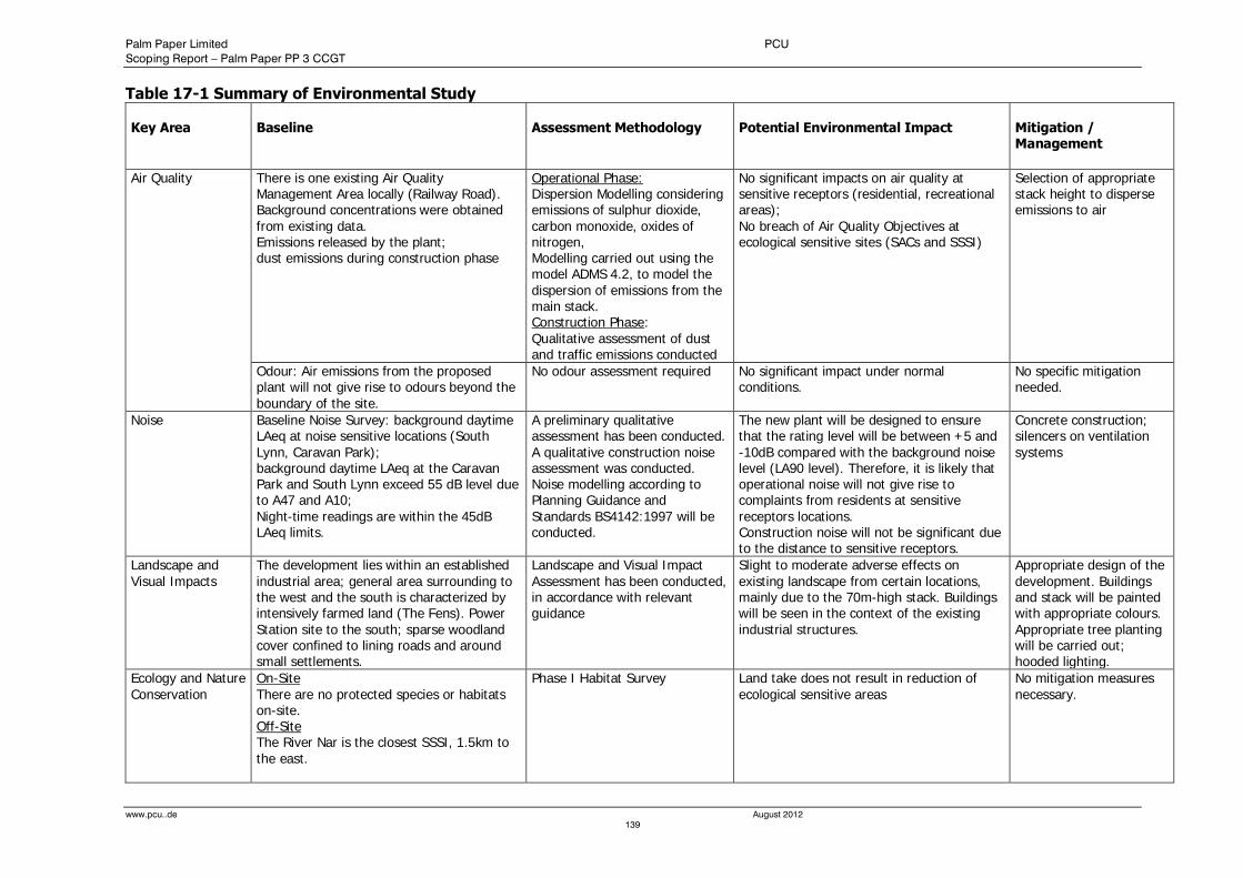
Palm Paper Limited PCU
Scoping Report – Palm Paper PP 3 CCGT
www.pcu..de August 2012
139
Table 17-1 Summary of Environmental Study Key Area
Baseline
Assessment Methodology
Potential Environmental Impact
Mitigation / Management
Air Quality There is one existing Air Quality Management Area locally (Railway Road). Background concentrations were obtained from existing data. Emissions released by the plant; dust emissions during construction phase
Operational Phase: Dispersion Modelling considering emissions of sulphur dioxide, carbon monoxide, oxides of nitrogen, Modelling carried out using the model ADMS 4.2, to model the dispersion of emissions from the main stack. Construction Phase: Qualitative assessment of dust and traffic emissions conducted
No significant impacts on air quality at sensitive receptors (residential, recreational areas); No breach of Air Quality Objectives at ecological sensitive sites (SACs and SSSI)
Selection of appropriate stack height to disperse emissions to air
Odour: Air emissions from the proposed plant will not give rise to odours beyond the boundary of the site.
No odour assessment required No significant impact under normal conditions.
No specific mitigation needed.
Noise Baseline Noise Survey: background daytime LAeq at noise sensitive locations (South Lynn, Caravan Park); background daytime LAeq at the Caravan Park and South Lynn exceed 55 dB level due to A47 and A10; Night-time readings are within the 45dB LAeq limits.
A preliminary qualitative assessment has been conducted. A qualitative construction noise assessment was conducted. Noise modelling according to Planning Guidance and Standards BS4142:1997 will be conducted.
The new plant will be designed to ensure that the rating level will be between +5 and -10dB compared with the background noise level (LA90 level). Therefore, it is likely that operational noise will not give rise to complaints from residents at sensitive receptors locations. Construction noise will not be significant due to the distance to sensitive receptors.
Concrete construction; silencers on ventilation systems
Landscape and Visual Impacts
The development lies within an established industrial area; general area surrounding to the west and the south is characterized by intensively farmed land (The Fens). Power Station site to the south; sparse woodland cover confined to lining roads and around small settlements.
Landscape and Visual Impact Assessment has been conducted, in accordance with relevant guidance
Slight to moderate adverse effects on existing landscape from certain locations, mainly due to the 70m-high stack. Buildings will be seen in the context of the existing industrial structures.
Appropriate design of the development. Buildings and stack will be painted with appropriate colours. Appropriate tree planting will be carried out; hooded lighting.
Ecology and Nature Conservation
On-Site There are no protected species or habitats on-site. Off-Site The River Nar is the closest SSSI, 1.5km to the east.
Phase I Habitat Survey Land take does not result in reduction of ecological sensitive areas
No mitigation measures necessary.
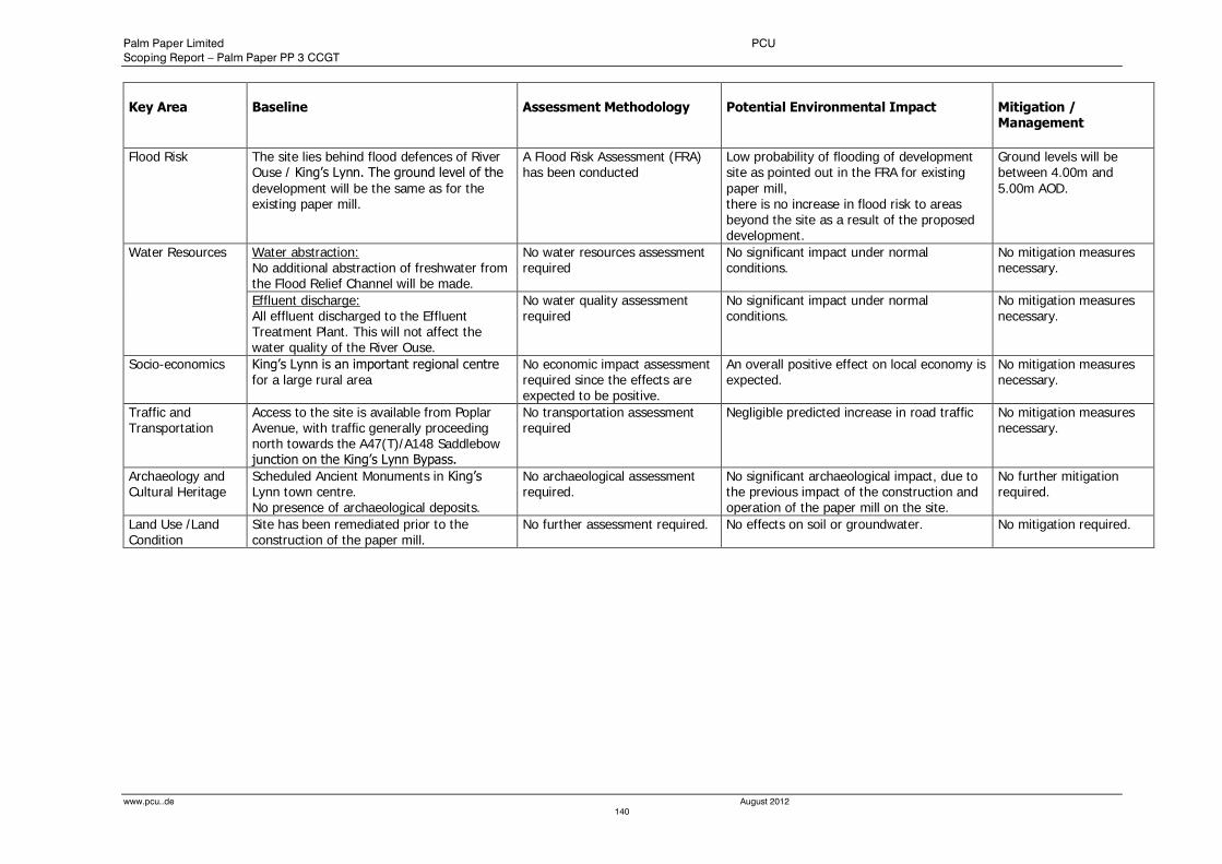
Palm Paper Limited PCU
Scoping Report – Palm Paper PP 3 CCGT
www.pcu..de August 2012
140
Key Area
Baseline
Assessment Methodology
Potential Environmental Impact
Mitigation / Management
Flood Risk The site lies behind flood defences of River Ouse / King’s Lynn. The ground level of the development will be the same as for the existing paper mill.
A Flood Risk Assessment (FRA) has been conducted
Low probability of flooding of development site as pointed out in the FRA for existing paper mill, there is no increase in flood risk to areas beyond the site as a result of the proposed development.
Ground levels will be between 4.00m and 5.00m AOD.
Water Resources Water abstraction: No additional abstraction of freshwater from the Flood Relief Channel will be made.
No water resources assessment required
No significant impact under normal conditions.
No mitigation measures necessary.
Effluent discharge: All effluent discharged to the Effluent Treatment Plant. This will not affect the water quality of the River Ouse.
No water quality assessment required
No significant impact under normal conditions.
No mitigation measures necessary.
Socio-economics King’s Lynn is an important regional centre for a large rural area
No economic impact assessment required since the effects are expected to be positive.
An overall positive effect on local economy is expected.
No mitigation measures necessary.
Traffic and Transportation
Access to the site is available from Poplar Avenue, with traffic generally proceeding north towards the A47(T)/A148 Saddlebow junction on the King’s Lynn Bypass.
No transportation assessment required
Negligible predicted increase in road traffic No mitigation measures necessary.
Archaeology and Cultural Heritage
Scheduled Ancient Monuments in King’s Lynn town centre. No presence of archaeological deposits.
No archaeological assessment required.
No significant archaeological impact, due to the previous impact of the construction and operation of the paper mill on the site.
No further mitigation required.
Land Use /Land Condition
Site has been remediated prior to the construction of the paper mill.
No further assessment required. No effects on soil or groundwater. No mitigation required.
Palm Paper Limited PCU
Scoping report – Palm Paper PP3 CCGT
www.pcu.de August 2012
141
18.0 References
BSPConsulting February 2007, Flood Risk Assessment. Former Sugar Beet Factory off Poplar Avenue, Kings
Lynn.
Defra 2005, Water Framework Directive Summary Report Of The Characterisation, Impacts And Economics Analyses Required By Article 5 Anglian River Basin District
Defra, 24th May 2007, Waste Strategy for, England 2007
East Of England Development Agency, Regional Fishing Plan, Final Report, June 2006;
Environment Agency 2005, The North West Norfolk Catchment Abstraction Management Strategy March 2005, www.environment-agency.gov.uk/cams
Environment Agency, 1993, River Corridor Survey of the Relief Channel
Environment Agency, 2005, Fish Population Survey of the Great Ouse Relief Channel, 2005
European Commission, 2001, Integrated Pollution Prevention and Control (IPPC) Reference Document on Best Available Techniques in the Pulp and Paper Industry December 2001
Evans & Langford LLP & Palm Paper Ltd. June 2007, Evans & Langford LLP & Palm Paper Ltd. June 2007, Site Investigation Lynn PM7, Morston Sugar Site, Poplar Avenue, King’s Lynn..
Fichtner UK, November 2010, Air Quality Assessment. Palm Paper, King’s Lynn,
GeoDyne Ltd – Combined Phase1 Desk Study & Phase 2 Preliminary Investigation, for Morston Sugar Ltd. Project No 25042, dated 24th June 2005.
JNCC (2006a) Ramsar Information Sheet: UK11072. The Wash. JNCC
JNCC (2006b) Natura 2000 Standard Data Form. The Wash and North Norfolk Coast SAC.
JNCC (2006c) Natura 2000 Standard Data Form. Ouse Washes SAC. JNCC.
JNCC (2006d) Natura 2000 Standard Data Form. Ouse Washes SPA. JNCC.
JNCC, 1996,The Wash Estuary, Management Plan, 1996;
JNCC, 2004, The Wash Estuary Management Plan 2nd Revised Edition 2004;

Palm Paper Limited PCU
Scoping report – Palm Paper PP3 CCGT
www.pcu.de August 2012
142
19.0 Drawings and Figures

Palm Paper Limited PCU
Scoping report – Palm Paper PP3 CCGT
www.pcu.de August 2012
143
20.0 Appendices