Embed Size (px)
Citation preview

Pacific Island Network
Vital Signs Monitoring Plan
Appendix A: American Memorial Park Resource Overview
Allison Snyder (NPS)
Pacific Island Network (PACN) Territory of Guam War in the Pacific National Historical Park (WAPA) Commonwealth of the Northern Mariana Islands American Memorial Park, Saipan (AMME) Territory of American Samoa National Park of American Samoa (NPSA) State of Hawaii USS Arizona Memorial, Oahu (USAR) Kalaupapa National Historical Park, Molokai (KALA) Haleakala National Park, Maui (HALE) Ala Kahakai National Historic Trail, Hawaii (ALKA) Puukohola Heiau National Historic Site, Hawaii (PUHE) Kaloko-Honokohau National Historical Park, Hawaii (KAHO) Puuhonua o Honaunau National Historical Park, Hawaii (PUHO) Hawaii Volcanoes National Park, Hawaii (HAVO)
http://science.nature.nps.gov/im/units/pacn/monitoring/plan/
National Park Service U.S. Department of the Interior

Appendix A: American Memorial Park Resource Overview
2
Suggested citation:
Snyder, A. 2006. Appendix A: American Memorial Park resource overview. In: HaySmith, L., F. L. Klasner, S. H. Stephens, and G. H. Dicus. Pacific Island Network vital signs monitoring plan. Natural Resource Report NPS/PACN/NRR—2006/003 National Park Service, Fort Collins, Colorado.
Last revision: 14 February 2005
Organization contact information:
National Park Service (NPS), Inventory and Monitoring Program, Pacific Island Network, PO Box 52, Hawaii National Park, HI 96718, phone: 808-985-6180, fax: 808-985-6111, http://science.nature.nps.gov/im/units/pacn/monitoring/plan/
Hawaii-Pacific Islands Cooperative Ecosystems Studies Unit (HPI-CESU), University of Hawaii at Manoa, 3190 Maile Way, St. John Hall #408, Honolulu, HI 96822-2279
Acknowledgements:
This appendix was prepared with assistance from the Hawaii-Pacific Islands Cooperative Ecosystems Studies Unit (HPI-CESU).

National Park Service 3
EXECUTIVE SUMMARY
Enabling Legislation
"On August 18, 1978 (P.L. 95-348), the U.S. Congress authorized and directed the U.S. National Park Service '...to develop, maintain and administer the existing American Memorial Park (AMME) located at Tanapag Harbor Reservation, Saipan. The park shall be administered for the primary purpose of honoring the dead in the World War II Mariana Island campaign'" (General Management Plan 1989). The U.S. National Park Service was further directed to provide interpretive activities at the park and interpret historical aspects in four languages: English, Chamorro, Carolinian, and Japanese. The primary use of interpretation would be a description of the World War II battle for Saipan and its relationship to the Pacific Theater as a whole. Secondary interpretive themes would encompass the ecological and environmental resources of the park. Lastly, the early history of Saipan could be interpreted to explain its relationship to subsequent historical events.
To find enabling legislation documents on-line, follow the “Policy & Legislation” link from the Pacific Island Network website (www1.nature.nps.gov/im/units/pacn).
Geographic Setting
American Memorial Park is on the island of Saipan within the Commonwealth of the Northern Mariana Islands (CNMI). The Mariana Island chain stretches from Guam toward Okinawa and Japan. The 133-acre park is on the west side of the island. Elevation ranges from mean sea level to 10 feet. The climate is tropical; relative humidity is generally within 80-90%, with temperatures ranging from 68 to 89 degrees Fahrenheit. Average annual rainfall is 83 inches. Saipan is repeatedly affected by tropical cyclones (often several per decade), which have caused major damage in the past. Furthermore, the park lies in a floodplain. Most park visitors are local residents, and the beach area experiences heaviest use. Recreation includes picnicking, swimming, fishing, boating, athletic events, and ceremonial use. Most of the adjacent landowners are private and include the Hyatt and Victoria Hotels. The park is bounded by public roads, and the town of Garapan borders the south side. The CNMI government owns Puerto Rico Dump/Lower Base on the northeast side of the park as well as the waters to the west and north, including a beach and a boat harbor with an access channel created during World War II.
Appendix A: American Memorial Park Resource Overview
4
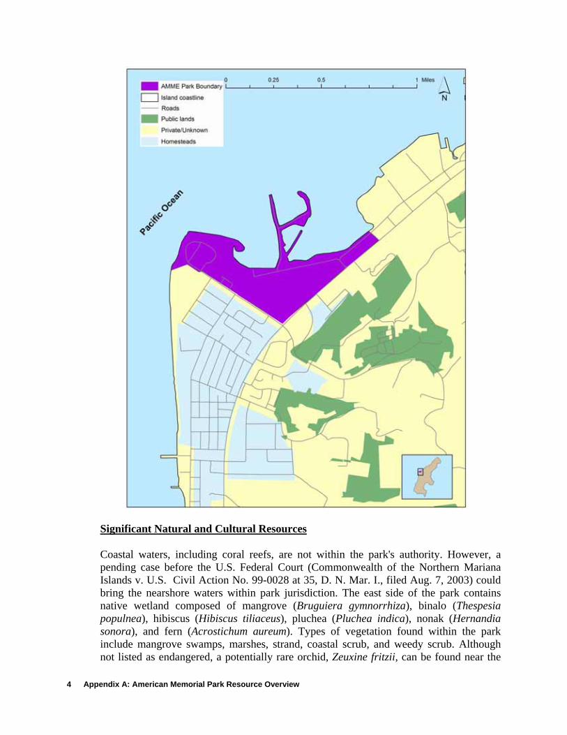
Significant Natural and Cultural Resources
Coastal waters, including coral reefs, are not within the park's authority. However, a pending case before the U.S. Federal Court (Commonwealth of the Northern Mariana Islands v. U.S. Civil Action No. 99-0028 at 35, D. N. Mar. I., filed Aug. 7, 2003) could bring the nearshore waters within park jurisdiction. The east side of the park contains native wetland composed of mangrove (Bruguiera gymnorrhiza), binalo (Thespesia populnea), hibiscus (Hibiscus tiliaceus), pluchea (Pluchea indica), nonak (Hernandia sonora), and fern (Acrostichum aureum). Types of vegetation found within the park include mangrove swamps, marshes, strand, coastal scrub, and weedy scrub. Although not listed as endangered, a potentially rare orchid, Zeuxine fritzii, can be found near the
National Park Service 5
boundaries of the park. Wildlife includes collared kingfishers (Halcyon chloris), Micronesian honeyeaters (Myzomela rebratra), bridled white-eyes (Zosterops conspicillatas saypani), golden white-eyes (Cleptornis marchei), rufous fantails (Rhipidura rufifrons), and island swiftlets (Aerodramus vanikorensis). Migratory shorebirds are common along the tidal flats. Several species, including the nightingale reed-warbler (Acrocephalus luscinia), moorhen (Gallinula chloropus guami), and Mariana mallard (Anas oustaleti), are listed as threatened or endangered. The humped tree snail (Partula gibba), a Species of Concern (SOC) that is now apparently extirpated from Guam, was recently found in the park.
The beach within AMME was used by ancient Chamorro as a training beach for celestial navigators. Several areas within the park have cultural significance to the local Carolinian populations and are used for traditional ceremonies. These sites are protected by NPS historic preservation policies and are included in a proposed Micronesian cultural center. World War II related sites and features exist within the park.
Resource Management Priorities
Due to the park's primary designation as a historic monument, management priorities center on recreational, environmental, and cultural resources. Near the park, the Puerto Rico dump is closed, and its impact on the surrounding ecosystems is being evaluated (see monitoring projects, below). Completed inventories around AMME exist for geology, soils, birds, and wetland vegetation. Monitoring projects exist for earthquakes, erosion, birds, and water quality.
The park is a “living memorial” and will be maintained with picnic facilities, roads, parking, and restrooms.
NATURAL RESOURCES
Focal Ecosystems and Processes
• Wetlands/mangroves • Threatened and endangered species • Coral reefs (not within park) • Nearshore marine water (not within park) • Shoreline dynamics • Migratory birds
Wetlands: The inland mangrove-wetland complex is unique to Saipan, as well as to the Pacific Island Network. Furthermore, AMME is the only park in the Pacific Island Network that has native mangroves. This wetland has fresh water at the periphery and is saline in the center, suggesting a marine connection. Main wetland species include mangrove (Bruguiera gymnorrhiza), pluchea (Pluchea indica), binalo (Thespesia populnea), beach hibiscus (Hibiscus tiliaceus), aquatic fern (Acrostichum aureum), and nonak (Hernandia sonora). The distribution of Saipan’s single species of mangrove

Appendix A: American Memorial Park Resource Overview
6
occurs almost entirely within the park’s boundary. The AMME mangrove wetland has approximately 200 species of plants and animals. For vegetation, “Thirteen (10%) of the species are native ferns and fern allies. The remainder are flowering plants. Fifty-six species (44%) are indigenous- two are endemic to the Marianas. Seventy-two species (56%) are introduced, sixty-seven (78%) of which are naturalized” (from Raulerson and Rinehart 1989) (Uyehara 1997). The wetlands also includes two endangered species of birds, the nightingale reed-warbler (Acrocephalus luscinia) and the Mariana common moorhen (Gallinula chloropus guami), and also includes the SOC humped tree snail (Partula gibba). Collared kingfishers, Micronesian honeyeaters, Micronesian starlings, bridled and golden white-eye, rufous fantails, yellow bittern, Marianas fruit-dove, and island swiftlets have been seen in the park’s wetlands. Adjacent to the wetland is the Puerto Rico mudflat, which serves as an important habitat for migratory birds. Threatened and Endangered species: Federally listed threatened or endangered bird species include the Micronesian megapode (Megapodius laperouse), the Mariana common moorhen (Gallinula chloropus guami), the Mariana gray swiftlet (Aerodramus vanikorensis bartschi), the Mariana crow (Corvus kubaryi), the nightingale reed-warbler (Acrocephalus luscinia), the Guam rail (Rallus owstoni), and Mariana mallard (Anas oustaleti) (believed to be extinct). Other threatened and endangered species include the hawksbill sea turtle (Eretmochelys imbricata), leatherback sea turtle (Dermochelys coriacea), green sea turtle (Chelonia mydas), loggerhead sea turtle (Caretta caretta)1, and Tinian monarch (Monarcha takatsukasae). The only federally listed plant is the fire tree (Serianthes nelsonii). However, at least one orchid species (Zeuxine fritzii) has been identified as rare (Raulerson and Rinehart 1989). Additional species listed by the Commonwealth are the Micronesian gecko (Perochirus ateles), Rota-bridled white-eye
1. Green sea turtles are threatened in Pacific. Hawksbill are endangered. Leatherbacks are endangered throughout their range in the US. Loggerheads are listed as threatened.
(Zosterops rotensis), cat’s tail (Lycopodium phlegmaria var. logifolium), sheath-tailed bat (Emballonura semicaudata), and Mariana fruit bat (Pteropus mariannus mariannus). Two turtle species, green and hawksbill, have attempted nesting on AMME beaches in the recent past. It was believed that these attempts were “false nestings” (D. Minton, pers. comm). However, in the late 1990s, large numbers of juvenile green turtles were found in the marina adjacent to the park boundary, suggesting that a successful nesting occurred nearby, potentially within the park. Coral reefs: Although the reefs are technically not within the park's jurisdiction (see above), they are a significant resource. Reefs in the Mariana Islands are diverse, well-formed, in good-to-excellent condition, and are moderately well studied. Some reef areas have experienced bleaching, but high mortality was only documented in 2001 (Turgeon 2002). In the Mariana Islands, there are 119 known species of non-scleractinian corals (Paulay et al. 2003), 377 species of scleractinian corals (Randall 2003), 26 species of hydrozoan coral (Randall 2003) and 1,019 shorefishes (Myers and Donaldson 2003). The reefs near AMME lie within the Managaha Lagoon, the only true lagoonal system within the Mariana Islands. This lagoon is enclosed by an extensive, well-developed barrier reef
National Park Service 7
system and is the location of Saipan's principal harbor. Investigations of corralline lethal orange disease, tumors, and black-band disease are being carried out (Turgeon 2002). Nearshore marine waters: Nearshore waters around CNMI include over 150 algae species, 3 seagrass species, 1 mangrove species, 101 crustacean species, 15 echinoderm species, 30 annelid species, 520 molluscan species, 28 sponge species, and 11 ascidian species. Nearshore waters also include two gastropods that are endemic to the southern Marianas and Guam (Starmer et al 2002). Shoreline dynamics: The size of the sandy shoreline at Micro Beach is subject to fluctuation. Erosion has been documented at the beaches within AMME, but it is currently believed to be a natural phenomenon. The Army Corps of Engineers conducted an assessment and made management recommendations to reduce beach erosion, but recommendations need to be carefully reviewed for their environmental impacts before implementation. A document discusses some of the historical changes in shoreline patterns and makes recommendations to stabilize the shoreline (Dean 1991). However, predictions from this document have not yet occurred, suggesting that the shoreline may be reaching a stable state. Park staff is now assessing the rate of beach erosion in cooperation with CNMI Coastal Resource Management Office (CRMO). Migratory birds: Several migratory birds have temporary residence within the park, including golden plovers (Pluvialis dominica), Pacific reef-herons (Egretta sacra), red-footed boobies (Sula sula rubripes), Mariana common moorhens (Gallinula chloropus guami), whimbrels (Numenius phaeopus), sandpipers (Actitis sp.), and ruddy turnstones (Arenaria interpres).
Threats & Stressors:
• Tropical cyclones • Earthquakes, tsunami, and volcanic activity • Illegal dumping and abandoned equipment • Effluent and runoff • Shoreline erosion • Development and tourism • Alien species • Overfishing
Tropical Cyclones: Tropical cyclones can cause water damage from flooding and storm surge, along with coastal erosion, impacting nearshore, coastal, and inland ecosystems, including reefs, wetlands, and mud flats. They may also produce wind damage to forested areas, potentially disrupting ecosystem processes. The beach at AMME is usually washed over during tropical storms, such as in Ryan-1992, Gay-1992, Wilda-1994, Keith-1997, Winnie-1997, and Paka-1997. A result of storm surge and overwash is erosion of beaches and reefs, deposition of debris and rocks, and destruction of built structures. Storm surge associated with Ryan removed at least 15 feet of sand from Micro Beach at AMME in 1992.

Appendix A: American Memorial Park Resource Overview
8
Earthquakes, tsunami, and volcanic activity: Earthquakes can potentially raise or lower local sea level, which might disrupt wetlands, uproot trees, and alter coastal habitats. Earthquakes from both proximal and distal sources may also generate tsunami. Volcanic ash from nearby active volcanoes is also a potential threat. Ash erupted from nearby active volcanoes (Anatahan, Pagan, Agrigan, and Farralon de Pajaros) can have a significant impact on AMME if the ash plume were to drop ash onto the park or nearby waters. Additionally, volcanic gas emissions from nearby active volcanoes affect air quality.
Illegal dumping and abandoned equipment: Rubbish dumping continues to occur in the park. In the past, the wetland had been affected by filling and waste oil (www.wetlands.org accessed 7/13/2004). A report on oil remediation in the park was recently finished for the Army Corps of Engineers (Will Chee Planning Inc., 2004).
Effluent and Runoff: A stream-like ditch running along the western edge of the park receives runoff and effluent from the Hyatt Hotel desalinization facility, which is regulated by the Environmental Protection Agency (EPA) under its National Pollutant and Elimination Discharge System (NPDES) program. Despite this monitoring and permitting process, CNMI standards maintain that the salinity of discharged water should not affect a change in the ambient salinity of the receiving waters. The Hyatt is in the process of completing injection wells and will then be able to divert discharge away from the channel. The channel is being expanded to handle additional runoff from Garapan, which is undergoing renovation to alleviate flooding problems. As part of the channel expansions, CNMI is planning to install an artificial wetland system. Water quality at AMME is also threatened by the nearby Puerto Rico Dump, illegal dumping, a public marina, and leakage or seepage from abandoned fuel tanks and military equipment.
Shoreline erosion: Erosion has been documented at the beaches within AMME, but it is currently believed to be a natural phenomenon. The Army Corps of Engineers conducted an assessment and made management recommendations to reduce beach erosion. Historical changes in shoreline patterns and recommendations to stabilize the shoreline are documented in Dean (1991). Work has been started by park staff to assess the rate of beach erosion at the park.
Development and tourism: The nearby town of Garapan is experiencing increased development. Paved areas in and near the park contribute to sedimentation in nearshore waters (Starmer et al. 2002). The park is heavily used during celebrations such as the annual Flame Tree and Liberation Day Festival. The most important stressors caused by development and tourism include trampling, illegal harvesting of vegetation, and rubbish dumping.
Alien species: Most of the park is dominated by alien plant species except for the native wetland. Wetland areas are at risk for invasion by weedy plants, which may alter the structure of vegetation communities. Invasive vines, scarlet gourd (Coccinia grandis) and chain-of-love (Antigonon leptopus), are overgrowing the edge of the wetland, and introduced mosquito fish (Gambusia affinis) and tilapia (Sarotheradon mossambicus) are

National Park Service 9
present. AMME is in the process of inventorying its mangrove and wetland ecosystems and, until completed, the severity of the invasive species problem is unknown. However, the potential for these ecologically and economically destructive species to be present in the park is high, and it is urgent that the park assess the distributions of alien or invasive species and formulate management strategies after the initial inventories are completed. Off-shore, many aquatic and semi-aquatic vascular plants and marine or brackish algae have been identified as invasive species on Pacific islands. Feral animals also pose threats to native ecosystems; these include cats, rats, and dogs. The brown tree snake (Boiga irregularis) has been seen on Saipan and is a potential threat, especially to native birds. The introduced monitor lizard (Varanus indicus) is also a threat to ground-nesting birds.
Overfishing: Fishing is popular on the reef areas around the park. Questionnaires found common catches of emperorfish, tuna, grouper, ee, parrotfish, and octopus. Other harvests include various clams, crabs, and algae. Overfishing may be aggravated by illegal fishing with dynamite and chlorine, taking of juvenile fish, and the lack of creel limits (Micronesian Environmental Services 1997). Due to variation between surveys, it is difficult to determine exactly how much fishing is occurring or the resulting abundances of certain species.
Water Quality Designations
Under the jurisdiction of the CNMI, Division of Environmental Quality (DEQ), Saipan has two classifications (AA and A) for marine waters, and two for fresh surface water (1 and 2). The coastal waters of AMME to the North of Puntan Muchot are considered Class A waters “…protected for their recreational use and aesthetic enjoyment. Other uses are allowed as long as they are compatible with the protection and propagation of fish, shellfish, wildlife, and recreation in and on these waters of a limited body contact nature.” The AMME coastal areas south of Puntan Muchot are Class AA; to remain in their natural state with a minimum of alteration and no dumping permitted. AMME fresh waters are Class 1, carrying the objective of an absolute minimum of human influence and the prohibition of wastewater discharges and mixing zones for these waters. At this time, groundwater quality management zones are being developed to protect the island’s drinking water sources. Because the Commonwealth is almost entirely dependent on ground water for its drinking water supplies, regulations set water quality standards for land disposal activities to ensure the protection of this natural resource. At this time, requirements for land disposal activities will be dependent on vertical distances to the aquifer, lateral distances to nearby water wells, and general quality of existing ground water until specific groundwater quality management zones are developed (see http://www.epa.gov/ost/standards/wqslibrary/territories/northern_mariana_9_wqs.pdf for full details). In April 2004, DEQ published proposed changes to the CNMI Water Quality Standards that included revisions to the microbiological criteria and anti-degradation policy. The CNMI DEQ water quality standards are available at http://www.epa.gov/ost/standards/wqslibrary/territories/northern_mariana_9_wqs.pdf. Outstanding Natural Resource Waters have not been designated in the Pacific Islands. However, the wetlands are considered a unique/pristine resource. Saipan Lagoon is the
Appendix A: American Memorial Park Resource Overview
10
only water body in or near AMME that is currently listed as impaired by the Clean Water Act Section 303(d).
CULTURAL ISSUES
Light pollution has become a problem in AMME due to the lighted walkway along the beach. Night sky is a culturally significant feature because ancient Chamorro used beaches for teaching navigation; the beach within AMME is one of the few spots on the islands where ¾ of the sky can be seen to the horizon with no land in the way.
MANAGEMENT ISSUES
Park Management
The park places emphasis on facilities for sports, swimming, and marine, botanic and cultural use. Planning objectives include development for memorial, recreational, environmental, and cultural activities, which are limited to certain locations so as to protect and preserve the primary historic, natural, terrestrial, and marine park resources.
Park management documents (General Management Plan, Resource Management Plan, etc.) are available on-line at the NPS intranet site (http://www1.nrintra.nps.gov/im/units/pacn/parks/mgmt_docs.htm). This website is available only from NPS computer networks. Inquiries about public access should be directed to the park.
Maintaining wetlands and marine waters: Wetlands must be maintained as natural areas to restore and preserve endangered and indigenous species, with visitor access through walkways. The impact on the park from the Puerto Rico mudflats and dump should be better understood and, therefore, monitoring is needed. Priorities need to be re-evaluated if marine waters abutting the park should come under NPS jurisdiction, pending the decision of the aforementioned legal action.
Exotic species: Exotic species will be removed or controlled.
INVENTORIES
Existing Inventories in Park
Vegetation: Falanruw et al. (1989) mapped park vegetation using 1976 aerial photos. Raulerson and Rinehart (1989) mapped the vegetation of American Memorial Park using a 1987 aerial photograph and data from four transects surveyed in 1986 and 1988. Along these transects, they collected frequency and cover data on all plant species. As many of the plants encountered on two of the transects were weedy species, this research may be considered a baseline for alien plant monitoring. A wetlands survey in 2001 included an inventory of plant species (Raulerson and Witteman, in prep.). In 2003, the park funded a

National Park Service 11
project to map and inventory the mangrove swamps within the park boundary (Raulerson and Witteman in prep). Terrestrial Vertebrates: Nesting research of nightingale reed-warbler was conducted by Mosher and Fancy (2002). Johnson (2003) recently completed a study on the nightingale reed-warbler, and to a lesser extent the Mariana moorhen. Terrestrial Invertebrates: Individuals of the candidate endangered humped tree snail (Partula gibba) were recently discovered in the wetland (D. Minton, pers. comm.). Geology: Beach erosion was investigated in American Memorial Park by Dean (1991). Water Quality: Six stations within American Memorial Park were used for a wetland hydrology assessment in 1990 (Wagner 1990). Priorities for New Inventories in Park
A comprehensive inventory of marine plants and animals is needed for AMME and an inventory of terrestrial invertebrates should be done. The results of the inventory of wetlands need to be completed and incorporated into a management plan. A biological inventory should be conducted in the stream, and results integrated into a water quality monitoring and management plan. Monitoring for and response to invasive species such as the brown tree snake and known invasive plant species is crucial for the maintenance of AMME’s ecosystems.
A hydrological study of the wetland in the park has been funded for 2005 by the National Park Service Water Resources Division. The U.S. Geological Survey Water Resources Division in Saipan will conduct the work through an interagency agreement. In addition, a biological study of the Puerto Rico mudflat has been funded by American Memorial/ War in the Pacific for 2005.
Buffer Zone Inventories
Vegetation: Moore et al. (1977) mapped and inventoried seven wetland sites on Saipan. Trees and shrubs of the islands were surveyed (Raulerson and Rinehart 1991), as were orchids and ferns (Raulerson and Rinehart 1992). Terrestrial Vertebrates: Birds for Saipan were described by Baker (1951) and Pratt et al. (1979) described the status of many endemic species. A forest bird survey by Engbring et al. (1986) included surveys of native forest birds, seabirds, introduced species, waterbirds, shorebirds, and domestic birds. General ornithological surveys of wetlands were conducted by Tenorio and Associates (1979). A study on migrant shorebirds was carried out by Stinson et al. (1997). Other studies include Saipan birds checklists (Owen 1977, Pyle and Engbring 1985, Reichel and Glass 1991), survey on endemic avifauna (Marshall 1949), nightingale reed-warbler (US Fish and Wildlife Service 1997), golden white-eye nest and clutch (Stinson and Stinson 1994), megapode (Pratt and Bruner 1978),

Appendix A: American Memorial Park Resource Overview
12
and Mariana mallard (Yamashina 1948). In 1982, a study in cooperation with the Commonwealth Division of Fish and Wildlife surveyed the abundance and distribution of forest birds on Saipan. Fauna surveys from Saipan also include reptiles and amphibians (Rodda et al. 1991) and a report on the status of the Marianas fruit bat (Pteropus mariannus) (Wheeler 1980) although no bats were actually encountered on Saipan. Terrestrial Invertebrates: African snails and other mollusks (Lange 1950), two new species of parasitic wasps (Anagyrus sp.) (Doutt 1952), and coconut beetle (Lange 1950) have been inventoried. Surveys were also carried out by Sengbusch (1984) in which they identified some new mite species (Annectacarus sp. and Lohmannia sp.). Land snails of the family Partulidae were described in a comprehensive study by Crampton (1924) and further noted by Kondo (1970). Marine Communities: Marine surveys in other areas of Saipan include those for creel (CNMI Division of Fish and Wildlife 1988 and 1993), coconut crabs (Birgus latro) (Amesbury 1980), marine plants (Fitzgerald and Tobias 1974), fishes (Trianni 1999, Houk 2001), fish and spawning areas (Amesbury et al. 1979), crown of thorns starfish (Acanthaster planci) (Goreau 1969 and 1972), collector urchin (Tripneustes gratilla) (Cloud et al. 1959), sea cucumbers (Chandran 1988, Tsuda 1996), seagrasses (Tsuda et al. 1977), agar-agar (Nelson et al. 1982), and sea turtles (Kolinski et al. 2001). Coastal Resource Management (CRM) and Department of Environmental Quality (DEQ) marine biologists conducted a habitat survey of the lagoon’s southern half to understand potential sea urchin habitats, and collector urchin populations in these waters (Yuknavage 2001). An underwater survey was conducted in June 1986 of lagoon waters adjacent to the Puerto Rico Dump to determine the nature of the biological communities (Richmond and Matson 1986); this study found that the marine community adjacent to the dump is “normal” although the area southwest of the dump had high coral mortality. Ocean currents, vegetation, and wildlife were measured in 1987 in preparation for rehabilitation of the Smiling Cove Marina. Channel, inner basin, and reef-flat areas were surveyed, and checklists and relative abundances were recorded for marine plants, corals, and fishes (PBEC 1987). Habitats and their correlations to fish were studied around Managaha Island (Tenorio 1999). From 1984 through 1988, the Division of Fish and Wildlife (DFW) conducted regular reef fish surveys to track changes in abundance and diversity (CNMI DFW 1988). A species checklist is maintained by the DFW (1994). Reef fish abundance was also sampled near AMME in the Managaha Marine Conservation Area (Trianni 2003). Studies of the power barge Impedance included marine plants (Tobias 1977), corals (Doty et al. 1977), mollusca and other benthic invertebrates (Dickinson 1977), zooplankton (Amesbury and Doty 1977), and fishes (Amesbury et al. 1977). Observations and measurements of coral were made to determine coral density, dominance of substrate of living corals, and frequency of occurrence (Gawal 1974). Coral damage was assessed and water flow was studied in the Tanapag Barrier (Randall 1987). Coral reef areas have been summarized by Hunter (1995) and NOAA (http://state_of_coast.noaa.gov/bulletins/html/crf_08/crf.html). The Managaha Patch Reef

National Park Service 13
site was surveyed for benthic cover and coral communities before (1994) and after (1997) the Saipan Channel dredging project (UOG). A recent checklist for all coral species encountered by the CNMI Inter-Agency Monitoring Team (MMT) is available (Houk 2001) with results similar to Birkeland et al. (1997). Data collected in this last survey include percent cover, coral colony diameter, water quality, and sedimentation rates. Mapping and monitoring of U.S. coral reef ecosystems is also under way (http://biogeo.nos.noaa.gov/projects/mapping/pacific/territories/data/ accessed 9/8/2004). Geology: Geological studies in Saipan include Cloud et al. (1958 and 1959). Cloud (1955) conducted beach and terrain analysis, and Eldredge and Randall (1980) studied Saipan’s reefs and beaches. Cloud (1959) analyzed submarine topography and shoal water ecology. Other studies include a subsurface soil investigation of Smiling Cove Marina (Geotesting 1987), topography, geology, and related water resources (Cole and Bridge 1953), general geological surveys (McCracken 1953, Young 1989), limestones (Johnson 1957), and volcanic rocks (Schmidt 1954 and 1957). Siegrist (1989) evaluated a potential source of fine-aggregate in limestone bedrock deposits located in northeastern Saipan, following an earlier extensive geologic reconnaissance and sampling-testing program carried out in 1988. Soils were studied by McCracken (1957), and McCracken and Zarza (1958); Young (1989) has published soil maps for Saipan. Hydrological studies include Davis (1958), Tenorio Engineers (1973), and van der Brug (1985). Paleontology studies include calcareous algae (Johnson 1957), discoaster (Bramlette 1957), radiolarian (Reidel 1957), foraminifera (Todd 1957 and Cole 1957), and echinoids (Cooke 1957). Water Quality: A summary of hydrology data was produced for Saipan in 1998 (Carruth 2000). Studies of the power barge Impedance included sediments (Clayshults 1977), water motion (Marsh and Doty 1977), water temperatures and plant operation (Doty 1977), and oxygen and nutrients (Marsh and Ross 1977).
MONITORING
Existing Monitoring in Park
Terrestrial Vertebrates: The Division of Fisheries & Wildlife currently monitors birds in the wetlands, including Christmas bird counts. Geology: The park has started a project monitoring beach erosion in cooperation with the CNMI CRM. Water Quality: The U.S. Geological Survey Water Resources Division (USGS-WRD) Hawaii District operates a network of gauging stations that collect information on streamflow, suspended sediment, lake and reservoir stage, groundwater level, salinity, rainfall, and evapotranspiration throughout the Pacific Islands. The District also carries out interpretive studies on the quantity, quality, and dynamics of surface and groundwater (Hoffman 1995, USGS- WRD 2003). Since 1994, DEQ has been monitoring water temperature, dissolved oxygen, pH, salinity, phosphate, total phosphorous, silicate,

Appendix A: American Memorial Park Resource Overview
14
nitrate, nitrite, turbidity, and human health parameters at six sites along the AMME coastline. Monitoring of wells in AMME was conducted by the Army Corps of Engineers from 1995- 2004 to characterize and bioremediate fuel contamination; these wells may be used by NPS in the future. Invasive Species: Twenty snake traps exist in the AMME wetland. No snakes have been captured in these traps, as of 1997. Skinks and shrews are also monitored because they are common prey for the brown tree snake. If these species start to decline, the brown tree snake may increase its predation on birds, as occurred on Guam (Uyehara 1997). Priorities for New Monitoring in Park The stream in the park receives saline effluent from a desalinization plant and pollutants from a nearby town, affecting its suitability as habitat for invertebrates. Water quality monitoring for the stream should include the presence and abundance of stream-breeding insects and snails. The status of the alien ant community also deserves attention. Established transects could be used for timed-flight observations of dragonflies and other potentially sensitive native arthropods, as well as bait-station monitoring for ants and snails. An important monitoring need is to follow changes in the wetland community. Baseline transects were established in the wetland in the late 1980s, and additional vegetation studies have recently been completed.
Buffer Zone Monitoring
Marine Communities: A commonwealth coral reef task force conducts extensive coral reef monitoring. This program is relatively new, but agencies and personnel involved hope to make this a long-term monitoring effort. The CNMI monitoring team (MMT is composed of CRM, DEQ, and DFW) monitors 9 sites offshore, one of which includes the Managaha Reef, for benthic coverage, coral communities, fish and macroinvertebrate abundance, biodiversity of corals and fish, and sedimentation rates (Bearden et al. 1994, Houk 2001). Approximately 20 sites were established for intensive data collection on a yearly basis. DEQ monitoring of 32 offshore locations inside Saipan Lagoon has been ongoing since summer 2003. DFW is also looking at no-take Marine Protected Areas (MPA) and the effectiveness of ‘spillover’ effects of MPAs (Trianni 2003). The closest MPA to AMME includes the Managaha Marine Conservation Area. The Commercial Purchase Survey collects commercial fisheries data on pelagic species, various invertebrates, and both shallow and deep water bottomfish that are marketed in Saipan (Micronesian Environmental Services 1997). Invasive Species: Monitoring for brown tree snakes is conducted at ports in Saipan by the CNMI government. Activities generally consist of snake trapping, night time surveys, and canine inspections of incoming cargo. Snakes have been sighted on Saipan but it is not known if there is a breeding population.

National Park Service 15
Geology: CNMI Emergency Management Office (EMO) records earthquakes at one site in Saipan. There are no long-term monitoring programs for volcanic activity. For the volcanoes north of Saipan, there are limited past and present monitoring efforts conducted by Hawaiian Volcano Observatory and the CNMI EMO. These include geologic mapping, sampling of ash and lava flows for geochemical studies, Electronic Distance Measuring for deformation monitoring, and seismic stations to gauge current activity. Water Quality: The University of Guam Water and Energy Resources Institute (WERI) conducts research projects on surface and groundwater quality, pesticide and heavy metal contamination, and soil run-off. WERI is involved with some water quality work in the Puerto Rico mudflat dump, and the EPA is part of an effort to monitor and clean up the dump. The CRMO has initiated a sampling scheme around the dump site to detect the presence of toxic substances or residues in water, silt, and/or biological samples taken at designated stations in the vicinity of the dump (Bryan 1981). The DEQ conducts weekly monitoring of enterococci, fecal coliform, and nutrients at recreational beaches around Saipan. They also monitor runoff at a site adjacent to the park boundary, and a storm water discharge basin created to prevent pollution runoff into the area near Smiling Cove Marina. Water is also monitored by EPA at a number of sites across the island. Denton et al. (2000) studied sediments in Tanapag Lagoon to determine levels of pollutants (heavy metals, polychlorinated biphenyls, and polycyclic aromatic hydrocarbons). The CNMI MMT also monitors 9 sites in Saipan Lagoon for water quality parameters (Houk 2001). In 2002, Saipan Lagoon was surveyed to assess effects of upland runoff. Aerial photographs were scanned and remote sensing techniques were used to delineate the habitats found. These are used to examine correlations between water quality, drainage areas, other areas of concern, and the lagoon habitat. Lagoon survey work is a joint project between NOAA’s CRM Program and DEQ. Other Monitoring: Weather is being monitored by the U.S. National Weather Service. Stations are located at the airport and other points across the islands. No stations exist within the park.
CONCLUSIONS
Designated as a historical monument, management priorities entail maintenance of recreational, environmental, and cultural resources. Natural resources include coral reefs (not under park jurisdiction), a sandy beach, a stream and estuary, and a wetland. Primary threats to resources include tropical cyclones, high fishing pressure, recreational damage, increasing urbanization, invasive species, and chemical contamination of water and soil. Preservation of this park is extremely important as endangered and endemic species exist within the wetland. The marine areas near the park include the only true lagoonal systems in the Marianas, providing habitat which supports high marine diversity. Future conservation efforts will involve improving water quality, maintaining the native wetlands including the existing flora and fauna, and adding the marine areas to the park.
Appendix A: American Memorial Park Resource Overview
16
REFERENCES Amesbury, S.S., and J.E. Doty 1977. The zooplankton of Tanapag Harbor. Pages 114-117 in J.E.
Doty and J.A. Marsh, Jr. editors. Marine survey of Tanapag, Saipan: The power barge “Impedance.” University of Guam Marine Laboratory Technical Report 33.
Amesbury, S.S., M.E. Molina, and R.M. Ross 1977. The fishes of Tanapag Harbor. Pages 118-137 in J.E. Doty and J.A. Marsh, Jr., editors. Marine survey of Tanapag, Saipan: The power barge “Impedance.” University of Guam Marine Laboratory Technical Report 33..
Amesbury, S.S., D.R. Lassuy, R.F. Myers, and V. Tyndzik 1979. A survey of the fish resources of Saipan Lagoon. University of Guam Marine Laboratory Technical Report 52. 58 pp.
Amesbury, S.S. 1980. Biology studies of the coconut crab (Birgus latro) in the Mariana Islands. AES College of Agriculture and Life Science Technical Report 17. 39 pp.
Baker, R.H. 1951. The avifauna of Micronesia, its origin, evolution, and distribution. University of Kansas Publication Museum of Natural History 3(1): 1-359.
Bearden, B., F. Castro, P. Houk, J. Kaipat, and C. Tanaka 2004. Commonwealth of the Northern Mariana Islands Integrated 305(b) and 303(d) Water Quality Assessment Report. Saipan, MP, CNMI Division of Environmental Quality.
Birkeland, C., R.H. Richmond, and T. Rongo 1997. Resurvey of coral communities along the dredge channel into Tanapag Lagoon. Report prepared for the CNMI Coastal Resource Management Office. 8 pp.
Bramlette, M.N. 1957. Geology of Saipan, Mariana Islands; Discoaster and some related microfossils. Geological Survey Professional Paper 280-F. Pp 247-253.
Carruth, R.L. 2000. Summary of hydrologic data for 1998, Saipan, Commonwealth of the North Mariana Islands: U.S. Geological Survey, OF-00-301.
Chandran, R. 1988. The distribution and abundance of Holothurians in Saipan Lagoon, Mariana Islands, MS Thesis, University of Guam.
Clayshults, R.N. 1977. Description of sediments. Pages 13-21. in J.E. Doty and J.A. Marsh, Jr., editors. Marine survey of Tanapag, Saipan: The power barge “Impedance.” University of Guam Marine Laboratory Technical Report 33.
Cloud, P.E. 1955. Beach and terrain analysis in Military geology of Saipan, Mariana Islands. Volume III. Headquarters U.S. Army Forces Far East Office of the Engineer, Intelligence Division.
Cloud, P.E., Jr. 1959. Geology of Saipan, Mariana Islands; Submarine topography and shoal-water ecology. Geological Survey Professional Paper 280-K. Pp. 361-445
Cloud, P.E., R.J. Schmidt, and H.W. Burke 1958. Geologic map of Saipan, Mariana Islands in Military geology of Saipan, Mariana Islands. Volume II. U.S. Army, Intelligence Division, Office of the Engineer.
Cloud, P.E. Jr., R.G. Schmidt, H.W. Burke. 1959. Geology of Saipan, Mariana Islands; General geology. Geological Survey Professional Paper 280-A. Pp. 1-126.
National Park Service 17
CNMI Division of Fish and Wildlife 1988. Progress report: October 1, 1982- September 30, 1987.
CNMI Division of Fish and Wildlife 1994. Biological analysis of the nearshore reef fish fishery of Saipan and Tinian. DFW Technical Report 94-02.
CNMI Division of Fish and Wildlife 1993. Five-year Report, Fiscal Year 1993. Division of Fish and Wildlife, Commonwealth of the Northern Marian Islands.
Cole, W.S. 1957. Geology of Saipan, Mariana Islands; Larger Foraminifera. Geological Survey Professional Paper 290-1. Pp. 321- 356.
Cole, W.S. and J. Bridge 1953. Geology and larger foraminifera of Saipan Island. Geological Survey Professional Paper 253. Pp. 1-45.
Cooke, C.W. 1957. Geology of Saipan, Mariana Islands; echinoids. Geological Survey Professional 280-J. Pp. 361- 364.
Crampton, H.E. 1924. Studies on the variation, distribution, and evolution of the genus Partula. The species of the Mariana Islands. Carnegie Institution Washington 228A: 1-116.
Davis, D.A. 1958. Military Geology of Saipan, Mariana Islands. Volume II. Water Resources: Headquarters U.S. Army Forces Far East Office of the Engineer, Intelligence Division.
Dean, R.G. 1991. Field investigation of beach erosion at American Memorial Park Saipan. Unpublished report.
Denton, G.R.W., L.R. Concepcion, H.R. Wood, H.G. Seigrist, and B. Bearden 2000. Heavy metals, PCBs, and PAHs in surficial sediments from Tanapag Lagoon, Saipan: A preliminary investigation. University of Guam WERI and DEQ, Saipan.
Dickinson, R.E. 1977. Mollusca and other benthic invertebrates. Pages 101-113 in J.E. Doty and J.A. Marsh, Jr., editors. Marine survey of Tanapag, Saipan: The power barge “Impedance.” University of Guam Marine Laboratory Technical Report 33.
Doty, J.E., M.J. Wilder, and R.H. Randall 1977. Corals. Pages 89-100 in J.E. Doty and J.A. Marsh, Jr. editors. Marine survey of Tanapag, Saipan: The power barge “Impedance.” University of Guam Marine Laboratory Technical Report 33.
Doty, J.E. 1977. Water temperatures and plant operation. Pages 46-60 in J.E. Doty and J.A. Marsh, Jr. editors. Marine survey of Tanapag, Saipan: The power barge “Impedance.” University of Guam Marine Laboratory Technical Report 33.
Doutt, R.L. 1952. Two new species of Anagyrus (Hymenoptera: Encyrtidae). Proceedings of the Hawaiian Entomological Society 14(3): 399-402.
Eldredge, L.G. and R.H. Randall 1980. Atlas of the reefs and beaches of Saipan, Tinian, and Rota. University of Guam Marine Laboratory. 162 pp.
Engbring, J., F.L. Ransey, V.J. Wildman 1986. Micronesian forest bird survey, 1982: Saipan, Tinian, Agiguan, and Rota. U.S. Fish and Wildlife Service, Honolulu, HI. 143 pp.
Falanruw, M.C., T.G. Cole, and A.H Ambacher 1989. Vegetation survey of Rota, Tinian, and Saipan, Commonwealth of the Northern Mariana Islands. Resource bulletin PSW-27: Pacific Southwest Forest and Range Experiment Station.

Appendix A: American Memorial Park Resource Overview
18
Fitzgerald, W., and W. Tobias 1974. A preliminary survey of the marine plants of Saipan Lagoon. University of Guam Marine Laboratory, Environmental Survey Report 17. 20 pp.
Gawel, M.J. 1974. Marine survey of Saipan Lagoon. A preliminary coral survey of Saipan Lagoon. University of Guam Marine Laboratory, Environmental Survey Report 11. 13 pp.
Geotesting 1987. Subsurface soil investigation: Smiling Cove Marina improvements, Garapan, Saipan, Commonwealth of the Northern Mariana Islands.
Goreau, T.F. and P. Isidro 1969. The Acanthaster survey of Saipan, Mariana Islands 1967. The Research Foundation at the State University of New York, Report AD-726-476.
Goreau, T.F., J.G. Lang, E.A. Graham, and P.D. Goreau 1972. Structure and ecology of the Saipan reefs in relation to predation by Acanthaster planci (Linnaeus). Bulletin of Marine Science 22(1): 113-152.
Hoffmann, J.P. 1995. Saltwater intrusion: Problems and solutions found on Saipan, Commonwealth of the Northern Mariana Islands, Water Resources and Environmental Hazards: emphasis on hydrologic and cultural insight in the Pacific Rim, Honolulu, HI (USA), 25-28 Jun 1995: American Water Resources Association.
Houk, P. 2001. State of the reef report for Saipan Island, Commonwealth of the Northern Mariana Islands. Saipan, MP, Division of Environmental Quality. 59 pp.
Hunter, C.L. 1995. Review of status of coral reefs around American flag Pacific islands and assessment of need, value, and feasibility of establishing a coral reef fishery management plan for the Western Pacific Region. Final Report of the West Pacific Fish Management Council. 30 pp.
Johnson, J.H. 1957. Geology of Saipan, Mariana Islands; Calcareous Algae. Geological Survey Professional Paper 280-E. Pp 209-243.
Johnson, J.H. 1957. Geology of Saipan, Mariana Islands; petrography of the limestones. Geological Survey Professional Paper 280-C. Pp 177-185.
Johnson, N.C. 2003. An assessment of the nightingale reed-warbler (Acrocephalus luscinia) population in American Memorial Park on Saipan, Northern Mariana Islands. Marianas Conservation Unlimited. Final Report. 9 pp.
Kolinski, S.P., D.M. Parker, L.I. Ilo, and J.K. Ruak 2001. An assessment of the sea turtles and their marine and terrestrial habitats at Saipan, Commonwealth of the Northern Mariana Islands. Micronesica 34(1): 55-72.
Kondo, Y. 1970. Some aspects of Mariana Islands Partulidae (Mollusca, pulmonata). Occasional papers (Bernice Pauahi Bishop Museum) 24(5): 73-90.
Lange, W.H. 1950. The biology of the Mariana coconut beetle, Brontispa mariana Spaeth, on Saipan, and the introduction of parasites from Malaya and Java for control. Proceedings of the Hawaiian Entomological Society 14(1): 143-162.
Lange, W.H. 1950. Life history and feeding habits of the giant African snail on Saipan. Pacific Science 4(4): 323-335.
National Park Service 19
Marsh, J.A. and J.E. Doty 1977. Water motion and related factors. Pages 22-25 in J.E. Doty and J.A. Marsh, Jr. editors. Marine survey of Tanapag, Saipan: The power barge “Impedance.” University of Guam Marine Laboratory Technical Report 33.
Marsh, J.A. and R.M. Ross 1977. Oxygen and nutrients. Pages 61-67 in J.E. Doty and J.A. Marsh, Jr. editors. Marine survey of Tanapag, Saipan: The power barge “Impedance.” University of Guam Marine Laboratory Technical Report 33.
Marshall, J.T. 1949. The endemic avifauna of Saipan, Tinian, Guam and Palau. Condor 51(5): 200-221.
McCracken, R.J. 1953. A preliminary report on the soils of Saipan, Mariana Islands. Pacific Science 7(3): 267-277.
McCracken, R.J. and R.E. Zarza 1958. Soils map of Saipan, Mariana Islands in Military geology of Saipan, Mariana Islands. Volume II. U.S. Army, Intelligence Division, Office of the Engineer.
McCracken, R.J. 1957. Soils. Pages 189-206 in Geology of Saipan, Mariana Islands. Geological Survey Professional Paper 280-D.
Micronesian Environmental Services 1997. The Commonwealth of the Northern Mariana Islands: an assessment of the coral reef resources under local and federal jurisdiction. Final Report.
Moore, P., L. Raulerson, M. Chernin, P. McMakin 1977. Inventory and mapping of wetland vegetation in Guam, Tinian, and Saipan, Mariana Islands. University of Guam, Biosciences. 253 pp.
Mosher, S.M. and S.G. Fancy 2002. Description of nests, eggs, and nestlings of the endangered nightingale reed-warbler on Saipan, Micronesia. The Wilson Bulletin 114(1):1-10.
Myers, R. F. & Donaldson, T. J. 2003. The fishes of the Mariana Islands. Micronesica 35-36: 594-648.
Nelson, S.G., D.B. Matlock, and J.P Villagomez 1982. Distribution and growth of the agarophyte Gracillaria lichenoides (Rhodo-phyta) in Saipan Lagoon. Sea Grant Quarterly 4(1): 1-6.
Owen, R.P. 1977. A checklist of the birds of Micronesia. Micronesica 13(1): 65-81.
Pacific Basin Environmental Consultants, Inc. 1987. Limited biological and physical survey of Smiling Cove Marina: Saipan, CNMI. Unpublished Report.
Paulay, G., Puglisi, M. P. & Starmer, J. A. (2003). The non-scleractinian Anthozoa (Cnidaria) of the Mariana Islands. Micronesica 35-36: 138-155.
Pratt, H.D., P.L. Bruner, and D.G. Berrett. 1979. American’s unknown avifauna: the birds of the Mariana Islands. American Birds 33(3):227-235.
Pyle, R.L. and J. Engbring 1985. Checklist of birds of Micronesia. Elepaio 46(6): 57-68.
Pratt, H.D. and P.L. Bruner 1978. Micronesian megapode rediscovered on Saipan. Elepaio 39(6): 57-59.
Randall, R.H. 1987. A marine survey of the northern Tanapag reef platform, Saipan, Mariana Islands. University of Guam Technical Report 87. 147 pp.

Appendix A: American Memorial Park Resource Overview
20
Randall, R. H. 2003. An annotated checklist of hyrozoan and scleractinian corals collected from Guam and other Mariana Islands. Micronesica 35-36: 121-137.
Raulerson, L. and A.F. Rinehart 1989. Vegetation of American Memorial Park, Saipan, Mariana Islands. Technical Report 70. Cooperative National Park Resources Studies Unit Technical Report Service. University of Hawaii, Honolulu HI.
Raulerson, L. and A.F. Rinehart 1991. Trees and shrubs of the Northern Mariana Islands. Commonwealth of the Northern Mariana Islands. 120 pp.
Raulerson, L. and A.F. Rinehart 1992. Ferns and orchids of the Mariana Islands. Agana, Guam. 138 pp.
Raulerson, L. and G. Witteman In prep. Floral survey of American Memorial Park.
Reichel, J.D. and P.O. Glass 1991. Checklist of birds of the Mariana Islands. Elepaio: 51(1): 3-11.
Richmond, R.H. and E.A. Matson 1986. Report of a preliminary field survey of the lagoon waters adjacent to the Puerto Rico dump site, Saipan. University of Guam Marine Laboratory. 3 pp.
Riedel, W.R. 1957. Geology of Saipan, Mariana Islands; Eocene radiolaria. Geological Survey Professional Paper 280-G. Pp. 257-261.
Rodda, G.H., T.H Fritts, and J.D Reichel 1991. The distributional patterns of reptiles and amphibians in the Mariana Islands, Micronesica 24(2): 195-210.
Schmidt, R.G. 1954. Volcanic rocks of Saipan, Mariana Islands. Bulletin of the Geological Society of America 65(12) part 2. pp. 1301- 1302.
Schmidt, R.G. 1957. Geology of Saipan, Mariana Islands; petrology of the volcanic rocks. Geological survey professional paper 280-B. Pp. 127-174.
Sengbusch, H.G. 1984. Micronesian oribate III. A new species of Lohmannia from Saipan, International Journal of Entomology 26(1/2): 136-142.
Siegrist, H.G. 1989. Testing a possible source of manufactured sand at I. Maddock on North East Saipan. Contract: #C61988-01.
Starmer, J., M.S. Trianni and P. Houk. 2002. The Status of Coral Reefs in the Commonwealth of the Northern Mariana Islands. Pages 195-204 in D.D. Turgeon and R.G. Asch, editors. Health of US Coral Reef Ecosystems: 2002. National Oceanic and Atmospheric Administration/ National Ocean Service/ National Center for Coastal Ocean Science, Silver Spring, MD. 195-204.
Stinson, D.W., G.J. Wiles, and J.D. Reichel 1997. Occurrence of migrant shorebirds in the Mariana Islands. Journal of field ornithology 68(1): 42-55.
Stinson, C.M. and D.W. Stinson 1994. Nest sites, clutch size and incubation behavior in the golden white-eye. Journal of field ornithology 65(1): 65-69.
Tenorio, M.C. 1999. Habitat and fish correlation, Managaha Sanctuary: May 24,1999- September 17, 1999. Unpublished Report. 4pp.
National Park Service 21
Tenorio Environmental Engineers, 1973. Evaluation of the Groundwater resources at Isley Field region and other areas for Planning and development, Saipan, Mariana Islands: Consultant report to Trust Territory Administration.
Tenorio and Associates, Inc. 1979. Ornithological survey of wetlands in Guam, Saipan, Tinian and Pagan. Corps of Engineers, Pacific Ocean Division, Department of the Army. 202 pp.
Tobias, W.J. 1977. Marine Plants. Pages 68-88 in J.E. Doty and J.A. Marsh, Jr. editors. Marine survey of Tanapag, Saipan: The power barge “Impedance.” University of Guam Marine Laboratory Technical Report 33.
Todd, R. 1957. Geology of Saipan, Mariana Islands; smaller foraminifera. Geological Survey Professional Paper 280-H. Pp. 265-320.
Trianni, M.S. 1999. Estimation of reef fish abundance and benthic habitat composition in the proposed Managaha Marine Conservation Area. CNMI, Saipan, Division of Fish and Wildlife Technical Report 99-03. 16 pp.
Trianni, M.S. 2003. Determining reef fish abundance in Marine Protected Areas in the Northern Mariana Islands. Pages 366-376 in J.P. Beumer, A. Grant, and D.C. Smith, editors. Aquatic Protected Areas- what works best and how do we know? Proceedings of the World Congress on Aquatic Protected Areas 14-17 August 2002; Cairns, Australia University of Queensland Printery, St. Lucia: Queensland.
Tsuda, R.T. and P. Bryan 1996. Survey of commercially-valued sea cucumbers (Echinodermata: Holothuroidea) in the Saipan Lagoon. (Draft) report to the CNMI Coastal Resources Management Office. 20 pp.
Tsuda, R.T., F. Fosberg, and M.H. Sachet 1977. Distribution of seagrasses in Micronesia. Micronesica 13(2): 191-198.
Turgeon, D.D., R.G. Asch, B.D. Causey, R.E. Dodge, W. Jaap, K. Banks, J. Delaney, B.D. Keller, R. Speiler, C.A. Matos, J.R. Garcia, E. Diaz, D. Catanzaro, C.S. Rogers, Z. Hillis-Starr, R. Nemeth, M. Taylor, G.P. Schmahl, M.W. Miller, D.A. Gulko, J.E. Maragos, A.M. Friedlander, C.L. Hunter, R.S. Brainard, P. Craig, R.H. Richond, G. Davis, J. Starmer, M. Trianni, P. Houk, C.E. Birkeland, A. Edward, Y. Golbuu, J. Gutierrez, N. Idechong, G. Paulay, A. Tafileichig, and N. Vander Velde. 2002. The State of Coral Reef Ecosystems of the United States and Pacific Freely Associated States. National Oceanic and Atmospheric Administration/National Ocean Service/National Centers for Coastal Ocean Science, Silver Spring, MD. 265 pp.
U.S. Geological Survey Water Resources Division 2003. USGS plan for water-resources science in the Pacific Islands Region. Science Plan.
Uyehara, K.J. 1997. Why people and wetlands need one another: A case study of the American Memorial Park Wetland and Mangrove Forest, Saipan, Commonwealth of the Northern Marianas. Northern Marianas College.
van der Brug, O. 1985. Compilation of water resources development and hydrologic data of Saipan, Mariana Islands: U.S. Geological Survey Water- Resources Investigations Report 84-4121. 578 pp.
Wagner, J. 1990. Trip report for travel to American Memorial Park. Unpublished Report.
Appendix A: American Memorial Park Resource Overview
22
Wheeler, M. 1980. Status of the Marianas fruit bat on Saipan, Tinian, and Rota. Elepaio 40(8): 109-113.
Wil Chee– Planning, Inc. Well Closure Report, Garapan Fuel Pipeline, Garapan, Saipan Commonwealth of the Northern Mariana Islands. Inc. 2004. Prepared for U.S. Army Corps of Engineers. United States Army Engineer District, Honolulu. Project No. H09CN013002.
Yamashina, Y. 1948. Notes on the Marianas mallard. Pacific Science 2(2): 121-124.
Young, F.J. 1989. Soil survey of the islands of Agiguan, Rota, Saipan, and Tinian, Commonwealth of the Northern Mariana Islands. U.S.D.A. Soil Conservation Service. U.S. Government Printing office, Washington DC. 166 pp.
Yuknavage, K. 2001. Survey report for Tripneustes gratilla on Saipan. Unpublished Report. 4pp.