Embed Size (px)
Citation preview

GHD | Report for Main Roads Western Australia - Margaret River Perimeter Road, 61/27189
Appendix B - Figures

312,000
312,000
320,000
320,000
328,000
328,000
336,000
336,0006,224,
000
6,224,
000
6,232,
000
6,232,
000
6,240,
000
6,240,
000
6,248,
000
6,248,
000
6,256,
000
6,256,
000
G:\61\27189\GIS\Maps\MXD\6127189_G009_Fig1_Rev0.mxd
LEGEND
Map Projection: Transverse MercatorHorizontal Datum: Geocentric Datum of Australia
Grid: Map Grid of Australia 1994, Zone 50
© 2012. Whilst every care has been taken to prepare this map, GHD, GA, MRWA, and Landgate make no representations or warranties about its accuracy, reliability, completeness or suitability for any particular purpose and cannot accept liability and responsibility of any kind (whether in contract, tort or otherwise) for any expenses, losses, damages and/or costs (including indirect or consequential damage) which are or may be incurred by any party as a result of the map being inaccurate, incomplete or unsuitable in any way and for any reason.
Main Roads Western AustraliaMargaret River Bypass
Project Location Figure 1
Job NumberRevision 0
61-27189
14 Nov 2012Date
Data source: GHD: Project Area - 20121023; Landgate: Traveller's Atlas 2004 Geodetic - 2004; GA: Geodetic 250k Topo Series 3 - 2006. Created by: erice
239 Adelaide Terrace Perth WA 6004 Australia T 61 8 6222 8222 F 61 8 6222 8555 E [email protected] W www.ghd.com.au
!
!
!
Indian Ocean
AUGUSTA
BUSSELTON
MARGARET RIVER
Locality Map
1: 100,000 (at A3)
o0 1 2 3 4 50.5
Kilometres
Project Area

!
!
!
!
0 100
200
300
400
500600
700
800
900
1000
1100
1200
1300
1400
15001600
1700
1800
1900
2000
2100
2200
2300
2400
2500
2600
2700
2800
2900
3000
3100
3200
3300
34003500
3600
3700
3800
3900
4000
4100
4200
43004400
4500
4600
4700
48004900500051005200
53005400
55005600
57005800590060006100620063006400
6500
6600
67006800
69007000
Bramley National Park
Keenan State Forest
MARGARET RIVER
DARCH BROOK
Site 4494
Site 4495
BUSSELL HWY
ROSA BROOK RD
JOHN ARCHIBALD DR
OLD ROSA BROOK RD
ROSA BROOK RD
MARGARET RIVER
322,000
322,000
324,000
324,000
326,000
326,000
6,238,
000
6,238,
000
6,240,
000
6,240,
000
6,242,
000
6,242,
000
6,244,
000
6,244,
000
G:\61\27189\GIS\Maps\MXD\6127189_G010_Fig2_Rev0.mxd
LEGEND
Map Projection: Transverse MercatorHorizontal Datum: Geocentric Datum of Australia
Grid: Map Grid of Australia 1994, Zone 50
© 2011. Whilst every care has been taken to prepare this map, GHD, GA, DoW, DIA, DoP, MRWA, and Landgate make no representations or warranties about its accuracy, reliability, completeness or suitability for any particular purpose and cannot accept liability and responsibility of any kind (whether in contract, tort or otherwise) for any expenses, losses, damages and/or costs (including indirect or consequential damage) which are or may be incurred by any party as a result of the map being inaccurate, incomplete or unsuitable in any way and for any reason.
Main Roads Western AustraliaMargaret River Bypass
Environmental Context - DEC Estate,PDWSA, and Heritage Figure 2
Job NumberRevision 0
61-27189
14 Nov 2012Date
Data source: MRWA: Roads - 20091028; GHD; Project Area - 20121023, Chainage Point - 20120828; DEC: DEC Estate - 20120823; DOW: Public Drinking Water Source Areas - 20100408; DIA: Aboriginal Heritage- 20120823; DoP: European Heritage - 20120823; Landgate: Bussleton 2010 Mosaic -20111206; GA: NatMap Geodata 250K Topographic Series 3 - 2006. Created by: cagilbert, erice
239 Adelaide Terrace Perth WA 6004 Australia T 61 8 6222 8222 F 61 8 6222 8555 E [email protected] W www.ghd.com.au
!
!
!
!!
!
!
BUSSELLHWY
GRACETOWN
WITCHCLIFFE
MARGARET RIVER
Locality Map
1: 20,000 (at A3)
o0 200 400 600 800 1,000100
Metres
Rivers
Project Area
Public Drinking Water Source AreasProtection Area-P1
DEC EstateNational Park
State Forest
Timber Reserve
HeritageEuropean Heritage
Aboriginal Heritage
2300 Chainage Point
Indian Ocean

#*#*#*
#*
#*#*#*
#*
#*
#*
#*
#*
#*
#*
#*
#*
#*
#*
#*
#*
#*
!
!
!
!
0 100
200
300
400
500600
700
800
900
1000
1100
1200
1300
1400
15001600
1700
1800
1900
2000
2100
2200
2300
2400
2500
2600
2700
2800
2900
3000
3100
3200
3300
34003500
3600
3700
3800
3900
4000
4100
4200
43004400
4500
4600
4700
48004900500051005200
53005400
55005600
57005800590060006100620063006400
6500
6600
67006800
69007000
MARGARET RIVER
DARCH BROOK
BUSSELL HWY
ROSA BROOK RD
JOHN ARCHIBALD DR
OLD ROSA BROOK RD
ROSA BROOK RD
MARGARET RIVER
322,000
322,000
324,000
324,000
326,000
326,000
6,238,
000
6,238,
000
6,240,
000
6,240,
000
6,242,
000
6,242,
000
6,244,
000
6,244,
000
G:\61\27189\GIS\Maps\MXD\6127189_G008_Fig3_Rev0.mxd
LEGEND
Map Projection: Transverse MercatorHorizontal Datum: Geocentric Datum of Australia
Grid: Map Grid of Australia 1994, Zone 50
© 2011. Whilst every care has been taken to prepare this map, GHD, GA, DEC, MRWA, and Landgate make no representations or warranties about its accuracy, reliability, completeness or suitability for any particular purpose and cannot accept liability and responsibility of any kind (whether in contract, tort or otherwise) for any expenses, losses, damages and/or costs (including indirect or consequential damage) which are or may be incurred by any party as a result of the map being inaccurate, incomplete or unsuitable in any way and for any reason.
Main Roads Western AustraliaMargaret River Bypass
Environmental Context - Flora and Acid Sulfate Soil Risk Figure 3
Job NumberRevision 0
61-27189
14 Nov 2012Date
Data source: MRWA: Roads - 20091028; GHD; Chainage Point - 20120828, Project Area - 20121023; DEC Threatened (Declared Rare) & Priority Flora - 20111104, Acid Sulfate Soil Risk Mapping - 20120823; Landgate: Bussleton 2010 Mosaic -20111206; GA: 250K Topographic Series - 2006. Created by: cagilbert, erice
239 Adelaide Terrace Perth WA 6004 Australia T 61 8 6222 8222 F 61 8 6222 8555 E [email protected] W www.ghd.com.au
!
!
!
!!
!
!
Indian Ocean
BUSSELL H
WY
GRACETOWN
WITCHCLIFFE
MARGARET RIVER
Locality Map
1: 20,000 (at A3)
o0 200 400 600 800 1,000100
Metres
Threatened (Declared Rare) & Priority Flora#* (T) Threatened Rare Flora - Extant Taxa
#* Priority 1 - Poorly Known Taxa
#* Priority 2 - Poorly Known Taxa
#* Priority 3 - Poorly Known Taxa
#* Priority 4 - Rare Taxa
#* Priority 5 - Conservation Dependent Taxa
Project Area
Acid Sulfate Soil Risk MappingModerate to low ASS disturbance risk (<3m from surface)
2300 Chainage Point

#*
"
"
"
!
!
Rails to Trails Trail (F)
WHARNCLIFFE RD
JOHN ARCHIBALD DR
MIKE RD (F)
BUSS
ELL H
WYBA
CK RD
OLD R
OSA BROOK RD
DARC
H RD
NILS
SON
RD
ROSA BROOK RD
CARTERS RD
DAM RD
NOZZLE RD
Gastrolobium formosum
Q3
Q2
Q1
R2
R1
322,000
322,000
324,000
324,000
326,000
326,000
6,238,
000
6,238,
000
6,240,
000
6,240,
000
6,242,
000
6,242,
000
6,244,
000
6,244,
000
G:\61\27189\GIS\Maps\MXD\6127189_G002_Fig4_Rev2.mxd
LEGEND
Map Projection: Transverse MercatorHorizontal Datum: Geocentric Datum of Australia
Grid: Map Grid of Australia 1994, Zone 50
© 2012. Whilst every care has been taken to prepare this map, GHD, MRWA, GA and Landgate make no representations or warranties about its accuracy, reliability, completeness or suitability for any particular purpose and cannot accept liability and responsibility of any kind (whether in contract, tort or otherwise) for any expenses, losses, damages and/or costs (including indirect or consequential damage) which are or may be incurred by any party as a result of the map being inaccurate, incomplete or unsuitable in any way and for any reason.
Main Roads Western AustraliaMargaret River Bypass
Vegetation Type Figure 4
Job NumberRevision 2
61-27189
14 Nov 2012Date
Data source: MRWA: Roads - 2012; GHD;Project Area - 20121023, Vegetation Type - 20121113, GHD Declared Rare & Priority Species - 20111207, Quadrat - 20111207, Releve - 20111207; Landgate: Bussleton 2010 Mosaic -20111206; GA: 250K Topographic Series - 2006. Created by: cagilbert, erice
239 Adelaide Terrace Perth WA 6004 Australia T 61 8 6222 8222 F 61 8 6222 8555 E [email protected] W www.ghd.com.au
!
!
!
!!
!
!
Indian Ocean
BUSSELLHWY
GRACETOWN
WITCHCLIFFE
MARGARET RIVER
Locality Map
1: 20,000 (at A3)
o0 200 400 600 800 1,000100
Metres
" Quadrat
! ReleveGHD Declared Rare & Priority Species
#*
(T) Threatened Flora - Extant Taxa
#*
Priority 1 - Poorly Known Taxa
#*
Priority 2 - Poorly Known Taxa
#*
Priority 3 - Poorly Known Taxa
#*
Priority 4 - Rare Taxa
RoadsProject Area
Vegetation TypeCleared FarmlandClosed ScrubHighly Disturbed/Planted
Jarrah Marri ForestJarrah Marri Peppermint ForestPine PlantationWater Body
Rails to Trails Trail (F)
WHARNCLIFFE RD
JOHN ARCHIBALD DR
MIKE RD (F)
BUSS
ELL H
WYBA
CK RD
OLD R
OSA BROOK RD
DARC
H RD
NILS
SON
RD
ROSA BROOK RD
CARTERS RD
DAM RD
NOZZLE RD
322,000
322,000
324,000
324,000
326,000
326,000
6,238,
000
6,238,
000
6,240,
000
6,240,
000
6,242,
000
6,242,
000
6,244,
000
6,244,
000
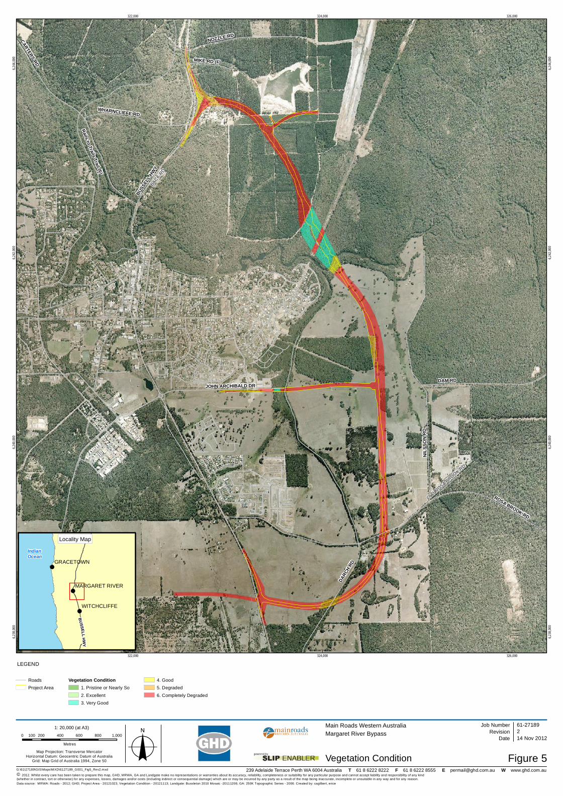
G:\61\27189\GIS\Maps\MXD\6127189_G001_Fig5_Rev2.mxd
LEGEND
Map Projection: Transverse MercatorHorizontal Datum: Geocentric Datum of Australia
Grid: Map Grid of Australia 1994, Zone 50
© 2012. Whilst every care has been taken to prepare this map, GHD, MRWA, GA and Landgate make no representations or warranties about its accuracy, reliability, completeness or suitability for any particular purpose and cannot accept liability and responsibility of any kind (whether in contract, tort or otherwise) for any expenses, losses, damages and/or costs (including indirect or consequential damage) which are or may be incurred by any party as a result of the map being inaccurate, incomplete or unsuitable in any way and for any reason.
Main Roads Western AustraliaMargaret River Bypass
Vegetation Condition Figure 5
Job NumberRevision 2
61-27189
14 Nov 2012Date
Data source: MRWA: Roads - 2012; GHD; Project Area - 20121023, Vegetation Condition - 20121113; Landgate: Bussleton 2010 Mosaic -20111206; GA: 250K Topographic Series - 2006. Created by: cagilbert, erice
239 Adelaide Terrace Perth WA 6004 Australia T 61 8 6222 8222 F 61 8 6222 8555 E [email protected] W www.ghd.com.au
!
!
!
!!
!
!
Indian Ocean
BUSSELLHWY
GRACETOWN
WITCHCLIFFE
MARGARET RIVER
Locality Map
1: 20,000 (at A3)
o0 200 400 600 800 1,000100
Metres
RoadsProject Area
Vegetation Condition1. Pristine or Nearly So2. Excellent3. Very Good
4. Good5. Degraded6. Completely Degraded

!!!!!!!!!!!!!!!!!!! !!!! !!!! !!!!!!!!!!!!!!! !!!!!!!!!!!!!!!!! !!!!!! !!!!!!!!
!!!!!!!!!!!!
!!!!!
!!!!!!! !!!!!!
!
!!!!!!!!!!!!!!!!!!!!!!!!!!!!!!!!!!!!
!!!!!!! ! !!!!!!!! !!!! !!! !!!
!!!!!!!!!!!!!!!!
!!!!!!!!!!!!!!!!!!!!!!!!!!!!!!!!!!!!!!!!!!!!!!!!!!!!!!!!!!!!!!!!!!!!!!!!
!
!!
!!!
!!
!!!!!!!!!!!!!!!!!!!!!!!!!!!!!!! !!!!!!!! !!!! !!! !!!!!!! !!!!!!!!!!!!!!!!! !!!!!!!!! !!! !!! !!!!!!! !!! !!!!!! !!!! !! !!!! !!!! !!!! !!!!!!!!! !!!!!!!!!!!!!!!! !! !!!!!!!!!!!!! ! !!!!!! !!!! !!!!!!!!!! !!!! !!!! !!! !!!! !! !!! !!!!!! ! !!!!!!!! !! !!!!! !!!!!!!!!!!!!!!!!!!!!!! !!!! !!!!! !!!! !!!!!!
!!!!!!!!!!
!!!
!!!!!!!!!!!! !!!!!!!!!!!!!
!!!
!
NOZZLE RD
BACK
RD
OLD R
OSA BROOK RD
322,000
322,000
324,000
324,000
326,000
326,000
6,238,
000
6,238,
000
6,240,
000
6,240,
000
6,242,
000
6,242,
000
6,244,
000
6,244,
000
G:\61\27189\GIS\Maps\MXD\6127189_G005_Fig6_Rev2.mxd
LEGEND
Map Projection: Transverse MercatorHorizontal Datum: Geocentric Datum of Australia
Grid: Map Grid of Australia 1994, Zone 50
© 2011. Whilst every care has been taken to prepare this map, GHD, GA, MRWA, and Landgate make no representations or warranties about its accuracy, reliability, completeness or suitability for any particular purpose and cannot accept liability and responsibility of any kind (whether in contract, tort or otherwise) for any expenses, losses, damages and/or costs (including indirect or consequential damage) which are or may be incurred by any party as a result of the map being inaccurate, incomplete or unsuitable in any way and for any reason.
Main Roads Western AustraliaMargaret River Bypass
Potential Cockatoo Breeding Trees Figure 6
Job NumberRevision 2
61-27189
14 Nov 2012Date
Data source: MRWA: Roads - 20091028; GHD; Project Area - 20121023, Potential Cockatoo Breeding Trees - 20111207; Landgate: Bussleton 2010 Mosaic -20111206; GA: 250K Topographic Series - 2006. Created by: cagilbert
239 Adelaide Terrace Perth WA 6004 Australia T 61 8 6222 8222 F 61 8 6222 8555 E [email protected] W www.ghd.com.au
!
!
!
!!
!
!
Indian Ocean
BUSSELLHWY
GRACETOWN
WITCHCLIFFE
MARGARET RIVER
Locality Map
1: 20,000 (at A3)
o0 200 400 600 800 1,000100
Metres
Potential Cockatoo Breeding Trees! Trees > 500mm DBH
!Possible Black Cockatoo Breeding Areas (Large tree with Hollows)
Roads
Project Area