Embed Size (px)
Citation preview
APPENDIX B
NOISE, VIBRATION AND AIR QUALITY REPORT
127 Walgreen Road, Ottawa, Ontario K0A 1L0 T (613) 836‐0934 ● www.gradientwind.com
Air Quality, Noise and Vibration Impact Assessment O‐Train Extension EA
Ottawa, Ontario
REPORT: GWE14‐031 – Environmental Assessment
Prepared For:
Emily Sangster MMM Group Limited
1145 Hunt Club Road, Suite 300 Ottawa, Ontario
K1V 0Y3
Prepared By:
Michael Lafortune, Environmental Technologist
Joshua Foster, P.Eng., Partner
January 21, 2016
MMM Group Limited
O‐Train Extension: Environmental Assessment i
EXECUTIVE SUMMARY
Gradient Wind Engineering Inc. (GWE) was retained by MMM Group Limited to provide engineering
support in the areas of air quality, noise and ground vibrations, for the environmental assessment
(EA) and planning phase of the City of Ottawa’s O‐Train Extension project.
The project is a proposed extension of the O‐Train light rail system from Greenboro Station to Riverside
South and the Ottawa Macdonald – Cartier International Airport. Consideration is also being given to two
new proposed stations at Gladstone Avenue and Walkley Road along the existing O‐Train corridor, as well
as a maintenance and storage facility located at the Walkley Yard.
The work summarized in this report compares existing and projected future conditions for air quality,
noise and vibrations. Figures 1 to 12 illustrate the existing and future O‐Train alignment and receptor
locations.
Air Quality Impacts
The O‐Train extension, with increased train volume, addition of stations and extended tracks, will have a
negligible impact on the local air quality. Pollutant emissions, such as Nitrogen Oxides (NOx) are expected
to decrease over time, with the introduction of more stringent NOx emission regulations and introduction
of cleaner burning diesel engines. Carbon Monoxide (CO) and Particulate emissions (PM) are expected to
marginally increase over existing conditions as a result of the increase train volumes and new stations. In
all cases, existing and future concentrations of criteria air contaminants (NOx, CO, PM) remain well under
the Ontario Ministry of the Environment and Climate Change (MOECC) Ambient Air Quality Criteria
(AAQC).
Noise Impacts
Existing noise levels along the O‐Train corridor range from 39 to 70 dBA within the project limit during the
daytime period. With increased rail volumes, future noise levels will marginally increase above existing
conditions throughout the project limits, but are not expected to be considered noticeable by the majority
of human observers. All but two receptors within the project limits have future noise levels less than or
equal to 60 dBA. In addition, the increase in noise due to the O‐Train extension is less than 5 dB above
the existing (ambient) conditions. As such, noise control measures will not be required at these locations.
MMM Group Limited
O‐Train Extension: Environmental Assessment ii
The existing and future noise levels at residences in close proximity to Highway 417 (R2 and R3) will
naturally see elevated noise levels. They were measured to be 66 and 70 dBA respectively. Because these
levels are above the City of Ottawa’s Environmental Noise Control Guidelines (ENCG) criterion of 60 dBA,
noise control measures should be investigated for the residences along Gladstone Avenue, George Street
and Railway Street. According to the ENCG, for a retrofit barrier to be considered practical it must provide
a reduction of 6 dBA. Investigation into a noise barrier indicated that for noise levels to be reduced by 6
dBA, a 5 meter tall barrier would be required along Highway 417 in this area (see Figure 2). As the change
in noise levels between existing and future conditions is marginal, and a barrier 5 m in height would be
difficult to implement, there is no practical way within the project limit to mitigate noise at these
locations. Furthermore, Highway 417 is under the jurisdiction of the Ontario Ministry of Transportation
and any noise mitigation project would be outside the scope of the O‐Train expansion project.
Vibration Impacts
The highest vibrations levels throughout the corridor were measured at Kaladar Park, at a distance of 25
meters from the rail edge, which is an equal distance of the house in the area to the tracks. Maximum
vibration levels were measured to be 0.37 mm/s RMS (83 dBV). At this section of track, there is a bypass,
and therefore trains can be braking or accelerating. Based on the measured vibration levels, vibrations
from the O‐Train line can be moderately perceptible within a distance of approximately 25 meters from
the edge of the tracks. These vibration levels are moderately above the perceptible criteria of 0.14 mm/s
RMS (75 dBV), but still, however, under the level commonly considered annoying by building occupants.
With the project undertaking, ground vibrations are not expected to increase substantially to cause
annoyance or structural issues. At three other monitoring locations, vibration levels were well below the
criteria and did not trigger the seismograph set to a minimum trigger level of 0.13 peak partial velocity.
As the section of the new track is further offset from residences than the existing track, no vibration
impacts are expected along the new track segment of the project.

MMM Group Limited
O‐Train Extension: Environmental Assessment iii
Construction Impacts
Varied construction activities along the O‐Train corridor are expected to create isolated and short‐term
noise, air quality and vibration impacts on the environment. The construction manager will be required
to develop a strategy for mitigating the effects according to good practices intended to satisfy, as feasible,
the fugitive dust limits specified in O.Reg. 419, the noise limits specified in MOE NPC‐1151 and City of
Ottawa By‐laws for Noise2, and MOECC NPC ‐1193 for ground vibrations. A list of common mitigation
strategies adapted to the current project is outlined of Section 6 of this report.
1 MOE, Model Municipal Noise Control By‐Law, NPC‐115 Construction Equipment, August 1978 2 City of Ottawa, Noise By‐law No. 2004‐253 3 MOE, Model Municipal Noise Control By‐Law, NPC‐119 Blasting, August 1978
MMM Group Limited
O‐Train Extension: Environmental Assessment iv
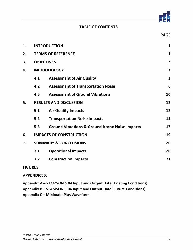
TABLE OF CONTENTS
PAGE
1. INTRODUCTION 1
2. TERMS OF REFERENCE 1
3. OBJECTIVES 2
4. METHODOLOGY 2
4.1 Assessment of Air Quality 2
4.2 Assessment of Transportation Noise 6
4.3 Assessment of Ground Vibrations 10
5. RESULTS AND DISCUSSION 12
5.1 Air Quality Impacts 12
5.2 Transportation Noise Impacts 15
5.3 Ground Vibrations & Ground‐borne Noise Impacts 17
6. IMPACTS OF CONSTRUCTION 19
7. SUMMARY & CONCLUSIONS 20
7.1 Operational Impacts 20
7.2 Construction Impacts 21
FIGURES
APPENDICES:
Appendix A – STAMSON 5.04 Input and Output Data (Existing Conditions)
Appendix B – STAMSON 5.04 Input and Output Data (Future Conditions)
Appendix C – Minimate Plus Waveform
MMM Group Limited
O‐Train Extension: Environmental Assessment Page 1
1. INTRODUCTION
Gradient Wind Engineering Inc. (GWE) was retained by MMM Group Limited to provide engineering
support in the areas of air quality, noise and ground vibrations, for the environmental assessment
(EA) and planning phase of the City of Ottawa’s O‐Train Extension project. The project is a proposed
extension of the O‐Train light rail system from Greenboro Station to Riverside South and the Ottawa
Macdonald – Cartier International Airport. Consideration is also being given to two new proposed stations,
at Gladstone Avenue and Walkley Road, along the existing O‐Train corridor, as well as upgrades to the
maintenance and storage facility located at the Walkley Yard. The O‐Train Extension is being undertaken
as an Environmental Assessment under the Transit Project Assessment Process (Ontario Regulation
231/08). Our work is based on base mapping and aerial photographs provided by MMM Group Limited,
and GWE’s experience on past similar projects.
This report describes the assessment, methodology and results for existing and future environmental air
quality, noise and vibration impacts created by the project.
2. TERMS OF REFERENCE
The focus of this environmental assessment is the proposed O‐Train extension. The purpose of the
provincial and federal EA is to develop a functional plan for extended light rail services south of Greenboro
Station. The planning and EA study will perform a needs assessment for the corridor and evaluate various
alternative designs, and recommend a preferred recommended plan. Following the development of a
recommended plan, GWE has performed an impact assessment for the areas of Air Quality, Noise and
Vibration, as outlined in this report.
The overall study area is confined to the immediate area of the O‐Train corridor from Bayview Station
to Riverside South and the Ottawa Macdonald – Cartier International Airport, including two new proposed
stations at Gladstone Avenue and Walkley Road along the existing O‐Train corridor. The study area will
also include Walkley Yard, where there are proposed renovations to the existing maintenance and storage
facility. The study boundaries will be expanded as necessary to properly account for peripheral conditions
around the planning area. There are a number of roadways along the O‐Train Corridor that may affect air
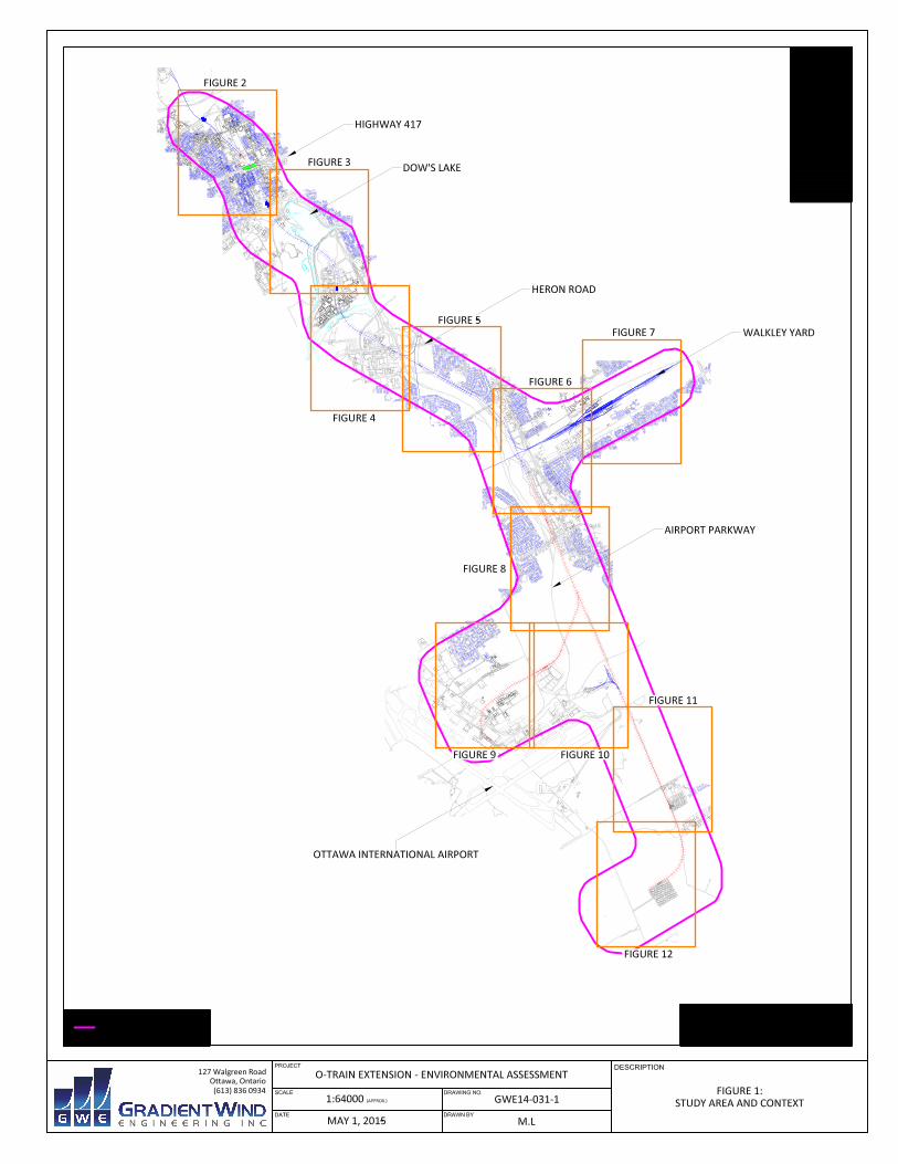
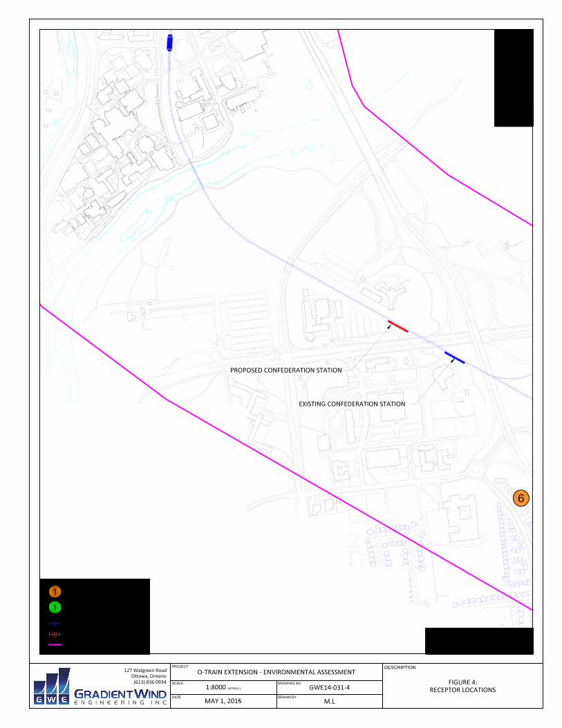
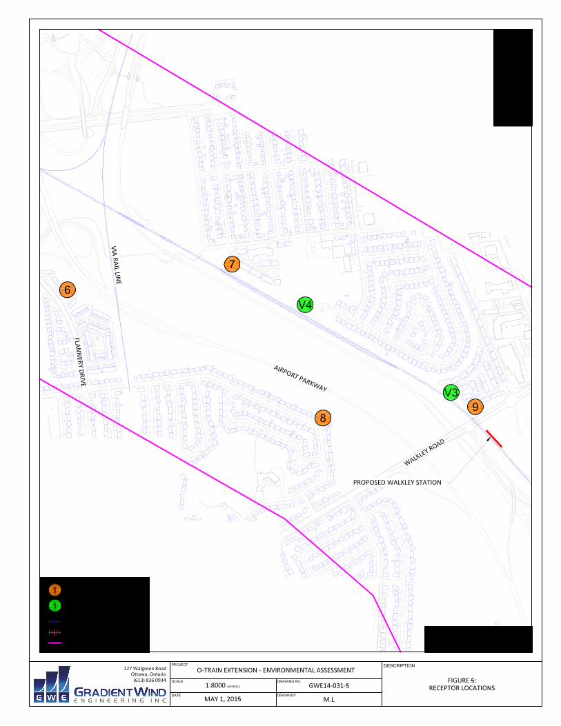
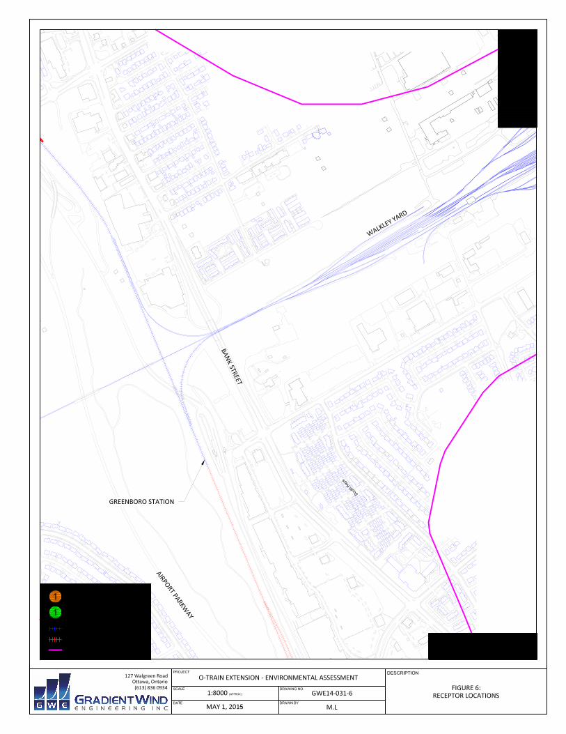
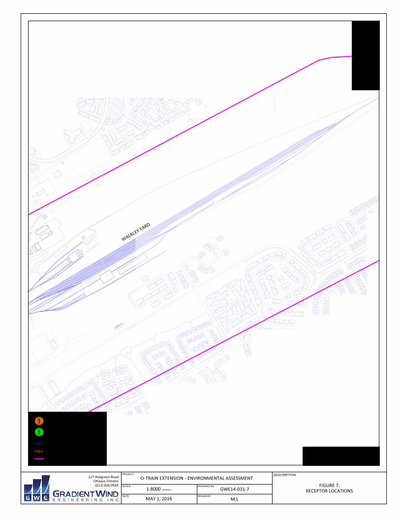
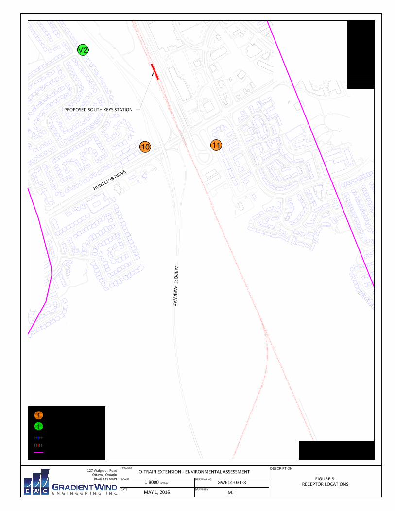
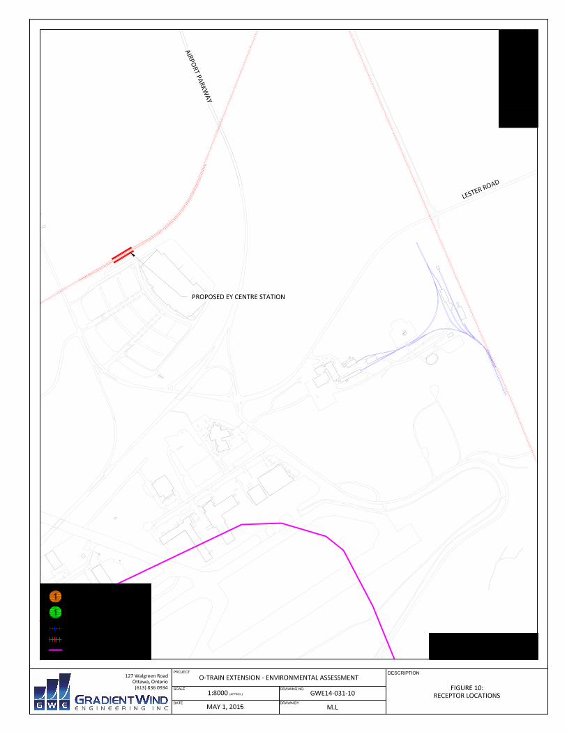
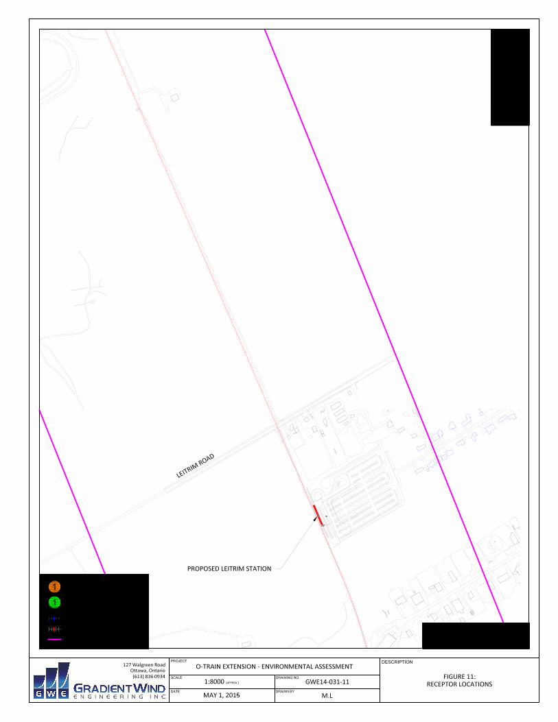
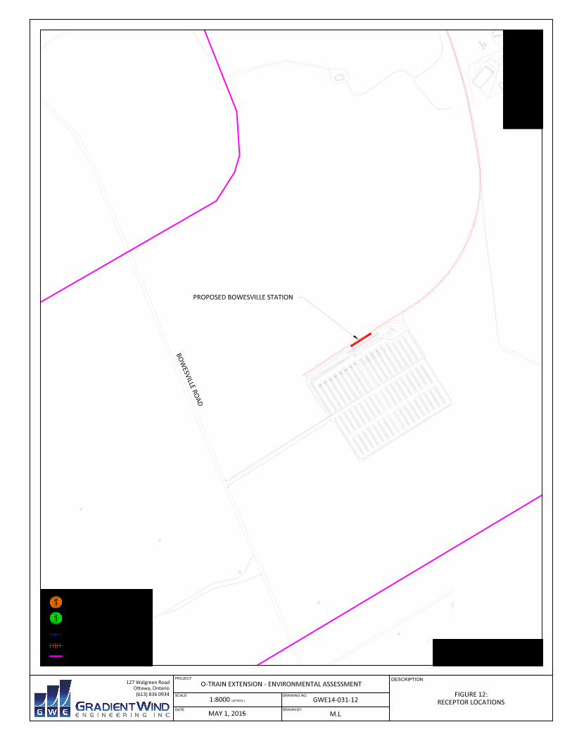
quality, noise and vibration within the study area. Figure 1 contains an overview of the entire study area.
Figures 2 through 12 illustrate the alignment of the O‐Train along various sections of the corridor.
MMM Group Limited
O‐Train Extension: Environmental Assessment Page 2
3. OBJECTIVES
The O‐Train Extension project is intended to provide extended light rail services south of Greenboro
Station. The underlying goals addressed in this study include assessing existing and future conditions for
air quality, traffic noise and ground vibrations resulting from the undertaking and recommending
appropriate mitigation measures where comparisons show significant deterioration according to
established criteria.
4. METHODOLOGY
The following sections describe the methodology for assessing baseline existing conditions and predicted
future conditions due to project implementation of the expanded O‐Train network.
4.1 Assessment of Air Quality
Vehicle and rail traffic are a source of gasoline and diesel emissions and includes the contaminants of
Carbon Monoxide (CO), Hydrocarbons (HC), Oxides of Nitrogen (NOx), and Particulate Matter (PM), in
addition to other secondary compounds. As such, increased traffic and rail activity along the corridor could
have a potential negative effect on air quality at nearby points of impingement.
Assessment of air quality is based on determining the concentration of a pollutant at a particular location.
Pollutant concentrations are measured in either parts per million (ppm) or micrograms per cubic meter
(μg/m3). Resulting concentrations are compared to clean air standards that have been set by the Ontario
Ministry of the Environment and Climate Change (MOECC), Standards Development Branch. The Ambient
Air Quality Criteria (AAQC) are the Ministry’s targets for clean air from all sources of pollutants, including
transit, transportation and industrial facilities when considered with other sources.
AAQC standards are effect‐based concentration levels for individual pollutants in air, with variable
averaging periods for each pollutant. Averaging periods vary from one hour to 24‐hours, according to the
relevant impacts of each pollutant on people and the environment. For example, CO has acute health
effects (poisoning) and has a corresponding short averaging period of one‐half hour. Conversely, PM has
an averaging period of 24‐hours to account for the known long‐term respiratory effects. The AAQC
standards for representative pollutants are listed in Table 1, with the averaging period for each pollutant
indicated in parenthesis.
MMM Group Limited
O‐Train Extension: Environmental Assessment Page 3
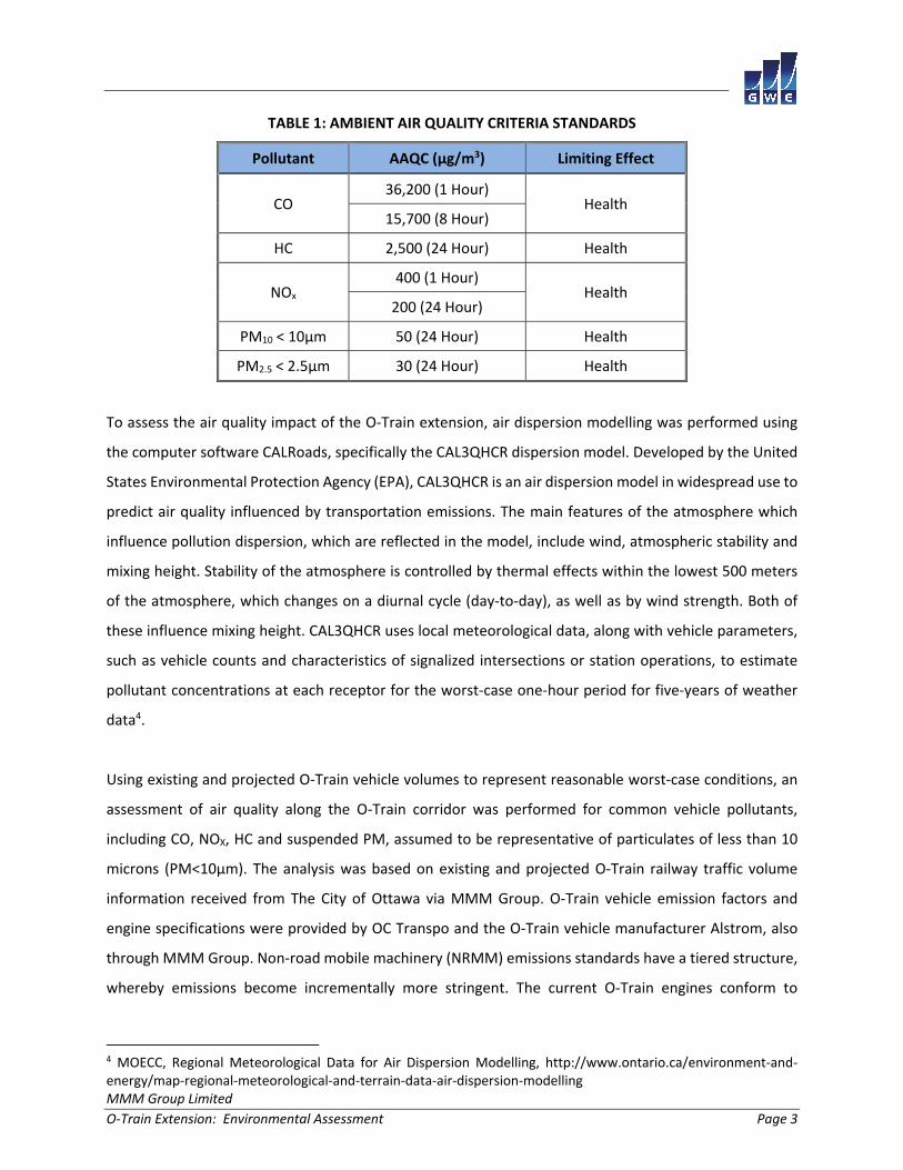
TABLE 1: AMBIENT AIR QUALITY CRITERIA STANDARDS
Pollutant AAQC (µg/m3) Limiting Effect
CO 36,200 (1 Hour)
Health 15,700 (8 Hour)
HC 2,500 (24 Hour) Health
NOx 400 (1 Hour)
Health 200 (24 Hour)
PM10 < 10µm 50 (24 Hour) Health
PM2.5 < 2.5µm 30 (24 Hour) Health
To assess the air quality impact of the O‐Train extension, air dispersion modelling was performed using
the computer software CALRoads, specifically the CAL3QHCR dispersion model. Developed by the United
States Environmental Protection Agency (EPA), CAL3QHCR is an air dispersion model in widespread use to
predict air quality influenced by transportation emissions. The main features of the atmosphere which
influence pollution dispersion, which are reflected in the model, include wind, atmospheric stability and
mixing height. Stability of the atmosphere is controlled by thermal effects within the lowest 500 meters
of the atmosphere, which changes on a diurnal cycle (day‐to‐day), as well as by wind strength. Both of
these influence mixing height. CAL3QHCR uses local meteorological data, along with vehicle parameters,
such as vehicle counts and characteristics of signalized intersections or station operations, to estimate
pollutant concentrations at each receptor for the worst‐case one‐hour period for five‐years of weather
data4.
Using existing and projected O‐Train vehicle volumes to represent reasonable worst‐case conditions, an
assessment of air quality along the O‐Train corridor was performed for common vehicle pollutants,
including CO, NOX, HC and suspended PM, assumed to be representative of particulates of less than 10
microns (PM<10μm). The analysis was based on existing and projected O‐Train railway traffic volume
information received from The City of Ottawa via MMM Group. O‐Train vehicle emission factors and
engine specifications were provided by OC Transpo and the O‐Train vehicle manufacturer Alstrom, also
through MMM Group. Non‐road mobile machinery (NRMM) emissions standards have a tiered structure,
whereby emissions become incrementally more stringent. The current O‐Train engines conform to
4 MOECC, Regional Meteorological Data for Air Dispersion Modelling, http://www.ontario.ca/environment‐and‐energy/map‐regional‐meteorological‐and‐terrain‐data‐air‐dispersion‐modelling
MMM Group Limited
O‐Train Extension: Environmental Assessment Page 4
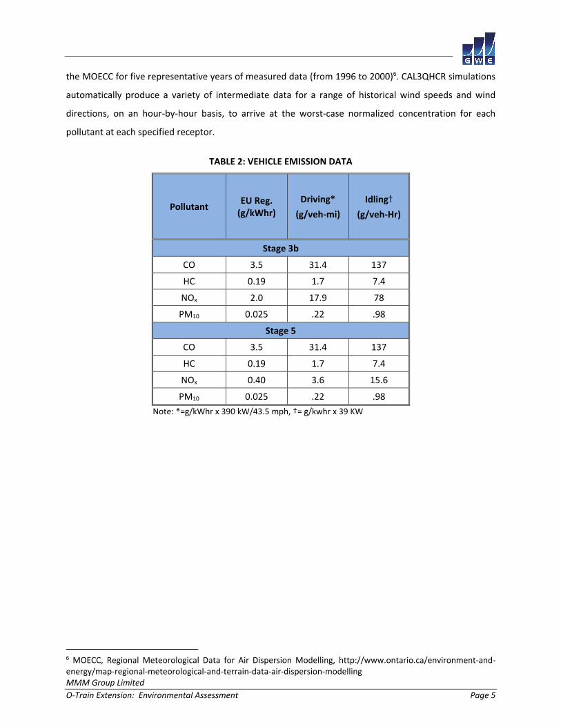
European Union (EU) Regulation 97/68/ EG Stage 3b emissions standards5. Newer engines, engines
manufactured after 2021, will need to conform to Stage 5, which introduces a very stringent NOx limit of
0.4 g/kWh. For future conditions considered in the horizon year of 2031, it was assumed that Stage 5
implementation of new engines would have taken place. The emission standards in g/kWh were
converted to the modelling inputs of grams per vehicle mile (g/veh‐mi) and grams per vehicle hour (g/veh‐
hr) considering a full load engine rating of 390 kW, and an idle load engine rating of 39 kW and an
operation speed of the trains of 43.5 miles per hour (70 km/h). Table 2 summarizes the emission factors
used in this assessment.
Other criteria air contaminants such as Sulphur Dioxide (SO2), Benzene, 1‐3 butadine, Formaldehyde,
Acetaldehyde, and Acroliein are also produced by diesel engines. These, however, are not regulated under
the European Union Standard 97/68/ EG. Estimates of these emissions were investigated using the EPA’s
Motor Vehicle Emission Simulator (MOVES), which incorporates the NONROAD2008 emission inventory
model. A comparison of the emission factors for CO, NOx HC and PM derived from MOVES were found to
be three to four times higher than emission factors allowable by the EU regulation standards. This is
contributed to the fact that the MOVES model considers older vehicles which began operation prior to
the standards coming into effect. Since the current locomotive O‐Train fleet is already in compliance with
the EU Regulation Stage 3b standards, and the MOVES results for CO, NOx, HC, and PM were considerably
higher than the Stage 3b standards, it is not reasonable to use the emission factors from MOVES for SO2,
Benzene, 1‐3 butadine, Formaldehyde, Acetaldehyde, or Acroliein. As there is no other realistic way to
determine the emissions of these contaminants, they have been excluded from our assessment. In our
experience on other projects, the governing contaminants for products of combustion tend to be NOx and
PM.
The entire length of the existing and proposed O‐Train line and stations were included in the model.
Because the O‐Train is expected to be the dominant source of emissions in the O‐Train corridor, major
intersections and roadways that are in the influence zone of the corridor were excluded from the
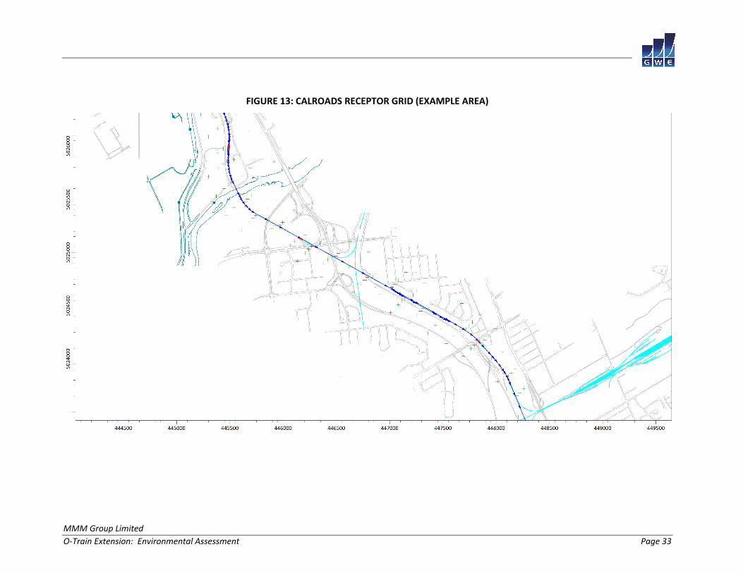
CAL3QHCR model. Receptors were placed along the O‐Train corridor in a grid with a spacing of 200 × (15,
50, 100, 200) meters (see Figure 13) to determine the maximum pollutant concentrations. Wind profiles
as a function of height above grade, appropriate for the exposures of the study site, were obtained from
5 https://www.dieselnet.com/standards/eu/nonroad.php
MMM Group Limited
O‐Train Extension: Environmental Assessment Page 5
the MOECC for five representative years of measured data (from 1996 to 2000)6. CAL3QHCR simulations
automatically produce a variety of intermediate data for a range of historical wind speeds and wind
directions, on an hour‐by‐hour basis, to arrive at the worst‐case normalized concentration for each
pollutant at each specified receptor.
TABLE 2: VEHICLE EMISSION DATA
Pollutant EU Reg. (g/kWhr)
Driving*
(g/veh‐mi)
Idling†
(g/veh‐Hr)
Stage 3b
CO 3.5 31.4 137
HC 0.19 1.7 7.4
NOx 2.0 17.9 78
PM10 0.025 .22 .98
Stage 5
CO 3.5 31.4 137
HC 0.19 1.7 7.4
NOx 0.40 3.6 15.6
PM10 0.025 .22 .98
Note: *=g/kWhr x 390 kW/43.5 mph, †= g/kwhr x 39 KW
6 MOECC, Regional Meteorological Data for Air Dispersion Modelling, http://www.ontario.ca/environment‐and‐energy/map‐regional‐meteorological‐and‐terrain‐data‐air‐dispersion‐modelling
MMM Group Limited
O‐Train Extension: Environmental Assessment Page 6
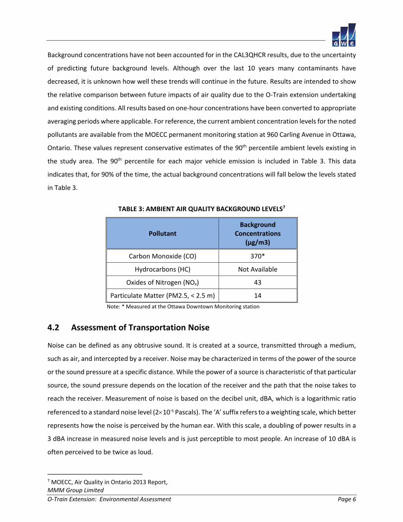
Background concentrations have not been accounted for in the CAL3QHCR results, due to the uncertainty
of predicting future background levels. Although over the last 10 years many contaminants have
decreased, it is unknown how well these trends will continue in the future. Results are intended to show
the relative comparison between future impacts of air quality due to the O‐Train extension undertaking
and existing conditions. All results based on one‐hour concentrations have been converted to appropriate
averaging periods where applicable. For reference, the current ambient concentration levels for the noted
pollutants are available from the MOECC permanent monitoring station at 960 Carling Avenue in Ottawa,
Ontario. These values represent conservative estimates of the 90th percentile ambient levels existing in
the study area. The 90th percentile for each major vehicle emission is included in Table 3. This data
indicates that, for 90% of the time, the actual background concentrations will fall below the levels stated
in Table 3.
TABLE 3: AMBIENT AIR QUALITY BACKGROUND LEVELS7
Pollutant Background
Concentrations (μg/m3)
Carbon Monoxide (CO) 370*
Hydrocarbons (HC) Not Available
Oxides of Nitrogen (NOx) 43
Particulate Matter (PM2.5, < 2.5 m) 14
Note: * Measured at the Ottawa Downtown Monitoring station
4.2 Assessment of Transportation Noise
Noise can be defined as any obtrusive sound. It is created at a source, transmitted through a medium,
such as air, and intercepted by a receiver. Noise may be characterized in terms of the power of the source
or the sound pressure at a specific distance. While the power of a source is characteristic of that particular
source, the sound pressure depends on the location of the receiver and the path that the noise takes to
reach the receiver. Measurement of noise is based on the decibel unit, dBA, which is a logarithmic ratio
referenced to a standard noise level (210‐5 Pascals). The ‘A’ suffix refers to a weighting scale, which better
represents how the noise is perceived by the human ear. With this scale, a doubling of power results in a
3 dBA increase in measured noise levels and is just perceptible to most people. An increase of 10 dBA is
often perceived to be twice as loud.
7 MOECC, Air Quality in Ontario 2013 Report,
MMM Group Limited
O‐Train Extension: Environmental Assessment Page 7
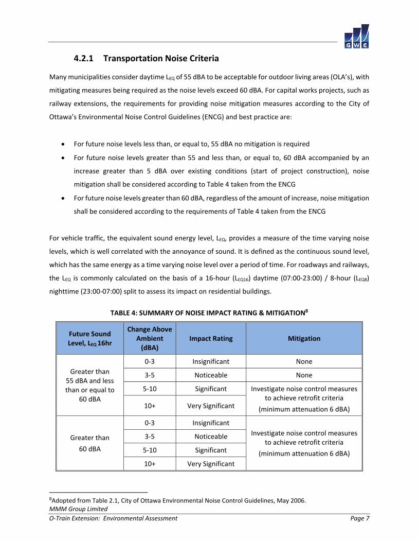
4.2.1 Transportation Noise Criteria
Many municipalities consider daytime LEQ of 55 dBA to be acceptable for outdoor living areas (OLA’s), with
mitigating measures being required as the noise levels exceed 60 dBA. For capital works projects, such as
railway extensions, the requirements for providing noise mitigation measures according to the City of
Ottawa’s Environmental Noise Control Guidelines (ENCG) and best practice are:
For future noise levels less than, or equal to, 55 dBA no mitigation is required
For future noise levels greater than 55 and less than, or equal to, 60 dBA accompanied by an
increase greater than 5 dBA over existing conditions (start of project construction), noise
mitigation shall be considered according to Table 4 taken from the ENCG
For future noise levels greater than 60 dBA, regardless of the amount of increase, noise mitigation
shall be considered according to the requirements of Table 4 taken from the ENCG
For vehicle traffic, the equivalent sound energy level, LEQ, provides a measure of the time varying noise
levels, which is well correlated with the annoyance of sound. It is defined as the continuous sound level,
which has the same energy as a time varying noise level over a period of time. For roadways and railways,
the LEQ is commonly calculated on the basis of a 16‐hour (LEQ16) daytime (07:00‐23:00) / 8‐hour (LEQ8)
nighttime (23:00‐07:00) split to assess its impact on residential buildings.
TABLE 4: SUMMARY OF NOISE IMPACT RATING & MITIGATION8
Future Sound Level, LEQ 16hr
Change Above Ambient (dBA)
Impact Rating Mitigation
Greater than 55 dBA and less than or equal to
60 dBA
0‐3 Insignificant None
3‐5 Noticeable None
5‐10 Significant Investigate noise control measures to achieve retrofit criteria
(minimum attenuation 6 dBA) 10+ Very Significant
Greater than
60 dBA
0‐3 Insignificant
Investigate noise control measures to achieve retrofit criteria
(minimum attenuation 6 dBA)
3‐5 Noticeable
5‐10 Significant
10+ Very Significant
8Adopted from Table 2.1, City of Ottawa Environmental Noise Control Guidelines, May 2006.
MMM Group Limited
O‐Train Extension: Environmental Assessment Page 8
According to Section 2.0 of the ENCG, retrofit sound barriers will be installed and maintained within the
City’s right of way, except for flanking walls where an easement may be requested. Sound barriers within
the right of way will only be installed where it is feasible to achieve the minimum retrofit criteria of 6 dBA.
The guideline also states ‘Off right‐of‐way noise control measures and nighttime (23:00 – 07:00)
assessment of the noise impact will not be considered as part of these guidelines’.
The Ministry of Transportation, Ontario (MTO) and the MOECC have also established guidelines and
criteria for assessing noise from roadway and transportation sources. These guidelines are less stringent
than the ENCG, and suggested mitigation should be investigated when future sound levels exceed 65
dBA, or when there is an increase of 5 dBA over the established ambient (future do‐nothing) conditions.
Since the project is being undertaken by the City of Ottawa, the more stringent ENCG guidelines were
adopted as the standard for this project.
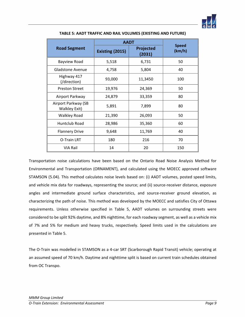
4.2.2 Noise Assessment Procedure
Existing and future noise levels at 11 receptors were based on current traffic information received from
The City of Ottawa through MMM Group. Projected future roadway traffic volumes, for the horizon year
of 2031, were performed by GWE based on Transportation Master Plan growth estimates. Existing and
projected O‐Train headway information was received from The City of Ottawa and MMM Group. Figures
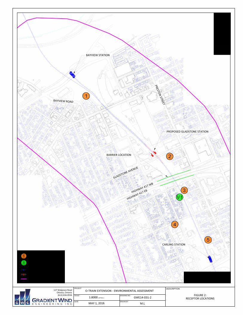
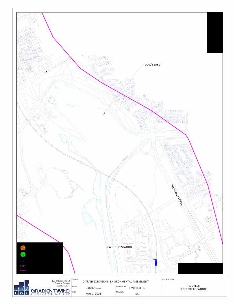
2 to 12 illustrate receptor locations along the O‐Train corridor. Traffic and rail volumes included in the
study are described in Table 5 below:
MMM Group Limited
O‐Train Extension: Environmental Assessment Page 9
TABLE 5: AADT TRAFFIC AND RAIL VOLUMES (EXISTING AND FUTURE)
Road Segment AADT
Speed (km/h) Existing (2015)
Projected (2031)
Bayview Road 5,518 6,731 50
Gladstone Avenue 4,758 5,804 40
Highway 417 (/direction)
93,000 11,3450 100
Preston Street 19,976 24,369 50
Airport Parkway 24,879 33,359 80
Airport Parkway (SB Walkley Exit)
5,891 7,899 80
Walkley Road 21,390 26,093 50
Huntclub Road 28,986 35,360 60
Flannery Drive 9,648 11,769 40
O‐Train LRT 180 216 70
VIA Rail 14 20 150
Transportation noise calculations have been based on the Ontario Road Noise Analysis Method for
Environmental and Transportation (ORNAMENT), and calculated using the MOECC approved software
STAMSON (5.04). This method calculates noise levels based on: (i) AADT volumes, posted speed limits,
and vehicle mix data for roadways, representing the source; and (ii) source‐receiver distance, exposure
angles and intermediate ground surface characteristics, and source‐receiver ground elevation, as
characterizing the path of noise. This method was developed by the MOECC and satisfies City of Ottawa
requirements. Unless otherwise specified in Table 5, AADT volumes on surrounding streets were
considered to be split 92% daytime, and 8% nighttime, for each roadway segment, as well as a vehicle mix
of 7% and 5% for medium and heavy trucks, respectively. Speed limits used in the calculations are
presented in Table 5.
The O‐Train was modelled in STAMSON as a 4‐car SRT (Scarborough Rapid Transit) vehicle; operating at
an assumed speed of 70 km/h. Daytime and nighttime split is based on current train schedules obtained
from OC Transpo.
MMM Group Limited
O‐Train Extension: Environmental Assessment Page 10
4.3 Assessment of Ground Vibrations
Transit systems and heavy vehicles on roadways can produce perceptible levels of ground vibrations,
especially when they are in close proximity to residential neighbourhoods. Similar to sound waves in air,
vibrations in solids are generated at a source, propagated through the medium and intercepted by a
receiver. In the case of ground vibrations, the medium can be uniform, or more often, a complex layering
of soils and rock strata. Also, similar to sound waves in air, ground vibrations produce perceptible motions
and regenerated noise known as ‘ground‐borne noise’ when the vibrations encounter a hollow structure,
such as a building. Ground‐borne noise and vibrations are generated when there is excitation of the
ground, from a train for instance. Repetitive motion of the wheels on the track or rubber tires passing
over an uneven surface causes vibrations to propagate through the soil. When they encounter a building,
vibrations pass along the structure of the building beginning at the foundation and propagating to all
floors. Air inside the building excited by the vibrating walls and floors represents regenerated airborne
noise. Characteristics of the soil and the building are imparted to the noise thereby creating a unique noise
signature.
Human response to ground vibrations is dependent on the magnitude of the vibrations, which is measured
by the root mean square (RMS) of the movement of a particle on a surface. Typical units of ground
vibration measures are millimeters per second (mm/s), or inch per second (in/s). Since vibrations can vary
over a wide range, it is also convenient to represent them in decibel units, or dBV. In North America, it is
common practice to use the reference value of one micro‐inch per second (μin/s) to represent vibration
levels for this purpose. The threshold level of human perception to vibrations is about 0.10 mm/s RMS or
about 72 dBV. Although somewhat variable, the threshold of annoyance for continuous vibrations is (1.0
mm/s RMS or 92 dBV), ten times higher than the perception threshold, whereas the threshold for
significant structural damage is (10 mm/s RMS or 112 dBV) at least one hundred times higher than the
annoyance threshold level.
MMM Group Limited
O‐Train Extension: Environmental Assessment Page 11
4.3.1 Vibration Criteria
Generic vibration criteria for a variety of building functions have been established based on years of
experience and fundamental research performed by the International Standards Organization (ISO) 2631‐
2, and similar groups. The ISO criteria are primarily used when dealing with highly sensitive equipment
common in high‐technology manufacturing and some university facilities. A survey of the O‐Train corridor
around the study area revealed no highly sensitive buildings within 200 m of the corridor, which would
require ISO vibration criteria.
In the United States, the Federal Transportation Authority (FTA) has set vibration criteria for sensitive land
use next to Transit corridors. Similar standards have been developed by a partnership between the MOECC
and the Toronto Transit Commission9. These standards indicate that the appropriate criteria for residential
buildings are 0.1 mm/s RMS (72 dBV) for vibrations and that for levels exceeding 85 dBV, most people will
be strongly annoyed. For main line railways, a document titled Guidelines for New Development in
Proximity to Railway Operations10, indicates that vibration conditions should not exceed 0.14 mm/s RMS
averaged over a one second time period at the first floor and above of the proposed building. As the main
vibration source is due to a main line O‐Train corridor, the 0.14 mm/s RMS (75 dBV) vibration criteria and
35 dBA ground borne noise criteria were adopted for this study. Ground borne noise can be estimated from
vibration levels by subtracting 50 from the dBV level, where the dominant frequency of the vibrations is
less than 30 Hz.
4.3.2 Assessment Procedure
Existing levels of ground vibrations due to O‐Train activity were determined by field measurements using
an Instantel seismograph (Minimate Plus) capable of recording three components of ground velocity, one
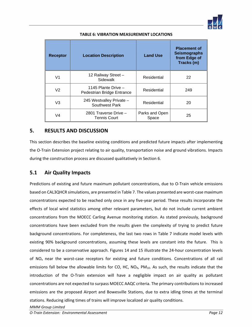
vertical and two horizontal. Four measurement sites were selected at sensitive receptors throughout the
corridor, as identified in Table 6. All seismograph measurements were set to a minimum trigger level of
0.13 mm/s peak partial velocity (ppv). Figures 2, 5 and 8 illustrate the vibration measurement locations.
Potential vibration impacts of the proposed O‐Train extension can be derived from measurement data
because the current vehicles will likely be used in the future.
9 MOEE/TTC Protocol for Noise and Vibration Assessment for the Proposed Yonge‐Spadina Subway Loop, June 16, 1993 10 Dialog and J.E. Coulter Associates Limited, prepared for The Federation of Canadian Municipalities and The Railway Associated of Canada, May 2013
MMM Group Limited
O‐Train Extension: Environmental Assessment Page 12
TABLE 6: VIBRATION MEASUREMENT LOCATIONS
Receptor Location Description Land Use Placement of
Seismographs from Edge of Tracks (m)
V1 12 Railway Street –
Sidewalk Residential 22
V2 1145 Plante Drive –
Pedestrian Bridge Entrance Residential 249
V3 245 Westvalley Private –
Southwest Park Residential 20
V4 2801 Traverse Drive –
Tennis Court Parks and Open
Space 25
5. RESULTS AND DISCUSSION
This section describes the baseline existing conditions and predicted future impacts after implementing
the O‐Train Extension project relating to air quality, transportation noise and ground vibrations. Impacts
during the construction process are discussed qualitatively in Section 6.
5.1 Air Quality Impacts
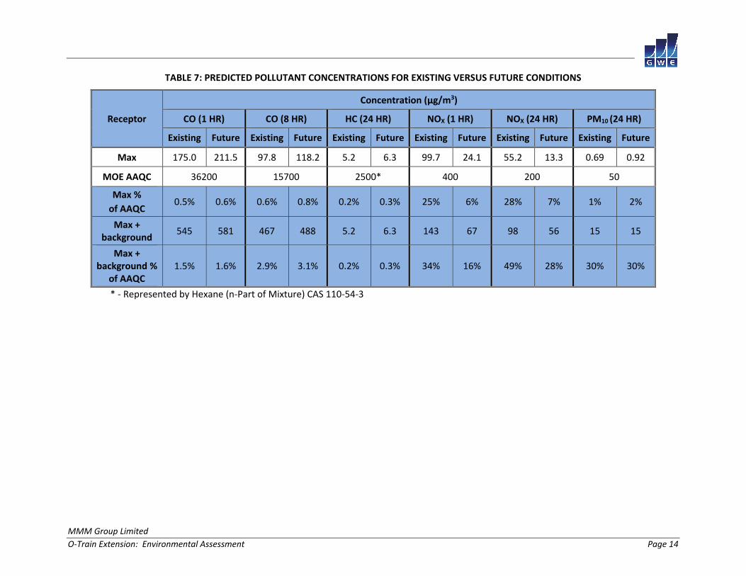
Predictions of existing and future maximum pollutant concentrations, due to O‐Train vehicle emissions
based on CAL3QHCR simulations, are presented in Table 7. The values presented are worst‐case maximum
concentrations expected to be reached only once in any five‐year period. These results incorporate the
effects of local wind statistics among other relevant parameters, but do not include current ambient
concentrations from the MOECC Carling Avenue monitoring station. As stated previously, background
concentrations have been excluded from the results given the complexity of trying to predict future
background concentrations. For completeness, the last two rows in Table 7 indicate model levels with
existing 90% background concentrations, assuming these levels are constant into the future. This is
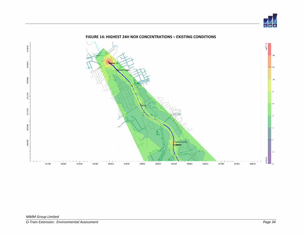
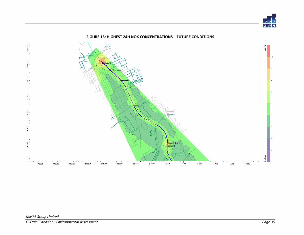
considered to be a conservative approach. Figures 14 and 15 illustrate the 24‐hour concentration levels
of NOx near the worst‐case receptors for existing and future conditions. Concentrations of all rail
emissions fall below the allowable limits for CO, HC, NOX, PM10. As such, the results indicate that the
introduction of the O‐Train extension will have a negligible impact on air quality as pollutant
concentrations are not expected to surpass MOECC AAQC criteria. The primary contributions to increased
emissions are the proposed Airport and Bowesville Stations, due to extra idling times at the terminal
stations. Reducing idling times of trains will improve localized air quality conditions.

MMM Group Limited
O‐Train Extension: Environmental Assessment Page 13
With respect to the maintenance yard, increased activities such as welding, painting and sand blasting
may trigger the requirement to complete an Environmental Compliance Approval for the facility during
detailed design. At this stage, little detailed information has been decided about the facility, and it would
be premature to conduct any detailed assessment. These studies would be conducted by a qualified air
quality consultant during detailed design of the facility.
MMM Group Limited
O‐Train Extension: Environmental Assessment Page 14
TABLE 7: PREDICTED POLLUTANT CONCENTRATIONS FOR EXISTING VERSUS FUTURE CONDITIONS
Receptor
Concentration (μg/m3)
CO (1 HR) CO (8 HR) HC (24 HR) NOX (1 HR) NOX (24 HR) PM10 (24 HR)
Existing Future Existing Future Existing Future Existing Future Existing Future Existing Future
Max 175.0 211.5 97.8 118.2 5.2 6.3 99.7 24.1 55.2 13.3 0.69 0.92
MOE AAQC 36200 15700 2500* 400 200 50
Max %
of AAQC 0.5% 0.6% 0.6% 0.8% 0.2% 0.3% 25% 6% 28% 7% 1% 2%
Max + background
545 581 467 488 5.2 6.3 143 67 98 56 15 15
Max + background %
of AAQC 1.5% 1.6% 2.9% 3.1% 0.2% 0.3% 34% 16% 49% 28% 30% 30%
* ‐ Represented by Hexane (n‐Part of Mixture) CAS 110‐54‐3
MMM Group Limited
O‐Train Extension: Environmental Assessment Page 15
5.2 Transportation Noise Impacts
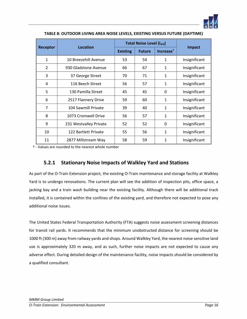
Existing and future noise levels due to vehicle traffic along the O‐Train corridor are summarized in Table
8 for daytime (07:00 to 23:00) periods with reference to receptors illustrated in Figures 2 to 12. Table 8
shows the change in overall noise levels. Appendices A and B provide the detailed input parameters and
calculation results from STAMSON for existing and future conditions.
According to the City of Ottawa ENCG, mitigation should be investigated and implemented where feasible
when future daytime noise levels exceed 60 dBA, or when there is a change of more than 5 dBA and future
noise levels exceed 55 dBA, as per Table 8. All but two receptors within the project limits have future noise
levels less than or equal to 60 dBA. In addition, the increase in noise due to the roadway expansion is less
than 5 dB. As such, noise control measures will not be required at these locations.
The existing and future noise levels at residences in close proximity to Highway 417 (R2 and R3) will
naturally see elevated noise levels. They were measured to be 66 and 70 dBA respectively. Because these
levels are above the City of Ottawa’s Environmental Noise Control Guidelines (ENCG) criterion of 60 dBA,
noise barriers should be investigated for the residences along Gladstone Avenue, George Street and
Railway Street. According to the ENCG, for a retrofit barrier to be considered practical it must provide a
reduction of 6 dBA. Investigation into a noise barrier indicated that for noise levels to be reduced 6 dBA,
a 5 meter tall barrier would be required along Highway 417 in this area (see Figure 2). The change in noise
levels between existing and future conditions is marginal, and a barrier 5 m in height would be difficult to
implement within the project limit. Furthermore, Highway 417 is under the jurisdiction of the Ontario
Ministry of Transportation and any noise mitigation project would be outside the scope of the O‐Train
expansion project.
MMM Group Limited
O‐Train Extension: Environmental Assessment Page 16
TABLE 8: OUTDOOR LIVING AREA NOISE LEVELS, EXISTING VERSUS FUTURE (DAYTIME)
Receptor Location Total Noise Level (LEQ)
Impact Existing Future Increase†
1 10 Breezehill Avenue 53 54 1 Insignificant
2 930 Gladstone Avenue 66 67 1 Insignificant
3 37 George Street 70 71 1 Insignificant
4 116 Beech Street 56 57 1 Insignificant
5 130 Pamilla Street 45 45 0 Insignificant
6 2517 Flannery Drive 59 60 1 Insignificant
7 104 Sawmill Private 39 40 1 Insignificant
8 1073 Cromwell Drive 56 57 1 Insignificant
9 231 Westvalley Private 52 52 0 Insignificant
10 122 Bartlett Private 55 56 1 Insignificant
11 2877 Millstream Way 58 59 1 Insignificant
† ‐ Values are rounded to the nearest whole number
5.2.1 Stationary Noise Impacts of Walkley Yard and Stations
As part of the O‐Train Extension project, the existing O‐Train maintenance and storage facility at Walkley
Yard is to undergo renovations. The current plan will see the addition of inspection pits, office space, a
jacking bay and a train wash building near the existing facility. Although there will be additional track
installed, it is contained within the confines of the existing yard, and therefore not expected to pose any
additional noise issues.
The United States Federal Transportation Authority (FTA) suggests noise assessment screening distances
for transit rail yards. It recommends that the minimum unobstructed distance for screening should be
1000 ft (300 m) away from railway yards and shops. Around Walkley Yard, the nearest noise sensitive land
use is approximately 320 m away, and as such, further noise impacts are not expected to cause any
adverse effect. During detailed design of the maintenance facility, noise impacts should be considered by
a qualified consultant.
MMM Group Limited
O‐Train Extension: Environmental Assessment Page 17
Proposed stations will be similar to existing configurations and will consist of a platform with standalone
weather shelters. No HVAC equipment is anticipated to be included. As such noise impacts from these
stations are expected to be limited to the train operations, which is considered in the Transportation Noise
Impacts section.
5.3 Ground Vibrations & Ground‐borne Noise Impacts
Vibration measurements were taken at four locations, as illustrated in Figures 2, 5 and 8. Results in Table
9 represent the upper range of the recorded measurements. Measured root mean square (RMS) vibration
levels at V4 marginally exceed the level commonly considered perceptible by most building occupants of
75 dBV or equivalently 0.14 mm/s. Furthermore, existing vibration levels are found to be negligible with
respect to the risk of structural damages or even cosmetic damages to building finishes. Future vibration
levels are not expected to increase in amplitude as the existing train fleet is expected to be used with
some improvement to the fleet in future years. With increased headways the frequency of vibration
events may increase.
The highest vibrations levels were measured at location V4, at Kaladar Park, at a distance of 25 meters
from the rail edge. The nearby homes in the area are equidistant to the track. The maximum vibration
levels were measured to be 0.37 mm/s RMS (83 dBV). At this section of track there is a bypass track, and
therefore trains were observed to be braking and accelerating. The Minimate Plus waveform can be seen
in Appendix C. Based on the measured vibration levels, vibrations from the O‐Train line can be moderately
perceptible within a distance of approximately 25 meters from the edge of the roadway along this section
of the track. Vibrations along this section of track are not expected to increase as the LRT will function in
a similar matter as the existing O‐Train.
According to the United States Federal Transit Authority’s vibration assessment protocol, ground borne
noise can be estimated by subtracting 50 dB from the velocity vibration level in dBV. Since measured
vibration levels were found to be 0.37 mm/s RMS (83 dBV) ground borne noise levels of 33 dBA are
expected to be below the ground borne noise criteria of 35 dBA.
Because vibration levels along section of new track are expected fall below the level of perceptibility of
75 dBV and vibration levels are not expected to substantially increase with the project undertaking, LRT
vibrations and ground borne noise are not expected to cause annoyance to dwelling occupants.
MMM Group Limited
O‐Train Extension: Environmental Assessment Page 18
TABLE 9: VIBRATION MEASUREMENT RESULTS FOR EXISTING CONDITIONS
Receptor Location Description Measured Vibration Level (RMS)
(dBV) (mm/s) Distance from Edge of Road (m)
V1 12 Railway Street –
Sidewalk N/A N/A 22
V2 1145 Plante Drive –
Pedestrian Bridge Entrance N/A N/A 249
V3 245 Westvalley Private –
Southwest Park N/A N/A 20
V4 2801 Traverse Drive –
Tennis Court 83 0.37 25
N/A – Vibration levels are under minimum trigger level

MMM Group Limited
O‐Train Extension: Environmental Assessment Page 19
6. IMPACTS OF CONSTRUCTION
Construction will involve surface works for replacing or construction of the new roadbed. As such, many
areas along the corridor are expected to experience some degree of air quality, noise and vibration
impacts during construction. In most cases however, the impacts will be controlled, minor and
intermittent over short cycles of activity.
The expected impacts from construction of the O‐Train extension will be limited to isolated and local
surface construction projects generating occasional minor ground vibrations, fumes and dust, as well as
intermittent noise. Common mitigation measures should make use of moveable noise barriers around the
perimeter of the work areas, extensive water spraying to control dust, and implementing daytime hours
of operation to avoid nighttime impacts when background noise is lowest. In all cases, air quality, noise
and ground vibrations are not expected to be disruptive to commonly occurring regular activities.
Suggested methods to control air emissions include, but are not limited to:
(i) Monitor wind conditions and plan operations to take advantage of calm wind periods
(ii) Minimize site storage of granular material in height and extent
(iii) Locate storage piles in sheltered areas that can be covered
(iv) Provide movable windbreaks
(v) Use water spray and suppression techniques to control fugitive dust
(vi) Cover haul trucks and keep access routes to the construction site clean of debris
For noise and vibrations, common control methods include but are not limited to:
(i) Limit speeds of heavy vehicles within and approaching the site
(ii) Provide compacted smooth surfaces, avoiding abrupt steps and ditches
(iii) Install movable barriers or temporary enclosures, around blast sites for instance
(iv) Keep equipment properly maintained and functioning as intended by the manufacturer
(v) If required, implement a blast design program prepared by a blast design engineer
The construction manager will be responsible for preparing and implementing a mitigation strategy with
the intent of satisfying the requirements of Ontario Regulations 419 for dust emissions, MOECC NPC‐115
and City of Ottawa By‐laws for noise, and MOECC NPC‐119 for ground vibrations. Proper planning will also
require that pre‐construction surveys be undertaken for selected buildings along the corridor. This will
also be identified during the detailed design phase.
MMM Group Limited
O‐Train Extension: Environmental Assessment Page 20
7. SUMMARY & CONCLUSIONS
The work summarized in this report compares existing and projected future conditions for air quality,
noise and ground vibrations, in support of the O‐Train Extension Environmental Assessment Study. The
study considered air quality, noise and vibration impacts along the O‐Train corridor, and the modification
of various stations along the rail line, as illustrated in Figure 1.
7.1 Operational Impacts
7.1.1 Air Quality Impacts
The O‐Train extension, with increased train volume, addition of stations and extended tracks will have a
negligible impact on the local air quality. Pollutant emissions, such as Nitrogen Oxides (NOx) are expected
to decrease over time, with the introduction of more stringent NOx emission regulations and introduction
of cleaner burning diesel engines. Carbon Monoxide (CO) and Particulate emissions (PM) are expected to
marginally increase over existing conditions as a result of the increased train volumes and new stations.
In all cases, existing and future concentrations of criteria air contaminants (NOx, CO, PM) remain well
under the Ontario Ministry of the Environment and Climate Change (MOECC) Ambient Air Quality Criteria
(AAQC).
7.1.2 Noise Impacts
Existing noise levels along the O‐Train corridor range from 39 to 70 dBA within the project limit during the
daytime period. With increased rail volumes, future noise levels will marginally increase above existing
conditions throughout the project limits, but are not expected to be considered noticeable by the majority
of human observers. All but two receptors within the project limits have future noise levels less than or
equal to 60 dBA. In addition, the increase in noise due to the O‐Train extension is less than 5 dB above
the existing (ambient) conditions. As such, noise control measures will not be required at these locations.
The existing and future noise levels at residences in close proximity to Highway 417 (R2 and R3) will
naturally see elevated noise levels. They were measured to be 66 and 70 dBA respectively. Because these
levels are above the City of Ottawa’s Environmental Noise Control Guidelines (ENCG) criterion of 60 dBA,
noise control measures should be investigated for the residences along Gladstone Avenue, George Street
and Railway Street. According to the ENCG, for a retrofit barrier to be considered practical, it must provide
a reduction of 6 dBA. Investigation into a noise barrier indicated that for noise levels to be reduced by 6
MMM Group Limited
O‐Train Extension: Environmental Assessment Page 21
dBA, a 5 meter tall barrier would be required along Highway 417 in this area (see Figure 2). As the change
in noise levels between existing and future conditions is marginal, and a barrier 5 m in height would be
difficult to implement, there is no practical way within the project limit to mitigate noise at these
locations. Furthermore, Highway 417 is under the jurisdiction of the Ontario Ministry of Transportation
and any noise mitigation project would be outside the scope of the O‐Train expansion project.
7.1.3 Vibration Impacts
The highest vibrations levels throughout the corridor were measured at Kaladar Park, at a distance of 25
meters from the rail edge, which is an equal distance of the house in the area to the tracks. Maximum
vibration levels were measured to be 0.37 mm/s RMS (83 dBV). At this section of track there is a bypass
track, and therefore trains can be breaking and accelerating. Based on the measured vibration levels,
vibrations from the O‐Train line can be moderately perceptible within a distance of approximately 25
meters from the edge of the tracks. These vibration levels are moderately above perceptible criteria of
0.14 mm/s RMS (75 dBV) however still under the level commonly considered annoying by building
occupants, 0.45 mm/s RMS (85 dBV). With the project undertaking, ground vibrations are not expected
to increase substantially to cause annoyance or structural issues. At three other monitoring locations,
vibration levels were well below the criteria and did not trigger the seismograph set to a minimum trigger
level of 0.13 peak partial velocity. The new section of track is at greater distances to residences and
therefore no vibration impacts are anticipated.
7.2 Construction Impacts
Varied construction activities along the O‐Train corridor are expected to create isolated and short‐term
noise, air quality and vibration impacts on the environment. The construction manager will be required
to develop a strategy for mitigating the effects according to good practices intended to satisfy, as feasible,
the fugitive dust limits specified in O.Reg. 419, the noise limits specified in MOE NPC‐11511 and City of
Ottawa By‐laws for Noise12, and MOECC NPC ‐11913 for ground vibrations. A list of common mitigation
strategies adapted to the current project is outlined of Section 6 of this report.
11 MOE, Model Municipal Noise Control By‐Law, NPC‐115 Construction Equipment, August 1978 12 City of Ottawa, Noise By‐law No. 2004‐253 13 MOE, Model Municipal Noise Control By‐Law, NPC‐119 Blasting, August 1978

MMM Group Limited
O‐Train Extension: Environmental Assessment Page 33
FIGURE 13: CALROADS RECEPTOR GRID (EXAMPLE AREA)
MMM Group Limited
O‐Train Extension: Environmental Assessment Page 34
FIGURE 14: HIGHEST 24H NOX CONCENTRATIONS – EXISTING CONDITIONS
MMM Group Limited
O‐Train Extension: Environmental Assessment Page 35
FIGURE 15: HIGHEST 24H NOX CONCENTRATIONS – FUTURE CONDITIONS

MMM Group Limited
O-Train Extension: Environmental Assessment A 1
APPENDIX A
STAMSON 5.04 - INPUT AND OUTPUT DATA (EXISTING CONDITIONS)

MMM Group Limited
O-Train Extension: Environmental Assessment A 2
STAMSON 5.0 NORMAL REPORT Date: 17-04-2015 10:22:19 MINISTRY OF ENVIRONMENT AND ENERGY / NOISE ASSESSMENT Filename: r1.te Time Period: Day/Night 16/8 hours Description: Road data, segment # 1: BayviewL (day/night) -------------------------------------------- Car traffic volume : 4467/388 veh/TimePeriod * Medium truck volume : 355/31 veh/TimePeriod * Heavy truck volume : 254/22 veh/TimePeriod * Posted speed limit : 50 km/h Road gradient : 0 % Road pavement : 1 (Typical asphalt or concrete) * Refers to calculated road volumes based on the following input: 24 hr Traffic Volume (AADT or SADT): 5518 Percentage of Annual Growth : 0.00 Number of Years of Growth : 0.00 Medium Truck % of Total Volume : 7.00 Heavy Truck % of Total Volume : 5.00 Day (16 hrs) % of Total Volume : 92.00 Data for Segment # 1: BayviewL (day/night) ------------------------------------------ Angle1 Angle2 : -48.00 deg -17.00 deg Wood depth : 0 (No woods.) No of house rows : 0 / 0 Surface : 2 (Reflective ground surface) Receiver source distance : 67.00 / 67.00 m Receiver height : 1.50 / 1.50 m Topography : 2 (Flat/gentle slope; with barrier) Barrier angle1 : -48.00 deg Angle2 : -29.00 deg Barrier height : 10.00 m Barrier receiver distance : 42.00 / 42.00 m Source elevation : 0.00 m Receiver elevation : 0.00 m Barrier elevation : 0.00 m Reference angle : 0.00
MMM Group Limited
O-Train Extension: Environmental Assessment A 3
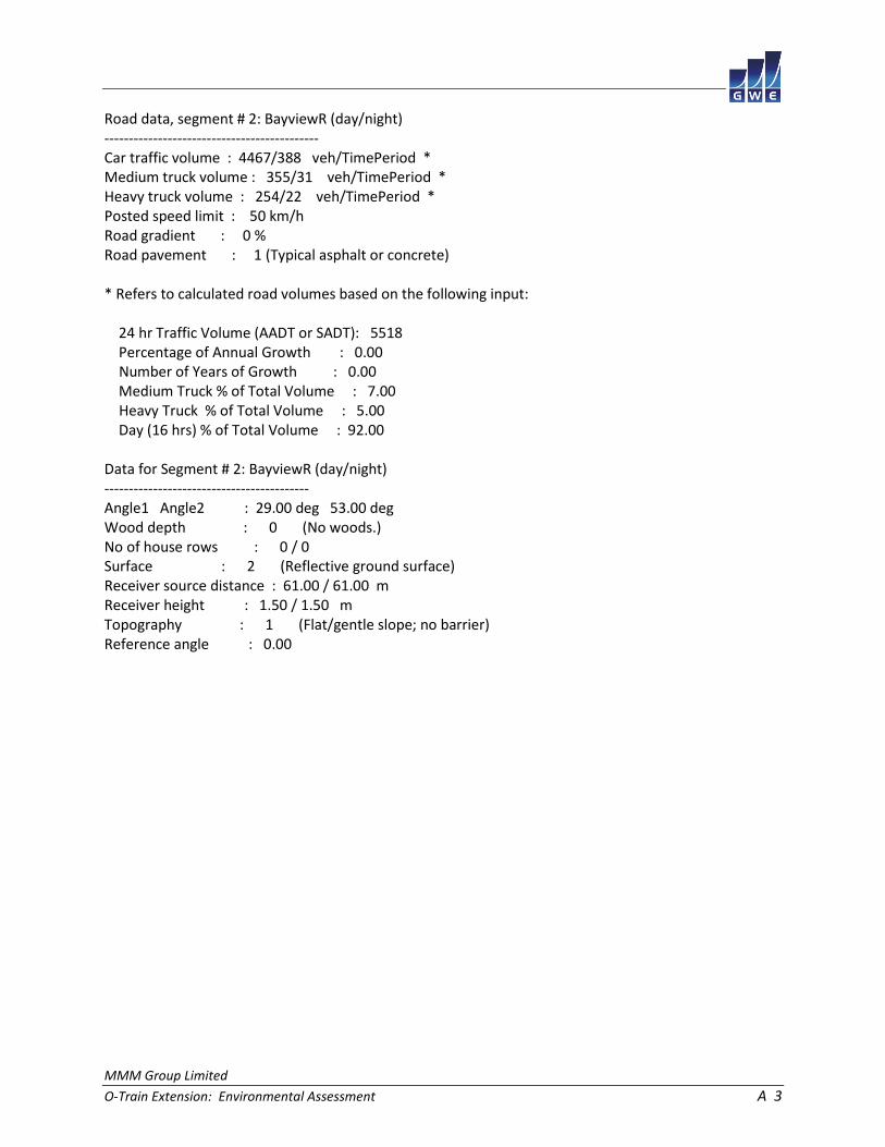
Road data, segment # 2: BayviewR (day/night) -------------------------------------------- Car traffic volume : 4467/388 veh/TimePeriod * Medium truck volume : 355/31 veh/TimePeriod * Heavy truck volume : 254/22 veh/TimePeriod * Posted speed limit : 50 km/h Road gradient : 0 % Road pavement : 1 (Typical asphalt or concrete) * Refers to calculated road volumes based on the following input: 24 hr Traffic Volume (AADT or SADT): 5518 Percentage of Annual Growth : 0.00 Number of Years of Growth : 0.00 Medium Truck % of Total Volume : 7.00 Heavy Truck % of Total Volume : 5.00 Day (16 hrs) % of Total Volume : 92.00 Data for Segment # 2: BayviewR (day/night) ------------------------------------------ Angle1 Angle2 : 29.00 deg 53.00 deg Wood depth : 0 (No woods.) No of house rows : 0 / 0 Surface : 2 (Reflective ground surface) Receiver source distance : 61.00 / 61.00 m Receiver height : 1.50 / 1.50 m Topography : 1 (Flat/gentle slope; no barrier) Reference angle : 0.00

MMM Group Limited
O-Train Extension: Environmental Assessment A 4
Results segment # 1: BayviewL (day) ----------------------------------- Source height = 1.50 m Barrier height for grazing incidence ------------------------------------ Source ! Receiver ! Barrier ! Elevation of Height (m) ! Height (m) ! Height (m) ! Barrier Top (m) ------------+-------------+-------------+-------------- 1.50 ! 1.50 ! 1.50 ! 1.50 ROAD (0.00 + 27.99 + 45.88) = 45.95 dBA Angle1 Angle2 Alpha RefLeq P.Adj D.Adj F.Adj W.Adj H.Adj B.Adj SubLeq ---------------------------------------------------------------------------- -48 -29 0.00 64.14 0.00 -6.50 -9.77 0.00 0.00 -19.88 27.99 ---------------------------------------------------------------------------- -29 -17 0.00 64.14 0.00 -6.50 -11.76 0.00 0.00 0.00 45.88 ---------------------------------------------------------------------------- Segment Leq : 45.95 dBA Results segment # 2: BayviewR (day) ----------------------------------- Source height = 1.50 m ROAD (0.00 + 49.29 + 0.00) = 49.29 dBA Angle1 Angle2 Alpha RefLeq P.Adj D.Adj F.Adj W.Adj H.Adj B.Adj SubLeq ---------------------------------------------------------------------------- 29 53 0.00 64.14 0.00 -6.09 -8.75 0.00 0.00 0.00 49.29 ---------------------------------------------------------------------------- Segment Leq : 49.29 dBA Total Leq All Segments: 50.94 dBA

MMM Group Limited
O-Train Extension: Environmental Assessment A 5
Results segment # 1: BayviewL (night) ------------------------------------- Source height = 1.49 m Barrier height for grazing incidence ------------------------------------ Source ! Receiver ! Barrier ! Elevation of Height (m) ! Height (m) ! Height (m) ! Barrier Top (m) ------------+-------------+-------------+-------------- 1.49 ! 1.50 ! 1.50 ! 1.50 ROAD (0.00 + 20.39 + 38.27) = 38.34 dBA Angle1 Angle2 Alpha RefLeq P.Adj D.Adj F.Adj W.Adj H.Adj B.Adj SubLeq ---------------------------------------------------------------------------- -48 -29 0.00 56.53 0.00 -6.50 -9.77 0.00 0.00 -19.88 20.39 ---------------------------------------------------------------------------- -29 -17 0.00 56.53 0.00 -6.50 -11.76 0.00 0.00 0.00 38.27 ---------------------------------------------------------------------------- Segment Leq : 38.34 dBA Results segment # 2: BayviewR (night) ------------------------------------- Source height = 1.49 m ROAD (0.00 + 41.69 + 0.00) = 41.69 dBA Angle1 Angle2 Alpha RefLeq P.Adj D.Adj F.Adj W.Adj H.Adj B.Adj SubLeq ---------------------------------------------------------------------------- 29 53 0.00 56.53 0.00 -6.09 -8.75 0.00 0.00 0.00 41.69 ---------------------------------------------------------------------------- Segment Leq : 41.69 dBA Total Leq All Segments: 43.34 dBA
MMM Group Limited
O-Train Extension: Environmental Assessment A 6
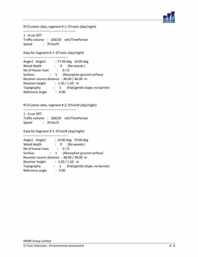
RT/Custom data, segment # 1: OTrainL (day/night) ------------------------------------------------ 1 - 4-car SRT: Traffic volume : 160/20 veh/TimePeriod Speed : 70 km/h Data for Segment # 1: OTrainL (day/night) ----------------------------------------- Angle1 Angle2 : -77.00 deg 16.00 deg Wood depth : 0 (No woods.) No of house rows : 0 / 0 Surface : 1 (Absorptive ground surface) Receiver source distance : 46.00 / 46.00 m Receiver height : 1.50 / 1.50 m Topography : 1 (Flat/gentle slope; no barrier) Reference angle : 0.00 RT/Custom data, segment # 2: OTrainR (day/night) ------------------------------------------------ 1 - 4-car SRT: Traffic volume : 160/20 veh/TimePeriod Speed : 70 km/h Data for Segment # 2: OTrainR (day/night) ----------------------------------------- Angle1 Angle2 : 10.00 deg 79.00 deg Wood depth : 0 (No woods.) No of house rows : 0 / 0 Surface : 1 (Absorptive ground surface) Receiver source distance : 48.00 / 48.00 m Receiver height : 1.50 / 1.50 m Topography : 1 (Flat/gentle slope; no barrier) Reference angle : 0.00

MMM Group Limited
O-Train Extension: Environmental Assessment A 7
Results segment # 1: OTrainL (day) ---------------------------------- Source height = 0.50 m RT/Custom (0.00 + 46.40 + 0.00) = 46.40 dBA Angle1 Angle2 Alpha RefLeq D.Adj F.Adj W.Adj H.Adj B.Adj SubLeq ---------------------------------------------------------------------- -77 16 0.66 58.15 -8.08 -3.67 0.00 0.00 0.00 46.40 ---------------------------------------------------------------------- Segment Leq : 46.40 dBA Results segment # 2: OTrainR (day) ---------------------------------- Source height = 0.50 m RT/Custom (0.00 + 44.39 + 0.00) = 44.39 dBA Angle1 Angle2 Alpha RefLeq D.Adj F.Adj W.Adj H.Adj B.Adj SubLeq ---------------------------------------------------------------------- 10 79 0.66 58.15 -8.39 -5.38 0.00 0.00 0.00 44.39 ---------------------------------------------------------------------- Segment Leq : 44.39 dBA Total Leq All Segments: 48.52 dBA
MMM Group Limited
O-Train Extension: Environmental Assessment A 8
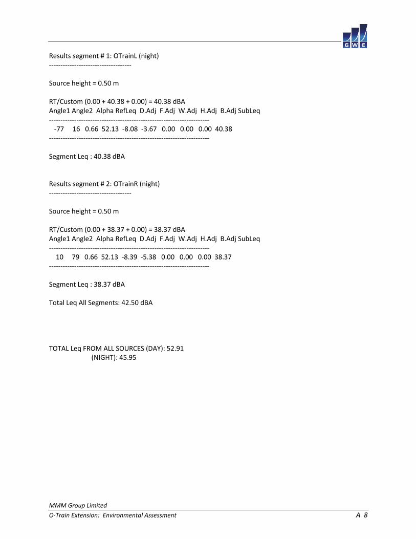
Results segment # 1: OTrainL (night) ------------------------------------ Source height = 0.50 m RT/Custom (0.00 + 40.38 + 0.00) = 40.38 dBA Angle1 Angle2 Alpha RefLeq D.Adj F.Adj W.Adj H.Adj B.Adj SubLeq ---------------------------------------------------------------------- -77 16 0.66 52.13 -8.08 -3.67 0.00 0.00 0.00 40.38 ---------------------------------------------------------------------- Segment Leq : 40.38 dBA Results segment # 2: OTrainR (night) ------------------------------------ Source height = 0.50 m RT/Custom (0.00 + 38.37 + 0.00) = 38.37 dBA Angle1 Angle2 Alpha RefLeq D.Adj F.Adj W.Adj H.Adj B.Adj SubLeq ---------------------------------------------------------------------- 10 79 0.66 52.13 -8.39 -5.38 0.00 0.00 0.00 38.37 ---------------------------------------------------------------------- Segment Leq : 38.37 dBA Total Leq All Segments: 42.50 dBA TOTAL Leq FROM ALL SOURCES (DAY): 52.91 (NIGHT): 45.95

MMM Group Limited
O-Train Extension: Environmental Assessment A 9
STAMSON 5.0 NORMAL REPORT Date: 17-04-2015 10:22:35 MINISTRY OF ENVIRONMENT AND ENERGY / NOISE ASSESSMENT Filename: r2.te Time Period: Day/Night 16/8 hours Description: Road data, segment # 1: Gladstone (day/night) --------------------------------------------- Car traffic volume : 3852/335 veh/TimePeriod * Medium truck volume : 306/27 veh/TimePeriod * Heavy truck volume : 219/19 veh/TimePeriod * Posted speed limit : 40 km/h Road gradient : 0 % Road pavement : 1 (Typical asphalt or concrete) * Refers to calculated road volumes based on the following input: 24 hr Traffic Volume (AADT or SADT): 4758 Percentage of Annual Growth : 0.00 Number of Years of Growth : 0.00 Medium Truck % of Total Volume : 7.00 Heavy Truck % of Total Volume : 5.00 Day (16 hrs) % of Total Volume : 92.00 Data for Segment # 1: Gladstone (day/night) ------------------------------------------- Angle1 Angle2 : -70.00 deg 70.00 deg Wood depth : 0 (No woods.) No of house rows : 0 / 0 Surface : 2 (Reflective ground surface) Receiver source distance : 35.00 / 35.00 m Receiver height : 1.50 / 1.50 m Topography : 2 (Flat/gentle slope; with barrier) Barrier angle1 : -48.00 deg Angle2 : 70.00 deg Barrier height : 10.00 m Barrier receiver distance : 3.00 / 3.00 m Source elevation : 0.00 m Receiver elevation : 0.00 m Barrier elevation : 0.00 m Reference angle : 0.00

MMM Group Limited
O-Train Extension: Environmental Assessment A 10
Road data, segment # 2: 417WBL (day/night) ------------------------------------------ Car traffic volume : 75293/6547 veh/TimePeriod * Medium truck volume : 5989/521 veh/TimePeriod * Heavy truck volume : 4278/372 veh/TimePeriod * Posted speed limit : 100 km/h Road gradient : 0 % Road pavement : 1 (Typical asphalt or concrete) * Refers to calculated road volumes based on the following input: 24 hr Traffic Volume (AADT or SADT): 93000 Percentage of Annual Growth : 0.00 Number of Years of Growth : 0.00 Medium Truck % of Total Volume : 7.00 Heavy Truck % of Total Volume : 5.00 Day (16 hrs) % of Total Volume : 92.00 Data for Segment # 2: 417WBL (day/night) ---------------------------------------- Angle1 Angle2 : -73.00 deg 6.00 deg Wood depth : 0 (No woods.) No of house rows : 0 / 0 Surface : 2 (Reflective ground surface) Receiver source distance : 143.00 / 143.00 m Receiver height : 1.50 / 1.50 m Topography : 2 (Flat/gentle slope; with barrier) Barrier angle1 : -73.00 deg Angle2 : 6.00 deg Barrier height : 7.00 m Barrier receiver distance : 16.00 / 16.00 m Source elevation : 10.00 m Receiver elevation : 0.00 m Barrier elevation : 0.00 m Reference angle : 0.00

MMM Group Limited
O-Train Extension: Environmental Assessment A 11
Road data, segment # 3: 417WBC (day/night) ------------------------------------------ Car traffic volume : 75293/6547 veh/TimePeriod * Medium truck volume : 5989/521 veh/TimePeriod * Heavy truck volume : 4278/372 veh/TimePeriod * Posted speed limit : 100 km/h Road gradient : 0 % Road pavement : 1 (Typical asphalt or concrete) * Refers to calculated road volumes based on the following input: 24 hr Traffic Volume (AADT or SADT): 93000 Percentage of Annual Growth : 0.00 Number of Years of Growth : 0.00 Medium Truck % of Total Volume : 7.00 Heavy Truck % of Total Volume : 5.00 Day (16 hrs) % of Total Volume : 92.00 Data for Segment # 3: 417WBC (day/night) ---------------------------------------- Angle1 Angle2 : 6.00 deg 12.00 deg Wood depth : 0 (No woods.) No of house rows : 0 / 0 Surface : 2 (Reflective ground surface) Receiver source distance : 143.00 / 143.00 m Receiver height : 1.50 / 1.50 m Topography : 2 (Flat/gentle slope; with barrier) Barrier angle1 : 6.00 deg Angle2 : 12.00 deg Barrier height : 1.50 m Barrier receiver distance : 135.00 / 135.00 m Source elevation : 10.00 m Receiver elevation : 0.00 m Barrier elevation : 10.00 m Reference angle : 0.00

MMM Group Limited
O-Train Extension: Environmental Assessment A 12
Road data, segment # 4: 417EBL (day/night) ------------------------------------------ Car traffic volume : 75293/6547 veh/TimePeriod * Medium truck volume : 5989/521 veh/TimePeriod * Heavy truck volume : 4278/372 veh/TimePeriod * Posted speed limit : 100 km/h Road gradient : 0 % Road pavement : 1 (Typical asphalt or concrete) * Refers to calculated road volumes based on the following input: 24 hr Traffic Volume (AADT or SADT): 93000 Percentage of Annual Growth : 0.00 Number of Years of Growth : 0.00 Medium Truck % of Total Volume : 7.00 Heavy Truck % of Total Volume : 5.00 Day (16 hrs) % of Total Volume : 92.00 Data for Segment # 4: 417EBL (day/night) ---------------------------------------- Angle1 Angle2 : -71.00 deg 6.00 deg Wood depth : 0 (No woods.) No of house rows : 0 / 0 Surface : 2 (Reflective ground surface) Receiver source distance : 162.00 / 162.00 m Receiver height : 1.50 / 1.50 m Topography : 2 (Flat/gentle slope; with barrier) Barrier angle1 : -71.00 deg Angle2 : 6.00 deg Barrier height : 7.00 m Barrier receiver distance : 16.00 / 16.00 m Source elevation : 10.00 m Receiver elevation : 0.00 m Barrier elevation : 0.00 m Reference angle : 0.00

MMM Group Limited
O-Train Extension: Environmental Assessment A 13
Road data, segment # 5: 417EBC (day/night) ------------------------------------------ Car traffic volume : 75293/6547 veh/TimePeriod * Medium truck volume : 5989/521 veh/TimePeriod * Heavy truck volume : 4278/372 veh/TimePeriod * Posted speed limit : 100 km/h Road gradient : 0 % Road pavement : 1 (Typical asphalt or concrete) * Refers to calculated road volumes based on the following input: 24 hr Traffic Volume (AADT or SADT): 93000 Percentage of Annual Growth : 0.00 Number of Years of Growth : 0.00 Medium Truck % of Total Volume : 7.00 Heavy Truck % of Total Volume : 5.00 Day (16 hrs) % of Total Volume : 92.00 Data for Segment # 5: 417EBC (day/night) ---------------------------------------- Angle1 Angle2 : 6.00 deg 13.00 deg Wood depth : 0 (No woods.) No of house rows : 0 / 0 Surface : 2 (Reflective ground surface) Receiver source distance : 162.00 / 162.00 m Receiver height : 1.50 / 1.50 m Topography : 2 (Flat/gentle slope; with barrier) Barrier angle1 : 6.00 deg Angle2 : 13.00 deg Barrier height : 1.50 m Barrier receiver distance : 135.00 / 135.00 m Source elevation : 10.00 m Receiver elevation : 0.00 m Barrier elevation : 10.00 m Reference angle : 0.00

MMM Group Limited
O-Train Extension: Environmental Assessment A 14
Road data, segment # 6: 417WBR (day/night) ------------------------------------------ Car traffic volume : 75293/6547 veh/TimePeriod * Medium truck volume : 5989/521 veh/TimePeriod * Heavy truck volume : 4278/372 veh/TimePeriod * Posted speed limit : 100 km/h Road gradient : 0 % Road pavement : 1 (Typical asphalt or concrete) * Refers to calculated road volumes based on the following input: 24 hr Traffic Volume (AADT or SADT): 93000 Percentage of Annual Growth : 0.00 Number of Years of Growth : 0.00 Medium Truck % of Total Volume : 7.00 Heavy Truck % of Total Volume : 5.00 Day (16 hrs) % of Total Volume : 92.00 Data for Segment # 6: 417WBR (day/night) ---------------------------------------- Angle1 Angle2 : 19.00 deg 74.00 deg Wood depth : 0 (No woods.) No of house rows : 0 / 0 Surface : 2 (Reflective ground surface) Receiver source distance : 139.00 / 139.00 m Receiver height : 1.50 / 1.50 m Topography : 2 (Flat/gentle slope; with barrier) Barrier angle1 : 19.00 deg Angle2 : 74.00 deg Barrier height : 1.50 m Barrier receiver distance : 136.00 / 136.00 m Source elevation : 10.00 m Receiver elevation : 0.00 m Barrier elevation : 10.00 m Reference angle : 0.00

MMM Group Limited
O-Train Extension: Environmental Assessment A 15
Road data, segment # 7: 417EBR (day/night) ------------------------------------------ Car traffic volume : 75293/6547 veh/TimePeriod * Medium truck volume : 5989/521 veh/TimePeriod * Heavy truck volume : 4278/372 veh/TimePeriod * Posted speed limit : 100 km/h Road gradient : 0 % Road pavement : 1 (Typical asphalt or concrete) * Refers to calculated road volumes based on the following input: 24 hr Traffic Volume (AADT or SADT): 93000 Percentage of Annual Growth : 0.00 Number of Years of Growth : 0.00 Medium Truck % of Total Volume : 7.00 Heavy Truck % of Total Volume : 5.00 Day (16 hrs) % of Total Volume : 92.00 Data for Segment # 7: 417EBR (day/night) ---------------------------------------- Angle1 Angle2 : 20.00 deg 72.00 deg Wood depth : 0 (No woods.) No of house rows : 0 / 0 Surface : 2 (Reflective ground surface) Receiver source distance : 156.00 / 156.00 m Receiver height : 1.50 / 1.50 m Topography : 2 (Flat/gentle slope; with barrier) Barrier angle1 : 20.00 deg Angle2 : 72.00 deg Barrier height : 1.50 m Barrier receiver distance : 136.00 / 136.00 m Source elevation : 10.00 m Receiver elevation : 0.00 m Barrier elevation : 10.00 m Reference angle : 0.00
MMM Group Limited
O-Train Extension: Environmental Assessment A 16
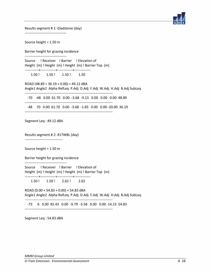
Results segment # 1: Gladstone (day) ------------------------------------ Source height = 1.50 m Barrier height for grazing incidence ------------------------------------ Source ! Receiver ! Barrier ! Elevation of Height (m) ! Height (m) ! Height (m) ! Barrier Top (m) ------------+-------------+-------------+-------------- 1.50 ! 1.50 ! 1.50 ! 1.50 ROAD (48.89 + 36.19 + 0.00) = 49.12 dBA Angle1 Angle2 Alpha RefLeq P.Adj D.Adj F.Adj W.Adj H.Adj B.Adj SubLeq ---------------------------------------------------------------------------- -70 -48 0.00 61.70 0.00 -3.68 -9.13 0.00 0.00 0.00 48.89 ---------------------------------------------------------------------------- -48 70 0.00 61.70 0.00 -3.68 -1.83 0.00 0.00 -20.00 36.19 ---------------------------------------------------------------------------- Segment Leq : 49.12 dBA Results segment # 2: 417WBL (day) --------------------------------- Source height = 1.50 m Barrier height for grazing incidence ------------------------------------ Source ! Receiver ! Barrier ! Elevation of Height (m) ! Height (m) ! Height (m) ! Barrier Top (m) ------------+-------------+-------------+-------------- 1.50 ! 1.50 ! 2.62 ! 2.62 ROAD (0.00 + 54.83 + 0.00) = 54.83 dBA Angle1 Angle2 Alpha RefLeq P.Adj D.Adj F.Adj W.Adj H.Adj B.Adj SubLeq ---------------------------------------------------------------------------- -73 6 0.00 82.43 0.00 -9.79 -3.58 0.00 0.00 -14.23 54.83 ---------------------------------------------------------------------------- Segment Leq : 54.83 dBA

MMM Group Limited
O-Train Extension: Environmental Assessment A 17
Results segment # 3: 417WBC (day) --------------------------------- Source height = 1.50 m Barrier height for grazing incidence ------------------------------------ Source ! Receiver ! Barrier ! Elevation of Height (m) ! Height (m) ! Height (m) ! Barrier Top (m) ------------+-------------+-------------+-------------- 1.50 ! 1.50 ! 0.94 ! 10.94 ROAD (0.00 + 51.86 + 0.00) = 51.86 dBA Angle1 Angle2 Alpha RefLeq P.Adj D.Adj F.Adj W.Adj H.Adj B.Adj SubLeq ---------------------------------------------------------------------------- 6 12 0.00 82.43 0.00 -9.79 -14.77 0.00 0.00 -6.01 51.86 ---------------------------------------------------------------------------- Segment Leq : 51.86 dBA Results segment # 4: 417EBL (day) --------------------------------- Source height = 1.50 m Barrier height for grazing incidence ------------------------------------ Source ! Receiver ! Barrier ! Elevation of Height (m) ! Height (m) ! Height (m) ! Barrier Top (m) ------------+-------------+-------------+-------------- 1.50 ! 1.50 ! 2.49 ! 2.49 ROAD (0.00 + 53.86 + 0.00) = 53.86 dBA Angle1 Angle2 Alpha RefLeq P.Adj D.Adj F.Adj W.Adj H.Adj B.Adj SubLeq ---------------------------------------------------------------------------- -71 6 0.00 82.43 0.00 -10.33 -3.69 0.00 0.00 -14.55 53.86 ---------------------------------------------------------------------------- Segment Leq : 53.86 dBA

MMM Group Limited
O-Train Extension: Environmental Assessment A 18
Results segment # 5: 417EBC (day) --------------------------------- Source height = 1.50 m Barrier height for grazing incidence ------------------------------------ Source ! Receiver ! Barrier ! Elevation of Height (m) ! Height (m) ! Height (m) ! Barrier Top (m) ------------+-------------+-------------+-------------- 1.50 ! 1.50 ! -0.17 ! 9.83 ROAD (0.00 + 50.41 + 0.00) = 50.41 dBA Angle1 Angle2 Alpha RefLeq P.Adj D.Adj F.Adj W.Adj H.Adj B.Adj SubLeq ---------------------------------------------------------------------------- 6 13 0.00 82.43 0.00 -10.33 -14.10 0.00 0.00 -7.59 50.41 ---------------------------------------------------------------------------- Segment Leq : 50.41 dBA Results segment # 6: 417WBR (day) --------------------------------- Source height = 1.50 m Barrier height for grazing incidence ------------------------------------ Source ! Receiver ! Barrier ! Elevation of Height (m) ! Height (m) ! Height (m) ! Barrier Top (m) ------------+-------------+-------------+-------------- 1.50 ! 1.50 ! 1.28 ! 11.28 ROAD (0.00 + 62.33 + 0.00) = 62.33 dBA Angle1 Angle2 Alpha RefLeq P.Adj D.Adj F.Adj W.Adj H.Adj B.Adj SubLeq ---------------------------------------------------------------------------- 19 74 0.00 82.43 0.00 -9.67 -5.15 0.00 0.00 -5.28 62.33 ---------------------------------------------------------------------------- Segment Leq : 62.33 dBA

MMM Group Limited
O-Train Extension: Environmental Assessment A 19
Results segment # 7: 417EBR (day) --------------------------------- Source height = 1.50 m Barrier height for grazing incidence ------------------------------------ Source ! Receiver ! Barrier ! Elevation of Height (m) ! Height (m) ! Height (m) ! Barrier Top (m) ------------+-------------+-------------+-------------- 1.50 ! 1.50 ! 0.21 ! 10.21 ROAD (0.00 + 60.41 + 0.00) = 60.41 dBA Angle1 Angle2 Alpha RefLeq P.Adj D.Adj F.Adj W.Adj H.Adj B.Adj SubLeq ---------------------------------------------------------------------------- 20 72 0.00 82.43 0.00 -10.17 -5.39 0.00 0.00 -6.46 60.41 ---------------------------------------------------------------------------- Segment Leq : 60.41 dBA Total Leq All Segments: 65.68 dBA Results segment # 1: Gladstone (night) -------------------------------------- Source height = 1.49 m Barrier height for grazing incidence ------------------------------------ Source ! Receiver ! Barrier ! Elevation of Height (m) ! Height (m) ! Height (m) ! Barrier Top (m) ------------+-------------+-------------+-------------- 1.49 ! 1.50 ! 1.50 ! 1.50 ROAD (41.30 + 28.59 + 0.00) = 41.53 dBA Angle1 Angle2 Alpha RefLeq P.Adj D.Adj F.Adj W.Adj H.Adj B.Adj SubLeq ---------------------------------------------------------------------------- -70 -48 0.00 54.11 0.00 -3.68 -9.13 0.00 0.00 0.00 41.30 ---------------------------------------------------------------------------- -48 70 0.00 54.11 0.00 -3.68 -1.83 0.00 0.00 -20.00 28.59 ---------------------------------------------------------------------------- Segment Leq : 41.53 dBA

MMM Group Limited
O-Train Extension: Environmental Assessment A 20
Results segment # 2: 417WBL (night) ----------------------------------- Source height = 1.50 m Barrier height for grazing incidence ------------------------------------ Source ! Receiver ! Barrier ! Elevation of Height (m) ! Height (m) ! Height (m) ! Barrier Top (m) ------------+-------------+-------------+-------------- 1.50 ! 1.50 ! 2.62 ! 2.62 ROAD (0.00 + 47.23 + 0.00) = 47.23 dBA Angle1 Angle2 Alpha RefLeq P.Adj D.Adj F.Adj W.Adj H.Adj B.Adj SubLeq ---------------------------------------------------------------------------- -73 6 0.00 74.83 0.00 -9.79 -3.58 0.00 0.00 -14.23 47.23 ---------------------------------------------------------------------------- Segment Leq : 47.23 dBA Results segment # 3: 417WBC (night) ----------------------------------- Source height = 1.50 m Barrier height for grazing incidence ------------------------------------ Source ! Receiver ! Barrier ! Elevation of Height (m) ! Height (m) ! Height (m) ! Barrier Top (m) ------------+-------------+-------------+-------------- 1.50 ! 1.50 ! 0.94 ! 10.94 ROAD (0.00 + 44.26 + 0.00) = 44.26 dBA Angle1 Angle2 Alpha RefLeq P.Adj D.Adj F.Adj W.Adj H.Adj B.Adj SubLeq ---------------------------------------------------------------------------- 6 12 0.00 74.83 0.00 -9.79 -14.77 0.00 0.00 -6.01 44.26 ---------------------------------------------------------------------------- Segment Leq : 44.26 dBA

MMM Group Limited
O-Train Extension: Environmental Assessment A 21
Results segment # 4: 417EBL (night) ----------------------------------- Source height = 1.50 m Barrier height for grazing incidence ------------------------------------ Source ! Receiver ! Barrier ! Elevation of Height (m) ! Height (m) ! Height (m) ! Barrier Top (m) ------------+-------------+-------------+-------------- 1.50 ! 1.50 ! 2.49 ! 2.49 ROAD (0.00 + 46.26 + 0.00) = 46.26 dBA Angle1 Angle2 Alpha RefLeq P.Adj D.Adj F.Adj W.Adj H.Adj B.Adj SubLeq ---------------------------------------------------------------------------- -71 6 0.00 74.83 0.00 -10.33 -3.69 0.00 0.00 -14.55 46.26 ---------------------------------------------------------------------------- Segment Leq : 46.26 dBA Results segment # 5: 417EBC (night) ----------------------------------- Source height = 1.50 m Barrier height for grazing incidence ------------------------------------ Source ! Receiver ! Barrier ! Elevation of Height (m) ! Height (m) ! Height (m) ! Barrier Top (m) ------------+-------------+-------------+-------------- 1.50 ! 1.50 ! -0.17 ! 9.83 ROAD (0.00 + 42.81 + 0.00) = 42.81 dBA Angle1 Angle2 Alpha RefLeq P.Adj D.Adj F.Adj W.Adj H.Adj B.Adj SubLeq ---------------------------------------------------------------------------- 6 13 0.00 74.83 0.00 -10.33 -14.10 0.00 0.00 -7.59 42.81 ---------------------------------------------------------------------------- Segment Leq : 42.81 dBA

MMM Group Limited
O-Train Extension: Environmental Assessment A 22
Results segment # 6: 417WBR (night) ----------------------------------- Source height = 1.50 m Barrier height for grazing incidence ------------------------------------ Source ! Receiver ! Barrier ! Elevation of Height (m) ! Height (m) ! Height (m) ! Barrier Top (m) ------------+-------------+-------------+-------------- 1.50 ! 1.50 ! 1.28 ! 11.28 ROAD (0.00 + 54.73 + 0.00) = 54.73 dBA Angle1 Angle2 Alpha RefLeq P.Adj D.Adj F.Adj W.Adj H.Adj B.Adj SubLeq ---------------------------------------------------------------------------- 19 74 0.00 74.83 0.00 -9.67 -5.15 0.00 0.00 -5.28 54.73 ---------------------------------------------------------------------------- Segment Leq : 54.73 dBA Results segment # 7: 417EBR (night) ----------------------------------- Source height = 1.50 m Barrier height for grazing incidence ------------------------------------ Source ! Receiver ! Barrier ! Elevation of Height (m) ! Height (m) ! Height (m) ! Barrier Top (m) ------------+-------------+-------------+-------------- 1.50 ! 1.50 ! 0.21 ! 10.21 ROAD (0.00 + 52.81 + 0.00) = 52.81 dBA Angle1 Angle2 Alpha RefLeq P.Adj D.Adj F.Adj W.Adj H.Adj B.Adj SubLeq ---------------------------------------------------------------------------- 20 72 0.00 74.83 0.00 -10.17 -5.39 0.00 0.00 -6.46 52.81 ---------------------------------------------------------------------------- Segment Leq : 52.81 dBA Total Leq All Segments: 58.08 dBA
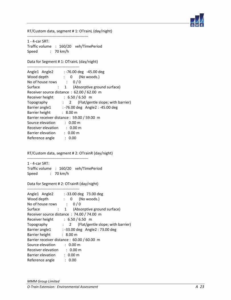
MMM Group Limited
O-Train Extension: Environmental Assessment A 23
RT/Custom data, segment # 1: OTrainL (day/night) ------------------------------------------------ 1 - 4-car SRT: Traffic volume : 160/20 veh/TimePeriod Speed : 70 km/h Data for Segment # 1: OTrainL (day/night) ----------------------------------------- Angle1 Angle2 : -76.00 deg -45.00 deg Wood depth : 0 (No woods.) No of house rows : 0 / 0 Surface : 1 (Absorptive ground surface) Receiver source distance : 62.00 / 62.00 m Receiver height : 6.50 / 6.50 m Topography : 2 (Flat/gentle slope; with barrier) Barrier angle1 : -76.00 deg Angle2 : -45.00 deg Barrier height : 8.00 m Barrier receiver distance : 59.00 / 59.00 m Source elevation : 0.00 m Receiver elevation : 0.00 m Barrier elevation : 0.00 m Reference angle : 0.00 RT/Custom data, segment # 2: OTrainR (day/night) ------------------------------------------------ 1 - 4-car SRT: Traffic volume : 160/20 veh/TimePeriod Speed : 70 km/h Data for Segment # 2: OTrainR (day/night) ----------------------------------------- Angle1 Angle2 : -33.00 deg 73.00 deg Wood depth : 0 (No woods.) No of house rows : 0 / 0 Surface : 1 (Absorptive ground surface) Receiver source distance : 74.00 / 74.00 m Receiver height : 6.50 / 6.50 m Topography : 2 (Flat/gentle slope; with barrier) Barrier angle1 : -33.00 deg Angle2 : 73.00 deg Barrier height : 8.00 m Barrier receiver distance : 60.00 / 60.00 m Source elevation : 0.00 m Receiver elevation : 0.00 m Barrier elevation : 0.00 m Reference angle : 0.00

MMM Group Limited
O-Train Extension: Environmental Assessment A 24
Results segment # 1: OTrainL (day) ---------------------------------- Source height = 0.50 m Barrier height for grazing incidence ------------------------------------ Source ! Receiver ! Barrier ! Elevation of Height (m) ! Height (m) ! Height (m) ! Barrier Top (m) ------------+-------------+-------------+-------------- 0.50 ! 6.50 ! 0.79 ! 0.79 RT/Custom (0.00 + 23.99 + 0.00) = 23.99 dBA Angle1 Angle2 Alpha RefLeq D.Adj F.Adj W.Adj H.Adj B.Adj SubLeq ---------------------------------------------------------------------- -76 -45 0.06 58.15 -6.53 -7.84 0.00 0.00 -19.80 23.99 ---------------------------------------------------------------------- Segment Leq : 23.99 dBA Results segment # 2: OTrainR (day) ---------------------------------- Source height = 0.50 m Barrier height for grazing incidence ------------------------------------ Source ! Receiver ! Barrier ! Elevation of Height (m) ! Height (m) ! Height (m) ! Barrier Top (m) ------------+-------------+-------------+-------------- 0.50 ! 6.50 ! 1.64 ! 1.64 RT/Custom (0.00 + 29.94 + 0.00) = 29.94 dBA Angle1 Angle2 Alpha RefLeq D.Adj F.Adj W.Adj H.Adj B.Adj SubLeq ---------------------------------------------------------------------- -33 73 0.06 58.15 -7.35 -2.36 0.00 0.00 -18.50 29.94 ---------------------------------------------------------------------- Segment Leq : 29.94 dBA Total Leq All Segments: 30.92 dBA

MMM Group Limited
O-Train Extension: Environmental Assessment A 25
Results segment # 1: OTrainL (night) ------------------------------------ Source height = 0.50 m Barrier height for grazing incidence ------------------------------------ Source ! Receiver ! Barrier ! Elevation of Height (m) ! Height (m) ! Height (m) ! Barrier Top (m) ------------+-------------+-------------+-------------- 0.50 ! 6.50 ! 0.79 ! 0.79 RT/Custom (0.00 + 17.97 + 0.00) = 17.97 dBA Angle1 Angle2 Alpha RefLeq D.Adj F.Adj W.Adj H.Adj B.Adj SubLeq ---------------------------------------------------------------------- -76 -45 0.06 52.13 -6.53 -7.84 0.00 0.00 -19.80 17.97 ---------------------------------------------------------------------- Segment Leq : 17.97 dBA Results segment # 2: OTrainR (night) ------------------------------------ Source height = 0.50 m Barrier height for grazing incidence ------------------------------------ Source ! Receiver ! Barrier ! Elevation of Height (m) ! Height (m) ! Height (m) ! Barrier Top (m) ------------+-------------+-------------+-------------- 0.50 ! 6.50 ! 1.64 ! 1.64 RT/Custom (0.00 + 23.92 + 0.00) = 23.92 dBA Angle1 Angle2 Alpha RefLeq D.Adj F.Adj W.Adj H.Adj B.Adj SubLeq ---------------------------------------------------------------------- -33 73 0.06 52.13 -7.35 -2.36 0.00 0.00 -18.50 23.92 ---------------------------------------------------------------------- Segment Leq : 23.92 dBA Total Leq All Segments: 24.90 dBA TOTAL Leq FROM ALL SOURCES (DAY): 65.69 (NIGHT): 58.09

MMM Group Limited
O-Train Extension: Environmental Assessment A 26
STAMSON 5.0 NORMAL REPORT Date: 17-04-2015 10:26:41 MINISTRY OF ENVIRONMENT AND ENERGY / NOISE ASSESSMENT Filename: r3.te Time Period: Day/Night 16/8 hours Description: Road data, segment # 1: 417WBL (day/night) ------------------------------------------ Car traffic volume : 75293/6547 veh/TimePeriod * Medium truck volume : 5989/521 veh/TimePeriod * Heavy truck volume : 4278/372 veh/TimePeriod * Posted speed limit : 100 km/h Road gradient : 0 % Road pavement : 1 (Typical asphalt or concrete) * Refers to calculated road volumes based on the following input: 24 hr Traffic Volume (AADT or SADT): 93000 Percentage of Annual Growth : 0.00 Number of Years of Growth : 0.00 Medium Truck % of Total Volume : 7.00 Heavy Truck % of Total Volume : 5.00 Day (16 hrs) % of Total Volume : 92.00 Data for Segment # 1: 417WBL (day/night) ---------------------------------------- Angle1 Angle2 : -78.00 deg -28.00 deg Wood depth : 0 (No woods.) No of house rows : 0 / 0 Surface : 2 (Reflective ground surface) Receiver source distance : 105.00 / 105.00 m Receiver height : 1.50 / 1.50 m Topography : 2 (Flat/gentle slope; with barrier) Barrier angle1 : -78.00 deg Angle2 : -28.00 deg Barrier height : 1.50 m Barrier receiver distance : 87.00 / 87.00 m Source elevation : 8.00 m Receiver elevation : 0.00 m Barrier elevation : 8.00 m Reference angle : 0.00

MMM Group Limited
O-Train Extension: Environmental Assessment A 27
Road data, segment # 2: 417WBC (day/night) ------------------------------------------ Car traffic volume : 75293/6547 veh/TimePeriod * Medium truck volume : 5989/521 veh/TimePeriod * Heavy truck volume : 4278/372 veh/TimePeriod * Posted speed limit : 100 km/h Road gradient : 0 % Road pavement : 1 (Typical asphalt or concrete) * Refers to calculated road volumes based on the following input: 24 hr Traffic Volume (AADT or SADT): 93000 Percentage of Annual Growth : 0.00 Number of Years of Growth : 0.00 Medium Truck % of Total Volume : 7.00 Heavy Truck % of Total Volume : 5.00 Day (16 hrs) % of Total Volume : 92.00 Data for Segment # 2: 417WBC (day/night) ---------------------------------------- Angle1 Angle2 : -35.00 deg 0.00 deg Wood depth : 0 (No woods.) No of house rows : 0 / 0 Surface : 2 (Reflective ground surface) Receiver source distance : 98.00 / 98.00 m Receiver height : 1.50 / 1.50 m Topography : 2 (Flat/gentle slope; with barrier) Barrier angle1 : -35.00 deg Angle2 : 0.00 deg Barrier height : 1.50 m Barrier receiver distance : 86.00 / 86.00 m Source elevation : 8.00 m Receiver elevation : 0.00 m Barrier elevation : 8.00 m Reference angle : 0.00

MMM Group Limited
O-Train Extension: Environmental Assessment A 28
Road data, segment # 3: 417WBR (day/night) ------------------------------------------ Car traffic volume : 75293/6547 veh/TimePeriod * Medium truck volume : 5989/521 veh/TimePeriod * Heavy truck volume : 4278/372 veh/TimePeriod * Posted speed limit : 100 km/h Road gradient : 0 % Road pavement : 1 (Typical asphalt or concrete) * Refers to calculated road volumes based on the following input: 24 hr Traffic Volume (AADT or SADT): 93000 Percentage of Annual Growth : 0.00 Number of Years of Growth : 0.00 Medium Truck % of Total Volume : 7.00 Heavy Truck % of Total Volume : 5.00 Day (16 hrs) % of Total Volume : 92.00 Data for Segment # 3: 417WBR (day/night) ---------------------------------------- Angle1 Angle2 : 0.00 deg 79.00 deg Wood depth : 0 (No woods.) No of house rows : 0 / 0 Surface : 2 (Reflective ground surface) Receiver source distance : 98.00 / 98.00 m Receiver height : 1.50 / 1.50 m Topography : 2 (Flat/gentle slope; with barrier) Barrier angle1 : 0.00 deg Angle2 : 79.00 deg Barrier height : 0.80 m Barrier receiver distance : 86.00 / 86.00 m Source elevation : 8.00 m Receiver elevation : 0.00 m Barrier elevation : 8.00 m Reference angle : 0.00

MMM Group Limited
O-Train Extension: Environmental Assessment A 29
Road data, segment # 4: 417EBL (day/night) ------------------------------------------ Car traffic volume : 75293/6547 veh/TimePeriod * Medium truck volume : 5989/521 veh/TimePeriod * Heavy truck volume : 4278/372 veh/TimePeriod * Posted speed limit : 100 km/h Road gradient : 0 % Road pavement : 1 (Typical asphalt or concrete) * Refers to calculated road volumes based on the following input: 24 hr Traffic Volume (AADT or SADT): 93000 Percentage of Annual Growth : 0.00 Number of Years of Growth : 0.00 Medium Truck % of Total Volume : 7.00 Heavy Truck % of Total Volume : 5.00 Day (16 hrs) % of Total Volume : 92.00 Data for Segment # 4: 417EBL (day/night) ---------------------------------------- Angle1 Angle2 : -76.00 deg -22.00 deg Wood depth : 0 (No woods.) No of house rows : 0 / 0 Surface : 2 (Reflective ground surface) Receiver source distance : 123.00 / 123.00 m Receiver height : 1.50 / 1.50 m Topography : 2 (Flat/gentle slope; with barrier) Barrier angle1 : -76.00 deg Angle2 : -22.00 deg Barrier height : 1.50 m Barrier receiver distance : 87.00 / 87.00 m Source elevation : 8.00 m Receiver elevation : 0.00 m Barrier elevation : 8.00 m Reference angle : 0.00

MMM Group Limited
O-Train Extension: Environmental Assessment A 30
Road data, segment # 5: 417EBC (day/night) ------------------------------------------ Car traffic volume : 75293/6547 veh/TimePeriod * Medium truck volume : 5989/521 veh/TimePeriod * Heavy truck volume : 4278/372 veh/TimePeriod * Posted speed limit : 100 km/h Road gradient : 0 % Road pavement : 1 (Typical asphalt or concrete) * Refers to calculated road volumes based on the following input: 24 hr Traffic Volume (AADT or SADT): 93000 Percentage of Annual Growth : 0.00 Number of Years of Growth : 0.00 Medium Truck % of Total Volume : 7.00 Heavy Truck % of Total Volume : 5.00 Day (16 hrs) % of Total Volume : 92.00 Data for Segment # 5: 417EBC (day/night) ---------------------------------------- Angle1 Angle2 : -28.00 deg 0.00 deg Wood depth : 0 (No woods.) No of house rows : 0 / 0 Surface : 2 (Reflective ground surface) Receiver source distance : 117.00 / 117.00 m Receiver height : 1.50 / 1.50 m Topography : 2 (Flat/gentle slope; with barrier) Barrier angle1 : -28.00 deg Angle2 : 0.00 deg Barrier height : 1.50 m Barrier receiver distance : 86.00 / 86.00 m Source elevation : 8.00 m Receiver elevation : 0.00 m Barrier elevation : 8.00 m Reference angle : 0.00

MMM Group Limited
O-Train Extension: Environmental Assessment A 31
Road data, segment # 6: 417EBR (day/night) ------------------------------------------ Car traffic volume : 75293/6547 veh/TimePeriod * Medium truck volume : 5989/521 veh/TimePeriod * Heavy truck volume : 4278/372 veh/TimePeriod * Posted speed limit : 100 km/h Road gradient : 0 % Road pavement : 1 (Typical asphalt or concrete) * Refers to calculated road volumes based on the following input: 24 hr Traffic Volume (AADT or SADT): 93000 Percentage of Annual Growth : 0.00 Number of Years of Growth : 0.00 Medium Truck % of Total Volume : 7.00 Heavy Truck % of Total Volume : 5.00 Day (16 hrs) % of Total Volume : 92.00 Data for Segment # 6: 417EBR (day/night) ---------------------------------------- Angle1 Angle2 : 0.00 deg 77.00 deg Wood depth : 0 (No woods.) No of house rows : 0 / 0 Surface : 2 (Reflective ground surface) Receiver source distance : 117.00 / 117.00 m Receiver height : 1.50 / 1.50 m Topography : 2 (Flat/gentle slope; with barrier) Barrier angle1 : 0.00 deg Angle2 : 77.00 deg Barrier height : 0.80 m Barrier receiver distance : 86.00 / 86.00 m Source elevation : 8.00 m Receiver elevation : 0.00 m Barrier elevation : 8.00 m Reference angle : 0.00

MMM Group Limited
O-Train Extension: Environmental Assessment A 32
Results segment # 1: 417WBL (day) --------------------------------- Source height = 1.50 m Barrier height for grazing incidence ------------------------------------ Source ! Receiver ! Barrier ! Elevation of Height (m) ! Height (m) ! Height (m) ! Barrier Top (m) ------------+-------------+-------------+-------------- 1.50 ! 1.50 ! 0.12 ! 8.12 ROAD (0.00 + 61.77 + 0.00) = 61.77 dBA Angle1 Angle2 Alpha RefLeq P.Adj D.Adj F.Adj W.Adj H.Adj B.Adj SubLeq ---------------------------------------------------------------------------- -78 -28 0.00 82.43 0.00 -8.45 -5.56 0.00 0.00 -6.64 61.77 ---------------------------------------------------------------------------- Segment Leq : 61.77 dBA Results segment # 2: 417WBC (day) --------------------------------- Source height = 1.50 m Barrier height for grazing incidence ------------------------------------ Source ! Receiver ! Barrier ! Elevation of Height (m) ! Height (m) ! Height (m) ! Barrier Top (m) ------------+-------------+-------------+-------------- 1.50 ! 1.50 ! 0.52 ! 8.52 ROAD (0.00 + 60.23 + 0.00) = 60.23 dBA Angle1 Angle2 Alpha RefLeq P.Adj D.Adj F.Adj W.Adj H.Adj B.Adj SubLeq ---------------------------------------------------------------------------- -35 0 0.00 82.43 0.00 -8.15 -7.11 0.00 0.00 -6.93 60.23 ---------------------------------------------------------------------------- Segment Leq : 60.23 dBA

MMM Group Limited
O-Train Extension: Environmental Assessment A 33
Results segment # 3: 417WBR (day) --------------------------------- Source height = 1.50 m Barrier height for grazing incidence ------------------------------------ Source ! Receiver ! Barrier ! Elevation of Height (m) ! Height (m) ! Height (m) ! Barrier Top (m) ------------+-------------+-------------+-------------- 1.50 ! 1.50 ! 0.52 ! 8.52 ROAD (0.00 + 65.56 + 0.00) = 65.56 dBA Angle1 Angle2 Alpha RefLeq P.Adj D.Adj F.Adj W.Adj H.Adj B.Adj SubLeq ---------------------------------------------------------------------------- 0 79 0.00 82.43 0.00 -8.15 -3.58 0.00 0.00 -5.14 65.56 ---------------------------------------------------------------------------- Segment Leq : 65.56 dBA Results segment # 4: 417EBL (day) --------------------------------- Source height = 1.50 m Barrier height for grazing incidence ------------------------------------ Source ! Receiver ! Barrier ! Elevation of Height (m) ! Height (m) ! Height (m) ! Barrier Top (m) ------------+-------------+-------------+-------------- 1.50 ! 1.50 ! -0.84 ! 7.16 ROAD (0.00 + 60.35 + 0.00) = 60.35 dBA Angle1 Angle2 Alpha RefLeq P.Adj D.Adj F.Adj W.Adj H.Adj B.Adj SubLeq ---------------------------------------------------------------------------- -76 -22 0.00 82.43 0.00 -9.14 -5.23 0.00 0.00 -7.71 60.35 ---------------------------------------------------------------------------- Segment Leq : 60.35 dBA

MMM Group Limited
O-Train Extension: Environmental Assessment A 34
Results segment # 5: 417EBC (day) --------------------------------- Source height = 1.50 m Barrier height for grazing incidence ------------------------------------ Source ! Receiver ! Barrier ! Elevation of Height (m) ! Height (m) ! Height (m) ! Barrier Top (m) ------------+-------------+-------------+-------------- 1.50 ! 1.50 ! -0.62 ! 7.38 ROAD (0.00 + 56.79 + 0.00) = 56.79 dBA Angle1 Angle2 Alpha RefLeq P.Adj D.Adj F.Adj W.Adj H.Adj B.Adj SubLeq ---------------------------------------------------------------------------- -28 0 0.00 82.43 0.00 -8.92 -8.08 0.00 0.00 -8.63 56.79 ---------------------------------------------------------------------------- Segment Leq : 56.79 dBA Results segment # 6: 417EBR (day) --------------------------------- Source height = 1.50 m Barrier height for grazing incidence ------------------------------------ Source ! Receiver ! Barrier ! Elevation of Height (m) ! Height (m) ! Height (m) ! Barrier Top (m) ------------+-------------+-------------+-------------- 1.50 ! 1.50 ! -0.62 ! 7.38 ROAD (0.00 + 63.36 + 0.00) = 63.36 dBA Angle1 Angle2 Alpha RefLeq P.Adj D.Adj F.Adj W.Adj H.Adj B.Adj SubLeq ---------------------------------------------------------------------------- 0 77 0.00 82.43 0.00 -8.92 -3.69 0.00 0.00 -6.46 63.36 ---------------------------------------------------------------------------- Segment Leq : 63.36 dBA Total Leq All Segments: 69.95 dBA

MMM Group Limited
O-Train Extension: Environmental Assessment A 35
Results segment # 1: 417WBL (night) ----------------------------------- Source height = 1.50 m Barrier height for grazing incidence ------------------------------------ Source ! Receiver ! Barrier ! Elevation of Height (m) ! Height (m) ! Height (m) ! Barrier Top (m) ------------+-------------+-------------+-------------- 1.50 ! 1.50 ! 0.12 ! 8.12 ROAD (0.00 + 54.18 + 0.00) = 54.18 dBA Angle1 Angle2 Alpha RefLeq P.Adj D.Adj F.Adj W.Adj H.Adj B.Adj SubLeq ---------------------------------------------------------------------------- -78 -28 0.00 74.83 0.00 -8.45 -5.56 0.00 0.00 -6.64 54.18 ---------------------------------------------------------------------------- Segment Leq : 54.18 dBA Results segment # 2: 417WBC (night) ----------------------------------- Source height = 1.50 m Barrier height for grazing incidence ------------------------------------ Source ! Receiver ! Barrier ! Elevation of Height (m) ! Height (m) ! Height (m) ! Barrier Top (m) ------------+-------------+-------------+-------------- 1.50 ! 1.50 ! 0.52 ! 8.52 ROAD (0.00 + 52.64 + 0.00) = 52.64 dBA Angle1 Angle2 Alpha RefLeq P.Adj D.Adj F.Adj W.Adj H.Adj B.Adj SubLeq ---------------------------------------------------------------------------- -35 0 0.00 74.83 0.00 -8.15 -7.11 0.00 0.00 -6.93 52.64 ---------------------------------------------------------------------------- Segment Leq : 52.64 dBA

MMM Group Limited
O-Train Extension: Environmental Assessment A 36
Results segment # 3: 417WBR (night) ----------------------------------- Source height = 1.50 m Barrier height for grazing incidence ------------------------------------ Source ! Receiver ! Barrier ! Elevation of Height (m) ! Height (m) ! Height (m) ! Barrier Top (m) ------------+-------------+-------------+-------------- 1.50 ! 1.50 ! 0.52 ! 8.52 ROAD (0.00 + 57.96 + 0.00) = 57.96 dBA Angle1 Angle2 Alpha RefLeq P.Adj D.Adj F.Adj W.Adj H.Adj B.Adj SubLeq ---------------------------------------------------------------------------- 0 79 0.00 74.83 0.00 -8.15 -3.58 0.00 0.00 -5.14 57.96 ---------------------------------------------------------------------------- Segment Leq : 57.96 dBA Results segment # 4: 417EBL (night) ----------------------------------- Source height = 1.50 m Barrier height for grazing incidence ------------------------------------ Source ! Receiver ! Barrier ! Elevation of Height (m) ! Height (m) ! Height (m) ! Barrier Top (m) ------------+-------------+-------------+-------------- 1.50 ! 1.50 ! -0.84 ! 7.16 ROAD (0.00 + 52.75 + 0.00) = 52.75 dBA Angle1 Angle2 Alpha RefLeq P.Adj D.Adj F.Adj W.Adj H.Adj B.Adj SubLeq ---------------------------------------------------------------------------- -76 -22 0.00 74.83 0.00 -9.14 -5.23 0.00 0.00 -7.71 52.75 ---------------------------------------------------------------------------- Segment Leq : 52.75 dBA

MMM Group Limited
O-Train Extension: Environmental Assessment A 37
Results segment # 5: 417EBC (night) ----------------------------------- Source height = 1.50 m Barrier height for grazing incidence ------------------------------------ Source ! Receiver ! Barrier ! Elevation of Height (m) ! Height (m) ! Height (m) ! Barrier Top (m) ------------+-------------+-------------+-------------- 1.50 ! 1.50 ! -0.62 ! 7.38 ROAD (0.00 + 49.20 + 0.00) = 49.20 dBA Angle1 Angle2 Alpha RefLeq P.Adj D.Adj F.Adj W.Adj H.Adj B.Adj SubLeq ---------------------------------------------------------------------------- -28 0 0.00 74.83 0.00 -8.92 -8.08 0.00 0.00 -8.63 49.20 ---------------------------------------------------------------------------- Segment Leq : 49.20 dBA Results segment # 6: 417EBR (night) ----------------------------------- Source height = 1.50 m Barrier height for grazing incidence ------------------------------------ Source ! Receiver ! Barrier ! Elevation of Height (m) ! Height (m) ! Height (m) ! Barrier Top (m) ------------+-------------+-------------+-------------- 1.50 ! 1.50 ! -0.62 ! 7.38 ROAD (0.00 + 55.76 + 0.00) = 55.76 dBA Angle1 Angle2 Alpha RefLeq P.Adj D.Adj F.Adj W.Adj H.Adj B.Adj SubLeq ---------------------------------------------------------------------------- 0 77 0.00 74.83 0.00 -8.92 -3.69 0.00 0.00 -6.46 55.76 ---------------------------------------------------------------------------- Segment Leq : 55.76 dBA Total Leq All Segments: 62.35 dBA

MMM Group Limited
O-Train Extension: Environmental Assessment A 38
RT/Custom data, segment # 1: OTrainL (day/night) ------------------------------------------------ 1 - 4-car SRT: Traffic volume : 160/20 veh/TimePeriod Speed : 70 km/h Data for Segment # 1: OTrainL (day/night) ----------------------------------------- Angle1 Angle2 : -84.00 deg 27.00 deg Wood depth : 0 (No woods.) No of house rows : 0 / 0 Surface : 1 (Absorptive ground surface) Receiver source distance : 27.00 / 27.00 m Receiver height : 7.50 / 7.50 m Topography : 2 (Flat/gentle slope; with barrier) Barrier angle1 : -84.00 deg Angle2 : 27.00 deg Barrier height : 7.00 m Barrier receiver distance : 23.00 / 23.00 m Source elevation : 0.00 m Receiver elevation : 0.00 m Barrier elevation : 0.00 m Reference angle : 0.00 RT/Custom data, segment # 2: OTrainR (day/night) ------------------------------------------------ 1 - 4-car SRT: Traffic volume : 160/20 veh/TimePeriod Speed : 70 km/h Data for Segment # 2: OTrainR (day/night) ----------------------------------------- Angle1 Angle2 : 34.00 deg 84.00 deg Wood depth : 0 (No woods.) No of house rows : 0 / 0 Surface : 1 (Absorptive ground surface) Receiver source distance : 25.00 / 25.00 m Receiver height : 7.50 / 7.50 m Topography : 2 (Flat/gentle slope; with barrier) Barrier angle1 : 34.00 deg Angle2 : 84.00 deg Barrier height : 7.00 m Barrier receiver distance : 23.00 / 23.00 m Source elevation : 0.00 m Receiver elevation : 0.00 m Barrier elevation : 0.00 m Reference angle : 0.00

MMM Group Limited
O-Train Extension: Environmental Assessment A 39
Results segment # 1: OTrainL (day) ---------------------------------- Source height = 0.50 m Barrier height for grazing incidence ------------------------------------ Source ! Receiver ! Barrier ! Elevation of Height (m) ! Height (m) ! Height (m) ! Barrier Top (m) ------------+-------------+-------------+-------------- 0.50 ! 7.50 ! 1.54 ! 1.54 RT/Custom (0.00 + 34.32 + 0.00) = 34.32 dBA Angle1 Angle2 Alpha RefLeq D.Adj F.Adj W.Adj H.Adj B.Adj SubLeq ---------------------------------------------------------------------- -84 27 0.09 58.15 -2.78 -2.25 0.00 0.00 -18.80 34.32 ---------------------------------------------------------------------- Segment Leq : 34.32 dBA Results segment # 2: OTrainR (day) ---------------------------------- Source height = 0.50 m Barrier height for grazing incidence ------------------------------------ Source ! Receiver ! Barrier ! Elevation of Height (m) ! Height (m) ! Height (m) ! Barrier Top (m) ------------+-------------+-------------+-------------- 0.50 ! 7.50 ! 1.06 ! 1.06 RT/Custom (0.00 + 31.20 + 0.00) = 31.20 dBA Angle1 Angle2 Alpha RefLeq D.Adj F.Adj W.Adj H.Adj B.Adj SubLeq ---------------------------------------------------------------------- 34 84 0.09 58.15 -2.42 -5.88 0.00 0.00 -18.66 31.20 ---------------------------------------------------------------------- Segment Leq : 31.20 dBA Total Leq All Segments: 36.04 dBA

MMM Group Limited
O-Train Extension: Environmental Assessment A 40
Results segment # 1: OTrainL (night) ------------------------------------ Source height = 0.50 m Barrier height for grazing incidence ------------------------------------ Source ! Receiver ! Barrier ! Elevation of Height (m) ! Height (m) ! Height (m) ! Barrier Top (m) ------------+-------------+-------------+-------------- 0.50 ! 7.50 ! 1.54 ! 1.54 RT/Custom (0.00 + 28.30 + 0.00) = 28.30 dBA Angle1 Angle2 Alpha RefLeq D.Adj F.Adj W.Adj H.Adj B.Adj SubLeq ---------------------------------------------------------------------- -84 27 0.09 52.13 -2.78 -2.25 0.00 0.00 -18.80 28.30 ---------------------------------------------------------------------- Segment Leq : 28.30 dBA Results segment # 2: OTrainR (night) ------------------------------------ Source height = 0.50 m Barrier height for grazing incidence ------------------------------------ Source ! Receiver ! Barrier ! Elevation of Height (m) ! Height (m) ! Height (m) ! Barrier Top (m) ------------+-------------+-------------+-------------- 0.50 ! 7.50 ! 1.06 ! 1.06 RT/Custom (0.00 + 25.18 + 0.00) = 25.18 dBA Angle1 Angle2 Alpha RefLeq D.Adj F.Adj W.Adj H.Adj B.Adj SubLeq ---------------------------------------------------------------------- 34 84 0.09 52.13 -2.42 -5.88 0.00 0.00 -18.66 25.18 ---------------------------------------------------------------------- Segment Leq : 25.18 dBA Total Leq All Segments: 30.02 dBA TOTAL Leq FROM ALL SOURCES (DAY): 69.95 (NIGHT): 62.36

MMM Group Limited
O-Train Extension: Environmental Assessment A 41
STAMSON 5.0 NORMAL REPORT Date: 17-04-2015 10:26:48 MINISTRY OF ENVIRONMENT AND ENERGY / NOISE ASSESSMENT Filename: r4.te Time Period: Day/Night 16/8 hours Description: Road data, segment # 1: 417WBL (day/night) ------------------------------------------ Car traffic volume : 75293/6547 veh/TimePeriod * Medium truck volume : 5989/521 veh/TimePeriod * Heavy truck volume : 4278/372 veh/TimePeriod * Posted speed limit : 100 km/h Road gradient : 0 % Road pavement : 1 (Typical asphalt or concrete) * Refers to calculated road volumes based on the following input: 24 hr Traffic Volume (AADT or SADT): 93000 Percentage of Annual Growth : 0.00 Number of Years of Growth : 0.00 Medium Truck % of Total Volume : 7.00 Heavy Truck % of Total Volume : 5.00 Day (16 hrs) % of Total Volume : 92.00 Data for Segment # 1: 417WBL (day/night) ---------------------------------------- Angle1 Angle2 : -53.00 deg 18.00 deg Wood depth : 0 (No woods.) No of house rows : 0 / 0 Surface : 2 (Reflective ground surface) Receiver source distance : 303.00 / 303.00 m Receiver height : 1.50 / 1.50 m Topography : 2 (Flat/gentle slope; with barrier) Barrier angle1 : -53.00 deg Angle2 : 18.00 deg Barrier height : 7.00 m Barrier receiver distance : 24.00 / 24.00 m Source elevation : 8.00 m Receiver elevation : 0.00 m Barrier elevation : 0.00 m Reference angle : 0.00

MMM Group Limited
O-Train Extension: Environmental Assessment A 42
Road data, segment # 2: 417WBR (day/night) ------------------------------------------ Car traffic volume : 75293/6547 veh/TimePeriod * Medium truck volume : 5989/521 veh/TimePeriod * Heavy truck volume : 4278/372 veh/TimePeriod * Posted speed limit : 100 km/h Road gradient : 0 % Road pavement : 1 (Typical asphalt or concrete) * Refers to calculated road volumes based on the following input: 24 hr Traffic Volume (AADT or SADT): 93000 Percentage of Annual Growth : 0.00 Number of Years of Growth : 0.00 Medium Truck % of Total Volume : 7.00 Heavy Truck % of Total Volume : 5.00 Day (16 hrs) % of Total Volume : 92.00 Data for Segment # 2: 417WBR (day/night) ---------------------------------------- Angle1 Angle2 : 11.00 deg 51.00 deg Wood depth : 0 (No woods.) No of house rows : 0 / 0 Surface : 2 (Reflective ground surface) Receiver source distance : 312.00 / 312.00 m Receiver height : 1.50 / 1.50 m Topography : 2 (Flat/gentle slope; with barrier) Barrier angle1 : 11.00 deg Angle2 : 51.00 deg Barrier height : 7.00 m Barrier receiver distance : 25.00 / 25.00 m Source elevation : 8.00 m Receiver elevation : 0.00 m Barrier elevation : 0.00 m Reference angle : 0.00

MMM Group Limited
O-Train Extension: Environmental Assessment A 43
Road data, segment # 3: 417EBL (day/night) ------------------------------------------ Car traffic volume : 75293/6547 veh/TimePeriod * Medium truck volume : 5989/521 veh/TimePeriod * Heavy truck volume : 4278/372 veh/TimePeriod * Posted speed limit : 100 km/h Road gradient : 0 % Road pavement : 1 (Typical asphalt or concrete) * Refers to calculated road volumes based on the following input: 24 hr Traffic Volume (AADT or SADT): 93000 Percentage of Annual Growth : 0.00 Number of Years of Growth : 0.00 Medium Truck % of Total Volume : 7.00 Heavy Truck % of Total Volume : 5.00 Day (16 hrs) % of Total Volume : 92.00 Data for Segment # 3: 417EBL (day/night) ---------------------------------------- Angle1 Angle2 : -50.00 deg 18.00 deg Wood depth : 0 (No woods.) No of house rows : 0 / 0 Surface : 2 (Reflective ground surface) Receiver source distance : 321.00 / 321.00 m Receiver height : 1.50 / 1.50 m Topography : 2 (Flat/gentle slope; with barrier) Barrier angle1 : -50.00 deg Angle2 : 18.00 deg Barrier height : 7.00 m Barrier receiver distance : 24.00 / 24.00 m Source elevation : 8.00 m Receiver elevation : 0.00 m Barrier elevation : 0.00 m Reference angle : 0.00

MMM Group Limited
O-Train Extension: Environmental Assessment A 44
Road data, segment # 4: 417EBR (day/night) ------------------------------------------ Car traffic volume : 75293/6547 veh/TimePeriod * Medium truck volume : 5989/521 veh/TimePeriod * Heavy truck volume : 4278/372 veh/TimePeriod * Posted speed limit : 100 km/h Road gradient : 0 % Road pavement : 1 (Typical asphalt or concrete) * Refers to calculated road volumes based on the following input: 24 hr Traffic Volume (AADT or SADT): 93000 Percentage of Annual Growth : 0.00 Number of Years of Growth : 0.00 Medium Truck % of Total Volume : 7.00 Heavy Truck % of Total Volume : 5.00 Day (16 hrs) % of Total Volume : 92.00 Data for Segment # 4: 417EBR (day/night) ---------------------------------------- Angle1 Angle2 : 12.00 deg 49.00 deg Wood depth : 0 (No woods.) No of house rows : 0 / 0 Surface : 2 (Reflective ground surface) Receiver source distance : 331.00 / 331.00 m Receiver height : 1.50 / 1.50 m Topography : 2 (Flat/gentle slope; with barrier) Barrier angle1 : 12.00 deg Angle2 : 49.00 deg Barrier height : 7.00 m Barrier receiver distance : 25.00 / 25.00 m Source elevation : 8.00 m Receiver elevation : 0.00 m Barrier elevation : 0.00 m Reference angle : 0.00

MMM Group Limited
O-Train Extension: Environmental Assessment A 45
Results segment # 1: 417WBL (day) --------------------------------- Source height = 1.50 m Barrier height for grazing incidence ------------------------------------ Source ! Receiver ! Barrier ! Elevation of Height (m) ! Height (m) ! Height (m) ! Barrier Top (m) ------------+-------------+-------------+-------------- 1.50 ! 1.50 ! 2.13 ! 2.13 ROAD (0.00 + 51.00 + 0.00) = 51.00 dBA Angle1 Angle2 Alpha RefLeq P.Adj D.Adj F.Adj W.Adj H.Adj B.Adj SubLeq ---------------------------------------------------------------------------- -53 18 0.00 82.43 0.00 -13.05 -4.04 0.00 0.00 -14.34 51.00 ---------------------------------------------------------------------------- Segment Leq : 51.00 dBA Results segment # 2: 417WBR (day) --------------------------------- Source height = 1.50 m Barrier height for grazing incidence ------------------------------------ Source ! Receiver ! Barrier ! Elevation of Height (m) ! Height (m) ! Height (m) ! Barrier Top (m) ------------+-------------+-------------+-------------- 1.50 ! 1.50 ! 2.14 ! 2.14 ROAD (0.00 + 48.80 + 0.00) = 48.80 dBA Angle1 Angle2 Alpha RefLeq P.Adj D.Adj F.Adj W.Adj H.Adj B.Adj SubLeq ---------------------------------------------------------------------------- 11 51 0.00 82.43 0.00 -13.18 -6.53 0.00 0.00 -13.92 48.80 ---------------------------------------------------------------------------- Segment Leq : 48.80 dBA

MMM Group Limited
O-Train Extension: Environmental Assessment A 46
Results segment # 3: 417EBL (day) --------------------------------- Source height = 1.50 m Barrier height for grazing incidence ------------------------------------ Source ! Receiver ! Barrier ! Elevation of Height (m) ! Height (m) ! Height (m) ! Barrier Top (m) ------------+-------------+-------------+-------------- 1.50 ! 1.50 ! 2.10 ! 2.10 ROAD (0.00 + 50.44 + 0.00) = 50.44 dBA Angle1 Angle2 Alpha RefLeq P.Adj D.Adj F.Adj W.Adj H.Adj B.Adj SubLeq ---------------------------------------------------------------------------- -50 18 0.00 82.43 0.00 -13.30 -4.23 0.00 0.00 -14.45 50.44 ---------------------------------------------------------------------------- Segment Leq : 50.44 dBA Results segment # 4: 417EBR (day) --------------------------------- Source height = 1.50 m Barrier height for grazing incidence ------------------------------------ Source ! Receiver ! Barrier ! Elevation of Height (m) ! Height (m) ! Height (m) ! Barrier Top (m) ------------+-------------+-------------+-------------- 1.50 ! 1.50 ! 2.10 ! 2.10 ROAD (0.00 + 48.12 + 0.00) = 48.12 dBA Angle1 Angle2 Alpha RefLeq P.Adj D.Adj F.Adj W.Adj H.Adj B.Adj SubLeq ---------------------------------------------------------------------------- 12 49 0.00 82.43 0.00 -13.44 -6.87 0.00 0.00 -14.00 48.12 ---------------------------------------------------------------------------- Segment Leq : 48.12 dBA Total Leq All Segments: 55.77 dBA

MMM Group Limited
O-Train Extension: Environmental Assessment A 47
Results segment # 1: 417WBL (night) ----------------------------------- Source height = 1.50 m Barrier height for grazing incidence ------------------------------------ Source ! Receiver ! Barrier ! Elevation of Height (m) ! Height (m) ! Height (m) ! Barrier Top (m) ------------+-------------+-------------+-------------- 1.50 ! 1.50 ! 2.13 ! 2.13 ROAD (0.00 + 43.40 + 0.00) = 43.40 dBA Angle1 Angle2 Alpha RefLeq P.Adj D.Adj F.Adj W.Adj H.Adj B.Adj SubLeq ---------------------------------------------------------------------------- -53 18 0.00 74.83 0.00 -13.05 -4.04 0.00 0.00 -14.34 43.40 ---------------------------------------------------------------------------- Segment Leq : 43.40 dBA Results segment # 2: 417WBR (night) ----------------------------------- Source height = 1.50 m Barrier height for grazing incidence ------------------------------------ Source ! Receiver ! Barrier ! Elevation of Height (m) ! Height (m) ! Height (m) ! Barrier Top (m) ------------+-------------+-------------+-------------- 1.50 ! 1.50 ! 2.14 ! 2.14 ROAD (0.00 + 41.20 + 0.00) = 41.20 dBA Angle1 Angle2 Alpha RefLeq P.Adj D.Adj F.Adj W.Adj H.Adj B.Adj SubLeq ---------------------------------------------------------------------------- 11 51 0.00 74.83 0.00 -13.18 -6.53 0.00 0.00 -13.92 41.20 ---------------------------------------------------------------------------- Segment Leq : 41.20 dBA

MMM Group Limited
O-Train Extension: Environmental Assessment A 48
Results segment # 3: 417EBL (night) ----------------------------------- Source height = 1.50 m Barrier height for grazing incidence ------------------------------------ Source ! Receiver ! Barrier ! Elevation of Height (m) ! Height (m) ! Height (m) ! Barrier Top (m) ------------+-------------+-------------+-------------- 1.50 ! 1.50 ! 2.10 ! 2.10 ROAD (0.00 + 42.85 + 0.00) = 42.85 dBA Angle1 Angle2 Alpha RefLeq P.Adj D.Adj F.Adj W.Adj H.Adj B.Adj SubLeq ---------------------------------------------------------------------------- -50 18 0.00 74.83 0.00 -13.30 -4.23 0.00 0.00 -14.45 42.85 ---------------------------------------------------------------------------- Segment Leq : 42.85 dBA Results segment # 4: 417EBR (night) ----------------------------------- Source height = 1.50 m Barrier height for grazing incidence ------------------------------------ Source ! Receiver ! Barrier ! Elevation of Height (m) ! Height (m) ! Height (m) ! Barrier Top (m) ------------+-------------+-------------+-------------- 1.50 ! 1.50 ! 2.10 ! 2.10 ROAD (0.00 + 40.52 + 0.00) = 40.52 dBA Angle1 Angle2 Alpha RefLeq P.Adj D.Adj F.Adj W.Adj H.Adj B.Adj SubLeq ---------------------------------------------------------------------------- 12 49 0.00 74.83 0.00 -13.44 -6.87 0.00 0.00 -14.00 40.52 ---------------------------------------------------------------------------- Segment Leq : 40.52 dBA Total Leq All Segments: 48.17 dBA

MMM Group Limited
O-Train Extension: Environmental Assessment A 49
RT/Custom data, segment # 1: OTrain (day/night) ----------------------------------------------- 1 - 4-car SRT: Traffic volume : 160/20 veh/TimePeriod Speed : 70 km/h Data for Segment # 1: OTrain (day/night) ---------------------------------------- Angle1 Angle2 : -58.00 deg 58.00 deg Wood depth : 0 (No woods.) No of house rows : 0 / 0 Surface : 2 (Reflective ground surface) Receiver source distance : 132.00 / 132.00 m Receiver height : 10.50 / 10.50 m Topography : 2 (Flat/gentle slope; with barrier) Barrier angle1 : -58.00 deg Angle2 : 58.00 deg Barrier height : 8.00 m Barrier receiver distance : 122.00 / 122.00 m Source elevation : 0.00 m Receiver elevation : 0.00 m Barrier elevation : 0.00 m Reference angle : 0.00
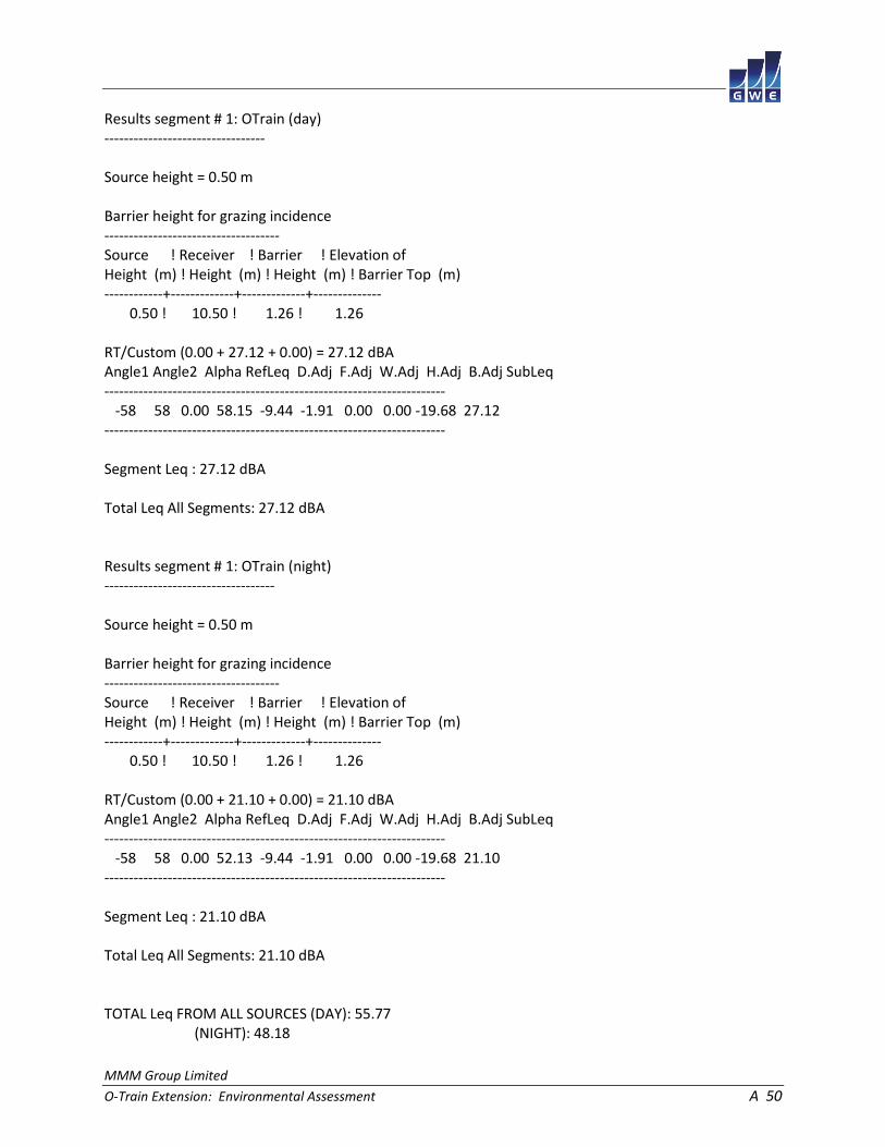
MMM Group Limited
O-Train Extension: Environmental Assessment A 50
Results segment # 1: OTrain (day) --------------------------------- Source height = 0.50 m Barrier height for grazing incidence ------------------------------------ Source ! Receiver ! Barrier ! Elevation of Height (m) ! Height (m) ! Height (m) ! Barrier Top (m) ------------+-------------+-------------+-------------- 0.50 ! 10.50 ! 1.26 ! 1.26 RT/Custom (0.00 + 27.12 + 0.00) = 27.12 dBA Angle1 Angle2 Alpha RefLeq D.Adj F.Adj W.Adj H.Adj B.Adj SubLeq ---------------------------------------------------------------------- -58 58 0.00 58.15 -9.44 -1.91 0.00 0.00 -19.68 27.12 ---------------------------------------------------------------------- Segment Leq : 27.12 dBA Total Leq All Segments: 27.12 dBA Results segment # 1: OTrain (night) ----------------------------------- Source height = 0.50 m Barrier height for grazing incidence ------------------------------------ Source ! Receiver ! Barrier ! Elevation of Height (m) ! Height (m) ! Height (m) ! Barrier Top (m) ------------+-------------+-------------+-------------- 0.50 ! 10.50 ! 1.26 ! 1.26 RT/Custom (0.00 + 21.10 + 0.00) = 21.10 dBA Angle1 Angle2 Alpha RefLeq D.Adj F.Adj W.Adj H.Adj B.Adj SubLeq ---------------------------------------------------------------------- -58 58 0.00 52.13 -9.44 -1.91 0.00 0.00 -19.68 21.10 ---------------------------------------------------------------------- Segment Leq : 21.10 dBA Total Leq All Segments: 21.10 dBA TOTAL Leq FROM ALL SOURCES (DAY): 55.77 (NIGHT): 48.18
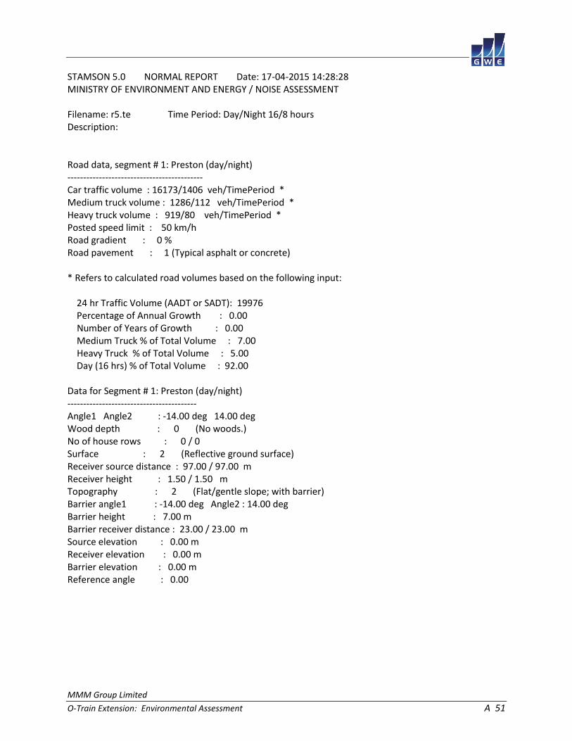
MMM Group Limited
O-Train Extension: Environmental Assessment A 51
STAMSON 5.0 NORMAL REPORT Date: 17-04-2015 14:28:28 MINISTRY OF ENVIRONMENT AND ENERGY / NOISE ASSESSMENT Filename: r5.te Time Period: Day/Night 16/8 hours Description: Road data, segment # 1: Preston (day/night) ------------------------------------------- Car traffic volume : 16173/1406 veh/TimePeriod * Medium truck volume : 1286/112 veh/TimePeriod * Heavy truck volume : 919/80 veh/TimePeriod * Posted speed limit : 50 km/h Road gradient : 0 % Road pavement : 1 (Typical asphalt or concrete) * Refers to calculated road volumes based on the following input: 24 hr Traffic Volume (AADT or SADT): 19976 Percentage of Annual Growth : 0.00 Number of Years of Growth : 0.00 Medium Truck % of Total Volume : 7.00 Heavy Truck % of Total Volume : 5.00 Day (16 hrs) % of Total Volume : 92.00 Data for Segment # 1: Preston (day/night) ----------------------------------------- Angle1 Angle2 : -14.00 deg 14.00 deg Wood depth : 0 (No woods.) No of house rows : 0 / 0 Surface : 2 (Reflective ground surface) Receiver source distance : 97.00 / 97.00 m Receiver height : 1.50 / 1.50 m Topography : 2 (Flat/gentle slope; with barrier) Barrier angle1 : -14.00 deg Angle2 : 14.00 deg Barrier height : 7.00 m Barrier receiver distance : 23.00 / 23.00 m Source elevation : 0.00 m Receiver elevation : 0.00 m Barrier elevation : 0.00 m Reference angle : 0.00

MMM Group Limited
O-Train Extension: Environmental Assessment A 52
Road data, segment # 2: 417EB (day/night) ----------------------------------------- Car traffic volume : 75293/6547 veh/TimePeriod * Medium truck volume : 5989/521 veh/TimePeriod * Heavy truck volume : 4278/372 veh/TimePeriod * Posted speed limit : 100 km/h Road gradient : 0 % Road pavement : 1 (Typical asphalt or concrete) * Refers to calculated road volumes based on the following input: 24 hr Traffic Volume (AADT or SADT): 93000 Percentage of Annual Growth : 0.00 Number of Years of Growth : 0.00 Medium Truck % of Total Volume : 7.00 Heavy Truck % of Total Volume : 5.00 Day (16 hrs) % of Total Volume : 92.00 Data for Segment # 2: 417EB (day/night) --------------------------------------- Angle1 Angle2 : -15.00 deg 15.00 deg Wood depth : 0 (No woods.) No of house rows : 0 / 0 Surface : 2 (Reflective ground surface) Receiver source distance : 483.00 / 483.00 m Receiver height : 1.50 / 1.50 m Topography : 2 (Flat/gentle slope; with barrier) Barrier angle1 : -15.00 deg Angle2 : 15.00 deg Barrier height : 7.00 m Barrier receiver distance : 17.00 / 17.00 m Source elevation : 6.00 m Receiver elevation : 0.00 m Barrier elevation : 0.00 m Reference angle : 0.00

MMM Group Limited
O-Train Extension: Environmental Assessment A 53
Results segment # 1: Preston (day) ---------------------------------- Source height = 1.50 m Barrier height for grazing incidence ------------------------------------ Source ! Receiver ! Barrier ! Elevation of Height (m) ! Height (m) ! Height (m) ! Barrier Top (m) ------------+-------------+-------------+-------------- 1.50 ! 1.50 ! 1.50 ! 1.50 ROAD (0.00 + 36.64 + 0.00) = 36.64 dBA Angle1 Angle2 Alpha RefLeq P.Adj D.Adj F.Adj W.Adj H.Adj B.Adj SubLeq ---------------------------------------------------------------------------- -14 14 0.00 69.72 0.00 -8.11 -8.08 0.00 0.00 -16.90 36.64 ---------------------------------------------------------------------------- Segment Leq : 36.64 dBA Results segment # 2: 417EB (day) -------------------------------- Source height = 1.50 m Barrier height for grazing incidence ------------------------------------ Source ! Receiver ! Barrier ! Elevation of Height (m) ! Height (m) ! Height (m) ! Barrier Top (m) ------------+-------------+-------------+-------------- 1.50 ! 1.50 ! 1.71 ! 1.71 ROAD (0.00 + 42.79 + 0.00) = 42.79 dBA Angle1 Angle2 Alpha RefLeq P.Adj D.Adj F.Adj W.Adj H.Adj B.Adj SubLeq ---------------------------------------------------------------------------- -15 15 0.00 82.43 0.00 -15.08 -7.78 0.00 0.00 -16.78 42.79 ---------------------------------------------------------------------------- Segment Leq : 42.79 dBA Total Leq All Segments: 43.73 dBA

MMM Group Limited
O-Train Extension: Environmental Assessment A 54
Results segment # 1: Preston (night) ------------------------------------ Source height = 1.50 m Barrier height for grazing incidence ------------------------------------ Source ! Receiver ! Barrier ! Elevation of Height (m) ! Height (m) ! Height (m) ! Barrier Top (m) ------------+-------------+-------------+-------------- 1.50 ! 1.50 ! 1.50 ! 1.50 ROAD (0.00 + 29.04 + 0.00) = 29.04 dBA Angle1 Angle2 Alpha RefLeq P.Adj D.Adj F.Adj W.Adj H.Adj B.Adj SubLeq ---------------------------------------------------------------------------- -14 14 0.00 62.13 0.00 -8.11 -8.08 0.00 0.00 -16.90 29.04 ---------------------------------------------------------------------------- Segment Leq : 29.04 dBA Results segment # 2: 417EB (night) ---------------------------------- Source height = 1.50 m Barrier height for grazing incidence ------------------------------------ Source ! Receiver ! Barrier ! Elevation of Height (m) ! Height (m) ! Height (m) ! Barrier Top (m) ------------+-------------+-------------+-------------- 1.50 ! 1.50 ! 1.71 ! 1.71 ROAD (0.00 + 35.19 + 0.00) = 35.19 dBA Angle1 Angle2 Alpha RefLeq P.Adj D.Adj F.Adj W.Adj H.Adj B.Adj SubLeq ---------------------------------------------------------------------------- -15 15 0.00 74.83 0.00 -15.08 -7.78 0.00 0.00 -16.78 35.19 ---------------------------------------------------------------------------- Segment Leq : 35.19 dBA Total Leq All Segments: 36.13 dBA
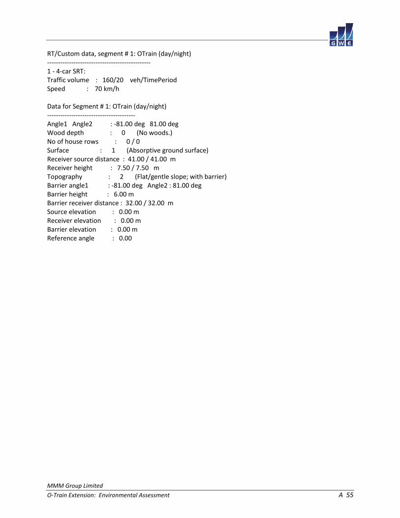
MMM Group Limited
O-Train Extension: Environmental Assessment A 55
RT/Custom data, segment # 1: OTrain (day/night) ----------------------------------------------- 1 - 4-car SRT: Traffic volume : 160/20 veh/TimePeriod Speed : 70 km/h Data for Segment # 1: OTrain (day/night) ---------------------------------------- Angle1 Angle2 : -81.00 deg 81.00 deg Wood depth : 0 (No woods.) No of house rows : 0 / 0 Surface : 1 (Absorptive ground surface) Receiver source distance : 41.00 / 41.00 m Receiver height : 7.50 / 7.50 m Topography : 2 (Flat/gentle slope; with barrier) Barrier angle1 : -81.00 deg Angle2 : 81.00 deg Barrier height : 6.00 m Barrier receiver distance : 32.00 / 32.00 m Source elevation : 0.00 m Receiver elevation : 0.00 m Barrier elevation : 0.00 m Reference angle : 0.00

MMM Group Limited
O-Train Extension: Environmental Assessment A 56
Results segment # 1: OTrain (day) --------------------------------- Source height = 0.50 m Barrier height for grazing incidence ------------------------------------ Source ! Receiver ! Barrier ! Elevation of Height (m) ! Height (m) ! Height (m) ! Barrier Top (m) ------------+-------------+-------------+-------------- 0.50 ! 7.50 ! 2.04 ! 2.04 RT/Custom (0.00 + 37.24 + 0.00) = 37.24 dBA Angle1 Angle2 Alpha RefLeq D.Adj F.Adj W.Adj H.Adj B.Adj SubLeq ---------------------------------------------------------------------- -81 81 0.15 58.15 -5.02 -0.74 0.00 0.00 -15.15 37.24 ---------------------------------------------------------------------- Segment Leq : 37.24 dBA Total Leq All Segments: 37.24 dBA Results segment # 1: OTrain (night) ----------------------------------- Source height = 0.50 m Barrier height for grazing incidence ------------------------------------ Source ! Receiver ! Barrier ! Elevation of Height (m) ! Height (m) ! Height (m) ! Barrier Top (m) ------------+-------------+-------------+-------------- 0.50 ! 7.50 ! 2.04 ! 2.04 RT/Custom (0.00 + 31.22 + 0.00) = 31.22 dBA Angle1 Angle2 Alpha RefLeq D.Adj F.Adj W.Adj H.Adj B.Adj SubLeq ---------------------------------------------------------------------- -81 81 0.15 52.13 -5.02 -0.74 0.00 0.00 -15.15 31.22 ---------------------------------------------------------------------- Segment Leq : 31.22 dBA Total Leq All Segments: 31.22 dBA TOTAL Leq FROM ALL SOURCES (DAY): 44.61 (NIGHT): 37.35
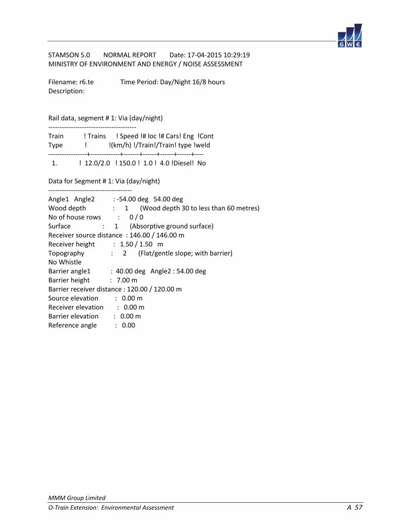
MMM Group Limited
O-Train Extension: Environmental Assessment A 57
STAMSON 5.0 NORMAL REPORT Date: 17-04-2015 10:29:19 MINISTRY OF ENVIRONMENT AND ENERGY / NOISE ASSESSMENT Filename: r6.te Time Period: Day/Night 16/8 hours Description: Rail data, segment # 1: Via (day/night) --------------------------------------- Train ! Trains ! Speed !# loc !# Cars! Eng !Cont Type ! !(km/h) !/Train!/Train! type !weld -----------------+-------------+-------+------+------+------+---- 1. ! 12.0/2.0 ! 150.0 ! 1.0 ! 4.0 !Diesel! No Data for Segment # 1: Via (day/night) ------------------------------------- Angle1 Angle2 : -54.00 deg 54.00 deg Wood depth : 1 (Wood depth 30 to less than 60 metres) No of house rows : 0 / 0 Surface : 1 (Absorptive ground surface) Receiver source distance : 146.00 / 146.00 m Receiver height : 1.50 / 1.50 m Topography : 2 (Flat/gentle slope; with barrier) No Whistle Barrier angle1 : 40.00 deg Angle2 : 54.00 deg Barrier height : 7.00 m Barrier receiver distance : 120.00 / 120.00 m Source elevation : 0.00 m Receiver elevation : 0.00 m Barrier elevation : 0.00 m Reference angle : 0.00

MMM Group Limited
O-Train Extension: Environmental Assessment A 58
Results segment # 1: Via (day) ------------------------------ Barrier height for grazing incidence ------------------------------------ Source ! Receiver ! Barrier ! Elevation of Height (m) ! Height (m) ! Height (m) ! Barrier Top (m) ------------+-------------+-------------+-------------- 4.00 ! 1.50 ! 3.55 ! 3.55 0.50 ! 1.50 ! 0.68 ! 0.68 LOCOMOTIVE (46.05 + 33.06 + 0.00) = 46.26 dBA Angle1 Angle2 Alpha RefLeq D.Adj F.Adj W.Adj H.Adj B.Adj SubLeq ---------------------------------------------------------------------- -54 40 0.28 66.73 -12.70 -2.98 -5.00 0.00 0.00 46.05 ---------------------------------------------------------------------- 40 54 0.28 66.73 -12.70 -11.57 -5.00 0.00 0.00 37.46 40 54 0.17 66.73 -11.51 -11.37 0.00 0.00 -10.79 33.06 ---------------------------------------------------------------------- WHEEL (38.03 + 20.11 + 0.00) = 38.10 dBA Angle1 Angle2 Alpha RefLeq D.Adj F.Adj W.Adj H.Adj B.Adj SubLeq ---------------------------------------------------------------------- -54 40 0.39 59.81 -13.74 -3.04 -5.00 0.00 0.00 38.03 ---------------------------------------------------------------------- 40 54 0.39 59.81 -13.74 -11.75 -5.00 0.00 0.00 29.32 40 54 0.27 59.81 -12.55 -11.55 0.00 0.00 -15.60 20.11 ---------------------------------------------------------------------- Segment Leq : 46.88 dBA Total Leq All Segments: 46.88 dBA

MMM Group Limited
O-Train Extension: Environmental Assessment A 59
Results segment # 1: Via (night) -------------------------------- Barrier height for grazing incidence ------------------------------------ Source ! Receiver ! Barrier ! Elevation of Height (m) ! Height (m) ! Height (m) ! Barrier Top (m) ------------+-------------+-------------+-------------- 4.00 ! 1.50 ! 3.55 ! 3.55 0.50 ! 1.50 ! 0.68 ! 0.68 LOCOMOTIVE (41.28 + 28.29 + 0.00) = 41.49 dBA Angle1 Angle2 Alpha RefLeq D.Adj F.Adj W.Adj H.Adj B.Adj SubLeq ---------------------------------------------------------------------- -54 40 0.28 61.96 -12.70 -2.98 -5.00 0.00 0.00 41.28 ---------------------------------------------------------------------- 40 54 0.28 61.96 -12.70 -11.57 -5.00 0.00 0.00 32.69 40 54 0.17 61.96 -11.51 -11.37 0.00 0.00 -10.79 28.29 ---------------------------------------------------------------------- WHEEL (33.26 + 15.34 + 0.00) = 33.33 dBA Angle1 Angle2 Alpha RefLeq D.Adj F.Adj W.Adj H.Adj B.Adj SubLeq ---------------------------------------------------------------------- -54 40 0.39 55.04 -13.74 -3.04 -5.00 0.00 0.00 33.26 ---------------------------------------------------------------------- 40 54 0.39 55.04 -13.74 -11.75 -5.00 0.00 0.00 24.55 40 54 0.27 55.04 -12.55 -11.55 0.00 0.00 -15.60 15.34 ---------------------------------------------------------------------- Segment Leq : 42.11 dBA Total Leq All Segments: 42.11 dBA

MMM Group Limited
O-Train Extension: Environmental Assessment A 60
Road data, segment # 1: Flannery (day/night) -------------------------------------------- Car traffic volume : 7811/679 veh/TimePeriod * Medium truck volume : 621/54 veh/TimePeriod * Heavy truck volume : 444/39 veh/TimePeriod * Posted speed limit : 40 km/h Road gradient : 0 % Road pavement : 1 (Typical asphalt or concrete) * Refers to calculated road volumes based on the following input: 24 hr Traffic Volume (AADT or SADT): 9648 Percentage of Annual Growth : 0.00 Number of Years of Growth : 0.00 Medium Truck % of Total Volume : 7.00 Heavy Truck % of Total Volume : 5.00 Day (16 hrs) % of Total Volume : 92.00 Data for Segment # 1: Flannery (day/night) ------------------------------------------ Angle1 Angle2 : -61.00 deg 61.00 deg Wood depth : 0 (No woods.) No of house rows : 0 / 0 Surface : 2 (Reflective ground surface) Receiver source distance : 48.00 / 48.00 m Receiver height : 1.50 / 1.50 m Topography : 2 (Flat/gentle slope; with barrier) Barrier angle1 : -61.00 deg Angle2 : 61.00 deg Barrier height : 10.00 m Barrier receiver distance : 3.00 / 3.00 m Source elevation : 0.00 m Receiver elevation : 0.00 m Barrier elevation : 0.00 m Reference angle : 0.00

MMM Group Limited
O-Train Extension: Environmental Assessment A 61
Road data, segment # 2: AirportSB (day/night) --------------------------------------------- Car traffic volume : 10071/876 veh/TimePeriod * Medium truck volume : 801/70 veh/TimePeriod * Heavy truck volume : 572/50 veh/TimePeriod * Posted speed limit : 80 km/h Road gradient : 0 % Road pavement : 1 (Typical asphalt or concrete) * Refers to calculated road volumes based on the following input: 24 hr Traffic Volume (AADT or SADT): 12440 Percentage of Annual Growth : 0.00 Number of Years of Growth : 0.00 Medium Truck % of Total Volume : 7.00 Heavy Truck % of Total Volume : 5.00 Day (16 hrs) % of Total Volume : 92.00 Data for Segment # 2: AirportSB (day/night) ------------------------------------------- Angle1 Angle2 : -51.00 deg 51.00 deg Wood depth : 1 (Wood depth 30 to less than 60 metres) No of house rows : 0 / 0 Surface : 1 (Absorptive ground surface) Receiver source distance : 63.00 / 63.00 m Receiver height : 4.50 / 4.50 m Topography : 1 (Flat/gentle slope; no barrier) Reference angle : 0.00

MMM Group Limited
O-Train Extension: Environmental Assessment A 62
Road data, segment # 3: AirportNB (day/night) --------------------------------------------- Car traffic volume : 10071/876 veh/TimePeriod * Medium truck volume : 801/70 veh/TimePeriod * Heavy truck volume : 572/50 veh/TimePeriod * Posted speed limit : 80 km/h Road gradient : 0 % Road pavement : 1 (Typical asphalt or concrete) * Refers to calculated road volumes based on the following input: 24 hr Traffic Volume (AADT or SADT): 12440 Percentage of Annual Growth : 0.00 Number of Years of Growth : 0.00 Medium Truck % of Total Volume : 7.00 Heavy Truck % of Total Volume : 5.00 Day (16 hrs) % of Total Volume : 92.00 Data for Segment # 3: AirportNB (day/night) ------------------------------------------- Angle1 Angle2 : -39.00 deg 39.00 deg Wood depth : 1 (Wood depth 30 to less than 60 metres) No of house rows : 0 / 0 Surface : 1 (Absorptive ground surface) Receiver source distance : 77.00 / 77.00 m Receiver height : 4.50 / 4.50 m Topography : 1 (Flat/gentle slope; no barrier) Reference angle : 0.00
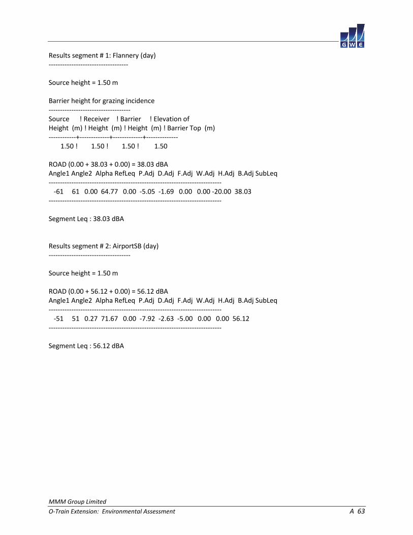
MMM Group Limited
O-Train Extension: Environmental Assessment A 63
Results segment # 1: Flannery (day) ----------------------------------- Source height = 1.50 m Barrier height for grazing incidence ------------------------------------ Source ! Receiver ! Barrier ! Elevation of Height (m) ! Height (m) ! Height (m) ! Barrier Top (m) ------------+-------------+-------------+-------------- 1.50 ! 1.50 ! 1.50 ! 1.50 ROAD (0.00 + 38.03 + 0.00) = 38.03 dBA Angle1 Angle2 Alpha RefLeq P.Adj D.Adj F.Adj W.Adj H.Adj B.Adj SubLeq ---------------------------------------------------------------------------- -61 61 0.00 64.77 0.00 -5.05 -1.69 0.00 0.00 -20.00 38.03 ---------------------------------------------------------------------------- Segment Leq : 38.03 dBA Results segment # 2: AirportSB (day) ------------------------------------ Source height = 1.50 m ROAD (0.00 + 56.12 + 0.00) = 56.12 dBA Angle1 Angle2 Alpha RefLeq P.Adj D.Adj F.Adj W.Adj H.Adj B.Adj SubLeq ---------------------------------------------------------------------------- -51 51 0.27 71.67 0.00 -7.92 -2.63 -5.00 0.00 0.00 56.12 ---------------------------------------------------------------------------- Segment Leq : 56.12 dBA
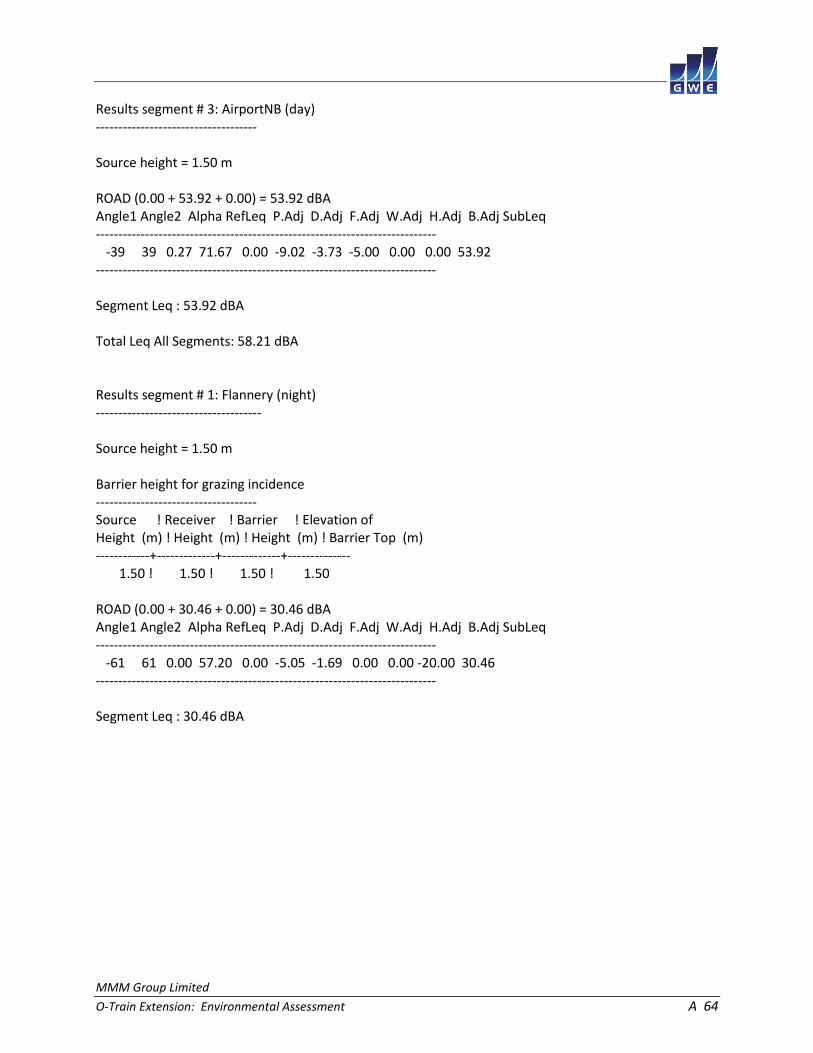
MMM Group Limited
O-Train Extension: Environmental Assessment A 64
Results segment # 3: AirportNB (day) ------------------------------------ Source height = 1.50 m ROAD (0.00 + 53.92 + 0.00) = 53.92 dBA Angle1 Angle2 Alpha RefLeq P.Adj D.Adj F.Adj W.Adj H.Adj B.Adj SubLeq ---------------------------------------------------------------------------- -39 39 0.27 71.67 0.00 -9.02 -3.73 -5.00 0.00 0.00 53.92 ---------------------------------------------------------------------------- Segment Leq : 53.92 dBA Total Leq All Segments: 58.21 dBA Results segment # 1: Flannery (night) ------------------------------------- Source height = 1.50 m Barrier height for grazing incidence ------------------------------------ Source ! Receiver ! Barrier ! Elevation of Height (m) ! Height (m) ! Height (m) ! Barrier Top (m) ------------+-------------+-------------+-------------- 1.50 ! 1.50 ! 1.50 ! 1.50 ROAD (0.00 + 30.46 + 0.00) = 30.46 dBA Angle1 Angle2 Alpha RefLeq P.Adj D.Adj F.Adj W.Adj H.Adj B.Adj SubLeq ---------------------------------------------------------------------------- -61 61 0.00 57.20 0.00 -5.05 -1.69 0.00 0.00 -20.00 30.46 ---------------------------------------------------------------------------- Segment Leq : 30.46 dBA
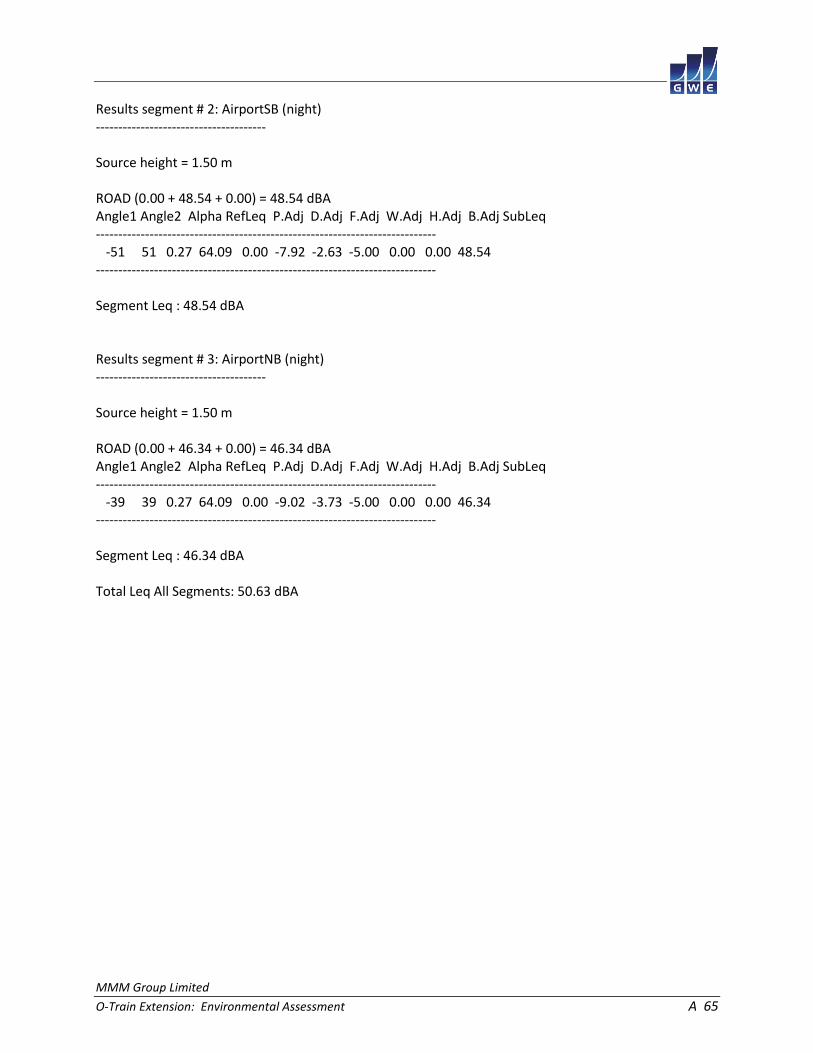
MMM Group Limited
O-Train Extension: Environmental Assessment A 65
Results segment # 2: AirportSB (night) -------------------------------------- Source height = 1.50 m ROAD (0.00 + 48.54 + 0.00) = 48.54 dBA Angle1 Angle2 Alpha RefLeq P.Adj D.Adj F.Adj W.Adj H.Adj B.Adj SubLeq ---------------------------------------------------------------------------- -51 51 0.27 64.09 0.00 -7.92 -2.63 -5.00 0.00 0.00 48.54 ---------------------------------------------------------------------------- Segment Leq : 48.54 dBA Results segment # 3: AirportNB (night) -------------------------------------- Source height = 1.50 m ROAD (0.00 + 46.34 + 0.00) = 46.34 dBA Angle1 Angle2 Alpha RefLeq P.Adj D.Adj F.Adj W.Adj H.Adj B.Adj SubLeq ---------------------------------------------------------------------------- -39 39 0.27 64.09 0.00 -9.02 -3.73 -5.00 0.00 0.00 46.34 ---------------------------------------------------------------------------- Segment Leq : 46.34 dBA Total Leq All Segments: 50.63 dBA
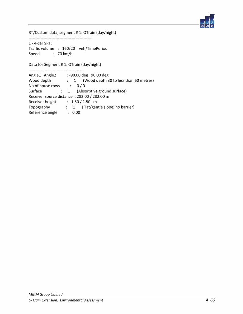
MMM Group Limited
O-Train Extension: Environmental Assessment A 66
RT/Custom data, segment # 1: OTrain (day/night) ----------------------------------------------- 1 - 4-car SRT: Traffic volume : 160/20 veh/TimePeriod Speed : 70 km/h Data for Segment # 1: OTrain (day/night) ---------------------------------------- Angle1 Angle2 : -90.00 deg 90.00 deg Wood depth : 1 (Wood depth 30 to less than 60 metres) No of house rows : 0 / 0 Surface : 1 (Absorptive ground surface) Receiver source distance : 282.00 / 282.00 m Receiver height : 1.50 / 1.50 m Topography : 1 (Flat/gentle slope; no barrier) Reference angle : 0.00

MMM Group Limited
O-Train Extension: Environmental Assessment A 67
Results segment # 1: OTrain (day) --------------------------------- Source height = 0.50 m RT/Custom (0.00 + 34.48 + 0.00) = 34.48 dBA Angle1 Angle2 Alpha RefLeq D.Adj F.Adj W.Adj H.Adj B.Adj SubLeq ---------------------------------------------------------------------- -90 90 0.39 58.15 -17.71 -0.96 -5.00 0.00 0.00 34.48 ---------------------------------------------------------------------- Segment Leq : 34.48 dBA Total Leq All Segments: 34.48 dBA Results segment # 1: OTrain (night) ----------------------------------- Source height = 0.50 m RT/Custom (0.00 + 28.46 + 0.00) = 28.46 dBA Angle1 Angle2 Alpha RefLeq D.Adj F.Adj W.Adj H.Adj B.Adj SubLeq ---------------------------------------------------------------------- -90 90 0.39 52.13 -17.71 -0.96 -5.00 0.00 0.00 28.46 ---------------------------------------------------------------------- Segment Leq : 28.46 dBA Total Leq All Segments: 28.46 dBA TOTAL Leq FROM ALL SOURCES (DAY): 58.54 (NIGHT): 51.22

MMM Group Limited
O-Train Extension: Environmental Assessment A 68
STAMSON 5.0 NORMAL REPORT Date: 17-04-2015 10:29:27 MINISTRY OF ENVIRONMENT AND ENERGY / NOISE ASSESSMENT Filename: r7.te Time Period: Day/Night 16/8 hours Description: RT/Custom data, segment # 1: OTrain (day/night) ----------------------------------------------- 1 - 4-car SRT: Traffic volume : 160/20 veh/TimePeriod Speed : 70 km/h Data for Segment # 1: OTrain (day/night) ---------------------------------------- Angle1 Angle2 : -83.00 deg 83.00 deg Wood depth : 0 (No woods.) No of house rows : 0 / 0 Surface : 1 (Absorptive ground surface) Receiver source distance : 30.00 / 30.00 m Receiver height : 5.50 / 5.50 m Topography : 2 (Flat/gentle slope; with barrier) Barrier angle1 : -83.00 deg Angle2 : 83.00 deg Barrier height : 4.00 m Barrier receiver distance : 25.00 / 25.00 m Source elevation : 0.00 m Receiver elevation : 0.00 m Barrier elevation : 0.00 m Reference angle : 0.00

MMM Group Limited
O-Train Extension: Environmental Assessment A 69
Results segment # 1: OTrain (day) --------------------------------- Source height = 0.50 m Barrier height for grazing incidence ------------------------------------ Source ! Receiver ! Barrier ! Elevation of Height (m) ! Height (m) ! Height (m) ! Barrier Top (m) ------------+-------------+-------------+-------------- 0.50 ! 5.50 ! 1.33 ! 1.33 RT/Custom (0.00 + 39.44 + 0.00) = 39.44 dBA Angle1 Angle2 Alpha RefLeq D.Adj F.Adj W.Adj H.Adj B.Adj SubLeq ---------------------------------------------------------------------- -83 83 0.33 58.15 -4.00 -0.99 0.00 0.00 -13.72 39.44 ---------------------------------------------------------------------- Segment Leq : 39.44 dBA Total Leq All Segments: 39.44 dBA Results segment # 1: OTrain (night) ----------------------------------- Source height = 0.50 m Barrier height for grazing incidence ------------------------------------ Source ! Receiver ! Barrier ! Elevation of Height (m) ! Height (m) ! Height (m) ! Barrier Top (m) ------------+-------------+-------------+-------------- 0.50 ! 5.50 ! 1.33 ! 1.33 RT/Custom (0.00 + 33.42 + 0.00) = 33.42 dBA Angle1 Angle2 Alpha RefLeq D.Adj F.Adj W.Adj H.Adj B.Adj SubLeq ---------------------------------------------------------------------- -83 83 0.33 52.13 -4.00 -0.99 0.00 0.00 -13.72 33.42 ---------------------------------------------------------------------- Segment Leq : 33.42 dBA Total Leq All Segments: 33.42 dBA TOTAL Leq FROM ALL SOURCES (DAY): 39.44 (NIGHT): 33.42

MMM Group Limited
O-Train Extension: Environmental Assessment A 70
STAMSON 5.0 NORMAL REPORT Date: 17-04-2015 10:29:41 MINISTRY OF ENVIRONMENT AND ENERGY / NOISE ASSESSMENT Filename: r8.te Time Period: Day/Night 16/8 hours Description: Road data, segment # 1: Airport (day/night) ------------------------------------------- Car traffic volume : 20142/1751 veh/TimePeriod * Medium truck volume : 1602/139 veh/TimePeriod * Heavy truck volume : 1144/100 veh/TimePeriod * Posted speed limit : 80 km/h Road gradient : 0 % Road pavement : 1 (Typical asphalt or concrete) * Refers to calculated road volumes based on the following input: 24 hr Traffic Volume (AADT or SADT): 24879 Percentage of Annual Growth : 0.00 Number of Years of Growth : 0.00 Medium Truck % of Total Volume : 7.00 Heavy Truck % of Total Volume : 5.00 Day (16 hrs) % of Total Volume : 92.00 Data for Segment # 1: Airport (day/night) ----------------------------------------- Angle1 Angle2 : -36.00 deg 36.00 deg Wood depth : 1 (Wood depth 30 to less than 60 metres) No of house rows : 0 / 0 Surface : 1 (Absorptive ground surface) Receiver source distance : 81.00 / 81.00 m Receiver height : 1.50 / 1.50 m Topography : 1 (Flat/gentle slope; no barrier) Reference angle : 0.00
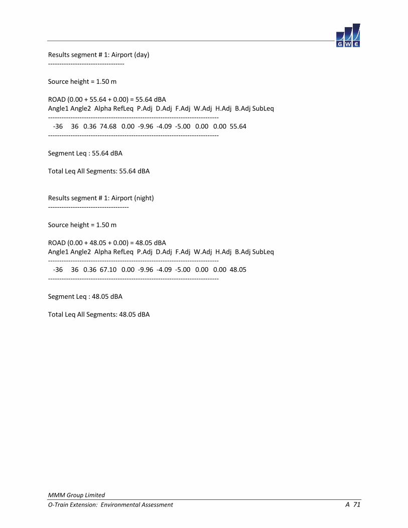
MMM Group Limited
O-Train Extension: Environmental Assessment A 71
Results segment # 1: Airport (day) ---------------------------------- Source height = 1.50 m ROAD (0.00 + 55.64 + 0.00) = 55.64 dBA Angle1 Angle2 Alpha RefLeq P.Adj D.Adj F.Adj W.Adj H.Adj B.Adj SubLeq ---------------------------------------------------------------------------- -36 36 0.36 74.68 0.00 -9.96 -4.09 -5.00 0.00 0.00 55.64 ---------------------------------------------------------------------------- Segment Leq : 55.64 dBA Total Leq All Segments: 55.64 dBA Results segment # 1: Airport (night) ------------------------------------ Source height = 1.50 m ROAD (0.00 + 48.05 + 0.00) = 48.05 dBA Angle1 Angle2 Alpha RefLeq P.Adj D.Adj F.Adj W.Adj H.Adj B.Adj SubLeq ---------------------------------------------------------------------------- -36 36 0.36 67.10 0.00 -9.96 -4.09 -5.00 0.00 0.00 48.05 ---------------------------------------------------------------------------- Segment Leq : 48.05 dBA Total Leq All Segments: 48.05 dBA

MMM Group Limited
O-Train Extension: Environmental Assessment A 72
RT/Custom data, segment # 1: OTrain (day/night) ----------------------------------------------- 1 - 4-car SRT: Traffic volume : 160/20 veh/TimePeriod Speed : 70 km/h Data for Segment # 1: OTrain (day/night) ---------------------------------------- Angle1 Angle2 : -10.00 deg 10.00 deg Wood depth : 2 (Wood depth 60 metres or more) No of house rows : 0 / 0 Surface : 1 (Absorptive ground surface) Receiver source distance : 246.00 / 246.00 m Receiver height : 1.50 / 1.50 m Topography : 1 (Flat/gentle slope; no barrier) Reference angle : 0.00
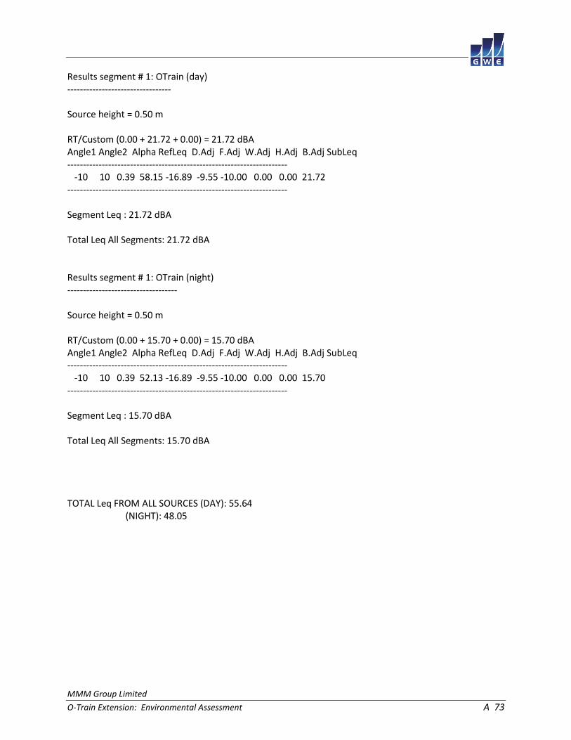
MMM Group Limited
O-Train Extension: Environmental Assessment A 73
Results segment # 1: OTrain (day) --------------------------------- Source height = 0.50 m RT/Custom (0.00 + 21.72 + 0.00) = 21.72 dBA Angle1 Angle2 Alpha RefLeq D.Adj F.Adj W.Adj H.Adj B.Adj SubLeq ---------------------------------------------------------------------- -10 10 0.39 58.15 -16.89 -9.55 -10.00 0.00 0.00 21.72 ---------------------------------------------------------------------- Segment Leq : 21.72 dBA Total Leq All Segments: 21.72 dBA Results segment # 1: OTrain (night) ----------------------------------- Source height = 0.50 m RT/Custom (0.00 + 15.70 + 0.00) = 15.70 dBA Angle1 Angle2 Alpha RefLeq D.Adj F.Adj W.Adj H.Adj B.Adj SubLeq ---------------------------------------------------------------------- -10 10 0.39 52.13 -16.89 -9.55 -10.00 0.00 0.00 15.70 ---------------------------------------------------------------------- Segment Leq : 15.70 dBA Total Leq All Segments: 15.70 dBA TOTAL Leq FROM ALL SOURCES (DAY): 55.64 (NIGHT): 48.05

MMM Group Limited
O-Train Extension: Environmental Assessment A 74
STAMSON 5.0 NORMAL REPORT Date: 17-04-2015 14:30:08 MINISTRY OF ENVIRONMENT AND ENERGY / NOISE ASSESSMENT Filename: r9.te Time Period: Day/Night 16/8 hours Description: Road data, segment # 1: WalkleyWB (day/night) --------------------------------------------- Car traffic volume : 8659/753 veh/TimePeriod * Medium truck volume : 689/60 veh/TimePeriod * Heavy truck volume : 492/43 veh/TimePeriod * Posted speed limit : 50 km/h Road gradient : 0 % Road pavement : 1 (Typical asphalt or concrete) * Refers to calculated road volumes based on the following input: 24 hr Traffic Volume (AADT or SADT): 10695 Percentage of Annual Growth : 0.00 Number of Years of Growth : 0.00 Medium Truck % of Total Volume : 7.00 Heavy Truck % of Total Volume : 5.00 Day (16 hrs) % of Total Volume : 92.00 Data for Segment # 1: WalkleyWB (day/night) ------------------------------------------- Angle1 Angle2 : -71.00 deg 71.00 deg Wood depth : 0 (No woods.) No of house rows : 0 / 0 Surface : 1 (Absorptive ground surface) Receiver source distance : 32.00 / 32.00 m Receiver height : 1.50 / 1.50 m Topography : 2 (Flat/gentle slope; with barrier) Barrier angle1 : -71.00 deg Angle2 : 71.00 deg Barrier height : 2.00 m Barrier receiver distance : 27.00 / 27.00 m Source elevation : 6.00 m Receiver elevation : 0.00 m Barrier elevation : 6.00 m Reference angle : 0.00

MMM Group Limited
O-Train Extension: Environmental Assessment A 75
Road data, segment # 2: WalkleyEB (day/night) --------------------------------------------- Car traffic volume : 8659/753 veh/TimePeriod * Medium truck volume : 689/60 veh/TimePeriod * Heavy truck volume : 492/43 veh/TimePeriod * Posted speed limit : 50 km/h Road gradient : 0 % Road pavement : 1 (Typical asphalt or concrete) * Refers to calculated road volumes based on the following input: 24 hr Traffic Volume (AADT or SADT): 10695 Percentage of Annual Growth : 0.00 Number of Years of Growth : 0.00 Medium Truck % of Total Volume : 7.00 Heavy Truck % of Total Volume : 5.00 Day (16 hrs) % of Total Volume : 92.00 Data for Segment # 2: WalkleyEB (day/night) ------------------------------------------- Angle1 Angle2 : -63.00 deg 63.00 deg Wood depth : 0 (No woods.) No of house rows : 0 / 0 Surface : 1 (Absorptive ground surface) Receiver source distance : 46.00 / 46.00 m Receiver height : 1.50 / 1.50 m Topography : 2 (Flat/gentle slope; with barrier) Barrier angle1 : -63.00 deg Angle2 : 63.00 deg Barrier height : 2.00 m Barrier receiver distance : 27.00 / 27.00 m Source elevation : 6.00 m Receiver elevation : 0.00 m Barrier elevation : 6.00 m Reference angle : 0.00

MMM Group Limited
O-Train Extension: Environmental Assessment A 76
Results segment # 1: WalkleyWB (day) ------------------------------------ Source height = 1.50 m Barrier height for grazing incidence ------------------------------------ Source ! Receiver ! Barrier ! Elevation of Height (m) ! Height (m) ! Height (m) ! Barrier Top (m) ------------+-------------+-------------+-------------- 1.50 ! 1.50 ! 0.56 ! 6.56 ROAD (0.00 + 49.76 + 0.00) = 49.76 dBA Angle1 Angle2 Alpha RefLeq P.Adj D.Adj F.Adj W.Adj H.Adj B.Adj SubLeq ---------------------------------------------------------------------------- -71 71 0.54 67.01 0.00 -5.07 -1.71 0.00 0.00 -10.48 49.76 ---------------------------------------------------------------------------- Segment Leq : 49.76 dBA Results segment # 2: WalkleyEB (day) ------------------------------------ Source height = 1.50 m Barrier height for grazing incidence ------------------------------------ Source ! Receiver ! Barrier ! Elevation of Height (m) ! Height (m) ! Height (m) ! Barrier Top (m) ------------+-------------+-------------+-------------- 1.50 ! 1.50 ! -0.98 ! 5.02 ROAD (0.00 + 44.86 + 0.00) = 44.86 dBA Angle1 Angle2 Alpha RefLeq P.Adj D.Adj F.Adj W.Adj H.Adj B.Adj SubLeq ---------------------------------------------------------------------------- -63 63 0.54 67.01 0.00 -7.50 -2.07 0.00 0.00 -12.59 44.86 ---------------------------------------------------------------------------- Segment Leq : 44.86 dBA Total Leq All Segments: 50.98 dBA

MMM Group Limited
O-Train Extension: Environmental Assessment A 77
Results segment # 1: WalkleyWB (night) -------------------------------------- Source height = 1.50 m Barrier height for grazing incidence ------------------------------------ Source ! Receiver ! Barrier ! Elevation of Height (m) ! Height (m) ! Height (m) ! Barrier Top (m) ------------+-------------+-------------+-------------- 1.50 ! 1.50 ! 0.56 ! 6.56 ROAD (0.00 + 42.18 + 0.00) = 42.18 dBA Angle1 Angle2 Alpha RefLeq P.Adj D.Adj F.Adj W.Adj H.Adj B.Adj SubLeq ---------------------------------------------------------------------------- -71 71 0.54 59.43 0.00 -5.07 -1.71 0.00 0.00 -10.47 42.18 ---------------------------------------------------------------------------- Segment Leq : 42.18 dBA Results segment # 2: WalkleyEB (night) -------------------------------------- Source height = 1.50 m Barrier height for grazing incidence ------------------------------------ Source ! Receiver ! Barrier ! Elevation of Height (m) ! Height (m) ! Height (m) ! Barrier Top (m) ------------+-------------+-------------+-------------- 1.50 ! 1.50 ! -0.98 ! 5.02 ROAD (0.00 + 37.28 + 0.00) = 37.28 dBA Angle1 Angle2 Alpha RefLeq P.Adj D.Adj F.Adj W.Adj H.Adj B.Adj SubLeq ---------------------------------------------------------------------------- -63 63 0.54 59.43 0.00 -7.50 -2.07 0.00 0.00 -12.59 37.28 ---------------------------------------------------------------------------- Segment Leq : 37.28 dBA Total Leq All Segments: 43.40 dBA
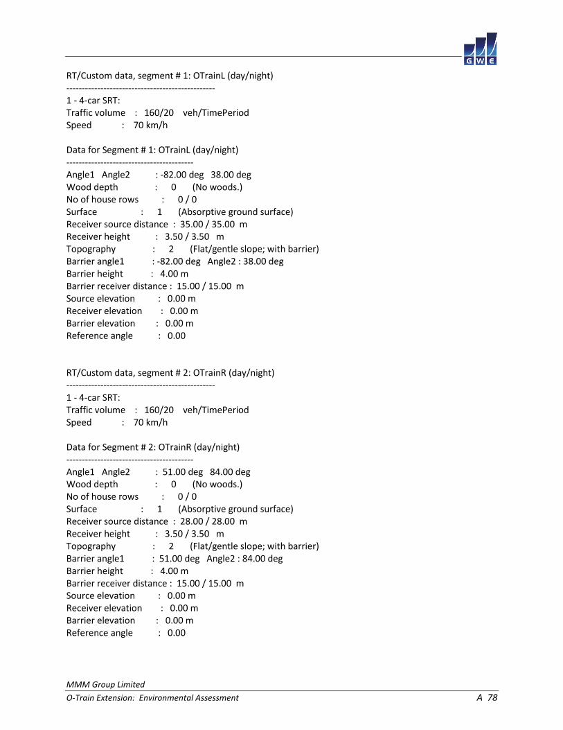
MMM Group Limited
O-Train Extension: Environmental Assessment A 78
RT/Custom data, segment # 1: OTrainL (day/night) ------------------------------------------------ 1 - 4-car SRT: Traffic volume : 160/20 veh/TimePeriod Speed : 70 km/h Data for Segment # 1: OTrainL (day/night) ----------------------------------------- Angle1 Angle2 : -82.00 deg 38.00 deg Wood depth : 0 (No woods.) No of house rows : 0 / 0 Surface : 1 (Absorptive ground surface) Receiver source distance : 35.00 / 35.00 m Receiver height : 3.50 / 3.50 m Topography : 2 (Flat/gentle slope; with barrier) Barrier angle1 : -82.00 deg Angle2 : 38.00 deg Barrier height : 4.00 m Barrier receiver distance : 15.00 / 15.00 m Source elevation : 0.00 m Receiver elevation : 0.00 m Barrier elevation : 0.00 m Reference angle : 0.00 RT/Custom data, segment # 2: OTrainR (day/night) ------------------------------------------------ 1 - 4-car SRT: Traffic volume : 160/20 veh/TimePeriod Speed : 70 km/h Data for Segment # 2: OTrainR (day/night) ----------------------------------------- Angle1 Angle2 : 51.00 deg 84.00 deg Wood depth : 0 (No woods.) No of house rows : 0 / 0 Surface : 1 (Absorptive ground surface) Receiver source distance : 28.00 / 28.00 m Receiver height : 3.50 / 3.50 m Topography : 2 (Flat/gentle slope; with barrier) Barrier angle1 : 51.00 deg Angle2 : 84.00 deg Barrier height : 4.00 m Barrier receiver distance : 15.00 / 15.00 m Source elevation : 0.00 m Receiver elevation : 0.00 m Barrier elevation : 0.00 m Reference angle : 0.00
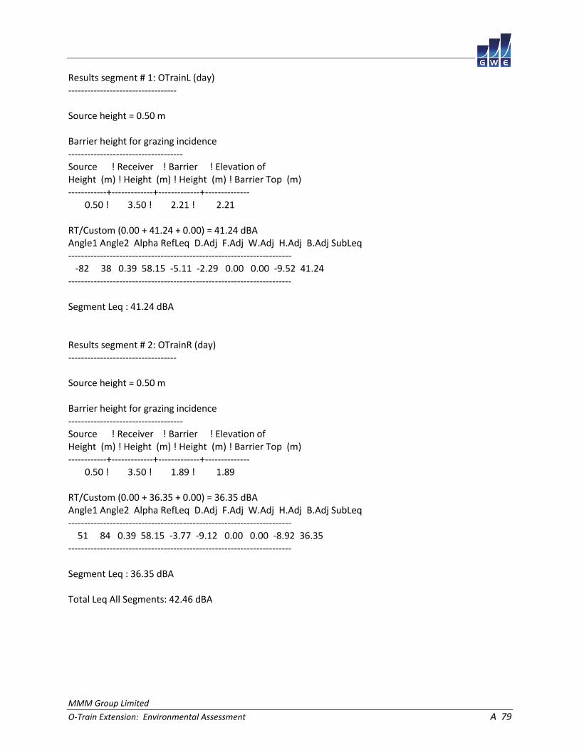
MMM Group Limited
O-Train Extension: Environmental Assessment A 79
Results segment # 1: OTrainL (day) ---------------------------------- Source height = 0.50 m Barrier height for grazing incidence ------------------------------------ Source ! Receiver ! Barrier ! Elevation of Height (m) ! Height (m) ! Height (m) ! Barrier Top (m) ------------+-------------+-------------+-------------- 0.50 ! 3.50 ! 2.21 ! 2.21 RT/Custom (0.00 + 41.24 + 0.00) = 41.24 dBA Angle1 Angle2 Alpha RefLeq D.Adj F.Adj W.Adj H.Adj B.Adj SubLeq ---------------------------------------------------------------------- -82 38 0.39 58.15 -5.11 -2.29 0.00 0.00 -9.52 41.24 ---------------------------------------------------------------------- Segment Leq : 41.24 dBA Results segment # 2: OTrainR (day) ---------------------------------- Source height = 0.50 m Barrier height for grazing incidence ------------------------------------ Source ! Receiver ! Barrier ! Elevation of Height (m) ! Height (m) ! Height (m) ! Barrier Top (m) ------------+-------------+-------------+-------------- 0.50 ! 3.50 ! 1.89 ! 1.89 RT/Custom (0.00 + 36.35 + 0.00) = 36.35 dBA Angle1 Angle2 Alpha RefLeq D.Adj F.Adj W.Adj H.Adj B.Adj SubLeq ---------------------------------------------------------------------- 51 84 0.39 58.15 -3.77 -9.12 0.00 0.00 -8.92 36.35 ---------------------------------------------------------------------- Segment Leq : 36.35 dBA Total Leq All Segments: 42.46 dBA

MMM Group Limited
O-Train Extension: Environmental Assessment A 80
Results segment # 1: OTrainL (night) ------------------------------------ Source height = 0.50 m Barrier height for grazing incidence ------------------------------------ Source ! Receiver ! Barrier ! Elevation of Height (m) ! Height (m) ! Height (m) ! Barrier Top (m) ------------+-------------+-------------+-------------- 0.50 ! 3.50 ! 2.21 ! 2.21 RT/Custom (0.00 + 35.22 + 0.00) = 35.22 dBA Angle1 Angle2 Alpha RefLeq D.Adj F.Adj W.Adj H.Adj B.Adj SubLeq ---------------------------------------------------------------------- -82 38 0.39 52.13 -5.11 -2.29 0.00 0.00 -9.52 35.22 ---------------------------------------------------------------------- Segment Leq : 35.22 dBA Results segment # 2: OTrainR (night) ------------------------------------ Source height = 0.50 m Barrier height for grazing incidence ------------------------------------ Source ! Receiver ! Barrier ! Elevation of Height (m) ! Height (m) ! Height (m) ! Barrier Top (m) ------------+-------------+-------------+-------------- 0.50 ! 3.50 ! 1.89 ! 1.89 RT/Custom (0.00 + 30.33 + 0.00) = 30.33 dBA Angle1 Angle2 Alpha RefLeq D.Adj F.Adj W.Adj H.Adj B.Adj SubLeq ---------------------------------------------------------------------- 51 84 0.39 52.13 -3.77 -9.12 0.00 0.00 -8.92 30.33 ---------------------------------------------------------------------- Segment Leq : 30.33 dBA Total Leq All Segments: 36.44 dBA TOTAL Leq FROM ALL SOURCES (DAY): 51.55 (NIGHT): 44.19

MMM Group Limited
O-Train Extension: Environmental Assessment A 81
STAMSON 5.0 NORMAL REPORT Date: 17-04-2015 14:38:31 MINISTRY OF ENVIRONMENT AND ENERGY / NOISE ASSESSMENT Filename: r10.te Time Period: Day/Night 16/8 hours Description: Road data, segment # 1: Airport (day/night) ------------------------------------------- Car traffic volume : 20142/1751 veh/TimePeriod * Medium truck volume : 1602/139 veh/TimePeriod * Heavy truck volume : 1144/100 veh/TimePeriod * Posted speed limit : 80 km/h Road gradient : 0 % Road pavement : 1 (Typical asphalt or concrete) * Refers to calculated road volumes based on the following input: 24 hr Traffic Volume (AADT or SADT): 24879 Percentage of Annual Growth : 0.00 Number of Years of Growth : 0.00 Medium Truck % of Total Volume : 7.00 Heavy Truck % of Total Volume : 5.00 Day (16 hrs) % of Total Volume : 92.00 Data for Segment # 1: Airport (day/night) ----------------------------------------- Angle1 Angle2 : -46.00 deg 46.00 deg Wood depth : 0 (No woods.) No of house rows : 0 / 0 Surface : 1 (Absorptive ground surface) Receiver source distance : 70.00 / 70.00 m Receiver height : 1.50 / 1.50 m Topography : 2 (Flat/gentle slope; with barrier) Barrier angle1 : -46.00 deg Angle2 : 46.00 deg Barrier height : 2.00 m Barrier receiver distance : 6.00 / 6.00 m Source elevation : 0.00 m Receiver elevation : 0.00 m Barrier elevation : 6.00 m Reference angle : 0.00

MMM Group Limited
O-Train Extension: Environmental Assessment A 82
Road data, segment # 2: AirportRamp (day/night) ----------------------------------------------- Car traffic volume : 4769/415 veh/TimePeriod * Medium truck volume : 379/33 veh/TimePeriod * Heavy truck volume : 271/24 veh/TimePeriod * Posted speed limit : 40 km/h Road gradient : 0 % Road pavement : 1 (Typical asphalt or concrete) * Refers to calculated road volumes based on the following input: 24 hr Traffic Volume (AADT or SADT): 5891 Percentage of Annual Growth : 0.00 Number of Years of Growth : 0.00 Medium Truck % of Total Volume : 7.00 Heavy Truck % of Total Volume : 5.00 Day (16 hrs) % of Total Volume : 92.00 Data for Segment # 2: AirportRamp (day/night) --------------------------------------------- Angle1 Angle2 : -70.00 deg 0.00 deg Wood depth : 0 (No woods.) No of house rows : 0 / 0 Surface : 1 (Absorptive ground surface) Receiver source distance : 35.00 / 35.00 m Receiver height : 5.50 / 5.50 m Topography : 2 (Flat/gentle slope; with barrier) Barrier angle1 : -70.00 deg Angle2 : 0.00 deg Barrier height : 6.00 m Barrier receiver distance : 6.00 / 6.00 m Source elevation : 0.00 m Receiver elevation : 0.00 m Barrier elevation : 0.00 m Reference angle : 0.00
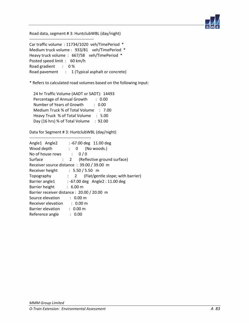
MMM Group Limited
O-Train Extension: Environmental Assessment A 83
Road data, segment # 3: HuntclubWBL (day/night) ----------------------------------------------- Car traffic volume : 11734/1020 veh/TimePeriod * Medium truck volume : 933/81 veh/TimePeriod * Heavy truck volume : 667/58 veh/TimePeriod * Posted speed limit : 60 km/h Road gradient : 0 % Road pavement : 1 (Typical asphalt or concrete) * Refers to calculated road volumes based on the following input: 24 hr Traffic Volume (AADT or SADT): 14493 Percentage of Annual Growth : 0.00 Number of Years of Growth : 0.00 Medium Truck % of Total Volume : 7.00 Heavy Truck % of Total Volume : 5.00 Day (16 hrs) % of Total Volume : 92.00 Data for Segment # 3: HuntclubWBL (day/night) --------------------------------------------- Angle1 Angle2 : -67.00 deg 11.00 deg Wood depth : 0 (No woods.) No of house rows : 0 / 0 Surface : 2 (Reflective ground surface) Receiver source distance : 39.00 / 39.00 m Receiver height : 5.50 / 5.50 m Topography : 2 (Flat/gentle slope; with barrier) Barrier angle1 : -67.00 deg Angle2 : 11.00 deg Barrier height : 6.00 m Barrier receiver distance : 20.00 / 20.00 m Source elevation : 0.00 m Receiver elevation : 0.00 m Barrier elevation : 0.00 m Reference angle : 0.00

MMM Group Limited
O-Train Extension: Environmental Assessment A 84
Road data, segment # 4: HuntclubWBR (day/night) ----------------------------------------------- Car traffic volume : 11734/1020 veh/TimePeriod * Medium truck volume : 933/81 veh/TimePeriod * Heavy truck volume : 667/58 veh/TimePeriod * Posted speed limit : 60 km/h Road gradient : 0 % Road pavement : 1 (Typical asphalt or concrete) * Refers to calculated road volumes based on the following input: 24 hr Traffic Volume (AADT or SADT): 14493 Percentage of Annual Growth : 0.00 Number of Years of Growth : 0.00 Medium Truck % of Total Volume : 7.00 Heavy Truck % of Total Volume : 5.00 Day (16 hrs) % of Total Volume : 92.00 Data for Segment # 4: HuntclubWBR (day/night) --------------------------------------------- Angle1 Angle2 : 11.00 deg 67.00 deg Wood depth : 0 (No woods.) No of house rows : 0 / 0 Surface : 2 (Reflective ground surface) Receiver source distance : 39.00 / 39.00 m Receiver height : 4.50 / 4.50 m Topography : 2 (Flat/gentle slope; with barrier) Barrier angle1 : 11.00 deg Angle2 : 67.00 deg Barrier height : 7.00 m Barrier receiver distance : 14.00 / 14.00 m Source elevation : 0.00 m Receiver elevation : 0.00 m Barrier elevation : 0.00 m Reference angle : 0.00

MMM Group Limited
O-Train Extension: Environmental Assessment A 85
Road data, segment # 5: HuntclubEBL (day/night) ----------------------------------------------- Car traffic volume : 11734/1020 veh/TimePeriod * Medium truck volume : 933/81 veh/TimePeriod * Heavy truck volume : 667/58 veh/TimePeriod * Posted speed limit : 60 km/h Road gradient : 0 % Road pavement : 1 (Typical asphalt or concrete) * Refers to calculated road volumes based on the following input: 24 hr Traffic Volume (AADT or SADT): 14493 Percentage of Annual Growth : 0.00 Number of Years of Growth : 0.00 Medium Truck % of Total Volume : 7.00 Heavy Truck % of Total Volume : 5.00 Day (16 hrs) % of Total Volume : 92.00 Data for Segment # 5: HuntclubEBL (day/night) --------------------------------------------- Angle1 Angle2 : -59.00 deg 11.00 deg Wood depth : 0 (No woods.) No of house rows : 0 / 0 Surface : 2 (Reflective ground surface) Receiver source distance : 52.00 / 52.00 m Receiver height : 5.50 / 5.50 m Topography : 2 (Flat/gentle slope; with barrier) Barrier angle1 : -59.00 deg Angle2 : 11.00 deg Barrier height : 6.00 m Barrier receiver distance : 20.00 / 20.00 m Source elevation : 0.00 m Receiver elevation : 0.00 m Barrier elevation : 0.00 m Reference angle : 0.00

MMM Group Limited
O-Train Extension: Environmental Assessment A 86
Road data, segment # 6: HuntclubEBR (day/night) ----------------------------------------------- Car traffic volume : 11734/1020 veh/TimePeriod * Medium truck volume : 933/81 veh/TimePeriod * Heavy truck volume : 667/58 veh/TimePeriod * Posted speed limit : 60 km/h Road gradient : 0 % Road pavement : 1 (Typical asphalt or concrete) * Refers to calculated road volumes based on the following input: 24 hr Traffic Volume (AADT or SADT): 14493 Percentage of Annual Growth : 0.00 Number of Years of Growth : 0.00 Medium Truck % of Total Volume : 7.00 Heavy Truck % of Total Volume : 5.00 Day (16 hrs) % of Total Volume : 92.00 Data for Segment # 6: HuntclubEBR (day/night) --------------------------------------------- Angle1 Angle2 : 11.00 deg 59.00 deg Wood depth : 0 (No woods.) No of house rows : 0 / 0 Surface : 2 (Reflective ground surface) Receiver source distance : 52.00 / 52.00 m Receiver height : 4.50 / 4.50 m Topography : 2 (Flat/gentle slope; with barrier) Barrier angle1 : 11.00 deg Angle2 : 59.00 deg Barrier height : 7.00 m Barrier receiver distance : 14.00 / 14.00 m Source elevation : 0.00 m Receiver elevation : 0.00 m Barrier elevation : 0.00 m Reference angle : 0.00

MMM Group Limited
O-Train Extension: Environmental Assessment A 87
Results segment # 1: Airport (day) ---------------------------------- Source height = 1.50 m Barrier height for grazing incidence ------------------------------------ Source ! Receiver ! Barrier ! Elevation of Height (m) ! Height (m) ! Height (m) ! Barrier Top (m) ------------+-------------+-------------+-------------- 1.50 ! 1.50 ! -4.50 ! 1.50 ROAD (0.00 + 41.20 + 0.00) = 41.20 dBA Angle1 Angle2 Alpha RefLeq P.Adj D.Adj F.Adj W.Adj H.Adj B.Adj SubLeq ---------------------------------------------------------------------------- -46 46 0.54 74.68 0.00 -10.30 -3.18 0.00 0.00 -20.00 41.20 ---------------------------------------------------------------------------- Segment Leq : 41.20 dBA Results segment # 2: AirportRamp (day) -------------------------------------- Source height = 1.50 m Barrier height for grazing incidence ------------------------------------ Source ! Receiver ! Barrier ! Elevation of Height (m) ! Height (m) ! Height (m) ! Barrier Top (m) ------------+-------------+-------------+-------------- 1.50 ! 5.50 ! 4.81 ! 4.81 ROAD (0.00 + 45.08 + 0.00) = 45.08 dBA Angle1 Angle2 Alpha RefLeq P.Adj D.Adj F.Adj W.Adj H.Adj B.Adj SubLeq ---------------------------------------------------------------------------- -70 0 0.18 62.63 0.00 -4.34 -4.33 0.00 0.00 -8.87 45.08 ---------------------------------------------------------------------------- Segment Leq : 45.08 dBA

MMM Group Limited
O-Train Extension: Environmental Assessment A 88
Results segment # 3: HuntclubWBL (day) -------------------------------------- Source height = 1.50 m Barrier height for grazing incidence ------------------------------------ Source ! Receiver ! Barrier ! Elevation of Height (m) ! Height (m) ! Height (m) ! Barrier Top (m) ------------+-------------+-------------+-------------- 1.50 ! 5.50 ! 3.45 ! 3.45 ROAD (0.00 + 50.16 + 0.00) = 50.16 dBA Angle1 Angle2 Alpha RefLeq P.Adj D.Adj F.Adj W.Adj H.Adj B.Adj SubLeq ---------------------------------------------------------------------------- -67 11 0.00 69.85 0.00 -4.15 -3.63 0.00 0.00 -11.90 50.16 ---------------------------------------------------------------------------- Segment Leq : 50.16 dBA Results segment # 4: HuntclubWBR (day) -------------------------------------- Source height = 1.50 m Barrier height for grazing incidence ------------------------------------ Source ! Receiver ! Barrier ! Elevation of Height (m) ! Height (m) ! Height (m) ! Barrier Top (m) ------------+-------------+-------------+-------------- 1.50 ! 4.50 ! 3.42 ! 3.42 ROAD (0.00 + 46.02 + 0.00) = 46.02 dBA Angle1 Angle2 Alpha RefLeq P.Adj D.Adj F.Adj W.Adj H.Adj B.Adj SubLeq ---------------------------------------------------------------------------- 11 67 0.00 69.85 0.00 -4.15 -5.07 0.00 0.00 -14.61 46.02 ---------------------------------------------------------------------------- Segment Leq : 46.02 dBA

MMM Group Limited
O-Train Extension: Environmental Assessment A 89
Results segment # 5: HuntclubEBL (day) -------------------------------------- Source height = 1.50 m Barrier height for grazing incidence ------------------------------------ Source ! Receiver ! Barrier ! Elevation of Height (m) ! Height (m) ! Height (m) ! Barrier Top (m) ------------+-------------+-------------+-------------- 1.50 ! 5.50 ! 3.96 ! 3.96 ROAD (0.00 + 50.53 + 0.00) = 50.53 dBA Angle1 Angle2 Alpha RefLeq P.Adj D.Adj F.Adj W.Adj H.Adj B.Adj SubLeq ---------------------------------------------------------------------------- -59 11 0.00 69.85 0.00 -5.40 -4.10 0.00 0.00 -9.81 50.53 ---------------------------------------------------------------------------- Segment Leq : 50.53 dBA Results segment # 6: HuntclubEBR (day) -------------------------------------- Source height = 1.50 m Barrier height for grazing incidence ------------------------------------ Source ! Receiver ! Barrier ! Elevation of Height (m) ! Height (m) ! Height (m) ! Barrier Top (m) ------------+-------------+-------------+-------------- 1.50 ! 4.50 ! 3.69 ! 3.69 ROAD (0.00 + 44.88 + 0.00) = 44.88 dBA Angle1 Angle2 Alpha RefLeq P.Adj D.Adj F.Adj W.Adj H.Adj B.Adj SubLeq ---------------------------------------------------------------------------- 11 59 0.00 69.85 0.00 -5.40 -5.74 0.00 0.00 -13.83 44.88 ---------------------------------------------------------------------------- Segment Leq : 44.88 dBA Total Leq All Segments: 55.22 dBA

MMM Group Limited
O-Train Extension: Environmental Assessment A 90
Results segment # 1: Airport (night) ------------------------------------ Source height = 1.50 m Barrier height for grazing incidence ------------------------------------ Source ! Receiver ! Barrier ! Elevation of Height (m) ! Height (m) ! Height (m) ! Barrier Top (m) ------------+-------------+-------------+-------------- 1.50 ! 1.50 ! -4.50 ! 1.50 ROAD (0.00 + 33.61 + 0.00) = 33.61 dBA Angle1 Angle2 Alpha RefLeq P.Adj D.Adj F.Adj W.Adj H.Adj B.Adj SubLeq ---------------------------------------------------------------------------- -46 46 0.54 67.10 0.00 -10.30 -3.18 0.00 0.00 -20.00 33.61 ---------------------------------------------------------------------------- Segment Leq : 33.61 dBA Results segment # 2: AirportRamp (night) ---------------------------------------- Source height = 1.50 m Barrier height for grazing incidence ------------------------------------ Source ! Receiver ! Barrier ! Elevation of Height (m) ! Height (m) ! Height (m) ! Barrier Top (m) ------------+-------------+-------------+-------------- 1.50 ! 5.50 ! 4.81 ! 4.81 ROAD (0.00 + 37.54 + 0.00) = 37.54 dBA Angle1 Angle2 Alpha RefLeq P.Adj D.Adj F.Adj W.Adj H.Adj B.Adj SubLeq ---------------------------------------------------------------------------- -70 0 0.18 55.08 0.00 -4.34 -4.33 0.00 0.00 -8.87 37.54 ---------------------------------------------------------------------------- Segment Leq : 37.54 dBA

MMM Group Limited
O-Train Extension: Environmental Assessment A 91
Results segment # 3: HuntclubWBL (night) ---------------------------------------- Source height = 1.50 m Barrier height for grazing incidence ------------------------------------ Source ! Receiver ! Barrier ! Elevation of Height (m) ! Height (m) ! Height (m) ! Barrier Top (m) ------------+-------------+-------------+-------------- 1.50 ! 5.50 ! 3.45 ! 3.45 ROAD (0.00 + 42.56 + 0.00) = 42.56 dBA Angle1 Angle2 Alpha RefLeq P.Adj D.Adj F.Adj W.Adj H.Adj B.Adj SubLeq ---------------------------------------------------------------------------- -67 11 0.00 62.25 0.00 -4.15 -3.63 0.00 0.00 -11.90 42.56 ---------------------------------------------------------------------------- Segment Leq : 42.56 dBA Results segment # 4: HuntclubWBR (night) ---------------------------------------- Source height = 1.50 m Barrier height for grazing incidence ------------------------------------ Source ! Receiver ! Barrier ! Elevation of Height (m) ! Height (m) ! Height (m) ! Barrier Top (m) ------------+-------------+-------------+-------------- 1.50 ! 4.50 ! 3.42 ! 3.42 ROAD (0.00 + 38.42 + 0.00) = 38.42 dBA Angle1 Angle2 Alpha RefLeq P.Adj D.Adj F.Adj W.Adj H.Adj B.Adj SubLeq ---------------------------------------------------------------------------- 11 67 0.00 62.25 0.00 -4.15 -5.07 0.00 0.00 -14.61 38.42 ---------------------------------------------------------------------------- Segment Leq : 38.42 dBA

MMM Group Limited
O-Train Extension: Environmental Assessment A 92
Results segment # 5: HuntclubEBL (night) ---------------------------------------- Source height = 1.50 m Barrier height for grazing incidence ------------------------------------ Source ! Receiver ! Barrier ! Elevation of Height (m) ! Height (m) ! Height (m) ! Barrier Top (m) ------------+-------------+-------------+-------------- 1.50 ! 5.50 ! 3.96 ! 3.96 ROAD (0.00 + 42.94 + 0.00) = 42.94 dBA Angle1 Angle2 Alpha RefLeq P.Adj D.Adj F.Adj W.Adj H.Adj B.Adj SubLeq ---------------------------------------------------------------------------- -59 11 0.00 62.25 0.00 -5.40 -4.10 0.00 0.00 -9.81 42.94 ---------------------------------------------------------------------------- Segment Leq : 42.94 dBA Results segment # 6: HuntclubEBR (night) ---------------------------------------- Source height = 1.50 m Barrier height for grazing incidence ------------------------------------ Source ! Receiver ! Barrier ! Elevation of Height (m) ! Height (m) ! Height (m) ! Barrier Top (m) ------------+-------------+-------------+-------------- 1.50 ! 4.50 ! 3.69 ! 3.69 ROAD (0.00 + 37.28 + 0.00) = 37.28 dBA Angle1 Angle2 Alpha RefLeq P.Adj D.Adj F.Adj W.Adj H.Adj B.Adj SubLeq ---------------------------------------------------------------------------- 11 59 0.00 62.25 0.00 -5.40 -5.74 0.00 0.00 -13.83 37.28 ---------------------------------------------------------------------------- Segment Leq : 37.28 dBA Total Leq All Segments: 47.63 dBA
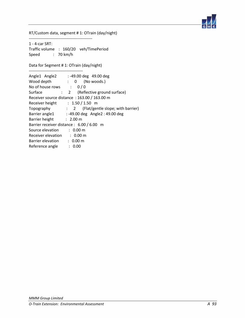
MMM Group Limited
O-Train Extension: Environmental Assessment A 93
RT/Custom data, segment # 1: OTrain (day/night) ----------------------------------------------- 1 - 4-car SRT: Traffic volume : 160/20 veh/TimePeriod Speed : 70 km/h Data for Segment # 1: OTrain (day/night) ---------------------------------------- Angle1 Angle2 : -49.00 deg 49.00 deg Wood depth : 0 (No woods.) No of house rows : 0 / 0 Surface : 2 (Reflective ground surface) Receiver source distance : 163.00 / 163.00 m Receiver height : 1.50 / 1.50 m Topography : 2 (Flat/gentle slope; with barrier) Barrier angle1 : -49.00 deg Angle2 : 49.00 deg Barrier height : 2.00 m Barrier receiver distance : 6.00 / 6.00 m Source elevation : 0.00 m Receiver elevation : 0.00 m Barrier elevation : 0.00 m Reference angle : 0.00
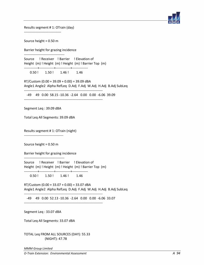
MMM Group Limited
O-Train Extension: Environmental Assessment A 94
Results segment # 1: OTrain (day) --------------------------------- Source height = 0.50 m Barrier height for grazing incidence ------------------------------------ Source ! Receiver ! Barrier ! Elevation of Height (m) ! Height (m) ! Height (m) ! Barrier Top (m) ------------+-------------+-------------+-------------- 0.50 ! 1.50 ! 1.46 ! 1.46 RT/Custom (0.00 + 39.09 + 0.00) = 39.09 dBA Angle1 Angle2 Alpha RefLeq D.Adj F.Adj W.Adj H.Adj B.Adj SubLeq ---------------------------------------------------------------------- -49 49 0.00 58.15 -10.36 -2.64 0.00 0.00 -6.06 39.09 ---------------------------------------------------------------------- Segment Leq : 39.09 dBA Total Leq All Segments: 39.09 dBA Results segment # 1: OTrain (night) ----------------------------------- Source height = 0.50 m Barrier height for grazing incidence ------------------------------------ Source ! Receiver ! Barrier ! Elevation of Height (m) ! Height (m) ! Height (m) ! Barrier Top (m) ------------+-------------+-------------+-------------- 0.50 ! 1.50 ! 1.46 ! 1.46 RT/Custom (0.00 + 33.07 + 0.00) = 33.07 dBA Angle1 Angle2 Alpha RefLeq D.Adj F.Adj W.Adj H.Adj B.Adj SubLeq ---------------------------------------------------------------------- -49 49 0.00 52.13 -10.36 -2.64 0.00 0.00 -6.06 33.07 ---------------------------------------------------------------------- Segment Leq : 33.07 dBA Total Leq All Segments: 33.07 dBA TOTAL Leq FROM ALL SOURCES (DAY): 55.33 (NIGHT): 47.78

MMM Group Limited
O-Train Extension: Environmental Assessment A 95
STAMSON 5.0 NORMAL REPORT Date: 17-04-2015 10:30:12 MINISTRY OF ENVIRONMENT AND ENERGY / NOISE ASSESSMENT Filename: r11.te Time Period: Day/Night 16/8 hours Description: Road data, segment # 1: Huntclub (day/night) -------------------------------------------- Car traffic volume : 23467/2041 veh/TimePeriod * Medium truck volume : 1867/162 veh/TimePeriod * Heavy truck volume : 1333/116 veh/TimePeriod * Posted speed limit : 60 km/h Road gradient : 0 % Road pavement : 1 (Typical asphalt or concrete) * Refers to calculated road volumes based on the following input: 24 hr Traffic Volume (AADT or SADT): 28986 Percentage of Annual Growth : 0.00 Number of Years of Growth : 0.00 Medium Truck % of Total Volume : 7.00 Heavy Truck % of Total Volume : 5.00 Day (16 hrs) % of Total Volume : 92.00 Data for Segment # 1: Huntclub (day/night) ------------------------------------------ Angle1 Angle2 : -21.00 deg 21.00 deg Wood depth : 0 (No woods.) No of house rows : 0 / 0 Surface : 2 (Reflective ground surface) Receiver source distance : 94.00 / 94.00 m Receiver height : 5.50 / 5.50 m Topography : 2 (Flat/gentle slope; with barrier) Barrier angle1 : 10.00 deg Angle2 : 21.00 deg Barrier height : 11.00 m Barrier receiver distance : 45.00 / 45.00 m Source elevation : 0.00 m Receiver elevation : 0.00 m Barrier elevation : 0.00 m Reference angle : 0.00
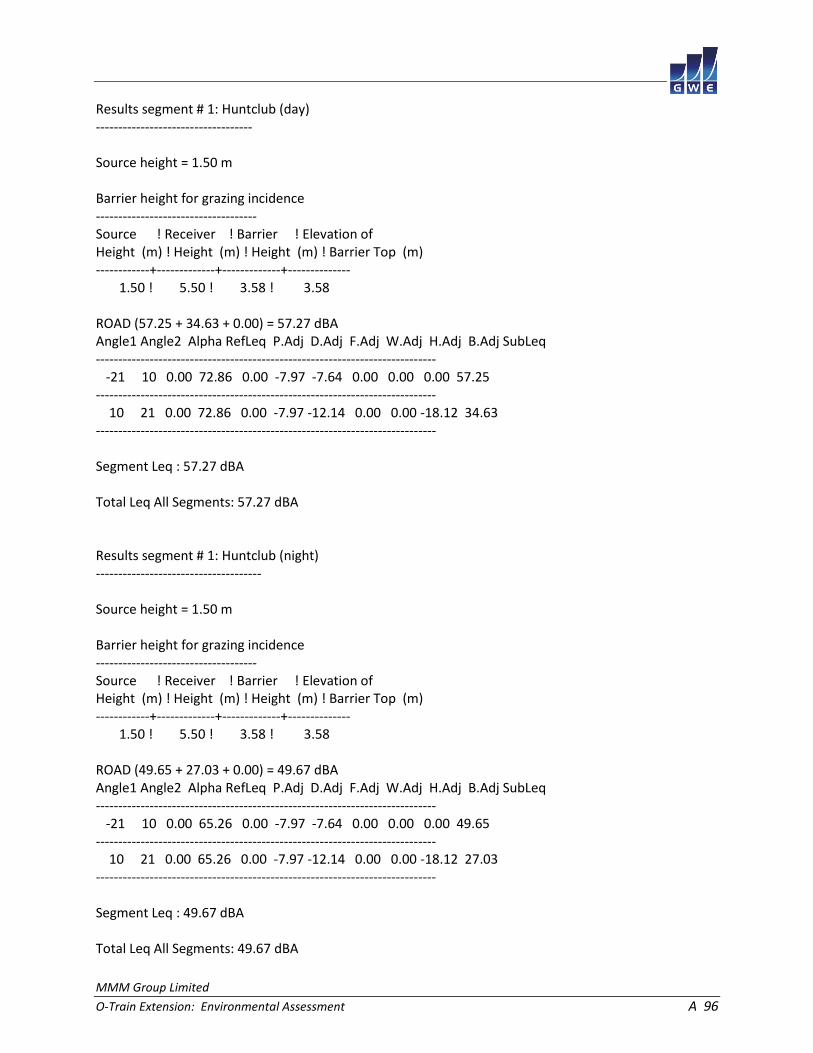
MMM Group Limited
O-Train Extension: Environmental Assessment A 96
Results segment # 1: Huntclub (day) ----------------------------------- Source height = 1.50 m Barrier height for grazing incidence ------------------------------------ Source ! Receiver ! Barrier ! Elevation of Height (m) ! Height (m) ! Height (m) ! Barrier Top (m) ------------+-------------+-------------+-------------- 1.50 ! 5.50 ! 3.58 ! 3.58 ROAD (57.25 + 34.63 + 0.00) = 57.27 dBA Angle1 Angle2 Alpha RefLeq P.Adj D.Adj F.Adj W.Adj H.Adj B.Adj SubLeq ---------------------------------------------------------------------------- -21 10 0.00 72.86 0.00 -7.97 -7.64 0.00 0.00 0.00 57.25 ---------------------------------------------------------------------------- 10 21 0.00 72.86 0.00 -7.97 -12.14 0.00 0.00 -18.12 34.63 ---------------------------------------------------------------------------- Segment Leq : 57.27 dBA Total Leq All Segments: 57.27 dBA Results segment # 1: Huntclub (night) ------------------------------------- Source height = 1.50 m Barrier height for grazing incidence ------------------------------------ Source ! Receiver ! Barrier ! Elevation of Height (m) ! Height (m) ! Height (m) ! Barrier Top (m) ------------+-------------+-------------+-------------- 1.50 ! 5.50 ! 3.58 ! 3.58 ROAD (49.65 + 27.03 + 0.00) = 49.67 dBA Angle1 Angle2 Alpha RefLeq P.Adj D.Adj F.Adj W.Adj H.Adj B.Adj SubLeq ---------------------------------------------------------------------------- -21 10 0.00 65.26 0.00 -7.97 -7.64 0.00 0.00 0.00 49.65 ---------------------------------------------------------------------------- 10 21 0.00 65.26 0.00 -7.97 -12.14 0.00 0.00 -18.12 27.03 ---------------------------------------------------------------------------- Segment Leq : 49.67 dBA Total Leq All Segments: 49.67 dBA
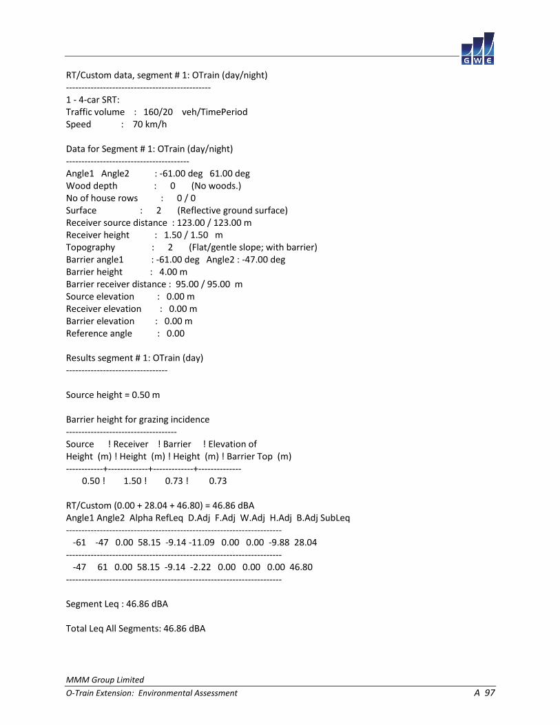
MMM Group Limited
O-Train Extension: Environmental Assessment A 97
RT/Custom data, segment # 1: OTrain (day/night) ----------------------------------------------- 1 - 4-car SRT: Traffic volume : 160/20 veh/TimePeriod Speed : 70 km/h Data for Segment # 1: OTrain (day/night) ---------------------------------------- Angle1 Angle2 : -61.00 deg 61.00 deg Wood depth : 0 (No woods.) No of house rows : 0 / 0 Surface : 2 (Reflective ground surface) Receiver source distance : 123.00 / 123.00 m Receiver height : 1.50 / 1.50 m Topography : 2 (Flat/gentle slope; with barrier) Barrier angle1 : -61.00 deg Angle2 : -47.00 deg Barrier height : 4.00 m Barrier receiver distance : 95.00 / 95.00 m Source elevation : 0.00 m Receiver elevation : 0.00 m Barrier elevation : 0.00 m Reference angle : 0.00 Results segment # 1: OTrain (day) --------------------------------- Source height = 0.50 m Barrier height for grazing incidence ------------------------------------ Source ! Receiver ! Barrier ! Elevation of Height (m) ! Height (m) ! Height (m) ! Barrier Top (m) ------------+-------------+-------------+-------------- 0.50 ! 1.50 ! 0.73 ! 0.73 RT/Custom (0.00 + 28.04 + 46.80) = 46.86 dBA Angle1 Angle2 Alpha RefLeq D.Adj F.Adj W.Adj H.Adj B.Adj SubLeq ---------------------------------------------------------------------- -61 -47 0.00 58.15 -9.14 -11.09 0.00 0.00 -9.88 28.04 ---------------------------------------------------------------------- -47 61 0.00 58.15 -9.14 -2.22 0.00 0.00 0.00 46.80 ---------------------------------------------------------------------- Segment Leq : 46.86 dBA Total Leq All Segments: 46.86 dBA
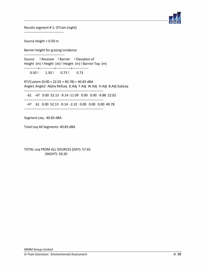
MMM Group Limited
O-Train Extension: Environmental Assessment A 98
Results segment # 1: OTrain (night) ----------------------------------- Source height = 0.50 m Barrier height for grazing incidence ------------------------------------ Source ! Receiver ! Barrier ! Elevation of Height (m) ! Height (m) ! Height (m) ! Barrier Top (m) ------------+-------------+-------------+-------------- 0.50 ! 1.50 ! 0.73 ! 0.73 RT/Custom (0.00 + 22.02 + 40.78) = 40.83 dBA Angle1 Angle2 Alpha RefLeq D.Adj F.Adj W.Adj H.Adj B.Adj SubLeq ---------------------------------------------------------------------- -61 -47 0.00 52.13 -9.14 -11.09 0.00 0.00 -9.88 22.02 ---------------------------------------------------------------------- -47 61 0.00 52.13 -9.14 -2.22 0.00 0.00 0.00 40.78 ---------------------------------------------------------------------- Segment Leq : 40.83 dBA Total Leq All Segments: 40.83 dBA TOTAL Leq FROM ALL SOURCES (DAY): 57.65 (NIGHT): 50.20
MMM Group Limited
O-Train Extension: Environmental Assessment B 1
APPENDIX B
STAMSON 5.04 - INPUT AND OUTPUT DATA (FUTURE CONDITIONS)

MMM Group Limited
O-Train Extension: Environmental Assessment B 2
STAMSON 5.0 NORMAL REPORT Date: 17-04-2015 15:09:54 MINISTRY OF ENVIRONMENT AND ENERGY / NOISE ASSESSMENT Filename: r1.te Time Period: Day/Night 16/8 hours Description: Road data, segment # 1: BayviewL (day/night) -------------------------------------------- Car traffic volume : 5449/474 veh/TimePeriod * Medium truck volume : 433/38 veh/TimePeriod * Heavy truck volume : 310/27 veh/TimePeriod * Posted speed limit : 50 km/h Road gradient : 0 % Road pavement : 1 (Typical asphalt or concrete) * Refers to calculated road volumes based on the following input: 24 hr Traffic Volume (AADT or SADT): 6731 Percentage of Annual Growth : 0.00 Number of Years of Growth : 0.00 Medium Truck % of Total Volume : 7.00 Heavy Truck % of Total Volume : 5.00 Day (16 hrs) % of Total Volume : 92.00 Data for Segment # 1: BayviewL (day/night) ------------------------------------------ Angle1 Angle2 : -48.00 deg -17.00 deg Wood depth : 0 (No woods.) No of house rows : 0 / 0 Surface : 2 (Reflective ground surface) Receiver source distance : 67.00 / 67.00 m Receiver height : 1.50 / 1.50 m Topography : 2 (Flat/gentle slope; with barrier) Barrier angle1 : -48.00 deg Angle2 : -29.00 deg Barrier height : 10.00 m Barrier receiver distance : 42.00 / 42.00 m Source elevation : 0.00 m Receiver elevation : 0.00 m Barrier elevation : 0.00 m Reference angle : 0.00

MMM Group Limited
O-Train Extension: Environmental Assessment B 3
Road data, segment # 2: BayviewR (day/night) -------------------------------------------- Car traffic volume : 5449/474 veh/TimePeriod * Medium truck volume : 433/38 veh/TimePeriod * Heavy truck volume : 310/27 veh/TimePeriod * Posted speed limit : 50 km/h Road gradient : 0 % Road pavement : 1 (Typical asphalt or concrete) * Refers to calculated road volumes based on the following input: 24 hr Traffic Volume (AADT or SADT): 6731 Percentage of Annual Growth : 0.00 Number of Years of Growth : 0.00 Medium Truck % of Total Volume : 7.00 Heavy Truck % of Total Volume : 5.00 Day (16 hrs) % of Total Volume : 92.00 Data for Segment # 2: BayviewR (day/night) ------------------------------------------ Angle1 Angle2 : 29.00 deg 53.00 deg Wood depth : 0 (No woods.) No of house rows : 0 / 0 Surface : 2 (Reflective ground surface) Receiver source distance : 61.00 / 61.00 m Receiver height : 1.50 / 1.50 m Topography : 1 (Flat/gentle slope; no barrier) Reference angle : 0.00

MMM Group Limited
O-Train Extension: Environmental Assessment B 4
Results segment # 1: BayviewL (day) ----------------------------------- Source height = 1.50 m Barrier height for grazing incidence ------------------------------------ Source ! Receiver ! Barrier ! Elevation of Height (m) ! Height (m) ! Height (m) ! Barrier Top (m) ------------+-------------+-------------+-------------- 1.50 ! 1.50 ! 1.50 ! 1.50 ROAD (0.00 + 28.85 + 46.74) = 46.81 dBA Angle1 Angle2 Alpha RefLeq P.Adj D.Adj F.Adj W.Adj H.Adj B.Adj SubLeq ---------------------------------------------------------------------------- -48 -29 0.00 65.00 0.00 -6.50 -9.77 0.00 0.00 -19.88 28.85 ---------------------------------------------------------------------------- -29 -17 0.00 65.00 0.00 -6.50 -11.76 0.00 0.00 0.00 46.74 ---------------------------------------------------------------------------- Segment Leq : 46.81 dBA Results segment # 2: BayviewR (day) ----------------------------------- Source height = 1.50 m ROAD (0.00 + 50.16 + 0.00) = 50.16 dBA Angle1 Angle2 Alpha RefLeq P.Adj D.Adj F.Adj W.Adj H.Adj B.Adj SubLeq ---------------------------------------------------------------------------- 29 53 0.00 65.00 0.00 -6.09 -8.75 0.00 0.00 0.00 50.16 ---------------------------------------------------------------------------- Segment Leq : 50.16 dBA Total Leq All Segments: 51.81 dBA
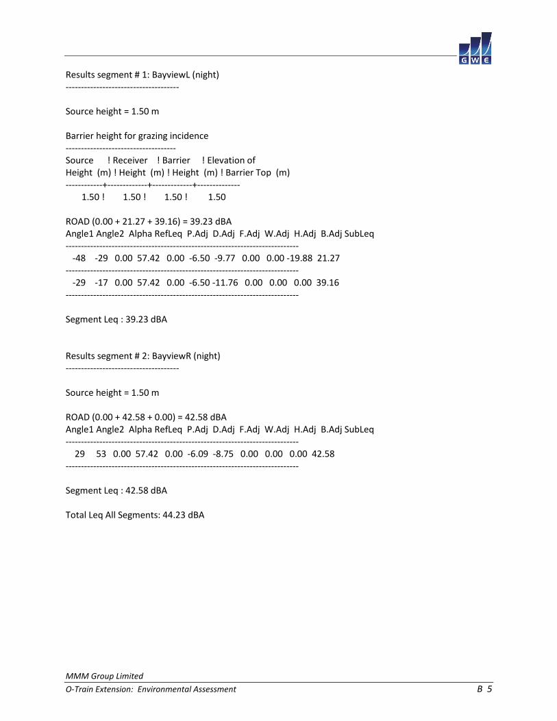
MMM Group Limited
O-Train Extension: Environmental Assessment B 5
Results segment # 1: BayviewL (night) ------------------------------------- Source height = 1.50 m Barrier height for grazing incidence ------------------------------------ Source ! Receiver ! Barrier ! Elevation of Height (m) ! Height (m) ! Height (m) ! Barrier Top (m) ------------+-------------+-------------+-------------- 1.50 ! 1.50 ! 1.50 ! 1.50 ROAD (0.00 + 21.27 + 39.16) = 39.23 dBA Angle1 Angle2 Alpha RefLeq P.Adj D.Adj F.Adj W.Adj H.Adj B.Adj SubLeq ---------------------------------------------------------------------------- -48 -29 0.00 57.42 0.00 -6.50 -9.77 0.00 0.00 -19.88 21.27 ---------------------------------------------------------------------------- -29 -17 0.00 57.42 0.00 -6.50 -11.76 0.00 0.00 0.00 39.16 ---------------------------------------------------------------------------- Segment Leq : 39.23 dBA Results segment # 2: BayviewR (night) ------------------------------------- Source height = 1.50 m ROAD (0.00 + 42.58 + 0.00) = 42.58 dBA Angle1 Angle2 Alpha RefLeq P.Adj D.Adj F.Adj W.Adj H.Adj B.Adj SubLeq ---------------------------------------------------------------------------- 29 53 0.00 57.42 0.00 -6.09 -8.75 0.00 0.00 0.00 42.58 ---------------------------------------------------------------------------- Segment Leq : 42.58 dBA Total Leq All Segments: 44.23 dBA

MMM Group Limited
O-Train Extension: Environmental Assessment B 6
RT/Custom data, segment # 1: OTrainL (day/night) ------------------------------------------------ 1 - 4-car SRT: Traffic volume : 192/24 veh/TimePeriod Speed : 70 km/h Data for Segment # 1: OTrainL (day/night) ----------------------------------------- Angle1 Angle2 : -77.00 deg 16.00 deg Wood depth : 0 (No woods.) No of house rows : 0 / 0 Surface : 1 (Absorptive ground surface) Receiver source distance : 46.00 / 46.00 m Receiver height : 1.50 / 1.50 m Topography : 1 (Flat/gentle slope; no barrier) Reference angle : 0.00 RT/Custom data, segment # 2: OTrainR (day/night) ------------------------------------------------ 1 - 4-car SRT: Traffic volume : 192/24 veh/TimePeriod Speed : 70 km/h Data for Segment # 2: OTrainR (day/night) ----------------------------------------- Angle1 Angle2 : 10.00 deg 79.00 deg Wood depth : 0 (No woods.) No of house rows : 0 / 0 Surface : 1 (Absorptive ground surface) Receiver source distance : 48.00 / 48.00 m Receiver height : 1.50 / 1.50 m Topography : 1 (Flat/gentle slope; no barrier) Reference angle : 0.00

MMM Group Limited
O-Train Extension: Environmental Assessment B 7
Results segment # 1: OTrainL (day) ---------------------------------- Source height = 0.50 m RT/Custom (0.00 + 47.20 + 0.00) = 47.20 dBA Angle1 Angle2 Alpha RefLeq D.Adj F.Adj W.Adj H.Adj B.Adj SubLeq ---------------------------------------------------------------------- -77 16 0.66 58.95 -8.08 -3.67 0.00 0.00 0.00 47.20 ---------------------------------------------------------------------- Segment Leq : 47.20 dBA Results segment # 2: OTrainR (day) ---------------------------------- Source height = 0.50 m RT/Custom (0.00 + 45.18 + 0.00) = 45.18 dBA Angle1 Angle2 Alpha RefLeq D.Adj F.Adj W.Adj H.Adj B.Adj SubLeq ---------------------------------------------------------------------- 10 79 0.66 58.95 -8.39 -5.38 0.00 0.00 0.00 45.18 ---------------------------------------------------------------------- Segment Leq : 45.18 dBA Total Leq All Segments: 49.32 dBA

MMM Group Limited
O-Train Extension: Environmental Assessment B 8
Results segment # 1: OTrainL (night) ------------------------------------ Source height = 0.50 m RT/Custom (0.00 + 41.17 + 0.00) = 41.17 dBA Angle1 Angle2 Alpha RefLeq D.Adj F.Adj W.Adj H.Adj B.Adj SubLeq ---------------------------------------------------------------------- -77 16 0.66 52.93 -8.08 -3.67 0.00 0.00 0.00 41.17 ---------------------------------------------------------------------- Segment Leq : 41.17 dBA Results segment # 2: OTrainR (night) ------------------------------------ Source height = 0.50 m RT/Custom (0.00 + 39.16 + 0.00) = 39.16 dBA Angle1 Angle2 Alpha RefLeq D.Adj F.Adj W.Adj H.Adj B.Adj SubLeq ---------------------------------------------------------------------- 10 79 0.66 52.93 -8.39 -5.38 0.00 0.00 0.00 39.16 ---------------------------------------------------------------------- Segment Leq : 39.16 dBA Total Leq All Segments: 43.29 dBA TOTAL Leq FROM ALL SOURCES (DAY): 53.75 (NIGHT): 46.80

MMM Group Limited
O-Train Extension: Environmental Assessment B 9
STAMSON 5.0 NORMAL REPORT Date: 17-04-2015 16:03:20 MINISTRY OF ENVIRONMENT AND ENERGY / NOISE ASSESSMENT Filename: r2.te Time Period: Day/Night 16/8 hours Description: Road data, segment # 1: Gladstone (day/night) --------------------------------------------- Car traffic volume : 4699/409 veh/TimePeriod * Medium truck volume : 374/33 veh/TimePeriod * Heavy truck volume : 267/23 veh/TimePeriod * Posted speed limit : 40 km/h Road gradient : 0 % Road pavement : 1 (Typical asphalt or concrete) * Refers to calculated road volumes based on the following input: 24 hr Traffic Volume (AADT or SADT): 5804 Percentage of Annual Growth : 0.00 Number of Years of Growth : 0.00 Medium Truck % of Total Volume : 7.00 Heavy Truck % of Total Volume : 5.00 Day (16 hrs) % of Total Volume : 92.00 Data for Segment # 1: Gladstone (day/night) ------------------------------------------- Angle1 Angle2 : -70.00 deg 70.00 deg Wood depth : 0 (No woods.) No of house rows : 0 / 0 Surface : 2 (Reflective ground surface) Receiver source distance : 35.00 / 35.00 m Receiver height : 1.50 / 1.50 m Topography : 2 (Flat/gentle slope; with barrier) Barrier angle1 : -48.00 deg Angle2 : 70.00 deg Barrier height : 10.00 m Barrier receiver distance : 3.00 / 3.00 m Source elevation : 0.00 m Receiver elevation : 0.00 m Barrier elevation : 0.00 m Reference angle : 0.00

MMM Group Limited
O-Train Extension: Environmental Assessment B 10
Road data, segment # 2: 417WBL (day/night) ------------------------------------------ Car traffic volume : 91849/7987 veh/TimePeriod * Medium truck volume : 7306/635 veh/TimePeriod * Heavy truck volume : 5219/454 veh/TimePeriod * Posted speed limit : 100 km/h Road gradient : 0 % Road pavement : 1 (Typical asphalt or concrete) * Refers to calculated road volumes based on the following input: 24 hr Traffic Volume (AADT or SADT): 113450 Percentage of Annual Growth : 0.00 Number of Years of Growth : 0.00 Medium Truck % of Total Volume : 7.00 Heavy Truck % of Total Volume : 5.00 Day (16 hrs) % of Total Volume : 92.00 Data for Segment # 2: 417WBL (day/night) ---------------------------------------- Angle1 Angle2 : -73.00 deg 6.00 deg Wood depth : 0 (No woods.) No of house rows : 0 / 0 Surface : 2 (Reflective ground surface) Receiver source distance : 143.00 / 143.00 m Receiver height : 1.50 / 1.50 m Topography : 2 (Flat/gentle slope; with barrier) Barrier angle1 : -73.00 deg Angle2 : 6.00 deg Barrier height : 7.00 m Barrier receiver distance : 16.00 / 16.00 m Source elevation : 10.00 m Receiver elevation : 0.00 m Barrier elevation : 0.00 m Reference angle : 0.00

MMM Group Limited
O-Train Extension: Environmental Assessment B 11
Road data, segment # 3: 417WBC (day/night) ------------------------------------------ Car traffic volume : 91849/7987 veh/TimePeriod * Medium truck volume : 7306/635 veh/TimePeriod * Heavy truck volume : 5219/454 veh/TimePeriod * Posted speed limit : 100 km/h Road gradient : 0 % Road pavement : 1 (Typical asphalt or concrete) * Refers to calculated road volumes based on the following input: 24 hr Traffic Volume (AADT or SADT): 113450 Percentage of Annual Growth : 0.00 Number of Years of Growth : 0.00 Medium Truck % of Total Volume : 7.00 Heavy Truck % of Total Volume : 5.00 Day (16 hrs) % of Total Volume : 92.00 Data for Segment # 3: 417WBC (day/night) ---------------------------------------- Angle1 Angle2 : 6.00 deg 12.00 deg Wood depth : 0 (No woods.) No of house rows : 0 / 0 Surface : 2 (Reflective ground surface) Receiver source distance : 143.00 / 143.00 m Receiver height : 1.50 / 1.50 m Topography : 2 (Flat/gentle slope; with barrier) Barrier angle1 : 6.00 deg Angle2 : 12.00 deg Barrier height : 1.50 m Barrier receiver distance : 135.00 / 135.00 m Source elevation : 10.00 m Receiver elevation : 0.00 m Barrier elevation : 10.00 m Reference angle : 0.00

MMM Group Limited
O-Train Extension: Environmental Assessment B 12
Road data, segment # 4: 417EBL (day/night) ------------------------------------------ Car traffic volume : 91849/7987 veh/TimePeriod * Medium truck volume : 7306/635 veh/TimePeriod * Heavy truck volume : 5219/454 veh/TimePeriod * Posted speed limit : 100 km/h Road gradient : 0 % Road pavement : 1 (Typical asphalt or concrete) * Refers to calculated road volumes based on the following input: 24 hr Traffic Volume (AADT or SADT): 113450 Percentage of Annual Growth : 0.00 Number of Years of Growth : 0.00 Medium Truck % of Total Volume : 7.00 Heavy Truck % of Total Volume : 5.00 Day (16 hrs) % of Total Volume : 92.00 Data for Segment # 4: 417EBL (day/night) ---------------------------------------- Angle1 Angle2 : -71.00 deg 6.00 deg Wood depth : 0 (No woods.) No of house rows : 0 / 0 Surface : 2 (Reflective ground surface) Receiver source distance : 162.00 / 162.00 m Receiver height : 1.50 / 1.50 m Topography : 2 (Flat/gentle slope; with barrier) Barrier angle1 : -71.00 deg Angle2 : 6.00 deg Barrier height : 7.00 m Barrier receiver distance : 16.00 / 16.00 m Source elevation : 10.00 m Receiver elevation : 0.00 m Barrier elevation : 0.00 m Reference angle : 0.00

MMM Group Limited
O-Train Extension: Environmental Assessment B 13
Road data, segment # 5: 417EBC (day/night) ------------------------------------------ Car traffic volume : 91849/7987 veh/TimePeriod * Medium truck volume : 7306/635 veh/TimePeriod * Heavy truck volume : 5219/454 veh/TimePeriod * Posted speed limit : 100 km/h Road gradient : 0 % Road pavement : 1 (Typical asphalt or concrete) * Refers to calculated road volumes based on the following input: 24 hr Traffic Volume (AADT or SADT): 113450 Percentage of Annual Growth : 0.00 Number of Years of Growth : 0.00 Medium Truck % of Total Volume : 7.00 Heavy Truck % of Total Volume : 5.00 Day (16 hrs) % of Total Volume : 92.00 Data for Segment # 5: 417EBC (day/night) ---------------------------------------- Angle1 Angle2 : 6.00 deg 13.00 deg Wood depth : 0 (No woods.) No of house rows : 0 / 0 Surface : 2 (Reflective ground surface) Receiver source distance : 162.00 / 162.00 m Receiver height : 1.50 / 1.50 m Topography : 2 (Flat/gentle slope; with barrier) Barrier angle1 : 6.00 deg Angle2 : 13.00 deg Barrier height : 1.50 m Barrier receiver distance : 135.00 / 135.00 m Source elevation : 10.00 m Receiver elevation : 0.00 m Barrier elevation : 10.00 m Reference angle : 0.00

MMM Group Limited
O-Train Extension: Environmental Assessment B 14
Road data, segment # 6: 417WBR (day/night) ------------------------------------------ Car traffic volume : 91849/7987 veh/TimePeriod * Medium truck volume : 7306/635 veh/TimePeriod * Heavy truck volume : 5219/454 veh/TimePeriod * Posted speed limit : 100 km/h Road gradient : 0 % Road pavement : 1 (Typical asphalt or concrete) * Refers to calculated road volumes based on the following input: 24 hr Traffic Volume (AADT or SADT): 113450 Percentage of Annual Growth : 0.00 Number of Years of Growth : 0.00 Medium Truck % of Total Volume : 7.00 Heavy Truck % of Total Volume : 5.00 Day (16 hrs) % of Total Volume : 92.00 Data for Segment # 6: 417WBR (day/night) ---------------------------------------- Angle1 Angle2 : 19.00 deg 74.00 deg Wood depth : 0 (No woods.) No of house rows : 0 / 0 Surface : 2 (Reflective ground surface) Receiver source distance : 139.00 / 139.00 m Receiver height : 1.50 / 1.50 m Topography : 2 (Flat/gentle slope; with barrier) Barrier angle1 : 19.00 deg Angle2 : 74.00 deg Barrier height : 1.50 m Barrier receiver distance : 136.00 / 136.00 m Source elevation : 10.00 m Receiver elevation : 0.00 m Barrier elevation : 10.00 m Reference angle : 0.00

MMM Group Limited
O-Train Extension: Environmental Assessment B 15
Road data, segment # 7: 417EBR (day/night) ------------------------------------------ Car traffic volume : 91849/7987 veh/TimePeriod * Medium truck volume : 7306/635 veh/TimePeriod * Heavy truck volume : 5219/454 veh/TimePeriod * Posted speed limit : 100 km/h Road gradient : 0 % Road pavement : 1 (Typical asphalt or concrete) * Refers to calculated road volumes based on the following input: 24 hr Traffic Volume (AADT or SADT): 113450 Percentage of Annual Growth : 0.00 Number of Years of Growth : 0.00 Medium Truck % of Total Volume : 7.00 Heavy Truck % of Total Volume : 5.00 Day (16 hrs) % of Total Volume : 92.00 Data for Segment # 7: 417EBR (day/night) ---------------------------------------- Angle1 Angle2 : 20.00 deg 72.00 deg Wood depth : 0 (No woods.) No of house rows : 0 / 0 Surface : 2 (Reflective ground surface) Receiver source distance : 156.00 / 156.00 m Receiver height : 1.50 / 1.50 m Topography : 2 (Flat/gentle slope; with barrier) Barrier angle1 : 20.00 deg Angle2 : 72.00 deg Barrier height : 1.50 m Barrier receiver distance : 136.00 / 136.00 m Source elevation : 10.00 m Receiver elevation : 0.00 m Barrier elevation : 10.00 m Reference angle : 0.00

MMM Group Limited
O-Train Extension: Environmental Assessment B 16
Results segment # 1: Gladstone (day) ------------------------------------ Source height = 1.50 m Barrier height for grazing incidence ------------------------------------ Source ! Receiver ! Barrier ! Elevation of Height (m) ! Height (m) ! Height (m) ! Barrier Top (m) ------------+-------------+-------------+-------------- 1.50 ! 1.50 ! 1.50 ! 1.50 ROAD (49.75 + 37.05 + 0.00) = 49.98 dBA Angle1 Angle2 Alpha RefLeq P.Adj D.Adj F.Adj W.Adj H.Adj B.Adj SubLeq ---------------------------------------------------------------------------- -70 -48 0.00 62.56 0.00 -3.68 -9.13 0.00 0.00 0.00 49.75 ---------------------------------------------------------------------------- -48 70 0.00 62.56 0.00 -3.68 -1.83 0.00 0.00 -20.00 37.05 ---------------------------------------------------------------------------- Segment Leq : 49.98 dBA Results segment # 2: 417WBL (day) --------------------------------- Source height = 1.50 m Barrier height for grazing incidence ------------------------------------ Source ! Receiver ! Barrier ! Elevation of Height (m) ! Height (m) ! Height (m) ! Barrier Top (m) ------------+-------------+-------------+-------------- 1.50 ! 1.50 ! 2.62 ! 2.62 ROAD (0.00 + 55.69 + 0.00) = 55.69 dBA Angle1 Angle2 Alpha RefLeq P.Adj D.Adj F.Adj W.Adj H.Adj B.Adj SubLeq ---------------------------------------------------------------------------- -73 6 0.00 83.29 0.00 -9.79 -3.58 0.00 0.00 -14.23 55.69 ---------------------------------------------------------------------------- Segment Leq : 55.69 dBA
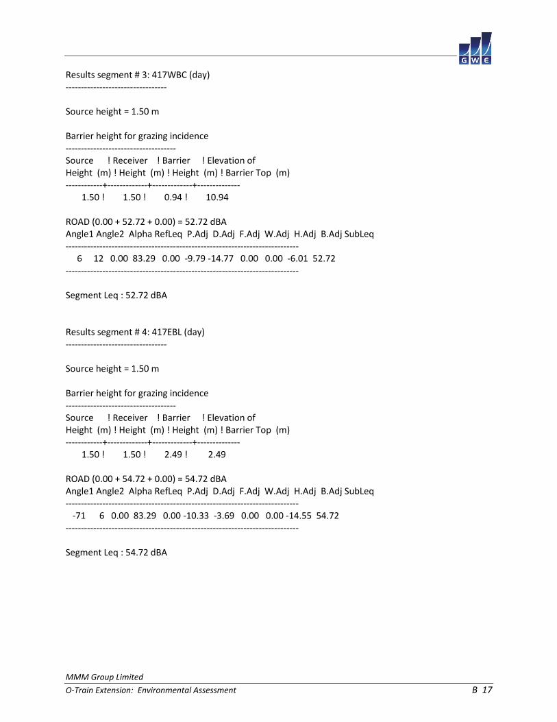
MMM Group Limited
O-Train Extension: Environmental Assessment B 17
Results segment # 3: 417WBC (day) --------------------------------- Source height = 1.50 m Barrier height for grazing incidence ------------------------------------ Source ! Receiver ! Barrier ! Elevation of Height (m) ! Height (m) ! Height (m) ! Barrier Top (m) ------------+-------------+-------------+-------------- 1.50 ! 1.50 ! 0.94 ! 10.94 ROAD (0.00 + 52.72 + 0.00) = 52.72 dBA Angle1 Angle2 Alpha RefLeq P.Adj D.Adj F.Adj W.Adj H.Adj B.Adj SubLeq ---------------------------------------------------------------------------- 6 12 0.00 83.29 0.00 -9.79 -14.77 0.00 0.00 -6.01 52.72 ---------------------------------------------------------------------------- Segment Leq : 52.72 dBA Results segment # 4: 417EBL (day) --------------------------------- Source height = 1.50 m Barrier height for grazing incidence ------------------------------------ Source ! Receiver ! Barrier ! Elevation of Height (m) ! Height (m) ! Height (m) ! Barrier Top (m) ------------+-------------+-------------+-------------- 1.50 ! 1.50 ! 2.49 ! 2.49 ROAD (0.00 + 54.72 + 0.00) = 54.72 dBA Angle1 Angle2 Alpha RefLeq P.Adj D.Adj F.Adj W.Adj H.Adj B.Adj SubLeq ---------------------------------------------------------------------------- -71 6 0.00 83.29 0.00 -10.33 -3.69 0.00 0.00 -14.55 54.72 ---------------------------------------------------------------------------- Segment Leq : 54.72 dBA

MMM Group Limited
O-Train Extension: Environmental Assessment B 18
Results segment # 5: 417EBC (day) --------------------------------- Source height = 1.50 m Barrier height for grazing incidence ------------------------------------ Source ! Receiver ! Barrier ! Elevation of Height (m) ! Height (m) ! Height (m) ! Barrier Top (m) ------------+-------------+-------------+-------------- 1.50 ! 1.50 ! -0.17 ! 9.83 ROAD (0.00 + 51.27 + 0.00) = 51.27 dBA Angle1 Angle2 Alpha RefLeq P.Adj D.Adj F.Adj W.Adj H.Adj B.Adj SubLeq ---------------------------------------------------------------------------- 6 13 0.00 83.29 0.00 -10.33 -14.10 0.00 0.00 -7.59 51.27 ---------------------------------------------------------------------------- Segment Leq : 51.27 dBA Results segment # 6: 417WBR (day) --------------------------------- Source height = 1.50 m Barrier height for grazing incidence ------------------------------------ Source ! Receiver ! Barrier ! Elevation of Height (m) ! Height (m) ! Height (m) ! Barrier Top (m) ------------+-------------+-------------+-------------- 1.50 ! 1.50 ! 1.28 ! 11.28 ROAD (0.00 + 63.19 + 0.00) = 63.19 dBA Angle1 Angle2 Alpha RefLeq P.Adj D.Adj F.Adj W.Adj H.Adj B.Adj SubLeq ---------------------------------------------------------------------------- 19 74 0.00 83.29 0.00 -9.67 -5.15 0.00 0.00 -5.28 63.19 ---------------------------------------------------------------------------- Segment Leq : 63.19 dBA
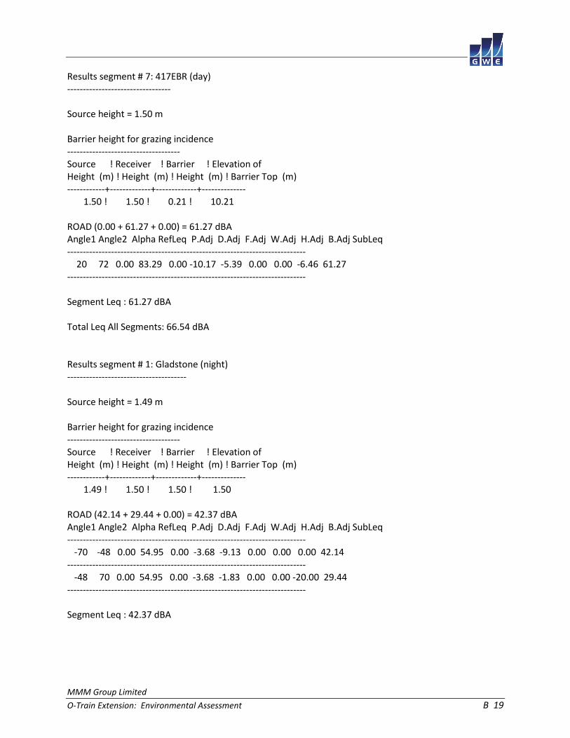
MMM Group Limited
O-Train Extension: Environmental Assessment B 19
Results segment # 7: 417EBR (day) --------------------------------- Source height = 1.50 m Barrier height for grazing incidence ------------------------------------ Source ! Receiver ! Barrier ! Elevation of Height (m) ! Height (m) ! Height (m) ! Barrier Top (m) ------------+-------------+-------------+-------------- 1.50 ! 1.50 ! 0.21 ! 10.21 ROAD (0.00 + 61.27 + 0.00) = 61.27 dBA Angle1 Angle2 Alpha RefLeq P.Adj D.Adj F.Adj W.Adj H.Adj B.Adj SubLeq ---------------------------------------------------------------------------- 20 72 0.00 83.29 0.00 -10.17 -5.39 0.00 0.00 -6.46 61.27 ---------------------------------------------------------------------------- Segment Leq : 61.27 dBA Total Leq All Segments: 66.54 dBA Results segment # 1: Gladstone (night) -------------------------------------- Source height = 1.49 m Barrier height for grazing incidence ------------------------------------ Source ! Receiver ! Barrier ! Elevation of Height (m) ! Height (m) ! Height (m) ! Barrier Top (m) ------------+-------------+-------------+-------------- 1.49 ! 1.50 ! 1.50 ! 1.50 ROAD (42.14 + 29.44 + 0.00) = 42.37 dBA Angle1 Angle2 Alpha RefLeq P.Adj D.Adj F.Adj W.Adj H.Adj B.Adj SubLeq ---------------------------------------------------------------------------- -70 -48 0.00 54.95 0.00 -3.68 -9.13 0.00 0.00 0.00 42.14 ---------------------------------------------------------------------------- -48 70 0.00 54.95 0.00 -3.68 -1.83 0.00 0.00 -20.00 29.44 ---------------------------------------------------------------------------- Segment Leq : 42.37 dBA

MMM Group Limited
O-Train Extension: Environmental Assessment B 20
Results segment # 2: 417WBL (night) ----------------------------------- Source height = 1.50 m Barrier height for grazing incidence ------------------------------------ Source ! Receiver ! Barrier ! Elevation of Height (m) ! Height (m) ! Height (m) ! Barrier Top (m) ------------+-------------+-------------+-------------- 1.50 ! 1.50 ! 2.62 ! 2.62 ROAD (0.00 + 48.10 + 0.00) = 48.10 dBA Angle1 Angle2 Alpha RefLeq P.Adj D.Adj F.Adj W.Adj H.Adj B.Adj SubLeq ---------------------------------------------------------------------------- -73 6 0.00 75.70 0.00 -9.79 -3.58 0.00 0.00 -14.23 48.10 ---------------------------------------------------------------------------- Segment Leq : 48.10 dBA Results segment # 3: 417WBC (night) ----------------------------------- Source height = 1.50 m Barrier height for grazing incidence ------------------------------------ Source ! Receiver ! Barrier ! Elevation of Height (m) ! Height (m) ! Height (m) ! Barrier Top (m) ------------+-------------+-------------+-------------- 1.50 ! 1.50 ! 0.94 ! 10.94 ROAD (0.00 + 45.12 + 0.00) = 45.12 dBA Angle1 Angle2 Alpha RefLeq P.Adj D.Adj F.Adj W.Adj H.Adj B.Adj SubLeq ---------------------------------------------------------------------------- 6 12 0.00 75.70 0.00 -9.79 -14.77 0.00 0.00 -6.01 45.12 ---------------------------------------------------------------------------- Segment Leq : 45.12 dBA

MMM Group Limited
O-Train Extension: Environmental Assessment B 21
Results segment # 4: 417EBL (night) ----------------------------------- Source height = 1.50 m Barrier height for grazing incidence ------------------------------------ Source ! Receiver ! Barrier ! Elevation of Height (m) ! Height (m) ! Height (m) ! Barrier Top (m) ------------+-------------+-------------+-------------- 1.50 ! 1.50 ! 2.49 ! 2.49 ROAD (0.00 + 47.13 + 0.00) = 47.13 dBA Angle1 Angle2 Alpha RefLeq P.Adj D.Adj F.Adj W.Adj H.Adj B.Adj SubLeq ---------------------------------------------------------------------------- -71 6 0.00 75.70 0.00 -10.33 -3.69 0.00 0.00 -14.55 47.13 ---------------------------------------------------------------------------- Segment Leq : 47.13 dBA Results segment # 5: 417EBC (night) ----------------------------------- Source height = 1.50 m Barrier height for grazing incidence ------------------------------------ Source ! Receiver ! Barrier ! Elevation of Height (m) ! Height (m) ! Height (m) ! Barrier Top (m) ------------+-------------+-------------+-------------- 1.50 ! 1.50 ! -0.17 ! 9.83 ROAD (0.00 + 43.67 + 0.00) = 43.67 dBA Angle1 Angle2 Alpha RefLeq P.Adj D.Adj F.Adj W.Adj H.Adj B.Adj SubLeq ---------------------------------------------------------------------------- 6 13 0.00 75.70 0.00 -10.33 -14.10 0.00 0.00 -7.59 43.67 ---------------------------------------------------------------------------- Segment Leq : 43.67 dBA

MMM Group Limited
O-Train Extension: Environmental Assessment B 22
Results segment # 6: 417WBR (night) ----------------------------------- Source height = 1.50 m Barrier height for grazing incidence ------------------------------------ Source ! Receiver ! Barrier ! Elevation of Height (m) ! Height (m) ! Height (m) ! Barrier Top (m) ------------+-------------+-------------+-------------- 1.50 ! 1.50 ! 1.28 ! 11.28 ROAD (0.00 + 55.60 + 0.00) = 55.60 dBA Angle1 Angle2 Alpha RefLeq P.Adj D.Adj F.Adj W.Adj H.Adj B.Adj SubLeq ---------------------------------------------------------------------------- 19 74 0.00 75.70 0.00 -9.67 -5.15 0.00 0.00 -5.28 55.60 ---------------------------------------------------------------------------- Segment Leq : 55.60 dBA Results segment # 7: 417EBR (night) ----------------------------------- Source height = 1.50 m Barrier height for grazing incidence ------------------------------------ Source ! Receiver ! Barrier ! Elevation of Height (m) ! Height (m) ! Height (m) ! Barrier Top (m) ------------+-------------+-------------+-------------- 1.50 ! 1.50 ! 0.21 ! 10.21 ROAD (0.00 + 53.67 + 0.00) = 53.67 dBA Angle1 Angle2 Alpha RefLeq P.Adj D.Adj F.Adj W.Adj H.Adj B.Adj SubLeq ---------------------------------------------------------------------------- 20 72 0.00 75.70 0.00 -10.17 -5.39 0.00 0.00 -6.46 53.67 ---------------------------------------------------------------------------- Segment Leq : 53.67 dBA Total Leq All Segments: 58.95 dBA

MMM Group Limited
O-Train Extension: Environmental Assessment B 23
RT/Custom data, segment # 1: OTrainL (day/night) ------------------------------------------------ 1 - 4-car SRT: Traffic volume : 192/24 veh/TimePeriod Speed : 70 km/h Data for Segment # 1: OTrainL (day/night) ----------------------------------------- Angle1 Angle2 : -76.00 deg -45.00 deg Wood depth : 0 (No woods.) No of house rows : 0 / 0 Surface : 1 (Absorptive ground surface) Receiver source distance : 62.00 / 62.00 m Receiver height : 6.50 / 6.50 m Topography : 2 (Flat/gentle slope; with barrier) Barrier angle1 : -76.00 deg Angle2 : -45.00 deg Barrier height : 8.00 m Barrier receiver distance : 59.00 / 59.00 m Source elevation : 0.00 m Receiver elevation : 0.00 m Barrier elevation : 0.00 m Reference angle : 0.00 RT/Custom data, segment # 2: OTrainR (day/night) ------------------------------------------------ 1 - 4-car SRT: Traffic volume : 192/24 veh/TimePeriod Speed : 70 km/h Data for Segment # 2: OTrainR (day/night) ----------------------------------------- Angle1 Angle2 : -33.00 deg 73.00 deg Wood depth : 0 (No woods.) No of house rows : 0 / 0 Surface : 1 (Absorptive ground surface) Receiver source distance : 74.00 / 74.00 m Receiver height : 6.50 / 6.50 m Topography : 2 (Flat/gentle slope; with barrier) Barrier angle1 : -33.00 deg Angle2 : 73.00 deg Barrier height : 8.00 m Barrier receiver distance : 60.00 / 60.00 m Source elevation : 0.00 m Receiver elevation : 0.00 m Barrier elevation : 0.00 m Reference angle : 0.00

MMM Group Limited
O-Train Extension: Environmental Assessment B 24
Results segment # 1: OTrainL (day) ---------------------------------- Source height = 0.50 m Barrier height for grazing incidence ------------------------------------ Source ! Receiver ! Barrier ! Elevation of Height (m) ! Height (m) ! Height (m) ! Barrier Top (m) ------------+-------------+-------------+-------------- 0.50 ! 6.50 ! 0.79 ! 0.79 RT/Custom (0.00 + 24.78 + 0.00) = 24.78 dBA Angle1 Angle2 Alpha RefLeq D.Adj F.Adj W.Adj H.Adj B.Adj SubLeq ---------------------------------------------------------------------- -76 -45 0.06 58.95 -6.53 -7.84 0.00 0.00 -19.80 24.78 ---------------------------------------------------------------------- Segment Leq : 24.78 dBA Results segment # 2: OTrainR (day) ---------------------------------- Source height = 0.50 m Barrier height for grazing incidence ------------------------------------ Source ! Receiver ! Barrier ! Elevation of Height (m) ! Height (m) ! Height (m) ! Barrier Top (m) ------------+-------------+-------------+-------------- 0.50 ! 6.50 ! 1.64 ! 1.64 RT/Custom (0.00 + 30.73 + 0.00) = 30.73 dBA Angle1 Angle2 Alpha RefLeq D.Adj F.Adj W.Adj H.Adj B.Adj SubLeq ---------------------------------------------------------------------- -33 73 0.06 58.95 -7.35 -2.36 0.00 0.00 -18.50 30.73 ---------------------------------------------------------------------- Segment Leq : 30.73 dBA Total Leq All Segments: 31.71 dBA

MMM Group Limited
O-Train Extension: Environmental Assessment B 25
Results segment # 1: OTrainL (night) ------------------------------------ Source height = 0.50 m Barrier height for grazing incidence ------------------------------------ Source ! Receiver ! Barrier ! Elevation of Height (m) ! Height (m) ! Height (m) ! Barrier Top (m) ------------+-------------+-------------+-------------- 0.50 ! 6.50 ! 0.79 ! 0.79 RT/Custom (0.00 + 18.76 + 0.00) = 18.76 dBA Angle1 Angle2 Alpha RefLeq D.Adj F.Adj W.Adj H.Adj B.Adj SubLeq ---------------------------------------------------------------------- -76 -45 0.06 52.93 -6.53 -7.84 0.00 0.00 -19.80 18.76 ---------------------------------------------------------------------- Segment Leq : 18.76 dBA Results segment # 2: OTrainR (night) ------------------------------------ Source height = 0.50 m Barrier height for grazing incidence ------------------------------------ Source ! Receiver ! Barrier ! Elevation of Height (m) ! Height (m) ! Height (m) ! Barrier Top (m) ------------+-------------+-------------+-------------- 0.50 ! 6.50 ! 1.64 ! 1.64 RT/Custom (0.00 + 24.71 + 0.00) = 24.71 dBA Angle1 Angle2 Alpha RefLeq D.Adj F.Adj W.Adj H.Adj B.Adj SubLeq ---------------------------------------------------------------------- -33 73 0.06 52.93 -7.35 -2.36 0.00 0.00 -18.50 24.71 ---------------------------------------------------------------------- Segment Leq : 24.71 dBA Total Leq All Segments: 25.69 dBA TOTAL Leq FROM ALL SOURCES (DAY): 66.55 (NIGHT): 58.95

MMM Group Limited
O-Train Extension: Environmental Assessment B 26
STAMSON 5.0 NORMAL REPORT Date: 17-04-2015 16:03:28 MINISTRY OF ENVIRONMENT AND ENERGY / NOISE ASSESSMENT Filename: r3.te Time Period: Day/Night 16/8 hours Description: Road data, segment # 1: 417WBL (day/night) ------------------------------------------ Car traffic volume : 91849/7987 veh/TimePeriod * Medium truck volume : 7306/635 veh/TimePeriod * Heavy truck volume : 5219/454 veh/TimePeriod * Posted speed limit : 100 km/h Road gradient : 0 % Road pavement : 1 (Typical asphalt or concrete) * Refers to calculated road volumes based on the following input: 24 hr Traffic Volume (AADT or SADT): 113450 Percentage of Annual Growth : 0.00 Number of Years of Growth : 0.00 Medium Truck % of Total Volume : 7.00 Heavy Truck % of Total Volume : 5.00 Day (16 hrs) % of Total Volume : 92.00 Data for Segment # 1: 417WBL (day/night) ---------------------------------------- Angle1 Angle2 : -78.00 deg -28.00 deg Wood depth : 0 (No woods.) No of house rows : 0 / 0 Surface : 2 (Reflective ground surface) Receiver source distance : 105.00 / 105.00 m Receiver height : 1.50 / 1.50 m Topography : 2 (Flat/gentle slope; with barrier) Barrier angle1 : -78.00 deg Angle2 : -28.00 deg Barrier height : 1.50 m Barrier receiver distance : 87.00 / 87.00 m Source elevation : 8.00 m Receiver elevation : 0.00 m Barrier elevation : 8.00 m Reference angle : 0.00

MMM Group Limited
O-Train Extension: Environmental Assessment B 27
Road data, segment # 2: 417WBC (day/night) ------------------------------------------ Car traffic volume : 91849/7987 veh/TimePeriod * Medium truck volume : 7306/635 veh/TimePeriod * Heavy truck volume : 5219/454 veh/TimePeriod * Posted speed limit : 100 km/h Road gradient : 0 % Road pavement : 1 (Typical asphalt or concrete) * Refers to calculated road volumes based on the following input: 24 hr Traffic Volume (AADT or SADT): 113450 Percentage of Annual Growth : 0.00 Number of Years of Growth : 0.00 Medium Truck % of Total Volume : 7.00 Heavy Truck % of Total Volume : 5.00 Day (16 hrs) % of Total Volume : 92.00 Data for Segment # 2: 417WBC (day/night) ---------------------------------------- Angle1 Angle2 : -35.00 deg 0.00 deg Wood depth : 0 (No woods.) No of house rows : 0 / 0 Surface : 2 (Reflective ground surface) Receiver source distance : 98.00 / 98.00 m Receiver height : 1.50 / 1.50 m Topography : 2 (Flat/gentle slope; with barrier) Barrier angle1 : -35.00 deg Angle2 : 0.00 deg Barrier height : 1.50 m Barrier receiver distance : 86.00 / 86.00 m Source elevation : 8.00 m Receiver elevation : 0.00 m Barrier elevation : 8.00 m Reference angle : 0.00

MMM Group Limited
O-Train Extension: Environmental Assessment B 28
Road data, segment # 3: 417WBR (day/night) ------------------------------------------ Car traffic volume : 91849/7987 veh/TimePeriod * Medium truck volume : 7306/635 veh/TimePeriod * Heavy truck volume : 5219/454 veh/TimePeriod * Posted speed limit : 100 km/h Road gradient : 0 % Road pavement : 1 (Typical asphalt or concrete) * Refers to calculated road volumes based on the following input: 24 hr Traffic Volume (AADT or SADT): 113450 Percentage of Annual Growth : 0.00 Number of Years of Growth : 0.00 Medium Truck % of Total Volume : 7.00 Heavy Truck % of Total Volume : 5.00 Day (16 hrs) % of Total Volume : 92.00 Data for Segment # 3: 417WBR (day/night) ---------------------------------------- Angle1 Angle2 : 0.00 deg 79.00 deg Wood depth : 0 (No woods.) No of house rows : 0 / 0 Surface : 2 (Reflective ground surface) Receiver source distance : 98.00 / 98.00 m Receiver height : 1.50 / 1.50 m Topography : 2 (Flat/gentle slope; with barrier) Barrier angle1 : 0.00 deg Angle2 : 79.00 deg Barrier height : 0.80 m Barrier receiver distance : 86.00 / 86.00 m Source elevation : 8.00 m Receiver elevation : 0.00 m Barrier elevation : 8.00 m Reference angle : 0.00

MMM Group Limited
O-Train Extension: Environmental Assessment B 29
Road data, segment # 4: 417EBL (day/night) ------------------------------------------ Car traffic volume : 91849/7987 veh/TimePeriod * Medium truck volume : 7306/635 veh/TimePeriod * Heavy truck volume : 5219/454 veh/TimePeriod * Posted speed limit : 100 km/h Road gradient : 0 % Road pavement : 1 (Typical asphalt or concrete) * Refers to calculated road volumes based on the following input: 24 hr Traffic Volume (AADT or SADT): 113450 Percentage of Annual Growth : 0.00 Number of Years of Growth : 0.00 Medium Truck % of Total Volume : 7.00 Heavy Truck % of Total Volume : 5.00 Day (16 hrs) % of Total Volume : 92.00 Data for Segment # 4: 417EBL (day/night) ---------------------------------------- Angle1 Angle2 : -76.00 deg -22.00 deg Wood depth : 0 (No woods.) No of house rows : 0 / 0 Surface : 2 (Reflective ground surface) Receiver source distance : 123.00 / 123.00 m Receiver height : 1.50 / 1.50 m Topography : 2 (Flat/gentle slope; with barrier) Barrier angle1 : -76.00 deg Angle2 : -22.00 deg Barrier height : 1.50 m Barrier receiver distance : 87.00 / 87.00 m Source elevation : 8.00 m Receiver elevation : 0.00 m Barrier elevation : 8.00 m Reference angle : 0.00

MMM Group Limited
O-Train Extension: Environmental Assessment B 30
Road data, segment # 5: 417EBC (day/night) ------------------------------------------ Car traffic volume : 91849/7987 veh/TimePeriod * Medium truck volume : 7306/635 veh/TimePeriod * Heavy truck volume : 5219/454 veh/TimePeriod * Posted speed limit : 100 km/h Road gradient : 0 % Road pavement : 1 (Typical asphalt or concrete) * Refers to calculated road volumes based on the following input: 24 hr Traffic Volume (AADT or SADT): 113450 Percentage of Annual Growth : 0.00 Number of Years of Growth : 0.00 Medium Truck % of Total Volume : 7.00 Heavy Truck % of Total Volume : 5.00 Day (16 hrs) % of Total Volume : 92.00 Data for Segment # 5: 417EBC (day/night) ---------------------------------------- Angle1 Angle2 : -28.00 deg 0.00 deg Wood depth : 0 (No woods.) No of house rows : 0 / 0 Surface : 2 (Reflective ground surface) Receiver source distance : 117.00 / 117.00 m Receiver height : 1.50 / 1.50 m Topography : 2 (Flat/gentle slope; with barrier) Barrier angle1 : -28.00 deg Angle2 : 0.00 deg Barrier height : 1.50 m Barrier receiver distance : 86.00 / 86.00 m Source elevation : 8.00 m Receiver elevation : 0.00 m Barrier elevation : 8.00 m Reference angle : 0.00

MMM Group Limited
O-Train Extension: Environmental Assessment B 31
Road data, segment # 6: 417EBR (day/night) ------------------------------------------ Car traffic volume : 91849/7987 veh/TimePeriod * Medium truck volume : 7306/635 veh/TimePeriod * Heavy truck volume : 5219/454 veh/TimePeriod * Posted speed limit : 100 km/h Road gradient : 0 % Road pavement : 1 (Typical asphalt or concrete) * Refers to calculated road volumes based on the following input: 24 hr Traffic Volume (AADT or SADT): 113450 Percentage of Annual Growth : 0.00 Number of Years of Growth : 0.00 Medium Truck % of Total Volume : 7.00 Heavy Truck % of Total Volume : 5.00 Day (16 hrs) % of Total Volume : 92.00 Data for Segment # 6: 417EBR (day/night) ---------------------------------------- Angle1 Angle2 : 0.00 deg 77.00 deg Wood depth : 0 (No woods.) No of house rows : 0 / 0 Surface : 2 (Reflective ground surface) Receiver source distance : 117.00 / 117.00 m Receiver height : 1.50 / 1.50 m Topography : 2 (Flat/gentle slope; with barrier) Barrier angle1 : 0.00 deg Angle2 : 77.00 deg Barrier height : 0.80 m Barrier receiver distance : 86.00 / 86.00 m Source elevation : 8.00 m Receiver elevation : 0.00 m Barrier elevation : 8.00 m Reference angle : 0.00

MMM Group Limited
O-Train Extension: Environmental Assessment B 32
Results segment # 1: 417WBL (day) --------------------------------- Source height = 1.50 m Barrier height for grazing incidence ------------------------------------ Source ! Receiver ! Barrier ! Elevation of Height (m) ! Height (m) ! Height (m) ! Barrier Top (m) ------------+-------------+-------------+-------------- 1.50 ! 1.50 ! 0.12 ! 8.12 ROAD (0.00 + 62.64 + 0.00) = 62.64 dBA Angle1 Angle2 Alpha RefLeq P.Adj D.Adj F.Adj W.Adj H.Adj B.Adj SubLeq ---------------------------------------------------------------------------- -78 -28 0.00 83.29 0.00 -8.45 -5.56 0.00 0.00 -6.64 62.64 ---------------------------------------------------------------------------- Segment Leq : 62.64 dBA Results segment # 2: 417WBC (day) --------------------------------- Source height = 1.50 m Barrier height for grazing incidence ------------------------------------ Source ! Receiver ! Barrier ! Elevation of Height (m) ! Height (m) ! Height (m) ! Barrier Top (m) ------------+-------------+-------------+-------------- 1.50 ! 1.50 ! 0.52 ! 8.52 ROAD (0.00 + 61.10 + 0.00) = 61.10 dBA Angle1 Angle2 Alpha RefLeq P.Adj D.Adj F.Adj W.Adj H.Adj B.Adj SubLeq ---------------------------------------------------------------------------- -35 0 0.00 83.29 0.00 -8.15 -7.11 0.00 0.00 -6.93 61.10 ---------------------------------------------------------------------------- Segment Leq : 61.10 dBA

MMM Group Limited
O-Train Extension: Environmental Assessment B 33
Results segment # 3: 417WBR (day) --------------------------------- Source height = 1.50 m Barrier height for grazing incidence ------------------------------------ Source ! Receiver ! Barrier ! Elevation of Height (m) ! Height (m) ! Height (m) ! Barrier Top (m) ------------+-------------+-------------+-------------- 1.50 ! 1.50 ! 0.52 ! 8.52 ROAD (0.00 + 66.42 + 0.00) = 66.42 dBA Angle1 Angle2 Alpha RefLeq P.Adj D.Adj F.Adj W.Adj H.Adj B.Adj SubLeq ---------------------------------------------------------------------------- 0 79 0.00 83.29 0.00 -8.15 -3.58 0.00 0.00 -5.14 66.42 ---------------------------------------------------------------------------- Segment Leq : 66.42 dBA Results segment # 4: 417EBL (day) --------------------------------- Source height = 1.50 m Barrier height for grazing incidence ------------------------------------ Source ! Receiver ! Barrier ! Elevation of Height (m) ! Height (m) ! Height (m) ! Barrier Top (m) ------------+-------------+-------------+-------------- 1.50 ! 1.50 ! -0.84 ! 7.16 ROAD (0.00 + 61.21 + 0.00) = 61.21 dBA Angle1 Angle2 Alpha RefLeq P.Adj D.Adj F.Adj W.Adj H.Adj B.Adj SubLeq ---------------------------------------------------------------------------- -76 -22 0.00 83.29 0.00 -9.14 -5.23 0.00 0.00 -7.71 61.21 ---------------------------------------------------------------------------- Segment Leq : 61.21 dBA

MMM Group Limited
O-Train Extension: Environmental Assessment B 34
Results segment # 5: 417EBC (day) --------------------------------- Source height = 1.50 m Barrier height for grazing incidence ------------------------------------ Source ! Receiver ! Barrier ! Elevation of Height (m) ! Height (m) ! Height (m) ! Barrier Top (m) ------------+-------------+-------------+-------------- 1.50 ! 1.50 ! -0.62 ! 7.38 ROAD (0.00 + 57.66 + 0.00) = 57.66 dBA Angle1 Angle2 Alpha RefLeq P.Adj D.Adj F.Adj W.Adj H.Adj B.Adj SubLeq ---------------------------------------------------------------------------- -28 0 0.00 83.29 0.00 -8.92 -8.08 0.00 0.00 -8.63 57.66 ---------------------------------------------------------------------------- Segment Leq : 57.66 dBA Results segment # 6: 417EBR (day) --------------------------------- Source height = 1.50 m Barrier height for grazing incidence ------------------------------------ Source ! Receiver ! Barrier ! Elevation of Height (m) ! Height (m) ! Height (m) ! Barrier Top (m) ------------+-------------+-------------+-------------- 1.50 ! 1.50 ! -0.62 ! 7.38 ROAD (0.00 + 64.22 + 0.00) = 64.22 dBA Angle1 Angle2 Alpha RefLeq P.Adj D.Adj F.Adj W.Adj H.Adj B.Adj SubLeq ---------------------------------------------------------------------------- 0 77 0.00 83.29 0.00 -8.92 -3.69 0.00 0.00 -6.46 64.22 ---------------------------------------------------------------------------- Segment Leq : 64.22 dBA Total Leq All Segments: 70.81 dBA

MMM Group Limited
O-Train Extension: Environmental Assessment B 35
Results segment # 1: 417WBL (night) ----------------------------------- Source height = 1.50 m Barrier height for grazing incidence ------------------------------------ Source ! Receiver ! Barrier ! Elevation of Height (m) ! Height (m) ! Height (m) ! Barrier Top (m) ------------+-------------+-------------+-------------- 1.50 ! 1.50 ! 0.12 ! 8.12 ROAD (0.00 + 55.04 + 0.00) = 55.04 dBA Angle1 Angle2 Alpha RefLeq P.Adj D.Adj F.Adj W.Adj H.Adj B.Adj SubLeq ---------------------------------------------------------------------------- -78 -28 0.00 75.70 0.00 -8.45 -5.56 0.00 0.00 -6.64 55.04 ---------------------------------------------------------------------------- Segment Leq : 55.04 dBA Results segment # 2: 417WBC (night) ----------------------------------- Source height = 1.50 m Barrier height for grazing incidence ------------------------------------ Source ! Receiver ! Barrier ! Elevation of Height (m) ! Height (m) ! Height (m) ! Barrier Top (m) ------------+-------------+-------------+-------------- 1.50 ! 1.50 ! 0.52 ! 8.52 ROAD (0.00 + 53.50 + 0.00) = 53.50 dBA Angle1 Angle2 Alpha RefLeq P.Adj D.Adj F.Adj W.Adj H.Adj B.Adj SubLeq ---------------------------------------------------------------------------- -35 0 0.00 75.70 0.00 -8.15 -7.11 0.00 0.00 -6.93 53.50 ---------------------------------------------------------------------------- Segment Leq : 53.50 dBA

MMM Group Limited
O-Train Extension: Environmental Assessment B 36
Results segment # 3: 417WBR (night) ----------------------------------- Source height = 1.50 m Barrier height for grazing incidence ------------------------------------ Source ! Receiver ! Barrier ! Elevation of Height (m) ! Height (m) ! Height (m) ! Barrier Top (m) ------------+-------------+-------------+-------------- 1.50 ! 1.50 ! 0.52 ! 8.52 ROAD (0.00 + 58.83 + 0.00) = 58.83 dBA Angle1 Angle2 Alpha RefLeq P.Adj D.Adj F.Adj W.Adj H.Adj B.Adj SubLeq ---------------------------------------------------------------------------- 0 79 0.00 75.70 0.00 -8.15 -3.58 0.00 0.00 -5.14 58.83 ---------------------------------------------------------------------------- Segment Leq : 58.83 dBA Results segment # 4: 417EBL (night) ----------------------------------- Source height = 1.50 m Barrier height for grazing incidence ------------------------------------ Source ! Receiver ! Barrier ! Elevation of Height (m) ! Height (m) ! Height (m) ! Barrier Top (m) ------------+-------------+-------------+-------------- 1.50 ! 1.50 ! -0.84 ! 7.16 ROAD (0.00 + 53.62 + 0.00) = 53.62 dBA Angle1 Angle2 Alpha RefLeq P.Adj D.Adj F.Adj W.Adj H.Adj B.Adj SubLeq ---------------------------------------------------------------------------- -76 -22 0.00 75.70 0.00 -9.14 -5.23 0.00 0.00 -7.71 53.62 ---------------------------------------------------------------------------- Segment Leq : 53.62 dBA

MMM Group Limited
O-Train Extension: Environmental Assessment B 37
Results segment # 5: 417EBC (night) ----------------------------------- Source height = 1.50 m Barrier height for grazing incidence ------------------------------------ Source ! Receiver ! Barrier ! Elevation of Height (m) ! Height (m) ! Height (m) ! Barrier Top (m) ------------+-------------+-------------+-------------- 1.50 ! 1.50 ! -0.62 ! 7.38 ROAD (0.00 + 50.06 + 0.00) = 50.06 dBA Angle1 Angle2 Alpha RefLeq P.Adj D.Adj F.Adj W.Adj H.Adj B.Adj SubLeq ---------------------------------------------------------------------------- -28 0 0.00 75.70 0.00 -8.92 -8.08 0.00 0.00 -8.63 50.06 ---------------------------------------------------------------------------- Segment Leq : 50.06 dBA Results segment # 6: 417EBR (night) ----------------------------------- Source height = 1.50 m Barrier height for grazing incidence ------------------------------------ Source ! Receiver ! Barrier ! Elevation of Height (m) ! Height (m) ! Height (m) ! Barrier Top (m) ------------+-------------+-------------+-------------- 1.50 ! 1.50 ! -0.62 ! 7.38 ROAD (0.00 + 56.63 + 0.00) = 56.63 dBA Angle1 Angle2 Alpha RefLeq P.Adj D.Adj F.Adj W.Adj H.Adj B.Adj SubLeq ---------------------------------------------------------------------------- 0 77 0.00 75.70 0.00 -8.92 -3.69 0.00 0.00 -6.46 56.63 ---------------------------------------------------------------------------- Segment Leq : 56.63 dBA Total Leq All Segments: 63.22 dBA

MMM Group Limited
O-Train Extension: Environmental Assessment B 38
RT/Custom data, segment # 1: OTrainL (day/night) ------------------------------------------------ 1 - 4-car SRT: Traffic volume : 192/24 veh/TimePeriod Speed : 70 km/h Data for Segment # 1: OTrainL (day/night) ----------------------------------------- Angle1 Angle2 : -84.00 deg 27.00 deg Wood depth : 0 (No woods.) No of house rows : 0 / 0 Surface : 1 (Absorptive ground surface) Receiver source distance : 27.00 / 27.00 m Receiver height : 7.50 / 7.50 m Topography : 2 (Flat/gentle slope; with barrier) Barrier angle1 : -84.00 deg Angle2 : 27.00 deg Barrier height : 7.00 m Barrier receiver distance : 23.00 / 23.00 m Source elevation : 0.00 m Receiver elevation : 0.00 m Barrier elevation : 0.00 m Reference angle : 0.00 RT/Custom data, segment # 2: OTrainR (day/night) ------------------------------------------------ 1 - 4-car SRT: Traffic volume : 192/24 veh/TimePeriod Speed : 70 km/h Data for Segment # 2: OTrainR (day/night) ----------------------------------------- Angle1 Angle2 : 34.00 deg 84.00 deg Wood depth : 0 (No woods.) No of house rows : 0 / 0 Surface : 1 (Absorptive ground surface) Receiver source distance : 25.00 / 25.00 m Receiver height : 7.50 / 7.50 m Topography : 2 (Flat/gentle slope; with barrier) Barrier angle1 : 34.00 deg Angle2 : 84.00 deg Barrier height : 7.00 m Barrier receiver distance : 23.00 / 23.00 m Source elevation : 0.00 m Receiver elevation : 0.00 m Barrier elevation : 0.00 m Reference angle : 0.00

MMM Group Limited
O-Train Extension: Environmental Assessment B 39
Results segment # 1: OTrainL (day) ---------------------------------- Source height = 0.50 m Barrier height for grazing incidence ------------------------------------ Source ! Receiver ! Barrier ! Elevation of Height (m) ! Height (m) ! Height (m) ! Barrier Top (m) ------------+-------------+-------------+-------------- 0.50 ! 7.50 ! 1.54 ! 1.54 RT/Custom (0.00 + 35.11 + 0.00) = 35.11 dBA Angle1 Angle2 Alpha RefLeq D.Adj F.Adj W.Adj H.Adj B.Adj SubLeq ---------------------------------------------------------------------- -84 27 0.09 58.95 -2.78 -2.25 0.00 0.00 -18.80 35.11 ---------------------------------------------------------------------- Segment Leq : 35.11 dBA Results segment # 2: OTrainR (day) ---------------------------------- Source height = 0.50 m Barrier height for grazing incidence ------------------------------------ Source ! Receiver ! Barrier ! Elevation of Height (m) ! Height (m) ! Height (m) ! Barrier Top (m) ------------+-------------+-------------+-------------- 0.50 ! 7.50 ! 1.06 ! 1.06 RT/Custom (0.00 + 31.99 + 0.00) = 31.99 dBA Angle1 Angle2 Alpha RefLeq D.Adj F.Adj W.Adj H.Adj B.Adj SubLeq ---------------------------------------------------------------------- 34 84 0.09 58.95 -2.42 -5.88 0.00 0.00 -18.66 31.99 ---------------------------------------------------------------------- Segment Leq : 31.99 dBA Total Leq All Segments: 36.83 dBA
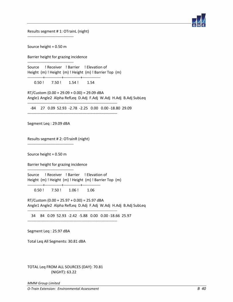
MMM Group Limited
O-Train Extension: Environmental Assessment B 40
Results segment # 1: OTrainL (night) ------------------------------------ Source height = 0.50 m Barrier height for grazing incidence ------------------------------------ Source ! Receiver ! Barrier ! Elevation of Height (m) ! Height (m) ! Height (m) ! Barrier Top (m) ------------+-------------+-------------+-------------- 0.50 ! 7.50 ! 1.54 ! 1.54 RT/Custom (0.00 + 29.09 + 0.00) = 29.09 dBA Angle1 Angle2 Alpha RefLeq D.Adj F.Adj W.Adj H.Adj B.Adj SubLeq ---------------------------------------------------------------------- -84 27 0.09 52.93 -2.78 -2.25 0.00 0.00 -18.80 29.09 ---------------------------------------------------------------------- Segment Leq : 29.09 dBA Results segment # 2: OTrainR (night) ------------------------------------ Source height = 0.50 m Barrier height for grazing incidence ------------------------------------ Source ! Receiver ! Barrier ! Elevation of Height (m) ! Height (m) ! Height (m) ! Barrier Top (m) ------------+-------------+-------------+-------------- 0.50 ! 7.50 ! 1.06 ! 1.06 RT/Custom (0.00 + 25.97 + 0.00) = 25.97 dBA Angle1 Angle2 Alpha RefLeq D.Adj F.Adj W.Adj H.Adj B.Adj SubLeq ---------------------------------------------------------------------- 34 84 0.09 52.93 -2.42 -5.88 0.00 0.00 -18.66 25.97 ---------------------------------------------------------------------- Segment Leq : 25.97 dBA Total Leq All Segments: 30.81 dBA TOTAL Leq FROM ALL SOURCES (DAY): 70.81 (NIGHT): 63.22

MMM Group Limited
O-Train Extension: Environmental Assessment B 41
STAMSON 5.0 NORMAL REPORT Date: 17-04-2015 15:39:07 MINISTRY OF ENVIRONMENT AND ENERGY / NOISE ASSESSMENT Filename: r4.te Time Period: Day/Night 16/8 hours Description: Road data, segment # 1: 417WBL (day/night) ------------------------------------------ Car traffic volume : 91849/7987 veh/TimePeriod * Medium truck volume : 7306/635 veh/TimePeriod * Heavy truck volume : 5219/454 veh/TimePeriod * Posted speed limit : 100 km/h Road gradient : 0 % Road pavement : 1 (Typical asphalt or concrete) * Refers to calculated road volumes based on the following input: 24 hr Traffic Volume (AADT or SADT): 113450 Percentage of Annual Growth : 0.00 Number of Years of Growth : 0.00 Medium Truck % of Total Volume : 7.00 Heavy Truck % of Total Volume : 5.00 Day (16 hrs) % of Total Volume : 92.00 Data for Segment # 1: 417WBL (day/night) ---------------------------------------- Angle1 Angle2 : -53.00 deg 18.00 deg Wood depth : 0 (No woods.) No of house rows : 0 / 0 Surface : 2 (Reflective ground surface) Receiver source distance : 303.00 / 303.00 m Receiver height : 1.50 / 1.50 m Topography : 2 (Flat/gentle slope; with barrier) Barrier angle1 : -53.00 deg Angle2 : 18.00 deg Barrier height : 7.00 m Barrier receiver distance : 24.00 / 24.00 m Source elevation : 8.00 m Receiver elevation : 0.00 m Barrier elevation : 0.00 m Reference angle : 0.00
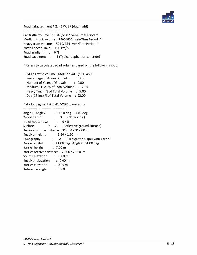
MMM Group Limited
O-Train Extension: Environmental Assessment B 42
Road data, segment # 2: 417WBR (day/night) ------------------------------------------ Car traffic volume : 91849/7987 veh/TimePeriod * Medium truck volume : 7306/635 veh/TimePeriod * Heavy truck volume : 5219/454 veh/TimePeriod * Posted speed limit : 100 km/h Road gradient : 0 % Road pavement : 1 (Typical asphalt or concrete) * Refers to calculated road volumes based on the following input: 24 hr Traffic Volume (AADT or SADT): 113450 Percentage of Annual Growth : 0.00 Number of Years of Growth : 0.00 Medium Truck % of Total Volume : 7.00 Heavy Truck % of Total Volume : 5.00 Day (16 hrs) % of Total Volume : 92.00 Data for Segment # 2: 417WBR (day/night) ---------------------------------------- Angle1 Angle2 : 11.00 deg 51.00 deg Wood depth : 0 (No woods.) No of house rows : 0 / 0 Surface : 2 (Reflective ground surface) Receiver source distance : 312.00 / 312.00 m Receiver height : 1.50 / 1.50 m Topography : 2 (Flat/gentle slope; with barrier) Barrier angle1 : 11.00 deg Angle2 : 51.00 deg Barrier height : 7.00 m Barrier receiver distance : 25.00 / 25.00 m Source elevation : 8.00 m Receiver elevation : 0.00 m Barrier elevation : 0.00 m Reference angle : 0.00
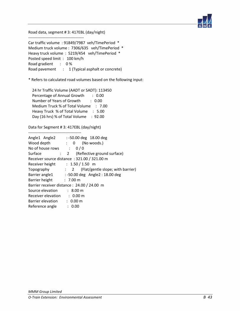
MMM Group Limited
O-Train Extension: Environmental Assessment B 43
Road data, segment # 3: 417EBL (day/night) ------------------------------------------ Car traffic volume : 91849/7987 veh/TimePeriod * Medium truck volume : 7306/635 veh/TimePeriod * Heavy truck volume : 5219/454 veh/TimePeriod * Posted speed limit : 100 km/h Road gradient : 0 % Road pavement : 1 (Typical asphalt or concrete) * Refers to calculated road volumes based on the following input: 24 hr Traffic Volume (AADT or SADT): 113450 Percentage of Annual Growth : 0.00 Number of Years of Growth : 0.00 Medium Truck % of Total Volume : 7.00 Heavy Truck % of Total Volume : 5.00 Day (16 hrs) % of Total Volume : 92.00 Data for Segment # 3: 417EBL (day/night) ---------------------------------------- Angle1 Angle2 : -50.00 deg 18.00 deg Wood depth : 0 (No woods.) No of house rows : 0 / 0 Surface : 2 (Reflective ground surface) Receiver source distance : 321.00 / 321.00 m Receiver height : 1.50 / 1.50 m Topography : 2 (Flat/gentle slope; with barrier) Barrier angle1 : -50.00 deg Angle2 : 18.00 deg Barrier height : 7.00 m Barrier receiver distance : 24.00 / 24.00 m Source elevation : 8.00 m Receiver elevation : 0.00 m Barrier elevation : 0.00 m Reference angle : 0.00

MMM Group Limited
O-Train Extension: Environmental Assessment B 44
Road data, segment # 4: 417EBR (day/night) ------------------------------------------ Car traffic volume : 91849/7987 veh/TimePeriod * Medium truck volume : 7306/635 veh/TimePeriod * Heavy truck volume : 5219/454 veh/TimePeriod * Posted speed limit : 100 km/h Road gradient : 0 % Road pavement : 1 (Typical asphalt or concrete) * Refers to calculated road volumes based on the following input: 24 hr Traffic Volume (AADT or SADT): 113450 Percentage of Annual Growth : 0.00 Number of Years of Growth : 0.00 Medium Truck % of Total Volume : 7.00 Heavy Truck % of Total Volume : 5.00 Day (16 hrs) % of Total Volume : 92.00 Data for Segment # 4: 417EBR (day/night) ---------------------------------------- Angle1 Angle2 : 12.00 deg 49.00 deg Wood depth : 0 (No woods.) No of house rows : 0 / 0 Surface : 2 (Reflective ground surface) Receiver source distance : 331.00 / 331.00 m Receiver height : 1.50 / 1.50 m Topography : 2 (Flat/gentle slope; with barrier) Barrier angle1 : 12.00 deg Angle2 : 49.00 deg Barrier height : 7.00 m Barrier receiver distance : 25.00 / 25.00 m Source elevation : 8.00 m Receiver elevation : 0.00 m Barrier elevation : 0.00 m Reference angle : 0.00

MMM Group Limited
O-Train Extension: Environmental Assessment B 45
Results segment # 1: 417WBL (day) --------------------------------- Source height = 1.50 m Barrier height for grazing incidence ------------------------------------ Source ! Receiver ! Barrier ! Elevation of Height (m) ! Height (m) ! Height (m) ! Barrier Top (m) ------------+-------------+-------------+-------------- 1.50 ! 1.50 ! 2.13 ! 2.13 ROAD (0.00 + 51.86 + 0.00) = 51.86 dBA Angle1 Angle2 Alpha RefLeq P.Adj D.Adj F.Adj W.Adj H.Adj B.Adj SubLeq ---------------------------------------------------------------------------- -53 18 0.00 83.29 0.00 -13.05 -4.04 0.00 0.00 -14.34 51.86 ---------------------------------------------------------------------------- Segment Leq : 51.86 dBA Results segment # 2: 417WBR (day) --------------------------------- Source height = 1.50 m Barrier height for grazing incidence ------------------------------------ Source ! Receiver ! Barrier ! Elevation of Height (m) ! Height (m) ! Height (m) ! Barrier Top (m) ------------+-------------+-------------+-------------- 1.50 ! 1.50 ! 2.14 ! 2.14 ROAD (0.00 + 49.66 + 0.00) = 49.66 dBA Angle1 Angle2 Alpha RefLeq P.Adj D.Adj F.Adj W.Adj H.Adj B.Adj SubLeq ---------------------------------------------------------------------------- 11 51 0.00 83.29 0.00 -13.18 -6.53 0.00 0.00 -13.92 49.66 ---------------------------------------------------------------------------- Segment Leq : 49.66 dBA

MMM Group Limited
O-Train Extension: Environmental Assessment B 46
Results segment # 3: 417EBL (day) --------------------------------- Source height = 1.50 m Barrier height for grazing incidence ------------------------------------ Source ! Receiver ! Barrier ! Elevation of Height (m) ! Height (m) ! Height (m) ! Barrier Top (m) ------------+-------------+-------------+-------------- 1.50 ! 1.50 ! 2.10 ! 2.10 ROAD (0.00 + 51.31 + 0.00) = 51.31 dBA Angle1 Angle2 Alpha RefLeq P.Adj D.Adj F.Adj W.Adj H.Adj B.Adj SubLeq ---------------------------------------------------------------------------- -50 18 0.00 83.29 0.00 -13.30 -4.23 0.00 0.00 -14.45 51.31 ---------------------------------------------------------------------------- Segment Leq : 51.31 dBA Results segment # 4: 417EBR (day) --------------------------------- Source height = 1.50 m Barrier height for grazing incidence ------------------------------------ Source ! Receiver ! Barrier ! Elevation of Height (m) ! Height (m) ! Height (m) ! Barrier Top (m) ------------+-------------+-------------+-------------- 1.50 ! 1.50 ! 2.10 ! 2.10 ROAD (0.00 + 48.98 + 0.00) = 48.98 dBA Angle1 Angle2 Alpha RefLeq P.Adj D.Adj F.Adj W.Adj H.Adj B.Adj SubLeq ---------------------------------------------------------------------------- 12 49 0.00 83.29 0.00 -13.44 -6.87 0.00 0.00 -14.00 48.98 ---------------------------------------------------------------------------- Segment Leq : 48.98 dBA Total Leq All Segments: 56.63 dBA

MMM Group Limited
O-Train Extension: Environmental Assessment B 47
Results segment # 1: 417WBL (night) ----------------------------------- Source height = 1.50 m Barrier height for grazing incidence ------------------------------------ Source ! Receiver ! Barrier ! Elevation of Height (m) ! Height (m) ! Height (m) ! Barrier Top (m) ------------+-------------+-------------+-------------- 1.50 ! 1.50 ! 2.13 ! 2.13 ROAD (0.00 + 44.26 + 0.00) = 44.26 dBA Angle1 Angle2 Alpha RefLeq P.Adj D.Adj F.Adj W.Adj H.Adj B.Adj SubLeq ---------------------------------------------------------------------------- -53 18 0.00 75.70 0.00 -13.05 -4.04 0.00 0.00 -14.34 44.26 ---------------------------------------------------------------------------- Segment Leq : 44.26 dBA Results segment # 2: 417WBR (night) ----------------------------------- Source height = 1.50 m Barrier height for grazing incidence ------------------------------------ Source ! Receiver ! Barrier ! Elevation of Height (m) ! Height (m) ! Height (m) ! Barrier Top (m) ------------+-------------+-------------+-------------- 1.50 ! 1.50 ! 2.14 ! 2.14 ROAD (0.00 + 42.07 + 0.00) = 42.07 dBA Angle1 Angle2 Alpha RefLeq P.Adj D.Adj F.Adj W.Adj H.Adj B.Adj SubLeq ---------------------------------------------------------------------------- 11 51 0.00 75.70 0.00 -13.18 -6.53 0.00 0.00 -13.92 42.07 ---------------------------------------------------------------------------- Segment Leq : 42.07 dBA

MMM Group Limited
O-Train Extension: Environmental Assessment B 48
Results segment # 3: 417EBL (night) ----------------------------------- Source height = 1.50 m Barrier height for grazing incidence ------------------------------------ Source ! Receiver ! Barrier ! Elevation of Height (m) ! Height (m) ! Height (m) ! Barrier Top (m) ------------+-------------+-------------+-------------- 1.50 ! 1.50 ! 2.10 ! 2.10 ROAD (0.00 + 43.71 + 0.00) = 43.71 dBA Angle1 Angle2 Alpha RefLeq P.Adj D.Adj F.Adj W.Adj H.Adj B.Adj SubLeq ---------------------------------------------------------------------------- -50 18 0.00 75.70 0.00 -13.30 -4.23 0.00 0.00 -14.45 43.71 ---------------------------------------------------------------------------- Segment Leq : 43.71 dBA Results segment # 4: 417EBR (night) ----------------------------------- Source height = 1.50 m Barrier height for grazing incidence ------------------------------------ Source ! Receiver ! Barrier ! Elevation of Height (m) ! Height (m) ! Height (m) ! Barrier Top (m) ------------+-------------+-------------+-------------- 1.50 ! 1.50 ! 2.10 ! 2.10 ROAD (0.00 + 41.38 + 0.00) = 41.38 dBA Angle1 Angle2 Alpha RefLeq P.Adj D.Adj F.Adj W.Adj H.Adj B.Adj SubLeq ---------------------------------------------------------------------------- 12 49 0.00 75.70 0.00 -13.44 -6.87 0.00 0.00 -14.00 41.38 ---------------------------------------------------------------------------- Segment Leq : 41.38 dBA Total Leq All Segments: 49.03 dBA

MMM Group Limited
O-Train Extension: Environmental Assessment B 49
RT/Custom data, segment # 1: OTrain (day/night) ----------------------------------------------- 1 - 4-car SRT: Traffic volume : 192/24 veh/TimePeriod Speed : 70 km/h Data for Segment # 1: OTrain (day/night) ---------------------------------------- Angle1 Angle2 : -58.00 deg 58.00 deg Wood depth : 0 (No woods.) No of house rows : 0 / 0 Surface : 2 (Reflective ground surface) Receiver source distance : 132.00 / 132.00 m Receiver height : 10.50 / 10.50 m Topography : 2 (Flat/gentle slope; with barrier) Barrier angle1 : -58.00 deg Angle2 : 58.00 deg Barrier height : 8.00 m Barrier receiver distance : 122.00 / 122.00 m Source elevation : 0.00 m Receiver elevation : 0.00 m Barrier elevation : 0.00 m Reference angle : 0.00
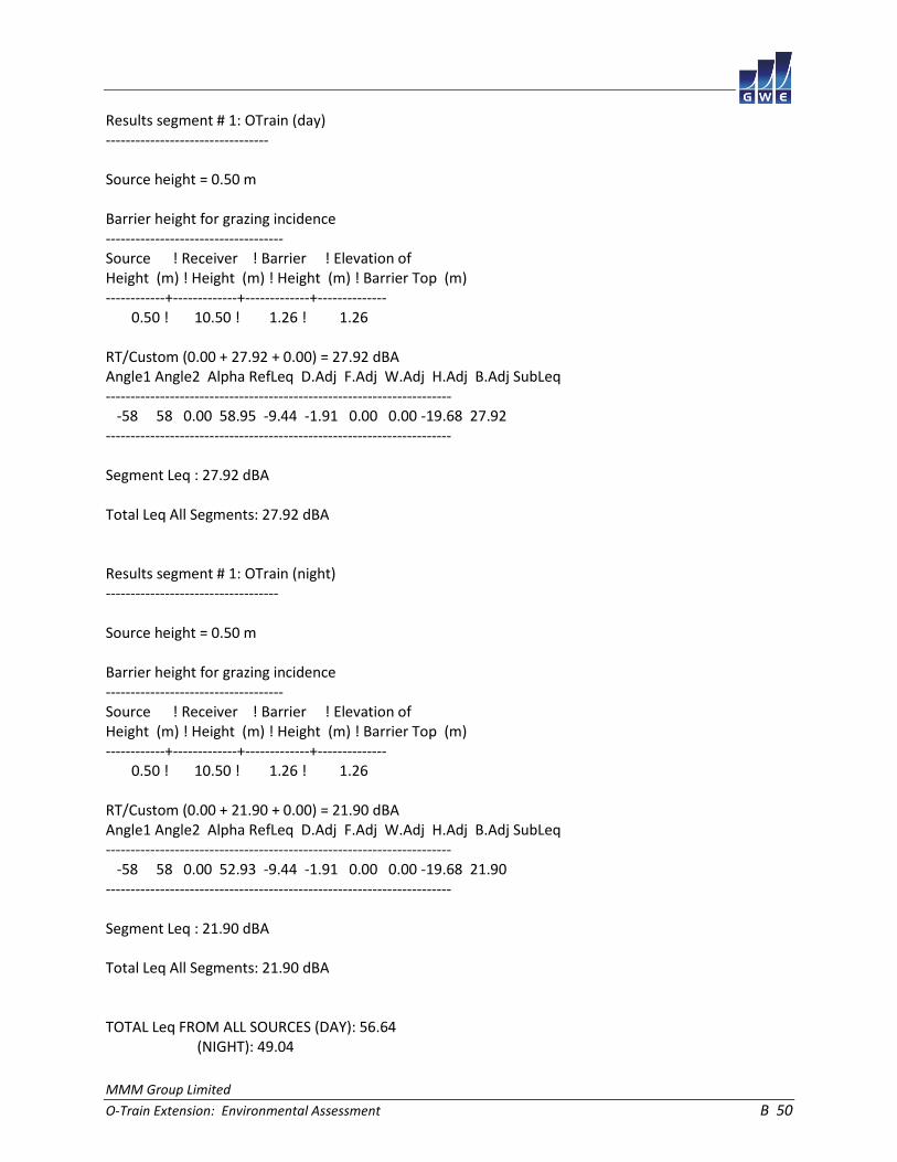
MMM Group Limited
O-Train Extension: Environmental Assessment B 50
Results segment # 1: OTrain (day) --------------------------------- Source height = 0.50 m Barrier height for grazing incidence ------------------------------------ Source ! Receiver ! Barrier ! Elevation of Height (m) ! Height (m) ! Height (m) ! Barrier Top (m) ------------+-------------+-------------+-------------- 0.50 ! 10.50 ! 1.26 ! 1.26 RT/Custom (0.00 + 27.92 + 0.00) = 27.92 dBA Angle1 Angle2 Alpha RefLeq D.Adj F.Adj W.Adj H.Adj B.Adj SubLeq ---------------------------------------------------------------------- -58 58 0.00 58.95 -9.44 -1.91 0.00 0.00 -19.68 27.92 ---------------------------------------------------------------------- Segment Leq : 27.92 dBA Total Leq All Segments: 27.92 dBA Results segment # 1: OTrain (night) ----------------------------------- Source height = 0.50 m Barrier height for grazing incidence ------------------------------------ Source ! Receiver ! Barrier ! Elevation of Height (m) ! Height (m) ! Height (m) ! Barrier Top (m) ------------+-------------+-------------+-------------- 0.50 ! 10.50 ! 1.26 ! 1.26 RT/Custom (0.00 + 21.90 + 0.00) = 21.90 dBA Angle1 Angle2 Alpha RefLeq D.Adj F.Adj W.Adj H.Adj B.Adj SubLeq ---------------------------------------------------------------------- -58 58 0.00 52.93 -9.44 -1.91 0.00 0.00 -19.68 21.90 ---------------------------------------------------------------------- Segment Leq : 21.90 dBA Total Leq All Segments: 21.90 dBA TOTAL Leq FROM ALL SOURCES (DAY): 56.64 (NIGHT): 49.04

MMM Group Limited
O-Train Extension: Environmental Assessment B 51
STAMSON 5.0 NORMAL REPORT Date: 17-04-2015 15:40:05 MINISTRY OF ENVIRONMENT AND ENERGY / NOISE ASSESSMENT Filename: r5.te Time Period: Day/Night 16/8 hours Description: Road data, segment # 1: Preston (day/night) ------------------------------------------- Car traffic volume : 19729/1716 veh/TimePeriod * Medium truck volume : 1569/136 veh/TimePeriod * Heavy truck volume : 1121/97 veh/TimePeriod * Posted speed limit : 50 km/h Road gradient : 0 % Road pavement : 1 (Typical asphalt or concrete) * Refers to calculated road volumes based on the following input: 24 hr Traffic Volume (AADT or SADT): 24369 Percentage of Annual Growth : 0.00 Number of Years of Growth : 0.00 Medium Truck % of Total Volume : 7.00 Heavy Truck % of Total Volume : 5.00 Day (16 hrs) % of Total Volume : 92.00 Data for Segment # 1: Preston (day/night) ----------------------------------------- Angle1 Angle2 : -14.00 deg 14.00 deg Wood depth : 0 (No woods.) No of house rows : 0 / 0 Surface : 2 (Reflective ground surface) Receiver source distance : 97.00 / 97.00 m Receiver height : 1.50 / 1.50 m Topography : 2 (Flat/gentle slope; with barrier) Barrier angle1 : -14.00 deg Angle2 : 14.00 deg Barrier height : 7.00 m Barrier receiver distance : 23.00 / 23.00 m Source elevation : 0.00 m Receiver elevation : 0.00 m Barrier elevation : 0.00 m Reference angle : 0.00

MMM Group Limited
O-Train Extension: Environmental Assessment B 52
Road data, segment # 2: 417EB (day/night) ----------------------------------------- Car traffic volume : 91849/7987 veh/TimePeriod * Medium truck volume : 7306/635 veh/TimePeriod * Heavy truck volume : 5219/454 veh/TimePeriod * Posted speed limit : 100 km/h Road gradient : 0 % Road pavement : 1 (Typical asphalt or concrete) * Refers to calculated road volumes based on the following input: 24 hr Traffic Volume (AADT or SADT): 113450 Percentage of Annual Growth : 0.00 Number of Years of Growth : 0.00 Medium Truck % of Total Volume : 7.00 Heavy Truck % of Total Volume : 5.00 Day (16 hrs) % of Total Volume : 92.00 Data for Segment # 2: 417EB (day/night) --------------------------------------- Angle1 Angle2 : -15.00 deg 15.00 deg Wood depth : 0 (No woods.) No of house rows : 0 / 0 Surface : 2 (Reflective ground surface) Receiver source distance : 483.00 / 483.00 m Receiver height : 1.50 / 1.50 m Topography : 2 (Flat/gentle slope; with barrier) Barrier angle1 : -15.00 deg Angle2 : 15.00 deg Barrier height : 7.00 m Barrier receiver distance : 17.00 / 17.00 m Source elevation : 6.00 m Receiver elevation : 0.00 m Barrier elevation : 0.00 m Reference angle : 0.00

MMM Group Limited
O-Train Extension: Environmental Assessment B 53
Results segment # 1: Preston (day) ---------------------------------- Source height = 1.50 m Barrier height for grazing incidence ------------------------------------ Source ! Receiver ! Barrier ! Elevation of Height (m) ! Height (m) ! Height (m) ! Barrier Top (m) ------------+-------------+-------------+-------------- 1.50 ! 1.50 ! 1.50 ! 1.50 ROAD (0.00 + 37.50 + 0.00) = 37.50 dBA Angle1 Angle2 Alpha RefLeq P.Adj D.Adj F.Adj W.Adj H.Adj B.Adj SubLeq ---------------------------------------------------------------------------- -14 14 0.00 70.59 0.00 -8.11 -8.08 0.00 0.00 -16.90 37.50 ---------------------------------------------------------------------------- Segment Leq : 37.50 dBA Results segment # 2: 417EB (day) -------------------------------- Source height = 1.50 m Barrier height for grazing incidence ------------------------------------ Source ! Receiver ! Barrier ! Elevation of Height (m) ! Height (m) ! Height (m) ! Barrier Top (m) ------------+-------------+-------------+-------------- 1.50 ! 1.50 ! 1.71 ! 1.71 ROAD (0.00 + 43.65 + 0.00) = 43.65 dBA Angle1 Angle2 Alpha RefLeq P.Adj D.Adj F.Adj W.Adj H.Adj B.Adj SubLeq ---------------------------------------------------------------------------- -15 15 0.00 83.29 0.00 -15.08 -7.78 0.00 0.00 -16.78 43.65 ---------------------------------------------------------------------------- Segment Leq : 43.65 dBA Total Leq All Segments: 44.59 dBA

MMM Group Limited
O-Train Extension: Environmental Assessment B 54
Results segment # 1: Preston (night) ------------------------------------ Source height = 1.49 m Barrier height for grazing incidence ------------------------------------ Source ! Receiver ! Barrier ! Elevation of Height (m) ! Height (m) ! Height (m) ! Barrier Top (m) ------------+-------------+-------------+-------------- 1.49 ! 1.50 ! 1.50 ! 1.50 ROAD (0.00 + 29.89 + 0.00) = 29.89 dBA Angle1 Angle2 Alpha RefLeq P.Adj D.Adj F.Adj W.Adj H.Adj B.Adj SubLeq ---------------------------------------------------------------------------- -14 14 0.00 62.97 0.00 -8.11 -8.08 0.00 0.00 -16.90 29.89 ---------------------------------------------------------------------------- Segment Leq : 29.89 dBA Results segment # 2: 417EB (night) ---------------------------------- Source height = 1.50 m Barrier height for grazing incidence ------------------------------------ Source ! Receiver ! Barrier ! Elevation of Height (m) ! Height (m) ! Height (m) ! Barrier Top (m) ------------+-------------+-------------+-------------- 1.50 ! 1.50 ! 1.71 ! 1.71 ROAD (0.00 + 36.06 + 0.00) = 36.06 dBA Angle1 Angle2 Alpha RefLeq P.Adj D.Adj F.Adj W.Adj H.Adj B.Adj SubLeq ---------------------------------------------------------------------------- -15 15 0.00 75.70 0.00 -15.08 -7.78 0.00 0.00 -16.78 36.06 ---------------------------------------------------------------------------- Segment Leq : 36.06 dBA Total Leq All Segments: 37.00 dBA

MMM Group Limited
O-Train Extension: Environmental Assessment B 55
RT/Custom data, segment # 1: OTrain (day/night) ----------------------------------------------- 1 - 4-car SRT: Traffic volume : 192/24 veh/TimePeriod Speed : 70 km/h Data for Segment # 1: OTrain (day/night) ---------------------------------------- Angle1 Angle2 : -81.00 deg 81.00 deg Wood depth : 0 (No woods.) No of house rows : 0 / 0 Surface : 1 (Absorptive ground surface) Receiver source distance : 41.00 / 41.00 m Receiver height : 7.50 / 7.50 m Topography : 2 (Flat/gentle slope; with barrier) Barrier angle1 : -81.00 deg Angle2 : 81.00 deg Barrier height : 6.00 m Barrier receiver distance : 32.00 / 32.00 m Source elevation : 0.00 m Receiver elevation : 0.00 m Barrier elevation : 0.00 m Reference angle : 0.00

MMM Group Limited
O-Train Extension: Environmental Assessment B 56
Results segment # 1: OTrain (day) --------------------------------- Source height = 0.50 m Barrier height for grazing incidence ------------------------------------ Source ! Receiver ! Barrier ! Elevation of Height (m) ! Height (m) ! Height (m) ! Barrier Top (m) ------------+-------------+-------------+-------------- 0.50 ! 7.50 ! 2.04 ! 2.04 RT/Custom (0.00 + 38.03 + 0.00) = 38.03 dBA Angle1 Angle2 Alpha RefLeq D.Adj F.Adj W.Adj H.Adj B.Adj SubLeq ---------------------------------------------------------------------- -81 81 0.15 58.95 -5.02 -0.74 0.00 0.00 -15.15 38.03 ---------------------------------------------------------------------- Segment Leq : 38.03 dBA Total Leq All Segments: 38.03 dBA Results segment # 1: OTrain (night) ----------------------------------- Source height = 0.50 m Barrier height for grazing incidence ------------------------------------ Source ! Receiver ! Barrier ! Elevation of Height (m) ! Height (m) ! Height (m) ! Barrier Top (m) ------------+-------------+-------------+-------------- 0.50 ! 7.50 ! 2.04 ! 2.04 RT/Custom (0.00 + 32.01 + 0.00) = 32.01 dBA Angle1 Angle2 Alpha RefLeq D.Adj F.Adj W.Adj H.Adj B.Adj SubLeq ---------------------------------------------------------------------- -81 81 0.15 52.93 -5.02 -0.74 0.00 0.00 -15.15 32.01 ---------------------------------------------------------------------- Segment Leq : 32.01 dBA Total Leq All Segments: 32.01 dBA TOTAL Leq FROM ALL SOURCES (DAY): 45.46 (NIGHT): 38.20

MMM Group Limited
O-Train Extension: Environmental Assessment B 57
STAMSON 5.0 NORMAL REPORT Date: 17-04-2015 15:53:55 MINISTRY OF ENVIRONMENT AND ENERGY / NOISE ASSESSMENT Filename: r6.te Time Period: Day/Night 16/8 hours Description: Rail data, segment # 1: Via (day/night) --------------------------------------- Train ! Trains ! Speed !# loc !# Cars! Eng !Cont Type ! !(km/h) !/Train!/Train! type !weld -----------------+-------------+-------+------+------+------+---- 1. ! 17.0/3.0 ! 150.0 ! 1.0 ! 4.0 !Diesel! No Data for Segment # 1: Via (day/night) ------------------------------------- Angle1 Angle2 : -54.00 deg 54.00 deg Wood depth : 1 (Wood depth 30 to less than 60 metres) No of house rows : 0 / 0 Surface : 1 (Absorptive ground surface) Receiver source distance : 146.00 / 146.00 m Receiver height : 1.50 / 1.50 m Topography : 2 (Flat/gentle slope; with barrier) No Whistle Barrier angle1 : 40.00 deg Angle2 : 54.00 deg Barrier height : 7.00 m Barrier receiver distance : 120.00 / 120.00 m Source elevation : 0.00 m Receiver elevation : 0.00 m Barrier elevation : 0.00 m Reference angle : 0.00
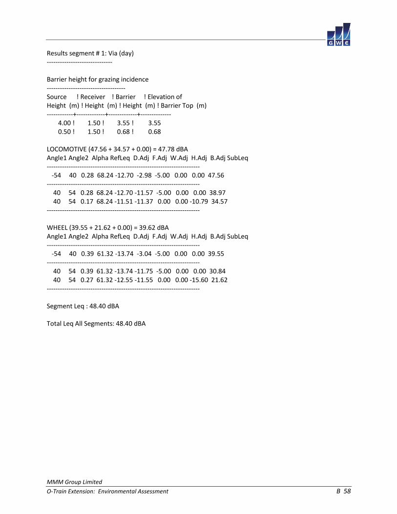
MMM Group Limited
O-Train Extension: Environmental Assessment B 58
Results segment # 1: Via (day) ------------------------------ Barrier height for grazing incidence ------------------------------------ Source ! Receiver ! Barrier ! Elevation of Height (m) ! Height (m) ! Height (m) ! Barrier Top (m) ------------+-------------+-------------+-------------- 4.00 ! 1.50 ! 3.55 ! 3.55 0.50 ! 1.50 ! 0.68 ! 0.68 LOCOMOTIVE (47.56 + 34.57 + 0.00) = 47.78 dBA Angle1 Angle2 Alpha RefLeq D.Adj F.Adj W.Adj H.Adj B.Adj SubLeq ---------------------------------------------------------------------- -54 40 0.28 68.24 -12.70 -2.98 -5.00 0.00 0.00 47.56 ---------------------------------------------------------------------- 40 54 0.28 68.24 -12.70 -11.57 -5.00 0.00 0.00 38.97 40 54 0.17 68.24 -11.51 -11.37 0.00 0.00 -10.79 34.57 ---------------------------------------------------------------------- WHEEL (39.55 + 21.62 + 0.00) = 39.62 dBA Angle1 Angle2 Alpha RefLeq D.Adj F.Adj W.Adj H.Adj B.Adj SubLeq ---------------------------------------------------------------------- -54 40 0.39 61.32 -13.74 -3.04 -5.00 0.00 0.00 39.55 ---------------------------------------------------------------------- 40 54 0.39 61.32 -13.74 -11.75 -5.00 0.00 0.00 30.84 40 54 0.27 61.32 -12.55 -11.55 0.00 0.00 -15.60 21.62 ---------------------------------------------------------------------- Segment Leq : 48.40 dBA Total Leq All Segments: 48.40 dBA

MMM Group Limited
O-Train Extension: Environmental Assessment B 59
Results segment # 1: Via (night) -------------------------------- Barrier height for grazing incidence ------------------------------------ Source ! Receiver ! Barrier ! Elevation of Height (m) ! Height (m) ! Height (m) ! Barrier Top (m) ------------+-------------+-------------+-------------- 4.00 ! 1.50 ! 3.55 ! 3.55 0.50 ! 1.50 ! 0.68 ! 0.68 LOCOMOTIVE (43.04 + 30.05 + 0.00) = 43.25 dBA Angle1 Angle2 Alpha RefLeq D.Adj F.Adj W.Adj H.Adj B.Adj SubLeq ---------------------------------------------------------------------- -54 40 0.28 63.72 -12.70 -2.98 -5.00 0.00 0.00 43.04 ---------------------------------------------------------------------- 40 54 0.28 63.72 -12.70 -11.57 -5.00 0.00 0.00 34.45 40 54 0.17 63.72 -11.51 -11.37 0.00 0.00 -10.79 30.05 ---------------------------------------------------------------------- WHEEL (35.02 + 17.10 + 0.00) = 35.09 dBA Angle1 Angle2 Alpha RefLeq D.Adj F.Adj W.Adj H.Adj B.Adj SubLeq ---------------------------------------------------------------------- -54 40 0.39 56.80 -13.74 -3.04 -5.00 0.00 0.00 35.02 ---------------------------------------------------------------------- 40 54 0.39 56.80 -13.74 -11.75 -5.00 0.00 0.00 26.31 40 54 0.27 56.80 -12.55 -11.55 0.00 0.00 -15.60 17.10 ---------------------------------------------------------------------- Segment Leq : 43.87 dBA Total Leq All Segments: 43.87 dBA

MMM Group Limited
O-Train Extension: Environmental Assessment B 60
Road data, segment # 1: Flannery (day/night) -------------------------------------------- Car traffic volume : 9528/829 veh/TimePeriod * Medium truck volume : 758/66 veh/TimePeriod * Heavy truck volume : 541/47 veh/TimePeriod * Posted speed limit : 40 km/h Road gradient : 0 % Road pavement : 1 (Typical asphalt or concrete) * Refers to calculated road volumes based on the following input: 24 hr Traffic Volume (AADT or SADT): 11769 Percentage of Annual Growth : 0.00 Number of Years of Growth : 0.00 Medium Truck % of Total Volume : 7.00 Heavy Truck % of Total Volume : 5.00 Day (16 hrs) % of Total Volume : 92.00 Data for Segment # 1: Flannery (day/night) ------------------------------------------ Angle1 Angle2 : -61.00 deg 61.00 deg Wood depth : 0 (No woods.) No of house rows : 0 / 0 Surface : 2 (Reflective ground surface) Receiver source distance : 48.00 / 48.00 m Receiver height : 1.50 / 1.50 m Topography : 2 (Flat/gentle slope; with barrier) Barrier angle1 : -61.00 deg Angle2 : 61.00 deg Barrier height : 10.00 m Barrier receiver distance : 3.00 / 3.00 m Source elevation : 0.00 m Receiver elevation : 0.00 m Barrier elevation : 0.00 m Reference angle : 0.00

MMM Group Limited
O-Train Extension: Environmental Assessment B 61
Road data, segment # 2: AirportSB (day/night) --------------------------------------------- Car traffic volume : 13503/1174 veh/TimePeriod * Medium truck volume : 1074/93 veh/TimePeriod * Heavy truck volume : 767/67 veh/TimePeriod * Posted speed limit : 80 km/h Road gradient : 0 % Road pavement : 1 (Typical asphalt or concrete) * Refers to calculated road volumes based on the following input: 24 hr Traffic Volume (AADT or SADT): 16679 Percentage of Annual Growth : 0.00 Number of Years of Growth : 0.00 Medium Truck % of Total Volume : 7.00 Heavy Truck % of Total Volume : 5.00 Day (16 hrs) % of Total Volume : 92.00 Data for Segment # 2: AirportSB (day/night) ------------------------------------------- Angle1 Angle2 : -51.00 deg 51.00 deg Wood depth : 1 (Wood depth 30 to less than 60 metres) No of house rows : 0 / 0 Surface : 1 (Absorptive ground surface) Receiver source distance : 63.00 / 63.00 m Receiver height : 4.50 / 4.50 m Topography : 1 (Flat/gentle slope; no barrier) Reference angle : 0.00
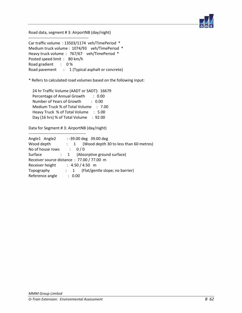
MMM Group Limited
O-Train Extension: Environmental Assessment B 62
Road data, segment # 3: AirportNB (day/night) --------------------------------------------- Car traffic volume : 13503/1174 veh/TimePeriod * Medium truck volume : 1074/93 veh/TimePeriod * Heavy truck volume : 767/67 veh/TimePeriod * Posted speed limit : 80 km/h Road gradient : 0 % Road pavement : 1 (Typical asphalt or concrete) * Refers to calculated road volumes based on the following input: 24 hr Traffic Volume (AADT or SADT): 16679 Percentage of Annual Growth : 0.00 Number of Years of Growth : 0.00 Medium Truck % of Total Volume : 7.00 Heavy Truck % of Total Volume : 5.00 Day (16 hrs) % of Total Volume : 92.00 Data for Segment # 3: AirportNB (day/night) ------------------------------------------- Angle1 Angle2 : -39.00 deg 39.00 deg Wood depth : 1 (Wood depth 30 to less than 60 metres) No of house rows : 0 / 0 Surface : 1 (Absorptive ground surface) Receiver source distance : 77.00 / 77.00 m Receiver height : 4.50 / 4.50 m Topography : 1 (Flat/gentle slope; no barrier) Reference angle : 0.00

MMM Group Limited
O-Train Extension: Environmental Assessment B 63
Results segment # 1: Flannery (day) ----------------------------------- Source height = 1.50 m Barrier height for grazing incidence ------------------------------------ Source ! Receiver ! Barrier ! Elevation of Height (m) ! Height (m) ! Height (m) ! Barrier Top (m) ------------+-------------+-------------+-------------- 1.50 ! 1.50 ! 1.50 ! 1.50 ROAD (0.00 + 38.89 + 0.00) = 38.89 dBA Angle1 Angle2 Alpha RefLeq P.Adj D.Adj F.Adj W.Adj H.Adj B.Adj SubLeq ---------------------------------------------------------------------------- -61 61 0.00 65.63 0.00 -5.05 -1.69 0.00 0.00 -20.00 38.89 ---------------------------------------------------------------------------- Segment Leq : 38.89 dBA Results segment # 2: AirportSB (day) ------------------------------------ Source height = 1.50 m ROAD (0.00 + 57.40 + 0.00) = 57.40 dBA Angle1 Angle2 Alpha RefLeq P.Adj D.Adj F.Adj W.Adj H.Adj B.Adj SubLeq ---------------------------------------------------------------------------- -51 51 0.27 72.95 0.00 -7.92 -2.63 -5.00 0.00 0.00 57.40 ---------------------------------------------------------------------------- Segment Leq : 57.40 dBA

MMM Group Limited
O-Train Extension: Environmental Assessment B 64
Results segment # 3: AirportNB (day) ------------------------------------ Source height = 1.50 m ROAD (0.00 + 55.20 + 0.00) = 55.20 dBA Angle1 Angle2 Alpha RefLeq P.Adj D.Adj F.Adj W.Adj H.Adj B.Adj SubLeq ---------------------------------------------------------------------------- -39 39 0.27 72.95 0.00 -9.02 -3.73 -5.00 0.00 0.00 55.20 ---------------------------------------------------------------------------- Segment Leq : 55.20 dBA Total Leq All Segments: 59.49 dBA Results segment # 1: Flannery (night) ------------------------------------- Source height = 1.49 m Barrier height for grazing incidence ------------------------------------ Source ! Receiver ! Barrier ! Elevation of Height (m) ! Height (m) ! Height (m) ! Barrier Top (m) ------------+-------------+-------------+-------------- 1.49 ! 1.50 ! 1.50 ! 1.50 ROAD (0.00 + 31.29 + 0.00) = 31.29 dBA Angle1 Angle2 Alpha RefLeq P.Adj D.Adj F.Adj W.Adj H.Adj B.Adj SubLeq ---------------------------------------------------------------------------- -61 61 0.00 58.03 0.00 -5.05 -1.69 0.00 0.00 -20.00 31.29 ---------------------------------------------------------------------------- Segment Leq : 31.29 dBA
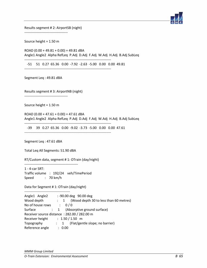
MMM Group Limited
O-Train Extension: Environmental Assessment B 65
Results segment # 2: AirportSB (night) -------------------------------------- Source height = 1.50 m ROAD (0.00 + 49.81 + 0.00) = 49.81 dBA Angle1 Angle2 Alpha RefLeq P.Adj D.Adj F.Adj W.Adj H.Adj B.Adj SubLeq ---------------------------------------------------------------------------- -51 51 0.27 65.36 0.00 -7.92 -2.63 -5.00 0.00 0.00 49.81 ---------------------------------------------------------------------------- Segment Leq : 49.81 dBA Results segment # 3: AirportNB (night) -------------------------------------- Source height = 1.50 m ROAD (0.00 + 47.61 + 0.00) = 47.61 dBA Angle1 Angle2 Alpha RefLeq P.Adj D.Adj F.Adj W.Adj H.Adj B.Adj SubLeq ---------------------------------------------------------------------------- -39 39 0.27 65.36 0.00 -9.02 -3.73 -5.00 0.00 0.00 47.61 ---------------------------------------------------------------------------- Segment Leq : 47.61 dBA Total Leq All Segments: 51.90 dBA RT/Custom data, segment # 1: OTrain (day/night) ----------------------------------------------- 1 - 4-car SRT: Traffic volume : 192/24 veh/TimePeriod Speed : 70 km/h Data for Segment # 1: OTrain (day/night) ---------------------------------------- Angle1 Angle2 : -90.00 deg 90.00 deg Wood depth : 1 (Wood depth 30 to less than 60 metres) No of house rows : 0 / 0 Surface : 1 (Absorptive ground surface) Receiver source distance : 282.00 / 282.00 m Receiver height : 1.50 / 1.50 m Topography : 1 (Flat/gentle slope; no barrier) Reference angle : 0.00

MMM Group Limited
O-Train Extension: Environmental Assessment B 66
Results segment # 1: OTrain (day) --------------------------------- Source height = 0.50 m RT/Custom (0.00 + 35.28 + 0.00) = 35.28 dBA Angle1 Angle2 Alpha RefLeq D.Adj F.Adj W.Adj H.Adj B.Adj SubLeq ---------------------------------------------------------------------- -90 90 0.39 58.95 -17.71 -0.96 -5.00 0.00 0.00 35.28 ---------------------------------------------------------------------- Segment Leq : 35.28 dBA Total Leq All Segments: 35.28 dBA Results segment # 1: OTrain (night) ----------------------------------- Source height = 0.50 m RT/Custom (0.00 + 29.26 + 0.00) = 29.26 dBA Angle1 Angle2 Alpha RefLeq D.Adj F.Adj W.Adj H.Adj B.Adj SubLeq ---------------------------------------------------------------------- -90 90 0.39 52.93 -17.71 -0.96 -5.00 0.00 0.00 29.26 ---------------------------------------------------------------------- Segment Leq : 29.26 dBA Total Leq All Segments: 29.26 dBA TOTAL Leq FROM ALL SOURCES (DAY): 59.83 (NIGHT): 52.55
MMM Group Limited
O-Train Extension: Environmental Assessment B 67
STAMSON 5.0 NORMAL REPORT Date: 17-04-2015 15:45:27 MINISTRY OF ENVIRONMENT AND ENERGY / NOISE ASSESSMENT Filename: r7.te Time Period: Day/Night 16/8 hours Description: RT/Custom data, segment # 1: OTrain (day/night) ----------------------------------------------- 1 - 4-car SRT: Traffic volume : 192/24 veh/TimePeriod Speed : 70 km/h Data for Segment # 1: OTrain (day/night) ---------------------------------------- Angle1 Angle2 : -83.00 deg 83.00 deg Wood depth : 0 (No woods.) No of house rows : 0 / 0 Surface : 1 (Absorptive ground surface) Receiver source distance : 30.00 / 30.00 m Receiver height : 5.50 / 5.50 m Topography : 2 (Flat/gentle slope; with barrier) Barrier angle1 : -83.00 deg Angle2 : 83.00 deg Barrier height : 4.00 m Barrier receiver distance : 25.00 / 25.00 m Source elevation : 0.00 m Receiver elevation : 0.00 m Barrier elevation : 0.00 m Reference angle : 0.00

MMM Group Limited
O-Train Extension: Environmental Assessment B 68
Results segment # 1: OTrain (day) --------------------------------- Source height = 0.50 m Barrier height for grazing incidence ------------------------------------ Source ! Receiver ! Barrier ! Elevation of Height (m) ! Height (m) ! Height (m) ! Barrier Top (m) ------------+-------------+-------------+-------------- 0.50 ! 5.50 ! 1.33 ! 1.33 RT/Custom (0.00 + 40.23 + 0.00) = 40.23 dBA Angle1 Angle2 Alpha RefLeq D.Adj F.Adj W.Adj H.Adj B.Adj SubLeq ---------------------------------------------------------------------- -83 83 0.33 58.95 -4.00 -0.99 0.00 0.00 -13.72 40.23 ---------------------------------------------------------------------- Segment Leq : 40.23 dBA Total Leq All Segments: 40.23 dBA Results segment # 1: OTrain (night) ----------------------------------- Source height = 0.50 m Barrier height for grazing incidence ------------------------------------ Source ! Receiver ! Barrier ! Elevation of Height (m) ! Height (m) ! Height (m) ! Barrier Top (m) ------------+-------------+-------------+-------------- 0.50 ! 5.50 ! 1.33 ! 1.33 RT/Custom (0.00 + 34.21 + 0.00) = 34.21 dBA Angle1 Angle2 Alpha RefLeq D.Adj F.Adj W.Adj H.Adj B.Adj SubLeq ---------------------------------------------------------------------- -83 83 0.33 52.93 -4.00 -0.99 0.00 0.00 -13.72 34.21 ---------------------------------------------------------------------- Segment Leq : 34.21 dBA Total Leq All Segments: 34.21 dBA TOTAL Leq FROM ALL SOURCES (DAY): 40.23 (NIGHT): 34.21
MMM Group Limited
O-Train Extension: Environmental Assessment B 69
STAMSON 5.0 NORMAL REPORT Date: 17-04-2015 15:46:23 MINISTRY OF ENVIRONMENT AND ENERGY / NOISE ASSESSMENT Filename: r8.te Time Period: Day/Night 16/8 hours Description: Road data, segment # 1: Airport (day/night) ------------------------------------------- Car traffic volume : 27007/2348 veh/TimePeriod * Medium truck volume : 2148/187 veh/TimePeriod * Heavy truck volume : 1535/133 veh/TimePeriod * Posted speed limit : 80 km/h Road gradient : 0 % Road pavement : 1 (Typical asphalt or concrete) * Refers to calculated road volumes based on the following input: 24 hr Traffic Volume (AADT or SADT): 33359 Percentage of Annual Growth : 0.00 Number of Years of Growth : 0.00 Medium Truck % of Total Volume : 7.00 Heavy Truck % of Total Volume : 5.00 Day (16 hrs) % of Total Volume : 92.00 Data for Segment # 1: Airport (day/night) ----------------------------------------- Angle1 Angle2 : -36.00 deg 36.00 deg Wood depth : 1 (Wood depth 30 to less than 60 metres) No of house rows : 0 / 0 Surface : 1 (Absorptive ground surface) Receiver source distance : 81.00 / 81.00 m Receiver height : 1.50 / 1.50 m Topography : 1 (Flat/gentle slope; no barrier) Reference angle : 0.00
MMM Group Limited
O-Train Extension: Environmental Assessment B 70
Results segment # 1: Airport (day) ---------------------------------- Source height = 1.50 m ROAD (0.00 + 56.91 + 0.00) = 56.91 dBA Angle1 Angle2 Alpha RefLeq P.Adj D.Adj F.Adj W.Adj H.Adj B.Adj SubLeq ---------------------------------------------------------------------------- -36 36 0.36 75.96 0.00 -9.96 -4.09 -5.00 0.00 0.00 56.91 ---------------------------------------------------------------------------- Segment Leq : 56.91 dBA Total Leq All Segments: 56.91 dBA Results segment # 1: Airport (night) ------------------------------------ Source height = 1.49 m ROAD (0.00 + 49.31 + 0.00) = 49.31 dBA Angle1 Angle2 Alpha RefLeq P.Adj D.Adj F.Adj W.Adj H.Adj B.Adj SubLeq ---------------------------------------------------------------------------- -36 36 0.36 68.36 0.00 -9.96 -4.09 -5.00 0.00 0.00 49.31 ---------------------------------------------------------------------------- Segment Leq : 49.31 dBA Total Leq All Segments: 49.31 dBA RT/Custom data, segment # 1: OTrain (day/night) ----------------------------------------------- 1 - 4-car SRT: Traffic volume : 192/24 veh/TimePeriod Speed : 70 km/h Data for Segment # 1: OTrain (day/night) ---------------------------------------- Angle1 Angle2 : -10.00 deg 10.00 deg Wood depth : 2 (Wood depth 60 metres or more) No of house rows : 0 / 0 Surface : 1 (Absorptive ground surface) Receiver source distance : 246.00 / 246.00 m Receiver height : 1.50 / 1.50 m Topography : 1 (Flat/gentle slope; no barrier) Reference angle : 0.00

MMM Group Limited
O-Train Extension: Environmental Assessment B 71
Results segment # 1: OTrain (day) --------------------------------- Source height = 0.50 m RT/Custom (0.00 + 22.51 + 0.00) = 22.51 dBA Angle1 Angle2 Alpha RefLeq D.Adj F.Adj W.Adj H.Adj B.Adj SubLeq ---------------------------------------------------------------------- -10 10 0.39 58.95 -16.89 -9.55 -10.00 0.00 0.00 22.51 ---------------------------------------------------------------------- Segment Leq : 22.51 dBA Total Leq All Segments: 22.51 dBA Results segment # 1: OTrain (night) ----------------------------------- Source height = 0.50 m RT/Custom (0.00 + 16.49 + 0.00) = 16.49 dBA Angle1 Angle2 Alpha RefLeq D.Adj F.Adj W.Adj H.Adj B.Adj SubLeq ---------------------------------------------------------------------- -10 10 0.39 52.93 -16.89 -9.55 -10.00 0.00 0.00 16.49 ---------------------------------------------------------------------- Segment Leq : 16.49 dBA Total Leq All Segments: 16.49 dBA TOTAL Leq FROM ALL SOURCES (DAY): 56.91 (NIGHT): 49.31

MMM Group Limited
O-Train Extension: Environmental Assessment B 72
STAMSON 5.0 NORMAL REPORT Date: 17-04-2015 15:47:33 MINISTRY OF ENVIRONMENT AND ENERGY / NOISE ASSESSMENT Filename: r9.te Time Period: Day/Night 16/8 hours Description: Road data, segment # 1: WalkleyWB (day/night) --------------------------------------------- Car traffic volume : 10563/919 veh/TimePeriod * Medium truck volume : 840/73 veh/TimePeriod * Heavy truck volume : 600/52 veh/TimePeriod * Posted speed limit : 50 km/h Road gradient : 0 % Road pavement : 1 (Typical asphalt or concrete) * Refers to calculated road volumes based on the following input: 24 hr Traffic Volume (AADT or SADT): 13047 Percentage of Annual Growth : 0.00 Number of Years of Growth : 0.00 Medium Truck % of Total Volume : 7.00 Heavy Truck % of Total Volume : 5.00 Day (16 hrs) % of Total Volume : 92.00 Data for Segment # 1: WalkleyWB (day/night) ------------------------------------------- Angle1 Angle2 : -71.00 deg 71.00 deg Wood depth : 0 (No woods.) No of house rows : 0 / 0 Surface : 1 (Absorptive ground surface) Receiver source distance : 32.00 / 32.00 m Receiver height : 1.50 / 1.50 m Topography : 2 (Flat/gentle slope; with barrier) Barrier angle1 : -71.00 deg Angle2 : 71.00 deg Barrier height : 2.00 m Barrier receiver distance : 27.00 / 27.00 m Source elevation : 6.00 m Receiver elevation : 0.00 m Barrier elevation : 6.00 m Reference angle : 0.00

MMM Group Limited
O-Train Extension: Environmental Assessment B 73
Road data, segment # 2: WalkleyEB (day/night) --------------------------------------------- Car traffic volume : 10563/919 veh/TimePeriod * Medium truck volume : 840/73 veh/TimePeriod * Heavy truck volume : 600/52 veh/TimePeriod * Posted speed limit : 50 km/h Road gradient : 0 % Road pavement : 1 (Typical asphalt or concrete) * Refers to calculated road volumes based on the following input: 24 hr Traffic Volume (AADT or SADT): 13047 Percentage of Annual Growth : 0.00 Number of Years of Growth : 0.00 Medium Truck % of Total Volume : 7.00 Heavy Truck % of Total Volume : 5.00 Day (16 hrs) % of Total Volume : 92.00 Data for Segment # 2: WalkleyEB (day/night) ------------------------------------------- Angle1 Angle2 : -63.00 deg 63.00 deg Wood depth : 0 (No woods.) No of house rows : 0 / 0 Surface : 1 (Absorptive ground surface) Receiver source distance : 46.00 / 46.00 m Receiver height : 1.50 / 1.50 m Topography : 2 (Flat/gentle slope; with barrier) Barrier angle1 : -63.00 deg Angle2 : 63.00 deg Barrier height : 2.00 m Barrier receiver distance : 27.00 / 27.00 m Source elevation : 6.00 m Receiver elevation : 0.00 m Barrier elevation : 6.00 m Reference angle : 0.00

MMM Group Limited
O-Train Extension: Environmental Assessment B 74
Results segment # 1: WalkleyWB (day) ------------------------------------ Source height = 1.50 m Barrier height for grazing incidence ------------------------------------ Source ! Receiver ! Barrier ! Elevation of Height (m) ! Height (m) ! Height (m) ! Barrier Top (m) ------------+-------------+-------------+-------------- 1.50 ! 1.50 ! 0.56 ! 6.56 ROAD (0.00 + 50.62 + 0.00) = 50.62 dBA Angle1 Angle2 Alpha RefLeq P.Adj D.Adj F.Adj W.Adj H.Adj B.Adj SubLeq ---------------------------------------------------------------------------- -71 71 0.54 67.87 0.00 -5.07 -1.71 0.00 0.00 -10.48 50.62 ---------------------------------------------------------------------------- Segment Leq : 50.62 dBA Results segment # 2: WalkleyEB (day) ------------------------------------ Source height = 1.50 m Barrier height for grazing incidence ------------------------------------ Source ! Receiver ! Barrier ! Elevation of Height (m) ! Height (m) ! Height (m) ! Barrier Top (m) ------------+-------------+-------------+-------------- 1.50 ! 1.50 ! -0.98 ! 5.02 ROAD (0.00 + 45.72 + 0.00) = 45.72 dBA Angle1 Angle2 Alpha RefLeq P.Adj D.Adj F.Adj W.Adj H.Adj B.Adj SubLeq ---------------------------------------------------------------------------- -63 63 0.54 67.87 0.00 -7.50 -2.07 0.00 0.00 -12.59 45.72 ---------------------------------------------------------------------------- Segment Leq : 45.72 dBA Total Leq All Segments: 51.84 dBA

MMM Group Limited
O-Train Extension: Environmental Assessment B 75
Results segment # 1: WalkleyWB (night) -------------------------------------- Source height = 1.49 m Barrier height for grazing incidence ------------------------------------ Source ! Receiver ! Barrier ! Elevation of Height (m) ! Height (m) ! Height (m) ! Barrier Top (m) ------------+-------------+-------------+-------------- 1.49 ! 1.50 ! 0.56 ! 6.56 ROAD (0.00 + 43.01 + 0.00) = 43.01 dBA Angle1 Angle2 Alpha RefLeq P.Adj D.Adj F.Adj W.Adj H.Adj B.Adj SubLeq ---------------------------------------------------------------------------- -71 71 0.54 60.27 0.00 -5.07 -1.71 0.00 0.00 -10.48 43.01 ---------------------------------------------------------------------------- Segment Leq : 43.01 dBA Results segment # 2: WalkleyEB (night) -------------------------------------- Source height = 1.49 m Barrier height for grazing incidence ------------------------------------ Source ! Receiver ! Barrier ! Elevation of Height (m) ! Height (m) ! Height (m) ! Barrier Top (m) ------------+-------------+-------------+-------------- 1.49 ! 1.50 ! -0.98 ! 5.02 ROAD (0.00 + 38.11 + 0.00) = 38.11 dBA Angle1 Angle2 Alpha RefLeq P.Adj D.Adj F.Adj W.Adj H.Adj B.Adj SubLeq ---------------------------------------------------------------------------- -63 63 0.54 60.27 0.00 -7.50 -2.07 0.00 0.00 -12.59 38.11 ---------------------------------------------------------------------------- Segment Leq : 38.11 dBA Total Leq All Segments: 44.23 dBA

MMM Group Limited
O-Train Extension: Environmental Assessment B 76
RT/Custom data, segment # 1: OTrainL (day/night) ------------------------------------------------ 1 - 4-car SRT: Traffic volume : 192/24 veh/TimePeriod Speed : 70 km/h Data for Segment # 1: OTrainL (day/night) ----------------------------------------- Angle1 Angle2 : -82.00 deg 38.00 deg Wood depth : 0 (No woods.) No of house rows : 0 / 0 Surface : 1 (Absorptive ground surface) Receiver source distance : 35.00 / 35.00 m Receiver height : 3.50 / 3.50 m Topography : 2 (Flat/gentle slope; with barrier) Barrier angle1 : -82.00 deg Angle2 : 38.00 deg Barrier height : 4.00 m Barrier receiver distance : 15.00 / 15.00 m Source elevation : 0.00 m Receiver elevation : 0.00 m Barrier elevation : 0.00 m Reference angle : 0.00 RT/Custom data, segment # 2: OTrainR (day/night) ------------------------------------------------ 1 - 4-car SRT: Traffic volume : 192/24 veh/TimePeriod Speed : 70 km/h Data for Segment # 2: OTrainR (day/night) ----------------------------------------- Angle1 Angle2 : 51.00 deg 84.00 deg Wood depth : 0 (No woods.) No of house rows : 0 / 0 Surface : 1 (Absorptive ground surface) Receiver source distance : 28.00 / 28.00 m Receiver height : 3.50 / 3.50 m Topography : 2 (Flat/gentle slope; with barrier) Barrier angle1 : 51.00 deg Angle2 : 84.00 deg Barrier height : 4.00 m Barrier receiver distance : 15.00 / 15.00 m Source elevation : 0.00 m Receiver elevation : 0.00 m Barrier elevation : 0.00 m Reference angle : 0.00

MMM Group Limited
O-Train Extension: Environmental Assessment B 77
Results segment # 1: OTrainL (day) ---------------------------------- Source height = 0.50 m Barrier height for grazing incidence ------------------------------------ Source ! Receiver ! Barrier ! Elevation of Height (m) ! Height (m) ! Height (m) ! Barrier Top (m) ------------+-------------+-------------+-------------- 0.50 ! 3.50 ! 2.21 ! 2.21 RT/Custom (0.00 + 42.03 + 0.00) = 42.03 dBA Angle1 Angle2 Alpha RefLeq D.Adj F.Adj W.Adj H.Adj B.Adj SubLeq ---------------------------------------------------------------------- -82 38 0.39 58.95 -5.11 -2.29 0.00 0.00 -9.52 42.03 ---------------------------------------------------------------------- Segment Leq : 42.03 dBA Results segment # 2: OTrainR (day) ---------------------------------- Source height = 0.50 m Barrier height for grazing incidence ------------------------------------ Source ! Receiver ! Barrier ! Elevation of Height (m) ! Height (m) ! Height (m) ! Barrier Top (m) ------------+-------------+-------------+-------------- 0.50 ! 3.50 ! 1.89 ! 1.89 RT/Custom (0.00 + 37.14 + 0.00) = 37.14 dBA Angle1 Angle2 Alpha RefLeq D.Adj F.Adj W.Adj H.Adj B.Adj SubLeq ---------------------------------------------------------------------- 51 84 0.39 58.95 -3.77 -9.12 0.00 0.00 -8.92 37.14 ---------------------------------------------------------------------- Segment Leq : 37.14 dBA Total Leq All Segments: 43.25 dBA
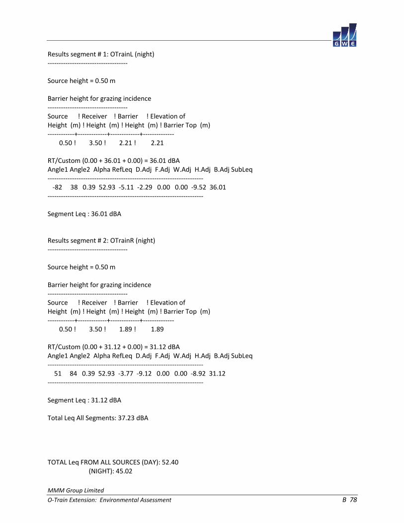
MMM Group Limited
O-Train Extension: Environmental Assessment B 78
Results segment # 1: OTrainL (night) ------------------------------------ Source height = 0.50 m Barrier height for grazing incidence ------------------------------------ Source ! Receiver ! Barrier ! Elevation of Height (m) ! Height (m) ! Height (m) ! Barrier Top (m) ------------+-------------+-------------+-------------- 0.50 ! 3.50 ! 2.21 ! 2.21 RT/Custom (0.00 + 36.01 + 0.00) = 36.01 dBA Angle1 Angle2 Alpha RefLeq D.Adj F.Adj W.Adj H.Adj B.Adj SubLeq ---------------------------------------------------------------------- -82 38 0.39 52.93 -5.11 -2.29 0.00 0.00 -9.52 36.01 ---------------------------------------------------------------------- Segment Leq : 36.01 dBA Results segment # 2: OTrainR (night) ------------------------------------ Source height = 0.50 m Barrier height for grazing incidence ------------------------------------ Source ! Receiver ! Barrier ! Elevation of Height (m) ! Height (m) ! Height (m) ! Barrier Top (m) ------------+-------------+-------------+-------------- 0.50 ! 3.50 ! 1.89 ! 1.89 RT/Custom (0.00 + 31.12 + 0.00) = 31.12 dBA Angle1 Angle2 Alpha RefLeq D.Adj F.Adj W.Adj H.Adj B.Adj SubLeq ---------------------------------------------------------------------- 51 84 0.39 52.93 -3.77 -9.12 0.00 0.00 -8.92 31.12 ---------------------------------------------------------------------- Segment Leq : 31.12 dBA Total Leq All Segments: 37.23 dBA TOTAL Leq FROM ALL SOURCES (DAY): 52.40 (NIGHT): 45.02

MMM Group Limited
O-Train Extension: Environmental Assessment B 79
STAMSON 5.0 NORMAL REPORT Date: 17-04-2015 15:52:38 MINISTRY OF ENVIRONMENT AND ENERGY / NOISE ASSESSMENT Filename: r10.te Time Period: Day/Night 16/8 hours Description: Road data, segment # 1: Airport (day/night) ------------------------------------------- Car traffic volume : 27007/2348 veh/TimePeriod * Medium truck volume : 2148/187 veh/TimePeriod * Heavy truck volume : 1535/133 veh/TimePeriod * Posted speed limit : 80 km/h Road gradient : 0 % Road pavement : 1 (Typical asphalt or concrete) * Refers to calculated road volumes based on the following input: 24 hr Traffic Volume (AADT or SADT): 33359 Percentage of Annual Growth : 0.00 Number of Years of Growth : 0.00 Medium Truck % of Total Volume : 7.00 Heavy Truck % of Total Volume : 5.00 Day (16 hrs) % of Total Volume : 92.00 Data for Segment # 1: Airport (day/night) ----------------------------------------- Angle1 Angle2 : -46.00 deg 46.00 deg Wood depth : 0 (No woods.) No of house rows : 0 / 0 Surface : 1 (Absorptive ground surface) Receiver source distance : 70.00 / 70.00 m Receiver height : 1.50 / 1.50 m Topography : 2 (Flat/gentle slope; with barrier) Barrier angle1 : -46.00 deg Angle2 : 46.00 deg Barrier height : 2.00 m Barrier receiver distance : 6.00 / 6.00 m Source elevation : 0.00 m Receiver elevation : 0.00 m Barrier elevation : 6.00 m Reference angle : 0.00

MMM Group Limited
O-Train Extension: Environmental Assessment B 80
Road data, segment # 2: AirportRamp (day/night) ----------------------------------------------- Car traffic volume : 6395/556 veh/TimePeriod * Medium truck volume : 509/44 veh/TimePeriod * Heavy truck volume : 363/32 veh/TimePeriod * Posted speed limit : 40 km/h Road gradient : 0 % Road pavement : 1 (Typical asphalt or concrete) * Refers to calculated road volumes based on the following input: 24 hr Traffic Volume (AADT or SADT): 7899 Percentage of Annual Growth : 0.00 Number of Years of Growth : 0.00 Medium Truck % of Total Volume : 7.00 Heavy Truck % of Total Volume : 5.00 Day (16 hrs) % of Total Volume : 92.00 Data for Segment # 2: AirportRamp (day/night) --------------------------------------------- Angle1 Angle2 : -70.00 deg 0.00 deg Wood depth : 0 (No woods.) No of house rows : 0 / 0 Surface : 1 (Absorptive ground surface) Receiver source distance : 35.00 / 35.00 m Receiver height : 5.50 / 5.50 m Topography : 2 (Flat/gentle slope; with barrier) Barrier angle1 : -70.00 deg Angle2 : 0.00 deg Barrier height : 6.00 m Barrier receiver distance : 6.00 / 6.00 m Source elevation : 0.00 m Receiver elevation : 0.00 m Barrier elevation : 0.00 m Reference angle : 0.00

MMM Group Limited
O-Train Extension: Environmental Assessment B 81
Road data, segment # 3: HuntclubWBL (day/night) ----------------------------------------------- Car traffic volume : 14314/1245 veh/TimePeriod * Medium truck volume : 1139/99 veh/TimePeriod * Heavy truck volume : 813/71 veh/TimePeriod * Posted speed limit : 60 km/h Road gradient : 0 % Road pavement : 1 (Typical asphalt or concrete) * Refers to calculated road volumes based on the following input: 24 hr Traffic Volume (AADT or SADT): 17680 Percentage of Annual Growth : 0.00 Number of Years of Growth : 0.00 Medium Truck % of Total Volume : 7.00 Heavy Truck % of Total Volume : 5.00 Day (16 hrs) % of Total Volume : 92.00 Data for Segment # 3: HuntclubWBL (day/night) --------------------------------------------- Angle1 Angle2 : -67.00 deg 11.00 deg Wood depth : 0 (No woods.) No of house rows : 0 / 0 Surface : 2 (Reflective ground surface) Receiver source distance : 39.00 / 39.00 m Receiver height : 5.50 / 5.50 m Topography : 2 (Flat/gentle slope; with barrier) Barrier angle1 : -67.00 deg Angle2 : 11.00 deg Barrier height : 6.00 m Barrier receiver distance : 20.00 / 20.00 m Source elevation : 0.00 m Receiver elevation : 0.00 m Barrier elevation : 0.00 m Reference angle : 0.00

MMM Group Limited
O-Train Extension: Environmental Assessment B 82
Road data, segment # 4: HuntclubWBR (day/night) ----------------------------------------------- Car traffic volume : 14314/1245 veh/TimePeriod * Medium truck volume : 1139/99 veh/TimePeriod * Heavy truck volume : 813/71 veh/TimePeriod * Posted speed limit : 60 km/h Road gradient : 0 % Road pavement : 1 (Typical asphalt or concrete) * Refers to calculated road volumes based on the following input: 24 hr Traffic Volume (AADT or SADT): 17680 Percentage of Annual Growth : 0.00 Number of Years of Growth : 0.00 Medium Truck % of Total Volume : 7.00 Heavy Truck % of Total Volume : 5.00 Day (16 hrs) % of Total Volume : 92.00 Data for Segment # 4: HuntclubWBR (day/night) --------------------------------------------- Angle1 Angle2 : 11.00 deg 67.00 deg Wood depth : 0 (No woods.) No of house rows : 0 / 0 Surface : 2 (Reflective ground surface) Receiver source distance : 39.00 / 39.00 m Receiver height : 4.50 / 4.50 m Topography : 2 (Flat/gentle slope; with barrier) Barrier angle1 : 11.00 deg Angle2 : 67.00 deg Barrier height : 7.00 m Barrier receiver distance : 14.00 / 14.00 m Source elevation : 0.00 m Receiver elevation : 0.00 m Barrier elevation : 0.00 m Reference angle : 0.00

MMM Group Limited
O-Train Extension: Environmental Assessment B 83
Road data, segment # 5: HuntclubEBL (day/night) ----------------------------------------------- Car traffic volume : 14314/1245 veh/TimePeriod * Medium truck volume : 1139/99 veh/TimePeriod * Heavy truck volume : 813/71 veh/TimePeriod * Posted speed limit : 60 km/h Road gradient : 0 % Road pavement : 1 (Typical asphalt or concrete) * Refers to calculated road volumes based on the following input: 24 hr Traffic Volume (AADT or SADT): 17680 Percentage of Annual Growth : 0.00 Number of Years of Growth : 0.00 Medium Truck % of Total Volume : 7.00 Heavy Truck % of Total Volume : 5.00 Day (16 hrs) % of Total Volume : 92.00 Data for Segment # 5: HuntclubEBL (day/night) --------------------------------------------- Angle1 Angle2 : -59.00 deg 11.00 deg Wood depth : 0 (No woods.) No of house rows : 0 / 0 Surface : 2 (Reflective ground surface) Receiver source distance : 52.00 / 52.00 m Receiver height : 5.50 / 5.50 m Topography : 2 (Flat/gentle slope; with barrier) Barrier angle1 : -59.00 deg Angle2 : 11.00 deg Barrier height : 6.00 m Barrier receiver distance : 20.00 / 20.00 m Source elevation : 0.00 m Receiver elevation : 0.00 m Barrier elevation : 0.00 m Reference angle : 0.00

MMM Group Limited
O-Train Extension: Environmental Assessment B 84
Road data, segment # 6: HuntclubEBR (day/night) ----------------------------------------------- Car traffic volume : 14314/1245 veh/TimePeriod * Medium truck volume : 1139/99 veh/TimePeriod * Heavy truck volume : 813/71 veh/TimePeriod * Posted speed limit : 60 km/h Road gradient : 0 % Road pavement : 1 (Typical asphalt or concrete) * Refers to calculated road volumes based on the following input: 24 hr Traffic Volume (AADT or SADT): 17680 Percentage of Annual Growth : 0.00 Number of Years of Growth : 0.00 Medium Truck % of Total Volume : 7.00 Heavy Truck % of Total Volume : 5.00 Day (16 hrs) % of Total Volume : 92.00 Data for Segment # 6: HuntclubEBR (day/night) --------------------------------------------- Angle1 Angle2 : 11.00 deg 59.00 deg Wood depth : 0 (No woods.) No of house rows : 0 / 0 Surface : 2 (Reflective ground surface) Receiver source distance : 52.00 / 52.00 m Receiver height : 4.50 / 4.50 m Topography : 2 (Flat/gentle slope; with barrier) Barrier angle1 : 11.00 deg Angle2 : 59.00 deg Barrier height : 7.00 m Barrier receiver distance : 14.00 / 14.00 m Source elevation : 0.00 m Receiver elevation : 0.00 m Barrier elevation : 0.00 m Reference angle : 0.00

MMM Group Limited
O-Train Extension: Environmental Assessment B 85
Results segment # 1: Airport (day) ---------------------------------- Source height = 1.50 m Barrier height for grazing incidence ------------------------------------ Source ! Receiver ! Barrier ! Elevation of Height (m) ! Height (m) ! Height (m) ! Barrier Top (m) ------------+-------------+-------------+-------------- 1.50 ! 1.50 ! -4.50 ! 1.50 ROAD (0.00 + 42.48 + 0.00) = 42.48 dBA Angle1 Angle2 Alpha RefLeq P.Adj D.Adj F.Adj W.Adj H.Adj B.Adj SubLeq ---------------------------------------------------------------------------- -46 46 0.54 75.96 0.00 -10.30 -3.18 0.00 0.00 -20.00 42.48 ---------------------------------------------------------------------------- Segment Leq : 42.48 dBA Results segment # 2: AirportRamp (day) -------------------------------------- Source height = 1.49 m Barrier height for grazing incidence ------------------------------------ Source ! Receiver ! Barrier ! Elevation of Height (m) ! Height (m) ! Height (m) ! Barrier Top (m) ------------+-------------+-------------+-------------- 1.49 ! 5.50 ! 4.81 ! 4.81 ROAD (0.00 + 46.35 + 0.00) = 46.35 dBA Angle1 Angle2 Alpha RefLeq P.Adj D.Adj F.Adj W.Adj H.Adj B.Adj SubLeq ---------------------------------------------------------------------------- -70 0 0.18 63.90 0.00 -4.34 -4.33 0.00 0.00 -8.87 46.35 ---------------------------------------------------------------------------- Segment Leq : 46.35 dBA

MMM Group Limited
O-Train Extension: Environmental Assessment B 86
Results segment # 3: HuntclubWBL (day) -------------------------------------- Source height = 1.50 m Barrier height for grazing incidence ------------------------------------ Source ! Receiver ! Barrier ! Elevation of Height (m) ! Height (m) ! Height (m) ! Barrier Top (m) ------------+-------------+-------------+-------------- 1.50 ! 5.50 ! 3.45 ! 3.45 ROAD (0.00 + 51.02 + 0.00) = 51.02 dBA Angle1 Angle2 Alpha RefLeq P.Adj D.Adj F.Adj W.Adj H.Adj B.Adj SubLeq ---------------------------------------------------------------------------- -67 11 0.00 70.71 0.00 -4.15 -3.63 0.00 0.00 -11.90 51.02 ---------------------------------------------------------------------------- Segment Leq : 51.02 dBA Results segment # 4: HuntclubWBR (day) -------------------------------------- Source height = 1.50 m Barrier height for grazing incidence ------------------------------------ Source ! Receiver ! Barrier ! Elevation of Height (m) ! Height (m) ! Height (m) ! Barrier Top (m) ------------+-------------+-------------+-------------- 1.50 ! 4.50 ! 3.42 ! 3.42 ROAD (0.00 + 46.88 + 0.00) = 46.88 dBA Angle1 Angle2 Alpha RefLeq P.Adj D.Adj F.Adj W.Adj H.Adj B.Adj SubLeq ---------------------------------------------------------------------------- 11 67 0.00 70.71 0.00 -4.15 -5.07 0.00 0.00 -14.61 46.88 ---------------------------------------------------------------------------- Segment Leq : 46.88 dBA

MMM Group Limited
O-Train Extension: Environmental Assessment B 87
Results segment # 5: HuntclubEBL (day) -------------------------------------- Source height = 1.50 m Barrier height for grazing incidence ------------------------------------ Source ! Receiver ! Barrier ! Elevation of Height (m) ! Height (m) ! Height (m) ! Barrier Top (m) ------------+-------------+-------------+-------------- 1.50 ! 5.50 ! 3.96 ! 3.96 ROAD (0.00 + 51.40 + 0.00) = 51.40 dBA Angle1 Angle2 Alpha RefLeq P.Adj D.Adj F.Adj W.Adj H.Adj B.Adj SubLeq ---------------------------------------------------------------------------- -59 11 0.00 70.71 0.00 -5.40 -4.10 0.00 0.00 -9.81 51.40 ---------------------------------------------------------------------------- Segment Leq : 51.40 dBA Results segment # 6: HuntclubEBR (day) -------------------------------------- Source height = 1.50 m Barrier height for grazing incidence ------------------------------------ Source ! Receiver ! Barrier ! Elevation of Height (m) ! Height (m) ! Height (m) ! Barrier Top (m) ------------+-------------+-------------+-------------- 1.50 ! 4.50 ! 3.69 ! 3.69 ROAD (0.00 + 45.74 + 0.00) = 45.74 dBA Angle1 Angle2 Alpha RefLeq P.Adj D.Adj F.Adj W.Adj H.Adj B.Adj SubLeq ---------------------------------------------------------------------------- 11 59 0.00 70.71 0.00 -5.40 -5.74 0.00 0.00 -13.83 45.74 ---------------------------------------------------------------------------- Segment Leq : 45.74 dBA Total Leq All Segments: 56.14 dBA

MMM Group Limited
O-Train Extension: Environmental Assessment B 88
Results segment # 1: Airport (night) ------------------------------------ Source height = 1.49 m Barrier height for grazing incidence ------------------------------------ Source ! Receiver ! Barrier ! Elevation of Height (m) ! Height (m) ! Height (m) ! Barrier Top (m) ------------+-------------+-------------+-------------- 1.49 ! 1.50 ! -4.50 ! 1.50 ROAD (0.00 + 34.87 + 0.00) = 34.87 dBA Angle1 Angle2 Alpha RefLeq P.Adj D.Adj F.Adj W.Adj H.Adj B.Adj SubLeq ---------------------------------------------------------------------------- -46 46 0.54 68.36 0.00 -10.30 -3.18 0.00 0.00 -20.00 34.87 ---------------------------------------------------------------------------- Segment Leq : 34.87 dBA Results segment # 2: AirportRamp (night) ---------------------------------------- Source height = 1.50 m Barrier height for grazing incidence ------------------------------------ Source ! Receiver ! Barrier ! Elevation of Height (m) ! Height (m) ! Height (m) ! Barrier Top (m) ------------+-------------+-------------+-------------- 1.50 ! 5.50 ! 4.81 ! 4.81 ROAD (0.00 + 38.79 + 0.00) = 38.79 dBA Angle1 Angle2 Alpha RefLeq P.Adj D.Adj F.Adj W.Adj H.Adj B.Adj SubLeq ---------------------------------------------------------------------------- -70 0 0.18 56.34 0.00 -4.34 -4.33 0.00 0.00 -8.87 38.79 ---------------------------------------------------------------------------- Segment Leq : 38.79 dBA
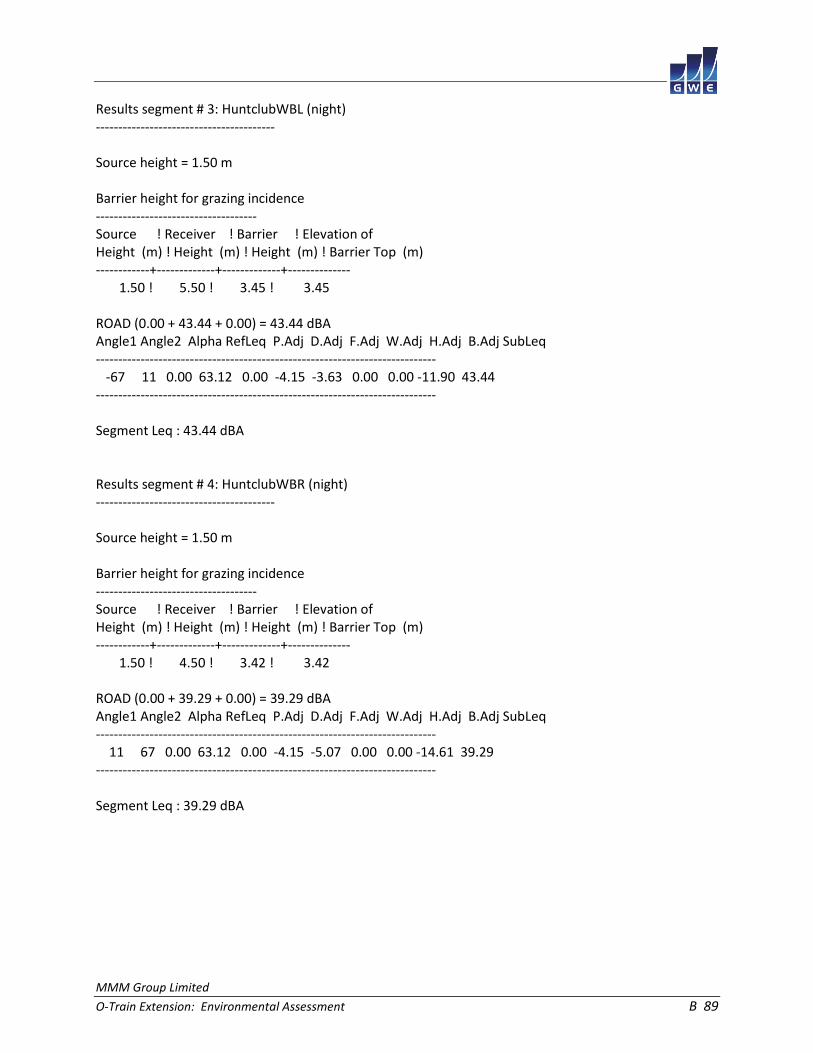
MMM Group Limited
O-Train Extension: Environmental Assessment B 89
Results segment # 3: HuntclubWBL (night) ---------------------------------------- Source height = 1.50 m Barrier height for grazing incidence ------------------------------------ Source ! Receiver ! Barrier ! Elevation of Height (m) ! Height (m) ! Height (m) ! Barrier Top (m) ------------+-------------+-------------+-------------- 1.50 ! 5.50 ! 3.45 ! 3.45 ROAD (0.00 + 43.44 + 0.00) = 43.44 dBA Angle1 Angle2 Alpha RefLeq P.Adj D.Adj F.Adj W.Adj H.Adj B.Adj SubLeq ---------------------------------------------------------------------------- -67 11 0.00 63.12 0.00 -4.15 -3.63 0.00 0.00 -11.90 43.44 ---------------------------------------------------------------------------- Segment Leq : 43.44 dBA Results segment # 4: HuntclubWBR (night) ---------------------------------------- Source height = 1.50 m Barrier height for grazing incidence ------------------------------------ Source ! Receiver ! Barrier ! Elevation of Height (m) ! Height (m) ! Height (m) ! Barrier Top (m) ------------+-------------+-------------+-------------- 1.50 ! 4.50 ! 3.42 ! 3.42 ROAD (0.00 + 39.29 + 0.00) = 39.29 dBA Angle1 Angle2 Alpha RefLeq P.Adj D.Adj F.Adj W.Adj H.Adj B.Adj SubLeq ---------------------------------------------------------------------------- 11 67 0.00 63.12 0.00 -4.15 -5.07 0.00 0.00 -14.61 39.29 ---------------------------------------------------------------------------- Segment Leq : 39.29 dBA
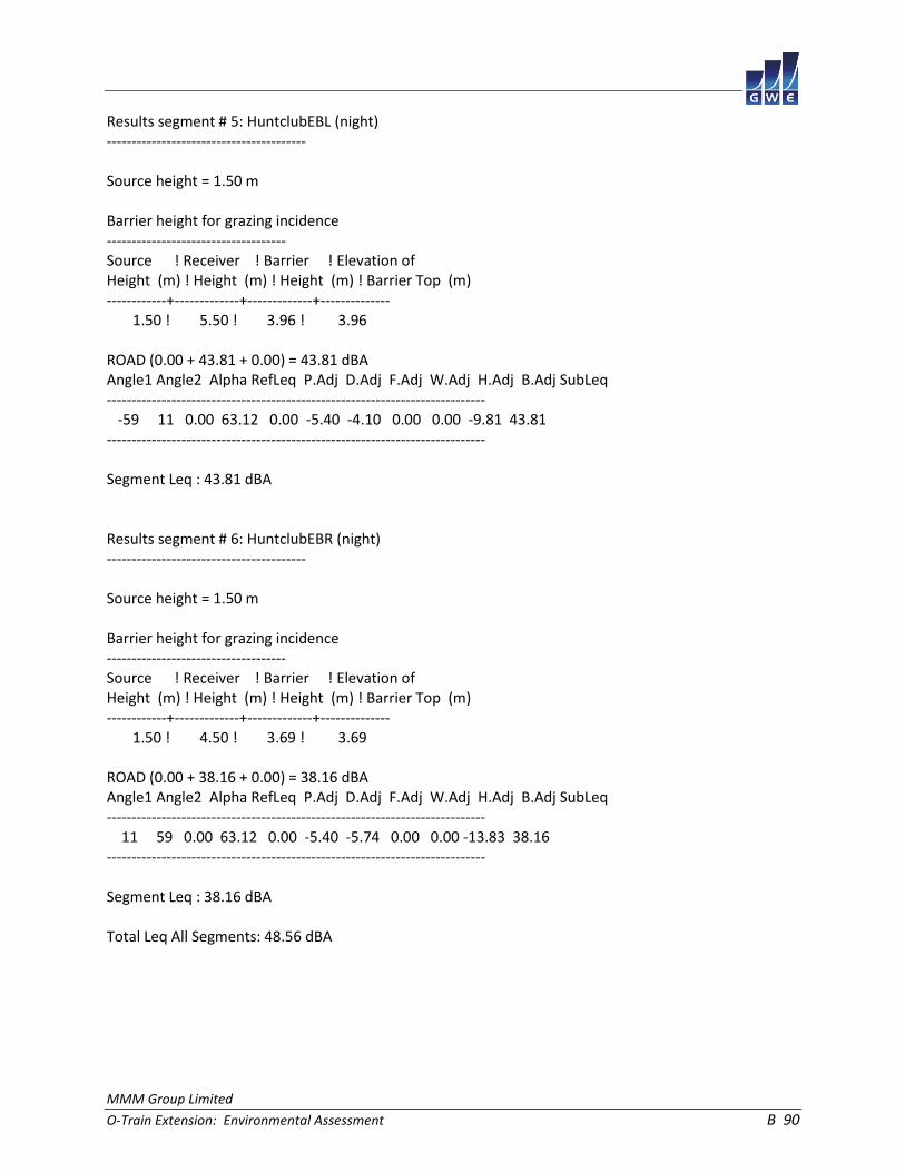
MMM Group Limited
O-Train Extension: Environmental Assessment B 90
Results segment # 5: HuntclubEBL (night) ---------------------------------------- Source height = 1.50 m Barrier height for grazing incidence ------------------------------------ Source ! Receiver ! Barrier ! Elevation of Height (m) ! Height (m) ! Height (m) ! Barrier Top (m) ------------+-------------+-------------+-------------- 1.50 ! 5.50 ! 3.96 ! 3.96 ROAD (0.00 + 43.81 + 0.00) = 43.81 dBA Angle1 Angle2 Alpha RefLeq P.Adj D.Adj F.Adj W.Adj H.Adj B.Adj SubLeq ---------------------------------------------------------------------------- -59 11 0.00 63.12 0.00 -5.40 -4.10 0.00 0.00 -9.81 43.81 ---------------------------------------------------------------------------- Segment Leq : 43.81 dBA Results segment # 6: HuntclubEBR (night) ---------------------------------------- Source height = 1.50 m Barrier height for grazing incidence ------------------------------------ Source ! Receiver ! Barrier ! Elevation of Height (m) ! Height (m) ! Height (m) ! Barrier Top (m) ------------+-------------+-------------+-------------- 1.50 ! 4.50 ! 3.69 ! 3.69 ROAD (0.00 + 38.16 + 0.00) = 38.16 dBA Angle1 Angle2 Alpha RefLeq P.Adj D.Adj F.Adj W.Adj H.Adj B.Adj SubLeq ---------------------------------------------------------------------------- 11 59 0.00 63.12 0.00 -5.40 -5.74 0.00 0.00 -13.83 38.16 ---------------------------------------------------------------------------- Segment Leq : 38.16 dBA Total Leq All Segments: 48.56 dBA

MMM Group Limited
O-Train Extension: Environmental Assessment B 91
RT/Custom data, segment # 1: OTrain (day/night) ----------------------------------------------- 1 - 4-car SRT: Traffic volume : 192/24 veh/TimePeriod Speed : 70 km/h Data for Segment # 1: OTrain (day/night) ---------------------------------------- Angle1 Angle2 : -49.00 deg 49.00 deg Wood depth : 0 (No woods.) No of house rows : 0 / 0 Surface : 2 (Reflective ground surface) Receiver source distance : 163.00 / 163.00 m Receiver height : 1.50 / 1.50 m Topography : 2 (Flat/gentle slope; with barrier) Barrier angle1 : -49.00 deg Angle2 : 49.00 deg Barrier height : 2.00 m Barrier receiver distance : 6.00 / 6.00 m Source elevation : 0.00 m Receiver elevation : 0.00 m Barrier elevation : 0.00 m Reference angle : 0.00

MMM Group Limited
O-Train Extension: Environmental Assessment B 92
Results segment # 1: OTrain (day) --------------------------------- Source height = 0.50 m Barrier height for grazing incidence ------------------------------------ Source ! Receiver ! Barrier ! Elevation of Height (m) ! Height (m) ! Height (m) ! Barrier Top (m) ------------+-------------+-------------+-------------- 0.50 ! 1.50 ! 1.46 ! 1.46 RT/Custom (0.00 + 39.88 + 0.00) = 39.88 dBA Angle1 Angle2 Alpha RefLeq D.Adj F.Adj W.Adj H.Adj B.Adj SubLeq ---------------------------------------------------------------------- -49 49 0.00 58.95 -10.36 -2.64 0.00 0.00 -6.06 39.88 ---------------------------------------------------------------------- Segment Leq : 39.88 dBA Total Leq All Segments: 39.88 dBA Results segment # 1: OTrain (night) ----------------------------------- Source height = 0.50 m Barrier height for grazing incidence ------------------------------------ Source ! Receiver ! Barrier ! Elevation of Height (m) ! Height (m) ! Height (m) ! Barrier Top (m) ------------+-------------+-------------+-------------- 0.50 ! 1.50 ! 1.46 ! 1.46 RT/Custom (0.00 + 33.86 + 0.00) = 33.86 dBA Angle1 Angle2 Alpha RefLeq D.Adj F.Adj W.Adj H.Adj B.Adj SubLeq ---------------------------------------------------------------------- -49 49 0.00 52.93 -10.36 -2.64 0.00 0.00 -6.06 33.86 ---------------------------------------------------------------------- Segment Leq : 33.86 dBA Total Leq All Segments: 33.86 dBA TOTAL Leq FROM ALL SOURCES (DAY): 56.25 (NIGHT): 48.71

MMM Group Limited
O-Train Extension: Environmental Assessment B 93
STAMSON 5.0 NORMAL REPORT Date: 17-04-2015 15:52:15 MINISTRY OF ENVIRONMENT AND ENERGY / NOISE ASSESSMENT Filename: r11.te Time Period: Day/Night 16/8 hours Description: Road data, segment # 1: Huntclub (day/night) -------------------------------------------- Car traffic volume : 28627/2489 veh/TimePeriod * Medium truck volume : 2277/198 veh/TimePeriod * Heavy truck volume : 1627/141 veh/TimePeriod * Posted speed limit : 60 km/h Road gradient : 0 % Road pavement : 1 (Typical asphalt or concrete) * Refers to calculated road volumes based on the following input: 24 hr Traffic Volume (AADT or SADT): 35360 Percentage of Annual Growth : 0.00 Number of Years of Growth : 0.00 Medium Truck % of Total Volume : 7.00 Heavy Truck % of Total Volume : 5.00 Day (16 hrs) % of Total Volume : 92.00 Data for Segment # 1: Huntclub (day/night) ------------------------------------------ Angle1 Angle2 : -21.00 deg 21.00 deg Wood depth : 0 (No woods.) No of house rows : 0 / 0 Surface : 2 (Reflective ground surface) Receiver source distance : 94.00 / 94.00 m Receiver height : 5.50 / 5.50 m Topography : 2 (Flat/gentle slope; with barrier) Barrier angle1 : 10.00 deg Angle2 : 21.00 deg Barrier height : 11.00 m Barrier receiver distance : 45.00 / 45.00 m Source elevation : 0.00 m Receiver elevation : 0.00 m Barrier elevation : 0.00 m Reference angle : 0.00

MMM Group Limited
O-Train Extension: Environmental Assessment B 94
Results segment # 1: Huntclub (day) ----------------------------------- Source height = 1.50 m Barrier height for grazing incidence ------------------------------------ Source ! Receiver ! Barrier ! Elevation of Height (m) ! Height (m) ! Height (m) ! Barrier Top (m) ------------+-------------+-------------+-------------- 1.50 ! 5.50 ! 3.58 ! 3.58 ROAD (58.11 + 35.49 + 0.00) = 58.14 dBA Angle1 Angle2 Alpha RefLeq P.Adj D.Adj F.Adj W.Adj H.Adj B.Adj SubLeq ---------------------------------------------------------------------------- -21 10 0.00 73.72 0.00 -7.97 -7.64 0.00 0.00 0.00 58.11 ---------------------------------------------------------------------------- 10 21 0.00 73.72 0.00 -7.97 -12.14 0.00 0.00 -18.12 35.49 ---------------------------------------------------------------------------- Segment Leq : 58.14 dBA Total Leq All Segments: 58.14 dBA Results segment # 1: Huntclub (night) ------------------------------------- Source height = 1.49 m Barrier height for grazing incidence ------------------------------------ Source ! Receiver ! Barrier ! Elevation of Height (m) ! Height (m) ! Height (m) ! Barrier Top (m) ------------+-------------+-------------+-------------- 1.49 ! 5.50 ! 3.58 ! 3.58 ROAD (50.51 + 27.89 + 0.00) = 50.53 dBA Angle1 Angle2 Alpha RefLeq P.Adj D.Adj F.Adj W.Adj H.Adj B.Adj SubLeq ---------------------------------------------------------------------------- -21 10 0.00 66.12 0.00 -7.97 -7.64 0.00 0.00 0.00 50.51 ---------------------------------------------------------------------------- 10 21 0.00 66.12 0.00 -7.97 -12.14 0.00 0.00 -18.12 27.89 ---------------------------------------------------------------------------- Segment Leq : 50.53 dBA Total Leq All Segments: 50.53 dBA

MMM Group Limited
O-Train Extension: Environmental Assessment B 95
RT/Custom data, segment # 1: OTrain (day/night) ----------------------------------------------- 1 - 4-car SRT: Traffic volume : 192/24 veh/TimePeriod Speed : 70 km/h Data for Segment # 1: OTrain (day/night) ---------------------------------------- Angle1 Angle2 : -61.00 deg 61.00 deg Wood depth : 0 (No woods.) No of house rows : 0 / 0 Surface : 2 (Reflective ground surface) Receiver source distance : 123.00 / 123.00 m Receiver height : 1.50 / 1.50 m Topography : 2 (Flat/gentle slope; with barrier) Barrier angle1 : -61.00 deg Angle2 : -47.00 deg Barrier height : 4.00 m Barrier receiver distance : 95.00 / 95.00 m Source elevation : 0.00 m Receiver elevation : 0.00 m Barrier elevation : 0.00 m Reference angle : 0.00 Results segment # 1: OTrain (day) --------------------------------- Source height = 0.50 m Barrier height for grazing incidence ------------------------------------ Source ! Receiver ! Barrier ! Elevation of Height (m) ! Height (m) ! Height (m) ! Barrier Top (m) ------------+-------------+-------------+-------------- 0.50 ! 1.50 ! 0.73 ! 0.73 RT/Custom (0.00 + 28.84 + 47.59) = 47.65 dBA Angle1 Angle2 Alpha RefLeq D.Adj F.Adj W.Adj H.Adj B.Adj SubLeq ---------------------------------------------------------------------- -61 -47 0.00 58.95 -9.14 -11.09 0.00 0.00 -9.88 28.84 ---------------------------------------------------------------------- -47 61 0.00 58.95 -9.14 -2.22 0.00 0.00 0.00 47.59 ---------------------------------------------------------------------- Segment Leq : 47.65 dBA Total Leq All Segments: 47.65 dBA

MMM Group Limited
O-Train Extension: Environmental Assessment B 96
Results segment # 1: OTrain (night) ----------------------------------- Source height = 0.50 m Barrier height for grazing incidence ------------------------------------ Source ! Receiver ! Barrier ! Elevation of Height (m) ! Height (m) ! Height (m) ! Barrier Top (m) ------------+-------------+-------------+-------------- 0.50 ! 1.50 ! 0.73 ! 0.73 RT/Custom (0.00 + 22.82 + 41.57) = 41.63 dBA Angle1 Angle2 Alpha RefLeq D.Adj F.Adj W.Adj H.Adj B.Adj SubLeq ---------------------------------------------------------------------- -61 -47 0.00 52.93 -9.14 -11.09 0.00 0.00 -9.88 22.82 ---------------------------------------------------------------------- -47 61 0.00 52.93 -9.14 -2.22 0.00 0.00 0.00 41.57 ---------------------------------------------------------------------- Segment Leq : 41.63 dBA Total Leq All Segments: 41.63 dBA TOTAL Leq FROM ALL SOURCES (DAY): 58.51 (NIGHT): 51.06
MMM Group Limited
O-Train Extension: Environmental Assessment C 1
APPENDIX C
MINIMATE PLUS – VIBRATION WAVEFORM
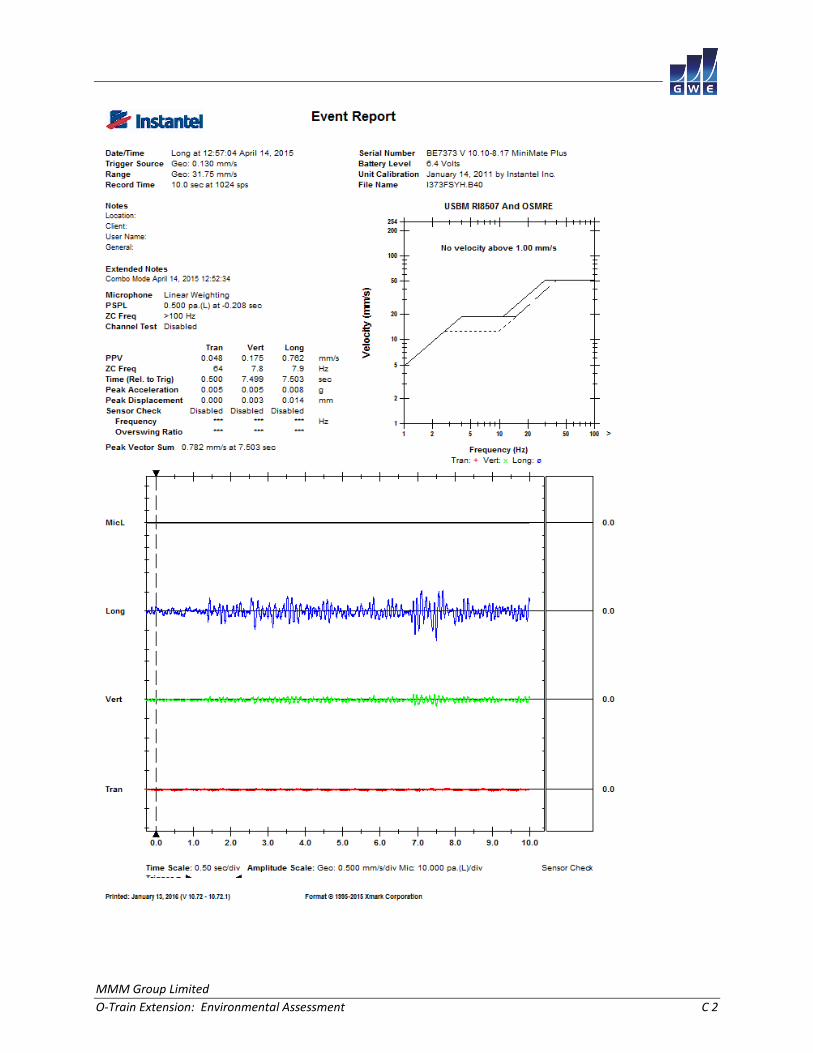
MMM Group Limited
O-Train Extension: Environmental Assessment C 2