Embed Size (px)
Citation preview

UPPER WENATCHEE RIVER ASSESSMENT – APPENDIX B
Upper Wenatchee River Stream Corridor Assessment and Habitat Restoration Strategy
Yakama Nation Fisheries Page B-1
APPENDIX B: SUB-UNIT MAPPING AND GEOMORPHOLOGY
1 INTRODUCTION
This appendix provides sub-unit mapping and geomorphic characterization at the sub-unit scale. Sub-units are finer-scale units than reaches and are comprised of individual geomorphic features such as a distinct floodplain surface or a specific segment of active channel. Mapping and describing conditions at this scale helps to further characterize the underlying geomorphic processes and the effects of human alterations on physical processes and habitat. Each sub-unit was mapped in the field and geomorphic conditions were characterized using field observations and remote sensing data sources (e.g. LiDAR and aerial photos). Each sub-unit was given a designation of “connected” or “disconnected” depending on the degree to which human alterations have disrupted the natural physical processes (e.g. channel migration or floodplain inundation) operating on the sub-unit. This information is used to help ensure that appropriate restoration projects are developed that fit within the proper geomorphic context of the reach.
2 METHODS
These methods generally follow the procedures established by the US Bureau of Reclamation in mapping sub-units as part of USBR Reach Assessments in the Upper Columbia Basin (e.g. USBR 2009).
There are two general types of sub-units – “inner zone” (IZ) sub-units and “outer zone” (OZ) sub-units. The IZ is defined as the active channel, which is the wetted low-flow channel and all related areas that annually experience ground-disturbing flow (i.e. including secondary channels and active bars). Boundaries between IZ sub-units were delineated using breaks in geomorphic control such as bedrock constrictions, changes in geomorphic patters (e.g. step-pool to riffle-run), or anthropogenic alterations that resulted in variations in channel pattern and channel type.
Outer zone units are within the floodplain, which is defined as the area that may become inundated at higher flows and is at a surface elevation equivalent to what would be the active channel migration zone in the absence of human alteration. The OZ frequently includes scoured flood overflow channels and floodplain wetlands. The OZ was identified via observation of flood deposits, the presence of relic channel scars and features, surface elevations in relation to the channel, and riparian vegetation. Boundaries between OZ sub-units were delineated based on natural breaks, confining geologic features (e.g. bedrock, valley wall), variation in the dominant ecology, or anthropogenic barriers.
Inner and outer zones were further designated as “connected” or “disconnected”. A disconnected zone is denoted with a “D” before the IZ or OZ identifier. A designation of “disconnected” indicates that a zone’s historical pattern and processes have been significantly altered due to anthropogenic alterations. Inner and outer zones may become disconnected through channel or floodplain manipulations including straightening, ditching, filling, and riprap; and through construction of levees, road embankments, or bridges. In addition, OZs may be disconnected via indirect alterations that affect channel migration and flood inundation processes. These may include upstream or downstream bridge crossings that limit channel migration or land-use
UPPER WENATCHEE RIVER ASSESSMENT – APPENDIX B
Upper Wenatchee River Stream Corridor Assessment and Habitat Restoration Strategy
Yakama Nation Fisheries Page B-2
induced channel incision that reduces the extent of floodplain inundation. Note that to receive a designation of “disconnected” does not necessarily mean that the entire floodplain unit is cut-off from floodplain inundation or channel migration, but it does indicate significant deviation from the natural function that would be expected in the absence of human alteration.
3 RESULTS
The sub-unit maps and descriptions are provided below by reach. Sub-units are numbered in the downstream direction. Thus, the furthest upstream sub-units are presented first and subsequent summaries proceed in the downstream direction within a given reach. Each sub-unit summary includes a description of geomorphic conditions and effects of human alteration. Notes on potential restoration constraints are also included.
UPPER WENATCHEE RIVER ASSESSMENT – APPENDIX B
Upper Wenatchee River Stream Corridor Assessment and Habitat Restoration Strategy
Yakama Nation Fisheries Page B-3
3.1 REACH ONE
Sub-Unit Description Potential Constraints 1-IZ-02 RM 35.9-37.57: This braided riffle-pool unit contains well vegetated island OZ units associated with
complex secondary channels. The pools are deep and the riffles (point and mid-channel) are complex and often transverse. LWD (large woody debris) accumulations are found on both bar and island features. The channel has a substrate of sands to cobbles. This is an aggrading section. The channel and its floodplain are semi-confined within steep sedimentary conglomerate hillslopes on both river-left (RL) and river-right (RR). Except for the straight upper RM 0.2 the channel form is moderately sinuous. An eddy cove at RM 36.65 on RR is ~3m deep with sands and gravel substrate and buried LWD. The eddy cove has steep high banks of hard sedimentary conglomerate rock and is at the mouth of a tributary outlet. Very good backwater habitat is provided during lower flows in a high-flow secondary channel behind a developing bar at RM 37.4-37.57. There is potential for the backwater feature to be lost due to natural aggradational processes. There is no bank hardening materials or human built features directly influencing this subunit. The majority of the channel banks are relatively low, composed of sands to cobbles and well vegetated.
US Forest Service managed property; FS primitive road access near RR, no road access on RL.
1-IZ-02 RM 37.05: This is an extended backwater on RL with its inlet located at the downstream end of 1-OZ-01. This unit is wide and deep enough to navigate by paddle boat but LWD inputs from beaver activity create navigation obstacles. This backwater IZ unit is connected to an upstream sequence of wetted abandoned channel scars. It is well vegetated with spirea, dogwood, alder, sedges and rush. The mouth of the blackwater is ~ 15m wide and currently maintained by a well-established secondary channel pool at the meander bend.
none
1-IZ-03 RM 35.51-35.9: This braided riffle-pool unit contains complex riffles (point and mid-channel) that are often transverse. At the upstream boundary of the unit is the confluence with Chiwaukum Creek on RR. An accumulation of cobbles and boulders on both RR and RL deposited by a historic flood wash from the creek act as an influence on channel morphology and sediment source. The channel has a substrate of sands to cobbles and some small boulders. This is an aggrading section with moderate sinuosity and no floodplain units. The channel is confined within a high alluvial terrace on RR and a sedimentary conglomerate hillslopes on RL. The downstream boundary of the unit is delineated by the Hwy 2 bridge crossing located at the up-stream most portion of Tumwater Canyon. The highway bridge, large boulder riprap and current construction of a massive culvert near the bridge and Tumwater Campground could have immediate or unknown impact to the geomorphology of the channel in Reach 1.
none
1-OZ-01 RM 37.05-37.57: This is the downstream portion of a wide connected floodplain unit on RL (02-OZ-03). It is composed of cobbles at the base and topped with sands. The surface is low with thick practically impenetrable vegetation (spirea, dogwood, alder, willow and cottonwood). A series of overbank flow channels and abandoned channels scar the surface creating wetted off-channel habitat. A navigable backwater (1-IZ-02) borders the inland side of this unit and connects to the surface waters of the upstream portion of
US Forest Service managed property; no road access on RL.

UPPER WENATCHEE RIVER ASSESSMENT – APPENDIX B
Upper Wenatchee River Stream Corridor Assessment and Habitat Restoration Strategy
Yakama Nation Fisheries Page B-4
this unit located in Reach 2. The backwater appears to receive seasonal surface water inputs from the adjacent hillslope as well as some hyporheic flow through the floodplain.
1-OZ-02 RM 37.03-37.2: This is a mid-channel island OZ unit. It is a low well vegetated surface composed of large cobbles to sands. A mix of mature well-established trees and shrubs populate its surface. LWD jams accumulate at it apex. A complex set of developing bars with some riparian shrub vegetation (primarily willow) and LWD are present both up and downstream from the island.
none
1-OZ-03 RM 36.7-37: This low elevation floodplain surface on RR is well vegetated. It is composed of cobbles at the base and topped with sands. Wood accumulations are present along the banks and on the attached bars associated with this unit. Wetted off-channel habitat exists at mid-unit in an abandoned secondary channel scar. An outlet at RM 36.8 that connects the wetted area to the main channel is mostly dry, sandy, and vegetated.
US Forest Service managed; good access on primitive FS road with a cleared landing directly above site.
1-OZ-04 RM 36.48-36.75: This is a large mid-channel island OZ unit. It is a low well vegetated surface composed of large cobbles to sands and banks are low but vertical. A mix of mature well-established trees and shrubs populate its surface. Log jams accumulate at it apex. The island is developing in a downstream direction with a lower scoured bar surface extending at its toe. The bar extension is vegetated with riparian vegetation but show evidence of regular scour and deposition.
none
1-OZ-05 RM 36.06-36.4: This RL floodplain surface is low with practically impenetrable vegetation on its banks and surface (difficult to access from the channel). There was no visible recent scour or deposits on the surface but localized accumulations of LWD are present on the banks. There are no attached bar associated with this unit.
none
1-OZ-06 RM 36-36.3: This is an island OZ unit near RR. It is a low floodplain with practically impenetrable vegetation on its banks and surfaces. It is composed of large cobbles to sands and banks are low but vertical. A mix of mature well-established trees and shrubs populate its surface. A massive log jam is accumulating at it apex. The log jam has blocked off flow in the secondary channel on RR of the island. This is creating an elongate backwater that extends the length of the island. The backwater/secondary channel is experiencing depositional infilling, wood inputs (some beaver inspired) and other vegetation encroachment. Bar development at the upstream and downstream end of the island add to the features complexity
none
1-OZ-07 RM 35.9-36.25: This is a thin elongate surface on RR behind the island 1-OZ-06 floodplain. It is a very low well-vegetated surface. It is separated from the island and dissected by narrow secondary channel flow. Large wood from the channel and beaver activity creates complex habitat in this unit that is connected to the main channel at the downstream end.
none
UPPER WENATCHEE RIVER ASSESSMENT – APPENDIX B
Upper Wenatchee River Stream Corridor Assessment and Habitat Restoration Strategy
Yakama Nation Fisheries Page B-5
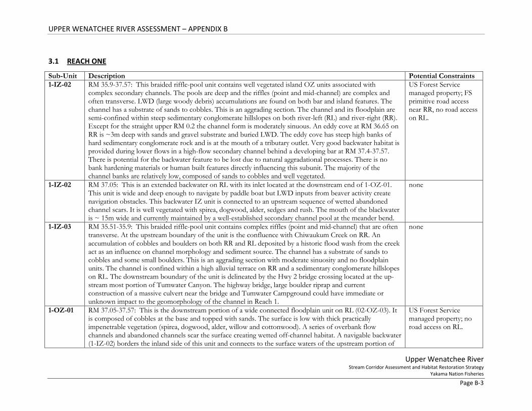
Figure 1. Subunit delineations for the downstream most portion of Reach 1. Flow is from north to south.
UPPER WENATCHEE RIVER ASSESSMENT – APPENDIX B
Upper Wenatchee River Stream Corridor Assessment and Habitat Restoration Strategy
Yakama Nation Fisheries Page B-6
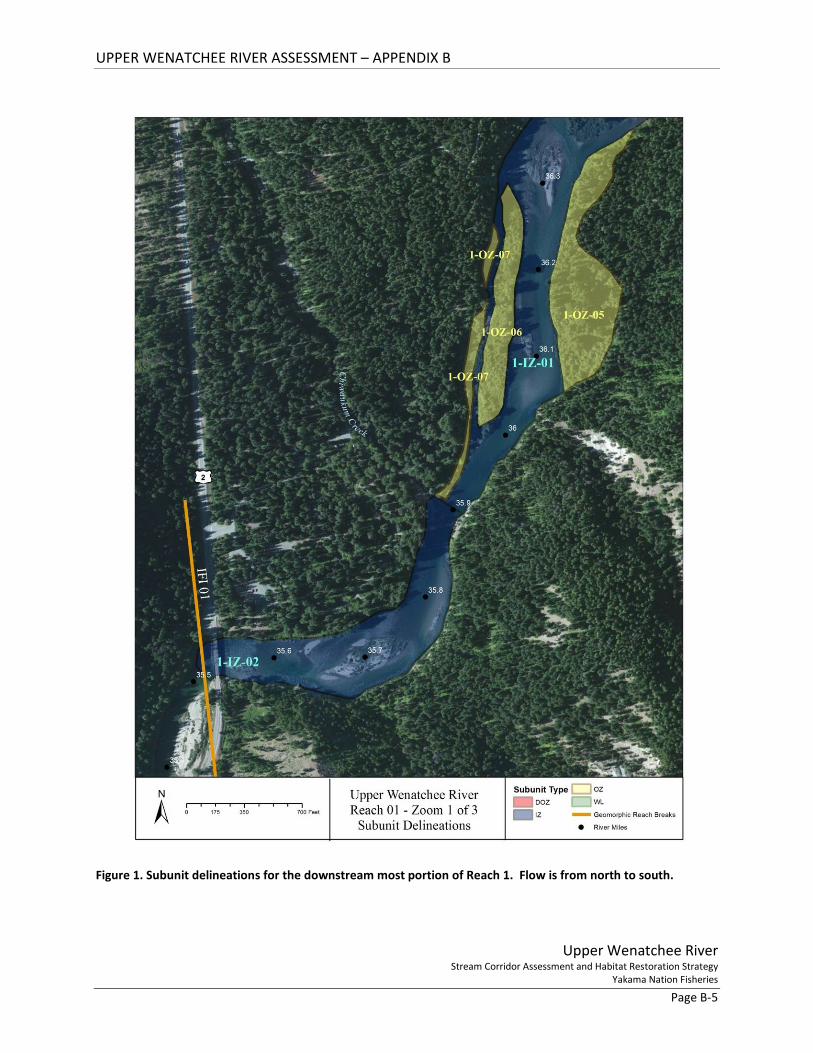
Figure 2. Subunit delineations for Reach 1. Flow is from north to south.
UPPER WENATCHEE RIVER ASSESSMENT – APPENDIX B
Upper Wenatchee River Stream Corridor Assessment and Habitat Restoration Strategy
Yakama Nation Fisheries Page B-7
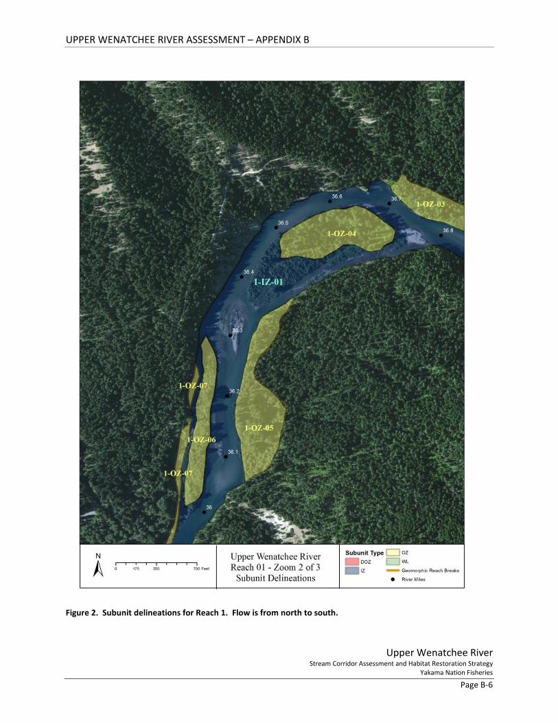
Figure 3. Subunit delineations for the upstream most portion of Reach 1. Flow is from north to south.
UPPER WENATCHEE RIVER ASSESSMENT – APPENDIX B
Upper Wenatchee River Stream Corridor Assessment and Habitat Restoration Strategy
Yakama Nation Fisheries Page B-8
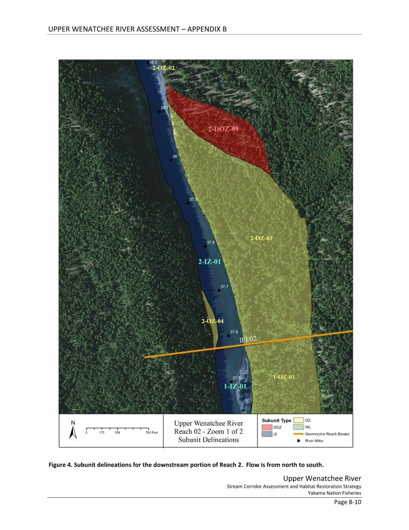
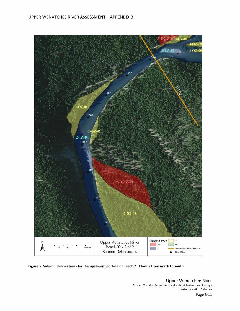
3.2 REACH TWO Sub-Unit Description Potential
Constraints 2-IZ-01 RM 37.57-38.61: This riffle-glide sequence extends the entirety of Reach 2. The glides are not shallow (pool-
like), less deep than the pools of Reach 3 but extended with minimal bed topography. The channel has a substrate of sands to cobbles. Some large boulders from the RL hillslope are found in the channel in the upper 0.2 miles. Large side-attached bars are present, but the braiding of Reach 3 is gone. The active channel width (IZ zone) is reduced compared to Reach 3. In the upper 0.2 miles of Reach 2 the channel is slightly confined between a historic alluvial terrace (RR) and a sedimentary conglomerate hillslope (RL). Downstream the floodplain widens but the channel remains confined to the right side of the valley where it borders a hillslope of sedimentary conglomerate rock on RR. Here the active IZ zone is straight and appears to be incising slightly. There is no bank hardening materials or human built features directly impacting this Reach. A sequence of alternating aggradational and degradational is occurring between Reaches 1-3 with minor degradation currently occurring in Reach 2. The majority of the channel banks are relatively low, composed of sands to cobbles and well vegetated.
US Forest Service managed property; FS primitive road access near RR, no road access on RL.
2-OZ-01 RM 38.22-38.47: This is a low elevation well-vegetated floodplain unit on RR. It is composed of sands to cobbles with very gradually sloping banks on the upstream end. The inland side of the unit is bordered by stair-step of historic alluvial terraces on the upstream end and a hillslope of sedimentary conglomerate on the downstream end. The surface is well vegetated with a mix of trees and shrubs (alder, hawthorne, spirea, snowberry, aspen, and cottonwood). A channel margin backwater heavily vegetated with dogwood exists along the back of the unit on the downstream end. Some wood is naturally accumulating near the backwater inlet where it connects to the main channel (RM 38.21).
US Forest Service managed property; easy FS primitive road access.
2-OZ-02 RM 38.2-38.32: This is a small OZ floodplain unit on RL that is inset within abandoned alluvial terraces. It is a margin OZ unit with a slightly higher surface containing mixed transitional vegetation of conifers (5-50 years old), Oregon grape, spirea, grasses, and lupin. Evidence of rare but recent floodwater inundation is noted as thin sand deposits on the surface.
none
2-OZ-03 RM 37.57-38.12: This is an extensive floodplain unit on RL of cobbles at the base and topped with sands. The surface is low and well vegetated throughout. On the downstream end vegetation along the banks is practically impenetrable. A series of overbank flow scars and abandoned channels scar the surface. The most prominent channel scars are wetted off-channel habitat that runs the inland perimeter of the unit at the upstream end between RM 37.7-38. At RM 37.57-37.7 it meanders into the middle of the unit. The wetted areas range in width from ~ 2-10m wide with a 30m diameter wetland pool at 37.57. This series of wetted abandoned channels are silting in and discontinuous in the upstream portion. They appear to receive seasonal surface water inputs from the adjacent hillslope as well as some hyporheic flow. The surface water in the wetted areas is connected to the floodplain unit directly downstream in Reach 1 (1-OZ-01) which eventually
US Forest Service managed; no road access on the left side of the channel (primitive road on RR but channel crossing could be challenging and damaging).

UPPER WENATCHEE RIVER ASSESSMENT – APPENDIX B
Upper Wenatchee River Stream Corridor Assessment and Habitat Restoration Strategy
Yakama Nation Fisheries Page B-9
connects to the mainstem channel. See survey map for excavation options 2-OZ-04 RM 37.57-37.7: This is a very small elongate floodplain unit on RR. It is a low elevation surface that is well
vegetated with mixed trees and riparian shrubs. A developing cobble-gravel bar is attached to the length of the unit. Vegetation (willow) is beginning to establish on the bar upstream of the unit and some wood is accumulating on the downstream banks.
none
2-DOZ-01 RM 38-38.15: This vegetated surface is located on RL directly upstream of 2-OZ-04. The boundary between these two units is gradual. Vegetation on the DOZ is less dense and dominated by conifers and ferns. Downstream transverse migrating scroll bars are visible on the surface of the DOZ. The maturity of the vegetation on the scrolls increases in an upstream pattern (historic channel migration and modern incision). DOZ designation has been given to this unit because there is no evidence of modern (50+ years) inundation. A gravel-cobble point bar is developing in front of this unit with some accumulated large wood and a high-water scour channel along the bank of the DOZ. This unit is composed of cobbles-sands. The inland side is bordered by a slightly higher and older alluvial terrace.
none
UPPER WENATCHEE RIVER ASSESSMENT – APPENDIX B
Upper Wenatchee River Stream Corridor Assessment and Habitat Restoration Strategy
Yakama Nation Fisheries Page B-10
Figure 4. Subunit delineations for the downstream portion of Reach 2. Flow is from north to south.
UPPER WENATCHEE RIVER ASSESSMENT – APPENDIX B
Upper Wenatchee River Stream Corridor Assessment and Habitat Restoration Strategy
Yakama Nation Fisheries Page B-11
Figure 5. Subunit delineations for the upstream portion of Reach 2. Flow is from north to south
UPPER WENATCHEE RIVER ASSESSMENT – APPENDIX B
Upper Wenatchee River Stream Corridor Assessment and Habitat Restoration Strategy
Yakama Nation Fisheries Page B-12
3.3 REACH THREE Sub-Unit Description Potential
Constraints 3-IZ-01 RM 38.61-41.9: This riffle-pool sequence extends the entirety of Reach 3. It has a substrate of sands to large
cobbles with sparse boulders. Good island and bar development associated with wood accumulations enhance the IZ’s geomorphic complexity. Large transverse mid-channel bar features are prominent in the upper half of the reach and the addition of vegetated islands shift the lower half of the reach into a partially braided riffle-pool sequence. The islands and mid-channel bars are composed primarily of cobble to sands. Flow velocity is increased relative to Reach 4. The highest flow velocity section of the Upper Wenatchee River is between RM 40.4-41.7. Localized velocity increases are associated with increased gradients. Except for the upstream-most one river mile (RM 40.9-41.9) this is an aggrading reach. The upper one mile is transitional with evidence of minor incision noted by a small neck cut-off (3-OZ-01) and abandoned alluvial terraces (3-DOZ-03; 3-DOZ-04) with steeply sloping banks. The channel banks in the rest of the reach are composed of sands to cobbles, are relatively low, connected and gradually sloping. Where banks are not hardened by riprap this is a laterally active reach.
Large boulder riprap and spurs are protecting or deflecting flow at privately owned residential areas; access downstream of RM 39.3 is by primitive road on RR only; RR upstream of RM 39.3 is privately owned; no current RL road access at RM 38.61-41.6.
3-OZ-01 RM 41.2-41.6: This floodplain unit on RL has moderately sloping banks (cobbles to sands). The surface is well vegetated with a mix of trees and shrubs (alder, hawthorne, spirea, snowberry, aspen, and cottonwood). The upper portion of the unit (RM 41.45-41.6) is a cut-off meander that curves behind a DOZ. Here the FP unit contains a wetted abandoned channel depression. Due to modern main-channel deposition the upstream inlet is not visible while the downstream outlet is wetted. The main channel here has enough gradient to support side/secondary channel reactivation in the abandoned channel scar. The secondary channel could be designed specifically for spawning habitat.
Land is private; nearest access at upstream end of unit appears to be privately owned secondary road.
3-OZ-02 RM 40.55-41.14: This unit widens in a downstream direction. The downstream OZ-IZ boundary is a set of whale-back transverse bars vegetated with successional vegetation and evidence of modern scour and deposition (including rafted wood). The transverse bars indicate a natural lateral/downstream channel migration pattern here. The unit is a low well vegetated surface composed of large cobbles to sands. A narrow wetted backwater extends from the downstream end inland between historic scroll bars. Highwater or hyporheic flow feeds these poorly developed moist low areas that are gradually filling. There is no evidence of modern human alterations. The inland boundary borders a hillslope of historic sedimentary deposits (Chumsitck Formation)
none
3-OZ-03 RM 40.8-40.93: Located on RR this unit is at the downstream end of a larger floodplain unit designated as a DOZ due to human alterations. This portion of the low-elevation floodplain is well-vegetated with mixed riparian trees and shrubs (ie. cottonwood, alder, aspen, vine maple, spirea, rose). Fresh scour and deposition,
Privately owned but road access is relatively close.
UPPER WENATCHEE RIVER ASSESSMENT – APPENDIX B
Upper Wenatchee River Stream Corridor Assessment and Habitat Restoration Strategy
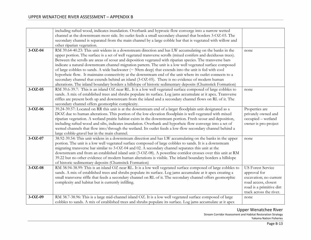
Yakama Nation Fisheries Page B-13
including rafted wood, indicates inundation. Overbank and hyproeic flow converge into a narrow wetted channel at the downstream most side. Its outlet feeds a small secondary channel that borders 3-OZ-03. The secondary channel is separated from the main channel by a large cobble bar that is vegetated with willow and other riparian vegetation.
3-OZ-04 RM 39.64-40.23: This unit widens in a downstream direction and has LW accumulating on the banks in the upper portion. The surface is a set of well vegetated transverse scrolls (mixed conifers and deciduous trees). Between the scrolls are areas of scour and deposition vegetated with riparian species. The transverse bars indicate a natural downstream channel migration pattern. The unit is a low well vegetated surface composed of large cobbles to sands. A wide backwater (~ 50cm deep) that extends into the unit is fed with cool hyporheic flow. It maintains connectivity at the downstream end of the unit where its outlet connects to a secondary channel that extends behind an island (3-OZ-05). There is no evidence of modern human alterations. The inland boundary borders a hillslope of historic sedimentary deposits (Chumstick Formation)
none
3-OZ-05 RM 39.6-39.7: This is an island OZ near RL. It is a low well vegetated surface composed of large cobbles to sands. A mix of established trees and shrubs populate its surface. Log jams accumulate at it apex. Transverse riffles are present both up and downstream from the island and a secondary channel flows on RL of it. The secondary channel offers geomorphic complexity.
none
3-OZ-06 39.24-39.57: Located on RR this unit is at the downstream end of a larger floodplain unit designated as a DOZ due to human alterations. This portion of the low-elevation floodplain is well-vegetated with mixed riparian vegetation. A wetland prairie habitat exists in the downstream portion. Fresh scour and deposition, including rafted wood and silts, indicates inundation. Overbank and hyporheic flow converge into a set of wetted channels that flow into/through the wetland. Its outlet feeds a low-flow secondary channel behind a large cobble-gravel bar in the main channel.
Properties are privately owned and occupied – wetland owner is pro-project
3-OZ-07 38.92-39.54: This unit widens in a downstream direction and has LW accumulating on the banks in the upper portion. The unit is a low well vegetated surface composed of large cobbles to sands. It is a downstream migrating transverse bar similar to 3-OZ-04 and 02. A secondary channel separates this unit at the downstream end from an established island unit (3-OZ-08). A powerline corridor crosses over this unit at RM 39.22 but no other evidence of modern human alterations is visible. The inland boundary borders a hillslope of historic sedimentary deposits (Chumsitck Formation)
none
3-OZ-08 RM 38.94-38.99: This is an island OZ near RL. It is a low well vegetated surface composed of large cobbles to sands. A mix of established trees and shrubs populate its surface. Log jams accumulate at it apex creating a small transverse riffle that feeds a secondary channel on RL of it. The secondary channel offers geomorphic complexity and habitat but is currently infilling.
US Forest Service approval for excavation; no current road access, closest road is a primitive dirt track across the river.
3-OZ-09 RM 38.7-38.96: This is a large mid-channel island OZ. It is a low well vegetated surface composed of large cobbles to sands. A mix of established trees and shrubs populate its surface. Log jams accumulate at it apex
none

UPPER WENATCHEE RIVER ASSESSMENT – APPENDIX B
Upper Wenatchee River Stream Corridor Assessment and Habitat Restoration Strategy
Yakama Nation Fisheries Page B-14
and at/near its banks on RR. The large wood creates bars and transverse riffle that feeds the secondary channel on RR of the island.
3-OZ-10 RM 38.64-39.09: This elongate low-elevation floodplain surface is well vegetated with mixed trees and shrubs. Its inland side (3-DOZ- 07) has been disconnected from river processes by a US Forest Service road with a raised dirt berm that runs parallel to the river. The road crosses a tributary inlet at the downstream-most end of the unit. Pool scouring below the culvert and incision above it reduce tributary function for the system. The inland boundary is an historic alluvial terrace.
Berm protects US Forest Service maintenance road; access to road is through private property.
3-DOZ-01 RM 42.57-43.12: This low-elevation well-vegetated floodplain surface located on RL has been significantly
altered by development. DOZ designation has been given to this unit as a result of railroad construction (fill and trusses) that border the upstream end, minor vegetation removal/alteration and home-site construction. This unit experiences some inundation during seasonal high-flow/flood events. The inland side is bordered by a slightly higher alluvial terrace that is more extensively developed. Topography suggests that this unit was historically connected to 4-DOZ-03 and, that combined, they were the point bar to the higher inland terrace.
Properties are privately owned and occupied; Railroad is in use.
3-DOZ-02 RM 40-92-41.81: This relatively low-elevation floodplain surface located on RR has been significantly altered by development. DOZ designation is based on road dissection, vegetation removal/alteration, home-site construction and extensive bank hardening. Large boulder riprap, cement retaining walls and levees form a continuously hardened bank along the upper-most portion from RM 41.53-41.81. Smaller sections of similar material are found on the banks between RM 41.1-41.2. Where bank hardening materials do not exist this unit experiences minor inundation during seasonal high-flow/flood events. The inland side is bordered by a slightly higher alluvial terrace that is also developed. Topography suggests that this unit was historically the point bar to the higher terrace.
Properties are privately owned and occupied; bank hardening materials is currently protecting occupied properties.
3-DOZ-03 RM 41.48-41.57: This floodplain surface on RL is rarely inundated (perhaps due to incision related to neck cut-off). Currently vegetated with pines and scrub brush. Composed of cobbles at base and topped with sands. Pine trees on and near the bank are a good source of LWD for the system
Properties are privately owned and no current road access is developed directly to this unit.
3-DOZ-04 RM 41.14-41.3: This is a partially abandoned alluvial terrace on RL that is rarely inundated. It is well-vegetated with a mix of conifers and deciduous trees & shrubs. Banks are composed of cobbles at base and topped with sands. A developing bar connected to this unit provides backwater habitat during low-flow periods in a scour channel at the base of this units banks. The bar is vegetated with willow, alder, cottonwood, and reed canary grass. Beaver activity is visible and a log jam is located at the upstream side. At low-flow there is no visible surface water but remainder of scour channel is wetted
Properties are privately owned and no current road access is developed directly to this unit.
3-DOZ-05 RM 39.91-40.62: This relatively low-elevation floodplain surface located on RR has been significantly altered by development. DOZ designation is based on road dissection, vegetation removal/alteration, home-site
Properties are privately owned and
UPPER WENATCHEE RIVER ASSESSMENT – APPENDIX B
Upper Wenatchee River Stream Corridor Assessment and Habitat Restoration Strategy
Yakama Nation Fisheries Page B-15
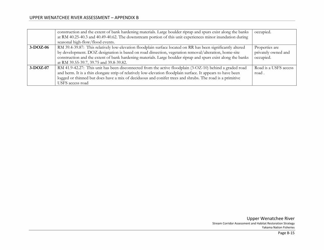
construction and the extent of bank hardening materials. Large boulder riprap and spurs exist along the banks at RM 40.25-40.3 and 40.49-40.62. The downstream portion of this unit experiences minor inundation during seasonal high-flow/flood events.
occupied.
3-DOZ-06 RM 39.4-39.87: This relatively low-elevation floodplain surface located on RR has been significantly altered by development. DOZ designation is based on road dissection, vegetation removal/alteration, home-site construction and the extent of bank hardening materials. Large boulder riprap and spurs exist along the banks at RM 39.55-39.7, 39.75 and 39.8-39.82.
Properties are privately owned and occupied.
3-DOZ-07 RM 41.9-42.27: This unit has been disconnected from the active floodplain (3-OZ-10) behind a graded road and berm. It is a thin elongate strip of relatively low-elevation floodplain surface. It appears to have been logged or thinned but does have a mix of deciduous and conifer trees and shrubs. The road is a primitive USFS access road
Road is a USFS access road .

UPPER WENATCHEE RIVER ASSESSMENT – APPENDIX B
Upper Wenatchee River Stream Corridor Assessment and Habitat Restoration Strategy
Yakama Nation Fisheries Page B-16
Figure 6. Subunit delineations in downstream portion of Reach 3. Flow is from west to east.

UPPER WENATCHEE RIVER ASSESSMENT – APPENDIX B
Upper Wenatchee River Stream Corridor Assessment and Habitat Restoration Strategy
Yakama Nation Fisheries Page B-17
Figure 7. Subunit delineations in Reach 3. Flow is from west to east.

UPPER WENATCHEE RIVER ASSESSMENT – APPENDIX B
Upper Wenatchee River Stream Corridor Assessment and Habitat Restoration Strategy
Yakama Nation Fisheries Page B-18
Figure 8. Subunit delineations in Reach 3. Flow is from west to east.

UPPER WENATCHEE RIVER ASSESSMENT – APPENDIX B
Upper Wenatchee River Stream Corridor Assessment and Habitat Restoration Strategy
Yakama Nation Fisheries Page B-19
Figure 9. Subunit delineations in upstream most portion of Reach 3. Flow is from north to south.
UPPER WENATCHEE RIVER ASSESSMENT – APPENDIX B
Upper Wenatchee River Stream Corridor Assessment and Habitat Restoration Strategy
Yakama Nation Fisheries Page B-20
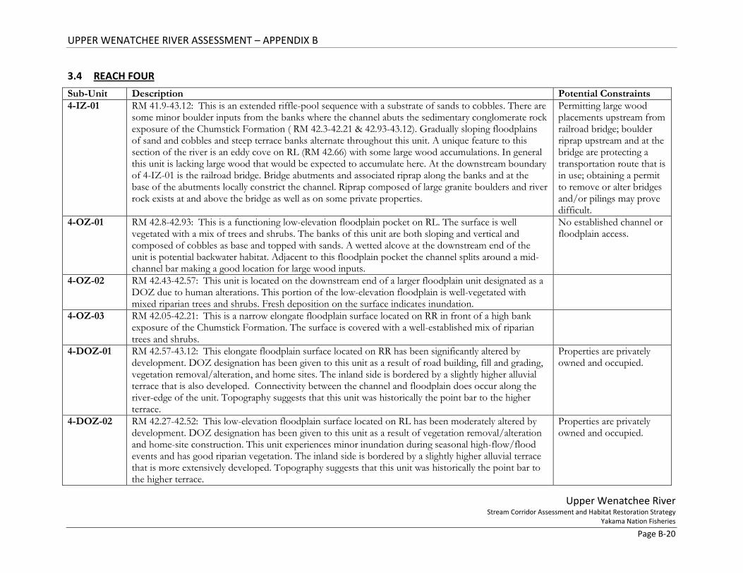
3.4 REACH FOUR Sub-Unit Description Potential Constraints 4-IZ-01 RM 41.9-43.12: This is an extended riffle-pool sequence with a substrate of sands to cobbles. There are
some minor boulder inputs from the banks where the channel abuts the sedimentary conglomerate rock exposure of the Chumstick Formation ( RM 42.3-42.21 & 42.93-43.12). Gradually sloping floodplains of sand and cobbles and steep terrace banks alternate throughout this unit. A unique feature to this section of the river is an eddy cove on RL (RM 42.66) with some large wood accumulations. In general this unit is lacking large wood that would be expected to accumulate here. At the downstream boundary of 4-IZ-01 is the railroad bridge. Bridge abutments and associated riprap along the banks and at the base of the abutments locally constrict the channel. Riprap composed of large granite boulders and river rock exists at and above the bridge as well as on some private properties.
Permitting large wood placements upstream from railroad bridge; boulder riprap upstream and at the bridge are protecting a transportation route that is in use; obtaining a permit to remove or alter bridges and/or pilings may prove difficult.
4-OZ-01 RM 42.8-42.93: This is a functioning low-elevation floodplain pocket on RL. The surface is well vegetated with a mix of trees and shrubs. The banks of this unit are both sloping and vertical and composed of cobbles as base and topped with sands. A wetted alcove at the downstream end of the unit is potential backwater habitat. Adjacent to this floodplain pocket the channel splits around a mid-channel bar making a good location for large wood inputs.
No established channel or floodplain access.
4-OZ-02 RM 42.43-42.57: This unit is located on the downstream end of a larger floodplain unit designated as a DOZ due to human alterations. This portion of the low-elevation floodplain is well-vegetated with mixed riparian trees and shrubs. Fresh deposition on the surface indicates inundation.
4-OZ-03 RM 42.05-42.21: This is a narrow elongate floodplain surface located on RR in front of a high bank exposure of the Chumstick Formation. The surface is covered with a well-established mix of riparian trees and shrubs.
4-DOZ-01 RM 42.57-43.12: This elongate floodplain surface located on RR has been significantly altered by development. DOZ designation has been given to this unit as a result of road building, fill and grading, vegetation removal/alteration, and home sites. The inland side is bordered by a slightly higher alluvial terrace that is also developed. Connectivity between the channel and floodplain does occur along the river-edge of the unit. Topography suggests that this unit was historically the point bar to the higher terrace.
Properties are privately owned and occupied.
4-DOZ-02 RM 42.27-42.52: This low-elevation floodplain surface located on RL has been moderately altered by development. DOZ designation has been given to this unit as a result of vegetation removal/alteration and home-site construction. This unit experiences minor inundation during seasonal high-flow/flood events and has good riparian vegetation. The inland side is bordered by a slightly higher alluvial terrace that is more extensively developed. Topography suggests that this unit was historically the point bar to the higher terrace.
Properties are privately owned and occupied.

UPPER WENATCHEE RIVER ASSESSMENT – APPENDIX B
Upper Wenatchee River Stream Corridor Assessment and Habitat Restoration Strategy
Yakama Nation Fisheries Page B-21
4-DOZ-03 RM 41.9-42.27: This low-elevation floodplain surface located on RL has been significantly altered by development. DOZ designation has been given to this unit as a result of railroad construction (fill and trusses) that border the downstream end and vegetation removal/alteration and home-site construction at the upstream end. The downstream section is well vegetated. This unit experiences minor inundation during seasonal high-flow/flood events. The inland side is bordered by a slightly higher alluvial terrace that is more extensively developed. Topography suggests that this unit was historically the point bar to the higher terrace.
Properties are privately owned and occupied; Railroad is in use.

UPPER WENATCHEE RIVER ASSESSMENT – APPENDIX B
Upper Wenatchee River Stream Corridor Assessment and Habitat Restoration Strategy
Yakama Nation Fisheries Page B-22
Figure 10. Subnit delineation map for downstream end of Reach 4. Flow is from north to south.
UPPER WENATCHEE RIVER ASSESSMENT – APPENDIX B
Upper Wenatchee River Stream Corridor Assessment and Habitat Restoration Strategy
Yakama Nation Fisheries Page B-23
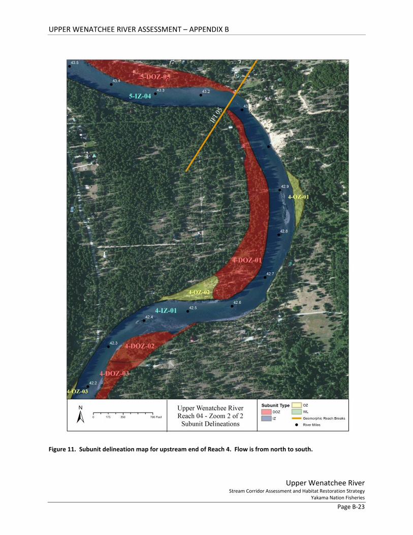
Figure 11. Subunit delineation map for upstream end of Reach 4. Flow is from north to south.
UPPER WENATCHEE RIVER ASSESSMENT – APPENDIX B
Upper Wenatchee River Stream Corridor Assessment and Habitat Restoration Strategy
Yakama Nation Fisheries Page B-24
3.5 REACH FIVE Sub-Unit Description Potential Constraints 5-IZ-01 RM 46.16-46.45: This is a straight, fast-moving section of the channel that is mostly confined by bridges
and high steep terraces. The Beaver Valley Rd bridge (RM 46.41) and the Plain Bridge (RM 46.21) both have sets of cement pilings and associated large boulder riprap that influence flow patterns. An additional set of pilings (RM 46.39) from a decommissioned bridge also remain in-channel. This relatively deep unit has plentiful large boulders. The high terrace banks are steep but vegetated with conifers. The narrow two small low-elevation floodplains along this unit offer gradually sloping banks that are also well-vegetated. At the downstream end on RR is a set of very large boulders with an eddy pool that is used as a swimming hole and access point.
Beaver Valley Bridge is an established transportation route in use; Plain Bridge is an historic structure; obtaining a permit to remove or alter bridges and/or pilings may prove difficult.
5-IZ-02 RM 44.9-46.16: Width of channel increases relative to the upstream unit and gradient is reduced slightly. This is a fast-moving riffle-pool/glide section with substrate of sands to cobbles and some large boulders. The boulders are sourced from terrace banks that alternate with narrow sections of floodplain. The channel expresses a very low sinuosity meander pattern. Gravel and cobble mid-channel bar development could be enhanced to encourage deposition in this transport dominated reach.
Property is primarily privately owned.
5-IZ-03 RM 43.58-44.9: Sinuosity within the confined channel pathway increases and velocity increases compared to the upstream IZ. This extended riffle sequence contains substrate of gravels to cobbles with some hill-slope boulder inputs. Some in-channel deposits of gravels and cobbles are establishing vegetation (willow). These deposits could be enhanced to encourage mid-channel bar or island development. Banks are primarily high steep alluvial terraces. In the downstream portion of this unit a lower-elevation floodplain exist but is disconnect (5-DOZ-04). Riprap and retaining walls are found on the banks of both RL and RR in the downstream half of this unit.
Retaining walls are built on and protecting private property and home sites; riprap is hardening bank to maintain River Road.
5-IZ-04 RM 43.12-43.58: This is a riffle-glide unit with substrate of cobbles to boulders. The unit is straight and laterally confined by an abandoned alluvial terrace on RR and rock and cement retaining walls along the floodplain on RL. Banks are partially vegetated.
Property is privately owned. Retaining walls are protecting private property and home sites.
5-OZ-01 RM 51.46-51.65: This is a narrow elongate low-elevation floodplain surface located on RL. The upstream end of 5-OZ-01 beings at the Beaver Valley Rd bridge. This floodplain unit rests between the channel and a high alluvial terrace. Banks are sloping and composed of sands with cobbles at base. The surface is covered with a well-established mix of riparian trees and shrubs
5-OZ-02 RM 46.07-46.23: This is a narrow elongate low-elevation floodplain surface located on RR. This floodplain unit rests between the channel and road fill added to a high alluvial terrace. Banks are sloping and composed of sands with cobbles at base. The surface is covered with a well-established mix of trees (conifers and
UPPER WENATCHEE RIVER ASSESSMENT – APPENDIX B
Upper Wenatchee River Stream Corridor Assessment and Habitat Restoration Strategy
Yakama Nation Fisheries Page B-25
deciduous) and riparian and wetland vegetation. Large wood accumulation at downstream end creates a small eddy behind it.
5-OZ-03 RM 44.5-44.69: This unit is located on RL at the base of a high steep terrace. It is topped with alluvium but its base is composed of talus material that originated from a landslide off the terrace slope behind it. It is now well vegetated with mixed trees (conifer & deciduous) and riparian vegetation. Landslide boulders extend into the channel. Some wood is accumulating on these boulders.
5-DOZ-01 RM 45.9-46.09: This narrow elongate low-elevation floodplain surface located on RL has been significantly altered by development. DOZ designation has been given to this unit as a result of fill and grading, vegetation removal/alteration and home-site construction. There is no riprap or retaining walls on this floodplain unit. The inland side is bordered by a high alluvial terrace where the community of Plain is located.
Properties are privately owned and occupied.
5-DOZ-02 RM 45.32-45.79: This elongate low-elevation floodplain surface located on RR has been significantly altered by development. DOZ designation has been given to this unit as a result of road building, fill and grading, vegetation removal/alteration and home-site construction. There is no riprap or retaining walls on this floodplain unit. The inland side is bordered by a high terrace where River Road traverses.
Properties are privately owned and occupied.
5-DOZ-03 RM 50.75-51.3: This elongate low-elevation floodplain surface located on RL has been moderately altered by development. DOZ designation has been given to this unit as a result of vegetation removal/alteration and home-site construction. This unit experiences minor inundation during seasonal high-flow/flood events. The inland side is bordered by a slightly higher alluvial terrace that is more extensively developed. Topography suggests that this unit was historically the point bar to the higher terrace.
Properties are privately owned and occupied.
5-DOZ-04 RM 43.81-44.12: This elongate floodplain surface located on RL has been significantly altered by development. DOZ designation has been given to this unit as a result of road building, fill and grading, vegetation removal/alteration, riprap placement, and home site and retaining wall construction. The inland side is bordered by a slightly higher alluvial terrace that is more extensively developed. Topography suggests that this unit was historically the point bar to the higher terrace.
Properties are privately owned and occupied.
5-DOZ-05 RM 43.12-43.58: This elongate low-elevation floodplain surface located on RL has been moderately altered by development. DOZ designation has been given to this unit as a result of road building, fill and grading, vegetation removal/alteration, riprap placement, and home site and retaining wall construction. The downstream portion (RM 43.12-43.2 has minor development and is inundated by high flow events. The inland side is bordered by a higher alluvial terrace.
Properties are privately owned and occupied.

UPPER WENATCHEE RIVER ASSESSMENT – APPENDIX B
Upper Wenatchee River Stream Corridor Assessment and Habitat Restoration Strategy
Yakama Nation Fisheries Page B-26
Figure 12. Subunit delineation map for downstream end of Reach 5. Flow is from northwest to to southeast.

UPPER WENATCHEE RIVER ASSESSMENT – APPENDIX B
Upper Wenatchee River Stream Corridor Assessment and Habitat Restoration Strategy
Yakama Nation Fisheries Page B-27
Figure 13. Subunit delineation map for upstream end of Reach 5. Flow is from North to South.

UPPER WENATCHEE RIVER ASSESSMENT – APPENDIX B
Upper Wenatchee River Stream Corridor Assessment and Habitat Restoration Strategy
Yakama Nation Fisheries Page B-28
Figure 14. Subunit delineation map for upstream end of Reach 5. Flow is from north to south.
UPPER WENATCHEE RIVER ASSESSMENT – APPENDIX B
Upper Wenatchee River Stream Corridor Assessment and Habitat Restoration Strategy
Yakama Nation Fisheries Page B-29
Figure 15. Subunit delineation map for upstream end of Reach 5. Flow is from north to south.
UPPER WENATCHEE RIVER ASSESSMENT – APPENDIX B
Upper Wenatchee River Stream Corridor Assessment and Habitat Restoration Strategy
Yakama Nation Fisheries Page B-30
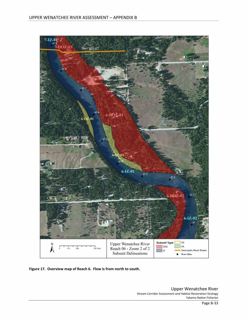
3.6 REACH SIX Sub-Unit Description Potential
Constraints 6-IZ-01 RM 47.12-47.89: This is a well-functioning low sinuosity pool-riffle unit of the channel. Substrate is
dominated with large cobbles but ranges from very coarse sands to small boulders. Channel gradient and thus velocity are slightly increased from the upstream unit. Two small sections of the RR bank are low and sloping. Otherwise RR is bordered by a vegetated but steep bank of historic alluvial terrace deposits. On RL channel banks are gradually sloping and low but altered by human activities. Riprap (RM 47.85) made of tires and rock and an earthen levee (RM 47.55-47.67) have been constructed along the RL banks.
Riprap and levee are protecting private property and associated structures.
6-IZ-02 RM 46.45-47.12: Gradient of the channel increases notable from the upstream unit through 6-IZ-02. This an island-braided section of the channel with substrates ranging from gravels to boulders. Extended cobble riffles are followed by short pool section that express small standing waves (rapids). Channel width expands where the channel splits around the established islands and is narrowest at the pool sections. The islands have large accumulations of LWD at their apexes. Left bank of channel is a very high steep exposure of the Chumstick Formation composed of sedimentary deposits (sedimentary conglomerate). In-channel boulders are primarily located at the base of this formation. The right bank of the channel is low and gradually sloping with a composition of sands to small boulders. Banks of the island units (6-OZ-03 & 6-OZ-04) are well-vegetated with large cobbles at the base and topped with very coarse sand.
6-OZ-01 RM 47.5-47.7: This is a narrow (~80 ft) low-elevation floodplain surface. It is bar-shaped and located at the inner bend of a meander. Lateral development of this point bar is likely restricted due to the constructed levee on the opposite bank. The surface is covered with a well-established mix of riparian trees and shrubs. The inland border is a historic alluvial terrace deposit
6-OZ-02 RM 47.3-47.55: This is a narrow elongate low-elevation floodplain surface located on RL in front of a slightly higher floodplain surface that has been developed with home sites. Banks are sloping and composed of sands with gravels at base. The surface is covered with a well-established mix of riparian trees and shrubs
Incision processes occurring immediately downstream may migrate upstream and negatively impact this functioning OZ and backwater; access is from dirt road down steep terrace bank.
6-OZ-03 RM 46.84-46.91: This island OZ unit is a functioning floodplain ~1 acre in size. Mature well-established vegetation composed of mixed trees (conifers and deciduous) and shrubs populate the bar-shaped mid-channel surface. The unit is composed of large cobbles at the base that are topped with very coarse sands. Banks are semi-sloped and well vegetated. Large wood is accumulating at the apex supporting island
UPPER WENATCHEE RIVER ASSESSMENT – APPENDIX B
Upper Wenatchee River Stream Corridor Assessment and Habitat Restoration Strategy
Yakama Nation Fisheries Page B-31
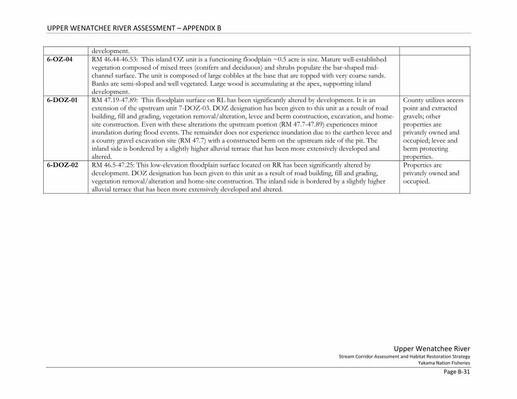
development. 6-OZ-04 RM 46.44-46.53: This island OZ unit is a functioning floodplain ~0.5 acre is size. Mature well-established
vegetation composed of mixed trees (conifers and deciduous) and shrubs populate the bar-shaped mid-channel surface. The unit is composed of large cobbles at the base that are topped with very coarse sands. Banks are semi-sloped and well vegetated. Large wood is accumulating at the apex, supporting island development.
6-DOZ-01 RM 47.19-47.89: This floodplain surface on RL has been significantly altered by development. It is an extension of the upstream unit 7-DOZ-03. DOZ designation has been given to this unit as a result of road building, fill and grading, vegetation removal/alteration, levee and berm construction, excavation, and home-site construction. Even with these alterations the upstream portion (RM 47.7-47.89) experiences minor inundation during flood events. The remainder does not experience inundation due to the earthen levee and a county gravel excavation site (RM 47.7) with a constructed berm on the upstream side of the pit. The inland side is bordered by a slightly higher alluvial terrace that has been more extensively developed and altered.
County utilizes access point and extracted gravels; other properties are privately owned and occupied; levee and berm protecting properties.
6-DOZ-02 RM 46.5-47.25: This low-elevation floodplain surface located on RR has been significantly altered by development. DOZ designation has been given to this unit as a result of road building, fill and grading, vegetation removal/alteration and home-site construction. The inland side is bordered by a slightly higher alluvial terrace that has been more extensively developed and altered.
Properties are privately owned and occupied.

UPPER WENATCHEE RIVER ASSESSMENT – APPENDIX B
Upper Wenatchee River Stream Corridor Assessment and Habitat Restoration Strategy
Yakama Nation Fisheries Page B-32
Figure 16. Overview map of Reach 6. Flow is from northwest to southwest.
UPPER WENATCHEE RIVER ASSESSMENT – APPENDIX B
Upper Wenatchee River Stream Corridor Assessment and Habitat Restoration Strategy
Yakama Nation Fisheries Page B-33
Figure 17. Overview map of Reach 6. Flow is from north to south.
UPPER WENATCHEE RIVER ASSESSMENT – APPENDIX B
Upper Wenatchee River Stream Corridor Assessment and Habitat Restoration Strategy
Yakama Nation Fisheries Page B-34
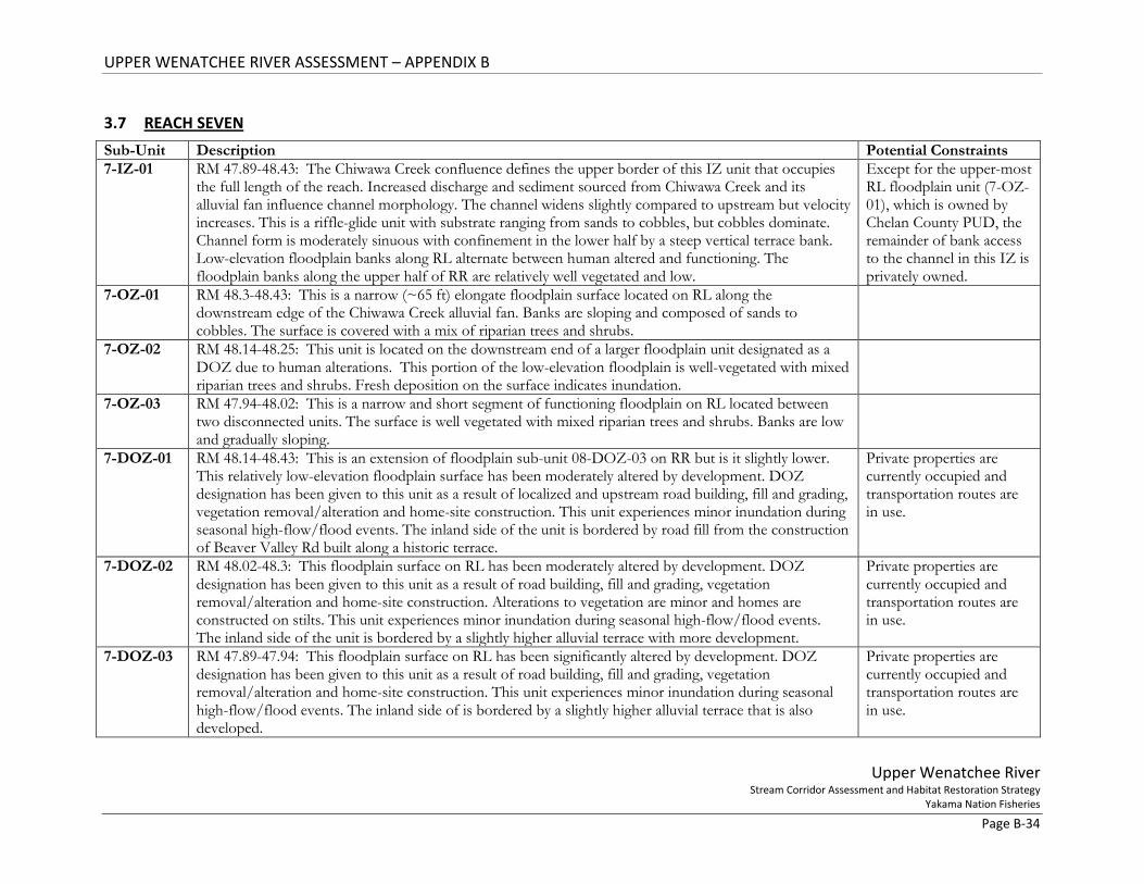
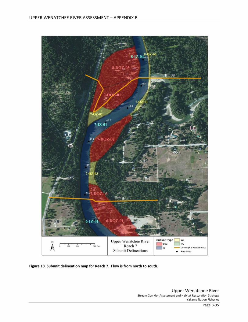
3.7 REACH SEVEN Sub-Unit Description Potential Constraints 7-IZ-01 RM 47.89-48.43: The Chiwawa Creek confluence defines the upper border of this IZ unit that occupies
the full length of the reach. Increased discharge and sediment sourced from Chiwawa Creek and its alluvial fan influence channel morphology. The channel widens slightly compared to upstream but velocity increases. This is a riffle-glide unit with substrate ranging from sands to cobbles, but cobbles dominate. Channel form is moderately sinuous with confinement in the lower half by a steep vertical terrace bank. Low-elevation floodplain banks along RL alternate between human altered and functioning. The floodplain banks along the upper half of RR are relatively well vegetated and low.
Except for the upper-most RL floodplain unit (7-OZ-01), which is owned by Chelan County PUD, the remainder of bank access to the channel in this IZ is privately owned.
7-OZ-01 RM 48.3-48.43: This is a narrow (~65 ft) elongate floodplain surface located on RL along the downstream edge of the Chiwawa Creek alluvial fan. Banks are sloping and composed of sands to cobbles. The surface is covered with a mix of riparian trees and shrubs.
7-OZ-02 RM 48.14-48.25: This unit is located on the downstream end of a larger floodplain unit designated as a DOZ due to human alterations. This portion of the low-elevation floodplain is well-vegetated with mixed riparian trees and shrubs. Fresh deposition on the surface indicates inundation.
7-OZ-03 RM 47.94-48.02: This is a narrow and short segment of functioning floodplain on RL located between two disconnected units. The surface is well vegetated with mixed riparian trees and shrubs. Banks are low and gradually sloping.
7-DOZ-01 RM 48.14-48.43: This is an extension of floodplain sub-unit 08-DOZ-03 on RR but is it slightly lower. This relatively low-elevation floodplain surface has been moderately altered by development. DOZ designation has been given to this unit as a result of localized and upstream road building, fill and grading, vegetation removal/alteration and home-site construction. This unit experiences minor inundation during seasonal high-flow/flood events. The inland side of the unit is bordered by road fill from the construction of Beaver Valley Rd built along a historic terrace.
Private properties are currently occupied and transportation routes are in use.
7-DOZ-02 RM 48.02-48.3: This floodplain surface on RL has been moderately altered by development. DOZ designation has been given to this unit as a result of road building, fill and grading, vegetation removal/alteration and home-site construction. Alterations to vegetation are minor and homes are constructed on stilts. This unit experiences minor inundation during seasonal high-flow/flood events. The inland side of the unit is bordered by a slightly higher alluvial terrace with more development.
Private properties are currently occupied and transportation routes are in use.
7-DOZ-03 RM 47.89-47.94: This floodplain surface on RL has been significantly altered by development. DOZ designation has been given to this unit as a result of road building, fill and grading, vegetation removal/alteration and home-site construction. This unit experiences minor inundation during seasonal high-flow/flood events. The inland side of is bordered by a slightly higher alluvial terrace that is also developed.
Private properties are currently occupied and transportation routes are in use.
UPPER WENATCHEE RIVER ASSESSMENT – APPENDIX B
Upper Wenatchee River Stream Corridor Assessment and Habitat Restoration Strategy
Yakama Nation Fisheries Page B-35
Figure 18. Subunit delineation map for Reach 7. Flow is from north to south.
UPPER WENATCHEE RIVER ASSESSMENT – APPENDIX B
Upper Wenatchee River Stream Corridor Assessment and Habitat Restoration Strategy
Yakama Nation Fisheries Page B-36
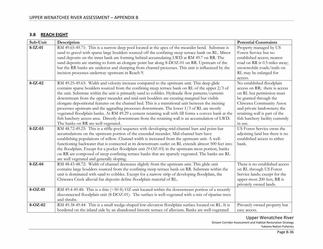
3.8 REACH EIGHT Sub-Unit Description Potential Constraints 8-IZ-01 RM 49.65-49.71: This is a narrow deep pool located at the apex of the meander bend. Substrate is
sand to gravel with sparse large boulders sourced off the confining steep terrace bank on RL. Minor sand deposits on the inner bank are forming behind accumulating LWD at RM 49.7 on RR. The sand deposits are starting to form an elongate point bar along 8-DOZ-01 on RR. Upstream of the bar the RR banks are undercut and slumping from channel processes. This unit is influenced by the incision processes underway upstream in Reach 9.
Property managed by US Forest Service but no established access; nearest road on RR is 0.5 miles away; snowmobile roads/trails on RL may be enlarged for access.
8-IZ-02 RM 49.25-49.65: Width and velocity increase compared to the upstream unit. This deep glide contains sparse boulders sourced from the confining steep terrace bank on RL of the upper 2/3 of the unit. Substrate within the unit is primarily sand to cobbles. Hydraulic flow patterns/currents downstream from the upper meander and mid-unit boulders are creating marginal but visible elongate depositional features on the channel bed. This is a transitional unit between the incising processes upstream and the aggrading processes downstream. The lower 1/3 of RL are mostly vegetated floodplain banks. At RM 49.29 a cement retaining wall with fill forms a convex bank at the fish hatchery access area. Directly downstream from the retaining wall is an accumulation of LWD. The banks on RR are well-vegetated.
No established floodplain access on RR; there is access on RL but permission must be granted through the Chiwawa Community Assoc and private landowners; the retaining wall is part of the fish hatchery facility currently in use.
8-IZ-03 RM 48.72-49.25: This is a riffle-pool sequence with developing mid-channel bars and point-bar accumulations on the upstream portion of the extended meander. Mid-channel bars have establishing populations of willow. Channel width is increased from the upstream unit. A well-functioning backwater that is connected at its downstream outlet on RL extends almost 500 feet into the floodplain. Except for a pocket floodplain unit (9-OZ-03) in the upstream-most portion, banks on RR are composed of steep confining terrace banks that are sparsely vegetated. The banks are RL are well vegetated and generally sloping.
US Forest Service owns the adjoining land but there is no established access to either bank.
8-IZ-04 RM 48.43-48.72: Width of channel decreases slightly from the upstream unit. This glide unit contains large boulders sourced from the confining steep terrace bank on RR. Substrate within the unit is dominated with sand to cobbles. Except for a narrow strip of developing floodplain, the Chiwawa Creek alluvial fan deposits define floodplain material of RL.
There is no established access on RL through US Forest Service lands; except for the upper-most 200 feet, RR is privately owned lands.
8-OZ-01 RM 49.4-49.48: This is a thin (~50 ft) OZ unit located within the downstream portion of a recently disconnected floodplain unit (8-DOZ-01). The surface is well-vegetated with a mix of riparian trees and shrubs.
8-OZ-02 RM 49.38-49.44: This is a small wedge-shaped low-elevation floodplain surface located on RL. It is bordered on the inland side by an abandoned historic terrace of alluvium. Banks are well-vegetated
Privately owned property but easy access.
UPPER WENATCHEE RIVER ASSESSMENT – APPENDIX B
Upper Wenatchee River Stream Corridor Assessment and Habitat Restoration Strategy
Yakama Nation Fisheries Page B-37
with mixed trees and shrubs. Some vegetation clearing associated with home-site development above this unit has occurred but the alterations are not impeding inundation or channel-side vegetation.
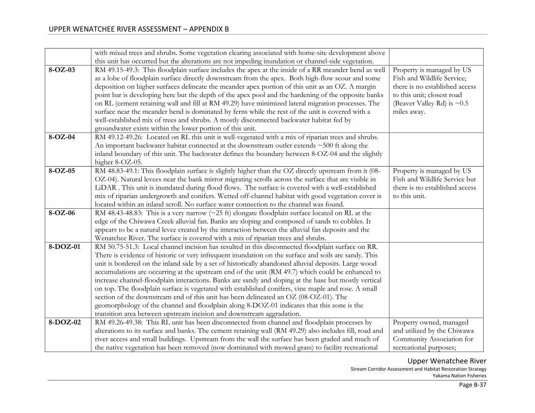
8-OZ-03 RM 49.15-49.3: This floodplain surface includes the apex at the inside of a RR meander bend as well as a lobe of floodplain surface directly downstream from the apex. Both high-flow scour and some deposition on higher surfaces delineate the meander apex portion of this unit as an OZ. A margin point bar is developing here but the depth of the apex pool and the hardening of the opposite banks on RL (cement retaining wall and fill at RM 49.29) have minimized lateral migration processes. The surface near the meander bend is dominated by ferns while the rest of the unit is covered with a well-established mix of trees and shrubs. A mostly disconnected backwater habitat fed by groundwater exists within the lower portion of this unit.
Property is managed by US Fish and Wildlife Service; there is no established access to this unit; closest road (Beaver Valley Rd) is ~0.5 miles away.
8-OZ-04 RM 49.12-49.26: Located on RL this unit is well-vegetated with a mix of riparian trees and shrubs. An important backwater habitat connected at the downstream outlet extends ~500 ft along the inland boundary of this unit. The backwater defines the boundary between 8-OZ-04 and the slightly higher 8-OZ-05.
8-OZ-05 RM 48.83-49.1: This floodplain surface is slightly higher than the OZ directly upstream from it (08-OZ-04). Natural levees near the bank mirror migrating scrolls across the surface that are visible in LiDAR . This unit is inundated during flood flows. The surface is covered with a well-established mix of riparian undergrowth and conifers. Wetted off-channel habitat with good vegetation cover is located within an inland scroll. No surface water connection to the channel was found.
Property is managed by US Fish and Wildlife Service but there is no established access to this unit.
8-OZ-06 RM 48.43-48.83: This is a very narrow (~25 ft) elongate floodplain surface located on RL at the edge of the Chiwawa Creek alluvial fan. Banks are sloping and composed of sands to cobbles. It appears to be a natural levee created by the interaction between the alluvial fan deposits and the Wenatchee River. The surface is covered with a mix of riparian trees and shrubs.
8-DOZ-01 RM 50.75-51.3: Local channel incision has resulted in this disconnected floodplain surface on RR. There is evidence of historic or very infrequent inundation on the surface and soils are sandy. This unit is bordered on the inland side by a set of historically abandoned alluvial deposits. Large wood accumulations are occurring at the upstream end of the unit (RM 49.7) which could be enhanced to increase channel-floodplain interactions. Banks are sandy and sloping at the base but mostly vertical on top. The floodplain surface is vegetated with established conifers, vine maple and rose. A small section of the downstream end of this unit has been delineated an OZ (08-OZ-01). The geomorphology of the channel and floodplain along 8-DOZ-01 indicates that this zone is the transition area between upstream incision and downstream aggradation.
8-DOZ-02 RM 49.26-49.38: This RL unit has been disconnected from channel and floodplain processes by alterations to its surface and banks. The cement retaining wall (RM 49.29) also includes fill, road and river access and small buildings. Upstream from the wall the surface has been graded and much of the native vegetation has been removed (now dominated with mowed grass) to facility recreational
Property owned, managed and utilized by the Chiwawa Community Association for recreational purposes;

UPPER WENATCHEE RIVER ASSESSMENT – APPENDIX B
Upper Wenatchee River Stream Corridor Assessment and Habitat Restoration Strategy
Yakama Nation Fisheries Page B-38
activities. The banks are marginally vegetated and steep. The inland side of this unit is bordered by notably higher terraces of alluvium and glacial deposits where residential home-sites and road development dominate the landscape.
retaining walls and related structures are currently in use.
8-DOZ-03 RM 48.43-48.56: This is a relatively low-elevation floodplain surface on RR that has been significantly altered by development. Disconnection has occurred as a result of road building, fill and grading, vegetation removal/alteration and home-site construction. The inland side of the unit is bordered by historically abandoned terrace deposits and road fill from the construction of Beaver Valley Rd.
Private properties are currently occupied and transportation routes are in use.
UPPER WENATCHEE RIVER ASSESSMENT – APPENDIX B
Upper Wenatchee River Stream Corridor Assessment and Habitat Restoration Strategy
Yakama Nation Fisheries Page B-39
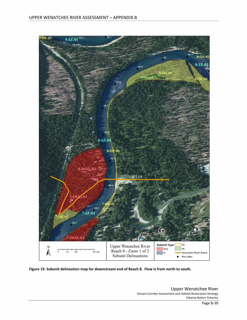
Figure 19. Subunit delineation map for downstream end of Reach 8. Flow is from north to south.

UPPER WENATCHEE RIVER ASSESSMENT – APPENDIX B
Upper Wenatchee River Stream Corridor Assessment and Habitat Restoration Strategy
Yakama Nation Fisheries Page B-40
Figure 20. Subunit delineation map for upstream end of Reach 8.
UPPER WENATCHEE RIVER ASSESSMENT – APPENDIX B
Upper Wenatchee River Stream Corridor Assessment and Habitat Restoration Strategy
Yakama Nation Fisheries Page B-41
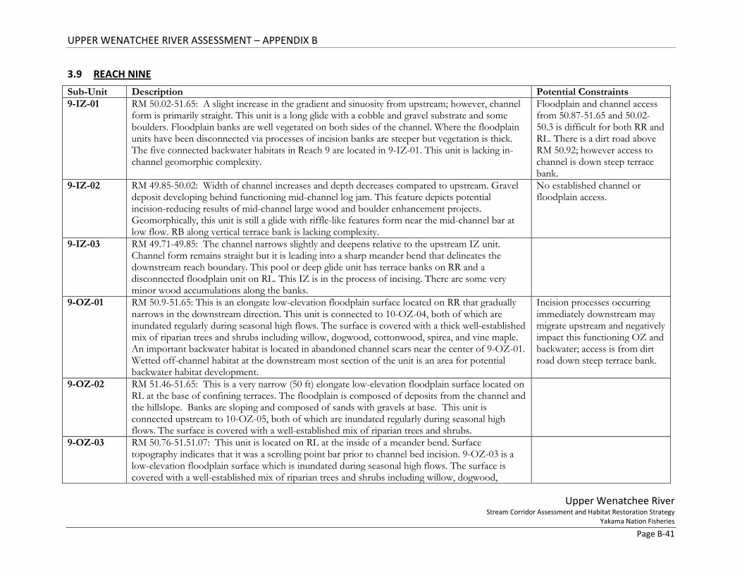
3.9 REACH NINE Sub-Unit Description Potential Constraints 9-IZ-01 RM 50.02-51.65: A slight increase in the gradient and sinuosity from upstream; however, channel
form is primarily straight. This unit is a long glide with a cobble and gravel substrate and some boulders. Floodplain banks are well vegetated on both sides of the channel. Where the floodplain units have been disconnected via processes of incision banks are steeper but vegetation is thick. The five connected backwater habitats in Reach 9 are located in 9-IZ-01. This unit is lacking in-channel geomorphic complexity.
Floodplain and channel access from 50.87-51.65 and 50.02-50.3 is difficult for both RR and RL. There is a dirt road above RM 50.92; however access to channel is down steep terrace bank.
9-IZ-02 RM 49.85-50.02: Width of channel increases and depth decreases compared to upstream. Gravel deposit developing behind functioning mid-channel log jam. This feature depicts potential incision-reducing results of mid-channel large wood and boulder enhancement projects. Geomorphically, this unit is still a glide with riffle-like features form near the mid-channel bar at low flow. RB along vertical terrace bank is lacking complexity.
No established channel or floodplain access.
9-IZ-03 RM 49.71-49.85: The channel narrows slightly and deepens relative to the upstream IZ unit. Channel form remains straight but it is leading into a sharp meander bend that delineates the downstream reach boundary. This pool or deep glide unit has terrace banks on RR and a disconnected floodplain unit on RL. This IZ is in the process of incising. There are some very minor wood accumulations along the banks.
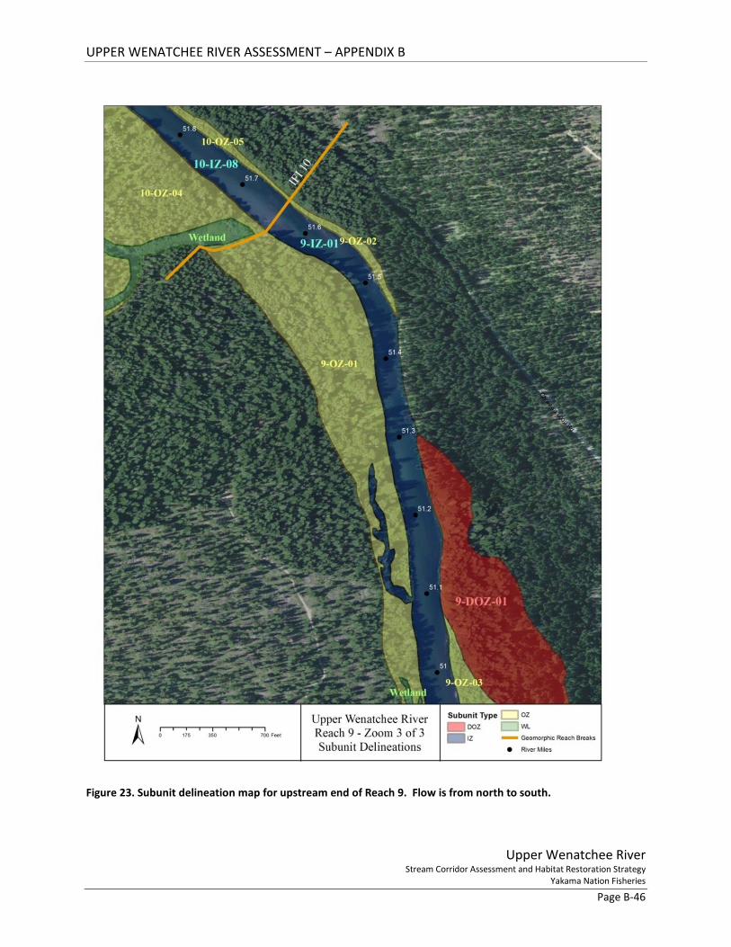
9-OZ-01 RM 50.9-51.65: This is an elongate low-elevation floodplain surface located on RR that gradually narrows in the downstream direction. This unit is connected to 10-OZ-04, both of which are inundated regularly during seasonal high flows. The surface is covered with a thick well-established mix of riparian trees and shrubs including willow, dogwood, cottonwood, spirea, and vine maple. An important backwater habitat is located in abandoned channel scars near the center of 9-OZ-01. Wetted off-channel habitat at the downstream most section of the unit is an area for potential backwater habitat development.
Incision processes occurring immediately downstream may migrate upstream and negatively impact this functioning OZ and backwater; access is from dirt road down steep terrace bank.
9-OZ-02 RM 51.46-51.65: This is a very narrow (50 ft) elongate low-elevation floodplain surface located on RL at the base of confining terraces. The floodplain is composed of deposits from the channel and the hillslope. Banks are sloping and composed of sands with gravels at base. This unit is connected upstream to 10-OZ-05, both of which are inundated regularly during seasonal high flows. The surface is covered with a well-established mix of riparian trees and shrubs.
9-OZ-03 RM 50.76-51.51.07: This unit is located on RL at the inside of a meander bend. Surface topography indicates that it was a scrolling point bar prior to channel bed incision. 9-OZ-03 is a low-elevation floodplain surface which is inundated during seasonal high flows. The surface is covered with a well-established mix of riparian trees and shrubs including willow, dogwood,
UPPER WENATCHEE RIVER ASSESSMENT – APPENDIX B
Upper Wenatchee River Stream Corridor Assessment and Habitat Restoration Strategy
Yakama Nation Fisheries Page B-42
cottonwood, spirea, and vine maple. An important backwater habitat is located at the downstream end in an historic point bar scrolls.
9-OZ-04 RM 50.57-50.74: This unit is located on RR at the inside of a minor meander bend. The surface is inundated during high flow events. A thick well-established mix of riparian trees and shrubs including willow, dogwood, cottonwood, spirea, and vine maple populate the surface. An important backwater habitat is located in what appears to be an abandoned secondary channel scar that extends along the inland side of the lower 2/3 of the unit.
9-OZ-05 RM 50.3-50.5: This low-elevation floodplain surface is located on RR. It is bordered on the inland side by a steep bank of road fill associated with the construction of Beaver Valley Road. The surface is covered with a thick well-established mix of riparian vegetation dominated by dogwood and spirea. Wetted off-channel habitat (~1.5 acres) with good vegetation cover and sedges is located inland at RM 50.35. No surface water connection to the channel was found. Channel incision combined with infilling (aided by the roughness from the thick vegetation cover) has disconnected these backwaters. Good road access to this area.
There is no clear inlet or outlet for reactivation; would need to design something that is not naturally defined on the landscape. Area may be influenced by road fill.
9-OZ-06 RM 50.02 – 50.28: This unit is located on RL at the inside of a meander bend. Surface topography indicates that it was a scrolling point bar prior to channel bed incision. 9-OZ-06 is a low-elevation floodplain surface which is inundated during seasonal high flows. The surface is covered with a well-established mix of riparian trees and shrubs including willow, dogwood, cottonwood, spirea, and vine maple. Two connected backwater habitats are located at the downstream end in historic point bar scrolls.
Access to the floodplain unit is easy but access across it to the backwater outlet would need to be constructed which could harm riparian vegetation communities.
9-DOZ-01 RM 50.75-51.3: Minimal channel incision here makes this a relatively new disconnected floodplain surface. It is considered a transitional unit between an OZ and a DOZ. There is minor evidence of historical or very infrequent inundation on the surface and soils are sandy and moist. An ephemeral stream from the hillslope is contributing to wetted areas on this unit. The floodplain surface is vegetated with a mix of conifers and thick riparian forest that include vine maple and equisetum. Continued incision processes will result in full abandonment of this RL unit. Restoring connectivity of 9-DOZ-01 is dependent on in-channel actions that reverse incision processes.
The dirt roads into this unit have long sections of standing water and mud difficult to cross with a high clearance 4x4 truck. Plans to traverse this unit to access restoration projects on it or other units will need to consider this.
9-DOZ-02 RM 50.45-50.79: Channel incision has made this a relatively new disconnected floodplain surface on RR. There is evidence of historic or very infrequent inundation (buried trunks of old trees and topography scarring) on the surface and soils are sandy. This unit is bordered on the inland side by a high terrace slope at the upstream most section and then by a steep bank of road fill associated with the construction of Beaver Valley Road. Standing water exists on landward side but it is not clear if the water is from hyporheic flow or hillslope/roadfill influenced. LWD accumulations are occurring at the upstream most end of the unit (RM 50.75) along the banks that could be enhanced to increase channel-floodplain interactions. Banks are vertical but loose and sandy with
Road access is near but steep; no current established access across floodplain.
UPPER WENATCHEE RIVER ASSESSMENT – APPENDIX B
Upper Wenatchee River Stream Corridor Assessment and Habitat Restoration Strategy
Yakama Nation Fisheries Page B-43
healthy stands of hawthorne, snowberry, and dogwood. The floodplain surface is vegetated with established conifers (fir, cedar, pine) and vine maple. Continued incision processes will result in full abandonment of this unit. Restoring connectivity of 9-DOZ-02 is dependent on in-channel actions that reverse incision processes.
9-DOZ-03 RM 50.33-50.7: This unit has been disconnected from channel and floodplain processes by the construction of Beaver Valley Rd. It is bordered on the inland side by high and steep Quaternary terrace deposits. An ephemeral stream from the hillslope contributes to soil moisture here. This unit is vegetated with mixed conifers, deciduous trees and shrubs.
This transportation route is currently in use.
9-DOZ-04 RM 49.69-50.53: Channel incision has made this a disconnected floodplain surface on RL. Topography scarring and sandy soils indicate that historic inundation did occur here. An ephemeral tributary that exits at RM 49.8 has a hanging outlet. This unit is bordered on the inland side by a high terrace of Pleistocene glacial deposits. US Forest Services dirt roads cross the surface at the up and downstream ends and traverse the length of the unit parallel to the channel. A maintained trail connects at the downstream end into the road system. Banks are marginally vegetated, sandy and steep. The floodplain surface is vegetated with mixed conifers including pine and fir with sparser understory of deciduous vine maple and other transitional shrubs. Restoring connectivity of 9-DOZ-04 is dependent on in-channel actions that reverse incision processes.
US Forest Service access roads. Projects in channel and on adjoining floodplain units will likely utilize these roads.

UPPER WENATCHEE RIVER ASSESSMENT – APPENDIX B
Upper Wenatchee River Stream Corridor Assessment and Habitat Restoration Strategy
Yakama Nation Fisheries Page B-44
Figure 21. Subunit delineation map for downstream end of Reach 9. Flow is from west to east.

UPPER WENATCHEE RIVER ASSESSMENT – APPENDIX B
Upper Wenatchee River Stream Corridor Assessment and Habitat Restoration Strategy
Yakama Nation Fisheries Page B-45
Figure 22. Subunit delineation map for upstream end of Reach 9. Flow is from northwest to southeast.
UPPER WENATCHEE RIVER ASSESSMENT – APPENDIX B
Upper Wenatchee River Stream Corridor Assessment and Habitat Restoration Strategy
Yakama Nation Fisheries Page B-46
Figure 23. Subunit delineation map for upstream end of Reach 9. Flow is from north to south.

UPPER WENATCHEE RIVER ASSESSMENT – APPENDIX B
Upper Wenatchee River Stream Corridor Assessment and Habitat Restoration Strategy
Yakama Nation Fisheries Page B-47
3.10 REACH TEN Sub-Unit Description Potential Constraints Nason-IZ-01
RM 53.67: The lower-most 0.18 river miles of Nason Creek. Nason-IZ-01 has a substrate of cobbles to sands. At the confluence on river-right is a large gravel to sand point bar with well-established scroll bars. Active high-water scour occurs behind the willow-vegetated scrolls defining the inland boundary of this unit. Nason Creek deepens on its left side as it approaches the confluence. There is a well-established backwater with sandy banks off of Nason Creek on river-left (0.03 RM Nason). The backwater inlet connection is at the downstream end of an abandoned channel scar and its wetted area extends the length of the river-left floodplain surface to the terrace boundary. It is possible that some hyporheic inputs to this backwater are from the Wenatchee River but it is most likely that it is primarily fed from Nason Creek.
Access from Hwy 207 on river-right is across privately owned property that is located on fill being protected by the river-right riprap. No access roads currently constructed to sites on river-left.
10-IZ-01 RM 53.39-53.67: This is a low-gradient unit with subtle riffle-pool characteristics. The pools are shallow. The substrate ranges from cobbles to sands. Island bar development near the confluence is influenced by sediment inputs from Nason Creek. Cement abutments and large granite boulder riprap and spurs constrict the channel at the Hwy 207 bridge (RM 53.57). The left bank is a steep glacial deposit terrace. Right bank is low elevation, moderately sloping sands to cobbles with heavily altered vegetation due to dense residential development.
Transportation features (Hwy 207 and bridge) are currently in use. The retaining wall, riprap, and dock on river-right are on privately owned lands.
10-IZ-02 RM 53.24-53.39: Channel morphology is classified as a low gradient, plane-bed deep glide unit. There are no depositional features within the zone. Channel banks on river-left are steep terraces with minor wood inputs. River-right are low but vertical banks of sands and cobbles with heavily altered vegetation and bank hardening features due to dense residential development
No access road to river-left. River-right is privately owned and occupied.
10-IZ-03 RM 52.66-53.39: This low gradient unit expresses a subtle riffle-glide sequence and a slightly greater channel width relative to 10-IZ-02. Substrate ranges from cobbles to sands with plentiful gravels. Few sparse boulders are present. An elongate mid-channel gravel bar with wood accumulating at the apex and establishing vegetation is located in the widest section of the unit at RM 52.8-52.9. A small functioning backwater on river-left is connected to 10-IZ-03 at a downstream outlet at RM 52.95. Except for the upstream most 0.05 miles of a steep terrace bank, the channel banks on river-left are low, sloping and composed of sands and cobbles. River-right are low but vertical banks composed of sands and cobbles with heavily altered vegetation and bank hardening features due to dense residential development. At RM 52.86-53.05 on river-right is an extended section of riprapped bank constructed of large granite boulders, kitchen appliances, cement, and gravel filled gabions as well as three large granite boulder spurs.
No good access road to river-left. River-right is privately owned and occupied. Existing riprap and retaining walls are currently protecting residential homes.
10-IZ-04 RM 52.7: This backwater complex is connected to the mainstem Wenatchee River via surface water and potential hyporheic flow from upstream. It is massive enough in scale (~ 1.8 acres) and unique enough in character that it has been designated a separate IZ unit. This unit occupies interconnected abandoned scrolls on the low elevation floodplain pocket (10-OZ-02) on river-left. This extensive backwater has

UPPER WENATCHEE RIVER ASSESSMENT – APPENDIX B
Upper Wenatchee River Stream Corridor Assessment and Habitat Restoration Strategy
Yakama Nation Fisheries Page B-48
several interconnected coves. Bordering and within the unit is a mature mix of riparian and wetland vegetation that includes willow, dogwood, hawthorne, sedges, rushes and aquatic macrophytes. The mouth of this backwater unit where it joins the Wenatchee River is ~ 365 feet across.
10-IZ-05 RM 52.52-52.66: This unit is a short deep narrow pool. Substrate ranges from large boulders to coarse sands. River-right is a well-vegetated sloping bank. River-left is a steep high terrace composed of glacial deposits. The steep terrace bank is a sediment source for the channel. The large boulders within this channel unit are from localized glacial deposits.
10-IZ-06 RM 52.05-52.52: Channel morphology is classified as a riffle-pool sequence that is geomorphically more complex and slightly wider than the up and downstream IZ units. Substrate of 10-IZ-06 ranges from small cobbles to sands with plentiful gravels. An elongate mid-channel gravel bar with transverse bar characteristics and establishing vegetation is located in the widest section of the unit at RM 52.4-52.5. A large left bank point bar of gravels and sands and laterally migrating scrolls is located at RM 52.18-52.3. River-left channel bank is a steep glacial deposit terrace at RM 52.05-52.11. From RM 52.11-52.52 the channel bank on river-left is sloping and well vegetated with mixed riparian trees and shrubs. River-right is a low semi-vertical bank with minimal vegetation alterations at RM 52.28-52.52 and well established vegetation at RM 52.05-52.28.
Road access on river-right is through privately owned properties. RM 52.35 is owned by people interested in restoration work.
10-IZ-07 RM 52.12: This backwater complex is connected to the mainstem Wenatchee River via surface water and potential hyporheic flow from upstream. A small tributary stream also feeds this unit from the adjacent hillslope. 10-IZ-07 is massive enough in scale (~ 3.7 acres) and unique enough in character that it has been designated a separate IZ unit. This unit occupies interconnected abandoned scrolls on the low elevation floodplain pocket (10-OZ-03) on river-left. This extensive backwater has several interconnected coves. Bordering and within the unit is a mature mix of riparian and wetland vegetation that includes willow, dogwood, hawthorne, sedges, rushes and aquatic macrophytes. The mouth of this backwater unit where it joins the Wenatchee River is ~ 280 feet across.
10-IZ-08 RM 51.65-52.52: Channel morphology is low gradient, straight, plane-bed glide. Substrate ranges from small cobbles to sands. This unit is lacking habitat and geomorphic complexity. River-right is a low semi-vertical bank with well-established vegetation. River-left has a narrow strip of low elevation floodplain banks that are well vegetated with mixed riparian species at RM 51.65-51.9. Otherwise, river-left is a high steep terrace of glacial deposits that acts as a source of sediment and LWD to the system. There are no depositional features within the active channel unit.
No established road access to channel.
10-OZ-01 RM 53.57-53.67: This is a low elevation floodplain surface located at the downstream side of the confluence of Nason Creek and the Wenatchee River. Extending from 10-OZ-01 is a developing gravel point bar. This surface is frequently seasonally inundated. Visible splay channels across the middle of this unit indicate that occasional high flow events have scoured this surface. Vegetation is successional with elongate bands of willow established along the tops of the scrolls. The older more mature vegetation occurs on the inland side of the unit.
UPPER WENATCHEE RIVER ASSESSMENT – APPENDIX B
Upper Wenatchee River Stream Corridor Assessment and Habitat Restoration Strategy
Yakama Nation Fisheries Page B-49
10-OZ-02 RM 52.63-53.15: This is a low elevation floodplain surface located on river-left. The surface is well-vegetated with established riparian trees and shrubs including willow, dogwood, cottonwood, spirea, and vine maple. Significant backwater complexes exist within the 10-OZ-02 floodplain unit.
No established road access to the floodplain unit.
10-OZ-03 RM 52.63-53.15: This is a low elevation floodplain surface located on river-left. The surface is well-vegetated with established riparian trees and shrubs including willow, dogwood, cottonwood, spirea, and vine maple. A significant backwater complex exists within the 10-OZ-03 floodplain unit.
No established road access to the floodplain unit.
10-OZ-04 RM 51.65-52.28: This is a wide, low elevation floodplain surface that is inundated frequently. The surface is covered with a thick well-established mix of riparian trees and shrubs. Significant off-channel habitat located in abandoned channel scars exist across this floodplain unit and the inland side of 10-DOZ-03. Most of the off-channel habitat is currently functioning as well developed wetlands that receive ground water influx from adjacent upland surfaces and hyporheic flow from the Wenatchee River. An inlet at RM 51.65 connects a downstream section of this habitat at high flows creating a seasonal backwater.
No established road access to downstream section; there is road access to upstream section; properties are private but people are interested in restoration work.
10-OZ-05 RM 51.65-51.9: This is a very narrow (50 ft) elongate low-elevation floodplain surface located on RL at the base of confining terraces. The floodplain is composed of deposits from the channel and the hillslope. This unit is connected downstream to 9-OZ-02, both of which are inundated regularly during seasonal high flows. The surface is covered with a well-established mix of riparian trees and shrubs.
10-DOZ-01
RM 53.57-53.6: The surface of this unit has experienced significant alterations. Large quantities of fill have been added and buildings with parking lots have been constructed on top of most of this unit. The land side of unit 10-DOZ-01 is bordered by Hwy 207. Besides a few trees and shrubs near the bank all natural riparian vegetation has been altered. Riprap boulders have been placed along the length of the unit’s bank.
Properties are occupied, riprap is hardening bank to reduce channel migration into occupied surface; Hwy 207 is in use.
10-DOZ-02
RM 52.6-53.57: The surface of this unit has been significantly altered. Hwy 207 borders its upstream end, successfully reducing the inputs of hyporheic and discharge events from Nason Creek and the upper Wenatchee to this surface. At the upstream land side, additional fill has been added to the surface and buildings with parking lots have been constructed. A large berm of graded fill material (~0.2 acres) acts as an additional barrier. The remainder of the floodplain surface is low elevation with sand dominated soils. Disconnection has occurred as a result of relatively dense residential development that includes roads, fill and grading, vegetation removal/alteration, riprap and retaining walls, and home-sites.
Properties are occupied, riprap is hardening bank to reduce channel migration into occupied surface, Hwy 207 is in use.
10-DOZ-03
RM 52.28-52.6: This is a wide low elevation floodplain surface with silty-loam dominated soils. This surface is moderately altered. Inundation occurs regularly but the surface is not functioning as connected floodplain habitat. Disconnection has occurred as a result of some residential development that includes roads, fill and grading, minor vegetation removal/alteration and home-site construction. The inland side of this unit contains extensive functioning wetland complexes that receive ground water influx from adjacent upland surfaces and hyporheic flow from the river. At RM 52.35 R large boulder riprap and road grade material currently block a potential high-water backwater inlet.
Properties are privately owned but people are interested in restoration work.
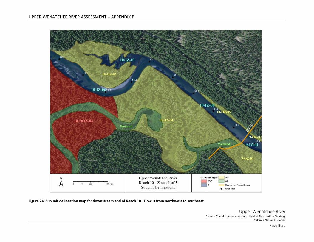
UPPER WENATCHEE RIVER ASSESSMENT – APPENDIX B
Upper Wenatchee River Stream Corridor Assessment and Habitat Restoration Strategy
Yakama Nation Fisheries Page B-50
Figure 24. Subunit delineation map for downstream end of Reach 10. Flow is from northwest to southeast.
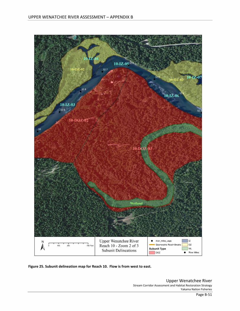
UPPER WENATCHEE RIVER ASSESSMENT – APPENDIX B
Upper Wenatchee River Stream Corridor Assessment and Habitat Restoration Strategy
Yakama Nation Fisheries Page B-51
Figure 25. Subunit delineation map for Reach 10. Flow is from west to east.

UPPER WENATCHEE RIVER ASSESSMENT – APPENDIX B
Upper Wenatchee River Stream Corridor Assessment and Habitat Restoration Strategy
Yakama Nation Fisheries Page B-52
Figure 26. Subunit delineation map for the upstream end of Reach 10. Flow is from west to northeast.
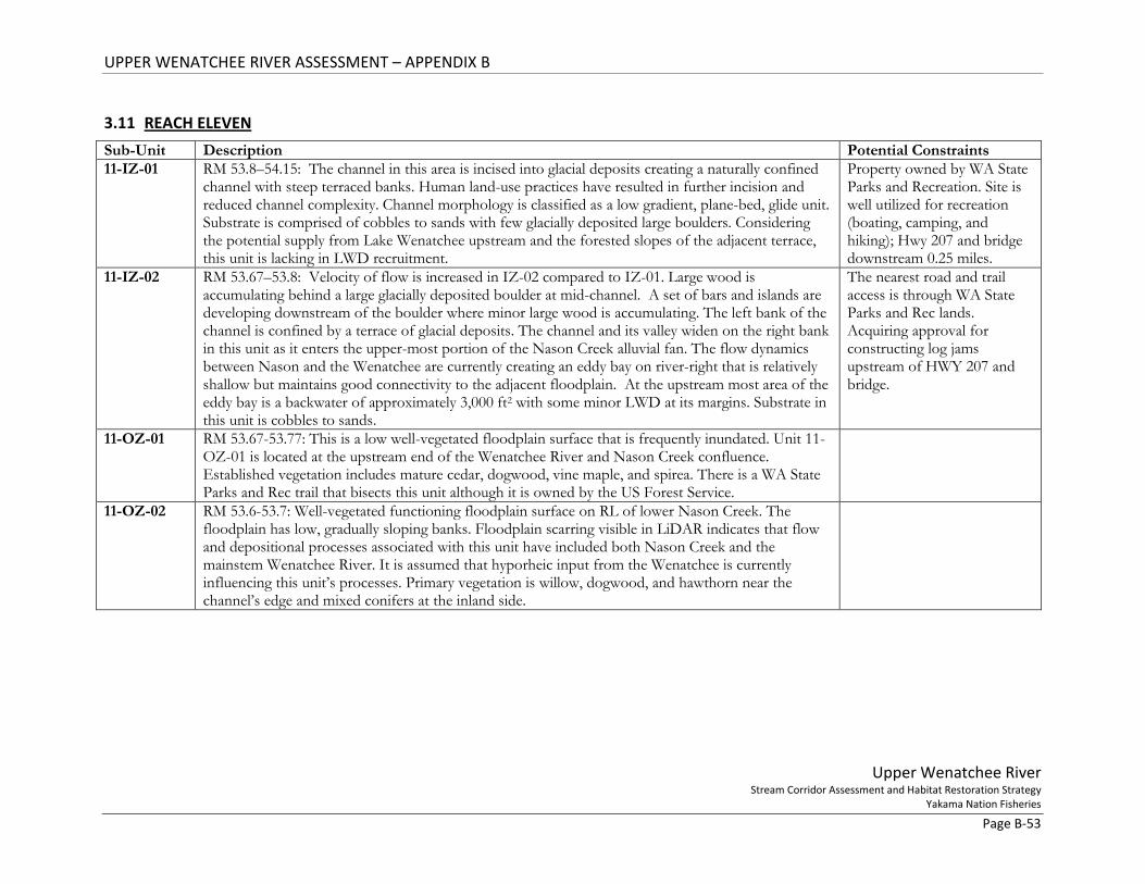
UPPER WENATCHEE RIVER ASSESSMENT – APPENDIX B
Upper Wenatchee River Stream Corridor Assessment and Habitat Restoration Strategy
Yakama Nation Fisheries Page B-53
3.11 REACH ELEVEN Sub-Unit Description Potential Constraints 11-IZ-01 RM 53.8–54.15: The channel in this area is incised into glacial deposits creating a naturally confined
channel with steep terraced banks. Human land-use practices have resulted in further incision and reduced channel complexity. Channel morphology is classified as a low gradient, plane-bed, glide unit. Substrate is comprised of cobbles to sands with few glacially deposited large boulders. Considering the potential supply from Lake Wenatchee upstream and the forested slopes of the adjacent terrace, this unit is lacking in LWD recruitment.
Property owned by WA State Parks and Recreation. Site is well utilized for recreation (boating, camping, and hiking); Hwy 207 and bridge downstream 0.25 miles.
11-IZ-02 RM 53.67–53.8: Velocity of flow is increased in IZ-02 compared to IZ-01. Large wood is accumulating behind a large glacially deposited boulder at mid-channel. A set of bars and islands are developing downstream of the boulder where minor large wood is accumulating. The left bank of the channel is confined by a terrace of glacial deposits. The channel and its valley widen on the right bank in this unit as it enters the upper-most portion of the Nason Creek alluvial fan. The flow dynamics between Nason and the Wenatchee are currently creating an eddy bay on river-right that is relatively shallow but maintains good connectivity to the adjacent floodplain. At the upstream most area of the eddy bay is a backwater of approximately 3,000 ft2 with some minor LWD at its margins. Substrate in this unit is cobbles to sands.
The nearest road and trail access is through WA State Parks and Rec lands. Acquiring approval for constructing log jams upstream of HWY 207 and bridge.
11-OZ-01 RM 53.67-53.77: This is a low well-vegetated floodplain surface that is frequently inundated. Unit 11-OZ-01 is located at the upstream end of the Wenatchee River and Nason Creek confluence. Established vegetation includes mature cedar, dogwood, vine maple, and spirea. There is a WA State Parks and Rec trail that bisects this unit although it is owned by the US Forest Service.
11-OZ-02 RM 53.6-53.7: Well-vegetated functioning floodplain surface on RL of lower Nason Creek. The floodplain has low, gradually sloping banks. Floodplain scarring visible in LiDAR indicates that flow and depositional processes associated with this unit have included both Nason Creek and the mainstem Wenatchee River. It is assumed that hyporheic input from the Wenatchee is currently influencing this unit’s processes. Primary vegetation is willow, dogwood, and hawthorn near the channel’s edge and mixed conifers at the inland side.
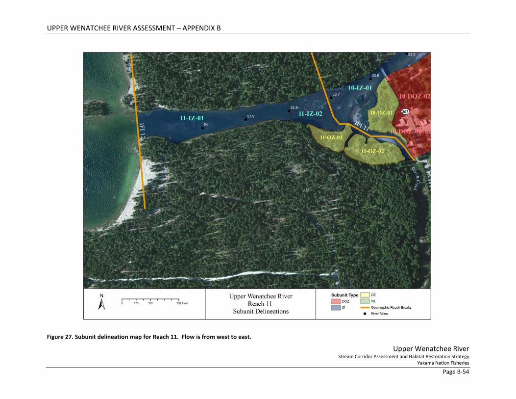
UPPER WENATCHEE RIVER ASSESSMENT – APPENDIX B
Upper Wenatchee River Stream Corridor Assessment and Habitat Restoration Strategy
Yakama Nation Fisheries Page B-54
Figure 27. Subunit delineation map for Reach 11. Flow is from west to east.
UPPER WENATCHEE RIVER ASSESSMENT – APPENDIX B
Upper Wenatchee River Stream Corridor Assessment and Habitat Restoration Strategy
Yakama Nation Fisheries Page B-55
4 REFERENCES
US Bureau of Reclamation (USBR). 2009. Stormy Reach Assessment – Entiat River. US Department of the Interior, Bureau of Reclamation, Pacific Northwest Region, Boise, ID.