Embed Size (px)
Citation preview

Appendix C
Data Tables Table C-1 Summary of precincts and investigation locations
Table C-2 Main geological and hydrogeological units and their characteristics
Table C-3 Groundwater segments and TDS
Table C-4 Main geological and hydrostratigraphic units and groundwater salinity
Table C-5 Acid sulfate soils and acid sulfate rock rating of geological units (soil and rock)
Table C-6 Summary of inorganic contaminants – tunnels
Table C-7 Summary of organic contaminants – tunnels
Table C8 Groundwater corrosion parameters – tunnels
Table C-9 Summary of inorganic and organic contaminants – portals
Table C-10 Groundwater corrosion parameters – portals
Table C-11 Summary of inorganic contaminants - stations
Table C-12 Summary of organic contaminants – stations
Table C-13 Groundwater corrosion parameters – stations


Table C- 0-1 Summary of precincts and investigation locations
MMRA precinct (Areas of Interest)
Golder Associates Segment *
Boreholes Total number of soil boreholes
Number of soil samples (Fill/Natural)
Groundwater bores
Total number of groundwater bores
Western portal (WP)
1 GA11-BHE001, 002, GA11-BH001, 031
4
39 (15/24)
GA11-BH001, 031
2
2 GA11-BH002, 003, GA11-BHE003 2 GA11-BH002,
003 2
3 GA11-BH005,GA11-BHE004 2 GA11-BH005 1
Tunnels – Western portal – Arden station (WP-AS)
4 None 0
43 (8/35)
None 0
5 GA11-BH007, GA15-BH001, 002, 003, MM1-BH001
5
GA11-BH007, GA15-BH001, 002, 003, MM1-BH001
5
6 GA11-BH008 1 GA11-BH008 1
Arden station (AS)
6 GA11-BH009, GA15-BH004
2
99 (37/62)
GA11-BH009 1
7
GA11-BHE005, 006, 007, 008, 009, 010, 011, GA15-BH005, 006, MM1-BH002, 003
11 GA15-BH005, MM1-BH002, 003
3
8 MM1-BH004 1 MM1-BH004 1
Tunnels – Arden station – Parkville station (AS-PS)
8 GA11-BH011, 012, MM1-BH006 3
0
GA11-BH011, 12, MM1-BH006
3
9 GA11-BH013, MM1-BH007
2 GA11-BH013, MM1-BH007
2
Parkville station (PS)
9 MM1-BH008, GA11-BHE012, 013
3
16 (10/6)
MM1-BH008 1
10 MM1-BH009, GA11-BHE014, 015 3 MM1-BH009 1
11 - 0 - 0
Tunnels – Parkville station – CBD North station (PS-CN)
11 MM1-BH010, GA11-BH014 2 0 MM1-BH010,
GA11-BH014 2

MMRA precinct (Areas of Interest)
Golder Associates Segment *
Boreholes Total number of soil boreholes
Number of soil samples (Fill/Natural)
Groundwater bores
Total number of groundwater bores
CBD North station (CN)
11 GA15-BH007 1
73 (33/40)
GA15-BH007 1
12
GA15-BH008, 009, 009A, 010, 011, MM1-BH011, GA11-BHE016, 017, 018, 019
10 GA15-BH008, 009, 010, 011
4
13 GA15-BH012, 013 2 GA15-BH012 1
Tunnels – CBD North station – CBD South station (CN-CS)
13 MM1-BH012, GA15-BH017 2 3 (1/2) MM1-BH012 1
CBD South station (CS)
14
GA15-BH018, 019, 021, 021A, 108, 109, 110, 111, 112, MM1-BH013, GA11-BHE020, 021, 022, 023
14 37 (20/17)
GA15-BH018, 019, 021, 108, 109, 110, 111, 112, MM1-BH013
9
15 - 0 - 0
Tunnels – CBD South station – Domain station (CS-DS)
16
MM1-BH015, 016, 017, GA11-BHE028, GA11-BH017, 018, 041, GA15-BH024, 025, GA11-BH032, 033, 034, 035, 036, 037, 038, 039, GA11-PH006, 007
19
114 (42/72)
MM1-BH015, 016, 017, GA11-BH017, 018, 041
6
17 GA15-BH026, 120, 121, MM1-BH018 4
GA15- 120, 121, MM1-BH018
3
18 GA15-BH027, 028, 122, 123, MM1-BH019
5 GA15-BH027, 028, 122, 123, MM1-BH019
5
19 - 0 - 0
Domain station (DS)
19 - 0
72 (17/55)
- 0
20
GA11-BH019, 026, 027, GA15-BH029, 029A, 030, 031, 032, 033, GA11-BHE029, 030, 031, 032
13
GA11-BH019, 026, 027, GA15-BH029, 030, 031, 032, 033
8

MMRA precinct (Areas of Interest)
Golder Associates Segment *
Boreholes Total number of soil boreholes
Number of soil samples (Fill/Natural)
Groundwater bores
Total number of groundwater bores
21 MM1-BH020 1 MM1-BH020 1
Tunnels – Domain station – Eastern Portal (DS-EP)
21 GA11-BH020, 021, 022 3
0
GA11-BH020, 021, 022 3
22 GA11-BH023 1 GA11-BH023 1
Eastern Portal (EP)
23 GA11-BH024, 025, GA11-BHE033, 034
4 8 (5/3) GA11-BH024, 025
2
Totals 120 504 (188/316)
Total wells 70
* As shown in Appendix D

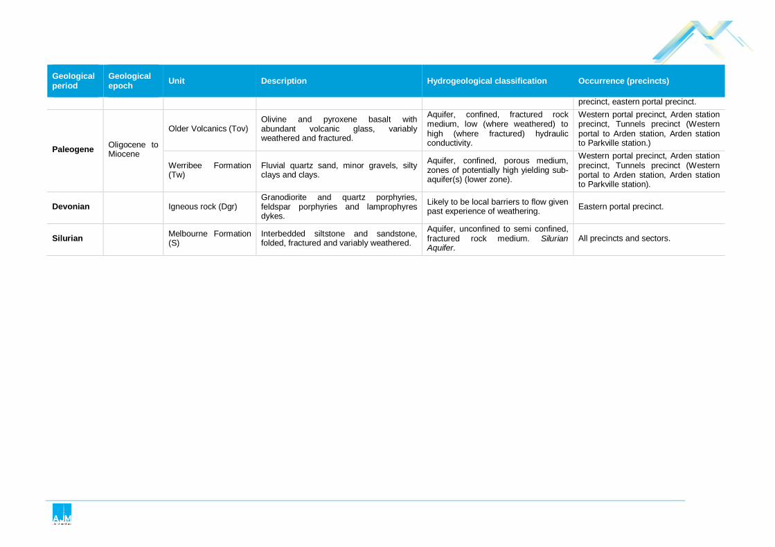
Table C- 0-2 Main geological and hydrogeological units and their characteristics (from Technical Appendix O Groundwater)
Geological period
Geological epoch Unit Description Hydrogeological classification Occurrence (precincts)
Quatrnary
Holocene
Coode Island Silt (Qc) Soft clayey sediments with shells and organic materials and lenses or thin layers of sandy material.
Aquitard, porous medium, due to presence of sand layers and lenses, horizontal hydraulic conductivity (Kh) greater than vertical (Kv).
Western portal precinct, Arden station precinct, Tunnels precinct (CBD South station to Domain station).
Pleistocene
Holocene Alluvium (Qha) Fine to medium-grained alluvial sands. Aquifer, confined, porous medium,
high yielding. Holocene Aquifer. Tunnels precinct (CBD South station to Domain station).
Jolimont Clay (Qj) Marine clay with minor silts and sands. Aquitard, porous medium. Tunnels precinct (CBD South station to Domain station).
Newer Volcanics (Qnv) (Burnley Basalt Flow)
Olivine basalt, variably weathered and fractured.
Aquifer, unconfined to semi confined, fractured rock medium, low (where weathered) to high (where fractured) hydraulic conductivity. Basalt Aquifer.
Tunnels precinct (CBD South station to Domain station).
Fishermans Bend Silt (Qf)
Clay and silt with some sands. Typically, proportion of sand is higher towards the base of the unit (lower Fishermans Bend Silt sub-unit), with clayey material encountered towards the top (Upper Fishermans Bend Silt sub-unit).
Aquitard (both upper and lower sub-units), porous medium, due to fissuring vertical hydraulic conductivity may be greater than horizontal.
Western portal precinct, Arden station precinct, Tunnels precinct (CBD South station to Domain station).
Moray Street Gravels (Qm)
Medium to coarse grained quartz sands with minor gravels, clay and silt.
Aquifer, confined, porous medium, high yielding.
Western portal precinct, Tunnels precinct (CBD South station to Domain station).
Fluvial Sediments (Qac)
Medium to coarse sands, gravels and clays with coarse inclusions of boulder and cobble size.
Aquifer, confined, porous medium, potentially high yielding (limited data available).
Western portal precinct, Arden station precinct, Tunnels precinct (CBD South station to Domain station).
Newer Volcanics (Qlv) (Lower Flow)
Olivine basalt variably weathered and fractured. Typically referred to as lower Newer Volcanics.
Aquifer of localised extent and low significance due to discontinuity of the unit (Golder Associates, 2013a). Confined, fractured rock medium, medium to low hydraulic conductivity.
Tunnels precinct (CBD South station to Domain station).
Neogene Pliocene Brighton Group (Tb) Sand, sandy clay, clayey sand, silt, clay and occasionally gravel.
Aquifer, unconfined, porous medium, medium-yielding aquifer where sandy but aquitard where clayey.
Tunnels precinct (Arden station to Parkville station, CBD South to Domain station, Domain station to eastern portal), Domain station
Geological period
Geological epoch Unit Description Hydrogeological classification Occurrence (precincts)
precinct, eastern portal precinct.
Paleogene Oligocene to Miocene
Older Volcanics (Tov) Olivine and pyroxene basalt with abundant volcanic glass, variably weathered and fractured.
Aquifer, confined, fractured rock medium, low (where weathered) to high (where fractured) hydraulic conductivity.
Western portal precinct, Arden station precinct, Tunnels precinct (Western portal to Arden station, Arden station to Parkville station.)
Werribee Formation (Tw)
Fluvial quartz sand, minor gravels, silty clays and clays.
Aquifer, confined, porous medium, zones of potentially high yielding sub-aquifer(s) (lower zone).
Western portal precinct, Arden station precinct, Tunnels precinct (Western portal to Arden station, Arden station to Parkville station).
Devonian Igneous rock (Dgr) Granodiorite and quartz porphyries, feldspar porphyries and lamprophyres dykes.
Likely to be local barriers to flow given past experience of weathering. Eastern portal precinct.
Silurian Melbourne Formation (S)
Interbedded siltstone and sandstone, folded, fractured and variably weathered.
Aquifer, unconfined to semi confined, fractured rock medium. Silurian Aquifer.
All precincts and sectors.

Table C- 0-3 : Groundwater segments and TDS
Groundwater segment Concentration of total dissolved solids (TDS mg/L)
A1 & A2 0-500 & 501-1000
B 1001-3500
C 3501-13000
D >13001
X Aquifer present - no project specific water quality data available
Table C- 0-4 Main geological and hydrostratigraphic units and groundwater salinity information (in mg/L)
Unit Western Portal
Tunnel (WP-AS)
Arden Station
Tunnel (AS-PS)
Parkville Station
Tunnel (PS-CN)
CBD North
Tunnel (CN-CS)
CBD South Station
Tunnel (CS-DS)
Domain Station
Tunnel (DS-EP)
Eastern Portal
Western Turnback
Coode Island Silt (Qhi) X X 25000 8100
Holocene Alluvium (Qha) X
Jolimont Clay (Qpj)
Newer Volcanics (Qvn) X X X
Pleistocene Alluvium (Qpa)
X X X
Fishermans Bend Silt Upper & Lower (Qpfu & Qpfl)
X 23000 8600 X 10000
Moray Street Gravels (Qpg)
30000 X 16000-27400
Early Pleistocene Colluvial and Alluvial Sediments (Qpc)
28000-38000
X X 17500
Newer Volcanics (Qvns) (Swan Street Basalt)
Brighton Group (Tpb) X 1500 X X X
Older Volcanics (Tov) 2100-8000
X X X

Unit Western Portal
Tunnel (WP-AS)
Arden Station
Tunnel (AS-PS)
Parkville Station
Tunnel (PS-CN)
CBD North
Tunnel (CN-CS)
CBD South Station
Tunnel (CS-DS)
Domain Station
Tunnel (DS-EP)
Eastern Portal
Western Turnback
Werribee Formation (Tew) 37000 44000 3000 X X
Igneous rock - Granite (Dgr) X
Melbourne Formation (Sud) X 25000 5800 4400-
10000 8800-12000
4300-5100
1400-4700 5100 1450-
5300 1300-8400
1600-10100
1300-7000
5000-5700 X

Table C- 0-5 Acid sulfate soils and acid sulfate rock rating of geological units (soil and rock)
Geological epoch Unit Description Occurrence (precincts)
Potential for acid sulfate soils and acid sulfate rock
Recent FILL Various. All precincts and tunnels Low – High.
Holocene Coode Island Silt (Qhi)
Soft clayey sediments with shells and organic materials and lenses or thin layers of sandy material.
Western portal, tunnel western portal – Arden station, Arden station, tunnel CBD South station – Domain station
High.
Pleistocene
Holocene Alluvium (Qha) Fine to medium grained alluvial sands. Tunnel CBD South station – Domain
station Medium
Jolimont Clay (Qpj) Marine clay with minor silts and sands. Tunnel CBD South station – Domain station
Medium
Newer Volcanics (Qvn) Olivine basalt, variably weathered and fractured. Tunnel CBD South station – Domain
station Low
Pleistocene Alluvium (Qpa)
Alluvial sediments typically comprising clay, silt and sand. The proportion of each of these materials is variable, with firm to stiff silty or sandy clay being dominant material.
Western portal, tunnel western portal – Arden station, Arden station Medium
Fishermens Bend Silt Upper & Lower (Qpfu & Qpfl)
Clay and silt with some sands. Typically, proportion of sand is higher towards the base of the unit (Lower Fishermens bend Silt sub-unit), with clayey material encountered towards the top (Upper Fishermens Bend Silt sub-unit).
Western portal, tunnel western portal – Arden station, Arden station, tunnel CBD South station – Domain station
Medium
Moray Street Gravels (Qpg) Medium to coarse grained quartz sands with minor gravels, clay and silt.
Western portal, tunnel western portal – Arden station, tunnel CBD South station – Domain station
Medium
Early Pleistocene Colluvial and Alluvial Sediments (Qpc)
Medium to coarse sands, gravels and clays with coarse clasts of boulder and cobble size.
Western portal, tunnel western portal – Arden station, Arden station, tunnel CBD South station – Domain station
Low

Geological epoch Unit Description Occurrence (precincts)
Potential for acid sulfate soils and acid sulfate rock
Newer Volcanics (Qvns) (Swan Street Basalt)
Olivine basalt variably weathered and fractured. Typically referred to as lower Newer Volcanics.
Tunnel CBD South station – Domain station Low
Pliocene Brighton Group (Tpb) Sand, sandy clay, clayey sand, silt, clay and occasionally gravel.
Tunnel western portal – Arden station, tunnel Arden station – Parkville station, Tunnel CBD South station – Domain station tunnel DS-EP, Domain station, eastern portal
Low - Medium
Oligocene to Miocene
Older Volcanics (Tov)
Olivine and pyroxene basalt with abundant volcanic glass, variably weathered and fractured.
Western portal, tunnel western portal – Arden station, Arden station, tunnel Arden station – Parkville station.
Low - Medium
Werribee Formation (Tew) Fluvial quartz sand, minor gravels, silty clays and clays.
Western portal, tunnel western portal – Arden station, Arden station, tunnel Arden station – Parkville station.
Medium – High
Devonian Igneous rock (Dgr) Granodiorite and quartz porphyries, feldspar porphyries and lamprophyres dykes. Eastern portal Low
Silurian Melbourne Formation (Sud) Interbedded siltstone and sandstone, folded, fractured and variably weathered. All precincts and tunnels
Low – highly weathered
High – fresh

Table C- 0-6 Summary of inorganic contaminants – tunnels
Precinct Well ID Aquifer monitored Date
Total Dissolved Solids
Ammonia (as N) Arsenic Iron Manganese Nickel Selenium
Units mg/L mg/L mg/L mg/L mg/L mg/L mg/L Drinking water (health/asethetic) -/600 -/0.5 (as
NH3) 0.01/- -/0.3 0.5/0.1 0.02/- 0.01/-
Tunnel (WP-AS) MM1-BH001 Quaternary Fluvial Sediments 2/07/2010 28000 0.052 0.1 8 0.05 0.24
Tunnel (WP-AS) MM1-BH001 Quaternary Fluvial Sediments 2/07/2010 28000 0.051 0.5 8.4 0.049 0.26
Tunnel (WP-AS) GA11-BH007 Werribee Formation 21/02/2012 37,200 6.3 <0.001 16.7 10.2 0.059 <0.01
Tunnel (WP-AS) GA11-BH008 Quaternary Fluvial Sediments 24/02/2012 38,000 49.4 22.9 1.92
Tunnel (WP-AS) GA15-BH001 Werribee Formation 3/07/2015 44,200 11.5 0.002 9.48 18 0.043 <0.02
Tunnel (WP-AS) GA15-BH002 Melbourne Formation 6/07/2015 25,300 1.13 0.012 3.87 0.154 0.024 <0.02
Tunnel (WP-AS) GA15-BH003 Quaternary Fluvial Sediments 6/07/2015 31,500 21 0.002 3.92 4.3 0.039 <0.02
Tunnel (AS-PS) MM1-BH006 Melbourne Formation 12/07/2010 10000 0.2
Tunnel (AS-PS) MM1-BH007 Melbourne Formation 12/07/2010 6700 0.009 2.8 0.15 0.006 0.052
Tunnel (AS-PS) GA11-BH011 Melbourne Formation 23/07/2013 5740 0.03 0.003 <0.05 0.758 0.018 0.02
Tunnel (AS-PS) GA11-BH013 Melbourne Formation 23/07/2013 4400 0.36 <0.05 0.342
Tunnel (PS-CN) MM1-BH010 Melbourne Formation 9/07/2010 4400 0.007 2.2 0.22 0.012 0.04
Tunnel (PS-CN) MM1-BH010 Melbourne Formation 9/07/2010 5100 <0.001 1.89 0.174 0.019 <0.01

Precinct Well ID Aquifer monitored Date
Total Dissolved Solids
Ammonia (as N) Arsenic Iron Manganese Nickel Selenium
Tunnel (PS-CN) GA11-BH014 Melbourne Formation 25/07/2013 4270 0.05 0.001 0.23 0.254 0.004 <0.01
Tunnel (CN-CS) MM1-BH012 Melbourne Formation 27/07/2010 5100 0.006 0.9 0.24 0.1 0.37
Tunnel (CS-DS) MM1-BH015 Moray Street Gravels 29/06/2010 16000 2.3
Tunnel (CS-DS) MM1-BH016 Fishermans Bend Silt 30/07/2010 10000 0.018 74 0.73 0.008 0.089
Tunnel (CS-DS) MM1-BH017 Coode Island Silt 29/06/2010 8100 10
Tunnel (CS-DS) MM1-BH018 Melbourne Formation 5/07/2010 1300
Tunnel (CS-DS) GA11-BH017 Moray Street Gravels 22/02/2012 25,000 59 0.08 1.14
Tunnel (CS-DS) GA11-BH018 Holocene Alluvium 8/07/2013 17,500 171 0.015 21 0.131 0.033 <0.01
Tunnel (CS-DS) GA11-BH041 Moray Street Gravels 23/07/2013 27,400 40.7 0.001 8.36 1.51 0.013 <0.01
Tunnel (CS-DS) GA15-BH120 Melbourne Formation 6/07/2015 1790 0.17 0.003 <0.05 0.108 0.068 <0.01
Tunnel (CS-DS) GA15-BH121 Melbourne Formation 20/08/2015 8380 0.26 0.013 0.84 0.016 0.007 <0.01
Tunnel (CS-DS) GA15-BH027 Melbourne Formation 20/08/2015 6650 0.14 0.001 <0.05 0.17 0.008 <0.01
Tunnel (CS-DS) GA15-BH028 Melbourne Formation 19/08/2015 4810 0.07 0.001 <0.05 0.285 0.013 <0.01
Tunnel (DS-EP) GA11-BH020 Melbourne Formation 18/01/2013 6220 0.07 8.54 0.623
Tunnel (DS-EP) GA11-BH021 Melbourne Formation 18/01/2013 1380 0.1 0.16 0.134
Tunnel (DS-EP) GA11-BH022 Melbourne Formation 18/01/2013 7000 <0.01 0.008 37 7.16 0.105 <0.01
Tunnel (DS-EP) GA11-BH023 Melbourne Formation 17/01/2013 5200 0.44 0.002 20.8 0.343 0.043

Table C- 0-7 Summary of organic contaminants – tunnels
Precinct Well ID Aquifer monitored Date 1,2,4-
TMB Benzene Toluene Xylenes (m & p)
Xylene (o)
Total Xylen
es
Total BTE
X
TRH < C9
TRH C10 - C36
TRH < C10
TRH C10 - C40
1,1-DCA
1,1-DCE
cis-1,2-DCE
PCE MEK
Units mg/L mg/L mg/L mg/L mg/L mg/L mg/L
mg/L mg/L mg/
L mg/L mg/L
mg/L
mg/L
mg/L mg/L
Drinking water (health/asethetic) 0.001/- 0.8/0.025 0.6/0.
02 0.09 0.09 0.03/-
0.06/-
Tunnel (WP-AS)
MM1-BH001
Quaternary Fluvial
Sediments 2/07/ 2010
<0.005 <0.001 <0.002 <0.002 <0.0
02 <0.00
2 <0.001
<0.02 <0.05 <0.
02 <0.1 <0.005
<0.005
<0.005
<0.005
Tunnel (WP-AS)
MM1-BH001
Quaternary Fluvial
Sediments 2/07/ 2010
<0.005 <0.001 <0.002 <0.002 <0.0
02 <0.00
2 <0.001
<0.02 <0.05 <0.
02 <0.1 <0.005
<0.005
<0.005
<0.005
Tunnel (WP-AS)
GA11-BH007
Werribee Formation
21/02/ 2012
<0.005 <0.001 <0.003 <0.002 <0.0
02 <0.00
2 <0.001
<0.02 0.22 <0.
02 0.18 <0.005
<0.005
<0.005
<0.005 <0.05
Tunnel (WP-AS)
GA11-BH008
Quaternary Fluvial
Sediments 24/02/ 2012
Tunnel (WP-AS)
GA15-BH001
Werribee Formation
3/07/2015
<0.005 <0.001 <0.002 <0.002 <0.0
02 <0.00
2 <0.001
<0.02 <0.05 <0.
02 <0.1 <0.005
<0.005
<0.005
<0.005 0.15
Tunnel (WP-AS)
GA15-BH002
Melbourne Formation
6/07/ 2015
Tunnel (WP-AS)
GA15-BH003
Quaternary Fluvial
Sediments 6/07/ 2015
<0.005 <0.001 <0.002 <0.002 <0.0
02 <0.00
2 <0.001
<0.02 <0.05 <0.
02 <0.1 <0.005
<0.005
<0.005
<0.005 0.19
Tunnel (AS-PS)
MM1-BH006
Melbourne Formation
12/07/ 2010
Tunnel (AS-PS)
MM1-BH007
Melbourne Formation
12/07/ 2010
<0.005 <0.001 <0.002 <0.002 <0.0
02 <0.00
2 <0.001
<0.02 <0.05 <0.
02 <0.1 <0.005
<0.005
<0.005
<0.005
Tunnel (AS-PS)
GA11-BH011
Melbourne Formation
23/07/ 2013
<0.005 <0.001 <0.002 <0.002 <0.0
02 <0.00
2 <0.001
<0.02 <0.05 <0.
02 <0.1 <0.005
<0.005
<0.005
<0.005 <0.05
Tunnel (AS-PS)
GA11-BH013
Melbourne Formation
23/07/ 2013

Precinct Well ID Aquifer monitored Date 1,2,4-
TMB Benzene Toluene Xylenes (m & p)
Xylene (o)
Total Xylen
es
Total BTE
X
TRH < C9
TRH C10 - C36
TRH < C10
TRH C10 - C40
1,1-DCA
1,1-DCE
cis-1,2-DCE
PCE MEK
Tunnel (PS-CN)
MM1-BH010
Melbourne Formation
9/07/2010
<0.005 <0.001 <0.002 <0.002 <0.0
02 <0.00
2 <0.001
<0.02 <0.05 <0.
02 <0.1 0.013
0.084
<0.005
<0.005
Tunnel (PS-CN)
MM1-BH010
Melbourne Formation
9/07/2010
<0.005 <0.001 <0.002 <0.002 <0.0
02 <0.00
2 <0.001
<0.02 <0.05 <0.
02 <0.1 0.016
0.071
<0.005
<0.005
Tunnel (PS-CN)
GA11-BH014
Melbourne Formation
25/07/2013
<0.005 <0.001 <0.002 <0.002 <0.0
02 <0.00
2 <0.001
<0.02 <0.05 <0.
02 <0.1 <0.005
<0.005
0.007
0.012 <0.05
Tunnel (CN-CS)
MM1-BH012
Melbourne Formation
27/07/2010
<0.005 <0.001 0.002 <0.002 <0.0
02 <0.00
2 <0.001
<0.02 <0.05 <0.
02 <0.1 <0.005
<0.005
<0.005
<0.005
Tunnel (CS-DS)
MM1-BH015
Moray Street
Gravels 29/06/2
010
Tunnel (CS-DS)
MM1-BH016
Fishermans Bend Silt
30/07/2010
<0.005 <0.001 <0.002 <0.002 <0.0
02 <0.00
2 <0.001
<0.02 <0.05 <0.
02 <0.1 <0.005
<0.005
<0.005
<0.005
Tunnel (CS-DS)
MM1-BH017
Coode Island Silt
29/06/2010
Tunnel (CS-DS)
MM1-BH018
Melbourne Formation
5/07/2010
Tunnel (CS-DS)
GA11-BH017
Moray Street
Gravels 22/02/2
012
Tunnel (CS-DS)
GA11-BH018
Holocene Alluvium
8/07/2013
<0.005 <0.001 <0.002 <0.002 <0.0
02 <0.00
2 <0.001
<0.02 <0.05 <0.
02 <0.1 <0.005
<0.005
<0.005
<0.005 <0.05
Tunnel (CS-DS)
GA11-BH041
Moray Street
Gravels 23/07/2
013 <0.00
5 <0.001 <0.002 <0.002 <0.002
<0.002
<0.001
<0.02 1.14 <0.
02 1.09 <0.005
<0.005
<0.005
<0.005 <0.05
Tunnel (CS-DS)
GA15-BH120
Melbourne Formation
6/07/2015
Tunnel (CS-DS)
GA15-BH121
Melbourne Formation
20/08/2015
Tunnel (CS-DS)
GA15-BH027
Melbourne Formation
20/08/2015
Tunnel (CS-DS)
GA15-BH028
Melbourne Formation
19/08/2015

Precinct Well ID Aquifer monitored Date 1,2,4-
TMB Benzene Toluene Xylenes (m & p)
Xylene (o)
Total Xylen
es
Total BTE
X
TRH < C9
TRH C10 - C36
TRH < C10
TRH C10 - C40
1,1-DCA
1,1-DCE
cis-1,2-DCE
PCE MEK
Tunnel (DS-EP)
GA11-BH020
Melbourne Formation
18/01/2013
Tunnel (DS-EP)
GA11-BH021
Melbourne Formation
18/01/2013
Tunnel (DS-EP)
GA11-BH022
Melbourne Formation
18/01/2013
<0.005 0.002 <0.002 <0.002 <0.0
02 <0.00
2 0.00
2 <0.02 <0.05 <0.
02 <0.1 <0.005
<0.005
<0.005
<0.005 0.15
Tunnel (DS-EP)
GA11-BH023
Melbourne Formation
17/01/2013 0.005 <0.001 <0.002 0.007 0.00
3 0.01 0.025
0.02 0.295 0.1
9 0.27 <0.05 Notes 1,2,4-TMB – 1,2,4 - trimethylbenzene 1,1-DCA – 1,1-dichloroethane 1,1-DCE – 1,1-dichloroethene Cis-1,2-DCE – Cis-1,2-dichloroethene PCE - Pentachloroethene MEK – Methyl Ethyl Ketone

Table C- 0-8 Groundwater corrosion parameters – tunnels
Bore ID Formation monitored
Total Dissolved Solids (mg/L)
pH Chloride (mg/L)
Sulfate (mg/L SO4)
Sulfate reducing bacteria 1 (MPN/ 100 ml)
Ammonia (mg/L as N)
Nitrate (mg/L as N)
Assessment criteria No criteria <5.5 6,000 1,000 No criteria No criteria No criteria
Tunnels
Western portal – Arden station
GA11-BH007 Werribee Formation 37,200 6.93 18,000 2,340 >11,000 6.3 0.02
MM1BH001 Quaternary Fluvial Sediments 28,000 7.3 14,000 1,000 not tested not tested <0.1
GA11-BH008 Quaternary Fluvial Sediments 38,000 7.07 18,400 698 >110,000 49.4 <0.01
GA15-BH001 Werribee Formation 44,200 6.51 19,900 2,720 27,000 (pac/mL) 11.5 0.01
GA15-BH002 Melbourne Formation 25,300 5.68 12,600 1,490 >1100 (pac/mL) 1.13 0.01
GA15-BH003 Quaternary Fluvial Sediments 31,500 6.6 16,400 1,070 75 (pac/mL) 21 <0.01
Arden station – Parkville station
MM1-BH006 Melbourne Formation 10,000 7.5 440 950 1 (orgs/mL) not tested 5.6
GA11-BH013 Melbourne Formation 4,400 7.5 1,820 383 not tested 0.36 8.62
GA11-BH011 Melbourne Formation 5,740 7.7 2,600 600 not tested 0.03 21

Bore ID Formation monitored
Total Dissolved Solids (mg/L)
pH Chloride (mg/L)
Sulfate (mg/L SO4)
Sulfate reducing bacteria 1 (MPN/ 100 ml)
Ammonia (mg/L as N)
Nitrate (mg/L as N)
MM1-BH007 Melbourne Formation 6,700 7.6 3,000 380 2 (orgs/mL) not tested 9.8
Parkville station – CBD North station
MM1-BH010 Melbourne Formation 5,100 7.5 1,500 280 2 (orgs/mL) not tested 8.1
GA11-BH014 Melbourne Formation 4,270 7.3 1,540 335 110,000 (org/100mL) 0.05 26.3
CBD North station – CBD South station
MM1-BH012 Melbourne Formation 5,100 7.2 2,000 280 not tested not tested 4.8
CBD South station – Domain station
MM1-BH015 Moray Street Gravels 16,000 7.2 7,200 550 not tested not tested < 0.1
GA11-BH017 Moray Street Gravels 25,000 6.8 14,400 1,430 1,500 59 0.03
GA11-BH041 Moray Street Gravels 27,400 6.9 16,000 1,980 4,300 (org/100mL) 40.7 0.04
MM1-BH016 Fishermens Bend Silt 10,000 7.3 5,500 390 not tested not tested <0.1
GA11-BH018 Holocene Alluvium 17,500 6.8 8,750 200 >110,000 171 <0.01
MM1-BH017 Coode Island Silt 8,100 6.8 3,100 88 not tested not tested < 0.1
MM1-BH018 Melbourne Formation 1,300 9.1 390 360 >110,000 (org/100mL) not tested 0.9
GA15-BH120 Melbourne Formation 1,790 6.09 380 241 9 (pac/mL) 0.17 8.69

Bore ID Formation monitored
Total Dissolved Solids (mg/L)
pH Chloride (mg/L)
Sulfate (mg/L SO4)
Sulfate reducing bacteria 1 (MPN/ 100 ml)
Ammonia (mg/L as N)
Nitrate (mg/L as N)
GA15-BH121 Melbourne Formation 8,380 7.29 143 185 150 (pac/mL) 0.26 0.26
GA15-BH027 Melbourne Formation 6,650 6.99 3,300 447 27,000 (pac/mL) 0.14 1.7
GA15-BH028 Melbourne Formation 4,810 6.52 2,410 386 6,000 Pac/mL) 0.07 0.37
Domain station – eastern portal
GA11-BH020 Melbourne Formation 6,220 6.35 3,780 402 >110,000 (org/100mL) 0.07 0.1
GA11-BH021 Melbourne Formation 1,380 6.32 428 141 >110,000 (org/100mL) 0.1 11.2
GA11-BH022 Melbourne Formation 7,000 6.3 4,110 443 >110,000 (org/100mL) <0.01 <0.01
GA11-BH023 Melbourne Formation not tested 5.75 not tested not tested not tested not tested not tested
1 – SRB = Sulfate reducing bacterial Blue shading indicates data over the assessment criterion

Table C- 0-9 Summary of inorganic and organic contaminants – Portals
Inorganics Organics
Precinct Well ID
Aquifer monitored Date
Total Dissolved
Solids Ammonia
(as N) Iron Manganese Nickel TRH C6 - C9
TRH+C10 - C36
TRH C6 - C10
Fraction F1
TRH+C10 - C40
Units mg/L mg/L mg/L mg/L mg/L mg/L mg/L mg/L mg/L Drinking water
(health/aesthetic) -/600 -/0.5 (as NH3) -/0.3 0.5/0.1 0.02/- 0.09 0.09
Western portal GA11-BH001
Moray Street Gravels 9/07/2013 29,800 23.7 6.38 4.44
Western portal GA11-BH002
Older Volcanics 21/02/2012 5000 0.75 0.42 0.637 0.033 <0.02 0.41 <0.02 0.37
Western portal GA11-BH003
Older Volcanics 22/02/2012 2160 0.29 0.46 0.165
Western portal GA11-BH005
Older Volcanics 21/02/2012 7920 0.06 <0.05 0.147 0.024 <0.02 <0.05 <0.02 <0.1
Western portal GA11-BH031
Older Volcanics 8/07/2013 7630 0.06 0.86 0.911
Eastern portal GA11-BH024
Melbourne Formation 17/01/2013 5000 0.11 3.41 0.232 0.117 <0.02 <0.2 <0.1 <0.05
Eastern portal GA11-BH025
Melbourne Formation 17/01/2013 5680 0.35 9.56 0.118

Table C. 0-10 Groundwater corrosion parameters – portals
Bore ID Formation monitored Total dissolved solid (mg/L)
pH Chloride (mg/L)
Sulfate (mg/L SO4)
Sulfate reducing bacteria 1 (MPN/ 100ml)
Ammonia (mg/L as N)
Nitrate (mg/L as N)
Assessment criteria
No criteria <5.5 6,000 1,000 No criteria No criteria No criteria
Western portal
GA11-BH001 Moray Street Gravels 29,800 6.93 13,500 1,630 >110,000 (org/100mL) 23.7 0.02
GA11-BH031 Older Volcanics 7,630 7.29 2,650 2,150 >110,000 (org/100mL) 0.06 <0.01
GA11-BH002 Older Volcanics 5,000 7.64 835 2,320 >11,000 0.75 <0.01
GA11-BH003 Older Volcanics 2,160 7.94 590 517 >110,000 0.29 0.03
GA11-BH005 Older Volcanics 7,920 7.59 4,310 897 1,500 0.06 8.02
Eastern portal
GA11-BH024 Melbourne Formation 5,000 5.56 3,000 1,107
0.11 27.5
GA11-BH025 Melbourne Formation 5,680 5.38 3,430 1,065 not tested 0.35 0.01
1 – SRB = Sulfate reducing bacteria. Blue shading indicates data over the assessment criterion

Table C- 0-11 Summary of inorganic contaminants – stations
Precinct Well ID Aquifer monitored Date
Total Dissolved
Solids Ammonia
(as N) Arsenic Iron Manganese Nickel
Units mg/L mg/L mg/L mg/L mg/L mg/L
Drinking water (health/asethetic) -/600 -/0.5 (as NH3) 0.01/- -/0.3 0.5/0.1 0.02/-
Arden Station MM1-BH002 Fishermens Bend Silt
8/07/2010 8600
0.013 0.9 2.9 0.025
Arden Station MM1-BH003 Fishermens Bend Silt
6/07/2010 8600
0.013 <0.1 0.93 0.011
Arden Station MM1-BH004 Werribee Formation
7/07/2010 3000
<0.005 0.3 0.83 0.015
Arden Station GA11-BH009
Fishermens Bend Silt
30/08/2013 22,600 15.4 <0.001 <0.05 2.9 0.009
Arden Station GA15-BH005
Coode Island Silt
7/08/2015 24,900 7.06 0.002 0.07 5.8 0.053
Parkville Station MM1-BH008 Melbourne Formation
13/07/2010 8800
0.6
Parkville Station MM1-BH009 Melbourne Formation
14/07/2010 12000
1
CBD North GA15-BH007
Melbourne Formation
7/07/2015 2280 0.06 0.004 <0.05 0.035 0.013
CBD North GA15-BH008
Melbourne Formation
31/08/2015 4710 0.05 0.003 <0.05 0.021 0.017
CBD North GA15-BH009
Melbourne Formation
3/08/2015 4400 0.14 0.002 0.08 0.209 0.037
CBD North GA15-BH010
Melbourne Formation
7/07/2015 3620 0.12 0.001 <0.05 0.22 0.145
CBD North GA15-BH011
Melbourne Formation
15/10/2015 6960 0.08 0.002 0.38 0.241 0.024
CBD North GA15-BH012
Melbourne Formation
27/08/2015 1410 0.04 0.002 <0.05 0.016 0.009
CBD South MM1-BH013 Melbourne Formation
26/07/2010 2400
<0.005 4.6 0.16 0.027
CBD South GA15-BH018
Melbourne Formation
31/07/2015 2030 0.11 0.002 <0.05 0.039 0.049
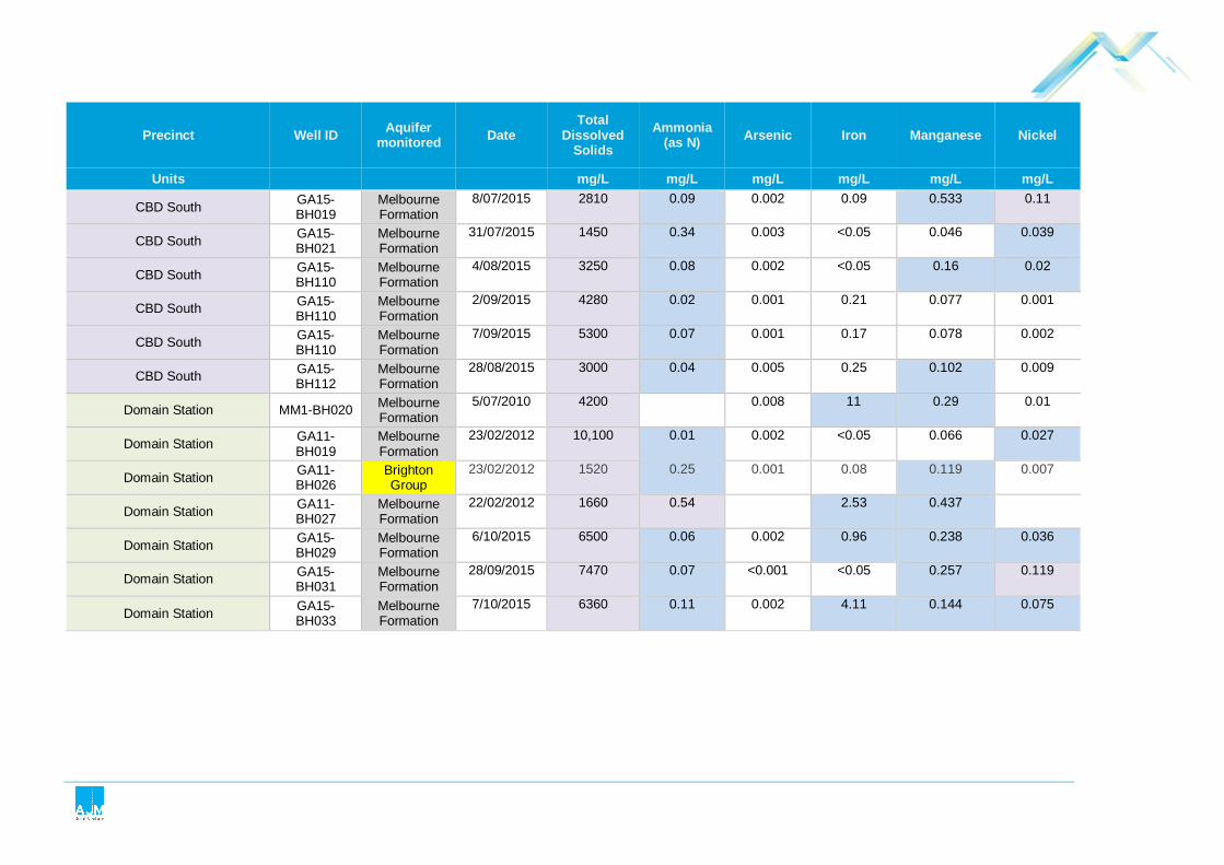
Precinct Well ID Aquifer monitored Date
Total Dissolved
Solids Ammonia
(as N) Arsenic Iron Manganese Nickel
Units mg/L mg/L mg/L mg/L mg/L mg/L
CBD South GA15-BH019
Melbourne Formation
8/07/2015 2810 0.09 0.002 0.09 0.533 0.11
CBD South GA15-BH021
Melbourne Formation
31/07/2015 1450 0.34 0.003 <0.05 0.046 0.039
CBD South GA15-BH110
Melbourne Formation
4/08/2015 3250 0.08 0.002 <0.05 0.16 0.02
CBD South GA15-BH110
Melbourne Formation
2/09/2015 4280 0.02 0.001 0.21 0.077 0.001
CBD South GA15-BH110
Melbourne Formation
7/09/2015 5300 0.07 0.001 0.17 0.078 0.002
CBD South GA15-BH112
Melbourne Formation
28/08/2015 3000 0.04 0.005 0.25 0.102 0.009
Domain Station MM1-BH020 Melbourne Formation
5/07/2010 4200
0.008 11 0.29 0.01
Domain Station GA11-BH019
Melbourne Formation
23/02/2012 10,100 0.01 0.002 <0.05 0.066 0.027
Domain Station GA11-BH026
Brighton Group
23/02/2012 1520 0.25 0.001 0.08 0.119 0.007
Domain Station GA11-BH027
Melbourne Formation
22/02/2012 1660 0.54 2.53 0.437
Domain Station GA15-BH029
Melbourne Formation
6/10/2015 6500 0.06 0.002 0.96 0.238 0.036
Domain Station GA15-BH031
Melbourne Formation
28/09/2015 7470 0.07 <0.001 <0.05 0.257 0.119
Domain Station GA15-BH033
Melbourne Formation
7/10/2015 6360 0.11 0.002 4.11 0.144 0.075
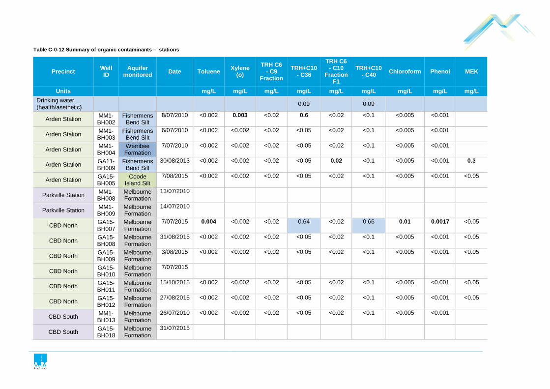
Table C- 0-12 Summary of organic contaminants – stations
Precinct Well ID
Aquifer monitored Date Toluene Xylene
(o) TRH C6
- C9 Fraction
TRH+C10 - C36
TRH C6 - C10
Fraction F1
TRH+C10 - C40 Chloroform Phenol MEK
Units mg/L mg/L mg/L mg/L mg/L mg/L mg/L mg/L mg/L Drinking water (health/asethetic) 0.09 0.09
Arden Station MM1-BH002
Fishermens Bend Silt
8/07/2010 <0.002 0.003 <0.02 0.6 <0.02 <0.1 <0.005 <0.001
Arden Station MM1-BH003
Fishermens Bend Silt
6/07/2010 <0.002 <0.002 <0.02 <0.05 <0.02 <0.1 <0.005 <0.001
Arden Station MM1-BH004
Werribee Formation
7/07/2010 <0.002 <0.002 <0.02 <0.05 <0.02 <0.1 <0.005 <0.001
Arden Station GA11-BH009
Fishermens Bend Silt
30/08/2013 <0.002 <0.002 <0.02 <0.05 0.02 <0.1 <0.005 <0.001 0.3
Arden Station GA15-BH005
Coode Island Silt
7/08/2015 <0.002 <0.002 <0.02 <0.05 <0.02 <0.1 <0.005 <0.001 <0.05
Parkville Station MM1-BH008
Melbourne Formation
13/07/2010
Parkville Station MM1-BH009
Melbourne Formation
14/07/2010
CBD North GA15-BH007
Melbourne Formation
7/07/2015 0.004 <0.002 <0.02 0.64 <0.02 0.66 0.01 0.0017 <0.05
CBD North GA15-BH008
Melbourne Formation
31/08/2015 <0.002 <0.002 <0.02 <0.05 <0.02 <0.1 <0.005 <0.001 <0.05
CBD North GA15-BH009
Melbourne Formation
3/08/2015 <0.002 <0.002 <0.02 <0.05 <0.02 <0.1 <0.005 <0.001 <0.05
CBD North GA15-BH010
Melbourne Formation
7/07/2015
CBD North GA15-BH011
Melbourne Formation
15/10/2015 <0.002 <0.002 <0.02 <0.05 <0.02 <0.1 <0.005 <0.001 <0.05
CBD North GA15-BH012
Melbourne Formation
27/08/2015 <0.002 <0.002 <0.02 <0.05 <0.02 <0.1 <0.005 <0.001 <0.05
CBD South MM1-BH013
Melbourne Formation
26/07/2010 <0.002 <0.002 <0.02 <0.05 <0.02 <0.1 <0.005 <0.001
CBD South GA15-BH018
Melbourne Formation
31/07/2015

Precinct Well ID
Aquifer monitored Date Toluene Xylene
(o) TRH C6
- C9 Fraction
TRH+C10 - C36
TRH C6 - C10
Fraction F1
TRH+C10 - C40 Chloroform Phenol MEK
Units mg/L mg/L mg/L mg/L mg/L mg/L mg/L mg/L mg/L
CBD South GA15-BH019
Melbourne Formation
8/07/2015
CBD South GA15-BH021
Melbourne Formation
31/07/2015 <0.002 <0.002 <0.02 1.59 <0.02 1.74 <0.005 <0.002 <0.05
CBD South GA15-BH110
Melbourne Formation
4/08/2015 <0.002 <0.002 <0.02 <0.05 <0.02 <0.1 <0.005 <0.002 <0.05
CBD South GA15-BH110
Melbourne Formation
2/09/2015 <0.002 <0.002 <0.02 <0.05 <0.02 <0.1 <0.005 <0.001 <0.05
CBD South GA15-BH110
Melbourne Formation
7/09/2015 <0.002 <0.002 <0.02 <0.05 <0.02 <0.1 <0.005 <0.001 <0.05
CBD South GA15-BH112
Melbourne Formation
28/08/2015 <0.002 <0.002 <0.02 <0.05 <0.02 <0.1 <0.005 <0.001 <0.05
Domain Station MM1-BH020
Melbourne Formation
5/07/2010 <0.002 <0.002 <0.02 0.27 <0.02 <0.1 <0.005 <0.001
Domain Station GA11-BH019
Melbourne Formation
23/02/2012 <0.002 <0.002 <0.02 <0.05 <0.02 <0.1 <0.005 <0.001 <0.05
Domain Station GA11-BH026
Brighton Group
23/02/2012 <0.002 <0.002 <0.02 <0.05 <0.02 <0.1 0.006 <0.001 <0.05
Domain Station GA11-BH027
Melbourne Formation
22/02/2012
Domain Station GA15-BH029
Melbourne Formation
6/10/2015 <0.002 <0.002 <0.02 0.06 <0.02 <0.1 <0.005 <0.001 <0.05
Domain Station GA15-BH031
Melbourne Formation
28/09/2015 <0.002 <0.002 <0.02 <0.05 <0.02 <0.1 <0.005 <0.001 <0.05
Domain Station GA15-BH033
Melbourne Formation
7/10/2015

Table C- 0-13 Groundwater corrosion parameters – stations
Bore ID Formation monitored TDS (mg/L) pH Chloride (mg/L) Sulfate (mg/L
SO4) SRB1 (MPN/ 100ml)
Ammonia (mg/L as N)
Nitrate (mg/L as N)
Assessment criteria
No criteria <5.5 6,000 1,000 No criteria No criteria No criteria
Stations
Arden station
MM1-BH002 Fishermens Bend Silt 8,600 7.3 3,800 470 11 (orgs/mL) NT <0.1
MM1-BH003 Fishermens Bend Silt 8,600 7.5 3,100 900 4.6 (orgs/mL) NT 5.8
MM1-BH004 Werribee Formation 3,000 8 860 340 11 (orgs/mL) NT 6.6
GA11-BH009 Melbourne Formation 22,600 6.83 13,200 1,390 15,000
(org/100mL) 15.4 0.01
GA15-BH005 Coode Island Silt 24,900 7.43 11,900 2,420 500,000 (pac/mL) 7.06 0.02
Parkville station
MM1BH008 Melbourne Formation 8,800 6.5 3,900 550 >11 (orgs/mL) not tested 0.6
MM1BH009 Melbourne Formation 12,000 7.1 4,900 500 >11 (orgs/mL) not tested 1.3
CBD North Station
GA15-BH007 Melbourne Formation 2,280 6.79 759 222 NT 0.06 0.01

Bore ID Formation monitored TDS (mg/L) pH Chloride (mg/L) Sulfate (mg/L
SO4) SRB1 (MPN/ 100ml)
Ammonia (mg/L as N)
Nitrate (mg/L as N)
GA15-BH009 Melbourne Formation 4,400 7.01 1,880 353 NT 0.14 14.5
GA15-BH008 Melbourne Formation 4,710 7.93 2,130 450 NT 0.05 3.63
GA15-BH010 Melbourne Formation 3,620 6.32 1,370 411 NT 0.12 7.49
GA15-BH011 Melbourne Formation
6,960 6.13 3,790 413 27,000 0.08 0.03
GA15-BH012 Melbourne Formation 1,410 7.73 363 121 NT 0.04 1.17
CBD South station
MM1-BH013 Melbourne Formation 2,400 7.9 760 170 2 not tested 0.1
GA15-BH018 Melbourne Formation 2,030 7.17 710 185 120,000 (pac/mL) 0.11 6.23
GA15-BH019 Melbourne Formation 2,810 5.91 1,070 288 320 (pac/mL) 0.09 4
GA15-BH021 Melbourne Formation 1,450 6.99 473 138 120,000 (pac/mL) 0.34 5.68
GA15-BH110 Melbourne Formation 5,300 7.15 2,620 498 500,000 (pac/mL) 0.08 2.25
GA15-BH112 Melbourne Formation 3,000 6.72 1,160 305 500,000 (pac/mL) 0.04 0.01

Bore ID Formation monitored TDS (mg/L) pH Chloride (mg/L) Sulfate (mg/L
SO4) SRB1 (MPN/ 100ml)
Ammonia (mg/L as N)
Nitrate (mg/L as N)
Domain station
GA11-BH019 Melbourne Formation 10,100 7.1 5,750 392 24,000 0.01 0.71
GA11-BH026 Brighton Group 1,520 7.7 273 180 >110,000 0.25 6.91
GA11-BH027 Melbourne Formation 1,660 7 860 111 46,000 0.54 0.14
GA15-BH029 Melbourne Formation
6,500 6.41 3,730 233 500,000 (pac/mL) 0.06 0.02
GA15-BH031 Melbourne Formation
7,470 6.17 4,510 376 Not tested 0.07 0.38
GA15-BH033 Melbourne Formation 6,360 5.80 3,950 230 500,000 (pac/mL) 0.11 0.02
MM1-BH020 Melbourne Formation 4,200 7.9 1,500 260 >11 not tested 0.3
1 – SRB = Sulfate reducing bacteria. Shaded text indicates data over the assessment criterion.


Appendix D
Golder Associates EES Summary Report


21 April 2016
MELBOURNE METRO RAIL PROJECT
Contaminated Land Assessment - EES Summary Report
REP
OR
T
Report Number. 1525532-217-R-Rev2
Distribution:
1 Copy - AJM Joint Venture 1 Copy - Golder Associates Pty Ltd
Submitted to:AJM Joint Venture 121 Exhibition Street Melbourne, Vic, 3000

CONTAMINATED LAND ASSESSMENT - EES SUMMARY REPORT
21 April 2016 Report No. 1525532-217-R-Rev2 i
Glossary of Abbreviations, Nomenclature and Technical Terms
ANC Acid Neutralising Capacity
As Arsenic
ASLP Australian Standard Leaching Procedure
ASS Acid Sulfate Soils
AASS Actual Acid Sulfate Soil
ASR Acid Sulfate Rock
B(a)P Benzo(a)pyrene
B(a)P TEQ Benzo(a)pyrene Toxic Equivalent Quotient, is calculated by multiplying the concentrations of carcinogenic polycyclic aromatic hydrocarbons in the sample by its’ B(a)P Toxic Equivalency Factor, as defined in the NEPM.
bgl Below Ground Level
CBD Central Business District
CrS Chromium Reducible Sulfur
EMP Environmental Management Plan
EPA Environmental Protection Agency
FID Flame Ionization Detector
GQRUZ Groundwater Quality Restricted Use Zone
IWRG The EPA Victoria Industrial Waste Resource Guidelines, as outlined in EPA Publication IWRG 600.2.
LEL Lower Explosive Limit
LNAPL Light Non-Aqueous Phase Liquid
MAH Monocyclic Aromatic Hydrocarbons
MIP Membrane Interface Probe
Melbourne Metro The Melbourne Metro Rail Project
NAF Not Acid Forming
NAG Net Acid Generation
NAPP Net Acid Production Potential

CONTAMINATED LAND ASSESSMENT - EES SUMMARY REPORT
21 April 2016 Report No. 1525532-217-R-Rev2 ii
NEPM Commonwealth of Australia National Environmental Protection (Assessment of Site Contamination) Measure (Commonwealth Government, 1999)
NEPM EIL National Environmental Protection Measures - Ecological Investigation Level
NEPM HIL NEPM Health Investigation Level
NEPM HSL NEPM Health Screening Level
Ni Nickel
OM Organic Matter
PAF Potentially Acid Forming
PASS Potential Acid Sulfate Soil
PAH Polycyclic Aromatic Hydrocarbon
Pb Lead
PCB Polychlorinated Biphenyl
PID Photoionization detector
PIW Prescribed industrial waste as defined in the Environment Protection (Industrial Waste Resource) Regulations 2009
pH (KCI) pH (Potassium Chloride)
QA/QC Quality Assurance/Quality Control
SEPP State Environment Protection Policy
SMF Spoil Management Framework
SNAS Net Acid Soluble Sulfur (Unit %S)
SPOS Peroxide Oxidisable Sulfur (Unit %S)
SPOCAS Suspension Peroxide Combined Acidity Sulfur
SVOC Semi Volatile Organic Compound
TAA Titratable Actual Acidity
TBM Tunnel Boring Machine
The Act Environment Protection Act (Victoria), 1970 (as amended)
TOC Total Organic Carbon
TPH Total Petroleum Hydrocarbon
TRH Total Recoverable Hydrocarbon

CONTAMINATED LAND ASSESSMENT - EES SUMMARY REPORT
21 April 2016 Report No. 1525532-217-R-Rev2 iii
UC Uncertain
UST Underground Storage Tank
VOCs Volatile Organic Compounds
WASS Waste Acid sulfate Soil and Rock
XSD Halogen Specific Detector
Zn Zinc

CONTAMINATED LAND ASSESSMENT - EES SUMMARY REPORT
21 April 2016 Report No. 1525532-217-R-Rev2 iv
Table of Contents
1.0 INTRODUCTION ........................................................................................................................................................ 1
1.1 Background .................................................................................................................................................. 1
1.2 Objectives ..................................................................................................................................................... 2
1.3 Scope of Assessment ................................................................................................................................... 2
1.4 Project Description ........................................................................................................................................ 2
2.0 ASSESSMENT FRAMEWORK AND CRITERIA ....................................................................................................... 5
2.1 Industrial Waste Resource Guidelines .......................................................................................................... 5
2.2 State Environment Protection Policy – (Prevention and Management of Contaminated Land) .................... 6
2.2.1 National Environmental Protection (Assessment of Contamination) Measure ........................................ 7
2.2.2 Maintenance of Ecosystems ................................................................................................................... 7
2.2.3 Human Health ......................................................................................................................................... 7
2.2.4 Buildings and Structures ......................................................................................................................... 9
2.2.5 Aesthetics ............................................................................................................................................... 9
2.3 Industrial Waste Management Policy (Waste Acid Sulfate Soils) 1999 ........................................................ 9
2.3.1 Management of WASS .......................................................................................................................... 11
3.0 ENVIRONMENTAL SETTING ................................................................................................................................. 12
3.1 Topography ................................................................................................................................................ 12
3.2 Lithology and Geology ................................................................................................................................ 12
3.3 Acid Sulfate Soils ........................................................................................................................................ 13
3.4 Acid Sulfate Rock ....................................................................................................................................... 13
4.0 SITE HISTORY REVIEW ......................................................................................................................................... 14
5.0 ASSESSMENT METHODOLOGY ........................................................................................................................... 21
6.0 ASSESSMENT OF CONTAMINATION WITHIN THE SITE .................................................................................... 23
6.1 Assessment Approach ................................................................................................................................ 23
6.2 Consideration of Onsite Conditions ............................................................................................................ 23
6.2.1 Human Health ....................................................................................................................................... 23
6.2.2 Aesthetic Impacts .................................................................................................................................. 26
6.2.3 Buildings and Structures ....................................................................................................................... 27
6.3 Preliminary Classification for Offsite Disposal ............................................................................................ 28
6.4 Consideration of Acid generating materials ................................................................................................ 32

CONTAMINATED LAND ASSESSMENT - EES SUMMARY REPORT
21 April 2016 Report No. 1525532-217-R-Rev2 v
6.4.1 Distribution and Nature of ASS ............................................................................................................. 33
6.5 Consideration of Acid Sulfate Rock ............................................................................................................ 34
6.5.1 Nature of acid generation from ASR ..................................................................................................... 37
6.6 Estimates Volumes of WASS ..................................................................................................................... 38
6.7 Consideration of Naturally Present Methane .............................................................................................. 41
6.7.1 MIP Investigation and Related Results ................................................................................................. 41
6.7.2 Management of Methane ...................................................................................................................... 43
7.0 CONCLUSIONS ....................................................................................................................................................... 44
8.0 REFERENCES ......................................................................................................................................................... 47
TABLES
Table 1: Relationships between EES Specialist Reports and the supporting Golder EES Summary Reports .................... 1
Table 2: Summary of segments adopted for reporting purposes ......................................................................................... 3
Table 3: Summary of Protected Beneficial Uses of Land – Melbourne Metro Concept Design ........................................... 6
Table 4: Basic Conceptual Exposure Pathways .................................................................................................................. 7
Table 5: Comparison of Historical TPH results with NEPM TRH criteria ............................................................................. 9
Table 6: Victorian EPA - WASS Action Levels .................................................................................................................. 10
Table 7: Criteria for classification of Acid Sulfate Rock ..................................................................................................... 10
Table 8: Predominant Geological Units within the Melbourne Metro alignment ................................................................ 12
Table 9: Summary of geochemical conditions within key geological rock units intercepted during the development of the Study Area .............................................................................................................................................. 14
Table 10: Historical land uses which had the potential to cause contamination in the area of stations, portals and Western Turnback ............................................................................................................................................ 15
Table 11: Summary of historical activities and potential sources of contamination within areas proposed for tunnels .............................................................................................................................................................. 19
Table 12: Melbourne Metro Concept Design - Investigation Summary ............................................................................ 21
Table 13: Summary of HIL, HSL and Management Limit Exceedances ............................................................................ 24
Table 14: Fill Description within Assessed Segments ....................................................................................................... 26
Table 15: Summary of IWRG Results for Fill within Excavation Areas .............................................................................. 29
Table 16: Total Volume Estimate of PIW – Melbourne Metro Concept Design ................................................................. 31
Table 17: Volume Estimate of PIW for Segments – Melbourne Metro Concept Design .................................................... 32
Table 18: Summary of Percentage of Samples reported as PAF or UC ........................................................................... 36
Table 19: Weathering Grades within Melbourne Formation .............................................................................................. 36
Table 20 Summary of Information to support ASR classification (Melbourne Formation) ................................................. 38
Table 21: Total Volume Estimate of WASS – Melbourne Metro Concept Design ............................................................. 39
Table 22: Volume Estimate of ASS for Segments – Melbourne Metro Concept Design ................................................... 40

CONTAMINATED LAND ASSESSMENT - EES SUMMARY REPORT
21 April 2016 Report No. 1525532-217-R-Rev2 vi
Table 23: Volume Estimate of ASR for Segments – Melbourne Metro Concept Design ................................................... 41
Table 24: Summary of FID Results ................................................................................................................................... 42
APPENDICES
APPENDIX A A1 - Geological Long Section & A2 Environmental Sampling Locations
APPENDIX B Site History Report
APPENDIX C Tabulated Summaries of Results
APPENDIX D 'Interim' Acid Sulfate Rock Kinetic Leach Assessment
APPENDIX E Preliminary Spoil Volume Estimate Report
APPENDIX F Important Information Relating to the Report

CONTAMINATED LAND ASSESSMENT - EES SUMMARY REPORT
21 April 2016 Report No. 1525532-217-R-Rev2 1
1.0 INTRODUCTION Aurecon Jacobs Mott Macdonald Joint Venture (AJM JV) has engaged Golder Associates Pty Ltd (Golder) to provide geotechnical, hydrogeological and environmental services for the proposed Melbourne Metro Rail Project (Melbourne Metro). The services provided by Golder in 2015 and 2016 are to support the development of the Environment Effects Statement (EES) for the Melbourne Metro ‘Concept Design’.
The Melbourne Metro Concept Design comprises approximately 9 km of rail tunnels running from South Kensington to South Yarra, including five new stations. The proposed alignment would connect into the existing rail network near South Kensington station, run beneath North Melbourne and Parkville, then continue south beneath Swanston Street, under the Yarra River, east of and beneath St Kilda Road, then east beneath Toorak Road and Fawkner Park. The Concept Design connects to the existing rail network, Caulfield Line, at South Yarra.
This EES summary report provides discussion of the contamination assessment results for material (predominantly soil and rock) likely to be encountered for the Melbourne Metro Concept Design. The relationship of this report to the other EES specialist reports is summarised in Table 1.
Within this report, the areal extent of the Melbourne Metro Concept Design, which incorporates the station boxes, portals and tunnels, would be referred to as “the Study Area”. The extent of the Study Area is presented on the geological cross section within Appendix A1.
Table 1: Relationships between EES Specialist Reports and the supporting Golder EES Summary Reports
Relationship between EES Specialist Reports and the supporting Golders EES Summary Reports'
EES Specialist Reports
Ground movement and Land Stability
Future Development
Loading Groundwater
Contaminated Land and Spoil Management
Gol
der
EE
S S
umm
ary
Rep
ort
Ground Movement Assessment
Interpreted Geological Setting
Interpreted Hydrogeological Setting
Regional Groundwater Numerical Modelling
Contaminated Land Assessment
In addition the above described Melbourne Metro Project Area, a Preliminary Site Investigation (PSI) comprising a site history review (without an intrusive assessment) has been undertaken for the “Western Turnback” in West Footscray. The results of the PSI have been summarised in Table 10 of this EES summary report.
1.1 Background Between 2011 and 2013, Golder was engaged by Public Transport Victoria to provide environmental services to support development of the business case for the project. The works over this period included the undertaking of a desk study (Phase 1 site history review) to identify potential sources of contamination and

CONTAMINATED LAND ASSESSMENT - EES SUMMARY REPORT
21 April 2016 Report No. 1525532-217-R-Rev2 2
chemicals of interest, preliminary assessment of soil waste category, risks to beneficial uses of land and potential to generate acidity. Within this report these works would be referred to as the “historical contamination assessment”.
During 2015, Golder was engaged to undertake a further stage of contamination assessment to support the development of the Concept Design for MMRA. This report summarises the results of this assessment, which considers all of the contaminated soil and rock factual information which has been collected for the project up to mid-September 2015.
1.2 Objectives The purpose of this report is to set out the environmental conditions within the proposed development area for the MMRP.
The objectives are summarised below:
Assess potential waste categorisation of material likely to be disturbed during construction of the Melbourne Metro.
Assess contamination status of soil and rock likely to be disturbed with regard to protection of human health (particularly construction workers).
Assess the extent and nature of potential acid generating materials, for the purpose of understanding potential risks to the environment and infrastructure associated with the oxidation of ASS.
Assess potential presence and associated risks from disturbance during construction works, of naturally generated methane within alluvial sediments.
1.3 Scope of Assessment The Melbourne Metro Concept Design contamination assessment works have included the following:
Assessment of the site history including development of an integrated spatial map.
Field assessment of soil and rock contamination and acid generation capacity.
Compilation of the project historical information and data relevant to the MMRP.
Assessment of environmental condition within the proposed development area.
1.4 Project Description The Melbourne Metro Concept Design comprises 7.5 m external diameter twin rail tunnels approximately 9 km long, running from Kensington to South Yarra. The proposed alignment would connect into the existing rail network near South Kensington station, run beneath North Melbourne and Parkville, then continue south beneath Swanston Street, under the Yarra River, east of and beneath St Kilda Road, then east beneath Toorak Road and Fawkner Park. The Melbourne Metro connects to the existing rail network, Caulfield Line, at South Yarra.
Key aspects of the Concept Design include:
Portals at South Yarra and Kensington;
Three cut and cover station excavations at Arden, Parkville and Domain;
Two underground cavern station excavations at CBD North and CBD South; and
Ventilation shafts and cross passages along the twin tunnel alignment.

CONTAMINATED LAND ASSESSMENT - EES SUMMARY REPORT
21 April 2016 Report No. 1525532-217-R-Rev2 3
For reporting purposes, the alignment has been divided into 23 segments, based on the type of infrastructure proposed and the expected ground conditions. The segments are numbered from west towards east. Their extents are shown on the longitudinal geological section in Appendix A1 and a brief description presented in Table 2.
Table 2: Summary of segments adopted for reporting purposes
Segment Description Key elements
1 Surface works and embankments
Embankment widening on potentially soft soils.
2 Western Portal approaches
Decline structure including retained excavation through soft soils and weak rock.
3 Western Portal and TBM shaft
Cut and cover excavation for TBM shaft and portal within weak rock.
4 TBM Tunnels Twin bored tunnels through weak rock.
5 TBM Tunnels Twin bored tunnels through dense clayey sand and sand with cross passage.
6 TBM Tunnels Twin bored tunnels through soft to stiff cohesive soils, some gravel and sand with one cross passage.
7 Arden Station Cut and cover station excavation through soft to stiff cohesive soils, some gravel and sand. Likely to be supported using diaphragm walls.
8 TBM Tunnels Bored tunnels through mixed face conditions comprising dense sands, clayey sands and weak rock with one cross passage.
9 TBM Tunnels Bored tunnels through weathered siltstone and sandstone with three cross passages.
10 Parkville Station Cut and cover station excavation through weathered and jointed siltstone and sandstone. Likely to be retained using soldier pile retention system.
11 TBM Tunnels Bored tunnels through weathered to fresh siltstone and sandstone with two cross passages.
12 CBD North Station Underground cavern excavation in weathered to fresh siltstone and sandstone. 40 m deep access shaft with full retention.
13 Mined Tunnels Mined tunnels through weathered siltstone and sandstone.
14 CBD South Station Underground cavern excavation in weathered to fresh siltstone and sandstone. 34 m deep tanked access shaft with full retention. Deepening of existing City Square basement excavation.
15 TBM Tunnels Bored twin tunnels through weathered siltstone and sandstone.
16 TBM Tunnels – Yarra Crossing
Bored tunnels through variable, mixed face conditions comprising high strength basalt rock, dense sand and soft to stiff clay.
17 TBM Tunnels Bored tunnels through weathered siltstone and sandstone. Shaft at Linlithgow Avenue and one cross passage.
18 TBM Tunnels – City Link Crossing
Bored tunnels through mixed face conditions with dense sand, hard clay and weathered siltstone and sandstone. In close proximity to the existing City Link tunnels. One cross passage.
19 TBM Tunnels Bored tunnels through weathered siltstone and sandstone with two cross passages.
20 Domain Station Cut and cover station excavation through weathered and jointed siltstone and sandstone, dense sand and hard clay. Likely to be retained using soldier pile retention system.
21 TBM Tunnels Bored tunnels through weathered siltstone and sandstone. One access shaft in Fawkner Park and three cross passages.
22 TBM Tunnels Bored tunnels through mixed face conditions comprising weathered siltstone and sandstone, dense sand and hard clay.
23 Eastern Portal and TBM Shaft
Cut and cover shaft with full retention in dense sand and hard clay. Fully retained decline structure in dense sand and hard clay. Widening of existing rail corridor excavations in dense sand and hard clay.
Based on discussion with AJM JV, the following provides a high level summary of the concepts for proposed Civil Infrastructure, from west to east:
The proposed Melbourne Metro branches north off the existing Sunbury line just east of the Kensington Road Bridge and dives in a cut towards the western portal. The twin track decline structure is to be fully retained.

CONTAMINATED LAND ASSESSMENT - EES SUMMARY REPORT
21 April 2016 Report No. 1525532-217-R-Rev2 4
A shaft is to be constructed at the western portal for use in TBM retrieval during construction.
The rail tunnels from Western Portal to Arden station are to be constructed using Tunnel Boring Machines (TBM’s).
Arden station is to be constructed as a cut and cover bottom-up station box.
The twin rail tunnels from Arden station to Parkville station are to be constructed using TBM’s.
Parkville station is to be constructed as a top down cut and cover station box.
The twin rail tunnels from Parkville station to CBD North station are to be constructed using TBM’s.
An underground station cavern is to be constructed at CBD North station with an expected span of approximately 23 m. A 40 m deep fully supported access shaft would be constructed adjacent to the cavern and underground adits and passages would be constructed between the shaft, cavern and the existing Melbourne Central Station.
Twin tunnels would be mined between CBD North station and CBD South station.
An underground station cavern is to be constructed at CBD South Station. This would have similar dimensions to the cavern at CBD North station. Two fully supported access shafts would be constructed. Both shaft excavations would need to be fully retained and sealed, likely using diaphragm walls.
TBM tunnels are proposed between CBD South station and Domain station. This section of the alignment would pass beneath the Yarra River and would be bored through highly variable geological materials including very high strength rock and soft clay. The tunnels would pass beneath the existing footings of the Princes Bridge. Closed face TBM’s are expected to be required through this section.
Domain station is to be constructed as a top down cut and cover excavation. Retention over the full excavation height would be required.
Twin TBM tunnels are proposed between Domain station and the eastern portal.
The eastern portal consists of a ventilation / emergency egress / TBM retrieval shaft in the vicinity of Osborne Street, realignment of the existing Dandenong and Frankston Line tracks, Twin track cut and cover tunnel sections including a section beneath the Sandringham Line tracks and Frankston Up track, Twin track tunnel decline structure between the reconfigured Dandenong Line tracks and surface tie-in to the existing Dandenong Line.
There are two emergency access shafts located at Linlithgow Avenue and Fawkner Park.
There are a number of emergency egress cross-passages, including low point drainage sumps and pumping facilities.
At this stage we understand that the tunnels and stations would be designed as long term undrained underground structures.

CONTAMINATED LAND ASSESSMENT - EES SUMMARY REPORT
21 April 2016 Report No. 1525532-217-R-Rev2 5
2.0 ASSESSMENT FRAMEWORK AND CRITERIA This section provides an overview of legislative requirements pertinent to the project and applicable to contaminated soils, including relevant publications and guidelines governing occupational health and safety and the environment in relation to impacts to the project.
The assessment criteria give consideration to:
Relevant Victorian legislation, policy and strategies (as described below);
Key issues relevant to this project; and
Our assessment of available information from past projects and public information sources.
2.1 Industrial Waste Resource Guidelines The Industrial Waste Resource Guidelines (IWRGs) have been established by the Victorian Environment Protection Authority (EPA) to provide guidance for management of waste soil in Victoria. Of particular relevance to the project, are the IWRGs that provide guidance in relation to the sampling and categorisation of waste soils to be moved offsite for reuse or disposal, included in the following IWRGs:
Publication IWRG621, Soil Hazard Categorisation and Management (EPA, 2009a)
Publication IWRG702, Soil Sampling (EPA, 2009b)
Publication IWRG600.2, Waste Categorization (EPA, 2010).
Waste classification involves an assessment of the soil, including site history, to identify which contaminants require analysis to determine the hazard category. The assessment must be for all chemical substances known and reasonably expected to be present in the waste.
EPA (2010) describes the different waste categories that apply to all wastes in Victoria. This includes four broad categories, two of which are applicable to soils:
Fill Material
Prescribed Industrial Waste (PIW).
Fill Material is described as consisting of soil (being clay, silt and/or sand), gravel and rock of naturally occurring materials. Fill Material is often referred to as ‘clean fill’ by industry. EPA does not regulate the use of Fill Material as it is not considered a waste. As a result there are usually no restrictions on the handling of Fill Material (as set out in EPA, 2009a) and it does not require disposal at a licensed landfill. The Act, however, places general obligations to prevent adverse impacts on the environment and human health, and hence, it is usually prudent to check the potential for Fill Material to result in these impacts via a regime of assessment. The assessment should typically include consideration of site history.
Where soil is found to contain elevated level of metals (such as arsenic) or other constituents that can be demonstrated to be of natural origin and are naturally elevated, the soil is not typically considered to be ‘contaminated’ and therefore can be classified as Fill Material.
Prescribed Industrial Waste may either be from a manufacturing source or be contaminated soil. Guidance in determining the hazard category for contaminated soil can be found in EPA (2009a). As set out in these guidelines, soils with contaminant concentrations which exceed the Fill Material criteria are classified as Prescribed Industrial Waste and fall in to one of three categories of as follows:
Category A
Category B
CONTAMINATED LAND ASSESSMENT - EES SUMMARY REPORT
21 April 2016 Report No. 1525532-217-R-Rev2 6
Category C.
Descriptions of the maximum concentrations of allowable contaminants for these categories are set out in EPA 2009a. The options for their management are as follows:
Category B or Category C – onsite remediation, offsite remediation or disposal to a licensed facility.
Category A – onsite remediation, offsite remediation or storage pending availability of treatment (i.e. immobilisation). Category A wastes cannot be disposed of to landfill prior to treatment.
Transport and disposal of Prescribed Industrial Waste is required to be carried out in vehicles licensed to carry such materials and EPA Waste Transport Certificates are required to be completed by the waste producer, transporter and receiver in accordance with Environment Protection (Industrial Waste Resource) Regulations 2009.
Landfills accepting Prescribed Industrial Waste would have in place their own processes and procedures to assess the material being received. However, EPA, 2009b provides guidance on the approach, scope and frequency of data assessments, including minimum sampling frequencies.
2.2 State Environment Protection Policy – (Prevention and Management of Contaminated Land)
The SEPP (Prevention and Management of Contaminated Land) (Land SEPP) outlines land use categories and specifies beneficial uses which must be protected for each of these categories. In accordance with the Land SEPP, the likely relevant beneficial uses of land that must be protected during the Melbourne Metro are presented in Table 3.
The Land SEPP outlines indicators and objectives for land, based on the relevant beneficial uses. For protection of ecosystems and human health, the management objectives are closely linked to the criteria outlined in the National Environment Protection Measure “Assessment of Site Contamination” (NEPC 2013).
The relevant soil assessment criteria considered to be applicable to the Melbourne Metro are discussed in the following sections.
Table 3: Summary of Protected Beneficial Uses of Land – Melbourne Metro Concept Design
Beneficial Use Land Use - Commercial
1. Maintenance of Ecosystems Natural Ecosystems Modified Ecosystems Highly Modified Ecosystems
No No Yes
2. Human Health Yes
3. Buildings and Structures Yes
4. Aesthetics Yes
5. Production of Food, Flora and Fibre No
There are also areas of Recreation/Open space land use within the Melbourne Metro Concept Design where shafts may access the surface (i.e. Fawkner Park). All the above beneficial uses that apply for a Commercial land use also apply for Recreational/Open space land use, however the NEPM also considers

CONTAMINATED LAND ASSESSMENT - EES SUMMARY REPORT
21 April 2016 Report No. 1525532-217-R-Rev2 7
that a modified ecosystem should apply, compared to a highly modified ecosystem. The ecosystem in Fawkner Park is already a highly modified ecosystem which should be protected and/or returned to pre-construction condition following Melbourne Metro delivery.
2.2.1 National Environmental Protection (Assessment of Contamination) Measure
National environmental protection measures are framework documents that contain national objectives for the management and protection of the environment. National environmental protection measures are developed and issued by the National Environmental Protection Council (NEPC), which has legislative authority as appointed under the National Environmental Protection Council Act 1994. The National Environmental Protection (Assessment of Contamination) Measure (hereafter referred to as ‘the NEPM’) was produced in 1999 to provide a national approach to the assessment of potentially contaminated sites to ensure effective management by the community and to provide adequate protection of human health and the environment where known contamination has occurred.
On 16 May 2013, the National Environment Protection Council published the National Environmental Protection (Assessment of Site Contamination) Amendment Measure 2013 (No.1) (NEPC, 2013).
The amendment to the NEPM includes a revised methodology for derivation of human health and ecological investigation and screening criteria. In addition, the amended NEPM provides interim soil vapour health investigation levels for selected volatile contaminants.
In order to be consistent with the most current guidance on the assessment of contamination, the results of the environmental investigation works have been compared against the criteria and assessment guidance described within the amended NEPM (NEPC 2013). The NEPM criteria are further described below.
2.2.2 Maintenance of Ecosystems The Melbourne Metro assessment has been undertaken for the purpose of management of spoil and risks to human health. Golder understands that material excavated from the Melbourne Metro is unlikely to be used in an environment where there is access to soil and as such risks to ecosystems have not been considered.
2.2.3 Human Health
Site Conceptual Exposure Pathways
The adopted criteria depend on the source of contaminant, exposure pathways and receptors affected on and off site.
Table 4 outlines the basic conceptual exposure pathways to on site and off site receptors on Melbourne Metro.
Table 4: Basic Conceptual Exposure Pathways
Source Exposure Pathway On Site Receptor for Soil Off Site Receptor
Non-volatile contaminants in soil
Primary contact, secondary contact via dust
Site workers, and Site users following development
Surrounding residents and users of adjacent commercial and recreational areas
Volatile contaminants in soil
Inhalation of vapours and primary contact
Site workers, site users following development, indoor and outdoor environments
Surrounding residents and users of adjacent commercial and recreational areas

CONTAMINATED LAND ASSESSMENT - EES SUMMARY REPORT
21 April 2016 Report No. 1525532-217-R-Rev2 8
Other, indirect pathways for potential impacts to human health may exist as a result of leaching of contamination from sources to groundwater.
Risks associated with impacts to groundwater are not further discussed in this report; see the Interpreted Hydrological Setting Report (Golder 2016) for assessment of potential risks to groundwater.
The Melbourne Metro Concept Design passes through areas with different land uses, including commercial land use, and recreational open space use. For the consideration of the human health for site occupants, soil results have been compared against the following NEPM Health Investigation Levels (HIL):
NEPM HIL C – For health risk assessment of public open space (does not include undeveloped public open space where the potential for exposure is lower).
NEPM HIL D – For health risk assessment of commercial / industrial use.
The NEPM HIL criteria do not include values for exposure to vapours. Therefore, the NEPM Health Screening Levels (HSL) have been adopted as TPH, MAH and Naphthalene human health screening criteria. The HSL adopted were:
HSL C – For health risk assessment in recreational/ public open space land uses.
HSL D – For health risk assessment of commercial / industrial use.
There is currently no criteria within Australia for the assessment of soil contamination risks to construction workers. For this report, HSL D and NEPM management limits have been adopted to identify material that may present a risk to health of workers, if standard personal protective equipment is adopted.
The amended NEPM requires characterisation of the Study Area in order to apply the assessment criteria against potential site uses. For the purpose of this review, the Study Area was characterised to comprise “sand” (coarse grained soils) which is the most conservative approach to applying the criteria.
In addition, for the assessment of soil vapours, the NEPM provides criteria for material located at different depths below the base of the development area. Based on the Melbourne Metro Concept Design, including underground tunnels and stations, the laboratory results were compared against vapour intrusion criteria for soil located between 0 and 1 metre from the base of proposed structures across the project. This is the most conservative criteria for the assessment of vapours.
Where results exceed these criteria, area specific criteria may be developed.
Management Limits for TPH fractions in soil
The NEPM provides management limits for petroleum hydrocarbons. They are applicable as screening levels following evaluation of human health and ecological risks and risks to groundwater resources. They are relevant for operating sites where significant sub-surface leakage of petroleum compounds has occurred and when decommissioning industrial land commercial sites (NEPC 2013).
The Management Limit for the TPH fraction F2 (C10-C16) is based on protection of workers in a trench breathing hydrocarbon vapours (using occupational exposure limits for jet fuel to represent fraction F2). This concentration is also likely to be protective of other factors such as free-phase formation and aesthetics.
The Management Limit for TPH fraction F3 (C16-34) is based on “technological factors” – including the difficulty in bio remediating fraction F3, along with toxic risk, aesthetics, and effects on infrastructure (CCME 2008).
Application of the Adopted Criteria
An exceedance of the adopted human health criteria or management limits does not necessarily indicate an unacceptable risk to human health in relation to the respective land use scenario. Rather, an exceedance
CONTAMINATED LAND ASSESSMENT - EES SUMMARY REPORT
21 April 2016 Report No. 1525532-217-R-Rev2 9
would trigger the need for further assessment to understand the risk and possibly the need for a site-specific human health risk assessment which would evaluate the relevant exposure setting and associated risks.
Data collected during the historical contamination assessment at the site for TPH was not reported in the same fractions as those defined for the amended NEPM Criteria. In this case, the assessment criteria for the nearest corresponding reported TPH fractions has been adopted. For instance, NEPM HSL for the TRH fraction, C6-C10, has been adopted to assess concentrations of TPH fraction, C6-C9, reported in soil samples (Table 5). Furthermore, TPH concentrations have been assessed without consideration of removing BTEX or naphthalene concentrations which is now required by the NEPM. This is a conservative approach.
Table 5: Comparison of Historical TPH results with NEPM TRH criteria
NEPM TPH Fraction Historical fraction assumed equivalent
F1 (C6-C10) C6 to C9
F2 >C10-C16 C10 to C14
F3 > C16-C34 C15 - C36 *
F4>C34-C40 Not reported
*Calculated from the sum of C15 to C28 and C28 to C36
2.2.4 Buildings and Structures For assessment of the beneficial use of “buildings and structures”, the Land SEPP states that contamination must not cause the land to be corrosive to, or adversely affect the integrity of structures or building materials.
The Australian Standard for Piling – Design and installation (AS2159), provides exposure classification for concrete piles (Table 6.4.2(C)) and steel piles (Table 6.5.2(C)). Aggressivity to concrete piles is assessed based on pH, the concentrations of sulphate (in soil and groundwater) and chloride (in groundwater). The aggressively to steel piles is based on pH, chloride (soil in soil and water) and resistivity.
To provide indicative information on soil aggressively and potential impacts to buildings and structures, assessment of soil pH and sulfate (derived from sulphide concentrations) has been undertaken as part of the ASS investigation. In addition, chloride concentrations in groundwater have been assessed as part of the hydrogeological assessment (Golder, 2016) and kinetic leach tests. This assessment has not included assessment of resistivity.
2.2.5 Aesthetics The Land SEPP states that contamination must not cause the land to be offensive to the senses of humans. Generally, the land is considered to be aesthetically acceptable if the soils are free of chemical substances, wastes, staining and odours. For the consideration of aesthetics, visual or olfactory observations of contamination were made at each bore location.
2.3 Industrial Waste Management Policy (Waste Acid Sulfate Soils) 1999
The Industrial Waste Management Policy (Waste Acid Sulfate Soils (WASS)), (EPA, 1999), establishes the statutory framework for the identification, assessment, and management of waste Acid Sulfate Soils (ASS). EPA, 1999 defines ASS as "…any soil, sediment or unconsolidated geological material or disturbed consolidated rock mass containing metal sulfides which exceed criteria for acid rock soils specified in EPA publication 655 entitled "Acid Sulfate Soil and Rock”. For the purpose of simplicity, where rock contains elevated concentrations of metal sulfides this has been referred to as Acid Sulfate Rock (ASR).

CONTAMINATED LAND ASSESSMENT - EES SUMMARY REPORT
21 April 2016 Report No. 1525532-217-R-Rev2 10
The EPA action criteria for ASS depend on the texture and volume of the material, however where the proposed development involves the disturbance of greater than 1000 tonnes of potential acid generating material; the criterion of 0.03 %S oxidisable sulfur applies regardless of texture (Table 6).
Table 6: Victorian EPA - WASS Action Levels
Description Net Acidity Action Levels (volumes >1000 tonnes)
(%S) Mole H+/tonne
Soil, Sediment and Weak Rock 0.03 18 Note: The %S should be determined using the Net Acidity calculation from either the Chromium Reducible Sulfur (SCR) suite method or the Suspension Peroxide Oxidation Combined Acidity and Sulfate (SPOCAS) method outlined in the Standards Australia Series AS 4969 (2008/9) Analysis of Acid Sulfate Soil.
In addition to the action criteria, EPA provides criteria for the classification of ASR. The classification of acid sulfate rock is based on the results of Net Acid Generation (NAG) and Net Acid Production Potential (NAPP) analytical tests. The classification criteria are summarised in Table 7.
Table 7: Criteria for classification of Acid Sulfate Rock
Final NAG pH NAPP (Kg H2SO4)/tonne) Classification
<4.5 Positive Potentially Acid Forming
>4.5 Negative Non-acid Forming Note: 1. Final net acid generation (NAG), pH, NAG value and NAPP calculations are to be determined by the methods given in Miller et al.
(1997) and USEPA Method EPA-600/2-78-054.
The NAG method provides a direct measure of the acid potential of sulfidic rock using:
Final NAG pH — this is the pH of a slurry of the sample that has been oxidised; and
NAPP value — this is the measure of acidity after oxidation of the sample (in kg H2SO4/tonne of rock).
The NAPP method uses two tests to derive the NAPP value. It is similar to acid base accounting (ABA) and uses:
Acid neutralising capacity (ANC) — which is a direct measure of the amount of acid the sample can neutralise and is expressed in kilograms of sulphuric acid per tonne of rock.
Maximum potential acidity (MPA) — which is calculated from the total amount of sulfur in a sample and is an estimate of the maximum acidity a rock can generate.
The MPA is determined by the sample sulfur content (measured using the Leco method), (AMIRA, 2002). The calculation assumes that the measured sulfur occurs as pyrite (FeS2) and that the pyrite reacts under oxidising conditions to generate acidity.
Where the final NAG pH is less than 4.5 pH units but the NAPP is negative, or when the final NAG pH is greater than 4.5 pH unit and the NAPP is positive it is considered uncertain (UC) if the rock would generate acidity.
The NAPP method is a conservative acid base accounting (ABA) method, in that the final NAPP is calculated based on the maximum sulfur in the sample minus the inherent buffering capacity measured as Acid Neutralising Capacity (ANC) of the rock. Care needs to be taken when evaluating the NAPP data without also reviewing the results of the rock chemistry. The NAPP results may be an over expression of risk as

CONTAMINATED LAND ASSESSMENT - EES SUMMARY REPORT
21 April 2016 Report No. 1525532-217-R-Rev2 11
they assume that all the sulfur is present in an acid generating form (sulfide, i.e. pyrite), conversely, the NAPP also assumes that the neutralising materials are available to neutralise any acid that could form, therefore they can mask risk as the acid may be generated at a faster rate than the ANC can neutralise it. In addition, the maximum potential acidity (MPA) does not include potential acidity generated from sources other than metal sulfides.
2.3.1 Management of WASS Waste acid sulfate soil and rock (WASS) must be managed in accordance with statutory requirements. The EPA specifies that WASS (i.e. definition includes soil, sediments and/or rock) is only to be disposed of in accordance with an EPA approved Environment Improvement Plan (EIP) or Licence (EPA, 2009).
The objective of EPA, 1999 is to protect human health and the environment from risks that may be posed by waste ASS, and requires that a person must not cause or permit the disposal or reuse of waste ASS at any premises, except where the occupier of the premises:
1) is licensed under the Act to dispose of that type of waste; or
2) has an environment management plan prepared in accordance with EPA, 1999 and approved by the Authority.
The onsite management of waste ASS does not require the preparation of an environmental management plan. However, the onsite management of waste ASS must be in accordance with current best practice environmental management to ensure the prevention of adverse impact on any beneficial uses of any element of the environment onsite or offsite.

CONTAMINATED LAND ASSESSMENT - EES SUMMARY REPORT
21 April 2016 Report No. 1525532-217-R-Rev2 12
3.0 ENVIRONMENTAL SETTING In order to understand the potential migration pathways and behaviour of contaminants the physical environmental setting of the MMRP Concept Design has been reviewed.
3.1 Topography The surface elevation of the Melbourne Metro alignment ranges from 4 m AHD to 37 m AHD. The topography in the vicinity of the western portal is generally flat, with the existing rail embankment forming the main topographic relief in the area. As the alignment moves eastward, the topography starts to rise after Arden station and reaches a topographic high at Leicester Street to the east of Parkville station, before sloping down through the CBD towards the Yarra River. The alignment to the south-west of the Yarra River towards the proposed Domain Station is again relatively flat with an average elevation of 10 m AHD. Between Domain station and South Yarra the topography rises within Fawkner Park and, after a high point of approximately 30 m AHD at Walsh Street, slopes down towards the eastern portal in South Yarra.
3.2 Lithology and Geology The subsurface materials vary considerably along the proposed Melbourne Metro alignment, with their spatial distribution and properties a function of Melbourne's complex geological history. A summary of the predominant geological units is provided in Table 8.
Table 8: Predominant Geological Units within the Melbourne Metro alignment
Geological Period Geological Epoch Unit Description
Quaternary
Holocene Coode Island Silt (Qhi)
Soft clayey sediments with shells and organic materials, and lenses or thin layers of sandy materials
Pleistocene
Holocene Alluvium (Qha) Fine to medium grained alluvial sands
Jolimont Clay (Qpj) Marine clay with minor silts and sands
Newer Volcanics (Qvn) (Burnley Basal Flow)
Olivine basalt, variably weathered and fractured
Fishermens Bend Silt (Qpf)
Clay and silt with some sands. Typically, proportion of sand is higher towards the base of the unit (lower Fishermens Bend Silt sub-unit), with clayey material encountered towards the top (upper Fishermens Bend Silt sub-unit)
Moray Street Gravels (Qpg) Medium to coarse grained quartz sands with minor gravels, clay and silt
Fluvial Sediments (Qpc) Medium to coarse sands, gravels and clays with coarse clasts of boulder and cobble size
Newer Volcanics (Qvns) – Swan Street Basalt
Olivine basalt variably weathered and fractured. Typically referred to as lower Newer Volcanics
Neogene Pliocene Brighton Group (Tpb) Sand, sandy clay, clayey sand, silt, clay and occasionally gravel
Paleogene Oligocene to Miocene Older Volcanics (Tov) Olivine and pyroxene-rich basalt with abundant volcanic glass, variably
CONTAMINATED LAND ASSESSMENT - EES SUMMARY REPORT
21 April 2016 Report No. 1525532-217-R-Rev2 13
Geological Period Geological Epoch Unit Description
weathered and fractured
Werribee Formation (Tew) Fluvial quartz sand, minor gravels, silty clays and clays
Devonian Igneous rock (Dgr) Granodiorite and quartz porphyries, feldspar porphyries and lamprophyres dykes
Silurian Melbourne Formation (Sud) Interbedded siltstone and sandstone, folded, fractured and variably weathered
3.3 Acid Sulfate Soils Acid sulfate soils (ASS) in Australia are commonly found in Holocene sediments below a natural surface elevation of 5m AHD and may be deeply deposited and covered by other sediments. Potential acid sulfate soils (PASS) contain iron pyrite which is stable in an un-oxidised state but becomes an interest if exposed to air, resulting in production of sulfuric acid by oxidation. These oxidising soils are commonly referred to as actual acid sulfate soils (AASS).
In general, the potential for soils to generate acid is a function of the geological history of the soils, and geomorphologic landscape within a given region. The Victorian Department of Primary Industries (DPI) has produced a series of maps illustrating the extent of estimated Coastal Acid Sulfate Soils along Victorian coastal regions. In addition, the Australian Soil Resource Information System (ASRIS)1 provides maps showing the likely probability of ASS within Victoria.
The depositional conditions, geomorphology and DPI mapping indicate that Quaternary Yarra Delta sediments, specifically the Coode Island Silt (Qhi) and the Fishermens Bend Silt (Qpf), have potential to be ASS. EPA Information Bulletin 655.1 “Acid Sulfate Soil and Rock”, (July 2009) lists the Quaternary Coode Island Silt and the Tertiary Brighton Group sediments as examples of local geological units that can contain ASS.
3.4 Acid Sulfate Rock Metal sulfide formation can occur in environments where sulfate or sulfur is present, where oxygen is limited and where the pH is less than 7 pH units (Robert et al. 1969). The occurrence of metal sulfides in rocks is not restricted to any particular rock type, depositional environment or age. As such, metal sulfides can be found in most rocks; however, they generally occur at very low concentrations, where the risk of adverse environmental impact due to acid generation is minimal. At elevated concentrations, the risk becomes higher. Weathering and oxidation of sulfide containing Acid Sulfate Rock can lead to Acid Rock Drainage (ARD), the release of sulfuric acid, similar to ASS.
Metal sulfides may be concentrated in rocks due to geological processes and are associated with many ore deposits, including coal, precious metals (e.g. gold, silver, and platinum), base metals (e.g. copper, lead, tin, zinc) and uranium.
EPA Information Bulletin 655.1 “Acid Sulfate Soil and Rock”, (July 2009) refers to possible sulfide enrichment in Silurian aged siltstones. Sulfide enrichment has been found in Silurian aged siltstones (similar to those within the Site) that underlie the Melbourne/Ringwood/Kilmore area, particularly in material which has undergone low amount of weathering (i.e. Fresh rock) (EPA 2009). The geochemical conditions which may

CONTAMINATED LAND ASSESSMENT - EES SUMMARY REPORT
21 April 2016 Report No. 1525532-217-R-Rev2 14
result in metal sulfide enrichment within the key geological rock units in the Study Area are summarised below.
Table 9: Summary of geochemical conditions within key geological rock units intercepted during the development of the Study Area
Geological rock unit Summary of potential geochemical conditions
Older Volcanics (Tvo)
The Older Volcanics contain iron in the Olivine matrix as well as in pyroxenes – augite. Metals Magnesium (Mg) and Aluminium (Al) are also bound in other silicate minerals (i.e. nepheline). The Older Volcanics are associated with lacustrine environments in some cases which in addition to its geochemistry, increase the potential for detrital and authigenic pyrite formation, leading to possible acid sulfide rock formation.
Werribee Formation (Tew) The Werribee Formation was deposited via continental lakes, rivers and lagoons. Ligneous material or coal is found within the formation as well as other organic material which can provide potential for acid sulfide rock formation of this formation.
Melbourne Formation (Sud)
The Silurian formation is a sedimentary rock comprising marine deposits of silts, sands and muds, deposited in a deep water environment. Seawater is high in sulfate, if deposited in a low oxygen environment accumulation of metals and formation of metal sulfides including pyrite, may have occurred during deposition of the Melbourne Formation. During major faulting events (concurrently with the Tabberabberan Orogeny) mineral enriched fluids (including sulfide-bearing minerals) have migrated along the open discontinuities such as joints, faults and bedding planes of the formation and are therefore likely to contribute to acid sulfide rock formation.
4.0 SITE HISTORY REVIEW The site history review provided information on potential land uses and activities within the Study Area and surrounding areas (Offsite Assessment Area) that may be sources of potential contamination. The site history review report is presented in Appendix B.
The site history used a relative ranking for the potential sources of contamination within, or near to the Site. The rankings are not intended to infer severity or extent of impact; rather, they are intended to indicate the potential for the contamination issues to exist in soil, soil vapour or groundwater in a manner that needs further consideration with respect to the implications for project schedule or cost.
The rankings are defined as follows:
Low: Unlikely to present a potential contamination issue to the proposed Melbourne Metro construction or operation.
Medium: Possibly present a potential contamination issue for the proposed Melbourne Metro construction or operation.
High: Increased potential to presents a contamination issue that needs to be considered for the proposed Melbourne Metro construction or operation.
The historical activities that have occurred within areas of the portals, stations and Fawkner shaft and surrounding areas are summarised in Table 10. The significance to the Melbourne Metro in these sections has been ranked with respect to the potential to cause contamination in the area of stations and portals.

CONTAMINATED LAND ASSESSMENT - EES SUMMARY REPORT
21 April 2016 Report No. 1525532-217-R-Rev2 15
Table 10: Historical land uses which had the potential to cause contamination in the area of stations, portals and Western Turnback
Area Summary of historical activities and potential sources of contamination
Potential Contaminants1
Potential impact to site
Soil Ground-
water Soil
Vapour
Western Portal
Onsite: Since at least the 20th century this area has been used as a rail corridor, former rail siding and maintenance yard. This area has been subjected to historical filling, using unknown sources of waste/fill, which may include asbestos and methane generating materials.
Metals (particularly As), asbestos, TPH, PAH, methane, creosote, pesticides and herbicides
Medium Low Medium
Offsite Assessment Area: The surrounding area was historically swamp land, which was reclaimed using unknown sources of fill. An electricity terminal and small substation has been present to the north of the portal directly west of Moonee Ponds Creek since the 1960s. Adjacent land uses include a freight terminal, parkland and industrial uses. Storage of chemicals, domestic waste, and stockpiling of soil has occurred at 1-39 Hobsons Rd, Kensington (north west).
Metals (particularly As), asbestos, TPH, PAH and PCBs
Low Low Low
Arden
Onsite: In the mid to late 1880s the western area of proposed station was on the edge of a swamp. The swamp was filled, potentially with dredged sediments (considered a potential source of methane). The area was developed as railway sidings, largely to support timber and the local flour mills. Within the proposed station footprint activities including cement works, carpentry and print works have historically been undertaken. The Print works has the potential for high solvent use and storage . There is also fuel and chemical storage, with the potential to cause impacts to soil, soil vapours & groundwater.
Metals, asbestos, methane, SVOCs, TPH, MAH, PAHs, phenols and solvents
High High High
Offsite Assessment Area: The proposed station area is part of a larger property bound by Laurens Street, Arden Street and the Railway, which has included store yards, Victorian Railways offices, timber/firewood leases, a railway depot, railway workshops, cement works, printing works, storage and transport of grain and fuel merchants. Historical environmental assessment has identified a UST and chemical storage areas within close proximity to the proposed station. A large gasholder was present approximately 300m north of the station. Fill from historic manufactured gas facilities are known to have been broadly distributed within west Melbourne. Groundwater beneath the historic manufactured gas facility is expected to be contaminated with TPH, PAHs (naphthalene), ammonia, cyanide, benzene, xylene, ethyl benzene and toluene.
Creosote, nutrients, methane, asbestos, SVOCs, TPH, MAH, PAHs, phenols and solvents
Low High Medium

CONTAMINATED LAND ASSESSMENT - EES SUMMARY REPORT
21 April 2016 Report No. 1525532-217-R-Rev2 16
Area Summary of historical activities and potential sources of contamination
Potential Contaminants1
Potential impact to site
Soil Ground-
water Soil
Vapour
Parkville
Onsite: The area of the proposed Parkville Station has predominantly been within a roadway. Historically the area was used as a pig and hay market and for commercial purposes.
Metals, TPH, PAH, MAH, nutrients
Low Low Low
Offsite Assessment Area: Residences were historically located immediately east and south of the proposed station. Filling has occurred immediately to the north west of the proposed Station. A paddock (later parkland) and baths were present to the north. The Royal Melbourne Hospital was built to the north of the proposed Parkville station in the 1930s. It is considered that fill was likely removed before or during construction of the hospital. Later the southern area was developed as a dental hospital, which has recently been demolished. A service station and motor garage was historically present approximately 50 metres south of the proposed station at 213 Berkeley St. Industries east of the station area included electroplating and leather manufacture.
Metals, TPH, PAH, MAH, Asbestos, solvents, SVOCs
Low Medium Medium
CBD North
Onsite: The proposed CBD North Station location is on Swanston Street between Franklin Street (and the Melbourne city baths) and Lonsdale Street. Swanston Street has been a main thoroughfare in the Melbourne CBD since the 1840s.
Metals, TPH, PAH, MAH,
Medium Low Low
Offsite Assessment Area: Commercial and light industrial activities occurred immediately adjacent to the proposed station location in Swanston Street. The industrial activities included: boiler and engine rooms, forges, a flour mill, a saw mill, a tobacco factory, a clothing factory, a coach factory, a jam factory, and a bicycle factory.
Metals, Asbestos, SVOCs, TPH, MAH, PAHs, phenols and solvents
Low Medium Medium
Significant Off Site Assessment Activities: North west of the proposed station has historically been part of the Carlton United Brewery (CUB), with brewing activities undertaken between the 1860s and 1980s. The CUB included stables, engine rooms, boilers, sales areas and residential areas. Impacts to groundwater, including fuels and chlorinated solvents have been reported in this area.
Chlorinated solvents, PAHs, MAHs, TPHs
Low High High
CBD South
Onsite: The proposed CBD South Station location is within Swanston Street between Flinders Street and Collins Street. The proposed station area has predominantly been used as a road, tramline and pavement.
Metals, TPH, PAH, MAH,
Medium Low Low
Offsite Assessment Area: Several historic businesses which have offered dry cleaning or dying services are listed within or immediately
Metals, asbestos, TPH, MAH, PAHs,
Low Medium Medium

CONTAMINATED LAND ASSESSMENT - EES SUMMARY REPORT
21 April 2016 Report No. 1525532-217-R-Rev2 17
Area Summary of historical activities and potential sources of contamination
Potential Contaminants1
Potential impact to site
Soil Ground-
water Soil
Vapour
adjacent to the proposed station area, including at 9a Swanston St and 81 Swanston St and may be a source of groundwater impacts (including VOCs and chlorinated solvents). The land uses surrounding the proposed station area have included St Paul’s Cathedral (previously St Paul Church), hotels and other commercial or industrial properties, including warehouses, printing offices and leather manufacturers.
phenols and solvents
Domain
Onsite: The Domain station is proposed to extend from the junction of Domain Rd and St Kilda Rd, south along St Kilda Rd. This area has historically been used as roads and includes a traffic island, historically used as a tennis court. Potential for significant filling from nearby industries.
Metals, TPH, PAH, MAH, nutrients,
Medium Low Low
Offsite Assessment Area: Historical uses of nearby land include parkland, schools (including Melbourne Grammar School, opened in the 1850s), residential and commercial properties. A tramway engine house was located on the corner of Bromby Street and St Kilda Road. The tramway engine house may have housed boilers and stored oils and greases for tram maintenance.
Metals, TPH, PAH, MAH, nutrients, herbicides, pesticides, solvents,
Low Medium Low
Fawkner Park shaft
Onsite: Since the late 1890s, the area of the proposed tunnel shaft has been covered by parkland. From 1966 a building is present in the proposed Fawkner shaft area. From the site walkover observations this building forms part of the Fawkner Park Tennis Centre. Potential for significant filling from nearby industries.
Metals, TPH, PAH, MAH, nutrients, cyanide
Medium Low Low
Offsite Assessment Area: Historic industries of potential interest including a motor garage, service station and drycleaners with 500m but greater than 200m from the proposed shaft. East to the proposed Fawkner Shaft is the Fawkner Park Child Centre and Kindergarten. This building visible in aerial photographs from 1966 to the present.
Metals, TPH, PAH, MAH, solvents
Low Low Low
Eastern Portal
Onsite: The proposed eastern portal would include excavation starting at Osborne Street and joins the existing Rail corridor to the south of the existing South Yarra station. This area includes VicTrack land, a public park (the South Yarra Rail Siding) and rail verge and rail tracks for the Sandringham and Caulfield rail lines. The parkland was formerly occupied by the Royal South Yarra Lawn Tennis Club and including 3 tennis courts, a squash court, and club house. These facilities were removed by 1982. Within the last 30 years the South Yarra Rail Siding has been used for lay-down of railway materials including sleepers and
Metals (particularly As), Asbestos, TPH, PAH, Creosote, Pesticides and herbicides
Medium Low Low

CONTAMINATED LAND ASSESSMENT - EES SUMMARY REPORT
21 April 2016 Report No. 1525532-217-R-Rev2 18
Area Summary of historical activities and potential sources of contamination
Potential Contaminants1
Potential impact to site
Soil Ground-
water Soil
Vapour
gravel or soil. Historically the railway cutting has flooded.
Offsite Assessment Area: Within the park, north of the proposed excavation, there was a former post office, fire brigade and an air raid trench located adjacent to the Sandringham Rail Line on Osborne Street. An historic service station was listed adjacent to the end of the alignment at 512 to 514 Chapel Street.
Metals (particularly As), Asbestos, TPH, PAH, MAHs
Low Low Low
Significant offsite: A high density of dry cleaners, service stations and motor garages has been present within the surrounding area. Long term storage and handling of fuel increases the risk of impact to soil, groundwater and soil vapour. Several GQRUZ are present approximately 250 m south east of the eastern portal, including LNAPL impacts to groundwater.
TPH, PAH, MAH, metals, solvents
Low High High
Western Turnback
Onsite: This area has predominantly comprised rail activities, including the West Footscray train station and railway. Activities including train stabling, routine maintenance works, weed control (traditional with arsenic) use of a rail substation and historical ash dumping may have resulted in contamination. Unknown sources of fill are likely to have been used to fill and /or landscape the area.
Metals (particularly As), asbestos, TPH, PAH and PCB
Medium Medium Medium
Offsite Assessment Area: Stone quarries were historically present in the surrounding area. Filling of these quarries is likely to have involved waste disposal from surrounding industry. The surrounding area has comprised many industrial activities, including woollen mills and store houses, tyre manufacture, agricultural implement manufacture, service stations and garages, dry cleaners and council depots. Environmental Audits within this area have identified chlorinated solvents in groundwater.
Metals, MAH, TPH, PAH, SVOCs, VOCs, nitrate, phosphates and OCP, OPP, pH, solvents, degreasers, asbestos
Low High Medium
The historical activities that have occurred within areas overlying and surrounding sections of tunnel are summarised in Table 11. The significance to the Melbourne Metro in these sections has been ranked with respect to the potential cause contamination in areas proposed for tunnels.

CONTAMINATED LAND ASSESSMENT - EES SUMMARY REPORT
21 April 2016 Report No. 1525532-217-R-Rev2 19
Table 11: Summary of historical activities and potential sources of contamination within areas proposed for tunnels
Tunnel Section
Areas of Potential Issues/ Sources of Contamination
Potential Contaminants1
Tunnel Spoil
Ground-water
Soil Vapour
Western Portal to Arden
The tunnel includes a section under Moonee Ponds Creek. Historical and current land uses in the area include industrial and commercial warehouses, including the SP AusNet electricity terminal.
Metals (particularly As), TPH, PAH & PCB
Low Low Low
Arden to Parkville
Historical activities in the overlying area include residential, industrial, agricultural and commercial businesses. The alignment is shown to go beneath a current service station on the corner of Dryburgh and Arden Street and a former service station on the corner of Abbotsford and Arden Streets. Service stations are a potential source of impact to soil, groundwater and soil vapour. A manufactured gas facility was historically present, north of the alignment area. The facility is a potential source of contaminated fill and impacts to groundwater within the area. Audit information at 35 Arden Street, indicate the presence of LNAPL and metal impacts in groundwater.
Metals, creosote, nutrients, methane, asbestos, TPH, MAH, PAHs, phenols and solvents
Low High High
Parkville to CBD North
Historical land uses in this area have included industrial and commercial activities, with medium high density residential use. The tunnel would go below part of the former Carlton United Brewery site. The tunnelled section is also in the vicinity of former historic motor garages / service stations at 636 Swanston Street, 503 Swanston Street, and, 183 Queensberry Street, 170 Queensberry Street and potential historic dry cleaners at 605 Swanston St and 157 Queensberry Street (based on Sands and McDougal records). Dry cleaners and service stations are considered potential sources of groundwater, soil and soil vapour impacts.
Metals, TPH, PAH, MAH, Asbestos, solvents
Low High High
CBD North to CBD South
Tunnel is beneath Swanston Street. This area of the CBD has included various commercial and industrial properties including forges, engine and boiler rooms, a laboratory, Victorian Lead Works, a hospital and a printing office. Factories were prevalent in the late 1800s and early 1900s. Later uses of property in the CBD were for commercial purposes. Several businesses listed as providing dry cleaning or dying services are present within 50 m of the alignment. In addition, road material over time was likely to have been comprised of fill potentially from industrial sources, such as manufactured gas facilities.
Metals, TPH, PAH, MAH, Asbestos, solvents
Low Medium Medium

CONTAMINATED LAND ASSESSMENT - EES SUMMARY REPORT
21 April 2016 Report No. 1525532-217-R-Rev2 20
Tunnel Section
Areas of Potential Issues/ Sources of Contamination
Potential Contaminants1
Tunnel Spoil
Ground-water
Soil Vapour
CBD South to Domain
Includes a tunnel under the Yarra River and over the city link tunnel. The section of the Yarra to be tunnelled was chosen for the development of Princes Bridge, as it was a shallow narrow section of the river. During 1886 the Yarra was straightened, deepened and widened using dynamite to blast the bedrock. Stone embankments were constructed along the edge of the river and Princes Bridge was constructed. Sewage has historically been directly drained into the Yarra (Allison 2007). South of the Yarra, the western portion of Alexandra gardens, have largely been swamps which were later filled and developed into park land. Filling in the area may have included sources of methane generating material. During the 19th century, this area was used for short term housing for immigrants and a police and military barracks was present. The area has since predominantly been used as parks and gardens. Domain Gardens was established by late 1850s.
Metals, TPH, PAH, MAH, Asbestos, solvents, Methane
Low Low Low
Domain to Eastern Portal
Several historic service stations and motor garages were historically present on St Kilda Road, adjacent to the tunnelled area. The proposed tunnel passes under Fawkner Park and Toorak Road and residential properties. The section of Toorak Road includes historic service stations, a motor garage and at least 7 historical businesses listed as dry cleaners /dyers.
Metals, TPH, PAH, MAH, Asbestos, solvents
Low High High
The results of the site history review were used to assist in the scope of chemical analysis during the contamination assessment works.

CONTAMINATED LAND ASSESSMENT - EES SUMMARY REPORT
21 April 2016 Report No. 1525532-217-R-Rev2 21
5.0 ASSESSMENT METHODOLOGY The fieldwork for the Melbourne Metro Concept Design was undertaken between 25 May 2015 (GA15-BH001) and 10 September 2015 (GA15-BH032) and comprised a land contamination assessment at a total of 36 bores for one or more of the following:
Presence of contamination (34 bores)
Presence of ASS (17 bores)
Presence of ASR (24 bores)
Presence of soil volatile organic compounds (VOCs) in particular methane (6 bores)
Assessment locations are presented in Figure 1-18 and summarised in Table 12 below.
Table 12: Melbourne Metro Concept Design - Investigation Summary
Bore Location
Scope of Assessment
Contamination ASS ASR VOCs (in particular methane)
GA15-BH001
GA15-BH002
GA15-BH003
GA15-BH004
GA15-BH005
GA15-BH006
GA15-BH007
GA15-BH008
GA15-BH009
GA15-BH009A*
GA15-BH010
GA15-BH011
GA15-BH012
GA15-BH013
GA15-BH017
GA15-BH018
GA15-BH019
GA15-BH021
GA15-BH021A*
GA15-BH024
GA15-BH025
GA15-BH026

CONTAMINATED LAND ASSESSMENT - EES SUMMARY REPORT
21 April 2016 Report No. 1525532-217-R-Rev2 22
Bore Location
Scope of Assessment
Contamination ASS ASR VOCs (in particular methane)
GA15-BH027
GA15-BH028
GA15-BH029
GA15-BH029A*
GA15-BH030
GA15-BH031
GA15-BH032
GA15-BH033
GA15-BH111
GA15-BH112
GA15-BH120
GA15-BH121
GA15-BH122
GA15-BH123 Notes: * Bore was not completed or did not reach targeted depth. Bore was relocated.
The Melbourne Metro Concept Design contamination assessment is part of a staged environmental assessment program. The scope of work was developed to supplement our current understanding of potential ground contamination conditions. The investigation program targeted specific focus areas; the tunnel between the western portal and Arden, Arden station, CBD North, CBD South, Alexandra Gardens and the proposed Domain station. Further assessment in these areas and other areas of the alignment are proposed during later stages of the Melbourne Metro works.
The locations of the soil bores were generally selected based upon the proposed depth and location of excavation during the Melbourne Metro and characterisation of soil and rock in areas of the proposed alignment. However, because the drill sites were located in an urban environment, the final borehole locations and selected drilling methods were influenced by access, permitting, and overhead and underground service(s) considerations.
Soil/rock samples were collected using a combination of hand auger, rotary drill and collection from the barrel during standard penetration tests (SPT) methods. Within shallow soils, a hand auger was used in conjunction with non-destructive drilling techniques (NDD).
Soil/rock samples were assessed for chemicals of interest identified in the site history assessment, including assessment of potential to generate acidity.
At six locations, across Arden, Alexandra Gardens and Queen Victoria Gardens, a Membrane Interface Probe (MIP) was used to provide an indication of the presence of methane within alluvial sediments of the Melbourne Metro Concept Design .

CONTAMINATED LAND ASSESSMENT - EES SUMMARY REPORT
21 April 2016 Report No. 1525532-217-R-Rev2 23
In addition, Golder has commenced kinetic leach column experiments on selected rock samples from the Melbourne Formation, to better understand requirements for the offsite disposal and management of excavated ASR. The methodology and interim results of the kinetic leach assessment (results from the first 4 months of the 10 month trial) are presented in Appendix D of this report, and summarised in 6.5.1.
6.0 ASSESSMENT OF CONTAMINATION WITHIN THE SITE
6.1 Assessment Approach The contamination assessment approach and results are discussed in the following sections.
The results of the contamination assessment works are discussed in relation to:
Consideration of on Site Conditions – soil contamination (compared against beneficial uses of land).
Preliminary classification for off-site disposal - with respect off-site treatment or disposal of excavated material, including assessment of WASS.
The discussion of the results is of a preliminary nature as they are based on a limited amount of data for each section.
Note: Due to access limitations and environmental conditions, not all bores were drilled within the area of excavation. For the purpose of preliminary assessment of soil contamination, investigation works undertaken within 20 m of the Melbourne Metro Concept Design are considered representative of the Study Area. However, due to changes in the proposed location of the Arden station, no intrusive assessment has been undertaken within the current Arden station footprint; therefore historical results within 200 m of Arden station have been included for consideration.
In addition due to the limited amount of soil data collected south of the Yarra Crossing, Segment 16, GA15-BH024 which is marginally outside the 20 m (approximately 23 m from Melbourne Metro Concept Design), has also been considered to assist with assessment general conditions of the Study Area.
6.2 Consideration of Onsite Conditions 6.2.1 Human Health Soil sample results collected during the Melbourne Metro Concept Design and historic contamination assessments were compared against the adopted assessment criteria for the protection of Human Health (Table 1, Appendix C). Contaminants which exceeded the adopted criteria are summarised in Table 13.
Comparison to criteria for the protection of human health in recreation or open space, has been adopted in areas which are proposed to remain in a recreational/open space land use setting, post construction.

CONTAMINATED LAND ASSESSMENT - EES SUMMARY REPORT
21 April 2016 Report No. 1525532-217-R-Rev2 24
Table 13: Summary of HIL, HSL and Management Limit Exceedances
Segment Description
HIL C (Recreation/open
space)
HIL D (Commercial /industrial)
TRH ML in commercial space,
fine soil
TRH ML in recreation and open space, coarse soil
Contaminant exceeding criteria (No. of samples)
1 Surface works and embankments
N/A NE NE N/A
2 Western Portal approaches
N/A NE NE N/A
3 Western Portal and TBM shaft
N/A NE NE
N/A
5 TBM Tunnels N/A NE NE N/A
6 TBM Tunnels N/A NE NE N/A
7 Arden Station N/A NE NE N/A
9 TBM Tunnels N/A NE NE N/A
10 Parkville Station N/A NE NE N/A
11 TBM Tunnels N/A NE NE N/A
12 CBD North Station
N/A NE NE N/A
13 Mined Tunnels N/A NE NE N/A
14 CBD South Station
N/A B(a)P TEQ (1) TRH >C16 - C34 (1)
N/A
16 TBM Tunnels -Yarra Crossing
Lead (4), B(a)P TEQ (2), PAHs (1)
Lead (2), B(a)P (1)
NE NE
17 TBM Tunnels B(a)P TEQ (2) NE NE NE
18 TBM Tunnels – City Link Crossing
B(a)P TEQ (3) NE NE NE
20 Domain Station N/A B(a)P TEQ (2) NE N/A
23 Eastern Portal & TBM Shaft
B(a)P TEQ (1) NE NE NE
Notes: No samples have been collected from tunneled sections at Segments 4, 8, 19, 21 or 22. HIL C =Human Health Investigation Level for Recreation and Open Space Land use HIL D = Human Health Investigation Level for Commercial /industrial land use (adopted for assessment of construction staff) TRH ML = Total Recoverable Hydrocarbon Management Limit NE = No Exceedance within reviewed samples N/A = Criteria not applicable within this area (..) = The number of samples exceeding the criteria is reported in brackets
The reported exceedances of the adopted criteria were within fill. Areas where the adopted criteria have been exceeded and it is likely that construction activities would disturb the impacted material (i.e. it is likely that this material, or similar would be excavated during the construction of the Melbourne Metro) are highlighted in Bold. Where the construction works within a segment comprise tunneling using TBM’s, it is unlikely that people associated with the Melbourne Metro works would have direct contact with fill soils (as the tunnel is within the underlying natural material); therefore the risk to human health in these areas is unlikely to be realized.

CONTAMINATED LAND ASSESSMENT - EES SUMMARY REPORT
21 April 2016 Report No. 1525532-217-R-Rev2 25
The exceedances of HILs at each station, where excavation of material is required, is described below:
CBD South: Concentrations of B(a)P TEQ above HIL D criteria were reported within one sample (SST4-1002) within fill at GA11-BHE020. Trace tar fragments were observed within the fill at this location.
Domain: Concentrations of B(a)P TEQ above HIL D criteria were reported within fill at GA11-BHE032 at 0.2 to 0.3 m bgl and GA15-BH033 at 0.5-0.6 m bgl. Blue stone gravels and tar was also observed within fill at GA11-BHE032.
Eastern Portal: Concentrations of B(a)P TEQ above HIL C criteria were reported within one sample of fill at GA11-BHE033, at 0.9-1m bgl. Fill at this location included fine gravels and brick fragments.
Where contamination is present management measures may be required to reduce occupational exposure of construction workers to contaminants.
Management Limits for petroleum hydrocarbons
The amended NEPM (NEPC 2013) provides “Management Limits” for petroleum hydrocarbons, that consider a number of potential effects of hydrocarbons not considered in the risk-based health screening levels. These factors include aesthetics, fire and explosive hazards, free-phase formation and effects on buried infrastructure (e.g., penetration of or damage to in-ground services by hydrocarbons). The Amended NEPM (NEPC 2013) indicates that consideration of aesthetics would be triggered by, for example, hydrocarbon sheen on surface water, or highly malodorous or coloured soils. The management limits are applicable as screening levels following evaluation of human health and ecological risks and risks to groundwater resources and buried infrastructure. They are relevant for operating sites where significant sub-surface leakage of petroleum compounds has occurred and when decommissioning industrial land commercial sites.” NEPC 2013.
One sample within fill at CBD South (SST4-1002) at GA11-BHE020), reported TRH results above the management limits for commercial use. Fill at this location included visible tar, which may have been the source of hydrocarbons.
Application of management limits requires consideration of site specific factors such as the depth of the building footprint and services. The NEPM notes that:
“the management limits may have less relevance at operating industrial sites (including mine sites) which have no or limited sensitive receptors in the area of potential impact” .
Further site specific assessment of risks associated with the presence of TRHs should be undertaken if this material is to be disturbed during the construction of the Melbourne Metro.
In addition, it is unclear if the tar observed was associated with bitumen. The NEPM specifies that where B(a)P occurs in bitumen fragments it is relatively immobile and does not represent a significant health risk.
Asbestos
The historical assessment indicates that asbestos containing material may be present within areas of the Site due to historical activities, particularly historical filling of low lying areas.
Visible asbestos was not observed in fill at the boreholes during the site investigations.
Asbestos contamination in soil can add significant management and disposal requirements as well as cost. It is recommended that further assessment of the potential presence and distribution of asbestos is undertaken.
Risk of exposure to asbestos during construction and operation of the Melbourne Metro is to be managed in line with Worksafe and EPA guidelines.

CONTAMINATED LAND ASSESSMENT - EES SUMMARY REPORT
21 April 2016 Report No. 1525532-217-R-Rev2 26
6.2.2 Aesthetic Impacts Evidence of anthropogenic impact on soil was observed during the field works consisting of bricks, steel pipes, fly ash concrete cobbles and waste plastic in the fill. A summary of the observed aesthetic impacts observed within each area are described in Table 14.
Table 14: Fill Description within Assessed Segments Segment Description Fill Description
1 Surface works and embankments
Silty gravels, gravelly clays and silty clays comprising blue stone cobbles and inert waste including bricks, plastic, steel and concrete rubble. Overlying a layer of re-worked natural silty clays.
2 & 3 Western Portal approaches
Clayey gravel and gravelly clays comprising fine to coarse grained, brown, high plasticity clay with trace plastic and trace brick fragments. Bitumen like gravels observed at 0.0-0.4m depth.
5 TBM Tunnels Clayey gravel, sandy clay, clayey gravel and sandy gravels comprising fine to coarse grained sand with cobbles and medium plasticity clays. A layer of bricks is observed between the clayey gravel and sandy gravel layers of fill.
6 TBM Tunnels Silty sandy gravels, silty clays and sandy clayey gravels comprised of fine to coarse
grained sands, sub-angular cobbles. Groundwater encountered within the fill layer.
7 Arden Station Sandy gravels, clayey gravels, silty clays and gravelly clays with fine to coarse grained
sands and sub-angular, fine to medium grained gravels and cobbles. Inert waste including fly ash, brick fragments, wood.
9 TBM Tunnels Sandy silt and silty clays with trace medium to coarse grained gravels as well as
bluestone cobbles in addition to inert wastes of trace coal/ash, trace red brick fragments and some scrap metal.
10 Parkville Station Silty gravels, clayey gravels and silty clays with some bluestone cobbles. Some
rootlets observed within the fill layer as well as trace plastic litter and large roots/timber.
11 TBM Tunnels Sand, sandy gravels and silty clay layers comprising of pale yellow cemented sands,
medium gravel and trace decomposed wood fragments. The cemented sand is inferred to be cement stabilised sand.
12
CBD North Station Top soil, silty clay, silty sands, gravelly sand and silty clay underlie bluestone cobble layer with the exception of GA15-BH010 where sandy gravels and gravelly clays underlie asphalt. Unit beneath the fill layer is inferred residual siltstone. Sand and clay layers also logged in some locations (GA11-BHE017). Inert waste comprising of geotextiles.
13 Mined Tunnels Bluestone paver and concrete slab is present, overlying sandy gravels or immediately
overly natural soils.
14
CBD South Station Surface includes asphalt and bluestone pavers. Underlying fill comprises sand and gravels with cobbles, bluestone fragments, rocks, ash and trace tar fragments. Inert waste materials in the fill layers include metal strips, steel reinforcement bars and concrete cobbles. Top soil at surface at GA15-BH112 overlying gravelly sandy clay and silty clay layers of the fill.
16
TBM Tunnels – Yarra Crossing
Underlying asphalt (100m thick) are gravels, clayey gravels, sands and silty clays (GA11-BHE028). At GA15-BH025 root matting and sand overly clayey sands, silty clays, siltstone and clayey sandy silts. Siltstone fill is inferred to be moderately to highly weathered siltstone. Fill comprises of sands, clays and siltstones with trace organic rootlets. Inert wastes include concrete, asphalt, brick and glass fragments.
17
TBM Tunnels Topsoil of sandy silt overlying gravelly sandy clay , sand and silty clay comprised of sub-angular gravel, cobbles, basalt gravels and rootlets. Inert wastes include brick fragments and glass. Organic odour and black staining was observed prior to intersecting the natural soil.
18 TBM Tunnels – City Link Crossing
Topsoil, silty sand, overlying sandy clay comprising of medium to coarse grained sand with some rootlets. Inert waste including concrete fragments and whole bricks.
20 Domain Station Sandy silts, silty gravels, cobbles, sandy gravels and silty sands comprising of fine to
coarse grained, bluestone gravels (with iron/crust accretions). Inert wastes include

CONTAMINATED LAND ASSESSMENT - EES SUMMARY REPORT
21 April 2016 Report No. 1525532-217-R-Rev2 27
Segment Description Fill Description
trace glass, tar nodules, foam and plastics in addition to mortar cement and concrete.
23
Eastern Portal and TBM Shaft
Sandy gravel and clayey sand with trace rootlets. Inert waste includes trace brick fragments. Railway ballast is inferred to make up 0.0-0.7m fraction of the fill. At 0.70m and below, no gravel or brick fragments are observed and fill is inferred to be re-worked Brighton Group.
Notes: No environmental assessment has been undertaken within Segments 4, 8, 15, 19, 21 and 22.
Due to the presence of inert waste within fill across the Site, some fill soils are likely to impact on the protected beneficial use of aesthetics. Inert waste may require removal/separation from fill if this material is to be reused in an uncovered land use setting.
During collection of environmental samples (during Concept Design phase of works), soil samples were screened with a PID to detect the possible presence of volatile hydrocarbons. The reported PID readings were typically below 10 ppm, which is considered to represent background readings and/or indicate a low risk of volatile hydrocarbons in the soil samples screened. However, elevated readings were reported within fill at bores GA15-BH024 and GA15-BH025 (55 ppm) and at GA15-BH026 (14.6 ppm) within the tunnelled section between the Yarra Crossing and Domain Station (Segments 16 and 17). A hydrocarbon odour was also reported at GA15-BH024, in soils south of the Yarra Crossing, Segment 16, within fill comprising brick fragments. This is considered a potential aesthetic issue, should this material be excavated and brought to the surface.
Natural soil, at the locations investigated, showed no visual or olfactory indication of contamination; however it is noted that ASS may produce sulfidic odour which may be considered offensive. The results of the ASS assessment are discussed in section 6.4.
6.2.3 Buildings and Structures An indicative assessment of soil aggressivity has been made based on comparison of the assessment results to the Australian Standard (2159-2009) for aggressivity of soil/rock to concrete and steel piles. Our current understanding of the environmental conditions within the MMRP Assessment Area indicates the following:
Material from the Melbourne Formation (particularly material at depths greater than 25 bgl) contain high sulphate (expressed as SO3) with;
Approximately 50% of samples with sulphate of >0.5% indicating mild conditions in a low permeability environment.
A few samples with sulfate >2% indicating severe aggressivity in a low permeability environment.
Aggressivity of ASR may be increased by pyrite oxidation. The pH within leachate collected from oxidised ASR of the Melbourne Formation may reduce to less than 2.5 pH units (based on kinetic leach experiments). The pH conditions less than 4 pH units are considered severe to very severe in high and low permeability conditions, respectively.
Soil pH across the Melbourne Metro ranges from acidic (3.6 pH units) to highly alkaline (11.5 pH units). The Australian Standard 2159-2009 criteria for concrete piles list pH levels above pH 5.5 pH units as indicative for non-aggressive soil conditions. Nine of the 180 soil samples analysed for pHf (1:5 H2O) during the contamination assessment works reported pH levels less than 5.5 pH units. The soils with acidic pH results were associated with fill and Qhi within the western portal, Arden station and Alexandra Gardens. These areas include ASS (as discussed in section 6.4). The Australian Standard 2159-2009 criteria for steel piles indicates that a pH greater than 5 pH units is non aggressive and pH conditions less than 3 pH units are considered moderate to severe in low to high permeability

CONTAMINATED LAND ASSESSMENT - EES SUMMARY REPORT
21 April 2016 Report No. 1525532-217-R-Rev2 28
conditions. Soil pH and pH of leachate from ASS within the Melbourne Metro include mild to severe aggressively.
Chloride concentrations within leachate from oxidised ASR of the Melbourne (based on low number of samples) were below 5000 mg/kg, classified as non aggressive to concrete or steel piles.
If ASS is oxidised, groundwater chemistry may change, including an increase in sulphate and acidity. Generation of acidity from ASS can cause corrosion of building materials. Infrastructure within areas identified as comprising ASS, should be constructed with material suitable for potential corrosive soils. Locations where ASS is likely to be encountered within the Concept Design are summarised in Section 6.4.
The Australian Standard (2159-2009) notes that in different environmental conditions aggressivity may be increased or reduced due to the presence of other elements, for example sulphate ions become aggressive at levels of 600 to 1000 ppm when combined with magnesium or ammonium ions. Consideration of the influence of other environmental factors, including the presence of contamination, on the durability of buildings and structures also needs to be considered by the contractor.
6.3 Preliminary Classification for Offsite Disposal Soil excavated during the development of the Assessment Project is likely to require off-site disposal or re-use. Comparison with the Melbourne Metro Concept Design and historical soil assessment data from the Assessment Project, to the IWRG guidelines for off-site disposal of soil is presented in Table 2a (total concentrations) and Table 2b (leachable concentrations), Appendix C.
Key locations requiring excavation and potential off-site disposal of fill within the Assessment Project have been defined as:
Segment 1: Surface works and embankments
Segment 2: Western Portal
Segment 3: Western Portal and TBM Shaft
Segment 7: Arden station
Segment 10: Parkville station
Segment 12: CBD North station
Segment 14: CBD South station
Segment 20: Domain station
Segment 23: Eastern Portal and TBM Shaft
No soil assessment was undertaken at Fawkner Park Shaft as part of the Melbourne Metro Concept Design contamination assessment.
Soil samples from a total of 37 locations within these excavation areas have been assessed for the presence of contamination.
A summary of the number of samples exceeding IWRG waste criteria is provided below.

CONTAMINATED LAND ASSESSMENT - EES SUMMARY REPORT
21 April 2016 Report No. 1525532-217-R-Rev2 29
Table 15: Summary of IWRG Results for Fill within Excavation Areas
Segment Description Type of excavation of Fill
Number of bores
No. of samples
Waste Category
Fill M Cat C Cat B Cat A
1 Surface works and embankments Open Cut 2 6 3/6 3/6 0 0
2 Western Portal approaches
Open Cut 1 3 0 1/3 1/3 1/3
3 Western Portal & TBM Shaft
Open Cut 1 4 0 4/4 0 0
7 Arden Station Station Box Excavation
9 27 6/27 19/27 1/27 1/27
10 Parkville Station Station Box Excavation
2 5 2/5 3/5 0 0
12 CBD North Station Shaft Excavation
9 27 8/27 18/27 1/27 0
14 CBD South Station Shaft Excavation
9 20 5/20 13/20 1/20 1/20
20 Domain Station Station Box Excavation
10 19 2/18 4/18 7/18 5/18
23 Eastern Portal & TBM Shaft Open cut 2 5 1/5 4/5 0 0
The key contaminants driving waste categorisation of fill across the Study Area are B(a)P, Pb, As, Ni and Zn.
Material with contaminant concentrations exceeding the Category B upper limit (i.e. Category A waste) were reported within the following areas:
Western Portal at GA11-BHE003
Arden Station at GA11-BHE003
CBD South at GA11-BHE022
Domain Station at GA11-BHE029, GA15-BH032 and GA15-BH033
Benz(a)pyrene was the driver of waste categorisation at each of the above locations. Leachability of PAHs including B(a)P was assessed within selected samples within Domain Station using Australian Standard Leaching Procedure (ASLP). The concentration of leachable B(a)P at the assessed location was below the limit of reporting and below the Category C ASLP upper limit.
The IWRG indicates that where a contaminant is intrinsically immobile (i.e. has low leachability) it may display a low hazard when disposed to landfill, despite high total concentrations. Therefore, where high total B(a)P concentrations can be shown to be immobile there is the opportunity to seek a reclassification of the material to Category C PIW (intrinsic) based on the low risk of the material. However, the reclassification would be subject to EPA approval.

CONTAMINATED LAND ASSESSMENT - EES SUMMARY REPORT
21 April 2016 Report No. 1525532-217-R-Rev2 30
Naturally Enriched Soils
Exceedances of the upper limit for Fill Material (i.e. Category C) were reported within natural soils, as follows
Arsenic:
Melbourne Formation - A total of 8 samples from tunnelled sections at Segment 9, 11, 13, 17, Parkville Station and CBD North Station, 17 across the site within soils derived from the Melbourne Formation.
Brighton Group - A total of 21 samples from Domain station and Eastern Portal within material inferred to be the Brighton Group.
Quaternary Alluvial Silty Clays – A total of 4 samples from Arden Station within alluvial silty clays.
Nickel:
Melbourne Formation & Fishermens Bend Silt – A total of 17 samples within a range of alluvial sediments including Fishermens Bend Silt and residual Melbourne Formation.
Fluoride:
Melbourne Formation – A total of 2 samples within residual Melbourne formation, tunnelled sections (Segment 9) and CBD North station. .
Where IWRG exceedances are due to soils being naturally elevated in metals/elements, this material may be disposed of as fill material (EPA, 2009).
Based on the broad lateral and vertical distribution within natural material (and no clear association with impacted fill or contaminant sources) it is likely the reported arsenic, nickel and fluoride concentrations are due to natural background conditions. However, further data should be collected to support this assessment, particularly for nickel, which appeared to correlate less to a specific geological formation.
Alkaline and Acid soils
The IWRG states that soils with a pH of less than 4 pH units or greater than 9 pH units are considered prescribed industrial waste. Soils with a pH greater than 9 pH units were reported within the following excavation areas:
Domain Station: within fill and natural clayey sands (inferred to be the Brighton Group).
Arden Station: within both fill and natural soils, comprising alluvial silty clays.
CBD North and CBD South stations: within fill and natural soils (inferred to be residual Melbourne Formation).
Soils overlying tunnelled sections also reported pH (1:5 H2O) greater than 9 pH units at:
Alexandra Gardens Segment 16 (TBM Tunnels – Yarra Crossing); within fill and natural clays.
Childers Street, Segment 5 (TBM Tunnels) within natural soils (inferred Fishermens Bend Silt).
West of Arden Station, Segment 6 (TBM Tunnels), within silty clay fill.
Further assessment of alkaline soil pH within these areas may be required to indicate if the alkaline pH is of natural origin. If these soils are to be disposed off-Site, potential impacts of alkaline pH on the proposed disposal environment should be considered.

CONTAMINATED LAND ASSESSMENT - EES SUMMARY REPORT
21 April 2016 Report No. 1525532-217-R-Rev2 31
Low pH results (less than 4 pH units) have been reported in ASS at the Site. Material categorised as ASS (see Section 6.4) would need to be managed and disposed of offsite at a facility with an EPA approved EMP as per Industrial Waste Management Policy IWMP (WASS) (Government of Victoria,1999).
This waste assessment is indicative only. As such, should this material require excavation and off-site disposal during the construction phase of the project, further soil sampling and classification would need to be undertaken to satisfy the requirements outlined in the EPA IWRG702 guidelines.
Estimates Volumes of waste for off-site disposal
Based on the results of the sampling and analyses, the majority of the surface fill (i.e. non-natural soil materials including wastes) to be excavated is considered likely to be classified as Category C PIW (EPA, 2010), and a smaller proportion of fill is likely to classify as Category B and Category A PIW. Category C and Category B PIW would be required to be treated for reuse or disposed of at landfills licensed by EPA to accept this category of PIW. Category A PIW soils would require treatment or reclassification prior to disposal at a facility licensed to receive this type of waste soils.
This limited data set has been used, in conjunction with bore logs, environmental observations and lithology, to estimate the volume of Cat C, Cat B and Cat A material at each of the excavation areas.
A preliminary spoil volume estimate has been prepared for the Melbourne Metro which is presented as Appendix E with all the associated assumptions and limitations. Below is a summary of the total volume estimate of PIW and waste categories for the Melbourne Metro is presented as Table 16.
Table 16: Total Volume Estimate of PIW – Melbourne Metro Concept Design
‘Best case’
(bank m3)
‘Likely case’
(bank m3)
‘Possible high case’
(bank m3)
PIW
Cat C 46,500 74,000 90,800
Cat B 3,000 13,500 26,100
Cat A 700 5,800 15,700
Total PIW 50,200 93,300 132,600
*note due to rounding numbers between tables may vary slightly.

CONTAMINATED LAND ASSESSMENT - EES SUMMARY REPORT
21 April 2016 Report No. 1525532-217-R-Rev2 32
A breakdown of the estimated volume of PIW for each segment is summarised in Table 17 below.
Table 17: Volume Estimate of PIW for Segments – Melbourne Metro Concept Design
Segment Description ‘Best case’
(bank m3)
‘Likely case’
(bank m3)
‘Possible high case’
(bank m3)
WEST
1‐3 Western Portal 6,000 9,000 18,000
7 Arden Station 16,000 27,000 32,000
10 Parkville Station 12,000 18,000 25,000
12 CBD North 3,000 9,000 16,000
13 CBD South 3,000 9,000 13,000
EAST
20 Domain 7,000 14,000 21,000
23 Eastern Portal 3,000 5,000 7,800
Total for West 40,000 72,000 104,000
Total for East 10,000 19,000 28,800
Total PIW 50,000 91,000 132,800
*note due to rounding numbers between tables may vary slightly.
A further breakdown of the estimated volume of PIW waste categories (Cat A, Cat B & Cat C) for each Segment is provided in Attachment B of Appendix E of this report.
Other areas of interest Fill within Segment 16 (TBM Tunnels – Yarra Crossing) (i.e. Alexandra Gardens) was reported to contain lead concentrations exceeding the Category C upper limit (i.e. Category B) for lead. Leachability testing using ASLP was undertaken at GA15-BH024 and GA15-BH025. The ASLP results indicate that lead is leachable at these locations (in exceedance of the Category B criteria (i.e. Category A). Fill within this area is currently not proposed for excavation.
6.4 Consideration of Acid generating materials
ASS has been identified, in material likely to be disturbed during the Melbourne Metro, in particular Coode Island Silt and the Melbourne Formation. Golder has undertaken a broad assessment of the distribution of ASS across the Study Area to better understand the likely volume of ASS which would require management/off-site disposal during the Melbourne Metro.
The assessment of acid generating materials has comprised desktop review, interpretation of chemical testing of soil and rock data across the Study Area and use of kinetic leach column experiments to assess the nature of acid leachate generated when ASR is oxidized.
The assessment identified two key potential contamination and ASS/ASR project risks:
The management of potentially contaminated ASS associated with shallow fill soils.
The disturbance and management of large volumes of ASR excavated during construction of tunnels and stations.

CONTAMINATED LAND ASSESSMENT - EES SUMMARY REPORT
21 April 2016 Report No. 1525532-217-R-Rev2 33
Acid sulfate soil formation is influenced by geological processes and parent material, depth, groundwater level, elevation and weathering. To understand the distribution of ASS across the Study Area, analytical results from the Melbourne Metro site investigation and historical assessment locations have been reviewed (including data from greater than 20 m laterally from the proposed excavations).
6.4.1 Distribution and Nature of ASS Soils were assessed for the presence of ASS using pHf and pHfox tests. Based on the results of the field tests, samples which reported potential to be ASS were further assessed using Chromium Reducible Sulfur (CrS) (72 samples) or Suspension Peroxide Combined Acidity Sulfur (SPOCAS) (34 samples).
The ASS assessment results are presented in Table C3a and Table C3b, Appendix C.
Both CrS and SPOCAS methods assess the existing acidity, potential acidity, inherent buffering capacity and net acidity (using differing methods). The results of the ASS assessment are summarised below.
Existing Acidity
The existing acidity measure includes ‘actual’ acidity and ‘retained’ acidity;
Actual acidity (reported as Titratable Actual Acidity (TAA)) for the samples analysed ranged from <0.02 to 0.27 %. Thirteen of the 106 (12%) contained actual acidity levels above the Action Criteria of 0.03 %S. These results indicate that some of the soils are AASS. The AASS were encountered within fill and inferred Qhi within Western Portal Approaches, Arden Station, TBM Tunnels – Yarra Crossing (i.e. Alexandra Gardens) and TBM Tunnels (i.e. Queen Victoria Gardens).
Retained acidity (reported as SNAS) is only calculated when the soil pH (KCl) is less than 4.5 pH units. Less than 5% of the samples reported a pH (KCl) of < 4.5 pH units. Retained acidity results within these samples ranged from 0 to 0.73 %S. The reported retained acidity was within Fill and Qhi.
Potential Acidity
Potential acidity results (reported as CrS or Peroxide Oxidisable Sulfur (SPOS)) range from <0.02 to 2.65 %S. Approximately 50% of samples contained potential acidity levels above the Action Criteria of 0.03 %S. These results indicate that some of the soils are PASS and have the potential to generate acidity upon oxidation. The PASS soils were typically encountered within Fill and Qhi at Kensington, at and east of Arden Station, Alexandra Gardens, and Queen Victoria Gardens .PASS was reported at one location (GA15-BH029) at Domain Station, within fill and shallow soils inferred to be from the Brighton Group.
Inherent Acid Neutralising Capacity
Approximately 60% of samples reported to have detectable Acid Neutralising Capacity (ANC) indicating that some samples may be able to buffer acid generation. Observations of shells were made within some fill and inferred Coode Island Silts at multiple locations across the Site. Shells provide an additional source of calcium carbonate, and may be a source of buffering capacity.
The maximum ANC of 1.04 %S was reported within fill at Alexandra Gardens and Domain Station.
Approximately 70% of soil samples collected from the inferred Brighton Group soils included detectable ANC. The ANC at location GA15-BH029 at Domain station, where PASS was reported within the Brighton Group soils was calculated to be sufficient to buffer potential acidity at this location.
Summary of Net Acidity
An overall acid-base accounting method was used to calculate a ‘Net Acidity’ value. The ‘Net Acidity’ is calculated by subtracting ANC (divided by a fineness factor of 1.5) from the sum of existing acidity (i.e. actual plus retained) and potential acidity.

CONTAMINATED LAND ASSESSMENT - EES SUMMARY REPORT
21 April 2016 Report No. 1525532-217-R-Rev2 34
The Net Acidity results were assessed against the Action Criteria for excavations greater than 1000 tonne (i.e. 0.03%S regardless of soil texture) defined by Victorian EPA (EPA, 2009). Based on the laboratory results, approximately 40% of the analysed samples exceed the Action Criteria of 0.03% and are required to be managed, if disturbed.
These samples were located within fill and Qhi at Kensington, Arden Station, Alexandra Gardens and Queen Victoria Gardens. Many of these samples were from areas that contain contamination (typically Category C waste).
No soil samples from the Brighton Group or Werribee formation exceeded the Action Criteria.
Disturbance of ASS includes any activity that may result in oxidation, including excavation, dewatering, changes to groundwater level. Where ASS is likely to be disturbed an environmental management plan for the disposal or treatment of material is required.
6.5 Consideration of Acid Sulfate Rock Limited laboratory analysis of material from the Melbourne Formation indicates that fresh to moderately weathered Melbourne Formation has the potential to generate acidity if oxidised. A total of 131 rock samples were therefore collected at various depths and at 38 locations to gain a better understanding of the vertical and horizontal variability of acid generation capacity between different rock weathering types within the Melbourne Formation.
During historical assessments different methods have been used to assess the acid generating capacity of rock, including NAG, NAPP and CrS. All three methods provide an indication of potential acid generation capacity.
The criteria for classification of material as Potentially Acid Forming (PAF) is described in Section 2.3.
Where CrS methods were used, a Net Acidity greater than 0.03%S has been assumed to indicate material is PAF. The classification of ASR results is presented in Table C4.
The findings of the evaluation indicate that:
PAF material is present within the Melbourne Formation, and is distributed across the Site (not limited to a particular segment or discrete areas).
Shallow material of the Melbourne Formation (less than 24 m bgl) typically do not classify as PAF, except for at one location at GA15-BH017 located between CBD North and CDB South.
Not all material below 24m is PAF.
Where both NAG and NAPP analysis has been undertaken, the PAF classification results are displayed in Figure1.

CONTAMINATED LAND ASSESSMENT - EES SUMMARY REPORT
21 April 2016 Report No. 1525532-217-R-Rev2 35
Figure 1: Summary of NAPP and NAG pH results categorised as non-acid forming “NAF”, Uncertain “UC”, or potentially acid forming “PAF”.
Metal sulfide formation can occur in layers, pending on the different geochemical conditions present at different times. Following deposition and folding of the Melbourne Formation, this unit has been subjected to two significant periods of weathering and erosion:
Devonian to Tertiary Weathering: between the end of the Devonian (360 Ma) through to the late Tertiary (about 5.5 Ma), weathering of chlorite to kaolinite and leaching out of iron and silica produced pale grey to white kaolinite rich soils. Most of this material was subsequently eroded within the Melbourne area and it is typically now only found where it has been preserved due to capping by Tertiary materials, principally Older Volcanics, emplaced about 34 Ma.
Late Tertiary Weathering: A hot, wet climate during the later tertiary induced lateritic type weathering, whereby the chlorite and mica was altered to kaolinite, illite and hydrous micas and iron leached upwards. The iron when exposed to oxygen higher in the weathering profile typically oxidised to form goethite and hematite on joint surfaces (Birch, 2003).
The weathering of the Melbourne Formation may have resulted in the oxidation of pyrite and subsequent leaching, at least in shallow rock units. Golder has observed limonite or pyrite coatings within joints of the Melbourne Formation during the Melbourne Metro Site Investigation. Cemented quartz, with calcite, chalcopyrite, chlorite and gypsum have also been observed on joints.
The increased potential to generate acidity with depth is likely a result of both reduced weathering and pyrite oxidation with depth, and changes in geochemical conditions during the deposition of the Melbourne Formation.
2.0
3.0
4.0
5.0
6.0
7.0
8.0
9.0
10.0
11.0
12.0
-100 -50 0 50 100
NA
G p
H (
pH
un
its)
NAPP (kg H2SO4/t)
> 24 m bgl <24m bgl
UC
NAG pH = 4.5PAFNAPP = 0
UC
NAF

CONTAMINATED LAND ASSESSMENT - EES SUMMARY REPORT
21 April 2016 Report No. 1525532-217-R-Rev2 36
The percentage of samples reported as Potential Acid Forming (PAF) or Uncertain (UC) is summarised by weathering unit is presented in Table 18 and Table 19 provides a description of the weathering classifications developed by Neilson (1970).
Table 18: Summary of Percentage of Samples reported as PAF or UC
Rock Unit (weathering) Total Count of Samples PAF or UC (%)
EW-HW (includes HW) 20 5
HW-MW (includes MW) 48 30
MW‐SW (includes SW) 43 37
SW‐Fr (includes Fresh) 20 85
Table 19: Weathering Grades within Melbourne Formation Degree of
Weathering Material Description Typical
Colour Reaction to blow from hammer
Visibility of Bedding
Extremely (EW)
Silty clay or sandy clay. May contain harder rock fragments.
Yellow- brown
Hammer indents
Bedding indiscernible
Highly (HW)
Very low to low strength siltstone and sandstone, with clay seams common. Clay is often from decomposition of mudstone beds; often in joints, with iron oxide also.
Yellow- brown
Shatters easily with light blow
Bedding somewhat discernible
Moderately (MW)
Low to moderate strength siltstone and sandstone. Thin mudstone bands weathered to clay are known but uncommon. Joints sometimes carry thin clay deposits, or often iron oxide.
Pale brown and pale grey, mottled
Only fractures with light blow. Shatters with fairly heavy blow.
Bedding mostly discernible
Slightly (SW)
Moderate strength mudstone. Joints sometimes contain thin clay films and often iron oxide staining.
Pale grey Shatters only with very heavy blow.
Bedding clearly visible
Fresh (Fr) Moderate to high strength mudstone. Joints clean or with pyrite films or occasionally calcite.
Dark blue-grey
Fractures, but does not shatters by very hard hammer blow.
Bedding clearly visible

CONTAMINATED LAND ASSESSMENT - EES SUMMARY REPORT
21 April 2016 Report No. 1525532-217-R-Rev2 37
The likelihood of Melbourne Formation being potentially acid forming is greatest within SW-Fr and Fr material.
In summary the preliminary findings for the ASR investigation indicate:
Deep fresh to slightly weathered rock, is typically present at depths greater than 24 m and comprises net acid generating properties.
Some (30 to 37%) highly weathered to slightly weathered rock has acid forming potential. The likelihood of this material comprising acid forming potential is significantly greater in material greater than 24 m bgl.
Shallow highly weathered to extremely weathered material observed between 0 and 24 m bgl, appears to be non-acid forming.
6.5.1 Nature of acid generation from ASR Golder has commenced kinetic leach column experiments on 6 primary samples and 3 duplicates of Fresh (Fr) and Slightly Weathered (SW) rock from the Melbourne Formation, to better understand requirements for the offsite disposal and management of excavated ASR.
The rock samples were collected from depths similar to the proposed depths of the Melbourne Metro tunnels (at 27 to 37 m bgl within the area between Arden and Parkville stations and at 25 to 33 m within the area between Parkville and CBD North station). Due to changes to the rail alignment post commencement of the kinetic leach trial, the column materials currently being tested are not within the Concept Design alignment (MM1- BH010 is located approximately 90 m from the alignment, while MM1-BH006 is located 220 m from the Concept Design alignment).
The objectives of the kinetic leach experiment are to characterise the acid-forming potential of rock samples from the vertical profile (slightly weathered and fresh) of the Melbourne Formation and gain an understanding of the timing and extent of acid generation and release of soluble metals following ASR oxidation. This assessment is intended to enable identification potential management measures for ASR.
The current analysis methods have focussed on three sections of core comprising:
A combined sample of both SW and Fr material (C01 and C07), which reported a NAG pH of less than 4.5 pH units.
Fr material (C03 and C04) with a NAG pH of less than 4.5 pH units.
SW material with a subsection comprising pyrite, but also comprising buffering capacity (C05 and C06).
The methodology and interim results of the kinetic leach assessment (results from the first 4 months of the 10 month trial) are presented in Appendix D of this report. The interim results indicate:
Release of leachate comprising heavy metals and sulfate during the short term flushing/wetting of crushed rock occurs for the Fresh (Fr) and Slightly Weathered (SW) Melbourne Formation.
Weathering (due to oxidation and infiltration of water) of Fresh (Fr) and SW/Fr (when mixed) material generates acidic leachate, which would require management. The acidic leachate was found to comprise concentrations of metals, above criteria for the protection of fresh water ecosystems and human health in a recreational setting.
A rapid increase in pyrite oxidation after 2.5 months of wetting/drying cycles resulting in a drop in pH to less than 3 pH units (i.e. very strong acid). The likely source of this observed rapid rate of pyrite oxidation and associated decreased in pH and metal solubilisation is likely to be catalysed by bacterial

CONTAMINATED LAND ASSESSMENT - EES SUMMARY REPORT
21 April 2016 Report No. 1525532-217-R-Rev2 38
activity. Therefore, if environmental conditions within crushed tunnel spoil are suitable for bacterial growth (i.e. similar to that in the columns), exponential increases in pyrite oxidation and associated acidity, can occur.
Some of the Melbourne Formation materials are alkaline and contain inherent buffering capacity. While conditions are alkaline acid production can be less significant, due to the lack of iron oxidising bacteria that can catalyse rapid pyrite oxidation in the lower pH ranges. Under conditions where buffering capacity could be maintained and not depleted or armoured (i.e. by iron precipitation) over the longer term, the need for ASR leachate capture and management could therefore be reduced. Long term monitoring and contingency arrangements would need to be considered where ASR leachate is not managed to ensure long tern risks to environment are acceptable.
However, as the kinetic leach experiment is based on small number of samples there remains uncertainty about the potential nature of acid leachate. The current assessment has not included assessment of:
The nature of acid generation from MW material which has high NAG capacity.
The nature of leachate likely to be generated from mixed rock material (a mixture of acid generation and non-acid generating material).
Whether alkaline ameliorants (i.e. lime) could reduce acid generations and mobilisation of metals in a real world scenario.
Whether reduction of bacterial activity (i.e. using biocides) could prevent the observed release of metals following the initial metal flush.
How representative of material excavated during tunnelling work is the material within the columns. The rock properties are variable, even within defined weathering. The profile is not homogenous, with each weathering category containing differing proportions of variably weathered rock. It is common for small zones of less weathered rock to be encountered within regions of more weathered rock. The reverse is true for localised areas in the upper portion of the less weathered zone. The increased degree of weathering is generally focused around a structural feature such as a shear zone or fault. With increasing depth these features become less impacted by weathering.
Further assessment of the nature of acid generation from oxidised ASR is recommended to be able to better estimate the volume of material likely to generate acid leachate, to inform the management of ASR.
6.6 Estimates Volumes of WASS The Potentially Acid Forming (PAF) or Not Acid Forming (NAF) is driven by the depth and weathering of the material as described in above section. Only one sample less than 24 metres (at BH017 at 10 metres) reported PAF. The summary below includes the historical data and Melbourne Metro Concept Design data. Not all data included analysis of both Net Acid Producing Potential (NAPP) and Net Acid Generation (NAG), so a classification has been inferred based on an interpretation of all results available for the MMRP.
Table 20 presents a tabulated summary of key data used to assist with the development of the preliminary spoil estimate for ASR.
Table 20 Summary of Information to support ASR classification (Melbourne Formation)
Material description No. of samples No. of PAF samples Percentage of PAF
<24 m 57 1 <2%
>24 m 66 42 64%
>24 m and SW, SW-Fr, Fr 39 29 75%
>24 m and Fr 12 9 75%

CONTAMINATED LAND ASSESSMENT - EES SUMMARY REPORT
21 April 2016 Report No. 1525532-217-R-Rev2 39
The rock data has not provided clear indicators (visual or physical) that would allow the separation of NAF from the PAF results for material >24 m (particularly during tunnelling works). It is likely that there are small intervals of PAF over NAF within the tunnelled profile of the Melbourne Formation. As there is no readily available method to separate the PAF from the NAF we have conservatively assumed that 100% of Melbourne Formation rock spoil greater than 24 m has acid generating potential.
The percentage of PAF in the Melbourne Formation described in Table B4 has been used to recognise some of variability in the properties of the rock for the purpose of preparing this preliminary spoil volume estimate.
The Melbourne Metro Concept Design includes limited analysis of the Coode Island Silt, Brighton Group, Werribee Formation and Fishermens Bend Silts to confirm whether or not this material is potential acid forming and needs to be managed as such. In summary:
Coode Island Silt – Moderate to high potential to generate acidity (i.e. approx. 80% based on 13 or 16 samples reported as PASS) and is treated as a WASS within this preliminary estimate.
Brighton Group – Low potential to generate acidity (i.e. approx. 5% based on 1 in 23 samples reported as PASS) in the Melbourne Metro Concept Design. Recommend further investigation to confirm preliminary assessment where there is limited spatial data below the groundwater table (i.e. Eastern Portal).
Werribee Formation – Low potential to generate acidity in the Melbourne Metro Concept Design; however this is based on a small data set (7 samples). Recommend further investigation and update spoil volume model based on the additional data.
Fishermens Bend Silts - Low potential to generate acidity in the Melbourne Metro Concept Design; however this is based on a small data set (5 samples). Recommend further investigation of these materials including other Quaternary/Pleistocene age sediments and update spoil volume model based on the additional data.
Updated review of geomorphology of the Older Volcanics indicates the potential presence of pyrite. We currently have no data on the Older Volcanics for the Melbourne Metro Concept Design. For the purpose of this preliminary soil volume model we have excluded these materials from our preliminary estimate.
A preliminary spoil volume estimate has been prepared for the Melbourne Metro which is presented as Appendix E with all the associated assumptions and limitations. Below is a summary total volume estimate for WASS for the Melbourne Metro is presented as Table 21.
Table 21: Total Volume Estimate of WASS – Melbourne Metro Concept Design
‘Best case’
(bank m3)
‘Likely case’
(bank m3)
‘Possible high case’
(bank m3)
WASS
ASS 40,000 40,000 50,000
ASR 330,000 380,000 500,000
*note due to rounding numbers between tables may vary slightly.
Presented below are the volume estimates for ASS for the MMRP Concept Design (See Table 22 with volume estimate for ASR in Table 23).

CONTAMINATED LAND ASSESSMENT - EES SUMMARY REPORT
21 April 2016 Report No. 1525532-217-R-Rev2 40
Table 22: Volume Estimate of ASS for Segments – Melbourne Metro Concept Design
Segment Description ‘Best case’
(bank m3)
‘Likely case’
(bank m3)
‘Possible high case’
(bank m3)
WEST
1‐3 Western Portal 900 900 1,000
4‐6 & 8‐9 TBM Tunnels 900 900 1,000
7 Arden Station 29,800 31,500 35,000
10 Parkville Station 0 0 0
11 TBM Tunnels 0 0 0
12 CBD North Station 0 0 0
14 CBD South Station 0 0 0
13,15‐16 TBM Tunnel 9,400 9,900 11,000
EAST
17‐19 TBM Tunnel 0 0 0
20 Domain 0 0 0
21‐22 TBM Tunnel 0 0 0
23 Eastern Portal 0 0 0
Total ASS for West 41,000 43,200 48,000
Total ASS for East 0 0 0
Total ASS 41,000 43,200 48,000
*note due to rounding numbers between tables may vary slightly.

CONTAMINATED LAND ASSESSMENT - EES SUMMARY REPORT
21 April 2016 Report No. 1525532-217-R-Rev2 41
Table 23: Volume Estimate of ASR for Segments – Melbourne Metro Concept Design
Segment Description ‘Best case’
(bank m3)
‘Likely case’
(bank m3)
‘Possible high case’
(bank m3)
WEST
1‐3 Western Portal 0 0 0
4‐6 & 8‐9 TBM Tunnel 8,000 9,000 12,000
7 Arden Station 0 0 0
10 Parkville Station 23,000 26,300 35,000
11 TBM Tunnel 47,000 54,000 72,000
12 CBD North 122,000 140,300 187,000
14 CBD South 47,000 54,000 72,000
13,15‐16 TBM Tunnel 40,000 46,500 62,000
EAST
17‐19 TBM Tunnel 0 0 0
20 Domain 0 0 0
21‐22 TBM Tunnel 41,000 47,000 63,000
23 Eastern Portal 0 0 0
Total ASR for West 287,000 330,100 440,000
Total ASR for East 41,000 47,000 63,000
Total ASR 328,000 377,100 503,000
*note due to rounding numbers between tables may vary slightly.
6.7 Consideration of Naturally Present Methane 6.7.1 MIP Investigation and Related Results Golder has undertaken a targeted assessment for the presence of soil vapours in particular methane gas in alluvial sediments using Membrane Interface Probe (MIP) and targeted soil sampling. The Membrane Interface Probe (MIP) investigations were undertaken between 15 and 26 June 2015 at six locations:
GA15-BH004, GA15-BH005 and GA15-BH006 located within the Arden Station precinct; and
GA15-BH0024, GA15-BH0025 and GA15-BH0026, located within Alexandra Gardens and Queen Victoria Gardens.
The MIP is a direct push tool designed by Geoprobe® that provides relative concentrations of a range of VOCs along the soil profile. The VOCs in the subsurface diffuse though the membrane of the probe and are transported to ground surface by a carrier gas where they are analysed in real time by a number of detectors including: PID, flame ionization detector (FID), and halogen specific detector (referred to as ‘XSD’).
Photoionization Detector (PID) and Halogen Specific Detector (XSD) PID and XSD responses were noted in GA15-BH024 and GA15-BH025 between approximately 6-10 mbgl and 7-11 mbgl respectively. VOCs analysis of soil samples collected from within those depth ranges were reported below the laboratory limits of reporting (LOR).

CONTAMINATED LAND ASSESSMENT - EES SUMMARY REPORT
21 April 2016 Report No. 1525532-217-R-Rev2 42
Elevated PID responses at GA15-BH024 (6 to 10 m) and GA15-BH025 (7 to 11 m), suggest that volatile hydrocarbons may be present within soils at these locations. Elevated PAH concentrations were reported within soil samples from fill at GA15-BH024 (Sum of PAHs exceeding Fill Material criteria2) and GA15-BH025 (sum of PAHs exceeding Category B criteria). A hydrocarbon odour was reported at the interface of fill and natural soils at GA15-BH024.
Flame Ionization Detector (FID) Substantive FID responses above base line levels were noted in GA15-BH024, GA15-BH025 and GA15-BH026 at the Gardens and only GA15-BH005 at Arden. These responses were confined to the Qhi in GA15-BH024, GA15-BH025 and GA15-BH005 and within fill material in GA15-BH026 (see Table 24). However, the zone of fill where FID responses were recorded in GA15-BH026 coincided with material that appeared to be reworked Qhi.
As shown is Table 24, each of the zones with elevated FID coincide with approximate depths where sulphur odours were observed in the soil profile. The sulphur odours are an indication of anaerobic reducing conditions which would be conducive for methanogenesis and the production of methane.
Table 24: Summary of FID Results
Location Depth Interval of Qhi (m bgl)
Approximate FID Response Depth Interval (m bgl)
Additional Observations
GA15-BH004 3.4 – 8.1 NR -
GA15-BH005 2.6 – 8.1 2.6 – 3.0 Sulphur odours from 2.6-3.6 m bgl.
GA15-BH006 2.1 – 5.8 NR -
GA15-BH024 4.3 – 20 (refusal)
7 – 20 Sulphur odours from 4.3 m bgl to end of hole.
GA15-BH025 6.6 – 18.5 (refusal)
6.5 – 19.2 Sulphur odours from 6.1 m bgl to end of hole.
Based on the MIP results, there appears to be a geological change at 19 m bgl which coincides with the drop off in FID. However, the push tube could not be pushed past 18.5 mbgl to confirm this.
GA15-BH026 5.4 – 6.6 2.7 – 4.2 Sulphur odours from 3.9-4.65 m bgl.
The FID response interval also coincides with fill material consisting of reworked Coode Island Silt.
Notes: NR = no response on the FID above baseline levels
Immediately following the removal of the MIP probe an LEL meter was used to monitor atmosphere within the NDD hole approximately 0.2m below ground surface. LEL readings at GA15-BH024 and GA15-BH025 were measured up to 4% and 80% respectively.
Results of the organic matter and TOC (in units of % and mg/kg respectively) from the soil samples were plotted against the average FID response (in uV) from the same depth ranges. No statistical correlations between the data were observed. However, organic matter and TOC results were generally higher from Qhi samples compared to other geological units encountered (e.g. “Fill Consisting of Reworked Coode Island Silt” at GA15-BH026 and “Fishermens Bend Silt” at GA15-BH005 and GA15-BH006).
2 IWRG 621

CONTAMINATED LAND ASSESSMENT - EES SUMMARY REPORT
21 April 2016 Report No. 1525532-217-R-Rev2 43
Figure 2: Organic Matter and Total Organic Carbon Vs FID Response
Overall, it is generally considered that the higher FID responses were found in areas with likely anaerobic reducing conditions which would be conducive for methanogenesis and the production of methane.
The MIP works have been able to provide an indication of methane in the subsurface and areas that may be a higher risk than others. The most sustained FID response was at GA15-BH024 and GA15-BH025 which are in close proximity to the Yarra River had the thickest zone of Qhi and also where the greatest sulphur odours were noted. LEL monitoring confirmed that methane was being produced at these locations. Locations at Arden have less Qhi and only an isolated zone of elevated FID was recorded in GA15-BH005 with nothing above baseline levels at the other two locations.
Review of Groundwater Data Groundwater wells GA11-BH017, GA11-BH018 GA11-BH041 and GA15-BH120 are located in the vicinity of the Gardens (Alexandra and Queen Victoria) MIP locations. Of these BH017 and BH041 were sampled for VOCs in 2013 with concentrations reported <LOR. However, none of these wells have been sampled for methane or are screened in the Qhi.
Groundwater wells GA11-BH009 and GA15-BH005 are located in the vicinity of the Arden MIP locations. GA11-BH009 and GA15-BH005 were sampled for VOCs in 2013 and 2015 respectively with concentrations reported <LOR. However, neither of these wells have been sampled for methane or are screened in the Qhi.
6.7.2 Management of Methane Overall it is generally considered that the higher FID responses were found in areas with likely anaerobic reducing conditions which would be conducive for methanogenesis and the production of methane.
The MIP works have been able to provide an indication of methane in the subsurface and areas that may be a higher risk than others. The most sustained FID response was in close proximity to the Yarra River had the thickest zone of Qhi and also where the greatest sulphur odours were noted.

CONTAMINATED LAND ASSESSMENT - EES SUMMARY REPORT
21 April 2016 Report No. 1525532-217-R-Rev2 44
7.0 CONCLUSIONS Golder has undertaken a contamination assessment of the proposed Melbourne Metro Concept Design which comprises 9 km of rail tunnels running from South Kensington to South Yarra, including five new stations and two portals. The purpose of this assessment is to gain a better understanding of the environmental conditions relating to soil and rock, to support development of the Melbourne Metro Concept Design and Environment Effects Statement.
The site history review identified potential historical and current land uses and activities that may be sources of contamination within the Study Area and outside the Study Area (termed Offsite Assessment Area). In addition, an updated review of geomorphology indicated that soil and rock within the Melbourne Metro Concept Design comprise acid generating potential.
This report included a review of soil and rock data collected as part of the Concept Design site investigations, as well as historical data located within the Study Area. The report has also considered other offsite data points where they were considered to have relevance to specific domains or geological units/materials of interest.
The assessment locations did not target specific areas of potential contamination, but rather were selected based upon accessible areas that provided general coverage of the Study Area.
The findings of the intrusive assessment were reviewed in relation to:
Consideration of beneficial uses of land as identified in the Land SEPP and implications for construction workers.
Consideration of ASS and ASR properties.
Offsite disposal, with respect off-site treatment or disposal of excavated material, including disposal of sediments.
Consideration of Beneficial Uses of Land Conclusions
The potential impacts to the beneficial uses of the land are as follows:
Human Health - Fill within excavation areas; CBD South and Domain station reported concentrations of contaminants (generally B(a)P TEQ and TRHs) above the adopted HIL and management criteria for the protection of human health in commercial or industrial land use setting. In addition, fill within the eastern Portal, which includes open space park lands, contained concentrations of B(a)P TEQ above HIL C for protection of human health in a recreational land use setting. The reported concentrations of B(a)P TEQ, were generally within fill with visible evidence of contamination including ash and tar. These reported soil results indicate that fill within some areas proposed for excavation may require measures to manage occupational exposure to construction workers and to site users. In addition, fill within other areas of the Site (currently not requiring excavation for the construction of the Melbourne Metro), also contained elevated contaminants, which may require management or further assessment, if they are to be removed/disturbed. The historical assessment indicates that asbestos containing material may be present within areas of the site due to historical activities. Asbestos assessment has not been undertaken as part of Melbourne Metro Concept Design phase of work. Risk of exposure to asbestos during construction and operation of the Melbourne Metro is to be managed in line with Worksafe and EPA guidelines.
Buildings and Structures: Acidic soils (pH less than 5.5 pH units) and material with the potential to generate acidic conditions (ASS) are present across the Site, particularly within fill, Coode Island Silt and the Melbourne Formation. Disturbance of ASS can result in acid generation and can cause corrosion of building materials. Infrastructure within areas identified as comprising ASS, should be constructed with material suitable for corrosive environments.

CONTAMINATED LAND ASSESSMENT - EES SUMMARY REPORT
21 April 2016 Report No. 1525532-217-R-Rev2 45
Aesthetics: The presence of waste materials, including brick fragments, tar, ash, plastic and wood within fill (found broadly across the Melbourne Metro) may present an aesthetic impact if visible in a recreational, residential or commercial and industrial land use setting.
Consideration of ASS and ASR properties
Based on the current results ASS has been identified within fill and Coode Island Silt within the Western Portal, Arden Station, Yarra Crossing and Alexandra Gardens. Limited data indicates that material from Brighton Group, Fishermens Bend Silt, and Werribee Formation, have a low potential to generate acidity (however this is based on a small dataset). Uncertainty remains around the acid forming potential within the Older Volcanics.
Assessment of ASR properties within the Melbourne Formation indicates that some areas within the Silurian bedrock (particularly fresh to moderately weathered rock) at depths greater than 24 m are potential acid forming. Interim results from kinetic leach experiments, show that pyrite oxidation from slightly weathered to fresh, and fresh material is likely to generate acidic leachate comprising metal concentrations above criteria for the protection of fresh water ecosystems and human health in a recreational setting. Disturbance of this material (during tunnelling or excavation) may result in acid leachate generation potential to impact on beneficial use of the environment, including building and structures.
Excavation spoil from the areas containing ASS and /or ASR is likely to require specialised management measures, comprising either treatment and re-use in accordance with an EPA approved Environmental Management Plan (EMP) or offsite disposal of the material to a facility licensed to accept ASS/ASR waste.
Further assessment of the distribution of ASS/ASR within the Site is recommended. This should include:
Refining the potential soil volumes for removal and evaluate options for soil management including re-use and disposal based on the results of further testing.
Preparation of spoil scenario plans to understand the implications of various factors on the spoil disposal strategy for the project.
As an outcome of the spoil scenario planning and in consultation with other Melbourne Metro alignment inputs, prepare an EMP for contaminated soils and ASS/ASR.
Presence of Potential Asbestos
The historical assessment indicates that asbestos containing material may be present within areas of the Site due to historical activities, particularly historical filling of low lying areas. Asbestos contamination in soil can add significant management and disposal requirements as well as cost. It is recommended that further assessment of the potential presence and distribution of asbestos is undertaken.
Risk of exposure to asbestos during construction and operation of the Melbourne Metro is to be managed in line with Worksafe and EPA guidelines.
Presence of Potential Ground gases in Sediments
The investigations indicate areas within the Site where there is the potential for anaerobic reducing conditions which would be conducive for methanogenesis and the production of methane. The MIP works have been able to provide an indication of methane in the subsurface and areas that may be a higher risk than others. Given these results, it is recommended that potential ground gases are managed and monitoring during construction.

CONTAMINATED LAND ASSESSMENT - EES SUMMARY REPORT
21 April 2016 Report No. 1525532-217-R-Rev2 46
Preliminary Classification for Offsite Disposal
The results of the preliminary intrusive assessment have confirmed the presence of widespread contamination within shallow fill which varies in depth from 0.4 m to 6.3 m. The main chemicals of interest (CoI) measured in the fill that exceeded IWRG fill criteria to varying degrees included metals (Ni, Cu, As, Pb, Sn, Zn), fluoride and organics (PAHs, BaP and TPH). Where the soil was compared to offsite disposal criteria much of the contaminated surface fill classified as Category C PIW (lower hazard category), with some fill classifying as Category B or Category A PIW (higher hazard category).
Concentrations of metals (As and Ni), and/or fluoride also exceeded Fill Material criteria within natural soils at Arden Station, Parkville Station, CBD North Station and Domain Station. The data set for the Melbourne Metro Concept Design provides evidence (based on spatial distribution) that As and fluoride in the Melbourne Formation, and As within the Brighton Group units is likely background. However, the distribution and geological conditions where Ni was encountered were variable. We recommend further data be collected to support the presence of natural enrichment and to assess if these soils pose a risk for off-site disposal (i.e. are the naturally enriched metals leachable).
Preliminary Volume Estimates for Offsite Disposal
The preliminary spoil volume model indicates the potential volume of:
Contaminated Soils (i.e. PIW) to be generated by the Melbourne Metro Concept Design is between 50,200 and 132,600 bank m3 (Detailed report and assumptions in Appendix E). The estimate is preliminary in nature, and would likely change as further data on ground conditions and chemistry is collected and opportunities for reuse/treatment, material separation as part of the construction program are identified.
Acid Sulfate Soils - to be generated by the Melbourne Metro Concept Design is between 40,000 and 50,000 bank m3 (Detailed report and assumptions in Appendix E).
Acid Sulfate Rock - to be generated by the Melbourne Metro Concept Design is between 330,000 and 500,000 bank m3 (Detailed report and assumptions in Appendix E).
Spoil Management Framework
A spoil management strategy to be prepared to guide the Melbourne Metro Concept Design. The spoil management strategy should include potential opportunities for PIW and ASS reuse, reclassification and/or disposal as part of the construction phase.

CONTAMINATED LAND ASSESSMENT - EES SUMMARY REPORT
21 April 2016 Report No. 1525532-217-R-Rev2 47
8.0 REFERENCES
ANZECC/ARMCANZ (2000). Australian and New Zealand Guidelines for Fresh and Marine Water Quality. Australian and New Zealand Environment and Conservation/Agriculture and Resource Management Council of Australia and New Zealand. Environment Protection Authority (2009). Publication IWRG621, Soil Hazard Categorisation and Management (EPA, 2009a)
Birch, W. D., (2003), Geology of Victoria, Geological Society of Australia Special Publication 23. Geological Society of Australia (Victoria Division). (Birch 2003).
Canadian Council of Ministers of the Environment (2008), Canadian Soil Quality Guidelines, Carcinogenic and other polycyclic aromatic hydrocarbons (Environment and Human Health Effects). Scientific Supporting Document, 218pp. (CCME, 2008).
Environment Protection Authority (2009). Publication IWRG702, Soil Sampling (EPA, 2009b)
Environment Protection Authority (2009). Information Bulletin No. 655.1: Acid Sulfate Soil and Rock (EPA, 2009c).
Environment Protection Authority (2010). Publication IWRG600.2, Waste Categorization (EPA, 2010).
Golder Associates Pty Ltd (2016) Interpreted hydrogeological setting – EES Summary Report , Document No. 1525532-220-R.
Government of Victoria (1999). Industrial Waste Management Policy (Waste Acid Sulfate Soils), Government Gazette, Victoria. September 1999 (GoV, 1999).
Neilson, J. L., (1970) Notes on weathering of the Silurian rocks of the Melbourne District. Journal of the Institute of Engineers Australia, Vol 42, No. 102. (Neilson, 1970)
NEPC (2013). National Environment Protection (Assessment of Site Contamination) Measure 1999 (April 2013), document ID F2013C00288, Canberra (NEPC, 2013).
Standards Australia (2005). Guide to the sampling and Investigation of Potentially Contaminated Soil, Part 1: Non-volatile and Semi-volatile compounds. AS4482.1 (SA 2005).

CONTAMINATED LAND ASSESSMENT - EES SUMMARY REPORT
21 April 2016 Report No. 1525532-217-R-Rev2
Report Signature Page
GOLDER ASSOCIATES PTY LTD
Christian Wallis Associate
SVLB/CW/svlb
A.B.N. 64 006 107 857
Golder, Golder Associates and the GA globe design are trademarks of Golder Associates Corporation.
\\golder.gds\gap\melbourne\jobs\geo\2015\1525532 - ajm jv melbourne metro\correspondence out\1525532-217-r-clair ees summary report\rev2\1525532-217-r-rev2- ees summary
report.docx