Embed Size (px)
Citation preview
Appendix C:Draft 4(f) Evaluation
C-1
DRAFT SECTION 4(f) EVALUATION Mark Clark Expressway DEIS
1.0 INTRODUCTION Section 4(f) of the Department of Transportation Act of 1966, 49 U.S.C. 303, requires that prior to the use of any land from a publicly-owned park, recreational area, wildlife or waterfowl refuge, or historic property or archeological site that is on or eligible for the National Register of Historic Places (NRHP), whether the historic property is publicly or privately owned, it must be determined that there is no prudent or feasible alternative which avoids such use and that the project includes all possible planning to minimize harm to these resources. Section 4(f) specifies that the Secretary of Transportation may approve a transportation program or project…requiring the use of publicly-owned land of a public park, recreation area, or wildlife and waterfowl refuge of national, State, or local significance, or land of a historic site of national, State, or local significance (as determined by the Federal, State, or local officials having jurisdiction over the park, area, refuge, or site) only if:
(1) here is no prudent and feasible alternative to using that land; and (2) the action includes all possible planning to minimize harm to the park,
recreation area, wildlife and waterfowl refuge, or historic site resulting from the use.
According to 23 CFR 774.17, a Section 4(f) resource is “used” in any of the following ways: (1) a direct use occurs when “land is permanently incorporated into a
transportation project;” (2) a temporary use occurs “when there is a temporary occupancy of land that is
adverse in terms of the statute’s preservation purpose;” or, (3) a constructive use occurs “when the project’s proximity impacts o are so
severe that the protected activities, features, or attributes that qualify property for protection under Section 4(f) are substantially impaired.” 1
In order for a park, recreational area, or wildlife or waterfowl refuge to qualify for protection under Section 4(f), it must be publicly-owned and officially designated as a park, recreational area, or wildlife or waterfowl refuge. When these areas are owned by private institutions and individuals, even if such areas are open to the public, Section 4(f) does not apply. However, the FHWA does strongly encourage the preservation of such privately-owned lands.2
1 23 CFR 774.15 2 FHWA, Section 4(f) Policy Paper, March 1, 2005, http://www.environment.fhwa.dot.gov/projdev/4fpolicy.asp (October 15, 2009).

C-2
Historic resources that are listed on or eligible for listing on, the National Register of Historic Places (NRHP) are not required to be publicly-owned in order to be protected under Section 4(f). An archeological site that is on or eligible for the NRHP must also be important for preservation in place in order to be considered a Section 4(f) site. Determinations of eligibility for the NRHP have been coordinated with the South Carolina State Historic Preservation Office (SHPO). The Safe, Accountable, Flexible, Efficient Transportation Equity Act: A Legacy for Users (SAFETEA-LU) recently amended Section 4(f) of the Department of Transportation Act in an effort to streamline the approval of projects that have a de minimis impact to Section 4(f) property.3 The word “de minimis” is defined by Black’s Law Dictionary (8th ed. 1999) as something that is “trifling, minimal” or “(of fact or thing) so insignificant that a court may overlook it in deciding an issue or case.” Under SAFETEA-LU, the U.S. Department of Transportation (USDOT) will take into account any avoidance or minimization of impacts along with any mitigation or enhancement measures to determine whether there is a de minimis impact from the use of the property. If the use results in a de minimis impact, then an avoidance alternatives analysis is not required and the Section 4(f) evaluation process would be considered completed. For parks, recreational lands, wildlife and waterfowl refuges, the managing agency would have to state, in writing, that the project is not likely to “adversely affect the activities, features and attributes” 4 of the Section 4(f) resource. A de minimis impact for historic resources would require the SHPO to determine in writing that the project would have “no historic properties affected” or “no adverse effect” to historic properties. 5
This Draft Section 4(f) Evaluation describes resources potentially affected by the proposed project and provides an estimate of impacts. Avoidance alternatives and measures to minimize and mitigate harm are also discussed. 1.1 The Proposed Project Since the 1970s, the plan for Interstate 526 has included a connection between West Ashley, Johns Island, and James Island. The plan has progressed off and on for the past 30 years with the most recent phase resulting in a Draft Supplemental Environmental Impact Statement (DSEIS) in 1995. In November 2004, funding was identified for the completion of the project through a half-cent sales tax approved by Charleston County voters, supported by funding from the South Carolina Transportation Infrastructure Bank (SIB) applied for in 2006. The South Carolina Department of Transportation (SCDOT) and Charleston County are moving forward with this project by implementing a new Environmental Impact Statement (EIS).
1.1.1 Purpose and Need The purpose of the Mark Clark Expressway project is to increase the capacity of the regional transportation system, improve safety, and enhance mobility to and from the West Ashley, Johns Island and James Island areas of Charleston, in an environmentally sensitive manner.
3 23 U.S.C. §6009(a) (2005). 4 FHWA, http://www.fhwa.dot.gov/hep/qasdeminimus.htm last accessed 9/8/09. 5 FHWA, http://www.fhwa.dot.gov/hep/qasdeminimus.htm last accessed 9/8/09.
C-3
The following needs have been identified in connection with the proposed federal action within the study area:
• Increase capacity- the traffic volume on several main thoroughfares in the area
exceeds the capacity of the facilities during peak hours, resulting in congestion, delays, and crashes.
• Improve safety- roadway segments within the study area have crash and fatality
rates higher than the state average. • Increase regional mobility- with limited and congested connecting routes between
the regions in the study area, additional transportation linkages are needed to efficiently move people and goods.
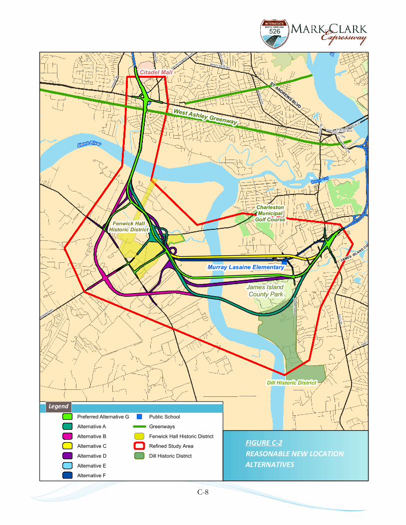
1.1.2 Description of the Proposed Action (Recommended Preferred Alternative) SCDOT proposes to construct a new location facility in Charleston County, South Carolina. The project was developed in close coordination with federal resource and regulatory agencies, as well as their state counterparts. The project, as proposed, is to add a new roadway in order to complete the Mark Clark Expressway from its current endpoint at U.S. 17 (Savannah Highway) in West Ashley, across the Stono River onto Johns Island, crossing the Stono River again onto James Island, and ending at the James Island Connector at Folly Road on James Island. Alternative G extends from U.S. 17 across the Stono River to Johns Island as a four-lane parkway with low speeds of 35-45 mph. This alternative provides two connector roads onto Johns Island. These connector roads would tie into River Road north of Maybank Highway and River Road south of Maybank Highway. On James Island, the parkway would pass through the northern edge of the James Island County Park. After passing Riverland Drive, Alternative G continues northeast, south of The Regatta, Carmike James Island Cinema and the U.S. Post Office, tying into the existing James Island Connector/Folly Road interchange. Alternative G provides access to Central Park Road via Riley Road and Up on the Hill Road. This alternative provides a multi-use path to accommodate bicycles and pedestrians. (See Figure C-1 for a map of the Recommended Preferred Alternative and impacted Section 4(f) resources)

")
West Ashley Greenway
Murray Lasaine Elementary
Citadel Mall
Fenwick HallHistoric District
Ashl
ehley
ST. ANDREWS BLVD
Wapoo Cut
JAMES ISLAND CONNECTO
Stono River
Dill Historic District
§̈¦526
FOLLY
RD
MAYBANK HWY
ASHLEY RIVER RDSAMRITTENBERG BLV
D
SAVA
GE
RD
OR
LEANS
RD
MA
GN
OLIA
RD
ASHLE
YH
ALL
RD
FORT JOHN
D
FOLL
Y
ROAD BLVDHIGHWAY 61 CONWES
LEY
DR
SAIN T ANDREWS BLVD
HIG
HWAY
61CON
CKETRD
RIV
ER
LAN
DD
R
James IslandCounty Park
CharlestonMunicipal
Golf Course
") Public School
Greenways
Alt. G
Fenwick Hall Historic District
Dill Historic District
Refined Study Area
FIGURE C-1PREFERRED ALTERNATIVE AND
Legend
SECTION 4(F) RESOURCES
C-4
C-5
2.0 SECTION 4(f) RESOURCES 2.1 Parks, Recreation Area or Wildlife Refuges There is one park, James Island County Park, and one recreation area, West Ashley Greenway that were identified adjacent to the Reasonable Alternatives. No other publicly-owned parks and recreational facilities, or publicly-owned wildlife refuges were identified adjacent to the Reasonable Alternatives.
2.1.1 James Island County Park The James Island County Park is the largest recreational area located in the refined study area. This 643-acre park is located on James Island off of Riverland Drive, south of Maybank Highway and west of Folly Road and is managed by the Charleston County Park and Recreation Commission. The park features miles of paved walking, biking and skating trails; picnic shelters and secluded picnic spots with tables and grills; grassy open meadows; a seasonal spray play fountain area; an off leash dog park; and opportunities for salt water fishing and crabbing for a park admission fee. Numerous amenities are available for reasonable costs including: 124-site campground, 10 vacation cottages, climbing wall and the Splash Zone Waterpark.6 2.1.2 West Ashley Greenway The West Ashley Greenway is a ten-mile long bicycle and pedestrian facility that uses a former railroad path (rail-trail) that is mostly unpaved, hard-packed dirt. It is part of the East Coast Greenway. The Greenway is 100-feet wide and follows parallel to U.S. 17 beginning to the east at Folly Road and continuing west to Main Road. The Greenway runs through portions of residential neighborhoods and marshland.
2.2 Historic Resources There are three historic resources that were identified adjacent to the Reasonable Alternatives.
2.2.1 Fenwick Hall Historic District - Located on Johns Island, this NRHP-listed property is noted for its c.1730 Georgian plantation house, oak allees, causeways leading to the Stono River, and archaeological sites, including 38CH1291/1292 and 38CH1656. These features contribute to the knowledge of 18th century plantation life. The setting of the district is fields and marsh which allude to past agricultural practices beside the Stono River. The NRHP boundary was recently expanded to include several recently discovered archaeological sites.
38CH1146 (Fenwick Hall Causeway) - Located within the Fenwick Hall Historic District, this causeway represents a historic landscape feature associated with the transportation of goods between the Stono River and the Fenwick Hall Plantation. Portions of the original causeway have been impacted by modern development and utility construction.
6 Charleston County Parks and Recreation, http://www.ccprc.com/index.aspx?nid=68
C-6
38CH2263 (Seven Oaks Causeway) - Located within the Fenwick Hall Historic District, this causeway is noted for its association with Fenwick Hall and Seven Oaks Plantation.
2.2.2 Dill Historic District - This recommended eligible property is the former Dill Plantation (also called Stono Plantation) on James Island and is currently operated by The Charleston Museum as the Dill Sanctuary. The district is comprised of fifteen archaeological sites, including 38CH0857, three Civil War earthworks listed in the NRHP, a caretaker’s house and two cemeteries. The Charleston Museum is currently in the process of nominating this property to the NRHP.
2.2.3 Murray-LaSaine Elementary School - This eligible property is noted for its 1950s architecture and its association with Charleston County’s movement to provide separate but equal educational facilities to African American students. The recommended NRHP boundary is the school property.
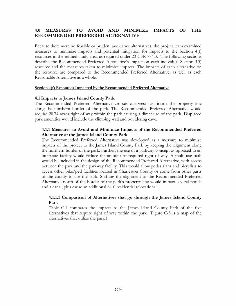
3.0 ALTERNATIVES AND FINDINGS 3.1 Development of Alternatives within the Study Area The development of project alternatives began by reviewing the four new location alternatives that were analyzed in the 1995 Draft Supplemental EIS study and designing 13 new location alternatives based on preliminary project goals. These initial 17 new location alignments were presented to the public for review during the first public information meeting in Fall 2008. Comments received during the following comment period resulted in the inclusion of 22 additional alignments for study, bringing the total number of alternatives considered to 38, including 35 new location alignments or improvements to existing roads, mass transit, transportation system management and the No-build Alternative. For further information on the development of alternatives, see Chapter 3, Development of Alternatives in the DEIS. The 38 build alternatives were evaluated to determine which of these alternatives met the purpose and need established for the project and which provided benefits in terms of traffic, safety and environmental criteria. The No-build, Mass Transit and Transportation System Management alternatives were also included in the DEIS for further analysis but upon further study were found not to meet the purpose and need for the project and further analysis of impacts was discontinued. The reasonable alternatives, Alternatives A through E, would continue the Mark Clark Expressway as a four-lane divided interstate facility with controlled access from U.S. 17 to the James Island Connector, bridging the Stono River twice. An additional new location alternative was added later in project development by looking at other reasonable routes for the parkway concept of Alternative F while addressing public concerns about the location of Alternative F. This resulted in Alternative G, the Recommended Preferred Alternative. Alternatives F and G would continue Mark Clark Expressway as a four-lane divided parkway facility with limited access from U.S. 17 to the James Island Connector, bridging the Stono
C-7
River twice. The facility would have reduced speeds and a multi-use path. (Refer to Figure C-2 for a map of the reasonable alternatives.) 3.2 Avoidance Alternatives None of the 35 new location alternatives, even those dismissed during the preliminary alternatives analysis, avoided impacting a Section 4(f) resource. GIS data obtained from the South Carolina Department of Archives and History (SCDAH), the South Carolina Institute of Archaeology and Anthropology (SCIAA), and Charleston County was reviewed in comparison to the alignment for each of the 35 alternatives. Each alternative directly impacted one of more historic resources, including sites and districts, or a publicly-owned recreational facility. This is due in large part to the historic nature of the area and the multiple recreational opportunities provided by the community. The No-build, Mass Transit and the Transportation System Management alternatives were found to not fulfill project purpose and need and further analysis of impacts was discontinued. Based on the studies for the 35 alternatives, there is no feasible and/or prudent alternative that avoids impacts to Section 4(f) Resources.
")
West Ashley Greenway
Murray Lasaine Elementary
Citadel Mall
Fenwick HallHistoric District
Ashl
ehley
ST. ANDREWS BLVD
Wapoo Cut
JAMES ISLAND CONNECTO
Stono River
Dill Historic District
§̈¦526
FOLLY
RD
MAYBANK HWY
ASHLEY RIVER RDSAMRITTENBERG BLV
D
SAVA
GE
RD
OR
LEANS
RD
MA
GN
OLIA
RD
ASHLE
YH
ALL
RD
FORT JOHN
D
FOLL
Y
ROAD BLVDHIGHWAY 61 CONWES
LEY
DR
SAIN T ANDREWS BLVD
HIG
HWAY
61CON
CKETRD
RIV
ER
LAN
DD
R
James IslandCounty Park
CharlestonMunicipal
Golf Course
Preferred Alternative G
Alternative A
Alternative B
Alternative C
Alternative D
Alternative E
Alternative F
") Public School
Greenways
Fenwick Hall Historic District
Refined Study Area
Dill Historic District
FIGURE C-2REASONABLE NEW LOCATION
Legend
ALTERNATIVES
C-8
C-9
4.0 MEASURES TO AVOID AND MINIMIZE IMPACTS OF THE RECOMMENDED PREFERRED ALTERNATIVE Because there were no feasible or prudent avoidance alternatives, the project team examined measures to minimize impacts and potential mitigation for impacts to the Section 4(f) resources in the refined study area, as required under 23 CFR 774.3. The following sections describe the Recommended Preferred Alternative’s impact on each individual Section 4(f) resource and the measures taken to minimize impacts. The impacts of each alternative on the resource are compared to the Recommended Preferred Alternative, as well as each Reasonable Alternative as a whole. Section 4(f) Resources Impacted by the Recommended Preferred Alternative 4.1 Impacts to James Island County Park The Recommended Preferred Alternative crosses east-west just inside the property line along the northern border of the park. The Recommended Preferred Alternative would require 20.74 acres right of way within the park causing a direct use of the park. Displaced park amenities would include the climbing wall and bouldering cave.
4.1.1 Measures to Avoid and Minimize Impacts of the Recommended Preferred Alternative at the James Island County Park The Recommended Preferred Alternative was developed as a measure to minimize impacts of the project to the James Island County Park by keeping the alignment along the northern border of the park. Further, the use of a parkway concept as opposed to an interstate facility would reduce the amount of required right of way. A multi-use path would be included in the design of the Recommended Preferred Alternative, with access between the park and the parkway facility. This would allow pedestrians and bicyclists to access other bike/ped facilities located in Charleston County or come from other parts of the county to use the park. Shifting the alignment of the Recommended Preferred Alternative north of the border of the park’s property line would impact several ponds and a canal, plus cause an additional 8-10 residential relocations.
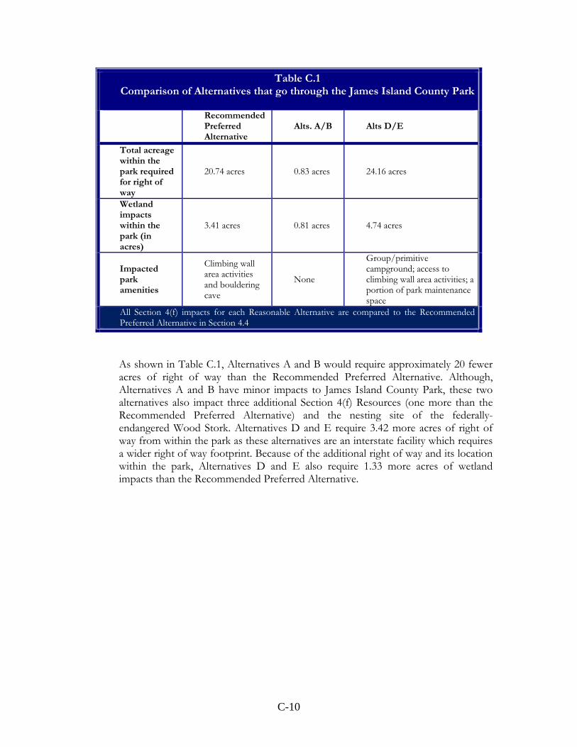
4.1.1.1 Comparison of Alternatives that go through the James Island County Park Table C.1 compares the impacts to the James Island County Park of the five alternatives that require right of way within the park. (Figure C-3 is a map of the alternatives that utilize the park.)
C-10
Table C.1 Comparison of Alternatives that go through the James Island County Park
RecommendedPreferred Alternative
Alts. A/B Alts D/E
Total acreage within the park required for right of way
20.74 acres 0.83 acres 24.16 acres
Wetland impacts within the park (in acres)
3.41 acres 0.81 acres 4.74 acres
Impacted park amenities
Climbing wall area activities and bouldering cave
None
Group/primitive campground; access to climbing wall area activities; a portion of park maintenance space
All Section 4(f) impacts for each Reasonable Alternative are compared to the Recommended Preferred Alternative in Section 4.4
As shown in Table C.1, Alternatives A and B would require approximately 20 fewer acres of right of way than the Recommended Preferred Alternative. Although, Alternatives A and B have minor impacts to James Island County Park, these two alternatives also impact three additional Section 4(f) Resources (one more than the Recommended Preferred Alternative) and the nesting site of the federally-endangered Wood Stork. Alternatives D and E require 3.42 more acres of right of way from within the park as these alternatives are an interstate facility which requires a wider right of way footprint. Because of the additional right of way and its location within the park, Alternatives D and E also require 1.33 more acres of wetland impacts than the Recommended Preferred Alternative.

C-11
Figure C-3 – Alternatives that impact James Island County Park Located approximately 200 feet south of the Recommended Preferred Alternative, Alternatives D and E would impact the Group/Primitive Campground, temporarily disrupt access to the climbing wall area activities during construction, and would use a portion of park maintenance space. Alternatives D and E would be 240 feet north of the campground as opposed to 670 feet north with the Recommended Preferred Alternative. Alternatives D and E would also be 190 feet from a vacation cottage on the western end of the park. Additionally, right of way for Alternatives D and E borders the park’s walking/bicycle trail. With the Recommended Preferred Alternative, climbing wall area activities and the bouldering cave would be relocated to another area of the park. Alternatives D and E would bisect approximately 30 acres of the northern portion of the park from the rest of the park. Although the facility would be elevated through the park allowing access to the bisected area, the setting, rural feel and related quietness would be disturbed for park users. The Recommended Preferred Alternative would not disrupt the setting and viewshed of the rest of the park because, as an at-grade facility, it would be able to maintain a tree buffer.
The Recommended Preferred Alternative would provide an additional access route on James Island to the park, because it would provide an at-grade intersection with Riverland Drive, 1,200 feet north of the park entrance. Alternatives A, B, D, and E

C-12
would not provide an additional access route since an interchange is not provided at Riverland Drive for these alternatives. Also, the Recommended Preferred Alternative would provide an additional mode of access to the park with a multi-use path, thus adding to the bike/ped network in the area. As interstate facilities, Alternatives A, B, D, and E would not provide a multi-use path and therefore would not provide an additional mode of access to the park or add to the bike/pedestrian network of the area. 4.1.1.2 Alternatives that do not go through the James Island County Park Alternatives C and F do not use park lands. Alternative F is located 1,363 feet of the north of the park and Alternative C is located 1,766 feet to the north. However, relocations for these alternatives are higher on James Island than the Recommended Preferred Alternative which only impacts four residences on the island. Alternative F impacts 10 residences, two businesses and one church while Alternative C impacts 24 residences and eight businesses as they traverse James Island.
4.1.2 Mitigation Mitigation under Section 4(f) for the land converted and park amenities impacted would be coordinated with Charleston County Park and Recreation Commission through a Memorandum of Agreement (MOA) prior to an issuance of the Record of Decision (ROD) for this project. Mitigation may include replacement in-kind of park amenities or enhancements, the use of Best Management Practices during construction to minimize construction impacts to the park and park-users, and planting vegetation along the border of the facility to minimize noise and visual impacts.
Mitigation to fulfill Section 6(f) for converting park lands into a non-recreational space would need the approval of the Department of Interior’s National Park Service prior to a ROD for the project. Compensatory acreage must be of at least equal fair market value, and reasonably equivalent usefulness and location. (36 CFR 59.3)
4.2 Impacts to the West Ashley Greenway The Recommended Preferred Alternative is a north-south alignment and the Greenway is east-west. Where the Recommended Preferred Alternative intersects the Greenway would be bridged with an overpass at a height of 15 feet. Right of way acquisition would cause a direct use of the property. Construction activities would create temporary impacts to the trail but would not diminish the qualities of this resource. Construction at the intersection of the trail and the project would necessitate temporary detours or closure of this portion of the trail in order to provide for the safety of users.
4.2.1 Measures to Avoid and Minimize Impacts of the Recommended Preferred Alternative at the West Ashley Greenway In an effort to minimize impacts to the Greenway, the Recommended Preferred Alternative will be bridged, providing a clearance of 15 feet to users of the Greenway facility. The bridge design was maintained throughout project development as opposed to bringing alternative alignments down to grade at the location of the Greenway. A culvert with a clearance of 10 feet in height was reviewed but this would not have provided clearance for Greenway maintenance or adequate safety for users of the facility.
C-13
By providing a multi-use path with the Recommended Preferred Alternative, bicyclists and pedestrians will be able to access the Greenway and sidewalks along U.S. 17 in West Ashley, and the James Island County Park on James Island, as well as area neighborhoods. Likewise, users from these facilities will be able to use the multi-use path with the Recommended Preferred Alternative to access other bicycle/pedestrian facilities in the area.
4.2.1.1 Comparison of Alternatives at the West Ashley Greenway All of the Reasonable Alternatives result in the same impact to the Greenway as they all follow the same alignment in this location. Because of the reduced right of way widths of the parkway alternatives (up to 150 feet for the parkway versus 250 feet for the interstate), Alternative F and the Recommended Preferred Alternative, the bridge crossing of the Greenway would not be as wide as the interstate alternatives (Alternatives A-E). (Refer to Figure C-2 for a map of the alternatives and the Greenway.)
4.3.1 Mitigation A new multi-use path is incorporated in the design of the Recommended Preferred Alternative. It is anticipated that a ramp will be provided between the two paths for ease of access. Users of the Greenway will be able to access the Recommended Preferred Alternative’s multi-use path and vice-versa at the junction of the Recommended Preferred Alternative and the Greenway. Mitigation may also include landscaping to enhance aesthetics and vegetative screening of the overpass structure.
Due to these enhancement measures, in addition to minimization measures taken during project development as described in section 3.3 below, a de minimis impact determination would be sought prior to the Final Environmental Impact Statement (FEIS), through coordination with the City of Charleston’s Department of Parks. If the impact to the Greenway is found and agreed upon with the jurisdictional agency to be de minimis, then an avoidance alternatives analysis is not required and the Section 4(f) evaluation process would be considered completed. Members of the public will have the opportunity to review and comment on the impacts to the Greenway during the Public Hearing in August of 2010 and the comment period following.
4.4 Impacts to Fenwick Hall Historic District The Recommended Preferred Alternative causes a direct use of the resource by requiring right of way from within the historic district. The Recommended Preferred Alternative enters the historic district from the west by intersecting with the Fenwick Hall Causeway (38CH1146), a feature that runs north-south through the marsh between Fenwick Hall and the Stono River. The causeway would be bridged by the Recommended Preferred Alternative, which would traverse east-west over non-contributing portions of the causeway at an approximate height of 15 feet. The Recommended Preferred Alternative reenters the historic district on the south side of Maybank Highway and continues south for a distance of 1,860 feet through the historic district along a transmission line easement parallel to the Stono River. Connector B departs from the mainline of the Recommended Preferred Alternative at an at-grade T-intersection. The Connector road reenters the historic district and continues west 3,200 feet to intersect with River Road. Connector B also intersects
C-14
archaeological site 38CH1656 in this portion of the historic district. Intersection improvements including widening the existing right of way to accommodate additional turn lanes would be required along River Road which borders the historic district.
4.4.1 Measures to Avoid and Minimize Impacts of the Recommended Preferred Alternative at the Fenwick Hall Historic District In order to minimize impacts to the Fenwick Hall Historic District, efforts were made during project development to stay within the non-contributing portions of the Fenwick Hall Causeway portion of the district. Less right of way would be required for the Recommended Preferred Alternative since it is a parkway facility rather than an interstate facility. An interchange with Maybank Highway would not be provided with the Recommended Preferred Alternative. This avoids a larger, localized impact to the district that would be associated with an interchange. Instead, an at-grade connector road (Connector B) would depart from the mainline with a T-intersection and continue along the edge of the district’s southeastern border to intersect with River Road. The mainline would stay along the edge of the district paralleling a transmission line easement. The parkway is able to be closer to the easement because the lower speeds of a parkway facility permit a tighter curve in the alignment. The transmission easement is an already disturbed portion of the viewshed, located between a forested area and the marshlands of the Stono River. Prior to the FEIS, shifts in the alignment of the Recommended Preferred Alternative to avoid known historical features, such as 38CH1656, or features discovered during the archaeological investigation will be reviewed. Impacts would be further reduced by requiring best construction practices during construction of the bridging over the Fenwick Hall Causeway (38CH1146) to minimize risk of further impacts.
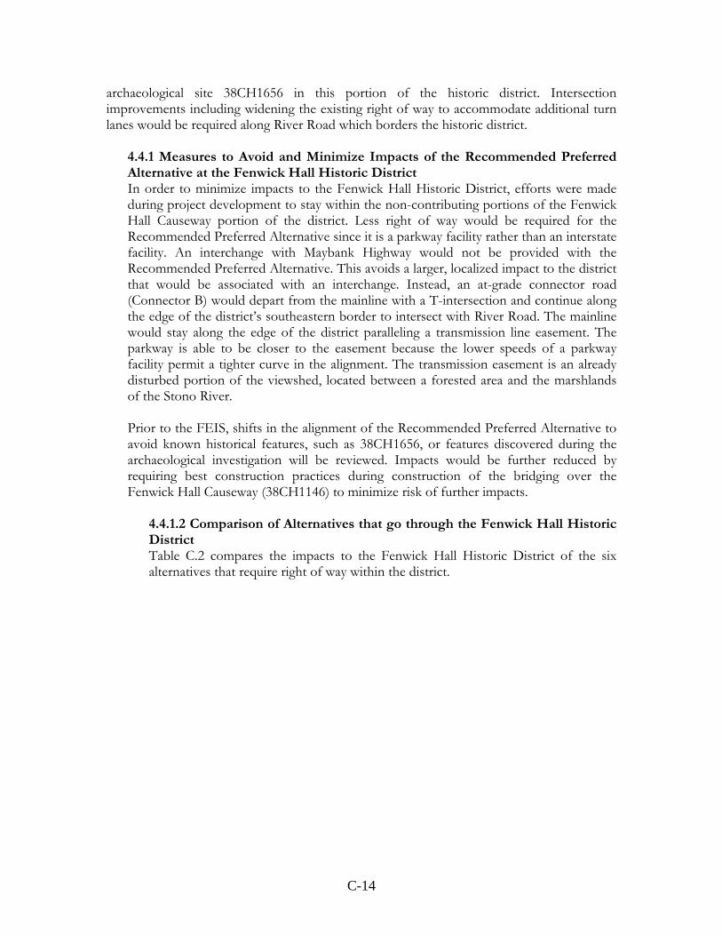
4.4.1.2 Comparison of Alternatives that go through the Fenwick Hall Historic District Table C.2 compares the impacts to the Fenwick Hall Historic District of the six alternatives that require right of way within the district.
C-15
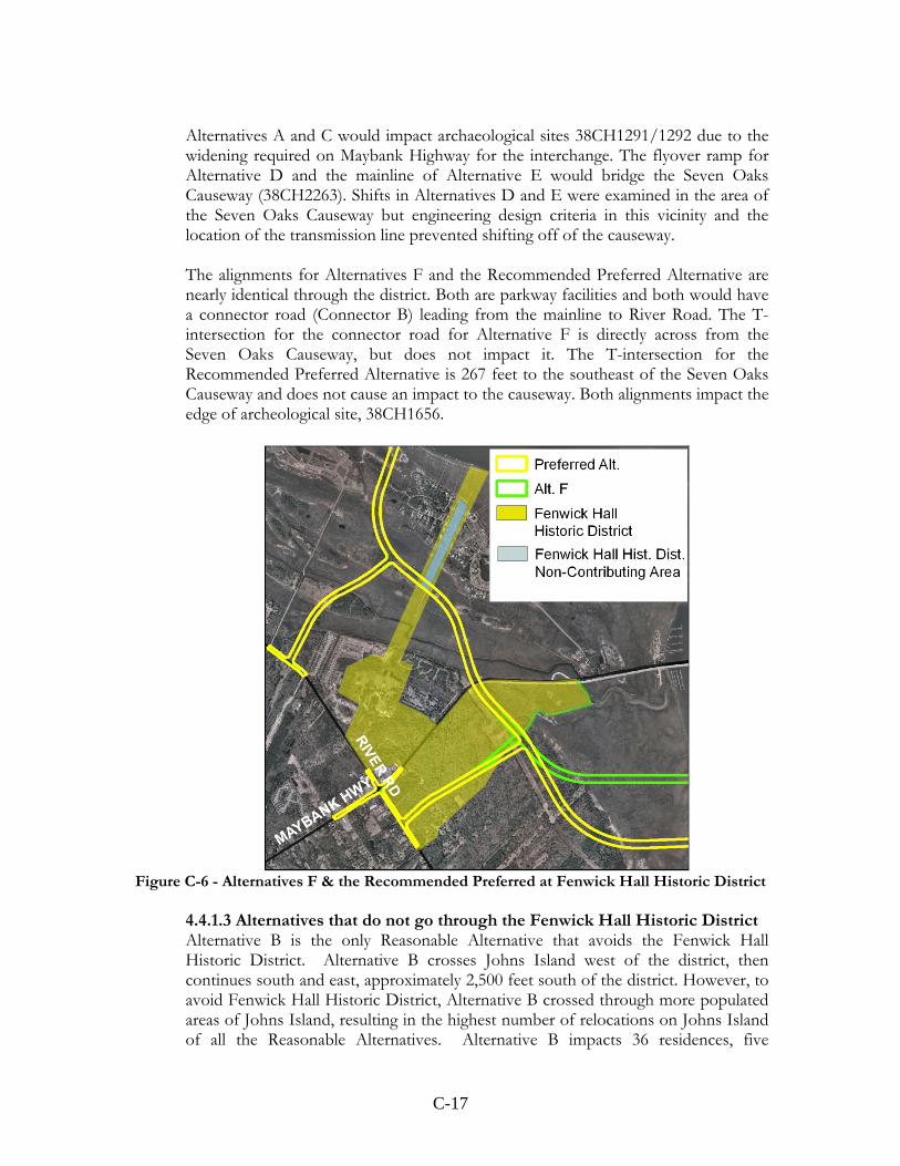
Figures C-4 through C-6 are maps of the alternatives that directly impact the district. The district is in shown yellow with the non-contributing portion of the district shown in blue. All of the alignments would bridge the Fenwick Hall Causeway (38CH1146) and follow the transmission line easement paralleling the Stono River through the district. Alternatives D and E are the farthest away from the easement due to the wider curvature needed for the higher speeds of an interstate facility. However, as discussed further in Sections 4.7.5 and 4.7.6, Alternatives D and E cost substantially more than other alternatives and have more overall wetland impacts and relocations. Alternatives A and C, although they are close to the easement, have an interchange with Maybank Highway that causes a greater localized impact to the district as compared to Alternatives F and the Recommended Preferred Alternative.
Table C.2 Comparison of Alternatives that go through the Fenwick Hall Historic District
Recommended
Preferred Alternative
Alts. A/C Alt. D Alt. E Alt. F
Total acreage within the district required for right of way
26.9 acres 40.4 acres 11.3 acres 11.3 acres 28.8 acres
Wetland impacts within the district (in acres)
9.84 acres 19.39 acres 9.67 acres 9.67 acres 10.37 acres
Impacted district resources
Fenwick Hall Causeway, 38CH1656
Fenwick Hall Causeway, 38CH1291-1292
Fenwick Hall Causeway, Seven Oaks Causeway
Fenwick Hall Causeway, Seven Oaks Causeway
Fenwick Hall Causeway, 38CH1656
All Section 4(f) impacts for each Reasonable Alternative are compared to the Recommended Preferred Alternative in Section 4.4
C-16
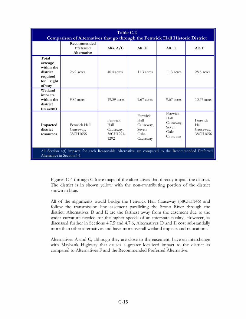
Figure C-4 – Alternatives A and C at Fenwick Hall Historic District
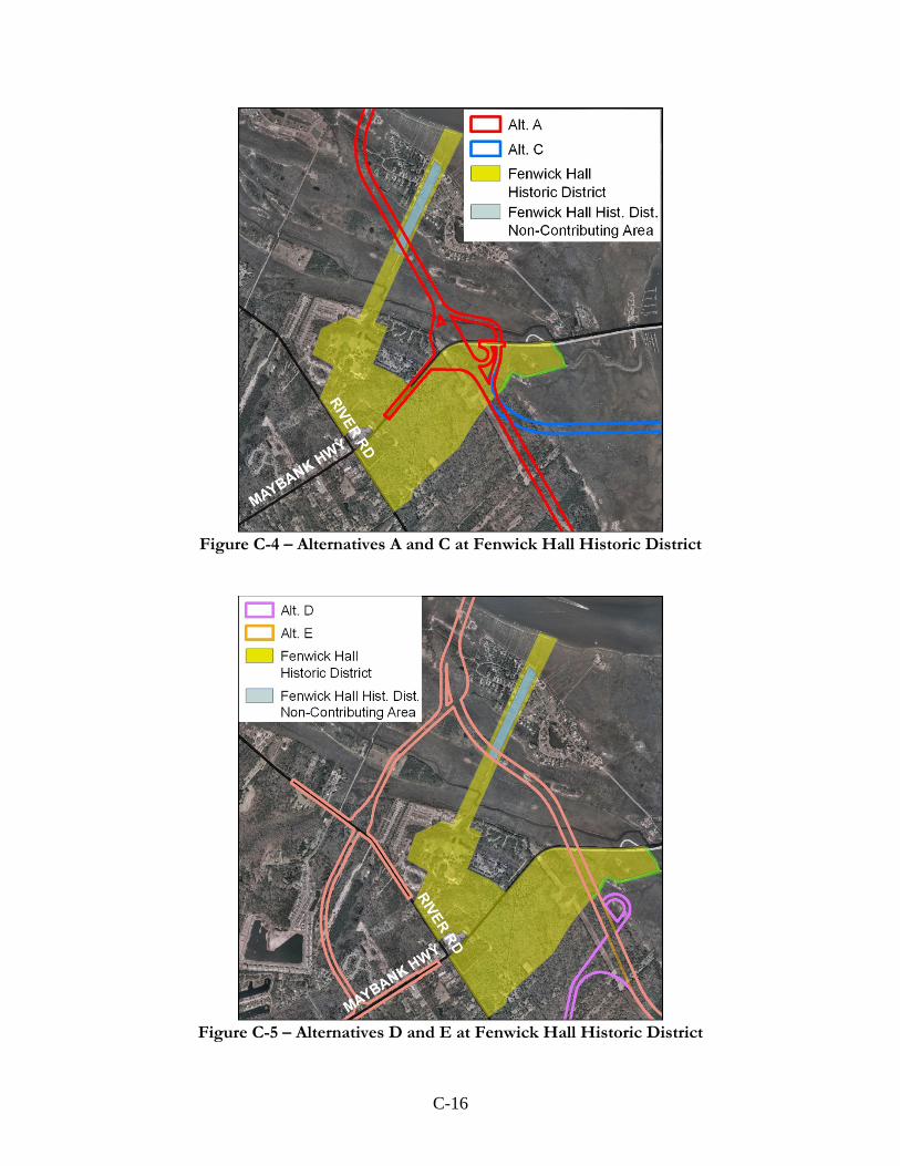
Figure C-5 – Alternatives D and E at Fenwick Hall Historic District
C-17
Alternatives A and C would impact archaeological sites 38CH1291/1292 due to the widening required on Maybank Highway for the interchange. The flyover ramp for Alternative D and the mainline of Alternative E would bridge the Seven Oaks Causeway (38CH2263). Shifts in Alternatives D and E were examined in the area of the Seven Oaks Causeway but engineering design criteria in this vicinity and the location of the transmission line prevented shifting off of the causeway. The alignments for Alternatives F and the Recommended Preferred Alternative are nearly identical through the district. Both are parkway facilities and both would have a connector road (Connector B) leading from the mainline to River Road. The T-intersection for the connector road for Alternative F is directly across from the Seven Oaks Causeway, but does not impact it. The T-intersection for the Recommended Preferred Alternative is 267 feet to the southeast of the Seven Oaks Causeway and does not cause an impact to the causeway. Both alignments impact the edge of archeological site, 38CH1656.
Figure C-6 - Alternatives F & the Recommended Preferred at Fenwick Hall Historic District
4.4.1.3 Alternatives that do not go through the Fenwick Hall Historic District Alternative B is the only Reasonable Alternative that avoids the Fenwick Hall Historic District. Alternative B crosses Johns Island west of the district, then continues south and east, approximately 2,500 feet south of the district. However, to avoid Fenwick Hall Historic District, Alternative B crossed through more populated areas of Johns Island, resulting in the highest number of relocations on Johns Island of all the Reasonable Alternatives. Alternative B impacts 36 residences, five

C-18
businesses and two churches, whereas the Recommended Preferred Alternative impacts only one business and one residence on Johns Island. A comparison of relocations on Johns Island resulting from the Reasonable Alternatives is shown in Table C.3.
Table C. 3
Relocations on Johns Island Recommended
Preferred Alternative
Alts. A and C
Alt. B Alt. D Alt. E Alt. F
Residence 1 0 36 15 13 1 Business 1 0 5 6 5 1 Church 0 0 2 1 1 0
4.4.2 Mitigation A Memorandum of Agreement (MOA) would be required for adverse affects by the project to the historic district. Further shifts to the Recommended Preferred Alternative will be reviewed prior to the FEIS in the area of the historic district to minimize or avoid impacts to historic features within the historic district. Mitigation of adverse affects may include but are not limited to documentation of the resource, landscape plans, or other measures decided upon by the FHWA and the SCDOT, in coordination with the SHPO.
4.5 Potential Indirect and Cumulative Impacts to Section 4(f) Resources Indirect impacts to the Section 4(f) resources could include changes in accessibility, increased noise or air quality impacts. Indirect impacts from induced development near the Fenwick Hall Historic District due to the Reasonable Alternatives could diminish the setting that contributes to its historical significance. Induced development could also affect the rural landscape and oak tree-lined roadways on Johns Island in the vicinity of the district. Future development could affect unidentified, potentially-eligible archeological resources in the refined study area, particularly in the area of interchanges or intersections. While special protections are required by Federal Agencies to avoid and minimize impacts to NRHP listed sites, there are no such requirements on private developers. The Recommended Preferred Alternative would not impact accessibility to the James Island County Park. It would provide enhanced access to the park by providing an intersection at Riverland Drive and a bicycle/pedestrian path connecting directly to the park. Improved access could contribute to increased attendance to the park. During construction, travel to the James Island County Park from Riverland Drive may be temporarily disrupted for all of the Reasonable Alternatives. However, it is anticipated that a through route would be maintained throughout construction. Construction activities within the park would be temporary in nature and would not disrupt continued usage of park facilities with the exception of those directly impacted, as listed previously.
C-19
Changes to the accessibility of the West Ashley Greenway are not expected. The Recommended Preferred Alternative provides a multi-use path connecting to the West Ashley Greenway, which could improve access and increase usage of this facility. Any impacts to the West Ashley Greenway during construction would be temporary in nature and would not permanently diminish the qualities of the trail. Accessibility is not expected to change for other parks or recreational facilities in the refined study area. While noise levels resulting from the proximity of the Recommended Preferred Alternative may increase for users of the James Island County Park, the level of noise is not considered to be an impact according to FHWA’s Noise Abatement Criteria (NAC) (see Section 5.3 of the DEIS for more information on noise). Noise levels would also rise for users of the West Ashley Greenway. However, the Greenway traverses an urban area, in proximity to U.S. 17 and the commercial district along the road. Therefore, the overall environment of the Greenway would not be diminished due to the noise levels from the proposed project. While noise levels may rise in the area of the Fenwick Hall Historic District, the level of noise is not considered to be an impact according to FHWA’s NAC. No structures within the district were above the NAC. The Section 4(f) resources within the refined study area are all within an attainment area for air quality and air quality impacts are not anticipated as a result of the Recommended Preferred Alternative (see Section 5.11 of the DEIS for more information on air quality). Cumulative impacts to public parks and recreation areas would include impacts from past, present and reasonably foreseeable projects in the area. There are no other projects in the refined study area that are anticipated to impacts the park or the Greenway and therefore, no cumulative impacts are expected. As discussed in the Land Use, Section 5.2 of the DEIS, the City of Charleston Century V City Plan (2000) designated the area of Maybank Highway and River Road as a community gathering place, meant to promote infill of mixed-use development. This area is also within the County’s Urban Growth Boundary (UGB), meant to promote development and, therefore, limit growth in rural areas outside of the UGB. A sign noting the future development of a Harris Teeter grocery store to be constructed within the Fenwick Hall Historic District stands along River Road. The cumulative impact from these plans, in addition to past and current development at this intersection, will adversely impact the Fenwick Hall Historic District. Mitigation for impacts to Section 4(f) resources will be coordinated with officials having jurisdiction over these resources prior to issuance of the Record of Decision (ROD) and will be detailed in the FEIS. 4.6 Comparison of the Recommended Preferred Alternative to all Alternatives Considered As stated previously, none of the 35 new location alternatives, even those dismissed during the preliminary alternatives analysis, avoided impacting a Section 4(f) resource. GIS data obtained from the South Carolina Department of Archives and History (SCDAH), the South Carolina Institute of Archaeology and Anthropology (SCIAA), and Charleston County was reviewed in comparison to the alignment for each of the 35 alternatives. Each alternative directly impacted one of more historic resources, including sites and districts, or a publicly-
C-20
owned recreational facility. This is due in large part to the historic nature of the area and the multiple recreational opportunities provided by the community. The No-build, Mass Transit and the Transportation System Management alternatives were found to not fulfill project purpose and need and further analysis of impacts was discontinued. Based on the studies for the 35 alternatives, there is no feasible and/or prudent alternative that avoids impacts to Section 4(f) Resources. 4.7 Comparison of the Recommended Preferred Alternative to the Reasonable Alternatives Considered
4.7.1 No-build Alternative The No-build Alternative would not impact a Section 4(f) resource. It would avoid impacts such as relocations, impacts to wetlands, and noise impacts anticipated from the reasonable new location alternatives. The purpose of the project is to increase the capacity of the regional transportation system, improve safety and enhance mobility to and from West Ashley, Johns Island and James Island areas of Charleston. The No-build Alternative would not meet any of these needs. This alternative does not meet the need and purpose of the project.
4.7.2 Alternative A Alternative A would impact the same Section 4(f) resources as the Recommended Preferred Alternative, the James Island County Park, the West Ashley Greenway and the Fenwick Hall Historic District; plus it would impact an additional 4(f) resource, the Dill Historic District.
• James Island County Park- Alternative A would traverse east-west across the southeastern portion of the park, requiring 0.83 acres of right of way within the park next to Riverland Drive, 147 feet south of the park entrance. No park amenities would be impacted. Any effort to move this alignment to the south would result in further impacts to the Dill Historic District, a 4(f) resource.
• Fenwick Hall Historic District- Alternative A would impact the Fenwick Hall
Causeway (38CH1146) in the same manner as the Recommended Preferred Alternative. Alternative A then reenters the historic district south of Maybank Highway with an interchange at Maybank Highway. It then continues south through the historic district along a transmission line easement parallel to the Stono River. Road improvements along Maybank Highway would include widening the existing right of way west of the interchange. This would impact archaeological sites 38CH1291/1292. Impacts to the Fenwick Hall Historic District would require a Memorandum of Agreement (MOA) with mitigation measures decided upon by FHWA and SCDOT, in coordination with the SHPO.
• Dill Historic District- Alternative A would traverse east-west across the northern
portion of the district requiring right of way from with the historic district

C-21
causing a direct use of the resource. Alternative A would also impact archaeological site 38CH0857. The Dill Historic District is the site of the former Dill Plantation that contains several historical and archaeological features including the Dill Slave Cemetery (38CH564) and the Devil’s Nest Cemetery (38CH464), Civil War Batteries Tynes and Leroy and Fort Pringle, the Caretaker’s House (5737), and 14 additional archaeological sites. The historic district is also the site of a privately-owned wildlife refuge, the Dill Sanctuary. It has a six acre freshwater pond that is the nesting site of the federally endangered Wood Stork. Alternative A would pass on the northern edge of the freshwater pond. In an effort to minimize impacts to the historic district, the alignment was focused on the northern portion of the district as opposed to running south through the middle of the district near the Caretaker’s House (5737) and the Dill Slave Cemetery (38CH564) as a previously considered alternative (#17) had done. The northern border of the historic district is the James Island County Park, any effort to move the alignment to the north would have further impacted this 4(f) resource and park amenities such as a crabbing dock, walking trail, and picnic areas. The Charleston Museum is currently in the process of nominating the Dill Historic District to the NRHP. Impacts to the Dill Historic District would require a Memorandum of Agreement (MOA) with mitigation measures decided upon by FHWA and SCDOT, in coordination with the SHPO.
• West Ashley Greenway- There would be no difference from the Recommended
Preferred Alternative in impacts to the Greenway with Alternative A. Alternative A would have a higher cost, $652 million, or $163 million more than the Recommended Preferred Alternative and would impact approximately the same amount of wetlands as the Recommended Preferred Alternative. Additionally, Alternative A would have higher relocations (29) than the Recommended Preferred Alternative.
Alternative A would not be a prudent alternative to the Recommended Preferred Alternative since it would impact an additional Section 4(f) resource, at which an endangered species has been identified. In addition, this alternative would cost substantially more and require three more relocations.
4.7.3 Alternative B Alternative B would avoid the Fenwick Hall Historic District but would impact two of the same Section 4(f) resources as the Recommended Preferred Alternative, the James Island County Park and the West Ashley Greenway, plus it would impact an additional 4(f) resource, the Dill Historic District.
• James Island County Park- Alternative B would pass east-west across the
southeastern portion of the park, requiring 0.83 acres of right of way within the park next to Riverland Drive, 147 feet south of the park entrance. No park amenities would be impacted. Any effort to move this alignment to the south would result in further impacts to the Dill Historic District, a 4(f) resource.
C-22
• Dill Historic District- Alternative B would pass east-west across the northern portion of the district requiring right of way from with the historic district causing a direct use of the resource. Alternative B would also impact archaeological site 38CH0857. The Dill Historic District is the site of the former Dill Plantation that contains several historical and archaeological features including the Dill Slave Cemetery (38CH564) and the Devil’s Nest Cemetery (38CH464), Civil War Batteries Tynes and Leroy and Fort Pringle, the Caretaker’s House (5737), and 14 additional archaeological sites. The historic district is also the site of a privately-owned wildlife refuge, the Dill Sanctuary. It has a six acre freshwater pond that is the nesting site of the federally endangered Wood Stork. Alternative B would pass on the northern edge of the freshwater pond. In an effort to minimize impacts to the historic district, the alignment was focused on the northern portion of the district as opposed to running south through the middle of the district near the Caretaker’s House (5737) and the Dill Slave Cemetery (38CH564) as a previously considered alternative (#17) had done. The northern border of the historic district is the James Island County Park, any effort to move the alignment to the north would have further impacted this 4(f) resource and park amenities such as a crabbing dock, walking trail, and picnic areas. Impacts to the Dill Historic District would require a Memorandum of Agreement (MOA) with mitigation measures decided upon by FHWA and SCDOT, in coordination with the SHPO.
• West Ashley Greenway- There would be no difference from the Recommended
Preferred Alternative in impacts to the Greenway with Alternative B. Alternative B would cost $629 million, $140 million more than the Recommended Preferred Alternative. It would also have the highest wetland impacts (29.39 acres), 11.96 more acres than the Recommended Preferred Alternative. Additionally, Alternative B has the highest relocations (72), including two churches. This is 46 more than the Recommended Preferred Alternative.
Alternative B would not be a prudent alternative to the Recommended Preferred Alternative since it would directly impact three Section 4(f) resources, one of which has a federally-endangered species. It costs substantially more, impacts 69 percent more wetlands and the highest relocations. 4.7.4 Alternative C Alternative C would avoid the James Island County Park but would impact two of the same Section 4(f) resources as the Recommended Preferred Alternative, the West Ashley Greenway and the Fenwick Hall Historic District.
• Fenwick Hall Historic District- Alternative C would impact the Fenwick Hall Causeway (38CH1146) in the same manner as the Recommended Preferred Alternative. Alternative C then reenters the historic district south of Maybank Highway with an interchange at Maybank Highway. It then continues south through the historic district along a transmission line easement parallel to the Stono River. Road improvements along Maybank Highway would include
C-23
widening the existing right of way west of the interchange. This would impact archeological sites 38CH1291/1292. Impacts to the Fenwick Hall Historic District would require a Memorandum of Agreement (MOA) with mitigation measures decided upon by FHWA and SCDOT, in coordination with the SHPO.
• West Ashley Greenway- There would be no difference from the Recommended
Preferred Alternative in impacts to the Greenway with Alternative C. Alternative C would higher cost, $607 million, $118 million more than the Recommended Preferred Alternative. It would also have approximately the same amount of wetland impacts as the Recommended Preferred Alternative. Additionally, Alternative C has the second highest relocations (53), 27 more than the Recommended Preferred Alternative.
Alternative C would not be a prudent alternative to the Recommended Preferred Alternative since it would directly impact two Section 4(f) resources, has a substantially higher cost and has higher relocations. 4.7.5 Alternative D Alternative D would impact the same Section 4(f) resources as the Recommended Preferred Alternative, the James Island County Park, the West Ashley Greenway, and the Fenwick Hall Historic District.
• James Island County Park- Alternative D would traverse east-west in the
northern portion of the Park, requiring 24.16 acres of right of way within the park. Impacted park amenities would include the group/primitive campground and access to the climbing wall/bouldering cave. The northern portion of the maintenance area would also be required for right of way.
• Fenwick Hall Historic District- Alternative D would impact the Fenwick Hall
Causeway (38CH1146) in the same manner as the Recommended Alternative. Alternative D then reenters the historic district south of Maybank Highway and continues south through the historic district along a transmission line easement parallel to the Stono River. The alternative would bridge the Seven Oaks Causeway (38CH2263) at a height of 12 feet. Impacts to the Fenwick Hall Historic District would require a Memorandum of Agreement (MOA) with mitigation measures decided upon by FHWA and SCDOT, in coordination with the SHPO.
• West Ashley Greenway- There would be no difference from the Recommended
Preferred Alternative in impacts to the Greenway with Alternative D. Alternative D would cost $646 million, which is $157 million more than the Recommended Preferred Alternative. It would also have the second highest wetland impacts (26.90 acres), which is 9.47 more acres than the Recommended Preferred Alternative. Additionally, Alternative D would have higher relocations (51), 25 more
C-24
than the Recommended Preferred Alternative. Alternative D also has the highest impact to farmlands at 253 acres. Alternative D would not be a prudent alternative to the Recommended Preferred Alternative since it would impact three Section 4(f) resources, cost substantially more, has higher relocations, and impact 54 percent more wetlands. 4.7.6 Alternative E Alternative E would impact the same Section 4(f) resources as the Recommended Preferred Alternative, the James Island County Park, the West Ashley Greenway and the Fenwick Hall Historic District.
• James Island County Park- Alternative E would traverse east-west in the
northern portion of the Park, requiring 24.16 acres of right of way within the park. Impacted park amenities would include the group/primitive campground and access to the climbing wall/bouldering cave. The northern portion of the maintenance area would also be required for right of way.
• Fenwick Hall Historic District- Alternative E would impact the Fenwick Hall
Causeway (38CH1146) in the same manner as the Recommended Preferred Alternative. Alternative E then reenters the historic district south of Maybank Highway and continues south through the historic district along a transmission line easement parallel to the Stono River. The alternative would bridge the Seven Oaks Causeway (38CH2263) at a height of 12 feet. Impacts to the Fenwick Hall Historic District would require a Memorandum of Agreement (MOA) with mitigation measures decided upon by FHWA and SCDOT, in coordination with the SHPO.
• West Ashley Greenway- There would be no difference from the Recommended
Preferred Alternative in impacts to the Greenway with Alternative E. Alternative E would cost $615 million, which is $126 million more than the Recommended Preferred Alternative. It would also have the third highest wetland impacts (24.05 acres), which is 6.62 acres more than the Recommended Preferred Alternative. Additionally, Alternative E has high relocations (50), 24 more than the Recommended Preferred Alternative.
Alternative E would not be a prudent alternative to the Recommended Preferred Alternative since it would impact three Section 4(f) resources, cost substantially more, have higher relocations, and 38 percent more wetlands. 4.7.7 Alternative F Alternative F would avoid the James Island County Park but would impact two of the same Section 4(f) resources as the Recommended Preferred Alternative, the West Ashley Greenway and the Fenwick Hall Historic District. Additionally, it would impact the Murray-LaSaine Elementary School, a 4(f) resource.

C-25
• Fenwick Hall Historic District- Alternative F would impact the Fenwick Hall Causeway (38CH1146) in the same manner as the Recommended Preferred Alternative. Alternative F then reenters the historic district south of Maybank Highway and continues south along a transmission line easement parallel to the Stono River. This alternative contains a connector road (Connector B) that deviates from the mainline at an at-grade T-intersection and travels west through the historic district to intersect with River Road. Connector B also intersects archaeological site 38CH1656 in this portion of the historic district. Intersection improvements including widening the existing right of way to accommodate additional turn lanes would be required along River Road which borders the historic district. Impacts to the Fenwick Hall Historic District would require a Memorandum of Agreement (MOA) with mitigation measures decided upon by FHWA and SCDOT, in coordination with the SHPO.
• Murray-LaSaine Elementary School- Alternative F would require minor amounts
of right of way from property along Riverland Drive to the side of the school. The school is located in the southwest corner of Lucky Road and Riverland Drive with Alternative F traveling in front of the school along Lucky Road and with road improvements on Riverland Drive to the east of the school. The school was constructed in 1955 under the County’s School Equalization Program of the early 1950s to provide equal schools for area African American students. In an effort to minimize impacts to the school, Alternative F was moved north 75 feet. Originally, the alignment directly impacted Murray-LaSaine Elementary School by requiring right of way from school property fronting Lucky Road, taking playground equipment, part of its parking and access to parking lots and drop-off site. The reconfigured alignment requires no right of way from the front of the school. A letter dated January 6, 2010 from SCDAH determined the impact to the school by Alternative F to be no adverse effect (see letter from SCDAH in Appendix F). Because only minor amounts of right of way would be required from the school property, a de minimis impact determination could be sought, through coordination with the jurisdictional agency, Charleston County School District. If the impact to the school property is found and agreed upon with the jurisdictional agency to be de minimis, then an avoidance alternatives analysis would not required and the Section 4(f) evaluation process would be considered completed.
• West Ashley Greenway- There would be no difference from the Recommended
Preferred Alternative in impacts to the Greenway with Alternative A. Alternative F would cost $495 million, $6 million more than the Recommended Preferred Alternative. Additionally, Alternative F has higher relocations (35), 9 more than the Recommended Preferred Alternative, including one church. Alternative F would not be a prudent alternative to the Recommended Preferred Alternative since it would also impact three Section 4(f) resources and would have higher costs and relocations.

C-26
Table C.4 summarizes the impacts of the Reasonable Alternatives on Section 4(f) Resources.
Table C.4
Summary of Section 4(f) Resources by Alternative
Alternative Resource Impact
A
Fenwick Hall Historic District
Dill Historic District
West Ashley Greenway
James Island County Park
Direct Use
Direct Use
Direct Use
Direct Use
B
Dill Historic District
West Ashley Greenway
James Island County Park
Direct Use
Direct Use
Direct Use
C
Fenwick Hall Historic District
West Ashley Greenway Direct Use
Direct Use
D
Fenwick Hall Historic District
West Ashley Greenway
James Island County Park
Direct Use
Direct Use
Direct Use
E
Fenwick Hall Historic District
West Ashley Greenway
James Island County Park
Direct Use
Direct Use
Direct Use
F
Fenwick Hall Historic District
Murray‐LaSaine Elementary School
West Ashley Greenway
Direct Use
Direct Use
Direct Use
G
Fenwick Hall Historic District
West Ashley Greenway
James Island County Park
Direct Use
Direct Use
Direct Use
5.0 COORDINATION Charleston County Parks and Recreation Commission The Charleston County Parks and Recreation Commission (CCPRC) was invited in May 2008 to become a participating agency throughout project development which they accepted on May 23, 2008. As a participating agency, representatives from CCPRC attended the following agency coordination meetings:
• The Agency Scoping Meeting was held April 29, 2008 and provided agencies an overview of the Mark Clark Expressway project. Comments received from the CCPRC included a request that all feasible alternatives that avoid park property be

C-27
considered. CCPRC expressed concern over lost park amenities, lost wildlife habitat, lost potential revenue, and loss of green space and quiet areas.
• The first Agency Coordination Meeting was held on October 14, 2008. The purpose of the meeting was to provide project information and collect input for Coordination Point 1: Need and Purpose for the project. No additional comments were received as a result of this meeting.
• The second Agency Coordination Meeting was held on April 21, 2009. The purpose of the meeting was to provide information and collect input for Coordination Point 2: Reasonable Alternatives that would be carried forward to the DEIS. No additional comments were received as a result of this meeting.
The project team met with the CCPRC on August 19, 2008 to discuss their Master Plan for the James Island County Park, which outlines future planned development within the park. On October 20, 2009 and November 24, 2009, representatives from SCDOT and Charleston County met with CCPRC to discuss the potential impacts that the proposed Reasonable Alternatives would have on the James Island County Park and the addition of Alternative G to the DEIS. South Carolina Department of Archives and History The South Carolina Department of Archives and History (SCDAH) was invited in May 2008 to become a participating agency throughout project development which they accepted on May 22, 2008. As a participating agency, representatives from SCDAH have attended all of the agency coordination meetings to date. No additional comments were received as a result of these meetings. Additional coordination meetings were held with the SCDAH. On August 5, 2008, SCDOT and SCDAH reviewed known, above-ground historic sites eligible for or listed on the NRHP. Battery Haig, Redoubt D and an unnamed earthwork located in James Island County Park were located in the field. The setting of the Fenwick Hall Causeway was reviewed, as well. It was confirmed that the Sons and Daughters of Jerusalem Church had been demolished and that Oak Point House had notable changes, making both sites ineligible for the NRHP. On August 6, 2009, representatives from SCDOT and SCDAH met to determine the expanded boundaries for the Fenwick Hall Historic District (see letter from SCDAH in Appendix F). On August 19, 2009, representatives from SCDOT and SCDAH met to discuss potential impacts that may occur from the proposed project. A concurrence letter from SCDAH concerning the Historic Resources Survey Technical Memorandum (Appendix O) was received on January 6, 2010 (see letter from SCDAH in Appendix F). City of Charleston The City of Charleston was invited in May 2008 to become a participating agency throughout project development which they accepted on June 26, 2008. The City presented an alternative alignment (Alternative 18) for consideration in the DEIS during the public comment period for the first public information meeting. The City reiterated their support for completion of the Mark Clark Expressway and expressed support for a parkway facility. Project team members met with City of Charleston representatives February 10, 2009 to
C-28
discuss the specifics of the proposed alternative and on June 3, 2009 to discuss the reasonable alternatives as presented at the public meeting. Project team members met with the Director of Planning, Preservation and Economic Innovation with the City of Charleston, on May 19, 2009 to review Alternative 36, a variation of the City of Charleston’s proposed Alternative 18, and other reasonable alternatives. The Charleston Museum Representatives of The Charleston Museum requested to become a consulting party in October 2008. As such they attended stakeholder meetings held June 16, 2008, December 4, 2008, and May 27, 2009. Comments received from The Charleston Museum at these stakeholder meetings requested that the alternatives under consideration that impact the Dill Sanctuary be removed from consideration because of impacts to natural and cultural resources located on the property including: salt marshes, archaeological sites and historical features including cemeteries, water quality of the wildlife pond and surrounding habitat specifically for migratory birds, particularly that of nesting wood storks. The Charleston Museum expressed that it was neutral toward the project as a whole.
Representatives of The Charleston Museum requested the project team and various participating and coordinating agency representatives to visit the Dill Sanctuary on June 9, 2009 to assess existing conditions of both natural and cultural resources present on the property. In addition to several project team members from SCDOT and Charleston County, representatives from several agencies also attended, including SCDAH, U.S. Fish and Wildlife Service, South Carolina Department of Health and Environmental Control’s Bureau of Water and it’s Office of Ocean and Coastal Resource Management, South Carolina Department of Natural Resources, National Oceanic and Atmospheric Administration, and U.S. Army Corps of Engineers. As a result of this meeting, the Charleston Museum proceeded with nominating the property to the NRHP, which is currently in review by the SCDAH. 6.0 CONCLUSION The Recommended Preferred Alternative was selected in the DEIS based upon less severe impacts to the environment including fewest relocations (26), potential enhancements bike/ped facilities and mitigation of 4(f) impacts and the lowest cost ($489 million). The Preferred Alternative would provide an additional route on James Island to the James Island County Park with an intersection less than a quarter of a mile north of the park entrance. It would add to the local bicycle/pedestrian network by providing a multi-use path with direct access to the James Island County Park and the West Ashley Greenway. Members of the public will have the opportunity to review and comment on the use of Section 4(f) resources by the proposed project and possible mitigation during the Public Hearing in August of 2010 and the comment period following. Based upon the above considerations, there is no feasible and prudent alternative to the use of the James Island County Park, West Ashley Greenway, and the Fenwick Hall Historic District. The proposed action would include all possible planning to minimize harm to these resources resulting from such use.