Embed Size (px)
Citation preview

Appendix E Historical Resources Evaluation (State of California DPR forms 523A and 523B)

DPR 523A (1/95) Schlueter Bldg DPR form.doc *Required Information
P5a. Photo or Drawing (Photo required for buildings, structures, and objects.)
State of California — The Resources Agency Primary # DEPARTMENT OF PARKS AND RECREATION HRI # PRIMARY RECORD Trinomial NRHP Status Code Other Listings Review Code Reviewer Date Page 1 of 37 *Resource Name or #: (Assigned by recorder) Schlueter Building
P1. Other Identifier: 2151-2175 Shattuck Avenue/2108-2112 Berkeley Way P2. Location: Not for Publication Unrestricted *a: County Alameda and (P2c,P2e, and P2b or P2d. Attach Location Map as necessary.) *b. USGS 7.5' Quad Oakland West Date 1980 T ; R ; ¼ of ¼ of Sec ; M.D. B.M. c. Address 2108 Berkeley Way (Assessor’s situs) City Berkeley Zip 94704 d. UTM: (Give more than one for large and/or linear resources) Zone ; mE/ mN *e. Other Locational Data: (e.g., parcel #, directions to resource, elevation, etc., as appropriate) APN: 57-2046-001
*P3a. Description: (Describe resource and its major elements. Include design, materials, condition, alterations, size, setting, and boundaries)
OVERVIEW
The 1922 Schlueter Building is located at the southeast corner of Shattuck Avenue and Berkeley Way at the north end of downtown Berkeley. It is a one-story reinforced concrete structure with eight stores, entered on two streets. Its minimal ornamental embellishments are less expressions of a particular style than they are survivors of familiar details of the period.Behind the building, largely hidden from view, at the southeast corner of the lot, is a two-story office building with concreteblock walls, built in 1970.
see continuation sheet
*P3b Resource Attributes: (List attributes and codes) *P4. Resources Present: Building Structure Object Site District Element of District Other (isolates, etc.)
P5b. Description of Photo: (View, date, accession #) View southeast, 11 December 2013 All photos by Michael Corbett No. 1266 *P6. Date Constructed/Age and Source: Historic
Prehistoric Both Building Permit No. 11692 22 April 1922 *P7. Owner and Address: Bay Properties, Inc. 870 Market Street San Francisco, California 94102 *P8. Recorded by: (Name, affiliation, and address) Michael R. Corbett Architectural Historian 2161 Shattuck Ave #203 Berkeley, California 94704 *P9. Date Recorded: 11 December 2013 *P10. Survey Type: (Describe)
Intensive
P11. Report Citation*: (Cite survey report and other sources, or enter "none".) None*Attachments: NONE Location Map Sketch Map Continuation Sheet Building, Structure and Object Record
Archaeological Record District Record Linear Feature Record Milling Station Record Rock Art Record Artifact Record Photograph Record Other (List)

DPR 523A (1/95) Schlueter Bldg DPR form.doc *Required Information
State of California — The Resources Agency Primary # DEPARTMENT OF PARKS AND RECREATION HRI/Trinomial CONTINUATION SHEETPage 2 of 37 Resource Identifier: Schlueter Building Recorded by Michael R. Corbett *Date 16 December 2013 Continuation Update
Description (continued)
SETTING
The Schlueter Building is at the north end of the continuously built-up area of commercial, office, multi-unit residential, lightindustrial, and theater buildings that defines downtown Berkeley. The Schlueter Building is at an abrupt edge of downtown, with a large parking lot across the street that occupies about three quarters of its block.
Within its own block, the Schlueter Building is adjacent to the similarly scaled one-story MacFarlane Building next door on Shattuck. The two buildings together establish a consistent streetscape of commercial buildings of the early 1920s. This will change with construction of the Acheson Commons Project.
On Berkeley Way, the Schlueter Building is bordered on the east by a pedestrian path to the rear of its lot and by a service driveway whose origins may have been a rail spur or truck loading area for the U.C. Express and Storage Co. building (now the University of California Press).
Directly across Shattuck, a very wide street due to its layout for a rail line, there are one- and two-story commercial structurescompatible in scale to the Schlueter and MacFarlane Buildings.
The low scale of the Schlueter Building and most others nearby represents their location at the edge of downtown. Generally speaking, the average height of buildings is greater toward the center of downtown.
SITE
The Schlueter Building property occupies an almost square rectangular lot at the southeast corner of Shattuck Avenue and Berkeley Way, measuring 134.4 feet along Shattuck and 130 feet along Berkeley Way. The Schlueter Building itself might be described as having an L-shaped footprint with the two legs of the “L” stretching the full length of the Shattuck Avenue side and all but a few feet of the Berkeley Way side, occupying more than three quarters of the entire lot.
The rest of the site is occupied by the Bay Properties office building of 1970 behind the Schlueter Building in the interior of the block, and by access to it via a pedestrian alley entered at the east edge of the property on Berkeley Way. The two buildings are separated by a narrow pedestrian alley except at the south edge of the property where an entry to the office building abutsthe back wall of the Schlueter Building.
The two buildings and the service areas together occupy 100% of the site. The site is bordered by public sidewalks of scored concrete on both streets, with street trees, parking meters, and bicycle racks.
BUILDINGS
Schlueter Building (1951-1975 Shattuck Avenue and 2108 Berkeley Way)
Plan. The Schlueter Building, a one-story commercial building, occupies an L-shaped footprint, with stores entered on both streets. Its interior plan has been altered slightly over the years but is the same in most respects today as when it was built.
The earliest evidence of its floor plan is the 1924 Sanborn Map, made two years after it was built. At that time the floor planwas the same as today.
Six spaces were entered on Shattuck, each one or two bays wide, four designated as stores, one as a restaurant, and one housed a “pressing” business, perhaps associated with the dyeing and cleaning operation in the rear building. At the rear of the store at 1971 Shattuck was an ice cream factory. Two spaces were entered on Berkeley Way, a restaurant and a plumbing business.
Restrooms for the entire building were located at the rear in spaces accessible by an inside corridor that led to all the stores,but one, and by an outside passage at the rear.
By 1941 the store–ice cream factory at 1971 had been divided into three spaces. Since that time it has been reconverted to a single space.

DPR 523A (1/95) Schlueter Bldg DPR form.doc *Required Information
State of California — The Resources Agency Primary # DEPARTMENT OF PARKS AND RECREATION HRI/Trinomial CONTINUATION SHEETPage 3 of 37 Resource Identifier: Schlueter Building Recorded by Michael R. Corbett *Date 16 December 2013 Continuation Update
Description (continued)
Structure. The Schlueter Building is a reinforced concrete structure. Interior columns of wood and steel support a flat roof. The rear wall is a mix of brick columns and hollow clay tile bulkheads. There were originally wire glass skylights over many ofthe spaces.
The original building permit described the building as having hollow clay tile walls fourteen feet high, sixteen inches thick at the front and eight inches at the rear where there were brick columns (24” × 16”). Floor and ceiling structures and interior columnswere wood. Although the permit was issued for a building with tile walls, the Sanborn map code (blue) indicates that it is reinforced concrete. Because structural systems were frequently changed and Sanborn maps are highly reliable it seems likely that the primary structural system is concrete.
Ornamentation and Style. The Schlueter Building is a generally plain building with ornamental treatment of utilitarian details. Its concrete frame and walls are covered in a stucco finish that culminate in a simple rolled cornice. Except for small, individual decorative parapet tiles above each column, the structural walls and columns are not otherwise embellished. The principal ornamentation is within the openings in the walls for the storefronts and transom windows along Shattuck Avenue.
Of what were probably nine original storefront bays — two have been combined at 1975 Shattuck — five appear to be largely original with decorative tile bulkheads, wood framed storefront windows, and transom windows with colored glass shields divided by turned mullions. In addition, the store at 1961 Shattuck has round-arched doors with decorative iron latches and locks.
Two of the storefronts have been remodeled and reconfigured. At 1971 Shattuck, the original entry has been replaced by an angled wall and the decorative detail and materials all removed. At 1975 Shattuck, the entire storefront has been changed including replacement of the central concrete column with a steel pipe column, new recessed storefronts of glass and aluminum behind flagstone planters, and a marquee with streamlined fascia.
The wood and glass storefronts on Berkeley Way, always simple and undecorated, appear not to have been changed.
The ornamental details — the tile bulkheads, round-arched doors and decorative iron hardware, the transoms, and the parapet tile — reflect the influence of the Arts and Crafts Movement and the inspiration of that movement in the late middle ages whichwas referred to as the Pre-Raphaelite era.
Bay Properties Office Building (2114-2116 Berkeley Way)
Plan. This is a two-story office building with a nearly rectangular footprint, about 46 feet across the front and 49 feet along itswest side. Each floor was designed as an open area office with restrooms and utilities at the rear. There are two entrances, one up an exposed outdoor stairway at the northeast corner, the other in the southwest corner at the end of a narrow pedestrian alley between the two buildings.
Structure. This is a reinforced concrete block structure with steel girders and a flat roof. Large windows on the north and west sides light the interior. The north side windows are in aluminum frames, those on the west side in standard steel sash.
Style and Appearance. This is a modern structure in appearance with its unembellished structure and materials in the service of its function. Because of its constrained midblock site, access to natural light was a prime concern. Also apparently was thedesire for an open office plan. The vertically ribbed columns between window bays reflect its structure and suggest the influence of the New Brutalism.

DPR 523B (1/95) Schlueter Bldg DPR form.doc *Required Information
See Location Map (Sketch map with north arrow required)
State of California — The Resources Agency Primary # DEPARTMENT OF PARKS AND RECREATION HRI # BUILDING, STRUCTURE, AND OBJECT RECORDPage 4 of 37 *NRHP Status Code
*Resource Name or # (Assigned by recorder) Schlueter Building B1. Historic Name: Schlueter Building B2. Common Name: 1951-1975 Shattuck Avenue B3. Original Use: stores B4. Present Use: stores *B5. Architectural Style: Arts and Crafts *B6. Construction History: (Construction date, alterations, and date of alterations) Built 1922
*B7. Moved? No Yes Unknown Date: Original Location:*B8. Related Features: rear building at southeast corner of parcel – 1214-1216 Berkeley Way
B9a. Architect: Hutchison and Mills, Architects b. Builder: Edwin C. Graff *B10. Significance: Theme Area
Period of Significance Property Type Applicable Criteria (Discuss importance in terms of historical or architectural context as defined by theme, period, and geographic scope. Also address integrity.)
B11. Additional Resource Attributes: (List attributes and codes) N/A
*B12. References:
see attached
B13. Remarks:
demolition proposed for new housing
*B14. Evaluator: Michael R. Corbett, Architectural Historian Date of Evaluation 16 December 2013
(This space reserved for official comments.)
HISTORY
SUMMARY OF FINDINGS
There are two buildings on the property at the southeast corner of Shattuck Avenue and Berkeley Way. The building in the rear, at 2114-2116 Berkeley Way, was built in 1970 and is not old enough to be evaluated. It is not a historic resource. The Schlueter Building at 1951-1975 Shattuck Avenue/2108-2112 Berkeley Way, was built in 1922 and is evaluated in this report for eligibility to the California Register of Historic Resources. Based on what is presently known, the Schlueter Building lackssignificance under each of the four criteria. It is not a historic resource.
HISTORIC CONTEXTS
The 2007 Downtown Survey and Contexts report prepared by Architectural Resources Group for the Downtown Area Plan presents twelve thematic contexts each of which presents a context for understanding and evaluating the significance of historic resources in downtown Berkeley. Four of these have particular relevance to the Schlueter Building. These are summarized and discussed below in relation to the Schlueter Building. see continuation sheet

DPR 523B (1/95) Schlueter Bldg DPR form.doc *Required Information
State of California — The Resources Agency Primary # DEPARTMENT OF PARKS AND RECREATION HRI/Trinomial CONTINUATION SHEETPage 5 of 37 Resource Identifier: Schlueter Building Recorded by Michael R. Corbett *Date 16 December 2013 Continuation Update
History (continued)
These formally identified contexts are followed by a section of contextual background on the designers and builders of the property.
Community Planning and Development
Located at the north edge of downtown Berkeley, the site of the Schlueter Building was not developed until after the rail line toShattuck Square was completed in 1876. Even then, the earliest and long-lasting structure on the property was not a commercial structure but a small cottage at its south edge that was in place by 1894 and not demolished until 1923.
As the core of downtown Berkeley became well-established in the 1880s-1890s, the site of the Schlueter Building remained underdeveloped. Likewise, the post-earthquake boom in 1906 did not result in development of the site. It appears that the development of the Schlueter Building had more to do with the general growth of the population in Berkeley than with any specific event in the development of downtown.
Commerce
With the arrival of the Key System transit line in downtown Berkeley in 1903, access to the area by shoppers increased. Between 1906 and 1911, the blocks of Shattuck north of University became increasingly commercial. Where previously a store was typically in its own building, in this era single buildings with several stores were common, representing the step fromindividual business owners to professional real estate developers. By 1929, downtown Berkeley’s commercial district stretched almost continuously along Shattuck between Dwight Way on the south and Hearst Avenue on the north. The Schlueter Building was part of the expansion of downtown commerce in the 1920s.
Commercial Architecture
The Schlueter Building is associated with the commercial architecture of downtown Berkeley in various ways. It is a one-part commercial block, typical of one-story store buildings, both those built for one business and those built with a row of store spaces. In style, it is more typically suburban, with its Arts and Crafts Movement details, that it is like any other downtownbuildings. The most salient characteristic of its architecture is as a large one-story store building, designed with economic considerations foremost, as explained by its architects. Additional research on the evolution of retail architecture may yieldmore understanding of its place in the history of commercial architecture.
Light Industry
Light industrial uses were present in downtown Berkeley from the beginning. The 1911 Sanborn Map showed an evolution of such businesses including a bakery, printing plant, and creamery. Although zoning would eventually contribute to the departure of light industry from downtown, at first it promoted it. The 1922 Zoning Map designated the Schlueter Building sitefor dyeing and cleaning which may have led to the construction of a dyeing and cleaning business in the new building at the rear in 1923. Then the 1924 Sanborn Map showed three light industrial uses on the property. In addition to dyeing and cleaning, there was a pressing business and an ice cream factory.
Designers and Builders
Hutchison and Mills, Architects. Hutchison and Mills was an Oakland architecture firm active in the east bay in the 1920s-1930s. Like many firms of the period, their practice included a wide range of building types, including houses, flats, apartments, stores, warehouses, factories, garages, and a theater. While none of their buildings are widely known, a recent article on the Hall & Durgin Mortuary at 3051 Adeline (Thompson 2009), suggests that more research is warranted on the example of that building alone. They may be best known for a 1924 article in the Architect and Engineer by Mills on “Improved Store Building Design.”
Robert A. Hutchison and Reginald Lewis Mills established their partnership in 1921. They were not licensed architects at the time they designed the Schlueter Building. Each was granted a license on 3 July 1926.

DPR 523B (1/95) Schlueter Bldg DPR form.doc *Required Information
State of California — The Resources Agency Primary # DEPARTMENT OF PARKS AND RECREATION HRI/Trinomial CONTINUATION SHEETPage 6 of 37 Resource Identifier: Schlueter Building Recorded by Michael R. Corbett *Date 16 December 2013 Continuation Update
History (continued)
Little is known about Hutchison’s training. In 1918, he worked as a draftsman in Oakland, probably an apprenticeship. He practiced until at least 1955 when he designed a music building at Emery High School in Emeryville.
Mills graduated from the University of California in 1916. His father was an Episcopal priest from Canada. Mills died in 1950at the age of 56.
Mills’ 1924 article on store building design provides insight into the firms’ approach to architectural practice, and particularly to store buildings such as the Schlueter Building. While Mills begins by saying, “It is gratifying to note that architects are puttingmore character into their designs of medium cost store buildings” — i.e., he is glad that architects are designing store buildings to look attractive — the emphasis of his article is on the economics of these buildings. In particular he notes the advantages of designing “concrete, brick and tile” structures rather than wood. He says that these better-built buildings provide a superiorenvironment for goods and shoppers that can earn a higher rent from “the better class of tenant and is leased more quickly and with considerably less effort than a frame building.” Insurance costs are much lower. “Depreciation and deterioration . . . do not figure to any extent” in better buildings. And the better buildings are resold more quickly and for more money. Altogether, he says such buildings are highly desirable as investments. (Mills 1924 85, 91)
Although no thorough inventory has been made of Hutchison and Mills’ buildings, many appear to be still standing including two store buildings on Bancroft in Berkeley, a 1917 mansion for J.A. Silveira on Park Boulevard in Oakland, and the Temple Apartments in Oakland, as well as the Hull & Durgin Mortuary.
Edwin C. Graff, Builder. Edwin C. Graff was born in San Leandro, the son of Edwin C. Graff, Sr. who was born in San Leandro in 1848 and acquired oil and citrus land in Kern County. Graff attended the University of California where he was a star rugby player.
Graff began in the oil business with his father but became a builder and developer. His most notable project was the Fairmont apartments in Oakland, designed by Hutchison and Mills, with a circular drive, gardens, tennis and handball courts, roof gardens, and ballroom. By 1923, the newspaper reported that “During the past twelve years Mr. Graff has constructed hours and apartment houses amounting to $4,000,000.” (Oakland Tribune 19 January 1923)
Graff worked on more than one project with the Schlueters and with Hutchison and Mills. In 1920 he lived one house away from Adolph Schlueter on Euclid Avenue in Oakland. He was also active in the same clubs as the Schlueters. Among at least six projects with Hutchison and Mills, one was the Gimbal & Schlueter National Dollar Store on East 14th Street in 1923.
Apaydin, Angell and Lockwood, Architects. The architects of the 1970 rear replacement building behind the Schlueter Building were based in Oakland. Little is known about the firm. However, one of the partners, Gene Angell, came to be “considered the leading theater architect in the region.” (Hurwitt 2007) Angell began his work on theaters in 1969. He died in2007.
HISTORY OF PROPERTY DEVELOPMENT
Early History
The first European-era use of the site now occupied by the Schlueter Building was as a part of the 44,000-acre Rancho San Antonio, grated to Luis Maria Peralta in 1820. In 1842, the northern portion of the rancho went to Jose Domingo Peralta, son of Luis Maria. Under the Peraltas this area was part of a vast grazing area for herds of cattle.
Soon after the transfer of California to the United States, speculators began to Americanize the land. In 1852 Francis K. Shattuck and others bought a square mile just south of the Schlueter Building site and laid out a few streets in a grid pattern,one of which became Shattuck Avenue. This area was farmed until the railroad came in from Oakland in 1876. With the newly opened University of California and the railroad, Shattuck’s square mile emerged as Berkeley’s downtown. With a growing population, new subdivisions were platted in every direction, extending the street grid. One of the first of these wasthe Villa Lots tract where the Schlueter Building would be built.
By 1894, Sanborn maps show the Schlueter site vacant except for a small one-story cottage at the south end of the site. In 1911, nothing had changed. This may be the same house identified on a 1923 building permit application as a “Frame Jap House.” (Berkeley Building Department 1923)

DPR 523B (1/95) Schlueter Bldg DPR form.doc *Required Information
State of California — The Resources Agency Primary # DEPARTMENT OF PARKS AND RECREATION HRI/Trinomial CONTINUATION SHEETPage 7 of 37 Resource Identifier: Schlueter Building Recorded by Michael R. Corbett *Date 16 December 2013 Continuation Update
History (continued)
Construction of the Schlueter Building
On 22 April 1922, Edwin C. Graff, builder, signed a Building Permit Application on behalf of property owner Adolph Schlueter and architects Hutchison and Mills for a $24,000 building to be occupied as “stores.” This was a Class C building with twelve stores. The city granted Permit No. 11692.
Construction of the Rear Building
The following year, on 10 September 1923, Graff signed another Building Permit Application at the rear of the lot. This application stated the owner as A. Schlueter Co. No architect was listed. The cost of this building was $5,000. It was built for a cleaning and dyeing business of hollow clay tile. For fire safety it was built with a concrete roof and a steel chimney. PermitNo. 14970 was granted for this building.
Zoning Ordinance
Following the creation of a City Planning Commission in 1916, one of the first in California, a zoning ordinance was enacted over the next few years. A 1922 Zoning Map of the City placed this property in Class V which allowed dyeing and cleaning businesses on a limited number of sites, including this one. (Hayler 1922) Additional research may show that the construction a year later of the rear building on the Schlueter property for a dyeing and cleaning business was stimulated by this ordinance.
Replacement of the Rear Building
In 1970, plans were approved for an office building to replace the 1923 rear building for cleaning and dyeing. The new building was a two-story concrete block structure for Bay Properties, Inc. It was designed by Apaydin, Angell, Lockwood Associates, Architects. The structural engineer was Davis, Ragsdale & Associates.
Proposed Development of the Site for Housing
In 2013, plans are underway to demolish the two buildings on the site and build a new eleven-story residential building.
HISTORY OF OWNERSHIP
Since it was first developed in 1922, the property has been in the ownership of two families, Schlueter and Nasser, except for a brief period between 1941 and 1944. The two principal families are described below, each of them having changes of names and management over time.
Schlueter
The structure of the Schlueter family ownership is not completely clear. Although Adolph Henry Schlueter’s name appeared frequently in newspaper items and in public records, others were also involved at various times, including brothers Max and Theodore, Adolph’s son George A. Schlueter and Theodore’s son Theodore, Jr.
The Schlueter family came to San Francisco in the 1870s from the Holstein area of what is now Germany. In the 1880 census, Jacob J. Schlueter was a forty-five year old carpenter. His sons Adolph, Max and Ferdinand had all been born in Holstein. The youngest son, Theodore, was born in California. According to the 1880 census, Adolph, the oldest son was sixteen years old and “studying architecture.”
By 1895, Adolph and Max were the proprietors of the Grand Rule Bazaar at Ninth and Washington Streets in Oakland. Max branched out as a organizer of public events, notably the Grand Midsummer Carnival in Idora Park of 1902-1903. In 1903, he relinquished the Grand Rule Bazaar “for the benefit of his creditors.” (San Francisco Call 3 November 1903)
By 1904, Adolph had established A. Schlueter & Co. and had an outside partner. In this business, he sold “a full line of bazaargoods, crockery, hardware, kitchen utensils, toys, stationary, and many other items.” (Berkeley Gazette 15 November 1904) By 1917, A. Schlueter & Co. was at the corner of Shattuck and Center Streets in Berkeley. In 1918, Adolph’s brother Theodore was a partner.
DPR 523B (1/95) Schlueter Bldg DPR form.doc *Required Information
State of California — The Resources Agency Primary # DEPARTMENT OF PARKS AND RECREATION HRI/Trinomial CONTINUATION SHEETPage 8 of 37 Resource Identifier: Schlueter Building Recorded by Michael R. Corbett *Date 16 December 2013 Continuation Update
History (continued)
In Berkeley, A Schlueter & Co. ran ads every week in the Berkeley Gazette and Adolph and Theodore were active in club activities and business promotion. Apparently his construction of the Schlueter Building in 1922 was an investment only, as his business was not located there. Rather, A. Schlueter & Co. was in the ground floor of the Acheson Hotel until it was demolished in 1925. At that time, the business moved to 2072 University Avenue. By 1925, Adolph Schlueter was president of the company, his son George was secretary, and his daughter’s husband M.J. Swift was vice president. By that time they had five branch stores in addition to the main store in downtown Berkeley, four in Oakland and one in Alameda.
In 1926, Adolph Schlueter died of a gunshot wound to the head on Snake Road, which the coroner ruled to be an accident. Schlueter left an estate worth over $400,000. While his son and son-in-law carried on the business, his brother Theodore and his wife Annabelle emerged as owners. In 1941 they sold the property. Theodore had always been listed as a merchant, apparently a quiet partner to his brother. He also developed real estate, notably the Lake Merritt Hotel in 1931.Nasser Brothers
The next principal owner of the Schlueter Building, the Nasser Brothers, has a somewhat parallel history. The brothers, the sons of an immigrant father, developed real estate as a sideline to their principal business activity. When they bought the building in 1948, they were well established in San Francisco and northern California as builders and operators of movie theaters, the best known being the Castro and Alhambra in San Francisco.
Abraham Nasser, the father was born in Syria in 1859. Among his seven sons, Richard and his descendants appear to have been most involved with this property.
Soon after its purchase by the Nasser Brothers, the name of the owner was changed to Shattuck Properties, Inc. By 1970, the name had changed again to Bay Properties, Inc.
EVALUATION
Previous Identification
According to the DAP Reconnaissance Survey Matrix, the property (listed on three lines, two applying to the Schlueter Building and one to the rear building) has appeared in previous lists of potentially significant resources. In the Downtown Plan Map 1990 and the Downtown Plan EIR it was identified as a contributor. In the 1994 Design Guidelines it was listed as significant.In the Reconnaissance Survey, Architectural Resources Group noted that its integrity was Good and listed its priority for further research and evaluation as High.
It was identified as an Opportunity Site for future development by the Planning Department staff. Perhaps because it was listed, for unknown reasons, on two lines (one for 1951-1965 Shattuck and the other for 1971-1975 Shattuck) it was mapped in the Downtown Opportunity Plan (Figure HD-3) both as a Development Opportunity Site Apparently Containing No Historic Resource, and in the northwest corner of the property as “Other building called Contributing or Significant by BAHA Report, 1990 Downtown Plan, LPC List, or Design Guidelines.”
Apart from the Downtown Area Plan, the property has not been listed in or found eligible for the California Register or the National Register, it is not a Point of Historical Interest or State Historical Landmark, and it is not a Berkeley Landmark or Structure of Merit.
In the 2007 Downtown Survey and Contexts report, it is possibly included in an area that could “with further study” become a historic district. This area, the Shattuck Avenue Commercial Corridor extends “from about Durant to University Avenue (maybe as far as Hearst Avenue) and includes a cluster of historic commercial buildings that share historic contexts, themes, physical attributes, and characteristics.” (DAP 2007: 8)
It appears that no evaluation of a historic district in this block has been made. The evaluation report prepared for the AchesonCommons Project addressed many buildings in the block individually (not including the Schlueter property) but did not address the group as a district.

DPR 523B (1/95) Schlueter Bldg DPR form.doc *Required Information
State of California — The Resources Agency Primary # DEPARTMENT OF PARKS AND RECREATION HRI/Trinomial CONTINUATION SHEETPage 9 of 37 Resource Identifier: Schlueter Building Recorded by Michael R. Corbett *Date 16 December 2013 Continuation Update
Evaluation (continued)
California Register of Historic Resources (CRHR)
A property that is eligible for the CRHR is a historic resource under CEQA. An eligible property is one that meets one of the four criteria of significance and possesses integrity for its period of significance.
Ordinarily, properties must be at least 50 years old to meet the threshold for evaluation. Because the rear building was built in 1970, it is only 43 years old and does not meet that threshold. Therefore it is not a historic resources. Only the Schlueter Building is evaluated below.
Criterion 1. Associated with events that have made a significant contribution to the broad patterns of local or regional historyof the cultural heritage of California or the United States.
Under Criterion 1, the Schlueter Building is associated with three historic contexts: Community Planning and Development, Commerce, and Light Industry. The building does not appear to possess significance under the theme of Community Planning and Development. Based on what is currently known, it does not possess significance under the Commerce and Light Industry themes.
Therefore, based on what is currently known, the Schlueter Building lacks significance and is not a historic resource in relationto Criterion 1.
Criterion 2. Associated with the lives of persons important to local, California, or national history.
Under criterion 2, the Schlueter Building is associated with Adolph Schlueter, his brothers, and other family members. The Schlueters are not identified among significant persons in the historic context statement for downtown. (ARG 2007)
Nevertheless, because Schlueter was an active merchant, real estate developer, and clubman in the 1920s, comparison with other “second tier” figures could elevate his stature.
Based on what is currently known, the property is not a historic resource in relation to Criterion 2.
Criterion 3. Embodies the distinctive characteristics of a type, period, region, or method of construction or represents the workof a master or possesses high artistic values.
Under Criterion 3, the Schlueter Building is associated with the Commercial Architecture theme. In relation to that theme, it isa one-part block, as is typical of store buildings. While it is associated with the theme, there is no evidence that it possessessignificance in relation to the theme.
The most distinctive feature of the building is the survival of small details that were once commonplace: tile bulkheads at thestore entries, colored glass transoms, arched doors and decorative hardware at 1961 Shattuck, and decorative tiles in the parapets.
Based on what is presently known, the building lacks significance under Criterion 3 and is not a historic resource under CEQA.
Criterion 4. Has yielded, or has the potential to yield, information important to the prehistory or history of the local area,California, or the nation.
Criterion 4 is ordinarily applied only to archeological sites. Under Criterion 4, the property is not a historic resource.

DPR 523B (1/95) Schlueter Bldg DPR form.doc *Required Information
State of California — The Resources Agency Primary # DEPARTMENT OF PARKS AND RECREATION HRI# LOCATION MAP Trinomial# Page 10 of 37 *Resource Name or # (Assigned by recorder) Schlueter Building *Map Name: Oakland West Quadrangle *Scale: 1:24,000 *Date of Map: 1980

DPR 523B (1/95) Schlueter Bldg DPR form.doc *Required Information
State of California — The Resources Agency Primary # DEPARTMENT OF PARKS AND RECREATION HRI# SKETCH MAP Trinomial# Page 11 of 37 *Resource Name or # (Assigned by recorder) Schlueter Building *Map Name: Alameda County Assessor, Map 57, Page 2046 *Date: 1982

State of California — The Resources Agency Primary # DEPARTMENT OF PARKS AND RECREATION HRI/Trinomial CONTINUATION SHEETPage 12 of 37 Resource Identifier: Schlueter Building Recorded by Michael R. Corbett *Date 16 December 2013 Continuation Update
DPR 523B (1/95) Schlueter Bldg DPR form.doc *Required Information
Source: Sanborn Map Company 1929, vol. 1, p. 73. Detail.

State of California — The Resources Agency Primary # DEPARTMENT OF PARKS AND RECREATION HRI/Trinomial CONTINUATION SHEETPage 13 of 37 Resource Identifier: Schlueter Building Recorded by Michael R. Corbett *Date 16 December 2013 Continuation Update
DPR 523B (1/95) Schlueter Bldg DPR form.doc *Required Information
Current site plan, with floor plan of Schlueter Building

State of California — The Resources Agency Primary # DEPARTMENT OF PARKS AND RECREATION HRI/Trinomial CONTINUATION SHEETPage 14 of 37 Resource Identifier: Schlueter Building Recorded by Michael R. Corbett *Date 16 December 2013 Continuation Update
DPR 523B (1/95) Schlueter Bldg DPR form.doc *Required Information
Photo 2. (1240) View northeast. 11 December 2013. Shattuck Avenue storefronts.
Photo 3. (1257) View west. 11 December 2013. Berkeley Way storefronts.

State of California — The Resources Agency Primary # DEPARTMENT OF PARKS AND RECREATION HRI/Trinomial CONTINUATION SHEETPage 15 of 37 Resource Identifier: Schlueter Building Recorded by Michael R. Corbett *Date 16 December 2013 Continuation Update
DPR 523B (1/95) Schlueter Bldg DPR form.doc *Required Information
Photo 4. (1227) View north. 11 December 2013. East wall of Schlueter Building.
Photo 5. (1233) View west. 11 December 2013. Rear walls of Schlueter Building.

State of California — The Resources Agency Primary # DEPARTMENT OF PARKS AND RECREATION HRI/Trinomial CONTINUATION SHEETPage 16 of 37 Resource Identifier: Schlueter Building Recorded by Michael R. Corbett *Date 16 December 2013 Continuation Update
DPR 523B (1/95) Schlueter Bldg DPR form.doc *Required Information
Photo 6. (1234) View south. 11 December 2013. Passageway between buildings.

State of California — The Resources Agency Primary # DEPARTMENT OF PARKS AND RECREATION HRI/Trinomial CONTINUATION SHEETPage 17 of 37 Resource Identifier: Schlueter Building Recorded by Michael R. Corbett *Date 16 December 2013 Continuation Update
DPR 523B (1/95) Schlueter Bldg DPR form.doc *Required Information
Photo 7. (1228) View west. 11 December 2013. View over roof of Schlueter Building.

State of California — The Resources Agency Primary # DEPARTMENT OF PARKS AND RECREATION HRI/Trinomial CONTINUATION SHEETPage 18 of 37 Resource Identifier: Schlueter Building Recorded by Michael R. Corbett *Date 16 December 2013 Continuation Update
DPR 523B (1/95) Schlueter Bldg DPR form.doc *Required Information
Photo 8. (1241) View northeast. 11 December 2013. 1975 Shattuck Avenue storefront.

State of California — The Resources Agency Primary # DEPARTMENT OF PARKS AND RECREATION HRI/Trinomial CONTINUATION SHEETPage 19 of 37 Resource Identifier: Schlueter Building Recorded by Michael R. Corbett *Date 16 December 2013 Continuation Update
DPR 523B (1/95) Schlueter Bldg DPR form.doc *Required Information
Photo 9. (1242) View northeast. 11 December 2013. 1971 Shattuck Avenue storefront.

State of California — The Resources Agency Primary # DEPARTMENT OF PARKS AND RECREATION HRI/Trinomial CONTINUATION SHEETPage 20 of 37 Resource Identifier: Schlueter Building Recorded by Michael R. Corbett *Date 16 December 2013 Continuation Update
DPR 523B (1/95) Schlueter Bldg DPR form.doc *Required Information
Photo 10. (1243) View northeast. 11 December 2013. Row of original storefronts.

State of California — The Resources Agency Primary # DEPARTMENT OF PARKS AND RECREATION HRI/Trinomial CONTINUATION SHEETPage 21 of 37 Resource Identifier: Schlueter Building Recorded by Michael R. Corbett *Date 16 December 2013 Continuation Update
DPR 523B (1/95) Schlueter Bldg DPR form.doc *Required Information
Photo 11. (1252) View east. 11 December 2013. 1959 Shattuck Avenue storefront.

State of California — The Resources Agency Primary # DEPARTMENT OF PARKS AND RECREATION HRI/Trinomial CONTINUATION SHEETPage 22 of 37 Resource Identifier: Schlueter Building Recorded by Michael R. Corbett *Date 16 December 2013 Continuation Update
DPR 523B (1/95) Schlueter Bldg DPR form.doc *Required Information
Photo 12. (1267) View east. 11 December 2013. 1959 and 1961 Shattuck Avenue storefronts.
Photo 13. (1246) View east. 11 December 2013. 1961 Shattuck Avenue storefront.

State of California — The Resources Agency Primary # DEPARTMENT OF PARKS AND RECREATION HRI/Trinomial CONTINUATION SHEETPage 23 of 37 Resource Identifier: Schlueter Building Recorded by Michael R. Corbett *Date 16 December 2013 Continuation Update
DPR 523B (1/95) Schlueter Bldg DPR form.doc *Required Information
Photo 14. (1248) View east. 11 December 2013. Decorative latch and lock at 1961 Shattuck Avenue.

State of California — The Resources Agency Primary # DEPARTMENT OF PARKS AND RECREATION HRI/Trinomial CONTINUATION SHEETPage 24 of 37 Resource Identifier: Schlueter Building Recorded by Michael R. Corbett *Date 16 December 2013 Continuation Update
DPR 523B (1/95) Schlueter Bldg DPR form.doc *Required Information
Photo 15. (1250) View east. 11 December 2013. Transom detail at 1159 Shattuck Avenue.
Photo 16. (1253) View east. 11 December 2013. Transom over 1159 Shattuck Avenue.

State of California — The Resources Agency Primary # DEPARTMENT OF PARKS AND RECREATION HRI/Trinomial CONTINUATION SHEETPage 25 of 37 Resource Identifier: Schlueter Building Recorded by Michael R. Corbett *Date 16 December 2013 Continuation Update
DPR 523B (1/95) Schlueter Bldg DPR form.doc *Required Information
Photo 17. (1260) View east. 11 December 2013. Decorative parapet tile over 1161 Shattuck Avenue.
Photo 18. (1261) View east. 11 December 2013. Cornice detail over 1161 Shattuck Avenue.
State of California — The Resources Agency Primary # DEPARTMENT OF PARKS AND RECREATION HRI/Trinomial CONTINUATION SHEETPage 26 of 37 Resource Identifier: Schlueter Building Recorded by Michael R. Corbett *Date 16 December 2013 Continuation Update
DPR 523B (1/95) Schlueter Bldg DPR form.doc *Required Information
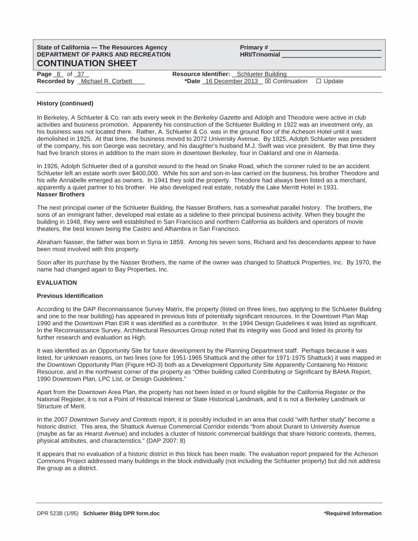
Photo 19. (1254) View east. 11 December 2013. Berkeley Way façade.

State of California — The Resources Agency Primary # DEPARTMENT OF PARKS AND RECREATION HRI/Trinomial CONTINUATION SHEETPage 27 of 37 Resource Identifier: Schlueter Building Recorded by Michael R. Corbett *Date 16 December 2013 Continuation Update
DPR 523B (1/95) Schlueter Bldg DPR form.doc *Required Information
Photo 20. (1258) View southwest. 11 December 2013. 2112 Berkeley Way storefront.
State of California — The Resources Agency Primary # DEPARTMENT OF PARKS AND RECREATION HRI/Trinomial CONTINUATION SHEETPage 28 of 37 Resource Identifier: Schlueter Building Recorded by Michael R. Corbett *Date 16 December 2013 Continuation Update
DPR 523B (1/95) Schlueter Bldg DPR form.doc *Required Information
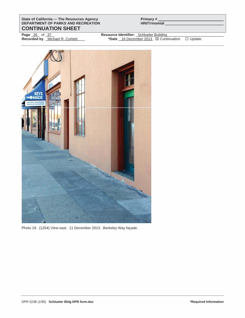
Photo 21. (1231) View northwest. 11 December 2013. East wall of Schlueter Building detail.

State of California — The Resources Agency Primary # DEPARTMENT OF PARKS AND RECREATION HRI/Trinomial CONTINUATION SHEETPage 29 of 37 Resource Identifier: Schlueter Building Recorded by Michael R. Corbett *Date 16 December 2013 Continuation Update
DPR 523B (1/95) Schlueter Bldg DPR form.doc *Required Information
Photo 22. (1256) View south. 11 December 2013. Perspective view of rear building.
Photo 23. (1232) View north. 11 December 2013. Wall on east property line.
State of California — The Resources Agency Primary # DEPARTMENT OF PARKS AND RECREATION HRI/Trinomial CONTINUATION SHEETPage 30 of 37 Resource Identifier: Schlueter Building Recorded by Michael R. Corbett *Date 16 December 2013 Continuation Update
DPR 523B (1/95) Schlueter Bldg DPR form.doc *Required Information
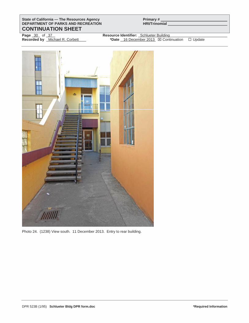
Photo 24. (1238) View south. 11 December 2013. Entry to rear building.

State of California — The Resources Agency Primary # DEPARTMENT OF PARKS AND RECREATION HRI/Trinomial CONTINUATION SHEETPage 31 of 37 Resource Identifier: Schlueter Building Recorded by Michael R. Corbett *Date 16 December 2013 Continuation Update
DPR 523B (1/95) Schlueter Bldg DPR form.doc *Required Information
Photo 25. (1226) View southwest. 11 December 2013. Entry façade, rear building.

State of California — The Resources Agency Primary # DEPARTMENT OF PARKS AND RECREATION HRI/Trinomial CONTINUATION SHEETPage 32 of 37 Resource Identifier: Schlueter Building Recorded by Michael R. Corbett *Date 16 December 2013 Continuation Update
DPR 523B (1/95) Schlueter Bldg DPR form.doc *Required Information
Photo 26. (1236) View east. 11 December 2013. Entry façade, rear building.

State of California — The Resources Agency Primary # DEPARTMENT OF PARKS AND RECREATION HRI/Trinomial CONTINUATION SHEETPage 33 of 37 Resource Identifier: Schlueter Building Recorded by Michael R. Corbett *Date 16 December 2013 Continuation Update
DPR 523B (1/95) Schlueter Bldg DPR form.doc *Required Information
1. Rear Building 1923-1969, 2114 Berkeley Way. Berkeley Building Department.

State of California — The Resources Agency Primary # DEPARTMENT OF PARKS AND RECREATION HRI/Trinomial CONTINUATION SHEETPage 34 of 37 Resource Identifier: Schlueter Building Recorded by Michael R. Corbett *Date 16 December 2013 Continuation Update
DPR 523B (1/95) Schlueter Bldg DPR form.doc *Required Information
2. Rear Building. Architectural plan of first floor, Bay Properties Building 1970. Apaydin, Angell and Lockwood Architects.
State of California — The Resources Agency Primary # DEPARTMENT OF PARKS AND RECREATION HRI/Trinomial CONTINUATION SHEETPage 35 of 37 Resource Identifier: Schlueter Building Recorded by Michael R. Corbett *Date 16 December 2013 Continuation Update
References (continued)
DPR 523B (1/95) Schlueter Bldg DPR form.doc *Required Information
Alameda County Assessor. 1982. Assessor’s Map 57.
Apaydin, Angell, Lockwood Associates, Architects. 1970. Office Building for Bay Properties, Inc., 8 sheets architectural and engineering drawings. 28 December 1970. Berkeley Planning Department.
Architectural Resources Group. 2007. City of Berkeley Downtown Survey and Contexts: Historic Resources Reconnaissance Survey. Prepared for Downtown Area Plan. August 2007.
BAHA (Berkeley Architectural Heritage Association). 2012. Donogh Real Estate file for 1951-59 Shattuck Avenue.
BAHA (Berkeley Architectural Heritage Association). 2013. Research file on block 57.
BAHA (Berkeley Architectural Heritage Association). 2013. Research file on Hutchison and Mills, Architect.
Bay Architects. 2013. Proposed Mixed-Use Residential Building (120’ Height) 1951-1975 Shattuck Avenue. Existing Site Plan AO.6.
Berkeley Gazette. 1895-1904. Digital search. web: newspaperarchive.com.
Berkeley. Building Department. 1922. Application for Building Permit for 1951 Shattuck Avenue. 22 April 1922. Permit No. 11692. Microfiche.
Berkeley. Building Department. 1923. Application for Building Permit; rear of Schlueter Building. 10 September 1923. PermitNo. 14970. Microfiche.
Berkeley. Department of Planning and Development. 2013. Permit files for 1951-1975 Shattuck Avenue and 2108-2116 Berkeley Way. Microfiche.
Berkeleyside. 2013. “New 120-foot building proposed for downtown Berkeley.” web: berkelyside.com
Bruce, Anthony (BAHA). 2013. Communications with Michael Corbett. December 2013.
California Death Index. 1940-1997. web: ancestry.com.
California Voter Registrations. 1900-1968. web: ancestry.com.
California. Office of Historic Preservation. 1988. Five Views: An Ethnic Historic Site Survey for California. Sacramento: Department of Parks and Recreation.
California. Office of Historic Preservation. 1996. California Historical Landmarks. Sacramento: California State Parks.
California. Office of Historic Preservation. 2012. Historic Properties Directory. 17 July 2012. Print-out at Berkeley Planning Department.
California. Office of Historic Preservation. 2013. California Register of Historic Resources. web: ohp.parks.ca.gov.
California. Secretary of State. 1947. Index to Architects, licenses issued 1901-1929. California State Archives.
Cerny, Susan, et al. 2007. An Architectural Guidebook to San Francisco and the Bay Area. Salt Lake City: Gibbs Smith.
Cerny, Susan. 2001. Berkeley Landmarks, revised edition. Berkeley: Berkeley Architectural Heritage Association.
Chicago Title Company. 2012. Preliminary Report: 1951-1975 Shattuck Avenue. 23 January 2012.
Draft Registration Forms. 1918. web: ancestry.com.
Gebhard, David, Eric Sandweis and Robert Winter. 1985. The Guide to Architecture in San Francisco and Northern California, revised edition. Salt Lake City: Gibbs M. Smith, Peregrine Smith Books.

State of California — The Resources Agency Primary # DEPARTMENT OF PARKS AND RECREATION HRI/Trinomial CONTINUATION SHEETPage 36 of 37 Resource Identifier: Schlueter Building Recorded by Michael R. Corbett *Date 16 December 2013 Continuation Update
References (continued)
DPR 523B (1/95) Schlueter Bldg DPR form.doc *Required Information
Hayler, Guy Wilfrid. 1922. Zone Map of the City of Berkeley. Berkeley: City Planning Commission. Berkeley Planning Department.
Hibma, Michael. 2012. A Cultural Resources Study and Historical Evaluation for the Acheson Commons Project. Prepared by LSA Associates, Point Richmond for City of Berkeley. 1 May 2012.
Hurwitt, Robert. 2009. “Gene Angell – Designed Innovative Bay Area Performance Spaces.” San Francisco Chronicle. 5 October 2007.
Lowell, Waverly, Elizabeth Byrne and Betsey Frederick-Rothwell. 2009. Design on the Edge: A Century of Teaching Architecture at the University of California, Berkeley, 1903-2003. Berkeley: College of Environmental Design.
Marvin, Betty. 2012. Communications with Michael Corbett. 13 December 2013.
Mills, R.L. 1924. “Improved Store Design.” Architect and Engineer 76:3 (March 1924), 85-92. web: internetarchive.org.
Oakland Cultural Heritage Survey. 2013. Files on Hutchison and Mills, Architects. Provided by Betty Marvin, Oakland Planning Department.
Oakland Tribune. 1910-1962. Digital search. web: newspaperarchive.com.
Polk’s Directory Company. 1916-1950. Oakland, Berkeley, Alameda City Directory. Oakland: R.L. Polk. web: internetarchive.com.
Powell, Edith Hopps. 1976. San Francisco Heritage in Art Glass. Seattle: Salisbury Press Book.
San Francisco Call. 1902-1912. Digital searches. web: Library of Congress via San Francisco Public Library website.
Sanborn Map Company. 1894. Insurance Maps of Berkeley. New York: 1894. web: Library of Congress via San Francisco Public Library website.
Sanborn Map Company. 1911. Insurance Maps of Berkeley, vol. 1, p. 59. New York: 1911. web: Library of Congress via San Francisco Public Library website.
Sanborn Map Company. 1928. Insurance Maps of Berkeley, vol. 1. New York: 1911, updated to 1928. BAHA.
Sanborn Map Company. 1929. Insurance Maps of Berkeley, vol. 1, p. 73. New York: 1929. web: Library of Congress via San Francisco Public Library website.
Sanborn Map Company. 1941. Insurance Maps of Berkeley, vol. 1. New York: 1929, updated to 1941. BAHA.
Sanborn Map Company. 1950. Insurance Maps of Berkeley. New York: 1911, updated to 1950.
Sanborn Map Company. 1950. Insurance Maps of Berkeley. New York: 1950. web: Library of Congress via San Francisco Public Library website.
Ship Passenger Lists. 1917-1941. web: ancestry.com.
Sibley, Robert, editor. 1937. The Golden Book of California. Berkeley: California Alumni Association.
Thompson, Daniella. 2009. “East Bay Then and Now: The Circuitous Career of Berkeley’s Favorite Undertaker.” BerkeleyDaily Planet. 17 September 2009. web: berkeleydailyplanet.com.
United States. Bureau of the Census. 1880. Tenth Census. Population Schedule. Berkeley, California. web: ancestry.com.
United States. Bureau of the Census. 1900. Twelfth Census. Population Schedule. Berkeley, California. web: ancestry.com.
United States. Bureau of the Census. 1910. Thirteenth Census. Population Schedule. Berkeley, California. web: ancestry.com.

State of California — The Resources Agency Primary # DEPARTMENT OF PARKS AND RECREATION HRI/Trinomial CONTINUATION SHEETPage 37 of 37 Resource Identifier: Schlueter Building Recorded by Michael R. Corbett *Date 16 December 2013 Continuation Update
References (continued)
DPR 523B (1/95) Schlueter Bldg DPR form.doc *Required Information
United States. Bureau of the Census. 1920. Fourteenth Census. Population Schedule. Berkeley, California. web: ancestry.com.
United States. Bureau of the Census. 1930. Fifteenth Census, Population Schedule. Berkeley, California. web: ancestry.com.
United States. Bureau of the Census. 1940. Sixteenth Census, Population Schedule. Berkeley, California. web: ancestry.com.
United States. Department of the Interior. National Park Service, Interagency Resources Division. 1991a. National Register Bulletin 15: How to Apply the National Register Criteria for Evaluation. Washington, DC.
United States. Passport Applications. 1795-1925. web: ancestry.com.
Wollenberg, Charles. 2008. Berkeley: A City in History. Berkeley: University of California Press.
Woodbridge, Sally B., John Woodbridge, and Chuck Byrne. 2005. San Francisco Architecture. Berkeley: Ten Speed Press.