Embed Size (px)
Citation preview
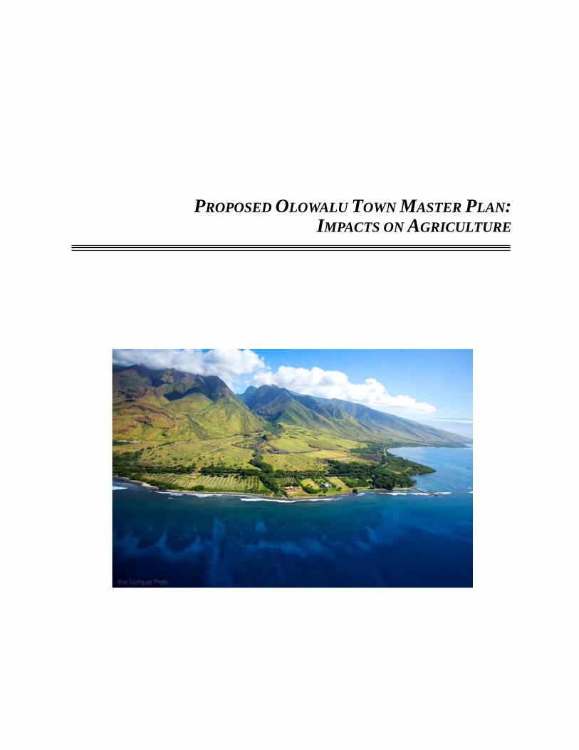
PROPOSED OLOWALU TOWN MASTER PLAN:IMPACTS ON AGRICULTURE
PROPOSED OLOWALU TOWN MASTER PLAN:IMPACTS ON AGRICULTURE
PREPARED FOR:Olowalu Town, LLC
and Olowalu Ekolu, LLC
PREPARED BY:Plasch Econ Pacific LLC
April 2015

C-1
CONTENTS
EXECUTIVE SUMMARY ES-1
1. INTRODUCTION 12. PROJECT INFORMATION 1
a. Project Location 1b. Land Ownership 1c. Project Description 1d. Land Classifications and Required Approvals 4
3. AGRICULTURAL CONDITIONS 5a. Soil Association 5b. Soil Types and Characteristics 5c. Soil Ratings 9d. Elevation and Slopes 14e. Climatic Conditions 14f. Wildfires 15g. Irrigation Water 15h. Road Access 17i. Current Land Uses at Olowalu 17j. Surrounding Land Uses 18k. Locational Advantages and Disadvantages 18l. Synergy with Other Farm Areas 20m. Potential Crops 20n. Summary 20
4. PAST AGRICULTURAL USES 21a. Hawaiian Crops Prior to Plantation Agriculture 21b. Sugarcane 21c. Recent Agricultural Activities 22
5. OLOWALU NUI FARM 23a. Farm Operations 23b. Impacts on Olowalu Nui Farm 26c. Recommended Mitigation for Olowalu Nui Farm 26
............................................................................................................................
....................................................................................................................................................
..................................................................................................................................
..................................................................................................................
................................................................................................................................................................................................................................
....................................................................
.......................................................................................................................
..............................................................................................................................................................................................................
............................................................................................................................................................................................................................................................................................................................................
.............................................................................................................................................................................................................................................
................................................................................................................................................................................................................
............................................................................................................................................................................
.........................................................................................................................................................................................................
...........................................................................................................................
........................................................................................................................
.........................................................................................................................................................................................
...........................................................................................
.....................................................................................................................................
..........................................................................................................................................................................................................
............................................................
CONTENTS C-2
6. PALM TREE FARMS 277. OLOWALU CULTURAL RESERVE 288. OTHER AGRICULTURAL ACTIVITIES 28
a. Ranching 28b. Fruit Stand and Garden 29c. Recommended Mitigation 29
9. ABUTTING AGRICULTURAL ACTIVITIES 29a. Olowalu Mauka Subdivision 29b. Olowalu Makai Subdivision 30c. Foothills 31
10. NEW OLOWALU FARMING ACTIVITY 32a. Field Farming 32b. Hydroponic Farming 33c. Home and Community Gardens 34
11. GROWTH OF DIVERSIFIED CROP FARMING 34a. Loss of Farmland 35b. Supply of Farmland 35c. Trends in Diversified Crop Acreage 36d. Limiting Factors 37e. Agricultural Outlook by Type of Crop 38f. Impact on the Growth of Diversified Crop Farming 43
12. OFFSETTING BENEFITS 4313. CONSISTENCY WITH STATE AND COUNTY POLICIES 44
a. Availability of Land for Agriculture 44b. Conservation of Agricultural Land 44c. Important Agricultural Lands 45d. County of Maui Land-Use Plans 46
14. REFERENCES 70
FIGURES
1. Project Location 47
2. Project Aerial Photograph 48
3. Project TMKs 49
........................................................................................................................................
...............................................................................................................
......................................................................................................
................................................................................................................................................................................................................................
.................................................................................................
..............................................................................................
.............................................................................................
.........................................................................................................................................................................................................................
....................................................................................................
.............................................................................................................................................................................................................................
........................................................................................
.......................................................................................
.........................................................................................................................................................................................................................
.................................................................................................................................................................................................
......................................................................................................................................
................................................................................................................................
......................................................................
....................................................................................................................................................................
...................................................................................................................................................................................
......................................................................................................................................................
...............................................................................................................
.................................................................................................
....................................................................................................................

CONTENTS C-3
4. Project Master Plan, Alternative 1 50
5. Project Master Plan, Alternative 2 51
6. Project State Districting, Existing 52
7. Project State Districting, Proposed for Alternative 1 53
8. Project Land Use Designations, Maui Island Plan 54
9. Project Land Use Designations, West Maui Community Plan 55
10. Maui General Soils Map 56
11. Project Soils Map 57
12. Project ALISH Map 58
13. Project LSB Map, General Ratings 59
14. Project LSB Map, Detailed Ratings 60
15. High-quality Agricultural Lands, Olowalu 61
16. Project Water Systems, Existing and Planned 62
17. Olowalu Agricultural Operations, Recent and Existing 63
18. Maui ALISH Map 64
19. Maui LSB Map 65
20. High-quality Agricultural Land, Maui 66
21. Olowalu Nui Farm, Exterior 67
22. Olowalu Nui Farm, Interior 68
23. Acreage in Crop, Statewide: 1960 to 2013 69
APPENDIX
State and County Goals, Objectives, Policies and GuidelinesRelated to Agricultural Lands A-1
....................................................................................
....................................................................................
.....................................................................................
........................................................
............................................................
.........................................
...................................................................................................
..............................................................................................................
..........................................................................................................
...................................................................................
..................................................................................
.......................................................................
..................................................................
....................................................
.............................................................................................................
.................................................................................................................
..............................................................................
.............................................................................................
..............................................................................................
.......................................................................
.........................................................................................
ES-1
EXECUTIVE SUMMARY
1. PROPOSED DEVELOPMENT
Olowalu Town, LLC and Olowalu Ekolu, LLC propose to re-establish a community at Olowalu as envisioned in the Olowalu Town Master Plan (the “Project”). This Project is envisioned to become a small-scale, mixed-use livable community that will provide a variety of uses including residential, commercial/business, agricultural, civic, social, parks, and open space.
There are two alternatives for the Project: (1) Alternative 1 includes land both makai and mauka of the existing Honoapiʻilani Highway, and (2) Alternative 2 includes just the mauka lands. Alternative 1 will encompass about 636 acres, including a 434-acre “Petition Area” proposed for State redistricting from Agricultural to Urban and Rural. Alternative 2 will encompass about 591 acres, including a 396-acre Petition Area.
2. AGRICULTURAL CONDITIONS
Olowalu has favorable agronomic conditions for growing low-elevation commercial crops. Alternative 1 includes about 532 acres of high-quality farmland, of which about 504 acres will be developed (409 acres are in the Petition Area, and about 95 acres of agricultural land for roads, parks, etc.). Alternative 2 includes about 495 acres of high-quality farmland, of which about 468 acres will be developed (374 acres are in the Petition Area, and about 94 acres of agricultural land for roads, parks, etc.). Some of the better soils are stony.
Olowalu benefits from high solar radiation, exceeding 500 calories per square centime-ter per day. Ample water is available to irrigate crops, and the water rate is competitive with many other farm areas in Hawaiʻi. Also, Olowalu is a reasonable trucking distance to Kahului.
However, Olowalu is isolated from other farm areas, so is poorly located for developing synergistic relationships with other farms on Maui. Also, occasional strong winds could cause crop damage if the crops are not protected by windbreaks, and wildfires will continue to be a threat as long as vegetation remains dry and overgrown.
3. OLOWALU NUI FARM
a. Farm Operations Olowalu Nui Farm is located on about 4 acres of leased land in the western portion of
the Project site. The farm grows tomatoes and other vegetables hydroponically in greenhous-

EXECUTIVE SUMMARY ES-2
es, and also grows various fruit and palm trees on adjoining land. Employment has been cut to a single owner-operator.
b. Impacts on Olowalu Nui FarmMost of Olowalu Nui Farm is located on the fringe of the Project in an area that is
planned for (1) single-family homes on rural lots, (2) a rural park, (3) portions of an interior road, and (4) a portion of the realigned Honoapiʻilani Highway. The Highway will cause the loss of some trees in the southwest corner of the farm. Thus, as currently planned, the Project would require Olowalu Nui Farm to relocate eventually.
Assuming suitable land can be found nearby—which might include Project land near Olowalu Stream that is planned for farming—Olowalu Nui Farm estimates that the cost to relocate the hydroponic component of the farm would be about $50,000. Also, the farm could lose up to 8 months of production and its associated revenues before newly planted crops are producing at the new location. An alternative would be for the farm to invest in new facilities at the new location; move the crops to the new site; then disassemble the facilities at the current location. This option would maintain production but the capital costs would be higher.
Most or all of the fruit trees would probably be lost since moving them would be expensive, but the palm trees could be sold.
c. Recommended Mitigation for Olowalu Nui FarmThe Project developers have discussed the proposed Master Plan with the owner of
Olowalu Nui Farm, and will continue to engage the owner in discussions as plans for the Project progress. Consistent with their current approach, it is recommended that the developers remain flexible regarding two alternatives:
— Modify the Project plan so that Olowalu Nui Farm can continue at its current location, and possibly provide some additional farmland to offset land that will be lost to roads in the Project.
— Assist with the cost to relocate Olowalu Nui Farm to an agricultural lot near Olowalu Stream, with new facilities built before the move so that production and revenues can be maintained during the transition.
For either location, Olowalu Nui Farm would be compatible with nearby homes given the inherent nature of hydroponic and orchard farming.
4. PALM TREE FARMS
Two palm tree farms are located within the Alternative 1 Project site. Both are low-revenue and unprofitable operations located on high-value oceanfront land. However, because of the County’s low property taxes on land that is actively farmed, farming can be a cost-effective approach for holding land for future high-value use.
EXECUTIVE SUMMARY ES-3
Both farm owners regard their farms as temporary operations that will continue until the the affected land is needed for the planned Project development. The farms will then be closed and not relocated. The loss in palm-tree production is likely to be offset by other palm-tree farms on Maui or other islands.
5. OLOWALU CULTURAL RESERVE
The Olowalu Cultural Reserve holds a 99-year lease to about 75 acres of the Project site. The organization is restoring former irrigation systems and loʻi for taro cultivation, and is planting other native crops. Currently, about 5 acres are used to demonstrate how crops are cultivated.
Project plans include expanding the Reserve, which will allow more varieties and greater quantities of native crops to be grown at the Reserve.
6. OTHER AGRICULTURAL ACTIVITIES
In addition to the formal agricultural leases, there are three informal agricultural uses within the Petition Area.
a. RanchingThe landowner allows a subsistence cattle rancher to graze about 20 head on about 200
acres located mauka of Honoapiʻilani Highway. In this same area, the landowner allows a retired rancher to graze a few head of horses. There are no formal leases for use of this land, and no rent is charged.
The two ranching activities are regarded as temporary land uses that are mutually beneficial to the ranchers and the landowner. For the ranchers, the landowner provides grazing land and range feed at no cost to the ranchers. For the landowner, the grazing controls vegetation and reduces the fire hazard at no cost to the landowner.
b. Fruit Stand and GardenA juice and fruit stand is located on the mauka side of Honoapiʻilani Highway near
Olowalu General Store. In addition to the roadside stand, the operator grows a variety of fruits on about 0.75 acre of abutting land, and sells the fruit at the roadside stand. Rent is not charged for the operation.
c. Recommended MitigationThe Project developers will inform the ranchers and fruit seller of progress on the
Project, and will provide ample notice regarding when they will have to vacate the land so that development can proceed as planned.
EXECUTIVE SUMMARY ES-4
7. ABUTTING AGRICULTURAL ACTIVITIES
a. Olowalu Mauka SubdivisionOlowalu Mauka Subdivision is a 14-lot agricultural subdivision designed for large-lot
residential use with comparatively expensive homes as well as agricultural use on a portion of each lot (i.e., “country estates”).
Impact on Farming ActivityAt full development of the Project, single-family homes on rural lots (a half-acre or
larger) will border the six lower-elevation lots in the Olowalu Mauka Subdivision. Portions of some of these agricultural lots are likely to be used for commercial farming and vegetable gardens. Similarly, portions of some of the rural lots may be used for vegetable gardens.
These two abutting uses are compatible as indicated by the many communities on Maui and throughout Hawaiʻi that have single-family homes on rural lots next to country estates. In such situations, farmers generally limit voluntarily their agricultural activities to those that are compatible with nearby homes. Thus, no adverse agricultural impacts are anticipated. Specifically, the residential use of homes on rural lots is not expected to interfere with existing or future farming activities in the Olowalu Mauka Subdivision. Also, farming activities are not expected to cause significant nuisance problems or other adverse impacts on new homes and their residents.
In any case, Hawaiʻi’s Right-to-Farm Act gives farmers the right to farm if they were operating before neighboring properties were developed, provided that their farm activity does not threaten public health or safety.
Recommended Mitigation Since adverse impacts are not expected on existing or likely farming within the Olowalu
Mauka Subdivision, no mitigating measures are recommended.
b. Olowalu Makai SubdivisionExisting and Potential Farming Activity
Olowalu Makai Subdivision is an oceanfront, 5-lot agricultural subdivision designed for country estates.
Impact on Farming ActivityThe existing and likely farming activities at Olowalu Makai Subdivision are compatible
with nearby homes. This indicates that the Project components that will be near this subdivision are likely to be compatible with this same farming activity. In particular, a new park, new homes on large town lots, and new farming activity are not expected to interfere with existing or future farming activity within the Olowalu Makai Subdivision. Also, the
EXECUTIVE SUMMARY ES-5
existing farming activities are expected to have little or no nuisance issues or other adverse impacts on park use, residential use of new homes, or new farming activity.
In any event, the Hawaiʻi’s Right-to-Farm Act gives farmers the right to farm if they were operating before neighboring properties were developed, provided that their farming activity does not threaten public health or safety.
Recommended Mitigation Since adverse impacts are not expected on existing or likely farming activity within the
Olowalu Makai Subdivision, no mitigating measures are recommended.
c. FoothillsPotential Ranch Activity
The Olowalu foothills are State-owned lands designated Agricultural. Cattle grazing would be possible in those areas having moderate slopes, provided that water and paddock fencing are provided. Although returns from cattle operations are unlikely to be sufficient to justify the cost of the improvements, grazing can be a cost-effective approach to reducing vegetation and, in turn, the fire hazard associated with dry vegetation.
Impact on Potential Grazing ActivityThe potential for grazing cattle in the Olowalu foothills would not be affected by the
Project as indicated by the fact that grazing operations near homes and farm areas is common on Maui and throughout Hawaiʻi with little or no adverse impacts. In fact, cattle would benefit the Project by reducing the fire hazard to homes and farms.
Recommended Mitigation Since the Project would not affect the potential for grazing cattle in the Olowalu
foothills, no mitigating measures are recommended.
8. NEW OLOWALU FARMING ACTIVITY
a. Field FarmingFarming Operations
About 28 acres in the center of the Project site along Olowalu Stream are planned for agriculture, of which about 27 acres are high-quality farmland. Subtracting land for homes and other improvements, about 27 acres will remain available for farming.
Assuming typical field farming of vegetables, annual production of food crops from 27 acres could total over 650,000 pounds, thereby contributing to food self-sufficiency and food security. Farm employment could total about three full-time equivalent farm jobs.

EXECUTIVE SUMMARY ES-6
Nuisance IssuesThe planned farm area along Olowalu Stream will border single-family homes on small
town lots, large town lots, and rural lots. The close proximity of farms and homes can create nuisance issues for residents, such as noisy farm equipment in the early morning, airborne dust from field plowing, odors from fertilizer and chemicals, airborne crop-protection products drifting toward homes, etc. It should be noted, however, that prevailing tradewinds at Olowalu blow offshore, not toward homes.
At the same time, nuisance complaints from nearby residents can cause farmers to change their operations to address the complaints. Also, farms near homes have greater risk of crop and equipment theft than farms that are hidden from view or for which access is difficult.
Recommended Mitigation To reduce nuisance issues, the following are recommended:
— Security fencing between farms and homes.— Stands of trees to provide buffers between farms and homes.— Farm practices that minimize nuisance issues (e.g., no noisy equipment during
early hours, dust control, no use of products that cause strong odors, restrictions on the use of crop-protection products in order to prevent airborne chemicals from drifting toward homes, etc.)
— Notification to homebuyers to inform them of nearby farms, potential nuisance issues, and the Right to Farm Act.
Regarding the last item, the intent is to have new residents embrace the fact that nearby farms will be part of the ambiance of the Olowalu community.
b. Hydroponic FarmingA strong and well-established trend has developed to grow vegetables and melons
hydroponically in greenhouses. Such farming would allow increased vegetable and melon production in Hawaiʻi while using much less land and water than is required for field farming. Also, good soils are not required for hydroponic farming, thereby allowing this type of farming to be located in areas having poor soils. Furthermore, farming inside greenhouses eliminates or reduces many of the nuisance issues normally associated with field farming including: load noises from farm equipment, dust from recently plowed fields, odors from fertilizers, drifting of sprayed products, and risk of theft.
Assuming that hydroponic farming at Olowalu would use technology already common in Hawaiʻi, their production could reach nearly 4.6 million pounds per year. This is equiva-lent to about 190 acres used in field farming, or about 7 times the potential production of field farming these lands. For comparison, about 400 acres of vegetables and melons were harvested from all of Maui County in 2008 (the latest year that acreage was reported), or
EXECUTIVE SUMMARY ES-7
about 200 acres farmed. Consequently, hydroponic farming on 27 acres at Olowalu would nearly double the production of vegetables and melons by Maui County farmers. Further-more, hydroponic farming would offset about 40% of the high-quality farmland lost to Project development. Hydroponic farming of 27 acres could generate about 14 jobs.
c. Home and Community GardensIn addition to commercial farming as discussed above, future Olowalu residents will
have access to good agricultural land to grow food and nursery crops for family and friends. Residents of rural lots can have home gardens, and all residents will have access to commu-nity gardens. Although such farming is largely a lifestyle choice, the food produced increases self-sufficiency.
9. GROWTH OF DIVERSIFIED CROP FARMING
The Project will result in a loss of good farmland to development. As discussed below, this loss, in combination with other projects (i.e., the cumulative impact), is too small to affect the growth of diversified-crop farming on Maui or statewide.
a. Loss of FarmlandOlowalu
The Project will commit about 500 acres of high-quality farmland now in the Agricul-tural District to a non-agricultural use, or about 0.7% of the 72,100 acres of high-quality farmland on Maui. If the Project is not developed as planned, then the land is likely to be subdivided for country estates. This would also result in a loss of farmland.
All Maui ProjectsThe County’s Maui Island Plan allows for the eventual development of about 3,540
acres of high-quality farmland, or about 4.9% of the island-wide supply of such land. In practice, the loss of good agricultural land will be less than 3,540 acres since not all approved projects will be built in the foreseeable future. Also, the loss will be gradual, depending on demand for new homes and visitor units.
b. Supply of FarmlandIsland of Maui
Maui Island has about 242,700 acres in the State Agricultural District, of which about 72,100 acres are high-quality farmland. The accounting of high-quality farmland excludes land used for country estates and golf courses.
EXECUTIVE SUMMARY ES-8
For the entire County (Maui, Molokaʻi and Lānaʻi), about 42,500 acres are in crop, most of which is on Maui Island. Thus, over 29,600 acres are available for farming (72,100 acres – 42,500 acres). Much of this land is now used for grazing cattle. Assuming that all projects shown in the 2014 Maui County Regional Maps are eventually approved and built, then over 26,000 acres of high-quality farmland on Maui would remain available for farming (29,600 acres – 3,540 acres). However, farming much of this land would require major water improvements, including wells, stream diversions, and delivery systems.
StatewideStatewide, the remaining supply of available farmland released by plantation agriculture
exceeds 170,000 acres. This is about double the amount of land in crop—about 87,700 acres. The supply of available farmland is vast because of the statewide contraction and closure of many sugarcane and pineapple plantations during the past four decades, combined with the subsequent slow growth of diversified-crop farming (all crops other than sugarcane and pineapple). In the late 1980s, Hawaiʻi had 19 plantations: now, just two remain.
c. Trends in Diversified Crop AcreageHawaiʻi has a long history of strong support for the agriculture industry. However,
since 1983 (over 30 years ago), no significant growth in diversified-crop acreage has occurred, with the single exception of seed crops which have increased at an average rate of about 290 acres per year since 1992. Following the Oʻahu plantation closures, vegetable and melon acreage expanded on Oʻahu, but this was followed by declines on the Neighbor Islands.
d. Agricultural Outlook by Type of CropFood Crops, Field Farming
Hawaiʻi is about 33% self-sufficient in fresh produce (i.e., vegetables, melons and fruits) while using about 15,000 acres of land. Given competition from low-cost imports, a realistic level of self-sufficiency may be about 50%. This would require about 7,500 acres of additional farmland.
The island of Maui would require about 1,100 acres of additional farmland for 50% self-sufficiency in fresh produce. With intensive farming (such as hydroponic farming), land requirements would be reduced greatly.
Food Crops, Hydroponic FarmingIn advanced economies—such as Europe, the U.S. mainland, and Hawaiʻi—a strong
and well-established trend has developed to grow vegetables and melons hydroponically in greenhouses. Although the capital cost of constructing hydroponic farms is high, hydroponic
EXECUTIVE SUMMARY ES-9
farming in greenhouses provides many advantages over traditional field farming, including but not limited to the following: (1) higher-quality and more consistent produce, (2) year-round production, (3) secure production unaffected by droughts and storms, (4) far higher yields due to controlled conditions, (5) much less land required because of the higher yields, (6) no need to use good farmland, (7) much less water, (8) no pesticide or herbicide spraying because of the controlled environment, (9) less labor and less difficulty in attracting workers because of better working conditions, (10) less crop and equipment theft because operations are inside buildings, (11) lower energy requirements, and (12) lower transportation costs if the farm is located near major markets.
If Hawaiʻi vegetable farmers are to remain competitive with mainland hydroponic farmers, they will be compelled to turn increasingly to hydroponic farming in greenhouses. This suggests that large agricultural fields, soil quality, developing irrigation systems, and microclimates will be of less significance for food production in the future.
Feed CropsIf feed crops could be grown in Hawaiʻi and priced competitively against mainland
imports, they could replace some of the grains and hay that are now being imported to the state. Unfortunately, a number of commercial attempts in Hawai'i to grow grains and alfalfa have not been successful. The major problems have been (1) pests, particularly birds that eat the grains before they are harvested; (2) humidity that is too high for some feed crops (e.g. problems with mold, smut fungus, insufficient drying of alfalfa, etc.); (3) high winds that cause stalks to lean over and break (lodge); and (4) high production costs compared to mainland farms. Nevertheless, large-scale attempts to grow feed crops continue.
Biofuel CropsOver the past 20+ years, a number of companies have explored biofuel crops to take
advantage of the vast acreage released from sugar and pineapple, and a number of biofuel plantations have been proposed and continue to be proposed. To date, no large single-purpose biofuel plantations have been developed in Hawaiʻi, largely due to high capital costs, combined with per-acre returns that are low compared to other crops. Developing profitable biofuel plantations has become more difficult with the sharp decline in energy prices.
Rather than growing a biofuel crop on farmland, a more promising alternative would be to produce biofuel from algae. One of the advantages of algae is its high yield of vegetable oil and high returns per acre. Also, good farmland is not required for algae since it is grown in ponds. The water source can include wastewater, brackish water, or even seawater.
Another promising energy alternative that is likely to threaten the profitability of Hawaiʻi biofuel crops is liquified natural gas shipped from the mainland. As a result of technological advances with hydrofracking, the supply is abundant, the gas is inexpensive (the equivalent of about $30 per barrel on the mainland), and clean compared to many alternatives.
EXECUTIVE SUMMARY ES-10
Olowalu would be a poor location for a biofuel plantation because of insufficient acreage, high land costs, and low rainfall. And if HC&S were to be converted to a biofuel plantation, hauling biomass from Olowalu to HC&S’s Puʻunēnē processing facilities would add significant costs.
Export CropsThe potential export market for crops is far larger than the Hawaiʻi market. However,
the history of agricultural efforts in Hawaiʻi reveals that the successful development of major new export crops requiring large amounts of land is difficult and infrequent. With the exception of seed corn and other seed crops, acreages of the major export crops have not grown significantly since the mid-1980s.
e. Impact on the Growth of Diversified Crop FarmingIn summary, the Project will result in a relatively small loss of high-quality farmland of
which there is a large supply, both on Maui and statewide. Furthermore, the demand for Hawaiʻi farmland has increased slowly over the past 30 years. Moreover, the trends toward hydroponic farming indicate that high-quality farmland will be of less significance for food production in the future. As a result, ample farmland will remain available to accommodate future diversified-crop farming, food self-sufficiency, and food security.
10. OFFSETTING BENEFITS The loss of about 500 acres of high-quality farmland (less than 0.7% of the island
supply)—along with the possible relocation of a hydroponic farm; the relocation of hobby ranching operations; the loss of a fruit stand and small garden and; for Alternative 1, the planned loss of two temporary palm-tree operations—will be offset by the following benefits of the Project:
— Construction Activity• Construction jobs associated with Project development.• Indirect jobs generated by purchases of goods and services by construction
companies and families of construction workers.• State tax revenues (excise taxes, personal income taxes, corporate income taxes,
etc.) paid by construction companies and workers, and by companies and families supported by construction activity.
— Operations, Full Development• About 1,500 new homes for Maui residents, of which about 50% will be avail-
able for affordable housing and senior living.• Commercial space for new restaurants, stores, services, etc.• New public and quasi-public facilities, including, community centers, schools, a
library, a museum, medical facilities, etc.

EXECUTIVE SUMMARY ES-11
• New recreational facilities, including ball fields, playgrounds, camping areas, bikeways, etc.
• New parks.• Improved access to the beach.• Preservation of about 28 acres of farmland for small farmers.• Expansion of the Olowalu Cultural Center.• Reduced risk of wildfires since dry unmanaged vegetation will be replaced by
irrigated and maintained vegetation. • Off-site jobs generated by purchases of goods and services by Project business-
es and residents.• State tax revenues (excise, personal income, corporate income taxes, etc.) paid
by Project businesses and residents, as well as by off-site businesses and residents supported by Project operations.
• County tax revenues (property taxes, etc.) paid by Project businesses and residents, as well as by off-site businesses and residents supported by Project operations.
11. CONSISTENCY WITH STATE AND CITY POLICIES
a. Availability of Lands for Agriculture The Hawai'i State Constitution, the Hawai'i State Plan, the State Agriculture Functional
Plan, the County of Maui 2030 General Plan, the County’s Maui Island Plan (Draft), and the County’s West Maui Community Plan call directly or implicitly for preserving the economic viability of plantation agriculture and promoting the growth of diversified agriculture. To accomplish this, an adequate supply of agriculturally suitable lands and water must be assured.
With regard to plantation agriculture, the cultivation of sugarcane at the Project site ceased in 1999 for reasons unrelated to the proposed Project.
With regard to diversified crop farming, Olowalu Nui Farm will lose some of the acreage now used for tree crops, but this can be offset by replacement land within the Project site. Project plans may have to be adjusted to allow the hydroponic component of the farm to remain in place, or assistance may be provided to allow the farm to relocate to Project lands that are planned for agriculture. The two ranching activities, both of which are hobby operations, will have to relocate. The small fruit stand and garden will have to relocate or close. For Alternative 1, the two temporary palm-tree operations will close as planned. Finally, Project plans call for preserving about 77 acres of high-quality farmland, including about 27 acres planned for small farmers and about 50 acres for other uses (parks, bikeways and greenways, and expanding the existing Olowalu Cultural Reserve).
However, about 504 acres of high-quality farmland will be used for non-agricultural activities with Alternative 1, and about 468 acres with Alternative 2. These are relatively
EXECUTIVE SUMMARY ES-12
small losses which, in combination with other planned and proposed projects, will not limit the anticipated growth of diversified-crop farming.
b. Conservation of Agricultural Lands In addition to the above, State and City policies call for conserving and protecting prime
agricultural lands, including protecting farmland from urban development. In compliance with these policies, Maui County conserves and protects the prime
agricultural lands located outside Urban, Small Town, and Rural Growth Boundaries as defined in the Maui Island Plan. These Boundaries were defined by the County to guide future urban and rural development on Maui while protecting lands located outside the Boundaries.
For Alternative 2, the urban and rural components are located within the Urban and Rural Growth Boundaries. As such, these areas do not include the agricultural lands identified by the County for protection. For Alternative 1, the Urban and Rural components mauka of Honoapiʻilani Highway are located within these Boundaries, while the makai components are outside the Boundaries.
It should also be noted that many of the State and County agricultural policies were written before the major contraction of plantation agriculture, and assume implicitly that profitable agricultural activities eventually will be available to utilize all available agricultur-al lands. This has proven to be a questionable assumption in view of the enormity of the contraction of plantation agriculture, the abundant supply of farmland that came available for diversified agriculture, and the slow growth in the amount of land being utilized for diversi-fied agriculture.
Furthermore, discussions in the Agriculture State Functional Plan recognize that redesignation of lands from Agricultural to Urban should be allowed “… upon a demonstrat-ed change in economic or social conditions, and where the requested redesignation will provide greater benefits to the general public than its retention in …agriculture;” that is, when an “overriding public interest exists.” The enormous contraction of plantation agriculture, which resulted in the supply of agricultural land far exceeding demand, consti-tutes a major change in economic conditions. Another ongoing change is the trend toward hydroponic farming to grow a variety of vegetable crops. Compared to field farming, hydroponic farms use far less land and water, and they can be located on low-quality farmland or even on urban land. Moreover, the Project will provide community benefits that far exceed the benefits of leaving the land in agriculture (currently, about six full- and part-time jobs), or the cost of relocating the Olowalu Nui Farm (if needed) and the hobby operations to new locations.
In practice, development of the Project is expected to have no significant impact on agricultural activity since Olowalu Nui Farm Farm is expected to continue operations at its current location or at a new location. Also, ample land is available on Maui and statewide to accommodate the anticipated growth of diversified agriculture.
EXECUTIVE SUMMARY ES-13
c. Important Agricultural LandsChapter 205 of Hawaiʻi Revised Statutes mandates the Counties to recommend to the
State Land Use Commission certain lands for designation as Important Agricultural Lands (“IAL”). Presumably, this would include the higher-quality farmlands on Maui. However, State law does not allow the Counties to recommend lands for IAL designation that are within County-defined Urban and Rural Growth Boundaries.
The Urban and Rural components of Alternative 1 that are mauka of the existing Honoapiʻilani Highway, and all of the Urban and Rural components of Alternative 2, are within the Maui County Growth Boundaries. As such, these lands cannot be recommended by the County for IAL designation. However, the Urban and Rural components of Alterna-tive 1 that are makai of the Highway are eligible for designation as IAL.
d. County of Maui Land-Use PlansThe Maui Island Plan (2012) shows the urban and rural components of Alternative 2
within the Urban and Rural Growth Boundaries. However, the makai lands in Alternative 1 are outside the Boundaries.
The current West Maui Community Plan (1996) designates most of the Project site as Agriculture (AG), with comparatively small amounts of land designated Conservation (C) and Public/Quasi-Public (P). However, it is anticipated that the County will change the West Maui Community Plan to conform with the Maui Island Plan.
1
PROPOSED OLOWALU TOWN MASTER PLAN:IMPACTS ON AGRICULTURE
1. INTRODUCTION
Olowalu Town, LLC and Olowalu Ekolu, LLC propose to re-establish a community at Olowalu as envisioned in the Olowalu Town Master Plan (the “Project”). There are two alternatives for the Project: (1) Alternative 1 includes land both makai and mauka of the existing Honoapiʻilani Highway, and (2) Alternative 2 includes just the mauka lands.
This report addresses the impacts of both alternatives on agriculture. The material below gives the following information for each alternative, as relevant: the Project location, landownership, description, and the land classifications and required approvals; the agricul-tural conditions at the Project site; past agricultural uses; the agricultural impacts of the Project on current farming and livestock operations; the impact of the Project on the growth of diversified crop farming; benefits of the Project that would offset adverse agricultural impacts; and consistency of the Project with State and County agricultural policies related to agricultural land. Maps are at the end of the report. The Appendix summarizes State and County goals, objectives, policies and guidelines related to agricultural lands.
2. PROJECT INFORMATION
a. Project LocationOlowalu is located in West Maui’s on Honoapiʻilani Highway, about 6 miles southeast
of Lahaina, and about 7 miles west-by-north of Māʻalaea (see Figures 1 and 2). Alternative 1 encompasses all or portions of the following Tax Map Keys: (2) 4-8-003: 84, 98 through 118, and 124 (see Figure 3). Alternative 2 includes the same TMKs with the exception of 4-8-003: 124
b. Land OwnershipAll but one of the parcels in the Project are owned by Olowalu Elua Associates LLC.
The 16.1-acre oceanfront parcel abutting and to the north-northwest of Olowalu Stream (TMK (2) 4-8-003:124) is owned by Olowalu Ekolu LLC.
c. Project DescriptionThe Olowalu Town Master Plan will serve as a guide to re-establish a viable community
at Olowalu. The Plan was developed as an alternative to an agricultural subdivision for
PROPOSED OLOWALU TOWN MASTER PLAN: IMPACTS ON AGRICULTURE 2
large-lot residential use (i.e., “country estates”), which which would otherwise be the likely use of most of the land. By 2023 (subject to development approvals and market conditions), the Project is envisioned to become a small-scale, mixed-use livable community that will provide a variety of uses including residential, commercial/business, agricultural, civic, social, parks, and open space. As such, it will serve as a center for housing, employment, and recreation. Residents will live within walking and biking distance of small stores, schools, parks, employment opportunities, gathering centers, beaches/shoreline, and other social and civic resources. Honoapiʻilani Highway will be realigned inland away from its existing and more environmentally sensitive coastal route.
Alternative 1Alternative 1 encompasses about 636 acres categorized into a range of zones which
transition from the central Neighborhood Town Centers (i.e. Urban) to Rural to Agriculture to Natural (see Figure 4). The “Petition Area” proposed for State redistricting from Agricul-tural to Urban and Rural covers about 434 acres. Land uses appropriate for each zone are as follows:
— Town Center (Urban): 266 acresThe Town Center will include a variety of higher density housing, including
400 to 800 single-family homes on small to large lots (3,500 to 10,000 sq. ft.), 600 to 900 apartments and townhouses, and 150 to 200 mixed-use live/work units.
The Town Center will also feature 300,000 to 375,000 sq. ft. of commercial space, including retail stores and shops, restaurants, offices, a theater, small-scale lodging, etc. These will serve local residents as well as visitors passing through Olowalu.
Public and quasi-public facilities will include community centers, schools, a library, a museum, a cultural center, police and fire stations, a post office, and medical facilities.
The Town Center will also feature multi-purpose ball fields, playgrounds, camping areas, passive parks, plazas and squares, bikeways and greenways.
— Rural: 168 acresRural areas will feature 75 to 100 single-family homes on half-acre or larger
lots, multi-purpose ball fields, parks, community centers, cultural areas, camping, bikeways and greenways.
— Agriculture: 175 acresThe Agriculture areas will include a number of uses. About 28 acres will be
used for about 14 small farms and related homes (about 2 acres per lot). About 89 acres will be used for parks, cultural areas, bikeways and greenways. Some of
PROPOSED OLOWALU TOWN MASTER PLAN: IMPACTS ON AGRICULTURE 3
this land will be used to expand the existing Olowalu Cultural Reserve. About 58 acres will be used for roads.
— Conservation: 27 acresConservation areas will include passive and minimally active parks, cultural
areas, and greenways. In total, about 1,500 residential dwelling units will be built, with the majority of homes
being located within the urban zones where residents will have easy access to daily goods and services. These homes will be offered to families with a wide-range of income levels, and will include both rentals and fee-simple ownership. About 50% of the homes are planned for affordable housing and senior living. Workforce housing will be provided in keeping with requirements of Chapter 2.96 of the Maui County Code relating to Residential Workforce Housing Policy. Remaining homes will be sold or rented at market prices and rates.
Planned recreational and cultural improvements include: — Enhanced access to the existing government beach reserve along the Olowalu
shoreline.— Expanded stream-side parks that provide mauka-makai access and related passive
park experiences along the Olowalu Stream.— A comprehensive greenway system for walking, jogging and biking.— A mauka community park connected to the greenway system.— Expansion of the Olowalu Cultural Reserve.— Enhancement of camping facilities (Camp Olowalu).— Shoreline parks.— Neighborhood parks.
Alternative 2Alternative 2 encompasses about 591 acres, all of which are mauka of the existing
highway (see Figure 5). The Petition Area proposed for State redistricting from Agricultural to Urban and Rural covers about 396 acres. The land-use allocations are as follows:
— Town Center (Urban): 228 acres (down 38 acres from Alternative 1)— Rural: 168 acres (no change from Alternative 1)— Agriculture: 173 acres (down 2 acres from Alternative 1)— Conservation: 22 acres (down 5 acres from Alternative 1)
For this alternative, the Petition Area proposed for State redistricting from Agricultural to Urban and Rural covers about 396 acres.

PROPOSED OLOWALU TOWN MASTER PLAN: IMPACTS ON AGRICULTURE 4
d. Land Classifications and Required ApprovalsCurrent land classifications of the Project site and proposed changes are as follows:
— State Districts• Alternative 1
+ Current: About 609 acres are designated as Agricultural, and about 27 acres are designated Conservation (see Figure 6). The Conservation lands are located along the shoreline and in mauka areas.
+ Proposed (see Figure 7)◦ Petition Area: about 434 acres would be re-districted from the Agricul-
tural District to Urban (about 266 acres) and Rural (about 168 acres.)◦ About 175 acres would remain Agricultural, and about 27 acres would
remain Conservation.• Alternative 2
+ Current: About 568 acres are designated as Agricultural, and about 22 acres are designated Conservation.
+ Proposed◦ Petition Area: about 396 acres would be re-districted from the Agricul-
tural District to Urban (about 228 acres) and Rural (about 168 acres.)◦ About 173 acres would remain Agricultural, and about 22 acres would
remain Conservation.— Maui Island Plan
• Alternative 1+ Current: Land uses mauka of Honoapiʻilani Highway are consistent with the
Maui Island Plan, with the urban and rural Project components located within the Urban and Rural Growth Boundaries (see Figure 8). However, the makai portion of Alternative 1 is outside the Boundaries.
+ Proposed: The Plan would be amended to add Urban Growth Boundaries makai of the highway.
• Alternative 2:+ Current: All of Alternative 2 is consistent with the Maui Island Plan. + Proposed: No change.
— West Maui Community Plan• Current: Mostly designated Agriculture, with some Conservation, Park and
Open Space (see Figure 9).
PROPOSED OLOWALU TOWN MASTER PLAN: IMPACTS ON AGRICULTURE 5
• Proposed: Designated Project District with land uses consistent with Figure 4 (Alternative 1) or Figure 5 (Alternative 2).
— Zoning• Current: Mostly designated Agricultural and, for Alternative 1, some R-3
Residential and A-3 Apartment.• Proposed: Zoned Project District consistent with Figure 4 (Alternative 1) or
Figure 5 (Alternative 2). — Special Management Area (SMA) Use Permit
• Current: Areas makai of Honoapiʻilani Highway and some areas mauka of the highway are in the SMA.
• Proposed: SMA Use permits consistent with Figure 4 (Alternative 1) or Figure 5 (Alternative 2).
3. AGRICULTURAL CONDITIONS
a. Soil AssociationAccording to the 1972 soil survey by the U.S. Natural Resources Conservation Service
(NRCS), formerly known as the Soil Conservation Service SCS), the Project site has soils comprised of Pulehu-Ewa-Jaucas association (see Figure 10). These soils were developed in alluvium washed from basic igneous rock, coral, and seashells. They are found in alluvial fans and in basins, and consist of deep soils that are well-drained and excessively drained, and have a moderately fine texture to coarse-textured subsoil or underlying material. Slopes range from nearly level to moderate.
Pulehu soils comprise about 40% of the association, Ewa soils about 15%, and Jaucas soils 10%. Alae, Iao, Kealia, and Puuone soils make up the rest. Pulehu soils have a surface layer of dark-brown, friable silt loam. Their substratum is dark-brown and dark yellowish-brown alluvium weathered from basic igneous rock. Ewa soils have a surface layer and subsoil of dark reddish-brown, friable silty clay loam. Their substratum is alluvium weathered from basic igneous rock. Jaucas soils have a pale-brown calcareous sand surface layer. Their substratum is yellowish-brown sand weathered from coral and seashells.
Historically these soils have been used for sugarcane, truck crops, and pasture.
b. Soil Types and CharacteristicsThe 1972 NRCS soil survey further indicates that the Project site has 14 soil types (see
Figure 11). These soils and their NRCS soil ratings (explained in the next subsection) are as follows:

PROPOSED OLOWALU TOWN MASTER PLAN: IMPACTS ON AGRICULTURE 6
— Rated I: 133 acres and 116 acres for Alternatives 1 and 2, respectively; 100 acres and 84 acres for the two Petition Areas, respectively• EaA (ʻEwa Silty Clay Loam, 0 to 3% slopes): 25 acres for Alternatives 1 and 2;
21 acres for both Petition Areas; rated I (irrigated)This soil derived from basic igneous rock, and occurs on alluvial fans and
terraces. Soil depth exceeds 60 inches, and in places roots penetrate to a depth of 5 feet or more. In a representative profile the surface layer is dark reddish-brown silty clay loam about 18 inches thick. The subsoil, about 42 inches thick, is dark reddish-brown and dark-red silty clay loam that has sub-angular blocky structure. The substratum is coral limestone, sand, or gravelly alluvi-um.
The soil is neutral in the surface layer and subsoil. Permeability is moderate, runoff is slow, and the erosion hazard is slight.
Historically, this soil has been used for sugarcane, truck crops, and pasture.
• PsA (Pulehu Clay Loam, 0 to 3% slopes): 66 acres and 64 acres for Alternatives 1 and 2, respectively; 37 acres and 36 acres for the two Petition Areas, respec-tively; rated I (irrigated)
This soil derived from basic igneous rock, and occurs on alluvial fans, stream terraces, and in basins.
In a representative profile the surface layer is dark brown clay loam about 21 inches thick. This is underlain by dark-brown, dark grayish-brown, and brown, massive and single grain, stratified loam, loamy sand, fine sandy loam, and silt loam about 39 inches thick. Below this is coarse, gravelly or sandy alluvium. In places roots penetrate to a depth of 5 feet or more.
The soil is neutral in the surface layer and neutral to mildly alkaline below the surface layer. Permeability is moderate, runoff is slow, and the erosion hazard is no more than slight. Low areas are subject to flooding.
Historically, this soil has been used for sugarcane, truck crops, and pasture.
• PpA (Pulehu Silt Loam, 0 to 3% slopes): 42 acres and 27 acres for Alternatives 1 and 2, respectively; 42 acres and 27 acres for the two Petition Areas, respec-tively; rated I (irrigated)
This soil is similar to PsA except that the texture is silt loam. Historically, this soil has been used for sugarcane.
— Rated II: 267 acres and 251 acres for Alternatives 1 and 2, respectively; 204 acres and 191 acres for the two Petition Areas, respectively
PROPOSED OLOWALU TOWN MASTER PLAN: IMPACTS ON AGRICULTURE 7
• PtA (Pulehu Cobbly Clay Loam, 0 to 3% slopes): 209 acres and 194 acres for Alternatives 1 and 2, respectively; 170 acres and 157 acres for the two Petition Areas, respectively; rated IIs (irrigated)
This soil is similar to PSA except that it is cobbly. Historically, this soil has been used for sugarcane.
• PtB (Pulehu Cobbly Clay Loam, 3 to 7% slopes): 58 acres and 57 acres for Alternatives 1 and 2, respectively; 34 acres for both Petition Areas, respectively; rated IIe (irrigated)
On this soil, runoff is slow and the erosion hazard is slight. Historically, this soil has been used for sugarcane.
— Rated VI: 132 acres for both Alternatives; and 98 acres for both Petition Areas• WyC (Wainee Extremely Stony Silt Clay, 7 to 15%slopes): 132 acres for both
Alternatives; and 98 acres for both Petition Areas; rated VIsThis soil derived from weathered basic igneous rock, and occurs on
smooth, moderately sloping, alluvial fans. In a representative profile, stones cover 3 to 15% of the surface. The
surface layer is dark reddish-brown silty clay about 12 inches thick, and stones make up 10 to 15% of the volume. The subsoil, 24 inches thick, consists of dark reddish-brown silty clay that has sub-angular blocky structure. Gravel, cobblestones, and stones make up 30 to 80 percent of the volume. The substratum. is dark-brown silty clay. As much as 80 to 90% of this layer is gravel, cobblestones, and stones. Roots penetrate to a depth of 5 feet or more.
This soil is neutral in the surface layer and subsoil. Permeability is moderately rapid, runoff is slow to medium, and the erosion hazard is slight to moderate.
Historically, this soil has been used for sugarcane and some pasture. — Rated VII: 96 acres and 85 acres for Alternatives 1 and 2, respectively; 29 acres
and 22 acres for the two Petition Areas, respectively• JaC (Jaucas Sand, 0 to 15% slopes): 14 acres and 6 acres for Alternatives 1 and
2, respectively; 9 acres and 2 acres for the two Petition Areas, respectively; rated VIIs
This calcareous soil occurs as narrow strips on coastal plains, adjacent to the ocean. It developed in wind and water deposited sand from coral and seashells. In most places the slope does not exceed 7%.
In a representative profile the soil is single grain, pale brown to very pale brown, sandy, and more than 60 inches deep. In many places the surface layer
PROPOSED OLOWALU TOWN MASTER PLAN: IMPACTS ON AGRICULTURE 8
is dark brown as a result of accumulation of organic matter and alluvium. Also, roots can penetrate to a depth of 5 feet or more.
The soil is neutral to moderately alkaline throughout the profile. Perme-ability is rapid, and runoff is very slow to slow. The hazard of water erosion is slight, but wind erosion is a severe hazard where vegetation has been removed. Workability is slightly difficult because the soil is loose and lacks stability for use of equipment.
Historically, this soil has been used for pasture, sugarcane, and truck crops.
• KMW (Kealia Silt Loam, 0 to 1% slopes): 3 acres for both Alternatives and both Petition Areas; rated VIIw
This soil is found on coastal flats.In a representative profile the surface layer is dark reddish-brown silt
loam about 3 inches thick. Below this are stratified layers of silt loam, loam, and fine sandy loam. A brackish water table occurs at a depth of 12 to 40 inches. The subsurface layers are dark reddish brown to dark reddish gray in the upper part and dark grayish brown to black near the zone of the water table.
The soil has a high concentration of salts and is moderately alkaline. Permeability is moderately rapid, and runoff is slow to very slow. Because of poor drainage, ponding occurs in low areas after a heavy rain. When the soil dries, salt crystals accumulate on the surface. The soil has a brackish water table that fluctuates with the tides: the water table is nearer the surface along the shoreline than in inland areas. The hazard of water erosion is no more than slight, but the hazard of wind erosion is severe when the soil is dry and the surface layer becomes loose and fluffy.
Historically, this soil has been used for pasture, but has low grazing value. It is not used for crops because of poor drainage and high salt content.
• rRS (Rough Broken and Stony Land): 18 acres and 17 acres for Alternatives 1 and 2, respectively; 1 acre for both Petition Areas; rated VIIs
This soil is found in very steep, stony gulches. The soil material is generally less than 20 inches deep over saprolite or bedrock. About 3 to 25 percent of the surface is covered with stones, and there are a few rock out-crops. Runoff is rapid, and geologic erosion is active.
Historically, this soil has been used for pasture. • rRK (Rock Lands): 6 acres for both Alternatives; none for both Petition Areas;
rated VIIs
PROPOSED OLOWALU TOWN MASTER PLAN: IMPACTS ON AGRICULTURE 9
This soil is made up of areas where exposed rock covers 25 to 90% of the surface, and is characterized by rock outcrops and very shallow soils. The rock outcrops are mainly basalt and andesite. In many areas, the soil material is very sticky and very plastic, and has high shrink-swell potential. Slopes are nearly level to very steep.
Historically, this soil has been used for pasture. • rSM (Stony Alluvial Land, 3 to 15% slopes): 55 acres and 53 acres for Alterna-
tives 1 and 2, respectively; 16 acre for both Petition Areas; rated VIIsThis soil consists of stones, boulders, and soil deposited by streams along
the bottoms of gulches and on alluvial fans. Historically, this soil has been used for pasture.
— Rated VIII: 8 acres and 6 acres for Alternatives 1 and 2, respectively; 1 acre for both Petition Areas;• rRO (Rock Outcrop): 4 acres for both Alternatives; none for both Petition
Areas; rated VIIIsThis soil occurs consists of areas where exposed bedrock covers more
than 90% of the surface. The rock outcrops are mainly basalt and andesite. Slopes range from gentle to precipitous.
This land type is not suited for agricultural use. • BS (Beaches): 2 acres for Alternative 1 and none for Alternative 2; none for
both Petition Areas; rated VIIlwThis soil occurs in sandy, gravelly, and cobbly areas that are washed and
rewashed by ocean waves. They consist mainly of light-colored sands derived from coral and seashells. A few of the beaches, however, are dark colored because their sands are from basalt and andesite.
Beaches have no value for agriculture. — Not Rated: 2 acres for both Alternatives; 1 acre for both Petition Areas
• W (Water): 2 acres for both Alternatives; 1 acre for both Petition Areas; not rated
Areas mapped as water includes streams and reservoirs.
c. Soil Ratings Three classification systems are commonly used to rate soils in Hawai'i: (1) Land
Capability Grouping, (2) Agricultural Lands of Importance to the State of Hawaiʻi, and (3) Overall Productivity Rating.
PROPOSED OLOWALU TOWN MASTER PLAN: IMPACTS ON AGRICULTURE 10
Land Capability Grouping (NRCS Rating)The 1972 Land Capability Grouping by the NRCS rates soils according to eight levels,
ranging from the highest classification level “I” to the lowest “VIII.” The NRCS ratings for soil type are given in the previous subsection. The farming limitations for each soil rating listed are as follows:
— Rating ISoils Rated I have few limitations that restrict their use.
— Rating IIThese soils have moderate limitations that reduce the choice of plants or
which require moderate conservation. The subclassification “s” indicates that the limitation is due to stoniness, unfavorable texture, shallow soils, or low water-holding capacity. The subclassification “e” indicates that the soils are subject to erosion if they are cultivated and not protected.
— Rating VIThese soils have severe limitations that make them generally unsuited to
cultivation and limit their use largely to pasture or range. — Rating VII
These soils have very severe limitations that make them unsuited to cultiva-tion and that restrict their use largely to pasture or range. The subclassification “w” indicates that the limitation is due to excess water.
— Rating VIIThese soils have limitations that preclude their use for commercial plant
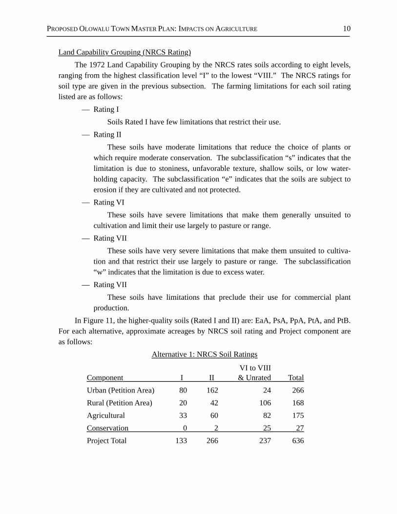
production. In Figure 11, the higher-quality soils (Rated I and II) are: EaA, PsA, PpA, PtA, and PtB.
For each alternative, approximate acreages by NRCS soil rating and Project component are as follows:
Alternative 1: NRCS Soil Ratings
VI to VIIIComponent I II & Unrated TotalUrban (Petition Area) 80 162 24 266Rural (Petition Area) 20 42 106 168Agricultural 33 60 82 175Conservation 0 2 25 27Project Total 133 266 237 636
PROPOSED OLOWALU TOWN MASTER PLAN: IMPACTS ON AGRICULTURE 11
Alternative 2: NRCS Soil Ratings
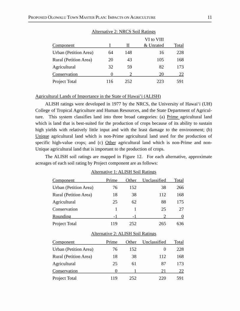
VI to VIIIComponent I II & Unrated TotalUrban (Petition Area) 64 148 16 228Rural (Petition Area) 20 43 105 168Agricultural 32 59 82 173Conservation 0 2 20 22Project Total 116 252 223 591
Agricultural Lands of Importance in the State of Hawai’i (ALISH)ALISH ratings were developed in 1977 by the NRCS, the University of Hawaiʻi (UH)
College of Tropical Agriculture and Human Resources, and the State Department of Agricul-ture. This system classifies land into three broad categories: (a) Prime agricultural land which is land that is best-suited for the production of crops because of its ability to sustain high yields with relatively little input and with the least damage to the environment; (b) Unique agricultural land which is non-Prime agricultural land used for the production of specific high-value crops; and (c) Other agricultural land which is non-Prime and non-Unique agricultural land that is important to the production of crops.
The ALISH soil ratings are mapped in Figure 12. For each alternative, approximate acreages of each soil rating by Project component are as follows:
Alternative 1: ALISH Soil Ratings
Component Prime Other Unclassified TotalUrban (Petition Area) 76 152 38 266Rural (Petition Area) 18 38 112 168Agricultural 25 62 88 175Conservation 1 1 25 27Rounding -1 -1 2 0Project Total 119 252 265 636
Alternative 2: ALISH Soil Ratings
Component Prime Other Unclassified TotalUrban (Petition Area) 76 152 0 228Rural (Petition Area) 18 38 112 168Agricultural 25 61 87 173Conservation 0 1 21 22Project Total 119 252 220 591
PROPOSED OLOWALU TOWN MASTER PLAN: IMPACTS ON AGRICULTURE 12
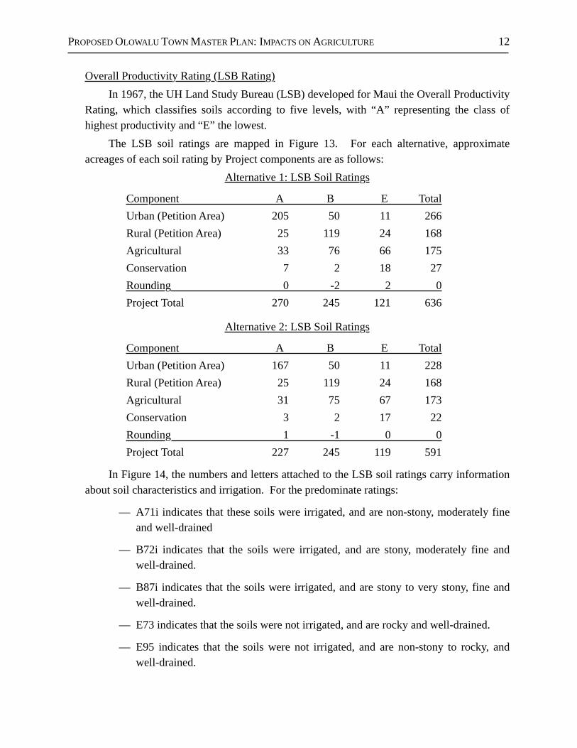
Overall Productivity Rating (LSB Rating)In 1967, the UH Land Study Bureau (LSB) developed for Maui the Overall Productivity
Rating, which classifies soils according to five levels, with “A” representing the class of highest productivity and “E” the lowest.
The LSB soil ratings are mapped in Figure 13. For each alternative, approximate acreages of each soil rating by Project components are as follows:
Alternative 1: LSB Soil Ratings
Component A B E TotalUrban (Petition Area) 205 50 11 266Rural (Petition Area) 25 119 24 168Agricultural 33 76 66 175Conservation 7 2 18 27Rounding 0 -2 2 0Project Total 270 245 121 636
Alternative 2: LSB Soil Ratings
Component A B E TotalUrban (Petition Area) 167 50 11 228Rural (Petition Area) 25 119 24 168Agricultural 31 75 67 173Conservation 3 2 17 22Rounding 1 -1 0 0Project Total 227 245 119 591
In Figure 14, the numbers and letters attached to the LSB soil ratings carry information about soil characteristics and irrigation. For the predominate ratings:
— A71i indicates that these soils were irrigated, and are non-stony, moderately fine and well-drained
— B72i indicates that the soils were irrigated, and are stony, moderately fine and well-drained.
— B87i indicates that the soils were irrigated, and are stony to very stony, fine and well-drained.
— E73 indicates that the soils were not irrigated, and are rocky and well-drained.
— E95 indicates that the soils were not irrigated, and are non-stony to rocky, and well-drained.
PROPOSED OLOWALU TOWN MASTER PLAN: IMPACTS ON AGRICULTURE 13
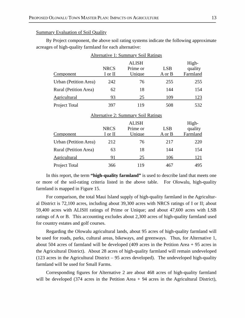
Summary Evaluation of Soil Quality
By Project component, the above soil rating systems indicate the following approximate acreages of high-quality farmland for each alternative:
Alternative 1: Summary Soil RatingsALISH High-
NRCS Prime or LSB quality Component I or II Unique A or B FarmlandUrban (Petition Area) 242 76 255 255Rural (Petition Area) 62 18 144 154Agricultural 93 25 109 123Project Total 397 119 508 532
Alternative 2: Summary Soil RatingsALISH High-
NRCS Prime or LSB quality Component I or II Unique A or B FarmlandUrban (Petition Area) 212 76 217 220Rural (Petition Area) 63 18 144 154Agricultural 91 25 106 121Project Total 366 119 467 495
In this report, the term “high-quality farmland” is used to describe land that meets one or more of the soil-rating criteria listed in the above table. For Olowalu, high-quality farmland is mapped in Figure 15.
For comparison, the total Maui Island supply of high-quality farmland in the Agricultur-al District is 72,100 acres, including about 39,300 acres with NRCS ratings of I or II; about 59,400 acres with ALISH ratings of Prime or Unique; and about 47,600 acres with LSB ratings of A or B. This accounting excludes about 2,300 acres of high-quality farmland used for country estates and golf courses.
Regarding the Olowalu agricultural lands, about 95 acres of high-quality farmland will be used for roads, parks, cultural areas, bikeways, and greenways. Thus, for Alternative 1, about 504 acres of farmland will be developed (409 acres in the Petition Area + 95 acres in the Agricultural District). About 28 acres of high-quality farmland will remain undeveloped (123 acres in the Agricultural District – 95 acres developed). The undeveloped high-quality farmland will be used for Small Farms.
Corresponding figures for Alternative 2 are about 468 acres of high-quality farmland will be developed (374 acres in the Petition Area + 94 acres in the Agricultural District),
PROPOSED OLOWALU TOWN MASTER PLAN: IMPACTS ON AGRICULTURE 14
resulting in about 27 acres of high-quality farmland remaining in the Agricultural District (121 acres in the Agricultural District – 94 acres developed).
For comparison, the loss of about 500 acres of high-quality farmland amounts to less than 0.7% of the 72,100-acre supply of high-quality farmland on Maui Island.
d. Elevation and SlopesThe Project site ranges in elevation from sea level to about 410 feet for mauka farmland
and 460 feet for non-farmland. Near the shoreline, the topography is generally flat to slightly sloping. Proceeding
mauka, the slopes gradually increase, with the farmlands reaching about 9% at the higher elevations.
e. Climatic Conditions Hawaiʻi has a mild semitropical climate that is due primarily to three factors: (1)
Hawai'i’s mid-Pacific location near the Tropic of Cancer, (2) the surrounding warm ocean waters that vary little in temperature between the winter and summer seasons, and (3) the prevailing northeasterly tradewinds that bring air having temperatures that are close to those of the surrounding waters.
Solar RadiationThe Project site receives considerable sunshine, with average daily insulation exceeding
500 calories per square centimeter per day.
RainfallAnnual rainfall at Olowalu averages about 11 inches near the shoreline and about 14
inches near the foothills. Most of this rainfall occurs during the winter rainy season (November through March), while the summer months are hot and dry.
Temperatures Temperatures at Olowalu range from an average low of 63°F in the winter to an average
high of 86°F in the summer.
WindsThe prevailing tradewinds blow down from Olowalu Valley then offshore at a mean
speed of about 16 miles per hour (measured at 50 meters altitude). Occasional strong winds can cause crop damage if unprotected by windbreaks.
PROPOSED OLOWALU TOWN MASTER PLAN: IMPACTS ON AGRICULTURE 15
f. Wildfires
Beginning in 1999 after the closure of sugarcane operations in West Maui, much of the lands at Olowalu reverted to dry grassland and shrub land, thereby providing fuel for wildfires. Several large wildfires have in fact occurred. In 2007, a wildfire destroyed the greenhouses and crops at Olowalu Nui Farms (see Subsection 5.a).
g. Irrigation Water
OverviewThe agricultural water system at Olowalu originally was designed by sugar companies
to deliver surface water and groundwater to irrigate sugarcane using furrow irrigation, which typically required an average of about 10,000 gallons per acre per day with all arable land in crop. For comparison, most diversified crops use about 4,000 gallons per day, often with half of the arable land in crop and half remaining fallow to control pests and restore the soil.
Currently, Olowalu Water Company, Inc. (OWC) supplies (1) potable water to the limited number of residential and commercial users at Olowalu, and (2) non-potable water to farmers. Founded in 1999, OWC is a private water company (ID# 209) regulated by the Public Utilities Commission (PUC).
Project plans are to significantly reduce or eliminate potable groundwater to irrigate crops and, instead, to rely on surface water, non-potable groundwater, and treated wastewater. The existing and planned water systems are shown in Figure 16.
Olowalu DitchSome time before 1911, Olowalu Company built the Olowalu Ditch to deliver surface
water diverted from Olowalu Stream (Tom Nance Water Resource Engineering, and Carol Wilcox). The diversion dam is at the 502-foot elevation, and a 1.1-mile-long conveyance ditch and tunnel system deliver water to a lined open reservoir at the 360-foor elevation. The system has three additional reservoirs at lower elevations, none of which are lined and one of which is still in use. Olowalu Company installed a second diversion at a lower elevation, but it was abandoned before 1950 and was subsequently destroyed by storms.
The Olowalu Ditch had a capacity of 11 mgd and, for the 56-year period from 1911 to 1967, diverted about 4 to 5 million gallons per day (mgd), an average of 4.8 mgd, a median of 4.08 mgd, and over 2 mgd for 98% of the days. In June 2010, an estimated 2 mgd were diverted from the stream, but less than 0.9 mgd were delivered to the storage reservoir. The difference was lost due to leakage in transit, with over half of the diverted water returning to the stream.
Portions of the irrigation system are reported to be in good condition, but some portions are in disrepair. With proper maintenance, including cleaning sediment and debris and
PROPOSED OLOWALU TOWN MASTER PLAN: IMPACTS ON AGRICULTURE 16
repairing leaks, the Olowalu Ditch should be able to deliver sufficient water to supply the irrigation needs of the Project. However, farming on the scale of the former plantation would likely require costly improvements and significant upgrades to the ditch, with the cost depending on the volume of water required and the corresponding improvements needed.
The OWC estimates that more than $1 million would be required to restore the ditch sufficiently to support extensive farming at Olowalu. Improvements costing $1 million could be feasible provided that at least 600,000 gallons or more of additional water per day could be sold at a rate of 90¢ or more per 1,000 gallons, and assuming that the improvements would be financed with a 20-year loan at 6% interest, and with at least 40¢ used for debt service and, at most, 50¢ used for operations and maintenance of the water system.
Groundwater WellsOlowalu Company and Pioneer Mill Co., which merged with Olowalu Company in
1931, also built skimming wells to tap basal groundwater on the property: — State Well No. 4937-01, also known as Olowalu Shaft and Pump N, was devel-
oped in 1905, and consists of four horizontal tunnels and seven drilled wells. — State Well 4837-01, also known as “0” Pump, was developed in 1933, and has a
230-foot long horizontal tunnel. Increased withdrawals in the 1970s using high-capacity pumps caused significant
salinity increases in both wells. Currently, both wells are unused but remain available as a backup in case surface water is insufficient. Both wells are capable of producing slightly brackish water, provided that pumping rates are modest—on the order of 1 mgd for each well.
In 2000, the Olowalu Elua Well was developed to provide potable water for homes in Olowalu. This well—which is located approximately 4,500 feet inland from the ocean at an elevation of 205 feet, and 100 feet west of Olowalu Stream—taps a confined aquifer that provides fresh water with very low chloride. The capacity of the well is approximately 360,000 gallons per day, but may be capable of producing about 600,000 gallons per day.
According to the Hawaiʻi Commission on Water Resource Management, the estimated sustainable yield of the Olowalu Aquifer is 2 mgd. However, a U.S. Geological Survey (USGS) study suggest that the Olowalu Aquifer may have a developable supply on the order of 7 mgd. In either case, the sustainable yield indicates that wells could provide substantially more water than is drawn by the Olowalu Elua Well.
Treated WastewaterAn on-site wastewater treatment plant within the Project site will discharge R-1 rated
(tertiary-quality) water to irrigate crops, parks, and landscaped open spaces. State regula-

PROPOSED OLOWALU TOWN MASTER PLAN: IMPACTS ON AGRICULTURE 17
tions allow R-1 water to be used to irrigate any crop with any type of irrigation system. At full build-out of the Project, about 0.245 mgd of R-1 water will be available to farmers.
Distribution SystemNon-potable water is currently delivered to agricultural customers located in areas
where the distribution system is in good condition. Additional farming at Olowalu will require repairing, upgrading, and extending the distribution system, including adding new water lines and new storage facilities.
Water RatesIn recent years, OWC has encountered financial losses from its potable and non-potable
water services—approximately $44,000 in 2010. In effect, OWC has been subsidizing its farmers and domestic customers. In view of these losses, the PUC recently approved a rate increase of about 25% in 2011 for both potable and non-potable water service at Olowalu, followed by another increase of nearly 15% effective March 12, 2011.
The current rate for non-potable water at Olowalu is $1.09 per thousand gallons, and $0.55 for bulk users (farms of at least 50 acres using over 1,000,000 gallons per month). This bulk rate is typical for many irrigation system in Hawaiʻi, and is about 55% the $1.00 rate charged by the County of Maui.
h. Road Access Honoapiʻilani Highway provides access to the Project site. Former plantations roads
and some paved roads provide access to areas within the Project site.
i. Current Land Uses at OlowaluCurrent land uses within the Project site and on abutting Olowalu properties are shown
in Figures 2 and 17, and include the following:— Project Site
• Agriculture, both Alternatives+ Olowalu Nui Farms (hydroponic tomatoes and other crops)+ Cattle grazing in the foothills
• Agriculture, only Alternative 1+ Olowalu Elua Associates, LLC (Palm Tree Farm)+ Olowalu Ekolu, LLC (Palm Tree Farm)
• Olowalu Cultural Reserve
PROPOSED OLOWALU TOWN MASTER PLAN: IMPACTS ON AGRICULTURE 18
• Fallow land (former sugarcane, much of which was subsequently used for seed corn, some for a sod and grass farm, some for a plant nursery, some for veg-etable crops, and some for gamecocks.)
— Abutting Properties• Residential
+ Plantation Manager’s House and other plantation-era single-family homes+ Olowalu makai Subdivision (5 agricultural lots)+ Camp Olowalu (formerly known as Camp Pecusa)+ Kapaʻiki Village (single-family residences reminiscent of the plantation era)+ Olowalu mauka Subdivision (14 agricultural lots)
• Olowalu General Store• Olowalu Church• Historic Structures, No Longer in Use
+ Olowalu Wharf+ Olowalu Sugar Mill
j. Surrounding Land UsesAs shown in Figure 1, Olowalu is somewhat isolated from other communities and farm
areas in West Maui:— mauka are Olowalu Valley and the West Maui Mountains.— About 2 miles toward Lahaina are the fallow sugarcane fields and the community
of Launiupoko. — About 2 miles toward Māʻalaea are the fallow sugarcane fields of Ukumehame.
k. Locational Advantages and DisadvantagesMaui Island Market
Farmers in Olowalu are well-situated for supplying the Maui Island market because of the short trucking distance to Kahului (about 17 miles), which is the island’s commercial, industrial, distribution and transportation center. While the Maui Island market is significant, it is comparatively small: in 2010, Maui Island had a de facto population of about 190,160 residents and visitors.
Honolulu MarketAll Maui farmers are at a disadvantage when competing against Oʻahu farmers in
supplying the Honolulu market due to the inter-island shipping costs, delays and extra handling. In comparing barge and air-cargo services, shipping by barge is less expensive and

PROPOSED OLOWALU TOWN MASTER PLAN: IMPACTS ON AGRICULTURE 19
larger loads can be shipped, but the shipments are slow and infrequent. Air service is faster and frequent, but it is far more expensive and capacities are limited.
In 2010, O'ahu had a de facto population of about 1,039,100 residents and visitors—over five times larger than the Maui market.
Mainland MarketCompared to Hawai'i, the mainland market is enormous: in 2010, the U.S. population
totaled 308.7 million. In supplying this market with products that can be carried by container ship—e.g., products having long shelf-lives such as coffee, nuts, and canned fruit—farmers on Maui are competitive with farmers on O'ahu and the other islands. Even though freight from Maui must first be barged to Honolulu then transferred onto a container ship, Matson’s overseas shipping service includes inter-island barge service at no additional fee: except for some minor port charges, Matson charges a common fare for all islands.
In the case of fresh products that must be shipped by air to the mainland—e.g., products having short shelf-lives such fresh vegetables and fruits—farmers on Maui are at a disadvan-tage compared to farmers on O'ahu because most mainland air cargo is shipped via Honolulu International Airport. Compared to farmers on O'ahu, Maui farmers encounter additional costs, delays, and handling to cover inter-island air-cargo service and transferring the fresh produce from small inter-island aircraft to large overseas aircraft.
However, overseas air-cargo service from Maui has improved somewhat because the current generation of aircraft can depart from the short runway at Kahului with a full load of passengers and a full load of cargo in the hold. This direct service allows farmers on Maui to be more competitive in mainland markets. However, the lift capacity from Maui is limited by the number of direct flights.
In the U.S. mainland market, Hawaiʻi farmers must also compete against farmers on the mainland and in Mexico, Central and South America, Southeast Asia, etc. Most of the competing farm areas have lower production and delivery costs than Hawai'i does. Compet-ing against Mexico is particularly difficult given the North America Free Trade Agreement (NAFTA) and Mexico’s proximity to major U.S. markets.
Summary of Locational AdvantagesIn terms of location, farmers in Central Maui are well-situated to supply the small Maui
Island market. And compared to other farmers in Hawai'i, they can also compete reasonably well in supplying mainland markets, as long as their products have long shelf-lives and so can be shipped by surface vessel.
However, compared to farmers on O'ahu, they are at a disadvantage in supplying the Honolulu market. Furthermore, they are at a disadvantage supplying mainland markets if
PROPOSED OLOWALU TOWN MASTER PLAN: IMPACTS ON AGRICULTURE 20
their products have short shelf-lives and so must be shipped by air. Also, farmers on Maui are at a disadvantage in competing against the low-cost producers who supply mainland markets.
l. Synergy With Other Farm Areas
Figures 18 through 20 show the location of high-quality farmland on Maui based on the ALISH soil ratings, the LSB soil ratings, and the combined soil ratings (see page 13). As indicated, the large concentrations of high-quality farmland—as well as most farming activity—are located in Central Maui and West Maui.
In contrast, Olowalu has a comparatively small and isolated amount of farmland. Thus, Olowalu is poorly located for developing synergistic relationships with other Maui farms.
m. Potential Crops
Most if not all of the crops grown commercially by farmers on lower elevation fields in Hawaiʻi could be grown commercially at Olowalu. These crops include but are not limited to bell peppers, bittermelon, broccoli, celery, Chinese cabbage, citrus, daikon, eggplant, flowers and nursery products, green onions, head cabbage, herbs, lettuces, melons, mustard cabbage, Oriental squash, papaya, romaine, squash, string beans, sweet corn, tomatoes and zucchini.
n. Summary
Olowalu has favorable agronomic conditions for growing low-elevation commercial crops. Alternative 1 includes about 532 acres of high-quality farmland, of which about 504 acres will be developed (409 acres are in the Petition Area, and about 95 acres of agricultural land for roads, parks, etc.). Alternative 2 includes about 495 acres of high-quality farmland, of which about 468 acres will be developed (374 acres are in the Petition Area, and about 94 acres of agricultural land for roads, parks, etc.). Some of the better soils are stony.
Olowalu benefits from high solar radiation, exceeding 500 calories per square centime-ter per day. Ample water is available to irrigate crops, and the water rate is competitive with many other farm areas in Hawaiʻi. Also, Olowalu is a reasonable trucking distance to Kahului.
However, Olowalu is isolated from other farm areas, so is poorly located for developing synergistic relationships with other farms on Maui. Also, occasional strong winds could cause crop damage if the crops are not protected by windbreaks, and wildfires will continue to be a threat as long as vegetation remains dry and overgrown.

PROPOSED OLOWALU TOWN MASTER PLAN: IMPACTS ON AGRICULTURE 21
4. PAST AGRICULTURAL USES
a. Hawaiian Crops Prior to Plantation AgricultureAs the largest and deepest valley in southwest Maui, Olowalu was well-suited for the
ahupuaʻa system which allowed an estimated 2,000 Hawaiians to thrive at Olowalu before western contact (Ainsworth, 2003; Smith, undated; and Lee-Grieg and Hammatt, 2012). Taro was grown in numerous lo`i on the wetter upper valley floor and, to a lesser extent, along Olowalu Stream. Sweet potatoes were grown on the dry slopes. Breadfruit and coconuts were grown along the coast. Other Olowalu crops included dry-land taro, banana, sugarcane, coconut, kukui, ti, kava, wauke, ʻolonā, pili, naio, and more. The sea provided fish, and the forest supplied wood for canoes and housing.
In 1855—seven years after the Great Mahele which established a system of private land ownership, and 5 years after foreigners were granted the right to own land—Hawaiians legally claimed ownership of 50 kuleana in Olowalu, which included about 115 acres of arable land. Most of the kuleana were located along Olowalu Stream and along the coastline. The Hawaiians continued their traditional agricultural practices, although sometimes in a more Western manner. For example, a hui of Olowalu taro growers, formed the Taro Planting Company. By1866, only 13 Hawaiians stated they owned kuleana land at Olowalu.
b. SugarcaneThe sugar industry came early to Olowalu, lasted about 135 years, and changed
agricultural activity dramatically from small-scale subsistence farming to large-scale plantation agriculture. In 1864, King Kamehameha V (Lot Kapuāiwa with a full name of Lota (Lot) Liholiho Kapuāiwa Kalanimakua Kalanikupuapaikalaninui Aliʻiolani Kalani-a-Kekūanaōʻa) then ruler of the Hawaiian Kingdom, leased his personally owned crown lands at Olowalu and Ukumehame to the newly-formed West Maui Sugar Company (also called the West Maui Sugar Association), and invested his own funds in the new plantation (Ainsworth, undated; Lee-Greig and Hammatt, 2012; Dorrance and Morgan, 2005). Following financial difficulties, the plantation was sold in 1874 to the owners of Pioneer Mill Plantation, but continued to operate as a separate plantation for a short period.
In anticipation of the Reciprocity Treaty (1876) which allowed sugar to be exported to the United States duty free, Maui businessmen acquired lands at Olowalu and Ukumehame in 1875, formed the Olowalu Plantation, and began growing sugarcane there in 1876.
Anther group of businessmen formed Olowalu Company, and acquired the plantation in 1881. This company survived for about 50 years. By modern standards, the plantation was small: only about 645 acres were farmed in 1930. Also, Olowalu was said to have kipikua (pickax) lands because, in the early years, it was necessary to use a pick and shovel to cultivate the stony soils.
PROPOSED OLOWALU TOWN MASTER PLAN: IMPACTS ON AGRICULTURE 22
In 1931, Olowalu Company merged with Pioneer Mill Company (PMCo), increasing PMCo’s plantation to more the 14,000 acres. Sugarcane operations at Olowalu continued for another 68 years when Amfac/JMB Hawaii, the parent company of PMCo, decided to close the plantation effective 1999. PMCo was forced to close because low sugar prices under-mined its profitably. Sugar prices were low largely because of competition from mainland producers of high-fructose corn syrup which began commercial production in the 1970s (Decision Analysts Hawaiʻi, Inc., 1981 and 1989). Statewide, the low sugar prices forced the closure of 13 of the 14 plantations that operated in 1980. The only survivor is the large Hawaiian Commercial and Sugar Co. (HC&S) plantation in Central Maui.
When PMCo closed, about 500 acres of sugarcane were being cultivated at Olowalu. Since 1999, most of the fields have remained fallow.
c. Recent Agricultural ActivitiesFollowing the closure of PMCo, several agricultural endeavors were attempted on portions
of former sugarcane lands in Olowalu. The unsuccessful ones are discussed below, while the ones that survived are discussed in Sections 5 through 8. The locations of both the successful operations and unsuccessful ones are shown in Figure 17.
Monsanto Company: Seed CornBased in Missouri, Monsanto Company is a multinational agricultural biotechnology
corporation with 2011 revenues of $11.8 billion. It is one of a number of seed companies which choose Hawaiʻi to conduct much of their research because the year-round growing conditions allow three crops per year instead of just one as in most other areas, and Hawaiʻi and the U.S. provide a supportive legal environment. The seeds derived from research in Hawaiʻi are distributed throughout the world, and contribute to feeding billions of people. In Hawaiʻi, the seed companies generally are the highest bidders for land, labor and other agricultural resources on Oʻahu, Kauai, Molokaʻi and Maui. Monsanto has operations on all four islands mentioned. On Oʻahu, the company recently purchased considerable land in Kunia, and invested in a number of large buildings.
Monsanto Hawaii leased about 215 acres at Olowalu for the 2002-to-2004 period, then extended the lease to 2007 (Tremble, 2011). Beginning in 2004, 4 or 5 acres were used to grow seed corn, but Monsanto ended the lease early in 2005.
Grass and Sod FarmA grass and sod farm was established in 2001 on about 5 acres of leased land located
mauka of Honoapiʻilani Highway, near the former Olowalu Landfill (Tremble, 2011). The farmer attempted to grow grass and sod for landscaping companies. However, the business was unsuccessful and the farm was abandoned in 2004 after 3 years of effort.
PROPOSED OLOWALU TOWN MASTER PLAN: IMPACTS ON AGRICULTURE 23
Plant NurseryFor about a 1-year period from 2002 to 2003, a plant nursery was attempted on about 2
acres of leased land located makai of Honoapiʻilani Highway, north of the Olowalu General Store (Tremble, 2011). The effort was abandoned, largely because of costly fire-protection improvements required by the County.
Casco GamefarmFrom 2009 to 2013, Casco Gamefarm—also known as Happy Happy Rooster Farm—
raised gamecocks as well as a few goats and pigs. The farm was located on about 4 acres of leased land in the western portion of the Project site (portions of TMK (2) 4-8-003:114 and TMK (2) 4-8-003:115)—see Figures 3 and 17.
After operating in Lahaina for about 4 years, the Farm relocated to Olowalu in 2009 because the Lahaina neighbors complained about the early morning rooster crowing. The Olowalu site was selected because of its isolation.
With about 250 roosters, the operation may have been the largest gamefarm on the island. Most of the roosters were sold in the Philippines. The Farm was run as a hobby, and provided no paid employment. For the first three years, the landowner did not charge Casco Gamefarm for the use of the land or water.
OCR Affiliated FarmsFrom 2012 to 2013, about 4 acres of land were made available to farmers affiliated with
the Olowalu Cultural Reserve. The farms (not shown in Figure 17) were located makai of the Casco Gamefarm and mauka of Honoapiʻilani Highway (a portion of TMK (2) 4-8-003:114). Vegetables, bananas, and papaya were grown on the site. To help the farmers achieve initial success, no rent was charged. However, the endeavor was not sustained.
5. OLOWALU NUI FARM
a. Farm Operations Type of Farm
Olowalu Nui Farm, registered as Olowalu Nui Hydroponic Tomato Farm, grows tomatoes and other vegetables hydroponically in greenhouses, and also grows various fruit and palm trees on adjoining land (see Figures 21 and 22 for photographs of the farm).
HistoryIn 1994, Jon Applegate started the farm on 7 acres of land in Hana to supply a variety of
high-quality tomatoes for his Italian-themed restaurants on Maui, especially tomatoes for
PROPOSED OLOWALU TOWN MASTER PLAN: IMPACTS ON AGRICULTURE 24
fried green tomato recipes. He soon realized that other restaurants on the island were interested in purchasing his tomatoes, so he expanded his farm operations. In 2001, he sold the Hana property and moved to Olowalu to be closer to his restaurants, which included three restaurants in Kāʻanapali: Basil Tomatoes Italian Grille, Giovani’s Tomato Pie, and Jonny's Burger Joint.
Mr. Applegate passed away in 2011, after which the farm has been managed by his widow.
LocationOlowalu Nui Farm is on about 4 acres of leased land in the western portion of the
Project site (portions of TMK (2) 4-8-003:115 and TMK (2) 4-8-003:117)—see Figures 3 and 17.
Advantages and DisadvantagesMajor advantages of the site include (1) a reasonable trucking distance to both West
Maui and Central Maui, and (2) high solar radiation and hot conditions which are good for growing tomatoes and other crops.
The major disadvantage of the site is the risk of fire. In 2007, the farm suffered a major setback when a wildfire destroyed the greenhouses and crops, causing $600,000 in damages. Another disadvantage of the site are the occasional strong winds which can damage green-houses and crops. Also, the dry, hot conditions at Olowalu and inside the greenhouses attract spider mites which have damaged crops. The mites are controlled by spraying soap and other non-toxic solutions.
Land UseAbout 2.7 acres are used for the greenhouses, office, storage sheds, open storage, and
parking. About 1.7 acres are used for fruit and palm trees, excluding the bananas used for windbreaks. The remainder of the property is used for windbreaks or is vacant.
Lease Term and RentThe initial lease began with a 5-year term which was extended for another 5 years.
Since 2011, the lease has been extended in 1-year increments. For the farm’s first 10 years at Olowalu, the landowner charged rent of $300 per year
($75 per acre per year), which is well below market for farmland. In effect, the landowner provided an implicit and substantial subsidy to Olowalu Nui Farms.
In late 2012, the rent for the 4 acres was $900 per month ($2,700 per acre per year).
PROPOSED OLOWALU TOWN MASTER PLAN: IMPACTS ON AGRICULTURE 25
ImprovementsOlowalu Nui Farm grows vegetable and herb crops in five greenhouses having a
combined area of 20,000 to 25,000 sq. ft. (about half an acre). The greenhouses are equipped with water systems designed for hydroponic farming.
Other improvements include a small office building and storage areas.
Water Usage and RateThe farm uses an average of about 14,200 gallons of non-potable water per day to
irrigate its crops, or less than 3,600 gallons per acre per day for the 4 acres. Water discharged from the hydroponic farm is recycled to irrigate fruit and palm trees.
For the farm’s first 10 years at Olowalu, the landowner provided water at no charge, another implicit and substantial subsidy to Olowalu Nui Farm. The current water rate is given in Subsection 3.g.
CropsCrops grown hydroponically by Olowalu Nui Farm have included: four varieties of
tomatoes which are the primary crop; 20 varieties of leafy lettuce; cucumber; peppers; basil; parsley; cilantro; and other herbs. The produce is sold to high-end restaurants on Maui.
Next to the greenhouses, Olowalu Nui Farm grows about 200 citrus trees (lime and lemon), and about 600 apple-banana, papaya, mango, and palm trees. The banana trees are dual purpose: they provide fruit and serve as a windbreak for the farm.
MarketThe farm sells its fresh vegetables and fruits to restaurants and grocery stores in West,
Central, and South Maui. In addition, some of the crop is sold onsite. The palms are sold to Maui landscapers and individuals. Marketing is by word of mouth.
EmploymentIn the past, Olowalu Nui Farm employed a fulltime manager, a few full-time workers,
and part-time workers. The farm did not employ seasonal workers inasmuch as hydroponic farming provides steady production, regardless of the season. Training was provided by the farm.
Currently, the farm is run by the owner without help from hired workers.
ProfitabilityThe farm has been profitable in some years, but has struggled in others. As mentioned,
greenhouses and crops were lost to fire in 2007. After the fire, the farm operated at a loss
PROPOSED OLOWALU TOWN MASTER PLAN: IMPACTS ON AGRICULTURE 26
due to the cost of rebuilding greenhouses combined with low production. Many of the major improvements were completed in 2011. In 2012, revenues were low because spider mites inside the greenhouses damaged crops. Since then, the farm has returned to profitability.
b. Impacts on Olowalu Nui FarmMost of Olowalu Nui Farm is located on the fringe of the Project in an area that is
planned for (1) single-family homes on rural lots, (2) a rural park, (3) portions of an interior road, and (4) a portion of the realigned Honoapiʻilani Highway—see Figures 4, 5 and 17. The Highway will cause the loss of some trees in the southwest corner of the farm. Thus, as currently planned, the Project would require Olowalu Nui Farm to relocate eventually.
Assuming suitable land can be found nearby—which might include Project land near Olowalu Stream that is planned for farming—Olowalu Nui Farm estimates that the cost to relocate the hydroponic component of the farm would be about $50,000. This cost covers the effort to disassembling the greenhouses and equipment, move them, then reassembling them at the new location. After operations cease at the existing location, the farm could lose up to 8 months of production and its associated revenues before newly planted crops are producing at the new location (about 6 months for the move plus about 2 months before new plants are producing).
An alternative would be for the farm to invest in new facilities at the new location; move the crops to the new site; then disassemble the facilities at the current location. This option would maintain production but the capital costs would be higher.
Most or all of the fruit trees would probably be lost since moving them would be expensive, but the palm trees could be sold.
c. Recommended Mitigation for Olowalu Nui FarmThe Project developers have discussed the proposed Master Plan with the owner of
Olowalu Nui Farm, and will continue to engage the owner in discussions as plans for the Project progress. Consistent with their current approach, it is recommended that the developers remain flexible regarding two alternatives:
— Modify the Project plan so that Olowalu Nui Farm can continue at its current location, and possibly provide some additional farmland to offset land that will be lost to roads in the Project.
— Assist with the cost to relocate Olowalu Nui Farm to an agricultural lot near Olowalu Stream, with new facilities built before the move so that production and revenues can be maintained during the transition.
For either location, Olowalu Nui Farm would be compatible with nearby homes inasmuch as:

PROPOSED OLOWALU TOWN MASTER PLAN: IMPACTS ON AGRICULTURE 27
— No tractors or harvesters are used that generate loud noises.— No fields are plowed, so dust from plowing is not generated.— No toxic chemicals are sprayed to control pests at the hydroponic farm.— The fruit trees are sprayed to control pests, but rarely. — No strong odors are generated.— The banana trees serve as a windbreak and also provide a buffer that reduces the
small amount of noise that is generated at the farm, and help prevent airborne chemicals from drifting beyond the farm.
6. PALM TREE FARMS
As shown in Figure 17, two palm tree farms are located within the Alternative 1 Project site. Details on the two farms are as follows (Trimble, 2011):
— Olowalu Elua, LLC Palm Tree Farm• Located on land makai of Honoapiʻilani Highway and east of Olowalu Wharf
(TMK (2) 4-8- 003:084).• Owned by Olowalu Elua, LLC, the larger of the two owners of the Project site.• About 10 acres farmed.• Revenues of about $3,000 per year generated by selling trees to Maui landscap-
ers and individuals. • Expense of about $5,400 per year for about 6 million gallons of water.• No information on farming costs.• Support for less than a single full-time-equivalent job.
— Olowalu Ekolu, LLC Palm Tree Farm• Located on land makai of Honoapiʻilani Highway, and abutting and to the
north-northwest of Olowalu Stream (TMK (2) 4-8-003:124).• Owned by Olowalu Ekolu, LLC, the smaller of the two owners of the Project
site.• About 10 acres farmed.• Revenues of about $4,700 per year generated by selling trees to Maui landscap-
ers and individuals. • Expense of about $5,400 per year for about 6 million gallons of water.• Expense of about $9,000 per year for a company to manage and maintain the
farm.• Support for less than a single full-time-equivalent job.

PROPOSED OLOWALU TOWN MASTER PLAN: IMPACTS ON AGRICULTURE 28
As indicated, both farms are low-revenue and unprofitable operations which are located on high-value oceanfront land. However, because of the County’s low property taxes on land that is actively farmed, farming can be a cost-effective approach for holding land for a future high-value use.
Both farm owners regard their farms as temporary operations that will continue until the affected land is needed for the planned Project development. The farms will then be closed and not relocated. The loss in palm-tree production is likely to be offset by other palm-tree farms on Maui or other islands.
7. OLOWALU CULTURAL RESERVE
Olowalu Cultural Reserve (“OCR”) was founded in 1999 as a community-based, non-profit organization with the purpose of supporting and promoting the revitalization of traditional Hawaiian culture by providing cultural and educational experiences for Hawaiʻi residents and visitors. The organization holds a 99-year lease on about 74 acres of land within the valley and along the stream to the ocean (see Figure 17). This land once held a thriving Native Hawaiian village and, as such, is rich in historical resources including numerous significant archaeological and cultural sites. It has been set aside and designated as a Cultural Reserve to serve as a culturally sensitive “sanctuary” providing a glimpse into Hawaii’s past, and making it an ideal environment for programs aimed at restoring and revitalizing Hawaiian customs and practices.
The OCR organization is restoring former irrigation systems and loʻi for taro cultivation, and is planting other native crops. Currently, about 5 acres are used to demon-strate the cultivation of taro, sweet potato, breadfruit, banana, sugarcane, kukui, ti, kava, and many other crops.
Project plans include expanding the Reserve, which will allow more varieties and greater quantities of native crops to be grown at the Reserve.
8. OTHER AGRICULTURAL ACTIVITIES
In addition to the formal agricultural leases, there are three informal agricultural uses within the Petition Area.
a. Ranching
The landowner allows a subsistence cattle rancher to graze about 20 head on about 200 acres located mauka of Honoapiʻilani Highway. In this same area, the landowner allows a retired rancher to graze a few head of horses. There are no formal leases for use of this land, and no rent is charged.
PROPOSED OLOWALU TOWN MASTER PLAN: IMPACTS ON AGRICULTURE 29
The two ranching activities are regarded as temporary land uses that are mutually beneficial to the ranchers and the landowner. For the ranchers, the landowner provides grazing land and range feed at no cost to the ranchers. For the landowner, the grazing controls vegetation and reduces the fire hazard at no cost to the landowner.
b. Fruit Stand and Garden
A juice and fruit stand is located on the mauka side of Honoapiʻilani Highway near Olowalu General Store. In addition to the roadside stand, the operator grows a variety of fruits on about 0.75 acre of abutting land, and sells the fruit at the roadside stand. The operator provides a Proof of Insurance and pays for water, but does not pay rent.
c. Recommended Mitigation
The Project developers will inform the ranchers and fruit seller of progress on the Project, and will provide ample notice regarding when they will have to vacate the land so that development can proceed as planned.
9. ABUTTING AGRICULTURAL ACTIVITIES
a. Olowalu Mauka Subdivision
Existing and Potential Farming Activity
Olowalu mauka Subdivision is a 14-lot agricultural subdivision that was developed about 10 years ago. The lots range in size from about 3.1 acres to about 6.1 acres. This project was designed for large-lot residential use with comparatively expensive homes as well as agricultural use on a portion of each lot (i.e., country estates). At least half the lots now have homes.
Tax records indicate that two lots have commercial farming (TMKs (2) 4-8-003: 092 and (2) 4-8-003: 094). In the future, a number of the lot owners are likely to use a portion of their lot for a vegetable garden or a small commercial farm, or they may lease some of their land to commercial farmers.
Impact on Farming Activity
At full development of the Project, single-family homes on rural lots (a half-acre or larger) will border the six lower-elevation lots in the Olowalu mauka Subdivision. As mentioned, portions of some of these agricultural lots are likely to be used for commercial farming and vegetable gardens. Similarly, portions of some of the rural lots may be used for vegetable gardens.
PROPOSED OLOWALU TOWN MASTER PLAN: IMPACTS ON AGRICULTURE 30
These two abutting uses are compatible as indicated by the many communities on Maui and throughout Hawaiʻi that have single-family homes on rural lots next to country estates. In such situations, farmers generally limit voluntarily their agricultural activities to those that are compatible with nearby homes. Thus, no adverse agricultural impacts are anticipated. Specifically, the residential use of homes on rural lots is not expected to interfere with existing or future farming activities in the Olowalu mauka Subdivision. Also, farming activities are not expected to cause significant nuisance problems or other adverse impacts on new homes and their residents.
In any case, Hawaiʻi’s Right-to-Farm Act gives farmers the right to farm if they were operating before neighboring properties were developed, provided that their farm activity does not threaten public health or safety.
Recommended Mitigation Since adverse impacts are not expected on existing or likely farming within the Olowalu
Mauka Subdivision, no mitigating measures are recommended.
b. Olowalu Makai SubdivisionExisting and Potential Farming Activity
Olowalu makai Subdivision is an oceanfront, 5-lot agricultural subdivision that was developed about 10 years ago, and which was designed for country estates. The lots range in size from about 2 acres to about 4.6 acres.
Two of the lots have tax assessments that indicate commercial agricultural activity. The oceanfront lot abutting and to the southeast of Olowalu Stream (TMK (2) 4-8-003: 121) has a home and less than 2 acres that are used mostly to grow palm trees. Even though this agricultural activity is a low-value use of high-value oceanfront land, such a use provides benefits of lower property taxes while being compatible with the adjoining and nearby homes. Once the Project is developed, land uses surrounding this lot will be as follows (see Figure 4):
— Lahaina side: Olowalu Stream and a Project oceanfront park.— Māʻalaea side: an existing oceanfront agricultural lot (currently vacant with no
home or commercial agricultural activity).— mauka side: the current Honoapiʻilani Highway which will be converted to an
access road and, mauka of the road, portions of the Project area planned for small farms.
The oceanfront lot bordering and northwest of the Plantation Manger’s House (TMK (2) 4-8-003: 120) has no home, but about 1 acre is used for growing crops. Once the Project is developed, land uses surrounding this lot will be as follows:
PROPOSED OLOWALU TOWN MASTER PLAN: IMPACTS ON AGRICULTURE 31
— Lahaina side: an existing agricultural lot and home.
— Māʻalaea side: the existing Plantation Manager’s House.
— mauka side: the current Honoapiʻilani Highway which will be converted to an access road and, mauka of the road, Project single-family homes on large town lots.
Regarding the remaining three oceanfront lots in the Olowalu makai Subdivision, two have large homes with little or no space for commercial agriculture. However, the second lot southeast of Olowalu Stream (TMK (2) 4-8-003: 122) is vacant. In the future, it is likely that this lot will be used for an oceanfront home, and possibly a home garden or a small commer-cial farm (about an acre).
Impact on Farming Activity
As mentioned above, the existing and likely farming activities at Olowalu makai Subdivision are compatible with nearby homes. This indicates that the Project components that will be near this subdivision are likely to be compatible with this same farming activity. In particular, a new park, new homes on large town lots, and new farming activity are not expected to interfere with existing or future farming activity within the Olowalu makai Subdivision. Also, the existing farming activities are expected to have little or no nuisance issues or other adverse impacts on park use, residential use of new homes, or new farming activity.
In any event, the Hawaiʻi’s Right-to-Farm Act gives farmers the right to farm if they were operating before neighboring properties were developed, provided that their farming activity does not threaten public health or safety.
Recommended Mitigation
Since adverse impacts are not expected on existing or likely farming activity within the Olowalu Makai Subdivision, no mitigating measures are recommended.
c. Foothills
Potential Ranch Activity
The Olowalu foothills are State-owned lands designated Agricultural. Portions of the foothills were used for grazing cattle in the past, but County tax records indicate no current or recent commercial agricultural use of these lands.
Cattle grazing in the foothills would be possible in those areas having moderate slopes, provided that water and paddock fencing are provided. Although returns from cattle
PROPOSED OLOWALU TOWN MASTER PLAN: IMPACTS ON AGRICULTURE 32
operations are unlikely to be sufficient to justify the cost of the improvements, grazing can be a cost-effective approach to reducing vegetation and, in turn, the fire hazard associated with dry vegetation.
Impact on Potential Grazing Activity
The potential for grazing cattle in the Olowalu foothills would not be affected by the Project as indicated by the fact that grazing operations near homes and farm areas is common on Maui and throughout Hawaiʻi with little or no adverse impacts. In fact, cattle would benefit the Project by reducing the fire hazard to homes and farms.
Recommended Mitigation
Since the Project would not affect the potential for grazing cattle in the Olowalu foothills, no mitigating measures are recommended.
10. NEW OLOWALU FARMING ACTIVITY
a. Field Farming
Farming Operations
About 28 acres in the center of the Project site along Olowalu Stream are planned for agriculture (see Figures 4 and 5). Project plans call for selling about 14 two-acre farm lots to farmers. About 27 acres are high-quality farmland as defined on page 13. Subtracting land for homes and other improvements, about 27 acres will remain available for farming (based on 2,000 sq. ft per lot x 14 lots).
Possible crops include those which are already commercial grown on Maui, including but are not limited to those listed in Subsection 3.m. The economic feasibility of commercial farming at Olowalu is indicated by (1) the favorable agronomic conditions discussed in Section 3, and (2) the commercial success of farms that grow crops at comparable locations on Maui and other Neighbor Islands.
It is assumed that all or nearly all of the 27 acres will be farmed, resulting in an average of about 13.5 acres in crop. This is based on an average of about 50% of the land kept fallow in order to control pests and restore the soil, a percentage which is typical of vegetable farming in many parts of Hawaiʻi.
An average of about 54,000 gallons of water per day would be required to irrigate 13.5 acres in crop (based on an average of about 4,000 gallons of water per acre per day). Water sources available for farming include surface water from Olowalu Ditch, R-1 water from the planned wastewater treatment plant, and brackish water from two groundwater wells (see Subsection 3.g).

PROPOSED OLOWALU TOWN MASTER PLAN: IMPACTS ON AGRICULTURE 33
Assuming typical field farming of vegetables, annual production of food crops from 27 acres could total over 650,000 pounds, thereby contributing to food self-sufficiency and food security (based on harvesting two crops per year per field, and 12,000 pounds per harvested acre). Farm employment could total about three full-time equivalent farm jobs (based on about 10 acres supporting one job).
Nuisance Issues
As shown in Figures 4 and 5, the planned farm area along Olowalu Stream will border single-family homes on small town lots, large town lots, and rural lots. The close proximity of farms and homes can create nuisance issues for residents, such as noisy farm equipment in the early morning, airborne dust from field plowing, odors from fertilizer and chemicals, airborne crop-protection products drifting toward homes, etc. It should be noted, however, that prevailing tradewinds at Olowalu blow offshore, not toward homes.
At the same time, nuisance complaints from nearby residents can cause farmers to change their operations to address the complaints. Also, farms near homes have greater risk of crop and equipment theft than farms that are hidden from view or for which access is difficult.
Recommended Mitigation
To reduce nuisance issues, the following are recommended:
— Security fencing between farms and homes.
— Stands of trees to provide buffers between farms and homes.
— Farming practices that minimize nuisance issues (e.g., no noisy equipment during early hours, dust control, no use of products that cause strong odors, restrictions on the use of crop-protection products in order to prevent airborne chemicals from drifting toward homes, etc.)
— Notification to homebuyers to inform them of nearby farms, potential nuisance issues, and the Right to Farm Act.
Regarding the last item, the intent is to have new residents embrace the fact that nearby farms will be part of the ambiance of the Olowalu community.
b. Hydroponic Farming
As discussed below in Subsection 11.e, a strong and well-established trend has developed to grow vegetables and melons hydroponically in greenhouses. Such farming would allow increased vegetable and melon production in Hawaiʻi while using much less
PROPOSED OLOWALU TOWN MASTER PLAN: IMPACTS ON AGRICULTURE 34
land and water than is required for field farming. Also, good soils are not required for hydroponic farming, thereby allowing this type of farming to be located in areas having poor soils. Furthermore, farming inside greenhouses eliminates or reduces many of the nuisance issues normally associated with field farming including: load noises from farm equipment, dust from recently plowed fields, odors from fertilizers, drifting of sprayed products, and risk of theft.
The existing Olowalu Nui Farms is just one of many such hydroponic farms in Hawaiʻi. Others are listed in Subsection 11.e.
Assuming that hydroponic farming at Olowalu would use technology already common in Hawaiʻi, their production could reach nearly 4.6 million pounds per year (based on farming about 27 acres of land, and 170,000 pounds per acre farmed). This is equivalent to about 190 acres used in field farming, or about 7 times the potential production of field farming these lands (based on the assumption in Subsection 10.a.). For comparison, about 400 acres of vegetables and melons were harvested from all of Maui County in 2008 (the latest year that acreage was reported), or about 200 acres farmed (assuming two crops per year on average). Consequently, hydroponic farming on 27 acres at Olowalu would nearly double the production of vegetables and melons by Maui County farmers. Furthermore, hydroponic farming would offset about 40% of the high-quality farmland lost to Project development (190 acres equivalent ÷ 495 acres of good farmland lost to development for Alternative 1 or 468 acres for Alternative 2).
Hydroponic farming on 27 acres could generate about 14 jobs (based on 2 acres to support one job).
c. Home and Community Gardens
In addition to commercial farming as discussed above, future Olowalu residents will have access to good agricultural land to grow food and nursery crops for family and friends. Residents of rural lots can have home gardens, and all residents will have access to commu-nity gardens. Although such farming is largely a lifestyle choice, the food produced increases self-sufficiency.
11. GROWTH OF DIVERSIFIED CROP FARMING
The Project will result in a loss of good farmland to development. As discussed below, this loss of farmland, in combination with other projects (i.e., the cumulative impact), is too small to affect the growth of diversified-crop farming on Maui or statewide. Diversified crops include all crops other than sugarcane and pineapple (e.g., vegetables, fruits, melons, herbs, organic crops, coffee, nuts, flowers, feed, energy, etc.)
PROPOSED OLOWALU TOWN MASTER PLAN: IMPACTS ON AGRICULTURE 35
a. Loss of Farmland
Olowalu
The Project will commit about 500 acres of high-quality farmland now in the Agricul-tural District to a non-agricultural use, or about 0.7% of the 72,100 acres of high-quality farmland on Maui (see Subsection 3.n). Olowalu’s comparatively small share of the good farmland on Maui is visually apparent in Figures 18 through 20.
If the Project is not developed as planned, then the land is likely to be subdivided for country estates. This would also result in a loss of farmland.
All Maui Projects
The 2014 Maui County Regional Maps list 124 development projects for Maui Island that (1) have all major entitlements (Maui Island Plan, Community Plan, and County zoning); (2) are partially entitled (Maui Island Plan and Community Plan); or (3) are included only in the Maui Island Plan. These projects would supply nearly 30,000 homes and over 2,000 additional visitor units. This compares with the County’s projected demand for Maui Island of about 34,000 new homes by 2030, and about 8,200 new visitor units. As indicated, the planned supply of new homes is less than projected demand.
Figure 20 shows the projects (bordered in red), including residential-oriented agricultur-al subdivisions, that will result in the loss of high-quality farmland in the State Agricultural District. In total, 32 projects will result in the loss of about 3,540 acres of high-quality farmland, or about 4.9% of the 72,100-acre island-wide supply of such land.
In practice, the loss of good agricultural land will be less than 3,540 acres since not all approved projects will be built in the foreseeable future. Also, the loss will be gradual, depending on demand for new homes and visitor units.
b. Supply of Farmland
Island of Maui
Maui Island has about 242,700 acres in the State Agricultural District, including farmed land and fallow farmland; farmland and low-quality agricultural land used for grazing cattle, country estates, golf coures, solar farms, etc.; lava land; and gulch land.
The supply of high-quality farmland is shown in Figures 18 through 20 based on the ALISH soil ratings, the LSB soil ratings, and the combined soil ratings (see page 13). As mentioned above, Maui Island has about 72,100 acres of high-quality farmland in the Agricultural District. This accounting and Figure 20 exclude about 2,300 acres of high-quality farmland used for country estates and golf courses.

PROPOSED OLOWALU TOWN MASTER PLAN: IMPACTS ON AGRICULTURE 36
For the entire County (Maui, Molokaʻi and Lānaʻi), about 42,500 acres are in crop, most of which is on Maui Island. This includes about 35,500 acres used to grow sugarcane in Central Maui by Hawaiian Commercial and Sugar Co. (HC&S), about 1,700 acres to grow food crops for the Hawaiʻi market (vegetables, melons, pineapple, and other fruits), and about 5,300 acres for other crops (e.g., seed crops, coffee, flowers and nursery products, etc.).
Thus, over 29,600 acres are available for farming (72,100 acres – 42,500 acres). Much of this land is now used for grazing cattle. Assuming that all projects shown in the 2014 Maui County Regional Maps are eventually approved and built, then over 26,000 acres of high-quality farmland on Maui would remain available for farming (29,600 acres – 3,540 acres). However, farming much of this land would require major water improvements, including wells, stream diversions, and delivery systems.
Subject to demand, the land that is the most realistic to use for new farms on Maui is that land that was recently used for plantation agriculture. Much of this land has access to irrigation water, although irrigation systems may have to be repaired. Since 1990, the contraction and eventual closure of Pioneer Mill (sugarcane) and Maui Pineapple Co. released over 19,000 acres of good farmland in Central and West Maui. While some of this former plantation land was planted in other crops (e.g., seed corn and coffee), and some was developed for homes, most of it remains available for farming.
StatewideStatewide, Hawaiʻi has over 1.9 million acres in the State Agricultural District. The
remaining supply of available farmland released by plantation agriculture exceeds 170,000 acres. This is about double the amount of land in crop—about 87,700 acres. About 15,000 acres of the 87,700 acres are used for food crops grown mostly for the Hawaiʻi market, while about 72,700 acres are used for crops grown primarily for export (sugar, seeds, macadamia nuts, coffee, flowers, etc.).
The supply of available farmland is vast because of the statewide contraction and closure of many sugarcane and pineapple plantations during the past four decades, combined with the subsequent slow growth of diversified-crop farming (all crops other than sugarcane and pineapple)—see Figure 23. In the late 1980s, Hawaiʻi had 19 plantations: 14 sugarcane and five pineapple. Now, just two remain: the large HC&S plantation in Central Maui, and Dole’s small pineapple plantation on Oʻahu.
c. Trends in Diversified Crop AcreageHawaiʻi has a long history of strong support for the agriculture industry. However,
since 1983 (over 30 years ago), no significant growth in diversified-crop acreage has occurred, with the single exception of seed crops which have increased at an average rate of
PROPOSED OLOWALU TOWN MASTER PLAN: IMPACTS ON AGRICULTURE 37
about 290 acres per year since 1992 (Figure 23 shows the growth of diversified-crop acreage). Following the Oʻahu plantation closures, vegetable and melon acreage expanded on Oʻahu, but this was followed by declines on the Neighbor Islands.
d. Limiting FactorsA great many crops can be grown in Hawai'i’s year-round subtropical climate, and a
number of them can be grown profitably in volumes requiring a few hundred acres. However, the modest growth in land requirements for diversified crops reflects the fact that few crops can be grown profitably on a large scale.
The primary factors that have limited the growth of diversified agriculture in Hawai'i are listed below:
— Hawai'i’s subtropical climate is not well-suited to the commercial production of major crops that grow better in the temperate mainland climates.
— For certain crops, special hybrids adapted to Hawai'i’s subtropical climate are yet to be developed.
— For some crops, local varieties are not perfect substitutes for imports (e.g., premi-um-priced sweet Maui onions versus inexpensive storage onions).
— Crop pests are more prevalent and more expensive to control in Hawai'i than they are on the mainland where the cold winters kill many pests.
— Fruit-fly infestations prevent exportation of many crops, or require expensive treatment.
— Most soils in Hawai'i have low nutrient levels and therefore require high expendi-tures for fertilizer.
— Hawai'i suffers from high farm-labor costs, largely because the agriculture industry must compete against the visitor industry and related industries for its labor.
— Compared to many other farm areas that supply U.S. markets, the cost of shipping agricultural supplies and equipment to Hawai'i is high, as is the cost of exporting produce from Hawai'i to mainland markets. High shipping costs are due to Hawai'i’s remote location and to Federal regulations that require use of American-built ships and U.S. crews between U.S. ports.
— For a number of crops, consumption volumes in Hawai'i are too small to support large, efficient farms (i.e., the volumes are too small to realize economies of scale).
— Trends toward crops that are certified as safe and toward a single supplier of many food items favor large farms.

PROPOSED OLOWALU TOWN MASTER PLAN: IMPACTS ON AGRICULTURE 38
— Hawai'i farmers must compete against highly efficient mainland and foreign farms which, in a number of cases, can deliver produce to Hawai'i more cheaply than can local producers. This is due to economies of scale and, in comparison to Hawai'i, low costs for land, labor, supplies, fertilizer, pest control, equipment, etc.
— Some crops cannot be produced profitably in the summer due to competition from low-cost fruit and vegetable imports from California, other states, and Mexico.
e. Agricultural Outlook by Type of CropFood Crops, Field Farming
The publication “Statistics of Hawaiʻi Agriculture” indicates that Hawaiʻi is about 33% self-sufficient in fresh produce (i.e., vegetables, melons and fruits) while using about 15,000 acres of land. Based on current farming practices in Hawaiʻi, 100% self-sufficiency in fresh produce would require about 45,000 acres statewide (15,000 acres x 3), or about 30,000 additional acres. Given competition from low-cost imports, a realistic level of self-sufficien-cy may be about 50%. This would require about about 7,500 acres of additional farmland.
In 2010, Maui Island had about 12.4% of the State’s population of residents and visitors (U.S. Census and State of Hawaiʻi Data Book). Thus, Maui Island would require about 2,800 acres for 50% self-sufficiency in fresh produce (12.4% of 22,500 acres), or about 1,100 additional acres (2,800 acres – 1,700 acres currently used for food crops). With intensive farming (such as hydroponic farming), land requirements would be reduced greatly.
Food Crops, Hydroponic FarmingIn advanced economies—such as Europe, the U.S. mainland, and Hawaiʻi—a strong
and well-established trend has developed to grow vegetables and melons hydroponically in greenhouses. Many of the tomatoes, cucumbers, peppers, and lettuces sold in our supermar-kets are grown hydroponically in greenhouses by Hawaii and mainland farmers. For the United States as a whole, most of the tomatoes sold in supermarkets are now grown hydro-ponically.
Although the capital cost of constructing hydroponic farms is high, hydroponic farming in greenhouses provides many advantages over traditional field farming, including but not limited to the following:
— Higher-quality and more consistent produce. — Year-round production, including high yields during winter months.— Secure production unaffected by droughts and storms. — Far higher yields due to controlled conditions (for advanced technology computer
control of temperature, humidity, CO2 level, water and nutrient applications, and air pressure to keep pests out of the greenhouse).
PROPOSED OLOWALU TOWN MASTER PLAN: IMPACTS ON AGRICULTURE 39
— Much less land required because of the higher yields (with advanced technology as low as 2% of field farming).
— No need to use good farmland because the farms can be placed on low-quality farmland, industrial land, or even on rooftops of large buildings.
— Much less water (as low as 5% of field farming).
— No pesticide or herbicide spraying because of the controlled environment.
— Less labor and less difficulty in attracting workers because of better working conditions.
— Less crop and equipment theft because operations are inside buildings.
— Lower energy requirements.
— Lower transportation costs if the farm is located near major markets.
Commercial hydroponic farms in Hawaiʻi and crops grown include, but are not limited to:
— Green Growers (Hauʻula, Oʻahu) is a 2.5-acre outdoor hydroponic farm supplying tomatoes.
— Kamuela (Big Island) supplies tomatoes.
— Kauaʻi Fresh Farms (Kīlauea, Kauaʻi) supplies tomatoes and lettuces.
— May’s Wonder Gardens (Haleʻiwa, Oʻahu) is an outdoor hydroponic farm supply-ing lettuces.
— Olowalu Nui Farms (Olowalu, Maui) supplies tomatoes, leafy lettuce, cucumbers, peppers, and herbs.
— Waipoli Hydroponic Greens (Kula, Maui) is an outdoor hydroponic farm supply-ing lettuces and watercress.
In addition to the above farms, many of the vegetables sold in Hawaiʻi come from large mainland hydroponic farms. For example, Houweling’s Tomatoes of Oxnard, California supplies many of the tomatoes and cucumbers sold in Hawaiʻi markets, including Costco, Foodland, Times and Safeway. Their 125-acre farm has six greenhouses having a combined area of about 30 Costco Warehouse stores. Windset Farms recently built a similar 128-acre farm in Santa Maria, California. And Eurofresh recently built America’s largest hydroponic farm on 318 acres in Wilcox, Arizona.
If Hawaiʻi vegetable farmers are to remain competitive with mainland hydroponic farmers, they will be compelled to turn increasingly to hydroponic farming in greenhouses. Hydroponic faming represents the future of vegetable farming in Hawaiʻi. This suggests that large agricultural fields, soil quality, developing irrigation systems, and microclimates will be of less significance for food production in the future. With hydroponic farming, it would be

PROPOSED OLOWALU TOWN MASTER PLAN: IMPACTS ON AGRICULTURE 40
theoretically possible for Hawaiʻi farmers to increase vegetable production sufficiently to achieve 100% self-sufficiency while reducing the acreage now used to grow vegetables.
Feed Crops
If feed crops could be grown in Hawaiʻi and priced competitively against mainland imports, they could replace some of the grains and hay that are now being imported to the state. Unfortunately, a number of commercial attempts in Hawai'i to grow grains and alfalfa have not been successful. The major problems have been (1) pests, particularly birds that eat the grains before they are harvested; (2) humidity that is too high for some feed crops (e.g. problems with mold, smut fungus, insufficient drying of alfalfa, etc.); (3) high winds that cause stalks to lean over and break (lodge); and (4) high production costs compared to mainland farms.
Nevertheless, Big Island Dairy is growing corn on about 800 acres to feed its cows. Also on the Big Island, Clover Leaf Dairy (the only other dairy in the islands) attempted to grow corn, but winds caused the stalks to lean, rendering them nearly impossible to harvest. They also attempted forage sorghum, but it turned moldy and smutty because of the high humidity.
Biofuel Crops
Over the past 20+ years, a number of companies have explored biofuel crops to take advantage of the vast acreage released from sugar and pineapple, and a number of biofuel plantations have been proposed and continue to be proposed.
In Koloa, Kauaʻi, Green Energy Team is building a $90 million biomass-to-energy facility having a capacity to generate 6.7 megawatts of electricity. The facility will burn wood chips from: short-rotation trees grown on 2,000 acres, invasive trees (e.g., albizia), eucalyptus trees, agricultural waste, and possibly trees from Kokee that were cut down and removed due to scorching from a 2012 fire. The facility is scheduled to open in 2015.
Also on Kauaʻi, Hawaiʻi BioEnergy is planning a 14,000-acre biofuel plantation that will convert eucalyptus and/or other feedstock into about 10 million gallons of fuel to burn at the Kahe Generating Station on Oʻahu. The plantation will be located on the windward side of the island which benefits from high rainfall.
In Kaʻū on the Big Island, ‘Āina Koa Pono LLC plans to develop a 12,000-acre plantation which would cost $450 million for the processing facility, and would produce about 24 million gallons of biofuel, including about 16 million gallons that would be sold to Hawaiian Electric Light Company at a rate subsidized by electric customers on Oʻahu and Maui. The biorefinery will initially process existing invasive plants, eucalyptus trees, and local green waste. Over the long term, the company is working with other organizations to
PROPOSED OLOWALU TOWN MASTER PLAN: IMPACTS ON AGRICULTURE 41
select an appropriate crop. Two advantages of locating a biofuel plantation in Kaʻū are (1) low land costs compared to other farm areas in Hawaiʻi, and (2) high rainfall which reduces or eliminates the need for irrigation.
A number of other companies in Hawaiʻi already burn biomass to generate electricity, are planning on burning biomass to generate electricity, or are planning to convert biomass to create a biofuel. For these cases; the feedstock is not from a biofuel plantation, but is often a byproduct from another operation—such as bagasse from sugarcane (e.g., HC&S on Maui), green waste from yards (e.g., HPOWER on Oʻahu), green waste from farms, and unused wood from commercial forest operations.
To date, no large single-purpose biofuel plantations have been developed in Hawaiʻi, largely due to high capital costs, combined with per-acre returns that are low compared to such alternatives as food crops, sugarcane, seed corn, etc. Developing profitable biofuel plantations has become more difficult with the sharp decline in energy prices. The price of oil has fallen from about $115 per barrel in June 2014 to less than $45 in March 2015. The price decline is a result of (1) increased oil supplies (fracking and horizontal drilling has allowed the U.S. to nearly double production from 2009 to 2015 and become the largest oil producer in the world); and (2) slower growth in demand for oil due to slower economic growth, increased efficiencies, and the switch to alternative fuels.
Rather than growing a biofuel crop on farmland, a more promising alternative would be to produce biofuel from algae. One of the advantages of algae is its high yield of vegetable oil (about 5,000 gallons to 15,000 gallons per acre per year), and the corresponding high returns per acre. Also, good farmland is not required for algae since it is grown in ponds. The water source can include wastewater, brackish water, or even seawater. High yields are achieved in areas having (1) high solar radiation, (2) access to a source of nutrients (such as a wastewater treatment plant), and (3) access to carbon dioxide to stimulate growth.
Another promising energy alternative that is likely to threaten the profitability of Hawaiʻi biofuel crops is liquified natural gas shipped from the mainland. This alternative is being explored by the State, Hawaiian Electric Company, Hawaiʻi Gas, and others. Natural gas is now abundant in the U.S. and elsewhere because of increased yields from advanced hydrofracking technology. In addition to being abundant, natural gas is inexpensive, clean compared to many alternatives, and the source is secure. For the U.S. mainland, the price of liquified natural gas is the equivalent of about $30 per barrel (Ritenbaugh).
Olowalu would be a poor location for a biofuel plantation because of insufficient acreage, high land costs, and low rainfall. And if HC&S were to be converted to a biofuel plantation, hauling biomass from Olowalu to HC&S’s Puʻunēnē processing facilities would add significant costs.
PROPOSED OLOWALU TOWN MASTER PLAN: IMPACTS ON AGRICULTURE 42
Export Crops
The potential export market for crops is far larger than the Hawaiʻi market. In 2010, the U.S. population was 308.7 million, compared to Hawai'i’s resident-plus-visitor population of 1.54 million. To take advantage of this large potential, Hawaiʻi farmers continue to explore various export crops on lands released from plantation agriculture. Over the next 20+ years, one or more of these crops may prove to be successful and may grow into a major export crop.
However, the history of agricultural efforts in Hawaiʻi reveals that the successful development of major new export crops requiring large amounts of land is difficult and infrequent. For example, over the past 50+ years, Hawaiʻi farmers have explored numerous possibilities for additional export crops, but they have developed overseas markets for just one such diversified crop that requires more than 10,000 acres (macadamia nuts at 18,000 acres in 2010); two that require more than 5,000 acres (coffee at 9,000 acres and seed crops at 7,040 acres); and only four crops or crop categories that require more than 1,000 acres each (flowers/nursery products at 2,695 acres, papaya at 2,000 acres, tropical specialty fruits at 1,480 acres (2008 data), and bananas at 1,300 acres). Tropical specialty fruits include longan, lychee, mango, star fruit (carambola), rambutan, etc. For most of these crops, only a portion of the acreage is used to supply overseas market. And with the exception of seed corn and other seed crops, acreages of these export crops have not grown significantly since the mid-1980s.
In terms of acreage, the greatest success occurred with macadamia nut orchards on the Big Island in the late 1970s and early 1980s, coffee on Kauaʻi in the late 1980s, and seed crops since the early 1990s. The success with macadamia nuts was driven largely by C. Brewer’s market development efforts, combined with tax-shelter advantages which ended in 1986. In 1987, Alexander and Baldwin planted about 4,850 acres in coffee on Kauaʻi, which was subsequently reduced to about 3,100 acres due to orchard losses caused by Hurricane ʻIniki in 1992. The operation has reported losses in most years. Flowers and other crops showed promise in the past, but acreage has declined in recent years due to competition from lower-cost foreign producers.
As mentioned earlier, the only major export crop that has exhibit sustained growth in recent decades has been seed corn and other seed crops: acreage has grown at a modest rate of about 290 acres per year since 1992. Unlike other crops, the success of seed crops in Hawaiʻi has not been driven by profitable farm operations in Hawaiʻi, but by the research needs of very large multi-national companies that develop seeds in Hawaiʻi to sell to farmers throughout the world.

PROPOSED OLOWALU TOWN MASTER PLAN: IMPACTS ON AGRICULTURE 43
f. Impact on the Growth of Diversified Crop FarmingIn summary, the Project will result in a relatively small loss of high-quality farmland of
which there is a large supply, both on Maui and statewide. Furthermore, the demand for Hawaiʻi farmland has increased very slowly over the past 30 years. Moreover, the trends toward hydroponic farming indicate that high-quality farmland will be of less significance to food production in the future. As a result, ample farmland will remain available to accom-modate future diversified-crop farming, food self-sufficiency, and food security.
12. OFFSETTING BENEFITS
The loss of about 500 acres of high-quality farmland (less than 0.7% of the island supply)—along with the possible relocation of a hydroponic farm; the relocation of hobby ranching operations; the loss of a fruit stand and small garden and; for Alternative 1, the planned loss of two temporary palm-tree operations—will be offset by the following benefits of the Project:
— Construction Activity• Construction jobs associated with Project development.• Indirect jobs generated by purchases of goods and services by construction
companies and families of construction workers.• State tax revenues (excise taxes, personal income taxes, corporate income taxes,
etc.) paid by construction companies and workers, and by companies and families supported by construction activity.
— Operations, Full Development• About 1,500 new homes for Maui residents, of which about 50% will be avail-
able for affordable housing and senior living.• Commercial space for new restaurants, stores, services, etc.• New public and quasi-public facilities, including, community centers, schools, a
library, a museum, medical facilities, etc.• New recreational facilities, including ball fields, playgrounds, camping areas,
bikeways, etc.• New parks.• Improved access to the beach.• Preservation of about 28 acres of farmland for small farmers.• Expansion of the Olowalu Cultural Center. • Reduced risk of wildfires since dry unmanaged vegetation will be replaced by
irrigated and maintained vegetation.

PROPOSED OLOWALU TOWN MASTER PLAN: IMPACTS ON AGRICULTURE 44
• Off-site jobs generated by purchases of goods and services by Project business-es and residents.
• State tax revenues (excise, personal income, corporate income taxes, etc.) paid by Project businesses and residents, as well as by off-site businesses and residents supported by Project operations.
• County tax revenues (property taxes, etc.) paid by Project businesses and residents, as well as by off-site businesses and residents supported by Project operations.
•
13. CONSISTENCY WITH STATE AND COUNTY POLICIES
a. Availability of Land for Agriculture The Hawai'i State Constitution, the Hawai'i State Plan, the State Agriculture Functional
Plan, the County of Maui 2030 General Plan, the County’s Maui Island Plan, and the County’s West Maui Community Plan call directly or implicitly for preserving the economic viability of plantation agriculture and promoting the growth of diversified agriculture. To accomplish this, an adequate supply of agriculturally suitable lands and water must be assured.
With regard to plantation agriculture, the cultivation of sugarcane at the Project site ceased in 1999 for reasons unrelated to the proposed Project.
With regard to diversified crop farming, Olowalu Nui Farm will lose some of the acreage now used for tree crops, but this can be offset by replacement land within the Project site. Project plans may have to be adjusted to allow the hydroponic component of the farm to remain in place, or assistance may be provided to allow the farm to relocate to Project lands that are planned for agriculture. The two ranching activities, both of which are hobby operations, will have to relocate. The small fruit stand and garden will have to relocate or close. For Alternative 1, the two temporary palm-tree operations will close as planned. Finally, Project plans call for preserving about 77 acres of high-quality farmland, including about 27 acres planned for small farmers and about 50 acres for other uses (parks, bikeways and greenways, and expanding the existing Olowalu Cultural Reserve).
However, about 504 acres of high-quality farmland will be used for non-agricultural activities with Alternative 1, and about 468 acres with Alternative 2. These are relatively small losses which, in combination with other planned and proposed projects, will not limit the anticipated growth of diversified-crop farming (see Section 11).
b. Conservation of Agricultural Land In addition to the above, State and City policies call for conserving and protecting prime
agricultural lands, including protecting farmland from urban development.
PROPOSED OLOWALU TOWN MASTER PLAN: IMPACTS ON AGRICULTURE 45
In compliance with these policies, Maui County conserves and protects the prime agricultural lands located outside Urban, Small Town, and Rural Growth Boundaries as defined in the Maui Island Plan. These Boundaries were defined by the County to guide future urban and rural development on Maui while protecting lands located outside the Boundaries.
For Alternative 2, the urban and rural components are located within the Urban and Rural Growth Boundaries (see Figures 5 and 8). As such, these areas do not include the agricultural lands identified by the County for protection. For Alternative 1, the Urban and Rural components mauka of Honoapiʻilani Highway are located within these Boundaries, while the makai components are outside the Boundaries (see Figures 4 and 8).
It should also be noted that many of the State and County agricultural policies were written before the major contraction of plantation agriculture, and assume implicitly that profitable agricultural activities eventually will be available to utilize all available agricultur-al lands. This has proven to be a questionable assumption in view of the enormity of the contraction of plantation agriculture, the abundant supply of farmland that came available for diversified agriculture, and the slow growth in the amount of land being utilized for diversi-fied agriculture (see Section 11 and Figure 23).
Furthermore, discussions in the Agriculture State Functional Plan recognize that redesignation of lands from Agricultural to Urban should be allowed “… upon a demonstrat-ed change in economic or social conditions, and where the requested redesignation will provide greater benefits to the general public than its retention in …agriculture;” that is, when an “overriding public interest exists.” The enormous contraction of plantation agriculture, which resulted in the supply of agricultural land far exceeding demand, consti-tutes a major change in economic conditions. Another ongoing change is the trend toward hydroponic farming to grow a variety of vegetable crops. Compared to field farming, hydroponic farms use far less land and water, and they can be located on low-quality farmland or even on urban land. Moreover, the Project will provide community benefits (see Section 12) that far exceed the benefits of leaving the land in agriculture (currently, about six full- and part-time jobs), or the cost of relocating the Olowalu Nui Farm (if needed) and the hobby operations to new locations.
In practice, development of the Project is expected to have no significant impact on agricultural activity since Olowalu Nui Farm Farm is expected to continue operations at its current location or at a new location. Also, ample land is available on Maui and statewide to accommodate the anticipated growth of diversified agriculture (see Section 11).
c. Important Agricultural LandsChapter 205 of Hawaiʻi Revised Statutes mandates the Counties to recommend to the
State Land Use Commission certain lands for designation as Important Agricultural Lands
PROPOSED OLOWALU TOWN MASTER PLAN: IMPACTS ON AGRICULTURE 46
(“IAL”). Presumably, this would include the higher-quality farmlands on Maui. However, State law does not allow the Counties to recommend lands for IAL designation that are within County-defined Urban and Rural Growth Boundaries.
The Urban and Rural components of Alternative 1 that are mauka of the existing Honoapiʻilani Highway, and all of the Urban and Rural components of Alternative 2, are within the Maui County Growth Boundaries. As such, these lands cannot be recommended by the County for IAL designation. However, the Urban and Rural components of Alterna-tive 1 that are makai of the Highway are eligible for designation as IAL.
d. County of Maui Land-Use PlansAs mentioned above, the Maui Island Plan (2012) shows the urban and rural compo-
nents of Alternative 2 within the Urban and Rural Growth Boundaries. However, the makai lands in Alternative 1 are outside the Boundaries.
The current West Maui Community Plan (1996) designates most of the Project site as Agriculture (AG), with comparatively small amounts of land designated Conservation (C) and Public/Quasi-Public (P)—Figure 9. However, it is anticipated that the County will change the West Maui Community Plan to conform with the Maui Island Plan.
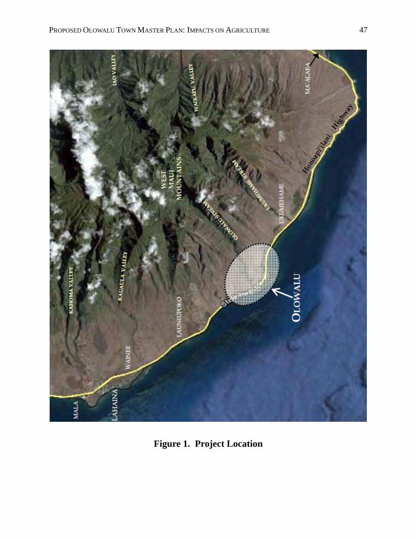
PROPOSED OLOWALU TOWN MASTER PLAN: IMPACTS ON AGRICULTURE 47
Figure 1. Project Location
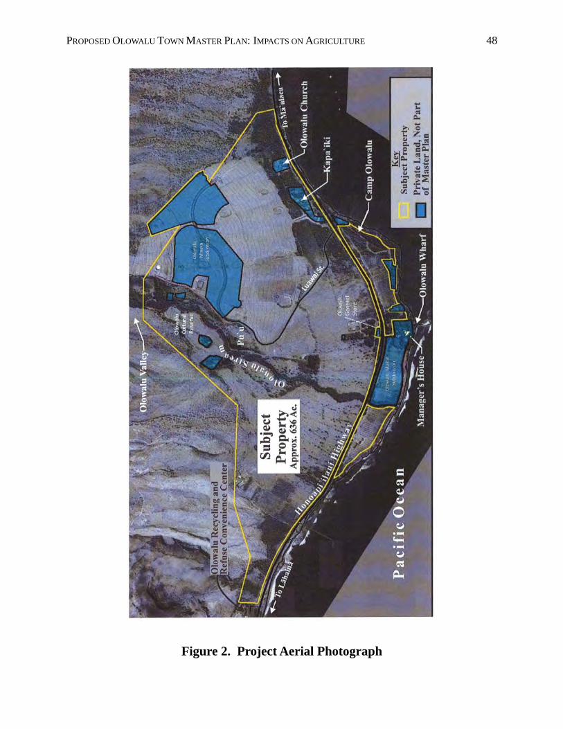
PROPOSED OLOWALU TOWN MASTER PLAN: IMPACTS ON AGRICULTURE 48
Figure 2. Project Aerial Photograph

PROPOSED OLOWALU TOWN MASTER PLAN: IMPACTS ON AGRICULTURE 49
Figure 3. Project TMKs
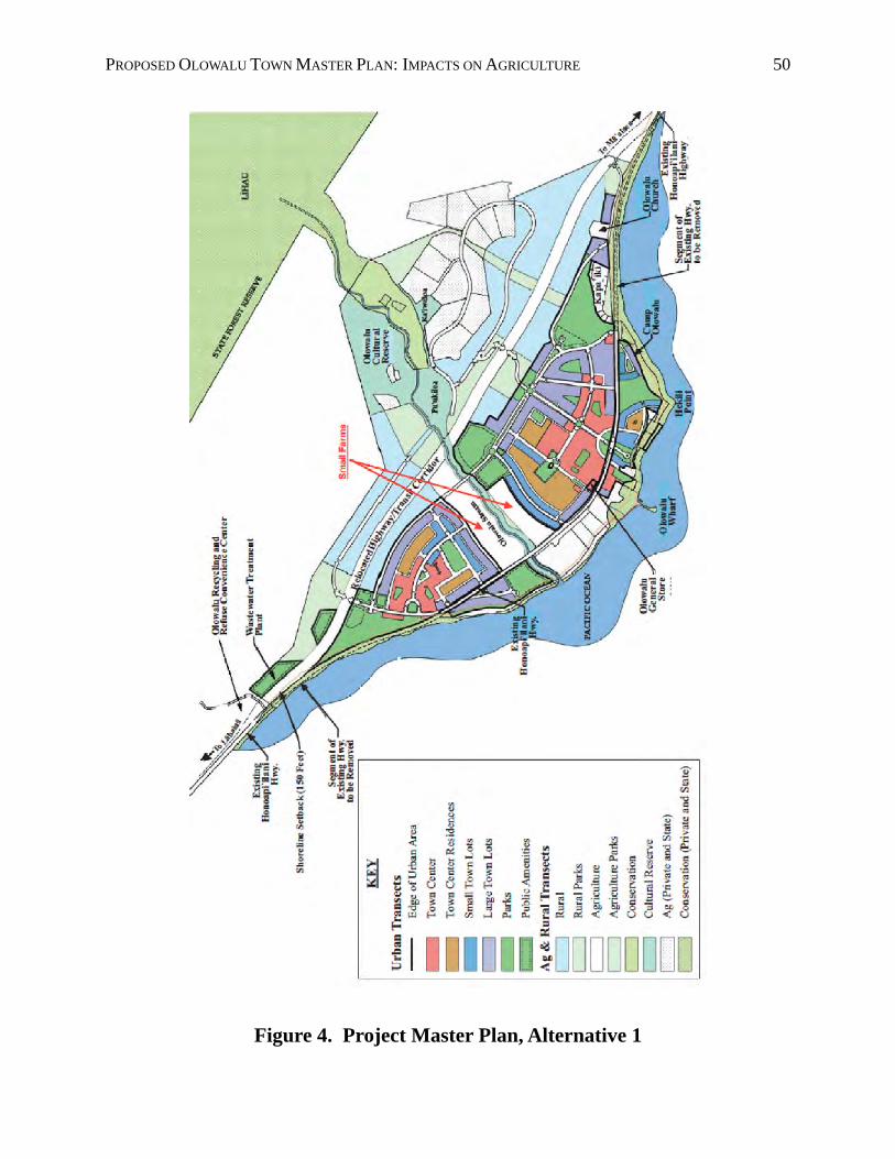
PROPOSED OLOWALU TOWN MASTER PLAN: IMPACTS ON AGRICULTURE 50
Figure 4. Project Master Plan, Alternative 1
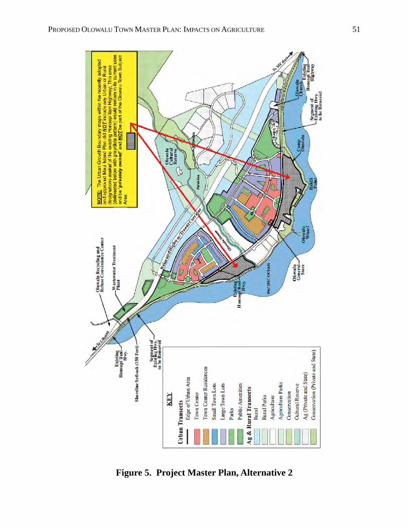
PROPOSED OLOWALU TOWN MASTER PLAN: IMPACTS ON AGRICULTURE 51
Figure 5. Project Master Plan, Alternative 2
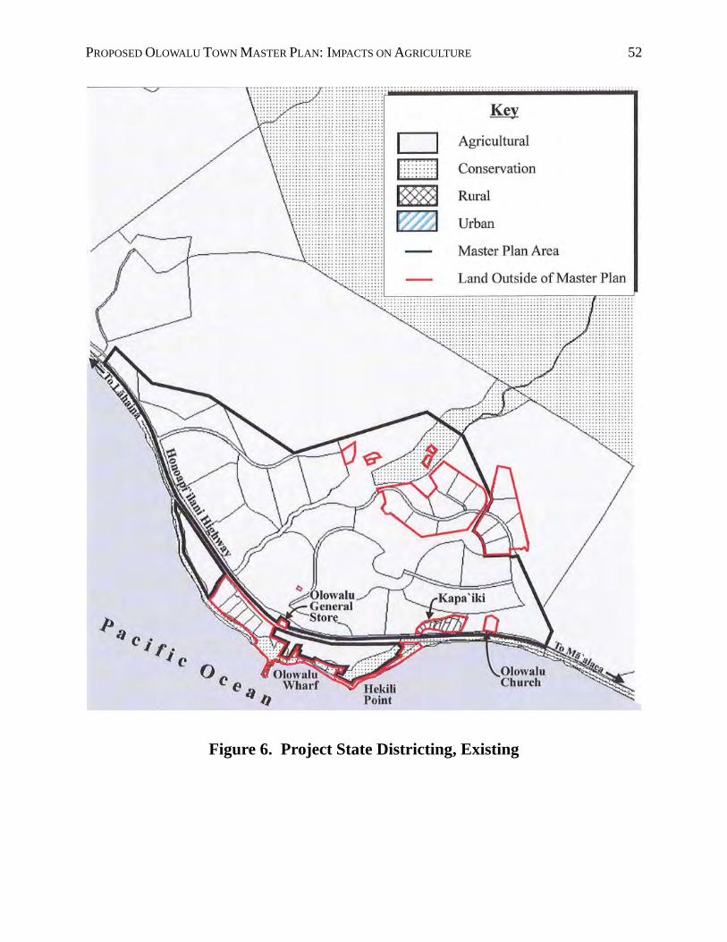
PROPOSED OLOWALU TOWN MASTER PLAN: IMPACTS ON AGRICULTURE 52
Figure 6. Project State Districting, Existing
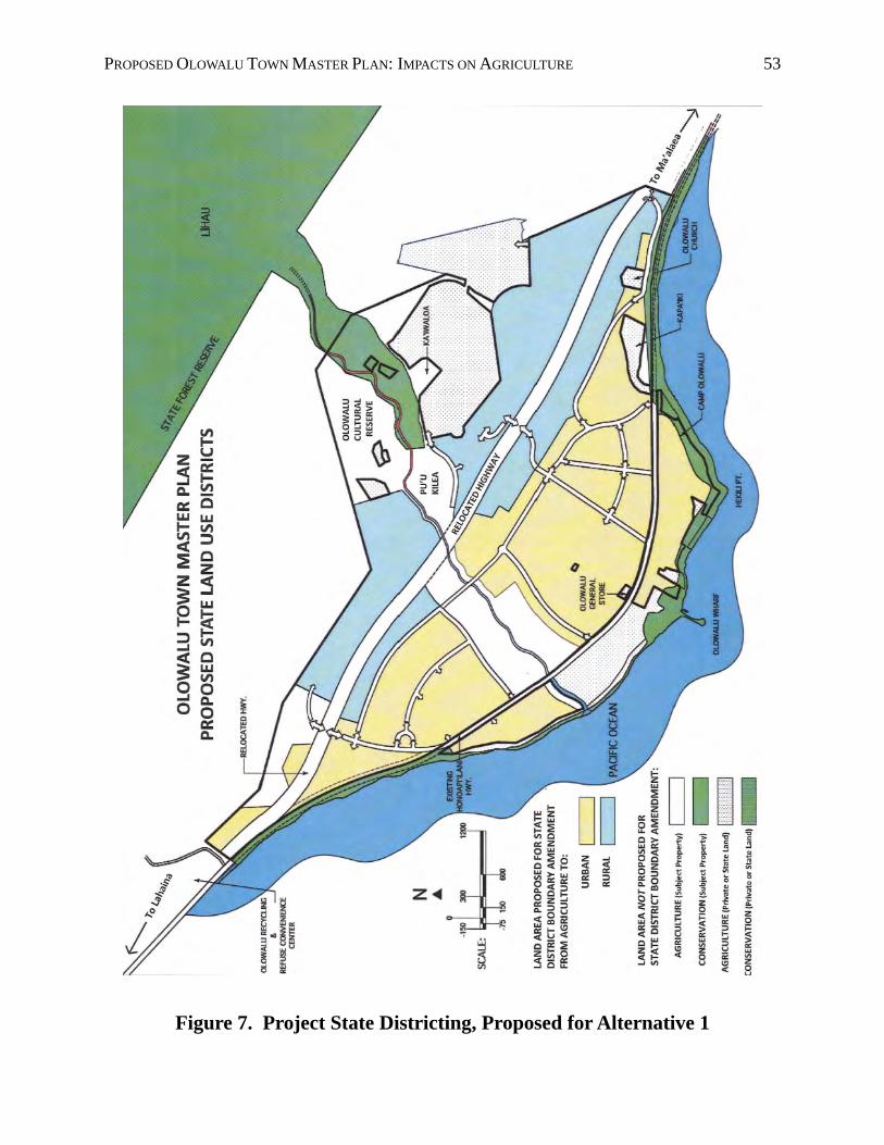
PROPOSED OLOWALU TOWN MASTER PLAN: IMPACTS ON AGRICULTURE 53
Figure 7. Project State Districting, Proposed for Alternative 1

PROPOSED OLOWALU TOWN MASTER PLAN: IMPACTS ON AGRICULTURE 54
Figure 8. Project Land Use Designations, Maui Island Plan
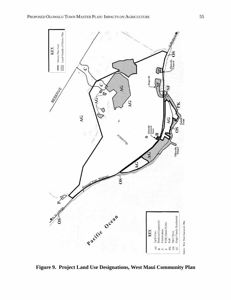
PROPOSED OLOWALU TOWN MASTER PLAN: IMPACTS ON AGRICULTURE 55
Figure 9. Project Land Use Designations, West Maui Community Plan

PROPOSED OLOWALU TOWN MASTER PLAN: IMPACTS ON AGRICULTURE 56
Figure 10. Maui General Soils Map

PROPOSED OLOWALU TOWN MASTER PLAN: IMPACTS ON AGRICULTURE 57
Figure 11. Project Soils Map
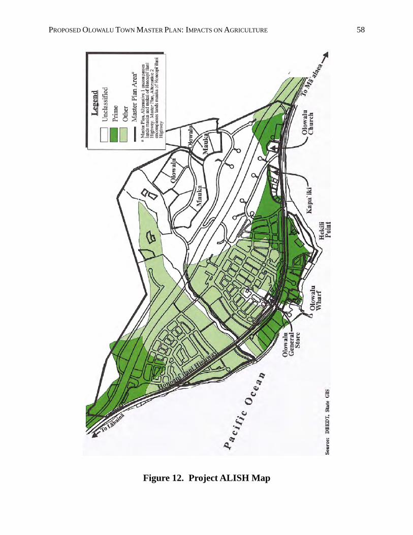
PROPOSED OLOWALU TOWN MASTER PLAN: IMPACTS ON AGRICULTURE 58
Figure 12. Project ALISH Map
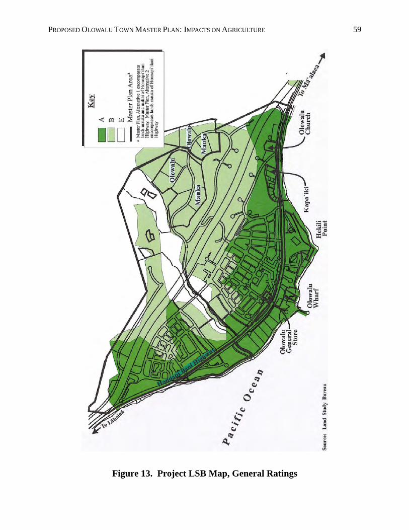
PROPOSED OLOWALU TOWN MASTER PLAN: IMPACTS ON AGRICULTURE 59
Figure 13. Project LSB Map, General Ratings
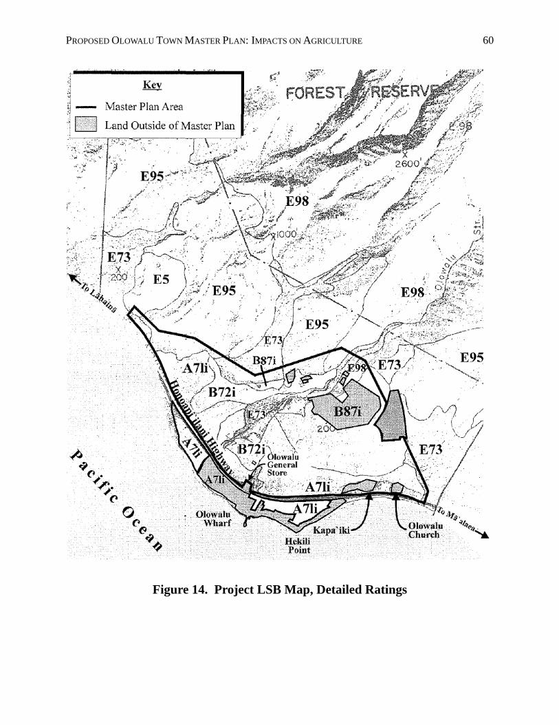
PROPOSED OLOWALU TOWN MASTER PLAN: IMPACTS ON AGRICULTURE 60
Figure 14. Project LSB Map, Detailed Ratings

PROPOSED OLOWALU TOWN MASTER PLAN: IMPACTS ON AGRICULTURE 61
Figure 15. High-quality Farmland, Olowalu
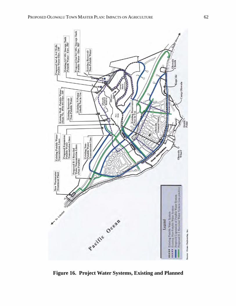
PROPOSED OLOWALU TOWN MASTER PLAN: IMPACTS ON AGRICULTURE 62
Figure 16. Project Water Systems, Existing and Planned
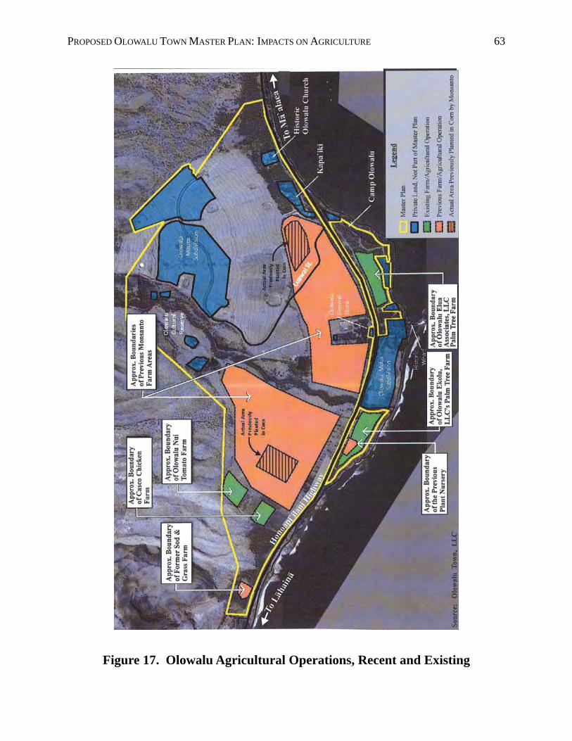
PROPOSED OLOWALU TOWN MASTER PLAN: IMPACTS ON AGRICULTURE 63
Figure 17. Olowalu Agricultural Operations, Recent and Existing
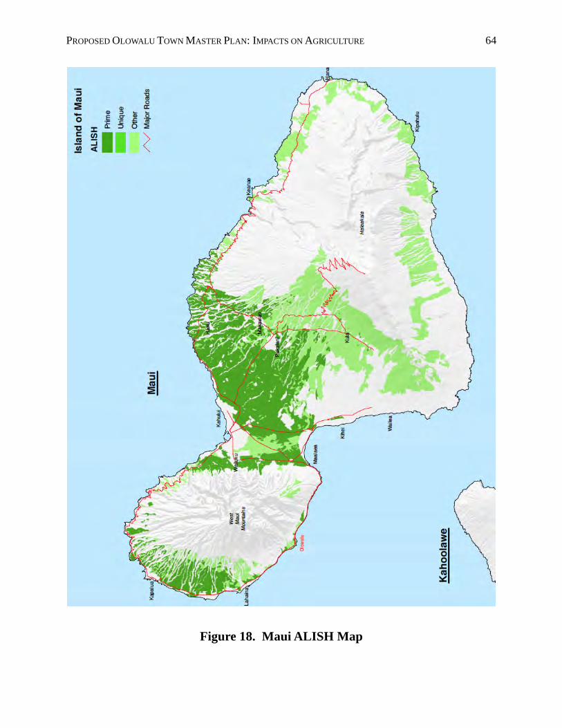
PROPOSED OLOWALU TOWN MASTER PLAN: IMPACTS ON AGRICULTURE 64
Figure 18. Maui ALISH Map
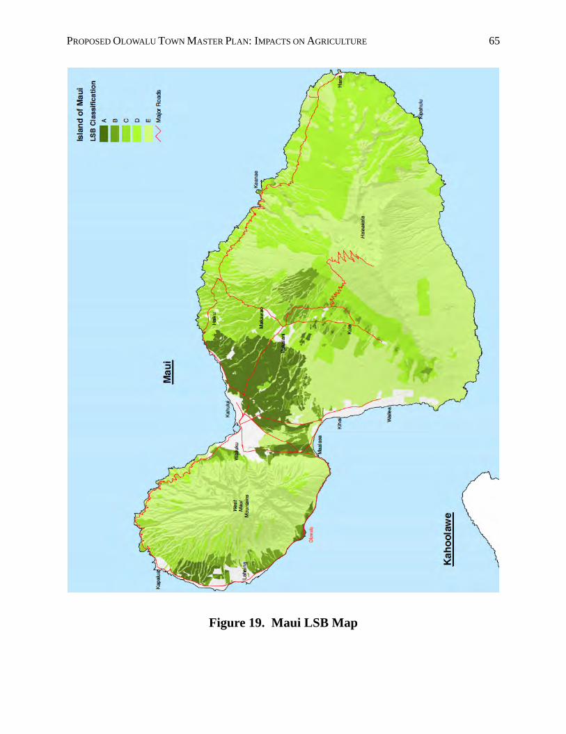
PROPOSED OLOWALU TOWN MASTER PLAN: IMPACTS ON AGRICULTURE 65
Figure 19. Maui LSB Map
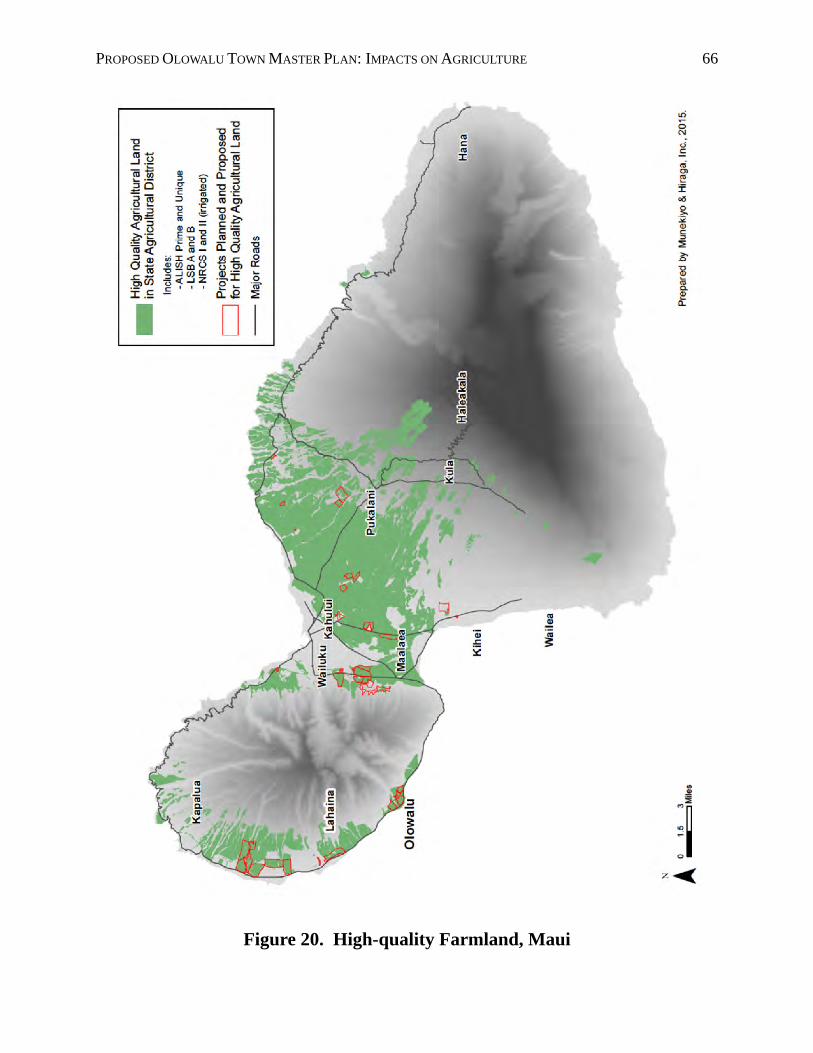
PROPOSED OLOWALU TOWN MASTER PLAN: IMPACTS ON AGRICULTURE 66
Figure 20. High-quality Farmland, Maui
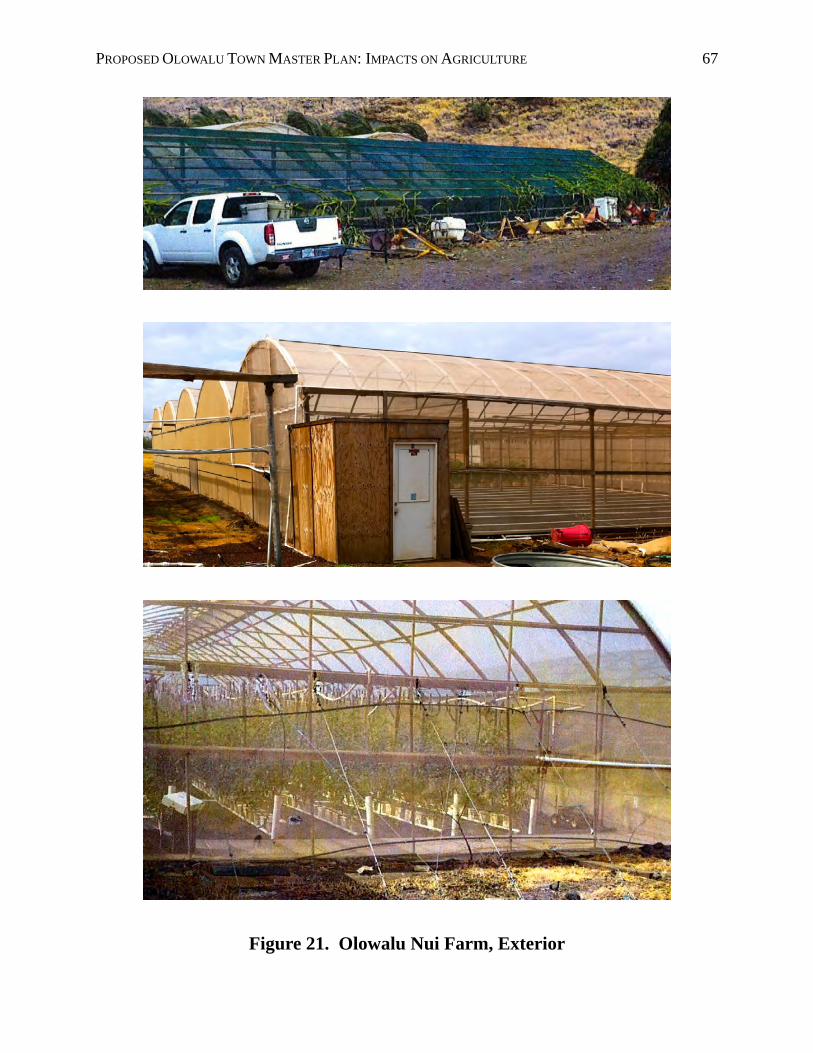
PROPOSED OLOWALU TOWN MASTER PLAN: IMPACTS ON AGRICULTURE 67
Figure 21. Olowalu Nui Farm, Exterior

PROPOSED OLOWALU TOWN MASTER PLAN: IMPACTS ON AGRICULTURE 68
Figure 22. Olowalu Nui Farm, Interior
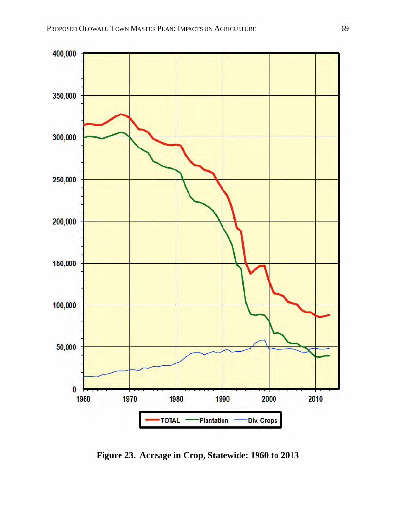
PROPOSED OLOWALU TOWN MASTER PLAN: IMPACTS ON AGRICULTURE 69
Figure 23. Acreage in Crop, Statewide: 1960 to 2013
PROPOSED OLOWALU TOWN MASTER PLAN: IMPACTS ON AGRICULTURE 70
14. REFERENCES
Ainsworth, Gail. “A History of Olowalu.” 2003.
Casco, Karl. October 26, 2011 and October 25, 2012.
Chris Hart & Partners, Inc. Maui County General Plan 2030, Maui Island Plan, Agricultural Resources Technical Issue Paper. September 2007.
County of Maui, Maui County Council. “West Maui Community Plan.” 1996.
County of Maui, Office of Economic Development. “Maui County Data Book.” Annual.
County of Maui, Planning Department, Long Range Division. Maui Island Plan, General Plan 2020. December 28, 2012.
County of Maui, Planning Department, Long Range Division. Regional maps with Develop-ment Projects and Growth Boundaries. February 2014.
County of Maui, Planning Department. “Socio-Economic Forecast: The Economic Projec-tions for the Maui County General Plan 2030.” June 2006.
County of Maui. County of Maui 2030 General Plan, Countywide Policy Plan. Ordinance No. 3732 (2010), effective March 24, 2010.
Decision Analysts Hawaiʻi, Inc. Hawaiʻi’s Sugar Industry and Sugarcane Lands: Outlook, Issues and Options. April 1989.
Decision Analysts Hawaiʻi, Inc. Hawaiʻi’s Sugar Industry and Sugarcane Lands: Problems, Outlook and Urban Growth Issues. April 1981.
Department of Business, Economic Development and Tourism. The State of Hawai'i Data Book. Honolulu, Hawai'i. Annual.
Dorrance, William H. and Francis S. Morgan. Sugar Lands (second edition). Mutual Publishing, LLC. Honolulu, Hawaiʻi. June 2005.
Giambelluca TW, Chen Q, Frazier AG, Price JP, Chen Y-L, Chu P-S, Eischeid J., and Delparte D.“ The Rainfall Atlas of Hawai‘i.” 2011. http://rainfall.geography.hawaii.edu.
Google Earth Pro.
Harold L. Baker. Agricultural Lands of Importance in the State of Hawai'i. University of Hawai'i College of Tropical Agriculture and Human Resources, Honolulu, Hawaii. 1977.
Hawai'i Agricultural Statistics Service. Statistics of Hawaiian Agriculture. Honolulu, Hawai'i. Annual.
Hawai'i Revised Statutes, Chapters 165 and 205.
PROPOSED OLOWALU TOWN MASTER PLAN: IMPACTS ON AGRICULTURE 71
Juvik, Sonia P. and James O., Atlas of Hawai'i, Third Edition. University of Hawai'i Press. Honolulu, Hawai'i. 1998.
Lee-Greig, Tanya L. and Hallett H. Hammatt. “Consultation Plan for Assessing Potential Cultural Impacts for the Proposed Olowalu Town Master Plan.” February 2012.
Lloyd, Alan S. (retired engineer, Hawaiian Electric Company). “LNG is Cleanest of All Fossil Fuels.” Honolulu Star Advertiser. November 15, 2012.
Maui County Council. “West Maui Community Plan.” 1996.
Maui Electric Co. “Windspeeds of Maui County at 50 Meters.” Undated.
Michel Hanz. May 2011.
Monsanto Company. 2012.
Munekiyo & Hiraga, Inc. “Draft Environmental Impact Statement, Proposed Olowalu Town Master Plan.” February 2012.
Munekiyo & Hiraga, Inc. Acreage calculations. 2012 and 2015.
Munekiyo & Hiraga, Inc. Figures 1 through 7, 9 , 11 through 17, and 20. 2012 and 2015.
Olowalu Nui Farm. May 2011, October 2011, October 2012, and March 2015.
Olowalu Water Company, Inc. "Rules and Regulations Governing Rate Schedules and the Provision of Non Potable Water Service to Customers." September 12, 2011.
Olowalu Water Company, Inc. "Water Usage Data." September 2011.
Ritenbaugh, Stephanie. “Moody’s Cuts Price Assumptions for Natural Gas, Oil through 2015.” PowerSource. September 22, 2014.
Schmitt, Robert C. Historical Statistics of Hawai'i. The University Press of Hawai'i, Honolulu, Hawai'i. 1977.
Smith, Katherine Kamaʻemaʻe, edited by Jill Engledow, cultural review by Hinano Rodrigues. “Puʻuhonua: The Legacy of Olowalu.”
State of Hawai'i, Department of Business and Economic Development. Maui Solar Radia-tion Map. Undated.
Tom Nance Water Resource Engineering. “Impact on Water Resources of the Olowalu Town Project.” September 2011.
Tremble, Glenn, Manager, Olowalu Water Company. Communication with Munekiyo & Hiraga, Inc. October 12, 2011.
TrueWind Solutions. “Wind Speed of Maui County at 50 Meters. April 15, 2003.
U.S. Census Bureau. Annual.
PROPOSED OLOWALU TOWN MASTER PLAN: IMPACTS ON AGRICULTURE 72
U.S. Department of Agriculture, Soil Conservation Service in cooperation with The Universi-ty of Hawai'i Agricultural Experiment Station. Soil Survey of Islands of Kauai, Oahu, Maui, Molokai, and Lanai, State of Hawai'i. Washington, D.C.
University of Hawaiʻi, Land Study Bureau. Detailed Land Classification – Islands of Maui. Honolulu, Hawai’i. 1967.
Wilcox, Carol. Sugar Water. University of Hawaiʻi Press. Honolulu, Hawaiʻi. 1996.
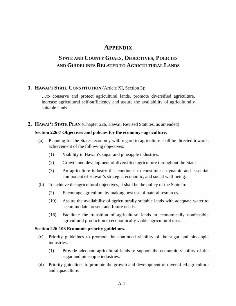
A-1
APPENDIX
STATE AND COUNTY GOALS, OBJECTIVES, POLICIES
AND GUIDELINES RELATED TO AGRICULTURAL LANDS
1. HAWAIʻI STATE CONSTITUTION (Article XI, Section 3):
…to conserve and protect agricultural lands, promote diversified agriculture, increase agricultural self-sufficiency and assure the availability of agriculturally suitable lands…
2. HAWAIʻI STATE PLAN (Chapter 226, Hawaii Revised Statutes, as amended):
Section 226-7 Objectives and policies for the economy--agriculture.
(a) Planning for the State's economy with regard to agriculture shall be directed towards achievement of the following objectives:
(1) Viability in Hawaii's sugar and pineapple industries.
(2) Growth and development of diversified agriculture throughout the State.
(3) An agriculture industry that continues to constitute a dynamic and essential component of Hawaii’s strategic, economic, and social well-being.
(b) To achieve the agricultural objectives, it shall be the policy of the State to:
(2) Encourage agriculture by making best use of natural resources.
(10) Assure the availability of agriculturally suitable lands with adequate water to accommodate present and future needs.
(16) Facilitate the transition of agricultural lands in economically nonfeasible agricultural production to economically viable agricultural uses.
Section 226-103 Economic priority guidelines.
(c) Priority guidelines to promote the continued viability of the sugar and pineapple industries:
(1) Provide adequate agricultural lands to support the economic viability of the sugar and pineapple industries.
(d) Priority guidelines to promote the growth and development of diversified agriculture and aquaculture:
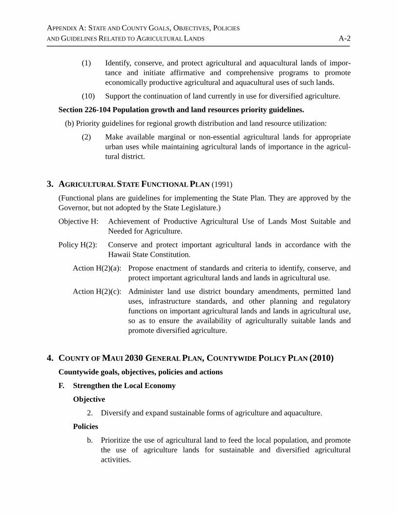
APPENDIX A: STATE AND COUNTY GOALS, OBJECTIVES, POLICIES
AND GUIDELINES RELATED TO AGRICULTURAL LANDS A-2
(1) Identify, conserve, and protect agricultural and aquacultural lands of impor-tance and initiate affirmative and comprehensive programs to promote economically productive agricultural and aquacultural uses of such lands.
(10) Support the continuation of land currently in use for diversified agriculture.
Section 226-104 Population growth and land resources priority guidelines.
(b) Priority guidelines for regional growth distribution and land resource utilization:
(2) Make available marginal or non-essential agricultural lands for appropriate urban uses while maintaining agricultural lands of importance in the agricul-tural district.
3. AGRICULTURAL STATE FUNCTIONAL PLAN (1991)
(Functional plans are guidelines for implementing the State Plan. They are approved by the Governor, but not adopted by the State Legislature.)
Objective H: Achievement of Productive Agricultural Use of Lands Most Suitable and Needed for Agriculture.
Policy H(2): Conserve and protect important agricultural lands in accordance with the Hawaii State Constitution.
Action H(2)(a): Propose enactment of standards and criteria to identify, conserve, and protect important agricultural lands and lands in agricultural use.
Action H(2)(c): Administer land use district boundary amendments, permitted land uses, infrastructure standards, and other planning and regulatory functions on important agricultural lands and lands in agricultural use, so as to ensure the availability of agriculturally suitable lands and promote diversified agriculture.
4. COUNTY OF MAUI 2030 GENERAL PLAN, COUNTYWIDE POLICY PLAN (2010)Countywide goals, objectives, policies and actions
F. Strengthen the Local Economy
Objective
2. Diversify and expand sustainable forms of agriculture and aquaculture.
Policies
b. Prioritize the use of agricultural land to feed the local population, and promote the use of agriculture lands for sustainable and diversified agricultural activities.
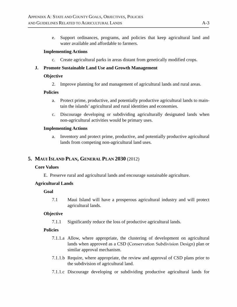
APPENDIX A: STATE AND COUNTY GOALS, OBJECTIVES, POLICIES
AND GUIDELINES RELATED TO AGRICULTURAL LANDS A-3
e. Support ordinances, programs, and policies that keep agricultural land and water available and affordable to farmers.
Implementing Actions
c. Create agricultural parks in areas distant from genetically modified crops.
J. Promote Sustainable Land Use and Growth Management
Objective
2. Improve planning for and management of agricultural lands and rural areas.
Policies
a. Protect prime, productive, and potentially productive agricultural lands to main-tain the islands’ agricultural and rural identities and economies.
c. Discourage developing or subdividing agriculturally designated lands when non-agricultural activities would be primary uses.
Implementing Actions
a. Inventory and protect prime, productive, and potentially productive agricultural lands from competing non-agricultural land uses.
5. MAUI ISLAND PLAN, GENERAL PLAN 2030 (2012)
Core Values
E. Preserve rural and agricultural lands and encourage sustainable agriculture.
Agricultural Lands
Goal
7.1 Maui Island will have a prosperous agricultural industry and will protect agricultural lands.
Objective
7.1.1 Significantly reduce the loss of productive agricultural lands.
Policies
7.1.1.a Allow, where appropriate, the clustering of development on agricultural lands when approved as a CSD (Conservation Subdivision Design) plan or similar approval mechanism.
7.1.1.b Require, where appropriate, the review and approval of CSD plans prior to the subdivision of agricultural land.
7.1.1.c Discourage developing or subdividing productive agricultural lands for
APPENDIX A: STATE AND COUNTY GOALS, OBJECTIVES, POLICIES
AND GUIDELINES RELATED TO AGRICULTURAL LANDS A-4
residential uses in which the residence would be the primary use and any agricultural activities would be secondary uses.
7.1.1.e Focus urban growth, to the extent practicable, away from productive and important agricultural lands.
7.1.1.f Strongly discourage the conversion of productive and important agricultural lands (such as sugar, pineapple, and other produce lands) to rural or urban use, unless justified during the General Plan update, or when other overrid-ing factors are present.
7.1.1.h Provide incentives for landowners to preserve and protect agricultural lands from development through the use of TDR/PDR, tax credits, easement programs, or similar means.
7.1.1.i Promote the use of U.S.D.A. Farm and Ranch Lands Protection Program grants to fund the acquisition of conservation easements on eligible agricul-tural lands.
7.1.1.j Require all major developments adjacent to agricultural lands to provide an appropriate and site-specific agricultural protection buffer as part of a required site plan.
7.1.1.k Support and promote the viability of Maui's agricultural businesses through property tax incentives and other programs and subsidies.
7.1.1.l Encourage future community plan efforts to identify lands within the County Agricultural zoning district that are primarily being used for large-lot residential or rural use and consider such lands for reclassification to an appropriate County Rural zone.
6. COUNTY OF MAUI, WEST MAUI COMMUNITY PLAN (1996)
A. Intended Effects of the West Maui Community Plan
5. Encourage infill in order to protect agriculture and mauka open spaces.
B. Goals, Objectives, Policies and Implementing Actions
LAND USE
Objectives and policies for the West Maui Region in General
3. Ensure that appropriate lands are available to support the region’s present and future agricultural activities.
5. Preserve the current State Agricultural District boundaries in the planning region,
APPENDIX A: STATE AND COUNTY GOALS, OBJECTIVES, POLICIES
AND GUIDELINES RELATED TO AGRICULTURAL LANDS A-5
in accordance with this Community Plan and its land use map.
6. Special Permits in the State Agricultural District may be allowed only: (1) to accommodate public and quasi-public uses; (2) public facility uses such as utility installation, landfills and sewer treatment plants whose location is determined by technical considerations; (3) uses which are clearly accessory and subordinate to a principal agricultural use on the property; and (4) extractive industries such as quarrying, where the operation does not adversely affect the environment or nearby agricultural uses.
7. Provide for specific criteria for the subdivision of lands designated for agricultur-al use in order to control the potential loss of productive agricultural lands and the open space resource.
Implementing Actions
5. Establish and enforce agricultural subdivision criteria.
ENVIRONMENT
Objectives and policies
2. Preserve agricultural lands and open space with particular emphasis on natural coastal areas along major highways.
ECONOMIC ACTIVITY
Goal
A diversified economy that … supports the existing … agricultural industr(y).
Objectives and policies
1. Promote a diversified economic base which offers long-term employment to West Maui residents, and maintains overall stability in economic activity in the areas of:
f. Agriculture.
2. Provide for the preservation and enhancement of agriculture.
a. Maintain the land acreage required to sustain present and future agricultural operations and open space.
b. Prevent urbanization of agricultural lands to the greatest extent possible.
APPENDIX A: STATE AND COUNTY GOALS, OBJECTIVES, POLICIES
AND GUIDELINES RELATED TO AGRICULTURAL LANDS A-6
c. Encourage maintenance and development of water sources for agricultural activities which do not conflict with domestic demand for potable water.
d. Discourage use of agricultural lands for non-agricultural purpose.
e. Adopt ordinances to establish appropriate standards for agricultural lands.
SOCIAL INFRASTRUCTURE
Recreation and Open Space
Objectives and Policies
3. Provide resource-oriented regional park facilities and public access along the shoreline for picnicking, camping, informal play, swimming, sunbathing, and other coastal-related activities along coastal lands makai of the existing or future realigned coastal highways …, except for the agriculture designated lands makai of the highway at Olowalu.
7. REFERENCES Act 25, S.B. No. 1158, April 15, 1993.
County of Maui, Planning Department, Long Range Division. Maui Island Plan, General Plan 2030. December 28, 2012.
County of Maui. County of Maui 2030 General Plan, Countywide Policy Plan. Adopted by Ordinance No. 3732, effective on March 24, 2010.
County of Maui. West Maui Community Plan. 1996.
Hawaii Department of Agriculture. The Hawaii State Plan: Agriculture, State Functional Plan. 1991.
State of Hawaii, Office of State Planning, Office of the Governor. The Hawaii State Plan, 1991. 1991.


![V P V U R gq ^ ý u;Vóÿ d u;S:Wßÿ ^ WS S:Wß0]0nÿ ) N …...N N N N N N N N N N N N N N N N N N N N N N N N N N N N N N N N N P N1 N1 N1 N1 N1 N1 N1 N1 N1 N1 N1 N1 P P P N1 N1](https://img.pdfslide.net/doc/110x75/5fbf575d848b0b7e9575f4b2/v-p-v-u-r-gq-uv-d-usw-ws-sw00n-n-n-n-n-n-n-n-n-n.jpg)