Embed Size (px)
Citation preview
Aquatic Vegetation Survey 2012
for Douglas Lake
by
University of Michigan Biological Station
Survey performed and report written by Mandy Bromilow, Tessa Diem, Sarah Fellbaum,
Stephanie Fortino, Caitlin Parsons, Zach Stamplis, and Miranda Steffler
2
Table of Contents
Page
Introduction ......................................................................... 3
Background ...................................................................... 3
Study Area ....................................................................... 4
Methods ................................................................................ 5
Results .................................................................................. 7
Discussion ........................................................................... 12
Dominant Plants Found ................................................. 12
Plant Densities and Depth .............................................. 12
Invasive Species ............................................................. 13
Eurasian Water-Milfoil .................................................. 13
Curly-Leaved Pondweed…………………………… 13
Starry Stonewort…………………………………… 14
Recommendations .......................................................... 15
Resources ........................................................................... 16
List of Table and Figures
Page
Table 1. Aquatic plant species frequencies at sample sites…………. 8
Table 2. Aquatic plant densities from sample sites…………………. 9
Figure 1. Average plant densities at each sample site………………. 10
Table 3. Dominant plant species…………………………………….. 11
3
Introduction
Background:
Aquatic plant communities are an important aspect of lake ecosystems. Submerged
macrophytes provide food and shelter for other organisms within the ecosystem, such as fish and
invertebrate communities. Like all plants, macrophytes supply oxygen to the system via
photosynthesis. Macrophyte photosynthesis can also potentially reduce eutrophication in lakes
by utilizing large amounts of nutrients, which decreases nutrient availability to phytoplankton
(Canfield et al. 1984). By reducing the amount of nutrients in the water column, aquatic plants
decrease the likelihood of algal blooms. Macrophytes also reduce effects of water turbulence
(Canfield et al. 1984), which means that shoreline vegetation can help prevent erosion.
Lake ecosystems that have do not have healthy and abundant macrophyte communities are
less diverse due to the lack of habitats and food resources on which other organisms rely. There
would also be greater abundances of nuisance algae populations and increased erosion of the
shoreline. A reduced native plant community could also allow invasive species, such as Eurasian
milfoil, to dominate the community, which could further change the community structure within
the ecosystem.
Despite all the benefits of aquatic plant communities, an overabundance of species,
especially invasive species, can be detrimental to lake ecosystems. Excessive plant growth can
disrupt recreational uses of the lake, such as boating, fishing, and swimming as well as
ecosystem functions. Lakes that contain excessive nuisance plant growth can require
management programs to control the effects of the plant community on the ecosystem.
4
Management of aquatic plant communities is important to maintain a stable lake ecosystem.
Aquatic plants surveys are a good start to understanding the macrophyte community by
recording plant species, abundance, density, and the presence of invasive species. In 2012, the
Tip of the Mitt Watershed Council cooperated with the University of Michigan Biological
Station to execute an aquatic plant survey of Douglas Lake to determine the overall health of the
aquatic plant community.
Study Area:
Douglas Lake is located in northwestern Cheboygan County, Michigan, on the border of
Emmet County. The lake covers an area of 15 km2 with 22.5 km of shoreline that is divided into
east and west halves by a large shoal. Major landmarks in the western half of the lake include
Marl Bay, Maple Bay, and Pell’s Island; North Fishtail Bay and South Fishtail Bay lie to the
east. Residential urbanization is seen along the shore of the western half of the lake, while the
shoreline of North and South Fishtail Bay is remains mostly undeveloped.
Douglas Lake is a kettle lake with five deep kettle holes that were formed by retreating
glaciers thousands of years ago. The maximum depth in the lake is 80 feet in the North and
South Fishtail Bay kettle holes. The majority of the lake has a depth of less than 30 feet.
Lancaster (or Bessey) Creek and Beavertail Creek are the major inlets of Douglas Lake at the
northeastern and northwestern shores, respectively. East Branch Maple River is the major outlet
of the lake in the southwestern shore of Maple Bay (Cwalinski 2004-09).
Douglas Lake has been determined a mesotrophic lake with oligotrophic areas in the deeper,
colder waters of the kettle holes (Cwalinski 2004-09). Oligotrophic lakes are characterized by
cold, deep, clear water that is nutrient-poor. A mesotrophic lake is a lake that is transitioning
from an oligotrophic state to a eutrophic state. Eutrophic lakes are warm, turbid, and very
5
productive due to the high nutrient content. Therefore, Douglas Lake is moderately productive
and transitioning to a more productive state, especially in the shallow areas.
Methods
Field data were collected throughout late July and early August of 2012. The residential
portion of Douglas Lake was the primary focus of this study, assuming that invasive species
would be more likely to be introduced in developed areas. Working closely with Tip of the Mitt
Watershed Council, sampling methods were designed to provide a representative profile of the
lake’s aquatic plant community. The survey was conducted using grappling hooks and rakes as
well as visual assessment of the area. Depth was used as a proxy for light penetration and
abundant plant growth.
Specimen were collected, identified, photographed, and recorded into a notebook. A total of
135 sites were sampled: 127 in the northwest portion of the lake, 7 near the boat launch, and 3 in
South Fishtail Bay. Sample sites were determined using GPS coordinates and creating transects
from the shore. Sampling transects were spaced approximately 500 meters apart along the shore
and sampling points were taken every 100 meters along the transect. This method was used to
maintain consistency among the sampling parties and to obtain samples representative of all
aquatic plant communities.
At each sample site, the boat was anchored, GPS data were collected and depth was
measured. A Garmin GPS 60 system was used to record and track coordinates, with 95%
accuracy of <15 meters. An H22PX Handheld Sonar System was employed to obtain depth
measurements which were used at each point to determine whether the depth was within the
range of viable plant productivity. Grappling hooks were used as sampling devices and thrown
6
in four directions from the boat to obtain a sufficient sample. When possible, a visual
assessment of the site was used to ensure that all plant species were accounted for. Specimen
sighted in the water that were not represented in the pulled samples were noted in observations
and included in density estimations.
Specimens were identified by species; however, macro-algae were only identified by genus.
All species present were recorded and estimated to one of eight possible density categories using
the following subjective scale: 0- Little to No Vegetation; 1- Very Light; 2- Light; 3-
Light/Moderate; 4- Moderate; 5- Moderate/Heavy; 6- Heavy; 7- Very Heavy. The same scale
was used to determine the overall density for a site using Very-Light to indicate only a few stems
and Very Heavy to indicate plants reaching the water’s surface. If multiple throws at a site
resulted in no specimens, that site was documented as having little to no vegetation. Specimen
that could not be identified on the boat were put into Whirl Paks and labeled by sample site to be
keyed out on shore. Although the methods were as thorough as possible, some species may have
been missed.
GPS data were compiled and entered into ArcMap GIS. The data points were projected onto
a map of Douglas Lake. Density data were imported into ArcMap GIS and layers were used to
separate different densities to generate a comprehensive map for general plant densities at each
sample point.
7
Results
Over one-third of Douglas Lake was surveyed for the presence of Eurasian water-milfoil or
any other invasive aquatic plant species. A total of 135 sites had samples taken from the lake
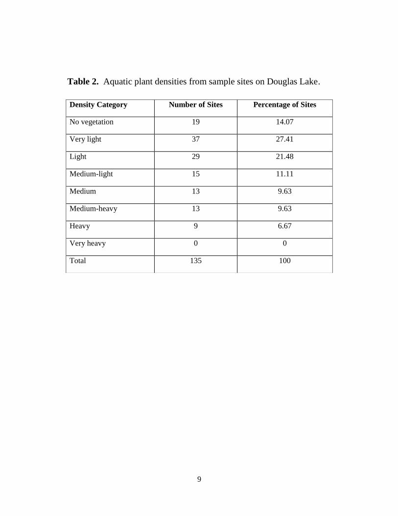
bottom. Of the 135 sites on Douglas Lake, 116 had aquatic plants present and 19 sites had no
vegetation (Table 2). The number of macrophyte species found at each site ranged from 0 to 14.
The average number of macrophyte species at each site was 5.41.
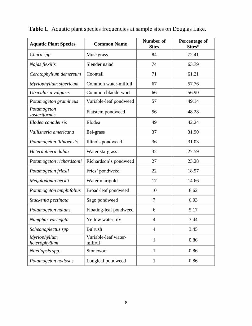
The most commonly encountered species of aquatic plants were Chara spp. (72.41%), N.
flexilis (63.79%), C. demersum (61.21%), M. sibiricum (57.76%), and U. vulgaris (56.9%)
(Table 1). The most abundant species were of the Potamogeton genus; 8 species out of the 22
found in Douglas Lake were from the Potamogeton genus.
No samples of Eurasian water-milfoil were found, but one possible non-native macroscopic
alga was found. The species was identified as belonging to the Nitellopsis genus, but species
could not be confirmed. The Nitellopsis spp. was found at site DL517. Nitellopsis spp. was
classified as very light at the sites where it was found.
Plant densities ranged from no vegetation to heavy at each site. Around half of all sites
surveyed on Douglas Lake were very light to light densities. About 14% of the sites had no
vegetation at all. None of the sites on Douglas Lake were considered very heavy (Table 2;
Figure 1).
The most dominant macrophytes found were Chara spp. and C. demsersum, which composed
over 50% of the total sites surveyed (Table 3). Dominance was determined by the number of
plants found and the total biomass of the species compared to other co-occurring species at the
site.
8
Aquatic Plant Species Common Name Number of
Sites
Percentage of
Sites*
Chara spp. Muskgrass 84 72.41
Najas flexilis Slender naiad 74 63.79
Ceratophyllum demersum Coontail 71 61.21
Myriophyllum sibericum Common water-milfoil 67 57.76
Utricularia vulgaris Common bladderwort 66 56.90
Potamogeton gramineus Variable-leaf pondweed 57 49.14
Potamogeton
zosteriformis Flatstem pondweed 56 48.28
Elodea canadensis Elodea 49 42.24
Vallisneria americana Eel-grass 37 31.90
Potamogeton illinoensis Illinois pondweed 36 31.03
Heteranthera dubia Water stargrass 32 27.59
Potamogeton richardsonii Richardson’s pondweed 27 23.28
Potamogetan friesii Fries’ pondweed 22 18.97
Megalodonta beckii Water marigold 17 14.66
Potamogeton amphifolius Broad-leaf pondweed 10 8.62
Stuckenia pectinata Sago pondweed 7 6.03
Potamogeton natans Floating-leaf pondweed 6 5.17
Numphar variegata Yellow water lily 4 3.44
Scheonoplectus spp Bulrush 4 3.45
Myriophyllum
heterophyllum
Variable-leaf water-
milfoil 1 0.86
Nitellopsis spp. Stonewort 1 0.86
Potamogeton nodosus Longleaf pondweed 1 0.86
Table 1. Aquatic plant species frequencies at sample sites on Douglas Lake.
9
Density Category Number of Sites Percentage of Sites
No vegetation 19 14.07
Very light 37 27.41
Light 29 21.48
Medium-light 15 11.11
Medium 13 9.63
Medium-heavy 13 9.63
Heavy 9 6.67
Very heavy 0 0
Total 135 100
Table 2. Aquatic plant densities from sample sites on Douglas Lake.
10
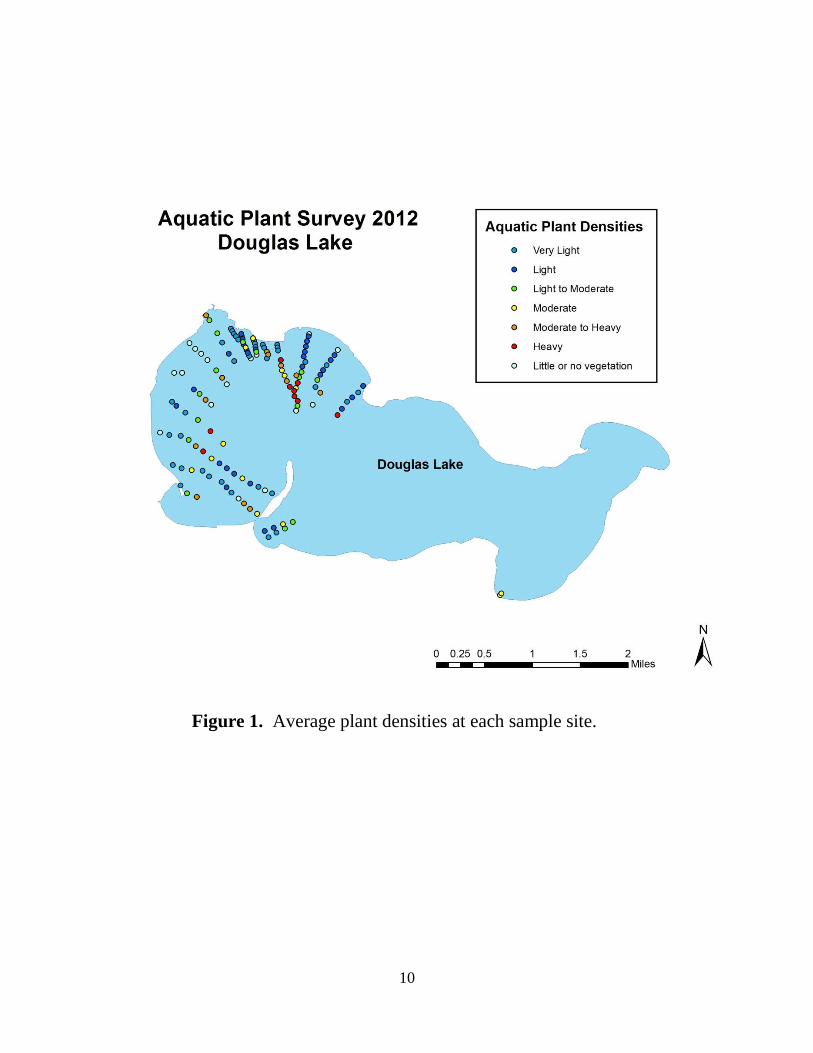
Figure 1. Average plant densities at each sample site.
11
Aquatic Plant Species Common Name
Number of sites
where
dominant*
Percent of sites
where
dominant*
Chara spp. Muskgrass 47 34.8
Ceratophyllum demersum Coontail 28 20.7
Najas flexilis Slender naiad 20 14.8
Myriophyllum sibiricum Common water-milfoil 19 14.1
Potamogeton gramineus Variable-leaf pondweed 18 13.3
Utricularia vulgaris Common bladderwort 18 13.3
Potamogeton illinoensis Illinois pondweed 16 11.9
Potamogeton zosteriformis Flatstem pondweed 14 10.4
Elodea canadensis Elodea 11 8.1
Schoenoplectus spp. Bulrush 4 3
Potamogeton richardsonii Richarson's pondweed 3 2.2
Stuckenia pectinata Sago pondweed 2 1.5
Potamogeton friesii Fries' pondweed 2 1.5
Vallisneria americana Eel-grass 1 0.7
Potamogeton natans Floating-leaf pondweed 1 0.7
Nuphar variegata Yellow pond lily 1 0.7
Heteranthera dubia Water stargrass 1 0.7
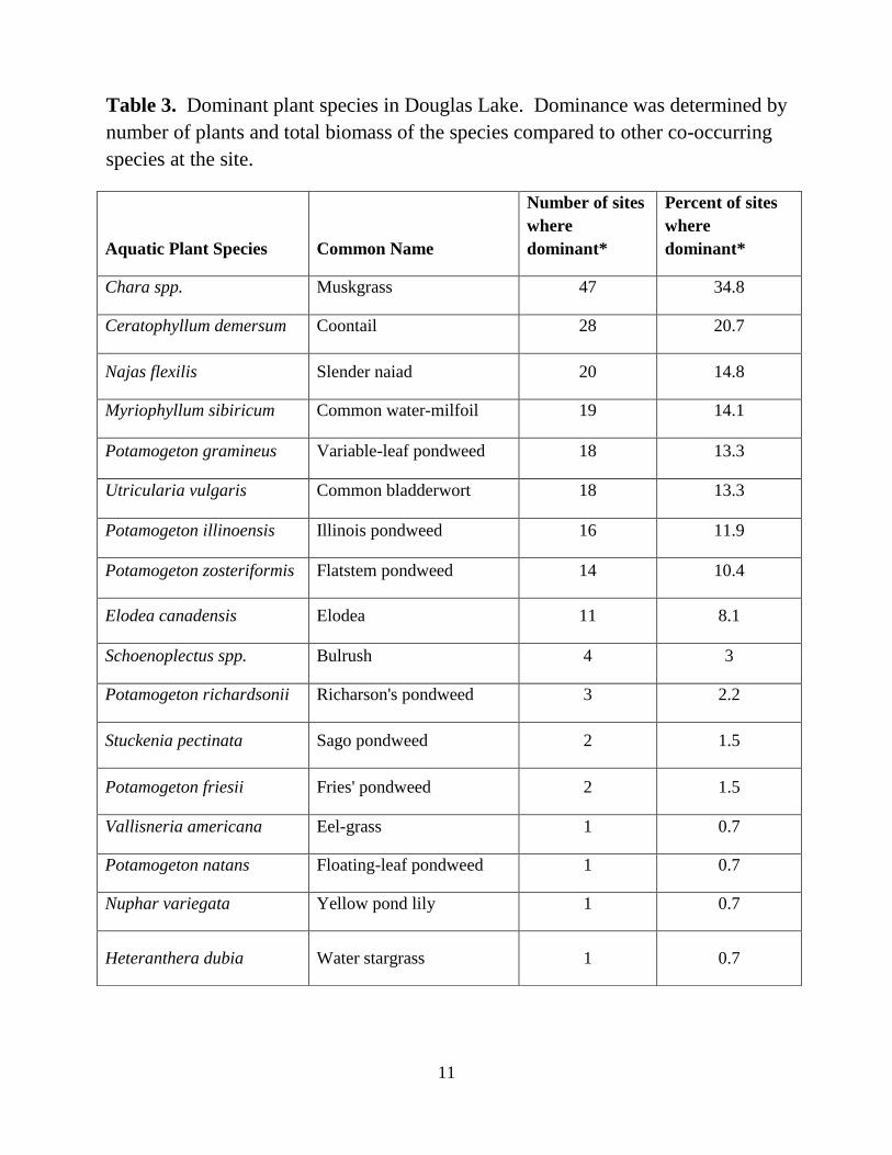
Table 3. Dominant plant species in Douglas Lake. Dominance was determined by
number of plants and total biomass of the species compared to other co-occurring
species at the site.
12
Discussion
Dominant Plants Found
As stated above, the most frequently seen plants in the sampled area of Douglas Lake were
Muskgrass, Coontail, Slender Naiad, Common Water-Milfoil, Common Bladderwort, Variable
Leaf Pondweed, Flatstem Pondweed and Elodea. All of these aquatic macrophytes occurred in at
least 42% of the sample sites (Elodea) and at most 72% of sites (Muskgrass). Muskgrass was
both the most ubiquitous plant (most frequently seen) and the most dominant macrophyte (had
greatest biomass).
These results seem characteristic of a northern Michigan lake. Compared with nearby lakes
surveyed by Tip of the Mitt Watershed Council, Douglas Lake had a higher than average mean
number of plants per sample site. The total number of aquatic plant taxa found in Douglas Lake
was lower than average; however, the entire lake has not yet been sampled, and it is possible that
additional taxa will be found as the survey continues (Cronk 2008). Overall, Douglas Lake
appears to have a healthy level of biodiversity, which is necessary to maintain healthy levels of
productivity in the lake (O’Neil and Soulliere 2006).
Plant Densities and Depth
Though the majority of the sample sites had very light to light levels of aquatic vegetative
biomass (27% and 21%, respectively), this is no cause for concern as these results can be
expected: since sampling occurred in the shallowest parts Douglas Lake, we would expect to see
lighter levels of vegetation. Plant densities transitioned from very light to light-moderate as
depth increased from shore along the transect (Fig. 1). The heaviest concentrations of plant
13
biomass occurred in areas of “intermittent” depths; i.e. waters that occurred in areas that were
neither “shallow” nor “deep.” The portion of Douglas Lake sampled has appropriate macrophyte
densities for a Northern Michigan lake (Cronk 2008).
Invasive Species
In the areas sampled in Douglas Lake, no invasive aquatic macrophytes were found.
However, the life history of some potential invaders are discussed below for future reference.
Eurasian Water-Milfoil
Eurasian water-milfoil (Myriophyllum spicatum) was introduced to the northeastern United
States around the 1940s, and has since spread through much of North America (Jacobs and
Mangold 2009). Eurasian water-milfoil can form dense canopies that shade out native plants.
The species is able to spread quickly in part because it is capable of reproducing through
fragmentation, meaning that stem fragments that are broken off are able to form new plants.
Eurasian water-milfoil requires high levels of light, so that it is unable to colonize deep waters.
The plant grows best at depths of 1 to 4 m, but is able to survive at depths up to 12 m.
Additionally, Eurasian water-milfoil is less effective at anchoring its roots in softer substrates,
such as sand. However, temperature generally has little effect on the plant’s growth. If Eurasian
water-milfoil is introduced to a lake, possible management strategies include mechanical harvest,
herbicides, and biocontrol (Jacobs and Mangold 2009).
Curly-Leaved Pondweed
P. crispus was accidentally introduced to the United States waters in the mid-1880’s by
hobbyists who used is as an aquarium plant (DNR 2012). Since then it has been found in all of
14
the lower 48 states except for Maine. Curly-leaved pondweed is identified by its distinct, finely
toothed wavy edges. They are found in alkaline and high nutrient waters and prefer soft
substrate in shallower waters. However, these plants have a large potential for invasion due to
their tolerance to low temperature and light conditions. Consequently they are able to occupy a
wide range of niches that many native plants cannot (DNR 2012). In October when most
vascular plants are in their dormant forms, P. crispus growth is initiated by seeds, rhizome
fragments (stems) and unique structures known as turions. P. crispus will then grow over
throughout winter and gain an immediate advantage over other native species that cannot grow
during this time (Sastroutomo 1980). Come spring the winter foliage disintegrates allowing
development of the larger, distinct leaves (Catling and Dobson 1984). Future turions and flowers
will develop during the growing season and begin to break up and disperse during mid-July
where they will lie dormant in the sediment. Once temperatures are low enough growth can
continue throughout winter and the cycle repeats.
Starry Stonewort
In one site of the area sampled, macroscopic algae of the genus Nitellopsis was found, a
genus very similar to the abundant Chara spp. Species in this group are commonly known as
“Nitella,” and identification to species level is often very difficult, requiring specific life-stages
of the algae sample and usage of microscopes and other identifying equipment. Such level of
identification was not possible given our time and specific knowledge constraints in the field.
However, a non-native species of Nitella, Nitellopsis obtusa, has been known to be an invasive
nuisance in some areas of the Northeastern United States (Kipp 2012). Starry stonewort (as
Nitellopsis obtusa is commonly known) was introduced to the Great Lakes Region in the late
1970’s via the St. Lawrence River (Groves et al. 2010, Kipp 2012, Wisconsin DNR). By the
15
early 1980’s, the non-native alga had migrated to both the Detroit and St. Clair Rivers, becoming
the 9th most dominant macrophyte in the former (Wisconsin DNR). Though the plant is found
in Michigan, it has not proved to be a nuisance species. In certain areas, the alga has been a
nuisance species (Kipp 2012). For example, the biomass of Starry Stonewort in New York’s
Lake Oneida is greater than the biomass of any other native (Wisconsin DNR). Starry stonewort
may become a problem for Northern Michigan lakes, like Douglas Lake, in the future.
Recommendations
Anthropogenic activities have proven to be the have a major impact on aquatic system
diversity and stability. Use of fertilizers has a direct impact on nutrient cycling in freshwater
ecosystems. Many of these fertilizers contain nitrogen and phosphorus, the limiting resource in
freshwater systems (Muir). Excess amounts of nutrients can be introduced by runoff and
percolation into the groundwater. Once these nutrients are introduced into the system, they can
explosive growth in algae. These algal blooms can be detrimental to the system, preventing light
from reaching photosynthetic organisms in the community (Muir 2011). Poorly maintained
septic systems also can introduce unwanted nutrients into the system. Solid waste is processed
goes into the septic tank where liquid waste goes into a leach field (Team 2008). As the liquid
slowly percolates through the soil, microscopic organisms break down any remaining biological
contaminants. However, if groundwater levels are too high, then microscopic organismal
breakdown may not be sufficient and excess nutrients built up in the liquid waste may end up in
the water (Team 2008). Any major shifts in systemic composition can create niches which
potentially invasive species may occupy. Proper maintenance of septic systems and reduced use
of fertilizers are some of the first steps to prevent major nutrient levels shifts in the ecosystem
and maintain a healthy, diverse plant community.
16
Invasive species are often transported between aquatic systems after becoming caught on
boat propellers and trailers. For this reason, it is important to clean trailers, boats, and other
recreational vehicles after use, especially when moving between different bodies of water.
Additionally, we recommend monitoring the area near the boat well in Douglas Lake, as it is
likely that invasive species would enter the lake at this location. If invasive species are found,
management strategies should be catered specifically to both the areas and degree of invasion
with the help of aquatic natural areas experts.
Resources
Canfield, D.E., Jr., J.V. Shireman, D.E. Colle, W.T. Haller, C.E. Watkins II, and M.J. Maceina.
(1984). Prediction of chlorophyll a concentrations in Florida lakes: Importance of aquatic
macrophytes. Canadian Journal of Fisheries and Aquatic Sciences 41: 497-501.
Catling, P. M., and I. Dobson. (1984). "The Biology of Canadian Weeds." Plant Sci. 65: 14.
Print.
Cronk, K. L. (2008). “Aquatic vegetation survey 2008 for crooked and pickerel lakes.” Tip of the
Mitt Watershed.
Cwalinski, T.A. (2004-09). Status of the fishery resources report. Michigan Department of
Natural Resources.
DNR, Wisconsin. "Curly-Leaf Pondweed (Potamogeton Crispus)." Wisconsin DNR January 5,
2012. Web. August 17 2012. Retrieved from
http://dnr.wi.gov/invasives/fact/curlyleaf_pondweed.htm
Groves, T., Tyning, P., & Hausler, P. (21, April 2010). “Starry Stonewort.” Michigan lake info.
Retrieved from http://michiganlakeinfo.com/?p=189
Jacobs, J., & Mangold, J. (2009, February). Ecology and management of eurasian watermilfoil
(myriophyllum spicatum l.). Retrieved from ftp://ftp-
fc.sc.egov.usda.gov/MT/www/technical/invasive/Invasive_Species_Tech_Note_MT23.pdf
Kipp, R. (2012). “Nitellopsis obtusa.” USGS Nonindigenous Aquatic Species Database,
Gainesville, FL. Retrieved from:
http://nas.er.usgs.gov/queries/GreatLakes/SpeciesInfo.asp?NoCache=5%2F31%2F2012+7%3A2
1%3A27+AM&SpeciesID=1688&State=&HUCNumber=DGreatLakes
17
Muir, P. "Eutrophication." Oregon State University: BI301 Human Impact On Ecosystems.
Oregon State University November 18, 2011. Web. August 17 2012. Retrieved from
http://people.oregonstate.edu/~muirp/eutrophi.htm
O'Neal, R. P., & Soulliere, G. J. (2006, March).Conservation guidelines for michigan lakes and
associated natural resources. Retrieved from http://www.ltu.edu/cm/attach/AFD72BFE-4121-
47A8-BD57-E660D31FAE97/Special report 38.pdf
Sastroutomo, S. S. "Environmental Control of Turion Formation in Curly Pondweed
(Potamogeton Crispus)." Physiol. Plant 49 (1980): 4. Print.
Team, Arrowhead Water Quality. "Maintaining Your Shoreland Septic System." Protecting Our
Waters. University of Minnesota 2008. Web. August 17 2012. Retrieved from
http://www.extension.umn.edu/distribution/naturalresources/components/DD6946b.html
Wisconsin DNR. Aquatic Invasive Species Literature Review: Nitellopsis obtusa. Retrieved
from: http://dnr.wi.gov/topic/Invasives/documents/classification/Nitellopsis%20obtusa.pdf