Embed Size (px)
Citation preview

VOL. 2, Special Issue, ICESR 2012 ISSN 2225-7217
ARPN Journal of Science and Technology ©2011-2012. All rights reserved.
http://www.ejournalofscience.org
365
URBAN GROWTH AND SPATIAL TRANSFORMATION OF KOLKATA METROPOLIS: A CONTINUATION OF COLONIAL LEGACY
Mala Mukherjee
Senior Research Fellow
Centre for the Study of Regional Development
School of Social Sciences
Jawaharlal Nehru University,
New Delhi-11006, India
Abstract
It is undoubtedly true that modern Indian cities were built during the British Rule and present day Indian urbanisation is the fruit of the past colonial legacy. Even today India records a very low rate of urbanisation (30 per cent) but the erstwhile colonial port cities record remarkable urban growth. Kolkata, previously known as Calcutta once enjoyed the status of the administrative capital of British India and still today, its growth and land uses are highly influenced by the past colonial rule. Earlier the city was racially segregated into White Town, exclusively built for the British officers, Native Town for Indians and in between Grey Town which was mainly the residing place of other foreign communities. Though after the Independence (1947) followed by the heart-breaking event of the Partition, Kolkata experienced population explosion and unprecedented urban growth. For combating the unplanned and sudden urban growth, the Kolkata Metropolitan Development Authority (KMDA) has introduced careful planning and spatial transformation, but the urban growth is still not uniform across the city. There is a marked difference between the former White Town and Native Town in terms of urban growth. Through this paper, it has been tried to identify how the past colonial rule still affects the urban growth of Kolkata. Secondary data (collected from the Census and various other documents) analysis and GIS mapping techniques are utilised to show variation in urban growth and spatial transformation within the city.
Keywords: Urban Growth, Spacial Transformation, Racial Segregation, White Town, Native Town
Introduction
Urbanisation is a recent phenomenon in human history. The process and characteristics of urbanisation varies from one country to another. Industrial revolution has resulted in urbanisation in Western Europe and North America in 19th century, but in Asia, Africa and Latin America it is a consequence of colonial rule. That is why pattern and trend of urbanisation of developing countries is quite unique. Therefore, the impact of colonial legacy still hovers on the urban planning of Indian cities. Though India records a low level of urbanisation, but few former colonial port cities record unprecedented urban growth. Kolkata, formerly known as Calcutta is one of the finest example of such port city whose urban growth and land use pattern still resemble colonial legacy.
Rationale of the Study
VOL. 2, Special Issue, ICESR 2012 ISSN 2225-7217
ARPN Journal of Science and Technology ©2011-2012. All rights reserved.
http://www.ejournalofscience.org
366
The city of Kolkata, erstwhile capital of British India and present day state capital of West Bengal acts as the primate city of eastern India. The so called ‘City of Palaces’ houses 4,486,679 i
To understand a city and its influence on surrounding settlements or hinterland, a student of urban geography must emphasis on the physical and cultural conditions that involved in the origin of the settlement, phase by phase as well as the functional, morphological transformation of life and organisation of the contemporary city.
population within its Municipal Corporation boundary and the urban agglomeration (8th largest urban agglomeration in the world) contains more than 15 million people. Unfortunately the city conjures up pictures of a sprawling urban agglomeration, bursting at the seams with population overload and with a distinct land use pattern dominated by residential land use. Policy makers and urban planners still condemned the colonial set up of the city and refugee influx after the partition, for Kolkata’s haphazard urban growth. Careful intervention of urban planning has tried to transform the city’s physical layout, but the spatial transformation has not yet been completed and urban growth in the immediate neighbourhood of Kolkata shows remarkable variation across various municipalities.
Literature Survey:
ii This statement once made by Harold M. Mayor has freed urban geography from the lifeless discussion of city’s physical layout only and has ignited urban geographers’ interest in a settlement’s origin and growth along with its physical layout. Urban geographers have pointed out that one nucleus or a centre of economic or administrative activities plays crucial role behind the origin and growth of a city. Walter Christaller (1933) has opined that three types of central places, i.e. market hubs, transport nodes and administrative centres act as the main nucleus or central place around which a city region gradually develops. C.C. Colby (1933) has further stated that two types of forces i.e. centripetal force which attracts various activities towards the city and centrifugal force which diffuses economic activities from the city core to the periphery operate hand in hand and the balanced combination of two forces help a city to achieve maturity. Gradual development of a city changes its physical lay out. Scholars like E.M. Burgess and H.Hoyt (1939) have proposed various functional zones around a nucleus called as ‘Central Business District’. C.D. Harris and Ulman (1945) further complicated the model by proposing multiple nucleuses for a single city. All these theories have developed before the Second World War and their applicability is found to be limited in western cities only. After the Second World War every important cities of the world have experienced different types of urban growth and spatial transformations. Cities of the developing countries have also witnessed various changes in their morphology as well as urban growth after the Second World War, but these cities still have not been able to erase their colonial yoke completely. John. E. Brush (1974) has pointed out two facts about distribution of urban population in India. These were, extremely high densities occurred in both the indigenous inland centres and the Indo- British port cities and there was a sharp difference in density of population between which the cantonment and civil lines were located. Anthony King (1976) has opined that colonial cities also operated as important sites in the deployment of technologies of power through which indigenous population were categorised and controlled. Urban architecture and planning of such cities mimicked the cities of their imperial rulers. In Kolkata the racial segregation of White and Native Town illustrates just such division. Indian scholars like Sunil Kumar Munshi (1989), Tapan Banerjee and Kalyan Roy (1990) have pointed out that Kolkata, one of the finest example of India’s colonial port city shows remarkable variation in urban growth across the city core (old city) and the periphery (new city). Sanjoy Chakroborty’s (2001) remarkable work has elaborately discussed the phases of

VOL. 2, Special Issue, ICESR 2012 ISSN 2225-7217
ARPN Journal of Science and Technology ©2011-2012. All rights reserved.
http://www.ejournalofscience.org
367
Kolkata’s urban growth and how three small initial nuclei located in three villages (Sutanuty, Gobindapore and Kalikata) have turned into a single nucleus that is BurraBazar-BBD Bagh area where administrative as well as economic activities are still concentrated, though the West Bengal government is carefully trying to shift all important activities towards the city’s north-eastern fringe (Salt Lake /Bidhan Nagar Township area). But, this change is far from the complete transformation and the city still reveals its old colonial set up. Therefore, Indian planners and policy makers consider Kolkata as a unique case where colonial legacy still burdens the city’s urban growth and land use pattern. Though immediately after the Independence proper city planning has been introduced in Kolkata like many other Indian cities, but still the city has not yet achieved uniform urban growth and a complete well-planned spatial transformation. Kolkata Metropolitan Development Authority (KMDA) has tried to arrest the unprecedented urban growth in Kolkata by introducing a bi-polar strategy of urban growth in Basic Development Plan (1966-86) which has tried to motivate the growth of adjoining municipalities and planned to set up ‘Kalyani’ as the new growth centre in the north of Kolkata. Unfortunately, this bi-polar strategy has failed to achieve its target of arresting unplanned population growth in the city. Thus the recent perspective plan “Vision 2025” launched by KMDA has adopted a multipolar growth strategy in which new urban centres near Kolkata have been given impetus.
Objectives
Objectives of the paper are the following-
VOL. 2, Special Issue, ICESR 2012 ISSN 2225-7217
ARPN Journal of Science and Technology ©2011-2012. All rights reserved.
http://www.ejournalofscience.org
368
• To identify the variation in urban growth within Kolkata Municipal Corporation (MC) and to interlink the present variation in urban growth with the city’s histogenesis1
• To identify how past colonial set up affects the city’s present day physical layout
• To examine the variation in urban growth between the main city (Kolkata MC) and the urban agglomeration of Kolkata • To examine how far the new urban planning strategy has become successful in arresting urban growth in Kolkata metropolis where old colonial set up still plays a crucial role. Methodology Secondary data from the Census, KMDA documents and archival documents have been analysed here along with GIS mapping of urban growth and spatial changes.
Data Base
• The Census of India, 1941, volume-IV, Bengal Tables by R.A. Dutch O.B.E., I.C.S., published by Manager of Publication, Delhi • The Census of India, 2001, Series -20, West Bengal, Provisional Population Totals. Distribution of Rural-Urban Population, Director of Census Operations, Kolkata, West Bengal (2001). • The Census of India, 1991, West Bengal, Part XIIA & XIIB, District Census Handbook, Calcutta, town Directory, series-26 • List of Documents on Calcutta, volume-I, (1764-1800), edited by Prof. Adhir Chakrovarty, Director of Archives (West Bengal) Histogenesis of Kolkata and Its Impact on Present Day Urban Growth-
Kolkata started its span of dated history on 24th August 1690 when Job Charnock, an agent of English East India Company, landed at Haatkhola of Sutanuty to explore trade opportunities. Before that the present day city of Kolkata was no more than a rural district in lower Bengal. It was a flat rice swamp interspersed with patches of jungle with a few scattered settlements on the river bank (Graph no-1- land use pattern of Sutanuty, Gobindapore and Kalikata). Consolidation of these three economically potential villages under British leadership laid the foundation of modern Kolkata.
1 Histogenesis is a term used in Biology for defining tissue formation from undifferentiated cells. In Urban Geography this term has been used here to define formation of a metropolis from rudimentary form of settlements.

VOL. 2, Special Issue, ICESR 2012 ISSN 2225-7217
ARPN Journal of Science and Technology ©2011-2012. All rights reserved.
http://www.ejournalofscience.org
369
The village of Sutanuty extended from modern BaghBazar to Nimtala and had sprung up as a market centre of textile products and agricultural goods. It was situated on a meander loop, favourable for ship anchoring. Kalikata was famous for lime and shell manufacturing while Gobindapore was a purely residential village which developed around the holy temple of Kalighat. During the eighteenth century a White Town exclusively for the British people developed in and around the old Fort William. However following the sacking of Kolkata by Siraj-Ud-Daula in 1756 (June) and its subsequent recapture by Colonel Robert Clive on 2nd January, 1757, construction of a new Fort William began on the site of the village of Gobindapore. The indigenous people were provided compensatory lands in the north of the city (Sutanuty area). The forests and marshy lands between Gobindapore and Chowranghee were reclaimed with a view to obtaining free fringe space around the fort. When the fort was completed its southerly location and removal of native population to Sutanuti reinforced the southward thrust of the erstwhile White Town. The racial division was sharpened by gradual withdrawal of the English from the Sutanuti area as the White Town turned its back from the Native Town in the northiii. The White Town was well drained, carefully planned and full with magnificent palatial buildings which earned the name “the City of Palaces” for Kolkata. On the other hand, The Native Town revealed an interesting physical lay out. Palatial buildings of Indian merchants and landlords acted as the local nuclei around which a ‘para’ or settlement emerged. This part of the city had small huts for commoners intercepted by few big mansions of local rich merchants. Roads were narrow and dingy; the most common form of transport was palanquins later replaced by hand pulled rickshaws. Small huts offered accommodation to the common people who earned their livelihoods by serving rich Indians as well as English people. Therefore, even in the White Town, slums developed in some localities for providing lodging to the servants. North eastern fringe of the city (Dhapa or present day Eastern Bypass area) remained as an underdeveloped area full with fisheries, patches of agricultural lands and dilapidated residences of poor fishermen and farmers. In between the White
0100200300400500600
Kalikata Sutanuty Gobindapore BurraBazar
Land Use Pattern of Kolkata in 1707
Built up Area Forest Agricultural Land
Total Area in Bighas Built up Area Forest Agricultural Land Kalikata 1717 248 263 484Sutanuty 1692 134 515 510Gobindapore 1178 51 510 510BurraBazar 488 400 0 0Source: C.R.Wilson, Early Annals of The English in Bengal, volume-I, pp 284-86
VOL. 2, Special Issue, ICESR 2012 ISSN 2225-7217
ARPN Journal of Science and Technology ©2011-2012. All rights reserved.
http://www.ejournalofscience.org
370
Town and the Native Town, other European as well as foreign communities had started settling down and that particular area was often called as Grey Towniv
. Urban growth varied markedly across the White Town and Native Town.
This initial set up of Kolkata remained more or less same before the Independence, though racial segregation of the city was tried to abolish in the later half of the nineteenth century. After 1921, many new areas were added to the eastern side of the city and the old set up was tried to transform into a new model. After the Independence the city experienced the trauma of partition and huge refugee influx led to unprecedented urban growth in few pockets of the city. For combating the situation, government had launched various schemes and programmes but nothing yielded satisfactory result. Urban growth remains high in few pockets of the city where basic infrastructure come under severe strain. If one closely examine the ward level decadal population growth of Kolkata, he can easily identifies that the former White Town still records moderate growth rate as compare to the Native Town where population growth and density are very high. Following tables and maps further elaborate the topic.
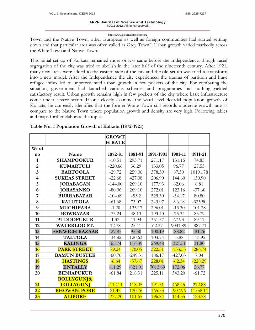
Table No: 1 Population Growth of Kolkata (1872-1921)
GROWTH RATE
Ward no Name 1872-81 1881-91 1891-1901 1901-11 1911-21 1 SHAMPOOKUR -10.51 293.71 271.17 131.15 74.85 2 KUMARTULI -220.66 36.29 133.05 96.77 27.55 3 BARTOOLA -29.72 259.06 378.39 87.50 10191.78 4 SUKEAS STREET -22.68 427.08 206.90 144.60 150.90 5 JORABAGAN -144.00 269.10 177.93 62.06 8.81 6 JORASANKO -80.06 269.10 272.01 123.16 -37.60 7 BURRABAZAR -104.69 -5.92 529.30 -34.17 80.80 8 KALUTOLA -61.68 73.07 243.97 -96.18 -325.50 9 MUCHIPARA -1.20 135.17 296.01 -13.30 101.28 10 BOWBAZAR -73.24 48.13 193.40 -75.34 83.79 11 PUDDOPUKUR 1.32 11.94 351.57 67.93 89.17 12 WATERLOO ST. 12.78 25.41 62.37 9041.89 -887.71 13 FENWICH BAZAAR -29.87 95.30 100.19 -88.82 -81.76 14 TALTOLA -34.82 120.63 103.74 -3.88 -13.95 15 KALINGA -65.74 116.39 269.48 -321.51 31.80 16 PARK STREET 79.24 -70.05 322.51 -133.55 -286.74 17 BAMUN BUSTEE -60.70 -249.31 186.17 -427.03 7.04 18 HASTINGS -6.64 -57.67 228.01 -62.34 -228.29 19 ENTALLY -11.29 -821.01 7013.69 172.06 56.77 20 BENIAPUKUR -61.84 218.31 225.11 343.20 -61.72
21 BOLLYGUNJ& TOLLYGUNJ -112.11 118.05 191.51 468.45 272.88
22 BHOWANIPORE 21.43 120.76 165.53 -907.96 11558.11 23 ALIPORE -277.20 101.65 196.84 114.35 123.58

VOL. 2, Special Issue, ICESR 2012 ISSN 2225-7217
ARPN Journal of Science and Technology ©2011-2012. All rights reserved.
http://www.ejournalofscience.org
371
24 EKBALPORE -109.80 -903.33 13086.05 12.08 436.74 25 WATGUNJ 150.06 -38.93 413.11 155.28 -212.92
FORMULA Pt-Po/Po*t*100 Pt Population of later date Po Population of initial year t Time
Table No: 2 Population Growth of Kolkata (1921-1951) Ward no Name 1921-31 1931-41 1941-51
1 SHAMPOOKUR 168.88 658.08 162.28 2 KUMARTULI 126.82 744.11 127.10 3 BARTOOLA -890.21 557.93 213.70 4 SUKEAS STREET -22.95 832.50 205.25 5 JORABAGAN -251.42 1686.34 136.95 6 JORASANKO -194.85 1239.40 152.97 7 BURRABAZAR -432.93 1921.29 -13.79 8 KALUTOLA 272.34 838.59 1.29 9 MUCHIPARA 156.94 691.91 0.52 10 BOWBAZAR -222.61 765.08 96.64 11 PUDDOPUKUR 82.27 775.70 20.46 12 WATERLOO ST. -55.59 600.21 284.94 13 FENWICH BAZAAR 186.28 682.20 -17.06 14 TALTOLA 213.59 832.38 -16.46 15 KALINGA 196.14 376.98 297.65 16 PARK STREET 440.15 386.54 329.18 17 BAMUN BUSTEE -148.71 502.43 577.89 18 TANGRA nil 1387.78 456.30 19 ENTALLY -75.62 675.11 206.14 20 BENIAPUKUR 141.91 883.90 5.82 21 BOLLYGUNJ -395.03 1032.15 344.06 22 BHOWANIPORE 60.72 601.39 217.90 23 KALIGHAT nil 1420.94 187.22 24 ALIPORE 305.58 599.70 1130.36 25 EKBALPORE 44.62 796.54 578.27 26 WATGUNJ 605.96 -39.89 309.58 27 TOLLYGUNJ nil 2199.39 480.99 28 BELIAGHATA nil 791.76 574.70 29 MANICKTOLLA nil 1039.67 555.17 30 BELGACHIA nil 528.27 321.02 31 SATPOOKUR nil 890.02 662.38 32 COSSIPORE nil 681.95 510.83

VOL. 2, Special Issue, ICESR 2012 ISSN 2225-7217
ARPN Journal of Science and Technology ©2011-2012. All rights reserved.
http://www.ejournalofscience.org
372
Table number 1 and 2 are showing variation in decadal population growth in various wards of Kolkata since 1872 when the first census was carried out. Yellow colour wards indicate erstwhile White Town and grey colour indicate the former Grey Town, rests are Native Town. Though Native Town consisted of a significant portion of the city and most of the population resided in Native Town, but the few pockets of White Town had formed a distinct posh area which still reveal its separate identity. Before 1921v
population growth was not very high and the decadal growth fluctuated remarkably in every ward due to frequent outbreak of epidemics and diseases. It is interesting to note that the population growth in White Town and Grey Town did not show negative trend but a positive growth of population was always found. Only during the World Wars some parts of the White Town (Park Street for instance) recorded negative growth. Immediately after the Independence all wards of Kolkata had shown rapid growth, but the erstwhile White Town and Grey Town recorded moderate to lower growth in compare to the other parts of the city.
The erstwhile White Town and Grey Town still offer a distinct cultural set up which discourages local people to reside there. After the independence Kolkata has witnessed a remarkable spatial expansion and its ward numbers shoots up from 32 to 145 (including four special wards consisting with canals, rivers and fort) during the last sixty years. A remarkable variation in urban growth is found between the city core and the periphery, even within the city core urban growth varies between the erstwhile White Town, Native Town and Grey Town.

VOL. 2, Special Issue, ICESR 2012 ISSN 2225-7217
ARPN Journal of Science and Technology ©2011-2012. All rights reserved.
http://www.ejournalofscience.org
373
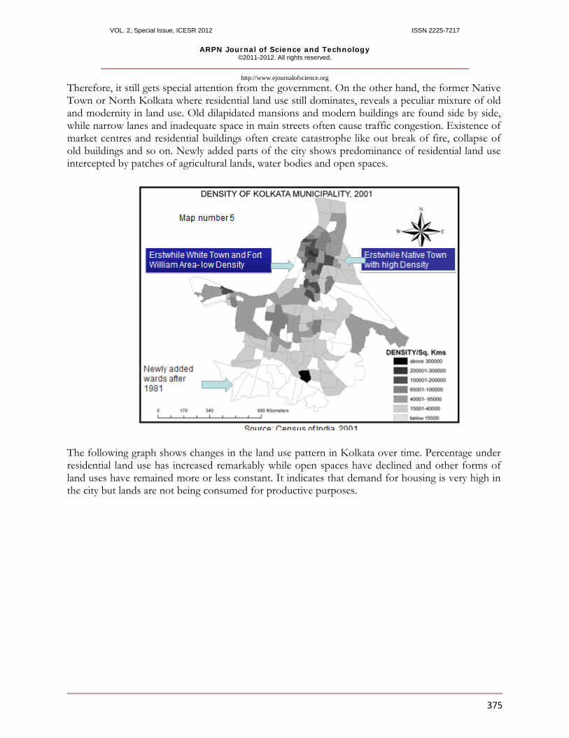
Map number 2 and 3 are showing ward level variation in urban growth and population densities of Kolkata in the last decade. In case of decadal growth, neither the former Native Town nor the White Town show impressive growth, but a low growth rate or depopulation of the city core has been recorded. Only recently added areas (adjoining to Eastern Bypass) is growing rapidly. In case of population density the older city records very high density especially the erstwhile Native Town or northern part of Kolkata.
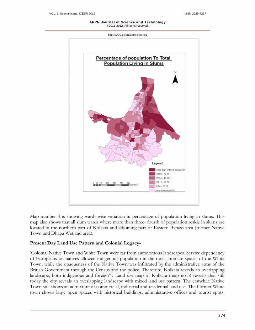
Map No: 4 Percentage distribution of Slum Population in Kolkata (2001)
VOL. 2, Special Issue, ICESR 2012 ISSN 2225-7217
ARPN Journal of Science and Technology ©2011-2012. All rights reserved.
http://www.ejournalofscience.org
374
Map number 4 is showing ward- wise variation in percentage of population living in slums. This map also shows that all slum wards where more than three- fourth of population reside in slums are located in the northern part of Kolkata and adjoining part of Eastern Bypass area (former Native Town and Dhapa Wetland area).
Present Day Land Use Pattern and Colonial Legacy-
‘Colonial Native Town and White Town were far from autonomous landscapes. Service dependency of Europeans on natives allowed indigenous population in the most intimate spaces of the White Town, while the opaqueness of the Native Town was infiltrated by the administrative arms of the British Government through the Census and the police. Therefore, Kolkata reveals an overlapping landscape, both indigenous and foreign’vi. Land use map of Kolkata (map no-5) reveals that still today the city reveals an overlapping landscape with mixed land use pattern. The erstwhile Native Town still shows an admixture of commercial, industrial and residential land use. The Former White town shows large open spaces with historical buildings, administrative offices and tourist spots.
VOL. 2, Special Issue, ICESR 2012 ISSN 2225-7217
ARPN Journal of Science and Technology ©2011-2012. All rights reserved.
http://www.ejournalofscience.org
375
Therefore, it still gets special attention from the government. On the other hand, the former Native Town or North Kolkata where residential land use still dominates, reveals a peculiar mixture of old and modernity in land use. Old dilapidated mansions and modern buildings are found side by side, while narrow lanes and inadequate space in main streets often cause traffic congestion. Existence of market centres and residential buildings often create catastrophe like out break of fire, collapse of old buildings and so on. Newly added parts of the city shows predominance of residential land use intercepted by patches of agricultural lands, water bodies and open spaces.
The following graph shows changes in the land use pattern in Kolkata over time. Percentage under residential land use has increased remarkably while open spaces have declined and other forms of land uses have remained more or less constant. It indicates that demand for housing is very high in the city but lands are not being consumed for productive purposes.

VOL. 2, Special Issue, ICESR 2012 ISSN 2225-7217
ARPN Journal of Science and Technology ©2011-2012. All rights reserved.
http://www.ejournalofscience.org
376
Data source: Metropolitan Kolkata: An Anthropology of Socio-Economic Studies and Survey Reports of KMDA (1970-2004), Volume-I to V
Growth of the Urban Agglomeration and Diffusion of Urban Growth towards New Growth Centres-
Discussion on Kolkata’s urban growth can not be completed without the study of its immediate neighbouring urban centres which together form one of the world’s largest urban agglomerations. Just like Kolkata all these settlements initially grew up as trade centres under various European powers and did not share much interaction with Kolkata before Independence. As for example Chandan Nagarn and Hooghly-Chinsurah remained the colonies of France and Portugal throughout the British period. Therefore, they developed a distinct socio-political identity. Other urban settlements in the agglomeration grew up as industrial centres in the second half of the nineteenth century. Along the western bank of the River Hooghly jute mill towns had developed in a linear form. On the other hand, many of the east bank municipalities had developed after the Independence. Kalyani, which was once considered as the second Kolkata developed in the extreme north of the agglomeration. Dum Dum, South Dum Dum, New Barrackpore, Bidhan Nagar and many other east bank municipalities developed after the Independence. Creation of Kalyani and Bidhan Nagar (Salt Lake) as new growth centres is an example of careful government intervention which tried to capture unprecedented population growth in the main city.
In case of the growth of Kolkata’s urban agglomeration the influence of colonial legacy does not play a crucial role. East bank municipalities record remarkable urban growth but west bank municipalities record stagnation. This is mainly due to deindustrialisation of Hooghly Industrial belt. Kalyani has failed to attract population growth but Bidhan Nagar has successfully emerged as the new nerve centre of Kolkata (map no-6 and 7).
01020304050607080
YEA
RS
LAND USE
LAND USE CHANGES OF KOLKATA METROPOLIS (1961-1990)
196119811990

VOL. 2, Special Issue, ICESR 2012 ISSN 2225-7217
ARPN Journal of Science and Technology ©2011-2012. All rights reserved.
http://www.ejournalofscience.org
377
Therefore, growth of the new towns around Bidhan Nagar is not a surprising fact. Emergence of Bidhan Nagar as the new administrative as well as economic and residential centre has

VOL. 2, Special Issue, ICESR 2012 ISSN 2225-7217
ARPN Journal of Science and Technology ©2011-2012. All rights reserved.
http://www.ejournalofscience.org
378
challenged the future of the former White Town which still houses important administrative buildings, economic centres and tourist spots.
Map number-8 is showing urban growth around Kolkata. The red coloured area is indicating high growth, yellow colour indicates moderate growth and green indicates low growth, blue patches are water bodies.
Impact of Colonial Legacy in Present Urban Planning- immediately after the Independence government had introduced careful planning intervention to solve the city’s unprecedented urban growth and unplanned spatial transformation leading to the formation of slums anywhere with open space. Under the authority of Kolkata Metropolitan Development Authority, Basic Development Plan (1966-86) was introduced. The BDP proposed a By-Polar model in which Kolkata in the south and Kalyani in the north would act as the main growth poles for urbanisation. Integration of Kolkata urban agglomeration as a single planning unit has helped to diffuse urban growth towards other towns near the main city, but, when Kalyani failed to act as the second growth centre, the so-called By-polar model failed. Currently KMDA has adopted a multi-polar growth strategy in which several urban settlements within the Kolkata Urban Agglomeration have been identified as potential growth centre and among them Bidhan Nagar has already emerged as the future nerve centre of Kolkata. On the other hand the main city or Kolkata (MC) is showing lower population growth than that of its neighbouring towns. Kolkata city as a whole needs a separate urban renewal plan for itself which will try to erase the urban disparity that still exists between the erstwhile White and Native Town.
Main Findings and Conclusion
• Colonial legacy still hovers on the urban growth and spatial transformation of Kolkata. The erstwhile Native Town which comprises the larger part of the Kolkata Municipal Corporation (north Kolkata especially) reveals high population density and mixed land use pattern where residential areas, industrial and commercial areas exist side by side. Moreover, wards with high slum population are also found in these localities. On the other hand, the former White Town has very low population growth and population density is also very low here. This area has most of the open
VOL. 2, Special Issue, ICESR 2012 ISSN 2225-7217
ARPN Journal of Science and Technology ©2011-2012. All rights reserved.
http://www.ejournalofscience.org
379
spaces, tourist spots, and important administrative and commercial buildings. Therefore, still today this part of the city gets special attention from the policy makers. • Consolidation of Kolkata Urban Agglomeration as a single planning unit is a remarkable step adopted by the KMDA, but the towns under Kolkata Urban Agglomeration still bears the separate identity inherited from their imperial rulers. Deindustrialisation of the Hooghly industrial belt and inconvenience of transport facility have retarded the growth of the west bank municipalities. • Bidhan Nagar or Salt Lake is emerging as the new administrative as well as economic nerve centre of Kolkata in the north eastern fringe of the city. This planned township area has successfully attracted urban population. It puts a big question mark before the existence of the former White Town. If all important activities shifts from the former White Town to Bidhan Nagar, will policy makers still invest in the beautification of the old colonial heritage or it will retain its importance as one of the main tourist spot in Kolkata?
Therefore, recent spatial transformation in Kolkata has put a severe challenge to the past colonial hegemony that still influences the city’s land uses and urban growth. Since the Independence, policy makers and urban planners are trying to divert the population growth towards new growth centres and very recently Bidhan Nagar has successfully emerged as the new nerve centre of modern Kolkata. Only the time can answer my question, either the former White Town will retain its importance or it will lose its significance and will turn into an old city core with dilapidated buildings and nostalgia of the colonial past.
i Census 2001, Kolkata Municipal Corporation ii Harold. M. Mayor iii Martin Beattie (2003) iv Grey Town developed between Janbazar and Park Street area (present day ward no 52 and 45) v 1921 is considered as the watershed in the demographic transition of India. vi Swati Chattopadhyay (1997) References • Banerjee, Tapan and Roy, Kalyan (1990): “Delivery of Urban Services in Calcutta Metropolitan Area”, ‘Urban India’, Volume X Number-1, 1990, pp 13-26 • Brush. John. E. (1974): “ The Morphology of Indian Cities”, from edited book of Rao, M.S.A., ‘Urban Sociology in India’ pp-225 • Burgess, E.W. (1939): “ The City” edited by Don Martindele (1958), pp-22-25 • Chattopadhyay Swati (1997) : “ Depicting Calcutta” PhD Dissertation, University of California, 1997, pp-XXV • Chakroborty, Sanjay (2001): “From Colonial City to Global City? The Far From Complete Spatial Transformation of Kolkata” • Chauncy D. Harris and Edward Ullman (1945): “ The Nature of Cities” from Annals of the American Academy of Political and Social Sciences , November, 1945, pp-7-17 • Christaller, Walter (1966): “Die Zentralen Orte in Suddeutschland” translated by Baskin.C.W. (1969), published by the Prentice Hall, New Jersey, USA

VOL. 2, Special Issue, ICESR 2012 ISSN 2225-7217
ARPN Journal of Science and Technology ©2011-2012. All rights reserved.
http://www.ejournalofscience.org
380
• Colby, C.C. (1933) : “Centrifugal and centripetal Forces in the urban Geography” ‘The Annals of American geographers’, 1933 volume, pp-23 • Harold, M. Mayor and C.F. Kohn (edited) (1967): “Readings in Urban Geography”, Chicago • Hoyt Homer (1970): “ Types of Ecological Units” edited by Alvin Boskoff ‘The Sociology of Urban Region’ , pp-83, Acc. Sociology Series • King, Anthony (1976): “Colonial Urban Development: Culture, Social Power and • There are no sources in the current document.Environment”: edited by Routledge and Kegan Paul, (London ) • Martin Beattie (2003) : “Colonial Space: Health and Modernity in BaraBazaar, Kolkata”, TDSR, Volume: XIV, Number: II, 2003 • Munshi, Sunil Kumar (1989): “Calcutta; Genesis of Metropolis”, from ‘Geographical Reviews of India’, September 1989, volume-51, no-3, pp-1 to 6 Government Documents: • Basic Development Plan for The CMD (1966-1986), CMPO, Government of West Bengal • Metropolitan Kolkata: An Anthropology of Socio-Economic Studies and Survey Reports of KMDA (1970-2004), Volume-I to V • A History of British India by Sir W.W. Hunter, volume-II, (1972), Chapter-IV, Our First Settlement on the Bengal Coast, 1633-1658, pp 85-108


![MUSCULOSKELETAL DISCOMFORT AMONG WORKERS IN …ML. 10, NO. 15, AUGW2015 lSSN 1819-6608 ARPN Journal of Engineering and Applied Sciences 82006-M15&ian Renard PuWinO Nelvmrk (ARPN].UI](https://img.pdfslide.net/doc/110x75/5e8cff63b0edef0c76123a80/musculoskeletal-discomfort-among-workers-in-ml-10-no-15-augw2015-lssn-1819-6608.jpg)