Embed Size (px)
DESCRIPTION
Water Resilience for Cities
Citation preview
A
Water resilience for cities
Arup UrbanLife
Helping cities build water resilience today, to mitigate the risks of climate change tomorrow
B
The effects of global warming on water supply represent one of the greatest challenges for cities in the 21st century. City administrations are seeking ways to meet demand for water from growing populations while grappling with the issues presented by climate change - extreme rainfall and drought, rising sea levels and flooding. Arup’s global water, climate change and planning experts offer practical recommendations and case studies to help cities build water resilience as part of a programme of climate change mitigation.
Foreword
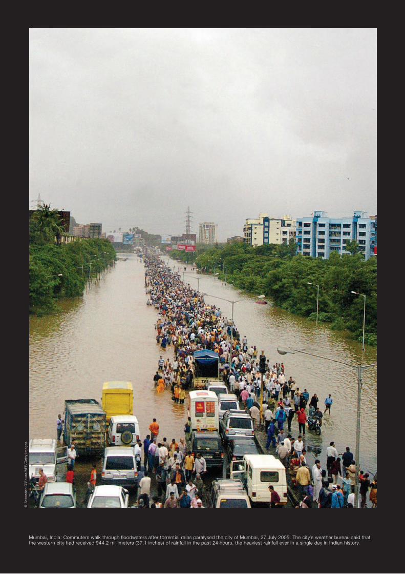
Mumbai, India: Commuters walk through floodwaters after torrential rains paralysed the city of Mumbai, 27 July 2005. The city’s weather bureau said that the western city had received 944.2 millimeters (37.1 inches) of rainfall in the past 24 hours, the heaviest rainfall ever in a single day in Indian history.
© S
ebas
tian
D’S
ouz
a/A
FP/G
etty
Im
ages

Top Liuzhou, China: A view of the city zone along the Liujiang River on 6 July 2009 in Liuzhou of Guangxi Zhuang Autonomous Region, China. The water level of the Liujiang River rose to 89.28 meters, exceeding the warning level by 6.78 meters. Bottom Nanjing, China: Stranded bus passengers help push the bus to higher grounds, along a flooded street in Nanjing, capital of eastern China’s Jiangsu province on 6 July 2003, where the heaviest rains in 20 years deposited some 194.5 millimetres (7.65 inches) of water. Officials in the neighbouring province of Anhui blew up a dike and urged 760,000 inhabitants along the Huaihe river, a tributary of the mighty Yangtze, to maintain vigilance as its water levels reached a record high.
© A
FP/G
etty
Im
ages
© Y
an H
uang
/Chi
naFo
toP
ress
/Get
ty I
mag
es

3
Contents
Introduction 05 The urban climate challenge 05 Urban water resources: the challenges 06
Recommendations 08 Water resource management 08 Increasing raw water storage capacity 10 Case study: Testwood Lakes scheme, UK 11 Combating salination 12 Case study: Shanghai Qing Cao Sha reservoir, China 13 Implementing water demand management 14 Case study: IDARA programme, Jordan 15 Improving river basin management 16 Case study: Murray-Darling Basin, Australia 17
Flood management and climate resilience 18 Deploying WSUD into city planning 20 Case study: Bay Meadows, San Francisco 21 Harvesting rainwater and recharging groundwater 22 Case study: Salisbury, South Australia 23 Improving drainage networks 24 Case study: Tokyo, Japan 26
Conclusion 27
Credits and further information 28
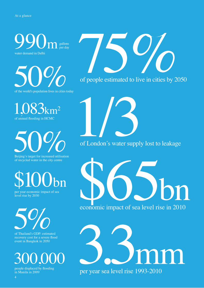
of people estimated to live in cities by 205075%
per year sea level rise 1993-20103.3mm
economic impact of sea level rise in 2010$65bn
At a glance
of the world’s population lives in cities today
50%
per year economic impact of sea level rise by 2030
$100bn
of London’s water supply lost to leakage1/3
300,000people displaced by flooding in Manila in 2009
5%of Thailand’s GDP: estimated recovery cost for a severe flood event in Bangkok in 2050
990mwater demand in Delhi
gallonsper day
50%Beijing’s target for increased utilisation of recycled water in the city centre
1,083km2of annual flooding in HCMC
4

5
3.3mm
The urban climate challenge
Introduction
Mark Watts, Director, Energy and Climate change
Cities have more that unites them than divides them when tackling climate change. This report shares best practice in cities around the world, from strategy to delivery.
50% of the world’s population lives in cities and they are responsible for 75% of the world’s carbon emissions. Both of these figures are increasing. City administrations across the world face the challenge of building new, or more commonly adapting existing infrastructure, buildings and systems to meet the challenges of changing weather patterns, increased demand for resources, shifting demographics and increased pressure to reduce emissions.
This report, the first in a series, presents a high level approach to urban water management and practical case studies for mayors and city administrations to consider as they put climate change adaptation policies into action.
Director, Energy and Climate Change
These recommendations were developed and refined at a C40 UrbanLife workshop, held in Ho Chi Minh City in May 2010, which brought together Arup’s global water, climate change and master planning specialists together with the city administrations in order to recommend strategic measures for helping the Vietnamese city build water resilience against climate change.
Each city has its own context and no single approach can help all cities adapt to water. However, the measures can form a starting point for considering an effective response by the political and private organisations involved in keeping cities running.

6
Around the world, city leaders are searching for ways to meet growing demand for water while grappling with water issues associated with unexpected new patterns in global temperature changes.
The problems for cities are complex and pressing: Growing and more affluent populations and changing climate are putting pressure on cities’ demand for water, and, as sea levels rise, on their ability to handle flooding. Increased demand for water is resulting in groundwater depletion. Meanwhile, saline water intrusion runs the risk of making groundwater supplies unusable.
Sea levels on the riseThe latest International Panel on Climate Change (IPCC) projections from climate change models predict that sea levels could see a mean rise of 480 millimetres by the year 2100 – and some sources, that account for dynamic changes in the ice sheets, make this figure four times higher.
Flooding will increase, affecting the hundreds of millions of people who live in cities situated close to vulnerable coastlines, river flood plains and river deltas. Many non-coastal cities, located besides rivers or in the foothills of mountains, will also face the problem of flooding as a result of more intense rainfall or snowmelt.
Extreme weather eventsExtreme weather events, such as tropical storms, are expected to become more frequent while rainfall is predicted to become more intense, even as some areas receive less rainfall than usual. Many cities can expect greater rainfall while others will experience droughts more severe than they have had in the past.
Reductions in fresh water storesWhere there are higher rates of evaporation, prompted by increased temperatures, drier soils will soak up more water, reducing the recharge of underground aquifers and the flow of fresh water springs. Higher temperatures will reduce the amount of water stored in mountain snowfields. As fresh water reserves found in glaciers and snow fields diminish, cities will be pressed to find new ways to store water to meet growing demand throughout the year.
Temperature change 0C
19
90
20
00
20
10
20
20
20
30
20
40
20
50
20
60
20
70
20
80
20
90
21
000
1
2
3
4
5
6
Increase in average global temperatures 1990 – 2100, shown in degrees Celsius (Source: Dow and Downing, 2006).
Area of uncertainty
Average of globalclimate models
Projected warming
Urban water resources: the challenges
Introduction

7
Although the global supply of water remains relatively stable, regional differences in seasonal and annual precipitation will be significant. Estimates suggest that climate change will account for about 20% of the increase in global water scarcity.
Water scarcityWater scarcity affects hundreds of millions of urban dwellers worldwide. Climate change will exacerbate this, as prolonged droughts and spreading destertification will increase the stress on already-stretched water resources. Cities that rely on glacial melt water may be impacted as glaciers recede and dry season water sources are not replenished. The result could be reductions in available water for drinking, household use and industry.
Water quality issuesThe quality of existing water, moreover, will become a further concern for some urban areas. Changes in the amounts or patterns of precipitation may change the route and residence of water in the watershed, in gturn affecting its quality. Regardless of water quantity, water could become unsuitable for use.
SalinationFor coastal cities, water quality is likely to be affected by salinisation, or increased quantities of salt in water supplies. This will result from a rise in sea levels, which can increase salt concentrations in groundwater and estuarine rivers. At times of low rainfall, city water managers will find it more difficult to release fresh water from reservoirs when needed for salinity control. The problem becomes even worse in regions where the dry season extends.
Higher sea levels due to climate change are more likely to breach existing coastal/river defenses. The result can be greater inundation of salt water which runs the risk of overloading water treatment systems. More intense rainfall may cause overloading of drainage systems, increasing cities’ vulnerability to flooding and reducing the level of flood protection.
Reduced food securityClimate change, finally, could threaten food security as agricultural activity in the tropics and sub-tropics is forecast to slow because of rising temperatures and drought. As demand for water intensifies under the climate change, effective methods for managing water resources and demand will become essential.
Introduction
Mediterranean basin
Central North America
East Africa
East Asia
No changeDrier Wetter
Very
like
lyU
nlik
ely
Likelihood of wetter or drier June to August with a doubling of CO2 equivalents in atmosphere, at approximately 2100 (Source: Dow and Downing, 2006).
Precipitation
Waterresource management
8

Recommendations
Ensuring a resilient water supply as climate patterns change and populations grow requires cities to introduce active water resource management measures.Arup recommends that city administrations consider a combination of increasing raw water storage capacity, combating salination, implementing demand management and improving river basin management.
9

10
Water resource management
Increasing raw water storage capacity Recommendation
Cities will increasingly face the challenge of how to store water during times of water plenty so that sufficient water resources are available during times of need.
With ever increasing demands for water, many cities face the real possibility that in drier years water basins experience a seasonal deficit.
An investment in urban water securityClimate change for some urban areas may cause more frequent and more severe storms and longer, drier periods of drought.To combat the impacts of drier dry seasons and wetter wet seasons, cities need to ensure that they have sufficient water storage capacity. Storage of water in reservoirs or in underground aquifers helps to ensure that water collected in the wet season will be available to boost river flows in the dry season.
Greater storage will be needed to capture peak flows and supplement low water flows. Increasing water storage capacity can be regarded as an investment in greater urban water security and reliability New groundwater and surface water storage will ensure a reliable water supply, and provide vital flood protection by managing more variable precipitation and runoff.
Alternative storage solutionsClimate change will impact not only the amount of water storage that cities need, but also the method of storage. While water storage strategies tend to focus on large-scale man made dams, there exists a wide range of alternative storage solutions, including natural storage, such as groundwater storage, wetlands and lakes, community tanks, and smaller scale reservoirs.
Water Resources in Ho Chi Minh’s River Basin
0
1
2
3
4
5
6
7
8
Jan
BCM
Natural yield
Demand
DecJu
l
NovJun
Oct
Ap
r
Sep
Mar
AugFeb
May
Dry Season Flood Season
Impact of climate change on water resources
0
1
2
3
4
5
6
7
8
Jan
BCM
Demand
Yield after storage
Possible impact of climate change
DecJu
l
NovJun
Oct
Ap
r
Sep
Mar
AugFeb
May
Dry Season Flood Season
Water supply in Ho Chi Minh City’s Dong Nai river basin illustrates the issue of seasonal supply in a typical year.

11
Water resource management
Testwood Lakes scheme, UK Case study
270mlitres storage capacity
OwnerSouthern Water
LocationSouthampton, UK
ConsultantsArup
Completion date2002
Top Little Testwood Lake, one of three disused gravel pits, is now a reservoir with a storage capacity of 270m litres. Left Two of the lakes have been converted in to nature conservation areas, benefitting the 200,000 inhabitants in and around Southampton. Right Little Testwood Lake is 800m away from the River Test, the previous source of raw water.
The Testwood Lakes Scheme uses river bank storage facilities to provide security of water supply to meet peak water demands during low river flows and it ensures against short term river pollution events. It consists of lakes formed in three disused gravel pits, just 800m away from the river and near to an existing water treatment facility. The scheme converted one to a reservoir and two to nature conservation areas.
Before the commissioning of the storage reservoir, raw water was pumped to the water treatment works directly from the nearby River Test. However, during seasonal drought conditions low river flows made operation of the works questionable given the requirement to maintain environmental flows in the river downstream.
The scheme provides the UK’s Southern Water with a valuable water storage asset and benefits the local community through the provision of a major amenity and leisure facility. River bank storage solutions are one way that water authorities are combating the impacts of climate change such as increasingly longer dry seasons while protecting against pollution risks.
A valuable water storage asset and a major environmental and leisure facility

12
Pressurizingpump
Filteredseawater in
Concentratedbrine out
Semi permeable membraneallows water to passthrough but not salt
Freshwaterout
Desalination of brackish water by reverse osmosis
The RO treatment process works by forcing water under pressure through a membrane. The membrane is specifically designed so that the salt fraction and other impurities in the water stream do not pass through and the concentrated brine solution is held and discharged to waste from the upstream side of the membrane. In hotter climates the brine waste is evaporated in ponds so that the residue with value can be disposed of more readily.
As sea level rises, there is the risk that salty seawater will intrude up estuaries, into the lower portions of rivers and into groundwater aquifers. In flat lands, even a minor sea level rise can result in salinity intruding miles up-river during dry periods. Furthermore, with simultaneous changes in river flow in climates with reduced precipitation and more water extracted from upstream reservoirs, and in ocean winds and waves, seawater may intrude even further – changing critical habitats and threatening freshwater supplies to cities located close to coastlines.
Raw water storageThe first method of combating salination is to develop raw water storage that is protected from the effects of salination and can allow continued production of water at treatment plants when water becomes temporarily too saline.
Desalinating brackish waterThe second approach is to improve water treatment by introducing a desalination process for brackish water that operates alongside the conventional treatment of surface water. Ocean water and brackish groundwater are desalinated so they can be converted to drinking-quality water. Conventional treatment processes such as coagulation, flocculation, sedimentation and filtration cannot remove dissolved salts from water.
Water resource management
Combating salination Recommendation

13
68 daysequivalent water demand of Qing Cao Sha Reservoir
To cope with the challenges of existing water source pollution and seasonal salination, the city of Shanghai opted to invest in a bulk water storage reservoir in the middle of the Yangtze River.
In November/December high tides and diminishing river flow can create temporary salinity problems as far as 80km inland for Shanghai, a city of more than 20 million. The situation could grow worse due to upstream dam construction, over-use of groundwater and water transfer to the north of China.
Expected to be complete soon, The Qing Cao Sha Reservoir will have a footprint of 70 sq km with a capacity of 435MCM, which is estimated to equate to 68 days worth of water demand. To link this new source of water to various treatment facilities, Shanghai is building-out its water grid to optimise the delivery of fresh water in the years ahead.
YangtzeRiver
Treatmentplant
Treatmentplant
Treatmentplant
Treatmentplant
Treatmentplant
Treatmentplant
Treatmentplant
Treatmentplant
Treatmentplant
Treatmentplant
Treatmentplant
Treatmentplant
Sea / river
Water treatment
Orange pipelines
green treatment
Highlighted area
Land
20mpopulation of Shanghai
OwnerShanghai Municipal Government
LocationShanghai, China
ConsultantsN/A
Completion date2011
Water resource management
Shanghai Qing Cao Sha reservoir, China Case study

14
Demand management and conservation play an important part in the development of a robust and resilient water resource strategy for any city. Importantly, cities that apply non-supply based approaches will be positioned to make the most of what could be diminishing water resources as a result of drier climatic conditions in the years ahead.
The need for demand management policiesThe impacts of climate change makes development of water management demand management policies even more important for city administrations responsible for managing water. Growing water scarcity, problems with deteriorating water quality, and the effects of more severe and frequent extreme climatic events, such as storms, floods and droughts increase the need for water demand management measures.
Water conservation measuresKey water conservation and efficiency measures – also called demand-side measures –will be of critical importance for groundwater resources that suffer from over-use and should therefore be given priority. These measures include:• Reducing waste from water transmission systems
and networks• Recycling water• Using water-efficient or water-saving devices• Fiscal measures to ensure that water goes to the highest
socio-economic value users, such as domestic and industrial users
• Ensuring that rivers remain healthy and beneficial as ecosystems
Social and economic benefitsImproved demand management can generate important social and economic benefits. In a delta city such as Ho Chi Minh City, reducing agricultural irrigation demand upstream means more water can be made available to high value users such as domestic and industrial use downstream, and, in turn, more effective salinity control can be achieved by higher downstream water flows.
At the same time, by reducing industrial demand for water, cities are better able to conserve groundwater, a common water resource for industry. Finally, by decreasing domestic demand and pipe network waste, this high value water can service a larger population in the future.
Irrigation
Domestic
Industry
Hydropower
Salinity control
35%
46%
5%7%
Gross water demand in the Dong Nai basin, Vietnam
6%
The Dong Nai river basin supplies Ho Chi Minh City. The majority of the water usage is for agriculture and for salinity control, largely associated with agriculture. Water demand management allows more water for important higher value uses such as domestic and industrial use downstream and more effective salinity control may result due to higher river flows.
Water resource management
Implementing water demand management Recommendation

15
40%reduction in water demand from new developments
Precipitation (mm/a)
< 50
50 – 100
100 – 200
200 – 300
300 – 400
400 – 500
500 – 600
> 600
Stations
Major towns
Main surfacewater basins
Surface waterbodies
Irbid
Zarqa
Amman
Karak
Aqaba
Ma’an
Gulf of Aqaba
Dead Sea
Sea of Galilee
Jord
on R
iver
Jordan
One of the driest places on earth, Jordan suffers from absolute water scarcity. In response, the Instituting Water Demand Management in Jordan (IDARA) programme is engaging citizens in water conservation efforts. The programme uses water policy change, new regulations, institutional support, modern technology, best management practices and education and outreach to affect change.
IDARA’s achievements to date are impressive: water demand from new high rise developments in the capital city Amman is down 40% as a result of a new building advisory code, while the city has witnessed a 15%-20% demand reduction in residential areas involved in the IDARA outreach programme.
Meanwhile, new measures to reduce demand from the agricultural sector, Jordan’s largest water consumer, include reusing treated wastewater, modern irrigation techniques and technologies, switching to less water intensive crops and imposing higher tariffs on agricultural water consumption.
20%reduction in water demand from residential areas
OwnerMinistry of Water and Irrigation
LocationJordan
ConsultantsUSAID / DAI
Completion dateOngoing
Water resource management
IDARA programme, Jordan Case study
16
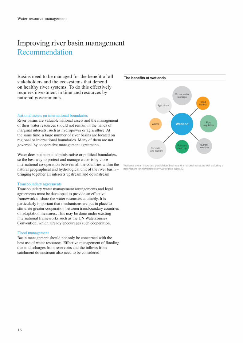
The benefits of wetlands
Wetland
Pollutantclean up
Groundwaterrecharge
Nutrientretention
Agricultural
FlowregulationWildlife
Floodcontrol
Recreationand tourism
Wetlands are an important part of river basins and a national asset, as well as being a mechanism for harvesting stormwater (see page 22)
Basins need to be managed for the benefit of all stakeholders and the ecosystems that depend on healthy river systems. To do this effectively requires investment in time and resources by national governments.
National assets on international boundariesRiver basins are valuable national assets and the management of their water resources should not remain in the hands of marginal interests, such as hydropower or agriculture. At the same time, a large number of river basins are located on regional or international boundaries. Many of them are not governed by cooperative management agreements.
Water does not stop at administrative or political boundaries, so the best way to protect and manage water is by close international co-operation between all the countries within the natural geographical and hydrological unit of the river basin – bringing together all interests upstream and downstream.
Transboundary agreementsTransboundary water management arrangements and legal agreements must be developed to provide an effective framework to share the water resources equitably. It is particularly important that mechanisms are put in place to stimulate greater cooperation between transboundary countries on adaptation measures. This may be done under existing international frameworks such as the UN Watercourses Convention, which already encourages such cooperation.
Flood managementBasin management should not only be concerned with the best use of water resources. Effective management of flooding due to discharges from reservoirs and the inflows from catchment downstream also need to be considered.
Water resource management
Improving river basin management Recommendation

17
39%of Australia’s national income derived from agriculture in the basin
For years, inadequate cooperation among the individual states of Queensland, New South Wales, Victoria and South Australia hampered integrated management of the Murray-Darling Basin.
The Basin suffered due to severe drought and over-allocation of water for agriculture. A single, independent agency, The Murray-Darling Basin Authority (MDBA), backed by a $12 billion Australian government investment program, is now responsible for planning integrated management of the water resources of the Murray-Darling Basin.
The Authority is preparing a Basin Plan that will, for the first time, set a long-term sustainable limit on the use of both surface and groundwater in the Murray-Darling Basin, while strengthening the role of the Australian Competition and Consumer Commission (ACCC) in regulating the water market.
Additional programs undertaken by the MDBA include the:• Stakeholder engagement: a critical component in developing the Basin Plan.
Helping people understand the plan development process, the content, potential implications and providing opportunities for people to input into the plan.
• The Sustainable Rivers Audit: monitoring Basin health.• The River Murray Water Quality Monitoring Program: the primary objective of
which is to collect physicochemical parameters at 36 sites along the River Murray and the lower reaches of its tributaries.
Sydney
Melbourne
Brisbane
Canberra
Adelaide
Victoria
SouthAustralia
Queensland
New SouthWales
Darling Rive
r
Murray River
Lachlan River
Murrumbidgee River
The catchment area for the Murray and Darling rivers covers 1m km2 and includes 23 river valleys. It produces 53% of Australia’s grain crop and 28% of the nation’s cattle herd.
OwnerMDBA
LocationSouth Australia
ConsultantsN/A
Completion dateOngoing
14%of total area of Australia
Water resource management
Murray-Darling Basin, Australia Case study

Flood management and climate resilience
18
Recommendations
Flooding is becoming a reality for the many urban areas that for economic and historical reasons are situated in flood plains. Arup recommends the following measures to improve the resilience of cities and their ability to adapt to climate change relating to flood management: improve drainage networks, deploy Water Sensitive Urban Design (WSUD) into city planning, harvest rainwater and recharge groundwater.
19

20
Water Sensitive Urban Design – or WSUD – is a widely promoted best management practice concept in America, Australia and Europe. It is an approach to urban planning and design that integrates land and surface water planning and management into urban design.
WSUD relates to all parts of the urban water cycle and involves improvements in town planning, engineering design, asset management, urban landscaping and urban water management.
The key objectives of WSUD• Protect and enhance natural water systems within urban
areas. Promoting and protecting natural water systems, and treating them as assets, allows them to function more effectively and supports the existing ecosystems that depend on them.
• Incorporate stormwater treatment methods into the natural landscape. Natural stormwater drainage systems can be employed by taking advantage of their natural aesthetic qualities.
• Protect water quality and improve the quality of water draining outward to the natural environment from urban areas. Through filtration and retention, water draining from urban developments can be treated to remove pollutants close to their source. This approach reduces the effect that polluted water can have upon the environment and protects the natural waterways.
• Reduce runoff and peak flows. Local detention storage enables effective land use for flood mitigation by utilising numerous storage points in contrast to the current practice of utilisation of large retarding basins. This approach subsequently reduces the infrastructure required downstream to effectively drain urban developments during rainfall events.
• Add value while minimising development costs. The reduction of downstream drainage infrastructure due to reduced peak flows and runoff minimises the development costs for drainage, whilst enhancing natural features such as rivers and lakes that add value to the properties of the area.
Green space in urban areas
Los AngelesUSA
6.6m2 per person
Ho Chi Minh CityVietnam
1.6m2 per person
World HealthOrganisation
8m2 per person
ShanghaiChina
10m2 per person
LondonUnited Kingdom
20.5m2 per person
A comparison of available green space per person in some of the world’s largest cities, compared with the World Health Organisation’s recommendation.
Flood management and climate resilience
Deploying WSUD into city planning Recommendation

21
Arup applied WSUD to a new storm water management system along one of the San Francisco Bay Area’s busiest commuter rail corridors. Embracing a philosophy of ‘doing more with less’, Arup proposed the following key storm water strategies to alleviate longstanding flooding problems:
• Surface runoff from the development drains to a designated wet pond prior to discharge to the downstream drainage system. The pond retains and attenuates the peak surface runoff and also cleans the storm water. The pond also serves to provide 2,270m3 of year-round water storage for firefighting water supplies.
• Floodable recreation fields behind the wet pond safely accept and detain floodwater during and after major storms.
• A suite of best management practices – such as rain gardens, curb-side biofiltration planters and bio-swales – are planned for street-level development to reduce peak flow and control pollution locally.
Wet and dry ponds
This conceptual design indicates how a community park can provide flood relief at times of heavy rainfall.
Case 1: <2 year rainfall
Case 2: 2 to 10 year rainfall
Case 3: 10 to 100 year rainfall
OwnerBay Meadows Land Company
LocationSan Mateo, California
ConsultantsArupCooper Robertson & Partners (architects)
Completion date2011
Developer Bay Meadows Land Company is transforming 33.8ha of impenetrable private property into a pedestrian friendly mixed use development driven by the approach ‘environment, society and economy’.
Flood management and climate resilience
Bay Meadows, San Francisco Case study
22
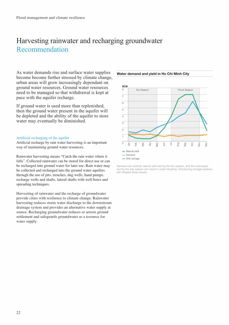
As water demands rise and surface water supplies become become further stressed by climate change, urban areas will grow increasingly dependant on ground water resources. Ground water resources need to be managed so that withdrawal is kept at pace with the aquifer recharge.
If ground water is used more than replenished, then the ground water present in the aquifer will be depleted and the ability of the aquifer to store water may eventually be diminished.
Artificial recharging of the aquiferArtificial recharge by rain water harvesting is an important way of maintaining ground water resources.
Rainwater harvesting means “Catch the rain water where it falls”. Collected rainwater can be stored for direct use or can be recharged into ground water for later use. Rain water may be collected and recharged into the ground water aquifers through the use of pits, trenches, dug wells, hand pumps, recharge wells and shafts, lateral shafts with well bores and spreading techniques.
Harvesting of rainwater and the recharge of groundwater provide cities with resilience to climate change. Rainwater harvesting reduces storm water discharge to the downstream drainage system and provides an alternative water supply at source. Recharging groundwater reduces or arrests ground settlement and safeguards groundwater as a resource for water supply.
Water demand and yield in Ho Chi Minh City
0
1
2
3
4
5
6
7
8
Jan
BCM
Natural yield
Demand
With storage
DecJu
l
NovJun
Oct
Ap
r
Sep
Mar
AugFeb
May
Dry Season Flood Season
Demand can outstrip natural yield during the dry season, and the oversupply during the wet season can result in urban flooding. Introducing storage systems will mitigate these issues.
Flood management and climate resilience
Harvesting rainwater and recharging groundwater Recommendation

23
260haof wetlands created
This is one of the world’s first projects in which urban storm water, harvested from an urban catchment, is conveyed to an engineered wetland, stored underground in an aquifer and recovered as water suitable for a continuous and sustainable supply at potable water quality.
An average annual 450mm of rainfall lands on the 1,500 hectare residential and industrial catchment yielding a total runoff of some 1,300ML per year. This is stored, treated and eventually fed to the city’s water grid. As well as eliminating the flow of polluted water into the marine environment of the Barker Inlet of Gulf St Vincent, the project provides landscape enhancement and creation of habitat diversity.
This project marks City of Salisbury as a world leader in the field of stormwater harvesting, wetland construction and implementing aquifer storage and recovery technology.
Aquifer storage and recovery (ASR)
During the high rainfall period in winter, excess stormwater, filtered and cleaned by the wetlands, is pumpedinto the aquifer, 164 metres below the ground. During the dry summer, the water is recovered as needed toirrigate sports fields and turf areas. This eliminates the demand on mains water for irrigation, conserving waterand reducing costs.
Aquifer
Confining layer
Groundwater levelWet season
Dry season
Injectionwell
Wetland/Basin
Stormwater
Irrigation
Storm/Waste-water to aquifer in wet season
Recovery from aquifer in dry season
OwnerCity of Salisbury
LocationSalisbury, South Australia
ConsultantsCSIROS
Completion date2002
Flood management and climate resilience
Salisbury, South Australia Case study
The creation of wetlands to cleanse stormwater was Salisbury’s key strategy to help the ecological rehabilitation of the Barker Inlet while providing water to local industry and other users.

24
Urban drainage networks need improvement to cope with more intense rainfall. This is particularly so for coastal cities also affected by sea level rise, which include 13 of the world’s megacities.
The measures recommended will vary according to topography and the prevailing natural drainage system. In some cases, diversions will be possible directing runoff from upstream away from vulnerable low lying areas. In others cases, storage of the peak runoff underground will be appropriate.
In all cases the best measures will be those that allow the maximum use of rainfall as a source for water supply, thereby making the best use of available resources.
Gate opens
a) Operation mode 1: free discharge to Saigon and Dong Nai Rivers
Dyke Dyke
b) Operation mode 2: gates closed to isolate discharge to Saigon and Dong Nai Rivers
Dyke Dyke Gate closes
Improving Ho Chi Minh City’s drainage network
c) Implement diversion and increase Retention storage in drainage system
Dyke Dyke
Ho Chi Minh City’s drainage system has two different modes of operation requiring different improvement strategies: (a) divert discharge of stormwater in to the Saigon and Dong Nai Rivers and (b) at high tide or times of storm surge, gates closed to retain water within the catchment. Arup’s recommendations were (c) adding retention storage along the canal system and a diversion system so that stormwater bypasses flood prone areas.
Retentionstorage
Flood management and climate resilience
Improving drainage networks Recommendation
25
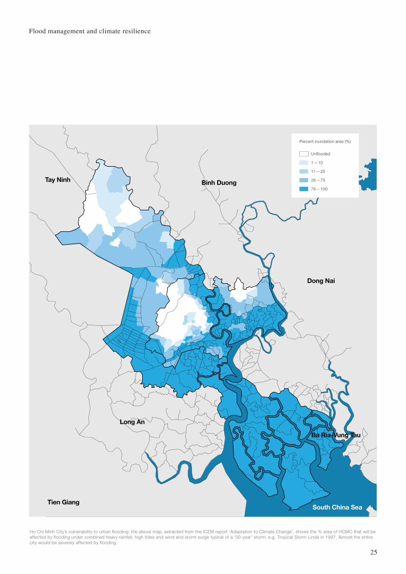
Binh Duong
Dong Nai
Tay Ninh
Ba Ria-Vung Tau
Long An
Tien GiangSouth China Sea
Percent inundation area (%)
Unflooded
1 – 10
11 – 25
26 – 75
76 – 100
Ho Chi Minh City’s vulnerability to urban flooding: the above map, extracted from the ICEM report ‘Adaptation to Climate Change’, shows the % area of HCMC that will beaffected by flooding under combined heavy rainfall, high tides and wind and storm surge typical of a ‘30-year’ storm, e.g. Tropical Storm Linda in 1997. Almost the entire city would be severely affected by flooding.
Flood management and climate resilience

Flooding from heavy rainfall and typhoons was a recurrent event in Tokyo. Due to the city’s heavy urban development and congestion, traditional ‘above-ground’ flood control measures – such as drainage improvement works, river training, channel-widening and dredging are not always possible. Tokyo therefore turned to ‘below-ground’ flood prevention measures.
• Metropolitan Area Outer Floodway: To reduce flooding of the Naka, Kuramatsu and Ohotoshi-no-furutone Rivers, five vertical intake shafts (32m in diameter and 65m deep), connected by a 6.3km long underground water tunnel (10m in diameter), divert floodwater from these rivers eastwards to the Edo River.
• Kanda River Diversion Channel: A box culvert was installed along under the carriageway adjacent to the Kanda River to provide additional flow capacity for the Kanda River.
• Meguro River Underground Reservoir: An underground storage reservoir temporarily stores floodwater from the Meguro River. When water flows in Meguro River reach a high level, water overflows via a side weir into an underground storage reservoir. Land above the underground storage reservoir has been designated for high-rise housing development
Tokyo, Japan Case study
2,187km2urban area
Cross section of the Metropolitan Area Outer Floodway
PumpingStation
Max. 200m3/s
32m dia.65m deep
10m dia. 6.4km long
Edo River
Storagetank
1st Shaft 2nd Shaft 3rd Shaft 4th Shaft 5th Shaft
The hydraulic stormwater tunnel system discharges floodwater to the downstream underground storage tank.The pumping station which is located adjacent to the storage tank pumps floodwater at a maximum rate of 200m3/sec to the Edo River.
OwnerTokyo Metropolitan Government
LocationTokyo, Japan
ConsultantsN/A
Completion date2006
annual rainfall, twice the world’s average
1,714mm
Flood management and climate resilience
26

Arup has put forward a number of key measures for consideration that we believe will help cities mitigate the risks of climate change on water resilience. They relate to both water resource and flood management and indeed many of the measures should be seen as integrated solutions to manage both.
Measures founded on technical expertise, sustainable, integrated thinking and policy considerations pave the way for urban decision makers to respond effectively to the water-related issues arising from climate change. Such measures are designed to help cities build water resilience today, and mitigate the risks of climate change tomorrow.
Conclusion
27

Bay Meadows www.baymeadows.com
C40 Cities Group www.c40cities.org
City of Salisbury www.cweb.salisbury.sa.gov.au
DARA/Climate Vulnerability Forum (2010) Climate Vulnerability Monitor
Dow and Downing (2006) The Atlas of Climate Change www.earthscan.co.uk
Intergovernmental Panel on Climate Change (IPCC) www.ipcc.ch
Melbourne Water www.melbournewatercom.au
Murray-Darling Basin Authority www.mdba.gov.au
Southern Water www.southernwater.co.uk
Tokyo Metropolitan Government www.metro.tokyo.jp
UN-Habitat (2010) State of the World’s Cities 2010/11: Bridging the Urban Divide
The Urban Age Project (London School of Economics and Deutsche Bank’s Alfred Herrhausen Society) (2010) The Endless City Phaidon
The World Bank (2010) Cities and Climate Change: an Urgent Agenda www.worldbank.org/climatechange
The World Bank (2010) Climate Risks and Adaptation in Asian Coastal Megacities www.worldbank.org/climatechange
Arup authorship team:Roger AlleyKenneth KwokDebra LamWilfred LauMark WattsFergal Whyte
With thanks to Ben McClure
Credits and further information
28


30
www.arup.com/urbanlife
© Arup 2011