Embed Size (px)
Citation preview

Richard Ferrare1, John Hair1, Sharon Burton1, Anthony Notari1
Chris Hostetler1, Syed Ismail1, Amin Nehrir1, Carolyn Butler2, James Collins2, Marta Fenn2, Amy Jo Scarino2, Cynthia Randles3,
Pete Colarco3, Arlindo daSilva3, James Campbell4, Angela Benedetti5, Samuel Remy5
1NASA Langley Research Center, Hampton, VA USA2SSAI, Hampton, VA USA
3NASA Goddard Space Flight Center, Greenbelt, MD USA4U.S. Naval Research Laboratory, Monterey, CA USA
5ECMWF, Shinfield Park, Reading Berkshire, UK
Assessing Aerosol Data Assimilation Products Using DIAL/HSRL Measurements
https://ntrs.nasa.gov/search.jsp?R=20160007335 2018-09-26T10:41:29+00:00Z
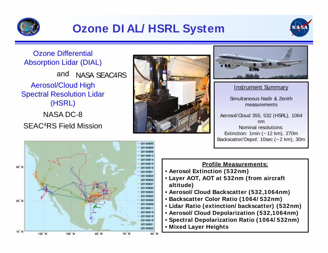
Ozone DIAL/HSRL System
Ozone Differential Absorption Lidar (DIAL)
and Aerosol/Cloud High
Spectral Resolution Lidar (HSRL)
NASA DC-8 SEAC4RS Field Mission
Profile Measurements:• Aerosol Extinction (532nm)• Layer AOT, AOT at 532nm (from aircraft
altitude)• Aerosol/Cloud Backscatter (532,1064nm)• Backscatter Color Ratio (1064/532nm)• Lidar Ratio (extinction/backscatter) (532nm)• Aerosol/Cloud Depolarization (532,1064nm)• Spectral Depolarization Ratio (1064/532nm)• Mixed Layer Heights
Instrument Summary
Simultaneous Nadir & Zenith measurements
Aerosol/Cloud 355, 532 (HSRL), 1064 nm
Nominal resolutions: Extinction: 1min (~12 km), 270m
Backscatter/Depol: 10sec (~2 km), 30m
NASA SEAC4RS
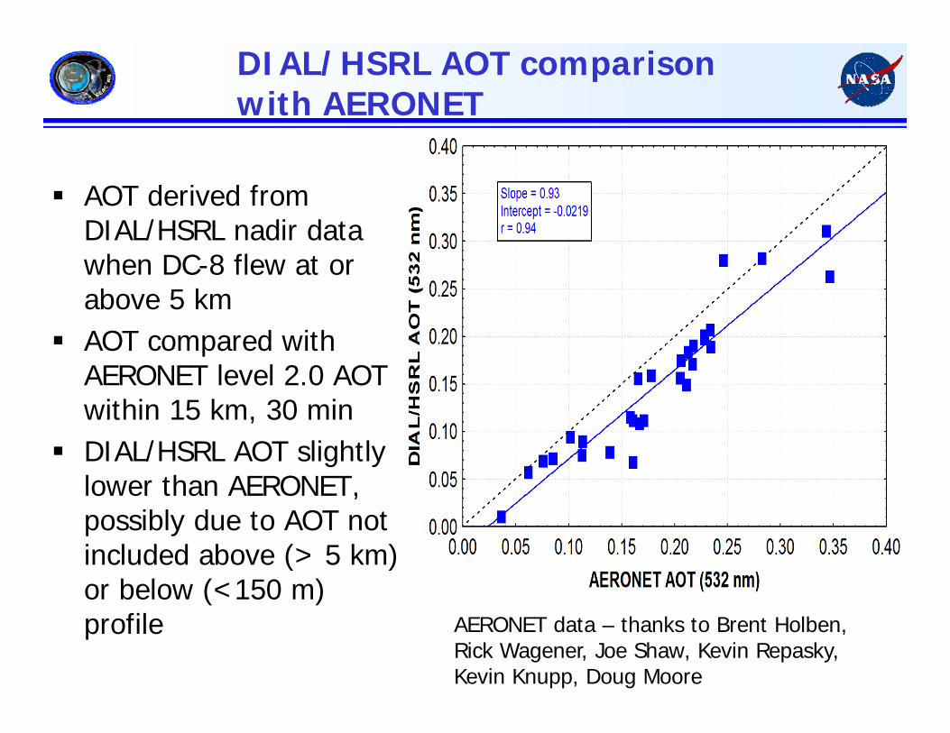
DIAL/HSRL AOT comparison with AERONET
AOT derived from DIAL/HSRL nadir data when DC-8 flew at or above 5 km
AOT compared with AERONET level 2.0 AOT within 15 km, 30 min
DIAL/HSRL AOT slightly lower than AERONET, possibly due to AOT not included above (> 5 km) or below (<150 m) profile AERONET data – thanks to Brent Holben,
Rick Wagener, Joe Shaw, Kevin Repasky, Kevin Knupp, Doug Moore
DIAL/HSRL Comparisons with GEOS-5 During
SEAC4RS
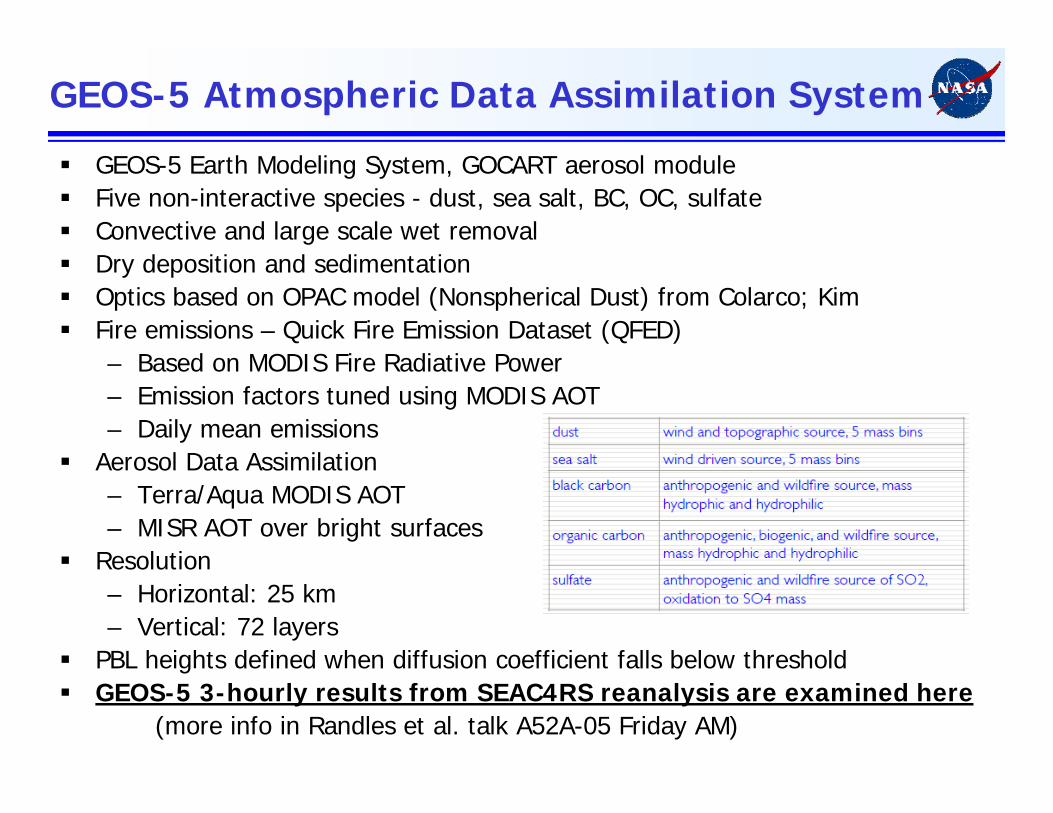
GEOS-5 Atmospheric Data Assimilation System
GEOS-5 Earth Modeling System, GOCART aerosol module Five non-interactive species - dust, sea salt, BC, OC, sulfate Convective and large scale wet removal Dry deposition and sedimentation Optics based on OPAC model (Nonspherical Dust) from Colarco; Kim Fire emissions – Quick Fire Emission Dataset (QFED)
– Based on MODIS Fire Radiative Power– Emission factors tuned using MODIS AOT– Daily mean emissions
Aerosol Data Assimilation– Terra/Aqua MODIS AOT– MISR AOT over bright surfaces
Resolution– Horizontal: 25 km– Vertical: 72 layers
PBL heights defined when diffusion coefficient falls below threshold GEOS-5 3-hourly results from SEAC4RS reanalysis are examined here
(more info in Randles et al. talk A52A-05 Friday AM)
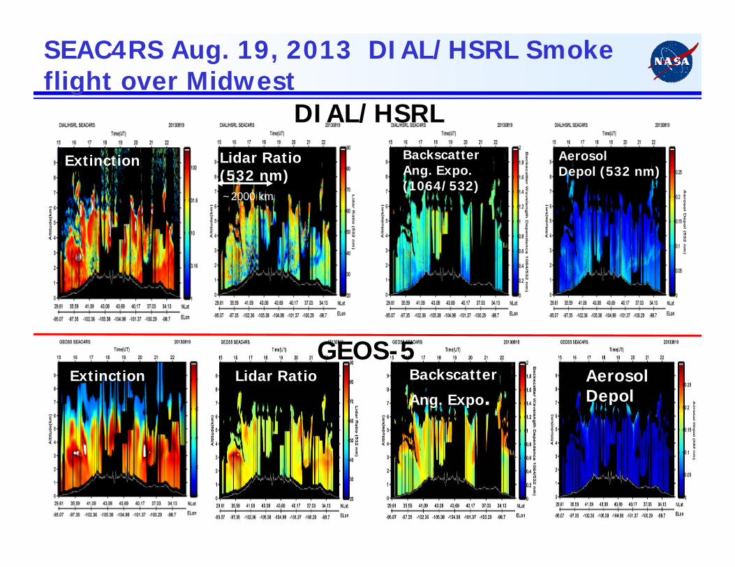
SEAC4RS Aug. 19, 2013 DIAL/HSRL Smoke flight over Midwest
Extinction Lidar Ratio(532 nm)
Backscatter
Ang. Expo.AerosolDepol
ExtinctionGEOS-5
Lidar Ratio
AerosolDepol (532 nm)
BackscatterAng. Expo. (1064/532)
DIAL/HSRL
~2000 km

DIAL/HSRL and GEOS-5 Median Backscatter and Extinction Profiles During SEAC4RS
GEOS-5 shows slightly higher backscatter and extinction in free troposphere
Solid Line = MedianShaded = 25-75%
Aerosol Backscatter
Aerosol Extinction
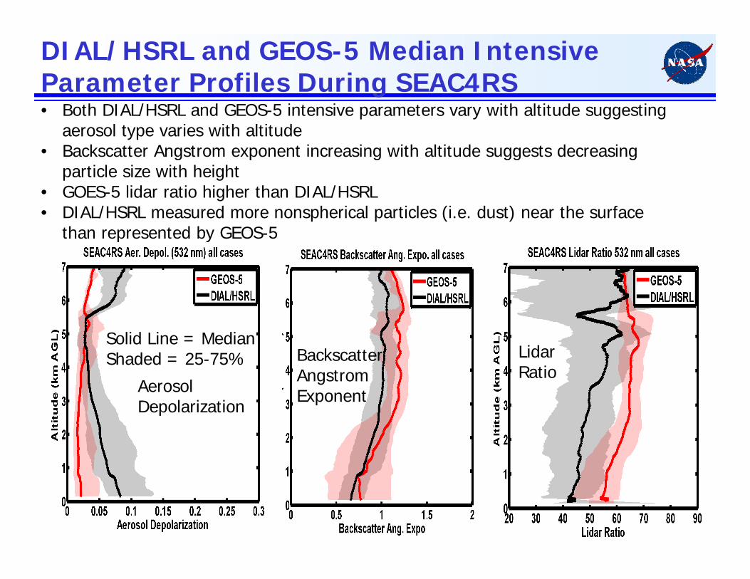
DIAL/HSRL and GEOS-5 Median Intensive Parameter Profiles During SEAC4RS • Both DIAL/HSRL and GEOS-5 intensive parameters vary with altitude suggesting
aerosol type varies with altitude• Backscatter Angstrom exponent increasing with altitude suggests decreasing
particle size with height• GOES-5 lidar ratio higher than DIAL/HSRL• DIAL/HSRL measured more nonspherical particles (i.e. dust) near the surface
than represented by GEOS-5
Solid Line = MedianShaded = 25-75%
Aerosol Depolarization
BackscatterAngstromExponent
LidarRatio
Comparisons of HSRL and GEOS-5 Boundary Layer Heights

Comparison of Boundary Layer Heights from HSRL-2 and GEOS-5 during DISCOVER-AQ HSRL-2 boundary layer heights from aerosol backscatter gradients GEOS-5 boundary layer heights from thermal diffusivity and aerosol backscatter gradients
were about 450-500 m higher than those derived from HSRL-2 and DIAL/HSRL
Sept. 10, 2013HSRL-2
GEOS-5Sept. 10, 2013
GEOS-5 BL heights from thermal diffusivity
GEOS-5 BL heights from aerosol backscatter
(see Scarino et al., poster A31C-3040 Wed. AMfor more details)
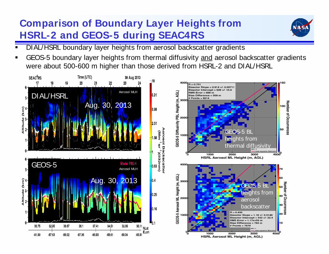
Comparison of Boundary Layer Heights from HSRL-2 and GEOS-5 during SEAC4RS DIAL/HSRL boundary layer heights from aerosol backscatter gradients GEOS-5 boundary layer heights from thermal diffusivity and aerosol backscatter gradients
were about 500-600 m higher than those derived from HSRL-2 and DIAL/HSRL
GEOS-5 BL heights from thermal diffusivity
GEOS-5 BL heights from aerosol backscatter
DIAL/HSRL
GEOS-5
Aug. 30, 2013
Aug. 30, 2013
Aerosol MLH
Aerosol MLH

DIAL/HSRL Comparisons with ECMWF/MACC During
SEAC4RS

ECMWF/MACC-II Model
Monitoring Atmospheric Composition and Climate-Interim Implementation (MACC-II) Model– Provides information regarding air quality, global atmospheric composition, climate forcing,
solar energy– Consumers include WMO, EPA and European Centers, weather services, solar irradiance
forecast groups, field campaigns Aerosol model has components for dust, sea salt, organic matter, black carbon, sulfate Eleven prognostic aerosol variables and one for SO2
Aerosol sources taken from– Quick Fire Emission Dataset (QFED)– Speciated Particulate Emission Wizard (SPEW)– Emission Database for Global Atmospheric Research (EDGAR)
Resolution– Horizontal: T255 (~80 km)– Vertical: 60 layers
Aerosol Data Assimilation– Terra/Aqua MODIS AOT– Working towards assimilation of CALIOP aerosol profiles
MACC-II 3-hourly results from reanalysis are examined here SEAC4RS DIAL/HSRL data used to examine impacts of:
Assimilation of CALIOP data Increased model resolution Plume rise model impact on smoke injection heights
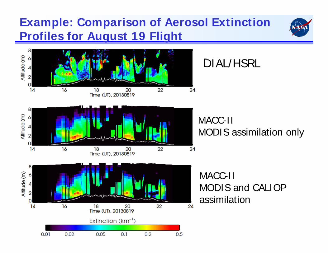
Example: Comparison of Aerosol Extinction Profiles for August 19 Flight
DIAL/HSRL
MACC-IIMODIS and CALIOP assimilation
MACC-IIMODIS assimilation only
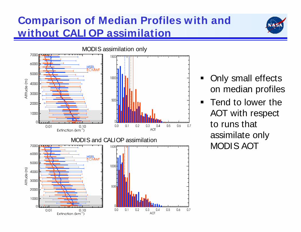
Comparison of Median Profiles with and without CALIOP assimilation
MODIS assimilation only
Only small effects on median profiles
Tend to lower the AOT with respect to runs that assimilate only MODIS AOT
MODIS and CALIOP assimilation

Impact of plume rise model smoke injection heights
Injection heights for smoke emissions are estimated using Plume rise model (Paugam et al., 2015, in preparation, based on Freitas et al., 2007), and Sofiev'sparameterization (Sofievet al., 2012)
This plume rise model uses MODIS FRP and modelled atmospheric profiles with a shallow convection scheme to represent detrainment from fire plume
Initial comparisons show that both aerosol extinction and AOT increase throughout the profile, not necessarily at smoke height shown in DIAL/HSRL profile

Impact of MODIS assimilation
Assimilation of MODIS AOT significantly reduces aerosol extinction profiles in some sections of these flights
Reductions in aerosol extinction vary with altitude
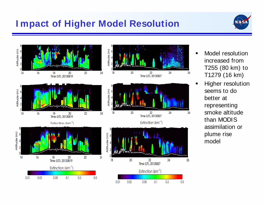
Impact of Higher Model Resolution
Model resolution increased from T255 (80 km) to T1279 (16 km)
Higher resolution seems to do better at representing smoke altitude than MODIS assimilation or plume rise model
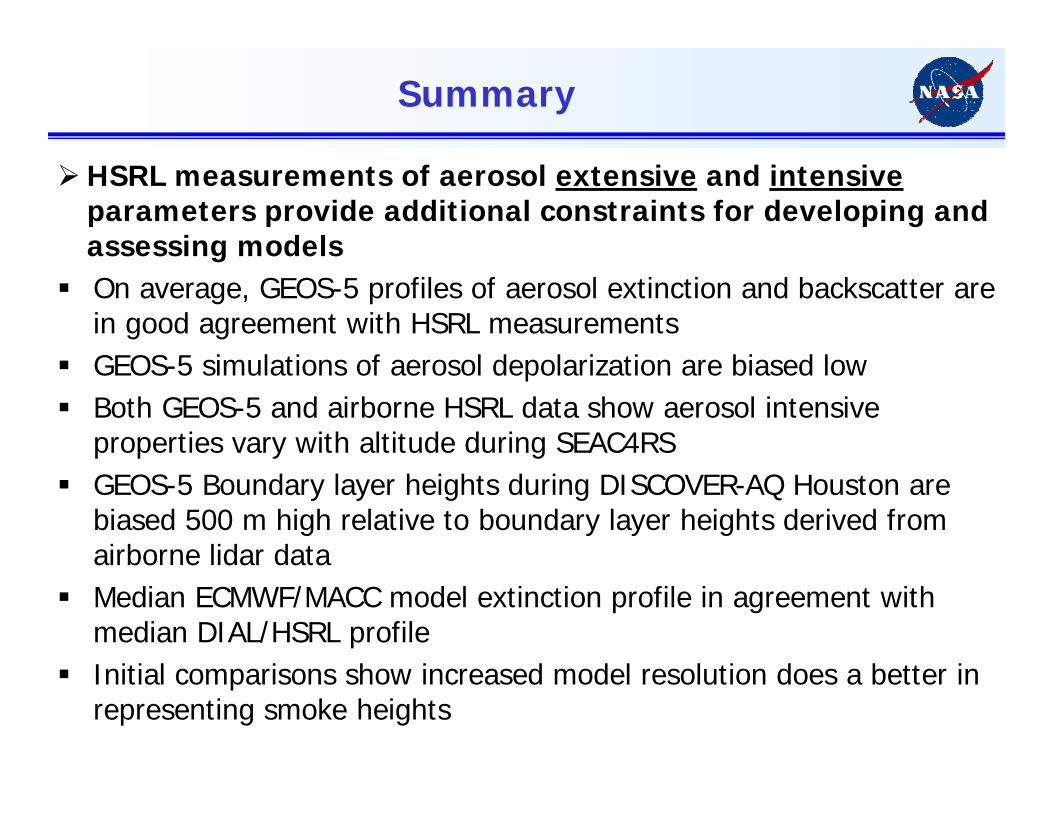
Summary
HSRL measurements of aerosol extensive and intensiveparameters provide additional constraints for developing and assessing models
On average, GEOS-5 profiles of aerosol extinction and backscatter are in good agreement with HSRL measurements
GEOS-5 simulations of aerosol depolarization are biased low Both GEOS-5 and airborne HSRL data show aerosol intensive
properties vary with altitude during SEAC4RS GEOS-5 Boundary layer heights during DISCOVER-AQ Houston are
biased 500 m high relative to boundary layer heights derived from airborne lidar data
Median ECMWF/MACC model extinction profile in agreement with median DIAL/HSRL profile
Initial comparisons show increased model resolution does a better in representing smoke heights