Embed Size (px)
Citation preview

1. AEE – Assessment of Environmental Effects

HFT Limited
30-Jun-2017
Assessment of Environmental Effects
Mixed Industrial Development at 28 Inlet Road, Papakura

AECOM
28 Inlet Road, Takanini
Assessment of Environmental Effects
30-Jun-2017 Prepared for – HFT Limited – ABN: N/A
Assessment of Environmental Effects
Mixed Industrial Development at 28 Inlet Road, Papakura
Client: HFT Limited
ABN: N/A
Prepared by
AECOM New Zealand Limited
8 Mahuhu Crescent, Auckland 1010, PO Box 4241, Auckland 1140, New Zealand
T +64 9 967 9200 F +64 9 967 9201 www.aecom.com
30-Jun-2017
Job No.: 60529463
AECOM in Australia and New Zealand is certified to ISO9001, ISO14001 AS/NZS4801 and OHSAS18001.
© AECOM New Zealand Limited (AECOM). All rights reserved.
AECOM has prepared this document for the sole use of the Client and for a specific purpose, each as expressly stated in the document. No other
party should rely on this document without the prior written consent of AECOM. AECOM undertakes no duty, nor accepts any responsibility, to any
third party who may rely upon or use this document. This document has been prepared based on the Client’s description of its requirements and
AECOM’s experience, having regard to assumptions that AECOM can reasonably be expected to make in accordance with sound professional
principles. AECOM may also have relied upon information provided by the Client and other third parties to prepare this document, some of which
may not have been verified. Subject to the above conditions, this document may be transmitted, reproduced or disseminated only in its entirety.

AECOM
28 Inlet Road, Takanini
Assessment of Environmental Effects
30-Jun-2017 Prepared for – HFT Limited – ABN: N/A
Quality Information
Document Assessment of Environmental Effects
Ref 60529463
Date 30-Jun-2017
Prepared by Katie Round / Matt Kerr-Ridge
Reviewed by Jarrod Snowsill
Revision History
Revision Revision Date
Details
Authorised
Name/Position Signature
A 30-Jun-2017
For Resource Consent Craig Hind Technical Director

AECOM
28 Inlet Road, Takanini
Assessment of Environmental Effects
30-Jun-2017 Prepared for – HFT Limited – ABN: N/A
Table of Contents
Applicant and Property Details a 1.0 Introduction 1 2.0 Existing Environment 2
The Site 2 2.12.1.1 Legal Encumbrances 2 2.1.2 Site History 2 2.1.3 Vegetation & Topography 3 2.1.4 Natural Hazards – Flooding, Inundation & Hydrology 3 2.1.5 Geology and Soil Character 3 2.1.6 Transport & Access 3 2.1.7 Utility Services 4 2.1.8 Cultural Heritage Features 4
Surrounding Area 6 2.22.2.1 Land Use Environment 6 2.2.2 Urban Structure & Built Form 7 2.2.3 Transport Environment 7 2.2.4 Heritage and Culture 8 2.2.5 Noise Environment 8 2.2.6 Natural Environment 8
3.0 Description of the Proposal 12 Design Philosophy 12 3.1
3.1.1 Market Research 12 Proposed Mixed Industrial Units 13 3.2
3.2.1 Development Staging 14 3.2.2 Materials and Finishes 14 3.2.3 Industrial Space Activities 14 3.2.4 Residential Activities 15 3.2.5 Commercial Office/Storage Space Activities 15
Earthworks 15 3.3 Site Servicing 16 3.4
3.4.1 Wastewater, Water and Utilities 16 3.4.2 Stormwater Management and Discharge 16
Parking, Loading & Access 16 3.53.5.1 Access 16 3.5.2 Parking 16 3.5.3 Loading 17 3.5.4 Cycle Parking 17
Signage 17 3.6 Vegetation Alteration and Landscaping 17 3.7
3.7.1 Vegetation Removal 17 3.7.2 Landscape - Planting 19 3.7.3 Landscape - Fencing Treatment 19
Rubbish Storage Area 19 3.8 Unit Title Subdivision 19 3.9 Consent Notice D306878.2 19 3.10
4.0 Consultation 20 Auckland Council 20 4.1
4.1.1 Auckland Council Regulatory Consents 20 4.1.2 Auckland Council Community Parks and Places 20 4.1.3 Auckland Council – Development Engineering 21
Utility Providers 21 4.24.2.1 Veolia Water 21
Mana Whenua 21 4.3 Adjacent Landowners 21 4.4
4.4.1 25 Inlet Road (Waste Management Services) 21
AECOM
28 Inlet Road, Takanini
Assessment of Environmental Effects
30-Jun-2017 Prepared for – HFT Limited – ABN: N/A
5.0 Status of Activity 23 Land Use & Discharge Consents 23 5.1 Signage Bylaw 2015 23 5.2 Summary 23 5.3
6.0 Assessment of Actual or Potential Effects on the Environment 24 Statutory Requirements 24 6.1 Permitted Baseline 24 6.2 Actual & Potential Positive Effects on the Environment 25 6.3 Actual & Potential Adverse Effects on the Environment 25 6.4
6.4.1 Land & Soil Resources 25 6.4.2 Amenity and Character 27 6.4.3 Traffic Generation, Parking, Manoeuvring, Loading & Access 30 6.4.4 Utilities & Servicing 31 6.4.5 Stormwater Infrastructure Capacity, Operation & Provision 31 6.4.6 Water Quality & Quantity 32 6.4.7 Construction - Noise, Vibration and Traffic 32 6.4.8 Natural Hazards 33 6.4.9 Cultural Heritage 33 6.4.10 Subdivision 33
Summary of Adverse Effects 33 6.57.0 Notification Assessment 34
Public Notification 34 7.17.1.1 Section 95A 34
8.0 Section 104 - Statutory Assessment 35 Part 2 Resource Management Act 1991 35 8.1 National Environmental Standards 36 8.2
8.2.1 National Environmental Standard for Assessing and Managing Contaminants in Soil to Protect Human Health 36
National Policy Statements 36 8.38.3.1 National Policy Statement on Urban Land Development Capacity 2016 37 8.3.2 New Zealand Coastal Policy Statement 2010 37
Relevant Objectives and Policies 37 8.48.4.1 Auckland Regional Policy Statement 37 8.4.2 Auckland Unitary Plan (Operative in Part) 38
Relevant Assessment Criteria (Section 104(1)(b)) 40 8.1 Other Matters 40 8.2
8.2.1 Auckland Plan 40 8.2.2 Papakura Local Board Plan 2014-2017 42 8.2.3 Economic Development Strategy 2012 42 8.2.4 Local Transport Improvements 42 8.2.5 Auckland Transport is also currently investigating the option of
establishing a new train station approximately 800m walking distance from the site (Tironui Station). 42
9.0 Section 106 – Subdivision 43 10.0 Section 104D – Gateway Test 43 11.0 Conclusion 44
Appendix A Certificate of Title A
Appendix B Planning Maps B
Appendix C Site Locality Maps C
Appendix D Contamination Assessment D
Appendix E Geotechnical Memo E

AECOM
28 Inlet Road, Takanini
Assessment of Environmental Effects
30-Jun-2017 Prepared for – HFT Limited – ABN: N/A
Appendix F Acoustic Assessment F
Appendix G Site Context Analysis and Design Statement G
Appendix H Design Drawings H
Appendix I Engineering Report & Drawings I
Appendix J Scheme Plan J
Appendix K Consultation K
Appendix L Rules Assessment L
Appendix M Transport Assessment M
Appendix N Statutory Assessment O

AECOM
28 Inlet Road, Takanini
Assessment of Environmental Effects
30-Jun-2017 Prepared for – HFT Limited – ABN: N/A
Applicant and Property Details
Applicant(s): HFT Ltd – Philip Maguire Agent: AECOM NZ Limited PO Box 4241
Shortland Street Auckland 1140
Attn: Matt Kerr-Ridge Site Address: 28 Inlet Road, Papakura, Auckland Legal Description: Lot 6 DP 184757 Limitations: Minor Overland Flowpath (southern corner of site)
Potentially Contaminated Land
Potentially subject to instability (CT encumbrance D306878.2)
(Refer to Certificate of Title in Appendix A)
Site Area: 3,721m² Operative Plan: Auckland Unitary Plan (Operative in Part)
Operative Zoning: Business – Light Industry
Precincts/Overlays: Infrastructure: Designations – ID 200, Ardmore Airport – Height Restrictions, Airspace Restriction Designations, Ardmore Airport Ltd
Natural Resources: High-Use Aquifer Management Areas Overlay – Clevedon West Waitemata Aquifer
Controls: Macroinvertebrate Community Index – Urban / Native
(Refer to Planning Maps in Appendix B)

AECOM
28 Inlet Road, Takanini
Assessment of Environmental Effects
30-Jun-2017 Prepared for – HFT Limited – ABN: N/A
1
1.0 Introduction
This Assessment of Environmental Effects (AEE) has been prepared for HFT Limited (the Applicant)
in support of an application for resource consent to establish 16 ‘mixed industrial’1 units at 28 Inlet
Road, Takanini (legally described as Lot 6 DP 184757).
The proposed units will comprise of two levels with light industrial activities on the ground floor with a
mix of residential units and commercial units on the upper floor. The proposed development and mix
of activities has been designed in response to the surrounding site context in particular, the
surrounding land uses (including the adjacent Pahurehure Inlet and adjoining Longford Park
Esplanade Reserve) and the site’s existing characteristics in terms of dimension, shape and area.
Resource consent is required to enable the construction, unit title subdivision and land use associated
with the development. In summary the reasons for consent are as follows:
Diversion and discharge of stormwater runoff – Controlled Activity.
Earthworks (Area) – Restricted Discretionary Activity.
Earthworks within a Coastal Protection Yard – Discretionary Activity.
Establishment of dwellings within the Light Industrial Zone – Non-Complying Activity.
Infringement to front yard setback requirements – Restricted Discretionary Activity.
Infringement to rear yard landscaping requirements – Restricted Discretionary Activity.
Unit title subdivision – Controlled Activity.
Further detail is provided in Section 5.0 of this AEE. Overall consent is required as a Non-Complying
Activity overall under the AUP(OiP).
The AEE accompanies an application for a resource consent made under Section 88 of the Resource
Management Act 1991 (RMA) and has been prepared in accordance with the Fourth Schedule of the
RMA in such detail as corresponds with the scale and significance of the effects that the activity may
have on the environment.
1 The term ‘Mixed Industrial’ has been adopted to describe the land use typology which is proposed for the development. The
‘Mixed Industrial’ land use typology provides for a mix of light industrial, commercial (likely office/storage) and residential land use activities. The predominant land use for the site is light industrial activities and it is intended that all commercial and residential land use will be accessory to the primary industrial activities of the site.

AECOM
28 Inlet Road, Takanini
Assessment of Environmental Effects
30-Jun-2017 Prepared for – HFT Limited – ABN: N/A
2
2.0 Existing Environment
The Site 2.1
The 3,721m² site is an unoccupied and irregular shaped parcel of light industrial zoned land located at
28 Inlet Road in Takanini, Auckland (legally described as Lot 6 DP 184757). The site is located
adjacent to the coastal marine area, overlooking the Pahurehure Inlet to the west and south west. The
site has street frontage to Inlet Road on its eastern boundary and adjoins light industrial properties on
its northern and south eastern boundaries. The western and south-western boundaries of the site
adjoin an esplanade reserve (Longford Park Esplanade Reserve). The site is currently grassed with a
shipping container and a relocatable prefabricated building situated on the northern half of the site.
2.1.1 Legal Encumbrances
The Certificate of Title for the site records two legal encumbrances:
D306878.2 Consent Notice pursuant to Section 221(1) Resource Management Act 1991
Consent Notice D306878.2 originated from the last subdivision carried out in 1998 to establish the
current land parcel. The consent notice requires that the building foundations for any future building or
structure on the site be specifically designed by a Registered Engineer experienced in geotechnical
engineering.
Figure 1 Aerial photograph of application site (outlined blue)
2.1.2 Site History
The site and surrounding area was historically rural land until at least 1959 (Auckland Council
GeoMaps 2017) after which time the area was progressively converted into urban industrial land use..
The current site was subdivided from a larger site occupied by Namco (New Zealand) Limited in 1998.
It has remained vacant and unoccupied whilst the adjacent properties have been developed within the
industrial area to the north. Based on historic aerial photography, the site has previously been subject
to earthworks activities and filling as a result of developments on adjacent properties.

AECOM
28 Inlet Road, Takanini
Assessment of Environmental Effects
30-Jun-2017 Prepared for – HFT Limited – ABN: N/A
3
Property file records for the site include a proposal in 2015 to establish a new workshop and
warehouse with support amenities for a cold form cladding manufacturing business. However this
development was not progressed by the site owner at the time2. That particular proposal also included
the adjoining property to the south east at 26 Inlet Road.
2.1.3 Vegetation & Topography
The site is grassed with no other vegetation currently situated within the site. The AUP(OiP) classifies
the site as ‘Macroinvertebrate Community Index – Urban / Native’.
The site is relatively flat and does not have any prominent slopes to its character. The entire site is
between 5m and 7m above sea level between its northern and southern boundaries (refer to Contour
and Hydrology Map in Appendix C). The northern half of the site is slightly elevated above the
adjoining esplanade reserve, however levels out with the reserve towards the southern half of the site.
2.1.4 Natural Hazards – Flooding, Inundation & Hydrology
The site is not affected by any identified flood plains or flood prone/sensitive areas. A minor overland
flowpath (catchment area of 2,000m² to 4,000m²) is situated on the southern corner of the site (refer to
Contour and Hydrology Map in Appendix C). The site is not affected by any identified coastal
inundation hazards (1m sea level rise).
2.1.5 Geology and Soil Character
The site is underlain by Tauranga Group, Puketoka Formation. This comprises of pumiceous mud,
sand and gravel with muddy peat and lignite; rhyolite pumice, including non-welded ignimbrite, tephra
and alluvial pumice deposits; massive micaceous sand.
Given the site’s current zoning and surrounding context, it is recognised that the site could have
potentially been subject to Hazardous Activities and Industries List (HAIL) activities. However, a
Contamination Assessment has been carried out (Appendix D) which concludes that it is unlikely that
HAIL activities have occurred on the site previously.
As noted previously, the site and surrounding area was historically rural land until at least 1959
(Auckland Council GeoMaps 2017). In 1961 the site became part of a larger NAMCO site, however
the site has remained vacant. Earthworks have previously occurred on the site in 1980 and 1988
which are likely to have been associated with land profiling activities associated with the wider
commercial/industrial development in the surrounding area at the time. The previous geotechnical
assessment for the site identified two areas of uncontrolled fill on the site (Appendix E). According to
historical Certificates of Title issued in 1931, the intended purpose of the land was for the disposal of
refuse rubbish and night soil and a cemetery. However no further evidence of this has been found to
suggest that these activities were carried out on the site.
2.1.6 Transport & Access
There are no existing formalised vehicle accesses on the eastern boundary of the site from Inlet Road.
Inlet Road is classified as a ‘Minor/Local Road’ and serves as a connection from the site to Great
South Road (an ‘Arterial Road’) either directly or via Waka Street (a ‘Minor/Local Road’). The road is a
cul-de-sac which is accessed directly via a controlled roundabout with Great South Road or via a
signalised intersection through Waka Street.
Pedestrian access to the site is available from the adjoining esplanade reserve (Longford Park
Esplanade Reserve) or by the existing footpath on Inlet Road which runs directly adjacent to part of
the site’s north eastern boundary.
2 B/PIM/2015/972

AECOM
28 Inlet Road, Takanini
Assessment of Environmental Effects
30-Jun-2017 Prepared for – HFT Limited – ABN: N/A
4
2.1.7 Utility Services
There are existing reticulated services (stormwater, water and wastewater lines) available in close
proximity to the site within Inlet Road (refer to Site Servicing Map in Appendix C).
2.1.8 Cultural Heritage Features
There are known archaeological and heritage features located around the wider Pahurehure Inlet
area, particularly around the western area of the inlet to the west of State Highway 1. However, there
are no known cultural or heritage features within or directly adjacent to the site. .

AECOM
28 Inlet Road, Takanini
Assessment of Environmental Effects
30-Jun-2017 Prepared for – HFT Limited – ABN: N/A
5
Figure 2 View of the site from the Longford Park Esplanade Reserve to the east (looking west)
Figure 3 View of the site from 26 Inlet Road (looking north)
Figure 4 View of the site (looking north west)
Figure 5 Existing site vehicle crossing (looking north)
Figure 6 View of site from west (looking east)
Figure 7 View from Esplanade Reserve (looking east)

AECOM
28 Inlet Road, Takanini
Assessment of Environmental Effects
30-Jun-2017 Prepared for – HFT Limited – ABN: N/A
6
Surrounding Area 2.2
2.2.1 Land Use Environment
The immediate area adjoining the site generally comprises of land zoned for light industrial and open
space activities. The site adjoins light industrial zoned land to the north (25 Inlet Road - Papakura
Refuse Transfer Station occupied by Waste Management Services) and the south east (26 Inlet Road
- currently vacant).
The Papakura Waste Transfer Station at 25 Inlet Road has been operational since 1997. Operations
on the site involve receiving, consolidating then transferring non-hazardous solid wastes, including
household refuse, garden wastes and commercial wastes. Waste Management New Zealand Limited
hold land use and air discharge consents to operate from the site (Consent Ref. 7528:WPTPGEN,
R/REG/2015/1977). The hours of operation at the site are limited to 8.00am to 4.00pm Monday to
Saturday and 10.30am to 3.30pm on Sunday or any public holiday.
Light industrial zoned land is also situated across the road to the east. This is characterised by
warehousing, industrial yard space and manufacturing operations.
Public open space zoned land adjoins the site to the west and south-west (Longford Park Esplanade
Reserve). The Longford Park Esplanade Reserve creates a continuous connected green corridor
along the coastline between Wellington Park (to the east) and the existing residential development at
Longford Park (to the west). The esplanade reserve includes a fitness trail and pedestrian path. The
pedestrian path extends to a jetty providing access to the coastal marine area directly adjacent to the
site.
The land use of the wider area is generally characterised by a range of residential, commercial, open
space and light industrial activities. A range of uses are present within a 400m walk of the site
including residential, commercial, retail and light industrial activities. Approximately 110m to the
northwest of the site across the Inlet are one or two storey residential properties accessed from
Longford Park Drive. Similarly, approximately 290m to the south across the Inlet there are one or two
storey residential properties. Approximately 300m to the east of the site on Great South Road are a
range of commercial and light industrial activities. Further east of the site (greater than 400m away)
the range of activities becomes increasingly residential and light industrial in nature. Approximately
430m to the north of the site is the Southgate Shopping Centre as well as a range of other commercial
activities. Notable land use activities within 800m of the site are summarised in Table 1 below.
Table 1 Notable Land Use Activities with 800m of Site
Land Use Activity Location
Pak’n’Save Supermarket 341 Great South Road
Gull Petrol Station 324 Great South Road
Z Petrol Station 254 Great South Road
Hospitality Various along Great South Road
Recreational Facilities Wellington Park, Longford Park Esplanade Reserve
Employment Opportunities Various locations along Inlet Road, Waka Street and
Great South Road
Southgate Shopping Centre 230 Great South Road
Papakura Private Hospital 7B Youngs Road
Longford Park Village – Metlifecare Corner of Longford Park Drive and Great South Road
Anytime Fitness Gym 230 Great South Road

AECOM
28 Inlet Road, Takanini
Assessment of Environmental Effects
30-Jun-2017 Prepared for – HFT Limited – ABN: N/A
7
2.2.2 Urban Structure & Built Form
The existing commercial and light industrial development surrounding the site was developed in the
1980’s and 1990’s. The street blocks tend to be of an irregular shape to conform to the road network.
Lot sizes are generally larger than residential land uses and accommodate large industrial
warehouses and commercial buildings (from 1,500m² to up to 1.8ha in area).
The existing residential suburb to the west of the site was developed in the late 1990’s to early
2000’s.. There are very few full street blocks, and those that are present are large and irregular, as
cul-de-sac is the most common feature observed. Lot sizes are generally larger than 600m² and
accommodate large standalone dwellings on each property.
The existing residential suburb to the south of the site was originally developed in the mid-20th
century. Infill development then began to occur in the 1980’s and 1990’s within this area. Similar to the
residential neighbourhood west of the site, there are very few full street blocks as cul-de-sacs are the
most common feature. Lot sizes are varied due to the infill development that has occurred ranging
from approximately 350m² to 2,000m² and accommodate single or semi-detached dwellings.
2.2.3 Transport Environment
Road Network & Hierarchy
Inlet Road is accessed by Great South Road which is classified as a ‘Strategic Arterial Road’. It
serves as an important link between Takanini, its neighbouring suburbs and State Highway 1
(Southern Motorway). Inlet Road is a cul-de-sac and is classified as a ‘Minor/Local Road’. It connects
to Great South Road either directly (at a controlled roundabout) or via Waka Street (at a signalised
intersection).
The site is approximately 2.8km from the nearest State Highway 1 Motorway on and off ramps at
Great South Road (commonly known as the Takanini on and off ramps). The motorway provides a
direct link to the South Auckland Region (and beyond) from the Central Business District.
Pedestrian & Cycling Facilities
There are no specified cycle lanes on Inlet Road. However there are specified on-road cycle lanes on
Great South Road in both directions which provide a direct link to public transport facilities in the wider
area. Pedestrian footpaths are provided on the northern, eastern and western sides of Inlet Road
which connect to Waka Street and Great South Road. Towards the end of the cul-de-sac on the
southern side of Inlet Road, pedestrian facilities are poor with only a partial footpath being provided in
this area adjacent to the site and esplanade reserve. Greater pedestrian facilities are provided
approaching Great South Road. Pedestrian footpaths are also provided within Longford Park
Esplanade Reserve directly adjacent to the site.
Public Transport
Approximately 400m from the site on Great South Road is a bus stop with regular routes to Otahuhu
Town Centre/Station (33) and routes on weekday peaks to the city centre (360X).
The Takanini Train Station is located approximately 2km from the site with direct routes from the
station to Britomart Station in the city centre.
Future Connections & Upgrades
Road Corridor
Auckland Transport plans to upgrade the Mill Road and Redoubt Road Corridor in the short to medium
term (timing to be confirmed). The upgrade is required to support future growth of the area and provide
improved transport access for Manukau, Flatbush, Takanini, Papakura, and Drury in particular. This
will in turn provide an alternative transport access route to the site from the wider area from Manukau,
Howick and Flat Bush.

AECOM
28 Inlet Road, Takanini
Assessment of Environmental Effects
30-Jun-2017 Prepared for – HFT Limited – ABN: N/A
8
Improvements are also proposed along State Highway 1 motorway corridor south of the Takanini off-
ramp to accommodate for planned future urban growth.
Public Transport
Auckland Transport has been investigating the option of establishing a new train station approximately
800m walking distance from the site (referred to as ‘Tironui Station’).
2.2.4 Heritage and Culture
The area adjacent to the site to the east of the Causeway within the Inlet has not been subject to an
archaeological survey. There are currently no scheduled or identified heritage features recorded
within 400m of the site under Council’s Cultural Heritage Inventory or the AUP(OiP). However the
Pahurehure Inlet and wider Manukau Harbour has known cultural significance to Mana Whenua with a
number of archaeological sites recorded to the west of the motorway causeway within and adjacent to
the Inlet. The name ‘Pahurehure’ is reported to mean ‘Angry Water’, due the Manukau Harbour being
known as notoriously wild and turbulent.
2.2.5 Noise Environment
An Acoustic Assessment has been prepared for the site and is provided in Appendix F. Existing noise measurements currently received at the site are significantly less than the limit of 65 dB LAeq permitted under the AUP(OiP).
2.2.6 Natural Environment
A significant portion of the wider natural environment comprises of the coastal marine area
(Pahurehure Inlet) which is situated directly adjacent to the application site to the south and south
west. The Pahurehure Inlet is a tidal estuary which encompasses approximately 70ha of water from
the wider outreaches of the Manukau Harbour. The Inlet is currently used for recreation, a habitat for
various wildlife and plants, a training ground for the local Sea Scouts and for the conveyance of
stormwater discharge from the wider land catchments.
The Inlet has been heavily influenced by the construction of the Southern (State Highway 1) Motorway
in 1964. A causeway was constructed for the motorway south of Longford Park with a 12m wide box
culvert to maintain the tidal flow of the Manukau Harbour and create a 170-acre area for aquatic
sports. Since the construction of the Southern Motorway causeway across the estuary, the
Pahurehure Inlet has been subject to exacerbated sedimentation with silt being transported through
the culvert under the motorway and being deposited within the Inlet creating a breeding ground for
mangroves. Mangroves remain present within the Pahurehure Inlet however large areas have been
cleared recently in efforts to improve the overall amenity values of Inlet and restore it back to some of
its original state prior to the establishment of the Southern Motorway causeway.
The latest ‘State of Auckland Marine Report Card’ for the Manukau Harbour dated August 2016
outlines that:
“The health grades within the harbour vary greatly, with sites in the wider harbour ranked as ‘extremely
good’ and ‘moderate’, while sites in tidal arms like Māngere Inlet and Pahurehure rank as ‘unhealthy’.
An increase in muddiness has been observed at a number of sites.”3
The topography of the surrounding land area has a flat to gentle slope in a south west direction
towards the Pahurehure Inlet. There are several flood plains, flood sensitive areas and overland flow
paths of varying scales identified within the wider environment due to its predominantly flat
topography. Land directly adjacent to the Pahurehure Inlet (including part of the esplanade reserve
and 26 Inlet Road) is subject to coastal inundation hazards (1m sea level rise). The wider surrounding
3 State of Auckland Marine Report Card, Auckland Council, August 2016

AECOM
28 Inlet Road, Takanini
Assessment of Environmental Effects
30-Jun-2017 Prepared for – HFT Limited – ABN: N/A
9
area is underlain by the Clevedon West Waitemata Aquifer which is identified as a ‘High-Use Aquifer
Management Area’ under the AUP(OiP).
Vegetation within the surrounding residential, industrial and commercial areas is limited being
predominantly limited to grass and landscaping within the rear and front yards of properties.
Vegetation within public open space areas is more extensive in comparison to the developed areas.
Within the Longford Park Esplanade Reserve and adjacent to the Pahurehure Inlet there is a range of
vegetation including native pohutukawa trees and flaxes.
An area to the northwest of the site within Longford Park Esplanade Reserve is identified as a
‘Significant Ecological Area’ (SEA_T_544 Terrestrial) under the AUP(OiP) recognised in terms of its
‘threat status and rarity’.

AECOM
28 Inlet Road, Takanini
Assessment of Environmental Effects
30-Jun-2017 Prepared for – HFT Limited – ABN: N/A
10
Figure 8 Eastern frontage of property at 21 Inlet Road (looking north) –Save Mart
Figure 9 Longford Park Esplanade Reserve (adjacent to site looking south)
Figure 10 Pak’n’Save Supermarket on Great South Road and industrial site on Inlet Road (looking east)
Figure 11 Pahurehure Inlet (looking west towards Longford Park residential development)
Figure 12 Longford Park Esplanade Reserve (adjacent to site looking north)
Figure 13 Property at 21 Inlet Road (looking east) – Trade Depot Limited

AECOM
28 Inlet Road, Takanini
Assessment of Environmental Effects
30-Jun-2017 Prepared for – HFT Limited – ABN: N/A
11
Figure 14 Property at 301 Great South Road (rear access from Inlet Road) – Tyre and Mechanic Services
Figure 15 Property at 7 Inlet Road (looking west) – Takanini Commercials Limited
Figure 16 Northern side of Inlet Road adjacent to the site (looking south)
Figure 17 Property at 25 Inlet Road (looking north) – Waste Management Services)
Figure 18 Property at 21 and 23 Inlet Road (looking north)
Figure 19 Properties at 303 and 305 Great South Road (rear access from Inlet Road)

AECOM
28 Inlet Road, Takanini
Assessment of Environmental Effects
30-Jun-2017 Prepared for – HFT Limited – ABN: N/A
12
3.0 Description of the Proposal
Design Philosophy 3.1
The Applicant recognises that the site has a unique range of constraints and opportunities and
understands that any successful development needs to respond to these matters. A Site Context
Analysis and Design Report has been prepared for the site (Appendix G) to provide a comprehensive
analysis of these constraints and opportunities and direct the design philosophy of the development.
The key matters which have directed the design of the development are as follows:
Limited supply of industrial zoned land in the Auckland Region, with a preference for industrial
type activities within industrial zoned land;
A high level of existing amenity provided by the adjacent public open space and coastal
marine area;
Connection to existing and future transport infrastructure, including SH1, Great South Road
and train services;
Sensitive location of the site and necessity to provide a development which does not
adversely impact upon the adjoining public open space and coastal marine areas;
Constrained dimensions of the site which is of a relatively small size, irregular shape and has
asymmetric lot form; and
Market desire for a diverse range of built typologies.
Understanding the constraints and opportunities of the site, the Applicant has determined the site to be
nonsuited for conventional light industrial activities such as warehousing and manufacturing which
generally require relatively large building footprints and store yard areas. Accordingly, a hybrid ‘mixed
industrial’ design has been developed to utilise the opportunities of the site and surrounding area while
appropriately addressing the known constraints.
The proposed ‘Mixed Industrial’ land use typology provides for a mix of light industrial, commercial
(likely office/storage) and residential land use activities. The predominant land use for the site is light
industrial activities and it is intended that all commercial and residential land use will be accessory to
the primary industrial activities of the site.
3.1.1 Market Research
The Applicant has engaged a property agent from Barfoot and Thompson-Commercial (David
Sylvester) in regards to market demand and the proposed mixed industrial development of the site.
Mr Sylvester has provided letter correspondence discussing the demand and suitability of
development in the local area.
Key feedback from Mr Sylvester is highlighted below:
It has been proven throughout the Auckland Region that “Live/Work” complexes are in high
demand and, in the cases that we are aware of, have been successful.
Within the Papakura area, the property at 3 Tironui Station Road West is the largest compliant
Live/Work development comprising of 24 units, each with a gross floor area of 120m²…To the
best of our knowledge does not appear to have resulted in any adverse effects on neighbouring
properties.
We consider that high quality live/work developments in the Takanini area are required to meet
the demand for small privately owned businesses. Residential values and rental costs have and
are expected to continue increasing due to the relatively low median house cost compared with
AECOM
28 Inlet Road, Takanini
Assessment of Environmental Effects
30-Jun-2017 Prepared for – HFT Limited – ABN: N/A
13
other parts of Auckland. This coupled with increasing values and rental rates for smaller industrial
units the benefits of the proposed style of development at Inlet Point are obvious.
There are many situations where small businesses are operating from a residential address or
living with their families in noncompliant and inappropriate industrial units. Should alternative
occupation options not be available this is likely to continue or perhaps increase. There is also a
real chance that some small businesses will simply fail due unsustainable costs.
The proposed development site’s waterfront position limits “pure” industrial development due to
required bulk and location setbacks from the esplanade reserve and the irregular shape and area
of the site. A single larger warehouse would increase the number of large trucks using Inlet Road
and the roundabout on the Great South Road which provides the primary access to Inlet Road.
Very nearby to 28 Inlet Road is a Pak n Save, Southgate, Takanini Village and the recently
completed development at 254 Great South Road. These amenities will benefit from the residents
who will live in the proposed development.
We are cognisant of the need to safeguard supply for future industrial development in the area.
We consider that the increased industrial land supply in the Takanini, Hingaia and Drury South
areas is sufficient and more suitable for pure industrial uses than the land at 28 Inlet Road.
This evidence supports the mixed industrial typology proposed in the development.
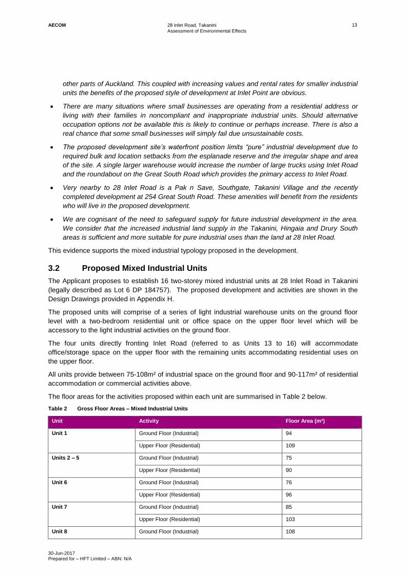
Proposed Mixed Industrial Units 3.2
The Applicant proposes to establish 16 two-storey mixed industrial units at 28 Inlet Road in Takanini
(legally described as Lot 6 DP 184757). The proposed development and activities are shown in the
Design Drawings provided in Appendix H.
The proposed units will comprise of a series of light industrial warehouse units on the ground floor
level with a two-bedroom residential unit or office space on the upper floor level which will be
accessory to the light industrial activities on the ground floor.
The four units directly fronting Inlet Road (referred to as Units 13 to 16) will accommodate
office/storage space on the upper floor with the remaining units accommodating residential uses on
the upper floor.
All units provide between 75-108m² of industrial space on the ground floor and 90-117m² of residential
accommodation or commercial activities above.
The floor areas for the activities proposed within each unit are summarised in Table 2 below.
Table 2 Gross Floor Areas – Mixed Industrial Units
Unit Activity Floor Area (m²)
Unit 1 Ground Floor (Industrial) 94
Upper Floor (Residential) 109
Units 2 – 5 Ground Floor (Industrial) 75
Upper Floor (Residential) 90
Unit 6 Ground Floor (Industrial) 76
Upper Floor (Residential) 96
Unit 7 Ground Floor (Industrial) 85
Upper Floor (Residential) 103
Unit 8 Ground Floor (Industrial) 108

AECOM
28 Inlet Road, Takanini
Assessment of Environmental Effects
30-Jun-2017 Prepared for – HFT Limited – ABN: N/A
14
Upper Floor (Residential) 117
Unit 9 Ground Floor (Industrial) 93
Upper Floor (Residential) 103
Units 10 Ground Floor (Industrial) 93
Upper Floor (Residential) 103
Unit 11 Ground Floor (Industrial) 92
Upper Floor (Residential) 102
Unit 12 Ground Floor (Industrial) 93
Upper Floor (Residential) 103
Units 13-16 Ground Floor (Industrial) 81
Upper Floor (Commercial/Office) 99
3.2.1 Development Staging
The Applicant intends to stage the construction of the development over a three year timeframe. The proposed stage is outlined in Table 3.
Table 3 Indicative Development Staging Timeframes
Year Block Units
1 A 1-7
2 B 8-12
3 C 13-16
All enabling works including earthworks and construction of servicing and connections will be undertaken within the first stage of development.
3.2.2 Materials and Finishes
The overall appearance of the buildings will be industrial/commercial in character but with a roofline
and some weatherboard sheathing to relate back to the adjacent residential activities of Longford
Park. The proposed indicative finishes will include:
- Weatherboard (on the top half of the upper floor).
- Schist veneer concrete panels (on lower half of upper floor and lower floor)
- Bonded aluminium fascia
- Boxed sunshade
The proposed colour palette includes neutral light brown, white and greys for the lower floor concrete
panels, dark brown for the upper floor concrete panels and dark navy blue for the garage doors.
3.2.3 Industrial Space Activities
Each unit will include light industrial floor space at ground level. The coupled nature of the upper floor with the industrial space below is intended to enable the use of this space for small scale light industrial activities which may not be viable in conventional larger scale light industrial developments. The types of small manufacturing and storage businesses envisaged to occupy the industrial warehouse spaces within each unit could include (but not limited to):
- Small workshop space;
- Boutique light industrial uses;

AECOM
28 Inlet Road, Takanini
Assessment of Environmental Effects
30-Jun-2017 Prepared for – HFT Limited – ABN: N/A
15
- Trade services;
- Light manufacturing; or
- E-Commerce
3.2.4 Residential Activities
Two bedroom, residential units are proposed on the upper floor of the building within Units 1 to 12. The residential units adjacent to the south western boundary (Units 1 to 12) will be orientated towards the esplanade reserve and the coastal marine area with enclosed balcony areas overlooking this area.
All residential units will be designed with acoustic insulation to achieve appropriate internal noise levels (refer Acoustic Assessment in Appendix F).
3.2.5 Commercial Office/Storage Space Activities
Ancillary commercial office/storage space is proposed on the upper floor of Units 13 to 16 to support the ground floor industrial activities.
Earthworks 3.3
The Engineering Report and Drawing A3 provided in Appendix I show the nature and scale of the
proposed earthworks.
Earthworks will occur over an approximate area of 3,721m² and volume of 750m³. Earthworks are
required to establish the new buildings and associated sealed yard area for parking, loading, access
and manoeuvring. A summary of the earthworks required is provided in Table 4 below.
Earthworks will be occurring within 25m of the coastal marine area within a Sediment Control
Protection Area as defined under the AUP(OiP).
Table 4 Earthworks Summary
Total Area 3,721m²
Total Volume 942.6m³
Total Volume (Cut to Fill) 0m³
Total Volume (Cut to Waste) 750m³
Total Volume (Imported Fill) 192.6m³
Maximum depth of cut 300mm
Maximum depth of fill 300mm
Appropriate sediment controls (including silt fences, a stabilised entrance and cleanwater diversion)
will be in place for the duration of the works in accordance with Auckland Council’s Technical
Publication 904 as shown on Drawing A3 in Appendix I.
The Detailed Site Investigation provided in Appendix D concludes that it is unlikely that HAIL activities
have occurred on the site and that historical land use activities do not appear to have significantly
impacted shallow soil materials at the site. However, soil required to be removed off-site during
earthworks may need to be disposed of at a licensed managed fill facility with appropriate laboratory
reports being provided.
4 Or other relevant guideline.

AECOM
28 Inlet Road, Takanini
Assessment of Environmental Effects
30-Jun-2017 Prepared for – HFT Limited – ABN: N/A
16
Site Servicing 3.4
The proposed development will be serviced by existing reticulated services within Inlet Road. The
Engineering Report and Plans provided in Appendix I describe the proposed site servicing for the site.
The Applicant has consulted with Veolia Water and Auckland Council’s Healthy Waters Team in
relation to the proposed wastewater, water and stormwater connections.
3.4.1 Wastewater, Water and Utilities
Water supply will be from the 150mm diameter water main on the grass berm within Inlet Road. There
is a fire hydrant within 40m of the site’s road frontage boundary. Veolia Water has confirmed that one
bulk water meter will be supplied to the site. Private meters for each unit will be administered by the
Body Corporate.
Wastewater connections will be established from the south eastern corner of the site. It is proposed to
upgrade the existing connection with a 150mm diameter pipe and extend this through the centre of the
site to service the new units. Right of entry is required from the neighbouring site at 26 Inlet Road to
upgrade this sewer connection.
3.4.2 Stormwater Management and Discharge
The site has a 300mm diameter stormwater pipe connection on its south eastern corner which passes
through the neighbouring site at 26 Inlet Road and connects to a 375mm diameter pipe crossing Inlet
Road. The Applicant’s Engineer has confirmed that the both of these pipes have adequate capacity to
service both the site and the neighbouring property at 26 Inlet Road should both sites be developed in
the future. Liaison has occurred with Auckland Council Development Engineer (Raj Kumar) who has
confirmed that stormwater mitigation (in terms of volume – detention and retention) is not required.
The new stormwater reticulation system within the site has been designed to service the proposed
development and will remain as a private system. The system will be maintained by the Body
Corporate. A Hynds offline Up-Flo Filter is proposed to collect and treat run-off from the new paved
area to achieve greater than 75% TSS5 removal. Further details of the proposed Hynds offline Up-Flo
filter are provided in the Engineering Report and Plans provided in Appendix I.
Parking, Loading & Access 3.5
3.5.1 Access
A single two-way access is proposed on the north eastern boundary of the site. It will have a width of
6.75m at the roadside footpath and a splay of 10.086m at the kerb.
3.5.2 Parking
The proposed development will collectively provide for 28 marked car parking spaces, including two
accessible car park spaces in accordance with Standard E27.6.2.3 of the AUP(OiP).
A total of ten ‘public/common’ parking spaces are proposed adjacent to the units for customer / visitor
use and 18 private parking spaces are proposed with a mix of internal and external spaces. The
allocation of parking spaces is provided in Table 5.
5 Total Suspended Solids

AECOM
28 Inlet Road, Takanini
Assessment of Environmental Effects
30-Jun-2017 Prepared for – HFT Limited – ABN: N/A
17
Table 5 Car park space allocation
Unit Internal Space(s) External Space(s)
Unit 1-7, 13-16 1 per unit -
8,9 & 12 - 1 per unit
10 & 11 - 2 per unit
Public/Common - 10 (total)*
* Includes 2 accessible car park spaces. ‘
Each of the units have sufficient internal space to provide additional internal private parking if
necessary.
3.5.3 Loading
One dedicated loading space is proposed adjacent to the vehicle entrance and Unit 16. The loading
bay will have dimensions of 3600mm wide and 11300mm long and complies with the standards under
Chapter E27 of the AUP(OiP). The loading space has been designed to accommodate a 8.3m truck.
3.5.4 Cycle Parking
Cycle parking is proposed in the common grass area between Units 7 and 8 for up to four spaces. Internal cycle parking will also be available within each unit.
Signage 3.6
A unit signboard is proposed within the front yard to the north of the proposed vehicle entrance. The
signboard will be free-standing and display details of each mixed industrial business. The signboard
will be 2.4m in height and 1.5m in width with a depth of 0.25m.
Vegetation Alteration and Landscaping 3.7
3.7.1 Vegetation Removal
An existing exotic street tree (less than 4m in height) situated adjacent to the site on Inlet Road is
required to be removed in order to establish the proposed development. The particular tree in question
is shown in Figure 20 below. The tree can be removed as a Permitted Activity under Rule E17.4.1(A9)
of the AUP(OiP), however will require asset approval from Auckland Council’s Community Parks and
Places Team to remove. As described in Section 5.0, the Applicant has undertaken preliminary
consultation with this Team in relation to the proposal and approval (in principle) has been provided.
As a condition of its removal, a replacement tree will be planted within the grass berm in a suitable
location on Inlet Road (location and species to be confirmed by Auckland Council).

AECOM
28 Inlet Road, Takanini
Assessment of Environmental Effects
30-Jun-2017 Prepared for – HFT Limited – ABN: N/A
18
Figure 20 Location of Street Tree to be removed

AECOM
28 Inlet Road, Takanini
Assessment of Environmental Effects
30-Jun-2017 Prepared for – HFT Limited – ABN: N/A
19
3.7.2 Landscape - Planting
A landscape plan is provided on Drawing 4 in Appendix H which has been developed with input from
Auckland Council Parks and in consultation with Ngati Tamaoho Trust. An indicative planting schedule
is included on this Drawing which includes a range of native ground cover, shrubs and specimen trees.
Two metres of planting/landscaping is proposed within the site along the road frontage to Inlet Road.
Rear yard landscaping 5m in width is proposed along the rear western and southern yards adjoining
Units 6 to 12. Landscaping will comprise of a range of native species including specimen and smaller
shrubs. Planter boxes are proposed in the western yard adjoining Units 1 to 5.
All landscaping will be implemented within the first planting season following the completion of works
at the site.
3.7.3 Landscape - Fencing Treatment
Fencing is proposed along the northern boundary which will comprise of 3m high precast concrete wall
(acoustic barrier) between the eastern façade of Unit 1 and Inlet Road to achieve sufficient visual and
acoustic screening from the neighbouring site at 25 Inlet Road. Fencing up to 1.8m in height is also
proposed on the northern boundary between the western façade of Unit 1 and Longford Park
Esplanade Reserve.
A two metre high metal screen fence and gate is proposed between Units 14 and 15 fronting Inlet Road.
A two metre high metal screen fence and automated gates are proposed at the vehicle entrance
between Unit 16 and the public car parking area.
Low pool fencing up to 1.5m in height is proposed along the common boundary with Longford Park
Esplanade Reserve and Inlet Road frontage.
Rubbish Storage Area 3.8
Rubbish storage areas are proposed internally within the industrial ground floor of each unit.
Unit Title Subdivision 3.9
It is proposed to undertake a unit title subdivision around each of the units within the proposed
development once it is constructed. Each unit will be owner-occupied and there will be common areas
allocated across the site for shared use which will be managed by the Body Corporate. The proposed
scheme plan is provided in Appendix J.
Consent Notice D306878.2 3.10
Consent Notice D306878.2 requires that the building foundations for any future building or structure on
the site be specifically designed by a Registered Engineer experienced in geotechnical engineering.
The Applicant will engage a Registered Engineer experienced in geotechnical engineering to design
the future foundations of the proposed units as part of the Building Consent stage to comply with this
legal encumbrance.

AECOM
28 Inlet Road, Takanini
Assessment of Environmental Effects
30-Jun-2017 Prepared for – HFT Limited – ABN: N/A
20
4.0 Consultation
Auckland Council 4.1
4.1.1 Auckland Council Regulatory Consents
Pre-Application Meeting
A Pre-Application Meeting was held with Council on 30 August 2016 (refer to Pre-Application Meeting
Minutes in Appendix K). Those in attendance were:
- Roneel Singh (Applicant’s Project Manager)
- Katie Round - AECOM (Applicant’s Planner)
- Peter Hill – Hill Design Engineering Ltd (Applicant’s Engineer)
- Phillip Maguire – HFT Ltd (Applicant)
- Barry Maxwell (Applicant’s Architect)
- Bryce Powell – Auckland Council (Council Planner)
- Joe Wolfgramm – Auckland Council (Council Planner)
- Alina Enovan – Auckland Council (Council Development Engineer)
Key items discussed at the meeting were:
- The site’s current and future light industrial zoning, including what kinds of activities are
generally provided for and what are not envisaged in the zone.
- The type of activity classification industrial ‘mixed industrial’ units fall under the AUP(OiP) (as
this activity is not specifically provided for in any zone).
- The activity status of the proposal under the AUP(OiP) – confirmed as Non-Complying and
subject to full public notification.
- Potential design considerations and mitigation required to demonstrate how the proposal will
address any significant adverse effects, including reverse sensitivity.
- Potentially affected properties.
- The role of Council’s Park team and the need to consult with them on the proposal given the
site’s proximity to the esplanade reserve.
- Stormwater, flooding, earthworks and servicing considerations.
- Traffic and parking considerations.
- Noise considerations.
- Specialist inputs required.
4.1.2 Auckland Council Community Parks and Places
The Applicant has consulted Steve Owens and Greg Lowe from Auckland Council’s Community Parks
and Places Team in relation to the proposed development. The purpose of this consultation was to
ensure that the proposed development achieved an appropriate interface with Longford Park
Esplanade Reserve in terms of amenity, public safety and on-going use of this area. A record of this
consultation is provided in Appendix K.
Key points of discussion were:
- The reserve area and existing land use activities within this space.

AECOM
28 Inlet Road, Takanini
Assessment of Environmental Effects
30-Jun-2017 Prepared for – HFT Limited – ABN: N/A
21
- The proposed extension of the walking and riding pathways across the Inlet.
- The ‘Pahurehure loop’ associated with the new additional motorway lane extensions and a
planned walking and bike riding lane across the Inlet.
- The existing plant species within and around the Inlet and the nature of plant species that would
be compatible for the proposed development. The esplanade was identified as an important
greenway link.
- The mangrove removal and removal of new mangrove re-growth.
- Proposed stormwater treatment options for the development.
Auckland Council Community Parks and Places Team has provided input into the plant species and
flora and fauna for the proposed landscaping interface between the site and adjoining esplanade
reserve. The final landscape plan has been provided to review.
4.1.3 Auckland Council – Development Engineering
As described in the Engineering Report in Appendix I, the Applicant has consulted with Auckland
Council’s Development Engineer with respect to the stormwater management system and connections
for the proposed development. Veolia Water has confirmed that the development can be
accommodated within their network.
Utility Providers 4.2
4.2.1 Veolia Water
As described in the Engineering Report in Appendix I, the Applicant has consulted with Veolia Water
with respect to the wastewater and water supply connections for the proposed development. Veolia
Water has confirmed that the development can be accommodated within their network.
Mana Whenua 4.3
The Applicant has consulted with local iwi representatives on multiple occasions through the Ngati
Tamaoho Trust in relation to the proposal. A record of this consultation is provided in Appendix K. In
summary, key matters discussed included:
- The nature of the proposal.
- The history of the Pahurehure Inlet, water quality and land use.
- Ensuring protection of the wider Manukau Harbour.
- The proposed stormwater management for the development, in particular stormwater
treatment measures.
- The role of Ngati Tamaoho Trust in terms of environmental guardianship and cultural matters.
No objections were raised in relation to the proposal. The Applicant has considered the feedback
received as a result of this consultation, in particular in terms of the proposed stormwater treatment
measures that have been incorporated into the design and proposed landscaping measures.
Adjacent Landowners 4.4
4.4.1 25 Inlet Road (Waste Management Services)
The Applicant has met with the property owners and operators of 25 Inlet Road (Waste Management Services).
Key issues raised by Waste Management Services were in relation to:

AECOM
28 Inlet Road, Takanini
Assessment of Environmental Effects
30-Jun-2017 Prepared for – HFT Limited – ABN: N/A
22
- Reverse sensitivity in terms of noise and odour and the potential complaints that may be received from the future occupants.

AECOM
28 Inlet Road, Takanini
Assessment of Environmental Effects
30-Jun-2017 Prepared for – HFT Limited – ABN: N/A
23
5.0 Status of Activity
Land Use & Discharge Consents 5.1
An assessment has been carried out in relation to the relevant rules under the AUP(OiP) and NES Soil
in Appendix L of this report. Resource consent is required for the proposed development under the
following Plans and Standards as outlined in Table 6 below. For the avoidance of doubt, the Applicant
seeks all necessary resource consents for the proposal whether or not they are specifically identified.
Table 6 Reasons for consent
Plan Consent Requirement
Auckland Unitary Plan
(Operative in Part)
Rule E8.4.1(A9)
Diversion and discharge of stormwater runoff from impervious areas greater than 1,000m²
and up to 5,000m² within an urban area, that complies with Standard E8.6.1 and Standard
E8.6.3.1 requires consent as a Controlled Activity.
Rule E11.4.1(A9)
Earthworks greater than 2,500m2 in a Business Zone within a Sediment Control Protection
Area requires consent as a Restricted Discretionary Activity.
Rule E12.4.1(A9) and C1.7(1)
Earthworks within a Coastal Protection Yard greater than 5m² and 5m³ requires consent as a
Discretionary Activity.
Rule H17.4.1(A3)
Establishment of 12 dwellings within industrial live-work units within the Light Industrial Zone
requires consent as a Non-Complying Activity.
Rule H17.6.4
Infringement to front yard setback requirements (northern boundary wall and free-standing
signage) requires consent as a Restricted Discretionary Activity.
Rule H17.6.4
Infringement to rear yard landscaping requirements along the western and south-western
boundaries of the site adjoining the esplanade reserve requires consent as a Restricted
Discretionary Activity.
Rule E38.4.1(A4)
Unit title subdivision complying with the Controlled Activity Standards under E38.7.2.3
requires consent as a Controlled Activity.
Signage Bylaw 2015 5.2
An assessment against Auckland Council’s Signage Bylaw 2015 with respect to the new free standing
signage that is proposed within the front yard is provided in Appendix L. In summary the proposed
signage will comply with the applicable standards and is considered a Permitted Activity.
Summary 5.3
Overall, resource consent is sought from Auckland Council as a Non-Complying Activity.

AECOM
28 Inlet Road, Takanini
Assessment of Environmental Effects
30-Jun-2017 Prepared for – HFT Limited – ABN: N/A
24
6.0 Assessment of Actual or Potential Effects on the
Environment
Subject to the provisions of any policy statement or plan, any person preparing an assessment of the
effects on the environment should consider the following matters:
(a) any effect on those in the neighbourhood and, where relevant, the wider community
including any socio-economic and cultural effects:
(b) any physical effect on the locality, including any landscape and visual effects:
(c) any effect on ecosystems, including effects on plants or animals and any physical
disturbance of habitats in the vicinity:
(d) any effect on natural and physical resources having aesthetic, recreational, scientific,
historical, spiritual, or cultural, or other special value for present or future generations:
(e) any discharge of contaminants into the environment, including any unreasonable emission
of noise and options for the treatment and disposal of contaminants:
(f) any risk to the neighbourhood, the wider community, or the environment through natural
hazards or the use of hazardous substances or hazardous installations.
Statutory Requirements 6.1
Section 88(2) of the Resource Management Act 1991 (the ‘Act’) stipulates that an application shall
include an assessment of environmental effects prepared in accordance with the Fourth Schedule and
be in such detail as corresponds with the scale and significance of the effects that the activity may
have on the environment.
Matters to be assessed by Council when assessing an application for resource consent under Section
104(1) of the RMA include (subject to Part 2), any actual and potential effects on the environment and
any relevant objectives, policies, rules or other provisions of a Plan or Proposed Plan.
The following adjacent properties in Table 7 are excluded from the assessment of effects on the wider
environment:
Table 7 Adjacent Properties
Address & Legal Description
25 Inlet Road, Takanini [Lot 1 DP 184757 BLK XIV OTAHUHU SD – SUBJ TO & INT IN ESMTS]
23 Inlet Road, Takanini [Lot 3 DP 184757]
26 Inlet Road, Takanini [Lot 5 DP 184757]
21 Inlet Road, Takanini [Lot 2 DP 184757]
Longford Park Esplanade Reserve
Overall, the proposed activity is a Non-Complying Activity. Under Section 104B, when considering an
application for resource consent for a Non-Complying Activity, the Consent Authority may grant or
refuse the application. If it grants the application, the Consent Authority may impose conditions under
Section 108.
Permitted Baseline 6.2
As prescribed by Sections 95D(1)(b) and 95E(2)(a) of the RMA, when determining the extent of
adverse effects of an activity, the Consent Authority ‘may disregard an adverse effect if a rule or
national environmental standard permits an activity with that effect’. Accordingly, the permitted

AECOM
28 Inlet Road, Takanini
Assessment of Environmental Effects
30-Jun-2017 Prepared for – HFT Limited – ABN: N/A
25
baseline is described as those activities which could be legally established as a Permitted Activity, or
have an existing resource consent.
A full assessment of the Permitted Activities associated with this application is provided in Appendix L.
In summary, the key permitted activities associated with the proposal are as follows:
Earthworks up to 2,500m3 – Rule E12.4.1(A9);
Street tree removal less than 4m in height and 400mm in girth within road reserve -
E17.4.1(A9);
Offices accessory to the primary activity on site - H17.4.1(A17);
Industrial Activities - H17.4.1(A33);
New Buildings - H17.4.1(A37).
The following details those elements which are critical to establishing the permitted baseline when
determining the extent of adverse effects associated with this proposal.
Actual & Potential Positive Effects on the Environment 6.3
The proposal will result in the following positive effects on the environment:
- It will establish a use of the site that interacts with and maintains the amenity values of the adjoining public open space and coastal marine area.
- The south western orientation of the residential units will provide passive surveillance over the esplanade reserve contributing to public safety and well-being.
- The inclusion of residential activities will contribute to the greater use of the adjoining esplanade reserve area.
- The proposal will contribute to the diversity of the Region’s housing supply, whilst also enabling businesses to operate from the site that contribute to the local economy.
Actual & Potential Adverse Effects on the Environment 6.4
6.4.1 Land & Soil Resources
As described in Section 4.2 of this report, earthworks of approximately 750m³ in volume over an area
of 3721m² are proposed on the site to establish a level building platform, parking spaces, manoeuvring
area, infrastructure and access to the units. The proposed earthworks will remain clear of the existing
utility services located in the surrounding area and will occur across the whole site. Excess fill will to
be removed from the site.
It is anticipated that the earthworks will take up to six months to complete and will be undertaken
during the earthworks season. Appropriate sediment control measures will be put in place in
accordance with Technical Publication 90 (or subsequent equivalent standards) which includes silt
fences to minimise sediment run-off from the site during construction (refer to Drawing A3 in Appendix
I).
The proposed earthworks will occur within proximity to the coastal marine area (Pahurehure Inlet)
which is approximately 20m from the southern and western boundaries of the site. As such, the site is
within a Sediment Control Protection Area. The implementation of erosion and sediment control
measures will reduce the risk of sediment discharge into the coastal environment. The site is not
affected by any flood hazards or major overland flowpaths based on Auckland Council’s GIS Mapping,
and the proposed area of works on the site will generally avoid the identified minor overland flowpath6
6 Contributing catchment area less than 4,000m²

AECOM
28 Inlet Road, Takanini
Assessment of Environmental Effects
30-Jun-2017 Prepared for – HFT Limited – ABN: N/A
26
on the south eastern area of the site. Furthermore the gentle slope of the site generally enables the
more effective implementation of erosion and sediment control measure compared with steeper
contours.
The proposed earthworks will generally maintain the existing topography of the site which is primarily
flat to gently sloping7. The proposed works area will be progressively stabilised and sealed with
paving, buildings or landscaping following the earthworks.
Geotechnical/Instability
Instability risk has previously been identified on the site which has been recorded on the Certificate of
Title in the form of an encumbrance to this effect (D306878.2). The encumbrance requires that
building foundations for any buildings or structures on the site (as well as other adjoining properties)
be specifically designed by a Registered Engineer experienced in geotechnical engineering. A
Geotechnical Assessment8 has previously been prepared for the site and adjoining land at 26 Inlet
Road in 2015 when it was proposed to develop the site for office and warehouse uses. A copy of this
report is appended to the Engineering Report provided in Appendix I.
The findings of this report are still relevant to consider with respect to this application in terms of the
development proposed. The assessment concludes that the site is underlain by competent ground
conditions and can be developed, providing certain measures are applied during earthworks and
construction. Such measures include:
- Ensuring that all un-retained cut batters be graded at no steeper than 1(v) and 2(h) and be no
higher than 1.0m. Cut batters should be located at least the cut batter height from the building.
- Ensuring that all un-retained fill batters be graded at no steeper than 1(v) on 3(h) and be no
higher than 1.0m. Fill batters should be located at least the fill batter height from the building.
- All structural fill should be inspected by a suitably qualified person.
- All cut and fill batters should be top soiled and grassed/planted on completion.
- Ensuring all topsoil layers are striped and removed from site and exposed fill be proof rolled with
a heavy roller.
- Any identified weak zones should be undercut and replaced with suitably compacted engineered
fill.
- On-site supervision of site works by a suitably qualified person.
The Applicant agrees to adhere to the recommendations of this report and further geotechnical input
will be obtained at the building consent stage. Providing the recommendations from the Geotechnical
Assessment are adhered to the potential adverse effects in terms of stability as a result of earthworks
will be less than minor.
Contaminated Land
The proposed works area was identified as a potential HAIL site. A Site Investigation (Contamination)
has been prepared for the site to provide an understanding of the nature and extent of the historical
land use activities on the site which may have impacted soil quality within the proposed development
footprint (refer to Appendix D). Section 8.0 of the Site Investigation (Contamination) concludes that
historical land use activities do not appear to have significantly impacted shallow materials at the site
and that it is unlikely that HAIL activities have occurred on the site. All soil samples taken as part of
this investigation complied with the adopted acceptance criteria, excluding four soil samples which
7 Slope angles less than 5°
8 Form Steel – 24 Inlet Road, Takanini: Geotechnical Investigation Report for a Proposed Waterhouse and Office, prepared by
Ground Consulting Limited, dated 30 June 2015, REF: R2019-1.

AECOM
28 Inlet Road, Takanini
Assessment of Environmental Effects
30-Jun-2017 Prepared for – HFT Limited – ABN: N/A
27
returned soil concentrations of heavy metals slightly above Auckland Background Concentrations.
Accordingly, the proposed earthworks on the site are considered to be of a relatively low risk to human
health or the environment. Nonetheless a conservative approach will be adopting in the disposal of fill
material which to be taken of off-site which will be sent to a licenced facility capable of accepting such
material. Based on the findings of the Site Investigation report and proposed soil disposal methods,
the adverse effects on the environment in terms of disturbance of contaminated land will less than
minor.
Heritage
The proposed earthworks will not be occurring within any known or identified heritage areas.
However, this area has not been subject to any archaeological surveys. The Applicant agrees to a
condition recommending that Accidental Discovery Protocols be applied for the duration of the
earthworks should there be any discovery of any heritage artefacts.
Summary
Based on the above, it is considered that the adverse effects on the environment in terms of land and
soil resources will be less than minor.
6.4.2 Amenity and Character
Coastal Marine Area and Public Open Space
The site is situated directly adjacent to the coastal marine area (Pahurehure Inlet) and a public open
space (Longford Park Esplanade Reserve). Conventional light industrial developments tend to have
relatively low amenity quality. Accordingly, light industrial forms of development has the potential to
have adverse amenity effects in this location, despite the underlying light industrial zoning of the site.
Careful consideration has been made by the Applicant to ensure that the proposed development
protects and enhances the amenity values of this environment in terms of its design, layout and types
of activities proposed within the site. The Applicant has consulted with Auckland Council’s Community
Parks and Places Team with respect to the proposed development to inform the design of the
interface with the esplanade reserve.
The proposed mixed industrial units will be setback at least 5m from the common boundary of the
esplanade reserve and will comply with the height in relation to boundary controls required on this
boundary. Landscaping treatments will be provided within the rear yard adjoining the esplanade
reserve. The landscaping will comprise of a combination of native species as shown on Drawing 4 in
Appendix H. An indicative planting schedule has been provided which has been informed by
consultation with Auckland Council Community Parks and Places Team and local iwi representatives.
The planting schedule includes a range of native species with a combination of specimen trees,
shrubs and grasses commonly found within the locality. It is considered that the landscaping along the
reserve interface will contribute positively to the surrounding area and the provision of mature trees will
soften the building and hard surfaces when viewed from the wider area. A maintenance schedule has
been included as part of this application to ensure that the planting remains in its entirety within the
development following construction.
The residential activities within Units 1 to 12 are orientated towards the esplanade reserve and have
enclosed balconies which overlook this space. This provides a degree of passive surveillance over
this space which would not be easily achieved if the site were to be developed as a conventional light
industrial development.
Signage is proposed within the front yard of the site (refer to Drawings 1 and 14 in Appendix H). It has
been designed to comply with the 2015 Signage Bylaw and will display information relating to the site
address and the associated businesses occupying the proposed units. The proposed signage will be
legible and consistent with what is currently present in the surrounding industrial area and replaces an

AECOM
28 Inlet Road, Takanini
Assessment of Environmental Effects
30-Jun-2017 Prepared for – HFT Limited – ABN: N/A
28
existing sign that is currently present in this location of the site. The signage proposed will not detract
from the external appearance of the development and it will not be visually intrusive to the surrounding
area.
Industrial Character and Land Supply
The site is zoned for light industry under the AUP(OiP). The Applicant recognises that there is a
limited supply of industrial zoned land in the Auckland Region, therefore the development of industrial
zoned land should be prioritized for industrial type activities where appropriate. However, as detailed
previously, the Applicant also recognises the sensitive location of the site and necessity to provide a
development which does not adversely impact upon the adjoining public open space and coastal
marine areas. Furthermore, the site is of a relatively small size, irregular shape and has asymmetric
dimensions. Accordingly, the site is considered to be impractical for conventional light industrial
activities such as warehousing and manufacturing which generally require relatively large building
footprints and store yard areas.
In response the Applicant has proposed a development that responds to the industrial character of the
site in a scale and form while also accommodating for the adjacent coastal and open space
environments. From the street front, the proposed development will have a modern industrial design
and be of a similar character to the existing built environment in the surrounding areas. The proposed
mixed industrial units will be finished with a combination of schist veneer concrete panels,
weatherboard, concrete panels and metal garage doors. The southern and western exterior of the
buildings provide a softer façade with the above floor residential units orientated towards the coastal
boundaries. As such, these exteriors will not be visible from the street front and will therefore not
detract from the overall industrial character of the area. Accordingly, it is considered that the overall
visual amenity will be significantly improved as a result of the proposed development.
The ground floor of the proposed mixed industrial units will be used for light industrial purposes which
are consistent with the types of activities occurring within the Light Industry zone. The space provided
and the design of the units enables a variety of small scale industries to be located within these units.
The proposed units have been designed in a manner that could enable them to be retrofitted in the
future for other industrial activities. The industrial space provided will be of a size and shape that is
adequate for operation, movement and storage functions of the business activities occupying these
areas. The four units fronting Inlet Road (Units 13 to 16) will contain offices/storage ancillary to the
ground floor industrial units. Ancillary offices are generally provided for as Permitted Activities within
the Light Industry zone providing they do not exceed 100m² or comprise of more than 30% of the
gross floor area of a development. Accordingly, these types of activities are common with industrial
areas.
Residential Amenity, Reverse Sensitivity, Health and Safety
The proposed mixed industrial units will be adjacent to light industrial activities to the north and east of
the site on Inlet Road which generally do not require the same level of amenity as residential activities.
There is potential for reverse sensitivity effects to occur as a result of having residential activities
situated amongst existing and future light industrial activities (both within and beyond the site) on Inlet
Road. The reverse sensitivity effects are primarily associated with noise, odour, safety and visual
amenity which are assessed below.
Noise
An Acoustic Assessment has been prepared and provided with the application in Appendix F. The
Acoustic Assessment specifically addresses the potential reverse sensitivity effects associated with
the proposed residential activities in terms of noise. It is noted that the existing noise levels currently
received at the site are significantly less than the limit of 65 dB LAeq permitted under the AUP(OiP).
However, for the purposes of the assessment, the acoustic assessment assumes the ‘worse-case

AECOM
28 Inlet Road, Takanini
Assessment of Environmental Effects
30-Jun-2017 Prepared for – HFT Limited – ABN: N/A
29
scenario’ where potential increases in noise levels could occur as a result of new
development/redevelopment within the area.
There are no explicit acoustic requirements for dwellings in the Light Industry zone under the
AUP(OiP). Accordingly, the acoustic requirements from other Business zones in the AUP(OiP)
(namely Rule E25.6.10.1) have been adopted in order to ensure that the proposed development
achieves an acceptable level of internal noise within each mixed industrial unit in order to provide for
residential amenity and well-being and prevent noise complaints from occupants.
The façade construction of the proposed residential units has been based on the maximum permitted
noise emissions that could occur from neighbouring sites, particularly from the north, east and south.
The proposed recommended façade construction materials to be adopted are described in Table 4
and Figure 3 of the Acoustic Assessment in Appendix F. Mechanical ventilation will also be installed
within each unit (in accordance with Clause G4 of the New Zealand Building Code) to allow for
external windows and doors to be closed.
Operationally, the proposed development may generate noise levels from vehicle movements, light
industrial activity and external mechanical plant associated with ventilation. It is anticipated that noise
generated from the proposed industrial activities within the site will comply with the noise standards
under the Light Industry zone in the AUP(OiP) by a significant margin due to the scale and type of
activities occupying each of the units.
Odour
The neighbouring property to the north at 25 Inlet Road is currently occupied by a waste management
refuse station operated by Waste Management Limited. The existing operations on site must adhere
to the specific land use and air discharge consent conditions applying under 7528:WPTPGEN and
R/REG/2015/1977 respectively which address potential odour related effects on adjacent properties.
In particular, Condition 9 of R/REG/2015/1977 requires the following:
“Beyond the boundary of the site there shall be no odour, dust, particulate, smoke, ash or fume
caused by discharges from the site which, in the opinion of an enforcement officer is noxious,
dangerous, offensive or objectionable.”
Furthermore, odour related effects by industrial activities discharging to air in the wider locality are
addressed by general standards under E14.6 of the AUP(OiP) which require that all discharges from a
site:
“must not cause noxious, dangerous, offensive or objectionable odour, dust, particulate, smoke or
ash beyond the boundary of the premises where the activity takes place.”
Based on the above, odour related effects associated with reverse sensitivity can be addressed
through the existing controls under the AUP(OiP).
Visual Amenity & Use
The proposed mixed industrial units will be situated at least 2m from the road frontage boundary
shared with Inlet Road with 12 of the units being situated more than 10m from the road frontage and
sufficiently separated from., the existing wider industrial area to the north and east. Whilst there are
units adjoining the neighbouring properties of 25 and 28 Inlet Road, careful consideration has been
made in terms of the interfaces with these properties and the potential for them to be developed up to
their common boundary with the application site in the future, in particular the site at 26 Inlet Road
which is yet to be developed. Units 13 and 12 will not have any glazing on their south eastern
facades. Unit 1 will not have glazing on its northern façade, however it is considered that any future
development on the neighbouring property at 25 Inlet Road will generally be localised around the
existing building footprint in the northern half of this property due to the shape of the site and its legal
access.

AECOM
28 Inlet Road, Takanini
Assessment of Environmental Effects
30-Jun-2017 Prepared for – HFT Limited – ABN: N/A
30
The residential activities within Units 1 to 12 are largely orientated towards the esplanade reserve and
coastal marine area. Accordingly, it is considered that these units have a sufficient level of separation
from the neighbouring industrial site by Inlet Road (at least 50m). As discussed in this section,
landscaping is proposed across the development which will contribute to the overall visual amenity of
the site. The residential units on the upper floor have been designed to be distinctly separate from the
industrial activities on the ground floor.
Summary
Based on the above, it is considered that the adverse effects on the environment in terms of amenity,
health and safety will be less than minor.
6.4.3 Traffic Generation, Parking, Manoeuvring, Loading & Access
A Traffic Assessment has been prepared which assesses the proposed parking, manoeuvring, loading
and access for the proposed development against the transportation requirements under the
AUP(OiP) (refer to Appendix M).
Parking & Manoeuvring
There is no particular parking requirements specified for the ‘live-work’ activity under the AUP(OiP). In
the absence of specific parking requirements, parking numbers have been determined based on the
scale and type of activities proposed within each unit in terms of residential and industrial activities.
Parking is provided for both visitors and occupants of each unit.
Based on the parking requirements under Rule E27, the proposal is considered to comply with the
required number of parking spaces where parking resources are shared between under an owner-
occupied scenario. The proposed number of spaces is considered to be adequate with respect to the
proposal and avoids, remedies and mitigates potential adverse effects on the transport environment
for the following reasons:
- The parking provided has been based on the anticipated number of staff working within each
mixed industrial unit (and anticipated visitor numbers) and complies as a whole with the parking
requirements under Chapter E27 of the AUP(OiP);
- One carpark for each unit is considered to be appropriate for the type of expected business
activities and the size of the units (which will all be owner-occupied);
- Cycle parking will be provided within the site with 4 external short-term spaces provided between
Units 7 and 8 and the ability to provide a secure cycle parking space within each unit on the
ground floor. The number provided exceeds that required under the AUP(OiP);
- All parking spaces have adequate manoeuvring space and will be located on formed sealed
areas on site;
- Inlet Road is a ‘minor’ road and therefore has low traffic volumes and provides approximately 60
on-street carparks within a 200m catchment, which can adequately cater for trips generated by
this proposal;
- Public transport facilities are available within walking distance of the site. The 33 and 360x bus
routes run along Great South Road within 400 metres of the site providing good public transport
options for occupants, visitors and staff; and
- Two accessible parking spaces will be provided within the site in accordance with the Building
Code standards under Section 5.4 of the Building Code.
Loading
A dedicated loading space will be provided adjacent to Unit 16.

AECOM
28 Inlet Road, Takanini
Assessment of Environmental Effects
30-Jun-2017 Prepared for – HFT Limited – ABN: N/A
31
Adequate turning areas have been provided for trucks accessing the loading bay areas on site
Access
The proposed development will be accessed by a new vehicle access on the northern boundary of the
site within the cul-de-sac of Inlet Road. The proposed vehicle crossing will meet the AUP(OiP)
requirements in terms of width and dimension. Adequate sightlines are provided directions and given
that the access is situated within a cul-de-sac where traffic volumes are low, traffic safety conflicts are
expected to be minimal.
Road Network
The impact of the traffic generated from the proposed development will be negligible as Inlet Road is
classified as a ‘Local/Minor Road’ which does not receive any through traffic. The nature of activities
proposed on the site will not generate significant numbers of vehicle trips above what this road
currently accommodates on a daily basis. As described in the Traffic Assessment, based on the total
number of parking spaces and nature of activities proposed for the development, the level of traffic
generation at peak times is expected to be 26 trips in the AM peak and 28 trips in the PM peak9.
The wider connecting road network to Inlet Road currently carries volumes of traffic which are
incomparably higher than the number of trips likely to be generated by the proposed development.
The morning peak and evening peak traffic volumes on Great South Road are 711 and 837
respectively. The trips generated by the proposed development range between 3% and 4% of the
overall Great South Road traffic, and can be adequately handled by the roundabout and signals
leading onto Great South Road without adversely impacting their existing operation. Therefore the
vehicle trips generated from the proposed development will have no effect on the surrounding road
network.
Based on the above, it is considered that effects on the environment in terms of transportation will be
less than minor.
6.4.4 Utilities & Servicing
The proposed mixed industrial units will be serviced by existing utilities within the road reserve already
established as part of the original subdivision. A development of this scale and nature is anticipated
within this area and it is considered that the proposed activities can be adequately accommodated by
existing infrastructure in the locality. The Applicant has consulted with Council’s Development
Engineer in relation to the proposal as described in Section 5.0 of this report and in Appendix I and K.
The Applicant has also consulted with Veolia Water in terms of the proposed water and wastewater
connections and has confirmed with Veolia that the existing network adjacent to the site has adequate
capacity to accommodate the proposed development (refer to Appendix I).
The stormwater infrastructure requirements for the proposed development are addressed in Section
8.4.5 of this report.
The adverse effects on the environment in terms of network utilities will be less than minor.
6.4.5 Stormwater Infrastructure Capacity, Operation & Provision
There are currently no stormwater connections or infrastructure within the site given that it is
undeveloped and primarily grassed.
A stormwater assessment has been provided in the Engineering Report in Appendix I which confirms
that the proposed new impervious areas can be provided for in terms of stormwater discharge
9 Based on a combination of General Light Industrial and Low Rise Residential description from ITE Trip Generation Rates 9
th
Edition

AECOM
28 Inlet Road, Takanini
Assessment of Environmental Effects
30-Jun-2017 Prepared for – HFT Limited – ABN: N/A
32
following the proposed development. Developments of this scale and impervious area are generally
anticipated within this area given the scale of the land parcels, associated activities and buildings.
There is an existing reticulated stormwater line within the adjoining road reserve within Inlet Road. A
capacity check of this line by the Applicant’s Engineer has concluded that the existing stormwater line
has limited capacity, however that a limited level of stormwater could potentially be discharged into
this line if on-site management measures were incorporated into the development.
The total new impervious area on the site will be 3010m² (80%). Stormwater discharged from the new
paved areas will be treated with a Hynds offline Up-Flo Filter10
prior to being directed into the existing
reticulated pipe network within the road reserve.
Based on the above, the adverse effects on the environment in terms of stormwater infrastructure
capacity, operation and servicing will be less than minor.
6.4.6 Water Quality & Quantity
Stormwater generated from the proposed development on site is proposed to discharge directly into
the existing reticulated network. The proposed stormwater discharge has the potential to ultimately
result in adverse effects on the receiving environment as a result of the quality and quantity of
stormwater which is being discharged from the catchment.
The proposed stormwater discharge will service a catchment of approximately 3,721m² comprised of
approximately 3,010m² of impervious area across the site. Currently, the entire site is pervious and
covered in grass, with the exception of the existing building.
The new buildings on site will include colour steel roofing and, based on the proposed activities to be
undertaken, the remainder of the impervious area is considered low-risk with regards to contamination
generation. Run-off from the new paved areas on site will be directed will be directed through a Hynds
Offline Up-Flo Filter11
prior to being directed into the existing reticulated pipe network within the road
reserve. Accordingly, the contamination and sediment concentrations which are discharged from the
catchment are likely to be low from the proposed development.
Overall, the stormwater volume control measures proposed for the entire site achieve the best
practicable option in terms of managing stormwater quantity and quality and have been design in
accordance with Auckland Council design standards (Technical Publication 10) and in consultation
with Auckland Council’s Stormwater team. A majority of the new impervious areas being established
(ie. the new paved areas) will be subject to stormwater treatment measures designed in accordance
with Council design standards to manage the quality of stormwater discharge from the proposed
development. Accordingly, the proposed stormwater discharge and impacts on water quality will result
in less than minor adverse effects on the receiving environment.
6.4.7 Construction - Noise, Vibration and Traffic
Construction works will be carried out during normal business hours in accordance with the
Construction Noise Standards under the AUP(OiP), as confirmed in the Acoustic Assessment provided
in Appendix F.
Construction traffic will be appropriately managed by the Contractor to minimise impact on the
surrounding road network. Appropriate traffic management measures will be applied as required
addressing the ingress and egress via controlled access during peak hours, the agreed route to and
from the proposed works area and installation and maintenance of erosion and sediment control
features (ie. stabilised entry point and wheel-wash facilities). No vibration is anticipated during
construction as no rock-breaking will be required.
10
To greater than 75% TSS removal 11
To greater than 75% TSS removal

AECOM
28 Inlet Road, Takanini
Assessment of Environmental Effects
30-Jun-2017 Prepared for – HFT Limited – ABN: N/A
33
The adverse effects on the environment as a result of construction related activities will be less than
minor.
6.4.8 Natural Hazards
The site is generally free of natural hazards12
, with the exception of a very minor overland flowpath13
on its south eastern corner and minor instability issues. Coastal inundation and sea-level rise hazards
affect adjoining properties, however do not encroach into the site or directly adjoin it.
The proposed development will not exacerbate the existing flows of the minor overland flowpath as the
proposed buildings will largely remain clear of this flowpath and the affected area will be grassed. The
proposed buildings will be constructed in accordance with the recommendations made in the previous
Geotechnical Assessment prepared for the site (provided in Appendix E), and the conditions of the
Consent Notice D306878.2 which require that the building foundations be specifically designed by a
Registered Engineer experienced in geotechnical engineering.
Overall the adverse effects on the environment in terms of natural hazards will be less than minor.
6.4.9 Cultural Heritage
The proposed development and earthworks will not occur within or adjacent to any known
archaeological, geological or cultural heritage features listed under the AUP(OiP) and the Cultural
Heritage Inventory. As a precaution, given that the site and adjoining area have not been surveyed by
an Archaeologist, the Applicant proposes an accidental discovery protocol condition in the event that
any heritage items are uncovered during site works.
6.4.10 Subdivision
The Applicant proposes to undertake a unit title subdivision of the proposed development once it is
constructed. It is considered that the assessment undertaken above addresses the relevant
considerations with respect to any unit title subdivision including natural hazards (stability, inundation,
flooding), site servicing requirements, building platforms and legal access. The proposed layout and
unit title plan ensures that each unit will remain owner-occupied and that there are adequate common
areas across the site for general access and use.
Overall, it is considered that the adverse effects on the surrounding environment as a result of the
subdivision itself will be negligible.
Summary of Adverse Effects 6.5
Overall, it is considered that the adverse effects on the surrounding environment as a result of the
proposed activities will be less than minor.
12
1% AEP Flood Plains, Overland Flowpaths, 1m Sea Level Rise Coastal Inundation 13
Contributing catchment area of up to 4,000m²

AECOM
28 Inlet Road, Takanini
Assessment of Environmental Effects
30-Jun-2017 Prepared for – HFT Limited – ABN: N/A
34
7.0 Notification Assessment
Public Notification 7.1
7.1.1 Section 95A
Section 95A of the RMA provides the ability for a consent authority in its discretion to publicly notify an
application. It also sets out when a consent authority must publicly notify an application. Section 95A
states:
(1) A consent authority may, in its discretion, decide whether to publicly notify an application for a resource consent for an activity.
(2) Despite subsection (1), a consent authority must publicly notify the application if—
(a) it decides (under section 95D) that the activity will have or is likely to have adverse effects on the environment that are more than minor; or
(b) the applicant requests public notification of the application; or
(c) a rule or national environmental standard requires public notification of the application.
(3) Despite subsections (1) and (2)(a), a consent authority must not publicly notify the application if—
(a) a rule or national environmental standard precludes public notification of the application; and
(b) subsection (2)(b) does not apply.
(4) Despite subsection (3), a consent authority may publicly notify an application if it decides that special circumstances exist in relation to the application.
Under Rule H17.5(1)(a) the application is required to be publicly notified. Accordingly, no further
notification is required.

AECOM
28 Inlet Road, Takanini
Assessment of Environmental Effects
30-Jun-2017 Prepared for – HFT Limited – ABN: N/A
35
8.0 Section 104 - Statutory Assessment
The proposal must be considered under Section 104 of the RMA. Section 104 sets out the matters to
be considered when assessing resource consents. It requires that subject to Part 2 (Purpose and
Principles) regard must be had to the following specified matters:
(a) any actual and potential effects on the environment of allowing the activity; and
(b) any relevant provisions of
(i) a national environmental standard:
(ii) other regulations:
(iii) a national policy statement:
(iv) a New Zealand coastal policy statement:
(v) a regional policy statement or proposed regional policy statement:
(vi) a plan or proposed plan; and
(c) any other matter the consent authority considers relevant and reasonably necessary to
determine the application.
The assessment of actual and potential effects on the environment above in Section 8.0 of this report
finds that the adverse effects on the surrounding environment will be less than minor.
Part 2 Resource Management Act 1991 8.1
Section 5 - Purpose
The purpose of the RMA is stated in Section 5(1) as being “to promote the sustainable management of
natural and physical resources. Sustainable Management means:
(2) In this Act, “sustainable management” means managing the use, development, and protection of natural and physical resources in a way, or at a rate, which enables people and communities to provide for their social, economic, and cultural wellbeing and for their health and safety while –
(a) Sustaining the potential of natural and physical resources (excluding minerals) to meet the reasonably foreseeable needs of future generations; and
(b) Safeguarding the life-supporting capacity of air, water, soil, and ecosystems; and
(c) Avoiding, remedying, or mitigating any adverse effects of activities on the environment.”
The proposal is considered to achieve the purpose of the RMA as it will provide for the development of the site in a manner which avoids, remedies or mitigates adverse effects.
Section 6 – Matters of National Importance
The following matters of national importance are relevant to this proposal under Section 6 of the RMA:
(a) the preservation of the natural character of the coastal environment (including the coastal marine area), wetlands, and lakes and rivers and their margins, and the protection of them from inappropriate subdivision, use, and development:
(d) the maintenance and enhancement of public access to and along the coastal marine
area, lakes, and rivers:
(e) the relationship of Maori and their culture and traditions with their ancestral lands, water,
sites, waahi tapu, and other taonga:
The proposal has been developed to respond to the adjacent public open space (Longford Park
Esplanade Reserve) and coastal marine area (Pahurehure Inlet), recognising the social, cultural

AECOM
28 Inlet Road, Takanini
Assessment of Environmental Effects
30-Jun-2017 Prepared for – HFT Limited – ABN: N/A
36
and amenity values which these elements provide. A mixed industrial development comprised of
light industrial, commercial and residential land use elements have been adopted as this is
considered to better integrate with the adjacent public open space and coastal marine area.
Section 7 – Other Matters
The relevant Section 7 matters that the proposal that shall have particular regard to are:
(b) the efficient use and development of natural and physical resources:
(c) the maintenance and enhancement of amenity values:
(f) maintenance and enhancement of the quality of the environment:
The proposal is considered to be an efficient use of an industrial zoned site which is currently
underutilised and vacant. It provides for light industrial uses and does not preclude the site (or any
other adjoining properties) for being used by other light industrial activities in the future. The proposed
development will maintain amenity values within the surrounding area and will continue to comply with
the front yard landscaping controls along the road frontage boundary. The sediment control measures
adopted during earthworks will ensure that sediment run-off from the site is minimised during
construction. The proposed vegetated swale will provide on-site treatment, improving stormwater
quality and discharge from the site from the proposed development area.
Section 8 – Treaty of Waitangi
Matters under Section 8 relate to the acknowledging the principles of the Treaty of Waitangi. As
described in Section 5.0 of this report, the Applicant has undertaken consultation with local iwi groups
in relation to the application recognising the cultural significance of the Pahurehure Inlet (and wider
Manukau Harbour) to local Mana Whenua.
National Environmental Standards 8.2
National environmental standards are regulations issued under Section 43 of the Resource
Management Act and apply nationally. The standards are for the purposes of maintaining a clean and
healthy environment within New Zealand. Relevant National Policy Statements to consider in relation
to this application are identified and assessed below.
8.2.1 National Environmental Standard for Assessing and Managing Contaminants in
Soil to Protect Human Health
The National Environmental Standard for Assessing and Managing Contaminants in Soil to Protect
Human Health is a nationally consistent set of planning controls and soil values. It ensures that any
land affected by contaminants in soil is appropriately identified and assessed before it is developed
and if necessary, remediated or the contaminants contained to make the land safe for human use.
There are no specific objectives and policies under this Standard. However it is considered that the
contamination assessment provided in the Site Investigation (Contamination) report in Appendix D
adequately addresses the provisions under this Standard and confirms that the land is safe for human
use and development. A further assessment in relation to contaminated land is provided under the in
Section 11.4.2 within the Contaminated Land chapter provisions of the AUP(OiP).
Overall, the proposal is consistent with the provisions of this Standard.
National Policy Statements 8.3
National Policy Statements are instruments issued under Section 52(2) of the Resource Management
Act 1991 and state objectives and policies for matters of national significance. Relevant National
Policy Statements to consider in relation to this application are identified and assessed below.

AECOM
28 Inlet Road, Takanini
Assessment of Environmental Effects
30-Jun-2017 Prepared for – HFT Limited – ABN: N/A
37
8.3.1 National Policy Statement on Urban Land Development Capacity 2016
This National Policy Statement on Urban Land Development Capacity 2016 (‘NPSULDC’) provides
direction to decision makers under the Resource Management Act 1991 on planning for urban
environments. It recognises the national significance of well-functioning urban environments, with
particular regard to ensuring that local authorities through their planning, both:
enable urban environments to grow and change in response to the changing needs of the
communities, and future generations; and
provide enough space for their populations to happily live and work. This can be both through
allowing development to go “up” by intensifying existing urban areas, and “out” by releasing land
in greenfield areas.
This national policy statement covers development capacity for both housing and business,
recognising that mobility and connectivity between both are important in achieving well-functioning
environments and planning’s role in promoting accessibility and connectivity between housing and
business.
The key objectives and policies of the NPSULDC which are relevant to the site and proposal are
assessed in Appendix N. With consideration to these objectives and policies the proposal is
considered to achieve the objectives of the NPSULDC in a manner which is consistent with the
relevant policies.
8.3.2 New Zealand Coastal Policy Statement 2010
The New Zealand Coastal Policy Statement (NZCPS) is a NPS which aims to achieve the purpose of
the RMA as it relates to the coastal environment. The ‘Coastal Environment’ is defined within Policy
1(2) of the NZCPS as those areas in which (amongst other) the following elements are significant:
“coastal processes, influences or qualities are significant”
“inter-related coastal marine and terrestrial systems” and
“elements and features that contribute to the natural character, landscape, visual qualities or
amenity values”.
Within this context, the site is considered to constitute part of the coastal environment and is therefore subject to the objectives and policies of the NZCPS. The key objectives and policies of the NZCPS which are relevant to the site and proposal are assessed in Appendix N. With consideration to these objectives and policies the proposal is considered to achieve the objectives of the NZCPS in a manner which is consistent with the relevant policies.
Relevant Objectives and Policies 8.4
An assessment has been carried out in relation to the relevant planning instruments which are detailed
and assessed below. The specific objectives and policies referred to in this section are quoted in the
Statutory Assessment Table provided in Appendix N.
8.4.1 Auckland Regional Policy Statement
The relevant objectives and policies of the Auckland Regional Policy Statement are detailed below.
Chapter 2 – Regional Overview & Strategic Objectives
The proposed development establishes additional industrial activities on an under-developed site
which is currently zoned for industrial purposes. Based on the design, nature and appearance of the
proposed development, it does not limit or restrict any existing or future industrial activities occurring in
the surrounding area and is therefore considered to be consistent with the strategic objectives of this
Plan.

AECOM
28 Inlet Road, Takanini
Assessment of Environmental Effects
30-Jun-2017 Prepared for – HFT Limited – ABN: N/A
38
8.4.2 Auckland Unitary Plan (Operative in Part)
The following section assesses the proposed activities against the relevant objectives and policies of
the AUP(OiP). As the application is for a non-complying activity a comprehensive assessment has
been provided against all relevant objectives and policies, including those of the Light Industry Zone,
Regional Policy Statement and development related chapters. The relevant objectives and policies
are listed in Table 7. A full assessment against these objectives and policies is provided in Table 3 of
Appendix N.
In summary, the proposal has been developed to respond to the objectives and policies of the
AUP(OiP) as they relate to the site. The site is located in the Light Industry Zone, forms part of the
‘coastal environment’ due to its proximity to the coastal marine area (Pahurehure Inlet) and shares a
common boundary with public opens space (Longford Park Esplanade Reserve). Accordingly, the
Applicant has developed a ‘mixed industrial’ design for the site to create a transitional zone, balancing
the contrasting character and values associated with the public open space and coastal, and light
industrial environments which divide the site.
The proposed ‘mixed industrial’ land use pattern will provide for a mix of light industrial, commercial
(likely office/storage) and residential land use activities. The predominant land use for the site will be
light industrial activities and it is intended that all commercial and residential land use will be accessory
to the primary industrial activities of the site. However, the layout, orientation and design of the
proposal have been developed to avoid visual impacts of the development on the open public space
and coastal environment while maintaining the character of the existing industrial built environment.
This land use typology and design is considered to better integrate with the adjacent public open
space and coastal marine area, compared with a conventional industrial development
The proposed residential and commercial (office/storage) elements of the development have been
designed to avoid reverse sensitivity effects which could constrain the establishment and operation of
light industrial activities in the local area. In particular, the units have been designed to avoid the
effects of noise, vibration and odour.
Overall, the proposal is considered reflect the transitional location of the site between a light industrial
area and the coastal environment and enables development which is sensitive to the contrasting
values associated with this context. Accordingly, the proposed development is consistent with the
objective and policies of the AUP(OiP).

AECOM
28 Inlet Road, Takanini
Assessment of Environmental Effects
30-Jun-2017 Prepared for – HFT Limited – ABN: N/A
39
Table 8 Relevant Objectives and Policies of the AUP(OiP)
Chapter Objectives Policies
B2. Regional Policy Statement – Urban Growth and Form
B2.2.1(1), B2.2.1(2), B2.2.1(3), B2.2.1(4), B2.2.1(5), B2.3.1(1), B2.3.1(2), B2.3.1(3), B2.4.1(4), B2.5.1(1), B2.5.1(3), B2.7.1(2), B2.7.1(3)
B2.2.2(1), B2.3.2(1), B2.3.2(2), B2.3.2(3), B2.3.2(5), B2.4.2(7), B2.4.2(11), B2.5.2(7), B2.5.2(8), B2.5.2(9), B2.5.2(10), B2.7.2(7)
B6. Regional Policy Statement – Mana Whenua
B6.2.1(1), B6.2.1(2), B6.3.1(1), B6.3.1(2)
B6.2.2(1), B6.3.2(3)
B7. Regional Policy Statement – Natural Resources
B7.4.1(2), B7.4.1(2), B7.4.1(4), B7.4.1(5), B7.4.1(6)
B7.4.2(1), B7.4.2(7), B7.4.2(8), B7.4.2(9)
B8. Regional Policy Statement – Coastal Environment
B8.2.1(2), B8.2.1(3), B8.3.1(1), B8.3.1(2), B8.3.1(7), B8.4.1(1), B8.4.1(3)
B8.2.2(4), B8.3.2(1), B8.3.2(7), B 8.4.2(1)
B10. Regional Policy Statement - Environmental Risk
B10.2.1(1), B10.2.1(2), B10.2.1(3), B10.2.1(4), B10.2.1(5), B10.2.1(6), B10.4.1(1)
B10.2.2(5), B10.2.2(7), B10.2.2(8), B10.4.2(1), B10.4.2(2), B10.4.2.2(3)
E1. Water Quality and Integrated Management
E1.2(3) E1.3(8), E1.3(9), E1.3(10), E1.3(11), E1.3(12), E1.3(13), E1.3(14), E1.3(26)
E11. Land Disturbance (District)
E11.2(1), E11.2(2), E11.2(3) E11.3(1), E11.3(2), E11.3(3), E11.3(4), E11.3(5), E11.3(6), E11.3(7)
E12 Land Disturbance (Regional)
E12.2(1) E12.3(1), E12.3(2), E12.3(3), E12.4(4), E12.4(5), E12.4(6)
E17. Trees in Roads E17.2(1), E17.2(2), E17.2(3) E17.3(1), E17.3(2), E17.3(3), E17.3(4)
E18. Natural Character of the Coastal Environment
E18.2(1), E18.2(2) E18.3(3), E18.3(4)
E25. Noise and Vibration E25.2(1), E25.2(2), E25.2(3), E25.2(4)
E25.3(1), E25.3(2), E25.3(3), E25.3(4), E25.3(5), E25.3(6), E25.3(7), E25.3(10)
E26. Infrastructure E26.2.1(4), E26.2.1(9) E26.2.2(1), E26.2.2(2), E26.2.2(3), E26.2.2(4), E26.2.2(5), E26.2.2(6)
E27. Transport E27.2(1), E27.2(3), E27.2(4), E27.2(5)
E27.3(3), E27.3(8), E27.3(9), E27.3(14), E27.3(15), E27.3(16), E27.3(17), E27.3(18), E27.3(20)
E30. Contaminated Land E30.2(1) E30.3(2)
E36. Natural Hazards and Flooding
E36.2(2), E36.2(5) E36.3(1), E36.3(3), E36.3(4), E36.3(29), E36.3(30), E36.3(31), E36.3(32), E36.3(33)
E38. Subdivision – Urban E38.2(1), E38.2(2), E38.2(5), E38.2(6), E38.2(10)
E38.3(1), E38.3(2), E38.3(6), E38.3(16), E38.3(18), E38.3(19), E38.3(20), E38.3(22), E38.3(23)
E40. Temporary Activities E40.2(2), E40.2(3) E40.3(1), E40.3(3), E40.3(6)
H17. Light Industry Zone H17.2(1), H17.2(2), H17.2(3), H17.2(4)
H17.3(1), H17.3(2), H17.3(3), H17.3(4), H17.3(5), H17.3(6), H17.3(7)

AECOM
28 Inlet Road, Takanini
Assessment of Environmental Effects
30-Jun-2017 Prepared for – HFT Limited – ABN: N/A
40
Relevant Assessment Criteria (Section 104(1)(b)) 8.1
The following assessment criteria and controls under the AUP(OiP) are considered relevant in the
assessment of this application as outlined in Table 9 below. These have been addressed in Section
8.0 of this report.
Table 9 Relevant Assessment Criteria
Activity Assessment Criteria
Auckland Unitary Plan (Operative in Part)
Stormwater – Discharge and Diversion E8.7.1 & E8.7.2
Land Disturbance - Regional E11.8.1 & E11.8.2
Land Disturbance - District E12.8.1 & E12.8.2
Transport E27.8.1 & E27.8.2
Light Industry Zone H17.8.1 and H17.8.2
Subdivision - Urban E38.11.1 and E38.11.2
Other Matters 8.2
8.2.1 Auckland Plan
The Auckland Plan is a long-term plan for the development of Auckland up until 2040. The purpose of
this Plan is to contribute to Auckland’s social, economic, cultural and environmental well-being through
a comprehensive and long-term 30-year strategy. The AUP(OiP) is a tool for implementing the
Auckland Plan and the assessment provided under the AUP(OiP) in Section 11.4.2 is also relevant to
consider in the context of this Plan.
Relevant chapters under this Plan in relation to the proposed development are identified and assessed
below. As a whole, the proposed development generally accords with the priorities outlined within this
Plan for the following reasons described below and that described in the AUP(OiP) assessment in
Section 11.4.2.
Chapter 6 (Auckland’s Economy):
- Priority 1: Grow a Business-Friendly and Well-Functioning City
The proposed development will enable the establishment of 16 small scale businesses of a light
industrial nature on an existing vacant site situated within a well-established light industrial area. It is
considered to be an efficient use of resources and will contribute to the local economy. The site is
located in an area characterised by an agglomeration of light industrial and commercial uses.
Agglomeration clusters are considered to increase productivity and provide an opportunity for other
supporting commercial and industrial businesses to take advantage of this context which contributes to
establishing a business-friendly and well-functioning area.
Chapter 7 (Auckland’s Environment):
- Priority 2: Sustainably manage natural resources
- Priority 3: Treasure our coastline, harbours, islands and marine areas
- Priority 4: Build resilience to natural hazards
The proposed development will require relatively minimal earthworks given its existing topography and
is not subject to any hazards that would detrimentally affect the on-going use of the site for the

AECOM
28 Inlet Road, Takanini
Assessment of Environmental Effects
30-Jun-2017 Prepared for – HFT Limited – ABN: N/A
41
activities proposed. The proposed development will have an active interface with the coast promoting
use and enjoyment of this space. The site’s interface with the coast will also be planted with native
trees and shrubs characteristic with what is present within the surrounding area.
Chapter 10 (Urban Auckland):
- Priority 1: Realise quality, compact urban environments
- Priority 2: Demand good design in all development
- Priority 3: Create enduring neighbourhoods, centres and business areas
A Site Context Analysis was prepared to inform the design of the proposal (refer to Appendix G). The
design of the proposed development has taken into consideration the site’s identified existing
constraints and opportunities as well as the activity related requirements associated with the
development in terms of acoustic insulation, outlook space, access, parking, loading and workshop
space as described in the Design Statement provided in Appendix G. The proposed native planting
proposed along the site’s western and south western interfaces will contribute to the visual amenity of
the wider coastal area to the south and west.
Chapter 11 (Auckland’s Housing):
- Priority 1: Increase house supply to meet demand
- Priority 2: Increase housing choice to meet diverse preferences and needs
- Priority 3: Improve the quality of existing and new housing
- Priority 4: Improve housing affordability and the supply of affordable housing
The site is located within the Papakura District adjacent to existing urban light industrial activities. The
proposed development will provide for light industrial activities (in accordance with the relevant zone
provisions applying to the site under the AUP(OiP)) as well as supporting residential and commercial
(office) activities. The inclusion of residential activities as part of this development supports the
priorities identified under this chapter in terms of increasing housing supply, choice, quality and
affordability.
Chapter 12 (Auckland’s Physical and Social Infrastructure):
- Priority 1: Optimise, integrate and align network utility provision and planning
- Priority 2: Protect, enable, align, integrate and provide social and community infrastructure for present and future generations
The proposed development can be adequately serviced by the existing physical infrastructure located
within the area in terms of wastewater, stormwater and water networks. The site is conveniently
located near social and community infrastructure adjacent to and along Great South Road in Takanini.
Chapter 13 (Auckland’s Transport):
- Priority 1: Manage Auckland’s Transport as a Single System
- Priority 2: Integrate Transport Planning and Investment with Land-Use Development
The site is situated in an accessible location within an existing urban industrial area of Auckland which
has good connections to regional and local transport routes. Furthermore, the site is conveniently
located within an area of Takanini which is readily accessible to community and education facilities
and commercial, hospitality and retail activities.

AECOM
28 Inlet Road, Takanini
Assessment of Environmental Effects
30-Jun-2017 Prepared for – HFT Limited – ABN: N/A
42
8.2.2 Papakura Local Board Plan 2014-2017
The site is situated within the Papakura Local Board area which extends from Drury in the south to
Alfriston in the north and includes, Takanini, Hingaia, Red Hill, Pahurehure and the current Papakura
town centre.
The Local Board Plan14
is a three-year plan reflecting community priorities, preferences and guiding
the following:
decisions on local activities, projects and facilities
input into the regional strategies and plans prepared by Auckland Council
interfaces with other agencies that play a key role in local areas including community groups,
central government agencies and council-controlled organisations.
Based on the assessment provided in this section above, the Papakura Local Board Plan supports the
following outcomes which are relevant to the proposal:
- A skilled workforce for local jobs
- Treasured for its environment and heritage
- Strong, safe and healthy communities
8.2.3 Economic Development Strategy 2012
The Economic Development Strategy advances the economic chapter in the Auckland Plan. It is a
regional document and sets out a 10-year strategy to achieve the economic directives under the
Auckland Plan. Priority 1 of this Strategy is relevant to consider in the assessment of this proposal:
Grow a Business-Friendly and Well-Functioning City
An assessment of this priority has been provided in Section 11.6.1 above.
8.2.4 Local Transport Improvements
The following local transport improvements are relevant to consider in relation to the proposed
development and how it may be further supported by the surrounding transport network in the future.
Mill Road / Redoubt Road Improvements
Auckland Transport has plans to upgrade the Mill Road and Redoubt Road corridor in the foreseeable
future (timing to be confirmed). The upgrade will support future growth of the area and provide future
growth of the area and provide improved transport access for Manukau, Flat Bush, Takanini (where
the site is located), Papakura and Drury in particular. This will support an alternative transport route to
the site from the wider area.
State Highway 1 Southern Road Improvements
The New Zealand Transport Agency has plans to upgrade the adjacent existing motorway network
within proximity to the site to support the growth anticipated within the southern region of Auckland.
Tironui Train Station
8.2.5 Auckland Transport is also currently investigating the option of establishing a new train station approximately 800m walking distance from the site (Tironui Station).
14
A new local board plan is currently being drafted and consulted on. The new plan will be adopted in October 2017.

AECOM
28 Inlet Road, Takanini
Assessment of Environmental Effects
30-Jun-2017 Prepared for – HFT Limited – ABN: N/A
43
9.0 Section 106 – Subdivision
Under Section 106, a Consent Authority may refuse to grant a subdivision consent, or may grant a
subdivision consent subject to conditions if it considers that:
(a) the land in respect of which a consent is sought, or any structure on the land, is or is likely to
be subject to material damage by erosion, falling debris, subsidence, slippage, or inundation
from any source; or
(b) any subsequent use that is likely to be made of the land is likely to accelerate, worsen, or
result in material damage to the land, other land, or structure by erosion, falling debris,
subsidence, slippage, or inundation from any source; or
(c) sufficient provision has not been made for legal and physical access to each allotment to be
created by the subdivision.
As described within this report, the proposed subdivision satisfies the above requirements for the
following reasons:
- A Geotechnical Assessment of the site has confirmed that it can be developed, subject to
specific recommendations and supervision by a Registered Engineer experienced with
geotechnical engineering;
- The site is not affected by coastal inundation or flood hazards; and
- Sufficient provision has been made for legal and physical access to the units within the site.
10.0 Section 104D – Gateway Test
Under Section 104D(1), despite any decision made for the purpose of Section 95A(2)(a)15
in relation to
adverse effects, a Consent Authority may grant a resource consent for a Non-Complying Activity only
if it is satisfied that either:
(a) The adverse effects of the activity on the environment (other than any effect to which Section 104(3)(a)(ii)
16 applies) will be minor; or
(b) The application is for an activity that will not be contrary to the objectives and policies of –
(i) the relevant plan, if there is a plan but no proposed plan in respect of the activity; or
(ii) the relevant proposed plan, if there is a proposed plan but no relevant plan in respect of the activity; or
(iii) both the relevant plan and the relevant proposed plan, if there is both a plan and a proposed plan in respect of the activity.
As described within this report, the proposal satisfies both of the above requirements for the following
reasons:
- As assessed in section 6.4 of this AEE any adverse effects will be less than minor; and
- As assessed in Section 9.0 if this AEE the proposal is consistent (will not be contrary) to the
relevant objectives and policies of the relevant plans.
15
Public notification – effects on the environment are likely to be more than minor. 16
Any effect on a person who has given written approval to the application.

AECOM
28 Inlet Road, Takanini
Assessment of Environmental Effects
30-Jun-2017 Prepared for – HFT Limited – ABN: N/A
44
11.0 Conclusion
This assessment of effects has been prepared in support of an application for the proposed mixed
industrial unit development at 28 Inlet Road, Takanini.
Overall, the proposal requires resource consent as a Non-Complying Activity under the AUP(OiP).
The key findings of this report are that the potential adverse effects on the environment are less than
minor and that there are no adversely affected persons as a result of the proposed development.
Granting resource consent to this activity is considered a sustainable outcome for this environment
that will meet the purpose and principles of the RMA and there is no reason to refuse consent for the
following reasons:
The proposed building and associated landscaping will contribute positively to the visual amenity
of the surrounding industrial area as well as the adjoining esplanade reserve and coastal
environment, and
The proposed development will not result in any potential reverse sensitivity issues that cannot be
mitigated, and
Appropriate sediment control measures will be applied on site (in accordance with Technical
Publication 90) to limit any sediment run-off from the site, and
The adverse effects on the wider environment will be less than minor, and
There will be no adversely affected persons, and
The proposal is consistent with the relevant objectives and policies of the Auckland Regional
Policy Statement and Auckland Unitary Plan (Operative in Part), and
The proposal is consistent with the purpose and principles of the Resource Management Act
1991.

AECOM
28 Inlet Road, Takanini
Assessment of Environmental Effects
30-Jun-2017 Prepared for – HFT Limited – ABN: N/A
Appendix A
Certificate of Title

AECOM
28 Inlet Road, Takanini
Assessment of Environmental Effects
30-Jun-2017 Prepared for – HFT Limited – ABN: N/A
Appendix B
Planning Maps

AECOM
28 Inlet Road, Takanini
Assessment of Environmental Effects
30-Jun-2017 Prepared for – HFT Limited – ABN: N/A
Appendix C
Site Locality Maps

AECOM
28 Inlet Road, Takanini
Assessment of Environmental Effects
30-Jun-2017 Prepared for – HFT Limited – ABN: N/A
Appendix D
Contamination Assessment

AECOM
28 Inlet Road, Takanini
Assessment of Environmental Effects
30-Jun-2017 Prepared for – HFT Limited – ABN: N/A
Appendix E
Geotechnical Memo

AECOM
28 Inlet Road, Takanini
Assessment of Environmental Effects
30-Jun-2017 Prepared for – HFT Limited – ABN: N/A
Appendix F
Acoustic Assessment

AECOM
28 Inlet Road, Takanini
Assessment of Environmental Effects
30-Jun-2017 Prepared for – HFT Limited – ABN: N/A
Appendix G
Site Context Analysis and Design Statement

AECOM
28 Inlet Road, Takanini
Assessment of Environmental Effects
30-Jun-2017 Prepared for – HFT Limited – ABN: N/A
Appendix H
Design Drawings

AECOM
28 Inlet Road, Takanini
Assessment of Environmental Effects
30-Jun-2017 Prepared for – HFT Limited – ABN: N/A
Appendix I
Engineering Report & Drawings

AECOM
28 Inlet Road, Takanini
Assessment of Environmental Effects
30-Jun-2017 Prepared for – HFT Limited – ABN: N/A
Appendix J
Scheme Plan

AECOM
28 Inlet Road, Takanini
Assessment of Environmental Effects
30-Jun-2017 Prepared for – HFT Limited – ABN: N/A
Appendix K
Consultation

AECOM
28 Inlet Road, Takanini
Assessment of Environmental Effects
30-Jun-2017 Prepared for – HFT Limited – ABN: N/A
Appendix L
Rules Assessment

AECOM
28 Inlet Road, Takanini
Assessment of Environmental Effects
30-Jun-2017 Prepared for – HFT Limited – ABN: N/A
Appendix M
Transport Assessment

AECOM
28 Inlet Road, Takanini
Assessment of Environmental Effects
30-Jun-2017 Prepared for – HFT Limited – ABN: N/A
Appendix N
Statutory Assessment