Embed Size (px)
Citation preview
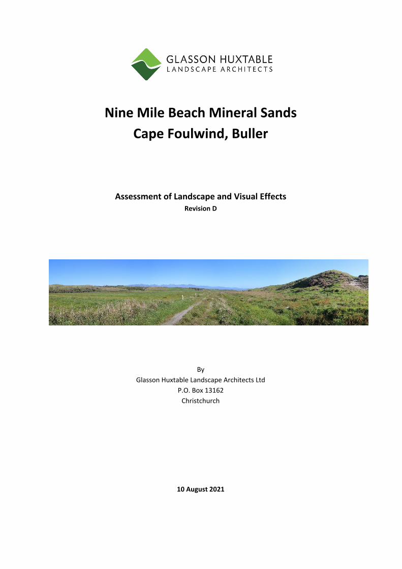
Nine Mile Beach Mineral Sands
Cape Foulwind, Buller
Assessment of Landscape and Visual Effects Revision D
By
Glasson Huxtable Landscape Architects Ltd
P.O. Box 13162
Christchurch
10 August 2021
1 2112 Nine Mile Beach Mineral Sands, Cape Foulwind, West Coast Assessment of Landscape and Visual Effects, Rev D. GHLA August 2021
Document Quality Assurance Title Nine Mile Beach Mineral Sands, Cape Foulwind, Buller
Assessment of Landscape and Visual Effects Prepared by Chris Glasson Reviewed by Andrew King Status: Revision D Date: 10 August 2021
2 2112 Nine Mile Beach Mineral Sands, Cape Foulwind, West Coast Assessment of Landscape and Visual Effects, Rev D. GHLA August 2021
1) INTRODUCTION
Westland Mineral Sands Limited has engaged Glasson Huxtable Landscape Architects to
undertake a landscape and visual assessment of the minerals sands excavation and
processing site located in the coastal dune area at Nine Mine Beach, Okari Road, Cape
Foulwind.
The landscape assessment identifies the landscape character of the context, the significance
of the place in terms of the RMA, the landscape and visual effects during and at the
completion of the mining operation, as well as identifying mitigation measures.
A graphic supplement augments the assessment, displaying viewpoints, and location data.
A site visit was made on 7th and 8th April 2021 during fine weather conditions.
Relevant previous planning and design projects in the Buller region have included:
● Review of all the existing and past Solid Energy New Zealand Limited’s mines on the
Denniston and Stockton plateaux;
● Subdivisions at Charleston, Woodpecker Bay and Cape Foulwind;
● Te Kuha mine, 1995 on behalf of Buller District Council;
● Escarpment mine for L&M Mining;
● Gully restoration at Cape Foulwind;
● Okari lagoon subdivision
2) THE PROPOSAL
Westland Mineral Sands is applying for consent to extract ilmenite, garnet and the possible
extractions of lesser concentrations of other minerals and then processing on site. The
mining operation will be limited to the inland dune with the processing and operations on
pastoral farmland in between the coastal dunes and the inland dune. Access to the site will
be reached from Okari Road and then a private road to the site. Mining of any wetland area
will be avoided and will primarily be undertaken in the inland dune system. Topsoil will be
removed and stockpiled, then the material excavated and transported by truck to the
processing plant in the centre of the site.
The processing plant will be a substantial structure measuring 17m in height and there will
also be associated building and loading facilities, all of which will be located on a 1.3 ha site.
3 2112 Nine Mile Beach Mineral Sands, Cape Foulwind, West Coast Assessment of Landscape and Visual Effects, Rev D. GHLA August 2021
The site will be mined and rehabilitated progressively with no more than 5 ha disturbed at
any one time. This will consist of recontouring the land to reflect the previous formation and
zoning or hydroseeding it in pasture grass. Water used in the processing plant will be from
Blind Creek, its tributaries and ground water discharge of this water will be into settling
ponds and released to ground.
The processed heavy mineral concentrate will be trucked to the port in Westport for
transport. The mining duration will be approximately 5‐7 years, although resource consent
will be sought for a 10 year period.
2.1 MINING METHODOLOGY
The mine methodology will include a work plan that highlights the following components:
equipment to be used and quarrying related activities,
area of topsoil stripping and stockpile locations,
new areas of land disturbance,
access tracks,
exploration sites,
other disturbances with the current area,
extent of the working pit,
rehabilitation works throughout the mine period,
measures to ensure slope stability, provision for runoff and drainage,
any other site works in the consent area.
3) LANDSCAPE CONTEXT
The site is located south of Cape Foulwind on a large and flat coastal plain with a backdrop
of high hills and incised by the Buller, Totara and Okari Rivers, that flow across the plain.
Much of this landscape has been remodelled for pastoral grazing purposes, although there
are remnants of vegetation, such as the site itself, even though the vegetation is in a
recovering phase. Quarries are prevalent in the area, for stone and silica. The Okari Lagoon
itself is near to the site and this is a result of the Okari River backing up before reaching the
sea. Even though it is a remote area, there are farm buildings, houses, and baches nearby to
the site, as well as being located across the plain and down the coastline south of Tauranga
4 2112 Nine Mile Beach Mineral Sands, Cape Foulwind, West Coast Assessment of Landscape and Visual Effects, Rev D. GHLA August 2021
Bay. Elsewhere in the district are examples of extractive industries, like the now redundant
cement works and associate pits.
The purpose of this description about the context of its locality is to highlight the diversity of
the landscape and activity. While there are wild and rugged coastal landscapes, there are
examples of extractive and farming industries established here since the early settlement
days. This is the dichotomy of the Buller region. The Okari Lagoon and coastline area is a
place of high and moderate landscape value due to the mix of waterbodies, coastline,
grassland, wetland, low forest and farming activities.
4) THE SITE
The Mineral Sands site is a very discrete place between two lines of sand dunes associated
with adjacent remnant forest. Within the sand formation are heavy minerals deposited on
wave cut terraces carried out of the basement mudstone and siltstones at the times of high
sea level with marine incursion. The incoming sea has cut the terrace in the mudstone and
concentrated heavy mineral on the beaches. Beach sand and minerals were redistributed to
form adjacent sand dunes.
The Nine Mile Beach environment is a lengthy coastline between the rocky headland
dividing the beach from Tauranga Bay and at the southern end of the beach is the Okari
Lagoon, a large tidal inlet. Coastal action has formed a continuous dune system set back
from the coastline. These dunes are of high proportions and form an almost impenetrable
barrier to access the hinterland, until north of Okari Lagoon where the landscape flattens
out.
Within these dunes, and facing the coastline, are a number of buildings (approx 12) which
are both permanent houses and baches, and then a farmhouse and buildings at the
southern end. All are nestled into the dunes, each having their own access drive. On the east
side of these dunes is a pastoral landscape of a wetland (Okari Road Swamp), and a
podocarp‐hardwood forest containing kahikatea, manuka, mahoe, flax and cabbage trees.
This is located at the northern end of the mine site, while further south the lowland has
been developed for farming purposes.
The site is bordered on the east side by a secondary dune system of reasonably high
proportions. Blind Creek flows through a gap in these dunes to the south and then to Okari
5 2112 Nine Mile Beach Mineral Sands, Cape Foulwind, West Coast Assessment of Landscape and Visual Effects, Rev D. GHLA August 2021
Lagoon. Immediately east, and on the lower slope of the dunes, is a healthy podocarp‐
hardwood forest consisting of totara, rimu, kahikitea, mahoe, tree fern, five finger, flax and
cabbage tree. This vegetation is located in the gullies and streams, while the plateaux areas
have been cleared for grazing.
Throughout this lowland there is a pastoral area of the site, which includes grassland, weedy
growth (eg willow wood) and sedge. Immediately north of the proposed mining area and
east of the Okari Road swamp is an isolated house located on a higher part of the dune
system.
5) VEGETATION
The mine area, between the coastal dune and secondary dune system is a substantially
modified landscape, while on the north and east boundaries are stands of native vegetation.
For the reminder, the present day swampland reflects the change according to man induced
activities. Existing on the site are sand dunes, swamps, creek, drainage channel and forest.
Although before farming activities the vegetation on the flats would have been dominated
by a podocarp forest and swamp vegetation. The latter is existing today in the northern
sector of the site. Today the flats have been drained and cattle/dairy grazing exists.
6) RMA MATTERS
6.1 NATURAL CHARACTER
Section 6 (a) of the RMA refers to Natural Character. This occurs in greater to lesser degrees
in a continuum from the pristine to the modified nature of landform, water surface, and
vegetation cover. Natural character of the landform is dependent on natural elements,
patterns and processes.
For the Okari site there is a need to assess the effect of the mining potential on the natural
character of the location, both the land and coastline. This site is a result of coastal elements
of dunes, back of dune swampland, stream and riparian strip and coastal vegetation.
The landform remains intact, but the vegetation has been modified with its clearance from
the flat area behind the foredunes and the land disturbance of humping and hollowing.
6 2112 Nine Mile Beach Mineral Sands, Cape Foulwind, West Coast Assessment of Landscape and Visual Effects, Rev D. GHLA August 2021
The built environment consists of access tracks, baches (adjacent to the site but on the west
side of the coastal dunes), farm fences, powerlines, and the Okari Road beyond the site, and
farm buildings south of the site.
The landscape of this location generally exhibits a high value of naturalness due to the intact
landforms, but the main reason for its downgraded status from outstanding is due to the
removal of forest vegetation on the swampland and the farming activity.
The mine will be accessed via Okari Road, off which the northern site access road will be
connected to. The mine will not influence the natural character of the coastline as it is
located eastward of the coastal dunes. This coastline is modified with a collection of houses
and baches and road.
6.2 OUTSTANDING NATURAL FEATURES AND LANDSCAPE
Section 6(b) of the RMA requires “the protection of outstanding natural features and
landscapes”
The Buller District Council does not list any outstanding areas in its Plan. The council
combined with the two other West Coast Councils to undertake a Natural Character and
Landscape assessments of the West Coast by Brown NZ. This study never became a public
document, but it did evaluate the coastal strip and this site was within the study boundary.
However the site and adjacent coastline were never accorded “outstanding” status.
6.3 AMENITY VALUES
Under section 7c of the Resource Management Act, regard must be shown for "the
maintenance and enhancement of amenity values." Many of the issues discussed under
natural character can also affect amenity values such as landform and landcover.
These amenity values can be influenced by such factors as viewing position (roads or
walking tracks), who is viewing it (recreationalists or travellers), the degree of change in the
landscape a viewer can accommodate, and the value inhabitants and travellers place on a
location.
Potential visibility of the proposed mining development will now be assessed for the short
to long‐term effects on the amenity value of the location. The visual catchment of the
proposed mine development will include only one public place, on Okari Road at the
7 2112 Nine Mile Beach Mineral Sands, Cape Foulwind, West Coast Assessment of Landscape and Visual Effects, Rev D. GHLA August 2021
southern end, near to the causeway. At the least there is one possible eastward view over
the mine from a bach on the west side of the coastal dune.
6.4 VIEWPOINTS
The visual effects of the mine on the visual amenity have determined from the following
public viewpoints:
(i) Viewpoint 1: Okari Road (south end).
South of the private farm buildings, on Okari Road, a viewpoint of the mine development
can be gained. The distance to the mine boundary will be 1.3km and to the processing plant
will be 1.6km. The latter will be the most visible part of the mine due to the 17m height of
the processing plant, although the structure will give an open and light appearance and will
be viewed at a significant distance. In terms of the visibility of the mine operation itself,
from this viewpoint it will be difficult to discern the mine itself as it will be below existing
ground level, and movement of workers and machinery will be obscured by the surrounding
ground level between the preparation and rehabilitation places.
The movement of the trucks to and from the site will not be visible from this viewpoint. Only
on the public road between the mine and the port of Westport will the transport be visible,
and then intermittently. Any adverse landscape and visual effects of the mine development
and operation for its duration will be very low. (See appendix 1 for an explanation of the
landscape and visual effects ratings). A low level of adverse effect is one where there are
less than minor adverse effects. (See Graphic Supplement, Public Viewpoint 3)
(ii) Viewpoint 2: Okari Road (north end)
A public viewpoint exists of the northern access route to the site off, Okari Road. This is a
gravel track which will be upgraded with a gravel top course. All vehicles will use this route
on an ongoing basis, including any heavy vehicles during the construction phase. There will
be an increase in vehicles and machinery using Okari Road and the western part of the
adjoining private road. This will include movement and noise of vehicles, and glare from
head lights during night‐time activity, before entering or exiting the coastal dunes. No view
of the site can be appreciated due to the presence of the coastal duneland, which exists for
the entire western boundary of the site. (See Graphic Supplement, Public Viewpoint 1)
8 2112 Nine Mile Beach Mineral Sands, Cape Foulwind, West Coast Assessment of Landscape and Visual Effects, Rev D. GHLA August 2021
(ii) Private Viewpoints (West)
There are a number of houses and baches located on the western side of the coastal dunes
along Okari Road. None of these buildings have direct views of the mine to the east of the
dunes because the dunes are interconnected and are much higher than the location of the
houses. The houses are orientated to the west to make the most of the coastline views.
There are five houses along the coastline north of the access road to the mine. These will be
unaffected by the mine itself as the southern most house will be 600m north‐west of the
mine, have dune backdrops, or a view to the east over swampland.
To the south of the northern entrance to the mine site are 5 houses/baches. These have a
dune backdrop, on the east boundary while the views from the properties are focused on
the coastline. From only one house there appears a potential view from an eastern window
of the house over the mine site. However, there is a dune eastward of the house which may
preclude a full or partial view of the site.
From these houses along Okari Road, north of the mine access road, and the lots
immediately south of the mine access road, the occupants will experience more vehicle
movement, noise, and the glare of lights at night‐time than currently exists.
Any adverse landscape and visual effects from these houses or properties will be low.
(iii) Private Viewpoints (North)
One property with an elevated house is located 650m east of Okari Road and 300m north of
the mine site. The vegetation on the south side of the house does partially screen a view of
the mine, but movement and the processing plant will be visible.
Although I have not visited the house or property, my assessment is that any adverse
landscape and visual effects will be low to moderate due to the 700m between the house
and the processing plant where most of the mining activity takes place. The house is also
300m to the edge of the mine. The main view from a house is generally in a north or west
direction, but the view of the mine from this property will be in a south direction. This
makes the view a more intermittent one, not like a dominant northerly view.
The further away from where the extraction take place then the adverse effects will become
lower. The occupants may still experience lighting glare and vehicle movement.
9 2112 Nine Mile Beach Mineral Sands, Cape Foulwind, West Coast Assessment of Landscape and Visual Effects, Rev D. GHLA August 2021
7) PERMITTED BASELINE EFFECTS
There are numerous activities permitted on the application site under the West Coast Land
and Water Regional Plan (WCLWRP) and the Buller District Plan (BDP). The activities
include:
7.1 Humping and hollowing, flipping or “v” blading of land outside of riparian
margins. This activity is considered to have similar land disturbance effects as
mining, such as the visual impact of exposed land.
7.2 Earthworks, including the ability to extract material at a rate of 5,000m3 per
hectare per year, which could result in ground level reduction.
7.3 Dairying and its accessory buildings, night time lighting, and tanker movement.
7.4 Large scale rural buildings, (eg glasshouse, herd homes). These structures are of
comparable size to the processing plant and would have similar visual effects.
These permitted activities are relevant to the acceptability of effects in this rural
environment, especially on the proposed land disturbance and structures associated with
the mining activity has a similar degree of visual impact as rural activities which could occur
on the site as of right.
8) MITIGATION MEASURES
The following measures will be undertaken to mitigate any potential adverse effects.
8.1 Dune retention. The western set of dunes will be retained in their entirety
which safeguards the natural character and amenity of the coastal environment and
dwellings.
8.2 Retention of Blind Creek and its riparian vegetation. The mine site will be a
minimum of 10m from the creek but significantly further in many locations.
8.3 The eastern native vegetation and swampland forest will almost be retained in
its entirety. Only a small sliver on the eastern boundary will be removed.
10 2112 Nine Mile Beach Mineral Sands, Cape Foulwind, West Coast Assessment of Landscape and Visual Effects, Rev D. GHLA August 2021
8.4 The processing plant will be located in the centre of the mine site. This location
will reduce its visibility from Okari Road in the south.
8.5 The site will be rehabilitated back to a pastoral landscape, suitable for stock
grazing.
9) PLANNING AND STATUATORY FRAMEWORK
The key planning instruments are:
(i) NZ Coastal Policy Statement (2010)
(ii) The West Coast Regional Policy Statement (WCRPS)
(iii) The Buller District Plan (BDP)
9.1 NEW ZEALAND COASTAL POLICY STATEMENT (NZCPS 2010)
The NZCPS recognises the competing tension between the need to maintain and enhance
natural character, natural landscape, open space, and recreational values in the coastal
areas, with the functional need for primary production activities to locate in the coastal
areas in appropriate places.
The NZCPS includes objectives and policies with respect to the presentation of the natural
character of the coastal environment (Policy 13) and protection of outstanding natural
features and landscape values, maintenance and enhancement of open space and
recreational opportunities of the coastal environment. It attempts to minimise adverse
effects, and facilitate the provision of social, economic, and cultural wellbeing and health of
the people and communities within a coastal location.
Policy 13 (Natural Character) and 15 (Landscape) of the NZCPS are relevant to this
assessment of this proposal, as both are effects based in their operation and rely on an
understanding of adverse effects in particular.
Policy 13 provides for preservation of coastal natural character:
1. To preserve the natural character of the coastal environment and to protect it from
inappropriate subdivision, use, and development:
11 2112 Nine Mile Beach Mineral Sands, Cape Foulwind, West Coast Assessment of Landscape and Visual Effects, Rev D. GHLA August 2021
A. avoid adverse effects of activities on natural character in areas of the coastal
environment with outstanding natural character; and
B. avoid significant adverse effects and avoid, remedy or mitigate other adverse
effects of activities on natural character in all other areas of the coastal
environment;
The effects of the proposal have been discussed elsewhere in this assessment.
Policy 15 provides for the protection of natural features and landscapes:
To protect the natural features and natural landscapes (including seascapes) of the coastal
environment from inappropriate subdivision, use, and development:
A. avoid adverse effects of activities on outstanding natural features and
outstanding natural landscapes in the coastal environment; and
B. avoid significant adverse effects and avoid, remedy, or mitigate other
adverse effects of activities on other natural features and natural landscapes in
all other areas of the coastal environment;
I have previously outlined the effects of the proposal on the landscape of the Okari coastline
and hinterland.
The important questions raised by the policies 13 and 15 are:
1. Will the proposed mining operation cause adverse effects:
(i) to the natural character of the Okari coastal environment?
Comment
The natural character of the surrounding area of the duneland and coastal processes are of a
high to moderate quality due to the felling of vegetation, modified landcover, presence of
dwellings throughout, the presence of a roadway, and farming activity.
The presence of a restored mine will not cause any long‐term adverse effects to the natural
character of this landscape unit. Measures including progressive landscape rehabilitation
and retention of existing vegetation will assist to reduce any adverse effects to the natural
character of the landscape unit.
(ii) to the natural features or landscape of the Okari coastal environment?
12 2112 Nine Mile Beach Mineral Sands, Cape Foulwind, West Coast Assessment of Landscape and Visual Effects, Rev D. GHLA August 2021
Comment
The Okari coastal processes are not of an outstanding landscape value. It is a small
contained area, and the area will be progressively rehabilitated to a state that will reflect
the current state of the landscape of grazing land and dunes. The result will be that there
will not be any adverse long term effects to the natural features or landscape of the coastal
plain.
2. If there are any adverse effects, will any of those be significant?
Comment
There will be no significant adverse effects on the natural character or natural features or
landscape of the Okari coastal environment.
3. Are there any adverse cumulative effects?
Comment
There will be no adverse cumulative effects from the mine on the Okari coastal
environment.
9.2 WEST COAST REGIONAL POLICY STATEMENT
The Regional Policy Statement (RPS) provides a broad direction and framework for
managing the West Coast’s natural and physical resources under the RMA. It includes the
principles that are important to West Coast’s communities, identifies regionally significant
issues and objectives, policies and methods. The RPS became operative in 2020. An
assessment of the relevant sections of the RPS is as follows:
Natural Character
Objectives 1 & 2 require the protection of the natural character of the regions wetlands,
lakes and rivers and their margins from inappropriate use and development. They also
provide for appropriate use and development to enable people to maintain or enhance their
economic, social and cultural well‐being.
This landscape assessment has determined that there will be no adverse long term effects of
the mine on the natural character due to the temporary nature of the activity and the
proposed measures to avoid, remedy and mitigate effects, including progressive

13 2112 Nine Mile Beach Mineral Sands, Cape Foulwind, West Coast Assessment of Landscape and Visual Effects, Rev D. GHLA August 2021
rehabilitation and retention of the vegetation between the foredune and back dune
landscape.
Post mining the land capability will be returned to the pre‐mining situation.
Policy 2
This policy seeks to protect the elements, patterns, processes and qualities that together
contribute to the natural character of wetlands and lakes and rivers and their margins from
inappropriate use and development.
This application has imposed setbacks and buffers from the margins of Blind River and Okari
Road wetland, and the coastline.
These setbacks and buffers and the exclusion of these features from mining means the
natural character has been protected.
Policy 3
This policy sets out the matters which must be considered when determining if an activity is
appropriate and include the following:
The degree and significance of actual or potential adverse effects on the elements,
patterns, processes and qualities that contribute to natural character;
The value, importance or significance of the natural character at the local, or
regional level
The degree of naturalness;
The potential for cumulative effects to dimmish natural character, and the efficacy
of measures proposed to avoid, remedy or mitigate such effects; and
The vulnerability of the natural character to change, and its capacity to
accommodate change, without comprising its values.
These matters have been considered within the Landscape Assessment, which has
concluded that there will be no adverse long‐term effects on the natural character following
final restoration.
Policy 4
Policy 4 allows activities to occur where there will be only acceptable effects on the natural
character.
14 2112 Nine Mile Beach Mineral Sands, Cape Foulwind, West Coast Assessment of Landscape and Visual Effects, Rev D. GHLA August 2021
9.2 BULLER DISTRICT PLAN
The site is located in the Rural zone of the BDP. Matters of concern include:
“ 4.4 Rural Land and Water Resource”.
4.4.4. Objective
4.4.4.1 To ensure that the overall integrity and character of the rural
environment and productivity of rural land resources is protected while
enabling rural communities to provide for their social, economic and
cultural wellbeing.
Policies 4.4.5.1. A wide range of compatible activities which do not individually or
cumulatively adversely affect the sustainability of rural land resources shall
be generally permitted to locate in the rural area.
4.4.5.2 Sustainable land management practices which maintain and/or enhance the
productive values of soils and amenities and character of the rural area shall
be encouraged and promoted
4.4.8. Intended Environmental Outcomes
4.4.8.1 Maintenance and enhancement of the biophysical character of soils, that is,
soil quality.
4.4.8.2 Protection of rural character and amenities.
4.4.8.4 Efficient and realistic servicing and provision of infrastructure for rural
activities.
15 2112 Nine Mile Beach Mineral Sands, Cape Foulwind, West Coast Assessment of Landscape and Visual Effects, Rev D. GHLA August 2021
Comment
The duration of the mine is short, and the land will be rehabilitated at the mines conclusion
back to its pastoral landscape.
4.5 Mineral Resource
4.5.4. Objective
4.5.4.1 To enable people and communities to provide for their economic and
social wellbeing through the efficient utilisation and development of
mineral resources.
4.5.4.2 To safeguard the life supporting capacity of air, water, soil and ecosystems
and avoid, remedy or mitigate adverse effects from the use and
development of mineral resources.
4.5.5. Policies
4.5.5.1 The adverse effects of activities related to the utilisation of mineral
resources shall be avoided, remedied or mitigated.
4.5.5.2. The rehabilitation of mining sites shall be required where practicable,
4.5.5.3 Co‐ordination and liaison with the West Coast Regional Council shall be
maintained on matters relating to mining activities where water resources
and soil conservation are affected.
4.5.5.4 To enable the investigation of the District’s known mineral potential and the
utilisation of mineral resources of regional significance while safeguarding
the life supporting capacity of air, water, soil and ecosystems and ensuring
the adverse effects of activities related to the investigation and utilisation of
mineral resources are avoided, remedied or mitigated.
4.5.5.5 To require mineral resource related activities to incorporate measures to
protect water quality and ecosystems, and provide for rehabilitation of
disturbed area to generally their original condition or another suitable
condition as approved by Council.
16 2112 Nine Mile Beach Mineral Sands, Cape Foulwind, West Coast Assessment of Landscape and Visual Effects, Rev D. GHLA August 2021
4.5.5.6 When rehabilitation plantings are carried out pursuant to a resource
consent, preference should be given to the use of indigenous species where
appropriate, with a further preference for local genetic stock where
indigenous species are to be used.
4.5.5.7 To ensure that in locations where there are known mineral resources of
regional significance that the presence of minerals is a relevant
consideration in decision making by encouraging other land use or
subdivision activities which would have the effect of rendering unusable
known mineral resources of regional significance and which have the ability
to locate elsewhere to do so.
4.5.8. Intended Environmental Outcomes
4.5.8.1. Maintenance and protection of environmental quality in the long‐term on
mineral extraction sites.
4.5.8.2. Utilisation of mineral resources in a way which avoids, remedies or
mitigates significant adverse effects on natural character, outstanding
landscapes and natural features, significant indigenous vegetation,
significant habitats of indigenous fauna and the life supporting capacity of
ecosystems.
4.5.8.3. Rehabilitation on mined areas to standards which take into account what is
practically achievable, desired by the community and environmentally
appropriate.
Comment
The site, following mining will be returned to its original landform condition and activity of
pastoral farming. The western coastal duneland will remain undisturbed as will the forested
swampland and vegetation to the east.
17 2112 Nine Mile Beach Mineral Sands, Cape Foulwind, West Coast Assessment of Landscape and Visual Effects, Rev D. GHLA August 2021
4.7 The Coastal Environment
4.7.7. Objective
4.7.5.1. To maintain or enhance the natural character of the coastal environment
by avoiding, remedying or mitigating the adverse effects of land use
activities and subdivision requiring a coastal location.
4.7.6. Policies
4.7.6.1 The subdivision, use and development of land in the coastal environment
shall be tightly controlled within the Paparoa Character Area.
4.7.6.2 Sensitive coastal environments including areas of importance for mahinga
kai shall be protected from the adverse effects of land use activities.
4.7.6.3 The protection and enhancement of whitebait spawning habitats shall be
encouraged in conjunction with the other regulatory agencies.
4.7.6.4 The maintenance and enhancement of public access to and along the
coastline shall be encouraged except where restrictions are necessary
to ensure public safety or to avoid the potential adverse effects of
people and/or vehicles on the coastal environment.
4.7.6.5 Alternative methods of refuse and sewage disposal for settlements
within the coastal environment shall be investigated where landfill
discharges enter waterways and/or where raw sewage is discharged
directly to the sea.
4.7.6.6 Co‐operation and co‐ordination with the West Coast Regional Council
in noise management within the Coastal Marine Area.
4.7.6.7. The needs of existing and future activities requiring a coastal location
shall be recognised.
4.7.7. Intended Environmental Outcomes
4.7.9.1 Siting and development of activities in a manner and scale which is in
harmony with and/or enhances the character of the coastal
environment.
18 2112 Nine Mile Beach Mineral Sands, Cape Foulwind, West Coast Assessment of Landscape and Visual Effects, Rev D. GHLA August 2021
4.7.9.2. Improved quality of the coastal environment.
4.7.9.3. Improved access to, and public appreciation of, the coastal
environment.
Comment
The issue is whether any adverse effects of inappropriate use, development and subdivision
will affect the natural character of the coastal environment. The mining activity may be one
of those activities that could affect the quality of the coastal environment. However, by
retaining a buffer of the coastal dune system between the coastline and the mine any
adverse effects will be negated and mitigated to a level where they are considered to be
very low.
10) ASSESSMENT OF LANDSCAPE AND VISUAL EFFECTS
Landscape and visual impacts result from natural or induced change in the in the
components, character, or quality of the landscape. Usually, these are the result of landform
or vegetation modification or the introduction of new structures, infrastructure, activities, or
facilities into the landscape.
The construction process and/or activities associated with the development of the land, also
carry with them their own landscape and associated visual effects with the development of
land, impacts as distinct from those generated by a completed development.
The landscape and visual effects generated by any particular proposal can be perceived as:
Positive (beneficial) contributing to the visual character and quality of the
environment.
Negative (adverse), detracting from existing character and quality of the
environment.
Neutral (benign), with essentially no effect on existing character or quality of the
environment.
The degree to which landscape and associated visual effects are generated by a
development depends on a number of factors, which include:
19 2112 Nine Mile Beach Mineral Sands, Cape Foulwind, West Coast Assessment of Landscape and Visual Effects, Rev D. GHLA August 2021
The degree to which the proposal contrasts, or is consistent, with the qualities of
surrounding landscape,
The predictable and likely known future of the locality,
The quality of the resultant landscape, its aesthetic values and contribution to the
wider landscape character of the area,
The proportion of the proposal that is visible, determined by the observer’s position
relative to the objects viewed,
The distance and foreground context within which the proposal is viewed,
The area or extent of visual catchment from which the proposal is visible,
The number of viewers, their location and situation (static or moving) in relation to
the view,
The backdrop and context within which the proposal is viewed.
Change in a landscape does not necessarily constitute an adverse landscape or visual effect.
Landscape is dynamic and is constantly changing over time in both subtle and more
dramatic and transformational ways, and these changes are both natural and human
induced. What is important in managing landscape change is that adverse effects are
avoided or sufficiently mitigated to ameliorate the effects of the change in land use.
In areas of anticipated landscape change, such as the case of the Nine Mile operation, the
prospect of a change to the character of the landscape, in this case the temporary shift to
rural mining, has already been signalled with the area being deemed appropriate in the
Buller District Plan, at least at a general level for such change.
In this respect, it is not so much the change in the landscape from rural to mining activity
that should be assessed in respect of this consent application, but how well the proposed
development responds to and delivers on the expectations for that development, as set out
in the Plan.
10.1 ASSESSMENT OF LANDSCAPE EFFECTS
Whist there will be a temporary transformation from an open and rural landscape to a
mining land use activity, there is an intent for the development to retain the natural
characteristics of the underlying landscape or to restore them after the mining has been
20 2112 Nine Mile Beach Mineral Sands, Cape Foulwind, West Coast Assessment of Landscape and Visual Effects, Rev D. GHLA August 2021
completed. These landscape components of the coastal dunes and pasture will remain
recognisable features. While the land topography and pastoral land cover
will be temporarily disrupted, it is recognised that the landscape will be progressively
rehabilitated to its previous state.
Therefore, the scale of change in the landscape is likely to generate low adverse effects for
the duration of the mining operation. The nature of the pastoral site, the approach to
development, (i.e. the desire not to mine the whole site and to leave alone the wetlands,
dunes, coastline and the limited area of mining at any one time), will assist the mitigation
measures in reducing potential adverse landscape effects associated with the mine to be of
a low level.
The dominance of the coastline to the west will not be adversely influenced by the presence
of a small area of mining, which is an anticipated activity in the District Plan.
10.2 ASSESSMENT OF VISUAL EFFECTS
In relation to visual effects and the viewing audience the following comments are relevant:
(i) Okari Road
This is an infrequently used road that terminates near the northern end of
the lagoon. The only view of the site, and it is a long distance one at the
same level on the road, is from south of the neighbouring farm buildings
and north of the causeway, at the southern part of the road.
This is a view across a pastoral landscape and only when travelling in a
northerly direction. The traveller’s eye will potentially be drawn to the tall
processing plant structure. It is possible the mine itself will not be visible
from this location. Due to the 1.6km distance to the processing plant
structure any adverse visual effect will be very low.
21 2112 Nine Mile Beach Mineral Sands, Cape Foulwind, West Coast Assessment of Landscape and Visual Effects, Rev D. GHLA August 2021
(ii) Junction of Okari Road and northern entrance
Only a casual and temporary access road for the mines duration will be
visible from this point. There will be very low adverse visual effects
experienced by the public.
(iii) Private properties
A view of the mining operation may be gained from two houses, one of
which is on the foredune and south of the northern access road. It is a
very limited view as there are intervening dunes and only a partial view
may be possible.
The visual effects are likely to be low from this house, whereas from a more
northern located house at a higher level and within the hardwood‐podocarp
forest with windows facing south to the mine will have a better view of the
mine. The visual effects from this property are likely to be moderate to low.
11) CONCLUSION
Mineral Sands Westland proposes to mine for mineral sands east of Nine Mine Beach, Okari
Road. It is a small site between the dunes and podocarp forest. Currently the land is used for
pastoral grazing and consists of a flat landscape with dunelands on the east and west
boundaries.
The two wetlands, (Okari Road Swamp and Silverstream) will remain untouched as will Blind
Creek and its riparian vegetation, and the western coastal dunes will not be mined but
remain in their current state.
This site will be progressively rehabilitated and returned to its pastoral landscape of
grassland for dairy farming. There will be more traffic movement along Okari Road but this
will be for a short time.
Throughout the mines duration there will be low (less than minor) adverse landscape and
visual effects experienced.
22 2112 Nine Mile Beach Mineral Sands, Cape Foulwind, West Coast Assessment of Landscape and Visual Effects, Rev D. GHLA August 2021
12) Appendices
Appendix 1: Landscape and Visual Effects Ratings
Appendix 2: See Graphic Supplement for maps, plans and photos
Chris Glasson FNZILA (Registered).
23 2112 Nine Mile Beach Mineral Sands, Cape Foulwind, West Coast Assessment of Landscape and Visual Effects, Rev D. GHLA August 2021
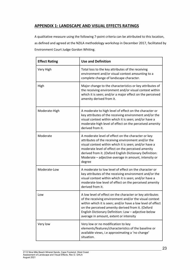
APPENDIX 1: LANDSCAPE AND VISUAL EFFECTS RATINGS
A qualitative measure using the following 7‐point criteria can be attributed to this location,
as defined and agreed at the NZILA methodology workshop in December 2017, facilitated by
Environment Court Judge Gordon Whiting.
Effect Rating Use and Definition
Very High Total loss to the key attributes of the receiving environment and/or visual context amounting to a complete change of landscape character.
High Major change to the characteristics or key attributes of the receiving environment and/or visual context within which it is seen; and/or a major effect on the perceived amenity derived from it.
Moderate‐High A moderate to high level of effect on the character or key attributes of the receiving environment and/or the visual context within which it is seen; and/or have a moderate‐high level of effect on the perceived amenity derived from it.
Moderate A moderate level of effect on the character or key attributes of the receiving environment and/or the visual context within which it is seen; and/or have a moderate level of effect on the perceived amenity derived from it. (Oxford English Dictionary Definition: Moderate – adjective‐average in amount, intensity or degree
Moderate‐Low A moderate to low level of effect on the character or key attributes of the receiving environment and/or the visual context within which it is seen; and/or have a moderate‐low level of effect on the perceived amenity derived from it.
Low A low level of effect on the character or key attributes of the receiving environment and/or the visual context within which it is seen; and/or have a low level of effect on the perceived amenity derived from it. (Oxford English Dictionary Definition: Low – adjective‐below average in amount, extent or intensity
Very low Very low or no modification to key elements/features/characteristics of the baseline or available views, i.e approximating a ‘no change’ situation.