Embed Size (px)
Citation preview
AT THE TIPPING POINTA Comprehensive Assessment and Conservation Action Plan
for the Georgia Coast
A REPORT BY
This report was made possible thanks to a grant from the R. Howard Dobbs, Jr. Foundation.
In addition, the Southern Environmental Law Center would like to thank the 70+ individuals weinterviewed as part of this report, including staff members of our coastal conservation partnergroups in Georgia, South Carolina, and North Carolina; state and local officials; regulatoryagency representatives; scientists; and business leaders.
At the Tipping Point was prepared by Christopher K. DeScherer, L.P. Fabrizio, William W. Sapp,David A. Lewis, and Adam M. Kron. For more information on SELC or these individuals, seeAppendix A and B, visit our website at SouthernEnvironment.org, or contact our Atlanta officeat (404) 521-9900.
Cover photo by Craig Tanner: Evening light on live oak trees on beach at Blackbeard NationalWildlife Refuge, Georgia.
Copyright July 2007 by the Southern Environmental Law Center

AT THE TIPPING POINTA Comprehensive Assessment and Conservation Action Plan
for the Georgia Coast
2 Southern Environmental Law Center 2007
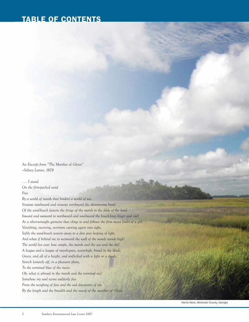
An Excerpt from “The Marshes of Glynn”—Sidney Lanier, 1878
. . . I standOn the firm-packed sandFreeBy a world of marsh that borders a world of sea.Sinuous southward and sinuous northward the shimmering bandOf the sand-beach fastens the fringe of the marsh to the folds of the land.Inward and outward to northward and southward the beach-lines linger and curlAs a silver-wrought garment that clings to and follows the firm sweet limbs of a girl.Vanishing, swerving, evermore curving again into sight,Softly the sand-beach wavers away to a dim gray looping of light.And what if behind me to westward the wall of the woods stands high?The world lies east: how ample, the marsh and the sea and the sky!A league and a league of marsh-grass, waist-high, broad in the blade,Green, and all of a height, and unflecked with a light or a shade,Stretch leisurely off, in a pleasant plain,To the terminal blue of the main.Oh, what is abroad in the marsh and the terminal sea?Somehow my soul seems suddenly freeFrom the weighing of fate and the sad discussion of sin,By the length and the breadth and the sweep of the marshes of Glynn.
TABLE OF CONTENTS
Harris Neck, McIntosh County, Georgia
Southern Environmental Law Center 2007 3
IInnttrroodduuccttiioonn
RReeppoorrtt SSuummmmaarryy
TThhrreeaattss FFaacciinngg tthhee CCooaasstt
GROWTH AND DEVELOPMENT
THREATS TO SPECIFIC RESOURCES
THREATS THAT AFFECT ALL RESOURCES
GGoovveerrnnmmeenntt AAggeenncciieess aanndd EEnnvviirroonnmmeennttaall GGrroouuppss
GOVERNMENT AGENCIES
ENVIRONMENTAL GROUPS
PPootteennttiiaall MMooddeellss
COASTAL CONSERVATION LEAGUE
NORTH CAROLINA COASTAL FEDERATION
KEY INGREDIENTS OF THE NORTH AND SOUTH CAROLINA
PROGRAMS
AAccttiioonnss aanndd IInniittiiaattiivveess NNeeeeddeedd oonn tthhee CCooaasstt
IMMEDIATE ACTIONS THAT MUST BE TAKEN
AN ECO-VISION TO GUIDE ACTIONS ON THE COAST
PROPOSED INITIATIVES
RReessoouurrcceess,, AAccttiioonnss,, aanndd IInniittiiaattiivveess
RESOURCES NEEDED
SHORT-TERM PLAN
LONG-TERM PLAN
NNootteess
AAppppeennddiixx AA:: SSoouutthheerrnn EEnnvviirroonnmmeennttaall LLaaww CCeenntteerr
AAppppeennddiixx BB:: AAuutthhoorr PPrrooffiilleess
AAppppeennddiixx CC:: PPrriioorriittyy LLaannddss SSuurrvveeyy RReessuullttss
44
66
1111
14
16
27
3311
32
44
4488
49
54
57
5588
59
62
68
8800
81
83
84
8888
9911
9933
9944
SUSAN KEMPKE

4 Southern Environmental Law Center 2007
INTRODUCTION
coastal development. SELC and its conservation partnersrecognize that growth will continue on the coast and thatsuch growth, in many cases, can be beneficial to those wholive in the region already. We also realize that, if thisgrowth is not managed correctly, the coast will be trans-formed and those people now living in the region stand tolose the most.
SELC has actively worked to protect the Georgia coastfor more than twenty years. In 1987, we successfully foughtto protect Cumberland Island National Seashore from anill-conceived dredging project. More recently, in 2000,SELC conducted an evaluation of the Georgia coast todetermine the threats that were facing the coast as the newmillennium began. Based on the findings made in 2000,SELC began to focus its efforts on protecting Georgia’smarshlands and hammocks under Georgia’s CoastalMarshlands Protection Act and ensuring that the Corps ofEngineers lived up to its obligations to protect freshwaterwetlands and streams under the federal Clean Water Act.Since that time, SELC, working closely with coastal advo-cates, has continued to address these issues as well as oth-ers. A more complete description of SELC and its historyof protecting the South’s coastal resources is found atAppendix A.
As a regional organization, our experiences in SouthCarolina and North Carolina have provided a frameworkfor conducting this Assessment. SELC has worked closelywith coastal organizations in neighboring states, includingthe Coastal Conservation League in South Carolina andthe North Carolina Coastal Federation. Both of theseorganizations have been effective in protecting their respec-tive coastlines. As part of this Assessment, SELC has inter-viewed staff at both of these organizations and their part-ner groups to gain further insights into how Georgia’senvironmental community could bolster efforts to addressthe waves of poorly planned development that are trans-forming the coast.
We also recognize our own limits and have depended onour coastal partners in Georgia to provide invaluable inputinto this process. As a result of the insights these organiza-tions have shared with us, SELC has developed a muchdeeper understanding of the situation confronting thecoastal region. We have also gathered and analyzed a widerange of data; evaluated numerous studies of the area; andconducted more than 70 interviews with scientists, stateand local officials, and business leaders.
In addition to identifying poorly planned developmentas the most significant threat to the coast, this process hasrevealed to us that the Georgia coast is a study in con-trasts. On the northernmost end of the coast, lies the his-toric city of Savannah. While this community retains thecharm and grace of a well-preserved southern city, it alsoexudes the vibrant sophistication of a 21st century metrop-
Nothing characterizes Georgia’s coast more than itsmarshes. Vast and sweeping, these landscapes still inspirevisitors today just as they inspired Sidney Lanier over ahundred years ago.1 These lush expanses of seemingly end-less marsh grass lie between Georgia’s mainland and itsbarrier islands. Watery pathways of tidal creeks meanderthrough this quiet, almost mysterious landscape. Dottingthe marsh are more than 1,650 islands, called “marsh ham-mocks,” that provide a secluded sanctuary for wildlife awayfrom the coastal mainland that has become congested withdevelopment, traffic, and noise. Hammocks serve as roost-ing grounds for birds as they rest while feeding in themarsh. They also serve as nesting grounds for colonies ofibises, herons, wood storks and other colonial nesters.Along the eastern seaboard, few places retain such a vastand wild character. Many Georgians consider this greatlandscape to be an important part of their natural heritage.
Unfortunately, this heritage is in jeopardy. Developersare heading to the Georgia coast with a “gold rush mentali-ty.” Sprawling mansions are being built on tiny marsh ham-mocks; wetlands are being filled; and precious maritimeforests are being leveled for subdivisions. If this trend con-tinues, the marshes and coast that Sidney Lanier held sodear will be unrecognizable within a decade. Admiredworldwide for their beauty and rich biological diversity,Georgia’s salt marshes, beaches, and barrier islands havelargely escaped the ravages of massive resort developmentthat have blighted so much of America’s coastline.Protecting the ecological integrity of the Georgia coastmust be one of the conservation community’s highest pri-orities. Many Georgians feel a sense of urgency to protectthis extraordinary region. They worry that the current waveof development will permanently change this magnificentplace and source of solace—its final stronghold along thesoutheastern seaboard.
Looking at the ominous threats to the Georgia coast, theSouthern Environmental Law Center (SELC) has recog-nized two pressing needs:
1) To bring local environmental groups and other inter-ested citizens together to form a strong, unified frontto counter powerful and well-financed developmentinterests; and
2) To plant the seeds for a comprehensive conservationplan for preserving the Georgia coast for future gener-ations.
To begin fulfilling these needs, SELC has undertaken abroad Assessment of the region, with generous supportfrom the R. Howard Dobbs, Jr. Foundation. ThisAssessment looks at the challenges the region faces and theresources needed to address those challenges. This processhas revealed poorly planned development to be the biggestthreat to the coast, and this report attempts to determinewhat can be done to temper the effects of poorly planned
Southern Environmental Law Center 2007 5
BIL
L LE
A
olis. In stark contrast to Savannah, on the southernmostend of the coast is the Okefenokee Swamp, a NationalWildlife Refuge that contains some of the wildest areas inthe region. In this peat-filled swampland, time seems tostand still as alligators guard the dark, tea-colored watersand wood storks stalk the shallows for fish. We have alsofound that the capacity of local governments on the coastvaries significantly. While Savannah and Chatham Countyhave a metropolitan planning commission and a host ofregulations governing local activities, some of the ruralcounties in the second row of counties back from theocean, like Charlton and Long, have few regulations on thebooks and lack the resources to enforce what little theyhave. In short, this process has given us a deep apprecia-tion for the different landscapes, communities, and issuesacross the region.
It was because of these differences and the challenges fac-ing the region that we felt compelled to conduct a compre-hensive Assessment of the present condition of the coastand the steps that can be taken to conserve the coast’s nat-ural resources and sense of place. In the following sectionsof this Assessment, we provide a summary of the reportand then:
• Examine the coast’s many exceptional resources, aswell as the threats these resources are facing;
• Describe the government agencies and environmentalgroups that manage and protect the coast;
• Analyze how other organizations in South Carolinaand North Carolina have become so effective at pro-tecting coastal resources in those states;
• Outline a conservation plan with a menu of concretenext steps to address the threats to the Georgia coast;and
• Discuss whether environmental groups working to pro-tect the coast, including SELC, need to realign into apowerful coalition or perhaps build a new entity.
We hope that this document will be used both as asource of information and also as a tool for future collabo-rative efforts by the conservation groups working to protectthe coast.
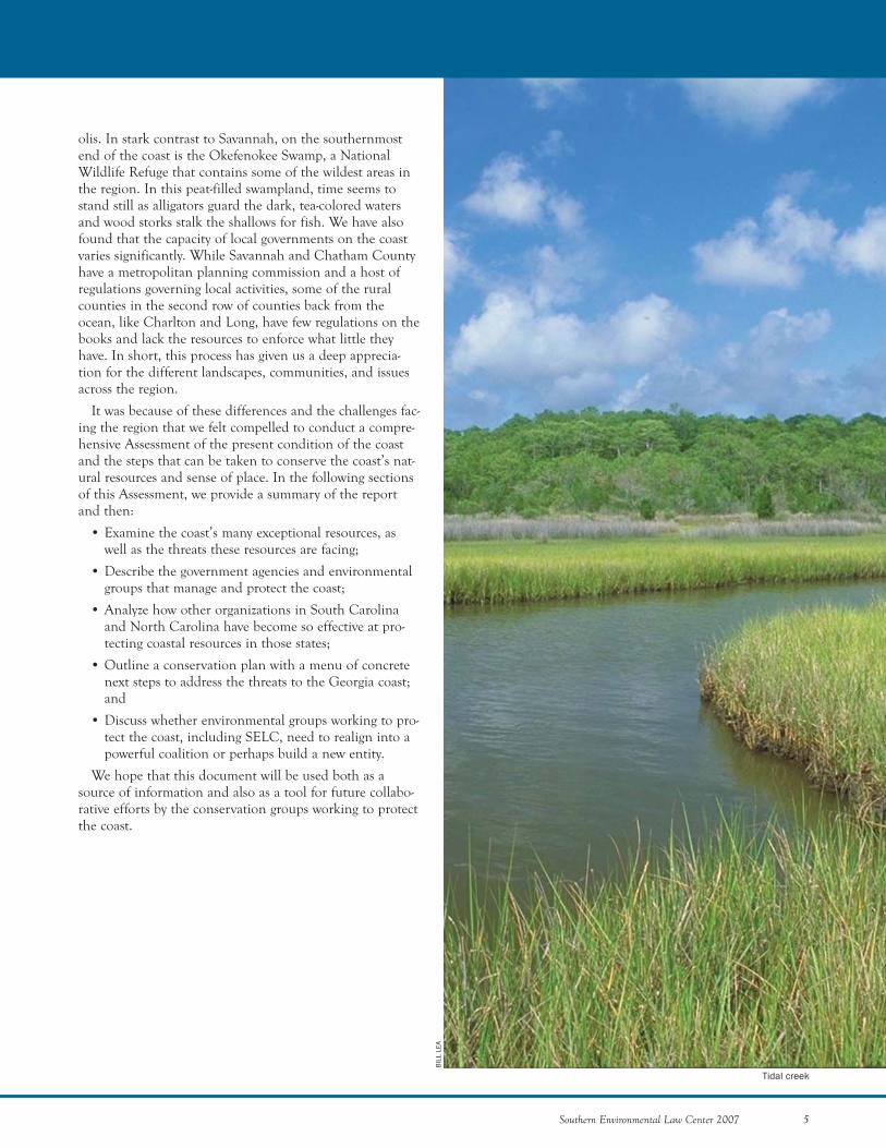
Tidal creek
6 Southern Environmental Law Center 2007
EExxcceeppttiioonnaall NNaattuurraall RReessoouurrcceessThe Georgia coast, with its rich variety of ecosystems, is
one of the most valuable ecological zones in the nation. Itharbors a third of the salt marsh on the East Coast, sus-tains an extensive array of plant and wildlife species, andsupports multi-million-dollar commercial and recreationalfishing industries. With places like Cumberland IslandNational Seashore and the Altamaha delta and wildlifelike the endangered right whale, Georgia’s coastal zone istruly home to resources of worldwide ecological impor-tance.
Due to a fortunate confluence of history, geography,economics, and legislation, much of the Georgia coast isstill intact. However, it is at a “tipping point.” The coast’snatural resources and beauty could, ironically, lead to itsown undoing. Unless greater emphasis is placed on pro-tecting the coast, it could end up as congested as Florida.The Florida coast once inspired people the way theGeorgia coast now does. It was this inspirational qualitythat caused so many to covet a piece of the Florida coast.Developers were more than willing to provide the coastalhomes, condominiums, and resorts to meet the explodingdemand and in the process dealt permanent damage toFlorida’s natural appeal.
The purpose of the Assessment is to put a plan inmotion that will help lead to a more balanced form ofdevelopment and conserve the qualities of the Georgiacoast that make it so special. To date, our findings havebeen sobering and confirm the immediate need for action.They include the following:
PPoooorrllyy PPllaannnneedd DDeevveellooppmmeennttNearly all of the people we interviewed for this
Assessment noted that poorly planned development is thesingle greatest threat to Georgia’s coastal treasures. Thedamage inflicted by poorly planned development affects allaspects of the environment, including scenic vistas, surfacewater, groundwater, freshwater wetlands, salt marshes, estu-aries, and wildlife. Development also brings with it traffic,light pollution, and noise pollution, as well as the prob-lems of burgeoning landfills and failing septic systems.
Despite these drawbacks, development continues tomarch up and down the coast, spurred on by access toreadily available land. Timber companies have already soldand continue to sell large tracts of land on the coast.These companies recognize that selling their properties todevelopers or developing the lands themselves bringsgreater profits than growing pine trees. Furthermore, devel-opment proposals continue to pile up in spite of the devas-tating 2005 hurricane season, which raised concerns aboutcoastal development in other states and has rendered someseaside properties around the country uninsurable.Developers are touting the Georgia coast as “hurricaneproof,” a claim that is rash and irresponsible.
REPORT SUMMARY
BIL
L LE
A
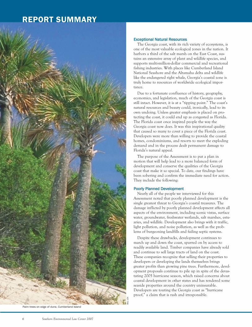
Palm trees on edge of dune, Cumberland Island
Southern Environmental Law Center 2007 7
EEffffeeccttiivvee MMooddeellssThe coastal conservation community should adapt for
use in Georgia the strategies that have been effective inother states. Having worked with model organizations inSouth and North Carolina, we know that we must work atall levels of government—local, state, and federal—to shapelaw and policy to protect our coastal resources, and, whenall other avenues are exhausted, we must go to court toensure proper implementation of the laws on the books.Both South Carolina and North Carolina have strongcoastal organizations. They are well staffed, well funded,and well organized. Through our interactions with each ofthem over the years and by interviewing their staff andpartners, we have gained insights into how efforts to pro-tect the Georgia coast can be strengthened. In this report,we describe ideas for how we could develop a strongercoastal presence here in Georgia.
IImmmmeeddiiaattee AAccttiioonnss aanndd CCoommpprreehheennssiivvee IInniittiiaattiivveessThis report proposes a series of Immediate Actions and
Comprehensive Initiatives to protect the coast, asdescribed in the “Actions and Initiatives Needed on theCoast” section below.
The Immediate Actions are those that are needed nowto address an urgent resource conservation need, will havean impact on the problem within three years, and can beachieved by the existing conservation groups with addition-al resources. These Immediate Actions include protectingsalt marshes and estuaries by requiring proper implementa-tion of the Coastal Marshlands Protection Act, protectingcoastal waters by enforcing the 25-foot buffer under theErosion and Sedimentation Act, protecting freshwater wet-lands and streams by reviewing and challenging illegaljurisdictional determinations, and permanently protectingsensitive lands across the region. These Immediate Actionsmust be launched and successfully implemented quickly toprotect the coast in this new era of fast-paced land conver-sion and development.
Based upon lessons learned from the CoastalConservation League, SELC proposes as the finalImmediate Action that the conservation groups, includingadvocacy groups, land trusts, and sportsmen’s groups, con-vene to create an “eco-vision” for the coast. Using mappingtechnologies, the eco-vision would present a unified visionfor protecting the coastal region. The eco-vision wouldidentify high conservation value lands for permanent pro-tection and areas that can accommodate balanced forms ofgrowth. The development of an eco-vision for coastalGeorgia would facilitate better coordination among envi-ronmental groups, increase the effectiveness of the entirecommunity, and set the stage for the launching of pro-posed Comprehensive Initiatives.
Even if we wanted to, we could not halt escalating devel-opment pressure. The challenge is to moderate and directdevelopment towards those areas that can sustain growth,while protecting the ecological gems that remain.
IInnssuuffffiicciieenntt RReessoouurrcceess The government agencies charged with protecting the
coast appear to lack the will and resources to do so. Thenon-government organizations, while possessing abundantwill, lack sufficient resources to meet the challenges posedby the intensity of development pressures. GOVERNMENT AGENCIES
Federal, state, and local governments have an array ofenvironmental laws and programs at their disposal to pro-tect the coast. The federal Clean Water Act, the federalEndangered Species Act, the Georgia Coastal MarshlandsProtection Act, and the Georgia Erosion andSedimentation Act are just a few of the existing authoritiesthat government agencies could use to protect the coast.
Unfortunately, the agencies have not lived up to theirresponsibilities to fully implement the laws that theyadminister. The government agents charged with imple-menting these laws lack the capacity or will to carry outtheir duties. Moreover, the government agencies are veryconservative in interpreting the limits of the law and areunwilling to seek additional authorities where they areneeded. A prime example is the state’s unwillingness todevelop a program to regulate freshwater wetlands leftunprotected by recent rollbacks in federal authority underthe Clean Water Act.
Even when environmental groups have won lawsuitsagainst government agencies on the coast, the agencieshave either ignored the court decisions or tried to rewritetheir regulations. These management failures are describedbelow in “Overall Assessment of GovernmentManagement of Coastal Resources.” As determined as theenvironmental community is to protect the coast, the gov-ernment agencies are just as determined to allow develop-ment to proceed. ENVIRONMENTAL GROUPS
The environmental groups that are banding together toprotect the coast have great determination but inadequateresources to stem the tide of rapid development. In orderto meet the challenges ahead to protect special places andrequire more balanced forms of development across theregion, the environmental community needs to fortify itsorganizational structure and deepen its technical, legal,and communication abilities. Moreover, as explainedbelow, additional financial resources are needed to sustainenhanced coastal protection efforts, and an effective planis required to deploy them.
8 Southern Environmental Law Center 2007
REPORT SUMMARY
In order to create a shared vision, key data must be ana-lyzed and depicted using geographic information systems.This information includes land ownership, protectedareas, and important natural resources such as wetlandsand threatened and endangered wildlife. For purposes ofthis Assessment, SELC gathered and analyzed much of thisdata. In addition, we conducted a survey of knowledgeableenvironmental professionals, including state and federalagency employees, scientists, environmentalists, environ-mental attorneys, and others regarding the most importantareas for conservation on the coast. Through this survey,SELC identified: (1) specific high value conservation targets deserving permanent protection such as St. Catherines Island; (2) specific wetland systems meritingrestoration; and (3) coast-wide resources needing addition-al regulatory protection. This information forms the foun-dation for the eco-vision.
In addition to Immediate Actions, including the devel-opment of an eco-vision, SELC recommends a series ofComprehensive Initiatives to address the most importantthreats to the region. Unlike the Immediate Actions,which are targeted in nature to address specific problems,the Initiatives adopt a broader approach by including anumber of different strategies to protect the coast’s mostimportant resources over the long-term. The proposedInitiatives address: (1) Marshlands and Hammocks, (2)Wetlands, (3) Polluted Runoff, (4) Special Places, (5)Planning, and (6) Climate Change. Although aspects ofthese Initiatives are already being worked on by environ-mental groups, including SELC, this work needs a muchmore robust, coordinated plan over the long haul to besuccessful.
RReessoouurrcceess,, AAccttiioonnss,, aanndd IInniittiiaattiivveessIn order to be effective and to successfully implement
the Immediate Actions and Comprehensive Initiativesdescribed above, the environmental community needsadditional resources. Based on the models in SouthCarolina and North Carolina, it is clear that there are notenough advocates focusing on coastal protection inGeorgia and that the environmental community must besubstantially strengthened in technical, legal, and commu-nication capacities. SELC believes that smart investmentsto strengthen these three capacities are fundamental toovercoming challenges in coastal Georgia. Because devel-opment and industrial interests will always be better fund-ed than the environmental community, it is important forgroups working in the region to maximize their effective-ness by making wise investments in tools that can enhancetheir abilities.
In order to successfully undertake the ImmediateActions and Comprehensive Initiatives listed above, SELCproposes the following Short and Long-Term Plans.
SHORT-TERM PLAN
The Short-Term Plan includes the Immediate Actionslisted above and the development of an eco-vision to guidelong-range conservation efforts on the coast. The Short-Term Plan also involves substantially strengthening keytechnical, legal, and communication capacities in order tosuccessfully implement these actions.
Technical Capacity. The current groups working to pro-tect coastal Georgia simply do not have adequate technicalexpertise on staff nor the financial resources to hire con-sultants when needed. To ensure that the coastal environ-mental community has the scientific and technologicalresources it needs to be effective, a scientist or environ-mental management professional with experience in a rele-vant coastal discipline, such as ecology, biology, or environ-mental planning, should be hired to serve the organiza-tions working in the region.
Increased Legal Capacity. Many of the proposedImmediate Action items—implementation of the CoastalMarshlands Protection Act, enforcement of buffer require-ments to protect coastal waters, and ensuring maximumfederal protection for wetlands and streams—require sub-stantial legal resources. Given the current political climatein Georgia, legal approaches are sometimes the only formsof advocacy that can effectively defend coastal resources.Considering the challenges addressed by the proposedImmediate Actions, it is imperative that more legalresources be deployed as part of the Short-Term Plan.
Increased Communications Capacity. The ability tocommunicate effectively about important issues in theregion is a key attribute of an effective conservation plan.For this reason, in addition to increasing overall capacityfor technical and legal resources, the Short-Term Planincludes funding to hire communication consultants andto fund important campaigns.
In order to launch the Short-Term Plan, SELC proposesa series of meetings with organizations working to protectthe coast, including advocacy groups, land trusts, andsportsmen’s organizations. These meetings will serve tofurther refine the Short-Term Plan, including the develop-ment of the eco-vision, which will help build the founda-tion for the implementation of an effective, coordinated,long-term strategy to protect the Georgia coast.LONG-TERM PLAN
In order to be effective and to successfully carry out theComprehensive Initiatives, substantial additional resourcesare needed. It is clear that there are not enough advocatesin Georgia focusing on coastal protection. In light of thegrowing development pressures on the coast, the conserva-tion groups, in addition to the Short-Term Plan outlinedabove, must begin laying the groundwork for a dramaticincrease in resources, including a minimum of five addi-tional advocates, to protect the coastal environment.
Southern Environmental Law Center 2007 9
ALAN
CR
ESSL
ER
SELC recommends that a new organization, modeledafter the Coastal Conservation League and the NorthCarolina Coastal Federation, be established. Because thereare a number of groups currently working to protect thecoast, such an organization should be smaller in size thanthese model organizations and complement ongoing con-servation efforts by filling areas of need. With a mission toprotect the entire coast, this new organization could bringpeople together and focus state and national attention onthe importance of protecting the region. By providing acentral location for deployment of additional resources,this organization would also be the most efficient andeffective vehicle for enhancing conservation efforts.Finally, such an organization would have the importantattribute of being able to use legal advocacy, wherever nec-essary on the coast, to address threats to importantresources.
Regardless of how resources are organized on the coast,the Assessment has revealed that Georgia’s conservationgroups need more of them. Just as importantly, the com-munity needs to use them effectively and collaboratively. Ifthe conservation community is not able to attract substan-tial new funding and to deploy these resources effectivelyand collaboratively, much of the coast will be lost forever.SELC has seen the scenario play out so many times before:a magical place naturally inspires people to covet a piece ofit; developers rush in to meet this demand and begin aflurry of building; in time, sprawl stretches out over thelandscape, and the magic of the setting—the very thing thatmade it so desirable in the first instance—is gone or greatlydiminished. Due to a fortunate confluence of history,geography, economics, and good legislation in the form ofthe Coastal Marshlands Protection Act, most of theGeorgia coast has escaped such a fate. The conservationcommunity must act swiftly and strategically to preservethis incomparable setting.
The obstacles that lie ahead are formidable. It will bedifficult to reverse the current trends that are transformingthe region. Correcting the failures of government agenciesto properly implement the law and ensuring more bal-anced and sensitive forms of development are dauntingchallenges. Nevertheless, SELC believes that by workingtogether to implement the Short and Long-Term Plans, theconservation community can, and will, protect this nation-al treasure for future generations.
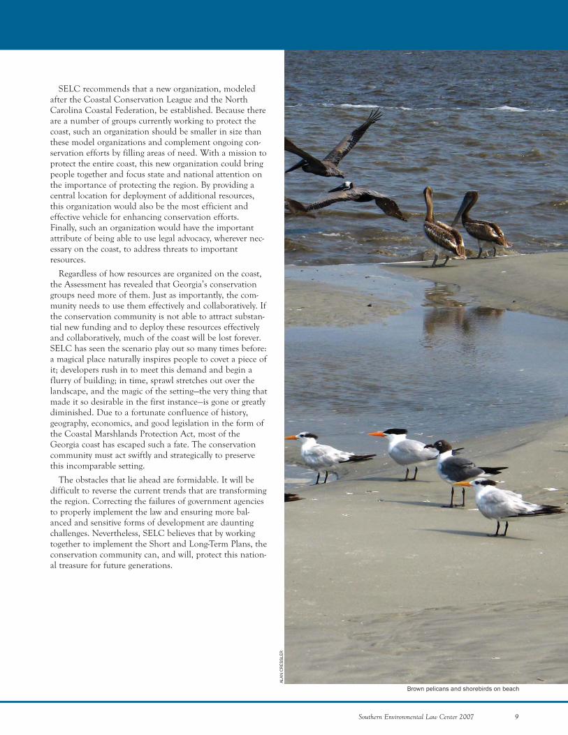
Brown pelicans and shorebirds on beach

10 Southern Environmental Law Center 2007
Southern Environmental Law Center 2007 11
THREATS FACING THE COAST
DAVE LEWIS
12 Southern Environmental Law Center 2007
THREATS FACING THE COAST
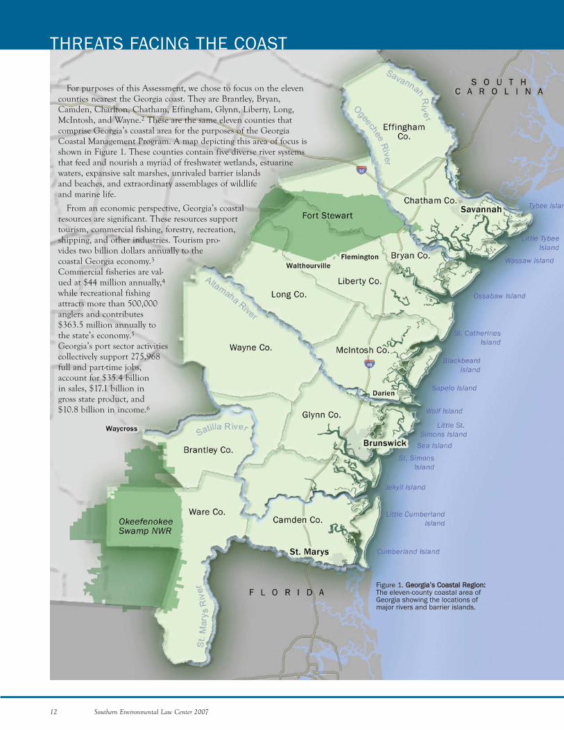
Figure 1. GGeeoorrggiiaa’’ss CCooaassttaall RReeggiioonn::The eleven-county coastal area ofGeorgia showing the locations ofmajor rivers and barrier islands.
For purposes of this Assessment, we chose to focus on the elevencounties nearest the Georgia coast. They are Brantley, Bryan,Camden, Charlton, Chatham, Effingham, Glynn, Liberty, Long,McIntosh, and Wayne.2 These are the same eleven counties thatcomprise Georgia’s coastal area for the purposes of the GeorgiaCoastal Management Program. A map depicting this area of focus isshown in Figure 1. These counties contain five diverse river systemsthat feed and nourish a myriad of freshwater wetlands, estuarinewaters, expansive salt marshes, unrivaled barrier islandsand beaches, and extraordinary assemblages of wildlifeand marine life.
From an economic perspective, Georgia’s coastalresources are significant. These resources supporttourism, commercial fishing, forestry, recreation,shipping, and other industries. Tourism pro-vides two billion dollars annually to thecoastal Georgia economy.3Commercial fisheries are val-ued at $44 million annually,4while recreational fishingattracts more than 500,000anglers and contributes$363.5 million annually tothe state’s economy.5Georgia’s port sector activitiescollectively support 275,968full and part-time jobs,account for $35.4 billion in sales, $17.1 billion in gross state product, and $10.8 billion in income.6
Southern Environmental Law Center 2007 13
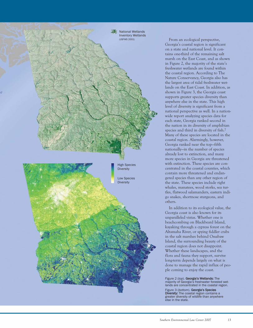
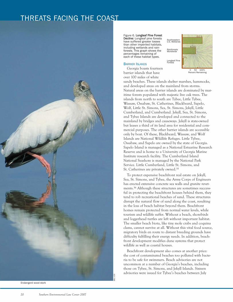
From an ecological perspective,Georgia’s coastal region is significanton a state and national level. It con-tains one-third of the remaining saltmarsh on the East Coast, and as shownin Figure 2, the majority of the state’sfreshwater wetlands are found withinthe coastal region. According to TheNature Conservancy, Georgia also hasthe largest area of tidal freshwater wet-lands on the East Coast. In addition, asshown in Figure 3, the Georgia coastsupports greater species diversity thananywhere else in the state. This highlevel of diversity is significant from anational perspective as well. In a nation-wide report analyzing species data foreach state, Georgia ranked second inthe nation in its diversity of amphibianspecies and third in diversity of fish.7Many of these species are located in thecoastal region. Alarmingly, however,Georgia ranked near the top—fifthnationally—in the number of speciesalready lost to extinction, and manymore species in Georgia are threatenedwith extinction. These species are con-centrated in the coastal counties, whichcontain more threatened and endan-gered species than any other region ofthe state. These species include rightwhales, manatees, wood storks, sea tur-tles, flatwood salamanders, eastern indi-go snakes, shortnose sturgeons, andothers.
In addition to its ecological value, theGeorgia coast is also known for itsunparalleled vistas. Whether one isbeachcombing on Blackbeard Island,kayaking through a cypress forest on theAltamaha River, or spying fiddler crabsin the salt marshes behind OssabawIsland, the surrounding beauty of thecoastal region does not disappoint.Whether these landscapes, and theflora and fauna they support, survivelong-term depends largely on what isdone to manage the rapid influx of peo-ple coming to enjoy the coast.
Figure 2 (top). GGeeoorrggiiaa’’ss WWeettllaannddss:: Themajority of Georgia’s freshwater forested wet-lands are concentrated in the coastal region. Figure 3 (bottom). GGeeoorrggiiaa’’ss SSppeecciieessDDiivveerrssiittyy:: The coastal region contains agreater diversity of wildlife than anywhereelse in the state.
High SpeciesDiversity
National WetlandsInventory Wetlands(USFWS 2001)
Low SpeciesDiversity
14 Southern Environmental Law Center 2007
THREATS FACING THE COAST
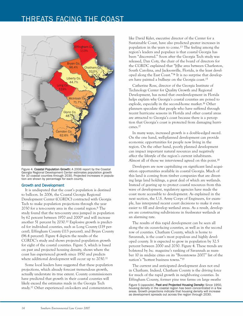
Figure 4. CCooaassttaall PPooppuullaattiioonn GGrroowwtthh:: A 2006 report by the CoastalGeorgia Regional Development Center estimates population growthfor 10 coastal counties through 2030. Projected increases in popula-tion are shown by percentage for each county.
GGrroowwtthh aanndd DDeevveellooppmmeenntt It is undisputed that the coast’s population is destined
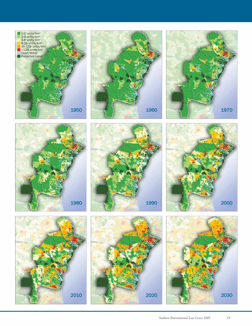
to balloon. In 2006, the Coastal Georgia RegionalDevelopment Center (CGRDC) contracted with GeorgiaTech to make population projections through the year2030 for a ten-county area in the coastal region.8 Thestudy found that the ten-county area jumped in populationby 62 percent between 1970 and 20009 and will increaseanother 51 percent by 2030.10 Explosive growth is predict-ed for individual counties, such as Long County (119 per-cent), Effingham County (113 percent), and Bryan County(96.4 percent). Figure 4 depicts the results of theCGRDC’s study and shows projected population growthfor eight of the coastal counties. Figure 5, which is basedon past and projected housing density, shows where thecoast has experienced growth since 1950 and predictswhere additional development will occur up to 2030.11
Some local leaders have suggested that these populationprojections, which already forecast tremendous growth,actually understate its true extent. County commissionershave predicted that growth in their coastal counties willlikely exceed the estimates made in the Georgia Techstudy.12 Other experienced on-lookers and commentators,
like David Kyler, executive director of the Center for aSustainable Coast, have also predicted greater increases inpopulation in the years to come.13 The feeling among theregion’s leaders and populace is that coastal Georgia hasbeen “discovered.” Soon after the Georgia Tech study wasreleased, Dan Coty, the chair of the board of directors forthe CGRDC explained that “[t]he area between Charleston,South Carolina, and Jacksonville, Florida, is the least devel-oped along the East Coast.”14 It is no surprise that develop-ers have painted a bullseye on the Georgia coast.15
Catherine Ross, director of the Georgia Institute ofTechnology Center for Quality Growth and RegionalDevelopment, has noted that overdevelopment in Floridahelps explain why Georgia’s coastal counties are poised toexplode, especially in the second-home market.16 Otherplanners speculate that people who have suffered throughrecent hurricane seasons in Florida and other coastal areasare attracted to Georgia’s coast because there is a percep-tion that Georgia’s coast is protected from damaging hurri-canes.17
In many ways, increased growth is a double-edged sword.On the one hand, well-planned development can provideeconomic opportunities for people now living in theregion. On the other hand, poorly planned developmentcan impact important natural resources and negativelyaffect the lifestyle of the region’s current inhabitants.Almost all of those we interviewed agreed on this point.18
Developers are now capitalizing on significant land acqui-sition opportunities available in coastal Georgia. Much ofthis land is coming from timber companies that are divest-ing large land holdings, a great deal of which are wetlands.Instead of gearing up to protect coastal resources from thiswave of development, regulatory agencies have made thecoast more accessible to development. As explained in thenext section, the U.S. Army Corps of Engineers, for exam-ple, has interpreted recent court decisions to make it eveneasier to fill and develop wetland areas. As a result, develop-ers are constructing subdivisions in freshwater wetlands atan alarming rate.
The results of this rapid development can be seen allalong the six ocean-facing counties, as well as in the secondrow of counties. Chatham County, which is home toSavannah, is the coast’s most populous and highly devel-oped county. It is expected to grow in population by 32.5percent between 2000 and 2030. Figure 4. These trends arebolstered by Inc. magazine’s ranking of Savannah as num-ber 10 in midsize cities on its “Boomtowns 2007” list of thenation’s “hottest business towns.”19
The current and anticipated development does not endin Chatham. Indeed, Chatham County is the driving forcefor much of the rapid growth in neighboring counties. InEffingham County, former pine tree farms on large swaths
Effingham Co.113%
Chatham Co.32.5%
Liberty Co.44.7%
Long Co.119%
McIntosh Co.71.7%
Glynn Co.48.7%
Camden Co.62.6%
Bryan Co.96.4%
Figure 5 (opposite). PPaasstt aanndd PPrroojjeecctteedd HHoouussiinngg DDeennssiittyy:: Since 1950,housing density in the coastal region has been concentrated in a fewareas. Growth projections indicate that housing density will increaseas development spreads out across the region through 2030.
11995500
11998800
11996600 11997700
11999900 22000000
22001100 22002200 22003300
0-2 units/km2
2-4 units/km2
4-8 units/km2
8-16 units/km2
16-128 units/km2
>128 units/km2
Open WaterProtected Land
Southern Environmental Law Center 2007 15
16 Southern Environmental Law Center 2007
of land are being clear-cut and replaced by sprawling cook-ie cutter subdivisions. Chatham’s burgeoning populationis spilling over into other adjacent counties as well. Somenow characterize Effingham County as a "bedroom com-munity"—the result of increasing numbers of workers fromChatham County that are moving farther away from thecity to find cheaper, suburban housing. In Bryan County,for example, Richmond Hill’s population increased 137percent between 1990 and 2000. This growth is due inlarge part to its proximity to Chatham County, FortStewart (one of the U.S. Army’s largest bases), and the I-95corridor.20
Other surrounding coastal counties are experiencingsimilar trends. Growth in Jacksonville, Florida, is affectingGeorgia’s rural counties on the southern end of the coast.In Camden County, sleepy little towns like St. Marys haveexperienced tremendous growth in the past decade. Thisgrowth is expected to continue between 2000 and 2030,with an estimated increase in population of 62.6 percent.Figure 4. Similar to trends near Savannah, workers inJacksonville are moving into southern coastal Georgia insearch of cheaper housing and a more rural landscape. Inaddition, resort-style developments are springing up inareas adjacent to the marshes and water. For example, theproposed Cumberland Harbour development, a 1200-unitdevelopment with the largest proposed marina complex inthe history of the region is proposed to be constructed onabout 650 acres of upland on a peninsula located betweenthe town of St. Marys and Cumberland Island NationalSeashore.21 Figure 17(c) depicts the general vicinity of theproposed Cumberland Harbour development. Further,just across a tidal creek from Cumberland Harbour is thesite of the former Durango Paper Company, where devel-opers plan to build a massive new community with high-rise hotels and marinas.
At this rate, the Georgia coast will be transformed with-in a decade.
TThhrreeaattss ttoo SSppeecciiffiicc RReessoouurrcceessIn this section, we examine specific coastal resources,
including everything from inland wetlands to the ocean,and the threats they face.
WETLANDS
The wetlands in the coastal region are a vital resourcefor people and wildlife alike. They improve water quality,maintain water levels, and provide wildlife habitat.Wetlands improve water quality by filtering and removingpollutants from stormwater, rainwater, and floodwaters. Byholding floodwaters and recharging groundwater, they playa critical role in maintaining the water levels of riverbasins and protecting developed areas. When wetlands areconverted to other land uses, increases in flooding anddecreases in water quality are a common outcome. In addi-tion, there are a multitude of birds, mammals, fish, rep-
THREATS FACING THE COAST
DER
RIC
K H
AMR
ICK
Setting sun through bald cypress
Southern Environmental Law Center 2007 17
tiles, and amphibians that depend upon wetlands. Indeed,the concentration of wildlife diversity found within thecoastal region is largely attributable to the large number ofwetlands located there.
Distributed throughout the inland region of the coastare important freshwater wetland ecosystems like bottom-land hardwood forests. These wetlands provide invaluablehabitat for many native and rare bird species, like theendangered wood stork. According to a new report by theAmerican Bird Conservancy—Top 20 Most ThreatenedBird Habitats in the United States—mixed longleafpine/bottomland hardwood forest is one of the most vul-nerable bird habitats in the nation.22
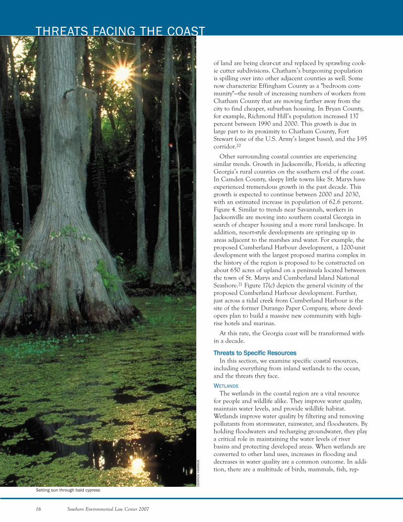
Cypress forests, found in the meandering floodplains ofthe region’s coastal rivers, are beautiful treasures that arean important part of the coast’s natural heritage. Cypresstrees can live up to 1,500 years and can grow up to 150feet tall and 25 feet in girth. In addition to serving theusual functions of wetlands, such as removing pollutantsand reducing flooding, cypress swamps support theGeorgia economy by attracting tourists. Thousands ofwildlife enthusiasts flock to the Okefenokee Swamp—thelargest swamp in North America—each year to see the alli-gators, sand hill cranes, and ibises living among the majes-tic cypress.
Freshwater wetlands are being hit especially hard bycoastal development. In general, these wetlands are beingfilled in to construct housing subdivisions and commercialcenters. Wetland parcels are less expensive than theirupland counterparts, and in some places the upland areasare already developed. Aside from the direct impacts of fill-ing and draining, wetlands are also suffering many indirectimpacts. Many cypress forests have been flooded byimpoundments constructed to create industrial and agri-cultural water sources. Although the flooding fromimpoundments typically does not kill the cypress trees,inundation stunts growth and prevents regeneration.Despite regeneration problems, these cypress trees arebeing harvested.
In 2004, a commission studying cypress harvests inLouisiana found that up to 80 percent of harvested cypressstands will not regenerate because of increased water lev-els. Without seasonal fluctuations in water level, cypressseedlings are unable to survive. Perhaps of greater concern,the number of water impoundments affecting the region isexpected to multiply with increased development.Moreover, regeneration failure is particularly acute giventhat cypress harvesting is on the rise.
Before the 1990s, landscaping mulch was produced fromtimber byproducts, such as pine tree bark. Recently, how-ever, there has been a sudden surge in demand for mulchmade from cypress. To meet this demand, timber compa-nies are harvesting whole cypress trees solely for mulch. In
addition, scientists at the University of Florida ExtensionService have found that timber companies are harvestingyounger and younger trees—some as small as a foot indiameter. As a result of these practices, it has been shownthat harvesting is outpacing the growth of cypress in bothFlorida and Louisiana. SELC is currently conducting a sep-arate study for the U.S. Environmental Protection Agencyto examine whether the same unsustainable harvest prac-tices are occurring in Georgia.
Another wetlands problem on the coast is that timbercompanies are using improper practices to drain wetlands.Timber companies are accomplishing this feat by usingtechniques such as bedding and ditching to slowly dry outwhole forests. After decades of improperly draining theseareas, many of these forests begin to resemble uplands.When changes in market prices make it profitable, timber-lands are developed or sold to developers. Since these for-mer wetlands have dried out, they are often developed assubdivisions or shopping malls without wetland permits.Even if the pine plantation that was once a bottomlandhardwood forest never dries out enough to actuallybecome an upland, the previous habitat is lost, and thediversity of indigenous species is severely reduced. Pineplantation stands are less diverse than natural wetlandcommunities, and, due to short harvest schedules, do notsupport species that depend upon old growth forests. Insome areas, where sufficient site wetness remains for thearea to meet federal jurisdiction, their degraded conditionoften means greater ease in obtaining development per-mits and fewer, if any, mitigation requirements. MARSHLANDS AND HAMMOCKS
Georgia's coast has approximately 378,000 acres ofmarshlands.23 These large expanses of marshland, whichso typify the Georgia coast, are as beautiful as they are eco-nomically and ecologically valuable. Marshes provide foodenergy to estuarine organisms such as small fish, plankton,oysters, shrimp, clams, and crabs. By providing food andshelter, the marshes serve as important nursery groundsfor young fish, shellfish, and crustaceans—many of thespecies that make up Georgia’s commercial seafood har-vest. In addition to being highly ecologically productive,Georgia’s salt marshes act as invaluable buffers againststorms by dissipating the wind and waves of hurricanesand northeasters. Coastal communities such as Darien aresafer from storms because of the marshes that surroundthem.
Georgia’s marshes are a complex habitat ecosystem,comprised of not just marsh grasses but also tidal creeksand hammocks. Hammocks are areas of upland embeddedin the marshes that range in size from less than one acreto over 1,000 acres. Approximately 1,655 hammocks com-prising over 49,687 acres have been identified along thecoast.24
of marsh productivity. Another type of structure, floatingdocks, has also been shown to have significant impacts. Arecent study that evaluated the effects of floating docks onmarshes in Georgia found primary production decreased57 to 73 percent under these structures.28 When theeffects of new marinas and bridges are added to the mix,the impacts to marshes due to the construction of newstructures are considerable.29
A decrease in the amount of freshwater flowing intoGeorgia’s estuarine waters can also impact the health ofour marshlands. Decreases in freshwater flows to the coastcan be attributed to the construction of drinking waterimpoundments and withdrawals in upstream areas.Atlanta officials, for example, have been eyeing coastalwater resources to quench Atlanta’s growing thirst forwater.30 According to reports, Atlanta officials have begundiscussing the possibility of building a pipeline from theSavannah River to Atlanta.31 If less freshwater reaches thecoast to mix with the ocean’s saltwater, saline levels in theestuaries go up. On the other hand, excessive stormwaterrunoff from development can also disrupt estuarine salini-ties by decreasing salinity during periods of heavy rainfalland increasing salinity during low rainfall periods—a prob-lem termed increased “flashiness” because the abnormalsalinity peaks and lows fluctuate abruptly. Maintainingnatural levels of salinity is important because salinity is akey factor that controls the structure and function of estu-arine systems. Changing levels of salinity in estuariesimpairs their function,32 impacts the species that livethere, and promotes the growth of invasive reed specieslike Phragmites australis.33
Another cause of decreased freshwater flows, which willaffect both wetlands and marshlands alike, is the contin-ued development or modification of water-hungry coal-fired and nuclear power plants. These plants consumelarge volumes of water and pose serious threats to down-stream water quality. For example, Plant Vogtle, located onthe Savannah River, already operates two nuclear reactors.These two reactors use massive amounts of water for cool-ing purposes, resulting in the evaporation of over 20,000gallons of river water per minute from each cooling towerduring peak power production.34 In addition to using largevolumes of water, these nuclear reactors affect downstreamwater quality by releasing pollutants, such as tritium. Inspite of the water quantity and quality problems associatedwith Plant Vogtle, Georgia Power is seeking to constructtwo additional nuclear reactors at the plant. Should thesenew reactors be built, there will be additional conse-quences for the coast’s marshes and estuarine ecosystems.
LONGLEAF PINE FORESTS
Longleaf pine forests were once commonplace withinGeorgia’s coastal region. Throughout the Southeast, thesebeautiful ecosystems once covered over 90 million acresfrom Virginia to Texas. Today, less than 3 percent of these
Most marsh hammocks support important maritimeforests, a disappearing natural community. The Partners inFlight program, a U.S. Fish and Wildlife Service bird con-servation initiative, has identified maritime forests as oneof three priority habitats for the conservation of migratorysongbirds in the South Atlantic coastal region. Many ham-mocks also provide roosting and nesting areas for wadingbirds, including the endangered wood stork, as well ashabitat for diamondback terrapin and other wildlife.
The late Dr. Eugene P. Odum, Distinguished ProfessorEmeritus of the University of Georgia’s Institute ofEcology, established that marsh hammocks are an integralpart of the coastal marshland ecosystem. He found thatthe hammocks and surrounding marshes function as onecontinuous ecological system. Birds use the hammocks andmarsh as a single habitat and continuously move back andforth between the grasses and islands to support their dailyneeds. The interconnection between hammocks andmarshes means that hammock development has significantconsequences for our marshlands. When hammocks aredeveloped, marsh vistas, so important to coastal residentsand visitors, are lost. In addition, polluted runoff fromdevelopment goes directly into the surrounding marsh.Almost all hammock development includes bridges andbulkheads, structures that eliminate marsh habitat andreduce productivity.
A condition that is affecting the marshes, and indirectlythe hammocks, is “marsh dieback.” In areas afflicted bythis phenomenon, the marsh vegetation dies, leaving themarsh soils bare and subject to increased erosion. Thisproblem, reported for the first time in the state in 2002,has created a considerable amount of concern over the sta-tus of Georgia’s marshes. Current estimates are that over1,000 acres of Georgia’s marshes have fallen prey to marshdieback. A number of hypotheses on the cause of thedieback are being investigated, including drought, changesin salinity, and a fungal pathogen.25 Each of these condi-tions can be exacerbated by stormwater runoff from devel-opment.
The rate of new construction of structures in the marsh-es is concerning. A review of state records revealed thatfrom 1995 through 2002, the Georgia Coastal ResourcesDivision issued permits for 1,688 private docks, eight newmarinas, and fourteen new commercial docks.26 A study ofthe dock structures on Wilmington Island documented a90 percent increase in total dock area from 1970 to2000.27 Stem density of marsh plants directly beneath thedocks was found to be 56 percent lower due to plant shad-ing, as compared to adjacent areas. Using modest assump-tions for dock build-out on the island, the study estimatedthat approximately 4 to 6 percent of the marshlands couldbe directly impacted. This amount is significant sinceresearch undertaken in South Carolina indicates that a 5percent loss of marsh coverage results in a significant loss
18 Southern Environmental Law Center 2007
THREATS FACING THE COAST
Southern Environmental Law Center 2007 19
KAT
IE S
TUB
LE
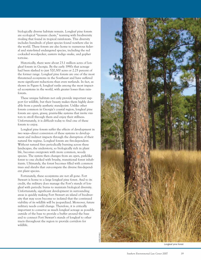
biologically diverse habitats remain. Longleaf pine forestsare ecological “treasure chests,” teaming with biodiversityrivaling that found in tropical rainforests. This diversityincludes hundreds of plant species found nowhere else inthe world. These forests are also home to numerous feder-al and state-listed endangered species, including the redcockaded woodpecker, eastern indigo snake, and gophertortoise.
Historically, there were about 23.1 million acres of lon-gleaf forests in Georgia. By the early 1990s that acreagehad been slashed to just 520,300 acres or 2.25 percent ofthe former range. Longleaf pine forests are one of the mostthreatened ecosystems in the Southeast and have sufferedmore significant reductions than even wetlands. In fact, asshown in Figure 6, longleaf ranks among the most impact-ed ecosystems in the world, with greater losses than rain-forests.
These unique habitats not only provide important sup-port for wildlife, but their beauty makes them highly desir-able from a purely aesthetic standpoint. Unlike otherforests common in Georgia’s coastal region, longleaf pineforests are open, grassy, prairie-like systems that invite visi-tors to stroll through them and enjoy their stillness.Unfortunately, it is difficult today to find one of theseforests to enjoy.
Longleaf pine forests suffer the effects of development intwo ways—direct conversion of these systems to develop-ment and indirect impacts through the disruption of theirnatural fire regime. Longleaf forests are fire-dependent.Without natural fires periodically burning across theselandscapes, the understory, so biologically rich in plantlife, becomes overgrown with more common, woodyspecies. The system then changes from an open, park-likeforest to one choked with brushy, transitional forest inhab-itants. Ultimately, the forest becomes filled with commontrees and shrubs that out-compete the diverse fire-depend-ent plant species.
Fortunately, these ecosystems are not all gone. FortStewart is home to a large longleaf pine forest. And to itscredit, the military does manage the Fort’s stands of lon-gleaf with periodic burns to maintain biological diversity.Unfortunately, significant development in surroundingareas is quickly making Fort Stewart an island of biodiver-sity that may soon become so isolated that the continuedviability of its wildlife will be jeopardized. Moreover, futuremilitary needs could change. Therefore, it is criticallyimportant to conserve as much longleaf acreage as possibleoutside of the base to provide a buffer around the baseand to connect Fort Stewart’s stands of longleaf to othertracts throughout the region to provide corridors forwildlife.
Longleaf pine forest
BARRIER ISLANDS
Georgia boasts fourteenbarrier islands that haveover 100 miles of white sandy beaches. These islands shelter marshes, hammocks,and developed areas on the mainland from storms.Natural areas on the barrier islands are dominated by mar-itime forests populated with majestic live oak trees. Theislands from north to south are Tybee, Little Tybee,Wassaw, Ossabaw, St. Catherines, Blackbeard, Sapelo,Wolf, Little St. Simons, Sea, St. Simons, Jekyll, LittleCumberland, and Cumberland. Jekyll, Sea, St. Simons,and Tybee Islands are developed and connected to themainland by bridges and causeways. Jekyll is state-ownedbut leases a third of its land area for residential and com-mercial purposes. The other barrier islands are accessibleonly by boat. Of these, Blackbeard, Wassaw, and WolfIslands are National Wildlife Refuges. Little Tybee,Ossabaw, and Sapelo are owned by the state of Georgia.Sapelo Island is managed as a National Estuarine ResearchReserve and is home to a University of Georgia MarineInstitute research facility. The Cumberland IslandNational Seashore is managed by the National ParkService. Little Cumberland, Little St. Simons, and St. Catherines are privately owned.35
To protect expensive beachfront real estate on Jekyll,Sea, St. Simons, and Tybee, the Army Corps of Engineershas erected extensive concrete sea walls and granite revet-ments.36 Although these structures are sometimes success-ful in protecting the beachfront houses behind them, theytend to rob recreational beaches of sand. These structuresdisrupt the natural flow of sand along the coast, resultingin the loss of beach habitat beyond them. Beachfronthomes remain protected from normal water levels, whiletourism and wildlife suffer. Without a beach, shorebirdsand loggerhead turtles are left without important habitat.The smaller beach biota, like tiny mole crabs and coquinaclams, cannot survive at all. Without this vital food source,migratory birds en route to distant breeding grounds havedifficulty fulfilling their energy needs. In addition, beach-front development modifies dune systems that protectwildlife as well as coastal houses.
Beachfront development also comes at another price:the cost of contaminated beaches too polluted with bacte-ria to be safe for swimmers. Beach advisories are notuncommon at a number of Georgia’s beaches, includingthose on Tybee, St. Simons, and Jekyll Islands. Sixteenadvisories were issued for Tybee’s beaches between July
20 Southern Environmental Law Center 2007
THREATS FACING THE COAST
BIL
L LE
A
Figure 6. LLoonngglleeaaff PPiinnee FFoorreessttDDeecclliinnee:: Longleaf pine forestshave suffered greater lossesthan other imperiled habitats,including wetlands and rain-forests. This graph shows thepercentages remaining ofeach of these habitat types.
SoutheasternU.S. Wetlands
RainforestsWorldwide
Longleaf PineForests
Percent Remaining0 50 100%
Endangerd wood stork
2004 and December 2005.37 For St. Simons and Jekyll,there were 108 advisories between January 2004 andNovember 2005, a slightly longer period.38
In addition to these threats, specific islands that have sofar escaped the ravages of development are now in thedevelopers’ sights. For example, Jekyll Island is currentlyunder a looming threat of development. The island,known as “Georgia's Jewel,” is unique in that it is signifi-cantly less developed than other islands accessible by car inGeorgia and throughout the Southeast. The potential forthis island to be transformed has recently been the centerof considerable controversy. Although much of the islandis to remain undeveloped according to state law, theisland’s managing authority has recently solicited ideasfrom developers on how to “redevelop” the developableareas into upscale, high-priced beach resorts. As much as$3 billion in luxury development is being proposed. Thebeaches at the south end of the island have become a keypoint in the controversy. These beaches are the most sensi-tive to development because they serve as important nest-ing grounds for sea turtles and numerous bird species. Thesouth end also happens to be highly desirable for develop-ers and is a focus for new development proposals.39 Oneproposal labels the south end “an excellent opportunityfor high-end luxury redevelopment.”40 If allowed to pro-ceed, the impacts of this type of intense development willundoubtedly impact not only the beaches, but the sur-rounding marshes and coastal waters as well. Fortunately,in the 2007 legislative session, an effort to protect the fragilesouth end resulted in the pas-sage of a bill that limits devel-opment in this area. Althoughmany heralded the bill’s pas-sage as a victory to preservethe island, continued moni-toring of this ongoing situa-tion is required.RIVERS
The health of our coastalrivers is critical to the well-being of our estuaries andcoastal waters. Along withtheir freshwater, these riversystems transport a number ofpollutants to the estuaries,some from as far away asAtlanta. All five of the majorrivers emptying into Georgia’sestuaries have significantwater quality problems andare listed by the state asimpaired, meaning they donot support their uses due to
Southern Environmental Law Center 2007 21
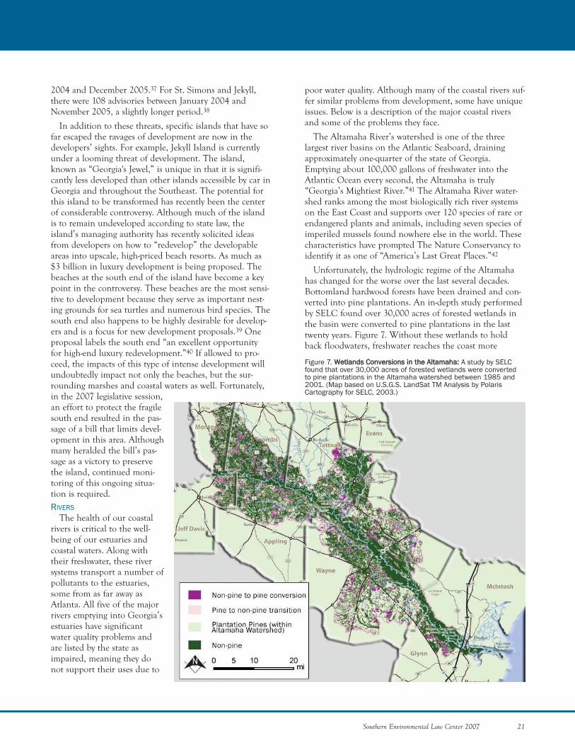
Figure 7. WWeettllaannddss CCoonnvveerrssiioonnss iinn tthhee AAllttaammaahhaa:: A study by SELCfound that over 30,000 acres of forested wetlands were convertedto pine plantations in the Altamaha watershed between 1985 and2001. (Map based on U.S.G.S. LandSat TM Analysis by PolarisCartography for SELC, 2003.)
poor water quality. Although many of the coastal rivers suf-fer similar problems from development, some have uniqueissues. Below is a description of the major coastal riversand some of the problems they face.
The Altamaha River’s watershed is one of the threelargest river basins on the Atlantic Seaboard, drainingapproximately one-quarter of the state of Georgia.Emptying about 100,000 gallons of freshwater into theAtlantic Ocean every second, the Altamaha is truly“Georgia’s Mightiest River.”41 The Altamaha River water-shed ranks among the most biologically rich river systemson the East Coast and supports over 120 species of rare orendangered plants and animals, including seven species ofimperiled mussels found nowhere else in the world. Thesecharacteristics have prompted The Nature Conservancy toidentify it as one of “America’s Last Great Places.”42
Unfortunately, the hydrologic regime of the Altamahahas changed for the worse over the last several decades.Bottomland hardwood forests have been drained and con-verted into pine plantations. An in-depth study performedby SELC found over 30,000 acres of forested wetlands inthe basin were converted to pine plantations in the lasttwenty years. Figure 7. Without these wetlands to holdback floodwaters, freshwater reaches the coast more
rapidly than in the past, and less water is available to theestuary during times of drought. This has impacted thecoastal ecology of the lower Altamaha watershed.
The Savannah River forms most of the boundarybetween Georgia and South Carolina.43 Two major citiesare found along its course—Augusta and Savannah. TheNature Conservancy describes the Savannah River basin'sabundant diversity of life as rivaling that of a SouthAmerican rainforest. Ebenezer Creek, a tributary of theSavannah, is one of Georgia’s four designated Wild andScenic Rivers, and the only one on the coast. It is also des-ignated a National Natural Landmark. Ebenezer’s swampconsists of unusual virgin bald cypress, with huge swollenbuttresses eight to twelve feet wide. Some of the trees areestimated to be more than a thousand years old.44
Notwithstanding the river’s scenic beauty and naturaldiversity, the ecological health of the Savannah River sys-tem is imperiled for various reasons, including upstreamimpoundments that have negatively altered the river’s flow,dredging that has affected the freshwater-saltwater compo-sition of the estuary, and industrial dischargers that havecaused toxic and radioactive contamination.
The Savannah River Site and Plant Vogtle, which areboth located on the Savannah River, release radionuclidessuch as cobalt and tritium, which contaminate fish.45
Mercury from Georgia Power’s coal-fired power plants andfrom Olin Corporation’s chlor-alkali plant also pollute theriver.46 Both radionuclides and mercury can lead to signifi-cant human health problems. Another factor contributingto the mercury problem is the fact that fish in coastalGeorgia contain about seven times as much mercury asother fish in the state because microbes that flourish inacidic coastal rivers make the mercury more bioavailable.47
The Satilla River is a blackwater river that begins inriverine coastal plain swamps and empties into St. AndrewSound on the Georgia coast. Blackwater rivers are natural-ly high in organic concentrations from decaying vegetationthat produces tannic acids and gives the river a dark bur-gundy color called “blackwater.” There are extensiveadjoining swamplands and bottomland forests that bufferthe course of the river.48
The Satilla’s watershed was covered at one time byextensive longleaf pine and bottomland hardwood forests.These areas were gradually converted to agriculture in theyears prior to the twentieth century. Over the past 100years, much of the land of the Satilla watershed has beenconverted from agriculture fields to pine plantations. Asdiscussed above, silvicultural operations often drain wet-lands. Such draining affects the downstream river and estu-ary. A number of ongoing studies are evaluating the effectsof these land-use changes; however, the full impacts havenot yet been adequately determined.49
Another issue of concern for the Satilla River and otherrivers and streams in the coastal zone is the recreationaluse of all-terrain vehicles and off-road vehicles. Drivingthese vehicles directly in the river bed has become a popu-lar recreational activity. The Satilla’s shallow depth formuch of its length facilitates its use as a highway forhunters and joy riders.50 Unfortunately, the results of thispopular activity are damaged streambeds, banks, andbuffers. Such impacts increase sedimentation and erosionproblems for the river and negatively affect water quality.Although landowners along the river object to the tres-passers, enforcement is lacking. Additionally, a large por-tion of the land along the river is owned by timber compa-nies that do not monitor these activities.51
The Ogeechee River is a blackwater system that has beenconsidered for inclusion as a component of the GeorgiaScenic River system and was nominated as a potentialNational Wild and Scenic River due to its ecological andrecreational value. The Ogeechee is relatively free from sig-nificant development except in the lower portions of thebasin where there are significant growth pressures.Nevertheless, there have been intense development-relatedwater quality problems from a number of sources. One ofthe biggest problems is excessive nutrient inputs fromfaulty septic systems and failing sewage treatment sys-tems.52 These increased nutrient loads disturb the delicatebalance in this blackwater river and cause algal bloomsand increased aquatic vegetation. In some instances, thepH of the river is altered, upsetting a fundamental charac-teristic of this river system—its low pH. Mercury contami-nation in the river’s fish is another prominent issue.53
More studies are needed to determine the effects of resi-dential and industrial development in the basin and toquantify changes in water quality resulting from develop-ment activities in the Ogeechee River estuarine system.
There is a distinct absence of information availableabout the St. Marys River by comparison to the othermajor rivers in the region. The St. Marys River forms theboundary between Georgia and Florida. It is also a black-water river with very high dissolved organic carbon con-centrations. A small area of the southeastern part of theOkefenokee swamp is drained by the St. Marys River. Itsdrainage area is the smallest of the five major coastalrivers. The St. Marys river estuary is experiencing many ofthe same problems from development as the other coastalriver estuaries. In addition, because of increased develop-ment pressure spilling over from the Jacksonville, Florida,area significant changes are expected in the lower St.Marys watershed.ESTUARINE WATERS
Estuaries are areas of moderate salinity (saltier thanfreshwater, but not as saline as sea water) that provide criti-cal habitat for sea life. These waterbodies are found whererivers meet the ocean. It is here that Georgia’s extensive
22 Southern Environmental Law Center 2007
THREATS FACING THE COAST

Southern Environmental Law Center 2007 23
CRAI
G T
ANN
ER
marshes are found as well as the critical nursery areas forso many species of fish and shellfish. More than 70 per-cent of Georgia’s recreationally and commercially impor-tant fishes, crustaceans, and shellfish spend at least part oftheir lives in the estuaries.54
In addition to providing essential habitat to importantsport and commercial fish and shellfish species, thesewaters are also home to federally endangered manatees.Only 3,000 of these creatures remain in the United States.They reside primarily in Florida and southeasternGeorgia.55 The most significant problem presently facingmanatees is death or serious injury from boat strikes.56 Asdevelopment increases along the coast, not only does boattraffic increase, but so does the number of docks and marinas.
Water quality impacts from docks and marinas includethe release of toxins from treated woods and other con-struction materials. In addition, petroleum products andother harmful chemicals are released at these sites fromboat fuel spills. Bacteria from human waste is anotherproblem because many small recreational boats dischargeuntreated human waste directly into the water. This prac-tice is particularly problematic in small tidal creeks wherebacteria can foul water quality and contaminate shellfishresources.57
Georgia’s estuaries suffer from increased nutrient levelsdue to development. Nutrients stimulate the growth ofphytoplankton. Then, when phytoplankton die, they aredecomposed by bacteria that consume dissolved oxygen.Excessive consumption of oxygen jeopardizes other aquaticlife that depend on higher dissolved oxygen levels.58 Astate report on estuarine water quality found that 93 per-cent of all estuarine waters in Georgia have elevated nutri-ent levels.59 The study also found that 94 percent of estu-aries have elevated potential for algal blooms. Low dis-solved oxygen levels at bottom depths cause a conditionknown as eutrophication. A federal report found that tenof Georgia’s estuaries are suffering from eutrophication, acondition that they predict will worsen due to rapidincreases in development.60
Even the mighty Altamaha’s estuary has seen betterdays. A study examining microorganisms with tetracycline-resistant genes in the estuary’s sediment found substantial-ly higher concentrations of these microorganisms than inSavannah River estuary sediment. The study found thatthis abundance of tetracycline-resistant microorganismswas proportional to the degree of the river’s biological con-tamination due to agricultural runoff. The study’s authorsnoted that the level of contamination is indicative of asevere deterioration of the Altamaha River estuary.61
Georgia’s estuaries also suffer from toxic contaminationfrom substances such as polychlorinated biphenyls (PCBs),mercury, Dichloro-Diphenyl-Trichloroethane (DDT),
Bald cypress swamp in autumn, Banks Lake National Wildlife Refuge, Georgia
toxaphene, chlordane, and dieldrin. Many of these com-pounds do not break down easily and remain in aquaticsediments for years. One estuarine area near Brunswick isadjacent to a site where toxaphene was once manufac-tured. Fish caught in these waters are often laced withtoxaphene compounds. These toxic contaminants concen-trate in fatty tissues of fish such as the liver and otherorgans. As a result, fish consumption advisories are wide-spread on the coast, with twenty-eight waterbodies havingfish consumption advisories.62 Based on the high level ofcontaminants, the Georgia Environmental ProtectionDivision recommends a limit of one meal per month offish caught from coastal waters for children and womenpregnant or nursing.63
An additional threat to the estuaries is the recent spateof port expansion projects. The projects are the SavannahHarbor Expansion Project (SHEP), the Brunswick Harbordeepening project, and the Jasper County port project.The Savannah harbor was originally twelve feet deep.SHEP proposes to deepen the harbor from its currentdepth of forty-two feet to forty-eight feet. The project iscontingent upon the completion of an EnvironmentalImpact Statement, which will describe environmentalimpacts such as depleted dissolved oxygen, increased salt-water intrusion on wetlands and groundwater aquifers,impacted aquatic wildlife, and increased beach erosion.
With respect to the first impact, one determining factorof a waterbody’s level of dissolved oxygen is the ratio ofthe water surface to the water column. Dredging causes adepletion in dissolved oxygen due to the fact that it deep-ens the water column without increasing its surface area.Such is the case with the Savannah River. Previous dredg-ing has decreased dissolved oxygen levels. With the antici-pated decreases from the proposed dredging, the SavannahHarbor would turn into a dead zone at some depths. TheU.S. Environmental Protection Agency has recently issueda total maximum daily load (TMDL) for dissolved oxygen,calling for zero upstream discharges of organic, oxygen-depleting wastes. However, it is likely that this controver-sial limit will be changed in the future with input fromSouth Carolina to allow some level of discharges. In orderto mitigate the impacts of harbor deepening, the ArmyCorps of Engineers has called for a different solution,involving the construction of an oxygen-injection systemfor the affected area.
The second impact, saltwater intrusion, is a problemthat threatens both freshwater wetlands and groundwateraquifers. Dredging in the harbor causes saltwater toadvance upstream from the ocean into freshwater wetlandsthat depend on the presence of freshwater. Saltwater intru-sion in groundwater aquifers—in this case, the UpperFloridan Aquifer—may occur if the dredging is deepenough to breach the aquifer’s “confining layer,” which is
24 Southern Environmental Law Center 2007
THREATS FACING THE COAST
CRAI
G T
ANN
ER
Shrimp boat at dock next to tidal mudflats, Jekyll Island, Georgia
especially problematic since the aquifer is used for drink-ing water.
The third impact is to aquatic life. The North Atlanticright whale, as is further explained below, is an endan-gered species that is particularly vulnerable to ship strikes.The purpose of the expanded harbor is to attract moreships, which inevitably will lead to more ship strikes.
Finally, harbor deepening will make the SavannahHarbor even more of a sand “sink” than it already is.Based on a recent study by the SHEP’s Beach ErosionCommittee, the new dredging is expected to increase theerosion rate of Tybee Island’s beaches by 4 percent, or12,000 cubic yards of sand per year.
The Jasper County port project is a proposed jointGeorgia/South Carolina port on the Savannah River.Ultimately, the two states will jointly own, operate, anddevelop the 1,800-acre port much like the way the PortAuthority of New York and New Jersey operates New YorkHarbor.64 In addition to these projects, another portexpansion is being proposed for Charleston, SouthCarolina.
With so many port projects in the works, it is criticalthat the cumulative environmental impacts for all propos-als be fully evaluated. In addition, the economics of under-taking multiple port projects in relatively close proximityto one another should be assessed. The Brunswick,Savannah, Jasper, and Charleston ports all come with sig-nificant environmental downsides. Therefore, it is impor-tant to eliminate any redundancy in planned facilities toensure the environment does not suffer in vain due tooverbuilding.FISHERIES
Georgia’s commercial saltwater fisheries historically haveconsisted of four main species: shrimp, blue crab, clams,and oysters. In addition, there are less significant commer-cial harvests of whelks, snapper, grouper, and other assort-ed finfish. The 2005 catch included about $9 million ofshrimp, $3 million of blue crab, $658,000 of clams, and$20,000 of oysters.65 The annual combined catch forgrouper and snapper is usually between $400,000 and$700,000.66 In addition, hundreds of Georgians earn theirlivelihood processing and selling this bounty.
Georgia also enjoys a large recreational saltwater fishery,whose more than forty species include spotted sea trout,red drum, sheepshead, whiting (Southern kingfish),Atlantic croaker, tripletail, and tarpon. A 1994 survey esti-mated that over 400,000 anglers participate in saltwaterfishing in the state. The National Oceanic andAtmospheric Administration has stated that the estimatedtotal economic value of this recreational fishing, includingsupport services and other commodities, is at over $250 million annually.67
While both the commercial and recreational saltwaterfisheries have been a large economic force for the state,they have faced significant threats in recent years. Forexample, the blue crab fishery has experienced a largedecline in the annual harvest over the past decade. While1995 saw a harvest of over 9 million pounds of hard bluecrabs, less than 2 million pounds were harvested in 2003.This is especially stark considering there have only beenfive sub-4 million pound years since 1956, four of whichhave occurred since 1999.
This downward trend is most likely the result of twocombined factors: a prolonged drought between 1998 and2002, which resulted in adverse conditions for blue crab;and the crab blood parasite, Hematodinium sp., whichrecently has reached epidemic levels. In January 2004, theGeorgia Department of Natural Resources prohibited theharvest of all female crabs during March 2004 and sus-pended the commercial license lottery. Since then, thepopulation has improved, with over 4 million pounds har-vested in 2005.
The food shrimp harvest also has experienced declines,having dropped by 50 percent over the past decade,though it is not clear what has been the cause of thisdecline. The Georgia Coastal Resources Division (CRD)attributes part of this decline to non-environmental threatssuch as conflicts among user groups (e.g., commercial ver-sus recreational, Georgian versus Floridian), the displace-ment of traditional fishing communities by residentialdevelopment, and an increase in foreign shrimp imports.
The oyster harvest also has declined, but for differentreasons. First, the oyster fishery has suffered from a lack ofstate funds for proper management of the full resource. Asa resource, the oyster fishery—and, more broadly, the entireshellfish fishery—is particularly vulnerable to decreasedwater quality, given that oysters and clams are filter feedersand consequently retain the contaminants that they filterout of the water. Under the federal National ShellfishSanitation Program (NSSP), in order to approve areas forcommercial harvest, a state must meet certain surveyingand monitoring requirements to ensure that harvest areasare not subject to contamination from fecal coliform bacte-ria and other contaminants. Because of the presence ofsuch contaminants and the high costs of—and consequentlack of funds for—regular monitoring and water sampling,CRD currently has approved 145,760 acres of shellfishhabitat under the NSSP requirements. In comparison, theNational Oceanic and Atmospheric Administration hasestimated that there are nearly 500,000 acres total ofpotentially productive shellfish habitat in Georgia.Furthermore, of the 145,760 acres approved under NSSP,only 25,364 are open to commercial harvest, and 15,509are open to public harvest. The reason for this low num-ber is a second step in the process that is somewhat
Southern Environmental Law Center 2007 25
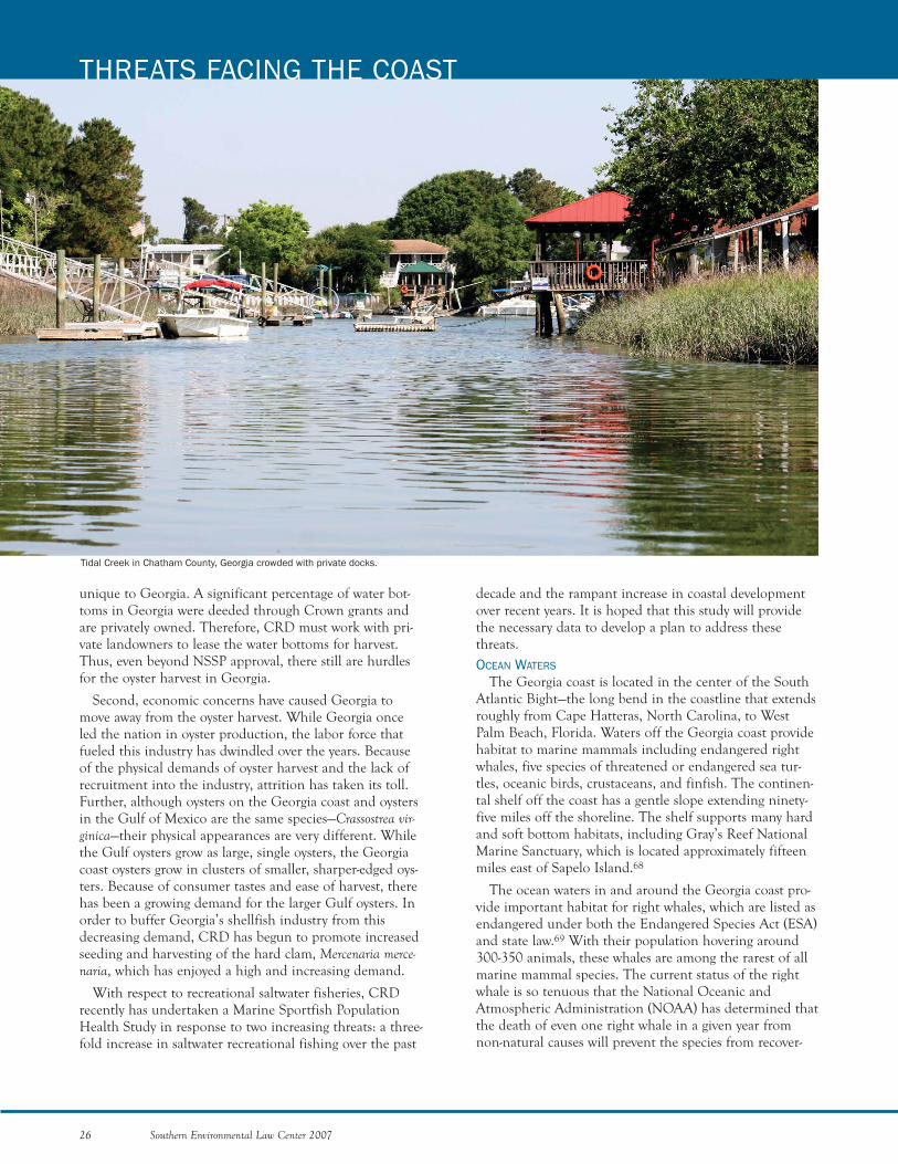
unique to Georgia. A significant percentage of water bot-toms in Georgia were deeded through Crown grants andare privately owned. Therefore, CRD must work with pri-vate landowners to lease the water bottoms for harvest.Thus, even beyond NSSP approval, there still are hurdlesfor the oyster harvest in Georgia.
Second, economic concerns have caused Georgia tomove away from the oyster harvest. While Georgia onceled the nation in oyster production, the labor force thatfueled this industry has dwindled over the years. Becauseof the physical demands of oyster harvest and the lack ofrecruitment into the industry, attrition has taken its toll.Further, although oysters on the Georgia coast and oystersin the Gulf of Mexico are the same species—Crassostrea vir-ginica—their physical appearances are very different. Whilethe Gulf oysters grow as large, single oysters, the Georgiacoast oysters grow in clusters of smaller, sharper-edged oys-ters. Because of consumer tastes and ease of harvest, therehas been a growing demand for the larger Gulf oysters. Inorder to buffer Georgia’s shellfish industry from thisdecreasing demand, CRD has begun to promote increasedseeding and harvesting of the hard clam, Mercenaria merce-naria, which has enjoyed a high and increasing demand.
With respect to recreational saltwater fisheries, CRDrecently has undertaken a Marine Sportfish PopulationHealth Study in response to two increasing threats: a three-fold increase in saltwater recreational fishing over the past
26 Southern Environmental Law Center 2007
THREATS FACING THE COAST
decade and the rampant increase in coastal developmentover recent years. It is hoped that this study will providethe necessary data to develop a plan to address thesethreats.OCEAN WATERS
The Georgia coast is located in the center of the SouthAtlantic Bight—the long bend in the coastline that extendsroughly from Cape Hatteras, North Carolina, to WestPalm Beach, Florida. Waters off the Georgia coast providehabitat to marine mammals including endangered rightwhales, five species of threatened or endangered sea tur-tles, oceanic birds, crustaceans, and finfish. The continen-tal shelf off the coast has a gentle slope extending ninety-five miles off the shoreline. The shelf supports many hardand soft bottom habitats, including Gray’s Reef NationalMarine Sanctuary, which is located approximately fifteenmiles east of Sapelo Island.68
The ocean waters in and around the Georgia coast pro-vide important habitat for right whales, which are listed asendangered under both the Endangered Species Act (ESA)and state law.69 With their population hovering around300-350 animals, these whales are among the rarest of allmarine mammal species. The current status of the rightwhale is so tenuous that the National Oceanic andAtmospheric Administration (NOAA) has determined thatthe death of even one right whale in a given year fromnon-natural causes will prevent the species from recover-
Tidal Creek in Chatham County, Georgia crowded with private docks.
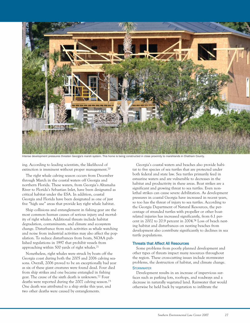
ing. According to leading scientists, the likelihood ofextinction is imminent without proper management.70
The right whale calving season occurs from Decemberthrough March in the coastal waters off Georgia andnorthern Florida. These waters, from Georgia’s AltamahaRiver to Florida’s Sebastian Inlet, have been designated ascritical habitat under the ESA. In addition, coastalGeorgia and Florida have been designated as one of justfive “high use” areas that provide key right whale habitat.
Ship collisions and entanglement in fishing gear are themost common human causes of serious injury and mortal-ity of right whales. Additional threats include habitatdegradation, contaminants, and climate and ecosystemchange. Disturbance from such activities as whale watchingand noise from industrial activities may also affect the pop-ulation. To reduce disturbances from boats, NOAA pub-lished regulations in 1997 that prohibit vessels fromapproaching within 500 yards of right whales.71
Nonetheless, right whales were struck by boats off theGeorgia coast during both the 2005 and 2006 calving sea-sons. Overall, 2006 proved to be an exceptionally bad yearas six of these giant creatures were found dead. Four diedfrom ship strikes and one became entangled in fishinggear. The cause of the sixth death is unknown.72 Fourdeaths were reported during the 2007 calving season.73
One death was attributed to a ship strike this year, andtwo other deaths were caused by entanglements.
Georgia’s coastal waters and beaches also provide habi-tat to five species of sea turtles that are protected underboth federal and state law. Sea turtles primarily feed inestuarine waters and are vulnerable to decreases in thehabitat and productivity in these areas. Boat strikes are asignificant and growing threat to sea turtles. Even non-lethal strikes can cause severe debilitation. As developmentpressures in coastal Georgia have increased in recent years,so too has the threat of injury to sea turtles. According tothe Georgia Department of Natural Resources, the per-centage of stranded turtles with propeller or other boat-related injuries has increased significantly, from 6.1 per-cent in 2002 to 20.9 percent in 2004.74 Loss of beach nest-ing habitat and disturbances on nesting beaches fromdevelopment also contribute significantly to declines in seaturtle populations.
TThhrreeaattss tthhaatt AAffffeecctt AAllll RReessoouurrcceess Some problems from poorly planned development and
other types of threats impact many resources throughoutthe region. These cross-cutting issues include stormwaterproblems, the destruction of habitat, and climate change. STORMWATER
Development results in an increase of impervious sur-faces such as parking lots, rooftops, and roadways and adecrease in naturally vegetated land. Rainwater that wouldotherwise be held back by vegetation to infiltrate the
Southern Environmental Law Center 2007 27
Intense development pressures threaten Georgia's marsh system. This home is being constructed in close proximity to marshlands in Chatham County.
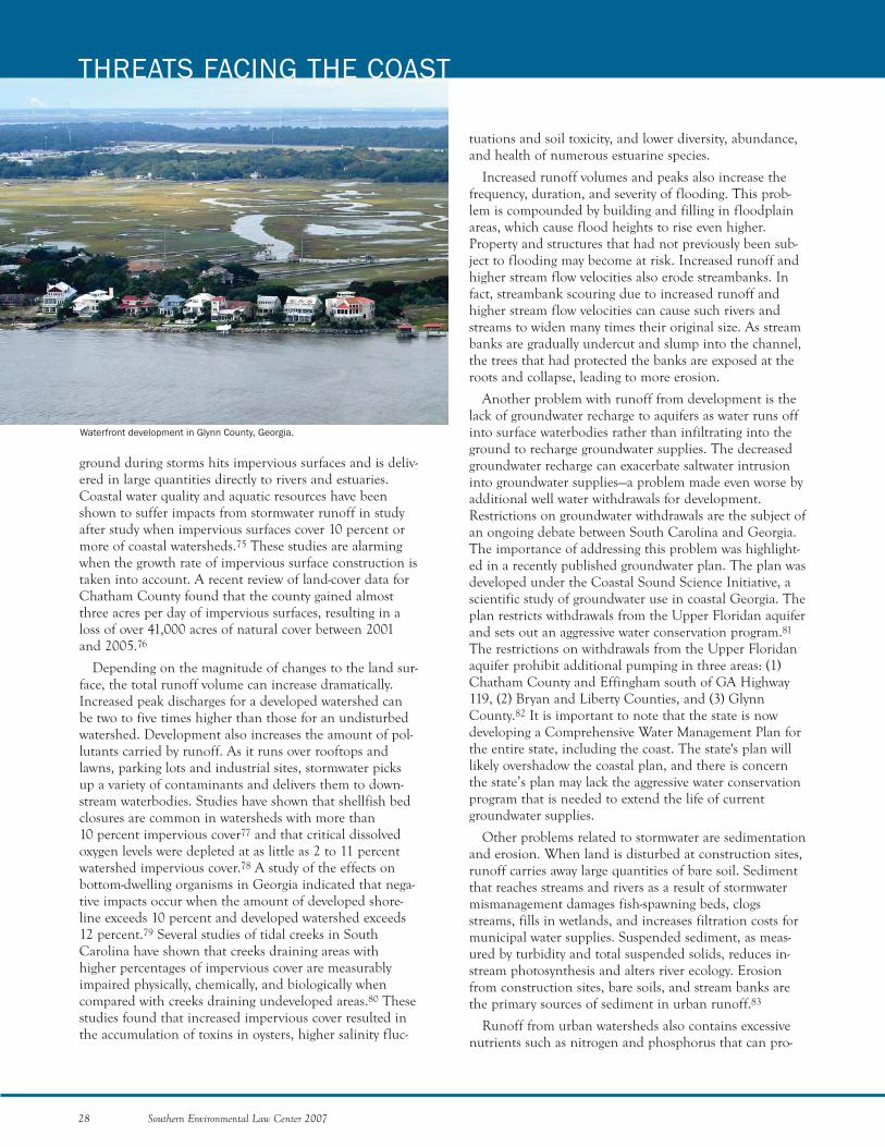
tuations and soil toxicity, and lower diversity, abundance,and health of numerous estuarine species.
Increased runoff volumes and peaks also increase thefrequency, duration, and severity of flooding. This prob-lem is compounded by building and filling in floodplainareas, which cause flood heights to rise even higher.Property and structures that had not previously been sub-ject to flooding may become at risk. Increased runoff andhigher stream flow velocities also erode streambanks. Infact, streambank scouring due to increased runoff andhigher stream flow velocities can cause such rivers andstreams to widen many times their original size. As streambanks are gradually undercut and slump into the channel,the trees that had protected the banks are exposed at theroots and collapse, leading to more erosion.
Another problem with runoff from development is thelack of groundwater recharge to aquifers as water runs offinto surface waterbodies rather than infiltrating into theground to recharge groundwater supplies. The decreasedgroundwater recharge can exacerbate saltwater intrusioninto groundwater supplies—a problem made even worse byadditional well water withdrawals for development.Restrictions on groundwater withdrawals are the subject ofan ongoing debate between South Carolina and Georgia.The importance of addressing this problem was highlight-ed in a recently published groundwater plan. The plan wasdeveloped under the Coastal Sound Science Initiative, ascientific study of groundwater use in coastal Georgia. Theplan restricts withdrawals from the Upper Floridan aquiferand sets out an aggressive water conservation program.81
The restrictions on withdrawals from the Upper Floridanaquifer prohibit additional pumping in three areas: (1)Chatham County and Effingham south of GA Highway119, (2) Bryan and Liberty Counties, and (3) GlynnCounty.82 It is important to note that the state is nowdeveloping a Comprehensive Water Management Plan forthe entire state, including the coast. The state's plan willlikely overshadow the coastal plan, and there is concernthe state’s plan may lack the aggressive water conservationprogram that is needed to extend the life of currentgroundwater supplies.
Other problems related to stormwater are sedimentationand erosion. When land is disturbed at construction sites,runoff carries away large quantities of bare soil. Sedimentthat reaches streams and rivers as a result of stormwatermismanagement damages fish-spawning beds, clogsstreams, fills in wetlands, and increases filtration costs formunicipal water supplies. Suspended sediment, as meas-ured by turbidity and total suspended solids, reduces in-stream photosynthesis and alters river ecology. Erosionfrom construction sites, bare soils, and stream banks arethe primary sources of sediment in urban runoff.83
Runoff from urban watersheds also contains excessivenutrients such as nitrogen and phosphorus that can pro-
28 Southern Environmental Law Center 2007
THREATS FACING THE COAST
ground during storms hits impervious surfaces and is deliv-ered in large quantities directly to rivers and estuaries.Coastal water quality and aquatic resources have beenshown to suffer impacts from stormwater runoff in studyafter study when impervious surfaces cover 10 percent ormore of coastal watersheds.75 These studies are alarmingwhen the growth rate of impervious surface construction istaken into account. A recent review of land-cover data forChatham County found that the county gained almostthree acres per day of impervious surfaces, resulting in aloss of over 41,000 acres of natural cover between 2001and 2005.76
Depending on the magnitude of changes to the land sur-face, the total runoff volume can increase dramatically.Increased peak discharges for a developed watershed canbe two to five times higher than those for an undisturbedwatershed. Development also increases the amount of pol-lutants carried by runoff. As it runs over rooftops andlawns, parking lots and industrial sites, stormwater picksup a variety of contaminants and delivers them to down-stream waterbodies. Studies have shown that shellfish bedclosures are common in watersheds with more than 10 percent impervious cover77 and that critical dissolvedoxygen levels were depleted at as little as 2 to 11 percentwatershed impervious cover.78 A study of the effects onbottom-dwelling organisms in Georgia indicated that nega-tive impacts occur when the amount of developed shore-line exceeds 10 percent and developed watershed exceeds12 percent.79 Several studies of tidal creeks in SouthCarolina have shown that creeks draining areas with higher percentages of impervious cover are measurablyimpaired physically, chemically, and biologically when compared with creeks draining undeveloped areas.80 Thesestudies found that increased impervious cover resulted inthe accumulation of toxins in oysters, higher salinity fluc-
Waterfront development in Glynn County, Georgia.
Southern Environmental Law Center 2007 29
mote weed and algae growth. In addition, the level of bacte-ria, viruses, and other microbes found in urban stormwaterrunoff often exceeds public health standards for water con-tact recreation such as swimming and wading. Thesemicrobes can also contaminate shellfish beds and increasepurification costs of municipal water treatment. One impor-tant source of these contaminants is improperly maintainedseptic tanks.
Since 1986, a long-term water quality sampling study ofthe Skidaway River Estuary has recorded a significantupward trend in nutrient levels that are tied to storm eventsand increases in nutrients and bacteria.84 Discussing theresults, the study’s author, Dr. Peter Verity, noted that“[p]arts of Coastal Georgia are heading in the direction ofChesapeake Bay and Boston Harbor. It may take a few moreyears to get there, but if it does, history shows that it willtake many generations to get it back.”85
DESTRUCTION OF WILDLIFE AND HABITAT
One of the biggest threats already facing wildlife through-out the coastal region is habitat loss. Due to the concentra-tion of threatened and endangered species within Georgia’scoastal region, habitat loss has a disproportionate effect onsuch wildlife. Heavy development in the region is not limit-ed to marsh-front or beach-front areas. Many areas, as farinland as Rincon, are experiencing significant growth.
As discussed previously, intense development pressure hasalready resulted in the loss or fragmentation of longleaf pineforests and wetlands.86 As more land is converted to devel-opment, these impacts are expected to increase. Specieswhose numbers are already dwindling, especially those listedas threatened or endangered under federal or state law, areof greatest concern. Some of these species, like gopher tor-toises and indigo snakes, are directly impacted by habitatloss. Other aquatic species, like shortnose sturgeon andfreshwater mussels, suffer the indirect effects of habitatdegradation as a result of water quality impairment.
New roads built to accommodate continued growth alsotake a toll on wildlife and the environment. For a numberof species, such as the threatened indigo snake, roads are amajor source of mortality. In addition, new roads and high-ways break up formerly contiguous tracts of forest andreduce the availability of undisturbed habitat. In addition towildlife impacts, there are a number of important implica-tions for water quality and flooding. At stream and rivercrossings, poorly designed roadways function as “roaddams,” trapping water and creating a back up of flow thatexacerbates flooding during storms. In addition, roads thatcross wetlands can disrupt natural water flow and causelarge sections of the wetlands to die off from either toomuch or too little water.
Numerous bird species, such as the painted bunting, aredeclining as a result of habitat losses. Painted buntingsexhibit extremely high nesting success in old growth mar-itime oak forests. Natural openings in these woods—created
by storms, fires, and dying trees—provide nesting and feed-ing habitat in adjacent marshes. Development has replacedmuch maritime forest habitat. In addition, increases in feralcat populations associated with increased development havedecimated the painted bunting population and other birdspecies.87 Unless measures are taken to restore habitat tothese species, their numbers are sure to continue todecline.
Other habitat losses result from the introduction of exot-ic species to the region. The ambrosia beetle from Asia, forexample, carries a fungus that kills redbay trees. CoastalGeorgia’s ambrosia beetle infestation has been traced towood packaging materials from Asia that were deposited bya freighter at the Savannah port. This recent infestation istaking a vast toll on redbays, with some areas experiencingnearly complete mortality of the local redbay population injust two to three years’ time.88 Redbay is important towildlife because its fruit, seed, and foliage are eaten by sev-eral species of songbirds, butterflies, wild turkeys, quail,deer, and black bear. Another exotic, released by anglersinto the Satilla River, is the flathead catfish. Flathead arenow decimating natural populations of other fish. TheGeorgia Department of Natural Resources has found a 75 percent drop in the number of native fish such as thered-breasted sunfish in areas of the Satilla River where flat-heads have increased dramatically.89 Without considerableeffort to contain and eliminate these invasives, they willcontinue to threaten our coastal heritage.CLIMATE CHANGE
Global warming is the elevation in the temperature ofthe earth’s surface and its atmosphere due to the increasedrelease of certain greenhouse gases. Also referred to as “climate-forcing” gases, greenhouse gases absorb infraredradiation that otherwise would escape back into space. Dueto this increased absorption, the earth radiates less energythan it absorbs from the sun, thereby resulting in a netwarming of the earth. The most significant greenhouse gasis carbon dioxide, which comes mainly from the burning offossil fuels (i.e., oil, gas, and coal). Other important con-tributors include chlorofluorocarbons (CFCs); the compo-nents of smog, such as methane and tropospheric ozone;and black carbon (or soot), which comes from the incom-plete burning of fossil fuels and biofuels.
Global warming may impact the Georgia coast in twodramatic ways. First, scientists predict it will increase sealevels. Second, scientists predict it will increase the numberof hurricanes that will strike coastal regions. Unless thecoastal region takes global warming into account in itsplanning for the future, it could suffer serious repercus-sions.
Over the next century, the range of temperature increaseis expected to be between 3.1 and 7.9 degrees Fahrenheit,under a moderate scenario.90 With this temperatureincrease, sea level will rise due to the melting of sea ice.
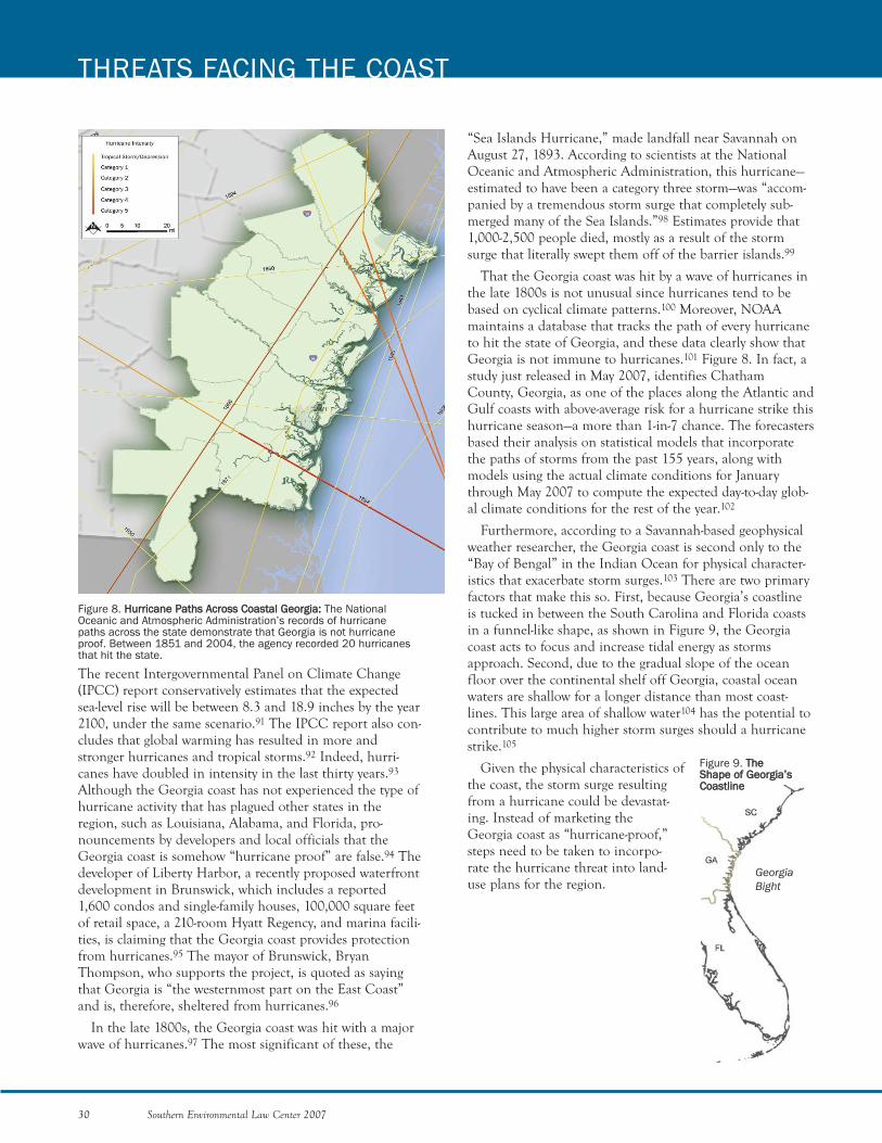
“Sea Islands Hurricane,” made landfall near Savannah on August 27, 1893. According to scientists at the NationalOceanic and Atmospheric Administration, this hurricane—estimated to have been a category three storm—was “accom-panied by a tremendous storm surge that completely sub-merged many of the Sea Islands.”98 Estimates provide that1,000-2,500 people died, mostly as a result of the stormsurge that literally swept them off of the barrier islands.99
That the Georgia coast was hit by a wave of hurricanes inthe late 1800s is not unusual since hurricanes tend to bebased on cyclical climate patterns.100 Moreover, NOAAmaintains a database that tracks the path of every hurricaneto hit the state of Georgia, and these data clearly show thatGeorgia is not immune to hurricanes.101 Figure 8. In fact, astudy just released in May 2007, identifies ChathamCounty, Georgia, as one of the places along the Atlantic andGulf coasts with above-average risk for a hurricane strike thishurricane season—a more than 1-in-7 chance. The forecastersbased their analysis on statistical models that incorporatethe paths of storms from the past 155 years, along withmodels using the actual climate conditions for Januarythrough May 2007 to compute the expected day-to-day glob-al climate conditions for the rest of the year.102
Furthermore, according to a Savannah-based geophysicalweather researcher, the Georgia coast is second only to the“Bay of Bengal” in the Indian Ocean for physical character-istics that exacerbate storm surges.103 There are two primaryfactors that make this so. First, because Georgia’s coastlineis tucked in between the South Carolina and Florida coastsin a funnel-like shape, as shown in Figure 9, the Georgiacoast acts to focus and increase tidal energy as stormsapproach. Second, due to the gradual slope of the oceanfloor over the continental shelf off Georgia, coastal oceanwaters are shallow for a longer distance than most coast-lines. This large area of shallow water104 has the potential tocontribute to much higher storm surges should a hurricanestrike.105
Given the physical characteristics ofthe coast, the storm surge resultingfrom a hurricane could be devastat-ing. Instead of marketing theGeorgia coast as “hurricane-proof,”steps need to be taken to incorpo-rate the hurricane threat into land-use plans for the region.
GeorgiaBight
Figure 8. HHuurrrriiccaannee PPaatthhss AAccrroossss CCooaassttaall GGeeoorrggiiaa:: The NationalOceanic and Atmospheric Administration’s records of hurricanepaths across the state demonstrate that Georgia is not hurricaneproof. Between 1851 and 2004, the agency recorded 20 hurricanesthat hit the state.
Figure 9. TThhee SShhaappee ooff GGeeoorrggiiaa’’ssCCooaassttlliinnee
30 Southern Environmental Law Center 2007
THREATS FACING THE COAST
The recent Intergovernmental Panel on Climate Change(IPCC) report conservatively estimates that the expectedsea-level rise will be between 8.3 and 18.9 inches by the year2100, under the same scenario.91 The IPCC report also con-cludes that global warming has resulted in more andstronger hurricanes and tropical storms.92 Indeed, hurri-canes have doubled in intensity in the last thirty years.93
Although the Georgia coast has not experienced the type ofhurricane activity that has plagued other states in theregion, such as Louisiana, Alabama, and Florida, pro-nouncements by developers and local officials that theGeorgia coast is somehow “hurricane proof” are false.94 Thedeveloper of Liberty Harbor, a recently proposed waterfrontdevelopment in Brunswick, which includes a reported1,600 condos and single-family houses, 100,000 square feetof retail space, a 210-room Hyatt Regency, and marina facili-ties, is claiming that the Georgia coast provides protectionfrom hurricanes.95 The mayor of Brunswick, BryanThompson, who supports the project, is quoted as sayingthat Georgia is “the westernmost part on the East Coast”and is, therefore, sheltered from hurricanes.96
In the late 1800s, the Georgia coast was hit with a majorwave of hurricanes.97 The most significant of these, the
Southern Environmental Law Center 2007 31
GOVERNMENT AGENCIES AND ENVIRONMENTAL GROUPS
CRAIG TANNER
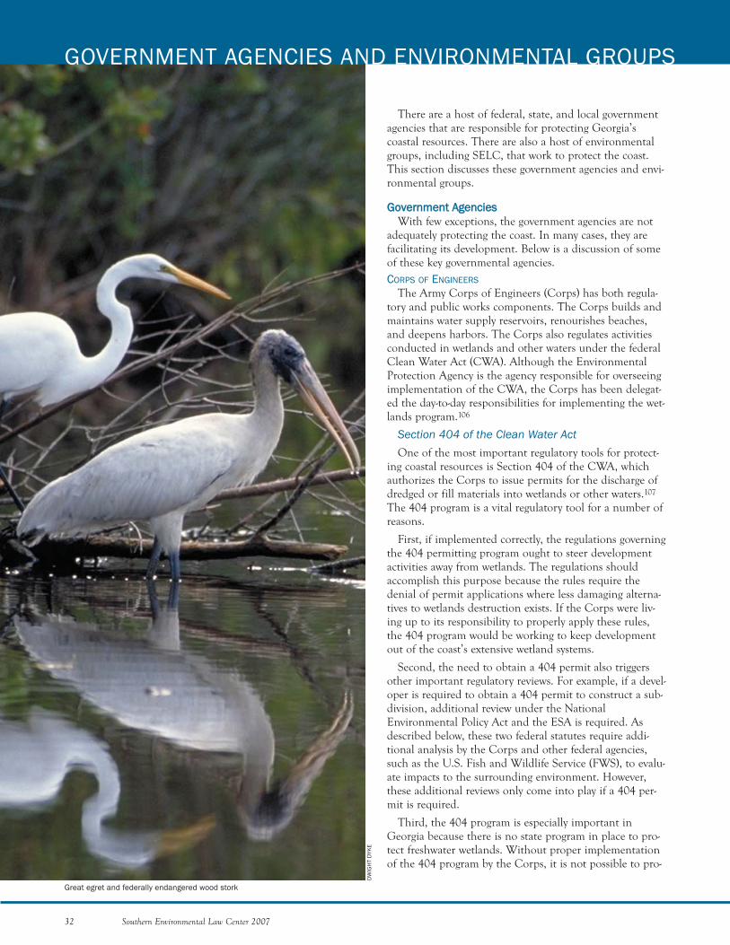
There are a host of federal, state, and local governmentagencies that are responsible for protecting Georgia’scoastal resources. There are also a host of environmentalgroups, including SELC, that work to protect the coast.This section discusses these government agencies and envi-ronmental groups.
GGoovveerrnnmmeenntt AAggeenncciieessWith few exceptions, the government agencies are not
adequately protecting the coast. In many cases, they arefacilitating its development. Below is a discussion of someof these key governmental agencies. CORPS OF ENGINEERS
The Army Corps of Engineers (Corps) has both regula-tory and public works components. The Corps builds andmaintains water supply reservoirs, renourishes beaches,and deepens harbors. The Corps also regulates activitiesconducted in wetlands and other waters under the federalClean Water Act (CWA). Although the EnvironmentalProtection Agency is the agency responsible for overseeingimplementation of the CWA, the Corps has been delegat-ed the day-to-day responsibilities for implementing the wet-lands program.106
Section 404 of the Clean Water Act One of the most important regulatory tools for protect-
ing coastal resources is Section 404 of the CWA, whichauthorizes the Corps to issue permits for the discharge ofdredged or fill materials into wetlands or other waters.107
The 404 program is a vital regulatory tool for a number ofreasons.
First, if implemented correctly, the regulations governingthe 404 permitting program ought to steer developmentactivities away from wetlands. The regulations shouldaccomplish this purpose because the rules require thedenial of permit applications where less damaging alterna-tives to wetlands destruction exists. If the Corps were liv-ing up to its responsibility to properly apply these rules,the 404 program would be working to keep developmentout of the coast’s extensive wetland systems.
Second, the need to obtain a 404 permit also triggersother important regulatory reviews. For example, if a devel-oper is required to obtain a 404 permit to construct a sub-division, additional review under the NationalEnvironmental Policy Act and the ESA is required. Asdescribed below, these two federal statutes require addi-tional analysis by the Corps and other federal agencies,such as the U.S. Fish and Wildlife Service (FWS), to evalu-ate impacts to the surrounding environment. However,these additional reviews only come into play if a 404 per-mit is required.
Third, the 404 program is especially important inGeorgia because there is no state program in place to pro-tect freshwater wetlands. Without proper implementationof the 404 program by the Corps, it is not possible to pro-
32 Southern Environmental Law Center 2007
GOVERNMENT AGENCIES AND ENVIRONMENTAL GROUPS
DW
IGH
T D
YKE
Great egret and federally endangered wood stork
tect the state’s extensive freshwater wetland resources,which conservative estimates place at more than four mil-lion acres.
Despite the importance of wetlands, the Corps hasfailed to live up to its responsibility to protect theseresources in recent years. Since figures on the overall lossof wetlands on the coast are not available, SELC conduct-ed a geographic information systems analysis usingNational Wetlands Inventory data prepared by the FWSand land cover data prepared by the Natural ResourcesSpatial Analysis Laboratory at the University of Georgia.This analysis indicates that Georgia’s coastal area has lostapproximately 97,890 acres of wetlands from the mid-1980s to 2001.108
Failure to Regulate Wetlands and Streams under theClean Water ActThe Solid Waste Agency of Northern Cook County v. U.S.Corps of Engineers Decision
For the first thirty years of its history, the CWA wasinterpreted to apply to virtually all wetlands, including so-called “isolated” wetlands. In 2001, however, in Solid WasteAgency of Northern Cook County v. U.S. Corps of Engineers(SWANCC),109 the U.S. Supreme Court issued a decisionthat, at the time, seemed to call into question the ability ofthe federal government to protect isolated wetlands—thosewetlands that lack an apparent surface water connection tonavigable streams and rivers. Specifically, the SupremeCourt held that the federal government cannot use thepresence of migratory birds as the sole basis for assertingCWA jurisdiction over these non-navigable, intrastate, iso-lated waters.
Since the SWANCC decision was handed down, theoverwhelming majority of lower federal court decisionshave construed SWANCC to allow CWA jurisdiction tocover all but the most hydrologically remote wetlands.Despite these decisions, the Savannah District of theCorps has been unwilling to assert jurisdiction over wet-lands that are clearly covered by the CWA. Based on itspost-SWANCC jurisdictional calls, the Savannah Districthas emerged as the one of the worst Corps districts in thecountry.
This is of critical importance for wetlands protectionbecause if a wetland is considered to be non-jurisdictional,a developer does not have to obtain a 404 permit beforefilling it. It also means that the developer does not have tomake any attempt to avoid the wetland, minimize theimpact to the wetland, or mitigate for the damage done tothe wetland. Typically, mitigation projects involve therestoration, preservation, or creation of other wetlands tooffset the losses caused by the project. Further, the protec-tions provided by other laws such as the NationalEnvironmental Policy Act and the Endangered Species Actdo not get triggered if a 404 permit is not required.
Usually, a developer hires an environmental consultantto identify wetlands as either non-jurisdictional or jurisdic-tional. The Corps then is supposed to review the environ-mental consultant’s report to render a decision called a“jurisdictional determination.” With the initial confusionsurrounding the SWANCC decision, the developers on theGeorgia coast, and their lawyers and environmental con-sultants, took advantage of the situation by convincing theCorps to remove federal protections for wetlands that wereclearly jurisdictional. And, because there is no public com-ment requirement for a determination of no jurisdiction,the developers were able to eliminate federal protectionsfor wetlands on their development sites without drawingany attention from the public.
Unlike Georgia, a number of other southern states,including North Carolina, Virginia, Tennessee, andFlorida, have recognized the importance of wetlandresources and have adopted their own programs to protectfreshwater wetlands, including those no longer coveredunder the CWA. In Georgia, however, the state has beenunwilling to protect wetlands deemed “isolated” by theCorps. Thus, when the Corps decides not to protect a wet-land, there is no state program in place to fill the gap infederal protection. As a result, thousands of acres ofGeorgia’s wetlands are left exposed to threats, including,but not limited to, mining and development. In the wakeof the SWANCC decision, SELC believes thousands ofacres of wetlands in Georgia were unlawfully destroyed.Without our review, analysis, and comment on these typesof decisions, scores of additional wetlands would havebeen destroyed with no regulatory oversight or notice tothe public.
The Rapanos v. United States Decision
In June 2006, federal wetland protections were againthreatened when the U.S. Supreme Court issued theRapanos v. United States decision.110 This decision, likeSWANCC, has caused even more confusion with respect tothe federal government’s authority over wetlands andstreams and has the potential to lead to crippling losses ofwater resources in coastal Georgia. In Rapanos, fourJustices, led by Justice Antonin Scalia, found that if astream lacks a permanent connection to navigable waters,that stream is not protected by the CWA. These sameJustices stated further that the CWA did not cover wet-lands that lacked a “continuous surface connection” to anavigable water.111 Four other Justices, led by Justice JohnStevens, held to the traditional interpretation of the thirty-four-year-old law, which reflects what Congress intended—that virtually all wetlands and waters are protected.112
Justice Anthony Kennedy authored his own opinion inwhich he disagreed with Justices Scalia and Stevens on thetest that should be applied to determine jurisdiction.Justice Kennedy decided that for a water to be jurisdiction-
Southern Environmental Law Center 2007 33

al, it must have a “significant nexus” or link to a down-stream water that is “navigable in the traditional sense.”113
Immediately after the Rapanos decision was handeddown, the EPA and the Corps instructed their field officesthat the agencies were planning to distribute guidanceinterpreting the Rapanos decision within three weeks. Theguidance was finally issued on June 5, 2007, close to a yearlater. How the guidance will be applied by the SavannahDistrict holds tremendous implications for wetlands andstreams throughout the coastal zone.
In the meantime, the environmental community cannotafford to sit back and simply wait to see how the Corpswill apply the new guidance. The application of theRapanos decision has huge ramifications for Georgiabecause of the abundance of wetland and stream resourcesfacing increasing development pressures. These resourcesare especially vulnerable due to the Savannah District’spoor record of making jurisdictional decisions and theabsence of a state wetland program to fill the gap createdby any withdrawal of federal authority. Further, history hastaught us that developers will be taking full advantage ofthis period of uncertainty, pressuring the SavannahDistrict to remove CWA protections for wetlands through-out the coastal zone. Other developers will not even both-er to pressure the Corps on these jurisdictional decisions;they will simply destroy wetlands that they believe are nolonger protected under federal law.
To prevent this outcome, immediate steps must be takento hold the line on federal protections for water resources.As discussed below in the section entitled “Actions andInitiatives Needed on the Coast,” the coastal advocatesmust implement strategies immediately to make sure thatwetlands and streams in the coastal zone are fully affordedCWA protections. These actions includeextensive monitoring of jurisdictional deter-minations and challenging any decisions thatimproperly remove federal protections.
Excluding Wetland Types throughImproper Jurisdictional DeterminationsAnother problem contributing to the loss
of wetlands in coastal Georgia is theSavannah District’s unwillingness to takejurisdiction over certain classes of wetlands.This problem existed even before SWANCCand Rapanos. Throughout the coast, theCorps has systematically eliminated an entireclass of wetlands from their jurisdiction.These wetlands meet the federal criteria forwetlands, and, therefore, should fall withinthe Corps’ jurisdiction just as they do inother states such as South Carolina andNorth Carolina. However, according to con-sultant biologists we have interviewed for pur-
34 Southern Environmental Law Center 2007
GOVERNMENT AGENCIES AND ENVIRONMENTAL GROUPS
WWiitthh LLeeggaall AAccttiioonn IImmmmiinneenntt,, CCoorrppss WWiitthhddrraawwss BBaadd““IIssoollaatteedd”” WWeettllaanndd DDeecciissiioonnss
In 2001, the Corps determined that about 112 acres of wetlands in the Savannah River water-shed were isolated and not protected by federal law.SELC, working with several experts, flew over thesite, photographed the area, and determined thatthe wetlands were connected to other waters. Theaerial photographs from the flyover revealed that thewetlands were not isolated. As Figure 10 shows, thewetlands (gray area) extend past the development'sproperty line and connect to a creek that ultimatelyempties into the Savannah River. After writing sever-al letters, sharing expert reports, and providingnotice of our intent to sue, the Corps reversed itsdecision and recaptured jurisdiction over about 77acres of wetlands.
At the same time, on the other end of the coast,the Corps advised a titanium mining company thatmore than 300 acres of forested wetlands on a pro-posed mining site in Brantley County were isolatedand, therefore, not protected under the Clean WaterAct. Based on this decision, the mining company wasfree to mine and destroy the wetlands without anypermit. SELC investigated the determination andexplained to the Corps that the wetlands at issuewere actually hydrologically connected to the SatillaRiver and therefore covered under the Clean WaterAct, as shown in Figure 11. After months of commu-nicating with the Corps and the mining company andpreparing for legal action, the Corps finally reversedits decision, claiming Clean Water Act jurisdictionover about 120 acres of the 300 acres that theCorps originally left unprotected.
Figure 10. WWeettllaanndd EErrrroorrss:: The Corps determined that 112 acres of wetlands were isolatedand not protected by federal law. After SELC demonstrated that the wetlands were clearlyconnected to other waters, the Corps reversed its decision on 77 acres.
KAT
HR
YN K
OLB
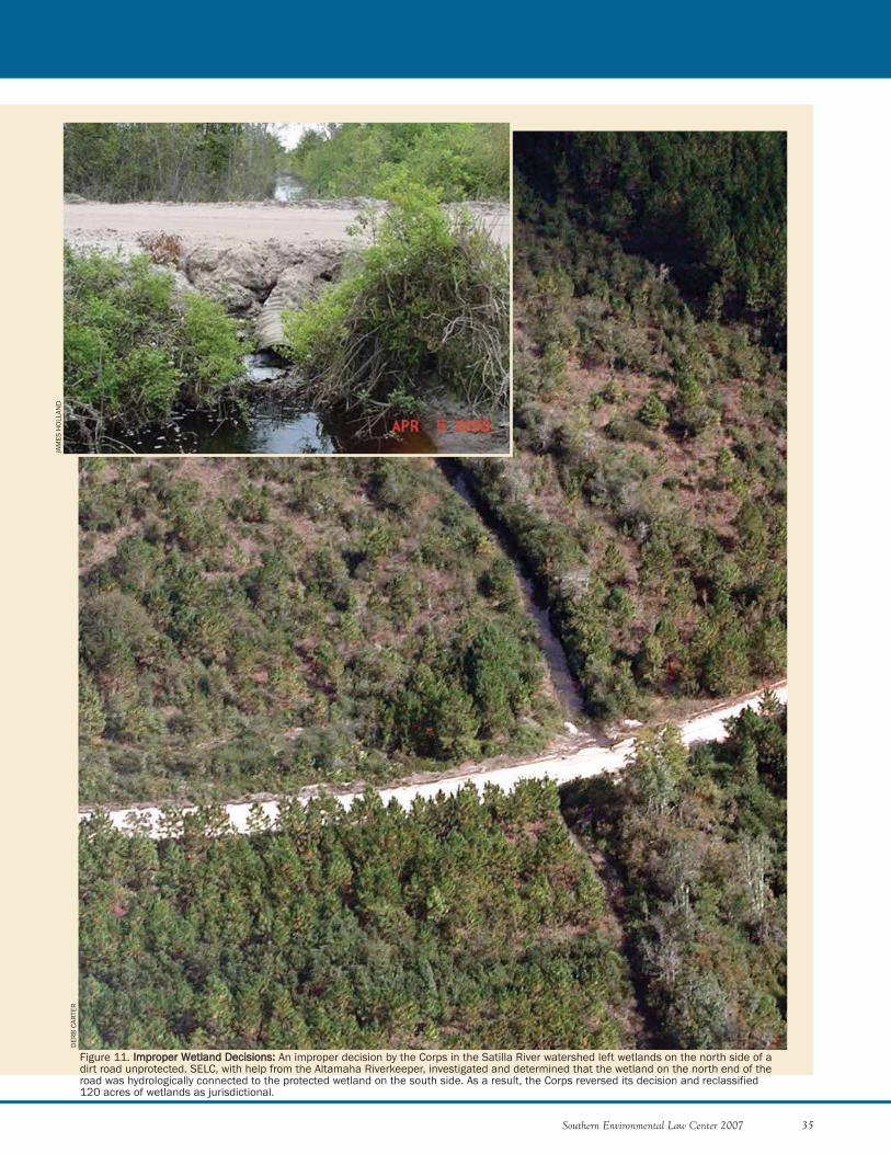
Southern Environmental Law Center 2007 35
Figure 11. IImmpprrooppeerr WWeettllaanndd DDeecciissiioonnss:: An improper decision by the Corps in the Satilla River watershed left wetlands on the north side of adirt road unprotected. SELC, with help from the Altamaha Riverkeeper, investigated and determined that the wetland on the north end of theroad was hydrologically connected to the protected wetland on the south side. As a result, the Corps reversed its decision and reclassified 120 acres of wetlands as jurisdictional.
DER
B C
ARTE
R
JAM
ES H
OLL
AND
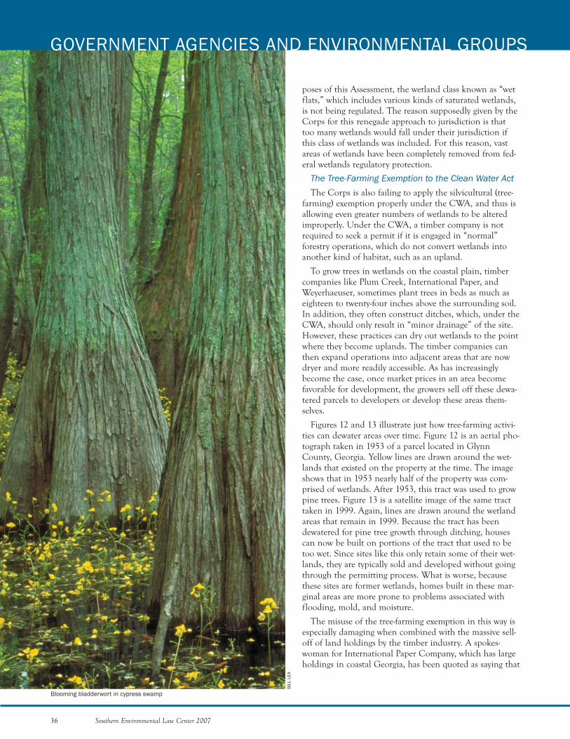
poses of this Assessment, the wetland class known as “wetflats,” which includes various kinds of saturated wetlands,is not being regulated. The reason supposedly given by theCorps for this renegade approach to jurisdiction is thattoo many wetlands would fall under their jurisdiction ifthis class of wetlands was included. For this reason, vastareas of wetlands have been completely removed from fed-eral wetlands regulatory protection.
The Tree-Farming Exemption to the Clean Water ActThe Corps is also failing to apply the silvicultural (tree-
farming) exemption properly under the CWA, and thus isallowing even greater numbers of wetlands to be alteredimproperly. Under the CWA, a timber company is notrequired to seek a permit if it is engaged in “normal”forestry operations, which do not convert wetlands intoanother kind of habitat, such as an upland.
To grow trees in wetlands on the coastal plain, timbercompanies like Plum Creek, International Paper, andWeyerhaeuser, sometimes plant trees in beds as much aseighteen to twenty-four inches above the surrounding soil.In addition, they often construct ditches, which, under theCWA, should only result in “minor drainage” of the site.However, these practices can dry out wetlands to the pointwhere they become uplands. The timber companies canthen expand operations into adjacent areas that are nowdryer and more readily accessible. As has increasinglybecome the case, once market prices in an area becomefavorable for development, the growers sell off these dewa-tered parcels to developers or develop these areas them-selves.
Figures 12 and 13 illustrate just how tree-farming activi-ties can dewater areas over time. Figure 12 is an aerial pho-tograph taken in 1953 of a parcel located in GlynnCounty, Georgia. Yellow lines are drawn around the wet-lands that existed on the property at the time. The imageshows that in 1953 nearly half of the property was com-prised of wetlands. After 1953, this tract was used to growpine trees. Figure 13 is a satellite image of the same tracttaken in 1999. Again, lines are drawn around the wetlandareas that remain in 1999. Because the tract has beendewatered for pine tree growth through ditching, housescan now be built on portions of the tract that used to betoo wet. Since sites like this only retain some of their wet-lands, they are typically sold and developed without goingthrough the permitting process. What is worse, becausethese sites are former wetlands, homes built in these mar-ginal areas are more prone to problems associated withflooding, mold, and moisture.
The misuse of the tree-farming exemption in this way isespecially damaging when combined with the massive sell-off of land holdings by the timber industry. A spokes-woman for International Paper Company, which has largeholdings in coastal Georgia, has been quoted as saying that
36 Southern Environmental Law Center 2007
GOVERNMENT AGENCIES AND ENVIRONMENTAL GROUPS
BIL
L LE
A
Blooming bladderwort in cypress swamp

due to escalating land values, the company is “contemplat-ing selling some or all” of its 6.8 million acres of forestlands in the United States.114 As of January 3, 2006,International Paper owned 571,000 acres in Georgia,115
and its website currently indicates that more than 31,824acres are available for sale on the coast.116 Other timbercompanies have large land holdings in Georgia, too. PlumCreek owns about 876,000 acres,117 Rayonier owns about817,000 acres,118 and MeadWestvaco owns another205,769 acres in Georgia.119 As huge swaths of forestlandscome on to the market, developers are swooping in andturning former wetlands into subdivisions and strip malls.As a result, there are widespread wetland losses throughoutGeorgia’s coast.
Failure of the Corps to Properly Implement the404 Permitting ProcessUnder the 404 program, if a wetland is protected
by the CWA and no exemptions, such as theforestry exemption, apply, applicants must obtain a404 permit prior to impacting wetlands. Pursuantto regulations issued under the CWA, the Corps isprohibited from issuing a permit where there is apracticable alternative that would have less adverseeffects on the aquatic ecosystem.120 If a proposedactivity does not need to occur in a wetland (i.e., isnot “water dependent” like a marina), the regula-tions contain a presumption that practicable, lessdamaging alternatives are available, unless the devel-oper clearly demonstrates otherwise.121
The Corps rarely requires the applicant for a per-mit to satisfy these requirements. All too often, anapplicant seeking a permit to authorize the destruc-tion of wetlands for a non-water-dependent activity,such as the construction of a subdivision or a mall,is issued a permit when other less damaging devel-opment sites exist or less damaging developmentplans could be devised. Steps must be taken tomake sure that the Corps lives up to its obligationsto properly administer the 404 program and requiredevelopers to avoid and minimize impacts to wet-lands and streams.
Improper Use of Nationwide PermitsNationwide permits (NWPs) are expedited wet-
land permits for activities with minimal impacts onwetlands and other waters. According to agencystaff at the Georgia Environmental ProtectionDivision and the U.S. Fish and Wildlife Service,the Corps is misusing NWP 39 to “kick-start” largesubdivision developments.122 NWP 39 wasdesigned to be used to authorize wetland impactscaused by residential development when the totalimpact of the entire project involves half an acre orless of wetland fill or impacts less than 300 feet of
stream. Dividing projects into smaller pieces to minimizeregulatory requirements is strictly impermissible.Nevertheless, the Corps, according to agency sources, isusing NWP 39 to quickly authorize roads for new subdivi-sions and then allowing the builders to return to theCorps for other wetlands permits once the roads are inplace.
The use of NWPs in this way results in a number ofproblems. First, by authorizing these housing develop-ments under an NWP, the public does not receive notifica-tion as it would for an individual permit. Thus, the impactof development to wetlands in coastal Georgia can occurrapidly without public knowledge or review. Second, it isalso unclear whether authorization is ever sought once
Southern Environmental Law Center 2007 37
Figure 12. OOrriiggiinnaall EExxtteenntt ooff WWeettllaannddss:: This 1953 aerial photographshows wetlands (outlined in yellow) at a site in Glynn County,Georgia. After 1953, this tract was converted to a pine plantation.
Figure 13. WWeettllaannddss DDeeccrreeaasseedd bbyy FFoorreessttrryy PPrraaccttiicceess:: In 1999,an aerial photograph of the same site shows that wetlandacreage has been reduced due to forestry practices.
individual lots in the subdivision are sold to others whothen fill in these wetlands to construct their new homes.Third, even if permits are ultimately obtained for the restof the subdivision, these smaller projects are most likelypermitted without adequate mitigation for the totalamount of wetlands lost due to the entire project. In thisway, the national goal of “no net loss” is not being met.Fourth, because the Corps is limiting its review to a verysmall part of the overall development, the U.S. Fish andWildlife Service is not able to evaluate the extent of harmto federally listed species, such as eastern indigo snakes,wood storks, and red cockaded woodpeckers, that may beimpacted by the completed project.
The NWP regulations contain specific provisions thatare intended to preclude this type of piecemeal permitting.For example, NWPs apply only to “single and completeprojects,”123 and NWPs may be combined with individualpermits only where the portion of the project authorizedby the NWP has independent utility.124 A road crossingbuilt with the express purpose of providing future access toa subdivision does not have independent utility.
National Environmental Policy ActThe Corps also receives authority and appropriations
directly from Congress to undertake projects on the coastthat can have significant impacts, such as beach renourish-ment projects. For a project that significantly affects thehuman environment, like the Savannah Harbor deepeningproject, the Corps must comply with the NationalEnvironmental Policy Act, by completing an Environ-mental Impact Statement (EIS).125 In an EIS, the Corps issupposed to take a “hard look” at all the potential impactsof the project.126 However, even if the Corps finds that theproject will adversely impact the environment, the Corps isfree to continue with the project as long as the EIS is com-pleted. Thus, the EIS is no assurance that the environmentwill be protected. Making matters worse, the SavannahDistrict rarely prepares an EIS, improperly finding thatmany projects do not have a significant effect on the envi-ronment.U.S. FISH AND WILDLIFE SERVICE AND NATIONAL OCEANIC ANDATMOSPHERIC ADMINISTRATION
The U.S. Fish and Wildlife Service and the NationalOceanic and Atmospheric Administration are the two fed-eral agencies responsible for administering the EndangeredSpecies Act on the coast. Because the Georgia coast pro-vides habitat to a number of threatened and endangeredanimals, the ESA has significance in the region. UnderSection 7 of this statute, each federal agency must “insurethat any action authorized, funded or carried out by suchagency ... is not likely to jeopardize the continued exis-tence of any” listed species “or result in the destruction oradverse modification of” the species’ critical habitat.127
Section 9 of the ESA makes it “unlawful for any person”to harm listed species. Both agencies are failing to live up
to their responsibilities to implement the ESA. Below areexamples of these failures.
FWS and NOAA share responsibility for protectingmarine life such as manatees, right whales, and sea turtles.As discussed above, increased boat traffic is the most seri-ous threat to the survival of right whales and manateesand presents a growing risk to sea turtles. Nevertheless,very little has been done to address this threat. In June2004, NOAA did publish an Advance Notice of ProposedRulemaking for Right Whale Ship Strike Reduction,which includes measures for protecting right whales fromcommercial ships larger than sixty-five feet in length.128
The rule represents a step in the right direction; however,it has not yet been adopted. In the meantime, boat traffic—both recreational and commercial—keeps increasing, asdoes the threat to each of these species.
The gopher tortoise—Georgia’s official state reptile—andthe eastern indigo snake are two species that are sufferingfrom a loss of habitat on the coast.129 Although the indigosnake is federally listed, the gopher tortoise is not, despiteits dwindling numbers. Both species are found in longleafpine forests and other coastal habitats. Although theseareas are being developed at a rapid rate and the snake'snumbers are continuing to decline, FWS has not designat-ed critical habitat for the indigo. The failure to designatecritical habitat for indigos and to list the gopher tortoise asfederally threatened are significant regulatory problemsthat are leading to the demise of these species. These prob-lems are emblematic of the failure to properly apply theESA for many other species in the coastal zone.
SELC has reviewed a number of recent large-scale devel-opment proposals that illustrate these regulatory failures.Many development sites on Georgia’s coastal plain containnumerous gopher tortoise burrows. Because of the closerelationship between gopher tortoises and indigo snakes(the snakes use the burrows for refuge, especially in win-ter), a high potential exists that these development sitesalso support indigo snakes. Although concerns are some-times raised regarding potential impacts from these devel-opment proposals on indigo snakes, these concerns sel-dom result in meaningful modifications to the proposals.
One of the main reasons why indigos are not receivingadequate protection is because developers are allowed touse highly ineffective surveying methods—infrared camerascopes to probe gopher tortoise burrows—to prove thatindigos do not exist on their sites. Despite the fact that thescientific literature concludes that this surveying method isnot reliable for locating indigo snakes, developers are rou-tinely allowed to use them to satisfy their obligationsunder the ESA. Not surprisingly, developers rarely identifythe presence of indigos on their properties, and projectsare permitted without any protective measures for thesnakes that may, in fact, be present.
38 Southern Environmental Law Center 2007
GOVERNMENT AGENCIES AND ENVIRONMENTAL GROUPS
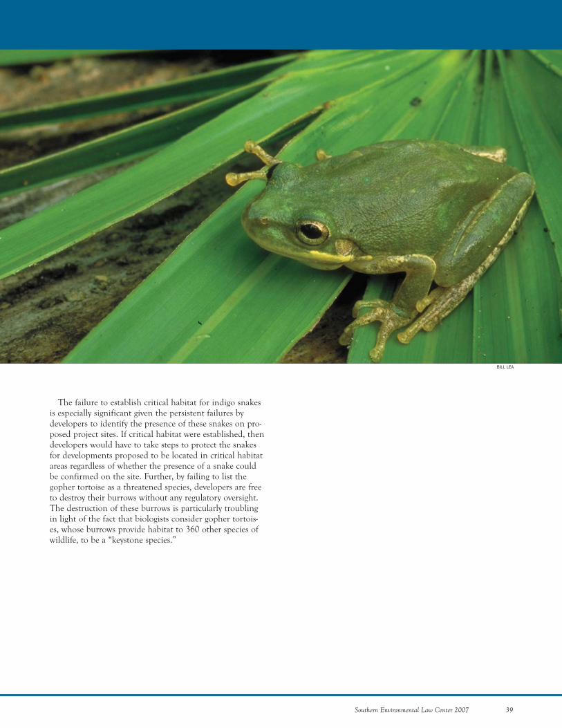
The failure to establish critical habitat for indigo snakesis especially significant given the persistent failures bydevelopers to identify the presence of these snakes on pro-posed project sites. If critical habitat were established, thendevelopers would have to take steps to protect the snakesfor developments proposed to be located in critical habitatareas regardless of whether the presence of a snake couldbe confirmed on the site. Further, by failing to list thegopher tortoise as a threatened species, developers are freeto destroy their burrows without any regulatory oversight.The destruction of these burrows is particularly troublingin light of the fact that biologists consider gopher tortois-es, whose burrows provide habitat to 360 other species ofwildlife, to be a “keystone species.”
Southern Environmental Law Center 2007 39
BILL LEA
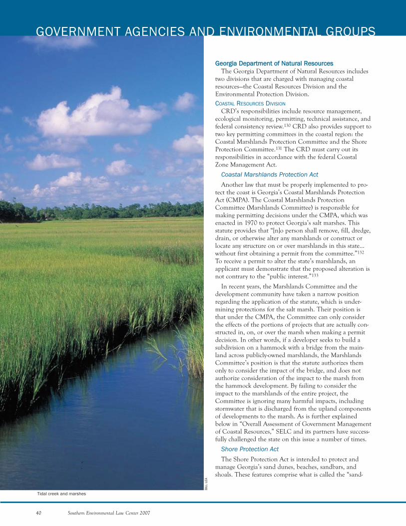
GGeeoorrggiiaa DDeeppaarrttmmeenntt ooff NNaattuurraall RReessoouurrcceessThe Georgia Department of Natural Resources includes
two divisions that are charged with managing coastalresources—the Coastal Resources Division and theEnvironmental Protection Division.COASTAL RESOURCES DIVISION
CRD’s responsibilities include resource management,ecological monitoring, permitting, technical assistance, andfederal consistency review.130 CRD also provides support totwo key permitting committees in the coastal region: theCoastal Marshlands Protection Committee and the ShoreProtection Committee.131 The CRD must carry out itsresponsibilities in accordance with the federal CoastalZone Management Act.
Coastal Marshlands Protection ActAnother law that must be properly implemented to pro-
tect the coast is Georgia’s Coastal Marshlands ProtectionAct (CMPA). The Coastal Marshlands ProtectionCommittee (Marshlands Committee) is responsible formaking permitting decisions under the CMPA, which wasenacted in 1970 to protect Georgia’s salt marshes. Thisstatute provides that “[n]o person shall remove, fill, dredge,drain, or otherwise alter any marshlands or construct orlocate any structure on or over marshlands in this state...without first obtaining a permit from the committee.”132
To receive a permit to alter the state’s marshlands, anapplicant must demonstrate that the proposed alteration isnot contrary to the “public interest.”133
In recent years, the Marshlands Committee and thedevelopment community have taken a narrow positionregarding the application of the statute, which is under-mining protections for the salt marsh. Their position isthat under the CMPA, the Committee can only considerthe effects of the portions of projects that are actually con-structed in, on, or over the marsh when making a permitdecision. In other words, if a developer seeks to build asubdivision on a hammock with a bridge from the main-land across publicly-owned marshlands, the MarshlandsCommittee’s position is that the statute authorizes themonly to consider the impact of the bridge, and does notauthorize consideration of the impact to the marsh fromthe hammock development. By failing to consider theimpact to the marshlands of the entire project, theCommittee is ignoring many harmful impacts, includingstormwater that is discharged from the upland componentsof developments to the marsh. As is further explainedbelow in “Overall Assessment of Government Managementof Coastal Resources,” SELC and its partners have success-fully challenged the state on this issue a number of times.
Shore Protection ActThe Shore Protection Act is intended to protect and
manage Georgia’s sand dunes, beaches, sandbars, andshoals. These features comprise what is called the “sand-
40 Southern Environmental Law Center 2007
GOVERNMENT AGENCIES AND ENVIRONMENTAL GROUPS
Tidal creek and marshes
BIL
L LE
A
sharing system,” because sand moves along the shoreamongst these features.134 The Shore Protection Actrequires a permit for certain activities and structures on thebeach. For example, construction activities in sand dunesare limited to temporary structures such as crosswalks, andthen only by permit. With intense pressures to developremaining available lands on barrier islands, proper imple-mentation of the Shore Protection Act is necessary to pro-tect Georgia’s 100 miles of sand beaches, which the GeneralAssembly has designated as a vital area of the state. Giventhe pressure to develop (and redevelop) in areas adjacent tosand beaches, the CRD and the Shore ProtectionCommittee often fail to live up to their obligation to applythe law in a manner that prevents damaging encroachmentfrom development.ENVIRONMENTAL PROTECTION DIVISION
Georgia’s Environmental Protection Division (EPD) isresponsible for implementing Section 402 of the CWA aswell as the Georgia Water Quality Control Act, the GeorgiaErosion and Sedimentation Act (E&S Act), and otherstatutes. Implementation of the Georgia Water QualityControl Act and the E&S Act is plagued by significantproblems.
Georgia Water Quality Control ActUnder the Georgia Water Quality Control Act, the EPD
has authority to regulate point source discharges of waterpollution from wastewater treatment plants, industrial dis-chargers, stormwater discharges, and other sources of waterpollution. As discussed above, many water quality problemsstem from the discharge of polluted stormwater. Althoughmany of the impacts associated with the discharge ofstormwater have been discussed above in “Threats Facingthe Coast,” one aspect of stormwater is important to notehere—the failure of EPD to adequately regulate stormwaterthat is discharged from development sites after constructionactivities are completed (post-construction stormwater).
Although it is true that EPD may regulate the dischargeof stormwater from project sites during the constructionphase under the E&S Act, the Georgia Water QualityControl Act, and the CWA, there is little regulation ofstormwater once construction has been completed. Afterconstruction activities cease, developed areas dischargeharmful runoff containing pollutants such as sediment andherbicides directly into rivers and streams.
The failure to adequately address the regulation of coastalstormwater is a concern to many. In fact, the NationalOceanic and Atmospheric Administration has identifiedstormwater and watershed management measures to protectcoastal waters as a deficiency in Georgia. In part to addressthese deficiencies, the state is in the process of developing acoastal supplement to the Georgia Stormwater ManagementManual that provides technical stormwater design proce-dures for developers to use in the coastal region.
Georgia Erosion and Sedimentation ActUnder the E&S Act, developers must get an approved
plan to control erosion and sedimentation from land-disturbing activities. The plan demonstrates how the devel-oper will attempt to keep stormwater from washing soilfrom the site into state waters. This statute requires thatevery plan include a 25-foot buffer on all state waters,including coastal marshlands. The buffer under the E&SAct is measured “horizontally from the point where vegeta-tion has been wrested by normal stream flow or waveaction.”135
EPD administers the E&S Act and is authorized to des-ignate a local government as a “Local Issuing Authority.” Ifa local government meets certain requirements, includingthe adoption of certain stormwater ordinances, and is cer-tified as a Local Issuing Authority, then the local govern-ment can enforce the requirements of the E&S Act,including its prohibition against land-disturbing activitiesin the buffer.
As discussed below, local governments in coastal Georgiahave a terrible record of enforcing compliance with envi-ronmental laws. With respect to buffers, Chatham andGlynn Counties—the most populous counties in thecoastal zone—simply refuse to enforce the buffer on the saltmarsh. Pointing to the language in the E&S Act, whichstates that buffers begin at “the point where vegetation hasbeen wrested by normal stream flow or wave action,” thesecounties argue that marshes do not have a point of wrestedvegetation and therefore do not require a buffer. This argu-ment directly contradicts the clear intent of the statute toapply a buffer to all state waters, and EPD and theAttorney General have plainly explained that the bufferprovisions do apply to marshes. Even so, the state has nottaken action to require these counties to comply with thelaw, such as stripping them of their status as Local IssuingAuthorities.
In addition to EPD’s failure to require compliance withthe buffer law in the coastal zone, EPD is also taking theerroneous position that buffers are not required for marsh-lands after bulkheads have been installed. A bulkhead is aretaining wall used to protect shorelines from erosion. Inthe coastal zone, marshfront landowners often seek to con-struct bulkheads at the marsh/upland interface in aneffort to armor the shoreline from erosion. Unfortunately,there are many problems associated with bulkheads,including the loss of marsh habitat. Furthermore, oncebulkheads are installed, the EPD no longer requiresbuffers in those areas. By taking this position, the GeorgiaDepartment of Natural Resources is essentially creatingincentives for marshfront landowners to bulkhead theirproperties. In turn, this practice will have a significantcumulative effect on the state’s marshlands, tidal creeks,and adjacent uplands.
Southern Environmental Law Center 2007 41
DEPARTMENT OF COMMUNITY AFFAIRS
The Georgia Department of Community Affairs (DCA)is charged with the responsibility of providing comprehen-sive planning in addition to technical and research assis-tance to local governments. As described below, DCA, fora variety of reasons, is failing to improve local planningefforts.
Georgia Planning Act of 1989The Georgia Planning Act of 1989 requires cities and
counties to prepare a comprehensive plan consistent withstandards and procedures established by the state.136 Thestatute gives the state the authority to develop minimumstandards and procedures for the protection of naturalresources, including, but not limited to, mountains, rivercorridors, public supply watersheds, groundwater, and wet-lands.137 These standards and procedures are intended tobe used by local governments in developing and imple-menting their comprehensive plans.138
Under the statute, DCA reviews locally developed plansfor their consistency with planning standards, but the stateis given no authority to disapprove of a plan, as long as allelements are included and sufficiently analyzed. DCA maydeny a local government their status as a “qualified localgovernment” due to failure to comply with planning stan-dards, which would disqualify the city or county fromreceiving certain state grants and loans. However, thispenalty is seldom exercised, and the state’s authority forrequiring that local governments make decisions that con-form to their respective locally adopted, state-approvedcomprehensive plans is extremely limited.
Likewise, the planning law creates a framework forreviewing “developments of regional impact,” which solic-its the opinions of affected local governments and stateagencies about the impacts of projects that exceed DCA-established thresholds of scale. The findings of suchreviews are non-binding, and the whole process must becompleted within 30 days. As a result, this review processserves an advisory function that, at best, improves thedesign and coordination of projects, but has little effect onevaluating or reducing environmental impacts.
LLooccaall GGoovveerrnnmmeennttssIn addition to federal and state laws, it is important to
consider applicable local laws when examining the regula-tory scheme for coastal Georgia, especially in light of thefact that the Georgia Constitution grants counties andmunicipalities “home rule.”139 The central idea behindhome rule is that local authorities have a certain level offreedom from control by the state.
Because of the importance of local regulations inGeorgia, we have studied the conservation ordinances ofthe eleven coastal counties. In addition to typical subdivi-sion ordinances, conservation ordinances in these counties
consist of two types: first, those specifically limiting devel-opment actions in vulnerable natural areas of the coast,such as marshlands; and, secondly, flood hazard districts,which place restrictions on the development in certainflood-prone areas.
Our Assessment found great variability among countiesand other local governments. On the one hand, countiessuch as Chatham, Camden, and Glynn, and communitiessuch as Savannah and now Darien, have developed systemsof conservation ordinances that take account of stormwa-ter and sensitive coastal areas. On the other hand, morerural counties, such as Charlton and Long, do not appearto have any noteworthy conservation-oriented ordinances.It is therefore important to recognize that local protectionsfor the Georgia coast vary greatly.
Interviews with government officials, academics, andenvironmental professionals revealed that adoption of con-servation ordinances is not the only indicator of a commu-nity’s achievements in addressing coastal managementissues. Rather, our interviewees consistently noted that acommunity’s capacity—that is, its funding, resources, man-power, and technical knowledge—is much more important.The existence of ordinances may reflect a communityinterest in important coastal management issues, but thecommunity’s capacity reveals its ability to actually addressthose issues. Without the funding and manpower, localcommunities simply are not able to enforce their ordi-nances, no matter how comprehensive.
Moreover, without sufficient funding to support enforce-ment of local laws, local governments are more likely toapprove changes in zoning to accommodate new develop-ments on the assumption that the new developments willlead to increased tax revenues. Local governments some-times fail to recognize that approving poorly planneddevelopments can have a higher cost for a community overthe long-term by degrading important natural resources.
OOvveerraallll AAsssseessssmmeenntt ooff GGoovveerrnnmmeenntt MMaannaaggeemmeenntt ooffCCooaassttaall RReessoouurrcceess
The overall political climate for environmental protec-tion in Georgia is troubling. In addition to the examplesdiscussed above relating to specific governmental agenciesand the laws they oversee, it is clear that matters relatingto environmental protection and conservation are not apriority for the current administration. The story relatingto efforts to protect an area known as “Oaky Woods” helpsillustrate the way in which Governor Perdue’s administra-tion treats environmental matters.
Oaky Woods, which is a 20,000-acre tract of land inmiddle Georgia, is one of the most valuable nature pre-serves and hunting grounds in the Southeast.140 Since the1960s, Oaky Woods was owned by WeyerhaeuserCompany and managed by the state of Georgia. In 2004,
42 Southern Environmental Law Center 2007
GOVERNMENT AGENCIES AND ENVIRONMENTAL GROUPS
Weyerhaeuser announced plans to sell off significant landholdings in Georgia, including Oaky Woods. The NatureConservancy was willing to finance most of the purchaseprice of $25 million if the state was willing to commit topurchasing the tract at an unspecified future date.Governor Perdue, however, would not commit to purchas-ing the land, and Weyerhaeuser sold it to developers for$32.1 million. Now, the developers plan to build as manyas 17,000 houses on the property.141
In defending his decision not to purchase Oaky Woods,the Governor claimed that the state could not afford thepurchase price and that Weyerhaeuser was unwilling togive the state sufficient time to make a decision onwhether or not to buy. However, during his successful bidfor reelection, it was reported that Governor Perdue pur-chased a 100-acre tract of land adjacent to Oaky Woods in2003 for about $300,000. According to newspaper reports,the Governor’s 100-acre tract has already appreciated invalue to approximately $750,000 due to its proximity tothe proposed development.142
Whether Governor’s Perdue’s reasons for deciding notto purchase Oaky Woods are legitimate is difficult to say.No matter the reason, what is clear is that the currentadministration lacks a commitment to conservingGeorgia’s environment, which has a cascading effect overthe agencies responsible for implementing environmentallaws in Georgia.
This lack of commitment is also evidenced by theamount of money that Georgia contributes to environmen-tal protection. Georgia lags behind other southeasternstates and other states in the nation in its commitment tofunding natural resource conservation. Even thoughGeorgia is the biggest state east of the Mississippi, Georgiaranks below all but ten states in the total acres owned asparks, forest, or other natural areas.143 A 2001 report rank-ing southeastern states ranked Georgia twelfth of sixteenstates in the Southeast in percentage of land under publicownership.144 Unfortunately, Georgia falls behind moststates in its overall conservation funding as well.145 In2004, Georgia ranked below the average of states national-ly in spending for natural resources (ranking 32nd), andparks and recreation (ranking 33rd).146
Not only is Georgia behind other states in terms offunding for conservation and protection of naturalresources, but recent events relating to the implementationof the CMPA, and the removal of environmentally-sensi-tive members from Georgia’s Board of Natural Resources(DNR Board), also illustrate Georgia’s current political cli-mate.
As mentioned above, beginning in 2001, SELC broughtseveral appeals on behalf of a number of public interestorganizations, including the Center for a SustainableCoast, Altamaha Riverkeeper, Satilla Riverkeeper, Sierra
Club, Georgia River Network, and others, challenging per-mits issued under the CMPA. Beginning with the firstcase, “Emerald Pointe,” which involved the construction ofbridges across publicly-owned marshlands to three ham-mocks, the public interest groups have argued that theCMPA must be interpreted broadly to evaluate all of theimpacts to the marsh of the proposed project, includingthe discharge of stormwater runoff from developed areas.The courts have, to date, unanimously upheld the broadinterpretation of the statute and rejected the state’s overlynarrow reading of the law, which would only require theCommittee to evaluate the impacts of activities that actual-ly take place in the marsh.
The most recent case involving the scope of reviewunder the CMPA is the “Cumberland Harbour” case. InFebruary 2006, an administrative law judge held that whena project involves construction both within and adjacent tostate marshlands, the entire development and its impacton the marsh must be considered.147 On remand, thejudge directed the Committee to “consider all features ofthe upland development that may alter the marsh, includ-ing, but not limited to, stormwater management, impervi-ous surface coverage, and buffer design and mainten-ance.”148
Instead of embracing the judicial decisions interpretingthe CMPA, which give the state wide latitude to protectmarshlands, the state has unsuccessfully fought against thecourts’ interpretation of the law. The state was unsuccess-ful in convincing the Georgia Court of Appeals or theGeorgia Supreme Court to overturn the Emerald Pointedecision, and recently, after losing an appeal in theSuperior Court of Fulton County, the state (and the devel-oper) appealed the Cumberland Harbour decision in theCourt of Appeals.
In addition to exhausting its appeals in court, the statehas adopted a pattern of using “stakeholder” groups in thewake of the court decisions to undermine important judi-cial rulings. Typically, the stakeholder groups convened bythe state are dominated by development interests with onlya couple of representatives from the environmental com-munity. For example, in addition to appealing theCumberland Harbour case, Georgia’s Board of NaturalResources convened a stakeholder group to make recom-mendations for rules to regulate waterfront development.Based on the work of the stakeholder group, the DNRBoard adopted rules on important items, such as stormwa-ter treatment, which lower the hurdles for developers. Thestate uses this practice of responding to litigation by form-ing one-sided stakeholder groups to circumvent the law.
This recent rulemaking under the CMPA also revealswhy the DNR Board has become such a difficult venue toadvance environmental protections. The DNR Board haseighteen members, who are appointed by the Governor.
Southern Environmental Law Center 2007 43
After raising substantial concerns over the new CMPArules, two members of the DNR Board were dismissed bythe Governor in the midst of the rulemaking process. Athird Board member, Sally Bethea (the only representativeof the conservation community), was removed from theDNR Board in April 2007 by the Georgia Senate. TheDNR Board is now left without an environmental repre-sentative and is dominated by development, agricultural,and industrial interests.
Another ongoing stakeholder group established by theGovernor requires close examination. On February 11,2005, Governor Perdue directed the Georgia Departmentof Community Affairs (DCA) to complete a “CoastalComprehensive Plan” by September 30, 2007. Accordingto the executive order establishing the master developmentplan, the plan is to balance the interests of “tourism, eco-nomic development, housing, transportation, environmen-tal management and other development issues that chal-lenge Georgia’s coast.”149 A fifty-person advisory councilhas been appointed to steer the development of the plan.Out of the fifty members selected, only two are from theenvironmental community. Given the current political cli-mate and the manner in which the state has recently usedstakeholder processes, this stakeholder undertaking mustbe monitored closely to ensure that the plan is not used tofacilitate sprawl in the region.
EEnnvviirroonnmmeennttaall GGrroouuppssThe environmental groups protecting the coast are a
diverse collection of organizations, which include, but arenot limited to, Riverkeepers, coastal advocacy organiza-tions, land trusts, and SELC. Despite the energy theseorganizations bring to their respective missions, efforts toprotect the coast are being overwhelmed by rapid develop-ment. If the character and the beauty of the Georgia coastare to be preserved, the organizations working in coastalGeorgia are going to need additional help.
ALTAMAHA RIVERKEEPER
Formed in 1999, the Altamaha Riverkeeper was the firstRiverkeeper organization on the Georgia coast. The organi-zation is based in Darien, Georgia, and covers the lengthof the Altamaha River as well as its tributaries, theOcmulgee, the Oconee, and the Ohoopee. The AltamahaRiverkeeper is the largest of Georgia’s coastal Riverkeepers,with five employees, over 2000 members, and expensestotaling $238,812 in 2005.
Deborah Sheppard has been the executive director ofthe Altamaha Riverkeeper since 1999. The “Riverkeeper”is James Holland, a former blue crab fisherman who setout to address the sources of water pollution that hebelieved were threatening Georgia’s commercial fisheriesand his way of life. As an environmental activist, he hasdeveloped a strong following throughout the state.Recently, the Altamaha Riverkeeper hired Billie Jo Parker
as its “Coastkeeper” in order to increase the organization’sfocus on protecting coastal resources within the lowerAltamaha watershed. Her duties include investigating pol-lution problems in the watershed’s coastal zone and work-ing with state and local regulatory agencies to enforcewater quality laws.
CAMDEN COUNTY LAND TRUST
The Camden County Land Trust is an all-volunteer landtrust that works to preserve natural areas, scenic lands, andhistoric and archaeological sites in the Camden Countyarea, primarily through conservation easements.150 TheCCLT is partnering with the Satilla Riverkeeper to pre-serve a corridor of land along the Satilla and its tributar-ies. Another project is the protection of Grover Island,which contains over 400 acres of high ground and is locat-ed just four miles from Cumberland Island NationalSeashore.
CENTER FOR A SUSTAINABLE COAST
The Center for a Sustainable Coast, which was foundedin 1997, is located on St. Simons Island. The Center’s mis-sion is to promote the conservation and sustainable use ofthe Georgia coastal region’s environmental, economic,social, and cultural resources. The Center has about 350members and one full-time employee—David Kyler, theCenter’s executive director. In 2004, the Center hadexpenses totaling $60,922.
Some in the Georgia environmental community havereferred to the Center as a “think and do tank” becausethe Center not only provides critical thinking aboutcoastal issues but also engages in legal and policy actionsto achieve important policy goals. One of the Center’s pri-mary goals is to enhance the region’s capacity to providebetter environmental protection through collaboration. Inworking to achieve this goal, the Center has played a majorrole in helping to establish three other coastal environ-mental non-profits, including Altamaha Riverkeeper,McIntosh Sustainable Environment & EconomicDevelopment, and Satilla Riverkeeper.
THE CONSERVATION FUND
The Conservation Fund is a national organization,which describes itself as “dedicated to protecting America’smost important landscapes and waterways for future gener-ations.”151 Since its founding in 1985, the Fund hashelped its partners safeguard wildlife habitat, workingfarms and forests, community greenspace, and historicsites totaling more than 65,000 acres in Georgia. TheGeorgia office is located outside Atlanta and has four full-time staff people.
THE GEORGIA CONSERVANCY
Founded forty years ago, the Georgia Conservancy (GC)collaborates, advocates, and educates to protect Georgia’snatural environment. Jim Stokes is the GC President, andthere are fifteen other staff positions in the Atlanta office.
44 Southern Environmental Law Center 2007
GOVERNMENT AGENCIES AND ENVIRONMENTAL GROUPS
In 2005, the GC had expenses totaling $1,716,568. GC’scoastal office in Savannah, which is thirty-five years old, isheaded by Patty McIntosh. There are two other staff mem-bers in the coastal office. GC has played a major role indesignating Cumberland Island as a National Seashore,protecting Georgia’s vulnerable marsh hammocks, and,very recently, saving the south end of Jekyll Island. GCwas among the groups initiating the coastal committee ofthe Georgia Water Coalition.152
GC has adopted a Coastal Vision and Policy as well as aCoastal Strategy.153 The two key objectives of GC’s CoastalStrategy are to preserve critical coastal lands and to ensuresustainable development on lands most suitable for accom-modating growth. Working with partner organizations,mapping of critical lands, establishing a regional land con-servation network, promoting sustainable growth patternsand development practices, and mobilizing a grassrootsnetwork are essential components of the strategy’s actionplan.
GEORGIA CONSERVATION VOTERS
Georgia Conservation Voters (GCV), based in Atlanta,is led by executive director Jason Rooks. It was founded in2000 and has three full-time staff members. GCV definesits goals as: advocating in the legislature and media, help-ing to elect conservation-minded leaders, and holdingthose elected officials accountable for their work to protectand restore Georgia’s environment. At the end of everylegislative session, GCV issues its Environmental Score-card, which publicizes the key environmental votes of allstate legislators.
THE GEORGIA LAND TRUST
The Georgia Land Trust’s (GLT) coastal office inSavannah was formed in 1994 as the Coastal GeorgiaLand Trust. In 2003, it was merged into the Georgia LandTrust, which is itself a component of the Chattowah (acombination of the Chattahoochee and Etowah Rivers)Open Land Trust (COLT). COLT was also formed in 1994by North Georgia citizens concerned with the loss of openand working lands and encroachment of sprawling devel-opment on the area from the Atlanta and Chattanoogametro areas. Now affiliated with the Alabama Land Trustand the Chattahoochee Valley Land Trust, the organiza-tion has over 60,000 acres under easements that it pro-vides direct stewardship to and has helped protect over70,000 acres in total. About 4,500 of those acres are incoastal Georgia. Frank McIntosh is the director of GLT’sEast Georgia office located in Savannah.
GEORGIA RIVER NETWORK
Georgia River Network (GRN) is a statewide organiza-tion dedicated to protecting and preserving Georgia’srivers and streams. GRN aims to help people and groupsprotect and restore rivers and watersheds by building localwatershed group capacity and by providing statewide policy
Southern Environmental Law Center 2007 45
analysis. Currently, GRN has three staff members. AprilIngle is GRN’s executive director and has served in thatcapacity since 2003. GRN also has a director of adminis-tration and outreach and a watershed support coordinator.GRN works “to ensure a clean water legacy by engagingand empowering Georgians to protect and restore ourrivers from the mountains to the coast.”154
GEORGIA WATER COALITION
The Georgia Water Coalition (GWC) was formed in2002 and works to protect water resources throughoutGeorgia. Originally comprised of SELC, the GeorgiaConservancy, the Georgia Wildlife Federation, and UpperChattahoochee Riverkeeper, GWC now consists of over145 civic, recreational, evangelical, business, and conserva-tion organizations. Since the group’s inception, the fourfounding members have continued to manage GWC’sefforts with the help of other groups such as the GeorgiaRiver Network and Georgia Conservation Voters.
Recently, GWC formed a coastal committee to addressissues of special concern to coastal Georgia. As a result ofworking together in the GWC coastal committee, the par-ticipating groups developed the “Buy Dry Land” campaign.Buy Dry Land is a public education campaign to makehomebuyers aware of the problems of building in wetlandsand floodplains, such as flooding, mold, and allergies.This type of campaign provides an opportunity to discour-age construction in wetlands and floodplains for common-sense reasons that have the potential of gaining tractionwith a wider audience than traditional environmental mes-sages.
GEORGIA WILDLIFE FEDERATION
Formed in 1936, the Georgia Wildlife Federation(GWF) is the oldest and largest conservation organizationin Georgia with approximately 50,000 members, of which40,000 are recognized as hunters and anglers. GWF haslong played an important role in advocating for conserva-tion in Georgia, particularly with regard to wildlife andhabitat. GWF’s main offices are at its Alcovy ConservationCenter in Covington, Georgia. GWF is also in the processof opening two more locations—the Mill Creek NatureCenter in Buford and the Wharton Conservation Centerat the headwaters of the Tallulah River. At this time, GWFhas nineteen staff members.
One of GWF’s staff members—Sarah Barmeyer, GWF’sWater Issues Coordinator—recently moved to Savannah.Since then, GWF has become more active on coastal poli-cy issues, including the recent rulemaking under theCoastal Marshlands Protection Act. GWF also has hiredthe former director of Georgia’s Wildlife ResourcesDivision to establish the “Camo Coalition,” a statewidenetwork of sportsmen, which currently has approximately20,000 members.
GLYNN ENVIRONMENTAL COALITION
The Glynn Environmental Coalition (GEC) is an organ-ization based in Brunswick, Georgia, which was created toaddress hazardous waste contamination issues in GlynnCounty. Glynn County has numerous hazardous wastesites and polluting industries. Four of its hazardous wastesites are Superfund sites, which are considered the mosthazardous sites in the nation and are national priorities forcleanup. Since many of these sites and industries are adja-cent to residential neighborhoods, GEC’s focus alsoincludes public health and the protection of affectedneighborhoods. In this respect, GEC works to raise com-munity awareness of health risks associated with pollutionand toxic waste sites and to preserve the public’s right toinformation and input into the decisions that affect theirlives. GEC has one employee, project manager DanielParshley. Total expenses for GEC were $101,081 in 2005.
OGEECHEE-CANOOCHEE RIVERKEEPER
Ogeechee-Canoochee Riverkeeper (OCRK) was formedin 2005 from the merger of Friends of the Ogeechee Riverand the Canoochee Riverkeeper. OCRK is based inStatesboro and covers the length of the Ogeechee andCanoochee Rivers, as well as coastal rivers and streams inthe Ogeechee Coastal watershed, such as the Vernon,Skidaway, Moon, Forest, Little Ogeechee, and JericoRivers. Together, the two rivers drain a 5,540 square-milebasin that includes the cities of Statesboro and Savannah.OCRK has two employees, over 800 members, and totalexpenses of $102,245 in 2005. Chandra Brown, a native ofStatesboro, is OCRK’s Riverkeeper and managing director.OCRK’s mission is to protect, preserve and improve thewater quality of the Ogeechee and Canoochee Riverbasins. To this end, OCRK “strives to amplify the voices ofconcerned citizens and to strengthen their efforts to pro-tect their rivers and their communities.”155
THE NATURE CONSERVANCY
The Nature Conservancy (TNC) has worked in Georgiasince 1969, with one of the first land conservation projectslocated in the Altamaha Sound. TNC’s Georgia Chapter,consisting of 45 staff members, is based in Atlanta. Twocoastal field offices, located in Darien and Savannah,house nine staff member with emphasis on the coast.Using a science-based approach, TNC works to prioritizeand implement land and water conservation efforts.Recent TNC international assessments have identifiedGeorgia’s estuaries to be a global conservation priority.Successful conservation of these areas will include bothland and water based activities. To date, TNC has workedwith private, public, and corporate landowners and conser-vation partners to permanently protect more than 258,000acres of land in Georgia. Acquired areas include portionsof the lower Altamaha and Ogeechee rivers, barrierislands, marsh hammocks, and marshlands.
Though efforts along the coast have been underwaysince the late 1960s, The Nature Conservancy formally cre-ated its Altamaha River project in 1991. Since that time,more than 79,000 acres in the Altamaha River watershedhave been preserved. In addition to its work on theAltamaha, there is an emphasis on the freshwater compo-nent of the Savannah River–primarily the restoration ofecological flows that directly impact Georgia’s estuaries interms of both freshwater input and connectivity for migrat-ing species such as sturgeon
SAPELO FOUNDATION
For years, the Sapelo Foundation and its executive direc-tor, Phyllis Bowen, have played a crucial role in coastalGeorgia by providing vital support to numerous conserva-tion organizations. In addition, the Sapelo Foundation hasplayed a key and active role in the conservation communi-ty and worked to facilitate collaboration through the estab-lishment of the the Georgia Water Coalition and thecoastal committee of the GWC.156
The Sapelo Foundation was established in 1953 byRichard J. Reynolds Jr. as a research affiliate of theUniversity of Georgia. The Foundation served as the vehi-cle for the development and operation of the SapeloIsland Marine Institute until 1976, when the University ofGeorgia took charge, and the foundation turned towardsfunding charitable activities. Through its grant-making pro-gram, the Sapelo Foundation is committed to promotingpositive social change and natural resources protection forthe benefit of all Georgians.
SATILLA RIVERKEEPER
Satilla Riverkeeper was founded in 2004 as a result of acollaboration between the Altamaha Riverkeeper, Centerfor a Sustainable Coast, Georgia Chapter of the SierraClub, and an organization known as Save Our Satilla.Satilla Riverkeeper’s goals are three-fold: (1) bring activitieswithin the Satilla basin into compliance with applicablelaws and regulations; (2) build a detailed base of knowl-edge of the watershed’s ecological system; and (3) raisepublic awareness regarding the river and the threats to itshealth. Currently, the Satilla Riverkeeper has two and one-half employees, 626 members, and total expenses of$92,125 in 2005. Gordon Rogers, a former biologist withthe Coastal Resources Division, is the organization’s execu-tive director and Riverkeeper.
SAVANNAH RIVERKEEPER
The Savannah Riverkeeper (SRK) was founded in 2003,modeled on those Riverkeeper organizations already estab-lished for the Upper Chattahoochee, the Altamaha, andthe Catawba Rivers. SRK is based in Augusta, Georgia. Itsmission is “[t]o protect the water quality of the SavannahRiver and the integrity of its watershed, and to promote anenlightened stewardship of this unique heritage.”157 TheSavannah River is approximately 300 miles long, flowing
46 Southern Environmental Law Center 2007
GOVERNMENT AGENCIES AND ENVIRONMENTAL GROUPS
from its start in Lake Hartwell, South Carolina, to itsdrainage into the Atlantic Ocean near Savannah. SRK’sactivities to protect the Savannah River include water qual-ity monitoring, public education, cleanups, and advocacy.SRK currently has 110 members, total expenses of $46,030in 2004, and one employee—Frank Carl, its executive direc-tor and Riverkeeper.
SIERRA CLUB
The Sierra Club is a national environmental organiza-tion with a Georgia Chapter located in Atlanta. PattyDurand is the State Director of the Chapter and has asmall staff in the Atlanta office. The Chapter has severalvolunteer-staffed conservation groups located in variousplaces around the state. There is a coastal group inSavannah, and there has been a conservation group on St. Simons Island. There is also a Savannah River Groupin Augusta. These groups have been instrumental in thecreation of a number of Riverkeeper and Streamwatchorganizations in the coastal area. The Chapter has a con-tract lobbyist who works at the General Assembly repre-senting a number of coastal organizations, and who repre-sents the Club in the Georgia Water Coalition. The SierraClub was among the groups initiating the coastal commit-tee of the Georgia Water Coalition.
THE SOUTHERN ALLIANCE FOR CLEAN ENERGY
The Southern Alliance for Clean Energy (SACE) is anon-profit organization that promotes responsible energychoices to address global warming problems and achievecleaner and safer communities in the Southeast.158 SACEadvocates for clean air, clean water, and cleaner, safer ener-gy technologies. SACE’s projects include green power, glob-al warming, energy efficiency, nuclear power, and otherissues. SACE has two offices in Georgia, one in Atlantaand one in Savannah.
SOUTHERN ENVIRONMENTAL LAW CENTER
The Southern Environmental Law Center has beendefending the health and environment of the Southeast forover twenty years. With offices across the region (coreoffices in Atlanta, GA; Chapel Hill, NC; and Char-lottesville, VA; and satellite offices in Charleston, SC;Washington, DC; Sewanee, TN; and Asheville, NC), SELCis the only organization using law and policy expertiseexclusively to protect the South’s natural resources. SELCworks in Congress and state legislatures to inform environ-mental law; in regulatory agencies to implement environ-mental laws and policies; and in the courts, when neces-sary, to stop the worst abuses of southern resources and setprecedents to ensure their lasting protection. SELC workscollaboratively with over 100 national, state, and localgroups to enhance their efficacy and achieve common con-servation goals. SELC has sixty-eight staff members and anannual budget of approximately $8 million. It currentlyspends approximately $500,000-$600,000 on coastal con-servation work in Georgia annually.
ST. SIMONS LAND TRUST
The St. Simons Land Trust (SSLT) is dedicated to pre-serving the natural and scenic character of St. SimonsIsland, as well as enhancing the quality of life of the islandcommunity for present and future generations.159 Since theSSLT began in 2000, they have preserved seventy-two acresof property on St. Simons. This has been accomplished byworking with landowners and the local government. TheSSLT has a membership of more than 3,000 individuals.The SSLT has three staff members.
TRUST FOR PUBLIC LAND
Founded in 1972, the Trust for Public Land (TPL) is anational organization that maintains an office in Atlanta.TPL’s stated mission is to “conserve land for people toenjoy as parks, gardens, and other natural places, ensuringlivable communities for generations to come.”160 It hasworked to accomplish this mission in Georgia through itsAtlanta BeltLine, Chattahoochee Riverway, and Parks forPeople programs. Although TPL historically has notfocused its efforts on coastal Georgia, TPL has worked inthe coastal area with TNC as part of its Greenprints pro-gram to help the U.S. Department of Defense manage itsbuffer between Fort Stewart and encroaching development.
SSuummmmaarryy ooff EEnnvviirroonnmmeennttaall GGrroouuppssAs mentioned above, although the environmental com-
munity is putting up an inspired fight to protect the coast,it is outgunned by developers. Driven by profit motives,developers have a strong self-interest to expend significantresources to hire technical and legal experts to achieve theirgoals, while conservation organizations have very limitedbudgets to address development proposals and other issues.In addition, the conservation groups have to dedicate aninordinate amount of time to prodding the governmentagencies to implement and enforce the law, which is oftenfruitless due to the current political climate and lack ofadequate government funding. Without question, the envi-ronmental groups working on the coast need reinforce-ments.
The rising tide of uncontrolled development is alreadyeroding the character and beauty of the Georgia coast.Without substantial help, the environmental groups willnot be able to adequately protect the resources that makethe coast special. Although it is challenging to determinewhat it will take to bolster present conservation efforts incoastal Georgia, it is instructive to take a close look at theenvironmental groups protecting the South and NorthCarolina coasts. In the “Potential Models” section below,we examine both the Coastal Conservation League inSouth Carolina and the North Carolina CoastalFederation. Examining these organizations provides aframework for evaluating the resources that are needed toprotect the Georgia coast and the types of initiatives thatshould be undertaken.
Southern Environmental Law Center 2007 47

48 Southern Environmental Law Center 2007
POTENTIAL MODELS
BILL LEA
CCooaassttaall CCoonnsseerrvvaattiioonn LLeeaagguueeThe Coastal Conservation League (Conservation
League), founded in 1989, is a non-profit conservationorganization headquartered in Charleston, SouthCarolina. At the time of its founding, development pres-sures had reached unprecedented levels in the Lowcountryof South Carolina. In the Charleston region, populationhad increased by 40 percent in the two previousdecades.161 In that same timeframe, developed lands incoastal South Carolina, including strip malls, subdivisions,and office parks, grew by 240 percent—six times as fast aspopulation growth. This unchecked growth was threaten-ing to permanently transform coastal South Carolina’srural landscape. Polluted stormwater associated withsprawling growth led to the closures of shellfish beds; rurallandscapes, including traditional family farms and commu-nities, were fragmented by strip malls; and forests wereclear cut and replaced by new, gated subdivisions.162 It wasagainst this backdrop that the Conservation League wasfounded.
THE ACE BASIN
In order to understand the context within which theConservation League was established and the factors thatled it to become the most effective environmental organi-zation in South Carolina, it is important to understandthe effort to protect the Ashepoo-Combahee-Edisto basin(ACE Basin).
The ACE Basin is one of the largest undeveloped estuar-ine wetland complexes on the East Coast, comprisingabout 350,000 acres.163 The basin is located about forty-five miles south of Charleston, where the Ashepoo,Combahee, and Edisto Rivers drain into St. HelenaSound.164 Historically, landowners in the basin wereengaged in cotton, rice, timber, and seafood production.165
When the rice and timber industries declined in the early1900s, many of the plantations that were used for rice andtimber cultivation were turned into hunting preserves.These plantations, including the waters that wereimpounded to cultivate rice, were maintained by theirowners, many of whom were avid sportsmen and sought toattract migratory waterfowl, deer, and other game animalsto their properties for hunting.166
With development sprawling in other areas of theLowcountry in the mid-1980s, landowners within the ACEBasin began to take steps in the late 1980s to guard againstthe effects of unchecked growth and to maintain the natu-ral and rural character of the ACE Basin. A proposal toconstruct a large marina and subdivision in the heart ofthe basin on the Edisto River further galvanized protectionefforts, and the individuals that teamed up to defeat theproposal, including Dana Beach and others, wouldbecome key figures in the development of an effective con-servation movement in the Lowcountry of South Carolina.
In the face of surrounding growth pressures and thedevelopment proposal on the Edisto River, a number ofrespected landowners decided to permanently protect theirproperties in the basin. The families that owned planta-tions within the ACE Basin had owned these tracts of landfor a long time and had relationships with other landown-ers throughout the area. These relationships proved impor-tant, as a group of small landowners began reaching out toothers about the importance of protecting their lands per-manently through the granting of conservation easements.Moreover, the fact that the first group of landowners toprotect their lands was widely respected within the com-munity influenced other owners. Landowners who donat-ed easements did not stop there; they became salesmen, ineffect, lobbying their neighbors on the virtues of protect-ing their lands for future generations. Landowners thathad not yet protected their holdings became subject topressure from their friends who had already donated ease-ments.
It was this same group of landowners that helped launcha coalition known as the ACE Basin Task Force in 1988.The Task Force included Ducks Unlimited, The NatureConservancy, the South Carolina Department of NaturalResources, the U.S. Fish and Wildlife Service, and privatelandowners. Later, other entities joined, includingWestvaco Corporation, the Lowcountry Open Land Trust,and Nemours Wildlife Foundation. These groups not onlywere successful in convincing private landowners to perma-nently protect their properties, but they were also able tosecure significant amounts of federal funding through theNorth American Wetlands Conservation Act, the NationalEstuarine Research Reserve program, Forest Legacy pro-grams, and other federal sources, such as the Clean WaterAct’s mitigation programs, to protect and manage lands inthe basin. At this time, almost half of the 350,000-acreACE Basin is owned by governmental or non-governmen-tal organizations or is under conservation easements.167
The South Carolina Department of Natural Resourcesmanages the Donnelly and Bear Island WildlifeManagement Areas as well as the ACE Basin NationalEstuarine Research Reserve. The U.S. Fish and WildlifeService manages the ACE Basin National Wildlife Refuge.Together, these areas provide public access to some 50,000acres.168
The willingness of influential, well respected landownersto step forward and demonstrate leadership by permanent-ly protecting their properties was a key factor leading tothe successful protection of the ACE Basin. These individ-uals that helped lead efforts to protect the basin considerthemselves to be conservationists in the Teddy Roosevelttradition. They have a strong sense of place, consideringthemselves to be citizens of the Lowcountry, where out-door activities, such as hunting and fishing, are part of thefabric of the culture. In their view, squandering the rural
Southern Environmental Law Center 2007 49
landscapes of the Lowcountry would be immoral. Theygrew up hunting and fishing in large, open fields, and theywant their children to have those same opportunities.They have no interest in seeing their holdings degraded byencroaching sprawl.
KEY INGREDIENTS TO EFFECTIVE CONSERVATION IN THE SOUTH
CAROLINA LOWCOUNTRY
This was the setting in which Dana Beach decided toestablish the Conservation League in 1989. During its firstyear of operation, the Conservation League had oneoffice, three employees, and an annual budget of $90,000.Since its founding, the Conservation League has growninto the most significant environmental organization inSouth Carolina, with four offices (Georgetown,Charleston, Beaufort, and Columbia) and an annual oper-ating budget in 2007 of approximately $2.7 million.Currently, the Conservation League has thirty-two fundedstaff positions, which include office directors; programdirectors to lead efforts in key areas, such as land and com-munities, clean water, forestry and wildlife, legislative, andthe recently added climate change initiative; and projectmanagers to oversee specific assignments. The staff is com-prised of a diverse mix of people ranging from senior levelpolicy advocates, including a former Chair of the Board ofCommissioners of the South Carolina Department ofHealth and Environmental Control, to a core of recentcollege graduates.
As an advocacy organization, the Conservation Leagueuses the full range of tools to accomplish its mission ofprotecting the Lowcountry of South Carolina. On one endof the spectrum, the Conservation League works in part-nerships with land trusts to permanently protect importanttracts of land, and, on the other end, the ConservationLeague is willing to take strong positions and to engage inlegal advocacy to ensure proper enforcement of the law.The Conservation League’s adeptness at utilizing a widevariety of advocacy tools has been, and continues to be,central to its success.
In addition to its willingness to do whatever it takes toget the job done, there are a number of factors—similar tothose key ingredients that led to the protection of the ACEBasin—which help to further illustrate why theConservation League is so effective. These factors are asfollows: (1) a landscape-based approach to conservation,which effectively capitalizes on land-ownership patterns incoastal South Carolina; (2) key roles filled by participatingorganizations; (3) effective collaboration among key part-ners; (4) strong leadership, including the ability to beentrepreneurial; (5) sufficient funding to carry out the mis-sion; and (6) the ability to communicate effectively withthe public.
Landscape-Based ApproachThe Conservation League and its partners have a land-
scape-based approach to conservation in coastal South
Carolina. From the Conservation League’s inception,Dana Beach recognized the opportunity to work withinfluential land owners in coastal South Carolina thathave a strong sense of place and an interest in hunting andpermanently protecting their lands. At the time of theConservation League’s founding in 1989, there were anumber of plantations and other large blocks of land notonly in the ACE Basin, but throughout South Carolina’scoastal plain. From the beginning, the ConservationLeague has grounded its approach to conservation byfocusing on land and the opportunity to permanently pro-tect tracts of ecologically valuable property. Over time, thisapproach has evolved into a very effective, vision-drivenstrategy that employs multiple tools and players.
The key to the Conservation League’s approach is thecreation of an eco-vision for important regions on thecoast. In order to devise this vision, the ConservationLeague, working with its partners, has used geographicinformation systems and other means to gather data aboutthe landscape in coastal South Carolina. This dataincludes land ownership information, protected areas, andthe location of important natural resources, such asstreams, wetlands, and threatened and endangeredwildlife. Once a detailed understanding of the landscape isacquired, an eco-vision for the area’s future is depicted.Such a vision includes designating areas in which develop-ment is not appropriate and other areas in which develop-ment makes sense. The Conservation League seeks notonly to keep poorly planned development out of certainareas, but also seeks to pull development (or re-develop-ment) into those areas where it is needed. Attractinggrowth to the right areas is a win-win proposition becausenot only does that development reinvigorate downtroddenurban areas, but, in theory, attracting development tourban areas alleviates the pressure to develop in rural areaswhere future development should be limited. TheConservation League relies on these eco-vision maps withits partners to help develop organizational goals and toguide collective decision-making about where to investinstitutional resources to attain the desired vision.
Key Roles Must Be FilledOnce the Conservation League and their partners devel-
op a consensus position on the landscape for a particularregion, critical roles must be filled to achieve the vision. Incoastal South Carolina, certain roles have been fundamen-tal to getting the job done. These include advocacy, legal,political, and land conservation.
The Conservation League fills the role of lead advocatein the region. As the lead advocacy organization, theConservation League identifies issues of importance, artic-ulates why these issues are significant, and charts an effec-tive strategy for resolving issues in a sustainable manner.By having other key roles filled by effective partners, theConservation League can devise the most effective strategy
50 Southern Environmental Law Center 2007
POTENTIAL MODELS
for addressing a particular problem. For example, if theConservation League determines that protecting an impor-tant wetland complex from a new development is impor-tant, the Conservation League might decide that the mosteffective strategy is to use legal advocacy to challenge animproperly granted wetlands permit. In another situation,it may be more effective to use a relationship with aninfluential ally to pressure an agency into making an envi-ronmentally responsible decision. With key legal, political,and land conservation roles filled, the ConservationLeague as the key advocate and quarterback in the regionhelps determine the best path to pursue.
The Conservation League must often employ legal toolsto meet its objectives. The Conservation League hasworked with SELC, the South Carolina EnvironmentalLaw Project, and local lawyers to provide needed legalcapacity over the years. By covering the entire coast, theConservation League has members throughout the area,which helps the organization establish standing to chal-lenge ill-conceived projects no matter where in the coastalregion they are proposed. Given the ConservationLeague’s comprehensive coverage of the coastal area, SELChas represented the Conservation League on numerousprojects throughout the region, including the constructionof I-73 through the Francis Marion National Forest, theconstruction of the 701 Connector through theWaccamaw National Wildlife Refuge and the historicBucksville Community, and the Carolina Bays Parkway, toname a few.
One example that captures how the combination ofadvocacy and legal work can achieve important results isthe story behind the successful effort to protect SandyIsland, South Carolina. Sandy Island is the largest undevel-oped freshwater island along the East Coast and is situatedbetween the Waccamaw and Great Pee Dee Rivers. Thisarea, which is known as the “Waccamaw Neck,” is locatedabout fifteen miles southwest of Myrtle Beach, and is oneof the fastest growing areas in the nation.169 Sandy Islandis comprised of valuable cypress-dominant wetlands, mar-itime forests, and stands of longleaf pine. The island isalso home to a Gullah community that has lived theresince the end of the Civil War. Given the intense develop-ment pressure in this area of coastal South Carolina, theisland would ultimately have been developed, and in 1994,the owners of Sandy Island proposed to construct a bridgefrom the mainland to the island.
The Conservation League understood the ecologicalvalue of Sandy Island and the threat posed by the con-struction of a bridge. The Conservation League movedquickly to establish relationships with local leaders andbegan working with SELC to devise a strategy for challeng-ing the bridge construction project. Although the ownersof the island claimed that the bridge was not intended tofacilitate development of the island, the Conservation
Southern Environmental Law Center 2007 51
League and SELC, working together, uncovered a pro-posed development plan for the island that told them oth-erwise. Understanding that the South CarolinaDepartment of Transportation (SCDOT) had plans toconstruct new highways through coastal South Carolinathat would have inevitably destroyed large areas of wet-lands, the Conservation League and SELC knew thatSCDOT would have to come up with a wetlands mitiga-tion plan under the Clean Water Act to offset impacts towetlands. The Conservation League and SELC convincedSCDOT to work with other agencies and non-profitgroups to satisfy its mitigation requirements for construct-ing new highway projects, such as the Conway Bypass andthe Carolina Bays Parkway, by purchasing a wetland mitiga-tion bank to permanently protect 16,825 acres, consistingof 9,164 acres on Sandy Island and 7,661 acres on threeadjoining tracts.170 The total cost of purchasing the tractswas $12.9 million.171 By combining advocacy and legalroles, the Conservation League and SELC were able topermanently protect more than 90 percent of the island,which is now owned as a nature preserve by the state andcan be accessed by the public.
Developing political power has also been essential forthe Conservation League. The Conservation League hashelped foster a powerful land conservation ethic through-out the state, which has made the Conservation Leagueand its allies very influential politically. The ConservationLeague has developed this following by establishing rela-tionships with influential leaders in South Carolina whocombine an appreciation for urban communities likeCharleston, where support for historic preservation isstrong, with the love of the land that so many plantationowners throughout the Lowcountry seem to share. Withinfluential Charlestonians on board, the ConservationLeague has been able to make inroads with conservativeleaders in South Carolina, like State Senator ChipCampsen. Even Governor Sanford, a plantation ownerhimself, has a strong conservation ethic. The ConservationLeague and its allies have made conservation almosttrendy.
The key to building this political influence has beenDana Beach, who has been able to develop important rela-tionships. Having worked as a special assistant for the envi-ronment to Congressman Arthur Ravenel, Beach hadalready developed important connections with politicallyinfluential people throughout the state, including stateand federal officials. In addition to cultivating importantfriends, the Conservation League is the only organizationon the coast with a full-time lobbyist. The ConservationLeague has had a lobbyist on staff since 1994, and recentlythe Conservation League helped to create the Conser-vation Voters of South Carolina to bolster political influ-ence of conservationists on a statewide level. TheConservation League has also hired a Grassroots
Coordinator to build a 20,000-member network across thestate that will have the knowledge, tools, and critical massto effect meaningful change in South Carolina.172 Lastyear, 27,000 messages were sent from this network to legis-lators and other key policy-makers.
In addition to legal and political roles, having a strongland conservation partner has been fundamental to effec-tive conservation in South Carolina. Over the years, theConservation League has worked closely with land trustorganizations, such as Ducks Unlimited, The NatureConservancy, the Trust for Public Lands, and theLowcountry Open Land Trust, to permanently protect eco-logically valuable lands. Effective collaboration betweenadvocacy and land trust groups has not only resulted inpermanent protection of key lands in South Carolina, butthis dynamic has also been effective in accomplishingother land protection strategies as well. For example, theConservation League has worked with its land trust part-ners to promote policies to incentivize land conservationagreements and public land purchases. Examples includethe effort to ensure accountability and efficiency in distrib-uting funds from a half-cent sales tax in CharlestonCounty to fund land acquisition.
As the Conservation League has evolved over time, ithas continued to develop the sophistication and breadthof the land protection strategies that it pursues with itspartners. For example, the Conservation League now hasthe capacity to immerse itself in local planning issues infast-growing counties, such as Charleston, Dorchester, andBerkeley Counties. After identifying areas of concern, theConservation League intentionally and methodicallybegins to build a network in these communities by consis-tently showing up at local planning meetings, makingfriends with local government staff, and providing soundanalysis of local development proposals. The employeeresponsible for working in a given area does not just showup for the controversial vote on a particular zoning deci-sion; they consistently attend meetings to become a fixturein the local planning process.
By comprehensively engaging in local planning issues incounties of concern, the Conservation League hasincreased its ability to shape growth by successfully guidingpublic investments—like water and sewer projects—awayfrom important rural areas to areas that can support newdevelopment. In Dorchester County, the ConservationLeague recently defeated a proposal to extend a sewer lineby twenty-seven miles through largely undeveloped tractsof land to the northern portion of the county, whichwould have fueled sprawling development in this ruralarea.
In sum, the effectiveness of conservation efforts inSouth Carolina can be explained, in part, by the fact thatkey advocacy, legal, political, and land conservation roles
have been filled in a meaningful way. As the lead advocate,the Conservation League has been adept at knowingwhich tool to use in which situation.
CollaborationIn addition to making sure that the necessary roles are
fulfilled, effective collaboration with key partners has beeninstrumental to the Conservation League’s success. As dis-cussed previously, the Conservation League works veryclosely with the land trusts. As an advocacy organization,the Conservation League can take strong positions ondevelopment projects that are proposed for valuable lands.If the proposed area to be developed is located in animportant area, a land trust, which typically does not advo-cate for or against particular development proposals, canoffer an alternate, more protective path for a developer,which may be more attractive than an adversarial regulato-ry process. Although the Conservation League and theland trusts do not publicly appear to be coordinating onspecific development projects, often times they are collabo-rating closely behind the scenes to focus on particularareas of interest.
Recently, on behalf of the Conservation League, SELCsubmitted a letter to the Mayor of Awendaw, SouthCarolina, relating to the proposed development of fourtracts of land that are adjacent to the Francis MarionNational Forest and the Cape Romain National WildlifeRefuge. Both Francis Marion and Cape Romain are impor-tant natural resources, which include habitat for water-fowl, federally protected species, shellfish beds, wetlands,and longleaf pine forests, and development on adjacentlands poses a threat to these resources. As an advocate, theConservation League, working with lawyers at SELC, cantake an aggressive position on development proposals,such as those in Awendaw, and work with a land trustbehind the scenes to devise an effective strategy to protectsensitive areas. While the Conservation League takes apublic position in opposition to the development propos-als and can threaten legal action to address projects thatwould violate the law, the land trust does not publiclyadvocate against the project. Instead, a land trust canapproach the developer and present different, less damag-ing development options to the developer. Sometimes, bycoordinating their approaches, the Conservation Leagueand a partner land trust can persuade the developer topursue a far less damaging project. By coordinating onprojects and working in tandem, the Conservation Leagueand the land trust community can be much more effectivethan if they were working on these projects by themselves.
Close collaboration among groups working in SouthCarolina has not only led to positive results on theground, but it has also led to more funding for the groupsworking in the region. In particular, foundations havebeen interested in the benefits to be derived from coordi-
52 Southern Environmental Law Center 2007
POTENTIAL MODELS
Southern Environmental Law Center 2007 53
nated work and, as a result, have funded collaboratinggroups.
Entrepreneurial LeadershipBy all accounts, the Conservation League has led the
effort to protect the Lowcountry of South Carolina, andthe organization has been a tremendous success story. Ofall of the key ingredients described in this section, themost important of them all might be Dana Beach. Sincethe League’s inception, Beach has been a strong and effec-tive leader. Prior to founding the Conservation League,Beach worked in Congress and on Wall Street. His priorexperiences and leadership abilities have given theConservation League a vision-driven, entrepreneurialnature, which has served the Conservation League and theenvironmental community well over the years. Beach hasbuilt key relationships with influential people, effectivelycommunicated the goals of the organization, and has guid-ed the evolution of the Conservation League from a small,grassroots organization into the most powerful environ-mental organization in South Carolina. Without his lead-ership, it is fair to say that the Conservation League andmany of its accomplishments would never have come topass.
FundingAs previously noted, in its first year of operation, the
Conservation League had a budget of $90,000 and a staffof three people. Today, the Conservation League has anannual operating budget of approximately $2.7 million.Part of the reason for this growth is that the ConservationLeague had enough seed money at the outset to give theorganization a chance to be successful. When it waslaunched, the overwhelming amount of the ConservationLeague’s funding came from national foundations thatwere convinced by Beach and others that the naturalresources in coastal South Carolina were of nationalimportance. With seed money, Beach was able to executehis vision and, in a short period of time, successfully devel-op a critical mass to build the organization into a powerfuladvocate. Continuing to do good work over time andachieving positive results throughout the region enabledthe Conservation League to continue growing into theorganization it is today.
Obviously, there are many benefits to be derived fromsuccessful fundraising. Effective fundraising, for example,has enabled the Conservation League to build a significantstaff over time and to hire, when needed, a cadre of out-side experts to amplify its advocacy work. Effective advoca-cy often requires working with technical experts to evalu-ate complicated development proposals, including ports,highways, and other large projects. By having the financialresources to hire experts such as planners, engineers, scien-tists, transportation experts, and economists, theConservation League is able to deepen the sophistication
of its advocacy and, by doing so, achieve better results andinfluence in the region.
CommunicationsThe Conservation League has also found that develop-
ing an engaged media to cover and explain importantissues in the press is critical. Over the years, theConservation League has received very favorable coveragein local newspapers, including the Post and Courier inCharleston and The State in Columbia. Over time, theConservation League has discovered how important mes-saging is to their work and to convincing people of the cor-rectness of their positions. Once the public supports itspositions, the Conservation League’s influence growsexponentially. To help in the fight against a recently pro-posed coal-fired power plant, the Conservation League andits allies have contracted with an outside firm to helpdevelop messages opposing the plant. In fact, recently dueto the importance of having strong messaging capabilities,the Conservation League and its partners, including TheNature Conservancy, SELC, and others, have hired a com-munications consultant to help develop a plan to increasethe groups’ effectiveness to communicate about conserva-tion issues.
South Carolina is similar to Georgia in that develop-ment pressures are intense in the coastal zone. In bothinstances, this pressure is fueled by the fact that timbercompanies own large swaths of lands and have divestedholdings and will likely continue doing so in the future. InMay 2007, the MeadWestvaco Corporation announcedthat it intended to sell a 72,000-acre tract next to the ACEBasin.173 Five years ago, MeadWestvaco would simply havesold the land to the highest bidder, as timber companiesare currently doing in Georgia. In recent times, however,companies have been harshly criticized by important peo-ple in South Carolina for this practice. By championing astrong conservation ethic and developing political clout,the Conservation League and its partners have helpedchange the political dynamic in South Carolina. Due tothis pressure, instead of dumping the property on theopen market, MeadWestvaco has announced its plans tohold public meetings to help develop a master plan for thearea it plans to sell.174 Although this process certainly doesnot guarantee that the property will be developed in a sus-tainable way, it does present an opportunity for an envi-ronmentally friendly design and also reveals the type ofinfluence that the conservation community in coastalSouth Carolina has over even the largest corporatelandowners.
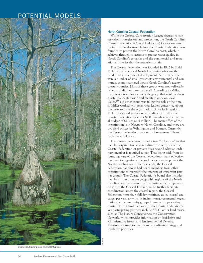
NNoorrtthh CCaarroolliinnaa CCooaassttaall FFeeddeerraattiioonnWhile the Coastal Conservation League focuses its con-
servation strategies on land protection, the North CarolinaCoastal Federation (Coastal Federation) focuses on waterprotection. As discussed below, the Coastal Federation wasfounded to protect the North Carolina coast, which itachieves through its actions to protect water quality inNorth Carolina’s estuaries and the commercial and recre-ational fisheries that the estuaries sustain.
The Coastal Federation was founded in 1982 by ToddMiller, a native coastal North Carolinian who saw theneed to stem the tide of development. At the time, therewere a number of small grassroots environmental and com-munity groups scattered across North Carolina’s twentycoastal counties. Most of these groups were not well-estab-lished and did not have paid staff. According to Miller,there was a need for a coast-wide group that could addresscoastal policy statewide and facilitate work on localissues.175 No other group was filling this role at the time,so Miller worked with grassroots leaders concerned aboutthe coast to form the organization. Since its inception,Miller has served as the executive director. Today, theCoastal Federation has over 8,000 members and an annu-al budget of $1.3 to $1.4 million. The main office of theorganization is in Newport, North Carolina, and there aretwo field offices in Wilmington and Manteo. Currently,the Coastal Federation has a staff of seventeen full- andpart-time employees.
The Coastal Federation is not a true “federation” in thatmember organizations do not direct the activities of theCoastal Federation or pay any dues beyond what an ordi-nary member is required to pay. That being said, from itsfounding, one of the Coastal Federation’s main objectiveshas been to organize and coordinate efforts to protect theNorth Carolina coast. To these ends, the CoastalFederation has always had board members from otherorganizations to represent the interests of important part-ner groups. The Coastal Federation’s board also includesmembers from different geographic regions of the NorthCarolina coast to ensure that the entire coast is represent-ed within the Coastal Federation. To further facilitatecoordination across the coastal region, the CoastalFederation hosts four, full-day meetings, called coastal cau-cuses, per year, to which it invites non-governmental organ-izations and community groups interested in protectingcoastal North Carolina. Some of the Coastal Federation’skey participating partners include SELC; other land trusts,such as The Nature Conservancy; the ConservationNetwork, which provides information on legislative andadministrative issues; and Environmental Defense.Meetings are used to discuss and coordinate strategy andlegislative priorities
54 Southern Environmental Law Center 2007
POTENTIAL MODELS
Duckweed, bald cypress, and water tupelos
JIM
WAI
TE
PROGRAM AREAS
The Coastal Federation has four key program areas: (1)Advocating for the Coastal Environment, (2) EncouragingEnforcement of Environmental Laws, (3) Restoring andProtecting Coastal Habitat and Water Quality, and (4)Educating Citizens, Students, and Community Leaders.176
The overriding theme of the organization is to protectwater quality.
Environmental Policy and AdvocacyLike the Conservation League in South Carolina, the
Coastal Federation is the principal advocacy organizationon the coast. Under its Environmental Policy andAdvocacy program area, the Coastal Federation works withcitizens, local governments, state environmental commis-sions, and legislators to advocate for effective land-useplans, water quality standards, and coastal shoreline devel-opment rules. The Coastal Federation’s first major victorycame in 1982, when the organization rallied fishermen,environmentalists, and scientists to oppose a proposal tostrip-mine 120,000 acres of wetlands between theAlbemarle and Pamlico Sounds. By 1984, the proposal wasdefeated. Thereafter, the Coastal Federation worked toachieve approval of new peat mining water quality rulesthat effectively prohibit large-scale peat mining in the state.Most of the areas that were formerly targeted for peat min-ing now have been permanently preserved within NationalWildlife Refuges.177
The Coastal Federation has achieved many other impor-tant policy objectives since its inception, including theestablishment of new wetland and water quality standards;tighter regulation of wastewater discharges from phosphatemining; new marina-siting standards; designation of 10 percent of North Carolina’s coastal waters asOutstanding Resource Waters; and a new federal law thatearmarks approximately $250 million for restoration of thenation’s estuaries.178 Today, the Coastal Federation’s keypolicy issues include stormwater pollution, oyster restora-tion, and beach and inlet management. In addition, theCoastal Federation engages in local land-use planning onthe coast.179
With respect to oyster restoration, North Carolina’s oys-ter fisheries have faced hardships similar to Georgia’s.While the 1902 oyster harvest yielded 1.8 million bushels,current harvests only number around 40,000 bushels peryear. In order to return oysters to North Carolina’s coastalwaters, the Coastal Federation has made oyster restorationa priority and is leading a coalition of environmentalgroups and government agencies. One of the coalition’simportant recent achievements was the development ofthe 2005 Oyster Legislative Priorities, which include rec-ommendations for creating oyster hatcheries, doubling thenumber of oyster restorations and sanctuaries, creating pol-lution-free zones near oyster growing areas, and establish-
ing a research program fund and a professor of shellfishresearch.180 Todd Miller has explained that, as the organi-zation has evolved over the years, it has been increasinglyhelpful to take on positive activities, such as oyster restora-tion, as opposed to always being “against everything.”
Enforcement of Environmental LawsLike the Riverkeeper organizations in coastal Georgia,
enforcement of the Clean Water Act and other environ-mental laws has been a central part of the CoastalFederation’s mission since its inception. In November2000, the Waterkeeper Alliance granted the CoastalFederation approval to license three Coastkeepers. Thisapproval made the Coastal Federation the only organiza-tion licensed by the Waterkeeper Alliance to cover theentire coast of a state. The Coastkeepers represent theCoastal Federation in the three geographic areas of theNorth Carolina coast: Northeastern—Cape Hatteras,Central—Cape Lookout, and Southeastern—Cape Fear.
Over the years, the Coastal Federation has used legaltools to effectively advance their agenda. During the mid-1980s, the organization appealed a number of permits thatforced the state to recognize that existing standards for pro-tecting coastal waters from marinas and developed areaswere not effective. As a result of these appeals and the des-ignation of Albemarle and Pamlico Sounds as waters ofnational concern, the state helped to fund a multi-million-dollar planning effort to protect the sounds.
The Coastal Federation’s willingness to enforce theCWA and other laws has been and continues to be anessential ingredient to the organization’s effectiveness, butlegal advocacy is not the only tool that the CoastalFederation or its Coastkeepers employ. The goals of theorganization’s Coastkeepers are diverse and include pro-tecting the water quality and habitat of the coast by serv-ing as a strong presence on the coastal waters; restoringhabitat and water quality via citizen- and agency-ledrestoration projects; raising public awareness and under-standing of the threats to the coast; leading educationefforts; documenting, investigating, and reporting detri-mental activities to the appropriate agency and media; sup-plementing the efforts of federal, state, and local agenciesby serving as an additional “watchdog” for the coast; andorganizing and strengthening citizen advocates for NorthCarolina’s coast.
Restoring and Protecting Habitat and Water QualityUnder its habitat and water quality program area, the
Coastal Federation operates two programs: the HabitatRestoration and Education Program and the Coastal LandPreservation program. Under the restoration program, theCoastal Federation has entered into numerous purchaseand cooperative agreements with private landowners andhas completed forty-seven restoration projects. In total,these actions have successfully restored more than 40,000
Southern Environmental Law Center 2007 55
estuarine acres. Currently, the Coastal Federation is con-ducting the largest wetland restoration project in the state’shistory at North River Farms. The project involves a 6,000-acre farm that is being returned back to wetlands with fed-eral, state, and private funding.181 The project is the largestsuch restoration effort ever attempted in North Carolina.The goal is for the restored wetlands to cleanse stormwaterand lead to the reopening of now-closed shellfish beds inthe adjacent North River. Other project areas within theprogram include oyster habitat restoration, living shore-lines (i.e., the development of natural erosion controlmeasures as an alternative to the use of bulkheads), educa-tion, and stormwater projects.182
Like the Conservation League, the Coastal Federationseeks to protect lands permanently via its land preservationprogram; however, the organization has a differentapproach to land protection than the ConservationLeague. The Coastal Federation operates like a land trustin that the Coastal Federation itself takes title to propertyand can hold conservation easements. Further, unlike theConservation League, the Coastal Federation’s land protec-tion program is focused primarily on protecting lands thatare needed to maintain or restore coastal water quality.183
Innovative collaboration with diverse partnerships hashelped fuel permanent protection and restoration ofimportant coastal habitats in North Carolina. The CoastalFederation, like the Conservation League, works with adiverse group of partners to permanently protect impor-tant lands. One example is its work in an area of theNorth Carolina coast referred to as the Onslow Bight, anarea that stretches from Cape Lookout to Cape Fear. TheCoastal Federation is working with a wide range of part-ners, including TNC and the United States Marine Corps,as part of the Onslow Bight Conservation Forum, to iden-tify areas that should be permanently protected andrestored.184
Educating Citizens and Community LeadersThe Coastal Federation’s education program seeks to
increase the public’s appreciation for the value and beautyof North Carolina’s coastal habitats. The CoastalFederation achieves this goal through workshops, confer-ences, publications (including its annual State of the Coastreport), the Daland Nature Library, and a monthly cableshow. Additionally, a strong component of the educationprogram area is the involvement of students via integratedcurriculum, field trips, and a variety of hands-on proj-ects.185
Technical and Communications Capacities andFundingOne of the biggest factors contributing to the organiza-
tion’s success has been its technical know-how on coastalissues, which at times leads it to have a better grasp of theissues than academics and regulatory agencies.186 Charles
Jones, head of the North Carolina Division of CoastalManagement, commented that “[t]he Coastal Federation isa very credible organization that does its homework.”187 Asa result of its technical capacity, the Coastal Federation isvery well-respected by members of the academic communi-ty and government agencies. Their opinions are not onlyhighly regarded, but actively sought on all coastal issues.
The Coastal Federation’s staff members provide expert-ise in a variety of areas, from science to advocacy to devel-opment. The staff of the Coastal Federation’s main officeconsists of Todd Miller, a program director, a lobbyist, acommunications professional, and two fundraisers.188 Ineach of its other two offices, the Coastal Federation hasaspired to employ at least one staff member in each ofthree disciplines—advocacy, education, and habitat restora-tion. The organization employs two scientists to lead theorganization’s restoration efforts. The Coastal Federationdoes not currently employ any legal staff, but instead relieson the legal expertise of SELC.
The Coastal Federation has also developed relationshipswith technical experts in North Carolina, which has bene-fited the organization greatly, beginning with its early bat-tles with the peat mining industry in which key membersof the academic community assisted the CoastalFederation. The Coastal Federation has established keyalliances with Duke University, the University of NorthCarolina, and the National Oceanic and AtmosphericAdministration, which all have marine science programsand/or labs in North Carolina.
In addition to technical ability, the Coastal Federation’scapacity to communicate with the public was important inhelping to establish the organization and remains an inte-gral trait to this day. The Coastal Federation communi-cates with the public in a number of ways, including itsState of the Coast report, its website, and a monthly televi-sion show. In its early years, the Coastal Federation’s col-laboration with a Raleigh television station on a “Save OurSounds” program helped educate the public, generate sup-port for water quality protection rules, and legitimize theorganization.189
In order to sustain these capacities, the CoastalFederation has a current annual budget of $1.3 to 1.4 mil-lion. The sources of these funds are the CoastalFederation’s large membership base, other donations,grants, and government funding. Generally, the CoastalFederation’s expenses are divided primarily between theRestoration/Education Program, Coastkeepers, andSpecial Projects.190
To celebrate the Coastal Federation’s twenty-five years ofprogress on the coast, several prominent North Carolinaenvironmentalists commented on the organization’s histo-ry and success. At its core, the organization made its markand built its influence by taking tough stands and enforc-
56 Southern Environmental Law Center 2007
POTENTIAL MODELS

ing the law against mining proposals that threatened thecoast’s tidal waters. Over time, the organization has beenable to broaden its activities from strictly being a coastaladvocate to one that now partners with state regulatorsand green developers.191 Rather than just highlightingproblems in state policy, the Coastal Federation points theway for new policy. The Coastal Federation also partnerswith state agencies on topics as varied as protecting coastalhabitats, promoting fisheries reforms, and devising betterways to share water quality information.192 It also workswith coastal towns and counties on stormwater projectsand land-use plans.193 Through it all, however, even as theCoastal Federation has begun to rely on more than advoca-cy to accomplish its agenda, the key to the CoastalFederation’s success has been its commitment to use legaladvocacy to protect coastal resources. In fact, a recentaction to enforce the CWA against developers that failedto obtain wetland permits sent a strong message to otherdevelopers in coastal North Carolina that the illegaldestruction of coastal wetlands will not be tolerated.
KKeeyy IInnggrreeddiieennttss ooff tthhee SSoouutthh aanndd NNoorrtthh CCaarroolliinnaaPPrrooggrraammss
Although the South Carolina and North Carolina pro-grams are different in many ways, as discussed above, theyboth have certain key ingredients that have contributed totheir success. In order for the environmental work on theGeorgia coast to become more effective, the conservationcommunity needs to incorporate these ingredients intoongoing efforts in Georgia. First, both organizations haveclear visions that guide their work. Second, both theConservation League and the Coastal Federation haveeffective leaders that have been able to unite the variousgroups along both coasts. Third, they have technical, legal,and communication capacity either on staff or theresources to contract with experts they need. Fourth, theyare politically connected and very visible so that when theyspeak, people listen. Fifth, they comprehensively cover theentire coastal regions of their respective states and havelarge member bases so that when they have to file a law-suit, members are able to provide standing. Finally, theyhave strong financial support for their programs. Althoughthe environmental groups working to protect the Georgiacoast have some of these ingredients already, the groupsneed to more fully develop these important attributes inorder to effectively address the rapid development that isimpacting the Georgia coast. There are many actions thatneed to be taken, and very little time to take them.
Southern Environmental Law Center 2007 57
BIL
L LE
A
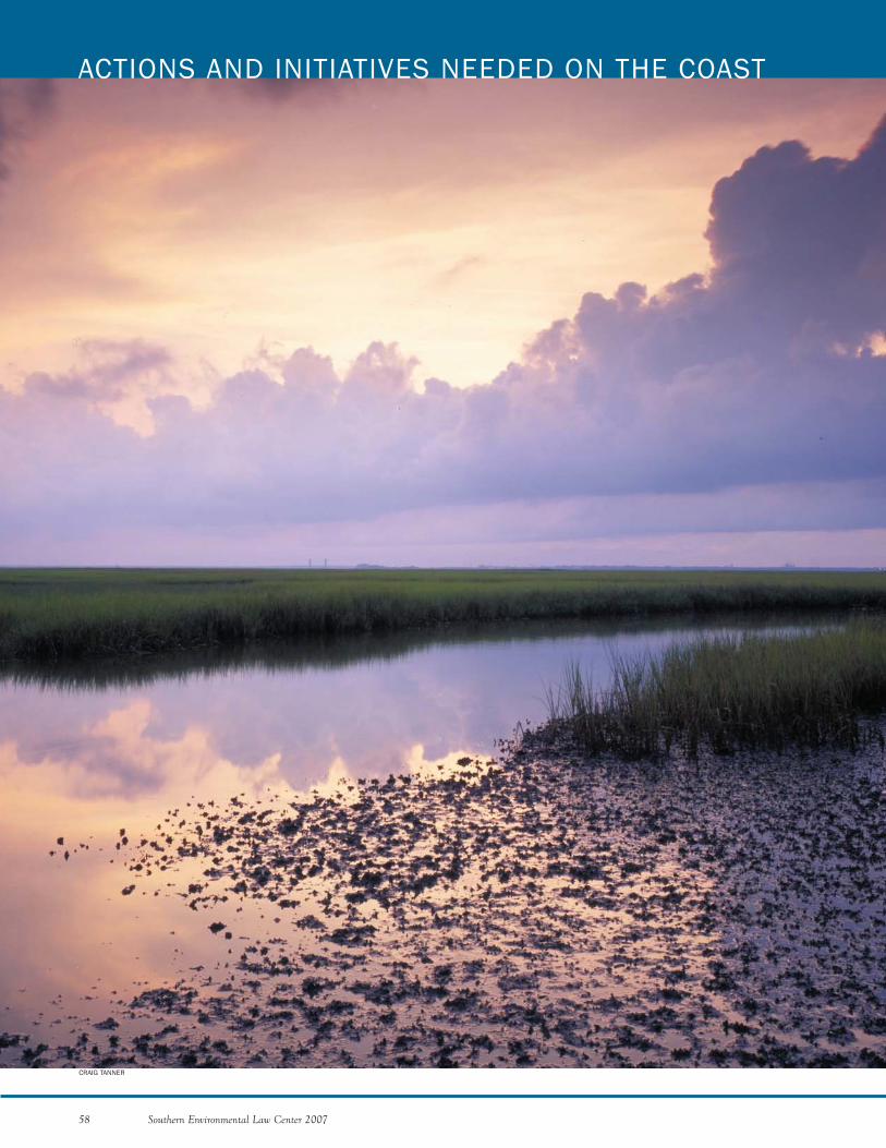
58 Southern Environmental Law Center 2007
ACTIONS AND INITIATIVES NEEDED ON THE COAST
CRAIG TANNER
To effectively address the threat of poorly planned devel-opment in coastal Georgia, it is imperative that the coastalconservation groups use their resources shrewdly and col-laboratively. This includes developing a collective plan ofaction and then working together to accomplish that plan.Until we have an opportunity to collaborate more fullywith all the conservation groups, SELC proposes a num-ber of Immediate Actions and Comprehensive Initiativesto address pressing conservation needs. In the followingdiscussion, SELC proposes items covering the full range ofconservation tools from challenging legal interpretationsof government agencies to acquiring land. We do not,however, pretend to have expertise in all of these areas. Itis for this reason that we are hoping that all conservationgroups will join in the effort to further refine theImmediate Actions and Comprehensive Initiatives that wepropose below.
Because the Georgia coast is at a “tipping point,” theconservation groups need to act quickly and decisively toensure that the coast “tips” in the direction of conserva-tion, as opposed to rampant and uncontrolled develop-ment. Thus, the conservation groups must execute a set ofimmediate and achievable actions to protect the coast.These are items that could be initiated and largely com-pleted within the next three years. At the same time, theconservation groups need to arrive at a flexible set ofComprehensive Initiatives. These Initiatives will includetasks that are fundamental to shaping the development ofthe Georgia coast over the next decade.
To tie the Immediate Actions and the ComprehensiveInitiatives together, SELC recommends that all the coastalorganizations join in the development of an eco-vision forthe coast. This would entail the conservation groups meet-ing to identify the most important and vulnerable areas onthe coast. From that exercise would emerge maps of thecoast that all the conservation groups could use to guidethe implementation of the Immediate Actions andComprehensive Initiatives. On a yearly basis, the conserva-tion groups could revisit the eco-vision to fine tune it andto take into account new conservation opportunities anddevelopment threats.
SELC developed the proposed Immediate Actions andComprehensive Initiatives based on the more than seventyinterviews we completed, the research we conducted, andthe studies we reviewed to complete this Assessment, aswell as on our own knowledge from the twenty years wehave worked on the Georgia coast. Even so, we have everyexpectation that through further collaboration with theother conservation groups, these Actions and Initiativeswill be refined.
IImmmmeeddiiaattee AAccttiioonnss tthhaatt MMuusstt BBee TTaakkeenn ttoo PPrrootteecctt tthheeCCooaasstt
In classifying measures as Immediate Actions, SELCapplied three criteria. First, the proposed action item must
Southern Environmental Law Center 2007 59
be critical to addressing an immediate resource preserva-tion need on the coast. Second, it must have a noticeableimpact on the problem within three years. And third, theaction must be achievable by the existing conservationgroups, assuming additional technical, legal, and commu-nication resources can be developed. The ImmediateActions that SELC arrived at are as follows: PROTECT SALT MARSHES AND ESTUARIES BY REQUIRING PROPERIMPLEMENTATION OF THE COASTAL MARSHLANDS PROTECTION ACT
This Immediate Action is vital to the overall health ofthe coast. The salt marshes comprise one of the most valu-able and productive natural resources on the planet andgive the Georgia coast its distinctive character. The coastalmarshlands sustain the health of the estuaries and saltwa-ter fisheries; provide the scenic vistas that give the coast itsuniqueness and beauty; and help protect coastal communi-ties from storms. The degradation of this natural resourcewould be devastating to the coastal region. ImmediateAction is needed to maintain the coast’s marshes andhammocks.
Georgia’s Coastal Marshlands Protection Act of 1970 isone of the strongest laws of its type in the nation. Inrecent years, however, the state has chosen to reinterpretthe Act to narrow its protections. SELC, working alongsidekey conservation groups, has won a number of cases,which require the state to consider the upland portion of adevelopment and the polluted runoff that it contributes tothe marsh before it grants a CMPA permit for any accom-panying marina, bridge, or other structure in the water.Instead of following these court decisions, the state hasunsuccessfully appealed each decision and is currentlychallenging the latest decision—the Cumberland Harbourcase—in the Court of Appeals. In addition, the state haspromulgated rules consistent with its narrow interpreta-tion of the CMPA in an attempt to bolster it failing legalposition. Win or lose, the conservation groups must con-tinue to pursue this issue until the state provides completeand comprehensive protection of Georgia’s coastal marsh-es. This strategy includes challenging the new rules thatthe state has promulgated. If the new rules are allowed tostand and the state is allowed to continue applying itsoverly narrow interpretation of the law, polluted runoffwill continue to run off the pavement and rooftops ofthese coast-side developments and dramatically impact themarshes.PROTECT COASTAL WATERS BY REQUIRING ENFORCEMENT OF THE25-FOOT BUFFER UNDER THE EROSION AND SEDIMENTATION ACT
Scientific research shows that buffers are needed to pro-tect salt marshes and other coastal waters from pollutedrunoff. These buffers filter and trap pollutants beforerunoff reaches nearby waterbodies. Buffers of at least 100 feet are necessary to afford adequate protection; how-ever, as discussed previously, the Georgia Erosion andSedimentation Act only requires a 25-foot buffer. Despite
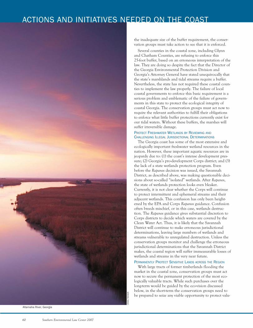
60 Southern Environmental Law Center 2007
ACTIONS AND INITIATIVES NEEDED ON THE COAST
the inadequate size of the buffer requirement, the conser-vation groups must take action to see that it is enforced.
Several counties in the coastal zone, including Glynnand Chatham Counties, are refusing to enforce this 25-foot buffer, based on an erroneous interpretation of thelaw. They are doing so despite the fact that the Director ofthe Georgia Environmental Protection Division andGeorgia’s Attorney General have stated unequivocally thatthe state’s marshlands and tidal streams require a buffer.Nevertheless, the state has not required these coastal coun-ties to implement the law properly. The failure of localcoastal governments to enforce this basic requirement is aserious problem and emblematic of the failure of govern-ments in this state to protect the ecological integrity ofcoastal Georgia. The conservation groups must act now torequire the relevant authorities to fulfill their obligationsto enforce what little buffer protections currently exist forour tidal waters. Without these buffers, the marshes willsuffer irreversible damage.PROTECT FRESHWATER WETLANDS BY REVIEWING ANDCHALLENGING ILLEGAL JURISDICTIONAL DETERMINATIONS
The Georgia coast has some of the most extensive andecologically important freshwater wetland resources in thenation. However, these important aquatic resources are injeopardy due to: (1) the coast’s intense development pres-sure; (2) Georgia’s pro-development Corps district; and (3)the lack of a state wetlands protection program. Evenbefore the Rapanos decision was issued, the SavannahDistrict, as described above, was making questionable deci-sions about so-called “isolated” wetlands. After Rapanos,the state of wetlands protection looks even bleaker.Currently, it is not clear whether the Corps will continueto protect intermittent and ephemeral streams and theiradjacent wetlands. This confusion has only been height-ened by the EPA and Corps Rapanos guidance. Confusionoften breeds mischief, or in this case, wetlands destruc-tion. The Rapanos guidance gives substantial discretion toCorps districts to decide which waters are covered by theClean Water Act. Thus, it is likely that the SavannahDistrict will continue to make erroneous jurisdictionaldeterminations, leaving large numbers of wetlands andstreams vulnerable to unregulated destruction. Unless theconservation groups monitor and challenge the erroneousjurisdictional determinations that the Savannah Districtmakes, the coastal region will suffer immeasurable losses ofwetlands and streams in the very near future.PERMANENTLY PROTECT SENSITIVE LANDS ACROSS THE REGION
With large tracts of former timberlands flooding themarket in the coastal zone, conservation groups must actnow to secure the permanent protection of the most eco-logically valuable tracts. While such purchases over thelong-term would be guided by the eco-vision discussedbelow, in the short-term the conservation groups need tobe prepared to seize any viable opportunity to protect valu-
CRAI
G T
ANN
ER
Altamaha River, Georgia
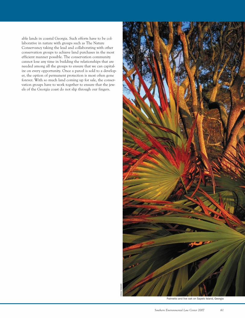
Southern Environmental Law Center 2007 61
able lands in coastal Georgia. Such efforts have to be col-laborative in nature with groups such as The NatureConservancy taking the lead and collaborating with otherconservation groups to achieve land purchases in the mostefficient manner possible. The conservation communitycannot lose any time in building the relationships that areneeded among all the groups to ensure that we can capital-ize on every opportunity. Once a parcel is sold to a develop-er, the option of permanent protection is most often goneforever. With so much land coming up for sale, the conser-vation groups have to work together to ensure that the jew-els of the Georgia coast do not slip through our fingers.
CRAI
G T
ANN
ER
Palmetto and live oak on Sapelo Island, Georgia
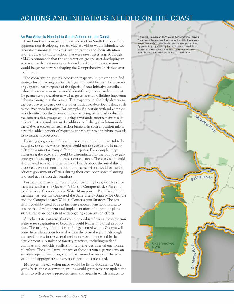
AAnn EEccoo--VViissiioonn iiss NNeeeeddeedd ttoo GGuuiiddee AAccttiioonnss oonn tthhee CCooaasstt Based on the Conservation League’s work in South Carolina, it is
apparent that developing a coast-wide eco-vision would stimulate col-laboration among all the conservation groups and focus attentionand resources on those actions that were most deserving. AlthoughSELC recommends that the conservation groups start developing aneco-vision early next year as an Immediate Action, the eco-visionwould be geared towards shaping the Comprehensive Initiatives overthe long run.
The conservation groups’ eco-vision maps would present a unifiedstrategy for protecting coastal Georgia and could be used for a varietyof purposes. For purposes of the Special Places Initiative describedbelow, the eco-vision maps would identify high value lands to targetfor permanent protection as well as green corridors linking importanthabitats throughout the region. The maps would also help determinethe best places to carry out the other Initiatives described below, suchas the Wetlands Initiative. For example, if a certain wetland complexwas identified on the eco-vision maps as being particularly valuable,the conservation groups could bring a wetlands enforcement case toprotect that wetland system. In addition to halting a violation underthe CWA, a successful legal action brought in such a location mighthave the added benefit of requiring the violator to contribute towardsits permanent protection.
By using geographic information systems and other powerful tech-nologies, the conservation groups could use the eco-vision in manydifferent venues for many different purposes. For example, mapsillustrating the eco-vision could be disseminated to the public to gen-erate grassroots support to protect critical areas. The eco-vision couldalso be used to inform local land-use boards about the suitability ofproposed developments. In addition, the eco-vision could be used toeducate government officials during their own open space planningand land acquisition deliberations.
Further, there are a number of plans currently being developed bythe state, such as the Governor’s Coastal Comprehensive Plan andthe Statewide Comprehensive Water Management Plan. In addition,the state has recently completed the State Energy Strategy for Georgiaand the Comprehensive Wildlife Conservation Strategy. The eco-vision could be used both to influence government actions and toensure that development and implementation of important planssuch as these are consistent with ongoing conservation efforts.
Another state initiative that could be evaluated using the eco-visionis the state’s aspiration to become a world leader in biofuel produc-tion. The majority of pine for biofuel generated within Georgia willcome from plantations located within the coastal region. Althoughmanaged forests in the coastal region may be more desirable thandevelopment, a number of forestry practices, including wetlanddrainage and pesticide application, can have detrimental environmen-tal effects. The cumulative impacts of these activities, particularly onsensitive aquatic resources, should be assessed in terms of the eco-vision and appropriate conservation positions articulated.
Moreover, the eco-vision maps would be living documents. On ayearly basis, the conservation groups would get together to update thevision to reflect newly protected areas and areas in which impacts to
62 Southern Environmental Law Center 2007
ACTIONS AND INITIATIVES NEEDED ON THE COAST
Figure 14. EEccoo--VViissiioonn HHiigghh VVaalluuee CCoonnsseerrvvaattiioonn TTaarrggeettss::These valuable coastal lands were identified in surveyresponses as top priorities for permanent protection.By protecting high priority lands, it is also possible toprotect numerous sensitive resources located on ornear those lands, such as those pictured here.
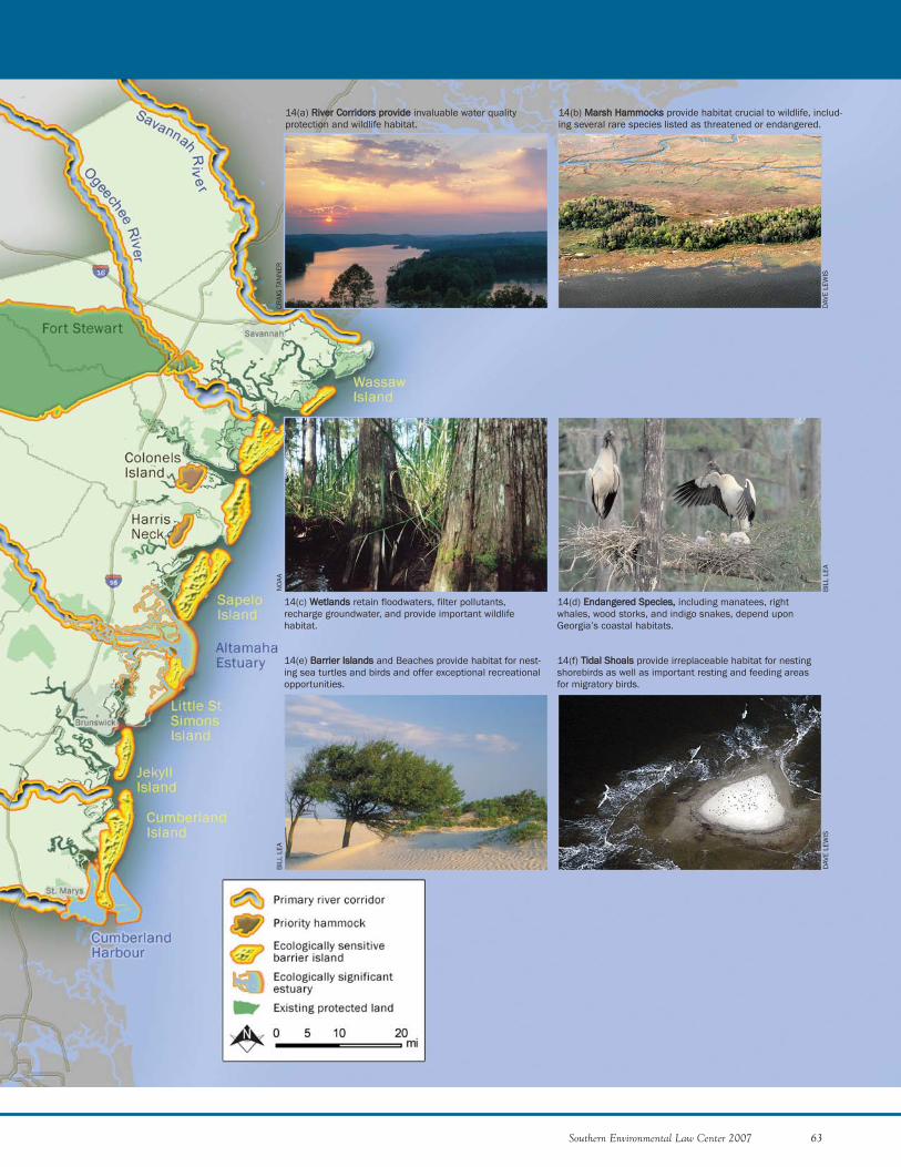
Southern Environmental Law Center 2007 63
14(a) RRiivveerr CCoorrrriiddoorrss pprroovviiddee invaluable water qualityprotection and wildlife habitat.
14(b) MMaarrsshh HHaammmmoocckkss provide habitat crucial to wildlife, includ-ing several rare species listed as threatened or endangered.
14(c) WWeettllaannddss retain floodwaters, filter pollutants,recharge groundwater, and provide important wildlifehabitat.
14(d) EEnnddaannggeerreedd SSppeecciieess,, including manatees, rightwhales, wood storks, and indigo snakes, depend uponGeorgia’s coastal habitats.
14(e) BBaarrrriieerr IIssllaannddss and Beaches provide habitat for nest-ing sea turtles and birds and offer exceptional recreationalopportunities.
14(f) TTiiddaall SShhooaallss provide irreplaceable habitat for nestingshorebirds as well as important resting and feeding areasfor migratory birds.
CRAI
G T
ANN
ER
DAV
E LE
WIS
NO
AA
BIL
L LE
A
BIL
L LE
A
DAV
E LE
WIS
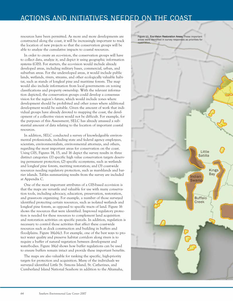
resources have been permitted. As more and more developments areconstructed along the coast, it will be increasingly important to trackthe location of new projects so that the conservation groups will beable to analyze the cumulative impacts to coastal resources.
In order to create an eco-vision, the conservation groups will haveto collect data, analyze it, and depict it using geographic informationsystems (GIS). For starters, the eco-vision would include alreadydeveloped areas, including military bases, commercial, urban, andsuburban areas. For the undeveloped areas, it would include publiclands, wetlands, rivers, streams, and other ecologically valuable habi-tat, such as stands of longleaf pine and maritime forests. The mapwould also include information from local governments on zoningclassifications and property ownership. With the relevant informa-tion depicted, the conservation groups could develop a consensusvision for the region’s future, which would include zones wheredevelopment should be prohibited and other zones where additionaldevelopment would be suitable. Given the amount of work that indi-vidual groups have already devoted to mapping the coast, the devel-opment of a collective vision would not be difficult. For example, forthe purposes of this Assessment, SELC has already amassed a sub-stantial amount of data relating to the location of important coastalresources.
In addition, SELC conducted a survey of knowledgeable environ-mental professionals, including state and federal agency employees,scientists, environmentalists, environmental attorneys, and others,regarding the most important areas for conservation on the coast.Using GIS, Figures 14, 15, and 16 depict the survey results in threedistinct categories: (1) specific high value conservation targets deserv-ing permanent protection; (2) specific ecosystems, such as wetlandsand longleaf pine forests, meriting restoration; and (3) coast-wideresources needing regulatory protection, such as marshlands and bar-rier islands. Tables summarizing results from the survey are includedat Appendix C.
One of the most important attributes of a GIS-based eco-vision isthat the maps are versatile and valuable for use with many conserva-tion tools, including advocacy, education, preservation, restoration,and grassroots organizing. For example, a number of those surveyedidentified protecting certain resources, such as isolated wetlands andlongleaf pine forests, as opposed to specific tracts of land. Figure 16shows the resources that were identified. Improved regulatory protec-tion is needed for these resources to complement land acquisitionand restoration activities on specific parcels. In addition, regulation isnecessary to control those activities that affect these coast-wideresources such as dock construction and building in buffers andfloodplains. Figure 16(a)-(c). For example, one of the best ways to pro-tect water quality and preserve habitat corridors along rivers is torequire a buffer of natural vegetation between development andwaterbodies. Figure 16(a) shows how buffer regulations can be usedto ensure buffers remain intact and provide these important benefits.
The maps are also valuable for ranking the specific, high-prioritytargets for protection and acquisition. Many of the individuals wesurveyed identified Little St. Simons Island, St. Catherines, andCumberland Island National Seashore in addition to the Altamaha,
64 Southern Environmental Law Center 2007
ACTIONS AND INITIATIVES NEEDED ON THE COAST
Figure 15. EEccoo--VViissiioonn RReessttoorraattiioonn AArreeaass:: These importantareas were identified in survey responses as priorities forrestoration.
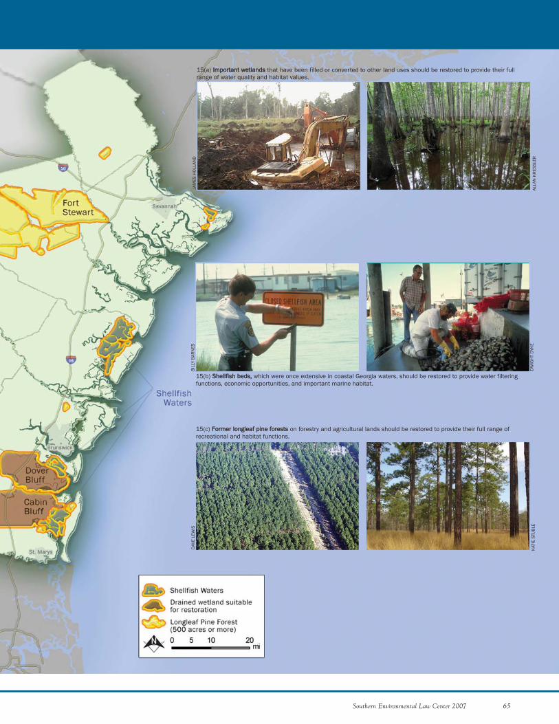
Southern Environmental Law Center 2007 65
15(a) IImmppoorrttaanntt wweettllaannddss that have been filled or converted to other land uses should be restored to provide their fullrange of water quality and habitat values.
15(b) SShheellllffiisshh bbeeddss,, which were once extensive in coastal Georgia waters, should be restored to provide water filteringfunctions, economic opportunities, and important marine habitat.
15(c) FFoorrmmeerr lloonngglleeaaff ppiinnee ffoorreessttss on forestry and agricultural lands should be restored to provide their full range ofrecreational and habitat functions.
JAM
ES H
OLL
AND
ALLA
N K
RES
SLER
DAV
E LE
WIS
KAT
IE S
TUB
LE
BIL
LY B
ARN
ES
DW
IGH
T D
YKE
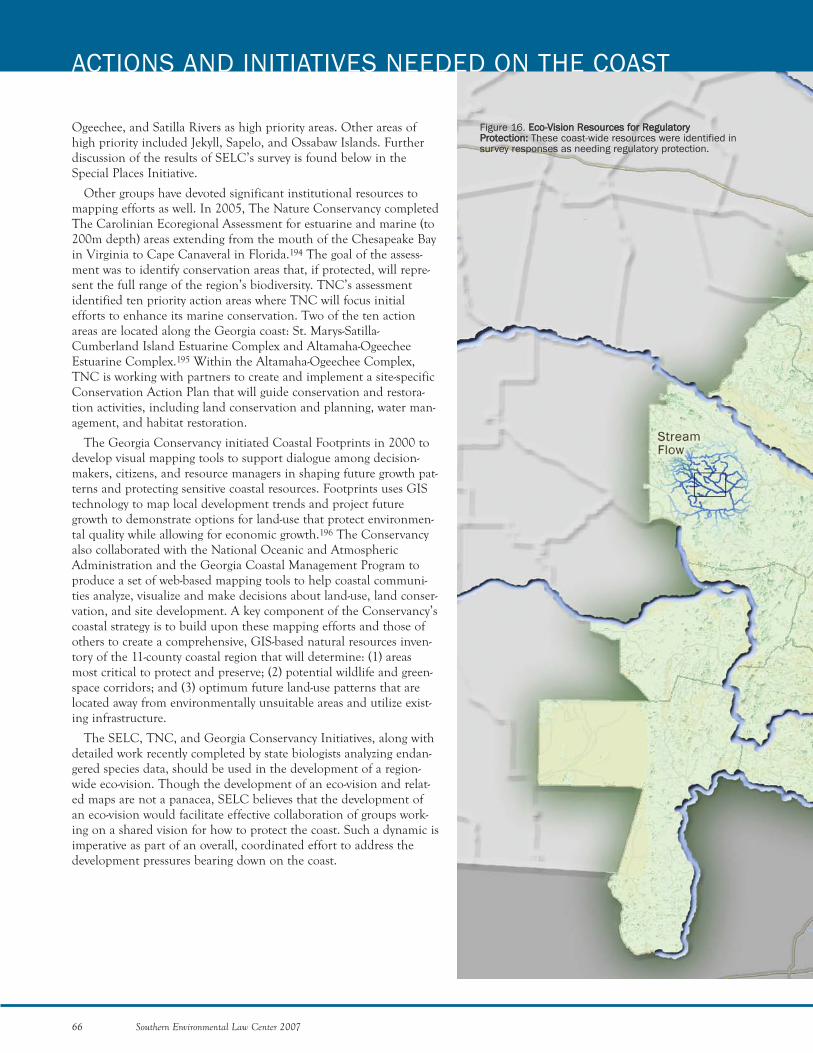
Ogeechee, and Satilla Rivers as high priority areas. Other areas ofhigh priority included Jekyll, Sapelo, and Ossabaw Islands. Furtherdiscussion of the results of SELC’s survey is found below in theSpecial Places Initiative.
Other groups have devoted significant institutional resources tomapping efforts as well. In 2005, The Nature Conservancy completedThe Carolinian Ecoregional Assessment for estuarine and marine (to200m depth) areas extending from the mouth of the Chesapeake Bayin Virginia to Cape Canaveral in Florida.194 The goal of the assess-ment was to identify conservation areas that, if protected, will repre-sent the full range of the region’s biodiversity. TNC’s assessmentidentified ten priority action areas where TNC will focus initialefforts to enhance its marine conservation. Two of the ten actionareas are located along the Georgia coast: St. Marys-Satilla-Cumberland Island Estuarine Complex and Altamaha-OgeecheeEstuarine Complex.195 Within the Altamaha-Ogeechee Complex,TNC is working with partners to create and implement a site-specificConservation Action Plan that will guide conservation and restora-tion activities, including land conservation and planning, water man-agement, and habitat restoration.
The Georgia Conservancy initiated Coastal Footprints in 2000 todevelop visual mapping tools to support dialogue among decision-makers, citizens, and resource managers in shaping future growth pat-terns and protecting sensitive coastal resources. Footprints uses GIStechnology to map local development trends and project futuregrowth to demonstrate options for land-use that protect environmen-tal quality while allowing for economic growth.196 The Conservancyalso collaborated with the National Oceanic and AtmosphericAdministration and the Georgia Coastal Management Program toproduce a set of web-based mapping tools to help coastal communi-ties analyze, visualize and make decisions about land-use, land conser-vation, and site development. A key component of the Conservancy’scoastal strategy is to build upon these mapping efforts and those ofothers to create a comprehensive, GIS-based natural resources inven-tory of the 11-county coastal region that will determine: (1) areasmost critical to protect and preserve; (2) potential wildlife and green-space corridors; and (3) optimum future land-use patterns that arelocated away from environmentally unsuitable areas and utilize exist-ing infrastructure.
The SELC, TNC, and Georgia Conservancy Initiatives, along withdetailed work recently completed by state biologists analyzing endan-gered species data, should be used in the development of a region-wide eco-vision. Though the development of an eco-vision and relat-ed maps are not a panacea, SELC believes that the development ofan eco-vision would facilitate effective collaboration of groups work-ing on a shared vision for how to protect the coast. Such a dynamic isimperative as part of an overall, coordinated effort to address thedevelopment pressures bearing down on the coast.
66 Southern Environmental Law Center 2007
ACTIONS AND INITIATIVES NEEDED ON THE COAST
Figure 16. EEccoo--VViissiioonn RReessoouurrcceess ffoorr RReegguullaattoorryyPPrrootteeccttiioonn:: These coast-wide resources were identified insurvey responses as needing regulatory protection.
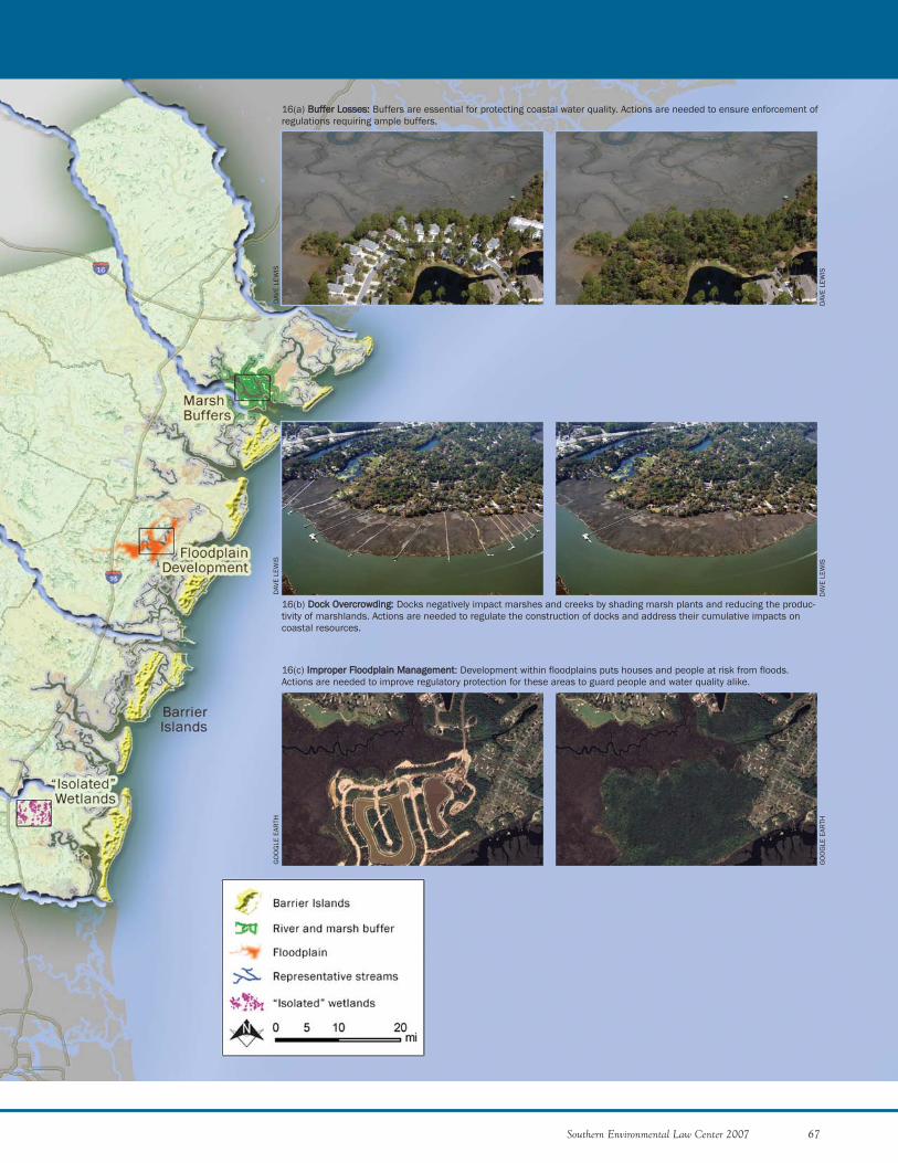
Southern Environmental Law Center 2007 67
16(a) BBuuffffeerr LLoosssseess:: Buffers are essential for protecting coastal water quality. Actions are needed to ensure enforcement ofregulations requiring ample buffers.
16(b) DDoocckk OOvveerrccrroowwddiinngg:: Docks negatively impact marshes and creeks by shading marsh plants and reducing the produc-tivity of marshlands. Actions are needed to regulate the construction of docks and address their cumulative impacts oncoastal resources.
16(c) IImmpprrooppeerr FFllooooddppllaaiinn MMaannaaggeemmeenntt: Development within floodplains puts houses and people at risk from floods.Actions are needed to improve regulatory protection for these areas to guard people and water quality alike.
DAV
E LE
WIS
DAV
E LE
WIS
DAV
E LE
WIS
DAV
E LE
WIS
GO
OG
LE E
ARTH
GO
OG
LE E
ARTH
CCoommpprreehheennssiivvee IInniittiiaattiivveess NNeeeeddeedd ttoo SSeeccuurree tthhee FFuuttuurree ooff tthhee CCooaassttWhile the Immediate Actions will go far to jump-start coastal protection and
the eco-vision will help guide long-range conservation efforts, SELC also pro-poses a suite of Comprehensive Initiatives to shape the future of the Georgiacoast. It is our expectation, however, that this list will be further refined as wecontinue to collaborate with other conservation groups.
Similar to the selection of Immediate Actions, SELC applied three criteria toidentify the “Comprehensive Initiatives.” First, the issue or action must havethe potential to significantly impact the development of the coast in either apositive or negative way over the next decade. Second, the issue or action mustbe one that the conservation groups have indicated that they would be interest-ed in pursuing. And third, the issue or action must be one that the conserva-tion groups could achieve if the overall resources available on the coastincreased by a substantial amount. After applying these criteria, we then chosethose issues and actions that were likely to have the most potential to furtheroverall conservation efforts. The Comprehensive Initiatives that SELC arrivedat are as follows:
68 Southern Environmental Law Center 2007
ACTIONS AND INITIATIVES NEEDED ON THE COAST
MARSHLANDS AND HAMMOCKS INITIATIVE
1) Ensure Proper Implementation of the Coastal Marshlands ProtectionAct
2) Ensure Proper Planning for Docks and Marinas3) Advocate for Conservation Leasing for Non-Profits and Fair Market
Value Leasing for For-Profit Entities4) Secure the Adoption and Implementation of Favorable
Recommendations Resulting from the Coastal Marsh HammocksCollaborative Dialogue
WETLANDS INITIATIVE
1) Ensure Proper Permitting Process2) Ensure Mitigation Requirements are Satisfied3) Enact a State Wetlands Program4) Ensure Proper Application of Silviculture Exemption
POLLUTED RUNOFF INITIATIVE
1) Secure Better Stormwater Permits2) Secure Larger Buffers3) Seek Local Adoption of the Coastal Stormwater Supplement4) Ensure Better Enforcement
SPECIAL PLACES INITIATIVE
1) Increase State Funding for Land Conservation2) Identify and Protect Special Places3) Restore Special Places
PLANNING INITIATIVE
1) Guide Land Use Decisions2) Guide Floodplain Management3) Develop Effective Watershed Plans4) Protect Groundwater5) Challenge Damaging Reservoir and Water Withdrawal Proposals6) Petition for Critical Habitat for Eastern Indigo Snakes under the
Endangered Species ActCLIMATE CHANGE INITIATIVE
1) Help the Coast Adopt Measures to Prepare for Global Warming2) Educate Coastal Georgians on Climate Change 3) Advocate for Decreases in Greenhouse Gas Emissions
BIL
L LE
A
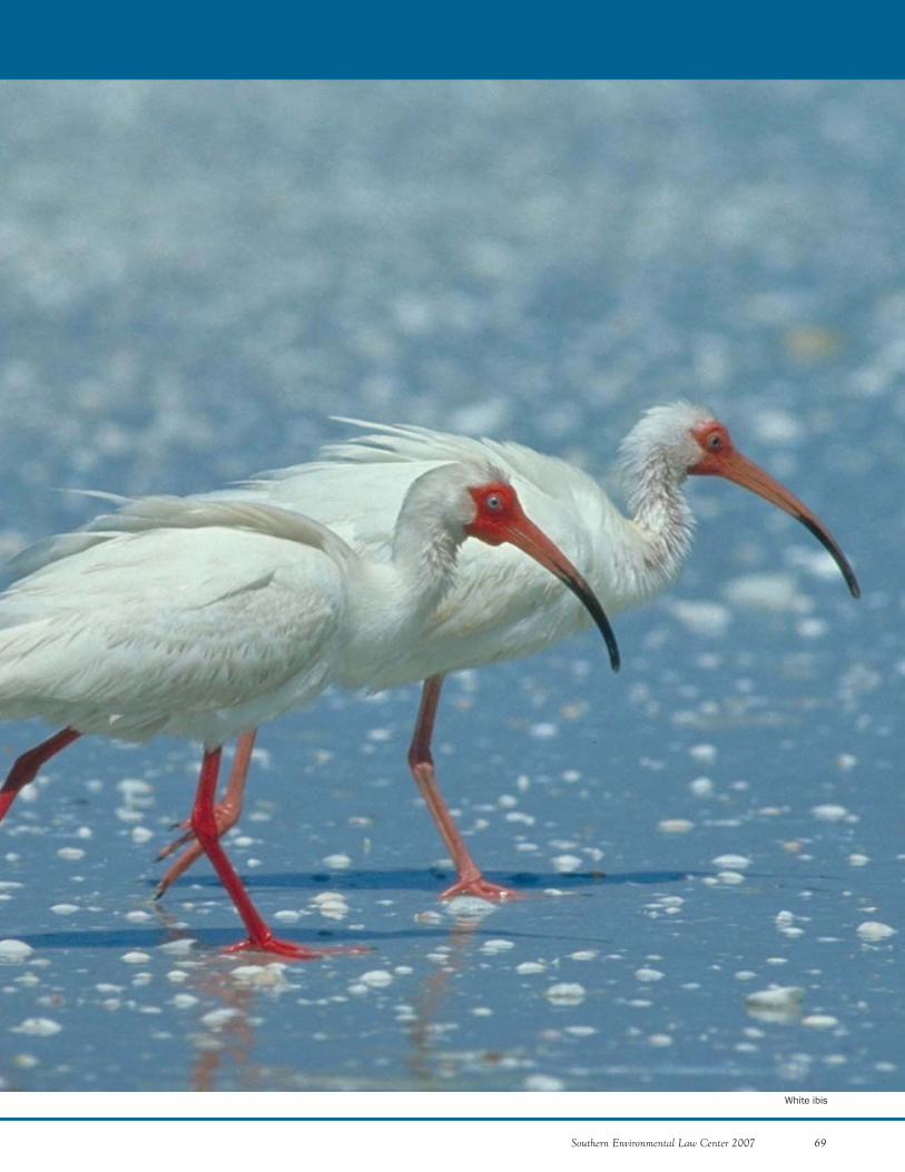
Southern Environmental Law Center 2007 69
White ibis
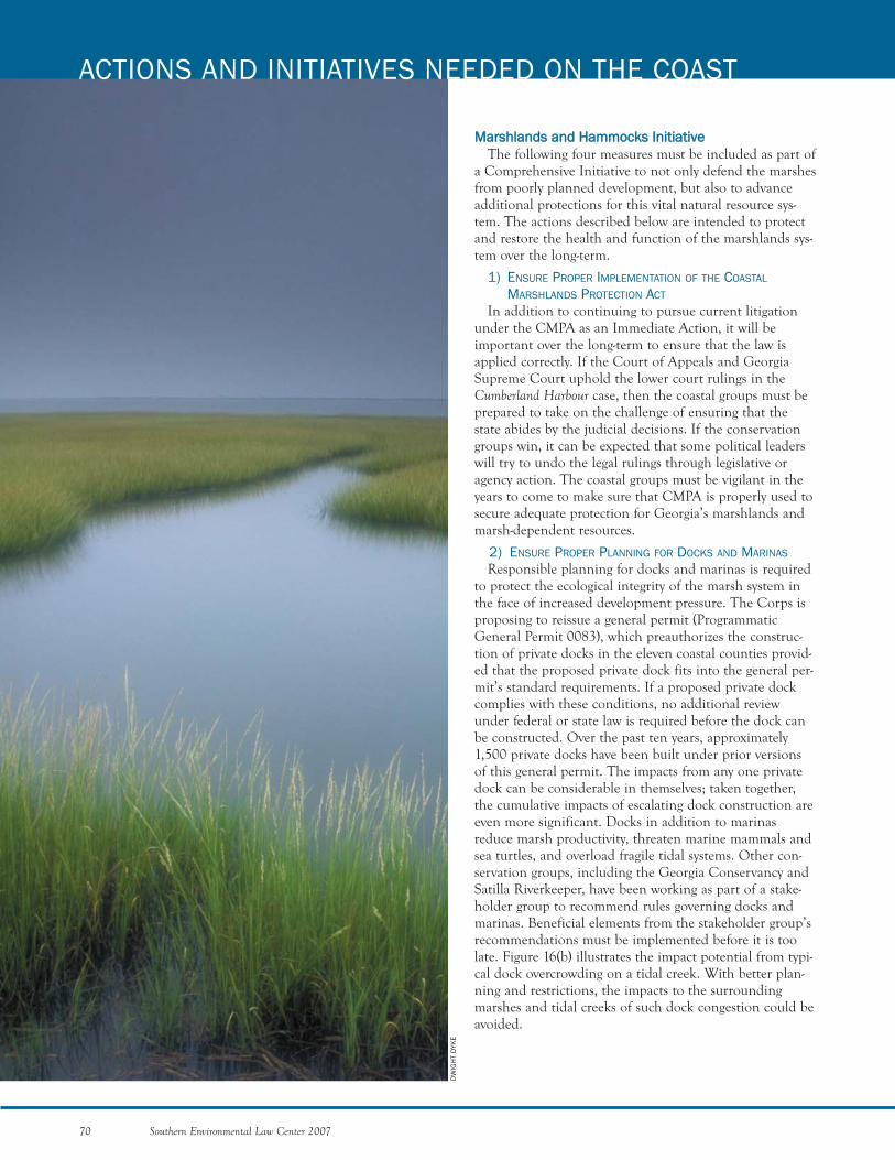
MMaarrsshhllaannddss aanndd HHaammmmoocckkss IInniittiiaattiivvee The following four measures must be included as part of
a Comprehensive Initiative to not only defend the marshesfrom poorly planned development, but also to advanceadditional protections for this vital natural resource sys-tem. The actions described below are intended to protectand restore the health and function of the marshlands sys-tem over the long-term.
1) ENSURE PROPER IMPLEMENTATION OF THE COASTAL
MARSHLANDS PROTECTION ACT
In addition to continuing to pursue current litigationunder the CMPA as an Immediate Action, it will beimportant over the long-term to ensure that the law isapplied correctly. If the Court of Appeals and GeorgiaSupreme Court uphold the lower court rulings in theCumberland Harbour case, then the coastal groups must beprepared to take on the challenge of ensuring that thestate abides by the judicial decisions. If the conservationgroups win, it can be expected that some political leaderswill try to undo the legal rulings through legislative oragency action. The coastal groups must be vigilant in theyears to come to make sure that CMPA is properly used tosecure adequate protection for Georgia’s marshlands andmarsh-dependent resources.
2) ENSURE PROPER PLANNING FOR DOCKS AND MARINAS
Responsible planning for docks and marinas is requiredto protect the ecological integrity of the marsh system inthe face of increased development pressure. The Corps isproposing to reissue a general permit (ProgrammaticGeneral Permit 0083), which preauthorizes the construc-tion of private docks in the eleven coastal counties provid-ed that the proposed private dock fits into the general per-mit’s standard requirements. If a proposed private dockcomplies with these conditions, no additional reviewunder federal or state law is required before the dock canbe constructed. Over the past ten years, approximately1,500 private docks have been built under prior versionsof this general permit. The impacts from any one privatedock can be considerable in themselves; taken together,the cumulative impacts of escalating dock construction areeven more significant. Docks in addition to marinasreduce marsh productivity, threaten marine mammals andsea turtles, and overload fragile tidal systems. Other con-servation groups, including the Georgia Conservancy andSatilla Riverkeeper, have been working as part of a stake-holder group to recommend rules governing docks andmarinas. Beneficial elements from the stakeholder group’srecommendations must be implemented before it is toolate. Figure 16(b) illustrates the impact potential from typi-cal dock overcrowding on a tidal creek. With better plan-ning and restrictions, the impacts to the surroundingmarshes and tidal creeks of such dock congestion could beavoided.
70 Southern Environmental Law Center 2007
ACTIONS AND INITIATIVES NEEDED ON THE COAST
DW
IGH
T D
YKE
3) ADVOCATE FOR CONSERVATION LEASING FOR NON-PROFITS
AND FAIR MARKET VALUE LEASING FOR FOR-PROFIT ENTITIES
In addition to proper planning for marinas and docks,other measures need to be assessed. Currently, the CMPAallows for non-profit organizations, such as yacht clubs, tolease marshlands and water bottoms for $1 to constructmarinas. The conservation groups need to advance the posi-tion that non-profit entities such as The NatureConservancy or the Trust for Public Lands can also securewater bottom leases at a nominal rate to preserve themarsh.
In addition, the current leasing rate for marshlands andwater bottoms for for-profit entities is $1,000 per acre, peryear. By charging just $1,000 per year for occupying an acreof marshlands, the state is not recouping fair market valuefor use of its publicly-owned resources, which is a violationof the CMPA. A long-term strategy under the MarshlandsAct should correct this problem so that the public is com-pensated fairly for the private use of this publicly-ownednatural resource.
4) SECURE THE ADOPTION AND IMPLEMENTATION OF FAVORABLE
RECOMMENDATIONS RESULTING FROM THE COASTAL MARSH
HAMMOCKS COLLABORATIVE DIALOGUE
In 2003, the Georgia Conservancy, The NatureConservancy, the Sierra Club, SELC, and others participat-ed in a marsh hammock stakeholder process, which resultedin a number of important recommendations.197 Amongthese are recommendations for bridge access restrictions,proof of hammock ownership, permanent protection ofhammocks through acquisition and other means, and waterquality buffers. The stakeholder group’s final report andrecommendations were presented to the Board of NaturalResources but have never been adopted. The coastal groupsshould advocate for the DNR Board to revisit and adoptthe protective measures presented by the stakeholders anddirect appropriate staff at the Georgia Department ofNatural Resources to proceed with their implementation.
WWeettllaannddss IInniittiiaattiivveeWhile it is absolutely essential that the conservation
groups immediately begin closely monitoring the SavannahDistrict of the Corps of Engineers in light of the confusionthat the Rapanos decision and its guidance have created, it isalso critical that the conservation groups undertake longer-term actions to protect freshwater wetlands on the coast.These wetlands are integral to the overall coastal ecosystem,including the marshes, since they provide many importantecological functions, including vital habitat for aquaticspecies and wildlife alike. They are also integral to humanlife on the coast in that they improve water quality, storeflood waters, and provide wild areas to visit. In short, theyare irreplaceable. To counter the trend of wetlands destruc-tion on the coast, the following measures are needed:
1) ENSURE PROPER PERMITTING PROCESS
Under the 404 program, if a wetland is protected by theCWA and no exemptions apply, a developer must obtain a404 permit prior to filling the wetland. Before issuing thepermit, the Corps must conclude that there is no practicalalternative to filling in the wetland, such as finding anoth-er site for the proposed project that does not involvedestruction of wetlands.198 If the project does not requirewater access, the burden is on the applicant to demon-strate that practicable, less damaging alternatives do notexist.199 Although these requirements are in the Corps’regulations, the Savannah District is often lax in applyingthem. Instead of steering developers away from wetlands,the Savannah District will often simply approve the permitapplication. The conservation groups cannot let this con-tinue. Over the long-term, the Corps’ failure to properlyimplement the permitting process results in the loss ofcountless wetlands. Although the Corps may require miti-gation to offset wetland losses, as discussed below, mitiga-tion requirements are often left unfulfilled or completedhundreds of miles away from the site of the wetlandsdestruction. In such situations, the area where the wetlandfill occurred suffers a complete loss of the functions andvalues that the wetland had provided.
If the Corps is unwilling to apply its own regulations inan appropriate manner, then conservation groups mustmonitor Corps permitting decisions and challenge them,when necessary. Only by aggressive enforcement can theconservation groups hope to get the message across to theCorps that it must follow its own permitting procedures.The longer it takes to change the Corps’ attitude towardpermitting, the more wetlands will be lost.
2) ENSURE MITIGATION REQUIREMENTS ARE SATISFIED
When the Corps issues a permit for a wetland fill, itmust require the applicant to restore, enhance, create, orpreserve another wetland to compensate the public for theloss. However, this is not necessarily the case if the appli-cant is the Georgia Department of Transportation(GADOT). GADOT fills more wetlands each year thanany other entity in the state. SELC has good reason tobelieve that GADOT is failing to satisfy its mitigationrequirements and that the Savannah District is turning ablind eye towards this malfeasance. The conservationgroups must require GADOT to satisfy its mitigationresponsibilities.
3) ENACT A STATE WETLANDS PROGRAM
In the wake of the SWANCC and Rapanos decisions, it isunlikely that the Corps will provide adequate protection towetlands and other waters in the coastal zone. Accordingly,it is important that the conservation groups begin layingthe groundwork for the adoption of a state wetlands regu-latory program that will, at a minimum, regulate those wet-lands and streams that are left unprotected by the deci-
Southern Environmental Law Center 2007 71
sions. Although the adoption of such a program may notseem politically feasible at the present time, it is imperativeto begin strategizing for such an effort now.
4) ENSURE PROPERY APPLICATION OF SILVICULTURE EXEMPTION
As explained above, throughout the coastal region, tim-ber companies have converted bottomland hardwoodforests to pine plantations. These pine stands are lessdiverse than natural communities and, due to short har-vest schedules, do not support species that depend uponold growth forests. In addition, many of these areas havebeen dried out through ditching and bedding activities.When these dried out tracts are sold to developers, theyare often developed without the required wetland permits.The conservation groups need to review development pro-posals affecting timberlands to ensure that the federalCWA is being implemented to protect wetland systemsthat have been illegally altered. Since so many thousandsof acres of wetlands are at issue, this action could have far-reaching benefits for the coast.
PPoolllluutteedd RRuunnooffff IInniittiiaattiivveeWith escalating levels of development and lax enforce-
ment of the law, Georgia’s streams, rivers, wetlands, andmarshes are becoming choked with sediment from con-struction sites. The Georgia Environmental ProtectionDivision recently conducted an investigation of 100 con-struction sites. It found that not a single developer was incompliance with the state erosion and sedimentationrequirements. Silt fences were absent or improperlyinstalled, sediment ponds were missing, and check damswere undersized. Consequently, with every rain event, soilwas being transported into the nearest stream or marsh.200
As sediment and other pollutants build up in tidal waters,they rob the water of oxygen, smother oyster mounds, andbury marsh grasses. To rectify the problems associated withthe ongoing discharge of pollution and sediment ladenrunoff, the conservation groups need to take the followingactions:
1) SECURE BETTER STORMWATER PERMITS
With a number of the state’s general permits forstormwater up for renewal in the next few years, the con-servation groups need to bolster the post-constructionstormwater requirements in these permits. For example, ageneral permit is currently required for local governmentsthat own or operate separate storm sewer systems. Thisgeneral permit expires next year. The conservation com-munity needs to engage in the regulatory process to getpermit conditions for post-construction stormwater andgreater coverage of the permit across the region. On thecoast, the only counties that have municipalities coveredby the general permit are Chatham County (and all of itsincorporated municipalities); Glynn County (Brunswick);and Liberty County (Flemington and Walthourville).201 Ifthe state does not strengthen the general permit and
require its proper implementation, the conservationgroups must challenge it.
2) SECURE LARGER BUFFERS
In the 2007 legislative session, House Bill 500 was intro-duced to amend the Coastal Marshlands Protection Act torequire a 50-foot buffer along the state’s marshlands.Although half of what science suggests is needed,202 thisproposed legislation would have doubled the size of the25-foot buffer currently provided under the Erosion andSedimentation Act. The 50-foot buffer would have beenmore effective in filtering out sediment and excess nutri-ents than its 25-foot counterpart. It would also have beenmore effective in protecting coastal waterbodies from otherharmful contaminants found in polluted runoff, includingpesticides, heavy metals, and pathogens from human andanimal wastes. Furthermore, the larger buffer would haveprovided more wildlife habitat, more protection againstflooding and storm damage, and more protection for sensi-tive estuarine areas. Although HB 500 was not enactedduring the 2007 legislative session, it is incumbent uponthe conservation groups to continue lobbying for this billor a stronger measure until it is passed by the GeneralAssembly.
3) SEEK LOCAL ADOPTION OF THE COASTAL STORMWATER
SUPPLEMENT
As discussed above, the state is now developing aCoastal Supplement to the Georgia Stormwater Manual.The conservation community needs to participate in theprocess to ensure that this document includes strong guid-ance for the protection of coastal waters. If the conserva-tion community is successful in its efforts, the manualcould ultimately contain numerous stormwater controlpractices that can provide important protection for coastalresources. Depending on the outcome of the process, theconservation community should stand ready to work withlocal governments throughout the region to advocate forthe adoption of ordinances that require compliance withthe manual.
4) ENSURE BETTER ENFORCEMENT
Finally, the last prong of the Polluted Runoff Initiativewould be to increase enforcement of stormwater require-ments. Local governments and the EPD are failing to usetheir enforcement powers in a way that will encourage dis-chargers to comply with the law throughout the coastalzone. The environmental community needs to identifygood cases and file enforcement actions against the mostegregious violators to bring developers in line with thestormwater requirements.
SSppeecciiaall PPllaacceess IInniittiiaattiivveeAs discussed above, although SELC is not an expert on
protecting land permanently, we strongly support a robustland conservation strategy to protect special places incoastal Georgia. Once the conservation groups identify
72 Southern Environmental Law Center 2007
ACTIONS AND INITIATIVES NEEDED ON THE COAST
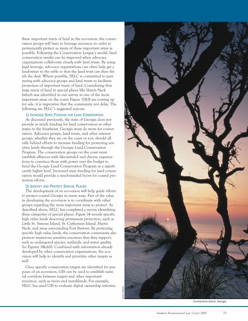
Southern Environmental Law Center 2007 73
CRAI
G T
ANN
ER
these important tracts of land in the eco-vision, the conser-vation groups will have to leverage resources in order topermanently protect as many of these important areas aspossible. Following the Conservation League’s model, landconservation results can be improved when advocacyorganizations collaborate closely with land trusts. By usinglegal leverage, advocacy organizations can often help get alandowner to the table so that the land trust can then fin-ish the deal. Where possible, SELC is committed to part-nering with advocacy groups and land trusts to facilitateprotection of important tracts of land. Considering thatlarge tracts of land in special places like Harris Neck(which was identified in our survey as one of the mostimportant areas on the coast; Figure 17(b)) are coming upfor sale, it is imperative that the community not delay. Thefollowing are SELC’s suggested actions:
1) INCREASE STATE FUNDING FOR LAND CONSERVATION
As discussed previously, the state of Georgia does notprovide as much funding for land conservation as otherstates in the Southeast. Georgia must do more for conser-vation. Advocacy groups, land trusts, and other interestgroups, whether they are on the coast or not, should allrally behind efforts to increase funding for protecting sen-sitive lands through the Georgia Land ConservationProgram. The conservation groups on the coast mustestablish alliances with like-minded and diverse organiza-tions to convince those with power over the budget tofund the Georgia Land Conservation Program at a signifi-cantly higher level. Increased state funding for land conser-vation would provide a much-needed boost for coastal pro-tection efforts.
2) IDENTIFY AND PROTECT SPECIAL PLACES
The development of an eco-vision will help guide effortsto protect coastal Georgia in many ways. Part of the valuein developing the eco-vision is to coordinate with othergroups regarding the most important areas to protect. Asdescribed above, SELC has completed a survey identifyingthree categories of special places. Figure 14 reveals specifichigh value lands deserving permanent protection, such asLittle St. Simons Island, St. Catherines Island, HarrisNeck, and areas surrounding Fort Stewart. By protectingspecific high value lands, the conservation community alsoprotects numerous sensitive resources that they support,such as endangered species, wetlands, and water quality.See Figures 14(a)-(f). Combined with information alreadydeveloped by other conservation organizations, the eco-vision will help to identify and prioritize other targets aswell.
Once specific conservation targets are identified for pur-poses of an eco-vision, GIS can be used to establish natu-ral corridors between targets and other importantresources, such as rivers and marshlands. For example,SELC has used GIS to evaluate digital ownership informa-
Cumberland Island, Georgia
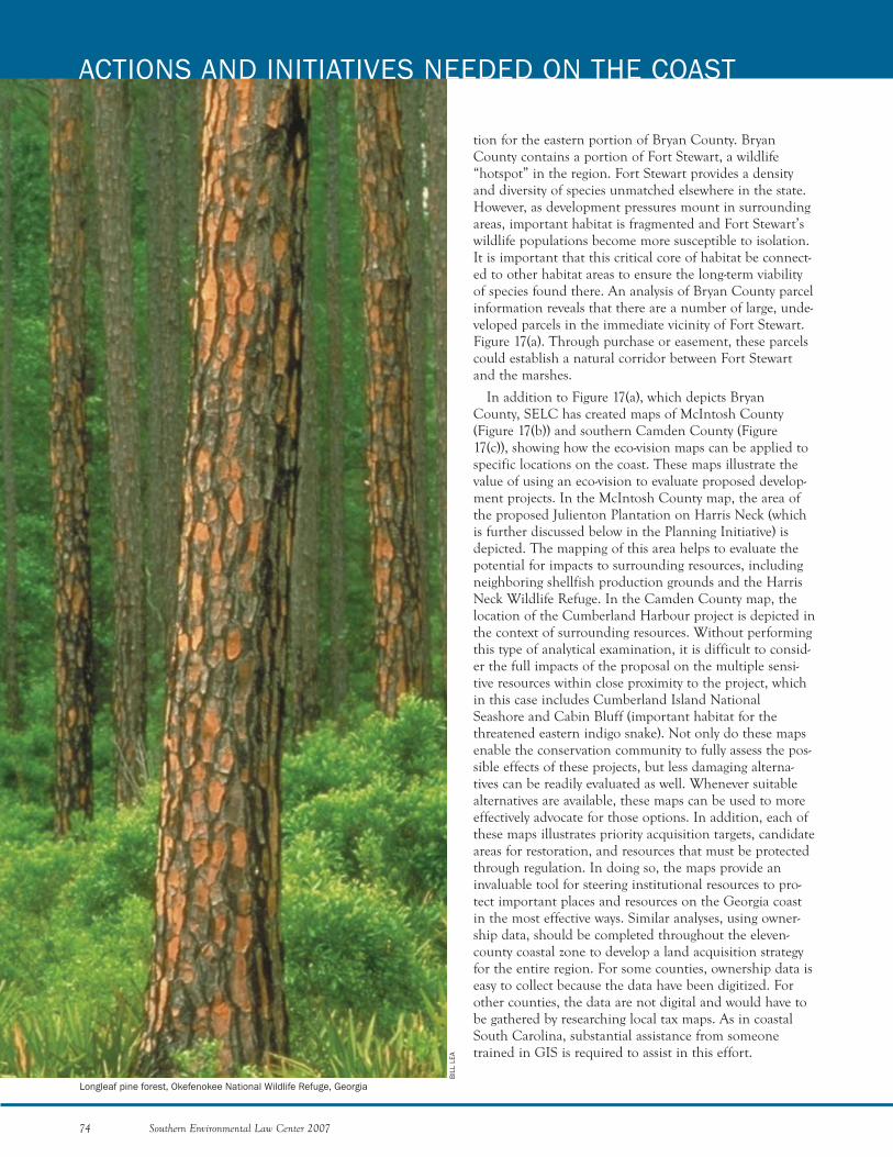
tion for the eastern portion of Bryan County. BryanCounty contains a portion of Fort Stewart, a wildlife“hotspot” in the region. Fort Stewart provides a densityand diversity of species unmatched elsewhere in the state.However, as development pressures mount in surroundingareas, important habitat is fragmented and Fort Stewart’swildlife populations become more susceptible to isolation.It is important that this critical core of habitat be connect-ed to other habitat areas to ensure the long-term viabilityof species found there. An analysis of Bryan County parcelinformation reveals that there are a number of large, unde-veloped parcels in the immediate vicinity of Fort Stewart.Figure 17(a). Through purchase or easement, these parcelscould establish a natural corridor between Fort Stewartand the marshes.
In addition to Figure 17(a), which depicts BryanCounty, SELC has created maps of McIntosh County(Figure 17(b)) and southern Camden County (Figure17(c)), showing how the eco-vision maps can be applied tospecific locations on the coast. These maps illustrate thevalue of using an eco-vision to evaluate proposed develop-ment projects. In the McIntosh County map, the area ofthe proposed Julienton Plantation on Harris Neck (whichis further discussed below in the Planning Initiative) isdepicted. The mapping of this area helps to evaluate thepotential for impacts to surrounding resources, includingneighboring shellfish production grounds and the HarrisNeck Wildlife Refuge. In the Camden County map, thelocation of the Cumberland Harbour project is depicted inthe context of surrounding resources. Without performingthis type of analytical examination, it is difficult to consid-er the full impacts of the proposal on the multiple sensi-tive resources within close proximity to the project, whichin this case includes Cumberland Island NationalSeashore and Cabin Bluff (important habitat for thethreatened eastern indigo snake). Not only do these mapsenable the conservation community to fully assess the pos-sible effects of these projects, but less damaging alterna-tives can be readily evaluated as well. Whenever suitablealternatives are available, these maps can be used to moreeffectively advocate for those options. In addition, each ofthese maps illustrates priority acquisition targets, candidateareas for restoration, and resources that must be protectedthrough regulation. In doing so, the maps provide aninvaluable tool for steering institutional resources to pro-tect important places and resources on the Georgia coastin the most effective ways. Similar analyses, using owner-ship data, should be completed throughout the eleven-county coastal zone to develop a land acquisition strategyfor the entire region. For some counties, ownership data iseasy to collect because the data have been digitized. Forother counties, the data are not digital and would have tobe gathered by researching local tax maps. As in coastalSouth Carolina, substantial assistance from someonetrained in GIS is required to assist in this effort.
74 Southern Environmental Law Center 2007
ACTIONS AND INITIATIVES NEEDED ON THE COAST
BIL
L LE
A
Longleaf pine forest, Okefenokee National Wildlife Refuge, Georgia

3) RESTORE SPECIAL PLACES
In addition to habitat preservation, there are areas with-in the region in which habitat restoration is needed. Theseareas should be identified and prioritized in conjunctionwith resource professionals. As discussed previously, largeareas on the Georgia coast are comprised of wetlands thathave been managed intensively as pine plantations. Timberpractices have altered the natural hydrology in these areas,resulting in increased flashiness of water flows to the estu-aries. In addition to identifying high value target lands forpreservation, our survey has identified a number of largewetland complexes that provide excellent opportunities forrestoration. These areas are currently managed for mono-culture pine production and could soon be converted intosubdivisions; however, the opportunity currently exists torestore these vast wetland complexes, such as IndianSwamp-Caney Bay, Buffalo Creek Swamp, Little SatillaSwamp Complex, and King’s Bay Complex. These areasare identified in Figure 15.
Other candidate habitats for restoration include shell-fish beds and longleaf pine forests. Figures 15(b) and (c). Afederal initiative that should be made part of the overalllongleaf conservation effort involves restoration of longleafforests on private lands under programs administered bythe federal Natural Resources Conservation Service. Theagency has prioritized longleaf restoration for fundingunder a number of its grant programs, including theConservation Reserve Program. This initiative, combinedwith acquisition efforts near Fort Stewart, is of paramountimportance for the future of longleaf in the region.
Following the example of the Coastal Federation inNorth Carolina, groups in Georgia should also supportefforts to restore shellfish habitat due to the importantfunctions that shellfish, such as oysters, play in tidal envi-ronments. In addition to filtering water and improving itsquality, oyster reefs provide important habitat for a widevariety of marine life and stabilize exposed marsh edges,which prevents erosion and loss of marsh grasses.
PPllaannnniinngg IInniittiiaattiivvee1) GUIDE LAND USE DECISIONS
Many of the most significant decisions for the future ofthe Georgia coast are made by local governments. Some ofthese decisions involve the rezoning of ecologically impor-tant tracts of land. A recent example is the proposedJulienton Plantation in McIntosh County, which involvesthe rezoning of a 1,300-acre parcel of land in an areacalled Harris Neck, which is in close proximity to theHarris Neck Wildlife Refuge. Figure 17(b). Harris Neck hasbeen identified in our survey as one of the most importantareas on the Georgia coast to preserve, and this rezoningmay allow for the construction of as many as 1500 homes.Immediately adjacent to the proposed development is oneof the most significant commercial clam operations on the
Southern Environmental Law Center 2007 75
coast, owned and operated by Sapelo Sea Farms, a smallbusiness started by local fishermen. Given the sensitivenature of these shellfish resources, the commercial fisher-men who work these waters believe that, if not carefullyregulated and limited to a moderate density, the develop-ment proposed will ultimately result in the closure of thesebeds due to water pollution. Major rezonings, such as this,are being approved routinely by cities and counties acrossthe coastal region, with little, if any, analysis of theirimpact on public resources.
Like the Conservation League, the conservation groups,relying on the eco-vision, should identify the counties andmunicipalities of concern within which to focus resources.The groups should engage in these communities andbecome respected voices for balanced forms of growth. Inaddition to regularly attending planning meetings, all localland-use decisions should be monitored so that significantdecisions do not get made without necessary pubic input.Further, like the Conservation League, the conservationgroups should steer public infrastructure projects, such asroads, sewer, and water lines away from ecologically impor-tant areas. When public input does not result in betterland-use decision-making, poor decisions must be chal-lenged.
Residents should also be educated to play a meaningfulrole in local policy formulation and governmental deci-sion-making. Some citizen monitoring programs alreadyexist in the coastal region. These opportunities should beexpanded and additional programs should be developed toraise awareness and provide much-needed input. As dis-cussed above, on February 11, 2005, Governor SonnyPerdue signed an executive order directing the GeorgiaDepartment of Community Affairs to begin work on a“Coastal Comprehensive Plan” for the Georgia coast. Theconservation groups will need to pay special attention tothis process to ensure that this plan includes the wiseinvestment of public resources. With this plan now underconstruction, immediate attention needs to be devoted tooversee this process.
2) GUIDE FLOODPLAIN MANAGEMENT
Improving floodplain management on national andlocal levels will decrease residential hazards and economiclosses resulting from natural disasters and reduce theamount of funds expended through emergency manage-ment programs. Therefore, responsible floodplain manage-ment is an environmental strategy that can increase sus-tainable growth as well as address a number of health andeconomic concerns. For this reason, the Buy Dry Landcampaign should be strengthened and supported to edu-cate homebuyers of the hazards of floodplain and wetlanddevelopment.203 Figure 16(c) shows examples of improperfloodplain development and proper floodplain manage-ment. Homes and other structures should be prohibited in
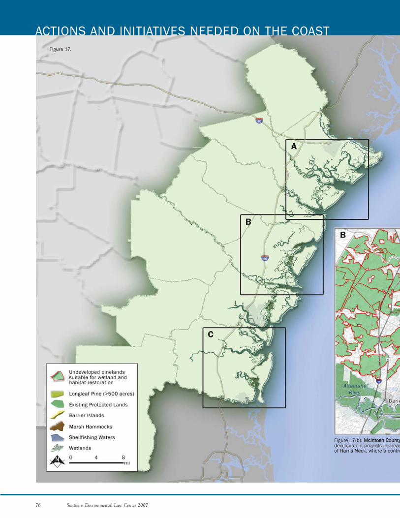
76 Southern Environmental Law Center 2007
ACTIONS AND INITIATIVES NEEDED ON THE COAST
A
B
C
B
Figure 17.
Figure 17(b). MMccIInnttoosshh CCoouunnttyydevelopment projects in areasof Harris Neck, where a contro
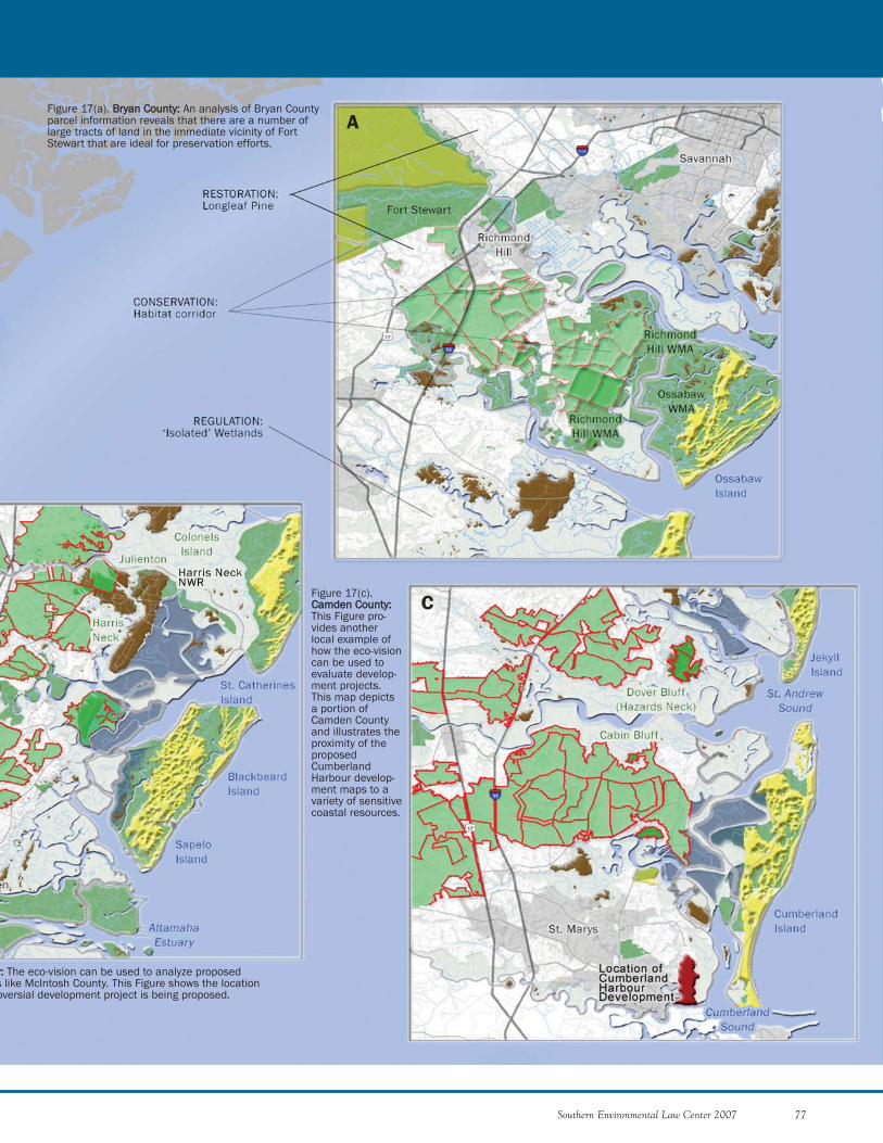
Southern Environmental Law Center 2007 77
A
C
Figure 17(a). BBrryyaann CCoouunnttyy:: An analysis of Bryan Countyparcel information reveals that there are a number oflarge tracts of land in the immediate vicinity of FortStewart that are ideal for preservation efforts.
yy:: The eco-vision can be used to analyze proposeds like McIntosh County. This Figure shows the locationoversial development project is being proposed.
Figure 17(c).CCaammddeenn CCoouunnttyy::This Figure pro-vides anotherlocal example ofhow the eco-visioncan be used toevaluate develop-ment projects.This map depictsa portion ofCamden Countyand illustrates theproximity of theproposedCumberlandHarbour develop-ment maps to avariety of sensitivecoastal resources.
floodways to protect against economic and ecological loss-es. The conservation groups need to have a bigger hand inmaking sure that coastal floodplains do not become filledwith houses.
3) DEVELOP EFFECTIVE WATERSHED PLANS
Coastal counties should conduct watershed planning,using tools essential for growing sustainably. These toolsinclude land conservation, aquatic buffers, improved sitedesigns, erosion and sediment control ordinances,stormwater treatments, and management of other dis-charges. Based on a directive by the Governor and a sched-ule set by the Georgia Department of Community Affairs,such plans should be completed by 2011.204 As part of thisInitiative, the conservation groups should monitor thedevelopment of these plans to ensure they are sufficientlyprotective of the coast.
4) PROTECT GROUNDWATER
Another issue that has major implications for coastalGeorgia is saltwater intrusion into the Upper FloridanAquifer. The conservation groups need to pressure thestate to take the actions necessary to protect groundwaterresources for coastal Georgia into the future. As part ofthis effort, development of the Statewide ComprehensiveWater Management Plan should be monitored. This planwill in all likelihood be key in determining where waterflows in Georgia. Considering that the water needs of
78 Southern Environmental Law Center 2007
ACTIONS AND INITIATIVES NEEDED ON THE COAST
Atlanta dwarf the needs of other parts of the state, the plancould recommend that provisions be made to send additionalwater to Atlanta. This could be done at the expense of thecoast. Thus, the conservation groups need to be prepared tolobby for a more coast-friendly outcome. In addition, as dis-cussed above, the conservation community should ensurethat the state’s plan includes the progressive conservationmeasures contained in the Coastal Georgia Water andWastewater Permitting Plan for Managing SaltwaterIntrusion.
At present, most of coastal Georgia receives its drinkingwater from the Upper Floridan Aquifer. Efforts to protectthis aquifer must include safeguarding groundwater rechargeareas, implementing aggressive water conservation programs,preventing new withdrawals that jeopardize the UpperFloridan Aquifer, and educating the public on the issue. Theconservation groups should be engaged in all of these efforts.
5) CHALLENGE DAMAGING RESERVOIR AND WATER WITHDRAWAL
PROPOSALS
A decrease in the amount of freshwater flowing intoGeorgia’s estuarine waters can degrade the health of marsh-lands and estuaries. Decreases in freshwater flows to the coastcan be attributed to the construction of drinking waterimpoundments and withdrawals in areas upstream from thecoast. There is concern that populated areas like Atlantamight try, possibly with the backing of recommendationsincluded as part of the final Statewide Comprehensive WaterManagement Plan, to use increasingly more water from riverslike the Savannah to quench the region’s growing thirst forwater. If less freshwater reaches the coast to mix with theocean’s saltwater, saline levels in the estuaries will rise, result-ing in severe damage to Georgia’s estuaries and estuarine-dependent aquatic life. Coastal protection efforts mustensure that damaging proposals to withdraw surface waters inupstream areas do not damage the coast’s aquatic resources.As discussed above, the conservation groups will need to payspecial attention to the Statewide Comprehensive WaterManagement Plan.
6) PETITION FOR CRITICAL HABITAT FOR EASTERN INDIGO SNAKES
UNDER THE ENDANGERED SPECIES ACT
Another tool for protecting land and affecting local land-use decisions is the Endangered Species Act. Eastern indigosnakes were designated as threatened in 1978, yet no criticalhabitat has ever been designated. The adoption of criticalhabitat would provide another important tool for shapingfuture development proposals. Proposals in areas of criticalhabitat would require the application of special conditionson the proposed project that would not only protect thethreatened snakes, but would also require a more sensitivetype of development. Therefore, the conservation groupsshould submit a petition for the designation of critical habi-tat for the indigo snake under the ESA.
NNeeuussee RRiivveerr BBaassiinn——EEffffeeccttiivvee WWaatteerrsshheedd PPllaannnniinngg
An outstanding example of successful watershedplanning is the effort to improve estuarine waterquality in the Neuse River Basin in North Carolina.The Neuse River Estuary was not meeting waterquality standards. Under requirements of the U.S.Environmental Protection Agency, the state adopteda nitrogen reduction requirement for the river of 30 percent. To achieve this reduction, the state pro-hibited new point source discharges and adopted abuffer protection regulation requiring a 50-foot veg-etated buffer. Where impacts to buffers areunavoidable, the state required a $40,000 per acrefee. These fees are used to restore buffers in otherlocations within the basin. New and expanded dis-charges must purchase discharge credits through anutrient trading program. In addition, initiativeswere undertaken throughout the basin to reducenitrogen inputs from agriculture. New urbanstormwater controls were adopted, and all newdevelopments are required to install BestManagement Practices such as constructed wet-lands, rain gardens, permeable pavement andgreen roofs to control nitrogen loading to 3.6 pounds per acre per year. Together, theseactions resulted in a 42 percent decrease in nitro-gen loading to the estuary, exceeding the 30 per-cent reduction goal.

Southern Environmental Law Center 2007 79
DAV
E LE
WIS
CClliimmaattee CChhaannggee IInniittiiaattiivvee
SELC believes climate change presents an opportunityfor the conservation groups to develop alternative messagesto support balanced coastal development. Communi-cations regarding the threats of climate change may havethe potential to reach greater numbers of people in coastalGeorgia. In fact, this spring, the mayor and city council inSavannah passed a unanimous resolution to join the Citiesfor Climate Protection campaign and became one of 230local governments committed to taking action at the locallevel to combat climate change.205
1) HELP THE COAST ADOPT MEASURES TO PREPARE FOR GLOBAL
WARMING
Due to the impacts of increased storms and sea-level rise,coastal areas must prepare for the impacts of climatechange. Conservation groups should advocate for widerbuffers, protection of wetlands, restrictions of developmentin floodplains, and other measures to mitigate the impactsof climate change. These same strategies comprise some ofthe measures described above. Climate change presents theopportunity to advocate for these same measures using dif-ferent strategies and messages. For example, threats associ-ated with climate change may lead to new opportunities toobtain state and federal funding to permanently protectimportant lands—not for their ecological values—but toserve as permanent buffers to protect developed areas fromstorms. Further, if people do not respond to messages toprotect wetlands based on their ecological values, perhapsthey will support strategies designed ultimately to protectprivate property from flooding and storms.
2) EDUCATE COASTAL GEORGIANS ON CLIMATE CHANGE
Like everywhere else on the planet, action must be takennow in coastal Georgia to address climate change. Groupsin coastal Georgia should educate the public on this impor-tant issue.
3) ADVOCATE FOR DECREASES IN GREENHOUSE GAS EMISSIONS
The conservation community must advocate in supportof actions to lower the emissions of greenhouse gases,which may include green building techniques, expansion ofmass transit, and use of alternative fuels.
Downtown Savannah, Georgia
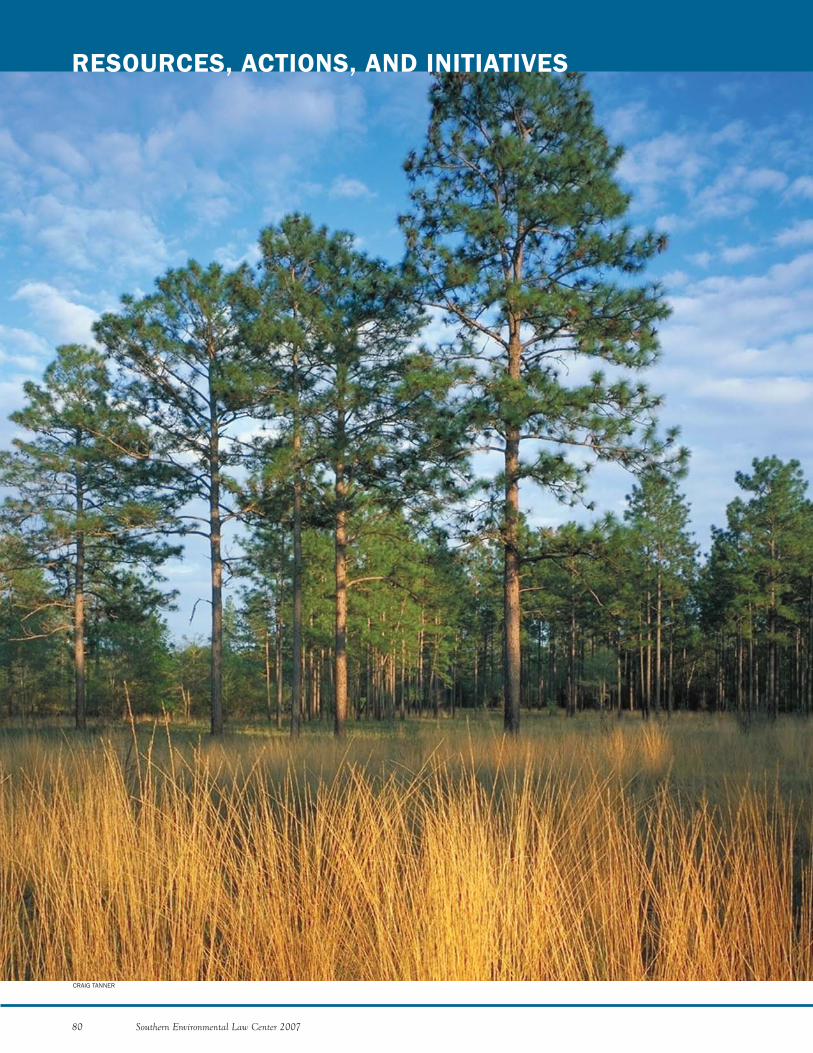
80 Southern Environmental Law Center 2007
RESOURCES, ACTIONS, AND INITIATIVES
CRAIG TANNER
Southern Environmental Law Center 2007 81
In the previous section we provided our analysis of what“Immediate Actions” and “Comprehensive Initiatives” areneeded to address the current threats to the coast. In thissection, we provide our estimation of what additionalresources are needed to achieve these Actions andInitiatives. Having completed this year-long Assessment, itis clear that: (1) Georgia’s coast still supports naturalresources that are of national, if not world-wide, impor-tance; (2) the coastal conservation groups, including advo-cacy organizations, land trusts, and sportsmen’s groups,must band together like never before if this incomparableregion is to be protected; and (3) without a significantinfusion of additional resources to support much-neededcapacities, the conservation groups will not be able toeffectively address the development pressures that are bear-ing down across the region. As discussed below, the con-servation groups must act now to get additional resourceson the ground to accomplish short-term goals and mustact strategically to begin laying the foundation for substan-tially increasing the capacity of the coastal conservationcommunity to meet growing long-term challenges.
RReessoouurrcceess NNeeeeddeedd ttoo PPrrootteecctt tthhee CCooaassttHaving examined the coastal advocacy groups in both
South Carolina and North Carolina, it is clear that theeffort to protect Georgia’s coast is suffering from deficien-cies in certain key areas.
Although the South and North Carolina coasts arearguably more challenging to protect in light of their largersize, each state has a community of coastal advocacygroups that is significantly larger than comparable groupson the Georgia coast. The Conservation League alone hastwenty-two to twenty-three funded program staff membersthat dedicate their time to protecting the South Carolinacoast. In addition to these program staff members, theConservation League has seven to eight development andadministrative employees to support the program work.Similarly, the Coastal Federation has about ten fundedprogram staff members that focus their time on protectingthe North Carolina coast. They too are supported by devel-opment and administrative staff. In addition, other advo-cacy organizations in North Carolina also have staff thatare dedicated to coastal protection. These organizationsinclude Environmental Defense, the Lower NeuseRiverkeeper, the Pamlico-Tar Riverkeeper, the Cape FearRiverkeeper, and Audubon North Carolina. Altogether,there are at least sixteen advocates focused on protectingNorth Carolina’s coastal rivers and estuaries. Despite hav-ing all these resources at their disposal, both theConservation League and the Coastal Federation are inthe midst of capital campaigns to further increase the sizeof their organizations. In short, protecting a coastlinerequires a lot of resources.
While it is difficult to make a precise “apples to apples”comparison of the resources on all three coasts, it is clearthat Georgia is lagging far behind the Carolinas in thenumber of people that are fully engaged in coastal advoca-cy efforts. Our conclusion is that in order to execute theComprehensive Initiatives as part of the Long-Term Plandiscussed below, at least five new people are needed tocomplement the existing organizations and fill gaps.
Even with such an increase of coastal advocates, it is alsoapparent that all conservation groups on the coast aregoing to have to collaborate more effectively. For instance,in our interviews with the Conservation League, it wasclear that the Conservation League’s work would not benearly as effective without the close working relationshipsthat it enjoys with land preservation organizations. If theconservation groups are to succeed on the Georgia coast,land preservation groups, such as The Nature Conser-vancy, and advocacy groups are going to have to worktogether. The Conservation League has enhanced its over-all effectiveness through close collaboration with landpreservation groups. The same level of coordination needsto occur here in Georgia.
In addition to needing additional manpower and greatercoordination, the conservation groups need otherresources in important areas to increase their overall effec-tiveness. While the coastal developers can hire experi-enced consultants, high-priced attorneys, and public rela-tions firms, the coastal groups are left to do the best theycan with the resources they have. Considering the rapidgrowth on the Georgia coast, every advocate in the fight tosave the coast must be equipped with the resources neededto be successful. To remedy this situation, the conservationgroups need to be equipped with increased levels of techni-cal, legal, and communications capacities in the followingways.
First, both the Conservation League and the CoastalFederation have considerable scientific and technicalcapacity to enhance their advocacy work. TheConservation League uses many different types of experts,including land-use planners, engineers, air quality experts,GIS technicians, and others. The Conservation Leaguedoes not have these experts on permanent staff; rather, theLeague has a preference for contracting with outside ex-perts, when needed. The Coastal Federation contractswith outside experts as well, but has scientists on staff toassist with issues related to water quality, habitat, and wet-lands. As the Conservation League and Coastal Federa-tion have demonstrated time and time again, having tech-nical expertise at their finger tips has made their advocacymuch more effective. The same should be true on theGeorgia coast.
Second, decisions are made every day at every level ofgovernment (federal, state, and local) that affect the envi-
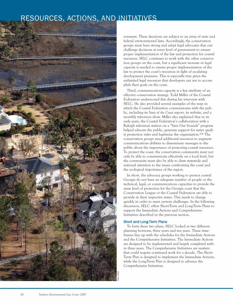
82 Southern Environmental Law Center 2007
RESOURCES, ACTIONS, AND INITIATIVES
DAV
E LE
WIS
ronment. These decisions are subject to an array of state andfederal environmental laws. Accordingly, the conservationgroups must have strong and adept legal advocates that canchallenge decisions at every level of government to ensureproper implementation of the law and protection for coastalresources. SELC continues to work with the other conserva-tion groups on the coast, but a significant increase in legalcapacity is needed to ensure proper implementation of thelaw to protect the coast’s resources in light of escalatingdevelopment pressures. This is especially true given theunlimited legal resources that developers can use to accom-plish their goals on the coast.
Third, communications capacity is a key attribute of aneffective conservation strategy. Todd Miller of the CoastalFederation underscored this during his interview withSELC. He also provided several examples of the ways inwhich the Coastal Federation communicates with the pub-lic, including its State of the Coast report, its website, and amonthly television show. Miller also explained that in itsearly years, the Coastal Federation’s collaboration with aRaleigh television station on a “Save Our Sounds” programhelped educate the public, generate support for water quali-ty protection rules and legitimize the organization.206 Theconservation groups need additional resources to augmentcommunications abilities to disseminate messages to thepublic about the importance of protecting coastal resources.To protect the coast, the conservation community must notonly be able to communicate effectively on a local level, butthe community must also be able to draw statewide andnational attention to the issues confronting the coast andthe ecological importance of the region.
In short, the advocacy groups working to protect coastalGeorgia do not have an adequate number of people or thetechnical, legal, or communications capacities to provide thesame level of protection for the Georgia coast that theConservation League or the Coastal Federation are able toprovide in their respective states. This needs to changequickly in order to meet current challenges. In the followingdiscussion, SELC offers Short-Term and Long-Term Plans tosupport the Immediate Actions and ComprehensiveInitiatives described in the previous section.
SShhoorrtt aanndd LLoonngg--TTeerrmm PPllaannssTo form these two plans, SELC looked at two different
planning horizons, three years and ten years. These time-frames line up with the schedules for the Immediate Actionsand the Comprehensive Initiatives. The Immediate Actionsare designed to be implemented and largely completed with-in three years. The Comprehensive Initiatives are mattersthat could require continued work for a decade. The Short-Term Plan is designed to implement the Immediate Actions,while the Long-Term Plan is designed to advance theComprehensive Initiatives.
SHORT-TERM PLAN
The Immediate Actions, as explained in the “Actionsand Initiatives Needed on the Coast” section above, arethe following:
(1) Prevent the state from marginalizing the protectionsof the Coastal Marshlands Protection Act (the state mustconsider all of the ways in which coastal development proj-ects impact the marsh);
(2) Require the state to enforce the Erosion andSedimentation Act’s 25-foot buffer requirement on the saltmarsh and other coastal waters (the state must requirelocal governments in the coastal zone, like Glynn andChatham Counties, to implement and enforce the 25-footbuffer for marshlands and tidal streams);
(3) Monitor and challenge, if necessary, Corps jurisdic-tional decisions over wetlands and streams throughout thecoastal region (if the Savannah District’s decisions are notmonitored and challenged, the agency will use the currentconfusion surrounding its authority to remove federal pro-tections for wetlands under the Clean Water Act); and
(4) Permanently protect as many ecologically importanttracts of land as possible (advocacy and land trust organiza-tions must work in tandem to achieve maximum protec-tion for sensitive lands).
The Short-Term Plan involves the Immediate Actionslisted above, as well as the development of an eco-vision toguide long-range conservation efforts on the coast. Thedevelopment of an eco-vision will result in maps that iden-tify the most vulnerable and ecologically valuable areas onthe coast. The conservation groups would use the maps torefine the Immediate Actions and ComprehensiveInitiatives and to deploy resources in the most strategicplaces.
In order to successfully implement the ImmediateActions, it is essential that the conservation groups beequipped properly. As described above, the conservationgroups need more technical, legal, and communicationresources. In the paragraphs below, we explain how thoseresources could be deployed on the coast in short order.
Technical CapacityTo ensure that the conservation groups have the scientif-
ic and technological resources they need to be effective, ascientist or environmental management professional withexperience in a relevant coastal discipline, such as ecology,biology, or environmental planning, should be hired. Thisperson would be available to assist conservation groupswith technical needs, including on-the-ground analysis ofpotential environmental problems. In addition, this per-son would be able to help analyze proposed development projects and offer suggested improvements to make theprojects more environmentally sensitive. If a project werebeyond this person’s expertise, he or she would be respon-
sible for identifying an appropriate expert in academia, anagency, or the private sector to provide the necessary assis-tance. The scientist would also be responsible for alertingthe conservation groups to lessons learned through suc-cessful approaches to environmental problems in othercoastal states.
SELC proposes that conservation groups form a com-mittee to hire the scientist. A key requirement for thisposition would be for the scientist to foster relationshipswith academics, consultants, and other technical experts todevelop a reliable community of experts that are willing toprovide assistance when called upon. In addition, suffi-cient funding must be provided not only to pay for the sci-entist, but also to allow the community to hire relevantexperts, such as GIS and aerial photography professionals.Expert assistance in disciplines such as these is critical toensuring that the Corps fulfills its obligation to protectwetlands. In light of the fact that most wetlands at issueare found on private lands, access to experts in aerial pho-tography and map-making is essential for successful investi-gation. Without these technical tools, it would be very dif-ficult to meet the challenges facing the conservation com-munity, including the fallout from the Rapanos decisionand other changes in federal wetlands law.
Having a scientist to strengthen overall technical capaci-ty would address one of the community’s primary short-comings. It would also obviate the need for individualgroups to build their own in-house technological expertise.In addition, it would be beneficial for groups to be able tolook to a single source for the latest scientific and techni-cal information to support program work, such as modelordinances for protecting resources.
Legal CapacityMany of the Immediate Actions identified above in the
“Actions and Initiatives Needed on the Coast” sectionrequire substantial legal resources. Implementation of theCoastal Marshlands Protection Act; requiring the state toimplement the 25-foot buffer requirement on coastalwaters; and reviewing and challenging improper wetlandsjurisdictional determinations, all require a significantinvestment in legal resources. Given the current politicalclimate in Georgia, legal approaches are sometimes theonly forms of advocacy that can effectively defend coastalresources and require government agencies to correctimproper implementation of the law. Considering thechallenges posed by the proposed Immediate Actions, it isimperative that more legal resources be deployed as part ofthe Short-Term Plan.
Communications Capacity In addition to increasing technical and legal capacities,
the Short-Term Plan includes building communicationscapacities for the coastal conservation community, whichincludes the ability to hire communications consultants
Southern Environmental Law Center 2007 83

organizations need to shift additional resources to thecoast, and all the conservation groups need to collaborateto devise ways to focus state and national attention on theGeorgia coast. The Georgia coast must be placed in thespotlight so that the conservation groups can raise thefunding needed to protect the saltwater marshes, maritimeforests, cypress domes, and other resources that comprisethe Georgia coast’s unique character.
As discussed above, compared to the South and NorthCarolina coasts, the Georgia coast has a fraction of theadvocates that the Carolina coasts enjoy, and, as the leadcoastal organizations in those states will readily explain,the South and North Carolina coasts are still not ade-quately protected. Based on the numbers of people pro-tecting the South and North Carolina coasts and the chal-lenges inherent in pursuing the Comprehensive Initiativesin Georgia, a minimum of five additional people focusedon protecting coastal Georgia is needed. In order to ensurethat these new people are utilized in the most effectivemanner, our recommendation, for the reasons discussedbelow, is that a new organization be established on theGeorgia coast.
Organization to Protect the Entire Coast Using AllForms of Advocacy SELC recommends that a free-standing organization
based on the successful models of the ConservationLeague and the Coastal Federation be established to focuson protecting the entire coast as a region. Such an organi-zation would be the best vehicle for deploying newresources and for enhancing efforts to protect the Georgiacoast for a number of reasons.
First, an organization dedicated solely to protecting theentire coast and with a critical mass of five program staffwould have the ability to bring all of the different coastalgroups together in a coordinated fashion to work meaning-fully on the full range of coastal issues. Also, with the rightcommunication resources, such an organization wouldhave the opportunity to focus public attention on theGeorgia coast and make its protection a statewide andnational priority. Over time, the new organization, like theConservation League and Coastal Federation, could builda significant constituency for protecting the entire coastalregion, including a much-needed political constituency toadvance an agenda of coastal protection in state govern-ment.
Second, a new stand-alone organization provides themost effective means for managing new employees andresources. If five new people were hired to protect thecoast, it would be more efficient to have those newemployees reporting to one manager located within oneorganization that has a goal of protecting the entire coastalregion. Without a new organization to house new employ-ees, new hires would be placed within different organiza-
84 Southern Environmental Law Center 2007
RESOURCES, ACTIONS, AND INITIATIVES
and to fund important campaigns. The conservationgroups must have the ability to communicate with the pub-lic in an effective way about important issues in the region.By educating the public through effective messages regard-ing substantive work, the conservation groups would beable to garner support for their positions and influenceimportant political leaders. In addition, the conservationgroups must have the ability to support those communica-tion campaigns that it develops. Accordingly, the Short-Term Plan includes acquiring sufficient funding to giveinnovative campaigns like “Buy Dry Land” a chance to suc-ceed.
In sum, the Short-Term Plan involves:
(1) Taking the immediate actions outlined in the“Actions and Initiatives Needed on the Coast” sec-tion above;
(2) Increasing technical capacity, including hiring a sci-entist or other environmental management profes-sional to serve existing groups; bolstering legal capac-ity; strengthening communications capacity; and
(3) Devising an eco-vision as a foundation for imple-mentation of Comprehensive Initiatives.
In order to launch the Short-Term Plan, SELC proposesthe following meetings:
August 2007—A meeting among environmental advo-cates, land trusts, sportsmen’s organizations, and others todiscuss the proposed Short-Term Plan, including immedi-ate next steps and the hiring of a scientific or environmen-tal management professional to serve the environmentalorganizations; and
February 2008—A meeting among environmental advo-cates, land trusts, sportsmen’s organizations, and others toinitiate the development of a coastal eco-vision. Asdescribed above, the objective of the eco-vision is to devel-op a shared vision for the future of the coast that wouldidentify ecologically valuable areas deserving of permanentprotection and other areas where responsible developmentcan be accommodated.
These meetings to further refine the Short-Term Planand develop the eco-vision will lay the foundation for theimplementation of an effective, coordinated, long-termstrategy to protect the Georgia coast.
LONG-TERM PLAN
Although the Short-Term Plan with its ImmediateActions is urgently needed and extremely important, thatplan is not going to save the Georgia coast on its own. TheShort-Term Plan must be complemented by a Long-TermPlan to implement the Comprehensive Initiatives. In addi-tion to actively implementing the Short-Term Plan, theconservation community needs to lay the groundwork todramatically increase resources to support coastal protec-tion efforts over the long haul. Where possible, statewide
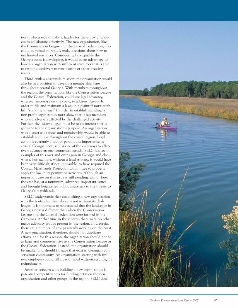
Southern Environmental Law Center 2007 85
tions, which would make it harder for these new employ-ees to collaborate effectively. The new organization, likethe Conservation League and the Coastal Federation, alsocould be poised to rapidly make decisions about how touse limited resources. Considering how quickly theGeorgia coast is developing, it would be an advantage tohave an organization with sufficient resources that is ableto respond decisively to new threats or other pressingissues.
Third, with a coast-wide mission, the organization wouldalso be in a position to develop a membership basethroughout coastal Georgia. With members throughoutthe region, the organization, like the Conservation Leagueand the Coastal Federation, could use legal advocacy,wherever necessary on the coast, to address threats. Inorder to file and maintain a lawsuit, a plaintiff must estab-lish “standing to sue.” In order to establish standing, anon-profit organization must show that it has memberswho are adversely affected by the challenged activity.Further, the injury alleged must be to an interest that isgermane to the organization’s purpose. An organizationwith a coast-wide focus and membership would be able toestablish standing throughout the coastal region. Legalaction is currently a tool of paramount importance incoastal Georgia because it is one of the only ways to effec-tively advance an environmental agenda. SELC has seenexamples of this over and over again in Georgia and else-where. For example, without a legal strategy, it would havebeen very difficult, if not impossible, to have required theCoastal Marshlands Protection Committee to properlyapply the law in its permitting activities. Although animportant case on this issue is still pending, win or lose,the case has, at a minimum, advanced important issuesand brought heightened public awareness to the threats toGeorgia’s marshlands.
SELC understands that establishing a new organizationwith the traits identified above is not without its chal-lenges. It is important to understand that the landscape inGeorgia now is different than when the ConservationLeague and the Coastal Federation were formed in theCarolinas. At that time in those states there were no othermajor advocacy groups present in the region. In Georgia,there are a number of groups already working on the coast.A new organization, therefore, should not duplicateefforts, and for this reason, the organization should not beas large and comprehensive as the Conservation League orthe Coastal Federation. Instead, the organization shouldbe smaller and should fill gaps that exist in Georgia’s con-servation community. An organization starting with fivenew employees could fill areas of need without resulting inredundancies.
Another concern with building a new organization ispotential competitiveness for funding between the neworganization and other groups in the region. SELC does
DW
IGH
T D
YKE

86 Southern Environmental Law Center 2007
RESOURCES, ACTIONS, AND INITIATIVES
not wish to increase competitive pressures for resourcesamong conservation groups. To the contrary, SELCbelieves that there are new sources of funding that can beattracted to support conservation efforts in the region, andany attempt to build a new organization should aim to bol-ster existing organizations by increasing funding levels forthe entire community. With a new organization dedicatedto enhancing coordination among groups and raising stateand national awareness of the issues confronting theGeorgia coast, SELC believes that new sources of fundingwill be developed.
Coalition A second, less desirable alternative for deploying addi-
tional resources is to form a coalition. Coalitions can beeffective mechanisms for bringing people together, espe-cially in the short-term, to rally around a common prob-lem or to advance a specific agenda. The Georgia WaterCoalition provides a good example.207 In the GWC, theGeorgia Wildlife Federation, Georgia Conservancy, UpperChattahoochee Riverkeeper, and SELC have worked welltogether to build and implement an advocacy strategy onstatewide water issues of mutual concern. In the GeorgiaGeneral Assembly, the GWC has demonstrated its effec-tiveness by defeating damaging legislative proposals, includ-ing a bill to create water markets in Georgia.
The benefits to be derived from coalition work are fur-ther illustrated by the establishment of a coastal committeeof the GWC, which was formed to address issues of specialconcern relating to coastal Georgia. This committee con-sists of many of the advocacy groups described above inthe “Government Agencies and Environmental Groups”section. As a result of working together in the GWCcoastal committee, these groups have demonstratedthrough the “Buy Dry Land” campaign how improvedcoordination can lead to greater overall effectiveness. If acoalition model were adopted to implement theComprehensive Initiatives, serious consideration should begiven to using the coastal committee of the GWC as afoundation from which to build the needed coalition.
Although the establishment of a coalition to implementthe Initiatives would enhance coastal protection effortsover the long-term relative to the status quo, the approachalso has drawbacks. A coalition, unlike a new organization,would not have a leader that could make important deci-sions in an efficient manner. Long-term coalitions areinherently inefficient relative to free standing organiza-tions and often become bogged down in decision-makingprocesses. In light of the rapid growth across the region,slow decision-making can mean the difference betweenpermanently protecting an important parcel of land andlosing it to a poorly-conceived development plan.
Furthermore, a coalition is a less desirable option formanaging new resources. Many of the groups in coastal
BIL
L LE
A
Georgia are small and must devote their available resourcesto their current priorities. To manage the GWC, groupsare expected to perform specific functions such as: legaland policy; legislative and lobbying; communication; mem-bership; report preparation; and meetings organization.For SELC, our leadership role within the GWC requires asignificant amount of staff resources from two attorneys.The GWC has been effective, in part, because the organi-zations that lead the coalition are relatively large and betterable to devote significant staff time to GWC responsibili-ties. Conversely, a number of the groups working to pro-tect the coast are already stretched thin in light of the sig-nificant challenges they are already undertaking.Therefore, it would be unfair to expect these organizationsto assume the added challenge of managing a coalition ontop of all of their other responsibilities.
In addition, a coalition, unlike a free-standing entity,does not have its own members and is therefore unable toestablish standing to challenge environmental harms or torequire proper implementation of the law. A coalition’sinability to use legal advocacy as a tool is a significantshortcoming compared to the ability of organizations likethe Conservation League or the Coastal Federation thatare able to use legal advocacy, when necessary, to addressproblems throughout the geographic regions they cover.
IImmpplleemmeennttaattiioonn aanndd CCoooorrddiinnaattiioonn ooff SShhoorrtt aanndd LLoonngg--TTeerrmm PPllaannss
As discussed previously, the Short-Term Plan includesurgent actions to address immediate threats to the coast.Time is of the essence, and this Short-Term Plan must belaunched in short order.
The Long-Term Plan will be more complicated to enact.The substantive actions included in the ComprehensiveInitiatives are far broader in scope than the Short-TermPlan’s Immediate Actions, and the establishment of a neworganization is a significant undertaking. There are manytasks that must be accomplished, including recruiting aboard of directors, hiring an executive director and staff,and raising significant funds. To be done properly, thesetasks will take time to complete. SELC recommends thatinterested parties take initial exploratory steps to examinethe formation of the recommended organization over thecourse of the next year. This evaluation, however, shouldnot interfere with the launching of the Short-Term Plan toaddress the immediate challenges that lie ahead.
If the conservation community can initiate and imple-ment these plans in a coordinated fashion, SELC believesthat the difficult obstacles that today cast a shadow overthe coastal region can be successfully overcome. Correctingthe failures of government agencies to properly implementthe law and ensuring more balanced and sensitive forms ofdevelopment on the Georgia coast are daunting challenges.Nevertheless, by working together to implement the Short
and Long-Term Plans, the conservation community can,and will, protect this national treasure and secure a futurewhere the Georgia coast remains distinctive, where habitatis protected and wildlife abounds, and where special placesthroughout the region are saved in perpetuity for genera-tion after generation to enjoy.
Southern Environmental Law Center 2007 87
1 Sidney Lanier, 1842-1881, is one of Georgia’s most famous poets. “The Marshes of Glynn”(1878) was part of an unfinished set of lyrical nature poems known as the “Hymns of theMarshes,” which describe the vast, open salt marshes of Glynn County on the coast of Georgia.See EDWIN MIMS, A BIOGRAPHY OF SIDNEY LANIER (1998), available at http://www.gutenberg.org/etext/1224 (last visited June 22, 2007). See also Milton S. Eisenhower Library, Johns HopkinsUniversity, Lanier (Sidney) 1842-1881, http://www.library.jhu.edu/collections/specialcollec-tions/manuscripts/msregisters/ms007.html (last visited June 22, 2007).2 See OFFICE OF OCEAN & COASTAL RES. MGMT., NAT’L OCEANIC AND ATMOSPHERIC ADMIN.,STATE OF GEORGIA COASTAL MANAGEMENT PROGRAM AND PROGRAM DOCUMENT 2 (2003).3 DOMINIC GUADAGNOLI ET AL., COASTAL RES. DIV., GA. DEP’T OF NATURAL RES., THE CONDITIONOF GEORGIA’S ESTUARINE AND COASTAL HABITATS 2000-2001—Interim Report 1 (2005), available athttp://crd.dnr.state.ga.us/assets/documents/GAreport3062306finalLOWRES.pdf (last visitedJune 19, 2007).4 Letter from Gov. Sonny Perdue, State of Georgia, to Hon. James D. Watkins, Chairman, U.S.Commission on Ocean 1 (June 4, 2004), available at http://www.oceancommission.gov/docu-ments/gov_comments/Georgia.pdf (last visited June 19, 2007).5 See GUADAGNOLI, supra note 3, at 1.6 See Perdue, supra note 4, at 1.7 BRUCE A. STEIN, STATES OF THE UNION: RANKING AMERICA'S BIODIVERSITY 20—21 (2002), avail-able at http://www.natureserve.org/Reports/stateofunions.pdf (last visited June 19, 2007).8 According to its website, Georgia’s Regional Development Centers (RDCs) are multi-countyplanning and development agencies serving municipal and county governments. The CoastalGeorgia RDC serves ten counties and thirty-five cities. The region encompasses the six coastalcounties and four inland counties. See Coastal Georgia Regional Development Center,http://www.coastalgeorgiardc.org (last visited June 19, 2007). It should be noted that these popu-lation projections are for an area that is not completely analogous to the region we have chosenfor purposes of this Assessment. The Coastal RDC study includes Bulloch and Screven counties,which are not included in our Assessment. Id. Meanwhile, our Assessment includes Brantley,Charlton, and Wayne, which are not included in the Coastal RDC study.9 CTR. FOR QUALITY GROWTH AND REG’L DEV., GA. INST. OF TECH., GEORGIA COAST 2030:POPULATION PROJECTIONS FOR THE 10-COUNTY COASTAL REGION 3 (2006), available athttp://www.cqgrd.gatech.edu/PDFs/coastal_ga_pop_projections.pdf (last visited June 19, 2007). 10 Id. at 4.11 R.B. Hammer et al., Characterizing spatial and temporal residential density patterns across the U.S.Midwest, 1940-1990, 69 LANDSCAPE & URBAN PLANNING 183 (2004).12 See Mary Star, Get Ready to Grow, BRUNSWICK NEWS, Oct. 14, 2006; Mary Landers, In CoastalGeorgia: Expect 844,000 residents by 2030, SAVANNAH MORNING NEWS, Oct. 18, 2006.13 Interview with David Kyler, Center for a Sustainable Coast (Apr. 2007).14 See Star, supra note 12. 15 See id.; Landers, supra note 12.16 See Star, supra note 12.17 See Landers, supra note 12. 18 According to Nap Caldwell, Senior Planning and Policy Advisor at the EnvironmentalProtection Division of the Georgia Department of Natural Resources, higher populations willmake the already difficult job of allocating water use and wastewater discharge permits in thecoastal zone even more difficult. See Landers, supra note 12; see also CTR. FOR QUALITY GROWTHAND REG’L DEV., supra note 9, at 25 (noting “concerns that the water/sewer capabilities of somecites will be unable to keep pace with new development in the coming years.”).19 Mary Carr Mayle, Savannah makes Inc. magazine's top 10 “boomtowns” list, SAVANNAH MORNINGNEWS, Apr. 25, 2007.20 OFFICE OF PLANNING & QUALITY GROWTH, GA. DEP’T OF CMTY. AFFAIRS, REGIONAL PROFILE OFGEORGIA’S COASTAL COUNTIES 2 (2005), available at http://www.dca.state.ga.us/development/PlanningQualityGrowth/programs/downloads/ccp/RegionalProfile.doc (last visited June 19,2007).21 As discussed, infa, SELC, on behalf of other conservation organizations, challenged the permitissued by the state authorizing construction of marinas and docks at Cumberland Harbour. Thelower court in this case (hereinafter referred to as the Cumberland Harbour case) have upheld theenvironmental groups’ broad interpretation of Georgia’s Coastal Marshlands Protection Act. Thecase is now pending before the Georgia Court of Appeals. See infra note 147 and accompanyingtext.22 AMERICAN BIRD CONSERVANCY, TOP 20 MOST THREATENED BIRD HABITATS IN THE U.S., avail-able at http://www.abcbirds.org/habitatreport.pdf (last visited June 19, 2007).23 Coastal Res. Div., Ga. Dep’t of Natural Res., Georgia’s Saltmarshes: Vital Nursery Habitat,http://crd.dnr.state.ga.us/content/displaycontent.asp?txtDocument=412 (last visited June 19,2007).24 Information on file with the Georgia Department of Natural Resources.25 Raymond W. Schneider, Georgia Coastal Research Council, Role of Pathogens in the BrownMarsh Syndrome and Development of Direct Seeding Technology for Planting Spartina alterniflora(Proceedings of the Marsh Dieback Workshop Savannah, Ga., Feb. 3-4, 2004).26 Interview with David Kyler, Center for a Sustainable Coast (April 2007).27 CLARK R. ALEXANDER & MICHAEL H. ROBINSON, GIS AND FIELD-BASED ANALYSIS OF THEIMPACTS OF RECREATIONAL DOCKS ON THE SALTMARSHES OF GEORGIA (2004), available athttp://www.skio.peachnet.edu/publications/pdfs/dock_impact.pdf (last visited June 19, 2007).28 DR. CLARK ALEXANDER ET AL., ASSESSING THE IMPACTS OF FLOATING DOCKS ON BOTTOMCHARACTER AND BENTHIC PRODUCTIVITY IN COASTAL GEORGIA 3 (2006), available athttp://www.skio.peachnet.edu/publications/pdfs/floatingdocks_on_benthicprod.pdf (last visitedJune 19, 2007).29 ALEXANDER & ROBINSON, supra note 27, at 6, 38. Another study evaluating the effects of float-ing docks on primary production of marshes in Georgia found that these docks, because theyshade the soils below them, decreased production of shellfish or benthic productivity by fifty-sevento seventy-three percent. See ALEXANDER ET AL., supra note 28, at 3.30 Mike Gisick, Atlanta Eyes Savannah River as Water Source, BEAUFORT GAZETTE, July 5, 2006, avail-able at http://www.islandpacket.com/news/local/story/5909735p-5223735c.html (last visited June19, 2007).31 There are other indications that state leaders may seek to satisfy Atlanta’s thirst for water supplyby piping water all the way from Georgia’s estuaries. In fact, in 2006, the General Assembly creat-ed a Joint Comprehensive Water Desalination Study Committee to evaluate the prospects for pro-
viding “safe and secure water supply for predicted population growth at least 20 years into thefuture” by employing desalination technologies on the coast. It has been reported that a companycalled Aquasis plans to build the first plant somewhere on the Georgia coast in 2007. MaryLanders, Desalination Likely to Move Forward, SAVANNAH MORNING NEWS, Sep. 28, 2006.Desalination has been criticized due to the amount of energy required to make the technologyrun and because the process requires a high salinity discharge to estuarine receiving waters. 32 F.H. Sklar & J.A. Browder, Coastal Environmental Impacts Brought about by Alterations ofFreshwater Flow in the Gulf of Mexico, 22 ENVTL. MGMT. 547 (1998).33 R.M. Chambers et al., Phragmites australis Invasion and Expansion in Tidal Wetlands: Interactionsamong Salinity, Sulfide, and Hydrology, 26 ESTUARIES & COASTS 398 (2003); David M. Burdick &Raymond A. Konisky, Determinants of Expansion for Phragmites australis, Common Reed, in Naturaland Impacted Coastal Marshes 26 ESTUARIES & COASTS 407 (2003); Edward A. Vasquez et al., Salttolerance and Osmotic Adjustment of Spartina alterniflora (Poaceae) and the Invasive M Haplotype ofPhragmites australis (Poaceae) Along a Salinity Gradient, 93 AM. J. OF BOTANY 1784 (2005).34 Frank Carl, Savannah Riverkeeper, Nuclear Legacy, Nuclear Future on the Savannah,WATERKEEPER, Fall 2004, available at http://switchstudio.com/waterkeeper/issues/Fall06/ savan-nah.html (last visited June 19, 2007).35 The New Georgia Encyclopedia, Tidal Marshes, http://www.georgiaencyclopedia.com/nge/Article.jsp?id=h-1183 (last visited June 19, 2007).36 Id.37 Coastal Res. Div., Ga. Dep’t of Natural Res., Beach Swimming Advisory Status for GeorgiaBeaches, http://crd.dnr.state.ga.us/content/displaycontent.asp?txtDocument=571 (last visited June 19, 2007).38 Id.39 Dan Chapman, Future is foggy on Jekyll Island: Battle over development of a Georgia jewel, ATLANTAJ.-CONST., Mar. 25, 2007.40 Don McKee, Jekyll Island given a voice, MARIETTA DAILY J., Feb. 28, 2007, available athttp://www.mdjonline.com/articles/2007/02/28/89/10249318.txt (last visited June 19, 2007).41 The Nature Conservancy, The Altamaha River, http://www.nature.org/wherewework/northamerica/states/georgia/preserves/art6633.html (last visited June 19, 2007).42 The New Georgia Encyclopedia, Tidal Marshes, http://www.georgiaencyclopedia.com/nge/Article.jsp?id=h-1183 (last visited June 19, 2007).43 Id.44 Id.45 Radionuclides represent both a human and animal health hazard. See CAROLINE MCFARLIN &DR. MERRYL ALBER, ASSESSMENT OF COASTAL WATER RESOURCES AND WATERSHED CONDITIONS ATFORT PULASKI NATIONAL MONUMENT, GEORGIA (2005), available at http://www.nature.nps.gov/water/watershed_reports/ fopu_final_01092006.pdf (last visited June 19, 2007).46 Savannah Riverkeeper, Projects: Chlor-Alkali Mercury-Free Campaign, http://www.savan-nahriverkeeper.org/projects.shtml#mercury (last visited June 19, 2007).47 David Kyler, Op-Ed, Mercury Rising, CONNECT SAVANNAH, May 5, 2004, available athttp://www.connectsavannah.com/show_article.php?article_id=1271424263 (last visited June 19,2007).48 RICHARD J. LENZ, LONGSTREET HIGHROAD GUIDE TO THE GEORGIA COAST & OKEFENOKEE(1999).49 M. ALBER ET AL., THE SATILLA RIVER ESTUARINE SYSTEM: THE CURRENT STATE OF KNOWLEDGE(2003), available at http://www.satillariverkeeper.org/current.pdf (last visited June 19, 2007).50 Terry Dickson, Off-road? OK, but some say driving into rivers is pesky, FLA. TIMES-UNION, December26, 2006. 51 Id.52 ENVTL. PROT. DIV., GA. DEP’T OF NATURAL RES., OGEECHEE RIVER BASIN WATERSHEDPROTECTION PLAN (2001), available at http://www.gaepd.org/Documents/ ogeechee.html (last vis-ited June 19, 2007).53 Id.54 The New Georgia Encyclopedia, Tidal Marshes, http://www.georgiaencyclopedia.com/nge/Article.jsp?id=h-1183 (last visited June 19, 2007).55 See B. ZOODSMA, STATE OF GEORGIA COMPREHENSIVE MANATEE MANAGEMENT PLAN(TRICHECHUS MANATUS LATIROSTRIS) (1998).56 U.S. FISH & WILDLIFE SERV., FLORIDA MANATEE RECOVERY PLAN (TRICHECHUS MANATUSLATIROSTRIS), THIRD REVISION 23 (2001). 57 Karl Blankenship, Bay’s First “No Discharge” Zone Established, CHESAPEAKE BAY J., July-Aug. 2002,available at http://www.bayjournal.com/article.cfm?article=700 (last visited June 19, 2007).58 Stephen B. Olsen et al., Managing Freshwater Inflows to Estuaries: A Methods Guide (2006),available at http://www.nature.org/initiatives/freshwater/files/methodsguidev61.pdf (last visitedJune 19, 2007).59 See GUADAGNOLI, supra note 3, at 1.60 SUZANNE B. BRICKER ET AL., NATIONAL ESTUARINE EUTROPHICATION ASSESSMENT, EFFECTS OFNUTRIENT ENRICHMENT IN THE NATION’S ESTUARIES (1999).61 ANDREI L. BARKOVSKII ET AL., GEOCHEMICAL AND MICROBIAL SIGNATURES FOR ANTHROPOGENICDISTURBANCE OF COASTAL ENVIRONMENTS (2004).62 GA. DEP’T OF NATURAL RES., GUIDELINES FOR EATING FISH FROM GEORGIA WATERS (2006),available at http://www.gaepd.org/Files_PDF/gaenviron/fish_advisory/fgc-2006.pdf (last visitedJune 19, 2007).63 ENVTL. PROTECTION DIV., GA. DEP’T OF NATURAL RES., A WOMAN’S GUIDE TO EATING FISHAND SEAFOOD FROM COASTAL GEORGIA, available at http://www.gaepd.org/Files_PDF/gaenviron/fish_advisory/wfcg_coastal.pdf (last visited June 19, 2007).64 Dan McCue, Port Proposal Easier Said Than Done, CHARLESTON BUS. J., Apr. 2, 200765 COASTAL RES. DIV., GEORGIA DEP’T OF NATURAL RES., SUMMARY OF GEORGIA HISTORICALLANDINGS BY BROAD CATEGORY (2006), available at http://crd.dnr.state.ga.us/assets/documents/julie/broadhis.pdf (last visited June 19, 2007).66 OFFICE OF OCEAN & COASTAL RES. MGMT., supra note 2, at 165.67 OFFICE OF OCEAN & COASTAL RES. MGMT., supra note 2, at 166.68 Id. at 15 – 16.
88 Southern Environmental Law Center 2007
ENDNOTES
69 Scott D. Kraus, The Tale of the Whale, WOODS HOLE CURRENTS, Nov. 1, 2004, available athttp://www.whoi.edu/page.do?pid=12639&tid=282&cid=25167 (last visited June 19, 2007).70 Scott D. Kraus et al., North Atlantic Right Whales in Crisis, 309 SCIENCE 561 (2005).71 Office of Protected Res., NOAA Fisheries Serv., Northern Right Whale (Eubalaena glacialis),http://www.nmfs.noaa.gov/pr/species/mammals/cetaceans/rightwhale.htm (last visited June 19,2007).72 Press Release, New England Aquarium, Endangered Right Whale Killed by Ship off of GeorgiaCoast (Dec. 2006), available at http://whale.wheelock.edu/rightwhale/RightWhale6-2006 (last vis-ited June 19, 2007).73 Interview with Sierra Weaver, The Ocean Conservancy (June 20, 2007).74 Information on file with Georgia Department of Natural Resources.75 Michael A. Mallin et al., Effect of Human Development on Bacteriological Water Quality in CoastalWatersheds, 10 ECOLOGICAL APPLICATIONS 1047 (2000); D.M. Bilkovic, et al., Influence of Land-useon Macrobenthic Communities in Near-shore Estuarine Habitats, 29 ESTUARIES & COASTS 1185 (2006).76 Mary Landers, Paradise paved: Chatham adding almost 3 acres of built surfaces per day, SAVANNAHMORNING NEWS, Mar. 12, 2007, at 1A, available at http://savannahnow.com/node/241312 (lastvisited June 19, 2007).77 Mallin et al., supra note 75.78 James H. Uphoff, Jr. et al., Developing Impervious Surface Targets and Limits for ChesapeakeBay Watersheds, Address Before the American Fisheries Society 136th Annual Meeting (Sep. 13,2006).79 Bilkovic et al., supra note 75.80 EMILY FRANZEN ET AL., PROTECTING RIPARIAN BUFFERS IN COASTAL GEORGIA: MANAGEMENTOPTIONS (2006), available at http://www.rivercenter.uga.edu/research/coastal/documents/coastal_buffers_2006_12.pdf (last visited June 19, 2007).81 ENVTL. PROT. DIV., GA. DEP’T OF NATURAL RES., COASTAL GEORGIA WATER AND WASTEWATERPERMITTING PLAN FOR MANAGING SALTWATER INTRUSION (2006), available athttp://www.gadnr.org/cws/Documents/ saltwater_management_plan_june2006.pdf (last visitedJune 19, 2007).82 Id. at 19, 32.83 2 GEORGIA STORMWATER MANAGEMENT MANUAL § 1.1 (2001).84 Peter G. Verity, A Decade of Change in the Skidaway River Estuary: I. Hydrography and Nutrients, 25ESTUARIES 944 (2002).85 Press Release, Skidaway Institute of Oceanography, Coastal Water Quality on Downhill Slide(July 7, 2005), available at http://www.skio.peachnet.edu/news/webarchive_fullsearchresult.php?year=2005 (last visited June 19, 2007).86 WILDLIFE RES. DIV., GA. DEP’T OF NATURAL RES., A COMPREHENSIVE WILDLIFE CONSERVATIONSTRATEGY FOR GEORGIA (2005), available at http://www.gadnr.org/cwcs/ Documents/strategy.html(last visited June 19, 2007).87 Patuxent Wildlife Research Center, U.S. Geological Survey, What Do We Know? The Story ofGeorgia’s Painted Buntings, http://www.pwrc.usgs.gov/pabu/h/weknow.html (last visited June 19,2007).88 Albert E. Mayfield III & Michael C. Thomas, Florida Department of Agriculture andConsumer Services, Pest Alert: The Redbay Ambrosia Beetle, Xyleborus glabratus Eichhoff(Scolytinae: Curculionidae) (2006), http://www.doacs.state.fl.us/pi/enpp/ento/x.glabratus.html(last visited June 19, 2007).89 Georgia Public Broadcasting, Georgia Outdoors: Episode 1507 Transcript, available athttp://www.gpb.org/media/pdf/Noodling1507.pdf (last visited June 19, 2007).90 Intergovernmental Panel on Climate Change, Summary for Policymakers, in CLIMATE CHANGE2007: THE PHYSICAL SCIENCE BASIS, CONTRIBUTION OF WORKING GROUP I TO THE FOURTHASSESSMENT REPORT OF THE INTERGOVERNMENTAL PANEL ON CLIMATE CHANGE 13 tbl. SPM.3(Susan Solomon et al. eds., 2007). The moderate scenario we have chosen to use is EmissionScenario A1B, which is one of the six main scenario groups used in the IPCC report. A1Bdescribes a future world of “very rapid economic growth,” very few regional differences, rapidintroduction of “new and more efficient technologies,” and a balance between fossil-intensive andnon-fossil energy sources. By contrast, there are more extreme scenarios in either direction, suchas B1, representing a world with “clean and resource-efficient technologies,” A2, representing aheterogeneous world with slow development of new technologies, and A1FI, representing a worldusing exclusively fossil-intensive energy sources. Id. at 18.91 G.A. Meehl et al., Global Climate Projections, in CLIMATE CHANGE 2007: THE PHYSICAL SCIENCEBASIS, CONTRIBUTION OF WORKING GROUP I TO THE FOURTH ASSESSMENT REPORT OF THEINTERGOVERNMENTAL PANEL ON CLIMATE CHANGE 820-21 (Susan Solomon et al. eds., 2007).92 Id. at 783, 788 93 Eugene Linden, Cloudy With a Chance of Chaos: Climate change may bring more violent weatherswings—and sooner—than experts had thought, FORTUNE, Jan. 17, 2006, available athttp://money.cnn.com/2006/01/17/news/economy/climate_fortune/ (last visited June 19,2007).94 Ryan Chittum et al., Developer Aims to Lure Buyers With 'Hurricane-Proof' Promise, WALL ST. J.,Apr. 6, 2006. 95 Id.96 Id.97 Interview with Chuck Watson (Jan. 25 2007); Betty Joyce Nash, The Sea Island Hurricane of1893, REGION FOCUS, Winter 2006, at 46, available at http://www.richmondfed.org/publica-tions/economic_research/region_focus/winter_2006/pdf/economic_history.pdf (last visited June 19, 2007).98 Al Sandrik & Christopher W. Landsea, Chronological Listing of Tropical Cyclones AffectingNorth Florida and Coastal Georgia 1565-1899, http://www.aoml.noaa.gov/hrd/Landsea/ history (last visited June 19, 2007).99 Id.100 Interview with Chuck Watson (Jan. 25, 2007).101 Coastal Services Ctr., Nat’l Oceanic & Atmospheric Admin., State Hurricane History:Georgia, http://www.csc.noaa.gov/hez_tool/states/georgia.html (last visited June 19, 2007).102 Mary Landers, Local experts: Chatham's chances for hurricane up this year, SAVANNAH MORNINGNEWS, May 22, 2007, available at http://savannahnow.com/node/290098 (last visited June 19,2007).
Southern Environmental Law Center 2007 89
103 Interview with Chuck Watson (Jan. 25, 2007). 104 Even at 80 miles off the Georgia coast, Georgia’s shelf is only 100 feet deep. In contrast, amile off the Miami coast, the waters are much deeper than that. See Nat’l Hurricane Ctr., Nat’lWeather Serv., Nat’l Oceanic & Atmospheric Admin., Storm Surges, http://www.nhc.noaa.gov/HAW2/english/storm_surges.html (last visited June 19, 2007).105 The American Heritage Science Dictionary defines “continental shelf” as “[t]he part of theedge of a continent between the shoreline and the continental slope. It is covered by shallowocean waters and has a very gentle slope.” See THE AMERICAN HERITAGE SCIENCE DICTIONARY(2002).106 Under the CWA, EPA is responsible for overseeing Section 402 and Section 404. UnderSection 402 of the CWA, all “point source” discharges, such as paper mills and sewage treatmentplants, are required to obtain permits to discharge pollution into nearby waterbodies. 33 U.S.C. §1342 (2006). In accordance with Section 402, EPA has delegated this program to the state ofGeorgia to administer. In rare circumstances, EPA will initiate enforcement actions directly againstviolators of Section 402. For Section 404, EPA is responsible for overseeing the Corps’ adminis-tration of the wetland permitting program and taking enforcement actions against parties that failto obtain Section 404 permits. Unfortunately, due to resource constraints, EPA has not had a sig-nificant enforcement presence on the Georgia coast. Presently, EPA has only three full-time wet-land enforcement officials to cover the eight southeastern states.107 33 U.S.C. § 1344(a) (2006).108 These two data sources categorize individual wetland types differently. We, however, per-formed a comparison of overall wetland acreage to obtain a general indication of the magnitudeof losses occurring in the eleven-county coastal region in recent years. The U.S. Fish and WildlifeService data, prepared in the mid-1980s reported 82,039 more acres of non-estuarine forested andshrub wetlands (excluding emergent and open water systems) for the region than the 2001 landcover data. Additionally, the U.S. Fish and Wildlife Service data show 15,851 acres more of estu-arine emergent wetlands.109 531 U.S. 159 (2001).110 126 S. Ct. 2208 (2006).111 Id. at 2226.112 Id. at 2265.113 Id. at 2252. 114 Juliet Eilperin, Timber Firms’ Sell Off Worries Groups, WASH. POST, Mar. 21, 2006, at A01. 115 Daniel Cusick, Stakes are high as timber giant plans massive land sale, Greenwire, Jan. 3, 2006,available at http://www.redlodgeclearinghouse.org/news/01_03_06_stakes.html (last visited June25, 2007).116 Int’l Paper, International Paper Land for Sale, http://www.iplandsales.com/aspxpages/default_IE.aspx (last visited June 5, 2007).117 Press Release, Plum Creek Timber Co., Public-Private Partnership Permanently Protects 3,597Acres in Georgia’s South Coastal Plain 3 (Apr. 19, 2006), available athttp://www.plumcreek.com/downloads/news/flattub_wildlife_preserve_release.pdf (last visitedJune 5, 2007).118 See Press Release, Rayonier, Rayonier Agrees to Purchase 176,000 Acres of Timberland (Aug.15, 2006), available at http://sec.edgar-online.com/2006/08/15/0001181431-06-047694/Section4.asp (last visited June 5, 2007).119 MeadWestvaco, Forest Land Managed in Acres as of 12/31/2006,http://www.meadwestvaco.com/sustainability.nsf/v/page_1 (last visited June 5, 2007).120 40 C.F.R. § 230.12(a)(3)(i) (2006). 121 40 C.F.R. § 230.10(a)(3) (2006).122 The Corps has recently reissued the Nationwide Permits Reissuance of Nationwide Permits. 72Fed. Reg. 11,092 (Mar. 12, 2007). Under the new suite of permits, NWP 39 is now NWP 29.123 33 C.F.R. § 330.2(i) (2006).124 33 C.F.R. § 330.6(d) (2006).125 42 U.S.C. § 4332 (2006).126 Robertson v. Methow Valley Citizens Council, 490 U.S. 332, 350 (1989). 127 16 U.S.C. § 1536(a)(2) (2006).128 Endangered Fish and Wildlife; Advance Notice of Proposed Rulemaking (ANPR) for RightWhale Ship Strike Reduction, 69 Fed. Reg. 30857 (June 1, 2004).129 The gopher tortoise is listed as a threatened species under Georgia law. See Wildlife Res. Div.,Ga. Dep’t of Natural Res., Protected Reptile Species in Georgia,http://georgiawildlife.dnr.state.ga.us/content/protectedreptiles.asp (last visited June 19, 2007);U.S. Fish & Wildlife Serv., Species Profile: Eastern Indigo Snake (Drymarchon corais couperi),http://ecos.fws.gov/speciesProfile/SpeciesReport.do?spcode=C026 (last visited June 19, 2007).130 OFFICE OF OCEAN & COASTAL RES. MGMT., supra note 2, at 6.131 These two committees have the same five members. By statute, the members of the committeemust include the Chairman of the Georgia Department of Natural Resources, three residents ofcoastal Georgia, and one at-large member. O.C.G.A. § 12-5-283(a). 132 O.C.G.A. § 12-5-286(a) (2007).133 O.C.G.A. § 12-5-286(h) (2007).134 O.C.G.A. § 12-5-230 (2007).135 O.C.G.A. § 12-7-6(b)(15)(A) (2006).136 O.C.G.A. § 12-2-8 (2006).137 O.C.G.A. § 12-2-8(b).138 Id.139 Although Georgia is a home rule state, the Georgia Constitution creates exceptions to homerule for “vital areas”—environments that are deserving of special consideration given their highecological values. The Georgia Constitution provides that “the General Assembly shall have thepower to provide by law for: “Restrictions upon land-use in order to protect and preserve the natu-ral resources, environment, and vital areas of this state.” GA. CONST. art. III, § 6, para. 2(a)(1).(Emphasis added). This provision constitutes an exception to the Constitution’s delegation of zon-ing and land-use planning authority to local governments. “The vital areas provision may be effec-tively regarded as an acknowledgement of the existence of res communes—resources that by natureare uniquely valuable and deserving of special legal treatment.” Melissa A. Heath, A Tidelands

Trust for Georgia, 17 GA. L. REV. 851, 873-74 (1983). By designating a number of coastal resourcesas “vital areas of the state,” including the marshlands and beaches, the General Assemblyexpressed its belief that the protection of these resources is an issue of state-wide concern thattrumps local governance. 140 Bill Shipp, Perdue Says No to Conservation, ATHENS-BANNER HERALD, Oct. 29, 2006, available athttp://www.onlineathens.com/stories/102906/opinion_20061029119.shtml (last visited June 19,2007).141 Id.142 Id.143 Georgia Dep’t of Natural Res., Georgia Land Conservation Partnership Plan: A Report toGovernor Sonny Perdue (2004), available at http://www.rivercenter.uga.edu/service/greenspace/documents/georgia_land_conservation_partnership_plan.pdf (last visited June 19, 2007).144 Id.145 Letter from Jason S. Rooks, Executive Director, Georgia Conservation Voters, to Gov. SonnyPerdue, State of Georgia (2007), available at http://www.protectgeorgia.org/downloads/2007-Legislative-Priorities.pdf (last visited June 19, 2007).146 Georgia Public Policy Foundation, Georgia State and Local Finances (2006), available athttp://www.gppf.org/pub/Spending/GaFinances2004.pdf (last visited June 19, 2007).147 Center for a Sustainable Coast v. Coastal Marshlands Prot. Comm., OSAH-BNR-CM-0526576-60-Malihi, at 29-30 (Ga. Bd. Nat. Res. Feb. 20, 2006). 148 Id. at 31.149 State of Georgia, Executive Order (Feb. 11, 2005), available at http://www.gov.state.ga.us/ExOrders/02_11_05_01.pdf (last visited June 19, 2007).150 Camden County Land Trust, http://www.camdencountylandtrust.org (last visited June 19,2007).151 http://www.conservationfund.org/who_we_are (last visited June 20, 2007).152 See discussion of Georgia Water Coalition in “Government Agencies and EnvironmentalGroups,” infra. 153 Georgia Conservancy, Home, http://www.gaconservancy.org/Home/Home.asp (last visitedJune 19, 2007).154 Georgia River Network, Strategic Plan, http://www.garivers.org/about/strategicplan.html (lastvisited June 20, 2007).155 Ogeechee-Canoochee Riverkeeper, History, http://www.ogeecheecanoocheeriverkeeper.org/history.html (last visited June 20, 2007).156 See discussion of Georgia Water Coalition in “Government Agencies and EnvironmentalGroups,” supra.157 Savannah Riverkeeper, About SRK, http://www.savannahriverkeeper.org/about_srk.shtml (lastvisited June 20, 2007).158 Southern Alliance for Clean Energy, http://www.cleanenergy.org (last visited June 19, 2007).159 St. Simons Land Trust, http://www.sslt.org (last visited June 19, 2007).160 Trust for Public Land, Overview of TPL's Services, Initiatives, and Statistics,http://www.tpl.org/tier3_cd.cfm?content_item_id=19576&folder_id=3027 (last visited June 20, 2007).161 Coastal Conservation League, Charleston Office, http://coastalconservationleague.org/NET-COMMUNITY/Page.aspx?&pid=217&srcid=193 (last visited June 19, 2007).162 Id.163 OFFICE OF OCEAN & COASTAL RES. MGMT., NAT’L OCEAN SERV., NAT’L OCEANIC &ATMOSPHERIC ADMIN., FINAL EVALUATION FINDINGS: ASHEPOO-COMBAHEE-EDISTO (ACE) BASINNATIONAL ESTUARINE RESEARCH RESERVE, JANUARY 2002 THROUGH JANUARY 2006 (2006), availableat http://coastalmanagement.noaa.gov/mystate/ docs/AceBasinNERR2006.pdf (last visited June19, 2007). 164 Id.165 Id.166 Id.167 Id.168 RUSSELL D. BUTCHER, AMERICA’S NATIONAL WILDLIFE REFUGES: A COMPLETE GUIDE 550-51(2003). 169 Coastal America, 1997 Partnership Award Recipients, http://www.coastalamerica.gov/text/awards1997.html (last visited June 19, 2007).170 Coastal America, 1997 Partnership Award Recipients, http://www.coastalamerica.gov/text/awards1997.html (last visited June 19, 2007).171 J. Wayne Hall, Wetlands Mitigation Program in South Carolina, GREENER ROADSIDES, Summer2001, available at http://www.fhwa.dot.gov/environment/greenerroadsides/ sum01_3.htm (lastvisited June 19, 2007).172 Nature and Community in the Balance, COASTAL CONSERVATION LEAGUE, Spring 2006, at 18.173 Sammy Fretwell & Ben Werner, MeadWestvaco proposal would blend development, conservation,THE STATE (Columbia, S.C.), May 3, 2007, at A1, available at http://www.thestate.com/426/story/53394.html (last visited June 19, 2007).174 Id.175 See North Carolina Coastal Fed’n, 2005 Oyster Legislative Priorities, http://www.nccoast.org/Advocacy/priorities/index_html (last visited June 19, 2007)176 See North Carolina Coastal Fed’n, About Us, http://www.nccoast.org/about (last visited June19, 2007).177 Id.178 Id.179 See North Carolina Coastal Fed’n, Environmental Policy & Advocacy,http://www.nccoast.org/Advocacy (last visited June 19, 2007).180 See North Carolina Coastal Fed’n, 2005 Oyster Legislative Priorities, http://www.nccoast.org/Advocacy/priorities/index_html (last visited June 19, 2007).181 N.C. COASTAL FED’N, STATE OF THE COAST REPORT (2007), available at
http://www.nccoast.org/publication/socreports/2007-state-of-the-coast-report/soc2007 (last visitedJune 19, 2007).182 See North Carolina Coastal Fed’n, Habitat Restoration, http://www.nccoast.org/Restoration(last visited June 19, 2007).183 Id.184 COOPERATIVE CONSERVATION AMERICA, FACES AND PLACES OF COOPERATIVE CONSERVATION:PROFILES IN CITIZENSHIP (2005), available at http://www.cooperativeconservationamerica.org/fnp.shtm (last visited June 19, 2007).185 See North Carolina Coastal Fed’n, Environmental Education, http://www.nccoast.org/educa-tion (last visited June 19, 2007).186 Charles “Pete” Peterson, professor at the University of North Carolina’s Institute of MarineScience, commenting on the success of the Coastal Federation. N.C. COASTAL FED’N, supra note179, at 8.187 Id.188 North Carolina Coastal Fed’n, Board and Staff Listings, http://www.nccoast.org/about/staff2(last visited June 19, 2007).189 N.C. COASTAL FED’N, supra note 179, at 6.190 Id.191 N.C. COASTAL FED’N, supra note 179.192 Id.193 Id.194 JEFF DEBLIEU ET AL., THE NATURE CONSERVANCY, CONSERVATION IN THE CAROLINIANECOREGION: AN ECOREGIONAL ASSESSMENT 4 (2005), available at http://conserveonline.org/docs/2005/08/carolinian_era.pdf (last visited June 19, 2007). 195 Id. at 18.196 Georgia Conservancy, Footprints to Map the Coast’s Future, http://www.gaconservancy.org/CoastalGeorgia/CG_footprints.asp (last visited June 19, 2007).197 COASTAL RES. DIV., GA. DEP’T OF NATURAL RES., FACILITATING HUMAN DIMENSIONS RESEARCHON THE FUTURE MANAGEMENT OF COASTAL MARSH HAMMOCK DEVELOPMENT: REPORT ANDRECOMMENDATIONS (2003), available at http://crd.dnr.state.ga.us/assets/documents/finalham-mock.pdf (last visited June 19, 2007). 198 40 C.F.R. § 230.12(a)(3)(i) (2006).199 40 C.F.R. § 230.10(a)(3) (2006).200 According to Dr. Bert Langley, District Manager, Mountain District, EnvironmentalProtection Division, Georgia Department of Natural Resources.201 ENVTL. PROT. DIV., GA. DEP’T OF NATURAL RES., LIST OF CITIES AND COUNTIES IDENTIFIED ASNEEDING NPDES PERMIT COVERAGE UNDER THE PHASE II STORMWATER RULE (2002).202 A 100-foot buffer would provide 90% removal of sediment, 80% removal of Phosphorus, 80%removal of Nitrogen, and 80% removal of total suspended solids from runoff entering adjacentwaterbodies. UNIV. OF GA. RIVER BASIN CTR. &, UNIV. OF GA. SCHOOL OF LAW LAND-USE CLINIC,RIPARIAN BUFFERS IN COASTAL GEORGIA: MANAGEMENT OPTIONS (2006), avail-able athttp://www.rivercenter.uga.edu/research/coastal/documents/management_options_2007_05_24.pdf (last visited June 19, 2007).203 See discussion of Georgia Water Coalition in “Government Agencies and EnvironmentalGroups,” supra. 204 PLANNING & QUALITY GROWTH, GA. DEP’T OF CMTY. AFFAIRS, QUALITY GROWTH TOOLS FORUSE IN COASTAL AREAS, available at http://www.georgia-planning.com/documents/Coastal/Coastal%20Toolkit.pdf (last visited June 19, 2007).205 Tommy Linstroth, Savannah and Chatham County can help combat global warming, SAVANNAHMORNING NEWS, May 22, 2007.206 N.C. COASTAL FED’N, supra note 179, at 6 (2007). 207 See discussion of Georgia Water Coalition in “Government Agencies and EnvironmentalGroups,” supra.
90 Southern Environmental Law Center 2007
ENDNOTES

Southern Environmental Law Center 2007 91
SSoouutthheerrnn EEnnvviirroonnmmeennttaall LLaaww CCeenntteerrThe Southern Environmental Law Center has been
defending the health and environment of the Southeastfor over 20 years. With offices across the region (coreoffices in Atlanta, GA; Chapel Hill, NC; andCharlottesville, VA; and satellite offices in Sewanee, TN;Asheville, NC; Charleston, SC; and Washington, DC),SELC is the only organization using law and policy expert-ise exclusively to protect the South’s natural resources—itsland, air, water, coast and wetlands—and to preserve ourscenic countryside and community character.
Our approach is unique—and successful. We work inCongress and state legislatures to inform environmentallaw; in regulatory agencies to implement environmentallaws and policies; and in the courts, when necessary, tostop the worst abuses of southern resources and set prece-dents to ensure their lasting protection. SELC works col-laboratively with over 100 national, state, and local groupsto enhance their efficacy and achieve our common conser-vation goals. Our legal and policy staff comprises some ofthe nation’s leading experts in their respective fields, andSELC is recognized as of one of the most effective environ-mental organizations in the country.
AAddvvooccaaccyy aanndd LLeeaaddeerrsshhiipp ffoorr tthhee SSoouutthh’’ss CCooaasstt aannddWWeettllaannddss
Effective coastal and wetland protection requires signifi-cant expertise in multiple, complex arenas. First and fore-most, a thorough understanding of state and federal envi-ronmental laws, especially wetlands law, and the science ofcoastal ecosystems is required. Experience in wildlife pro-tection and water law is also necessary to address waterpollution in coastal rivers and estuaries. An understandingof transportation law is needed, since where we buildroads and bridges directly affects growth patterns.Expertise is also needed in zoning and other local land-useissues. And recently, even air pollution expertise hasbecome critical to the coastal zone due to increased knowl-edge of the effects of global warming and sea level rise.
SELC has cultivated expertise in all of these areas overthe 20 years that we have been dedicated to protecting thesoutheastern coast. Working with myriad South Atlanticpartners including the North Carolina Coastal Federation,Coastal Conservation League in South Carolina,Chesapeake Bay Foundation in Virginia, and all theGeorgia groups working on coastal issues, SELC providesstrategic guidance, legal and policy acumen, and access tostate and federal decision-makers necessary to develop andimplement multi-faceted, comprehensive coastal protectioninitiatives.
In one of our earliest victories, SELC closed a signifi-cant federal loophole that resulted in the protection of 8million acres of highest-quality southern wetlands fromdestructive forestry activities. This landmark success
brought national attention to SELC and tagged our organ-ization as one of our country’s foremost wetlands advo-cates. In recognition of this early success and subsequentaccomplishments, in 2000 SELC received the NationalWetlands Award, granted by the U.S. EnvironmentalAgency and six other federal environmental agencies andorganizations.
Our more recent efforts have focused on compelling thefederal and state agencies responsible for coastal and wet-lands protection to fully enforce these safeguards. A seriesof court decisions in the late 1990s and early 2000s creat-ed uncertainty about the extent of federal protection pro-vided to wetlands. SELC has been working at the federallevel to clarify the law and ensure maximum protection forthese resources. We are using targeted legal action to stopthe worst projects that threaten key southern wetlands orcoastal resources, and we are strengthening and creatingstate-level protection programs to fill the gaps at the feder-al level. Virginia’s wetlands law and associated regulations,which we helped draft and pass, have been lauded as amodel program for state-level wetlands protection. InNorth Carolina, our efforts have curbed the unpermitteddestruction of wetlands by development projects posing asforestry endeavors. In South Carolina, we have workedwith environmental groups and developers to craft astrong wetlands protection program, which we are current-ly shepherding through the legislative process.
We launched our coastal work in Georgia in 1987 with asuccessful effort to prevent massive dredging that wouldhave threatened water quality and aquatic communities offCumberland Island. Then, as growth pressures began tomount up and down the South Atlantic seaboard, SELCmade protection of Georgia’s relatively natural and wildcoast an institutional priority. In 2000 SELC’s regionalcoastal expert, Derb Carter, working with staff fromSELC’s Atlanta office, conducted a comprehensive assess-ment of the coastal zone. We interviewed agency staff,community leaders, and policymakers. From that effort,SELC identified the protection of Georgia’s coastal marshhammocks and surrounding marshlands as an urgentneed.
To address this issue, SELC convened a group of scien-tists to conduct a biological inventory and ecologicalassessment of Georgia’s marsh hammocks. We publishedour data and analyses and distributed the report to conser-vation organizations, key decision-makers, and citizens.The investigation confirmed that the health of theseislands affects the health of their surrounding waters. Italso highlighted just how fragile and vulnerable this ecosys-tem is. The entire process brought regional attention andfocus to this unique and threatened resource. Moreover,our findings served as the foundation for a series of legalactions that should force the state to better enforce its
APPENDIX A: SOUTHERN ENVIRONMENTAL LAW CENTER
marshland law and regulations in order to fully protectGeorgia’s marshes from the direct and indirect threatsposed by development.
SELC is using a powerful combination of legal, legisla-tive, and policy advocacy to preserve the features that makeGeorgia’s coast so special—its marshes and marsh ham-mocks, barrier islands, natural forests, freshwater wetlands,and coastal and aquatic wildlife. Our multi-faceted strategyallows us to take immediate action to stop the worst pro-posals that threaten to destroy these resources, while at thesame time develop a strong framework for long-term pro-tection.
92 Southern Environmental Law Center 2007
SOUTHERN ENVIRONMENTAL LAW CENTER
Authors
Christopher K. DeScherer. Mr. DeScherer has many years of experience working on issues related to wetlands, water quality,and wildlife in the Southeast and has worked since 2000 to protect Georgia’s wetland resources. In particular, Mr. DeScherer ishighly knowledgeable regarding the current regulatory framework for Georgia’s coastal wetlands and marshes. Mr. DeSchererreceived his law degree from Georgetown University Law Center and his undergraduate degree in History from the Universityof Virginia. In addition to practicing with the Smith Anderson law firm in Raleigh, NC, he was a staff attorney with theConservation Law Foundation and has consulted with Environmental Defense. Until recently, Mr. DeScherer was a SeniorAttorney in SELC's Atlanta office. Mr. DeScherer will be opening SELC’s Charleston office this summer.
L. P. Fabrizio. Ms. Fabrizio formerly worked as a wetlands scientist for the North Carolina Division of Coastal Managementwhere she co-developed GIS-based wetland mapping and assessment techniques. Her work there included extensive field verifi-cation with cooperating state and federal agencies. Ms. Fabrizio later served as Director of the Planning Branch for the NCWetlands Restoration Program where she created watershed restoration strategies. She has also conducted extensive fieldresearch in coastal Georgia and authored the first report on marsh hammocks. She has an M.E.M. in Coastal Ecology andManagement from Duke University.
Adam M. Kron. Since his debut at SELC last year, Mr. Kron has worked on a variety of water quality issues. He is a recentgraduate of Harvard Law School where he was managing editor of the Harvard Environmental Law Review. He received a BAwith Distinction in Biology from the University of Virginia. Mr. Kron has done legal research for several conservation organiza-tions including EarthJustice, Conservation Law Foundation, and Appalachian Voices, and is an Associate Attorney in SELC’sAtlanta office.
William W. Sapp. Mr. Sapp has been working on wetlands issues for the past seventeen years. During this time he worked inthe Office of the Chief Counsel for the Army Corps of Engineers, practiced with the Atlanta law firm Alston & Bird, andserved as the lead wetlands attorney for Region 4 of the Environmental Protection Agency. Mr. Sapp earned his law degree atHarvard Law School and his masters of law degree in environmental law from George Washington Law School. In 2007, hejoined SELC as a Senior Attorney in our Atlanta office.
Graphic Design
David A. Lewis. Mr. Lewis is a specialist in GIS mapping. Mr. Lewis works in SELC’s North Carolina office and is responsiblefor producing GIS documentation and quantitative analyses to assess, quantify, and communicate issues related to the environ-ment. Mr. Lewis graduated from Duke University’s School of the Environment.
APPENDIX B: PROFILES
Southern Environmental Law Center 2007 93

APPENDIX C: PRIORITY LANDS SURVEY RESULTS
Altamaha RiverBarrier IslandsBottomland HardwoodsBuffalo Creek Swamp ComplexCabin BluffColonel’s IslandCorridor Along I-95Cumberland Island/South End BeachDover BluffEstuariesFort Stewart/Surrounding AreaFreshwater WetlandsHarris NeckJekyll IslandLittle St. Simons IslandOgeechee/Canoochee Rivers
Ossabaw IslandOyster Shell Rakes
Okefenokee Swamp
Raccoon KeyRecharge AreasSandbars and ShoalsSapelo IslandSatilla RiverScrub/Shrub HabitatsRight Whale Critical Habitat/ShippingSmall StreamsSt. Catherines IslandSt. Marys RiverWassaw Island
CCoonnsseerrvvaattiioonn PPrriioorriittyy SSuurrvveeyy
Altamaha River
TToopp 55 CCoonnsseerrvvaattiioonn PPrriioorriittyy RReessoouurrcceess
Cumberland Island/South End Beach
Little St. Simons Island
Ogeechee/Canoochee Rivers
St. Catherines Island
94 Southern Environmental Law Center 2007

The Candler Building127 Peachtree Street, Suite 605Atlanta, GA 30303-1840404-521-9900SouthernEnvironment.org


![The tipping point[1]](https://img.pdfslide.net/doc/110x75/54c35d9b4a79590a3d8b45e6/the-tipping-point1-5584a5a524230.jpg)