Embed Size (px)
Citation preview
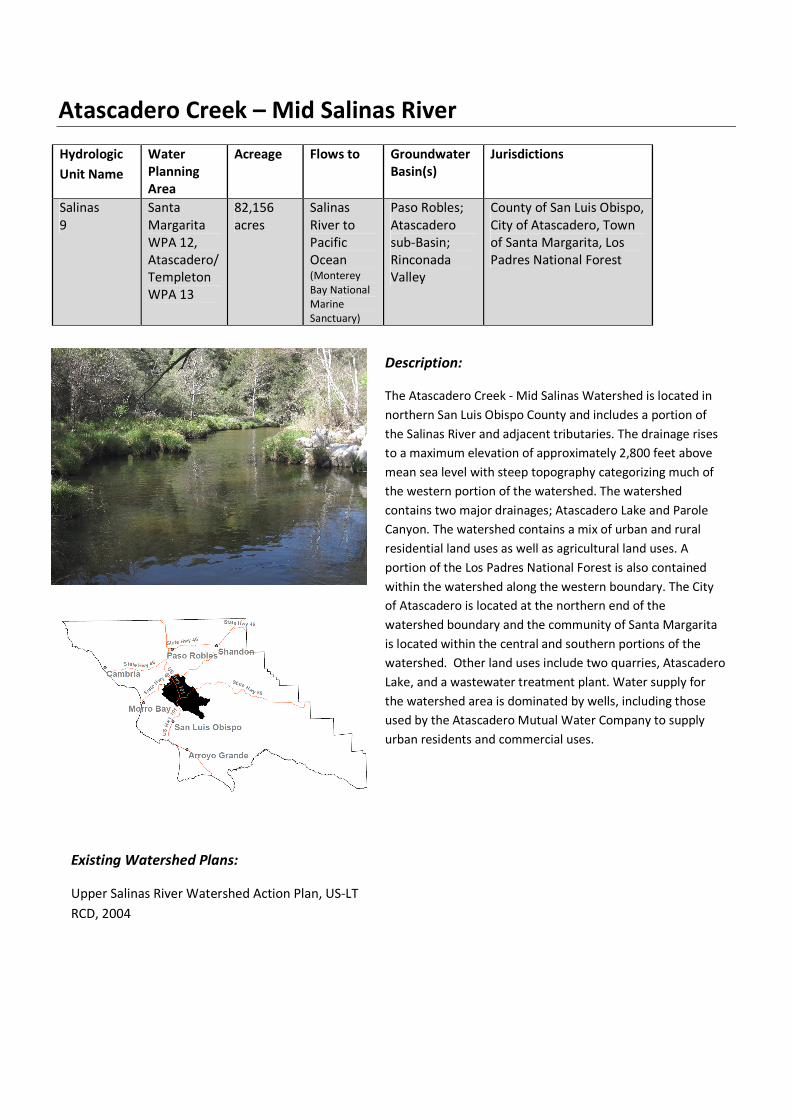
Atascadero Creek – Mid Salinas River
Hydrologic
Unit Name
Water
Planning
Area
Acreage Flows to Groundwater
Basin(s)
Jurisdictions
Salinas
9
Santa
Margarita
WPA 12,
Atascadero/
Templeton
WPA 13
82,156
acres
Salinas
River to
Pacific
Ocean (Monterey
Bay National
Marine
Sanctuary)
Paso Robles;
Atascadero
sub-Basin;
Rinconada
Valley
County of San Luis Obispo,
City of Atascadero, Town
of Santa Margarita, Los
Padres National Forest
Description:
The Atascadero Creek - Mid Salinas Watershed is located in
northern San Luis Obispo County and includes a portion of
the Salinas River and adjacent tributaries. The drainage rises
to a maximum elevation of approximately 2,800 feet above
mean sea level with steep topography categorizing much of
the western portion of the watershed. The watershed
contains two major drainages; Atascadero Lake and Parole
Canyon. The watershed contains a mix of urban and rural
residential land uses as well as agricultural land uses. A
portion of the Los Padres National Forest is also contained
within the watershed along the western boundary. The City
of Atascadero is located at the northern end of the
watershed boundary and the community of Santa Margarita
is located within the central and southern portions of the
watershed. Other land uses include two quarries, Atascadero
Lake, and a wastewater treatment plant. Water supply for
the watershed area is dominated by wells, including those
used by the Atascadero Mutual Water Company to supply
urban residents and commercial uses.
Existing Watershed Plans:
Upper Salinas River Watershed Action Plan, US-LT
RCD, 2004

Atascadero Creek – Mid Salinas River
Characteristics:
Physical Setting
Rainfall Average annual: 21-37 inches (NRCS shapefile, 2010)
Air Temperature Summer Range (August 1990- 2012): 52°-92°F
Winter Range (December 1990-2012): 32°-61°F
(Paso Robles, NOAA National Climatic Data Center, viewed 2013)
Geology Description Category #3: Rincon Creek is composed of flat highly infiltrative
Quaternary material – Category #3.
Category #5: Santa Margarita Creek and Hale Creek sub-watersheds
have steep pre-Quaternary non-infiltrative headwaters with steep
moderately infiltrative early to mid-Tertiary valleys – Category #5.
Category #12: Trout Creek has steep pre-Quaternary non-infiltrative
headwaters with flat highly infiltrative Quaternary valleys – Category
#12.
Category #13: Calf Canyon, Moreno Creek and Pilitas Creek have
steep pre-Quaternary non-infiltrative headwaters – Category #13.
Category #14: Paloma Creek sub-watershed has moderately
infiltrative early to mid-Tertiary headwaters with flat Quaternary
highly infiltrative valleys – Category #14 (Bell, pers. comm., 2013).
Water Bearing Formations. The principal water-bearing unit is
Quaternary age alluvium (Carollo, 2012)
The Middle Salinas-Atascadero Watershed is more complex than
northern San Luis Obispo Counties other watersheds because it is
dissected by the Rinconada Fault. Atascadero draws water from a
sub-basin, a pocket located on the western edge of the main basin
(just 3 percent of the basin) that is smaller, narrower and replenishes
water far more easily with rainfall. The Rinconada Fault separates
the two. The local public water utility doesn’t need a treatment plant
because the natural geology along the Salinas River in Atascadero
allows it to treat the water by filtering it through a sandy layer
adjacent to the Salinas River (Tribune, 2013).
The Santa Margarita Formation in this watershed is present
as Miocene aged, nearly white, coarse, arkosic sandstones which are
interbedded with small amounts of mudstone, siltstone, diatomite,
and conglomerate. The sandstones are commonly massively cross-
bedded, indicative of a high energy, shallow marine bottom
depositional environment. Minerals indicate a granitic origin for the
sands, while the pebbles in the conglomerates appear to have been
reworked from older conglomerates. Some beds are tuffaceous, and
some diatomaceous beds altered to chert by redeposition of silica.
Atascadero Creek – Mid Salinas River
Significant in environmental interpretation of the formation are the
thick biostromes, consisting of masses of pectin, oyster shells, and
broken shell debris. Such masses appear to have been storm
constructed masses. They imply shallow water, high energy
conditions, as supported by thick shells of many fossils, deposited in
a structural trough between the Rinconada and Nacimiento fault
zones, reaching 2,000 ft thick northeast of Santa Margarita but 200
feet west of Atascadero (Chipping, 1987).
Southern Salinas Valley contains extensive outcroppings of
Monterey Formation. The Hames member forms extensive outcrops
between Atascadero and Santa Margarita. The Monterey Formation
is dominated by thin, siliceous shales, and diatomaceous beds, which
contains few, thin phosphatic beds. Sandstones are usually
calcareous, well-cemented, and laced with small calcite veins. Some
beds, like Graves Creek near Atascadero for example, were buried
while still in a slurry-like state, and injected into overlying beds as
sandstone dikes. The calcareous nature of the Monterey Formation
is due to the high foraminifera content (Chipping, 1987).
The Salinas Valley near Santa Margarita is bounded by the
Sur-Nacimiento Fault on the east and Rinconada Fault to the west.
The Sur-Nacimiento fault marks the boundary between the old
oceanic crust of the Franciscan mélange to the west, and the Salinian
continental crust made up of granite to the east. The Salinan granite
basement extends to the San Andreas Fault to the east. The Salinan
Block represents a slice of continental granitic crust sandwiched
between two oceanic crustal plates of the younger Franciscan on the
west, and the older Franciscan of the San Joaquin Valley to the east.
The Rinconada Fault is a branch off the SAF and continues N until it
goes offshore N of Monterey. It is a right lateral wrench similar to
the San Andreas and forms the mountains on the westside of the
Salinas Valley. The fault passes through Paso Robles and is the
source of the mineral hot springs in town (Chipping, 1987).
Hydrology
Stream Gage Yes; USGS 11145500 (Salinas River near CA-58); USGS 11145000
(Salinas River at Las Pilitas Road); USGS 11144600 (Salinas River near
Santa Margarita Lake)
Hydrology Models Yes; Klinchuch. 2012. Groundwater model to analyze the
sustainability of the Atascadero Subbasin; Montgomery Watson,
1997, Monterey County Water Resource Agency’s Salinas Valley
Integrated Groundwater and Surface Water Model Update, Final
Report; Todd Engineers, Oct 2013, Paso Robles Groundwater Basin
Model.
Peak Flow 16,600 cfs (USGS, viewed 2013).
Base Flow 0 – 7.5 cfs (USGS, viewed 2013).
Atascadero Creek – Mid Salinas River
Flood reports None
Flood Control Structures Bridges: 1 over Rinconada Creek on Pozo Road; 2 over Salinas River
on Las Pilitas Road; 3 over Las Pilitas Creek on Las Pilitas Road; 5 over
Santa Margarita Creek on El Camino Real, Walnut Avenue, Norte
Road, Linden Ave and Tassajara Creek Road; 4 over Yerba Buena
Creek on H Street, J Street, I Street and Encina Avenue; 1 over
Tassajara Creek on Tassajara Creek Road (PWD Bridges GIS layer)
Areas of Heightened
Flood Risk
Creeks in Atascadero overflow banks and cause local flooding
• Major flooding problems in Santa Margarita are caused by
inadequate culverts/ bridges, and inadequate channel capacity in
Yerba Buena Creek, where water overtops the banks and floods
adjacent low topographic areas. • Santa Margarita has a serious lack of sufficient drainage ditches,
culverts, and storm drains. These facilities are often under
maintained and filled with sediment or debris, which prevents
the drainage system from properly conveying urban runoff to
Yerba Buena and Santa Margarita Creeks. • Proposed Solutions (2009): Construction of a levee and major
retention basins to address frequently recurring flooding
problems • Proposed Improvements (2009): The local CSA 23 advisory group
has been active in mobilizing community support for the projects
and pursuing an easement for the levee and retention basins
from the owners of adjacent Santa Margarita Ranch (SLO County
Flood Control and Water Conservation District, 2009). Biological Setting
Vegetation Cover Primarily chamise-redshank chaparral consisting mainly of
continuous chamise; mixed chaparral consisting mainly of
continuous buckbrush chaparral; and valley oak woodland consisting
mainly of intermittent valley oak, blue oak and coast live oak; with
non-native annual grassland; coastal scrub consisting mainly of
continuous chamise; blue oak-foothill pine consisting of continuous
blue oak and coast live oak; blue oak woodland; and cropland. (SLO
County vegetation shapefile, 1990)
Invasive Species Star thistle, tocolote, spotted knapweed, Blue gum/Eucalyptus
(Althouse and Meade, 2005)
Special Status Wildlife
and Plants
Templeton Quadrangle: San Joaquin kit fox- FE, ST; vernal pool fairy
shrimp- FT
Santa Margarita Quadrangle: California red-legged frog FT
Morro Bay North Quadrangle: California red-legged frog- FT;
western snowy plover – FT; tidewater goby- FE; California seablite –
FE;
Atascadero Creek – Mid Salinas River
York Mountain Quadrangle: California red-legged frog-FT
Atascadero Quadrangle: California red-legged frog-FT; Chorro Creek
bog thistle- FE, SE
Grasshopper sparrow (CDFW-SSC), silvery legless lizard (CDFW-SSC),
pallid bat (CDFW-SSC), Townsend’s big-eared bat (CDFW-SSC),
western pond turtle (CDFW-SSC), loggerhead shrike (CDFW-SSC),
purple martin (CDFW-SSC), foothill yellow-legged frog (CDFW-SSC),
western spadefoot (CDFW-SSC), Coast Range newt (CDFW-SSC),
American badger (CDFW-SSC)
(CNDDB database, viewed 2013)
Steelhead Trout (USFWS Critical Habitat Portal, viewed 2013)
Key: Federal endangered – FE, Federal threatened – FT, State endangered – SE, State
threatened – ST, California Department of Fish and Wildlife Special Species of
Concern - CDFW - SSC
Steelhead Streams Yes; Atascadero (Hale) Creek (FR 50)
Atascadero (Hale) Creek, Santa Margarita Creek, Tassajara Creek,
Salinas River (US-LT RCD, 2002)
Stream Habitat Inventory Yes; DFG, 2005
Fish Passage Barriers PAD ID: 707003– Bedrock waterfall on Atascadero Creek. Total
Barrier. 22.565639 miles upstream. PAD ID: 707244- Utility crossing
on Atascadero Creek at Curbail Avenue. Temporal Barrier. 25.51314
miles upstream. PAD ID: 719388- Dam at Atascadero Park on
unnamed tributary to Atascadero. Unknown Status.PAD ID: 731745-
Road crossing at Highway 41 on unnamed tributary to Atascadero
Creek. Unknown Status. PAD ID: 732138- Road crossing at Highway
41 on unnamed tributary to Atascadero Creek. Unknown Status.
PAD ID: 707246- Culvert under Highway 101 on Santa Margarita
Creek. Total Barrier. 5.52855 miles upstream.PAD ID: 712052- Road
Crossing at El Camino Real Bridge on Santa Margarita Creek. Partial
Barrier.69.42864 miles upstream. PAD ID: 707245- Culvert on Santa
Margarita Creek. Temporal Barrier. 7.00901 miles upstream.
Designated Critical
Habitat
Yes; Atascadero (Hale) Creek for Steelhead Trout (NMFS CFR 50 226)
Steelhead Trout: Tassajara (trout) creek, Santa Margarita Creek,
Salinas River (US Fish and Wildlife – Critical Habitat Mapper)
California Red-Legged Frog (USFWS Critical Habitat Portal, viewed
2013)
Habitat Conservation
Plans
Yes; North San Luis Obispo County Habitat Conservation Program –
Multiple species, initially San Joaquin kit fox.
Other Environmental
Resources
Salinas River, Paso Robles Groundwater Basin, Salinas
Reservoir/Santa Margarita Lake, Los Padres National Forest, Santa
Atascadero Creek – Mid Salinas River
Lucia Wilderness, Cuesta Ridge Botanical Area, Rinconada Mine
Botanical Area (SLO County Flood Control and Water Conservation
District, 2007)
Land Use
Jurisdictions &
Local Communities
County of San Luis Obispo, City of Atascadero, Town of Santa
Margarita
% Urbanized 9.6% in City of Atascadero, 0.05% Commercial (majority in Santa
Margarita), 5% residential (majority Santa Margarita and South
Atascadero: non-city)
% Agricultural 42% rangeland, small scale vineyard and crop production.
% Other 12.6% open space (Los Padres national Forest), 0.04% Public
Facilities, 0.2% recreation, 3% rural lands
Planning Areas Salinas River Planning Area
Potential growth areas Eagle Ranch (South Atascadero); Santa Margarita Ranch; City of
Atascadero Urban Core, South Atascadero
Facilities Present Atascadero Wastewater Treatment Plant discharges to the Salinas
River; Atascadero Lake; Los Padres National Forest, The Garden
Farms Water District
Commercial Uses City of Atascadero – Urban Core, Santa Margarita Ranch, hobby
vineyards, Livestock and Ag – east Salinas River, Kaiser Quarry, Rocky
Canyon Quarry (Union Asphalt), Santa Margarita Quarry (Hansen
Aggregates), various industrial facilities, agricultural service provides,
residential service providers, commercial districts, restaurants, wine
related tourism
Demographics
Population 24,098 in watershed (U.S. Census Block, 2010).
19,333 in Atascadero (US Census Blocks, 2010)
386 in Garden Farms (US Census Blocks, 2010)
1,259 in Santa Margarita (US Census Blocks, 2010)
Race and Ethnicity Watershed: Caucasians representing 76%, Latinos representing
16.3%, Mixed-race individuals representing 2.4%, Asians
representing 2.2%, African Americans representing 2.2% of the total
population in the watershed. The remaining races include Native
American, Pacific Islander, and other.
Atascadero: 74% Caucasian; 18% Latino; 2.5% Mixed Race; 2.4%
Asian (US Census Blocks, 2010)
Garden Farms: 87.3% Caucasian; 10.4% Hispanic or Latino; 1.3%
Asian (US Census, 2010)
Santa Margarita: 76.5% Caucasian; 16.4% Hispanic or Latino; 3.2%
Mixed Race; 2.2% Asian; 1.2% American Indian and Alaska Native (US
Census, 2010)

Atascadero Creek – Mid Salinas River
Income MHI $60,676 for watershed (U.S. Census Tracts, 2010).
MHI $68,502 in Atascadero (US Census, 2010)
MHI $49,032 in Santa Margarita (US Census, 2010)
Disadvantaged
Communities
No; 7% of individuals are below poverty level in the watershed (U.S.
Census Tracts, 2010).
8.7% of individuals are below poverty level in Atascadero (US Census,
2010)
16.7% of individuals are below poverty level in Garden Farms (2007-
2011 American Community Survey 5-Year Estimates)
18.9% of individuals are below poverty level in Santa Margarita
(2007-2011 American Community Survey 5-Year Estimates)
Water Resources
Water Management
Entities
Atascadero Mutual Water Company, County Waterworks District
No. 6
County Waterworks District No. 6: three wells located in the Paso
Robles groundwater basin that provide water to residents of Santa
Margarita
Atascadero Mutual Water Company – Salinas River wells located in
the Atascadero Sub-basin that provide water to the City of
Atascadero and surrounding areas.
Groundwater Yes; Paso Robles; Atascadero sub-Basin; Rinconada Valley
Surface Water No public reservoirs.
The rights to surface water flows in the Salinas River and associated
pumping from the alluvium have been fully appropriated by the
State Board and no future plans exist to increase these demands
beyond the current allocations. (Carollo, 2012)
Imported Water Yes; Nacimiento Pipeline (Atascadero Mutual Water Company)
Recycled/Desalinated
Water
Yes; The City of Atascadero uses reclaimed water from the
Wastewater Treatment Plant for use at Heilman Regional Park and
Golf Course, as well as recharge for Paso Robles Groundwater Basin.
Key Infiltration Areas The main source of recharge in the alluvium is the Salinas River.
Recharge to the Paso Robles Formation occurs from the overlying
Salinas River alluvium as well as from overlying channel deposits of
the Santa Margarita, Atascadero, Graves, and Paso Robles
Creeks (Carollo, 2012)
Water Budget Yes; Todd Engineers, 2013, Paso Robles Groundwater Basin Model
Update
Water Uses
Beneficial Uses Atascadero Creek – Municipal and Domestic Supply (MUN),
Agricultural Supply (AGR), Ground Water Recharge (GWR), Water
Contact Recreation (REC-1), Non-Contact Water Recreation (REC-2),
Commercial and Sport Fishing (COMM), Cold Fresh Water Habitat
Atascadero Creek – Mid Salinas River
(COLD), Wildlife Habitat (WILD), Rare, Threatened, or Endangered
Species (RARE), and/or Early Development (SPWN).
Atascadero Lake - Municipal and Domestic Supply (MUN), Ground
Water Recharge (GWR), Water Contact Recreation (REC-1), Non-
Contact Water Recreation (REC-2), Commercial and Sport Fishing
(COMM), Warm Freshwater habitat (WARM), Cold Fresh Water
Habitat (COLD) , Wildlife Habitat (WILD), Navigation (NAV), and/or
Early Development (SPWN).
Salinas River (Nacimiento River-Santa Margarita Reservoir) -
Municipal and Domestic Supply (MUN), Agricultural Supply (AGR),
Industrial Process Supply (PRO), Ground Water Recharge (GWR),
Water Contact Recreation (REC-1), Non-Contact Water Recreation
(REC-2), Wildlife Habitat (WILD), Cold Fresh Water Habitat (COLD),
Warm Freshwater habitat (WARM), Migration of Aquatic Organisms
(MIGR), Spawning, Reproduction, and/or Early Development (SPWN),
Threatened, or Endangered Species (RARE) and Commercial and
Sport Fishing (COMM).
(CCRWQCB, 2011)
Other Unique Characteristics
Historical Resources Santa Margarita de Cortona (22515 H Street, Santa Margarita)
(PLN_DES_HISTORIC_POINTS GIS layer)
Los Padres National Monument Ecosystems in Los Padres National Forest range from semi-desert in
interior areas to redwood forest on the coast. Forest vegetation
classified into two major types: chaparral and forested lands.
Provides a diverse wildlife habitat with 23 threatened and
endangered animals. Member of the California Condor Recovery
Program, and has been an active player in the reintroduction of
California condors in the wild. The Forest has one endangered plant,
two threatened plant species and 71 sensitive plant species.
Management of riparian vegetation focuses on supporting fish and
wildlife populations. There are over 870,000 acres of livestock
grazing allotments in the Forest.
Heilman Regional Park, Santa
Margarita Community Park and
Chalk Mountain Golf Course
Group day-use facilities owned and managed by the County of San
Luis Obispo.
Atascadero Lake Park Man-made lake managed by the City of Atascadero. There is a
walking path that follows the edge of the lake for a stroll, jog or bike
ride lakeside. The park also has a playground, paddle/kayak boats,
workout stations, restroom facilities, large and small barbecue areas,
horseshoe pits, sand volleyball court and the Charles Paddock Zoo.
Stadium Park During the 1920's, Stadium Park was a gathering place for
community events, concerts, and theater. Performances were held
on a big stage under an Oak tree. That stage was later moved to
Atascadero Creek – Mid Salinas River
where the Atascadero Lake Pavilion now stands. Besides being a
beautiful park, it is a natural amphitheater with gently sloping hills
leading to the basin. Acoustics are ideal just as nature made them.
Sunken Gardens Inspired by “The Grand Basin” at the 1904 St. Louis World’s Fair,
Atascadero founder E.G. Lewis envisioned a formal Sunken Garden
to adorn the civic center in his new colony. Restored in 2005 as
originally designed with walkways crossing the length and width of
the gardens and meeting at a central fountain designed by architect
Walter D. Bliss of the San Francisco firm of Bliss and Faville.
Climate Change Considerations
San Luis Obispo County expected to become 2-4°F warmer by 2050,
and depending on emissions, 4-8°F warmer by late-century, with
greater warming in summer as compared to winter. Northern and
northeastern parts of the county, especially areas of higher
elevation, could see increases in the area burned annually by wildfire
due to higher temperatures and stress to vegetation from climate
change. The state’s $30 billion agriculture industry could be
disrupted by changes in temperature and rainfall patterns and the
increased pests and diseases that may accompany those changes.
Differential social vulnerabilities, with the elderly, infants, socially
and culturally isolated individuals, and outdoor workers – especially
in the hotter inland areas – experiencing relatively greater exposure,
sensitivity and/or lower adaptive capacity. Threats to agriculture
include higher temperatures causing heat stress to plants, reduced
water availability, potential for increased water costs, more intense
downpours leading to fruit, vegetable and flower damage, increased
risk of soil erosion, increased water demand by plants and animals
and increased risk of pest infestations and spread of invasive plants.
Freshwater and riparian systems will be affected by increased
groundwater pumping, sedimentation, higher peak flows during
severe storms, sensitive species at risk due to stress, negative
impacts on vernal pools, and new dams or dam expansions. Oak
woodlands and coniferous forest may decline due to increased
temperatures, disease, drought and fire (ClimateWise, 2010).
See IRWMP, 2014 Section X. Climate Change
Atascadero Creek – Mid Salinas River
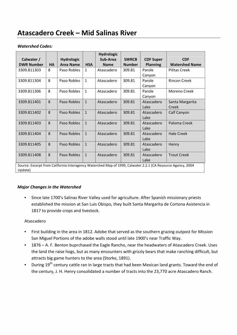
Watershed Codes:
Source: Excerpt from California Interagency Watershed Map of 1999, Calwater 2.2.1 (CA Resource Agency, 2004
Update)
Major Changes in the Watershed
• Since late 1700’s Salinas River Valley used for agriculture. After Spanish missionary priests
established the mission at San Luis Obispo, they built Santa Margarita de Cortona Asistencia in
1817 to provide crops and livestock.
Atascadero
• First building in the area in 1812. Adobe that served as the southern grazing outpost for Mission
San Miguel Portions of the adobe walls stood until late 1900’s near Traffic Way.
• 1876 – A. F. Benton buprchased the Eagle Rancho, near the headwaters of Atascadero Creek. Uses
the land the raise hogs, but as many encounters with grizzly bears that make ranching difficult, but
attracts big game hunters to the area (Storke, 1891).
• During 19th century cattle ran in large tracts that had been Mexican land grants. Toward the end of
the century, J. H. Henry consolidated a number of tracts into the 23,770 acre Atascadero Ranch.
Calwater /
DWR Number HA
Hydrologic
Area Name HSA
Hydrologic
Sub-Area
Name
SWRCB
Number
CDF Super
Planning
CDF
Watershed Name
3309.811303 8 Paso Robles 1 Atascadero 309.81 Parole
Canyon
Pilitas Creek
3309.811304 8 Paso Robles 1 Atascadero 309.81 Parole
Canyon
Rincon Creek
3309.811306 8 Paso Robles 1 Atascadero 309.81 Parole
Canyon
Moreno Creek
3309.811401 8 Paso Robles 1 Atascadero 309.81 Atascadero
Lake
Santa Margarita
Creek
3309.811402 8 Paso Robles 1 Atascadero 309.81 Atascadero
Lake
Calf Canyon
3309.811403 8 Paso Robles 1 Atascadero 309.81 Atascadero
Lake
Paloma Creek
3309.811404 8 Paso Robles 1 Atascadero 309.81 Atascadero
Lake
Hale Creek
3309.811405 8 Paso Robles 1 Atascadero 309.81 Atascadero
Lake
Henry
3309.811408 8 Paso Robles 1 Atascadero 309.81 Atascadero
Lake
Trout Creek

Atascadero Creek – Mid Salinas River
• During the early 20th
century, U.S. Army used the central plains of the ranch for annual
encampments and maneuvers and at one time considered the acquisition of the ranch for
permanent military camp.
• In 1913, Edward Gardner “E. G. Lewis” selected the Atascadero Ranch as the ideal location for a
model colony. Lewis purposely chose a location halfway between major urban center of the state
on both a railway and state highway.
• Lewis subdivided the entire 38 square miles, built 100 miles of roads, a water system of tanks, wells
and mains, nearly 3,000 acres of orchards, parks, the Sunken Gardens and public buildings.
• A twenty-mile road through the Santa Lucia Mountains connecting the Colony to the 1,000 acre
Atascadero Beach properties near Morro Bay which had schools, a community center, hospital and
hotel.
• Two important factors that stimulated growth in the 1950’s have also significantly affected design
and demographics of the community: bisection of the City in 1954 by Highway 101, and the siting
of the Atascadero State Hospital on the edge of the community in 1956.
• 2006 – Severely eroded bank on south side of Atascadero Creek repaired. Rock slope protection
installed along the bank and heavily vegetated with native riparian species.
Watershed Health by Major Tributary
Tributary Name Ephemeral /
Perennial
303d Listed/
TMDLs
Pollution Sources
NP (non-point)
MP (Major Point)
Environmental
Flows
Salinas River Yes; Sodium and
Chloride
Atascadero Creek
(Hale)
Perennial Yes on 303d list
for Chloride, E.
coli, Fecal
Coliform, Low
Dissolved Oxygen,
and Sodium.
TMDL estimated
date of
completion 2021.
NP: Agriculture,
grazing-related,
natural sources,
resource
extraction,
petroleum
activities,
transient
encampments
MP: None defined
as such on 303d
list
X Cfs (TBD by
Stillwater
Sciences)
Paloma Creek Unknown None n/a
Santa Margarita
Creek
Unknown None
n/a
Calf Canyon Creek Unknown None n/a
Moreno Creek Unknown None n/a
Trout Creek Unknown None n/a
Rincon Creek Unknown None n/a
Atascadero Creek – Mid Salinas River
Pilitas Creek Unknown n/a
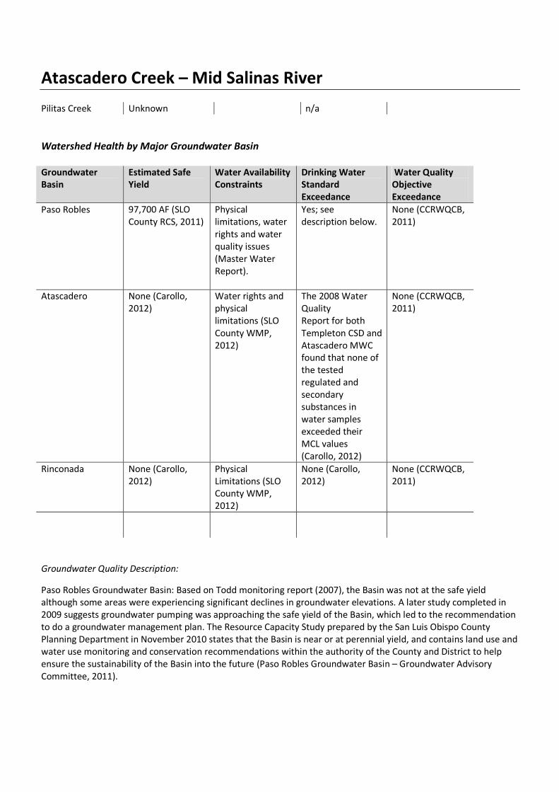
Watershed Health by Major Groundwater Basin
Groundwater
Basin
Estimated Safe
Yield
Water Availability
Constraints
Drinking Water
Standard
Exceedance
Water Quality
Objective
Exceedance
Paso Robles 97,700 AF (SLO
County RCS, 2011)
Physical
limitations, water
rights and water
quality issues
(Master Water
Report).
Yes; see
description below.
None (CCRWQCB,
2011)
Atascadero None (Carollo,
2012)
Water rights and
physical
limitations (SLO
County WMP,
2012)
The 2008 Water
Quality
Report for both
Templeton CSD and
Atascadero MWC
found that none of
the tested
regulated and
secondary
substances in
water samples
exceeded their
MCL values
(Carollo, 2012)
None (CCRWQCB,
2011)
Rinconada None (Carollo,
2012)
Physical
Limitations (SLO
County WMP,
2012)
None (Carollo,
2012)
None (CCRWQCB,
2011)
Groundwater Quality Description:
Paso Robles Groundwater Basin: Based on Todd monitoring report (2007), the Basin was not at the safe yield
although some areas were experiencing significant declines in groundwater elevations. A later study completed in
2009 suggests groundwater pumping was approaching the safe yield of the Basin, which led to the recommendation
to do a groundwater management plan. The Resource Capacity Study prepared by the San Luis Obispo County
Planning Department in November 2010 states that the Basin is near or at perennial yield, and contains land use and
water use monitoring and conservation recommendations within the authority of the County and District to help
ensure the sustainability of the Basin into the future (Paso Robles Groundwater Basin – Groundwater Advisory
Committee, 2011).
Atascadero Creek – Mid Salinas River
The predominant cations are calcium and sodium and the predominant anion is bicarbonate (DWR 1981; Fugro
West, 2001b). Analysis of 48 public supply wells in the subbasin show an average Total Dissoved Solid (TDS) content
of 614 ppm and a range of 346 to 1,670 ppm.
In one study, (Fugro West 2001b), 23 of 74 samples collected exceeded one or more drinking water standards. The
maximum contaminant level (MCL) for nitrate was exceeded in 4 samples (Fugro West, 2001b). Water quality trends
indicate an increasing concentration of TDS and chloride in the deep, historically artesian aquifer northeast of
Creston (Carollo, 2012).
Salinas River recharge typically contains calcium and magnesium bicarbonate. Santa Margarita Creek water contains
magnesium-calcium-bicarbonate. Atascadero and Paso Robles Creeks have calcium bicarbonate rich waters.
Increasing Total Dissolved Solids and chlorine, physical limitations (Carollo, 2012).
Atascadero sub-basin: In terms of physical limitations, Todd (2009) estimated the gross groundwater pumping in the
sub-basin during 2006 to be 15,545 AF, which is 95 percent of the sub-basin perennial yield of 16,400 AFY. Ongoing
studies may revise the estimated outflow from the sub-basin. According to Fugro (2010), whereas total groundwater
in storage in the main part of the Paso Robles Groundwater Basin is predominantly in the Paso Robles Formation,
the Salinas River alluvium in the Atascadero Groundwater Sub-basin accounts for a significant percentage of the
total groundwater storage in the sub-basin. Pumping from the alluvium should be accounted for separately from
pumping from the Paso Robles Formation.
Critical Issues
Issue Potential Causes Referenced from
Significant water level declines Range of groundwater uses in
close proximity, including
agricultural irrigation, municipal
supply wells, golf course
irrigation, and a relatively dense
aggregation of rural “ranchette”)
users
Carollo, 2012
Groundwater Quality High concentrations of TDS,
chlorides, sulfates, and boron
Carollo, 2012
Limited Groundwater Basin
information (rinconada basin)
Carollo, 2012
Groundwater: Paso Robles Groundwater Basin
According to multiple studies of this basin, annual basin pumping is now at or near the basin’s perennial yield (Paso
Robles Groundwater Management Plan, 2011). From 1997–2009, water levels declined on average of 2–6 feet per
year, depending on the location. A Todd Engineering monitoring report (2007) indicated that the Basin was not
approaching the safe yield level and some areas were experiencing significant declines in groundwater elevations. A
later study completed in 2009 suggested groundwater pumping was approaching the safe yield level of the Basin.
The 2010 Resource Capacity Study prepared by the San Luis Obispo County Planning Department stated that the
Basin is now near or at perennial yield levels. The County Board of Supervisors certified a Level of Severity III for the
Paso Robles Basin in October, 2012, due to declining water levels. In August 2013, the County Board of Supervisors
adopted an urgency ordinance to limit new draws from the Paso Robles Groundwater basin.
Atascadero Creek – Mid Salinas River
The Paso Robles Groundwater Basin encompasses an area of approximately 790 square miles and is the primary,
and in many places the only, source of water available to property owners throughout Northern San Luis Obispo
County. The basin extends from the Garden Farms area south of Atascadero to San Ardo in Monterey County, and
from the Highway 101 corridor east to Shandon. The basin supplies water for 29% of SLO County’s population and an
estimated 40% of the agricultural production of the County (Paso Robles Groundwater Basin Blue Ribbon
Committee, 2013).
Paso Robles, Atascadero, and Templeton draw their water from the groundwater basin (primarily the Atascadero
sub-basin), the underflow of the Salinas River and from the Nacimiento Pipeline Project. The remaining communities
(Shandon, San Miguel, Creston, Bradley, Camp Roberts, Whitley Gardens, and Garden Farms) are entirely dependent
on the groundwater basin for their water supply.
An established bi-annual well monitoring program overseen by the SLO County Flood Control and Water
Conservation District reported these water declines in groundwater dependent communities (Through April, 2013):
a. Shandon: Water levels have dropped approximately 17 feet from 2011 to 2013.
b. Creston: Water levels have dropped approximately 25 feet from 2011 to 2013.
c. Estrella: Water levels have dropped approximately 25 feet from 2011 to 2013.
d. San Juan: Water levels have dropped approximately 5 feet from 2012 to 2013.
Bibliography:
Technical Reports
Althouse and Meade. (2006). Biological Assessment for Atascadero Creek Pedestrian Bridge, City of Atascadero.
Bell, Ethan. (2013). Personal Communication.
CAL FIRE. (2012). West Atascadero Area Pre-Attack Plan.
http://www.calfireslo.org/gis/PreAttackPlans/preAttacksLowRes/westAtascaderoLowRes.pdf
CAL FIRE/San Luis Obispo County Fire. (2013). Unit Strategic Fire Plan.
http://www.calfireslo.org/Documents/Plans/UnitFirePlan/SLU_Unit_Fire_Plan_v13_1_(Complete).pdf
California Department of Water Resources. (2003). California’s Groundwater Bulletin 118 Update 2003.
http://www.water.ca.gov/pubs/groundwater/bulletin_118/california's_groundwater__bulletin_118_-
_update_2003_/bulletin118_entire.pdf
Carollo. (2012). San Luis Obispo County Master Water Report.
http://www.slocountywater.org/site/Frequent%20Downloads/Master%20Water%20Plan
Chipping, D. H. (1987). The Geology of San Luis Obispo County: A Brief Description and Guide. Cal Poly Press. San Luis
Obispo, CA.

Atascadero Creek – Mid Salinas River
Crawford, Multari and Clark. (2002). City of Atascadero General Plan 2025.
http://www.atascadero.org/files/CD/General%20Plan/Published%20version%20no%20markup%20-
%20GP%202025%20Draft%20Amendment%202004-1%202-17-04.wmf.pdf
ClimateWise. (2010). Integrated climate change adaptation planning in San Luis Obispo County.
http://www.lgc.org/adaptation/slo/docs/SLOClimateWiseFinal.pdf
Fugro West, Inc. (2010). Paso Robles Groundwater Basin Water Balance Review and Update.
http://www.slocountywater.org/site/Water%20Resources/Reports/pdf/Paso%20Robles%20Groundwater%2
0Basin%20Water%20Balance%20Review%20and%20Update.pdf
Hart, E. W. (1976). Basic Geology of the Santa Margarita Area, San Luis Obispo County, California.
NOAA Fisheries. (2012). South-Central Ca Coast Steelhead Recovery Plan.
http://swr.nmfs.noaa.gov/recovery/centralvalleyplan.htm
Paso Robles Groundwater Basin – Groundwater Advisory Committee. (2011). Paso Robles Basin Groundwater
Management Plan. http://www.slocounty.ca.gov/Assets/PL/PR+Groundwater/gwp.pdf
Regional Water Quality Control Board Central Coast Region 3. (2002). Watershed management Initiative.
http://www.waterboards.ca.gov/centralcoast/water_issues/programs/wmi/docs/wmi2002_final_document
_revised_1_22_02.pdf
San Luis Obispo County Flood Control and Water Conservation District. (2005). Water Years 2001-02 and 2002-03
Hydrologic Report.
http://www.slocountywater.org/site/Water%20Resources/Reports/pdf/Hydrologic%20Report%202002.pdf
San Luis Obispo County Board of Supervisors. (2011). Water Supply in the Paso Robles Groundwater Basin.
http://www.slocounty.ca.gov/Assets/PL/PR+Groundwater/rcs.pdf
San Luis Obispo County General Plan. (2011).
http://www.slocounty.ca.gov/planning/General_Plan__Ordinances_and_Elements.htm
San Luis Obispo County. (2013). North County Area Plan.
http://www.slocounty.ca.gov/Assets/PL/Draft+Plans/North.pdf
Stillwater Sciences. (2011). Development and Implementation of Hydromodification Control Methodology.
Watershed Characterization Part 1: Watershed Charcterization Part 1. Precipitation and Landscape.
http://www.waterboards.ca.gov/rwqcb3/water_issues/programs/stormwater/docs/lid/hydromod_lid_docs
/watershed_character_part_1.pdf
Storke, Y.A. (1891). A Memorial and Biographical History of the Counties of Santa Barbara, San Luis Obispo, and
Ventura, California. http://www.rootsweb.ancestry.com/~cagha/history/sanluisobispo/creeks.txt
Titus R. G., D. C. Erman and W. M. Snider. (2013). History of steelhead in California coastal drainages south of San
Francisco Bay. In preparation.
Atascadero Creek – Mid Salinas River
Todd Engineers, Geoscience. (2013). Paso Robles Groundwater Basin Water Budget. Approach and Methodology for
Water Balance Estimation, Paso Robles Groundwater Basin Model Update.
http://www.slocountywater.org/site/Water%20Resources/Water%20Forum/pdf/DRAFTWaterBalanceEstAp
prMethod.pdf
Upper Salinas – Las Tablas Resource Conservation District. (2002). Upper Salinas River and Tributaries Watershed
Fisheries Report and Early Actions. http://www.us-ltrcd.org/downloads/Watershed_Fisheries_Report.pdf
Upper Salinas – Las Tablas Resource Conservation District. (2004). Upper Salinas River Watershed Action Plan. US-LT
RCD.
http://www.mcwra.co.monterey.ca.us/Agency_data/USLS%20RCD%20Watershed%20Action%20Plan/Chapt
er%201%20-%20Introduction.pdf
U. S. Environmental Protection Agency. (2011). Climate Change Handbook for Regional Water Planning.
http://www.water.ca.gov/climatechange/CCHandbook.cfm
GIS Layers
Aerial Information Systems. (2008). San Luis Obispo County Vegetation Polygons.
National Hydrography Dataset. (2013). San Luis Obispo County Streams.
San Luis Obispo County Environmental Division. (2013). San Luis Obispo County Mines.
San Luis Obispo County Planning and Building Geographic Technology and Design. (2013). Various GIS shapefiles and
layers.
State Water Resources Control Board. (2013). Water Rights/Fully Appropriated Streams.
United States Census Bureau Master Address File/Topologically Integrated Geographic Encoding and Referencing
Database. (2013). 2010 Census Tracts.
United States Department of Agriculture. (2013). Soil Survey Geographic Database.
Databases
Department of Fish and Game. (2013). California Natural Diversity Database.
http://www.dfg.ca.gov/biogeodata/cnddb/
National Atlas of the United States. (2013). Streamer. http://www.nationalatlas.gov/streamer
National Oceanic and Atmospheric Administration. (2013). National Climatic Data Center.
http://www.ncdc.noaa.gov/
Surface Water Ambient Monitoring Program. (2013). CalWater 2.2.1
http://swamp.mpsl.mlml.calstate.edu/resources-and-downloads/database-management-systems/swamp-
Atascadero Creek – Mid Salinas River
25-database/templates-25/gis-shapefile-layersU. S. Fish and Wildlife Service. (2013). Critical Habitat Portal.
http://criticalhabitat.fw.gov/crithab.
U. S. Fish and Wildlife Service. (2013). National Wetlands Inventory. http://www.fws.gov/wetlands/
U.S. Geological Survey. (2013). California Water Sciences Center. http://ca.water.usgs.gov/
U.S. Geological Survey. (2013). Protected Areas Database. http://gapanalysis.usgs.gov/padus/
Significant Studies in Progress: