Embed Size (px)
Citation preview

Attachment 4
Articles, Conditions, and Measures

LEAPS TE/VS Interconnect
Proponent’s Environmental Assessment July 2008 (Revised November 2008 and February 2009)
Attachment 4 - Articles, Conditions, and Measures The Applicant has assumed that each of the articles, conditions, and measures which have been imposed or which are slated for imposition by the various federal and State agencies with jurisdiction over the proposed federal action(s), including the issuance of a federal hydropower license by FERC and the issuance of a special use permit authorization by the USDA Forest Service, are incorporated in and made a part of the Project. Since those articles, conditions, and measures, as presented in this Attachment 4 (Articles, Conditions, and Measures), are a part of the proposed federal action(s), those same articles, conditions, and measures are not separately cited as separate “applicant proposed measures” (APMS) herein. 1.0 Federal Energy Regulatory Commission 1.1 Federal Energy Regulatory Commission - Standard License Articles Licenses for hydropower projects include, in addition to articles specifically designed for each individual project, certain Standard License Articles (Standard Articles), contained in what are know as “L-Forms.”1 The Standard Articles provide “generic requirements” that may be applied based on effects known to occur in associated with particular types of projects or project attributes. The ordering paragraphs of the license identify which set of standard conditions are applied to the license which is issued. There are 18 different sets of Standard Articles with 15-37 individual articles in each set based on project size and location and whether the project is constructed or unconstructed.2
L-2 (Terms and Conditions of License for Unconstructed Major Project Affecting Lands in the United States) and L-6 (Terms and Conditions of License for Unconstructed Major Project Affecting Navigable Waters and Lands in the United States) are or may be applicable to LEAPS. Presented below are the Federal Energy Regulatory Commission’s (FERC or Commission) L-6 articles which, unless amended or otherwise modified, are assumed to be applicable to LEAPS. Article 1. The entire project, as described in this order of the Commission, shall be
subject to all of the provisions, terms, and conditions of the license.
Article 2. No substantial change shall be made in the maps, plans, specifications, and statements described and designated as exhibits and approved by the Commission in its order as a part of the license until such change shall have been approved by the Commission: Provided, however, That if the Licensee or the Commission deems it necessary or desirable that said approved exhibits, or any of them, be changed, there shall be submitted to the Commission for approval a revised, or additional exhibit or exhibits covering the proposed changes which, upon approval by the Commission, shall become a part of the license and shall supersede, in whole or in part, such exhibit or exhibits theretofore made a part of the license as may be specified by the Commission.
1/ The L-Forms are published at 54 FPC 1792-1928 (1975) and are incorporated into project licenses by an ordering paragraph. 2/ Federal Energy Regulatory Commission, Anatomy of Trackable and Enforceable License Conditions, December 8, 2000, p. 9.
Attachment 4: Articles, Conditions, and Measures Page 4-1
TE/VS Interconnect LEAPS
July 2008 (Revised November 2008 and February 2009) Proponent’s Environmental Assessment
Article 3. The project works shall be constructed in substantial conformity with the approved exhibits referred to in Article 2 herein or as changed in accordance with the provisions of said article. Except when emergency shall require for the protection of navigation, life, health, or property, there shall not be made without prior approval of the Commission any substantial alteration or addition not in conformity with the approved plans to any dam or other project works under the license or any substantial use of project lands and waters not authorized herein; and any emergency alteration, addition, or use so made shall thereafter be subject to such modification and change as the Commission may direct. Minor changes in project works, or in uses of project lands and waters, or divergence from such approved exhibits may be made if such changes will not result in a decrease in efficiency, in a material increase in cost, in an adverse environmental impact, or in impairment of the general scheme of development; but any of such minor changes made without the prior approval of the Commission, which in its judgment have produced or will produce any of such results, shall be subject to such alteration as the Commission may direct. Upon the completion of the project, or at such other time as the Commission may direct, the Licensee shall submit to the Commission for approval revised exhibits insofar as necessary to show any divergence from or variations in the project area and project boundary as finally located or in the project works as actually constructed when compared with the area and boundary shown and the works described in the license or in the exhibits approved by the Commission, together with a statement in writing setting forth the reasons which in the opinion of the Licensee necessitated or justified variation in or divergence from the approved exhibits. Such revised exhibits shall, if and when approved by the Commission, be made a part of the license under the provisions of Article 2 hereof.
Article 4. The construction, operation, and maintenance of the project and any work incidental to additions or alterations shall be subject to the inspection and supervision of the Regional Engineer, Federal Energy Regulatory Commission, in the region wherein the project is located, or of such other officer or agent as the Commission may designate, who shall be the authorized representative of the Commission for such purposes. The Licensee shall cooperate fully with said representative and shall furnish him a detailed program of inspection by the Licensee that will provide for an adequate and qualified inspection force for construction of the project and for any subsequent alterations to the project. Construction of the project works or any features or alteration thereof shall not be initiated until the program of inspection for the project works or any such feature thereof has been approved by said representative. The Licensee shall also furnish to said representative such further information as he may require concerning the construction, operation, and maintenance of the project, and of any alteration thereof, and shall notify him of the date upon which work will begin, as far in advance thereof as said representative may reasonably specify, and shall notify him promptly in writing of any suspension of work for a period of more than one week, and of its resumption and completion. The Licensee shall allow said representative and other officers or employees of the United States, showing proper credentials, free and unrestricted access to, through, and across the project lands and project works in the performance of their official duties. The Licensee shall comply with such rules and regulations of general or special applicability as the Commission may prescribe from time to time for the protection of life, health, or property.
Page 4-2 Attachment 4: Articles, Conditions, and Measures
LEAPS TE/VS Interconnect
Proponent’s Environmental Assessment July 2008 (Revised November 2008 and February 2009)
Article 5. The Licensee, within five years from the date of issuance of the license, shall acquire title in fee or the right to use in perpetuity all lands, other than lands of the United States, necessary or appropriate for the construction, maintenance, and operation of the project. The Licensee or its successors and assigns shall, during the period of the license, retain the possession of all project property covered by the license as issued or as later amended, including the project area, the project works, and all franchises, easements, water rights, and rights of occupancy and use; and none of such properties shall be voluntarily sold, leased, transferred, abandoned, or otherwise disposed of without the prior written approval of the Commission, except that the Licensee may lease or otherwise dispose of interests in project lands or property without specific written approval of the Commission pursuant to the then current regulations of the Commission. The provisions of this article are not intended to prevent the abandonment or the retirement from service of structures, equipment, or other project works in connection with replacements thereof when they become obsolete, inadequate, or inefficient for further service due to wear and tear; and mortgage or trust deeds or judicial sales made thereunder, or tax sales, shall not be deemed voluntary transfers within the meaning of this article.
Article 6. In the event the project is taken over by the United States upon the termination of the license as provided in Section 14 of the Federal Power Act, or is transferred to a new licensee or to a nonpower licensee under the provisions of Section 15 of said Act, the Licensee, its successors and assigns shall be responsible for, and shall make good any defect of title to, or of right of occupancy and use in, any of such project property that is necessary or appropriate or valuable and serviceable in the maintenance and operation of the project, and shall pay and discharge, or shall assume responsibility for payment and discharge of, all liens or encumbrances upon the project or project property created by the Licensee or created or incurred after the issuance of the license: Provided, That the provisions of this article are not intended to require the Licensee, for the purpose of transferring the project to the United States or to a new licensee, to acquire any different title to, or right of occupancy and use in, any of such project property than was necessary to acquire for its own purposes as the Licensee.
Article 7. The actual legitimate original cost of the project, and of any addition thereto or betterment thereof, shall be determined by the Commission in accordance with the Federal Power Act and the Commission's Rules and Regulations thereunder.
Article 8. The Licensee shall install and thereafter maintain gages and stream gaging stations for the purpose of determining the state and flow of the stream or streams on which the project is located, the amount of water held in and withdrawn from storage, and the effective head on the turbines; shall provide for the required reading of such gages and for the adequate rating of such stations; and shall install and maintain standard meters adequate for the determination of the amount of electric energy generated by the project works. The number, character, and location of gages, meters, or other measuring devices, and the method of operation thereof, shall at all times be satisfactory to the Commission or its authorized representative. The Commission reserves the right, after notice and opportunity for hearing, to require such alterations in the number, character and locations of gages, meters, or other measuring devices, and the method of operation
Attachment 4: Articles, Conditions, and Measures Page 4-3

TE/VS Interconnect LEAPS
July 2008 (Revised November 2008 and February 2009) Proponent’s Environmental Assessment
thereof, as are necessary to secure adequate determinations. The installation of gages, the rating of said stream or streams, and the determination of the flow thereof, shall be under the supervision of, or in cooperation with, the District Engineer of the United States Geological Survey having charge of stream-gaging operations in the region of the project, and the Licensee shall advance to the United States Geological Survey the amount of funds estimated to be necessary for such supervision, or cooperation for such periods as may be mutually agreed upon. The Licensee shall keep accurate and sufficient records of the foregoing determinations to the satisfaction of the Commission, and shall make return of such records annually at such time and in such form as the Commission may prescribe.
Article 9. The Licensee shall, after notice and opportunity for hearing, install additional capacity or make other changes in the project as directed by the Commission, to the extent that it is economically sound and in the public interest to do so.
Article 10. The Licensee shall, after notice and opportunity for hearing, coordinate the operation of the project, electrically and hydraulically, with such other projects or power systems and in such manner as the Commission may direct in the interest of power and other beneficial public uses of water resources, and on such conditions concerning the equitable sharing of benefits by the Licensee as the Commission may order.
Article 11. Whenever the Licensee is directly benefited by the construction work of another licensee, a permittee, or the United States on a storage reservoir or other headwater improvement, the Licensee shall reimburse the owner of the headwater improvement for such part of the annual charges for interest, maintenance, and depreciation thereof as the Commission shall determine to be equitable, and shall pay to the United States the cost of making such determination as fixed by the Commission. For benefits provided by a storage reservoir or other headwater improvement of the United States, the Licensee shall pay to the Commission the amounts for which it is billed from time to time for such headwater benefits and for the cost of making the determinations pursuant to the then current regulations of the Commission under the Federal Power Act.
Article 12. The United States specifically retains and safeguards the right to use water in such amount, to be determined by the Secretary of the Army, as may be necessary for the purposes of navigation on the navigable waterway affected; and the operations of the Licensee, so far as they affect the use, storage and discharge from storage of waters affected by the license, shall at all times be controlled by such reasonable rules and regulations as the Secretary of the Army may prescribe in the interest of navigation, and as the Commission may prescribe for the protection of life, health, and property, and in the interest of the fullest practicable conservation and utilization of such waters for power purposes and for other beneficial public uses, including recreational purposes, and the Licensee shall release water from the project reservoir at such rate in cubic feet per second, or such volume in acre-feet per specified period of time, as the Secretary of the Army may prescribe in the interest of navigation, or as the Commission may prescribe for the other purposes hereinbefore mentioned.
Article 13. On the application of any person, association, corporation, Federal Agency, State or municipality, the Licensee shall permit such reasonable use of its reservoir or
Page 4-4 Attachment 4: Articles, Conditions, and Measures

LEAPS TE/VS Interconnect
Proponent’s Environmental Assessment July 2008 (Revised November 2008 and February 2009)
other project properties, including works, lands and water rights, or parts thereof, as may be ordered by the Commission, after notice and opportunity for hearing, in the interests of comprehensive development of the waterway or waterways involved and the conservation and utilization of the water resources of the region for water supply or for the purposes of steam-electric, irrigation, industrial, municipal or similar uses. The Licensee shall receive reasonable compensation for use of its reservoir or other project properties or parts thereof for such purposes, to include at least full reimbursement for any damages or expenses which the joint use causes the Licensee to incur. Any such compensation shall be fixed by the Commission either by approval of an agreement between the Licensee and the party or parties benefiting or after notice and opportunity for hearing. Applications shall contain information in sufficient detail to afford a full understanding of the proposed use, including satisfactory evidence that the applicant possesses necessary water rights pursuant to applicable State law, or a showing of cause why such evidence cannot concurrently be submitted, and a statement as to the relationship of the proposed use to any State or municipal plans or orders which may have been adopted with respect to the use of such waters.
Article 14. In the construction or maintenance of the project works, the Licensee shall place and maintain suitable structures and devices to reduce to a reasonable degree the liability of contact between its transmission lines and telegraph, telephone and other signal wires or power transmission lines constructed prior to its transmission lines and not owned by the Licensee, and shall also place and maintain suitable structures and devices to reduce to a reasonable degree the liability of any structures and devices to reduce to a reasonable degree the liability of any structures or wires falling or obstructing traffic or endangering life. None of the provisions of this article are intended to relieve the Licensee from any responsibility or requirement which may be imposed by any other lawful authority for avoiding or eliminating inductive interference.
Article 15. The Licensee shall, for the conservation and development of fish and wildlife resources, construct, maintain, and operate, or arrange for the construction, maintenance, and operation of such reasonable facilities, and comply with such reasonable modifications of the project structures and operation, as may be ordered by the Commission upon its own motion or upon the recommendation of the Secretary of the Interior or the fish and wildlife agency or agencies of any State in which the project or a part thereof is located, after notice and opportunity for hearing.
Article 16. Whenever the United States shall desire, in connection with the project, to construct fish and wildlife facilities or to improve the existing fish and wildlife facilities at its own expense, the Licensee shall permit the United States or its designated agency to use, free of cost, such of the Licensee's lands and interests in lands, reservoirs, waterways and project works as may be reasonably required to complete such facilities or such improvements thereof. In addition, after notice and opportunity for hearing, the Licensee shall modify the project operation as may be reasonably prescribed by the Commission in order to permit the maintenance and operation of the fish and wildlife facilities constructed or improved by the United States under the provisions of this article. This article shall not be interpreted to place any obligation on the United States to construct or
Attachment 4: Articles, Conditions, and Measures Page 4-5

TE/VS Interconnect LEAPS
July 2008 (Revised November 2008 and February 2009) Proponent’s Environmental Assessment
improve fish and wildlife facilities or to relieve the Licensee of any obligation under this license.
Article 17. The Licensee shall construct, maintain, and operate, or shall arrange for the construction, maintenance, and operation of such reasonable recreational facilities, including modifications thereto, such as access roads, wharves, launching ramps, beaches, picnic and camping areas, sanitary facilities, and utilities, giving consideration to the needs of the physically handicapped, and shall comply with such reasonable modifications of the project, as may be prescribed hereafter by the Commission during the term of this license upon its own motion or upon the recommendation of the Secretary of the Interior or other interested Federal or State agencies, after notice and opportunity for hearing.
Article 18. So far as is consistent with proper operation of the project, the Licensee shall allow the public free access, to a reasonable extent, to project waters and adjacent project lands owned by the Licensee for the purpose of full public utilization of such lands and waters for navigation and for outdoor recreational purposes, including fishing and hunting: Provided, That the Licensee may reserve from public access such portions of the project waters, adjacent lands, and project facilities as may be necessary for the protection of life, health, and property.
Article 19. In the construction, maintenance, or operation of the project, the Licensee shall be responsible for, and shall take reasonable measures to prevent, soil erosion on lands adjacent to streams or other waters, stream sedimentation, and any form of water or air pollution. The Commission, upon request or upon its own motion, may order the Licensee to take such measures as the Commission finds to be necessary for these purposes, after notice and opportunity for hearing.
Article 20. The Licensee shall consult with the appropriate State and Federal agencies and, within one year of the date of issuance of this license, shall submit for Commission approval a plan for clearing the reservoir area. Further, the Licensee shall clear and keep clear to an adequate width lands along open conduits and shall dispose of all temporary structures, unused timber, brush, refuse, or other material unnecessary for the purposes of the project which results from the clearing of lands or from the maintenance or alteration of the project works. In addition, all trees along the periphery of project reservoirs which may die during operations of the project shall be removed. Upon approval of the clearing plan all clearing of the lands and disposal of the unnecessary material shall be done with due diligence and to the satisfaction of the authorized representative of the Commission and in accordance with appropriate Federal, State, and local statues and regulations.
Article 21. Material may be dredged or excavated from, or placed as fill in, project lands and/or waters only in the prosecution of work specifically authorized under the license; in the maintenance of the project; or after obtaining Commission approval, as appropriate. Any such material shall be removed and/or deposited in such manner as to reasonably preserve the environmental values of the project and so as not to interfere with traffic on land or water. Dredging and filling in a navigable water of the United States shall also be
Page 4-6 Attachment 4: Articles, Conditions, and Measures

LEAPS TE/VS Interconnect
Proponent’s Environmental Assessment July 2008 (Revised November 2008 and February 2009)
done to the satisfaction of the District Engineer, Department of the Army, in charge of the locality.
Article 22. Whenever the United States shall desire to construct, complete, or improve navigation facilities in connection with the project, the Licensee shall convey to the United States, free of cost, such of its lands and rights-of-way and such rights of passage through its dams or other structures, and shall permit such control of its pools, as may be required to complete and maintain such navigation facilities.
Article 23. The operation of any navigation facilities which may be constructed as a part of, or in connection with, any dam or diversion structure constituting a part of the project works shall at all times be controlled by such reasonable rules and regulations in the interest of navigation, including control of the level of the pool caused by such dam or diversion structure, as may be made from time to time by the Secretary of the Army.
Article 24. The Licensee shall furnish power free of cost to the United States for the operation and maintenance of navigation facilities in the vicinity of the project at the voltage and frequency required by such facilities and at a point adjacent thereto, whether said facilities are constructed by the Licensee or by the United States.
Article 25. The Licensee shall construct, maintain, and operate at its own expense such lights and other signals for the protection of navigation as may be directed by the Secretary of the Department in which the Coast Guard is operating.
Article 26. Timber on lands of the United States cut, used, or destroyed in the construction and maintenance of the project works, or in the clearing of said lands, shall be paid for, and the resulting slash and debris disposed of, in accordance with the requirements of the agency of the United States having jurisdiction over said lands. Payment for merchantable timber shall be at current stumpage rates, and payment for young growth timber below merchantable size shall be at current damage appraisal values. However, the agency of the United States having jurisdiction may sell or dispose of the merchantable timber to others than the Licensee: Provided, That timber so sold or disposed of shall be cut and removed from the area prior to, or without undue interference with, clearing operations of the Licensee and in coordination with the Licensee's project construction schedules. Such sale or disposal to others shall not relieve the Licensee of responsibility for the clearing and disposal of all slash and debris from project lands.
Article 27. The Licensee shall do everything reasonably within its power, and shall require its employees, contractors, and employees of contractors to do everything reasonably within their power, both independently and upon the request of officers of the agency concerned, to prevent, to make advance preparations for suppression of, and to suppress fires on the lands to be occupied or used under the license. The Licensee shall be liable for and shall pay the costs incurred by the United States in suppressing fires caused from the construction, operation, or maintenance of the project works or of the works appurtenant or accessory thereto under the license.
Attachment 4: Articles, Conditions, and Measures Page 4-7
TE/VS Interconnect LEAPS
July 2008 (Revised November 2008 and February 2009) Proponent’s Environmental Assessment
Article 28. The Licensee shall interpose no objection to, and shall in no way prevent, the use by the agency of the United States having jurisdiction over the lands of the United States affected, or by persons or corporations occupying lands of the United States under permit, of water for fire suppression from any stream, conduit, or body of water, natural or artificial, used by the Licensee in the operation of the project works covered by the license, or the use by said parties of water for sanitary and domestic purposes from any stream, conduit, or body of water, natural or artificial, used by the Licensee in the operation of the project works covered by the license.
Article 29. The Licensee shall be liable for injury to, or destruction of, any buildings, bridges, roads, trails, lands, or other property of the United States, occasioned by the construction, maintenance, or operation of the project works or of the works appurtenant or accessory thereto under the license. Arrangements to meet such liability, either by compensation for such injury or destruction, or by reconstruction or repair of damaged property, or otherwise, shall be made with the appropriate department or agency of the United States.
Article 30. The Licensee shall allow any agency of the United States, without charge, to construct or permit to be constructed on, through, and across those project lands which are lands of the United States such conduits, chutes, ditches, railroads, roads, trails, telephone and power lines, and other routes or means of transportation and communication as are not inconsistent with the enjoyment of said lands by the Licensee for the purposes of the license. This license shall not be construed as conferring upon the Licensee any right of use, occupancy, or enjoyment of the lands of the United States other than for the construction, operation, and maintenance of the project as stated in the license.
Article 31. In the construction and maintenance of the project, the location and standards of roads and trails on lands of the United States and other uses of lands of the United States, including the location and condition of quarries, borrow pits, and spoil disposal areas, shall be subject to the approval of the department or agency of the United States having supervision over the lands involved.
Article 32. The Licensee shall make provision, or shall bear the reasonable cost, as determined by the agency of the United States affected, of making provision for avoiding inductive interference between any project transmission line or other project facility constructed, operated, or maintained under the license, and any radio installation, telephone line, or other communication facility installed or constructed before or after construction of such project transmission line or other project facility and owned, operated, or used by such agency of the United States in administering the lands under its jurisdiction.
Article 33. The Licensee shall make use of the Commission's guidelines and other recognized guidelines for treatment of transmission line rights-of-way, and shall clear such portions of transmission line rights-of-way across lands of the United States as are designated by the officer of the United States in charge of the lands; shall keep the areas so designated clear of new growth, all refuse, and inflammable material to the satisfaction
Page 4-8 Attachment 4: Articles, Conditions, and Measures
LEAPS TE/VS Interconnect
Proponent’s Environmental Assessment July 2008 (Revised November 2008 and February 2009)
of such officer; shall trim all branches of trees in contact with or liable to contact the transmission lines; shall cut and remove all dead or leaning trees which might fall in contact with the transmission lines; and shall take such other precautions against fire as may be required by such officer. No fires for the burning of waste material shall be set except with the prior written consent of the officer of the United States in charge of the lands as to time and place.
Article 34. The Licensee shall cooperate with the United States in the disposal by the United States, under the Act of July 31, 1947, 61 Stat. 681, as amended (30 U.S.C. sec. 601, et seq.), of mineral and vegetative materials from lands of the United States occupied by the project or any part thereof: Provided, That such disposal has been authorized by the Commission and that it does not unreasonably interfere with the occupancy of such lands by the Licensee for the purposes of the license: Provided further, That in the event of disagreement, any question of unreasonable interference shall be determined by the Commission after notice and opportunity for hearing.
Article 35. If the Licensee shall cause or suffer essential project property to be removed or destroyed or to become unfit for use, without adequate replacement, or shall abandon or discontinue good faith operation of the project or refuse or neglect to comply with the terms of the license and the lawful orders of the Commission mailed to the record address of the Licensee or its agent, the Commission will deem it to be the intent of the Licensee to surrender the license. The Commission, after notice and opportunity for hearing, may require the Licensee to remove any or all structures, equipment and power lines within the project boundary and to take any such other action necessary to restore the project waters, lands, and facilities remaining within the project boundary to a condition satisfactory to the United States agency having jurisdiction over its lands or the Commission's authorized representative, as appropriate, or to provide for the continued operation and maintenance of nonpower facilities and fulfill such other obligations under the license as the Commission may prescribe. In addition, the Commission in its discretion, after notice and opportunity for hearing, may also agree to the surrender of the license when the Commission, for the reasons recited herein, deems it to be the intent of the Licensee to surrender the license.
Article 36. The right of the Licensee and of its successors and assigns to use or occupy waters over which the United States has jurisdiction, or lands of the United States under the license, for the purpose of maintaining the project works or otherwise, shall absolutely cease at the end of the license period, unless the Licensee has obtained a new license pursuant to the then existing laws and regulations, or an annual license under the terms and conditions of this license.
Article 37. The terms and conditions expressly set forth in the license shall not be construed as impairing any terms and conditions of the Federal Power Act which are not expressly set forth herein.
Attachment 4: Articles, Conditions, and Measures Page 4-9
TE/VS Interconnect LEAPS
July 2008 (Revised November 2008 and February 2009) Proponent’s Environmental Assessment
1.2 Federal Energy Regulatory Commission – Final Environmental Impact Statement As identified in the FEIS (Section 2.4.3.2), FERC has “modified several co-applicant-proposed measures.” The following “modified and additional measures” reflect those that FERC has listed as being a part of the “staff alternative” project. FERC’s categorization has been modified from that presented in the FEIS in order to provide consistency with the topical issues identified in the State CEQA Guidelines and the Applicant has added numbering for reference purposes. With the exception of those “environmental measures” (EMs) that are specifically related to construction activities, unless otherwise specified, amended, or modified by FERC, each of the following EMs shall be performed by or evidence of compliance shall be submitted by the Applicant prior to the commencement of operations of LEAPS. Aesthetics Environmental Measure No. 1. Prepare and implement a scenery conservation plan to
achieve the greatest consistency possible with the High Scenic Integrity Objectives of the Cleveland National Forest Land Management Plan.
Environmental Measure No. 2. Develop and implement a transmission tower placement plan.
Agricultural Resources
No additional environmental measures were identified by the Commission in the FEIS.
Air Quality
Environmental Measure No. 3. In order to reduce fugitive dust during construction, the following actions will be undertaken: (1) water active construction sites as needed or apply a non-toxic soil stabilizer; (2) vehicles hauling soil or other loose materials will be covered with tarp or other means; (3) cover or apply soil stabilizers to exposed stock piles; (4) sweep adjacent paved streets with water sweepers in the event soil materials are carried onto them; (5) limit traffic speeds in the construction area and along unpaved access roads; (6) cover or apply soil stabilizers to disturbed areas within five days of completion of the activity at each site; and (7) reclaim and revegetate disturbed areas as soon as practicable after completion of activity at each site.
Environmental Measure No. 4. In order to reduce construction-related air emissions, the following additional actions will be undertaken: (1) use particle traps or other appropriate controls to reduce emissions of diesel particulate matter (DPM) and other air pollutants; (2) limit visible emissions from all heavy-duty, off-road diesel equipment to not more than 20 percent opacity for more than three minutes in any hour of operation; (3) use diesel fuel with sulfur content of 15 ppm [parts per million] or less or other suitable alternative diesel fuel; and (4) employ periodic, unscheduled inspections to ensure that construction equipment is properly maintained and does not unnecessarily idle, is tuned to manufacture’s specifications, and is not modified to increase horsepower, except in accordance with established specifications.
Page 4-10 Attachment 4: Articles, Conditions, and Measures

LEAPS TE/VS Interconnect
Proponent’s Environmental Assessment July 2008 (Revised November 2008 and February 2009)
Biological Resources
Environmental Measure No. 5. Develop and implement a detailed plan specifying activities, locations, methods and schedules that the qualified environmental construction monitor will use to monitor construction in aquatic environments.
Environmental Measure No. 6. Conduct entrainment monitoring for one year and once very five years over the term of any license issued to the project to determine the extent of fish entrainment and mortality at the Lake Elsinore intake/outlet structures and provide the monitoring results to the California Department of Fish and Game (CDFG), United States Fish and Wildlife Service (USFWS), the State Water Resources Control Board (SWRCB), and the Lake Elsinore & San Jacinto Watershed Authority (LESJWA), and, based on the results of entrainment monitoring, develop and implement a plan to mitigate for entrainment losses through measures, such as enhancing near-shore fish habitat or stocking fish, that would aid in establishment of naturally sustaining population of desirable sport fish.
Environmental Measure No. 7. Develop and implement a detailed plan specifying the activities, locations, methods, and schedule that the qualified environmental construction monitor would use to monitor construction activities in terrestrial environments.
Environmental Measure No. 8. Develop and implement a vegetation and invasive weed management plan to prevent and control noxious weeds and exotic plants of concern in project-affected areas during construction and over the term of any license issued for the project.
Environmental Measure No. 9. Develop and implement a Lake Elsinore monitoring and remediation plan to address potential project-related effects on nesting shorebirds, waterfowl, and other birds.
Environmental Measure No. 10. Implement an avian protection plan consistent with Avian Power Line Interaction Committee and USFWS (2005) guidelines and over the term of any license issued for the project.
Environmental Measure No. 11. Conduct additional pre-construction special status plant and animal surveys at transmission line tower sites and along transmission alignment access road to ensure compliance with “Western Riverside County Multi-Species Habitat Conservation Plan” (MSHCP).
Environmental Measure No. 12. Prepare a habitat mitigation plan in consultation with the USFS, United States Department of the Interior, CDFG, and Riverside County to identify appropriate mitigation of habitat losses, including a 1:1 replacement ratio for about 5 acres of oak woodlands, about 32 acres of coastal sage scrub, and about 216 acres of chaparral and grasslands.
Environmental Measure No. 13. Consult with the USFS annually to review the list of special status species and survey new areas as needed.
Attachment 4: Articles, Conditions, and Measures Page 4-11

TE/VS Interconnect LEAPS
July 2008 (Revised November 2008 and February 2009) Proponent’s Environmental Assessment
Environmental Measure No. 14. Develop and implement an annual employee awareness training program regarding special status plants and animals.
Environmental Measure No. 15. Consult with USFWS during the process of developing final design drawings on measures to protect fish and wildlife resources.
Cultural Resources
Environmental Measure No. 16. Revise the draft HPMP in consultation with the State Historic Preservation Officer (SHPO), Tribes, United States Bureau of Indian Affairs (BIA), the Lake Elsinore Historical Society, and the USFS and file a final HPMP [Historic Properties Management Plan] for Commission approval within 1 year of any license issuance.
Environmental Measure No. 17. Ensure all transmission facilities conform to Avian Power Line Interaction Committee et al. (1996) guidelines, including power lines to reduce risks of bird strikes. The co-applicants should conform to the April 2005 avian protection plan guidelines.
Geology and Soils
Environmental Measure No. 18. Include specific provisions in the proposed erosion control plan that applies erosion control measures and BMPs [Best Management Practices] to all construction locations, including the upper reservoir, drainage and flood control locations, penstock tunnels, powerhouse, tailrace, inlet/outlet structure, transmission lines, and all associated construction laydown areas and temporary on-site borrow areas for all subsequent ground disturbing activities over the term of any license issued for the project.
Environmental Measure No. 19. Achieve the balance of excavation and fill material at the upper reservoir site (through additional excavation) and dispose of other excavation materials from the construction of project facilities (except the upper reservoir) off site.
Hazards and Hazardous Materials
Environmental Measure No. 20. Develop and implement a plan to determine the toxicity of sediments in Lake Elsinore lakebed that would be disturbed by construction of the intake/outlet structure and to provide for appropriate handling and disposal if toxins are identified in the lakebed sediment prior to beginning construction of the intake/outlet structure in Lake Elsinore.
Hydrology and Water Quality
Environmental Measure No. 21. Develop and implement a revised lake operating plan for Lake Elsinore, addressing increased minimum lake levels, flood control implications, and water supply issues.
Page 4-12 Attachment 4: Articles, Conditions, and Measures

LEAPS TE/VS Interconnect
Proponent’s Environmental Assessment July 2008 (Revised November 2008 and February 2009)
Environmental Measure No. 22. Develop and implement a surface water resources manage plan to control and monitor project-related effects on water resources that support riparian vegetation on National Forest System lands.
Environmental Measure No. 23. Include specific remediation measures in the upper reservoir and water conduit monitoring program to allow immediate action to be taken if water or non-native aquatic species are released from the upper reservoir into the San Juan Creek drainage.
Environmental Measure No. 24. Include specific provisions in the upper reservoir and water conduit monitoring program to explore the groundwater and characterize the aquifer, to consult on groundwater inflow criteria, and to monitor groundwater levels during construction and operation of the water conduits including the tunnels and penstocks that convey water between the upper reservoir and the powerhouse for 10 years or longer if necessary, specifying remedial actions if monitoring reveals changes in groundwater levels or seepage into the tunnels.
Recreation
Environmental Measure No. 25. Develop and implement a safety during project construction plan, identifying potential hazard areas near public roads, trails, and recreation areas and facilities, and measures necessary to protect public safety and conduct daily inspections on National Forest System lands for the plan compliance, public safety, and environmental protection.
Environmental Measure No. 26. Consult with the USFS to develop and implement a recreation development facility plan for a day-use recreation facility at the construction laydown area used during the construction of the upper reservoir on National Forest System lands or for an alternative use and/or location.
Environmental Measure No. 27. Develop and implement a recreation plan that provides for transferring of cleared land off National Forest System lands to a local entity and developing recreational facilities at the powerhouse location and operation and maintenance (O&M) funding sufficient to operate the facilities.
Transportation and Traffic
Environmental Measure No. 28. Include in the proposed road and traffic management plan applicable to National Forest System lands provisions addressing road construction, realignment, maintenance, use, and closure and identifying the co-applicants’ responsibility for road maintenance and repair costs.
Environmental Measure No. 29. Include in the proposed road and traffic management plan applicable on non-National Forest System lands provisions addressing road construction, realignment, maintenance, use, and closure, as well as land management policies and practices associated with project-related roads during both construction and operation.
Attachment 4: Articles, Conditions, and Measures Page 4-13
TE/VS Interconnect LEAPS
July 2008 (Revised November 2008 and February 2009) Proponent’s Environmental Assessment
1.3 Federal Energy Regulatory Commission - Revised Request for Formal Consultation under Section 7 of the Endangered Species Act
On May 22, 2007, FERC submitted a “revised request for formal consultation under Section 7 of the Endangered Species Act” to the USFWS. In that correspondence, FERC listed certain Section 7 “measures as part of the proposed action to ensure that endangered species issues are addressed before construction begins.” Those “measures” are listed below and are assumed to constitute FERC-imposed obligations upon the Applicant. Numbering has been provided by the Applicant for convenience only and is not intended to reflect any numbering or other nomenclature that may be designated by FERC under the hydropower license. Section 7 - Measure No. 1. Consult with the United States Fish and Wildlife Service
(Service) (and other resource management agencies) to design and conduct surveys of potential habitat for listed species where they have not been completed.
Section 7 - Measure No. 2. Prepare detailed reports and maps showing survey areas and the location of any listed species encountered in relationship to project facilities and areas of disturbance and provide them to the Service (and other resource management agencies) for review and comment.
Section 7 - Measure No. 3. Design project features to avoid or minimize adverse effects on listed species.
Section 7 Measure No. 4. Develop and implement vegetation and road management plans and a remediation plan to restore habitat for stream and riparian-associated species in the event of a dam break.
Section 7 - Measure No. 5. If listed species are present at sites where project construction or operation could affect them, consult with the Service (and other management agencies) to develop and implement a threatened and endangered species management plan.
Section 7 - Measure No. 6. The following measures will be implemented to maintain existing water quality and prevent adverse effects on instream and riparian habitat in San Juan Creek downstream of the Decker Canyon reservoir: A. Erosion control plan. This plan is intended to minimize the risk of introducing
sediment into waterways during construction. B. Reservoir clearing and revegetation plans. These plans are intended to control and
monitor the areas disturbed during construction and re-establish native plant communities to provide for long-term soil protection.
C. Spill prevention and control plan. This plan would be designed to minimize the risk that fuels, oils, lubricants or other hazardous materials would contaminate soils or water during construction activities and provide for immediate clean-up.
D. Flood control measures. Drainage, flood control, and water detention structures would be installed to control storm runoff, minimizing the risk of erosion and sedimentation and spills of Lake Elsinore water into San Juan Creek.
Page 4-14 Attachment 4: Articles, Conditions, and Measures

LEAPS TE/VS Interconnect
Proponent’s Environmental Assessment July 2008 (Revised November 2008 and February 2009)
E. Upper reservoir and water conduit monitoring program. This program would provide for early detection, repair, and containment of leaks in the reservoir liner or water conduits and remediation of any associated effects.
F. Surface water resource management and monitoring plan. This plan would include collection of baseline data and provide for long-term monitoring of project effects on hydrology, water quality, riparian plant communities, and wildlife in Decker Canyon below the dam, with implementation of measures to remediate effects that may be identified.
G. Design and installation of fish screens in Lake Elsinore. Fish screens would prevent entrainment so that fish in Lake Elsinore are not drawn into the upper reservoir and so could not accidentally be spilled into San Juan Creek.
Section 7 - Measure No. 7. Environmental monitoring shall be conducted during
construction to ensure that protective measures for terrestrial and aquatic habitats are in place and are effective. In consultation with the Service, the United States Army Corps of Engineers, the Forest Service, the County of Orange, and other watershed stakeholders, the Applicant shall develop and implement an upper reservoir and conduit monitoring program. The following steps will be taken in developing the remediation element of that program: A. Compile existing information regarding instream and riparian habitat conditions
in the upper San Juan Creek watershed and current and planned management efforts that may address the arroyo toad (e.g., San Juan Creek Special Area Management Plan; Cleveland National Forest LRMP [Land Resource Management Plan]; Arroyo Toad Recovery Plan).
B. Conduct baseline monitoring, including systematic surveys of invasive weeds and exotic predators in San Juan Creek within one mile of the Decker Canyon reservoir site.
C. Identify site-specific measures and opportunities to participate in cooperative watershed management projects, focusing on the arroyo toad, in the event of a leak or spill.
Section 7 - Measure No. 8. For each of the following threatened or endangered species, the following measures would be included in license articles: A. Quino checkerspot butterfly. The Applicant shall consult with the Service and the
California Department of Fish and Game (CDFG) to develop and implement an appropriate mitigation plan. On-site mitigation measures for areas of disturbance by construction could include: (1) evaluation of existing plant communities in terms of species preferred by Quino checkerspot butterfly; (2) management of non-native, invaseive plants, with restrictions on herbicide use; (3) planting and/or maintenance of preferred plant species for Quino checkerspot butterfly and pollinators; (4) restoration of cryptogamic crusts; and (5) placement of rock and brush to provide basking and display sites. Off-site mitigation could include a minimum 1:1 replacement of habitat types lost to construction with high-quality native grasslands or coastal sage scrub within the Lake Mathews-Estelle
Attachment 4: Articles, Conditions, and Measures Page 4-15
TE/VS Interconnect LEAPS
July 2008 (Revised November 2008 and February 2009) Proponent’s Environmental Assessment
Mountain Core Reserve proposed core area extension, subject to a habitat equivalency review, as recommended by the Service.
B. Coastal California gnatcatcher. The Applicant shall consult with the Service and CDFG to develop and implement an appropriate mitigation plan. On-site mitigation measures for areas disturbed by construction could include replanting and/or maintenance of sage scrub or native grassland species. Off-site mitigation could include a minimum 1:1 replacement of habitat types lost to construction with other suitable habitat within the Lake Mathews-Estelle Mountain proposed core area extension, which overlaps proposed designated critical habitat for the coastal California gnatcatcher, subject to a habitat equivalency review.
C. Stephens’ kangaroo rat. The Applicant shall pay current costs per acre as mitigation for project effects within the fee assessment area and consult with the Service and CDFG to develop and implement an appropriate mitigation plan for project effects within the Core Reserve. On-site mitigation could include manipulation of plant communities to create and/or maintain early successional grassland conditions and patches of sparse habitat types lost to construction with other suitable Stephens’ kangaroo rat habitat within the proposed core area extension, subject to a habitat equivalency review.
D. Arroyo toad. Preconstruction surveys shall be conducted for the arroyo toad, southwestern willow flycatcher, least Bell’s vireo, and listed plant species when the transmission line route is finalized and the need for temporary access roads, if any, is determined.
Section 7 - Measure No. 9. The Forest Service has specified that project effects on
coastal sage scrub should be mitigated at a minimum ratio of 1:1 and mitigation lands should be located within the Elsinore “Place” as a first priority. If opportunities within the Elsinore “Place” are unavailable, the second and third priorities would be the Trabuco Ranger District and the Cleveland National Forest.
2.0 USDA Forest Service - Section 4(e) and 10(a) Conditions3
The USDA Forest Service has submitted Final 4(e) Terms and Conditions (Conditions) and Section 10(a) recommendations, as applicable, for LEAPS in accordance with 18 CFR 4.34(b)(1)(i). Certain wording, as presented in brackets, in these conditions indicates the USDA Forest Service’s determined that the corresponding portion of the referenced condition was not within its jurisdiction. The USDA Forest Service, however, nonetheless has recommended that the referenced language be included in the license under Section 10(a) of the FPA. Section 4(e) of the FPA states that FERC may issue a license for a project within a reservation only if it finds that the license will not interfere or be inconsistent with the purpose for which such reservation was created or acquired. This is an independent threshold determination made by FERC, with the purpose of the reservation defined by the authorizing legislation or 3/ Since the project is located, in part, within the boundaries of a federal reservation (Cleveland National Forest), Section 4(e) of the FLA (16 U.S.C. 797[e]) applies to those lands located within the reserve. Under Section 4(e), the “licenses shall be issued within any reservation only after a finding by the Commission that the license will not interfere or be inconsistent with the purpose for which such reservation was created or acquired, and shall be subject to and contain such conditions as the Secretary of the department under whose supervision such reservation falls shall deem necessary for the adequate protection and utilization of such reservations.” In accordance therewith, the Forest Service has identified the following Section 4(e) conditions.
Page 4-16 Attachment 4: Articles, Conditions, and Measures

LEAPS TE/VS Interconnect
Proponent’s Environmental Assessment July 2008 (Revised November 2008 and February 2009)
proclamation. The USDA Forest Service, for its protection and utilization determination under Section 4(e) of the FPA may rely on broader purposes than those contained in the original authorizing statutes and proclamations in prescribing conditions. These terms and conditions are based on those resource and management requirements enumerated in the Organic Administration Act of 1897 (30 Stat. 11), the Multiple-Use Sustained Yield Act of 1960 (74 Stat. 215), the National Forest Management Act of 1976 (90 Stat. 2949), and any other law specifically establishing a unit of the NFS or prescribing the management thereof (such as the Wilderness Act or the Wild and Scenic Rivers Act), as such laws may be amended from time to time, and as implemented by regulations and approved land and resource management plans prepared in accordance with the National Forest Management Act. Specifically, the 4(e) conditions are based on the land and resource management plan (as amended) for the CNF, as approved by the Regional Forester of the Pacific Southwest Region. Pursuant to Section 4(e) of the FPA, the Secretary of Agriculture, acting by and through the Forest Service, considers the following conditions necessary for the adequate protection and utilization of the land and resources of the CNF. License articles contained in the Commission’s Standard Form L-2 (revised October 1975) issued by Order No. 540, and dated October 31, 1975, cover general requirements. Standard Forest Service Conditions Condition No. 1: Requirement to Obtain a Forest Service Special-Use
Authorization. The Licensee shall secure a special-use authorization from the Forest Service for the occupancy and use of National Forest System lands. The Licensee shall obtain the executed authorization before beginning ground-disturbing activities on National Forest System lands. Ground disturbing activities on or affecting National Forest Service Lands may proceed only after the Licensee has filed the required development plans, provided any additional documentation required for the Authorized Officer to complete a site specific environmental analysis, and obtained approval for the activity from the Authorized Officer. In no case shall ground-disturbing activities authorized by the license and special-use authorization begin sooner than 60 days following the date the Licensee files the Forest Service special-use authorization with the Commission, unless the Commission prescribes a different commencement schedule. In the event there is a conflict between any provision of the license and Forest Service special-use authorization, the special-use authorization shall prevail to the extent that the Forest Service, in consultation with the Commission, deems necessary to protect and utilize National Forest System resources.
Condition No. 2: Modification of 4(e) Conditions After Biological Opinion or Water Quality Certification. The Forest Service reserves the right, after notice and opportunity for comment, to modify these conditions, if necessary, to respond to any Final Biological Opinion issued for this project by the United States Fish and Wildlife Service, NOAA Fisheries, or any Certification or permit issued for this project by the State Water Resources Control Board or Army Corps of Engineers.
Condition No. 3: Forest Service Approval of Final Design. Before any new construction of the project occurs on National Forest System lands, the Licensee shall
Attachment 4: Articles, Conditions, and Measures Page 4-17
TE/VS Interconnect LEAPS
July 2008 (Revised November 2008 and February 2009) Proponent’s Environmental Assessment
obtain prior written approval of the Forest Service for all final design plans for project components, which the Forest Service deems as affecting or potentially affecting National Forest System resources. The Licensee shall follow the schedules and procedures for design review and approval specified in the conditions herein and in the Special Use Permit. As part of such written approval, the Forest Service may require adjustments to the final plans and facility locations to preclude or mitigate impacts and to insure that the project is either compatible with on-the-ground conditions or approved by the Forest Service based on agreed upon compensation or mitigation measures to address compatibility issues. Should such necessary adjustments be deemed by the Forest Service, the Commission, or the Licensee to be a substantial change, the Licensee shall follow the procedures of Article 2 of the license. Any changes to the license made for any reason pursuant to Article 2 or Article 3 shall be made subject to any new terms and conditions of the Secretary of Agriculture made pursuant to Section 4(e) of the Federal Power Act.
Condition No. 4: Approval of Changes. Notwithstanding any Commission approval or license provisions to make changes to the project when such changes directly affect National Forest System lands, the Licensee shall obtain written approval from the Forest Service prior to making any changes in any constructed project features or facilities, or in the uses of project lands and waters, or any departure from the requirements of any approved exhibits filed with the Commission. Following receipt of such approval from the Forest Service, and at least 60 days prior to initiating any such changes or departure, the Licensee shall file a report with the Commission describing the changes, the reasons for the changes, and showing the approval of the Forest Service for such changes. The Licensee shall file an exact copy of this report with the Forest Service at the same time it is filed with the Commission. This article does not relieve the Licensee from the amendment or other requirements of Article 2 or Article 3 of this license, nor shall it affect the Licensee’s obligation to comply with Commission requirements.
Condition No. 5: Consultation. Each year between February 15 and April 15, the Licensee shall consult with the Forest Service with regard to measures needed to ensure protection and utilization of the National Forest resources affected by the project. Within 60 days following such consultation, the Licensee shall file with the Commission evidence of the consultation with any recommendations made by the Forest Service. The Forest Service reserves the right, after notice and opportunity for comment, to require changes in the project and its operation through revision of the 4(e) conditions that require measures necessary to accomplish protection and utilization of National Forest resources. When Forest Service section 4(e) conditions require the Licensee to file a plan with the Commission that is approved by the Forest Service, the Licensee shall provide the Forest Service a minimum of 60 days to review and approve the plan before filing with the Commission. Upon Commission approval, the Licensee shall implement Forest Service required and approved plans.
Condition No. 6: Surrender of License or Transfer of Ownership. Prior to any surrender of this license, the Licensee shall provide assurance acceptable to the Forest Service that Licensee shall restore any project area directly affecting National Forest System lands to a condition satisfactory to the Forest Service upon or after surrender of
Page 4-18 Attachment 4: Articles, Conditions, and Measures

LEAPS TE/VS Interconnect
Proponent’s Environmental Assessment July 2008 (Revised November 2008 and February 2009)
the license, as appropriate. The restoration plan shall identify the measures to be taken to restore National Forest System lands and shall include adequate financial mechanisms to ensure performance of the restoration measures. In the event of any transfer of the license or sale of the project, the Licensee shall assure, in a manner satisfactory to the Forest Service, that the Licensee or transferee will provide for the costs of surrender and restoration. If deemed necessary by the Forest Service to assist in evaluating the Licensee's proposal, the Licensee shall conduct an analysis, using experts approved by the Forest Service, to estimate the potential costs associated with surrender and restoration of any project area directly affecting National Forest System lands to Forest Service specifications. In addition, the Forest Service may require the Licensee to pay for an independent audit of the transferee to assist the Forest Service in determining whether the transferee has the financial ability to fund the surrender and restoration work specified in the analysis.
Condition No. 7: Hazardous Substances Plan. Within one year of license issuance, or prior to any ground disturbing activities, the Licensee shall file with the Commission a plan approved by the Forest Service for hazardous substances storage, spill prevention, and spill cleanup for project facilities on or directly affecting National Forest System Lands. In addition, during planning and prior to any new construction or maintenance not addressed in an existing plan, the Licensee shall notify the Forest Service, and the Forest Service shall make a determination whether a plan approved by the Forest Service for oil and hazardous substances storage and spill prevention and cleanup is needed. At a minimum, the plan must require the Licensee to (1) maintain in the project area, or at an alternative location approved by the Forest Service, a cache of spill cleanup equipment suitable to contain any spill from the project; (2) to periodically inform the Forest Service of the location of the spill cleanup equipment on National Forest System lands and of the location, type, and quantity of oil and hazardous substances stored in the project area; (3) to inform the Forest Service immediately of the nature, time, date, location, and action taken for any spill affecting National Forest System lands, and Licensee adjoining property when such spill could reasonably be expected to affect National Forest System lands, and (4) provide annually to the Forest Service a list of Licensee project contacts.
Condition No. 8: Use of Explosives. Use of explosives shall be consistent with state and local requirements. 1. The Licensee shall use only electronic detonators for blasting on National Forest
System lands and Licensee adjoining property, except near high-voltage powerlines. The Forest Service may allow specific exceptions when in the public interest.
2. In the use of explosives, the Licensee shall exercise the utmost care not to endanger life or property and shall comply with the requirements of the Forest Service. The Licensee shall contact the Forest Service prior to blasting to obtain the requirements from the Forest Service. The Licensee shall be responsible for any and all damages resulting from the use of explosives and shall adopt precautions to prevent damage to surrounding objects. The Licensee shall furnish and erect special signs to warn the public of the Licensee's blasting operations. The Licensee shall place and maintain such signs so they are clearly evident to the
Attachment 4: Articles, Conditions, and Measures Page 4-19
TE/VS Interconnect LEAPS
July 2008 (Revised November 2008 and February 2009) Proponent’s Environmental Assessment
public during all critical periods of the blasting operations, and shall ensure that they include a warning statement to have radio transmitters turned off.
3. If stored on National Forest System lands, the Licensee shall store all explosives in a secure manner, in compliance with State and local laws and ordinances, and shall mark all such storage places "DANGEROUS—EXPLOSIVES”, or in any alternative manner approved by the Forest Service. Where no local laws or ordinances apply, the Licensee shall provide storage that is satisfactory to the Forest Service and in general not closer than 1,000 feet from the road or from any building or camping area unless otherwise approved by the Forest Service.
4. When using explosives on National Forest System lands, the Licensee shall adopt precautions to prevent damage to landscape features and other surrounding objects. When directed by the Forest Service, the Licensee shall leave trees within an area designated to be cleared as a protective screen for surrounding vegetation during blasting operations. The Licensee shall remove and dispose of trees so left when blasting is complete. When necessary, and at any point of special danger, the Licensee shall use suitable mats or some other approved method to smother blasts.
Condition No. 9: Fire Prevention, Response, and Investigation
A. Hazardous Vegetation Fuel Treatment Plan. Within one year of license issuance
or prior to any ground disturbing activities, the Licensee shall file with the Commission a plan approved by the Forest Service for Hazardous Vegetative Fuel Treatment on or directly affecting National Forest System lands. The purpose of the plan shall be to reduce the potential for wildfires originating at project facilities, and to protect project facilities from adjacent wildfires. At a minimum, the Hazardous Vegetative Fuel Treatment Plan shall:
1. Analyze fuel loading on Cleveland National Forest lands [and other
project lands] that extend from the edge of each project facility area (excluding the area around reservoir shorelines). Maintain fuel profiles within the project area consistent with plan standards set forth in the Cleveland Forest Land Management Plan, guidelines for development and maintenance of wildland urban interface defense and threat zones, and California Public Resource Code.
2. Identify fuel treatment methods to mitigate identified hazard fuels. Such treatment methods shall generally be limited to thinning of small trees, removing excess brush, and reducing fuel load and continuity of surface and ladder fuels. No fire break in association with transmission lines will be approved unless required to comply with applicable reliability standards or clearance around conductors.
3. Include a map and schedule of treatments. 4. Assure fire prevention measures will conform to water quality protection
practices as enumerated in USDA, Forest Service, Pacific Southwest Region, Water Quality Management for National Forest System Lands in California-Best Management Practices.
Page 4-20 Attachment 4: Articles, Conditions, and Measures
LEAPS TE/VS Interconnect
Proponent’s Environmental Assessment July 2008 (Revised November 2008 and February 2009)
The Licensee is responsible for implementing the approved plan.
B. Fire Prevention and Suppression Response Plan. Within one year of license issuance or prior to any ground disturbing activities, the Licensee shall file with the Commission a Fire Prevention and Suppression Response Plan that is approved by the Forest Service, and developed in consultation with appropriate State and local fire agencies. The plan shall set forth in detail the Licensee’s responsibility for the prevention (excluding fuel treatment as described above), reporting, control, and extinguishing of fires in the vicinity of the project resulting from project operations. At a minimum the plan shall address the following categories: 1. Prevention: [A] Availability of fire access roads, community road escape
routes, helispots to allow aerial firefighting assistance in the steep canyon, water drafting sites and other fire suppression strategies. [B] Address fire danger and public safety associated with project induced recreation, including fire danger associated with dispersed camping, existing and proposed developed recreation sites, trails, and vehicle access.
2. Emergency Suppression Response Preparedness: Analyze fire prevention needs including equipment and personnel availability.
3. Reporting: Licensee shall report any project related fires to the Forest Service within 24 hours.
4. Fire Control/Extinguishing: Provide the Forest Service with a list of the locations of available fire suppression equipment and the location and availability of fire suppression personnel.
Assure fire prevention measures will conform to water quality protection practices as enumerated in USDA, Forest Service, Pacific Southwest Region, Water Quality Management for National Forest System Lands in California-Best Management Practices or its successor.
C. Investigation of Project Related Fires. The Licensee agrees to fully cooperate with the Forest Service on all fire investigations. The Licensee shall produce upon request all material and witnesses not subject to attorney client or attorney work product privilege, over which the Licensee has control, related to the fire and its investigation including: [1] All investigation reports; [2] All witness statements; [3] All photographs; [4] All drawings; [5] All analysis of cause and origin; [6] All other, similar materials and documents regardless of how collected or maintained. The Licensee shall preserve all physical evidence, and give custody to the Forest Service of all physical evidence requested. The Forest Service shall provide the Licensee with reasonable access to the physical evidence and documents the Licensee requires in order to defend any and all claims, which may arise from a fire resulting from project operations, to the extent such access is not precluded by ongoing criminal or civil litigation.
Condition No. 10: Road Use by Government. The United States shall have unrestricted
use of any road over which the Licensee has control, within the project area for all
Attachment 4: Articles, Conditions, and Measures Page 4-21

TE/VS Interconnect LEAPS
July 2008 (Revised November 2008 and February 2009) Proponent’s Environmental Assessment
purposes deemed necessary and desirable in connection with the protection, administration, management, and utilization of National Forest System lands or resources. When needed for the protection, administration, and management of Federal lands or resources, the United States shall have the right to extend rights and privileges for use of the right-of-way and road thereon, to States and local subdivisions thereof, as well as to other users. The United States shall control such use so as not to unreasonably interfere with the use of the road by the Licensee, safety or security uses, or cause the Licensee to bear a share of costs disproportionate to the Licensee’s use in comparison to the use of the road by others.
Condition No. 11: Road Use. The Licensee shall confine all vehicles being used for project purposes, including but not limited to administrative and transportation vehicles and construction and inspection equipment, to roads or specifically designed access routes, and approved construction and staging areas, as identified in the Road and Traffic Management Plan (Condition No. 26). The Forest Service reserves the right to close any and all such routes where damage (impacts beyond the expected and approved disturbance) is occurring to the soil or vegetation, or, if requested by Licensee, to require reconstruction/construction by the Licensee to the extent needed to accommodate the Licensee's use. The Forest Service agrees to provide notice to the Licensee and the Commission prior to road closures, except in an emergency, in which case notice will be provided as soon as practicable.
Condition No. 12: Maintenance of Improvements. The Licensee shall maintain all its improvements and premises on National Forest System lands to standards of repair, orderliness, neatness, sanitation, architectural character, and safety consistent with applicable Forest Service guidelines and acceptable to the Forest Service. Disposal will be at an approved existing location, except as otherwise agreed by the Forest Service.
Condition No. 13: Safety during Project Construction. Sixty days prior to ground-disturbing activity related to new project construction on or affecting National Forest System Lands, the Licensee shall file a Safety during Construction Plan with the Commission that is approved by the Forest Service that identifies potential hazard areas and measures necessary to protect public safety. Areas to consider include construction activities near public roads, trails and recreation area and facilities. The Licensee shall perform daily (or on a schedule otherwise agreed to by the Forest Service in writing) inspections of Licensee's construction operations on or affecting National Forest System while construction is in progress. The Licensee shall document these inspections (informal writing sufficient) and shall deliver such documentation to the Forest Service on a schedule agreed to by the Forest Service. The inspections must specifically include fire plan compliance, public safety, and environmental protection. The Licensee shall act immediately to correct any items found to need correction to be incompliance with the license.
Condition No. 14: Pesticide Use Restrictions. Pesticides may not be used to control undesirable woody and herbaceous vegetation, aquatic plants, fish, insects, and rodents on National Forest System lands without the prior written approval of the Forest Service. The Licensee shall submit a request for approval of planned uses of pesticides on
Page 4-22 Attachment 4: Articles, Conditions, and Measures

LEAPS TE/VS Interconnect
Proponent’s Environmental Assessment July 2008 (Revised November 2008 and February 2009)
National Forest System lands. The request must cover annual planned use and be updated as required by the Forest Service. The Licensee shall provide information essential for review, including a forest-specific pesticide risk assessment, in the form specified. Exceptions to this schedule may be allowed only when unexpected outbreaks of pests require control measures that were not anticipated at the time the request was submitted. In such an instance, an emergency request and approval may be made. The Licensee shall use on National Forest System lands only those materials registered by the U. S. Environmental Protection Agency for the specific purpose planned. The Licensee must strictly follow label instructions in the preparation and application of pesticides and disposal of excess materials and containers.
Condition No. 15: Erosion Control Plan. During planning and before any new construction or non-routine maintenance project with the potential for causing erosion and/or stream sedimentation on or affecting National Forest System Lands, the Licensee shall file with the Commission an Erosion Control Measures Plan that is approved by the Forest Service. The Plan shall include measures to control erosion, stream sedimentation, dust, and soil mass movement attributable to the project. The plan shall be based on actual-site geological, soil, and groundwater conditions and shall include: 1. A description of the actual site conditions; 2. Detailed descriptions, design drawings, and specific topographic locations of all
control measures; 3. Measures to divert runoff away from disturbed land surfaces; 4. Measures to collect and filter runoff over disturbed land surfaces, including
sediment ponds at the diversion and powerhouse sites; 5. Revegetating disturbed areas in accordance with current direction on use of native
plants and locality of plant and seed sources; 6. Measures to dissipate energy and prevent erosion; and, 7. A monitoring and maintenance schedule.
Condition No. 16: Valid Claims and Existing Rights. This license is subject to all valid rights and claims of third parties. The United States is not liable to the Licensee for the exercise of any such right or claim.
Condition No. 17: Compliance with Regulations. The Licensee shall comply with the regulations of the Department of Agriculture for activities on NFS lands, and all applicable federal, state, county, and municipal laws, ordinances, or regulations in regards to the area or operations on or directly affecting NFS lands, to the extent those laws, ordinances, or regulations are not preempted by federal law.
Condition No. 18: Protection of United States Property. The Licensee shall exercise diligence in protecting from damage the land and property of the United States covered by and used in connection with the license.
Condition No. 19: Indemnification. The Licensee shall indemnify, defend, and hold the United States harmless for any violations incurred under any applicable laws and regulations or for judgments, claims, or demands assessed against the United States
Attachment 4: Articles, Conditions, and Measures Page 4-23
TE/VS Interconnect LEAPS
July 2008 (Revised November 2008 and February 2009) Proponent’s Environmental Assessment
caused by the construction, maintenance, or operation of the project works or of the works appurtenant or accessory thereto under the license. The Licensee’s indemnification of the United States shall include any loss by personal injury, loss of life or damage to property in connection with the construction, maintenance, or operation of the project works or of the works appurtenant or accessory thereto under this license. Indemnification shall include, but is not limited to, the value of resources damaged or destroyed; the costs of restoration, cleanup, or other mitigation; fire suppression or other types of abatement costs; third party claims and judgments; and all administrative, interest, and other legal costs. Upon surrender, transfer, or termination of the license, the Licensee’s obligation to indemnify and hold harmless the United States shall survive all valid claims for actions that occurred prior to such surrender, transfer or termination.
Condition No. 20: Surveys, Land Corners. The Licensee shall avoid disturbance to all public land survey monuments, private property corners, and forest boundary markers. In the event that any such land markers or monuments on National Forest System lands are destroyed by an act or omission of the Licensee, in connection with the use and/or occupancy authorized by this license, depending on the type of monument destroyed, the Licensee shall reestablish or reference same in accordance with (1) the procedures outlined in the "Manual of Instructions for the Survey of the Public Land of the United States," (2) the specifications of the County Surveyor, or (3) the specifications of the Forest Service. Further, the Licensee shall ensure that any such official survey records affected are amended as provided by law.
Condition No. 21: Damage to Land, Property, and Interests of the United States. The Licensee has an affirmative duty to protect the land, property and interests of the United States from damage arising from the Licensee’s construction, maintenance, or operation of the project works or of the works appurtenant or accessory thereto under the license. The Licensee is liable for all damages, costs and expenses associated with damage to the land, property and interests of the United States occasioned by the construction, maintenance, or operation of the project works or of the works appurtenant or accessory thereto under the license, including but not limited to damages, costs and expenses resulting from fire. Such damages, costs and expenses shall include, but not be limited to: (1) Fire suppression costs; (2) Rehabilitation and restoration costs; (3) Value of lost resources; (4) Abatement costs; (5) Investigative and administrative expenses; (6) Attorneys' fees. The Licensee’s liability under this condition shall not extend to acts or omissions of parties outside of the Licensee’s control. Licensee’s contractors or employees of contractors are not considered parties outside the Licensee’s control. Damages will be determined by the value of the resources lost or impaired, as determined by the Forest Service. The basis for damages will be provided to the Licensee. The Licensee shall accept transaction registers certified by the appropriate Forest Service official as evidence of costs and expenses. The Licensee shall have an opportunity to review the basis for the Forest Service’s damages, costs and expenses, and to meet and confer with the Forest Service to resolve any questions or disputes regarding such damages, costs and expenses. After the opportunity for review, the Licensee shall promptly pay to the United States such damages, costs and expenses upon written demand by the United States.
Page 4-24 Attachment 4: Articles, Conditions, and Measures
LEAPS TE/VS Interconnect
Proponent’s Environmental Assessment July 2008 (Revised November 2008 and February 2009)
Condition No. 22: Risks and Hazards. As part of the occupancy and use of the project area, the Licensee has a continuing responsibility to reasonably identify and report all known or observed hazardous conditions on or directly affecting NFS lands that would affect the improvements, resources, or pose a risk of injury to individuals. Licensee will abate those conditions, except those caused by third parties not related to the occupancy and use authorized by the License. Any non-emergency actions to abate such hazards on National Forest System lands shall be performed after consultation with the Forest Service. In emergency situations, the Licensee shall notify the Forest Service of its actions as soon as possible, but not more than 48 hours, after such actions have been taken. Whether or not the Forest Service is notified or provides consultation; the Licensee shall remain solely responsible for all abatement measures performed. Other hazards should be reported to the appropriate agency as soon as possible.
Condition No. 23: Crossings. Except as otherwise authorized, the Licensee shall maintain existing crossings as required by the Forest Service for all roads and trails that intersect the right-of-way occupied by linear project facilities (powerline, penstock, ditch, and pipeline) on or affecting National Forest System lands.
Condition No. 24: Access. The Forest Service reserves the right to use or permit others to use any part of the licensed area on National Forest System lands for any purpose, provided such use does not interfere with the rights and privileges authorized by this license or the Federal Power Act.
Condition No. 25: Signs. The Licensee shall consult with the Forest Service prior to erecting signs related to safety issues on National Forest System lands covered by the license. Prior to the Licensee erecting any other signs or advertising devices on National Forest System lands covered by the license, the Licensee must obtain the approval of the Forest Service as to location, design, size, color, and message. The Licensee shall be responsible for maintaining all Licensee-erected signs to neat and presentable standards.
Project-Specific Forest Service Conditions Condition No. 26: Road and Traffic Management Plan. Within one year of license
issuance or prior to any ground disturbing activities, the Licensee shall file with the Commission a plan approved by the Forest Service for management of all Forest Service and unclassified roads required by the Licensee to access the project area on National Forest System Lands. The Project Road and Traffic Management Plan shall include: 1. Identification of all Forest Service roads and unclassified roads on National Forest
System Lands needed for project access, including road numbers. 2. A map of all Forest Service roads and unclassified roads on National Forest
System land used for project access, including digital spatial data accurate to within 40 feet, identifying each road by Forest Service essential for review road number.
3. A description of each Forest Service road segment and unclassified roads on National Forest System land needed for project access including: (a) termini; (b) length; (c) purpose and use; (d) party responsible for maintenance; (e) level of
Attachment 4: Articles, Conditions, and Measures Page 4-25

TE/VS Interconnect LEAPS
July 2008 (Revised November 2008 and February 2009) Proponent’s Environmental Assessment
maintenance; (f) structures accessed; (g) location and status of gates and barricades, if any; (h) land status of road segment including ownership and right-of-way or easement; (i) instrument of authorization for road use; (j) assessment of road condition and Licensee reconstruction needs; (k) rehabilitation of temporary access disturbance; (l) temporary access locations will be gated to prevent unauthorized public vehicle access
4. Provisions for the Licensee to consult with the Forest Service in advance of performing any road construction, realignment, maintenance, or closure involving Forest Service roads, or roads authorized by the Forest Service.
The Licensee will be required to upgrade Forest Service roads if necessary to accommodate the proposed use. The Licensee shall cooperate with Forest Service on the preparation of a condition survey and a proposed maintenance plan subject to Forest Service approval annually; beginning the first full-year after the Road and Traffic Management Plan has been approved. The Licensee shall use non-Forest Service roads on or affecting National Forest System lands in accordance with applicable state, county, city, and/or local authority standards. The Licensee will furnish documentation and evidence of their coordination with other road management entities. The Licensee is responsible for securing any necessary easements or right of way for roads on private land if Forest Service easements are not available or assignable. The Road and Traffic Management Plan shall identify the Licensee’s responsibility for road maintenance and repair costs commensurate with the Licensee’s use and project-induced use. The Road and Traffic Management Plan shall specify road maintenance and management standards; that provide for traffic safety, minimize erosion and damage to natural resources, and that are acceptable to the Forest Service. Licensee shall be responsible for any new construction, realignment, closure, or other road management actions proposed by the Licensee in the future, subject to Forest Service standards in effect at the time, including related studies, analyses or reviews required by Forest Service. Upon Commission approval, the Licensee shall implement the plan.
Condition No. 27: Recreation Facilities and Administration. Within one year of license issuance, the Licensee shall file with the Commission a plan approved by the Forest Service for the development of recreation facilities to offset the loss of recreation opportunities on National Forest System lands associated with this project. The plan shall address the development, operation and maintenance of recreation facilities on National Forest System lands to include the project equipment and material laydown area as well as for other locations as approved by the Forest Service.
Condition No. 28: Heritage Resources Management Plan. The Licensee shall file with the Commission, within one year following license issuance, or prior to any ground disturbing activities, a Heritage Resources Management Plan (HRMP), approved by the Forest Service, for the purpose of protecting and interpreting heritage resources on National Forest System lands. The HRMP is tiered to a Programmatic Agreement, to which the Forest Service will be a signatory, as defined by 36 CFR 800, and implements regulations of the National Historic Preservation Act. The Licensee shall consult with the State Historic Preservation Officer, Native American Tribes, Forest Service, and other applicable agencies and communities during the preparation of the [Heritage Resources
Page 4-26 Attachment 4: Articles, Conditions, and Measures
LEAPS TE/VS Interconnect
Proponent’s Environmental Assessment July 2008 (Revised November 2008 and February 2009)
Management] Plan. The HRMP shall accurately define the area of potential effects, including effects of implementing Section 4(e) conditions, Native American traditional cultural values, and project-induced recreational impacts to archaeological properties on or affecting National Forest System lands. The HRMP shall also provide measures to mitigate the identified impacts, including a monitoring program, a patrolling program, and management protocols for the ongoing protection of archaeological properties. If, prior to or during ground-disturbing activities or as a result of project operations, items of potential cultural, historical, archaeological, or paleontological value are reported or discovered, or a known deposit of such items is disturbed on National Forest System lands, the Licensee shall immediately cease work in the area affected. The Licensee shall then: (1) consult with the California State Historic Preservation Officer (SHPO) and the Forest Service about the discovery; (2) prepare a site-specific plan, including a schedule, to evaluate the significance of the find and to avoid or mitigate any impacts to sites found eligible for inclusion in the National Register of Historic Places; (3) base the site-specific plan on recommendations of the SHPO, the Forest Service, and Secretary of the Interior’s Standards and guidelines for Archaeology and Historic Preservation; (4) file the site specific plan for Commission approval, together with the written comments of the SHPO and the Forest Service; and (5) take the necessary steps to protect the sites from further impact until informed by the Commission that the requirements have been fulfilled. Upon Commission approval, the Licensee shall implement the plan.
Condition No. 29: Annual Employee Awareness Training. The Licensee shall, beginning the first full calendar year after license issuance, provide annual employee awareness training in coordination with the Forest Service. The goal of the training shall be to familiarize the Licensee’s maintenance and operations staff with local Forest Service issues. Topics to be covered in this training include local resource issues, special status species, invasive weeds, procedures for reporting to the Forest Service, and Forest Service orders that pertain to the Cleveland National Forest lands in the vicinity of the project. Information on special status species and invasive weeds and their locations in the project area shall be provided to Licensee’s field personnel.
Condition No. 30: Special Status Species. The Licensee shall, beginning the first full calendar year after license issuance, in consultation with the Forest Service, annually review the current list of special status plant and wildlife species (species that are, Forest Service Sensitive, Cleveland National Forest Watch List, or U.S. Fish and Wildlife Service Federally listed) that might occur on National Forest System Lands in the project area directly affected by project operations. When a species is added to one or more of the lists, the Forest Service, in consultation with the Licensee, shall determine if the species or un-surveyed suitable habitat for the species is likely to occur on such National Forest System Lands. For such newly added species, if the Forest Service determines that the species is likely to occur on such National Forest System Lands, the Licensee shall develop and implement a study plan in consultation with the Forest Service to assess the effects of the project on the species. The Licensee shall prepare a report on the study including objectives, methods, results, recommended resource measures where appropriate, and a schedule of implementation, and shall provide a draft of the final report to the Forest Service for review and approval. The Licensee shall file the report,
Attachment 4: Articles, Conditions, and Measures Page 4-27
TE/VS Interconnect LEAPS
July 2008 (Revised November 2008 and February 2009) Proponent’s Environmental Assessment
including evidence of consultation, with the Commission and shall implement those resource management measures required by the Commission.
Condition No. 31: Ground Disturbing Activities. Ground disturbing activities may proceed only after appropriate NEPA analysis and documentation completion. If the Licensee proposes new activities to the Commission not previously addressed in the Commission’s NEPA analysis processes, the Licensee, in consultation with the Forest Service, shall determine the scope of work, and the potential project related effects and whether additional information is required to proceed with the planned ground disturbing activity. The Licensee shall enter into a collection agreement with the Forest Service under which the Licensee shall fund the Forest Service staff time required for staff activities related to the analysis, documentation and administration of the proposed activities.
Condition No. 32: Environmental Monitoring and Adaptive Management. Ground disturbing activities may proceed only after appropriate NEPA analysis and documentation completion. If the Licensee proposes new activities to the Commission not previously addressed in the Commission’s NEPA analysis processes, the Licensee, in consultation with the Forest Service, shall determine the scope of work, and the potential project related effects and whether additional information is required to proceed with the planned ground disturbing activity. The Licensee shall enter into a collection agreement with the Forest Service under which the Licensee shall fund the Forest Service staff time required for staff activities related to the analysis, documentation and administration of the proposed activities.
Condition No. 33: Vegetation and Invasive Weed Management Plans. Within one year of license issuance, or prior to any ground disturbing activities, the Licensee shall file with the Commission Vegetation and Invasive Weed Management Plan approved by the Forest Serviced. Invasive weeds will be those weeds identified in the California Department Food and Agriculture (CDFA) code, and other non-native species of concern identified by the Forest Service and other resource agencies. The plan will address both aquatic and terrestrial invasive weeds within the project boundary and adjacent to project features directly affecting National Forest lands including recreation facilities, roads, and distribution and transmission lines. 1. The Invasive Weed Plan will include and address the following elements:
[a] Inventory and mapping of new populations of invasive weeds using a
Forest Service compatible database and GIS software. The Invasive weed GIS data layer will be updated annually and shared with other resource agencies.
[b] Weed risk assessment. [c] Action and/or strategies to prevent and control spread of known
populations or introductions of new populations, such as public education and signing, vehicle/equipment wash stations, certified weed-free hay or straw for all construction or restoration needs and use an approved mix of plant species native to the Cleveland National Forest for restoration or
Page 4-28 Attachment 4: Articles, Conditions, and Measures
LEAPS TE/VS Interconnect
Proponent’s Environmental Assessment July 2008 (Revised November 2008 and February 2009)
erosion control purposes. Formulate an Integrated Pest Management approach for invasive weed control (IPM evaluates alternatives for managing forest pest populations, based on consideration of pest-host relationships).
[d] Assure that project staff is aware of the current location of invasive weeds and how to identify the invasive weeds likely to occur in the project area.
[e] Development of a schedule for control of all known A, B, Q (CDFA) and selected other invasive weed species, designated by resource agencies.
[f] On-going monitoring of known populations of invasive weeds for the life of the license in locations tied to project actions or effects, such as road maintenance, at project facilities, O&M activities, recreational areas, new construction sites, etc. to evaluate the effectiveness of re-vegetation and invasive weed control measures.
[g] Avoid use of gravel and fill from known weed infested borrow pits. New infestations of invasive and noxious weeds shall be controlled within 1 month of detection. At specific sites where other resource objectives need to be met (e.g. recreational use) all classes of invasive weeds may be required to be treated. Monitoring will be done in conjunction with other project maintenance and resource surveys, so as not to require separate travel and personnel. Monitoring information, in database and GIS formats, will be provided to the Forest Service as part of the annual consultation on affected National Forest resources (Condition No. 5). To assist with this monitoring requirement, training in invasive plant identification will be provided to project employees and contractors by the Forest Service. Licensee shall restore/revegetate areas where treatment has eliminated invasive weeds in an effort to eliminate the reintroduction of invasive weed species. Project-induced ground disturbing activities shall be monitored annually for the first 3 years after disturbance to detect and map new populations of Invasive weeds.
2. The Vegetation Management plan shall include and/or address the following elements: [a] Hazard tree removal and trimming; [b] Powerline/transmission line clearing to comply with electrical safety and
fire clearance requirements; [c] Vegetation management for native habitat and biodiversity improvement [d] Revegetation of disturbed sites (including plant palette, planting methods,
plant densities, propagation materials, and plant maintenance); [e] Soil fertility and moisture analysis, soil grading, soil amendments, soil
protection and erosion control, including use of certified weed free straw; [f] Use only clean, locally collected, weed free seed; [g] Irrigation amounts, methods, and schedule; [h] Pest treatment, monitoring, and prevention methods and schedule.
Upon Commission approval, the Licensee shall implement the plan.
Attachment 4: Articles, Conditions, and Measures Page 4-29
TE/VS Interconnect LEAPS
July 2008 (Revised November 2008 and February 2009) Proponent’s Environmental Assessment
Condition No. 34: Wildlife Management. The Licensee shall, within one year after license issuance, implement the following raptor/avian safety measures on National Forest System lands or on areas directly affecting National Forest System lands to maintain and enhance existing native wildlife species potentially affected by the project: All power lines, power stations, and other facilities on or affecting National Forest System lands shall be constructed to conform with the “Suggested Practices for Raptor Protection on Power Lines” by the Avian Powerline Interaction Committee (1996), including marking the power lines themselves if they are adjacent to Lake Elsinore or in a flyway where bird strikes may occur.
Condition No. 35: Surface Water Resources Management Plan. The Licensee shall within 6 months after license issuance file with the Commission a Water Resources Management Plan that is approved by the Forest Service, for the purpose of controlling and monitoring the project-related effects to water resources on National Forest System lands, which are related to the Licensee’s activities. The purpose of the plan is to protect ground water related surface water and other ground water dependent resources. At a minimum the plan shall: 1. Develop in consultation with and approved by Forest Service technical specialists
and their consultants an inventory of springs and other water courses within 1 mile of Morrell and Decker Canyon and their related riparian areas. The inventory shall include water chemistry and physical analysis in addition to monthly and annual hydrographs. Riparian areas shall be delineated and inventoried. Inventories shall include flora and fauna specific to each water source and shall also include special indicator species (i.e. spring snails), as required by the Forest Service technical specialists, which describe the overall health of the system.
2. Develop and implement in consultation with and approved by Forest Service technical specialists and their consultants a riparian vegetation and surface water monitoring plan addressing springs and other surface water courses in the canyon selected for the storage portion of the pumped storage project and their associated riparian areas. Baseline data prior to initiation of the project shall be obtained for both water quantity and quality because project activities could alter groundwater levels and quality, with subsequent alteration of surface water dynamics. The surface water monitoring should include intermittent as well as any perennial systems, and should be done no less frequently than monthly. Surface water monitoring stations shall be established at locations (e.g., at bedrock outcroppings) that would be unlikely to become unusable due to sedimentation or erosion. Riparian vegetation monitoring shall include quantifying extent of riparian vegetation associated with springs, streams, and other riparian areas. The monitoring plan shall be in effect upon approval for pre-construction so that baseline data can be established and shall continue for the entire duration of the project while in construction, and for the post construction period as long as project related impacts to groundwater and/or surface waters are anticipated by the Forest Service technical specialists and their consultants.
Page 4-30 Attachment 4: Articles, Conditions, and Measures
LEAPS TE/VS Interconnect
Proponent’s Environmental Assessment July 2008 (Revised November 2008 and February 2009)
Condition No. 36: Groundwater Management Plan. Within one year of license issuance the Licensee shall file with the Commission a plan approved by the Forest Service for the management of groundwater and the associated surface waters on or affecting National Forest System lands. The purpose of the plan shall be to reduce the potential for groundwater extraction or contamination and related effects to surface water resources. At a minimum, the Groundwater Management Plan shall: 1. Develop in consultation with and approved by the Forest Service technical
specialists and their consultants a groundwater exploration and aquifer characterization plan which includes the use of existing data as well as installation of additional exploration boreholes and monitoring wells, aquifer testing (which includes water quality) and geophysics as deemed necessary to determine baseline data, construction monitoring data and post construction monitoring data for the area potentially impacted by the project.
2. Groundwater inflow criteria for tunneling will be established by the Forest Service in consultation with the co-applicants. Inflow criteria will be approved by the forest service prior to construction.
3. Develop and implement, in consultation with and approved by the Forest Service, a plan to monitor and control groundwater levels and tunnel inflows for the duration of the construction of the penstocks and tunnels and for a minimum of 10 years post construction unless it can be determined that construction related impacts no longer exist. This plan may include, but is not limited to, the development and use of a groundwater model as well as the installation and use of in-tunnel piezometers, monitoring wells, and seepage collars (or other means to control longitudinal flows along the tunnel).
4. Develop in consultation with and approved by the Forest Service technical specialists and their consultants a groundwater testing and monitoring program for the lined reservoir which will detect seepage from the reservoir into the groundwater and riparian areas. This monitoring program will remain in place for the life of the permit project.
5. Develop in consultation with and approved by the Forest Service technical specialists and their consultants a groundwater testing and monitoring program for the tunnel (unless a final impervious liner is installed prior to commissioning) which will detect seepage from the tunnel liner into the groundwater and riparian areas. This monitoring program will remain in place for the life of the permit project.
Condition No. 37: Scenery Conservation Plan. Within one year after license issuance,
or prior to any ground disturbing activities, the Licensee shall file with the Commission a Scenery Conservation Plan that is approved by the Forest Service. The purpose of this Scenery Conservation Plan is to identify actions that will minimize the project’s disturbance to the naturally established scenery. While implementation of this plan is not expected to achieve the Scenic Integrity Objectives of the Cleveland National Forest LMP in many areas, it will enable achievement of the highest scenic integrity possible. The Forest’s “High” Scenic Integrity Objective is applicable to almost the entire project area. This objective is to maintain a natural appearing condition, and to design landscape alterations so they remain visually unnoticed from sensitive public viewpoints. These
Attachment 4: Articles, Conditions, and Measures Page 4-31
TE/VS Interconnect LEAPS
July 2008 (Revised November 2008 and February 2009) Proponent’s Environmental Assessment
viewpoints include the South Main Divide Road, Ortega Highway, Grand Avenue, Lake Elsinore and nearby communities, other nearby communities including La Cresta, Wildomar, Rancho Capistrano, Interstate 15, Morgan Trail, San Mateo Canyon Wilderness, and Wildomar Road viewpoints including the OHV recreation area, and road segments near Los Alamos Canyon and Tenaja Trailhead. In order to achieve the greatest consistency with the Forest’s High Scenic Integrity Objective, the project shall integrate the following design recommendations into the Scenery Conservation Plan: [1] Power line and Support Towers. Transmission lines shall be nonspecular
(nonreflective) and neutral in coloration. To appear as visually transparent as possible within the natural landscape pattern, power line support towers shall be custom-colored to harmonize with the natural vegetation and sky. Towers shall be designed to minimize their visual prominence and their contrast with the natural landscape patterns. They shall be surfaced with a flat, nonreflective finish. Towers beyond 3/4 mile shall visually recede into the natural appearing landscape. Support towers within the “foreground” (approximately 3/4 mile) of sensitive viewpoints shall typically be of monopole design offering a simple, clean and less industrial appearance. Support towers viewed beyond approximately 3/4 mile from sensitive viewpoints shall typically be of a more open, steel lattice design presenting less visual mass, allowing the natural scenery to be viewed through its more open structure. Selection of support tower design along the alignment shall consider both foreground and background sensitive views, as well as the tower’s nearby landscape appearance. Vegetation and ground clearing at the foot of each tower, and between towers, will be limited to the clearing necessary to comply with electrical safety requirements. Mitigation, such as placement of a dark colored vegetation barrier/matting, shall be incorporated to reduce the visual contrast of vegetation clearing.
[2] Reservoir. Conceal the unnatural views into the upper storage reservoir that may be visible from South Main Divide and Ortega Highway, nearby recreation areas, trails and wilderness. The reservoir shall be surrounded by an earth berm with irregular form and profile to reflect the local topography. This landform shall be planted with local species native to the area, to blend with the natural appearing landscape. Security fencing shall be colored to blend with, and be screened by, planted native vegetation.
[3] Roads. New temporary roads (maximum 15% ground slope) or roads needing reconstruction/expansion shall be configured to minimize the creation of cut/fill slopes, and where such slopes are created, they shall be immediately treated to minimize their level of scenery disturbance. These treatments may include construction of structural elements designed to blend with the adjacent natural scenery, or revegetation with native species.
[4] Penstock. Penstocks shall be located in underground tunnels and any associated ground disturbance shall be reshaped to natural appearing contours and revegetated with native species.
[5] Structures. All structures and structural elements constructed as part of the Project shall be designed, located, shaped, textured, colored and/or screened as necessary to minimize their visual contrast. Structures must blend with and complement the adjacent natural landscape appearance.
Page 4-32 Attachment 4: Articles, Conditions, and Measures

LEAPS TE/VS Interconnect
Proponent’s Environmental Assessment July 2008 (Revised November 2008 and February 2009)
The Licensee shall provide photorealistic visual simulations of the project features and scenery mitigation measures. These simulations shall demonstrate the effectiveness of the project in achieving LMP Scenic Integrity Objectives for the Elsinore Place as viewed from sensitive viewpoints. These simulations provide information necessary for the Forest Service to approve final project designs. Simulations shall support project refinement of location, design, color and other scenery considerations of the proposed power line and poles, upper reservoir, and powerhouse. Simulations shall use high quality photography to effectively portray potential scenery effects of the proposed facilities across the project’s full geographic range, as seen from most of the sensitive views listed above. Appropriate lighting and atmospheric clarity within the photographs are needed to accurately simulate the potential effects. Where project features create unavoidable scenery effects that are inconsistent with CNF Scenic Integrity Objectives, additional scenery enhancement activities approved by the Forest Service shall be performed in the nearest suitable areas to offset those effects.
Condition No. 38: Habitat Mitigation Plan. Within one year from license issuance or prior to any ground disturbing activities, and before starting any activities the Forest Service determines to be of a land-disturbing nature on National Forest System land, the Licensee shall file with the Commission habitat mitigation plan approved by the Forest Service. This plan must identify requirements for construction and mitigation measures to meet Forest Service habitat objectives and standards. Where project features create unavoidable effects that are inconsistent with Cleveland National Forest Land and Resource Management Plan Habitat Objectives, additional activities shall be performed to offset the direct effects of project construction. The replacement in kind of lost habitat would be most appropriately located within the project area, but if opportunities are not fully available there, then alternatively and in order of priority, to be located elsewhere within the Elsinore “Place” (as identified by the LRMP), the Trabuco Ranger District, or the Cleveland NF. Replacement habitat must be manageable by the Forest Service. The plan also must include dates for accomplishing these objectives and standards and must identify needs for and timing of any additional studies necessary. The plan must consist of the following minimum mitigation ratios for permanent loss of habitat: [1] 3:1 for riparian oak woodland; [2] 2:1 for habitats that are sensitive or support listed species; [3] 2:1 for coastal sage scrub; [4] 2:1 for grassland; [5] 1:1 for chaparral.
3.0 Applicant’s Environmental Protection, Mitigation and Enhancement Measures 3.1 Applicant’s Environmental Protection, Mitigation and Enhancement Measures As presented in the FEIS (Section 2.3.6), the following Applicant-proposed PM&Es have been cited by FERC. FERC’s categorization has been modified from that presented in the FEIS in order to provide consistency with the topical issues identified in the State CEQA Guidelines and numbering has been added solely for reference purposes. Each of the following PM&Es constitute voluntary actions that the Applicant currently plans to self-impose upon the proposed project. As such, these PM&Es are assumed to constitute components of the project descriptions and, therefore, are neither APMs nor mitigation measures under CEQA.
Attachment 4: Articles, Conditions, and Measures Page 4-33
TE/VS Interconnect LEAPS
July 2008 (Revised November 2008 and February 2009) Proponent’s Environmental Assessment
Aesthetics PM&E No. 1. Prepare a plan to avoid or minimize disturbances to the quality of the
existing visual resources of the project area.
Biological Resources PM&E No. 2. Development and implement plans for clearing the upper reservoir area
and re-vegetating disturbed areas with native plant species beneficial to wildlife prior to the start of any land-disturbing or land-clearing activities at the project.
PM&E No. 3. Retain a qualified biologist or natural resource specialist to serve as an environmental construction monitor to ensure that incidental construction efforts on biological resources are avoided or limited to the maximum feasible extent.
PM&E No. 4. Establish appropriate setbacks from streams, avoid sediment discharge, and implement BMPs identified by the Forest Service to avoid any effects on the existing steelhead recovery efforts in the San Mateo watershed as part of the erosion control plan.
PM&E No. 5. Design and install physical barrier screens consistent with National Marine Fisheries Service criteria in areas of underwater intakes to minimize impingement and entrainment.
PM&E No. 6. Establish limits of flow velocity rates of underwater intakes of less than 1.5 feet per section to reduce entrainment of fish.
PM&E No. 7. Conduct monitoring for one year to determine the extent of fish entrainment and mortality at the Lake Elsinore intake/outlet structures and implement and test behavioral avoidance devices if entrainment is significant.
PM&E No. 8. Conduct wetlands delineation and prepare habitat mitigation and management plans in consultation with the United States Army Corps of Engineers, the California Department of Fish and Game, and the Forest Service.
PM&E No. 9. Develop and implement a plan to prevent and control noxious weeds and exotic plants of concern in project-affected areas.
PM&E No. 10. Design and construct the transmission line to the standards outlined in 1996 by the Avian Power Line Interaction Committee (APLIC).
PM&E No. 11. Consult with the Forest Service and United States Department of the Interior to identify appropriate parcels for mitigation of habitat losses including 2:1 replacement ratio for oak woodlands and 1:1 replacement of coastal sage scrub.
PM&E No. 12. Provide compensation of $500 per acre to Riverside County for project effects within Stephens’ Kangaroo Rat Fee Assessment Area.
Page 4-34 Attachment 4: Articles, Conditions, and Measures
LEAPS TE/VS Interconnect
Proponent’s Environmental Assessment July 2008 (Revised November 2008 and February 2009)
Cultural Resources PM&E No. 13. Consult with the State Historic Preservation Officer (SHPO) at least 180
days prior to commencement of any land-clearing or land-disturbing activities within the project boundaries, other than those specifically authorized in the license, including recreational development at the project. If activity is on National Forest System lands, also consult with the Forest Service at least 180 days prior to commencement of any land-clearing or land-disturbing activities within the project boundaries, other than those specifically authorized in the license, including recreational development at the project.
PM&E No. 14. If previously unindentified archaeological or historic properties are discovered during the course of constructing or developing the project works or other facilities at the project, stop all land-clearing and land-disturbing activities in the vicinity of such properties and consult with the SHPO or take such alternative actions as may be authorized by the SHPO. Also consult with the Forest Service if a previously unidentified archeological site or historic property is identifies on National Forest System lands.
PM&E No. 15. Implement measures proposed in the draft “Historic Properties Management Plan” (HPMP) developed in consultation with the SHPO and the Forest Service and filed with the Commission, including provisions for the following: (1) completing pre-construction archaeological surveys in the area of potential affect (APE); (2) determining the need for intensive surveys; (3) monitoring archaeological sites and building during construction; (4) appointing a Tribal liaison; (5) studying the potential effects of ground acceleration on historic buildings; (6) developing a program to monitor archaeological sites for five years; and (7) developing a public interpretation program.
PM&E No. 16. Prepare any recovered fossil remains to the point of identification and prepare them for curation by the Los Angeles County Museum or San Bernardino County Museum.
Geology and Soils PM&E No. 17. Retain a board of three or more qualified independent engineering
consultants experienced in critical disciplines, such as geotechnical, mechanical, and civil engineering, to review the design specifications and construction of the project for safety and adequacy.
PM&E No. 18. Conduct additional geotechnical studies.
PM&E No. 19. Develop an erosion control plan prior to construction.
PM&E No. 20. Develop and implement a plan to monitor dissolved oxygen (DO) and temperature downstream of the tailrace in Lake Elsinore and in Temescal Wash during project operation.
Attachment 4: Articles, Conditions, and Measures Page 4-35
TE/VS Interconnect LEAPS
July 2008 (Revised November 2008 and February 2009) Proponent’s Environmental Assessment
PM&E No. 21. To the maximum extent feasible, achieve a balance of excavation and fill materials at the project site by using excavated materials form the intake, powerhouse, penstock, tunnel, and upper reservoir excavation in the construction of the upper reservoir dam and embankments.
Hazards and Hazardous Materials PM&E No. 22. Develop and implement a plan for the design and construction of a
system that would automatically detect conduit or penstock failure and, in the event of such a failure, immediately shut off flow in the conduit or penstock at the headworks.
PM&E No. 23. Develop and implement a dam safety monitoring program.
PM&E No. 24. Prepare a hazardous substance spill prevention and control plan.
PM&E No. 25. Install fencing around the upper reservoir. Hydrology and Water Quality PM&E No. 26. Develop and implement an upper reservoir and water conduit monitoring
program to asses the effects of the upper reservoir linear and seepage collection system, shafts, and tunnels on ground water levels and water quality prior to construction to detect changes in ground water levels and water quality after construction.
PM&E No. 27. Develop and implement a plan for installing drainage and flood control measures and any water detention structures to control storm runoff over the term of any license issued for the project.
PM&E No. 28. Pay an annual lake management fee to the Elsinore Valley Municipal Water District for make-up water to maintain Lake Elsinore at elevation of 1240-feet AMSL or above.
PM&E No. 29. Consult with the Riverside County Flood Control and Water Conservation District and formulate and implement plans to avoid adversely affecting existing drainage facilities and to control any project-related drainage.
Land Use and Planning PM&E No. 30. Acquire and modify the multi-family residences nearest the powerhouse
site (the Santa Rosa Villas in the case of the Santa Rosa powerhouse site, provide relocation assistance, use properties for construction purposes or retain in vacant condition, and return to the regional housing inventory upon completion of construction to address potential adverse effects on residents during construction.
PM&E No. 31. Acquire fee simple or leasehold interests in lands needed for project purposes by voluntary sale or conveyance to the extent possible.
Page 4-36 Attachment 4: Articles, Conditions, and Measures
LEAPS TE/VS Interconnect
Proponent’s Environmental Assessment July 2008 (Revised November 2008 and February 2009)
Noise PM&E No. 32. Where applicable, conduct all construction activities in accordance with
the Noise Element of the “County of Riverside Comprehensive General Plan,” City of Lake Elsinore construction noise standards, and any applicable codes or standards.
Recreation PM&E No. 33. Develop and implement a detailed site plan of construction sites and
laydown areas relative to existing recreational facilities and contingencies for restricting public access to these areas and provision of alternative facilities.
PM&E No. 34. Provide interpretive signage at the upper reservoir.
PM&E No. 35. Provide the Forest Service with an ancillary structure that would complement the fire fighters’ memorial along Ortega Highway.
PM&E No. 36. Grade, contour, and revegetate with native plants to return the site to pre-construction conditions or prepare site at the construction laydown area for the upper reservoir or another site for future development by the Forest Service or for another entity as determined by the Forest Service.
PM&E No. 37. Relocate portions of the Morgan Trail (Forest Route 7-s-12) if the upper reservoir is located in Morrell Canyon.
PM&E No. 38. Develop and implement a recreation plan, including the construction of a botanical garden, and provision of LEAPS powerhouse tours and other amenities at the LEAPS powerhouse site.
PM&E No. 39. Develop a hang glider landing site, provide for a community park, and public tours of the powerhouse if the powerhouse is located at the Ortega Oaks site and a northern mid-slope transmission alignment is used.
PM&E No. 40. Develop an annual fish stocking program for Lake Elsinore in consultation with the United States Fish and Wildlife Service, California Department of Fish and Game, and the Lake Elsinore and San Jacinto Watersheds Authority.
Transportation and Traffic PM&E No. 41. Participate in the installation of a traffic signal at the Grand
Avenue/Ortega Highway intersection.
PM&E No. 42. If the Ortega Oaks powerhouse location is selected, dedicate and improve any additional right-of-way along Ortega Highway that would be required to accommodate existing and anticipated future traffic volumes.
Attachment 4: Articles, Conditions, and Measures Page 4-37

TE/VS Interconnect LEAPS
July 2008 (Revised November 2008 and February 2009) Proponent’s Environmental Assessment
PM&E No. 43. Develop and implement traffic management and control plans to address construction traffic and access to and from active construction sites.
PM&E No. 44. Install temporary roads on National Forest System lands only with Forest Service approval and according to Forest Service policies and remove, recontour, and revegetate roads following construction, except where the Forest Service authorizes continued use of the roads for transmission line maintenance.
3.2 Supplemental Environmental Protection, Mitigation and Enhancement Measures In addition to those PM&E’s identified in the FEIS and presented in Section 3.1 (Applicant’s Environmental Protection, Mitigation and Enhancement Measures Identified in the Final Environmental Impact Statement), a number of other Applicant-nominated PM&E’s, as extracted from the “Initial Stage Consultation Document – Lake Elsinore Advanced Pumped Storage Project” (ISCD) and/or “Final License Application for Major Unconstruction Project – Lake Elsinore Advanced Pumped Storage Project - FERC Project No. 11858 (FLA). These “supplemental PM&Es” are assumed to constitute components of the project descriptions and, therefore, are neither APMs nor mitigation measures under CEQA. The following PM&E’s are generally consistent with those initially presented in the ISCD and/or in the FLA. Those “supplemental PM&Es” which have not carried forward from the ISCD and/or FLA are either encompassed by those PM&Es identified in the FEIS or have been deemed by the Applicant to no longer be applicable to the proposed project. With the exception of those PM&Es that are specifically related to construction activities, unless otherwise specified or otherwise amended, all PM&E’s shall be performed prior to the commencement of operations of LEAPS. Numbering (lettering) has been provided by the Applicant for ease of reference. Biological Resources4
Supplemental PM&E Measure A. Prior to commencement of any grading or site
clearance activities affecting jurisdictional waters, the Applicant shall: (1) submit a jurisdictional delineation acceptable to the ACOE and CDFG conducted to determine the acreage of areas within the jurisdiction of these two agencies; (2) if deemed required, obtain a Section 404 permit from the ACOE and Section 401 water quality certification from the SWRCB; and (3) if deemed required, execute a Streambed Alteration Agreement with the CDFG.
Supplemental PM&E Measure B. The Applicant, at least 180 days before the start of any land-clearing or land-disturbing activities at the project site, shall file, for Commission approval, detailed design drawings of the Applicant’s proposed trashrack structure or fish screen to reduce the entrainment of resident fish, together with a schedule to construct/install the trashrack or screen before commercial operation of the project. This filing shall include, but not be limited to: (1) specifications of the size of the openings between the trashrack bars (e.g., not to exceed 1.5 inches); (2) the maximum intake approach velocity (e.g., not to exceed two feet per second); and (3) a description of
4/ As identified in Section 3.0 (Report on Fish, Wildlife, and Botanical Resources) in Exhibit E (Environmental Report) of the FLA.
Page 4-38 Attachment 4: Articles, Conditions, and Measures
LEAPS TE/VS Interconnect
Proponent’s Environmental Assessment July 2008 (Revised November 2008 and February 2009)
the methods and schedule for installing the trashrack. The Applicant shall prepare the aforementioned drawings and specifications after consultation with the USFWS and State resource agency. The Applicant shall include with the drawings documentation of consultation, copies of agency comments and recommendations on the drawings and schedule after they have been prepared and provided to the agencies, and the specific descriptions of how the agencies’ comments are accommodated by the Applicant’s facilities. The Applicant shall allow a minimum of 30 days for the agencies to comment and to make recommendations before filing the drawings and schedule with the Commission. If the Applicant does not adopt a recommendation, the filing shall include the Applicant’s reasons, based on project-specific information. The Commission reserves the right to require changes to the proposed facilities and schedule. Project operation shall not begin until the Applicant is notified, by the Commission, that the filing is approved. Upon Commission approval, the Applicant shall implement the proposal, including any changes required by the Commission.
Supplemental PM&E Measure C. At least 180 days prior to the start of project operation, the Applicant shall file with the Commission, for approval, a plan for post-construction studies to monitor the effectiveness of the project facilities to reduce entrainment of fish in the project turbines and to allow for downstream fish passage. The monitoring plan shall include a schedule for: (1) implementation of the plan; (2) consultation with the appropriate federal and state agencies concerning the results of the monitoring; and (3) filing the results, agency comments, and Applicant’s response to agency comments with the Commission. The Applicant shall prepare the plan after consultation with the appropriate agencies and interested entities. The Applicant shall include with the plan documentation of consultation, copies of comments and recommendations on the completed plan after it has been prepared and provided to the agencies, and specific description of how the agencies’ comments are accommodated by the plan. The Applicant shall allow a minimum of 30 days for the agencies to comment and to make recommendations before filing the plan with the Commission. If the Applicant does not adopt a recommendation, the filing shall include the Applicant’s reasons, based on project-specific information. The Commission reserves the right to require changes to the plan. Project operation shall not begin until the Applicant is notified, by the Commission, that the plan is approved. Upon Commission approval, the Applicant shall implement the proposal, including any changes required by the Commission. If the results of the monitoring indicate that changes in project structures or operations, including alternative flow releases, are necessary to protect fish resources, the Commission may direct the Applicant to modify the project structures or operations.
Supplemental PM&E Measure D. At least 180 days before the start of any land-disturbing or land-clearing activities at the project, the Applicant shall file with the Commission, for approval, a plan to revegetate disturbed areas with plant species beneficial to wildlife. The plan shall describe the location of the areas to be revegetated and, at a minimum, shall include: (1) a description of the plant species used and planting densities; (2) fertilization and irrigation requirements; (3) a monitoring program to evaluate the effectiveness of the planting; (4) provisions for the filing of monitoring reports with the Commission; (5) a description of procedures to be followed if monitoring reveals that the revegetation is not successful; and (6) an implementation schedule that
Attachment 4: Articles, Conditions, and Measures Page 4-39
TE/VS Interconnect LEAPS
July 2008 (Revised November 2008 and February 2009) Proponent’s Environmental Assessment
provides for revegetation as soon as practicable after the beginning of land-clearing or land-disturbing activities with the disturbed area. The Applicant shall prepare the plan taking into account fully the erosion, dust, slopes, and sediment control plan prepared pursuant to this license, and after consultation with the appropriate agencies and with any federal agency with managerial authority over any part of project lands. The Applicant shall include with the plan documentation of consultation, copies of comments and recommendations on the completed plan after it has been prepared and provided to the agencies, and specific descriptions of how the agencies’ comments are accommodated by the plan. The Applicant shall allow a minimum of 30 days for the agencies to comment and to make recommendations before filing the plan with the Commission. If the Applicant does not adopt a recommendation, the filing shall include the Applicant’s reasons, based on project-specific information. The Commission reserves the right to require changes to the plan. No land-disturbing activities shall begin until the Applicant is notified, by the Commission, that the plan is approved. Upon Commission approval, the Applicant shall implement the plan, including any changes required by the Commission.
Supplemental PM&E Measure E. At least 180 days before the start of any land-disturbing or land-clearing activities, the Applicant shall file with the Commission, for approval, a plan for clearing the reservoir area. The plan, at a minimum, shall include: (1) topographic maps identifying the location and acreage of lands to be cleared; (2) descriptions of the vegetation to be cleared; (3) descriptions of any resource management goals related to fish and wildlife enhancement through vegetative clearing or retention; (4) descriptions of the disposal methodologies and disposal location of unused timber, brush and refuse, and maps identifying the location of disposal sites; and (5) an implementation schedule. The Applicant shall prepare the plan after consultation with the Forest Service. The Applicant shall include with the plan documentation of consultation, copies of comments and recommendations on the completed plan after it has been prepared and provided to the agencies, and specific descriptions of how the agencies’ comments are accommodated by the plan. The Applicant shall allow a minimum of 30 days for the agencies to comment and to make recommendations before filing the plan with the Commission. If the Applicant does not adopt a recommendation, the filing shall include the Applicant’s reasons, based on project-specific information. The Commission reserves the right to require changes to the plan. No land-disturbing or land-clearing activities shall begin until the Applicant is notified, by the Commission, that the plan is approved. Upon Commission approval, the Applicant shall implement the plan, including any changes required by the Commission.
Supplemental PM&E Measure F. At least 180 days before the start of construction, the Applicant shall file with the Commission, for approval, a transmission line design plan. The plan shall consider, at a minimum, the following: (1) adequate separation or energized conductors, ground wires, and other metal hardware; (2) adequate insulation; and (3) any other measures necessary to protect raptors form electrocution hazards. The plan shall include detailed design drawings of the transmission line clearly showing phase spacing, configuration, and grounding practices, and a construction schedule. The Applicant shall prepare the plan after consultation with the USFWS, the State resource agency, and the federal land management agency. The Applicant shall include with the
Page 4-40 Attachment 4: Articles, Conditions, and Measures
LEAPS TE/VS Interconnect
Proponent’s Environmental Assessment July 2008 (Revised November 2008 and February 2009)
plan documentation of consultation, copies of comments and recommendations on the completed plan after it has been prepared and provided to the agencies, and specific descriptions of how the agencies’ comments are accommodated by the plan. The Applicant shall allow a minimum of 30 days for the agencies to comment and to make recommendations before filing the plan with the Commission. If the Applicant does not adopt a recommendation, the filing shall include the Applicant’s reasons, based on project-specific information. The Commission reserves the right to require changes to the plan. No land-disturbing or land-clearing activities shall begin until the Applicant is notified, by the Commission, that the plan is approved. Upon Commission approval, the Applicant shall implement the plan, including any changes required by the Commission. Within 90 days after completion of construction, the Applicant shall file “as built” drawings of the transmission line with the Commission.
Cultural Resources5
Supplemental PM&E Measure G. The Applicant, before starting any land-clearing or
land-disturbing activities within the project boundaries, other than those specifically authorized in this license, including recreation development at the project, shall consult with the SHPO. If the Applicant discovers previously unidentified archaeological or historic properties during the course of constructing or developing the project works or other facilities at the project, the Applicant shall stop all land-clearing and land-disturbing activities in the vicinity of the properties and consult with the SHPO. In either instance, the Applicant shall file for Commission approval a cultural resource management plan prepared by a qualified cultural resource specialist after having consulted with the SHPO. The plan shall include the following items: (1) a description of each discovered property indicating whether it is listed or eligible to be listed on the NRHP; (2) a description of the potential effect on each discovered property; (3) proposed measures for avoiding or mitigating effects; (4) documentation of the nature and extent of consultation; and (5) a schedule for mitigating effects and conducting additional studies. The Commission may require changes in the plan. The Applicant shall not begin land-clearing or land-disturbing activities, other than those specifically authorized in this license, or resume such activities in the vicinity of a property discovered during construction, until informed by the Commission that the requirements of this article have been fulfilled.
Supplemental PM&E Measure H. Paleontologic monitoring of earthmoving will be conducted on a half-time or, in the judgment of the vertebrate paleontological monitor, on a less frequently basis in areas underlain by older fanglomerate and undifferentiated fanglomerate and terrace deposits. Freshly exposed sediment/rock and debris will be inspected for larger fossil remains and sediment samples will be test screened periodically for smaller fossil remains. If fossil remains are found by the paleontologist, earthmoving will be temporarily diverted around the resource site until the remains and/or a sediment sample (not to exceed 6,000 pounds) from the fossil-bearing rock unit has been removed and earthmoving allowed to proceed through the site by the paleontologist.
5/ As identified in Section 4.0 (Report on Historic and Archaeological Resources) in Exhibit E (Environmental Report) of the FLA.
Attachment 4: Articles, Conditions, and Measures Page 4-41
TE/VS Interconnect LEAPS
July 2008 (Revised November 2008 and February 2009) Proponent’s Environmental Assessment
Supplemental PM&E Measure I. Any recovered fossil remains will be prepared to the point of identification and identified to the lowest taxonomic level possible by a knowledgeable paleontologist. The remains will then be curated and catalogued by a laboratory technician. The remains, along with associated specimen and corresponding geologic and geographic site data, will then be accessioned into the Los Angeles County Museum or San Bernardino County Museum fossil collection where they will be stored, maintained, and made available for future study by qualified investigators, subject to the policies and procedures of those institutions.
Geology and Soils6
Supplemental PM&E Measure J. Before starting construction, the Applicant shall
retain a board of three or more qualified independent engineering consultants experienced in critical disciplines such as geotechnical, mechanical, and civil engineering, to review the design specifications, and construction of the project for safety and adequacy. The Applicant shall submit two copies of a letter with the names and qualifications of the board members for the Commission’s approval of the board and one copy shall be sent to the Regional Director. Among other things, the board shall assess the following: (1) the geology of the project site and surroundings; (2) the design, specifications, and construction of the dike(s), dam(s), spillways(s), powerhouse(s), electrical and mechanical equipment, and emergency power supply; (3) instrumentation; (4) the filling schedule for the reservoir(s) and plans and surveillance during the initial filling; and (5) construction procedures and progress. Before each meeting, the Applicant shall furnish members of the board of consultants the following: (1) a statement of the specific level of review the board is expected to provide; (2) an agenda for the meeting; (3) a list of the items to be discussed with the board; (4) a discussion of significant events in the design and construction that have occurred since the last board meeting; (5) drawings of the design and construction features; and (6) documentation for the details and analyses of the design and construction features to be discussed. The Applicant shall ensure that the board of consultants has sufficient time to review these items before each meeting. At the same time as a copy of these items is provided to the board of consultants, the Applicant shall also send two copies to the Commission and one copy to the Regional Office. Within 30 days after each board of consultants meeting, the Applicant shall submit to the Commission copies of the board’s report and a statement of intent to comply with the board’s recommendations or a statement of a plan to resolve the issue(s). The Applicant shall send two copies of this submission to the Commission and one copy to the Regional Director. The board’s review comments shall be submitted prior to or simultaneously with the submission of the final contract drawings and specifications accompanied by a supporting design report required to be filed with the Commission. Within one year after completion of construction, the Applicant shall file two copies with the Commission of the board’s final report, which shall contain a statement indicating the board’s opinion with respect to the construction, safety, and adequacy of the project structures.
6/ As identified in Section 6.0 (Report on Geological and Soils Resources) in Exhibit E (Environmental Report) of the FLA.
Page 4-42 Attachment 4: Articles, Conditions, and Measures
LEAPS TE/VS Interconnect
Proponent’s Environmental Assessment July 2008 (Revised November 2008 and February 2009)
Supplemental PM&E Measure K. At least 180 days before the start of project construction, the Applicant shall file with the Commission, for approval, a plan for the design and construction of a system that will automatically detect a conduit or penstock failure and immediately shut off flow in the conduit or penstock at the headworks in the event of such a failure. The plan, at a minimum, shall include: (1) design drawings; (2) a schedule for installation and testing of the system prior to operation of the project; (3) a schedule for annual testing of the system for the life of the project; and (4) a description of contingency measures to manually close off the conduit or penstock when the system is not operational. The Commission reserves the right to require changes to the plan. Project construction shall not begin until the Applicant is notified by the Commission that the plan is approved. Upon Commission approval, the Applicant shall implement the plan, including any changes required by the Commission.
Supplemental PM&E Measure L. At least 180 days before the start of any land-disturbing or land-clearing activities, the Applicant shall file with the Commission, for approval, a plan for clearing the reservoir area. The plan, at a minimum, shall include: (1) topographic maps identifying the location and acreage of lands to be cleared; (2) descriptions of the vegetation to be cleared; (3) descriptions of any resource management goals related to fish and wildlife enhancement through vegetative clearing or retention; (4) descriptions of the disposal methodologies and disposal location of unused timber, brush and refuse, and maps identifying the location of disposal sites; and (5) an implementation schedule. The Applicant shall prepare the plan after consultation with appropriate agencies. The Applicant shall include with the plan documentation of consultation, copies of comments and recommendations on the completed plan after it has been prepared and provided to the agencies, and specific descriptions of how the agencies’ comments are accommodated by the plan. The Applicant shall allow a minimum of 30 days for the agencies to comment and to make recommendations before filing the plan with the Commission. If the Applicant does not adopt a recommendation, the filing shall include the Applicant’s reasons, based on project-specific information. The Commission reserves the right to require changes to the plan. No land-disturbing or land-clearing activities shall begin until the Applicant is notified by the Commission that the plan is approved. Upon Commission approval, the Applicant shall implement the plan, including any changes required by the Commission.
Supplemental PM&E Measure M. At least 180 days before the start of any land-disturbing or land-clearing activities at the project, the Applicant shall file with the Commission, for approval, a plan to revegetate disturbed areas with plant species beneficial to wildlife. The plan shall describe the location of the areas to be revegetated and, at a minimum, shall include: (1) a description of the plant species used and planting densities; (2) fertilization and irrigation requirements; (3) a monitoring program to evaluate the effectiveness of the planting; (4) provisions for the filing of monitoring reports with the Commission; (5) a description of procedures to be followed if monitoring reveals that the revegetation is not successful; and (6) an implementation schedule that provides for revegetation as soon as practicable after the beginning of land-clearing or land-disturbing activities with the disturbed area. The Applicant shall prepare the plan taking into account fully the erosion, dust, slopes, and sediment control plan prepared pursuant to this license, and after consultation with the appropriate agencies and with any
Attachment 4: Articles, Conditions, and Measures Page 4-43
TE/VS Interconnect LEAPS
July 2008 (Revised November 2008 and February 2009) Proponent’s Environmental Assessment
Federal agency with managerial authority over any part of project lands. The Applicant shall include with the plan documentation of consultation, copies of comments and recommendations on the completed plan after it has been prepared and provided to the agencies, and specific descriptions of how the agencies’ comments are accommodated by the plan. The Applicant shall allow a minimum of 30 days for the agencies to comment and to make recommendations before filing the plan with the Commission. If the Applicant does not adopt a recommendation, the filing shall include the Applicant’s reasons, based on project-specific information. The Commission reserves the right to require changes to the plan. No land-disturbing activities shall begin until the Applicant is notified by the Commission that the plan is approved. Upon Commission approval, the Applicant shall implement the plan, including any changes required by the Commission.
Hydrology and Water Quality7
Supplemental PM&E Measure N. Only in the event that Morrell Canyon is selected as
the upper reservoir site, the Applicant shall release a specified daily average flow, measured in cubic feet per second, or inflow to the project reservoir, as measured at a defined location. The flow release shall at no time drop below a specified instantaneous minimum flow. This flow requirement may be temporarily modified if required by operating emergencies beyond the control of the Applicant and for short periods upon agreement between the Applicant and the State resource agency. If the flow is so modified, the Applicant shall notify the Commission as soon as possible, but not later than ten days after each such incident.
Supplemental PM&E Measure O. Only in the event that Morrell Canyon is selected as the upper reservoir site, at least 90 days before the start of project operation, the Applicant shall file with the Commission, for approval, a plan to monitor DO levels, temperature, etc. of the affected stream. The purpose of the monitoring plan is to ensure that stream flows below the project, as measured immediately downstream of the project tailrace, maintain temperature and DO content in conformity with a specified level. The monitoring plan shall include a schedule for: (1) implementation of the program; (2) consultation with the appropriate Federal and State agencies concerning the results of the monitoring; and (3) filing the results, agency comments, and Applicant’s response to agency comments with the Commission. The Applicant shall prepare the plan after consultation with the USFWS and State resource agency. The Applicant shall include with the plan documentation of consultation, copies of comments, and recommendations on the completed plan after it has been prepared and provided to the agencies, and specific descriptions of how the agencies’ comments are accommodated by the plan. The Applicant shall allow a minimum of 30 days for the agencies to comment and to make recommendations before filing the plan with the Commission. If the Applicant does not adopt a recommendation, the filing shall include the Applicant’s reasons, based on project-specific information. The Commission reserves the right to require changes in the plan. Project operations shall not begin until the Applicant is notified, by the Commission, that the plan is approved. Upon Commission approval, the Applicant shall implement the plan, including any changes required by the Commission.
7/ As identified in Section 2.0 (Report on Water Use and Quality) in Exhibit E (Environmental Report) of the FLA.
Page 4-44 Attachment 4: Articles, Conditions, and Measures
LEAPS TE/VS Interconnect
Proponent’s Environmental Assessment July 2008 (Revised November 2008 and February 2009)
Supplemental PM&E Measure P. Only in the event that Morrell Canyon is selected as the upper reservoir site, at least 90 days before the start of project operation, the Applicant shall file with the Commission, for approval, a plan to monitor DO [dissolved oxygen] levels, temperature, etc. of the affected stream. The purpose of the monitoring plan is to ensure that stream flows below the project, as measured immediately downstream of the project tailrace, maintain temperature and DO content in conformity with a specified level. The monitoring plan shall include a schedule for: (1) implementation of the program; (2) consultation with the appropriate Federal and State agencies concerning the results of the monitoring; and (3) filing the results, agency comments, and Applicant’s response to agency comments with the Commission. The Applicant shall prepare the plan after consultation with the USFWS and State resource agency. The Applicant shall include with the plan documentation of consultation, copies of comments, and recommendations on the completed plan after it has been prepared and provided to the agencies, and specific descriptions of how the agencies’ comments are accommodated by the plan. The Applicant shall allow a minimum of 30 days for the agencies to comment and to make recommendations before filing the plan with the Commission. If the Applicant does not adopt a recommendation, the filing shall include the Applicant’s reasons, based on project-specific information. The Commission reserves the right to require changes in the plan. Project operations shall not begin until the Applicant is notified, by the Commission, that the plan is approved. Upon Commission approval, the Applicant shall implement the plan, including any changes required by the Commission.
Supplemental PM&E Measure Q. The Applicant will develop a dam safety monitoring program as part of the design process. In general, the dam safety monitoring program for the upper reservoir dam/dike would include, but may not be limited to, the following elements: (1) specific objectives; (2) description of the instrumentation and its precise location; (3) a data collection program which includes responsibilities and schedules for the personnel involved; (4) data analysis procedures; (5) procedures for identifying and responding to critical changes; (6) procedures for effective maintenance of the instrumentation; and (7) procedures for training the personnel who carry out the plan. As required, other elements may be included to meet the requirements of the Commission and the California Department of Water Resources, Division of Safety of Dams.
Supplemental PM&E Measure R. The Applicant shall prepare an oil and hazardous substances pollution contingencies – spill prevention control and countermeasures plan (SPCC) in conformance with 40 CFR 112 (Oil Pollution Prevention). The Applicant’s SPCC shall include, but may not be limited to, an implementation schedule, inspection and maintenance program, and evidence of appropriate agency consultation.
4.0 Forest Service – Environmental Protection Plan (General Construction Conditions) The general construction conditions listed herein provide the details necessary to properly define USDA Forest Service’s construction requirements. Unresolved issues are approved during construction on a site-by-site basis. The environmental protection plan (EPP) is periodically revised to reflect necessary field changes. Changes necessary to facilitate construction and/or
Attachment 4: Articles, Conditions, and Measures Page 4-45
TE/VS Interconnect LEAPS
July 2008 (Revised November 2008 and February 2009) Proponent’s Environmental Assessment
protect sensitive resources are implemented with the approval of the USDA Forest Service’s Federal Project Coordinator (FPC). The following general construction conditions are assumed to constitute a component of the project descriptions and, therefore, are neither APMs nor mitigation measures under CEQA. Numbering has been provided by the Applicant for ease of reference. EPP Condition No. 1. On National Forest System lands, new construction access roads
will only be utilized where authorized by the Forest Service.
EPP Condition No. 2. Helicopters will be used to ferry workers, equipment, and materials to those remote sites where new construction access roads or temporary construction roads have not been authorized.
EPP Condition No. 3. Where helicopters are utilized, all construction materials will be placed on the existing terrain at the site or at approved construction staging sites.
EPP Condition No. 4. Where vehicular access is prohibited, helicopter pads, approximately 24 feet by 24 feet in dimension, will be cleared of vegetation in the vicinity of each helicopter construction tower site, for loading and unloading of personnel, equipment, and materials. If the natural terrain will not permit a landing pad, then a wooden platform, serving as a landing deck, will be constructed. The precise location of the helicopter pads shall be determined on a site-by-site basis. The Federal Project Coordinator shall approve all such sites. The platforms shall be allowed to remain after construction for inspection and maintenance activities. However, they must be treated with preservatives and be kept functional and in good condition. Periodic inspections shall be required for safety reasons.
EPP Condition No. 5. For helicopter platform sites, all footing holes will be dug either by a hand-help power auger or by helicopter-mounted auger.
EPP Condition No. 6. To allow for safe helicopter operation, the helicopter landing pads areas will have vegetation cleared, or “brushed” within one foot of the ground for an area up to 100 feet in diameter depending on the slope of the terrain. Helicopter landing platforms will be "brushed" up to 20 feet around the platform for fire protection. A 6-feet wide path may be cleared from the helipad to the tower for access. The laydown areas may also require "brushing" to within one foot of the ground to allow workers room to handle the tower steel.
EPP Condition No. 7. All materials shall be non-reflective. These include dulled tower steel and hardware, non-specular conductors, and groundwires. Galvanized materials shall be dulled using the Okite or similar process. Unless otherwise approved by the Federal Project Coordinator, the insulators shall be of the polymer type.
EPP Condition No. 8. Large boulders at the site that are in the way of construction may be moved or broken up so as not to obstruct the digging of footing holes. Excessively tall boulders along the right-of-way may also be moved or broken up if they impair the
Page 4-46 Attachment 4: Articles, Conditions, and Measures
LEAPS TE/VS Interconnect
Proponent’s Environmental Assessment July 2008 (Revised November 2008 and February 2009)
conductor to ground clearance. The specific heights required for the conductors above the ground shall be shown on the profile drawings approved by the Federal Project Coordinator.
EPP Condition No. 9. The disposal of all rocks will be approved by the USFS Federal Project Coordinator. However, rocks and excess soil shall generally be spread out over the area around the tower site. Likewise, dirt from the footing holes shall also generally be spread out among the surrounding rocks and brush.
EPP Condition No. 10. Unless otherwise approved, equipment and material storage areas shall not be graded anywhere in the National Forest. Equipment and materials shall be stored at only approved National Forest sites or at locations outside National Forest boundaries.
EPP Condition No. 11. Unless otherwise approved, the transmission structures shall be free-standing lattice steel towers, the legs will generally be adjusted to accommodate the terrain.
EPP Condition No. 12. General benching of existing terrain shall not be allowed. However, with the specific approval of the FPC, leveling of helicopter pads and localized tower leg grading shall be permitted.
EPP Condition No. 13. All of the provisions and conditions described in a Forest Service approved fire plan will be strictly followed. These provisions include taking reasonable and prudent precaution against starting fires.
EPP Condition No. 14. Areas such as tower sites, helipads, and underground transmission lines in which ground cover is destroyed in the course of construction shall be revegetated with suitable vegetation approved by the FPC.
EPP Condition No. 15. All excavated material taken from holes dug for the tower legs and/or helicopter platforms may be distributed evenly at a depth of no more than six inches within 20 feet of the transmission tower footing sites and helipad sites.
EPP Condition No. 16. Excavated material shall be placed carefully about the tower sites so as not to impede the regrowth of vegetation in cleared areas.
EPP Condition No. 17. It is important that any excavated material be properly placed in order not to impact natural drainage and water course channels. The type of handling of the excavated material depends on the steepness of the adjacent slope and the resultant likelihood of the material sliding into the water channels. Handling of spoil material shall be delineated for each tower site according to the following three classifications. a. Specific Guidance - Specific guidance and recommendations on appropriate
methods to spread spoil material to avoid erosion and sediments shall be provided by the Applicant’s biologists to the Applicant’s construction supervisors prior to excavation for those tower sites located on steep (>25% and <50%) slopes.
Attachment 4: Articles, Conditions, and Measures Page 4-47
TE/VS Interconnect LEAPS
July 2008 (Revised November 2008 and February 2009) Proponent’s Environmental Assessment
b. Specific Guidance and Monitoring – The Applicant’s biologists shall provide guidance to the Applicant’s construction supervisors regarding appropriate spoils spreading methods, including moving the spoils to flatter areas reviewed and approved by the FPC for those tower sites located on extremely steep (>50%) slopes and adjacent to canyons with sensitive riparian habitat. The Applicant’s biologists will monitor critical phases of earth moving construction activities.
c. General Requirement - Soil material from all other towers and helipads may be spread within 20 feet of the tower and helipad sites.
EPP Condition No. 18. Brush cleared from transmission tower sites may be utilized as a
mulch, along with topsoil, for revegetation purposes. Clearing for shrubs and trees should allow for at least eight inches of trunk stubs to remain above ground for resprouting and regeneration purposes. Due to the steepness of the slope at specific transmission tower sites, it is important the roots of such plants not be damaged in order to insure adequate regrowth for the prevention and control of erosion, where appropriate. Branches and leaves of cleared vegetation may be passed through a chipper to produce a mulch. Branches and trunks too large for the chipper may be sawed into lengths (four feet or less) and distributed evenly about the tower site so as not to increase the fire hazard. Proper location of such small logs will also assist in efforts to control soil erosion.
EPP Condition No. 19. Field site monitoring at construction areas will be done twice a year, before and after the rainy season (i.e., in October and April) for a period of two to three years to insure that revegetation and erosion efforts are succeeding. Where such efforts have failed, corrective measures developed in consultation with and approved by the FPC shall be implemented.
EPP Condition No. 20. Periodically during the construction of this line, the FPC and other Forest Service personnel will require transportation by the Applicant and contractor helicopter to remote construction sites. In order to comply with Forest Service regulations, all helicopters and helicopter pilots shall be certified ("carded") to transport Forest Service personnel.
EPP Condition No. 21. All blasting or welding activities shall be conducted in accordance with Forest Service permits and requirements.
EPP Condition No. 22. As determined by the FPC, chain saws, compressors, and other motorized equipment shall be inspected by Forest Service personnel to determine compliance with the approved fire plan prior to use. In addition, fire tool caches shall be in place prior to the start of construction at each work location.
EPP Condition No. 23. The marking and lighting of certain towers and spans on federal lands shall be as negotiated between the Forest Service and the United States Marine Corps (Camp Pendleton).
Page 4-48 Attachment 4: Articles, Conditions, and Measures
LEAPS TE/VS Interconnect
Proponent’s Environmental Assessment July 2008 (Revised November 2008 and February 2009)
5.0 Revised Draft Historic Properties Management Plan Pending the completion of a Final HRMP, the following avoidance, monitoring, protection, interpretation, participation, and other programs were identified in the Revised Draft HRMP. FERC’s subsequent review and acceptance of the Final HRMP may result in the elimination or modification of one or more of the following actions or may result in the inclusion of additional actions not specified herein. It is assumed that the conditions presented in the Revised Draft HRMP constitute components of the project descriptions and, therefore, are neither APMs nor mitigation measures under CEQA. Avoidance. Within six months of TNHC’s acceptance of the new license, a letter will be
sent to the FERC, USFS, and SHPO confirming that the Field Superintendent of Project Transmission and Hydro Operations has been provided maps of sites to be avoided and that a cultural resource coordinator has been appointed. Within 18 months of TNHC’s acceptance of a new license, a letter will be sent to the FERC, USFS, and SHPO confirming that sensitive area signs have been posted, site location maps have been distributed to appropriate personnel, and that project employees education has been implemented in consultation with the USFS and SHPO.
Monitoring. During Construction. As each design element of the project to be built is known, a consulting archaeologist will advise where monitoring during construction should take place. The consulting archaeologist will review construction plans in each area, including the location of access roads, laydown areas, etc. During Operation and Maintenance. The first monitoring of all sites currently identified will be performed within 20 months after license acceptance. Monitoring will be conducted annually for four additional years thereafter; any new sites identified by the transmission line inventory (or from any new source) will be included in these subsequent visits. The first monitoring report will be due to the USFS and SHPO within 26 months after license acceptance. Discovery Situations. Work should stop immediately within the vicinity of the discovered cultural resource. A letter report on any fieldwork required shall be submitted to SHPO before work in the vicinity resumes.
Physical Protection. Protective measures will be implemented as discussed in the HRMP.
Public Interpretation. TNHC will work with interested Native American groups, the USFS, and other interested parties to develop appropriate measures for public interpretation. The interpretive program will be developed within three years after construction of the project and will be reviewed by the USFS and SHPO prior to implementation.
Native American Participation. Within twelve months of acceptance of the license, TNHC will notify the FERC that cultural resources treatment plans have been sent to Native American groups for review. Prior to fieldwork, TNHC will file a Native American monitoring plan with the USFS and SHPO. Within six months after completion of fieldwork, TNHC will submit a report to the USFS and SHPO on the Native American monitoring that describes in detail the actual monitoring that took place
Attachment 4: Articles, Conditions, and Measures Page 4-49
TE/VS Interconnect LEAPS
July 2008 (Revised November 2008 and February 2009) Proponent’s Environmental Assessment
and discusses any resources repatriated under Native American Graves Protection and Repatriation Act (NAGPRA) or other relevant legislation.
Completion of APE Inventory. TNHC will conduct additional inventory in the following areas as design elements are identified: transmission tower locations, power plant location, access roads, any future amendments to the APE. TNHC will consult with the USFS and SHPO on proposed amendments to the APE, followed up by Section 106 consultation, as required.
Additional Consultation on Unevaluated Resources. TNHC will initiate this consultation within 18 months of issuance of the project license.
Data Recovery. If data recovery is proposed for any sites, within 18 months of acceptance of the TNHC project license, TNHC will submit a data recovery plan (DRP) to the USFS and SHPO for review and will apply for appropriate permits under the Archaeological Resource Protection Act to conduct approved data recovery plans.
Dispute Resolution. If a dispute arises, a consultation period of 30 days will be initiated. If no resolution is possible during that period, the FERC or its designee will refer the matter to the Advisory Council on Historic Preservation (Council). The Council will have 30 days to comment. The FERC will then made the final resolution.
6.0 Federal Clean Air Act (CAA) General Conformity Analysis Federal Energy Regulatory Commission On September 24, 2007, FERC released the “Lake Elsinore Advanced Pumped Storage Project, California – Clean Air Act Conformity Analysis.” As indicated therein, the following “proposed measures would potentially minimize exhaust and fugitive dust emissions during construction of the proposed development.” Although not explicitly identified as PM&Es therein, the Applicant has elected to incorporate each of the following measures. These measures are assumed to constitute components of the project descriptions and, therefore, are neither APMs nor mitigation measures under CEQA. Numbering has been provided by the Applicant for ease of reference. CAA1. Operational measures, such as limiting engine idling time and shutting down
equipment when not in use.
CAA2. Regular preventive maintenance to prevent emission increases resulting from engine problems.
CAA3. Use of low sulfur and low aromatic fuel meeting California standards for motor vehicle diesel fuel.
CAA4. Regular preventive maintenance to prevent emission increases resulting from engine problems.
CAA5. Use of low-emitting diesel engines meeting federal emissions standards for construction equipment, if available.
Page 4-50 Attachment 4: Articles, Conditions, and Measures
LEAPS TE/VS Interconnect
Proponent’s Environmental Assessment July 2008 (Revised November 2008 and February 2009)
CAA6. Use of either water application or chemical dust suppressant application to control dust emissions from unpaved surface travel and unpaved parking areas.
CAA7. Use of vacuum sweeping and/or water flushing of paved road surface to remove buildup of loose material to control dust emissions from travel on the paved access road (including adjacent public streets impacted by construction activities) and paved parking areas.
CAA8. Require all onsite haul trucks to maintain at least two feet of freeboard.
CAA9. Limit on-site traffic speeds on unpaved surfaces to 20 mph.
CAA10. Install sandbags or other erosion control measures to prevent silt runoff to roadways.
CAA11. Re-plant vegetation in disturbed areas as quickly as possible.
CAA12. As needed, use gravel pads along with wheel washers or wash tires of all trucks exiting Mitigate fugitive dust emissions from wind erosion of areas disturbed from construction activities (including storage piles) by application of either water or chemical dust suppressant and/or use of windbreaks.
Attachment 4: Articles, Conditions, and Measures Page 4-51
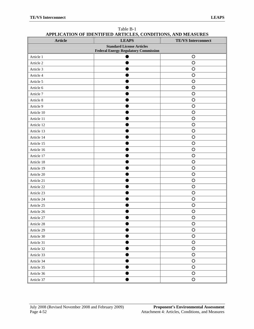
TE/VS Interconnect LEAPS
July 2008 (Revised November 2008 and February 2009) Proponent’s Environmental Assessment
Table B-1 APPLICATION OF IDENTIFIED ARTICLES, CONDITIONS, AND MEASURES
Article LEAPS TE/VS Interconnect Standard License Articles
Federal Energy Regulatory Commission
Article 1 Article 2 Article 3 Article 4 Article 5 Article 6 Article 7 Article 8 Article 9 Article 10 Article 11 Article 12 Article 13 Article 14 Article 15 Article 16 Article 17 Article 18 Article 19 Article 20 Article 21 Article 22 Article 23 Article 24 Article 25 Article 26 Article 27 Article 28 Article 29 Article 30 Article 31 Article 32 Article 33 Article 34 Article 35 Article 36 Article 37
Page 4-52 Attachment 4: Articles, Conditions, and Measures
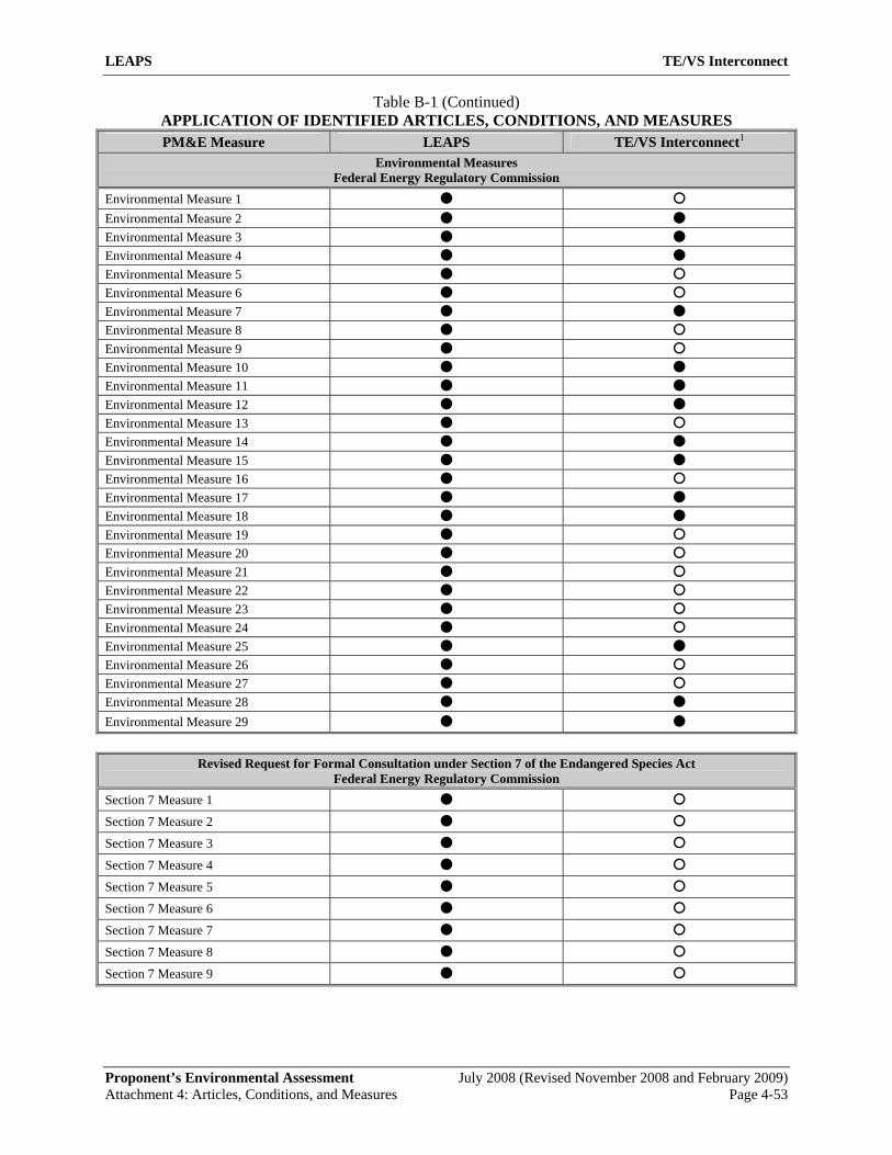
LEAPS TE/VS Interconnect
Proponent’s Environmental Assessment July 2008 (Revised November 2008 and February 2009)
Table B-1 (Continued) APPLICATION OF IDENTIFIED ARTICLES, CONDITIONS, AND MEASURES PM&E Measure LEAPS TE/VS Interconnect1
Environmental Measures Federal Energy Regulatory Commission
Environmental Measure 1 Environmental Measure 2 Environmental Measure 3 Environmental Measure 4 Environmental Measure 5 Environmental Measure 6 Environmental Measure 7 Environmental Measure 8 Environmental Measure 9 Environmental Measure 10 Environmental Measure 11 Environmental Measure 12 Environmental Measure 13 Environmental Measure 14 Environmental Measure 15 Environmental Measure 16 Environmental Measure 17 Environmental Measure 18 Environmental Measure 19 Environmental Measure 20 Environmental Measure 21 Environmental Measure 22 Environmental Measure 23 Environmental Measure 24 Environmental Measure 25 Environmental Measure 26 Environmental Measure 27 Environmental Measure 28 Environmental Measure 29
Revised Request for Formal Consultation under Section 7 of the Endangered Species Act
Federal Energy Regulatory Commission Section 7 Measure 1 Section 7 Measure 2 Section 7 Measure 3 Section 7 Measure 4 Section 7 Measure 5 Section 7 Measure 6 Section 7 Measure 7 Section 7 Measure 8 Section 7 Measure 9
Attachment 4: Articles, Conditions, and Measures Page 4-53
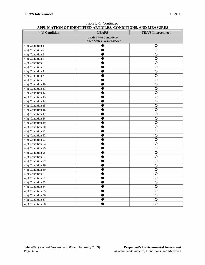
TE/VS Interconnect LEAPS
July 2008 (Revised November 2008 and February 2009) Proponent’s Environmental Assessment
Table B-1 (Continued) APPLICATION OF IDENTIFIED ARTICLES, CONDITIONS, AND MEASURES
4(e) Condition LEAPS TE/VS Interconnect Section 4(e) Conditions
United States Forest Service 4(e) Condition 1 4(e) Condition 2 4(e) Condition 3 4(e) Condition 4 4(e) Condition 5 4(e) Condition 6 4(e) Condition 7 4(e) Condition 8 4(e) Condition 9 4(e) Condition 10 4(e) Condition 11 4(e) Condition 12 4(e) Condition 13 4(e) Condition 14 4(e) Condition 15 4(e) Condition 16 4(e) Condition 17 4(e) Condition 18 4(e) Condition 19 4(e) Condition 20 4(e) Condition 21 4(e) Condition 22 4(e) Condition 23 4(e) Condition 24 4(e) Condition 25 4(e) Condition 26 4(e) Condition 27 4(e) Condition 27 4(e) Condition 29 4(e) Condition 30 4(e) Condition 31 4(e) Condition 32 4(e) Condition 33 4(e) Condition 34 4(e) Condition 35 4(e) Condition 36 4(e) Condition 37 4(e) Condition 38
Page 4-54 Attachment 4: Articles, Conditions, and Measures
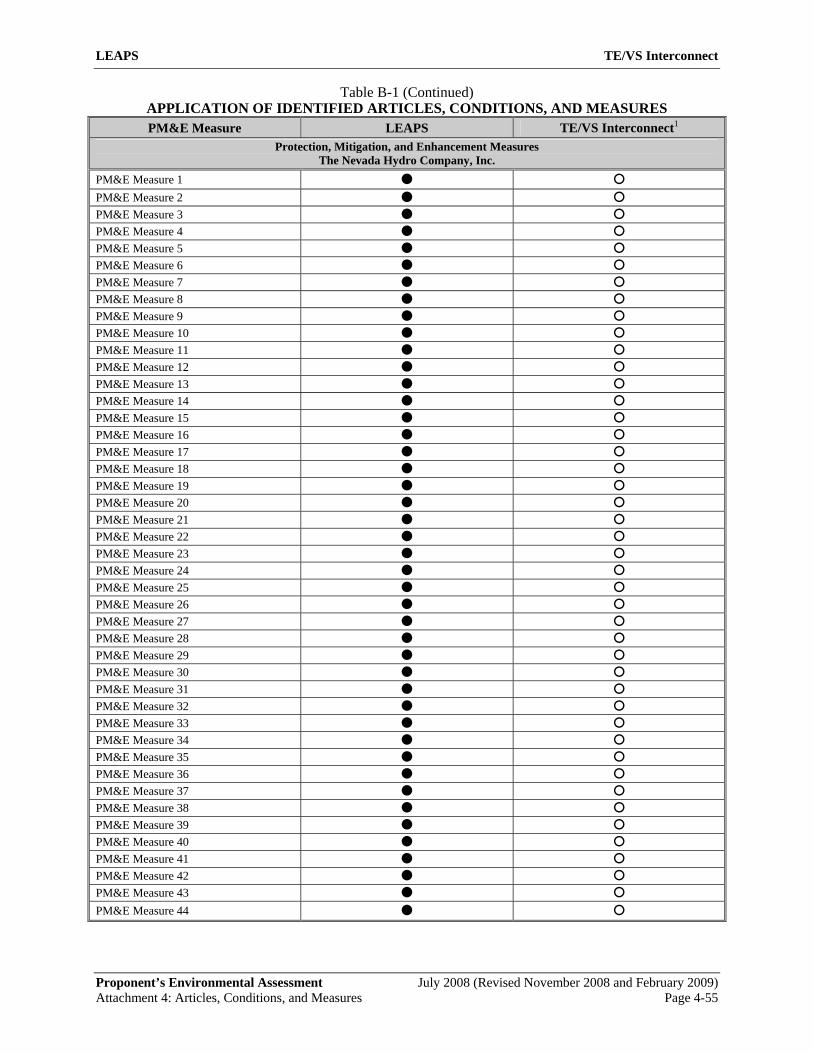
LEAPS TE/VS Interconnect
Proponent’s Environmental Assessment July 2008 (Revised November 2008 and February 2009)
Table B-1 (Continued) APPLICATION OF IDENTIFIED ARTICLES, CONDITIONS, AND MEASURES PM&E Measure LEAPS TE/VS Interconnect1
Protection, Mitigation, and Enhancement Measures The Nevada Hydro Company, Inc.
PM&E Measure 1 PM&E Measure 2 PM&E Measure 3 PM&E Measure 4 PM&E Measure 5 PM&E Measure 6 PM&E Measure 7 PM&E Measure 8 PM&E Measure 9 PM&E Measure 10 PM&E Measure 11 PM&E Measure 12 PM&E Measure 13 PM&E Measure 14 PM&E Measure 15 PM&E Measure 16 PM&E Measure 17 PM&E Measure 18 PM&E Measure 19 PM&E Measure 20 PM&E Measure 21 PM&E Measure 22 PM&E Measure 23 PM&E Measure 24 PM&E Measure 25 PM&E Measure 26 PM&E Measure 27 PM&E Measure 28 PM&E Measure 29 PM&E Measure 30 PM&E Measure 31 PM&E Measure 32 PM&E Measure 33 PM&E Measure 34 PM&E Measure 35 PM&E Measure 36 PM&E Measure 37 PM&E Measure 38 PM&E Measure 39 PM&E Measure 40 PM&E Measure 41 PM&E Measure 42 PM&E Measure 43 PM&E Measure 44
Attachment 4: Articles, Conditions, and Measures Page 4-55
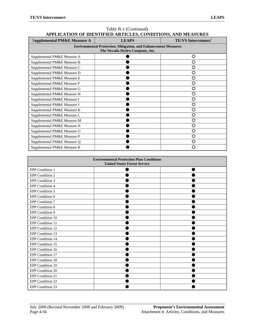
TE/VS Interconnect LEAPS
July 2008 (Revised November 2008 and February 2009) Proponent’s Environmental Assessment
Table B-1 (Continued) APPLICATION OF IDENTIFIED ARTICLES, CONDITIONS, AND MEASURES
Supplemental PM&E Measure A LEAPS TE/VS Interconnect1 Environmental Protection, Mitigation, and Enhancement Measures
The Nevada Hydro Company, Inc. Supplemental PM&E Measure A Supplemental PM&E Measure B Supplemental PM&E Measure C Supplemental PM&E Measure D Supplemental PM&E Measure E Supplemental PM&E Measure F Supplemental PM&E Measure G Supplemental PM&E Measure H Supplemental PM&E Measure I Supplemental PM&E Measure J Supplemental PM&E Measure K Supplemental PM&E Measure L Supplemental PM&E Measure M Supplemental PM&E Measure N Supplemental PM&E Measure O Supplemental PM&E Measure P Supplemental PM&E Measure Q Supplemental PM&E Measure R
Environmental Protection Plan Conditions
United States Forest Service EPP Condition 1 EPP Condition 2 EPP Condition 3 EPP Condition 4 EPP Condition 5 EPP Condition 6 EPP Condition 7 EPP Condition 8 EPP Condition 9 EPP Condition 10 EPP Condition 11 EPP Condition 12 EPP Condition 13 EPP Condition 14 EPP Condition 15 EPP Condition 16 EPP Condition 17 EPP Condition 18 EPP Condition 19 EPP Condition 20 EPP Condition 21 EPP Condition 22 EPP Condition 23
Page 4-56 Attachment 4: Articles, Conditions, and Measures

LEAPS TE/VS Interconnect
Proponent’s Environmental Assessment July 2008 (Revised November 2008 and February 2009)
Table B-1 (Continued) APPLICATION OF IDENTIFIED ARTICLES, CONDITIONS, AND MEASURES
Measure LEAPS TE/VS Interconnect1 Draft Historic Resource Management Plan
Federal Energy Regulatory Commission Avoidance Archeological Monitoring Physical Protection Public Interpretation Native American Participation Completion of APE Inventory Additional Consultation Data Recovery Dispute Resolution
Federal Clean Air Act General Conformity Analysis Federal Energy Regulatory Commission
CAA1 CAA2 CAA3 CAA4 CAA5 CAA6 CAA7 CAA8 CAA9 CAA10 CAA11 CAA12 Notes: 1. Based on the nature of any final permitting, reference to the Federal Energy Regulatory Commission (Commission) in the applicable PM&Es
is assumed to be modified to include either joint or substitute reference to the USDA Forest Service.
Attachment 4: Articles, Conditions, and Measures Page 4-57

TE/VS Interconnect LEAPS
July 2008 (Revised November 2008 and February 2009) Proponent’s Environmental Assessment
This page intentionally left blank.
Page 4-58 Attachment 4: Articles, Conditions, and Measures


![YEAR] SHORT TITLE 1 Fair Measures: A Behavioral Realist ...mrbworks/articles/manuscripts/Kang.pdfYEAR] SHORT TITLE 1 Fair Measures: A Behavioral Realist Revision of “ Affirmative](https://img.pdfslide.net/doc/110x75/5ad0eb7b7f8b9aca598e3550/year-short-title-1-fair-measures-a-behavioral-realist-mrbworksarticlesmanuscriptskangpdfyear.jpg)