Embed Size (px)
Citation preview
Final Report The Preparatory Survey for Dedicated Freight Corridor (Phase 2)(II) March 2012
Part II Attachment
Page A-II-140
Attachment II.4.4 Comments from the Public on Draft ESIA Report
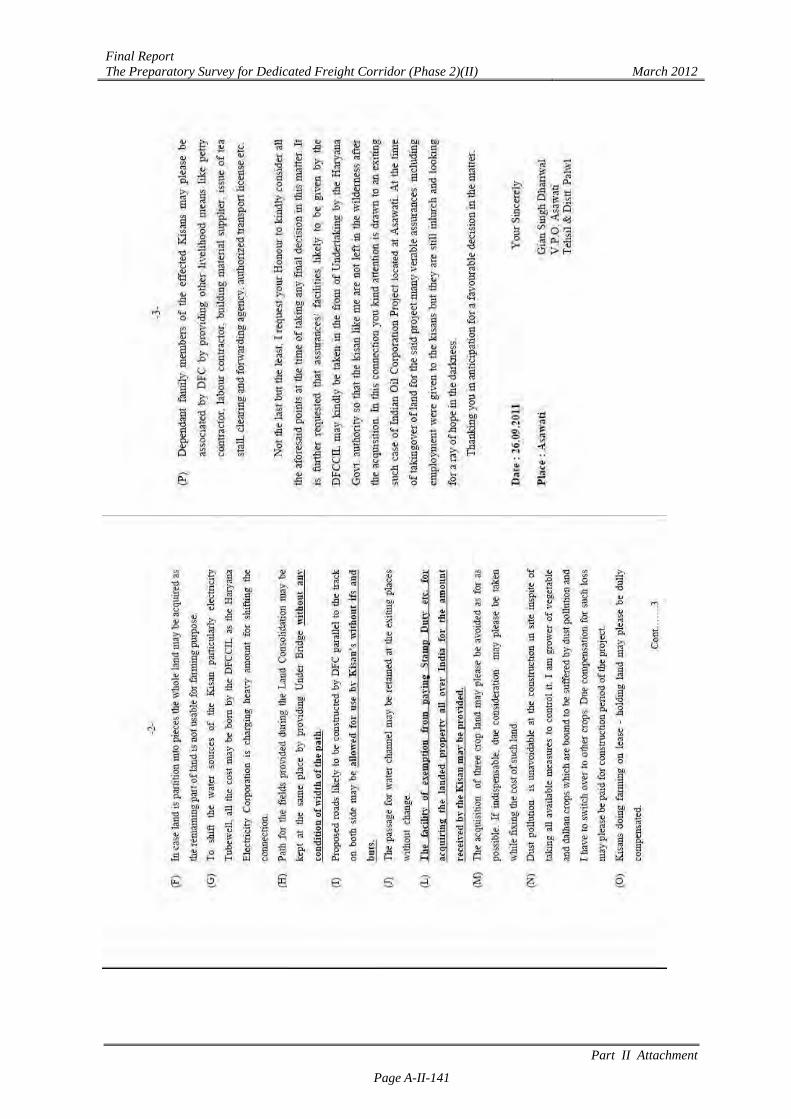
[Letter 1: Palwal]
Final Report The Preparatory Survey for Dedicated Freight Corridor (Phase 2)(II) March 2012
Part II Attachment
Page A-II-141

Final Report The Preparatory Survey for Dedicated Freight Corridor (Phase 2)(II) March 2012
Part II Attachment
Page A-II-142
[Letter 2: Palwal]
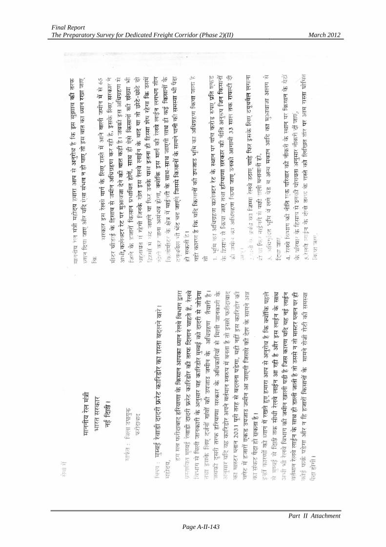
[Letter 3 Faridabad: Hindi]
Final Report The Preparatory Survey for Dedicated Freight Corridor (Phase 2)(II) March 2012
Part II Attachment
Page A-II-143
Final Report The Preparatory Survey for Dedicated Freight Corridor (Phase 2)(II) March 2012
Part II Attachment
Page A-II-144
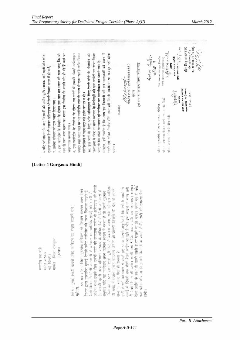
[Letter 4 Gurgaon: Hindi]
Final Report The Preparatory Survey for Dedicated Freight Corridor (Phase 2)(II) March 2012
Part II Attachment
Page A-II-145

Final Report The Preparatory Survey for Dedicated Freight Corridor (Phase 2)(II) March 2012
Part II Attachment
Page A-II-146
Attachment II.4.5 Summary of Final ESIA for Information Dissemination
[English]
Final Report The Preparatory Survey for Dedicated Freight Corridor (Phase 2)(II) March 2012
Part II Attachment
Page A-II-147
Final Report The Preparatory Survey for Dedicated Freight Corridor (Phase 2)(II) March 2012
Part II Attachment
Page A-II-148
Final Report The Preparatory Survey for Dedicated Freight Corridor (Phase 2)(II) March 2012
Part II Attachment
Page A-II-149
Final Report The Preparatory Survey for Dedicated Freight Corridor (Phase 2)(II) March 2012
Part II Attachment
Page A-II-150

Final Report The Preparatory Survey for Dedicated Freight Corridor (Phase 2)(II) March 2012
Part II Attachment
Page A-II-151
Final Report The Preparatory Survey for Dedicated Freight Corridor (Phase 2)(II) March 2012
Part II Attachment
Page A-II-152
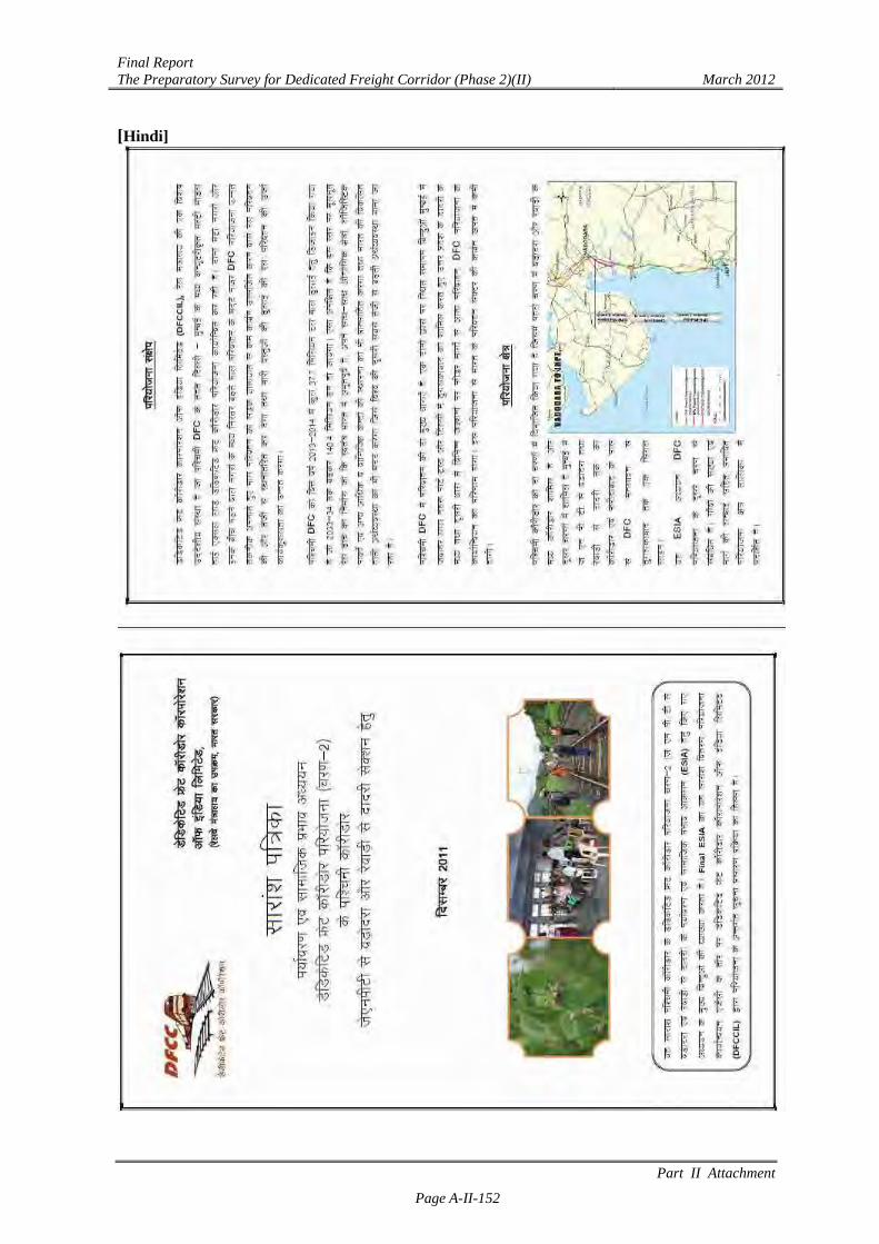
[Hindi]
Final Report The Preparatory Survey for Dedicated Freight Corridor (Phase 2)(II) March 2012
Part II Attachment
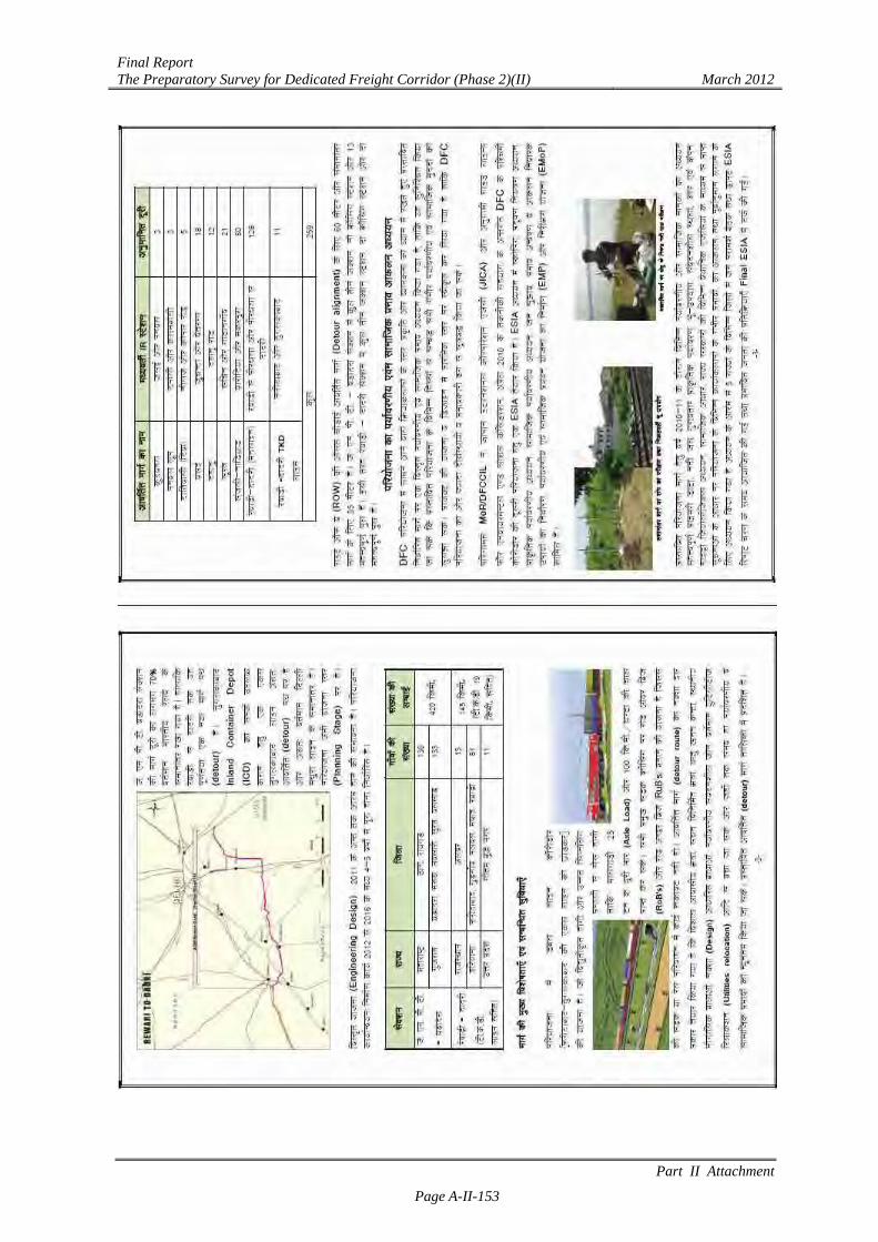
Page A-II-153
Final Report The Preparatory Survey for Dedicated Freight Corridor (Phase 2)(II) March 2012
Part II Attachment
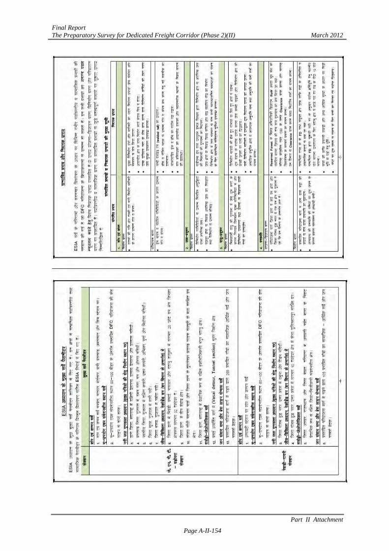
Page A-II-154
Final Report The Preparatory Survey for Dedicated Freight Corridor (Phase 2)(II) March 2012
Part II Attachment
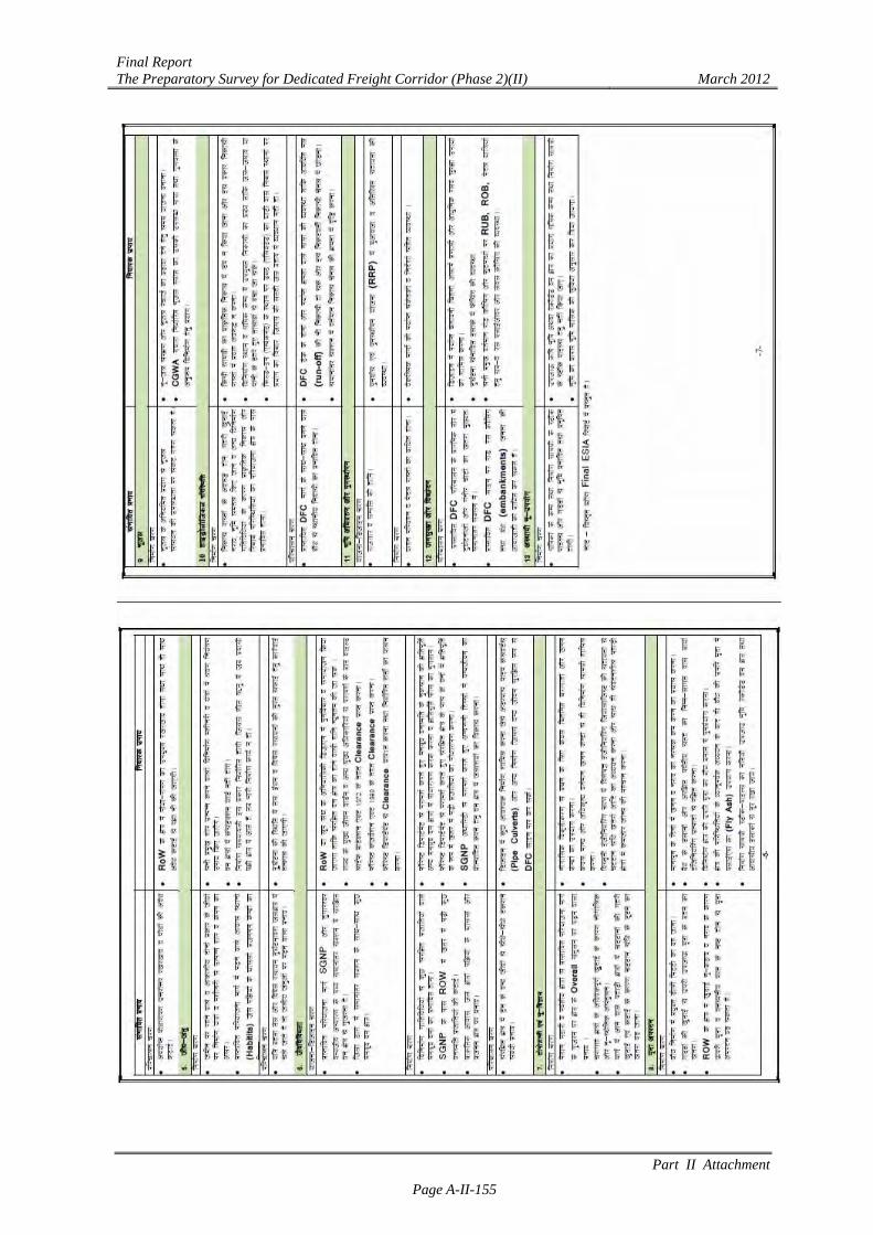
Page A-II-155
Final Report The Preparatory Survey for Dedicated Freight Corridor (Phase 2)(II) March 2012
Part II Attachment
Page A-II-156
Final Report The Preparatory Survey for Dedicated Freight Corridor (Phase 2)(II) March 2012
Part II Attachment
Page A-II-157
Final Report The Preparatory Survey for Dedicated Freight Corridor (Phase 2)(II) March 2012
Part II Attachment
Page A-II-158
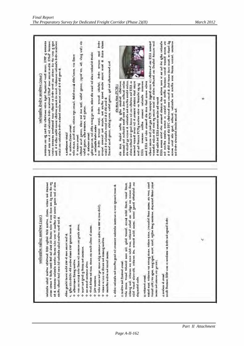
[Gujarati]
Final Report The Preparatory Survey for Dedicated Freight Corridor (Phase 2)(II) March 2012
Part II Attachment
Page A-II-159
Final Report The Preparatory Survey for Dedicated Freight Corridor (Phase 2)(II) March 2012
Part II Attachment
Page A-II-160
Final Report The Preparatory Survey for Dedicated Freight Corridor (Phase 2)(II) March 2012
Part II Attachment
Page A-II-161
Final Report The Preparatory Survey for Dedicated Freight Corridor (Phase 2)(II) March 2012
Part II Attachment
Page A-II-162
Final Report The Preparatory Survey for Dedicated Freight Corridor (Phase 2)(II) March 2012
Part II Attachment
Page A-II-163
Final Report The Preparatory Survey for Dedicated Freight Corridor (Phase 2)(II) March 2012
Part II Attachment
Page A-II-164
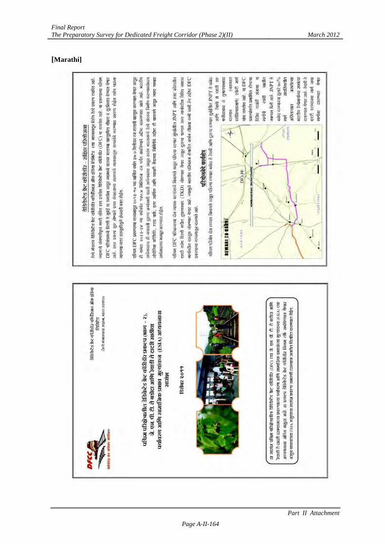
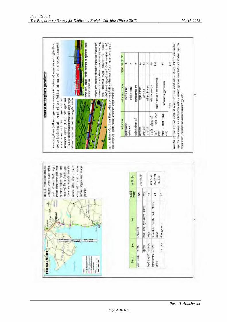
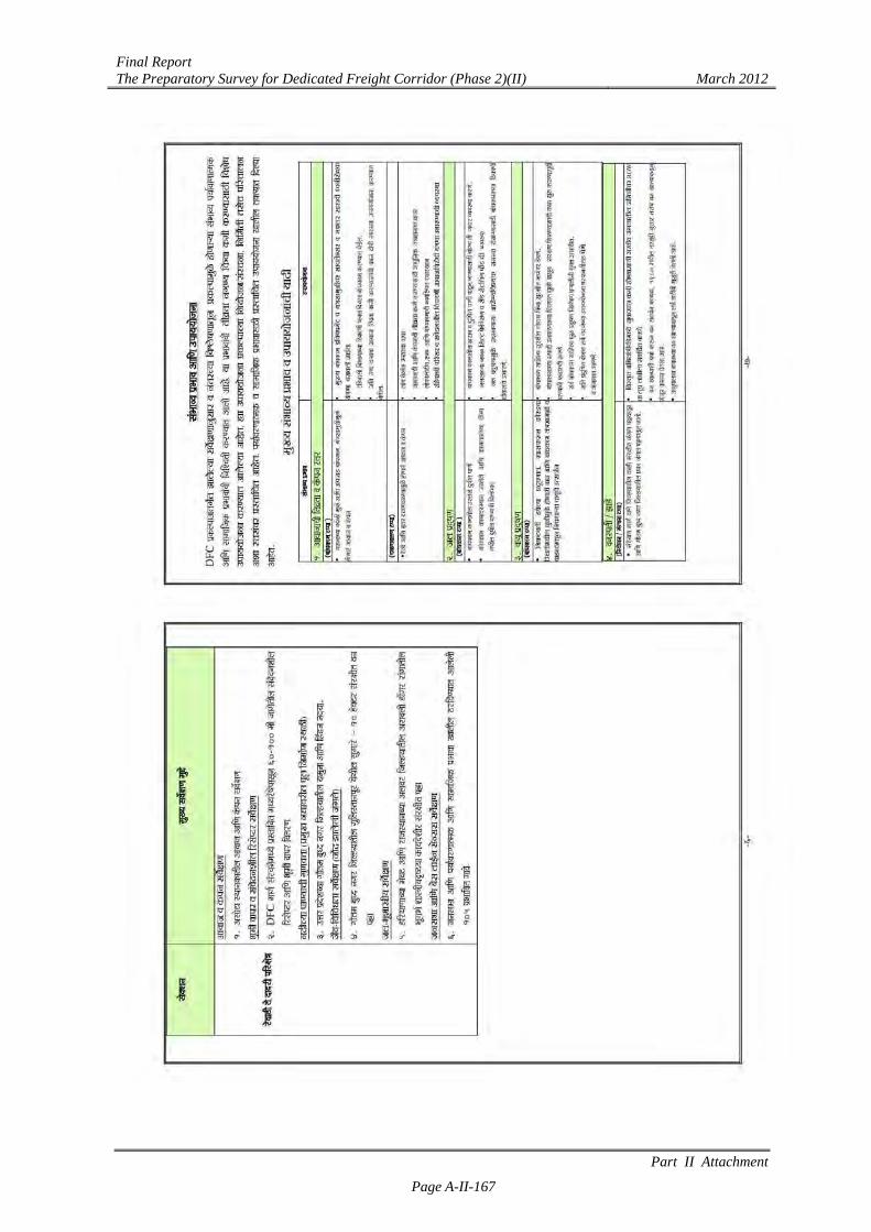
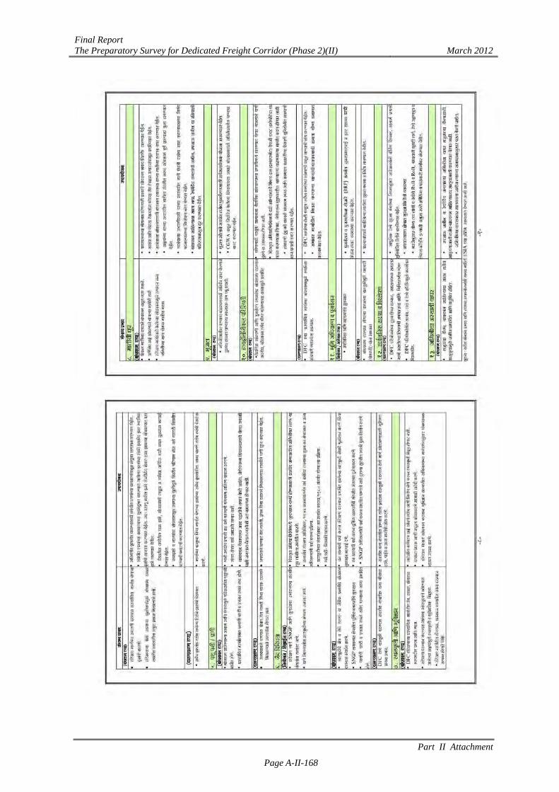
[Marathi]
Final Report The Preparatory Survey for Dedicated Freight Corridor (Phase 2)(II) March 2012
Part II Attachment
Page A-II-165

Final Report The Preparatory Survey for Dedicated Freight Corridor (Phase 2)(II) March 2012
Part II Attachment
Page A-II-166
Final Report The Preparatory Survey for Dedicated Freight Corridor (Phase 2)(II) March 2012
Part II Attachment
Page A-II-167
Final Report The Preparatory Survey for Dedicated Freight Corridor (Phase 2)(II) March 2012
Part II Attachment
Page A-II-168
Final Report The Preparatory Survey for Dedicated Freight Corridor (Phase 2)(II) March 2012
Part II Attachment
Page A-II-169
Final Report The Preparatory Survey for Dedicated Freight Corridor (Phase 2)(II) March 2012
Part II Attachment
Page A-II-170
Final Report The Preparatory Survey for Dedicated Freight Corridor (Phase 2)(II) March 2012
Part II Attachment
Page A-II-171
Attachment II.4.6 Public Notice and Letter for Information Dissemination of Final ESIA Report
[Public Notice: English]
[Public Notice_Hindi]

Final Report The Preparatory Survey for Dedicated Freight Corridor (Phase 2)(II) March 2012
Part II Attachment
Page A-II-172
[Public Notice: Gujarati]
[Public Notice_Marathi]
Final Report The Preparatory Survey for Dedicated Freight Corridor (Phase 2)(II) March 2012
Part II Attachment
Page A-II-173
[Letter to District Collector (DC): English]
Final Report The Preparatory Survey for Dedicated Freight Corridor (Phase 2)(II) March 2012
Part II Attachment
Page A-II-174
[Letter to Station Master: English]
Final Report The Preparatory Survey for Dedicated Freight Corridor (Phase 2)(II) March 2012
Part II Attachment
Page A-II-175
[Letter to Sarpanch: English]
Final Report The Preparatory Survey for Dedicated Freight Corridor (Phase 2)(II) March 2012
Part II Attachment
Page A-II-176
[Letter to Sarpanch: Hindi]

Final Report The Preparatory Survey for Dedicated Freight Corridor (Phase 2)(II) March 2012
Part II Attachment
Page A-II-177
[Letter to Sarpanch: Gujarati]
Final Report The Preparatory Survey for Dedicated Freight Corridor (Phase 2)(II) March 2012
Part II Attachment
Page A-II-178
[Letter to Sarpanch: Marathi]
Final Report The Preparatory Survey for Dedicated Freight Corridor (Phase 2)(II) March 2012
Part II Attachment
Page A-II-179
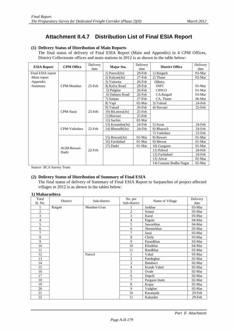
Attachment II.4.7 Distribution List of Final ESIA Report
(1) Delivery Status of Distribution of Main Reports The final status of delivery of Final ESIA Report (Main and Appendix) in 4 CPM Offices, District Collectorate offices and main stations in 2012 is as shown in the table below:
ESIA Report CPM Office Delivery
date Major Sta. Delivery
date District Office Delivery
date Final ESIA report
CPM-Mumbai 25-Feb
1) Panvel(Jn) 29-Feb 1) Raigarh 03-Mar-Main report 2) Kalyan(Jn) 27-Feb 2) Thane 02-Mar-Appendix 3) Vaitarna 26-Feb Others: -Summary 4) Kelve Road 29-Feb JNPT 01-Mar 5) Palghar 26-Feb CIDCO 01-Mar 6) Dahanu Road 26-Feb CA,Raigad 03-Mar 7) Sanjan 27-Feb CA, Thane 06-Mar
CPM-Surat 25-Feb
8) Vapi 02-Mar 3) Valsad 24-Feb 9) Valsad 26-Feb 4) Navsari 25-Feb 10) Bil,mora(Jn) 25-Feb 11)Navsari 25-Feb 12) Sachin 02-Mar
CPM-Vadodara 22-Feb 13) Kosamba(Jn) 24-Feb 5) Surat 24-Feb
14) Bharudh(Jn) 24-Feb 6) Bharuch 24-Feb 7) Vadodara 22-Feb
AGM-Rewari- Dadri
22-Feb
15) Rewari(Jn) 02-Mar 8) Rewari 01-Mar 16) Faridabad 01-Mar 9) Mewat 01-Mar 17) Dadri 01-Mar 10) Gurgaon 01-Mar 11) Palwal 24-Feb 12) Faridabad 24-Feb 13) Alwar 02-Mar 14) Gautam Budha Nagar 01-MarSource: JICA Survey Team
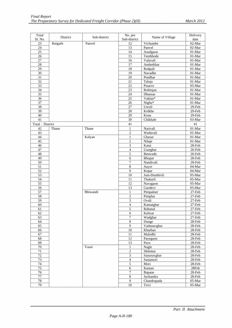
(2) Delivery Status of Distribution of Summary of Final ESIA
The final status of delivery of Summary of Final ESIA Report to Sarpanches of project affected villages in 2012 is as shown in the tables below:
1) Maharashtra Total
Sl. No. District Sub-district
No. per Sub-district
Name of Village Delivery
date 1 Raigad Mumbai-Uran 1 Jaskhar 03-Mar 2 2 Sonari 03-Mar 3 3 Karal 03-Mar 4 4 Pagote 04-Mar 5 5 Sawarkhar 04-Mar 6 6 Shemtekhar 03-Mar 7 7 Jasai 03-Mar 8 8 Chirle 03-Mar 9 9 Paundkhar 03-Mar
10 10 Khatkhar 04-Mar 11 11 Bandkhar 03-Mar 12 Panvel 1 Vahal 03-Mar 13 2 Pandeghar 02-Mar 14 3 Bambavi 02-Mar 15 4 Kunde Vahal 02-Mar 16 5 Ovale 02-Mar 17 6 Dapoli 02-Mar 18 7 Pargaon Inam 02-Mar 19 8 Kopar 02-Mar 20 9 Vadghar 02-Mar 21 10 Karanjade 29-Feb 22 11 Kalundre 29-Feb
Final Report The Preparatory Survey for Dedicated Freight Corridor (Phase 2)(II) March 2012
Part II Attachment
Page A-II-180
Total Sl. No.
District Sub-district No. per
Sub-districtName of Village
Delivery date
23 Raigarh Panvel 12 Vichumbe 02-Mar 24 13 Panvel 02-Mar 25 14 Asudgaon 01-Mar 26 15 Tembhode 01-Mar 27 16 Valavali 01-Mar 28 17 Ambetkhar 01-Mar 29 18 Rodpali 01-Mar 30 19 Navadhe 01-Mar 31 20 Pendhar 01-Mar 32
21 Taloja 01-Mar 33 22 Pisarve 05-Mar 34 23 Rohinjan 01-Mar 35 24 Dhansar 01-Mar 36 25 Vaklan* 01-Mar 37 26 Nighu* 01-Mar 38 27 Usroli 29-Feb 39 28 Kolkhe 29-Feb 40 29 Kone 29-Feb 41 30 Chikhale 03-Mar
Total:District 41 41 42 Thane Thane 1 Narivali 01-Mar 43 2 Wadavali 01-Mar 44 Kalyan 1 Ghesar 01-Mar 45 2 Nilaje 01-Mar 46 3 Katai 28-Feb 47 4 Usarghar 26-Feb 48 5 Betavade 26-Feb 49 6 Bhopar 28-Feb 50 7 Nandivali 28-Feb 51 8 Aayre 04-Mar 52 9 Kopar 04-Mar 53 10 Juni-Dombivli 05-Mar 54 11 Thakurli 05-Mar 55 12 Navagaon 05-Mar 56 13 Gaodevi 05-Mar 57 Bhiwandi 1 Pimpalner 27-Feb 58 2 Pimplas 27-Feb 59 3 Ovali 27-Feb 60 4 Kamatghar 27-Feb 61 5 Rahanal 27-Feb 62 6 Kalwar 27-Feb 63 7 Wadghar 27-Feb 64 8 Dunge 28-Feb 65 9 Vadunavghar 28-Feb 66 10 Kharbao 28-Feb 67 11 Malodhi 28-Feb 68 12 Payegaon 28-Feb 69 13 Paye 28-Feb 70 Vasai 1 Nagle 28-Feb 71 2 Shilottar 28-Feb 72 3 Sasunavghar 28-Feb 73 4 Sarjamori 28-Feb 74 5 Mori 28-Feb 75 6 Kaman 28Feb 76 7 Bapane 28-Feb 77 8 Juchandra 28-Feb 78 9 Chandrapada 05-Mar 79 10 Tivri 05-Mar
Final Report The Preparatory Survey for Dedicated Freight Corridor (Phase 2)(II) March 2012
Part II Attachment
Page A-II-181
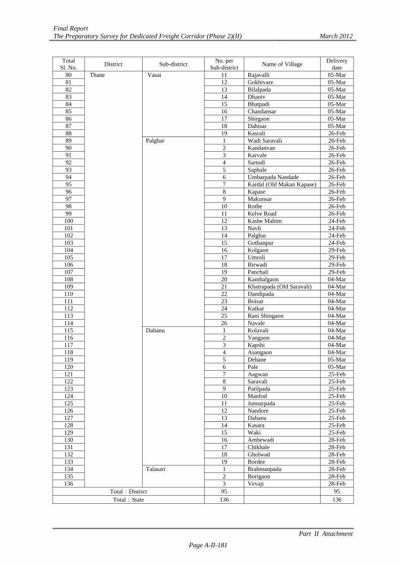
Total Sl. No.
District Sub-district No. per
Sub-districtName of Village
Delivery date
80 Thane Vasai 11 Rajavalli 05-Mar 81 12 Gokhivare 05-Mar 82 13 Bilalpada 05-Mar 83 14 Dhaniv 05-Mar 84 15 Bhatpadi 05-Mar 85 16 Chandansar 05-Mar 86 17 Shirgaon 05-Mar 87 18 Dahisar 05-Mar 88 19 Kasrali 26-Feb 89 Palghar 1 Wadi Saravali 26-Feb 90 2 Kandanvan 26-Feb 91 3 Karvale 26-Feb 92 4 Sartodi 26-Feb 93 5 Saphale 26-Feb 94 6 Umbarpada Nandade 26-Feb 95 7 Kardal (Old Makan Kapase) 26-Feb 96 8 Kapase 26-Feb 97 9 Makunsar 26-Feb 98 10 Rothe 26-Feb 99 11 Kelve Road 26-Feb 100 12 Kasbe Mahim 24-Feb 101 13 Navli 24-Feb 102 14 Palghar 24-Feb 103 15 Gothanpur 24-Feb 104 16 Kolgaon 29-Feb 105 17 Umroli 29-Feb 106 18 Birwadi 29-Feb 107 19 Panchali 29-Feb 108 20 Kambalgaon 04-Mar 109 21 Khairapada (Old Saravali) 04-Mar 110 22 Dandipada 04-Mar 111 23 Boisar 04-Mar 112 24 Katkar 04-Mar 113 25 Rani Shingaon 04-Mar 114 26 Navale 04-Mar 115 Dahanu 1 Kolavali 04-Mar 116 2 Vangaon 04-Mar 117 3 Kapshi 04-Mar 118 4 Asangaon 04-Mar 119 5 Dehane 05-Mar 120 6 Pale 05-Mar 121 7 Aagwan 25-Feb 122 8 Saravali 25-Feb 123 9 Patilpada 25-Feb 124 10 Manfod 25-Feb 125 11 Junnarpada 25-Feb 126 12 Nandore 25-Feb 127 13 Dahanu 25-Feb 128 14 Kasara 25-Feb 129 15 Waki 25-Feb 130 16 Ambewadi 28-Feb 131 17 Chikhale 28-Feb 132 18 Gholwad 28-Feb 133 19 Bordee 28-Feb 134 Talasari 1 Brahmanpada 28-Feb 135 2 Borigaon 28-Feb 136 3 Vevaji 28-Feb
Total:District 95 95 Total:State 136 136
Final Report The Preparatory Survey for Dedicated Freight Corridor (Phase 2)(II) March 2012
Part II Attachment
Page A-II-182
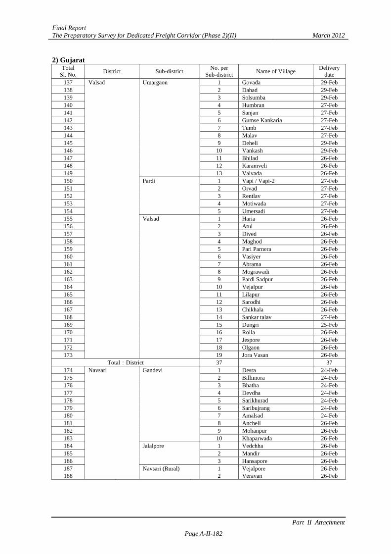
2) Gujarat Total
Sl. No. District Sub-district
No. per Sub-district
Name of Village Delivery
date 137 Valsad Umargaon 1 Govada 29-Feb 138 2 Dahad 29-Feb 139 3 Solsumba 29-Feb 140 4 Humbran 27-Feb 141 5 Sanjan 27-Feb 142 6 Gumse Kankaria 27-Feb 143 7 Tumb 27-Feb 144 8 Malav 27-Feb 145 9 Deheli 29-Feb 146 10 Vankash 29-Feb 147 11 Bhilad 26-Feb 148 12 Karamveli 26-Feb 149 13 Valvada 26-Feb 150 Pardi 1 Vapi / Vapi-2 27-Feb 151 2 Orvad 27-Feb 152 3 Rentlav 27-Feb 153 4 Motiwada 27-Feb 154 5 Umersadi 27-Feb 155 Valsad 1 Haria 26-Feb 156 2 Atul 26-Feb 157 3 Dived 26-Feb 158 4 Maghod 26-Feb 159 5 Pari Parnera 26-Feb 160 6 Vasiyer 26-Feb 161 7 Abrama 26-Feb 162 8 Mograwadi 26-Feb 163 9 Pardi Sadpur 26-Feb 164 10 Vejalpur 26-Feb 165 11 Lilapur 26-Feb 166 12 Sarodhi 26-Feb 167 13 Chikhala 26-Feb 168 14 Sankar talav 27-Feb 169 15 Dungri 25-Feb 170 16 Rolla 26-Feb 171 17 Jespore 26-Feb 172 18 Olgaon 26-Feb 173 19 Jora Vasan 26-Feb
Total:District 37 37 174 Navsari Gandevi 1 Desra 24-Feb 175 2 Billimora 24-Feb 176 3 Bhatha 24-Feb 177 4 Devdha 24-Feb 178 5 Sarikhurad 24-Feb 179 6 Saribujrang 24-Feb 180 7 Amalsad 24-Feb 181 8 Ancheli 26-Feb 182 9 Mohanpur 26-Feb 183 10 Khaparwada 26-Feb 184 Jalalpore 1 Vedchha 26-Feb 185 2 Mandir 26-Feb 186 3 Hansapore 26-Feb 187 Navsari (Rural) 1 Vejalpore 26-Feb 188 2 Veravan 26-Feb
Final Report The Preparatory Survey for Dedicated Freight Corridor (Phase 2)(II) March 2012
Part II Attachment
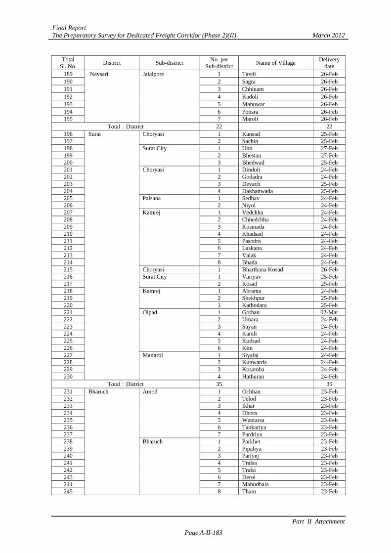
Page A-II-183
Total Sl. No.
District Sub-district No. per
Sub-districtName of Village
Delivery date
189 Navsari Jalalpore 1 Tavdi 26-Feb 190 2 Sagra 26-Feb 191 3 Chhinam 26-Feb 192 4 Kadoli 26-Feb 193 5 Mahuwar 26-Feb 194 6 Ponsra 26-Feb 195 7 Maroli 26-Feb
Total:District 22 22 196 Surat Choryasi 1 Kansad 25-Feb 197 2 Sachin 25-Feb 198 Surat City 1 Unn 27-Feb 199 2 Bhestan 27-Feb 200 3 Bhedwad 25-Feb 201 Choryasi 1 Dindoli 24-Feb 202 2 Godadra 24-Feb 203 3 Devach 25-Feb 204 4 Dakhanwada 25-Feb 205 Palsana 1 Sedhav 24-Feb 206 2 Niyol 24-Feb 207 Kamrej 1 Vedchha 24-Feb 208 2 Chhedchha 24-Feb 209 3 Kosmada 24-Feb 210 4 Khadsad 24-Feb 211 5 Pasodra 24-Feb 212 6 Laskana 24-Feb 213 7 Valak 24-Feb 214 8 Bhada 24-Feb 215 Choryasi 1 Bharthana Kosad 26-Feb 216 Surat City 1 Variyav 25-Feb 217 2 Kosad 25-Feb 218 Kamrej 1 Abrama 24-Feb 219 2 Shekhpur 25-Feb 220 3 Kathodara 25-Feb 221 Olpad 1 Gothan 02-Mar 222 2 Umara 24-Feb 223 3 Sayan 24-Feb 224 4 Kareli 24-Feb 225 5 Kudsad 24-Feb 226 6 Kim 24-Feb 227 Mangrol 1 Siyalaj 24-Feb 228 2 Kunwarda 24-Feb 229 3 Kosamba 24-Feb 230 4 Hathuran 24-Feb
Total:District 35 35 231 Bharuch Amod 1 Ochhan 23-Feb 232 2 Telod 23-Feb 233 3 Ikhar 23-Feb 234 4 Dhora 23-Feb 235 5 Wantarsa 23-Feb 236 6 Tankariya 23-Feb 237 7 Pardriya 23-Feb 238 Bharuch 1 Parkhet 23-Feb 239 2 Pipaliya 23-Feb 240 3 Pariyej 23-Feb 241 4 Tralsa 23-Feb 242 5 Tralsi 23-Feb 243 6 Derol 23-Feb 244 7 Mahudhala 23-Feb 245 8 Tham 23-Feb
Final Report The Preparatory Survey for Dedicated Freight Corridor (Phase 2)(II) March 2012
Part II Attachment
Page A-II-184
Total Sl. No.
District Sub-district No. per
Sub-districtName of Village
Delivery date
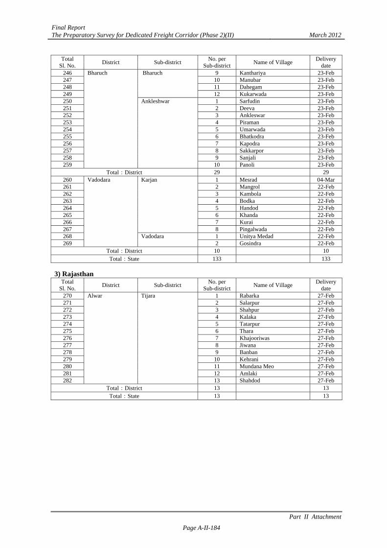
246 Bharuch Bharuch 9 Kanthariya 23-Feb 247 10 Manubar 23-Feb 248 11 Dahegam 23-Feb 249 12 Kukarwada 23-Feb 250 Ankleshwar 1 Sarfudin 23-Feb 251 2 Deeva 23-Feb 252 3 Ankleswar 23-Feb 253 4 Piraman 23-Feb 254 5 Umarwada 23-Feb 255 6 Bhatkodra 23-Feb 256 7 Kapodra 23-Feb 257 8 Sakkarpor 23-Feb 258 9 Sanjali 23-Feb 259 10 Panoli 23-Feb
Total:District 29 29 260 Vadodara Karjan 1 Mesrad 04-Mar 261 2 Mangrol 22-Feb 262 3 Kambola 22-Feb 263 4 Bodka 22-Feb 264 5 Handod 22-Feb 265 6 Khanda 22-Feb 266 7 Kurai 22-Feb 267 8 Pingalwada 22-Feb 268 Vadodara 1 Unitya Medad 22-Feb 269 2 Gosindra 22-Feb
Total:District 10 10 Total:State 133 133
3) Rajasthan
Total Sl. No.
District Sub-district No. per
Sub-districtName of Village
Delivery date
270 Alwar Tijara 1 Rabarka 27-Feb 271 2 Salarpur 27-Feb 272 3 Shahpur 27-Feb 273 4 Kalaka 27-Feb 274 5 Tatarpur 27-Feb 275 6 Thara 27-Feb 276 7 Khajooriwas 27-Feb 277 8 Jiwana 27-Feb 278 9 Banban 27-Feb 279 10 Kehrani 27-Feb 280 11 Mundana Meo 27-Feb 281 12 Amlaki 27-Feb 282 13 Shahdod 27-Feb
Total:District 13 13 Total:State 13 13
Final Report The Preparatory Survey for Dedicated Freight Corridor (Phase 2)(II) March 2012
Part II Attachment
Page A-II-185
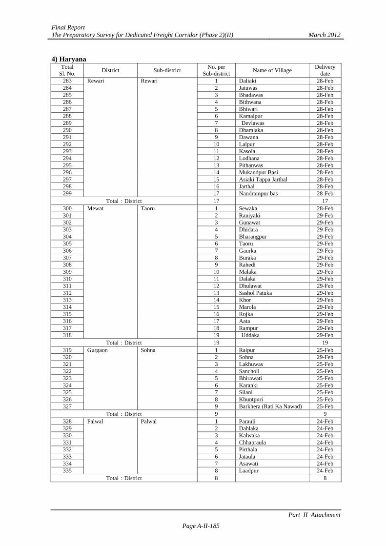
4) Haryana Total
Sl. No. District Sub-district
No. per Sub-district
Name of Village Delivery
date 283 Rewari Rewari 1 Daliaki 28-Feb 284 2 Jatuwas 28-Feb 285 3 Bhadawas 28-Feb 286 4 Bithwana 28-Feb 287 5 Bhiwari 28-Feb 288 6 Kamalpur 28-Feb 289 7 Devlawas 28-Feb 290 8 Dhamlaka 28-Feb 291 9 Dawana 28-Feb 292 10 Lalpur 28-Feb 293 11 Kasola 28-Feb 294 12 Lodhana 28-Feb 295 13 Pithanwas 28-Feb 296 14 Mukandpur Basi 28-Feb 297 15 Asiaki Tappa Jarthal 28-Feb 298 16 Jarthal 28-Feb 299 17 Nandrampur bas 28-Feb
Total:District 17 17 300 Mewat Taoru 1 Sewaka 28-Feb 301 2 Raniyaki 29-Feb 302
3 Gunawat 29-Feb 303
4 Dhidara 29-Feb 304 5 Bharangpur 29-Feb 305 6 Taoru 29-Feb 306
7 Gaurka 29-Feb 307 8 Buraka 29-Feb 308 9 Rahedi 29-Feb 309 10 Malaka 29-Feb 310 11 Dalaka 29-Feb 311 12 Dhulawat 29-Feb 312 13 Sashol Patuka 29-Feb 313 14 Khor 29-Feb 314 15 Marola 29-Feb 315 16 Rojka 29-Feb 316 17 Aata 29-Feb 317 18 Rampur 29-Feb 318 19 Uddaka 29-Feb
Total:District 19 19 319 Gurgaon Sohna 1 Raipur 25-Feb 320 2 Sohna 29-Feb 321 3 Lakhuwas 25-Feb 322 4 Sancholi 25-Feb 323 5 Bhirawati 25-Feb 324 6 Karanki 25-Feb 325 7 Silani 25-Feb 326 8 Khuntpuri 25-Feb 327 9 Barkhera (Rati Ka Nawad) 25-Feb
Total:District 9 9 328 Palwal Palwal 1 Parauli 24-Feb 329
2 Dahlaka 24-Feb 330 3 Kalwaka 24-Feb 331 4 Chhapraula 24-Feb 332 5 Pirthala 24-Feb 333 6 Jataula 24-Feb 334 7 Asawati 24-Feb 335 8 Laadpur 24-Feb
Total:District 8 8
Final Report The Preparatory Survey for Dedicated Freight Corridor (Phase 2)(II) March 2012
Part II Attachment
Page A-II-186
Total Sl. No.
District Sub-district No. per
Sub-districtName of Village
Delivery date
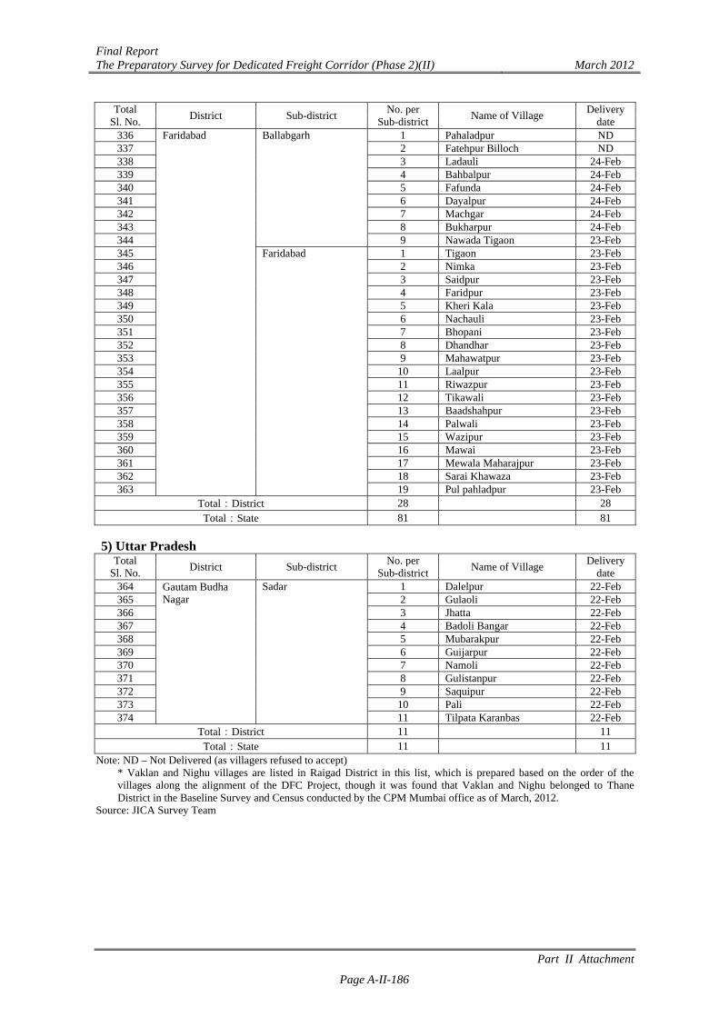
336 Faridabad Ballabgarh 1 Pahaladpur ND 337 2 Fatehpur Billoch ND 338 3 Ladauli 24-Feb 339 4 Bahbalpur 24-Feb 340 5 Fafunda 24-Feb 341 6 Dayalpur 24-Feb 342 7 Machgar 24-Feb 343 8 Bukharpur 24-Feb 344 9 Nawada Tigaon 23-Feb 345 Faridabad 1 Tigaon 23-Feb 346
2 Nimka 23-Feb 347 3 Saidpur 23-Feb 348 4 Faridpur 23-Feb 349 5 Kheri Kala 23-Feb 350 6 Nachauli 23-Feb 351 7 Bhopani 23-Feb 352 8 Dhandhar 23-Feb 353 9 Mahawatpur 23-Feb 354 10 Laalpur 23-Feb 355 11 Riwazpur 23-Feb 356 12 Tikawali 23-Feb 357 13 Baadshahpur 23-Feb 358 14 Palwali 23-Feb 359 15 Wazipur 23-Feb 360 16 Mawai 23-Feb 361 17 Mewala Maharajpur 23-Feb 362 18 Sarai Khawaza 23-Feb 363 19 Pul pahladpur 23-Feb
Total:District 28 28 Total:State 81 81
5) Uttar Pradesh
Total Sl. No.
District Sub-district No. per
Sub-districtName of Village
Delivery date
364 Gautam Budha Nagar
Sadar 1 Dalelpur 22-Feb 365 2 Gulaoli 22-Feb 366 3 Jhatta 22-Feb 367 4 Badoli Bangar 22-Feb 368 5 Mubarakpur 22-Feb 369 6 Guijarpur 22-Feb 370 7 Namoli 22-Feb 371 8 Gulistanpur 22-Feb 372 9 Saquipur 22-Feb 373 10 Pali 22-Feb 374 11 Tilpata Karanbas 22-Feb
Total:District 11 11 Total:State 11 11
Note: ND – Not Delivered (as villagers refused to accept) * Vaklan and Nighu villages are listed in Raigad District in this list, which is prepared based on the order of the villages along the alignment of the DFC Project, though it was found that Vaklan and Nighu belonged to Thane District in the Baseline Survey and Census conducted by the CPM Mumbai office as of March, 2012.
Source: JICA Survey Team

PART III
Final Report The Preparatory Survey for Dedicated Freight Corridor (Phase 2)(II) March 2012
Part III Attachment Page A-III-1
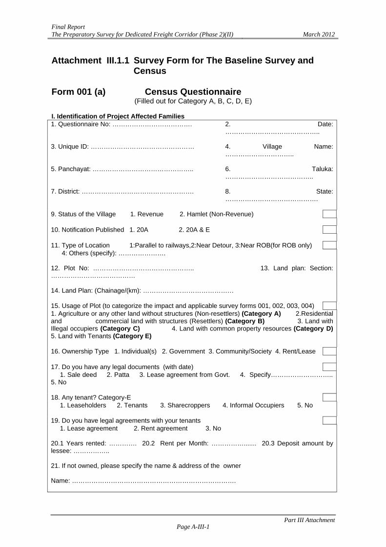
Attachment III.1.1 Survey Form for The Baseline Survey and Census
Form 001 (a) Census Questionnaire
(Filled out for Category A, B, C, D, E) I. Identification of Project Affected Families 1. Questionnaire No: ………………………………. 2. Date:
…………………………………….. 3. Unique ID: ………………………………………… 4. Village Name:
………………………….. 5. Panchayat: ……………………………………….. 6. Taluka:
………………………………….. 7. District: ……………………………………………. 8. State:
……………………………………. 9. Status of the Village 1. Revenue 2. Hamlet (Non-Revenue) 10. Notification Published 1. 20A 2. 20A & E 11. Type of Location 1:Parallel to railways,2:Near Detour, 3:Near ROB(for ROB only) 4: Others (specify): …………………. 12. Plot No: ……………………………………….. 13. Land plan: Section: ………………………………… 14. Land Plan: (Chainage/(km): …………………………………… 15. Usage of Plot (to categorize the impact and applicable survey forms 001, 002, 003, 004) 1. Agriculture or any other land without structures (Non-resettlers) (Category A) 2.Residential and commercial land with structures (Resettlers) (Category B) 3. Land with Illegal occupiers (Category C) 4. Land with common property resources (Category D) 5. Land with Tenants (Category E) 16. Ownership Type 1. Individual(s) 2. Government 3. Community/Society 4. Rent/Lease 17. Do you have any legal documents (with date) 1. Sale deed 2. Patta 3. Lease agreement from Govt. 4. Specify……………………….. 5. No 18. Any tenant? Category-E 1. Leaseholders 2. Tenants 3. Sharecroppers 4. Informal Occupiers 5. No 19. Do you have legal agreements with your tenants 1. Lease agreement 2. Rent agreement 3. No 20.1 Years rented: …………. 20.2 Rent per Month: ……………....... 20.3 Deposit amount by lessee: …………….. 21. If not owned, please specify the name & address of the owner Name: ………………………………………………………………….
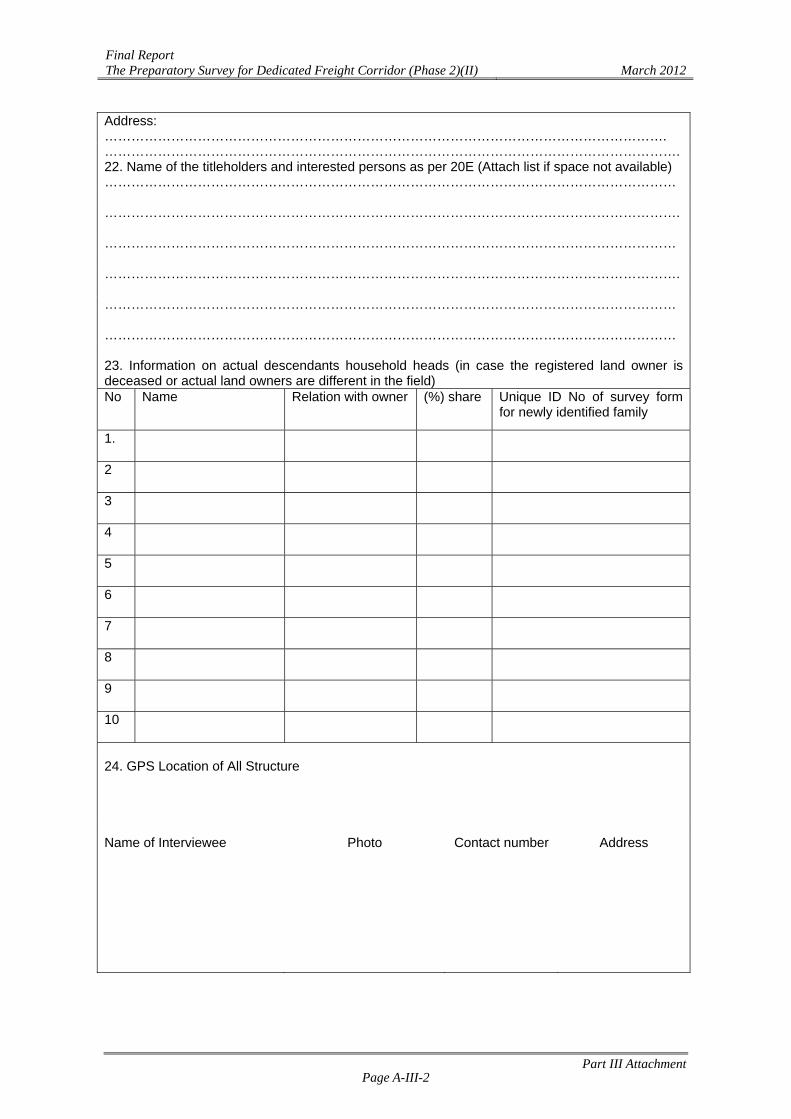
Final Report The Preparatory Survey for Dedicated Freight Corridor (Phase 2)(II) March 2012
Part III Attachment Page A-III-2
Address: ………………………………………………………………………………………………………………. ………………………………………………………………………………………………………………….22. Name of the titleholders and interested persons as per 20E (Attach list if space not available) ………………………………………………………………………………………………………………… …………………………………………………………………………………………………………………. ………………………………………………………………………………………………………………… …………………………………………………………………………………………………………………. ………………………………………………………………………………………………………………… ………………………………………………………………………………………………………………… 23. Information on actual descendants household heads (in case the registered land owner is deceased or actual land owners are different in the field) No Name Relation with owner (%) share Unique ID No of survey form
for newly identified family
1.
2
3
4
5
6
7
8
9
10
24. GPS Location of All Structure Name of Interviewee Photo Contact number Address
Part III A
ttachment
Page A
-III-3
Final R
eport T
he Preparatory Survey for D
edicated Freight C
orridor (Phase 2)(II)
March 2012
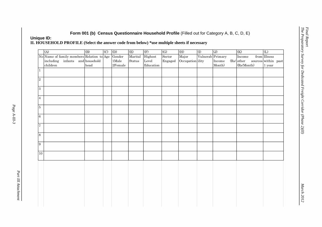
Form 001 (b) Census Questionnaire Household Profile (Filled out for Category A, B, C, D, E)
Unique ID: II. HOUSEHOLD PROFILE (Select the answer code from below) *use multiple sheets if necessary
(A) (B) (C) (D) (E) (F) (G) (H) (I) (J) (K) (L)No Name of family members
including infants andchildren
Relation tohouseholdhead
Age Gender1Male2Female
MaritalStatus
HighestLevelEducation
SectorEngaged
MajorOccupation
Vulnerability
PrimaryIncome (Rs/Month)
Income fromother sources(Rs/Month)
Illnesswithin past1 year
10
9
8
7
6
5
4
3
2
1
Part III A
ttachment
Page A
-III-4
Final R
eport T
he Preparatory Survey for D
edicated Freight C
orridor (Phase 2)(II)
March 2012
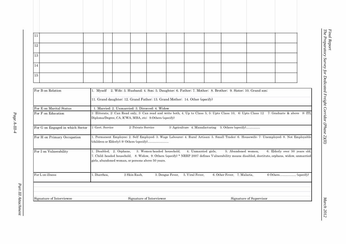
15
14
13
12
11
1. Myself 2. Wife; 3. Husband; 4. Son; 5. Daughter; 6. Father; 7. Mother; 8. Brother; 9. Sister; 10. Grand son;
11. Grand daughter; 12. Grand Father; 13. Grand Mother; 14. Other (specify)
For E on Marital Status 1. Married; 2. Unmarried; 3. Divorced; 4. WidowFor F on Education 1: Illiterate, 2: Can Read only, 3: Can read and write both, 4. Up to Class 5, 5: Upto Class 10, 6: Upto Class 12 7: Graduate & above 8: ITI,
Diploma/Degree, CA, ICWA, MBA, etc; 9.Others (specify)
For G on Engaged in which Sector 1: Govt. Service 2: Private Service 3: Agriculture 4. Manufacturing 5. Others (specify)…………..
For H on Primary Occupation 1. Permanent Employee; 2. Self Employed; 3. Wage Labourer; 4. Rural Artisan; 5. Small Trader; 6. Housewife; 7: Unemployed; 8. Not Employable(children or Elderly); 9: Others (specify)………………...
For I on Vulnerability 1. Disabled, 2. Orphans, 3. Women-headed household, 4. Unmarried girls, 5. Abandoned women, 6. Elderly over 50 years old,7. Child-headed household, 8. Widow, 9. Others (specify) * NRRP 2007 defines Vulnerability means disabled, destitute, orphans, widow, unmarriedgirls, abandoned woman, or persons above 50 years.
For L on illness 1. Diarrhea, 2 Skin Rash, 3. Dengue Fever, 5. Viral Fever, 6. Other Fever, 7. Malaria, 6 Others……………. (specify)
For B on Relation
Signature of Interviewee Signature of Interviewer Signature of Supervisor
Part III A
ttachment
Page A
-III-5
Final R
eport T
he Preparatory Survey for D
edicated Freight C
orridor (Phase 2)(II)
March 2012
Form 002 Asset Inventory (Filled out for Category A, B, C, D, E) * use multiple sheets if necessary. Unique ID: I. Land likely to be Lost Select one: Owner / Tenant
(A) (B) (C) (D) (E) (G) (I) (J) (K) (L) (M) (N)
Type ofLand
Ownershipof the land
Period ofyears ofOwnership
Total Area(in ha)
EstimatedMarketValue forLand (Rs)*
If rented,monthlyrent (Rs./Month)
Net AnnualProduction ifany standingcrops(kg/yr/crop)
Estimatedmarket valuefor crops(Rs/kg/crop)*
Type ofTrees
Number ofTrees
Age ofTrees
EstimatedMarketValue fortrees(Rs./Tree)*
No Type Rabi Khariff
18
17
16
15
14
13
12
11
10
9
8
7
6
5
4
3
2
1
No (F) (H)
No. & Land use /ownership pattern
Name of Major Crops(Max. 3)
Part III A
ttachment
Page A
-III-6
Final R
eport T
he Preparatory Survey for D
edicated Freight C
orridor (Phase 2)(II)
March 2012
(A) (B) (C) (D) (E) (G) (I) (J) (K) (L) (M) (N)
Type ofLand
Ownershipof the land
Period ofyears ofOwnership
Total Area(in ha)
EstimatedMarketValue forLand (Rs)*
If rented,monthlyrent (Rs./Month)
Net AnnualProductionif anystandingcrops(kg/yr/crop)
Estimatedmarket valuefor crops(Rs/kg/crop)*
Type ofTrees
Number ofTrees
Age ofTrees
EstimatedMarketValue fortrees(Rs./Tree)*
No Type Rabi Khariff
23
22
21
20
19
No (F) (H)
No. & Land use /ownership pattern
Name of Major Crops(Max. 3)
1. Agriculture – Irrigated 2. Agriculture Un-irrigated 3. Residential 4. Commercial 5. Industrial 6. Grazing land 7. Forest Land 8. Mixed (specify) 9. Barren Land
10. Others (specify):
B. Ownership 1: Self-owned 2: State-owned land for rental 3: Private-owned land for rental or borrow 4: Group or Community owned 5: Uncertain ownership 6: Illegal landoccupation
F. No. & Land use /ownership pattern
1. Registered Lessees 2. Contract Cultivator 3. Lease Holder 4. Unregistered Tenant 5. Share Croppers 6. Others (Specify)
K. Type of Trees 1. Fruit and fodder tree, 2. Firewood and timber wood
Khariff: 1. Rice 2. Sugarcane 3. Maize 4. Ground nut 5. Chillies 6. Bajra 7. Jawar 8. Other Pulses 9. Vegetables 10. Cotton 11 Tobacco 12. Others…..
Rabi: 11. Wheat 12. Barley 13. Gram 14. Onion 15. Oilseed 16. Cereals 17. Massar 18. Barseen 19. Tur 20. Methi 21. Others….
A. Type of Land
H. Major Crops

Part III A
ttachment
Page A
-III-7
Final R
eport T
he Preparatory Survey for D
edicated Freight C
orridor (Phase 2)(II)
March 2012
II. Structures Likely to Be Lost Select one: Owner / Tenant
No
(A) (B) (C) (D) (E) (F) (G) (H) (I) (J)
Type of Structure
Ownership of structures
Total Area in sq. mt.
Affected area in sq.
mt Age
No. & Type of Losses
No. Type
Type of construction
Type of Materials
Estimated Market Value for
Structure (Rs)*
If rented, monthly rent (Rs)
1
2
3
4
5
6
7
8
9
10
11
12
13
14
15
Part III A
ttachment
Page A
-III-8
Final R
eport T
he Preparatory Survey for D
edicated Freight C
orridor (Phase 2)(II)
March 2012
No
(A) (B) (C) (D) (E) (F) (G) (H) (I) (J)
Type of Structure
Ownership of structures
Total Area in sq. mt.
Affected area in sq.
mt Age
No. & Type of Losses
No. Type
Type of construction
Type of Materials
Estimated Market Value for
Structure (Rs)*
If rented, monthly rent (Rs)
16
17
18
19
20
* Estimated market value will be collected from the interviewee for a reference purpose. For A on Type of Affected Structures
[Private Residential] 1. Residence 2. House Fence 3.Separate Kitchen 4. Toilet 5. Bathroom 6.. Storage 7. Farm House 8. Animal Shed 9. Paddock fence 10. Well, 11.Water tank 12.Others (specify) [Private Enterprises] 13. Shop 14. Workshops 15. Stalls 16. Factories 17. Other business establishment (specify, e.g Restaurants, Dhabas etc.)
For B on Ownership 1:Self-owned 2: State-owned structure for rental 3: Private-owned house for rental or borrow 4: Group- or Community-owned 5: Uncertain ownership, 6: Illegal Occupants
For F No. and Type of Losses
1. Registered Lessees, 2. Tenant, 3. Others (Specify)
For G on Type of Construction
1: Single detached one‐storey 2: Single detached two‐storey 3: Single detached three‐storey or more 4: Apartment/Row house duplex 5: Shanties connected to each other 6: Tents or tentative simple hut
For H on Type of materials
Roof] R1: G.I. sheets R2: Tiles R3: Nipa or other natural materials R4: Concrete R5: Others (specify) [Wall] W1: All concrete W2: Concrete and wood W3: All wood W4: Nipa or other natural materials W5: Others (specify)
Name and Signature of Interviewee: Name and Signature of Interviewer: Name and Signature of Supervisor:
Part III A
ttachment
Page A
-III-9
Final R
eport T
he Preparatory Survey for D
edicated Freight C
orridor (Phase 2)(II)
March 2012
Form 003 Asset Inventory (Filled out for Category D Community Property) * conduct the survey by village-wise and use multiple sheets if necessary.
Unique ID: I. Common Property / Public Property
(A) (B) (C) (D) (E) (F) (G) (H) (I) (J) (K) (L)
No Name of Property
Type of Common Property /
Public property
Number of Properties
Ownership of the Property
Type of Impact
Affected Size of the Property (area per floor)
If partially affected, total
size of the property (areas
per floor)
Age of the property
No. of Floors
Type of Construction
Type of Materials
Estimated Value of Affected
Property (Rs)*
1
2
3
4
5
6
7
8
9
10
11
12
13
14
* Estimated market value will be collected from the interviewee for a reference purpose.

Part III A
ttachment
Page A
-III-10
Final R
eport T
he Preparatory Survey for D
edicated Freight C
orridor (Phase 2)(II)
March 2012
Answer Options for the Previous Table For B. Type of Common / Public Properties
[Common Land] 1. Village Common Land 2. Forest Woodland 3.Pasture 4. Fishing Area 5.Land for traditional tribal institutions [Common / Public Structures/Asset] 1. Community Centres 2. Roads 3. Bridge 4.Public Transport Facility (e.g. Bus shelters) 5. Irrigation & Drainage channels 6. Water & Sewerage Lines 7. Wells/Tube wells/Hand Pumps /Domestic Water 8. Livestock Watering Point 9. Bathing & Washing Platform 10. Community Ponds 11. Fair Price shops 12. Panchayat buildings 13. Cooperative Societies 14. Seed cum fertilizer storage 15. Post Offices 16. Bank 17. Electricity line 18. Transmission tower 19. Electricity Pole 20. Telephone Line 21. Base Transceiver Station 22. Schools 23. Health Centre/hospitals 24. Places of Worship 25. Burial/cremation grounds 26. Historical Places 27. Trees (specify) 28. Others (specify)
For D. Type of Ownership
1. Panchayat 2. Group of Society 3. Association 4. Individual Family 5. Government (specify department)………….. 6. Other (Specify)……………………….
For E. Type of Affected Property
1. Fully affected (needs to be relocated) 2.Partially Affected (no relocation) 3. Others (specify)……………………
For J Type of Construction
1. Permanent, 2. Semi Permanent, 3.Temporary
For K Type of Materials
[Roof] R1. G.I. Sheet, R2. Tiles R3. Nipa or Other Natural Materials R4. Concrete R5. Others (Specify)………………. [Wall] W1. All Concrete W2. Concrete & Wood, W3. All Wood, W4. Nipa or other Natural Materials W5. Others (Specify)…………………
II. Open Question to Village Head/ Community Leader/ Influential Persons Where do you want to re-construct this facility?
Name and Signature of Interviewer: Name and Signature of Interviewer: Name and Signature of Supervisor:
Final Report The Preparatory Survey for Dedicated Freight Corridor (Phase 2)(II) March 2012
Part III Attachment Page A-III-11
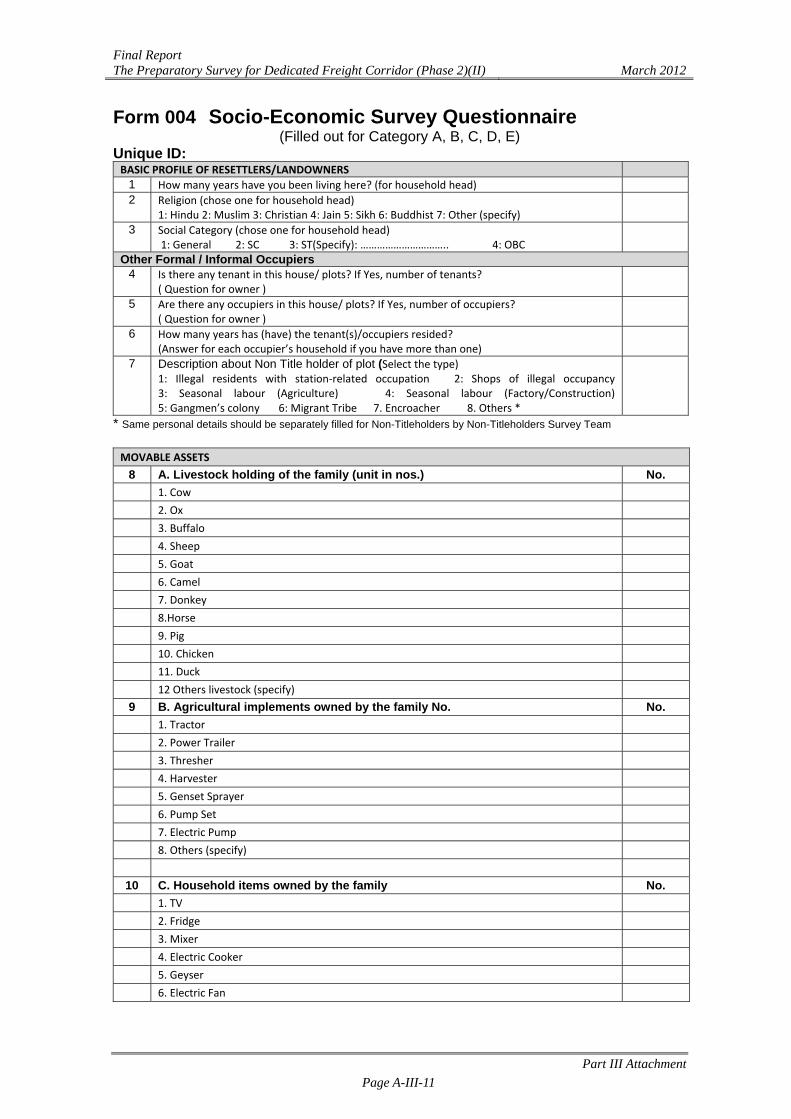
Form 004 Socio-Economic Survey Questionnaire (Filled out for Category A, B, C, D, E)
Unique ID: BASIC PROFILE OF RESETTLERS/LANDOWNERS
1 How many years have you been living here? (for household head) 2 Religion (chose one for household head)
1: Hindu 2: Muslim 3: Christian 4: Jain 5: Sikh 6: Buddhist 7: Other (specify)
3 Social Category (chose one for household head) 1: General 2: SC 3: ST(Specify): ………………………….. 4: OBC
Other Formal / Informal Occupiers 4 Is there any tenant in this house/ plots? If Yes, number of tenants?
( Question for owner )
5 Are there any occupiers in this house/ plots? If Yes, number of occupiers? ( Question for owner )
6 How many years has (have) the tenant(s)/occupiers resided? (Answer for each occupier’s household if you have more than one)
7 Description about Non Title holder of plot (Select the type) 1: Illegal residents with station‐related occupation 2: Shops of illegal occupancy 3: Seasonal labour (Agriculture) 4: Seasonal labour (Factory/Construction) 5: Gangmen’s colony 6: Migrant Tribe 7. Encroacher 8. Others *
* Same personal details should be separately filled for Non-Titleholders by Non-Titleholders Survey Team MOVABLE ASSETS
8 A. Livestock holding of the family (unit in nos.) No. 1. Cow 2. Ox 3. Buffalo 4. Sheep 5. Goat 6. Camel 7. Donkey 8.Horse 9. Pig 10. Chicken 11. Duck 12 Others livestock (specify)
9 B. Agricultural implements owned by the family No. No. 1. Tractor 2. Power Trailer 3. Thresher 4. Harvester 5. Genset Sprayer 6. Pump Set 7. Electric Pump 8. Others (specify)
10 C. Household items owned by the family No. 1. TV 2. Fridge 3. Mixer 4. Electric Cooker 5. Geyser 6. Electric Fan
Final Report The Preparatory Survey for Dedicated Freight Corridor (Phase 2)(II) March 2012
Part III Attachment Page A-III-12
7. Oven Toaster Grill (OTG) 8. Toaster 9. Microwave 10. Radio 11. Gas Chullah 12. Kerosene Chullah 13. Grain storing facilities 14. Others (specify)
11 D. Other assets owned by the family No. 1 Cycle 2 Scooter / Motor cycle 3 Three wheeler 4 Jeep / Car 5 Truck 6 Bus 7 Bullock / Camel Cart
8 Others (specify) 12.HOUSEHOLD INCOME
Source of Income
Average Monthly/Annual Income (Rs.)
(1) Monthly Regular Income
(2) Annual Seasonal Income
Total Annual Income= (1)x12+(2)
a. Agriculture
b. Wage Labour
c. Business/Trading
d. Service Sector
e. Livestock & Animal Husbandry
f. Fishing & Aquaculture
g. Artisan / Cottage Craft
h. Forestry
i. Others (specify)……………..
Total Income
13. HOUSEHOLD EXPENDITURE
Type of Expenditure Average Expenditure (Rs.)
Monthly Yearly Total = (1)x12+(2)
a. Food b. Cooking Fuel c. Rent d. Drinking Water e. Domestic Water f. Electricity g. Transportation h. Agriculture Expenditure (seeds, agrochemicals, labour)
i. Education j. Health k. Communication l. Social Functions m. Clothing n. Loan repayment o. Other (specify) Total Expenditure
Final Report The Preparatory Survey for Dedicated Freight Corridor (Phase 2)(II) March 2012
Part III Attachment Page A-III-13
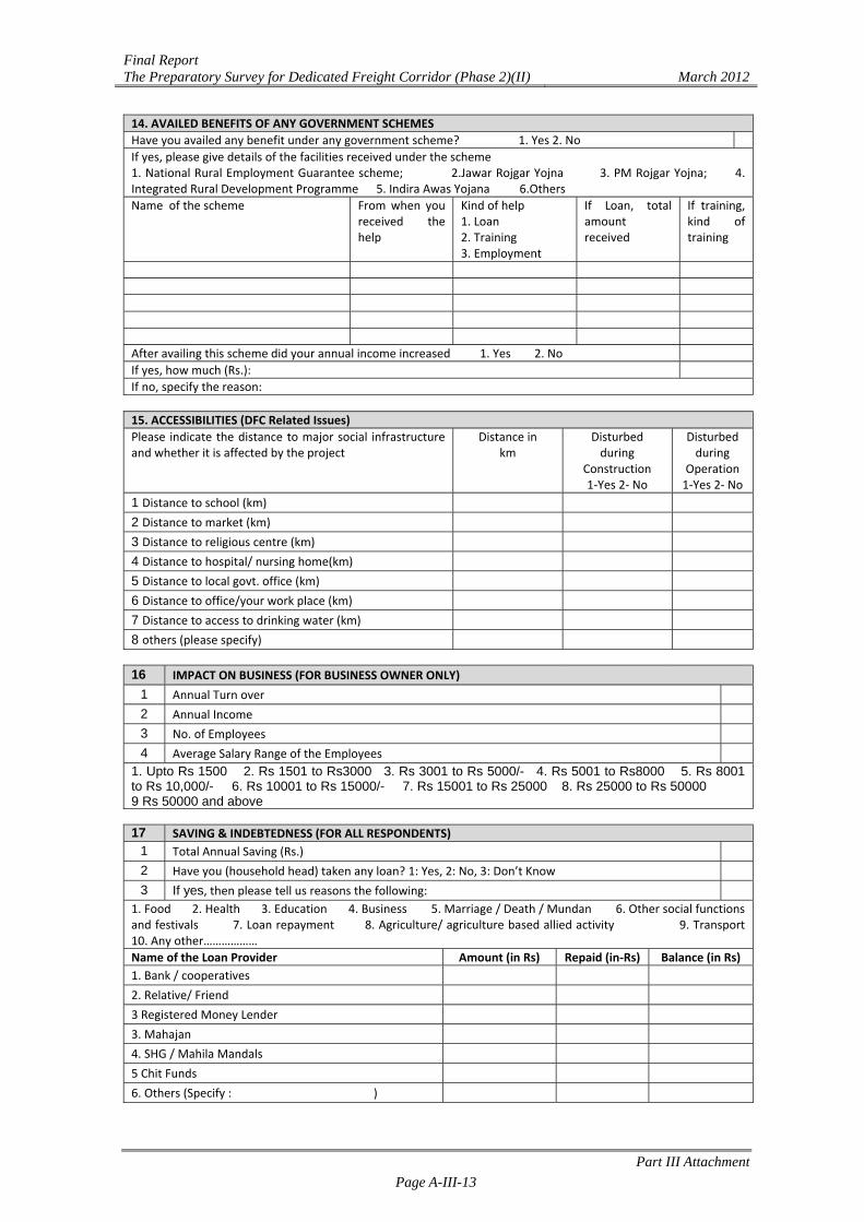
14. AVAILED BENEFITS OF ANY GOVERNMENT SCHEMES
Have you availed any benefit under any government scheme? 1. Yes 2. No
If yes, please give details of the facilities received under the scheme 1. National Rural Employment Guarantee scheme; 2.Jawar Rojgar Yojna 3. PM Rojgar Yojna; 4. Integrated Rural Development Programme 5. Indira Awas Yojana 6.Others
Name of the scheme From when you received the help
Kind of help 1. Loan 2. Training 3. Employment
If Loan, total amount received
If training, kind of training
After availing this scheme did your annual income increased 1. Yes 2. No
If yes, how much (Rs.):
If no, specify the reason:
15. ACCESSIBILITIES (DFC Related Issues)
Please indicate the distance to major social infrastructure and whether it is affected by the project
Distance in km
Disturbed during
Construction 1‐Yes 2‐ No
Disturbed during
Operation 1‐Yes 2‐ No
1 Distance to school (km)
2 Distance to market (km)
3 Distance to religious centre (km)
4 Distance to hospital/ nursing home(km)
5 Distance to local govt. office (km)
6 Distance to office/your work place (km)
7 Distance to access to drinking water (km)
8 others (please specify)
16 IMPACT ON BUSINESS (FOR BUSINESS OWNER ONLY)
1 Annual Turn over 2 Annual Income 3 No. of Employees 4 Average Salary Range of the Employees
1. Upto Rs 1500 2. Rs 1501 to Rs3000 3. Rs 3001 to Rs 5000/- 4. Rs 5001 to Rs8000 5. Rs 8001 to Rs 10,000/- 6. Rs 10001 to Rs 15000/- 7. Rs 15001 to Rs 25000 8. Rs 25000 to Rs 50000 9 Rs 50000 and above 17 SAVING & INDEBTEDNESS (FOR ALL RESPONDENTS)
1 Total Annual Saving (Rs.) 2 Have you (household head) taken any loan? 1: Yes, 2: No, 3: Don’t Know 3 If yes, then please tell us reasons the following:
1. Food 2. Health 3. Education 4. Business 5. Marriage / Death / Mundan 6. Other social functions and festivals 7. Loan repayment 8. Agriculture/ agriculture based allied activity 9. Transport 10. Any other……………… Name of the Loan Provider Amount (in Rs) Repaid (in‐Rs) Balance (in Rs)
1. Bank / cooperatives
2. Relative/ Friend
3 Registered Money Lender
3. Mahajan
4. SHG / Mahila Mandals
5 Chit Funds
6. Others (Specify : )
Final Report The Preparatory Survey for Dedicated Freight Corridor (Phase 2)(II) March 2012
Part III Attachment Page A-III-14
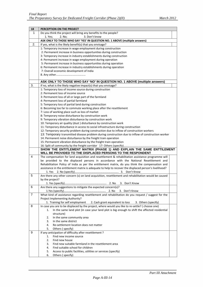
18 PERCEPTION ON THE PROJECT 1 Do you think the project will bring any benefits to the people?
1. Yes; 2. No; 3. Don’t know ASK ONLY TO THOSE WHO SAY ‘YES’ IN QUESTION NO. 1 ABOVE (multiple answers)
2. If yes, what is the likely benefit(s) that you envisage?
1: Temporary increase in wage employment during construction 2: Permanent increase in business opportunities during construction 3: Temporary increase in industry establishments during construction 4: Permanent increase in wage employment during operation 5: Permanent increase in business opportunities during operation 6: Permanent increase in industry establishments during operation 7: Overall economic development of India 8. Any other……………………………………
ASK ONLY TO THOSE WHO SAY ‘NO’ IN QUESTION NO. 1 ABOVE (multiple answers) 3. If no, what is the likely negative impact(s) that you envisage? 1: Temporary loss of income source during construction
2: Permanent loss of income source 3: Permanent loss of all or large part of the farmland 4: Permanent loss of partial farmland 5: Temporary loss of partial land during construction 6: Becoming too far to commute working place after the resettlement 7: Loss of working place such as loss of market 8: Temporary noise disturbance by construction work 9: Temporary vibration disturbance by construction work 10: Temporary air quality (dust ) disturbance by construction work 11: Temporary disturbance in access to social infrastructure during construction 12: Temporary security problem during construction due to inflow of construction workers 13: Temporary transmitted disease problem during construction due to inflow of construction worker 14: Permanent noise disturbance by the freight train operation 15: Permanent vibration disturbance by the freight train operation 16: Split of community by the freight corridor 17: Others (specify)………………………………………………
SHOW THE ENTITLEMENT MATRIX (PHASE 1) AND EXPLAIN THE SAME ENTTILEMENT WILL BE PROVIDED TO THE DISPLACED PERSONS TO THE RESPONDENT
4 The compensation for land acquisition and resettlement & rehabilitation assistance programme will be provided to the displaced persons in accordance with the National Resettlement and Rehabilitation Policy of India as per the entitlement matrix, do you think the compensation and assistance in the entitlement matrix is adequate to help to recover the displaced person’s livelihood? 1. Yes 2. No (specify)…………………………………………………….. 3. Don’t Know
5 Are there any other concern (s) on land acquisition, resettlement and rehabilitation would be caused by the project? 1. Yes (specify)………………………………………………….. 2. No 3. Don’t Know
6 Are there any suggestions to mitigate the expected concern(s)? 1.Yes (specify)………………………………………………….. 2. No 3. Don’t Know
7 What kind of assistance regarding resettlement and rehabilitation do you request / suggest for the Project Implementing Authority? 1. Training for self employment 2. Cash grant equivalent to loss 3. Others (specify)
8 In case you are to be displaced by the project, where would you like to re‐settle? ( choose one) 1. In the same land plot (in case your land plot is big enough to shift the affected residential
structure) 2. In the same community area 3. In the same district 4. Re‐settlement location does not matter 5. Others ( specify)
9 If any anticipation of difficulty after resettlement ? 1. Find new income source 2. Find new house 3. Find new suitable farmland in the resettlement area 4. Find suitable school for children 5. Access to public facilities, utilities or services (specify) 6. Others ( specify)
Final Report The Preparatory Survey for Dedicated Freight Corridor (Phase 2)(II) March 2012
Part III Attachment Page A-III-15
Name and Signature of Interviewee: Name and Signature of Interviewer: Name and Signature of Supervisor:
Final Report The Preparatory Survey for Dedicated Freight Corridor (Phase 2)(II) March 2012
Part III Attachment Page A-III-16
Attachment III.1.2 Summary of Baseline Survey and Census Report
1.1 INTRODUCTION
As phased implementation of the DFC project, DFC sections at both ends of the proposed railway, namely JNPT-Vadodara and Rewari–Dadri sections were determined as a second priority section under the Feasibility Study of the Development of Dedicated Freight Corridor for Delhi-Mumbai and Ludhiana-Sonnagar in India in 2006 and 2008. The JICA Survey Team has engaged DHI (India) Water & Environment Pvt Ltd, New Delhi as a local consultant to undertake the Baseline Survey and Census from Vadodara-JNPT and Rewari-Dadri; covering 5 states – Maharashtra, Gujarat, Rajasthan, Haryana and Uttar Pradesh. The total length of the alignment is approximately 565 km.
1.2 SCOPE OF THE WORK Brief Scopes of the Work for the survey are as follows: To establish a baseline for the project-affected persons (PAPs); To get all the information of demographic profile; To identify the vulnerable sections and individuals of the affected population; To identify the estimated expenditure and indebtedness of the households; To assess the ownership of land holding pattern and its use related particulars; To estimate the households production from the land in the project vicinity; To assess the extent of possession of immovable assets; To assess their dependence on local resources; To identify the households who do not reside in the area but derive their income from
land in the project area; and To assess the ethnic minority of the PAPs.
1.3 SUMMARY OF BASELINE SURVEY AND CENSUS The Baseline Survey and Census of the project-affected households was conducted to obtain the information of social economic status of the affected households, details regarding affected land plots and structures & common property resources, etc. The study has been carried out based on Land Plan and Notification 20A & 20E including various draft 20E (so called the list of PAPs, Joint Measurement List) which were readily available with DFCCIL. The district wise survey & re-survey schedule is presented in Table-1.1.

Final Report The Preparatory Survey for Dedicated Freight Corridor (Phase 2)(II) March 2012
Part III Attachment Page A-III-17
Table-1.1 District wise Survey Schedule Sl. No. District/ Section Survey Schedule Remarks
Vadodara-JNPT Section 1. Raigad 01/09/2011 to 11/10/2011 Survey carried out by CRADLE
2. Thane 15/12/2010 to 04/02/2012 Partly done by CRADLE
3. Valsad 31/11/2010 to 15/05/2011 -
4. Navsari 01/12/2010 to 15/05/2011 -
5. Surat 15/11/2010 to 07/09/2011 -
6. Bharuch 01/12/2010 to 20/09/2011 -
7. Vadodara 15/11/2010 to 15/03/2011
Rewari-Dadri Section
8. Rewari 12/02/2011 to 10/03/2011
9. Alwar 01/03/2011 to 30/03/2011 -
10. Mewat 01/04/2011 to 08/09/2011 -
11. Gurgaon 03/03/2011 to 09/04/2011 -
12. Palwal 01/02/2011 to 25/09/2011 -
13. Faridabad 07/03/2011 to 15/02/2012 4 villages are not covered
14. Gautam Budh Nagar 05/03/2011 to 12/12/2011
Source: Field Survey Data Total number of districts in Vadodara-JNPT and Rewari-Dadri Sections are 14; out of which Baseline Survey and Census have been completed in all districts except Faridabad district where the survey has been partially completed. In Faridabad, the survey was refused in 4 villages due to intervention by the local politician. As of 7th, March 2012, the survey has been completed in remaining 13 districts; however, several plots/households have remained uncovered due to the absence of respective titleholders at the time of the survey and/or their refusal to participate in the survey.
Sl. No.
District Village not Surveyed Remarks
1 Faridabad Pahaladpur, Fatehpur Billoch, Ladauli, and Bahbalpur (4 villages)
Intervention/influence of the local politician
Total 1 district 4 villages -
Note: Two plots in Bahbalpur (out of total 34 plots) have been surveyed.
1.3.1 Affected Plot Numbers & Area
In the surveyed districts total number of affected villages is 374. Total number of affected plots in these 374 villages is 8,776. As presented in Note in the below table, the survey was carried out based on Joint Measurement list and/or PAP list in several districts where (draft) 20E Notifications were not available. District wise total number of affected plots, affected plots as per 20A Notification and affected plots as per (draft) 20E Notification along with total affected area is presented in Table-1.2. Total 2,159.71 ha of land will be acquired for the DFC project as per the Notifications.
Table 1.2 District wise Number of Affected Plots & Affected Area
District Total No of
Village
Total No. of Affected Plot
as per 20A
Total Affected Area as per
20A (ha)
Total No. of Affected Plot as
per 20E/ Draft 20E
Total Affected Area as per 20E/Draft 20E (ha)2
Raigad 2 39 150 19.92 136 19.29 Thane, 2 97 1118 276.11 1588 373.21 Valsad 37 587 147.59 417 76.3 Navsari 22 476 60.98 461 92.16 Surat 35 642 326.38 641 160.59 Bharuch2 29 329 48.46 729 243.62
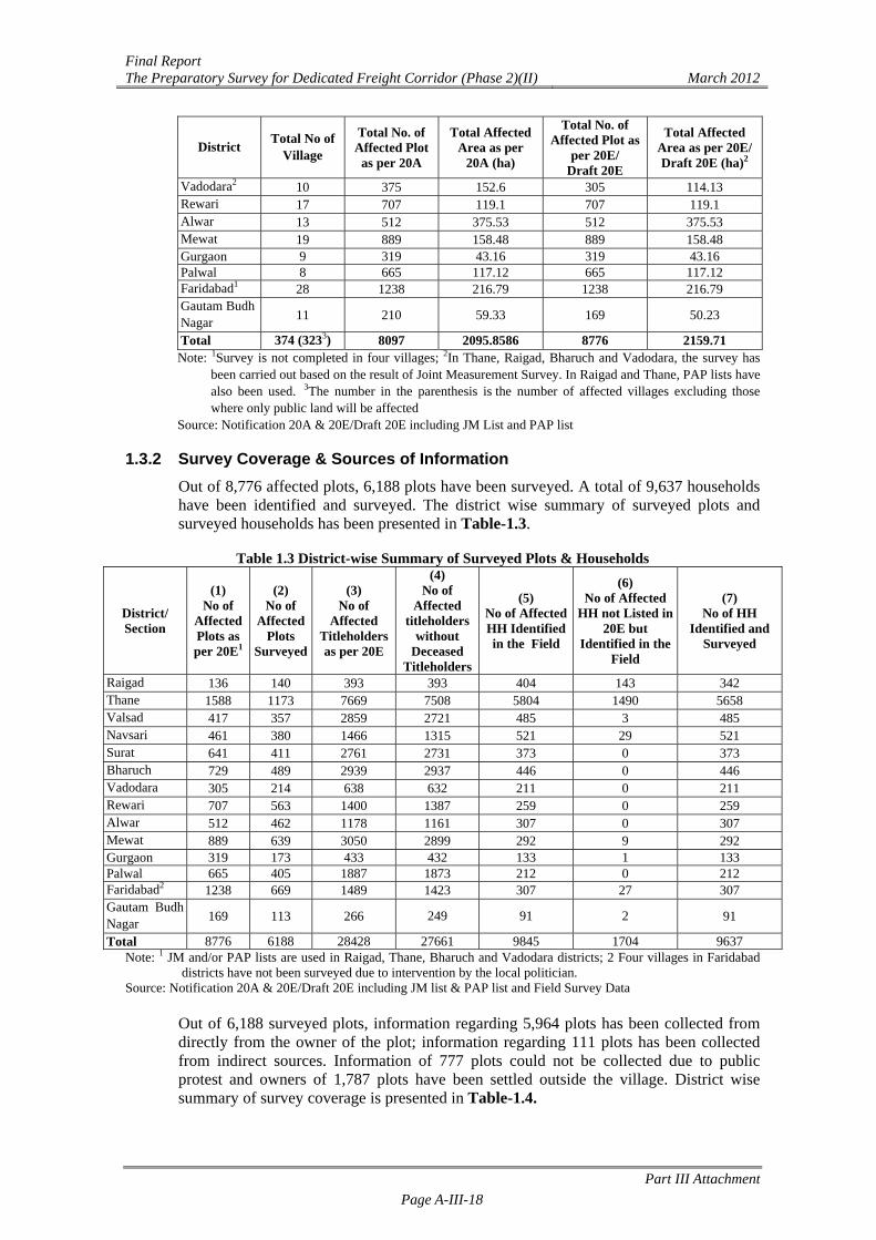
Final Report The Preparatory Survey for Dedicated Freight Corridor (Phase 2)(II) March 2012
Part III Attachment Page A-III-18
District Total No of
Village
Total No. of Affected Plot
as per 20A
Total Affected Area as per
20A (ha)
Total No. of Affected Plot as
per 20E/ Draft 20E
Total Affected Area as per 20E/Draft 20E (ha)2
Vadodara2 10 375 152.6 305 114.13 Rewari 17 707 119.1 707 119.1 Alwar 13 512 375.53 512 375.53 Mewat 19 889 158.48 889 158.48 Gurgaon 9 319 43.16 319 43.16 Palwal 8 665 117.12 665 117.12 Faridabad1 28 1238 216.79 1238 216.79 Gautam Budh Nagar
11 210 59.33 169 50.23
Total 374 (3233) 8097 2095.8586 8776 2159.71 Note: 1Survey is not completed in four villages; 2In Thane, Raigad, Bharuch and Vadodara, the survey has
been carried out based on the result of Joint Measurement Survey. In Raigad and Thane, PAP lists have also been used. 3The number in the parenthesis is the number of affected villages excluding those where only public land will be affected
Source: Notification 20A & 20E/Draft 20E including JM List and PAP list
1.3.2 Survey Coverage & Sources of Information Out of 8,776 affected plots, 6,188 plots have been surveyed. A total of 9,637 households have been identified and surveyed. The district wise summary of surveyed plots and surveyed households has been presented in Table-1.3.
Table 1.3 District-wise Summary of Surveyed Plots & Households
District/ Section
(1) No of
Affected Plots as per 20E1
(2) No of
Affected Plots
Surveyed
(3) No of
Affected Titleholders as per 20E
(4) No of
Affected titleholders
without Deceased
Titleholders
(5) No of Affected HH Identified in the Field
(6) No of Affected
HH not Listed in 20E but
Identified in the Field
(7) No of HH
Identified and Surveyed
Raigad 136 140 393 393 404 143 342 Thane 1588 1173 7669 7508 5804 1490 5658 Valsad 417 357 2859 2721 485 3 485 Navsari 461 380 1466 1315 521 29 521 Surat 641 411 2761 2731 373 0 373 Bharuch 729 489 2939 2937 446 0 446 Vadodara 305 214 638 632 211 0 211 Rewari 707 563 1400 1387 259 0 259 Alwar 512 462 1178 1161 307 0 307 Mewat 889 639 3050 2899 292 9 292 Gurgaon 319 173 433 432 133 1 133 Palwal 665 405 1887 1873 212 0 212 Faridabad2 1238 669 1489 1423 307 27 307 Gautam Budh Nagar
169 113 266 249 91 2 91
Total 8776 6188 28428 27661 9845 1704 9637 Note: 1 JM and/or PAP lists are used in Raigad, Thane, Bharuch and Vadodara districts; 2 Four villages in Faridabad
districts have not been surveyed due to intervention by the local politician. Source: Notification 20A & 20E/Draft 20E including JM list & PAP list and Field Survey Data
Out of 6,188 surveyed plots, information regarding 5,964 plots has been collected from directly from the owner of the plot; information regarding 111 plots has been collected from indirect sources. Information of 777 plots could not be collected due to public protest and owners of 1,787 plots have been settled outside the village. District wise summary of survey coverage is presented in Table-1.4.
Final Report The Preparatory Survey for Dedicated Freight Corridor (Phase 2)(II) March 2012
Part III Attachment Page A-III-19
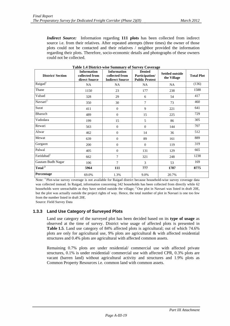
Indirect Source: Information regarding 111 plots has been collected from indirect source i.e. from their relatives. After repeated attempts (three times) the owner of those plots could not be contacted and their relatives / neighbor provided the information regarding their plots. Therefore, socio-economic details and photographs of these owners could not be collected.
Table 1.4 District-wise Summary of Survey Coverage
District/ Section Information
collected from direct Source
Information collected from
Indirect Source
Denied Participation/ Public Protest
Settled outside the Village
Total Plot
Raigad1 NA NA NA NA (136)
Thane 1150 23 177 238 1588
Valsad 328 29 6 54 417
Navsari2 350 30 7 73 460
Surat 411 0 9 221 641
Bharuch 489 0 15 225 729
Vadodara 199 15 5 86 305
Rewari 563 0 0 144 707
Alwar 462 0 14 36 512
Mewat 639 0 89 161 889
Gurgaon 200 0 0 119 319
Palwal 405 0 131 129 665
Faridabad1 662 7 321 248 1238
Gautam Budh Nagar 106 7 3 53 169
Total 2 5964 111 777 1787 8775
Percentage 69.0% 1.3% 9.0% 20.7%
Note: 1 Plot-wise survey coverage is not available for Raigad district because household-wise survey coverage data was collected instead. In Raigad, information concerning 342 households has been collected from directly while 62 households were unreachable as they have settled outside the village; 2 One plot in Navsari was listed in draft 20E, but the plot was actually outside the project rights of way. Hence, the total number of plot in Navsari is one too few from the number listed in draft 20E. Source: Field Survey Data
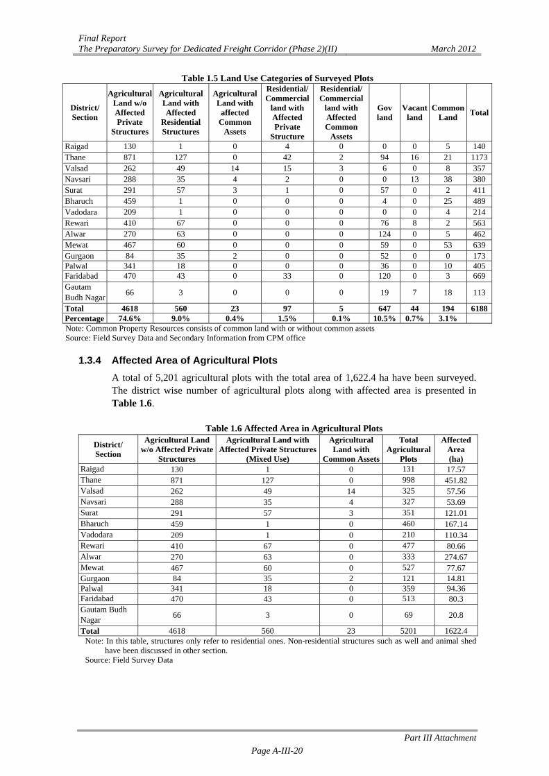
1.3.3 Land Use Category of Surveyed Plots
Land use category of the surveyed plot has been decided based on its type of usage as observed at the time of survey. District wise usage of affected plots is presented in Table 1.5. Land use category of 84% affected plots is agricultural; out of which 74.6% plots are only for agricultural use, 9% plots are agricultural & with affected residential structures and 0.4% plots are agricultural with affected common assets. Remaining 0.7% plots are under residential/ commercial use with affected private structures, 0.1% is under residential/ commercial use with affected CPR, 0.3% plots are vacant (barren land) without agricultural activity and structures and 1.9% plots as Common Property Resources i.e. common land with common assets.
Final Report The Preparatory Survey for Dedicated Freight Corridor (Phase 2)(II) March 2012
Part III Attachment Page A-III-20
Table 1.5 Land Use Categories of Surveyed Plots
District/ Section
Agricultural Land w/o Affected Private
Structures
Agricultural Land with Affected
Residential Structures
Agricultural Land with
affected Common
Assets
Residential/ Commercial
land with Affected Private
Structure
Residential/ Commercial
land with Affected Common
Assets
Gov land
Vacant land
Common Land
Total
Raigad 130 1 0 4 0 0 0 5 140Thane 871 127 0 42 2 94 16 21 1173Valsad 262 49 14 15 3 6 0 8 357Navsari 288 35 4 2 0 0 13 38 380Surat 291 57 3 1 0 57 0 2 411Bharuch 459 1 0 0 0 4 0 25 489Vadodara 209 1 0 0 0 0 0 4 214Rewari 410 67 0 0 0 76 8 2 563Alwar 270 63 0 0 0 124 0 5 462Mewat 467 60 0 0 0 59 0 53 639Gurgaon 84 35 2 0 0 52 0 0 173Palwal 341 18 0 0 0 36 0 10 405Faridabad 470 43 0 33 0 120 0 3 669Gautam Budh Nagar
66 3 0 0 0 19 7 18 113
Total 4618 560 23 97 5 647 44 194 6188Percentage 74.6% 9.0% 0.4% 1.5% 0.1% 10.5% 0.7% 3.1% Note: Common Property Resources consists of common land with or without common assets Source: Field Survey Data and Secondary Information from CPM office
1.3.4 Affected Area of Agricultural Plots
A total of 5,201 agricultural plots with the total area of 1,622.4 ha have been surveyed. The district wise number of agricultural plots along with affected area is presented in Table 1.6.
Table 1.6 Affected Area in Agricultural Plots
District/ Section
Agricultural Land w/o Affected Private
Structures
Agricultural Land with Affected Private Structures
(Mixed Use)
Agricultural Land with
Common Assets
Total Agricultural
Plots
Affected Area (ha)
Raigad 130 1 0 131 17.57 Thane 871 127 0 998 451.82 Valsad 262 49 14 325 57.56 Navsari 288 35 4 327 53.69 Surat 291 57 3 351 121.01 Bharuch 459 1 0 460 167.14 Vadodara 209 1 0 210 110.34 Rewari 410 67 0 477 80.66 Alwar 270 63 0 333 274.67 Mewat 467 60 0 527 77.67 Gurgaon 84 35 2 121 14.81 Palwal 341 18 0 359 94.36 Faridabad 470 43 0 513 80.3 Gautam Budh Nagar
66 3 0 69 20.8
Total 4618 560 23 5201 1622.4Note: In this table, structures only refer to residential ones. Non-residential structures such as well and animal shed
have been discussed in other section. Source: Field Survey Data
Final Report The Preparatory Survey for Dedicated Freight Corridor (Phase 2)(II) March 2012
Part III Attachment Page A-III-21
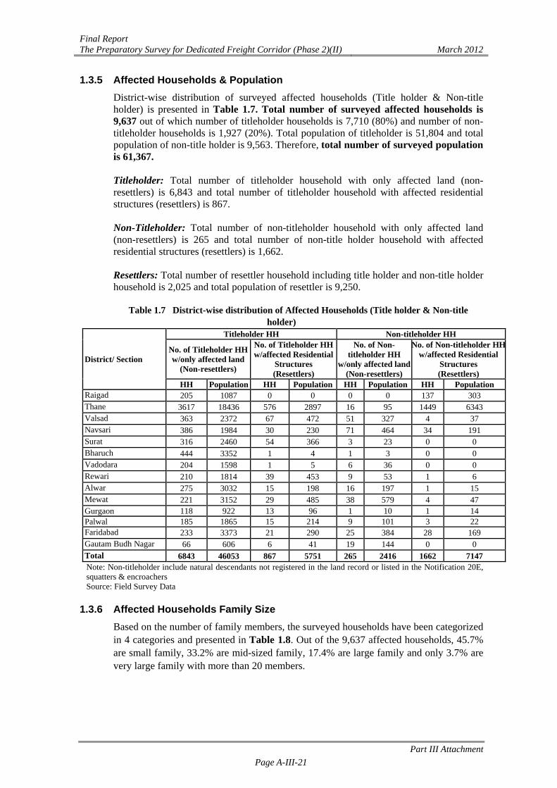
1.3.5 Affected Households & Population District-wise distribution of surveyed affected households (Title holder & Non-title holder) is presented in Table 1.7. Total number of surveyed affected households is 9,637 out of which number of titleholder households is 7,710 (80%) and number of non-titleholder households is 1,927 (20%). Total population of titleholder is 51,804 and total population of non-title holder is 9,563. Therefore, total number of surveyed population is 61,367. Titleholder: Total number of titleholder household with only affected land (non-resettlers) is 6,843 and total number of titleholder household with affected residential structures (resettlers) is 867. Non-Titleholder: Total number of non-titleholder household with only affected land (non-resettlers) is 265 and total number of non-title holder household with affected residential structures (resettlers) is 1,662. Resettlers: Total number of resettler household including title holder and non-title holder household is 2,025 and total population of resettler is 9,250.
Table 1.7 District-wise distribution of Affected Households (Title holder & Non-title holder)
District/ Section
Titleholder HH Non-titleholder HH
No. of Titleholder HH w/only affected land
(Non-resettlers)
No. of Titleholder HH w/affected Residential
Structures (Resettlers)
No. of Non-titleholder HH
w/only affected land (Non-resettlers)
No. of Non-titleholder HHw/affected Residential
Structures (Resettlers)
HH Population HH Population HH Population HH Population Raigad 205 1087 0 0 0 0 137 303 Thane 3617 18436 576 2897 16 95 1449 6343 Valsad 363 2372 67 472 51 327 4 37 Navsari 386 1984 30 230 71 464 34 191 Surat 316 2460 54 366 3 23 0 0 Bharuch 444 3352 1 4 1 3 0 0 Vadodara 204 1598 1 5 6 36 0 0 Rewari 210 1814 39 453 9 53 1 6 Alwar 275 3032 15 198 16 197 1 15 Mewat 221 3152 29 485 38 579 4 47 Gurgaon 118 922 13 96 1 10 1 14 Palwal 185 1865 15 214 9 101 3 22 Faridabad 233 3373 21 290 25 384 28 169 Gautam Budh Nagar 66 606 6 41 19 144 0 0 Total 6843 46053 867 5751 265 2416 1662 7147 Note: Non-titleholder include natural descendants not registered in the land record or listed in the Notification 20E, squatters & encroachers Source: Field Survey Data
1.3.6 Affected Households Family Size
Based on the number of family members, the surveyed households have been categorized in 4 categories and presented in Table 1.8. Out of the 9,637 affected households, 45.7% are small family, 33.2% are mid-sized family, 17.4% are large family and only 3.7% are very large family with more than 20 members.

Final Report The Preparatory Survey for Dedicated Freight Corridor (Phase 2)(II) March 2012
Part III Attachment Page A-III-22
Table 1.8 Members of the Affected Households
District/SectionAffected Households
Small Mid-Sized Large Very Large Total Households Raigad 222 92 28 0 342 Thane 2958 1797 736 167 5658 Valsad 227 184 71 3 485 Navsari 309 159 50 3 521 Surat 122 177 67 7 373 Bharuch 160 187 93 6 446 Vadodara 79 84 46 2 211 Rewari 66 120 65 8 259 Alwar 56 108 113 30 307 Mewat 12 86 136 58 292 Gurgaon 51 49 30 3 133 Palwal 51 51 97 13 212 Faridabad 50 81 121 55 307 Gautam Budh Nagar
39 26 20 6 91
Total 4402 3201 1673 361 9637 Percentage 45.7% 33.2% 17.4% 3.7% 100
Note: Small family: 1-5 members; Mid-Sized Family: 6-10 members; Large Family: 11-20 members; Very Large Family: more than 20 members
Source: Field Survey Data
1.3.7 Distribution of Age & Gender Total population of the 9,637 affected household is found to be 61,367, out of which 54.2% (33,232) are male and 45.8% (28,135) are female. Among titleholder households, total number of male is 27,690 and female is 23,522.
Table 1.9 Gender wise Distribution of Affected Population
District/ Section
Total Population Titleholders PopulationNon-titleholders
Population
Project Affected Structure Population
(Resettlers)# Male Female Male Female Male Female Male Female
Raigad 746 644 598 489 148 155 148 155 Thane 15086 12685 11243 9497 3517 2921 4999 4251 Valsad 1645 1563 1465 1379 180 184 268 241 Navsari 1519 1350 1169 1045 350 305 215 206 Surat 1478 1371 1466 1360 12 11 195 171 Bharuch 1764 1595 1762 1594 2 1 2 2 Vadodara 857 782 840 763 17 19 3 2 Rewari 1315 1011 1280 987 35 24 250 209 Alwar 1945 1497 1818 1412 127 85 119 94 Mewat 2369 1894 2016 1622 353 272 291 241 Gurgaon 553 489 539 479 14 10 56 54 Palwal 1210 992 1137 942 73 50 127 103 Faridabad 2321 1895 2012 1651 309 244 252 207 Gautam Budh Nagar
424 367 345 302 79 65 21 20
Total 33232 28135 27690 23522 5216 4346 6946 5956 61367 51212 9562 12902 Note: # including Titleholders and Non-titleholders to be resettled Source: Field Survey Data
1.3.8 Educational Status Education level of the affected population is presented in Table 1.10. Among the male population 44.9% (13,219) have attained high school education and above. Meanwhile,
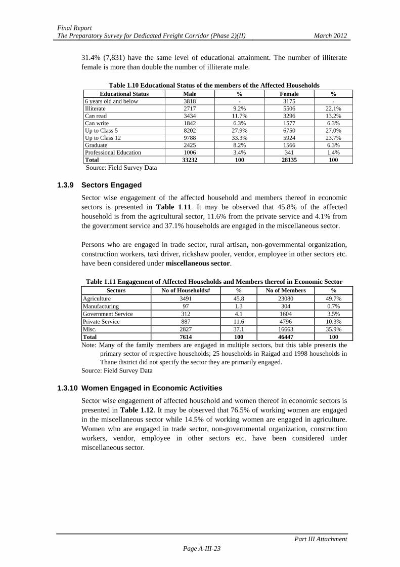
Final Report The Preparatory Survey for Dedicated Freight Corridor (Phase 2)(II) March 2012
Part III Attachment Page A-III-23
31.4% (7,831) have the same level of educational attainment. The number of illiterate female is more than double the number of illiterate male.
Table 1.10 Educational Status of the members of the Affected Households Educational Status Male % Female %
6 years old and below 3818 - 3175 - Illiterate 2717 9.2% 5506 22.1% Can read 3434 11.7% 3296 13.2% Can write 1842 6.3% 1577 6.3% Up to Class 5 8202 27.9% 6750 27.0% Up to Class 12 9788 33.3% 5924 23.7% Graduate 2425 8.2% 1566 6.3% Professional Education 1006 3.4% 341 1.4% Total 33232 100 28135 100 Source: Field Survey Data
1.3.9 Sectors Engaged
Sector wise engagement of the affected household and members thereof in economic sectors is presented in Table 1.11. It may be observed that 45.8% of the affected household is from the agricultural sector, 11.6% from the private service and 4.1% from the government service and 37.1% households are engaged in the miscellaneous sector. Persons who are engaged in trade sector, rural artisan, non-governmental organization, construction workers, taxi driver, rickshaw pooler, vendor, employee in other sectors etc. have been considered under miscellaneous sector.
Table 1.11 Engagement of Affected Households and Members thereof in Economic Sector Sectors No of Households# % No of Members %
Agriculture 3491 45.8 23080 49.7%
Manufacturing 97 1.3 304 0.7%
Government Service 312 4.1 1604 3.5%
Private Service 887 11.6 4796 10.3%
Misc. 2827 37.1 16663 35.9%
Total 7614 100 46447 100 Note: Many of the family members are engaged in multiple sectors, but this table presents the
primary sector of respective households; 25 households in Raigad and 1998 households in Thane district did not specify the sector they are primarily engaged.
Source: Field Survey Data
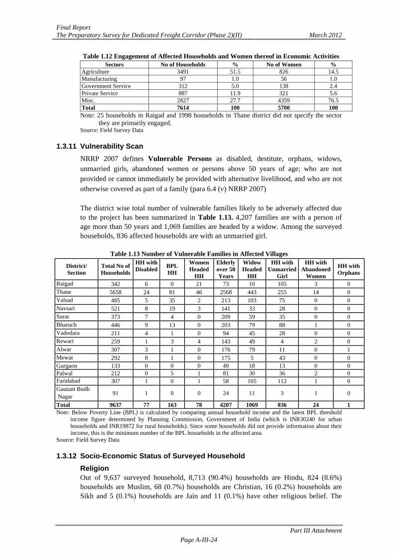
1.3.10 Women Engaged in Economic Activities Sector wise engagement of affected household and women thereof in economic sectors is presented in Table 1.12. It may be observed that 76.5% of working women are engaged in the miscellaneous sector while 14.5% of working women are engaged in agriculture. Women who are engaged in trade sector, non-governmental organization, construction workers, vendor, employee in other sectors etc. have been considered under miscellaneous sector.
Final Report The Preparatory Survey for Dedicated Freight Corridor (Phase 2)(II) March 2012
Part III Attachment Page A-III-24
Table 1.12 Engagement of Affected Households and Women thereof in Economic Activities Sectors No of Households % No of Women %
Agriculture 3491 51.5 826 14.5 Manufacturing 97 1.0 56 1.0 Government Service 312 5.0 138 2.4 Private Service 887 11.9 321 5.6 Misc. 2827 27.7 4359 76.5 Total 7614 100 5700 100 Note: 25 households in Raigad and 1998 households in Thane district did not specify the sector
they are primarily engaged. Source: Field Survey Data
1.3.11 Vulnerability Scan
NRRP 2007 defines Vulnerable Persons as disabled, destitute, orphans, widows, unmarried girls, abandoned women or persons above 50 years of age; who are not provided or cannot immediately be provided with alternative livelihood, and who are not otherwise covered as part of a family (para 6.4 (v) NRRP 2007) The district wise total number of vulnerable families likely to be adversely affected due to the project has been summarized in Table 1.13. 4,207 families are with a person of age more than 50 years and 1,069 families are headed by a widow. Among the surveyed households, 836 affected households are with an unmarried girl.
Table 1.13 Number of Vulnerable Families in Affected Villages
District/ Section
Total No of Households
HH with Disabled
BPL HH
Women Headed
HH
Elderly over 50 Years
Widow Headed
HH
HH with Unmarried
Girl
HH with Abandoned
Women
HH with Orphans
Raigad 342 6 0 21 73 10 105 3 0 Thane 5658 24 81 46 2568 443 255 14 0 Valsad 485 5 35 2 213 103 75 0 0 Navsari 521 8 19 3 141 33 28 0 0 Surat 373 7 4 0 209 59 35 0 0 Bharuch 446 9 13 0 203 79 88 1 0 Vadodara 211 4 1 0 94 45 28 0 0 Rewari 259 1 3 4 143 49 4 2 0 Alwar 307 3 1 0 176 79 11 0 1 Mewat 292 8 1 0 175 5 43 0 0 Gurgaon 133 0 0 0 49 18 13 0 0 Palwal 212 0 5 1 81 30 36 2 0 Faridabad 307 1 0 1 58 105 112 1 0 Gautam Budh Nagar
91 1 0 0 24 11 3 1 0
Total 9637 77 163 78 4207 1069 836 24 1 Note: Below Poverty Line (BPL) is calculated by comparing annual household income and the latest BPL threshold
income figure determined by Planning Commission, Government of India (which is INR30240 for urban households and INR19872 for rural households). Since some households did not provide information about their income, this is the minimum number of the BPL households in the affected area.
Source: Field Survey Data 1.3.12 Socio-Economic Status of Surveyed Household
Religion Out of 9,637 surveyed household, 8,713 (90.4%) households are Hindu, 824 (8.6%) households are Muslim, 68 (0.7%) households are Christian, 16 (0.2%) households are Sikh and 5 (0.1%) households are Jain and 11 (0.1%) have other religious belief. The
Final Report The Preparatory Survey for Dedicated Freight Corridor (Phase 2)(II) March 2012
Part III Attachment Page A-III-25
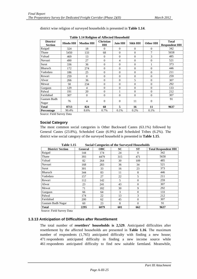
district wise religion of surveyed households is presented in Table 1.14.
Table 1.14 Religion of Affected Household District/ Section
Hindu HH Muslim HHChristian
HH Jain HH Sikh HH Other HH
Total Respondent HH
Raigad 324 18 0 0 0 0 342 Thane 5450 133 68 0 0 7 5658 Valsad 469 13 0 0 0 3 485 Navsari 490 27 0 4 0 0 521 Surat 336 36 0 0 0 1 373 Bharuch 172 274 0 0 0 0 446 Vadodara 186 25 0 0 0 0 211 Rewari 259 0 0 0 0 0 259 Alwar 266 36 0 0 5 0 307 Mewat 58 234 0 0 0 0 292 Gurgaon 129 4 0 0 0 0 133 Palwal 191 20 0 1 0 0 212 Faridabad 307 0 0 0 0 0 307 Gautam Budh Nagar
76 4 0 0 11 0 91
Total 8713 824 68 5 16 11 9637 Percentage 90.4% 8.6% 0.7% 0.1% 0.2% 0.1% Source: Field Survey Data Social Category The most common social categories is Other Backward Castes (63.1%) followed by General Castes (23.8%), Scheduled Caste (6.9%) and Scheduled Tribes (6.2%). The district wise social category of the surveyed household is presented in Table 1.15.
Table 1.15 Social Categories of the Surveyed Households
District/ Section General OBC SC ST Total Respondent HHRaigad 144 174 24 0 342 Thane 393 4479 315 471 5658 Valsad 82 264 30 109 485 Navsari 168 283 36 34 521 Surat 301 33 16 23 373 Bharuch 344 83 11 8 446 Vadodara 157 27 22 5 211 Rewari 112 142 5 0 259 Alwar 23 241 43 0 307 Mewat 71 182 30 9 292 Gurgaon 66 64 3 0 133 Palwal 174 22 13 3 212 Faridabad 200 62 45 0 307 Gautam Budh Nagar 60 23 8 0 91 Total 2295 6079 601 662 9637
Source: Field Survey Data
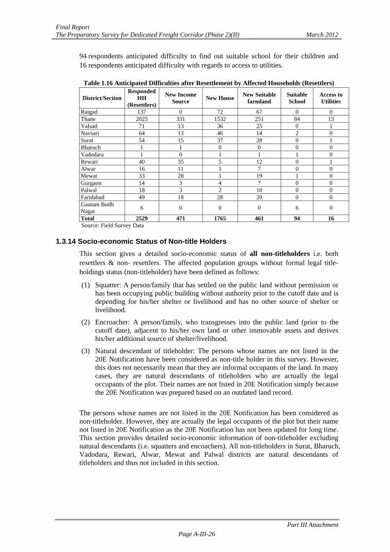
1.3.13 Anticipation of Difficulties after Resettlement The total number of resettlers’ households is 2,529. Anticipated difficulties after resettlement by the affected households are presented in Table 1.16. The maximum number of respondents (1,765) anticipated difficulty with finding a new house; 471 respondents anticipated difficulty in finding a new income source while 461 respondents anticipated difficulty to find new suitable farmland. Meanwhile,
Final Report The Preparatory Survey for Dedicated Freight Corridor (Phase 2)(II) March 2012
Part III Attachment Page A-III-26
94 respondents anticipated difficulty to find out suitable school for their children and 16 respondents anticipated difficulty with regards to access to utilities.
Table 1.16 Anticipated Difficulties after Resettlement by Affected Households (Resettlers)
District/Section Responded
HH (Resettlers)
New Income Source
New HouseNew Suitable
farmland Suitable School
Access to Utilities
Raigad 137 0 72 67 0 0 Thane 2025 331 1532 251 84 13 Valsad 71 13 36 25 0 1 Navsari 64 13 46 14 2 0 Surat 54 15 37 28 0 1 Bharuch 1 1 0 0 0 0 Vadodara 1 0 1 1 1 0 Rewari 40 35 5 12 0 1 Alwar 16 11 1 7 0 0 Mewat 33 28 1 19 1 0 Gurgaon 14 3 4 7 0 0 Palwal 18 3 2 10 0 0 Faridabad 49 18 28 20 0 0 Gautam Budh Nagar
6 0 0 0 6 0
Total 2529 471 1765 461 94 16 Source: Field Survey Data
1.3.14 Socio-economic Status of Non-title Holders
This section gives a detailed socio-economic status of all non-titleholders i.e. both resettlers & non- resettlers. The affected population groups without formal legal title-holdings status (non-titleholder) have been defined as follows:
(1) Squatter: A person/family that has settled on the public land without permission or has been occupying public building without authority prior to the cutoff date and is depending for his/her shelter or livelihood and has no other source of shelter or livelihood.
(2) Encroacher: A person/family, who transgresses into the public land (prior to the cutoff date), adjacent to his/her own land or other immovable assets and derives his/her additional source of shelter/livelihood.
(3) Natural descendant of titleholder: The persons whose names are not listed in the 20E Notification have been considered as non-title holder in this survey. However, this does not necessarily mean that they are informal occupants of the land. In many cases, they are natural descendants of titleholders who are actually the legal occupants of the plot. Their names are not listed in 20E Notification simply because the 20E Notification was prepared based on an outdated land record.
The persons whose names are not listed in the 20E Notification has been considered as non-titleholder. However, they are actually the legal occupants of the plot but their name not listed in 20E Notification as the 20E Notification has not been updated for long time. This section provides detailed socio-economic information of non-titleholder excluding natural descendants (i.e. squatters and encoachers). All non-titleholders in Surat, Bharuch, Vadodara, Rewari, Alwar, Mewat and Palwal districts are natural descendants of titleholders and thus not included in this section.
Final Report The Preparatory Survey for Dedicated Freight Corridor (Phase 2)(II) March 2012
Part III Attachment Page A-III-27
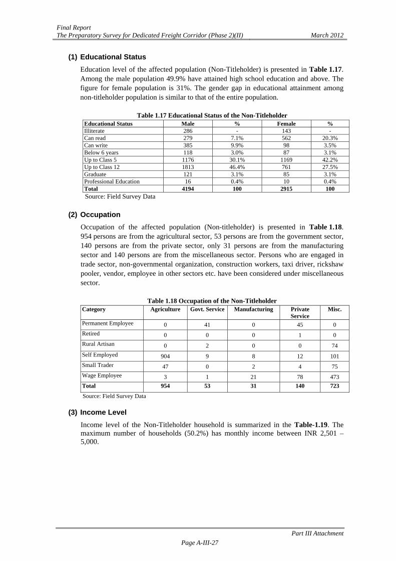
(1) Educational Status Education level of the affected population (Non-Titleholder) is presented in Table 1.17. Among the male population 49.9% have attained high school education and above. The figure for female population is 31%. The gender gap in educational attainment among non-titleholder population is similar to that of the entire population.
Table 1.17 Educational Status of the Non-Titleholder Educational Status Male % Female % Illiterate 286 - 143 - Can read 279 7.1% 562 20.3% Can write 385 9.9% 98 3.5% Below 6 years 118 3.0% 87 3.1% Up to Class 5 1176 30.1% 1169 42.2% Up to Class 12 1813 46.4% 761 27.5% Graduate 121 3.1% 85 3.1% Professional Education 16 0.4% 10 0.4% Total 4194 100 2915 100 Source: Field Survey Data
(2) Occupation
Occupation of the affected population (Non-titleholder) is presented in Table 1.18. 954 persons are from the agricultural sector, 53 persons are from the government sector, 140 persons are from the private sector, only 31 persons are from the manufacturing sector and 140 persons are from the miscellaneous sector. Persons who are engaged in trade sector, non-governmental organization, construction workers, taxi driver, rickshaw pooler, vendor, employee in other sectors etc. have been considered under miscellaneous sector.
Table 1.18 Occupation of the Non-Titleholder Category Agriculture Govt. Service Manufacturing Private
Service Misc.
Permanent Employee 0 41 0 45 0
Retired 0 0 0 1 0
Rural Artisan 0 2 0 0 74
Self Employed 904 9 8 12 101
Small Trader 47 0 2 4 75
Wage Employee 3 1 21 78 473
Total 954 53 31 140 723
Source: Field Survey Data
(3) Income Level Income level of the Non-Titleholder household is summarized in the Table-1.19. The maximum number of households (50.2%) has monthly income between INR 2,501 – 5,000.
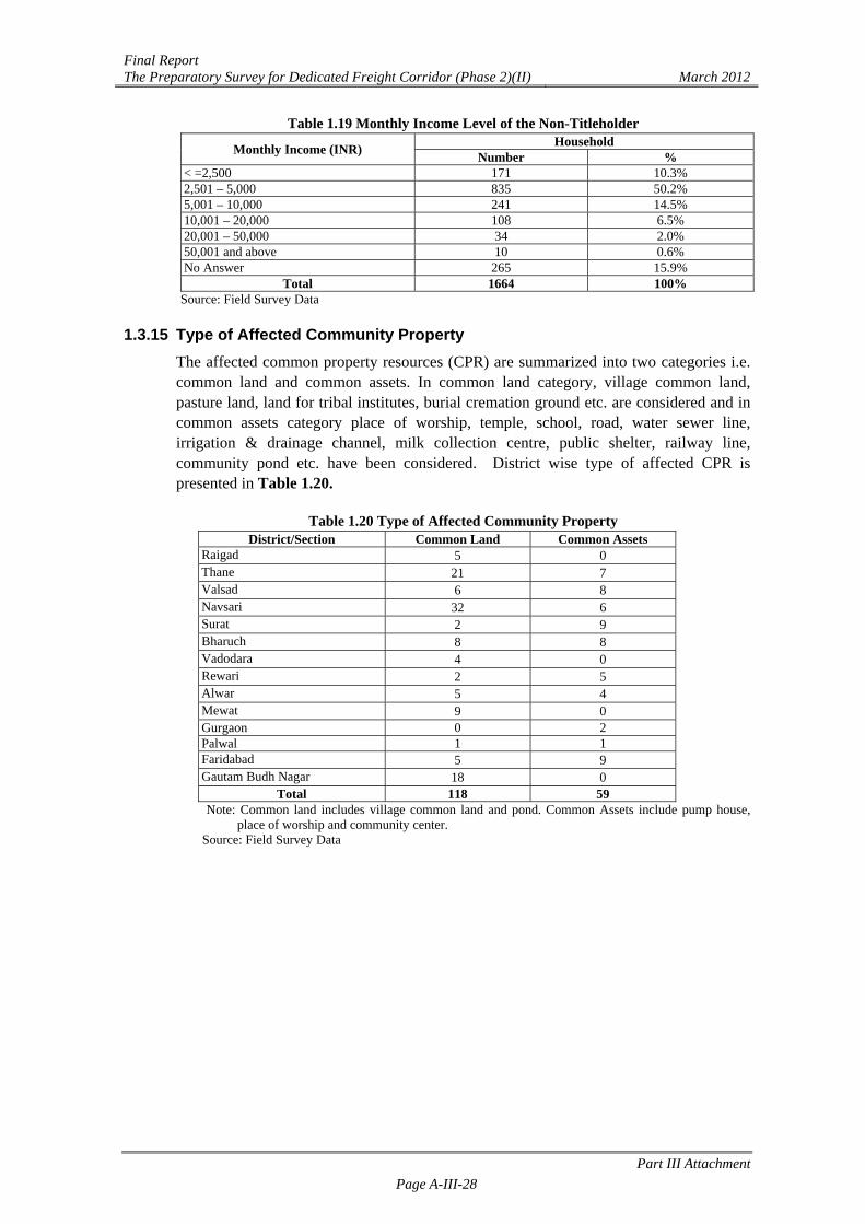
Final Report The Preparatory Survey for Dedicated Freight Corridor (Phase 2)(II) March 2012
Part III Attachment Page A-III-28
Table 1.19 Monthly Income Level of the Non-Titleholder
Monthly Income (INR) Household
Number % < =2,500 171 10.3% 2,501 – 5,000 835 50.2% 5,001 – 10,000 241 14.5% 10,001 – 20,000 108 6.5% 20,001 – 50,000 34 2.0% 50,001 and above 10 0.6% No Answer 265 15.9%
Total 1664 100% Source: Field Survey Data
1.3.15 Type of Affected Community Property
The affected common property resources (CPR) are summarized into two categories i.e. common land and common assets. In common land category, village common land, pasture land, land for tribal institutes, burial cremation ground etc. are considered and in common assets category place of worship, temple, school, road, water sewer line, irrigation & drainage channel, milk collection centre, public shelter, railway line, community pond etc. have been considered. District wise type of affected CPR is presented in Table 1.20.
Table 1.20 Type of Affected Community Property
District/Section Common Land Common Assets Raigad 5 0 Thane 21 7 Valsad 6 8 Navsari 32 6 Surat 2 9 Bharuch 8 8 Vadodara 4 0 Rewari 2 5 Alwar 5 4 Mewat 9 0 Gurgaon 0 2 Palwal 1 1 Faridabad 5 9 Gautam Budh Nagar 18 0
Total 118 59 Note: Common land includes village common land and pond. Common Assets include pump house,
place of worship and community center. Source: Field Survey Data

Final Report The Preparatory Survey for Dedicated Freight Corridor (Phase 2)(II) March 2012
Part III Attachment Page A-III-29
1.3.16 Type of Ownership of Community Property The district wise ownership of affected community property is presented in Table 1.21. Out of 130 common properties, 53 community properties are in possession of the respective village Panchayat, 38 community properties are in possession of the state government, 12 are in possession of group of society, 19 properties are in possession of Association/Group of Society and 8 properties are in possession of individual family.
Table 1.21 Ownership of Affected Community Property
District/Section Panchayat GovernmentGroup of Society
AssociationIndividual
family1 Total
Raigad 1 0 4 0 0 5 Thane 18 5 5 0 0 28 Valsad 1 8 1 2 2 14 Navsari 7 23 7 1 0 38 Surat 2 0 0 9 0 11 Bharuch 5 1 2 8 0 16 Vadodara 1 0 1 2 0 4 Rewari 5 2 0 0 0 7 Alwar 8 0 1 0 0 9 Mewat 9 0 0 0 0 9 Gurgaon 0 0 0 0 2 2 Palwal 2 0 0 0 0 2 Faridabad 9 4 0 0 1 14 Gautam Budh Nagar
18 0 0 0 0 18
Total 86 43 21 22 5 177 Note: 1: Developed by individual family for charitable purpose. Therefore it has been considered as
common assets owned by an individual family. Source: Field Survey Data
Final Report The Preparatory Survey for Dedicated Freight Corridor (Phase 2)(II) March 2012
Part III Attachment Page A-III-30
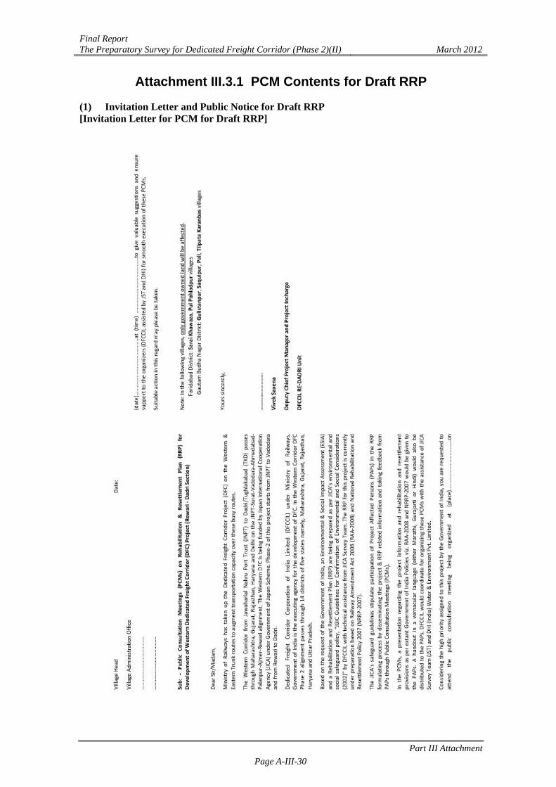
Attachment III.3.1 PCM Contents for Draft RRP (1) Invitation Letter and Public Notice for Draft RRP [Invitation Letter for PCM for Draft RRP]
Final Report The Preparatory Survey for Dedicated Freight Corridor (Phase 2)(II) March 2012
Part III Attachment Page A-III-31
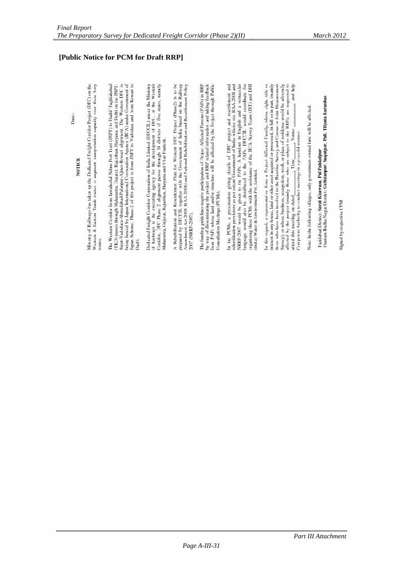
[Public Notice for PCM for Draft RRP]

![ESIA - Services Architecture Enterprise Services Integrated Architecture [ESIA] Viv Noot PwC](https://img.pdfslide.net/doc/110x75/56649e715503460f94b70588/esia-services-architecture-enterprise-services-integrated-architecture-esia.jpg)