Embed Size (px)
Citation preview
42A86NW8157 63.5439 DELORO 010
SUMMARY REPORTOP THE
STRIPPING/WASHING PROORAMON THE
COLLIN PROPERTYDELORO TOWNSHIP
PORCUPINE MINING DISTRICTOPAP f 90-506 6 90-507
August 19, 1990 Ken , HBSe
LAPIERRE EXPLORATION SERVICES INC.
P.O. Box 1021, Timmins, Ontario P4N 7H6 (705) 267-7389
r
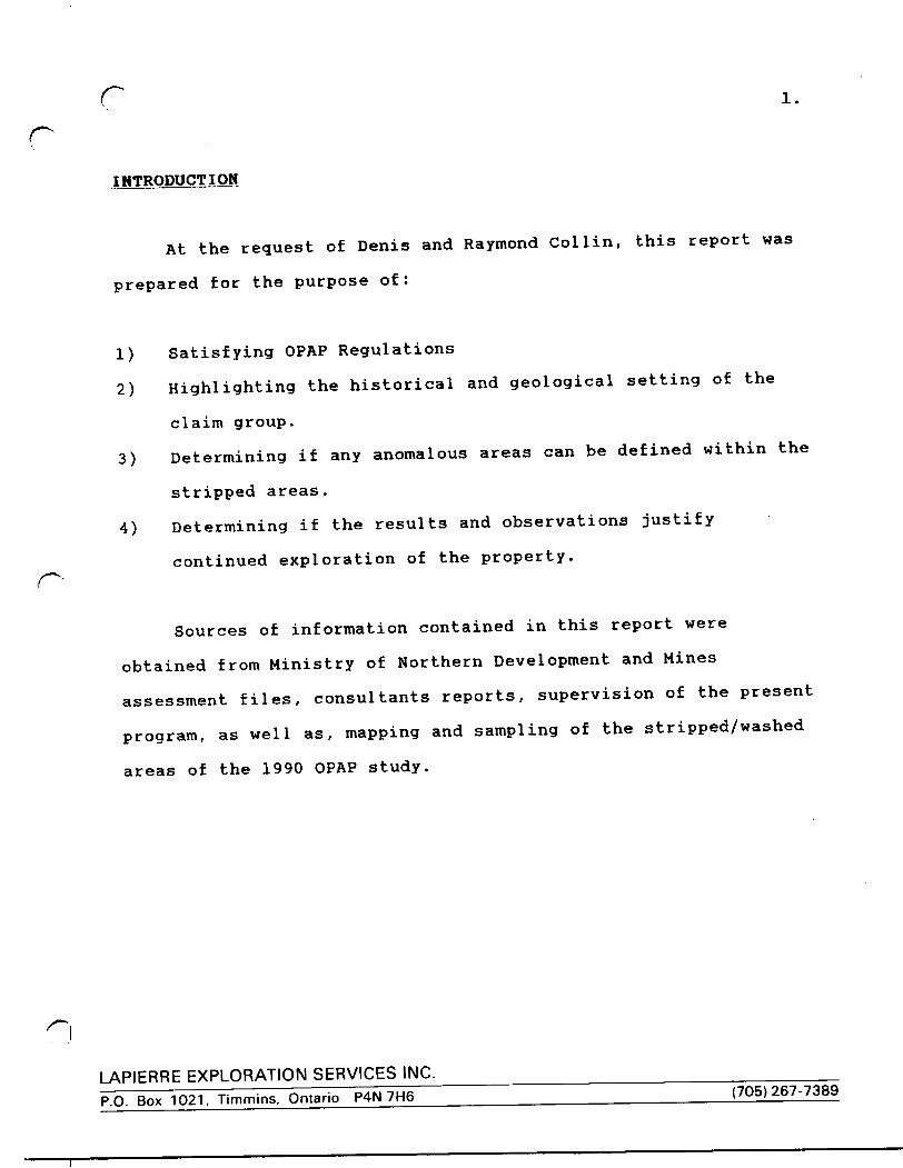
INTRODUCTION
At the request of Denis and Raymond Col l in, this report was
prepared for the purpose of:
1) Satisfying OPAP Regulations
2) Highlighting the historical and geological setting of the
claim group.
3) Determining if any anomalous areas can be defined within the
stripped areas.
4) Determining if the results and observations justify
continued exploration of the property.
Sources of information contained in this report were
obtained from Ministry of Northern Development and Mines
assessment files, consultants reports, supervision of the present
program, as well as, mapping and sampling of the stripped/washed
areas of the 1990 OPAP study.
LAPIERRE EXPLORATION SERVICES INC.
P.O. Box 1021, Timmins, Ontario P4N 7H6 (705)267-7389
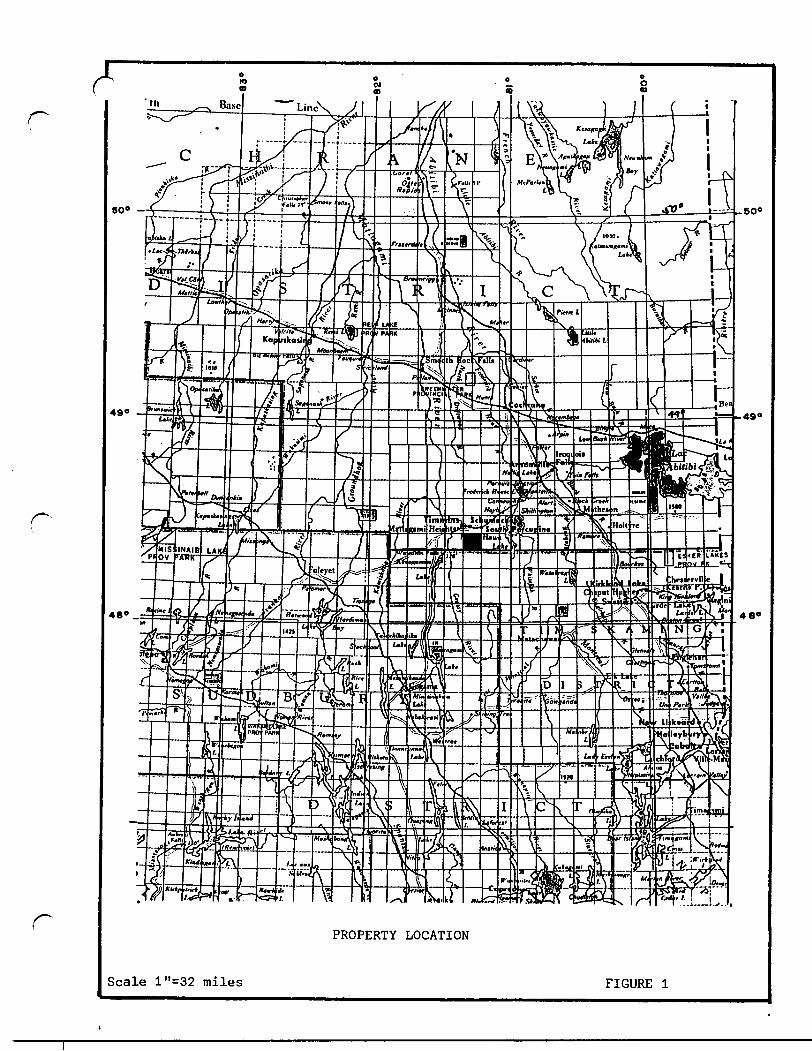
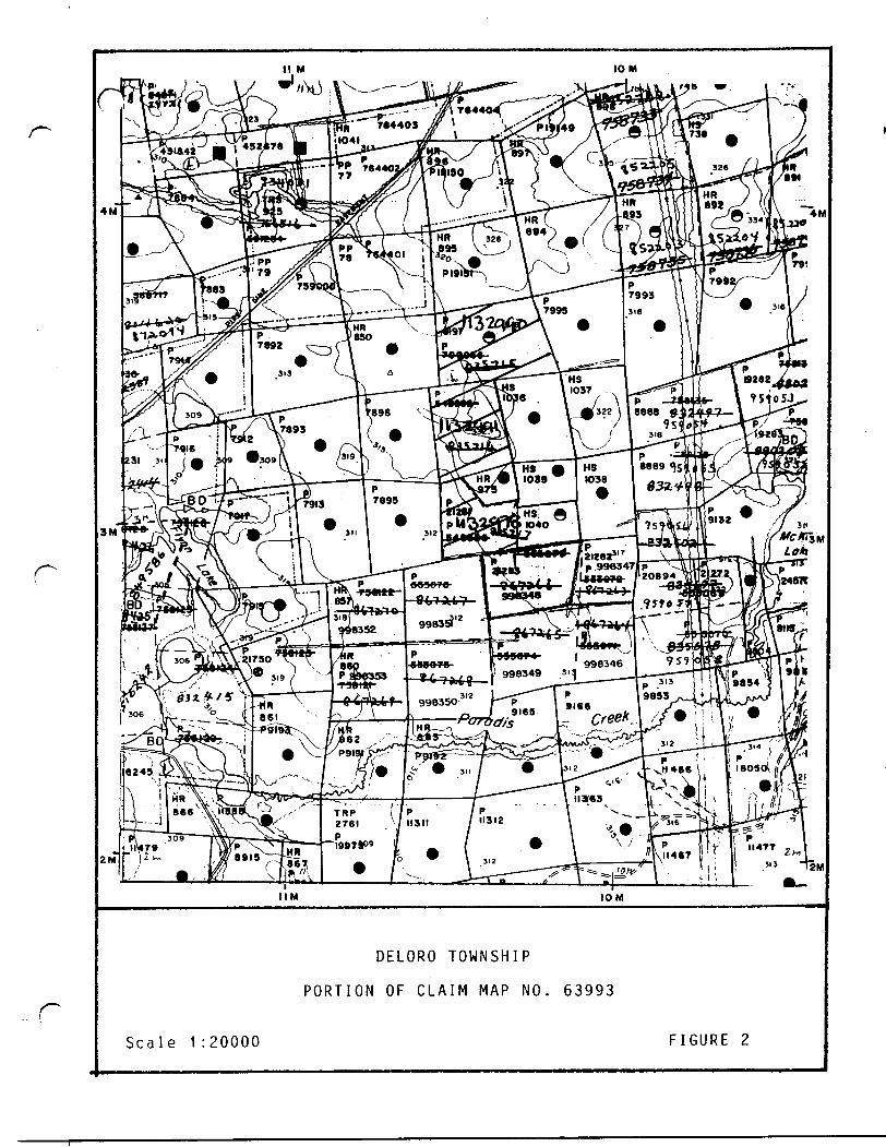
PROPERTY : LOCATION AMD^
The property is comprised of 3 unpatented mining claims
located in the central portion of Deloro Township, Porcupine
Mining Division, District of Cochrane, Ontario, Canada (Figure
D-
The claim numbers for the claim block under consideration of
this OPAP study are P1132990, P1132991 and P1132978 (Figure 2).
ACCESSIBILITY. CLIMATE. LOCAL RESOURCES
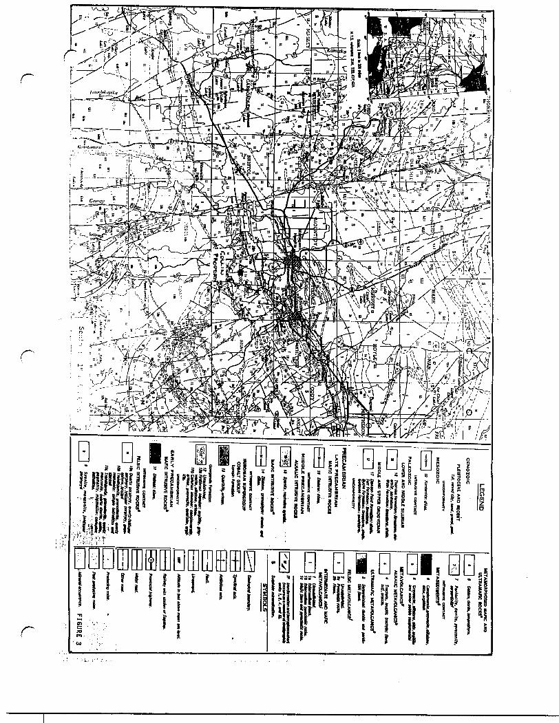
Access to the property is by means of the Timmins "back
road" from either Timmins or South Porcupine to the Aunor Mine
turnoff, then a distance of approximately l mile to the Aunor
Mine. At the Aunor Mine entrance, a bush road continues south a
distance of approximately 2.0 miles to the property (Figure 3).
Climatic conditions are typical for this part of Northern
Ontario. Temperatures range from -45 degrees celsius to +30
degrees celsius.
Availability of electrical power is located north at the
Delnite townsite.
Water resources are available within the property. Mining
supplies and manpower are located in Timmins and South Porcupine.
LAPIERRE EXPLORATION SERVICES INC.
P.O. Box 1021, Timmins, Ontario P4N 7H6 (705)267-7389
"th
50* —
490
48* .
50"
490
480
PROPERTY LOCATION
Scale l'^32 miles FIGURE l
10 M
|2M2Ml
IIM IOM
DELORO TOWNSHIP
PORTION OF CLAIM MAP NO. 63993
Scale 1 :20000 FIGURE 2
PLE
ISTO
CE
NE
AN
D K
CE
NT
ria, nm
l at,, am. am
i. fmL
|)\ '"/^
H^^T
T^V
]
y v
.^CM
-xJ
I IP
ITItu
Slve C
ON
TA
CT
PA
LE
OZ
OIC
LOW
ER
AN
D M
IDD
LE
SIL
UR
IAN
ME
TA
VO
LC
AN
ICS
* A
LKA
LIC M
ETA
VO
LCA
MC
S*
l - l
H
Iten
k.A
mtfin
.-ttnaM
(.M.
u m
at . ttntHoM
.l —
——
——
l lllik
AriiM
te.-M
HlM
lMk.
MID
DL
E A
ND
UP
PE
R O
RO
OV
ICIA
M
Utm
* ftu fa
ma*,
ULTR
AM
AFIC
ME
TAV
OLC
AM
CS
*
FELS
IC M
ETA
VD
LCA
MC
S7
fP
RE
CA
MB
RIA
NI-A
TE
PR
EC
AM
BR
IAN
MA
FIC
INT
RU
SIV
E R
OC
KS
MT
HU
MW
CO
NTA
CT
MID
DL
E P
RE
CA
MB
RIA
N
AL
KA
LIC
IKT
BU
SIV
l RO
CK
S
'S
Iteo
nM
iDtM
ttraftM
Z—l
Mai.i.t.utti).
MA
RC
INT
RU
SIV
E R
OC
KS
*
H
HU
RO
NIA
N S
UP
ER
GR
OU
P
CO
BA
LT CR
OU
P
ftt/Mtnut Mm
*,.- mat,, pir-
. .
•r/uu, yijuirti, guMnlli. n
*.
EA
RL
Y P
RE
CA
MB
RIA
N
MA
FIC
INT
RU
SIV
E R
OC
KS
*
Hfn
tUW
II CO
NTA
CT
FIL
SIC
INT
RU
SIV
E R
OC
KS
*
Ou
vb
mn
Am
r,
Srtn
ltt, mafu
eoy/t. ftUtfte"
''-
rr
PREVIOUS WORK
Limited exploration has been conducted on all or parts of
the claim group by previous owners. More recently, Canadian
Nickel Company, in 1975, completed geological mapping and a
magnetometer and VLP survey. Canamax also completed geological
mapping in 1982. Noranda Exploration in 1984 and Findore
Minerals Inc. in 1987 both completed magnetometer and VLF
surveys. Assessment files pertinent to the claim block are T-
1563, 1978, 2710 and 2791.
GEOLOGY:
r-Regional Geology:
The geology of the Timmins areas consists predominantly of
Precambrian (Archean and Proterozoic) metavolcanics and
metasediments. The Precambrian rocks were later covered
partially by unconsolidated Cenozoic deposits (Figure 3).
The Precambrian rocks represent a 40,000' thick sequence of lower
to middle greenschist facies volcanics and sediments that are
divided into three groups. From oldest to youngest the three
groups are known as the Deloro, Tisdale and Porcupine Groups.
LAPIERRE EXPLORATION SERVICES INC.P.O. Box 1021, Timmins, Ontario P4N 7H6 (705)267-7389
CThe Deloro group is a 16,000' sequence composed of basal
ultramafics, andesites and basalt flows followed by dacite flows,
calc-alkaline rhyolite and dacite pyroclastic rocks and oxide to
sulphide facies iron formations. The Tisdale group is a 14,000'
thick sequence composed of basal ultramafic volcanics and
komatiites followed by tholeitic basalts and calc-alkaline
pyroclastic rocks. The Porcupine group is a 10,000' thick
sequence composed of interlayered wacke, siltstone and
conglomerate.
The rocks of the Timmins area were then intruded by sill-
like bodies and dikes composed of felsic to mafic components.
Stratigraphic displacement of rock types range from tens of
{""^ feet to thousands of feet. The most prominent fault in the area
is called the Destor Porcupine Fault (Figure 3). This major
structural break trends northeast, dips steeply north and has a
width in excess of 400'. Other younger fault systems traversing
the area are the Montreal River Fault and the Burrows Benedict
Fault Systems.
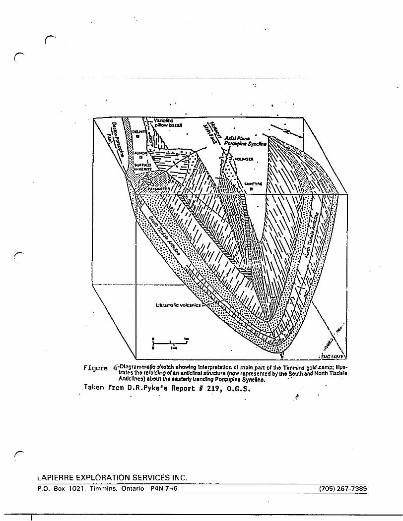
Structurally, the area lies within the Superior Province of
the Canadian Shield. North of the Destor Porcupine Fault, 2
major series of deformational-metamorphic events altered the
rocks in the region;
rLAPIERRE EXPLORATION SERVICES INC.P.O. Box 1021, Timmins, Ontario P4N 7H6 (705)267-7389
8.r r
1) Initial north trending series of folds
2) Subsequent refolding about an east-northeast trending series
of shear folds. (F\^oa4).
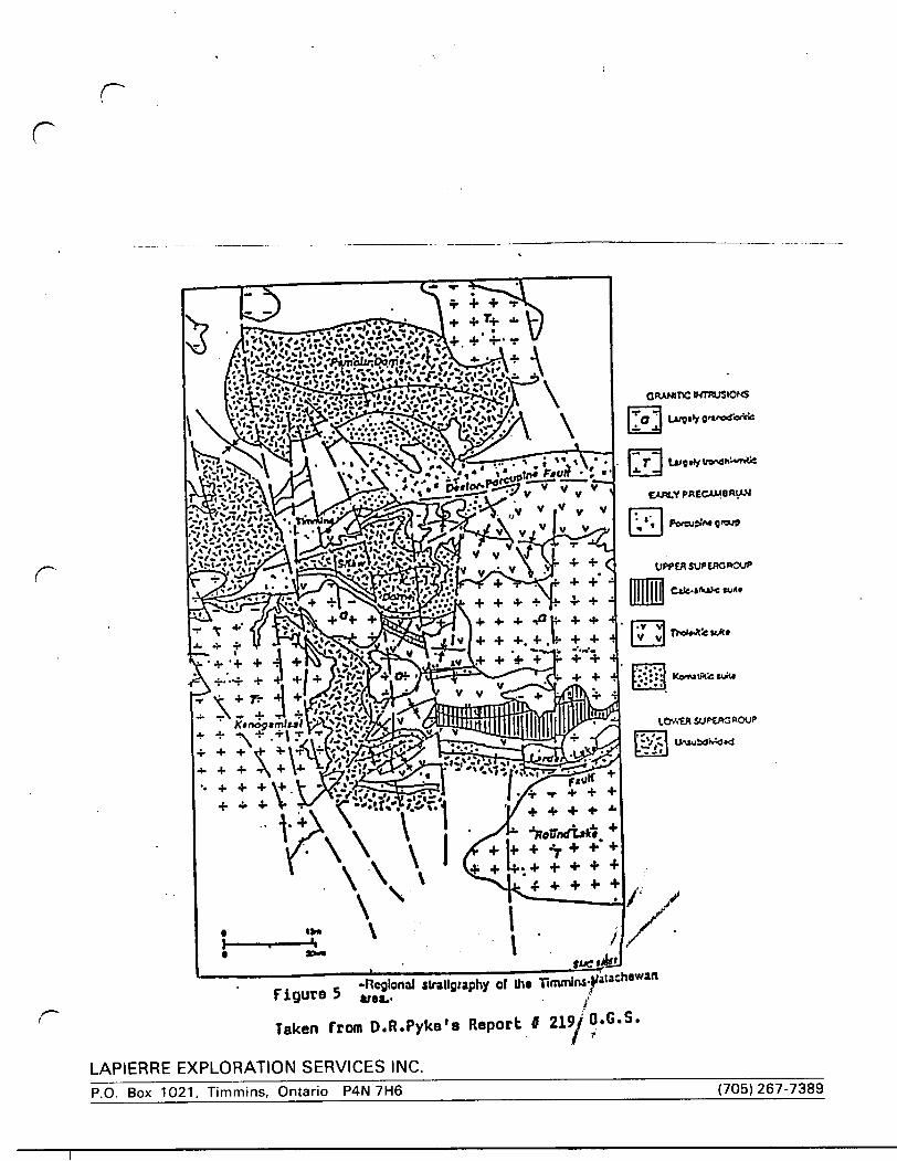
South of the Destor-Porcupine Fault and east-west trending
series of folds produced a major structural domain known as
the Shaw dome (Figure 5).
Local Geology/Geophysics:
The following information is based on D.R. Pyke's 1982 OGS
report: Geology of the Timmins Area, ODM maps and reports and
geological mapping surveys carried out by previous owners of the
^ claim block. It was felt the previous geological mapping was
adequate on the claim block and as a result it would not be
prudent to include another geological mapping program toward the
outcome of this OPAP study.
The geology of the claim group consists predominantly of the
middle to upper formations of the Deloro Group. The claims are
underlain generally by north dipping east-west trending calc-
alkaline basalts and andesites, pyroclastic rocks and sulphide to
oxide facies iron formation. The Destor-Porcupine Fault is
stratigraphically above these formations and is located
approximately 3/4 of a mile northward.
rLAPIERRE EXPLORATION SERVICES INC.P.O. Box 1021, Timmins, Ontario P4N 7H6 (705)267-7389
rr
\^^^^^^^^^^^^^^^^^^^^^^^^^^^^^^^^^^^^^Figure ^'-Diagrammatic sketch showing Interpretation of main part of the Timmins gold-camp; Illus
trates tho refolding of ah anticlinal structure (now represented b/tha South and North Tisdale Anticlines) about the easterly trending Porcupine Syncline.
Taken from D.R.Pyke's Report t 219, O.G.S..#
r
LAPIERRE EXPLORATION SERVICES INC.P.O. Box 1021, Timmins, Ontario P4N 7H6 (705) 267-7389
C
-Regional stratigraphy of lha Timminsfa'ach8Wan.. FigureTaken from D.R.Pyke's Report t 219^0.0.5.
LAPIERRE EXPLORATION SERVICES INC.P.O. Box 1021, Timmins, Ontario P4N 7H6 (705) 267-7389
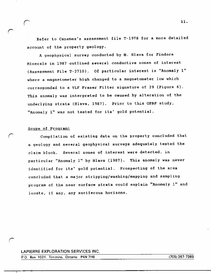
p 11.
cRefer to Canamax's assessment file T-1978 for a more detailed
account of the property geology.
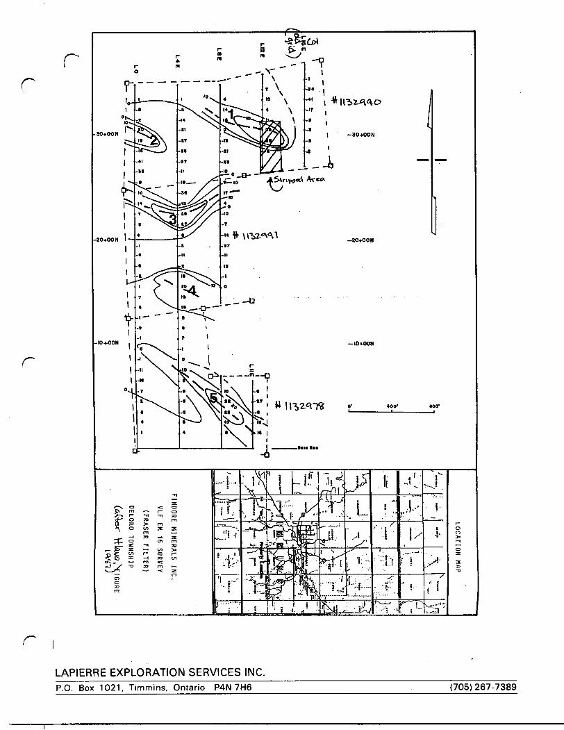
A geophysical survey conducted by M. Hlava for Findore
Minerals in 1987 outlined several conductive zones of interest
(Assessment File T-2710). Of particular interest is "Anomaly l"
where a magnetometer high changed to a magnetometer low which
corresponded to a VLF Fraser Filter signature of 29 (Figure 6).
This anomaly was interpreted to be caused by alteration of the
underlying strata (Hlava, 1987). Prior to this OPAP study,
"Anomaly l" was not tested for its' gold potential.
Scope of Program;
( Compilation of existing data on the property concluded that
a geology and several geophysical surveys adequately tested the
claim block. Several zones of interest were detected, in
particular "Anomaly l" by Hlava (1987). This anomaly was never
identified for its' gold potential. Prospecting of the area
concluded that a major stripping/washing/mapping and sampling
program of the near surface strata could explain "Anomaly l" and
locate, if any, any auriferous horizons.
LAPIERRE EXPLORATION SERVICES INC.P.O. Box 1021, Timmins, Ontario P4N 7H6 (705)267-7389
r
r
LAPIERRE EXPLORATION SERVICES INC.P.O. Box 1021, Timmins, Ontario P4N 7H6 (705) 267-7389
13-LO .
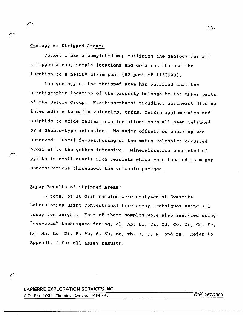
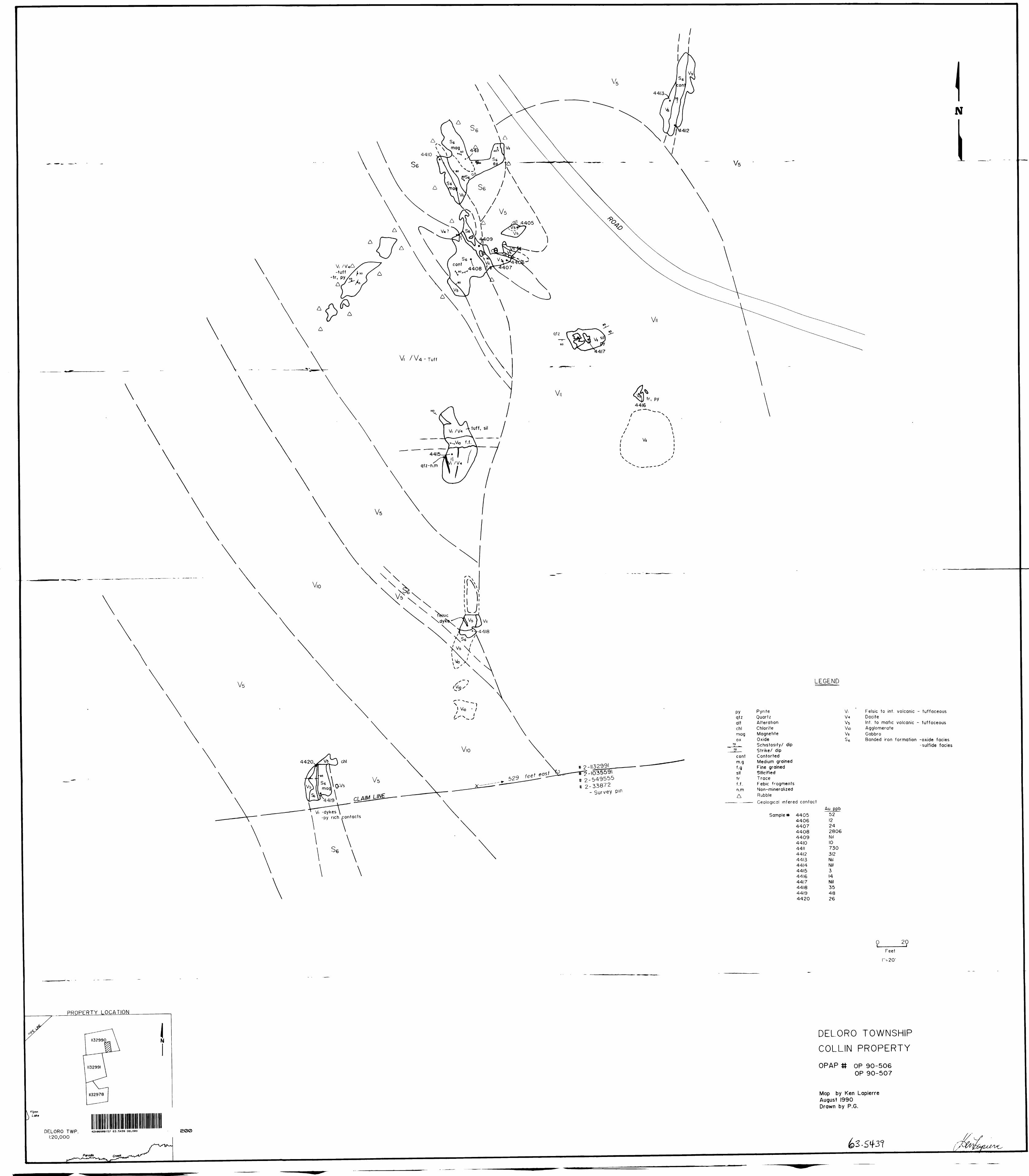
rGeology of Stripped Areas:
Pocket l has a completed map outlining the geology for all
stripped areas, sample locations and gold results and the
location to a nearby claim post (#2 post of 1132990).
The geology of the stripped area has verified that the
stratigraphic location of the property belongs to the upper parts
of the Deloro Group, North-northwest trending, northeast dipping
intermediate to mafic volcanics, tuffs, felsic agglomerates and
sulphide to oxide facies iron formations have all been intruded
by a gabbro-type intrusion. No major offsets or shearing was
observed. Local fe-weathering of the mafic volcanics occurred
proximal to the gabbro intrusive. Mineralization consisted of
pyrite in small quartz rich veinlets which were located in minor
concentrations throughout the volcanic package.
Assay Results of Stripped Areas;
A total of 16 grab samples were analyzed at Swastika
Laboratories using conventional fire assay techniques using a l
assay ton weight. Four of these samples were also analyzed using
"geo-scan" techniques for Ag, Al, As, Bi, Ga, Cd, Co, Cr, Cu, Fe,
Mg, Mn, Mo, Ni, P, Pb, S, Sb, Sr, Th, U, V, W, and Zn. Refer to
Appendix I for all assay results.
rLAPIERRE EXPLORATION SERVICES INC.P.O. Box 1021, Timmins, Ontario P4N 7H6____________________________(705) 267-7389
rr
Of the 16 samples taken, 3 samples returned gold values well
above the average for all 16 samples (255ppb Au). These are;
sample l 4412 yielded 312ppb Au, 14411 yielded 730ppb Au and
4408 yielded a cheque value of 2800ppb Au. All 3 samples were
taken from a sulphide (magnetite) rich iron formation proximal to
the gabbro contact.
Appendix II outlines the dates the work was carried out, the
names of all persons who performed the work, and the equipment
used.
r
rLAPIERRE EXPLORATION SERVICES INC.P.O. Box 1021, Timmins, Ontario P4N 7H6 (705)267-7389
15.
rCONCLUSIONS AND OBSERVATIONS
1) Since 1975 several geological and geophysical surveys on the
claim block identified several areas for further study.
2) Hlava's VLF signature and the mag high to mag low
interpretation could be the result of the magnetite rich
iron formation (mag high) abutting against the gabbro (mag
low) intrusion. Local alteration does occur proximal to the
gabbro intrusion in the mafic volcanics.
3) Anomalous gold values up to 2806ppb have been recorded fromr^the exposed strata. The highest three gold values are
associated in sulphide rich iron formation in close
proximity to a gabbro intrusion. Local remobilization of
gold bearing fluids may have taken place in this area.
4) The OPAP study was highly successful in locating, exposing
and defining an anomalous area where gold mineralization is
associated within iron formation in close proximity to a
gabbro intrusion.
r
LAPIERRE EXPLORATION SERVICES INC.P.O. Box 1021, Timmins, Ontario P4N 7H6 ___ ___________________(705) 267-7389
cRECOMMENDATIONS
Based on the successful completion of this OPAP study, a follow-up exploration program is justified and recommended. The follow-up program should include linecutting and a detailed
magnetometer survey over and along strike of the anomalous area, paying special attention to any major magnetic variation in the underlying strata which may correlate with other iron
f ormation/gabbro contacts. This program should also include detailed channel sampling of the area presently exposed as well as further stripping/washing/mapping/sampling of favourable areas detected by the magnetic survey. The success of this follow-up program could enhance the property to the diamond drilling stage.
Respectfully Submitted,
Kenneth Lapierre, HBSc
r.APIERRE EXPLORATION SERVICES INC.P.O. Box 1021, Timmins. Ontario P4N 7H6_____________-_______________(705) 267-7389
rDECLARATION
I, Kenneth Lapierre, of the City of Timmins, Province of Ontario,
Canada, do state:
1) That I am a practising Consulting Geologist with an office at Suite 17 - Hollinger Building, 637 Algonquin Blvd. E., Timmins, Ontario, and that my mailing address is P.O. Box 1021, Timmins, Ontario, P4N 7H6.
2) That I am a graduate with the Degree of Honours Bachelor of Science majoring in Geology from the University of Western Ontario, London, Ontario, Canada.
3) That I have practised my profession as Consulting Geologist since my graduation from the University of Western Ontario in 1983.
4) That I am an Associate Fellow of the Geological Association of Canada, and member of the Prospectors and Developers Association of Canada.
5) That I am familiar with the material in this report, having examined the material myself, and that I visited the property on several occasions in 1990.
6) That I do not have any interest in the property nor do Iexpect to have any interest in the property in the future.
Dated this 19th day of August 1990, Timmins, Ontario
Ken Lapierre, HBSc Consultant Geologi
r
LAPIERRE EXPLORATION SERVICES INC.P.O. Box 1021, Timmins, Ontario P4N 7H6 (705)267-7389
Established 1928
Swastika LaboratoriesA Division of Assayers Corporation Ltd.
Assaying - Consulting - Representation
Geochemical Analysis Certificatecomp,ny: LAPIERRE EXPL. SERVICESProject: DELORO TWP-3Ann: KEN LAPIERRE
OT-0399-RG1
Date. AUG-OI-90 Cbpy l. P.O.BOX 1021.TIMMINS.ONT. P4N 7H6
We hereby certify the following Geochemical Analysis of 4 ROCK samples submitted JUL-30-90 by .
Sample Number
Au Au check ppb ppb
4405440844124420
522825
31226
2787
Certified by
G. Lebel l Manager
P.O. Box 10, Swastika, Ontario POK1TO Telephone (705)642-3244 FAX (705)642-3300
LAPIERRE EXPLORATION SERVICES INC.P.O. Box 1021, Timmins, Ontario P4N 7H6 (705) 267-7389
Established 1928
Swastika LaboratoriesA Division of Assayers Corporation Ltd.
Assaying - Consulting - Representation
Assay CertificateCompnny: LAPIERRE EXPL. SERVICESProject: DELORO TWP-3Aitn: KEN LAPIERRE
We hereby certify the following Assay of 12 ROCK samples submitted JUL-30-90 by .
Opy
OT-0400 RAI
DMC: AUG-02-90P.O.BOX 1021.TIMMINS. ONT. P4N 7116
Nmrtier4406 4407 4409 4410 44114413 4414 4415 4416 44174418 4419
Au ppb
24 Nil 10
727/734Nil Nil
3 14
Nil35
45/51
Au was determined using l AT fusions
Certified by
G. Lebel / Manager
P.O. Box 10. Swastika, Ontario POK1TO Telephone (705)642-3244 FAX (705)642-3300
LAPIERRE EXPLORATION SERVICES INC.P.O. Box 1021, Timmins, Ontario P4N 7H6 (705)267-7389
r-*-. nuu l u au l J. l o oWH3 l l KH LHB HHtih . U6
r
Established 1921
Swastika LaboratoriesA Division of Asuyeri Corporation Ltd.
Assaying - Consulting - Representation
(Ef ritftntte nf AualymnPnrHflratP Nn flT-MO.*
Rpfplvpri .llily 50, I90n
SAMPLE NO.Ag PPM
* Al XAs PPMBl PPM
1 ea xCd PPMCo PPM
*Cr PPMdi PPMFe X
*Mg XMn PPMMo PPMNl PPMP XPb PPMS XSb PPMSr PPMTh PPMli PPM
*V PPM*H PPM
Zn PPMNOTE: Digestion may not
elements marked by
}-fifil
4405•cO.l1.8<10dO0.7dO1232577198.31.3477dO1180.06832.9dO42dO40
. 34dO60
be complete an asterisk
A
"GEO-SCAN"
4408•:0.10.5dO134.51710236731213.50,1921dO650.1903.1dO231010422dO43
for those
4412cO.l0.5dO134.51710636731313.5O.I925dO650.1833.1dO231013222dO44
F
Dal* Aug. 14, IQQn
rnrk s amp IP s
Qnturio proifftteloro-Twp 3
4420
*:0.11.4dOdO0.4101084305318.30.9380dO690.07666.6dO28dO3525dO /t
44 /7 /) J l,, J. wG. Lebel, Manager/dg
P.O. Box 10, swastika. Ontario POK ITO PAY
LAPIERRE EXPLORATION SERVICES INC.P.O. Box 1021, Timmins, Ontario P4N 7H6 (705) 267-7389
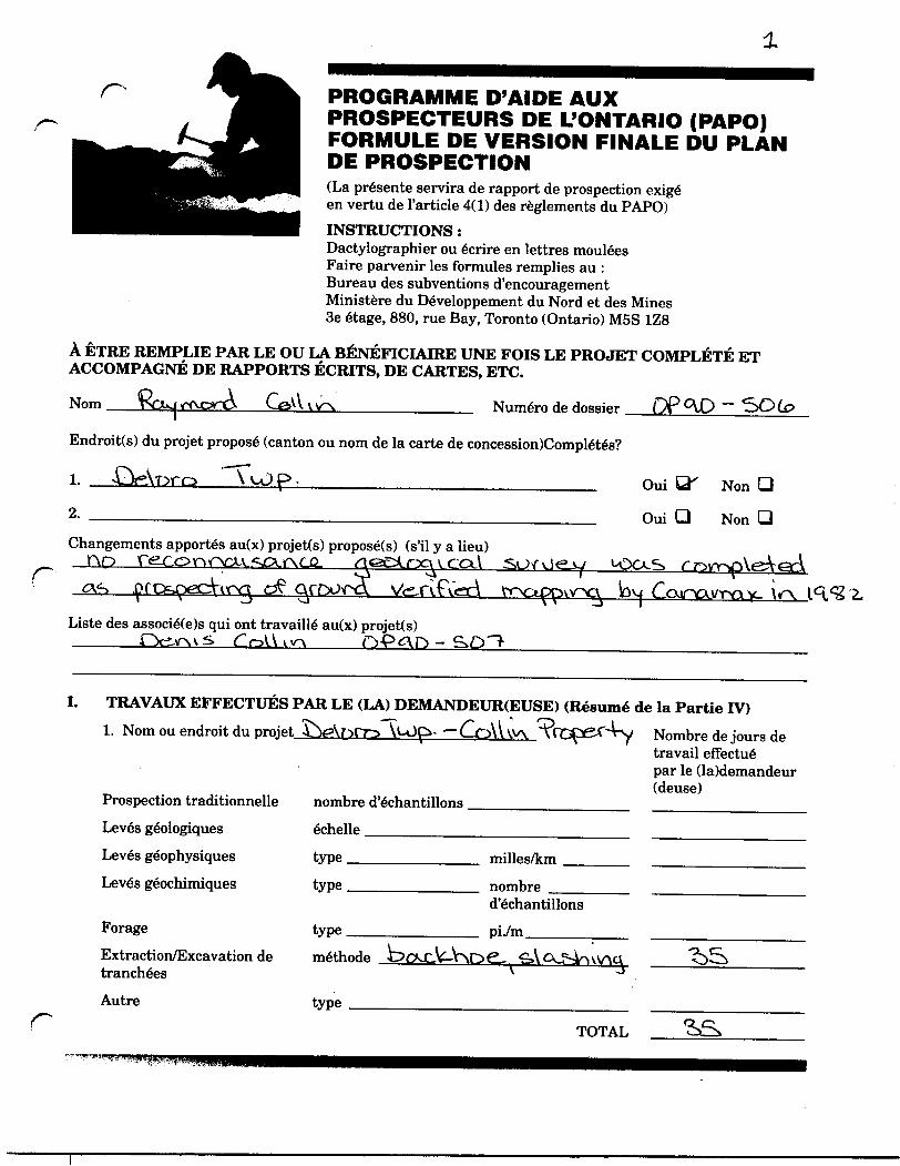
TT l
ONTARIO PROSPECTORS ASSISTANCEPROGRAM (OPAP)FINAL SUBMISSION FORM(This shall serve as the prospecting report as required under Section4(1) of the OPAP Regulations)INSTRUCTIONS:Please type or PrintSubmit completed form to:Incentives OfficeMinistry of Northern Development & Mines3rd Floor, 880 Bay St., Toronto, Ontario MSS 1Z8
TO BE COMPLETED BY SUCCESSFUL GRANTEES AFTER PROJECT COMPLETION AND ACCOMPANIED BY WRITTEN REPORTS, MAPS, ETC.
Name
Proposed Project Areas(s) (Twp. or Claim Map Name),
1. OsAor'O "TfitjQyM'kVxi, pt
File Number
2.
Changes to proposed project(s) (if any)no
of
Listof Other Co-owners of the Property that Worked on Project
by
Completed?
Yes QT~ No Q
Yes Q No Q
yryas
I. WORK PERFORMED BY APPLICANT (Summary of Section IV)
1. Project area/name r^VprO ""Woo^Vv v ^ ~(^olV VV^ \
Traditional Prospecting
Geological surveys
Geophysical surveys
Geochemical surveys
Drilling
Stripping/Trenching
Other
no. of samples
scale —————
type_____
type_____
miles/km
type
no. of samples
ft/m
method riQ-CV\V\ft6L
type p\cV-
No. Days Worked By Applicant
TOTAL
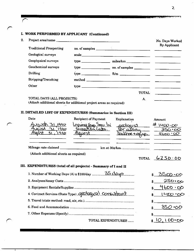
1. WORK PERFORMED BY APPLICANT (Continued)
2. Project area/name _________________________ No. Days WorkedBy Applicant
Traditional Prospecting no. of samples _____________________ ——^^—^-^——Geological surveys scale___________________________ ^——-^—-—^-—-Geophysical surveys type ____________ miles/km.Geochemical surveys type ___________ no. of samplesDrilling type -————.——.— ft/m ^——^—Stripping/Trenching method __^___^___^____^____Other type ^—^^^——^^-—^^——.^^-——
TOTAL ————TOTAL DAYS (ALL PROJECTS) A. ——— (Attach additional sheets for additional project areas as required)
II. DETAILED LIST OF EXPENDITURES (Summarize in Section III)
Date Recipient of Payment Explanation Amount 31 WlP LtMXtmD ^m-^C{u W
S\ . I'Ko /\\fl.oeM______ QacrW3e.-v^(rovn. itk-pp rISO'00
Mileage rate claimed ________;_______ km at 300/km................................(Attach additional sheets as required)
TOTAL
III. EXPENDITURES (total of all projects) - Summary of I and II
1. Number of Working Days (A) x $100/day ...............1^..(^ft^p.............
2. Analyses/Assay Costs................................................................................3. Equipment Rentals/Supplies ............................ i ....................................... S l bOC) ' OD4. Contract Services (State Type) ..^^\ra^Pw\...Q^?fe.v^a!CX\rvT......... $ __5. Travel (state method: road, air, etc.)........................................................ S ——6. Food and Accommodation ......................................................................... $___•O^C' "OP7. Other Expenses (Specify).......................................................................... $ ——^—-———^^—
^^ TOTAL EXPENDITURES....... ^ \O. V DD'OO
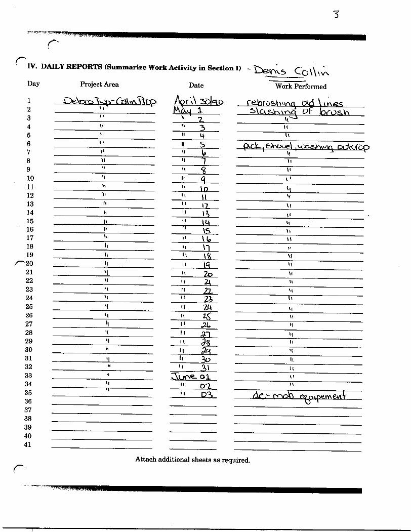
c^ IV. DAILY
Day
1 J2345678910111213141516171819
REPORTS (Summarize Work Activity in Section I) - \^ev\V3 Co \\ \ v\
Project Area Date Work Performed
kZ^eNi3fo~\wrs~('rtV\v\VVrei nOf \\ 2aD(c\t? rGiofo&hwAQ D^d VvwesVi KA A \. ^\T\ C^V-v \v\Pt Df" i"i/" "i^V-vM x 2. MM l ( 3 uli 'l U. \V
11 " S CXCJC-.fe.VMXje\ , M^o&iav^^: i OL^CfcC1' " (o M\i " "J "i' it *^ \i'i H q i 1'' " 10 \ (" " \l N'li M j? \(li " t^ \iM " \M *'h " \S M'- " VU "li M \~| *-li H V^ M
^20 't " \f\ ^212223242526272829303132333435
M 't 2o * 'M li 2\ 'tM H 22, V vM M 21 uM M ZM \iM "2^" vil| (i ^(. M•i li gr\ \\M K fa H
11 li ^ 'ti| l{ 3o 'l" 'i ^i MM C^UO'S- Oi. ' 'H ii Q-2. "k| M Q-3, (df ^ rroti e&i^inerAewA'
36 o '3738394041
Attach additional sheets as required.r
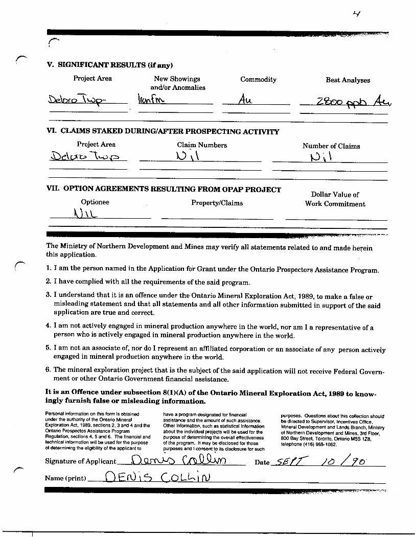
V. SIGNIFICANT RESULTS (if any)
Project Area
LieAr^ro \ ̂ -Op~
New Showings and/or Anomalies
Commodity
Au.Best Analyses
Z. feso *^r*J~"s A-CIY x l
VI. CLAIMS STAKED DURING/AFTER PROSPECTING ACTIVITY
Project Area Claim Numbers
_______O V\^—-^-——^——
Number of Claims
VII. OPTION AGREEMENTS RESULTING FROM OPAP PROJECT
Optionee Property/Claims
Khi_____ ___________Dollar Value of
Work Commitment
The Ministry of Northern Development and Mines may verify all statements related to and made herein this application.
1. I am the person named in the Application for Grant under the Ontario Prospectors Assistance Program.2. I have complied with all the requirements of the said program.
3. I understand that it is an offence under the Ontario Mineral Exploration Act, 1989, to make a false or misleading statement and that all statements and all other information submitted in support of the said application are true and correct.
4. I am not actively engaged in mineral production anywhere in the world, nor am I a representative of a person who is actively engaged in mineral production anywhere in the world.
5. I am not an associate of, nor do I represent an affiliated corporation or an associate of any person actively engaged in mineral production anywhere in the world.
6. The mineral exploration project that is the subject of the said application will not receive Federal Govern ment or other Ontario Government financial assistance.
It is an Offence under subsection 8(1)(A) of the Ontario Mineral Exploration Act, 1989 to know ingly furnish false or misleading information.
Personal information on this form is obtained under the authority of the Ontario Mineral Exploration Act. 1989. sections 2, 3 and 4 and the Ontario Prospectos Assistance Program Regulation, sections 4, 5 and 6. The financial and technical information will be used for the purpose of determining the eligibility of the applicant to
rSignature of Applicant
Name (print) Q EfO \ 5S
have a program designated for financial assistance and the amount of such assistance. Other information, such as statistical information about the individual projects will be used for the purpose of determining the overall effectiveness of the program. It may be disclosed for those purposes and l consent to its disclosure for such
Date
purposes. Questions about this collection should be directed to Supervisor, Incentives Office, Mineral Development and Lands Branch, Ministry of Northern Development and Mines, 3rd Floor, 800 Bay Street, Toronto, Ontario MSS 1Z8, telephone (416) 965-1062.
se f f ;e /?o

r PROGRAMME D'AIDE AUX PROSPECTEURS DE L'ONTARIO (PAPO) FORMULE DE VERSION FINALE DU PLAN DE PROSPECTION(La pr^sente servira de rapport de prospection exige en vertu de 1'article 4(1) des reglements du PAPO)INSTRUCTIONS :Dactylographier ou ^crire en lettres mouses Faire parvenir les formules remplies au : Bureau des subventions d'encouragement Ministere du DeVeloppement du Nord et des Mines 3e etage, 880, rue Bay, Toronto (Ontario) MSS 1Z8
A ETRE REMPLIE PAR LE OU LA BENEFICIAIRE UNE FOIS LE PROJET COMPLETE ET ACCOMPAGNE DE RAPPORTS ECRITS, DE CARTES, ETC.
Nom Num6ro de dossier
Endroit(s) du projet propose1 (canton ou nom de la carte de concession)Comp!4tes?
1. .Qr^Vrsro VvO p -_____________________ Oui Q' Non Q2. __________________;—-^^—..^——^——.^——^————Changements apporte"s au(x) projet(s) propose(s) (s'il y a lieu)
Oui Q Non Q
Liste des associe(e)s qui ont travaille" au(x) projet(s)
I. TRAVAUX EFFECTUES PAR LE (LA) DEMANDEUR(EUSE) (Resume de la Partie IV)1. Norn ou endroit du proiet
Prospection traditionnelle Lev6s g6ologiques
Lev^s g^ophysiques Lev6s g6ochimiques r
Forage
Extraction/Excavation de tranchees
Autre
\UJp- "~ C-oVV VV\
nombre d'6chantillons
type,
type.
type.
milles/km ——
nombre ——^— d'6chantillons
pL/m^^——^melhode
type
Nombre de jours de travail efFectue par le (la)demandeur (deuse)
TOTAL
PROGRAMME D'AIDE AUX PROSPECTEURS DE L'ONTARIO (PAPO) FORMULE DE VERSION FINALE DU PLAN DE PROSPECTION(La pr^sente servira de rapport de prospection exigd en vertu de 1'article 4(1) des reglements du PAPO)INSTRUCTIONS :Dactylographier ou 6crire en lettres moulees Faire parvenir les formules remplies au : Bureau des subventions d'encouragement Ministere du DeVeloppement du Nord et des Mines 3e 6tage, 880, rue Bay, Toronto (Ontario) M5S 1Z8
A ETRE REMPLIE PAR LE OU LA BENEFICIAIRE UNE FOIS LE PROJET COMPLETE ET ACCOMPAGNE DE RAPPORTS ECRITS, DE CARTES, ETC.
Nom TN^U irtxov^O- Numero de dossier
Endroit(s) du projet propos6 (canton ou nom de la carte de concession)Compl6te"s?
1. -Ljre\T3rQ___\ \jQ P*._________________________ Oui
2. Oui Q
Non Q
Non QChangements apportes au(x) projet(s) propose(s) (s'il y a lieu)
a vco-V
Liste des associe(e)s qui ont travaille au(x) projet(s)
TRAVAUX EFFECTUES PAR LE (LA) DEMANDEUR(EUSE) (Resume de la Partie IV)
r
1. Nom ou endroit du projet
Prospection traditionnelle Lev^s geologiques Lev6s geophysiques Leves geochimiques
Forage
Extraction/Excavation de tranches
Autre
\U3fi- — \rpfigr-V-y
nombre d'6chantillons echelle -^————^—
type —————————— type -———,.———
type.
milles/km __
nombre —-— d'echantillonspiJm_____
m^thode
type
&V O^Jh \V\(\
Nombre de jours de travail effectue^ par le (la)demandeur (deuse)
TOTAL
r
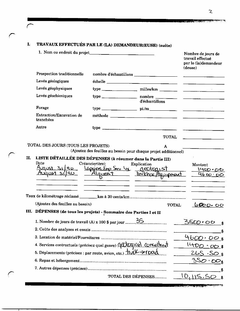
i. TRAVAUX EFFECTUES PAR LE (LA) DEMANDEUR(EUSE) (suite)
1. Nom ou endroit du projet_______^_____^^___^__^_ Nombre de jours de travail effectue" par le (la)demandeur (deuse)
Prospection traditionnelle Leves geologiques Leves geophysiques Leves geochimiques
Forage
Extraction/Excavation de tranches
Autre
nombre d'echantillons . 6chelle —^——^-——-
type ^—^^————.. type__________
type.
milles/km ——
nombre ———- d'echantillons
piVm^——^—methode
type
TOTAL
TOTAL DES JOURS (TOUS LES PROJETS) A(Ajoutez des feuilles au besoin pour chaque projet additionnel)
II. LISTE DETAILLEE DES DEFENSES (h resumer dans la Partie III)Date Creancier(ere) Explication
A
Taux de kilometrage reclame.
ti
Montant
.km a 30 cents/km.(Ajoutez des feuilles au besoin) TOTAL
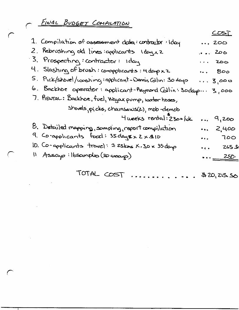
III. DEFENSES (de tous les projets) - Sommaire des Parties I et II
* OO
1. Nombre de jours de travail (A) x 100 S par jour2. Gouts des analyses et essais ...............................
3. Location de materiel/Fournitures ...........,..........4. Services contractuels (pr^cisez quel genre) .5. Deplacements (precisez : par route, avion, etc.)6. Repas et hebergement.....................................................................7. Autres depenses (pr6cisez)..............................................................
TOTAL DES DEPENSES
OO
oc?•So
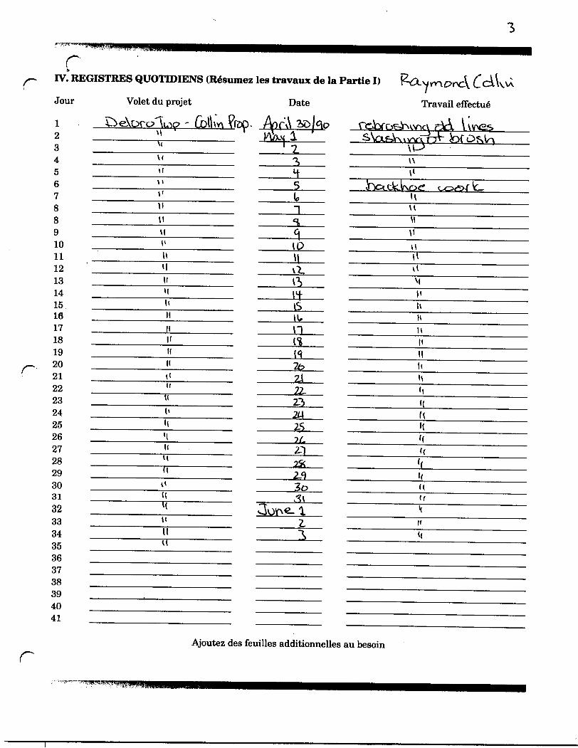
rIV. REGISTRES QUOTIDIENS (Resumez les travaux de la Partie I)
Jour
2345678891011121314151617181920212223242526272829303132333435363738394041
Volet du projet
u
M
H
M
U
Date
c\
ID\\
6tun
2122.22,m2S2L
Travail effectue'
\
v\
n
li
K
K(f
Ajoutez des feuilles additionnelles au besoin
rr
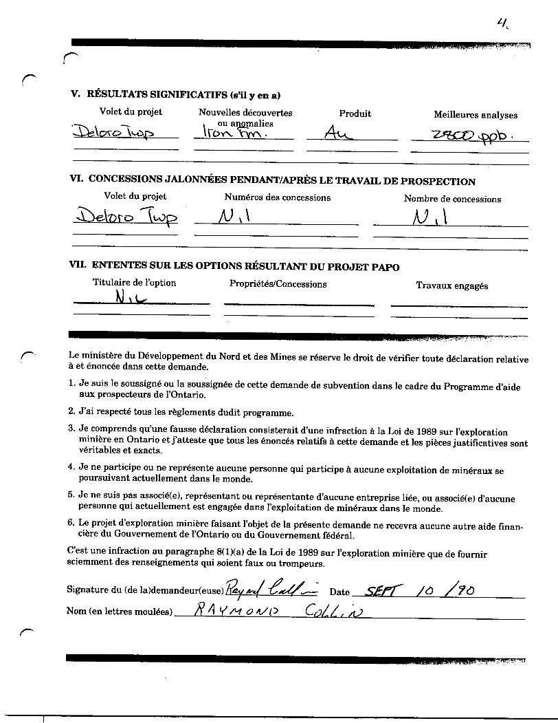
V. RESULTATS SIGNIFICATIFS (s'il y en a)
Volet du projet Nouvelles decouvertes Produit Meilleures analyses. ou anomaliesUQw VVVN -
VL CONCESSIONS JALONNEES PENDANT/APRES LE TRAVAIL DE PROSPECTION
Volet du projet NumeYos des concessions Nombre de concessions
i\
VII. ENTENTES SUR LES OPTIONS RESULTANT DU PROJET PAPOTitulaire de 1'option Proprietes/Concessions Travaux engages
Le ministere du DeVeloppement du Nord et des Mines se reserve le droit de verifier toute declaration relative a et enoncee dans cette demande.1. Je suis le soussign^ ou la soussign6e de cette demande de subvention dans le cadre du Programme d'aide
aux prospecteurs de 1'Ontario.2. J'ai respecte tous les reglements dudit programme.3. Je comprends qu'une fausse declaration consisterait d'une infraction a la Loi de 1989 sur 1'exploration
miniere en Ontario et j'atteste que tous les 6nonc6s relatifs a cette demande et les pieces justificatives sont veritables et exacts.
4. Je ne participe ou ne repr^sente aucune personne qui participe a aucune exploitation de min6raux se poursuivant actuellement dans le monde.
5. Je ne suis pas associeXe), representant ou representante d'aucune entreprise liee, ou associe(e) d'aucune personne qui actuellement est engagee dans 1'exploitation de mindraux dans le monde.
6. Le projet d'exploration miniere faisant 1'objet de la presente demande ne recevra aucune autre aide finan- ciere du Gouvernement de 1'Ontario ou du Gouvernement federal.
C'est une infraction au paragraphe 8(l)(a) de la Loi de 1989 sur 1'exploration miniere que de fournir sciemment des renseignements qui soient faux ou trompeurs.
Signature du (de la)demandeur(euse) lay/nt f̂-- — Date
Norn (en lettres mouses) ft A *S M 0 *S P
r
J
00 L
'S
J
rr
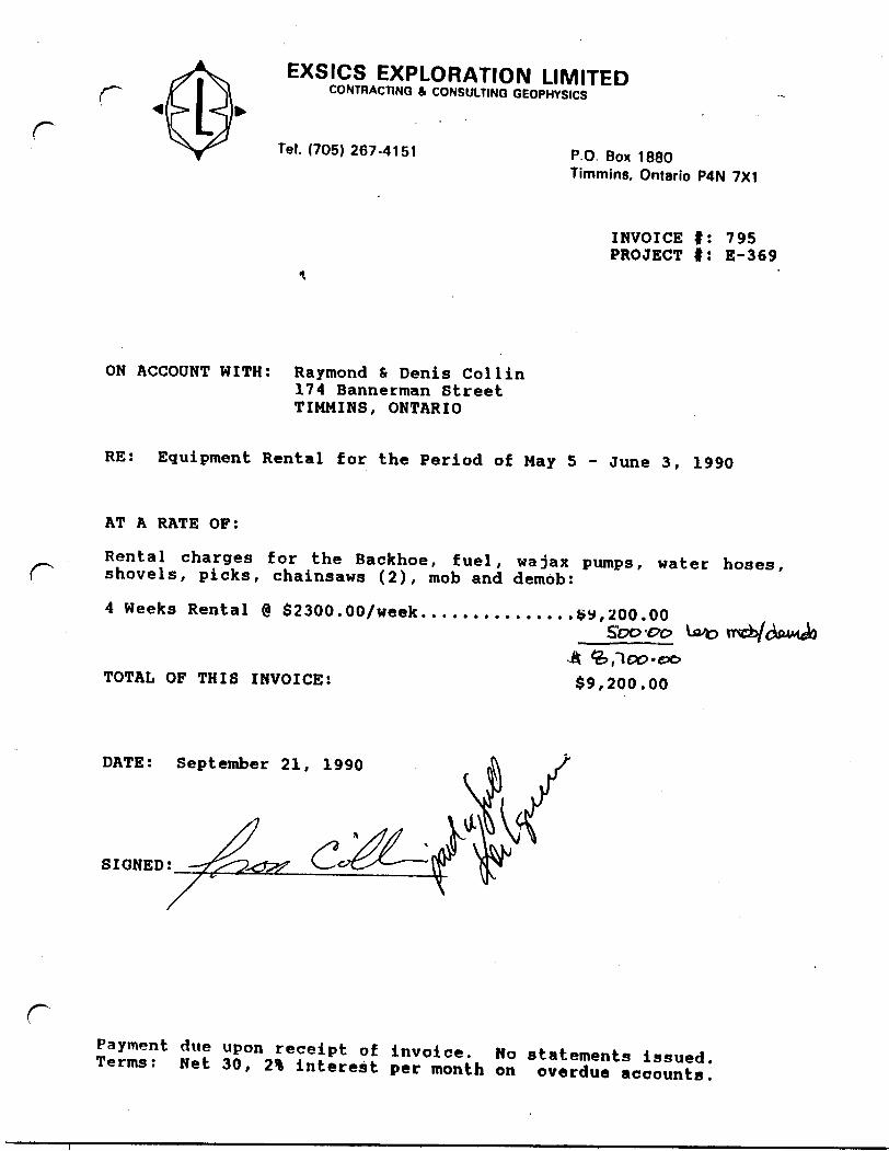
EXSICS EXPLORATION LIMITEDCONTRACTING A CONSULTING GEOPHYSICS
Tel. (705) 267-4151 P.O Box 1880Timmins, Ontario P4N 7X1
INVOICE f: 795 PROJECT f: E-369
ON ACCOUNT WITH: Raymond 6 Denis Col l in174 Bannerman Street TIMMINS, ONTARIO
RE: Equipment Rental for the Period of May 5 - June 3, 1990
AT A RATE OF:
Rental charges for the Backhoe, fuel, wajax pumps, water hoses, shovels, picks, chainsaws (2), mob and demob:
4 Weeks Rental @ S2300.00/week...............fry,200.00
TOTAL OF THIS INVOICE: S9,200.00
DATE: September 21, 1990
SIGNED;
rPayment due upon receipt of invoice. No statements issued. Terms: Net 30, 2% interest per month on overdue accounts.
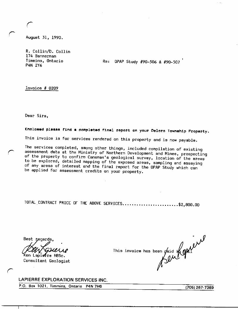
rAugust 31, 1990.
R. Collin/D. Collin 174 Bannerman Timmins, Ontario P4N 2Y6
Re: OPAP Study #90-506 A #90-507
Invoice # 0209
Dear Sirs,
plvaaa find * completed final report en your Deloro Township Property.
This invoice is for services rendered on this property and is now payable.
The services completed, among other things, included compilation of existing assessment data at the Ministry of Northern Development and Mines, prospecting of the property to confirm Canamax's geological survey, location of the areas to be explored, detailed mapping of the exposed areas, sampling and assaying of any areas of interest and the final report for the OPAP Study which can be applied for assessment credits on your property.
TOTAL CONTRACT PRICE OF THE ABOVE SERVICES.......................42,800.00
r
Best regards,
This invoice has been I/aidLapiafre HBSc.
Consultant Geologist
LAPIERRE EXPLORATION SERVICES INC.P.O. Box 1021, Timmins, Ontario P4N 7H6 (705)267-7389
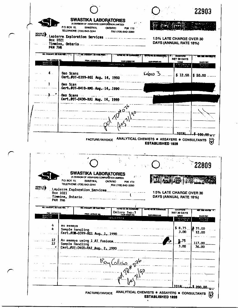
ro o 22903
SWASTIKA LABORATORIES(A DIMSION OF ASSAYER9 CORPORATION UMtTED)
P.O. BOX 10, SWASTIKA, ONTARIO POK 1TO TELEPHONE: (705) 642-3244 FAX (70S) 642-3300
Lapierre Exploration Services .. -— -. .— .......Box 1021Timmins, Ontario - . ...~....————.——~———...P4N 7H6
1.5Vo LATE CHARGE OVER 30 DAYS (ANNUAL RATE 18"/o)
4
l
3
Geo ScansOrt.fOT-0399-RGl Aug. 14, 1990Geo Scan Cert.fOT-0410-Wtt-Aug^-14r-1990————Geo Scans —- — —— Cert.fOT-0430-RAl Aug. 14. 1990
FACTURE/INVOICE ANALYTICAL CHEMISTS * ASSAYERS * CONSULTANTSESTABLISHED 1928
r
r
VENDUAkvcnw n lSOLD TO l
'OO, 22809
SWASTIKA LABORATORIES(A DMSION OF ASSAYERS CORPORATION UMTED)
P.O. BOX 10. SVWVSTIKA. ONTARIO POK 1 TO TELEPHONE: (70S) 642-3244 FAX (705) 642-3300
Lapierre Exploration Services Box 1021 ( Timmins, Ontario , — ..-—-. 7H6 " ~
1.50Xo LATE CHARGE OVER 30 DAYS (ANNUAL RATE 18Vo)
44
1212
au assays Sample handling Cert.fOi-0399-RGl Aug.J..1990
Au assays using .1. Sample Handling
AT-fusions___ J' 75 3.00
TOTAL
35.0012.00
117.00,36.00
t 9tm onFACTURE/INVOICE ANALYTICAL CHEMISTS * ASSAYERS * CONSULTANTS r^
ESTABLISHED 1928 ^

Ministry of 'f, - "' s : ?-^ Northern Development and Mines ^*- '
Ontario
DOCUMENT, No,.4aA86NW8157 63.5439 DELORO 900
Expenditures.- Refer to Sections 76 and 77, Ihe Mining Act for assessment work
requirements and Ihe reverse side of this form for table of Information.Mining Report of Work
Name and Address of Recorded Holder'''•^S&^^^^A GftUm
Summary of Distribution of Credits and Work PerformanceMining Division
vo rco o \Y\@Township or Area
"J^cAor^Total Assessment Credits Claimed
Type of Work Performed (Check on* only)
G Manual Workr-. Shaft Sinking Drifting or other U Lateral Work
O Mechanical equipmenti— JBewer Stripping other than Manual lM(maxlmum credit allowed - 100 days
per claim) Q Diamond or other Core drilling
Q] Core Specimens
Mining ClaimPrefix
P-p
42-
•" '.. :
Number
\ X'b'^c^Tj*
UlDT-0^ \
Dates when work wes performed ^ J
Work Days Cr.
I67DJPQira?
,
-'
Mining ClaimPrefix
LAfcn
Number
Total No. of Days Performed
Prospector's Licence No.iio a'rAaA y^-.2?? H 3
WorkDays Cr.
^Ik.
f.
c
Mining ClaimPrefix
AfoRK| F
Number
©eMeiO*ce f
Work Days Cr.
T
Total No. of Days ClaimedZOO
Total No. of Days to be Claimed at a Future Date ^ "S*^*? t l~lf\
All the work was performed on Mining Claim(s): Indicate no. of days performed on each claim. C * (See note No. 1 on reverse side)
Mining Claim No. of Day* Mining Claim No. rf Days
Mining Claim No. of Days'iiw\^o| s^oMining Claim No. of Days
Mining Claim
Mining Claim
No. of Days
No. of Days
Mining Claim No. of Days
Mining Claim No. of Days
Mining Claim
Mining Claim
No. of Days
No. o) Days
"J*
W
Required Information eg. type of equipment, Names, Addresses, etc. (See Table on reverse side) If space below Is insufficient, attach schedules with required information and location sketches
As \Y\\yoce.
La.puef ̂
GEOLOGICAL SURVEY ASSESSMENT FILE8
OFRCF
R P r. l V (5 UCertification of Beneficial Interest * (See Note No. 2 on reverse side)1 hereby certify that, at the time the work was performed, the claims covered In this report of work were recorded In the current recorded holder's name or held under a beneficial Interest by the current recorded holder.
RecoMM HotdvV or Agent (Slgnatura)
Certification Verifying Report of Workl hereby certify that l have a personal and Intimate knowledge of the facts set forth in the Report of Work annexed hereto, having performed the work or witnessed same during and/or after its completion and the annexed report is true.Name and
Y^-
Address of Pereon Certifying
Telephone No. Date Certtfd By (Slo/Mura) '
//ffi/J^Ul7
For Office Use Only elf1.-'-:.-.:" 1.- x'' V
RECORDED,Work Assignments
'- -
80TJ
Received Stamp
\
N
V5
* 2-1132991 ^-1035591 2-549555
* 2-33872 ~ Survey pin
Vi -dykes-py rich vcontacts
s, *\\
LEGEND
pyqtzaltchlmagox
70
70
contm. gf.gsiltrf. f.n.mA
PyriteQuartzAlterationChloriteMagnetiteOxideSchistosity/ dipStrike/ dipContortedMedium grainedFine grainedSilicifiedTraceFebic fragmentsNon-mineralizedRubble
ViV4
V5VioVnS 6
- Geological infered contact
Sample** 4405440644074408440944104411441244134414441544164417441844194420
Au ppb5212242806Nil10730312NilNil314Nil354826
Felsic to int. volcanic - tuffaceous DaciteInt. to mafic volcanic - tuffaceous Agglomerate GabbroBanded iron formation -oxide facies
-sulfide facies
PROPERTY LOCATION
N
, flynn \ Lake
DELORO TWP. 1:20,000
43A06NW0157 63.5439 DELORO 200
o 20Feet
r-20 1
DELORO TOWNSHIP
COLLIN PROPERTY
OPAP OP 90-506 OP 90-507
Mop by Ken Lapierre August 1990 Drawn by P.G.