Embed Size (px)
Citation preview
AAVC2021-22 Version 2 (Apr24) by CASE & KU
AUTONOMOUS AERIAL VEHICLE CHALLENGE 2021-2022
In 2021, Kasetsart University was honored to be the host for 2021
Autonomous Aerial Vehicle Challenge (AAVC2021). Unfortunately, the
event needed to be postponed due to the incident of COVID-19 pandemic.
It is projected that the situation is improving due to the international efforts
on the vaccine development progress, which leads to the possibility that
the AAVC event could be resume in the year 2022. By considering
relevance factors including lead time, number of the “projected”
participating teams, and the limitations of the host organization’s support
infrastructure/event management capability, it is decided that in this
upcoming event, The AVVC2021-2022, the “technical screening” process
will be introduced an initial selection phase prior to the actual on-site
aerial challenge. Each participating team will be expected to submit the
report detailing the development (engineering design, construction and
testing) of their aerial platform and associated subsystems to the AAVC
committee in 2021 for technical evaluation. A number of participant teams
will then be selected for the on-site operational challenges in 2022 based
on the technical evaluation result.
AAVC2021-12 Task Overview
Each participant team will be tasked to develop their unmanned
aircraft systems (UAS) for Surveillance and Reconnaissance (SAR)
operation. There is no restriction on platform configuration. The aerial
platform configuration could be either fixed-wing, rotary wing (multi-
rotor, or other rotorcraft), or hybrid (convertiplane such as tilt-rotors, fixed
wing with vertical lift components, tail-sitter, etc). However, the platform
must be developed under the following capability requirements:
Operating range and search area coverage: The system shall be able
to maintain line-of-sight (LOS) communication with the control station at
a minimum at a minimum range of 1000 m for provide continuous feed of
both target imaging and flight telemetry data. Also the vehicle shall be able
to perform a search covering the area of 1100 x 700 m (fixed wing/hybrid)
and 600 x 700 meters (rotary wing). The search operation consists of level-
flight patterns and loitering/hovering over target (configuration
dependent).
AAVC2021-22 Version 2 (Apr24) by CASE & KU
Search and Target Identification: The vehicle shall equipped with a
suitable imaging system to capture and transmit the imaging data of the
target to the control station. There is no restriction on the type and
capability of the system e.g. the system could use either electro-optical,
infra-red, or the combination of the two as well as multiple sensors of the
same type a part of sensor suite. The use of image processing algorithm is
encourages for better search capability. There is no restrictions on the
equipment and/or technique used to determine the position (coordinates) of
the target except the minimum flight deck (altitude) restriction e.g.
additional sensors such as laser range-finder is also allowed.
Payload system: The air vehicle shall have the payload handling
system that could accommodate the payload module(s) and release the
module to the ground target in mid-flight. The maximum weight of each
payload module is at 1kg with the minimum weight of 0.5 kg (see the
description in chapter “Payload Specification” for further details on the
specified size and dimensions of the payload module).
The air vehicle is allowed to carry multiple payload modules.
However, the payload handling system must have the ability to control the
release of each payload module independently from each other (it is not
allowed to released multiple payloads at the same time).
Flight system: The system shall equipped with autonomous flight
system using an open-source flight computer architecture which enables
the air vehicle to fly autonomously in the pre-programmed flight paths
(waypoints) during operations. The use of advanced algorithm such as
machine learning to enhance the autonomy of flight operations (auto target
identification and payload release, auto flight search pattern, etc.) is
encourages.
To ensure operational safety, the system shall have a suitable level of
safety by introducing emergency/fail-safe measures and/or system
engineering approach e.g. system redundancy by-design.
Flight and imaging data relay: The control station shall have the
ability to relay both flight and imaging data from the UAS main control
station to the third-party display unit for operational performance
evaluation.
AAVC2021-22 Version 2 (Apr24) by CASE & KU
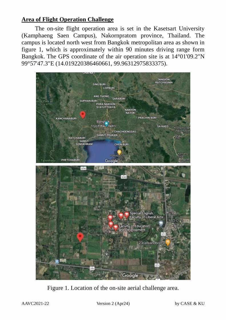
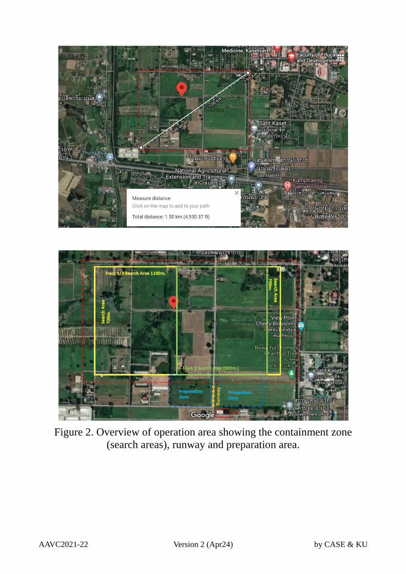
Area of Flight Operation Challenge
The on-site flight operation area is set in the Kasetsart University
(Kamphaeng Saen Campus), Nakornpratom province, Thailand. The
campus is located north west from Bangkok metropolitan area as shown in
figure 1, which is approximately within 90 minutes driving range form
Bangkok. The GPS coordinate of the air operation site is at 14°01'09.2"N
99°57'47.3"E (14.019220386460661, 99.96312975833375).
Figure 1. Location of the on-site aerial challenge area.
AAVC2021-22 Version 2 (Apr24) by CASE & KU
Operating Scenario Overview
During the development of the vaccines to cope with the pandemic
causing by a certain type of lethal virus. Two of the test subjects were
escaped from the research facility. A containment perimeter surrounded by
a high-voltage fence is set to prevent the test subject from reaching the
residential area, which could instantly kill any animals once it make
contact with the fence as a last resort. However, it is strongly
recommended that the test subject is to be captured alive due to the
valuable of the test subject’s developed immune system during the
experiment, which is invaluable for the vaccine development.
The search and capture team has already been deployed for search
and capture operation. However, according to the information provided by
the scientists working in the test facility, the escaped test subjects are
predator-type species which is highly aggressive and would violently
attack the capturing team once they are detected. Moreover, one particular
test subject has also developed the ability to detect heat signature from
other sources including other mammals at a certain distance as a side-
effect from the experiments. Hence, the conventional capturing approach
such as tranquilizer dart is deemed to be impractical as their heat-detection
range exceeds the effective range of the dart rifle.
Fortunately, there is currently a development of a prototype
tranquilizer bomb which could be deployed form an aerial vehicles such as
unmanned aircraft to the target located on the ground. It is designed for a
rapid release of the strong sedative gas on-impact which is expected to
effectively subdue a highly-agitated animal once the payload hit the target
directly or hit the ground near an animal within the effective gas range.
According to the data regarding to the size and weight of the test subject
provided by the test facility, the payload development team was able to
produced a number of tranquilizer bombs compatible with the small
unmanned aircraft, The overall weight of the tranquilizer, depending on the
amount of sedative inside the casing, is varied between 0.5-1.0 kg.
However, due to the intensity of the sedative, there is a risk of “fatal”
overdosing if more than two tranquilizer bombs are dropped within the
effective range to the test subject.
AAVC2021-22 Version 2 (Apr24) by CASE & KU
Figure 2. Overview of operation area showing the containment zone
(search areas), runway and preparation area.
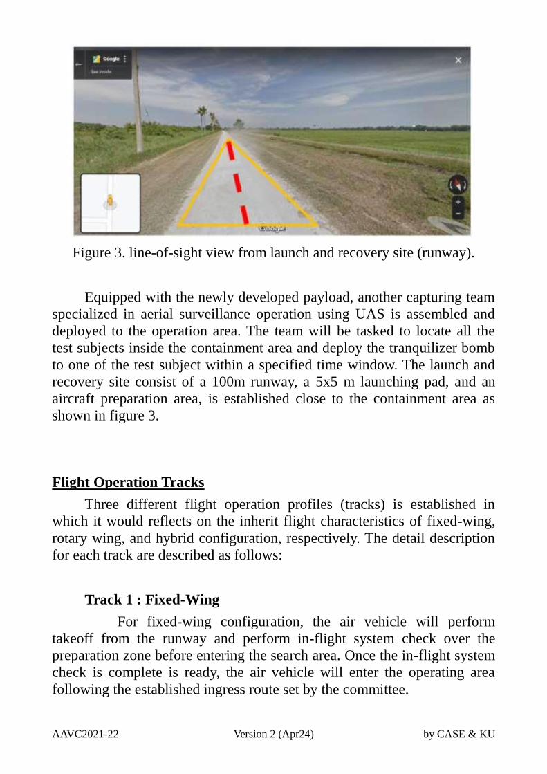
AAVC2021-22 Version 2 (Apr24) by CASE & KU
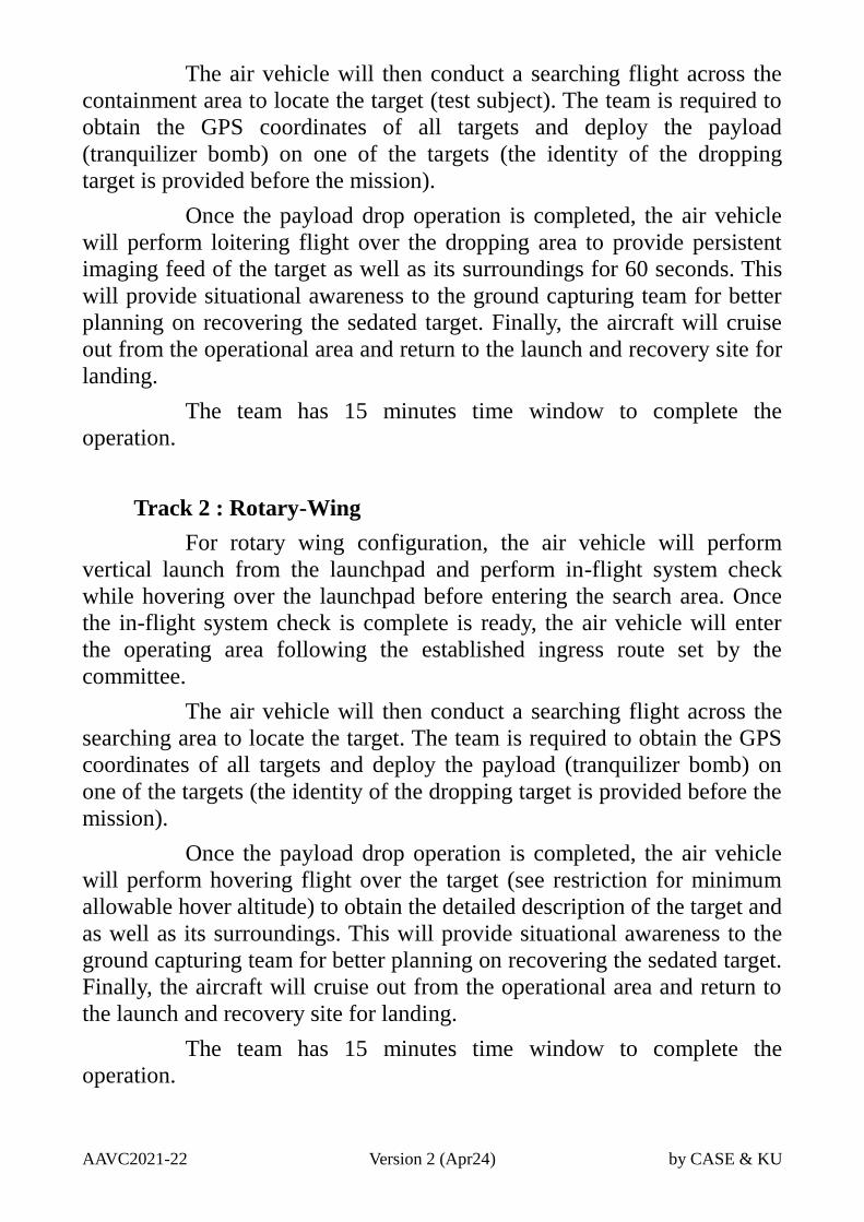
Figure 3. line-of-sight view from launch and recovery site (runway).
Equipped with the newly developed payload, another capturing team
specialized in aerial surveillance operation using UAS is assembled and
deployed to the operation area. The team will be tasked to locate all the
test subjects inside the containment area and deploy the tranquilizer bomb
to one of the test subject within a specified time window. The launch and
recovery site consist of a 100m runway, a 5x5 m launching pad, and an
aircraft preparation area, is established close to the containment area as
shown in figure 3.
Flight Operation Tracks
Three different flight operation profiles (tracks) is established in
which it would reflects on the inherit flight characteristics of fixed-wing,
rotary wing, and hybrid configuration, respectively. The detail description
for each track are described as follows:
Track 1 : Fixed-Wing
For fixed-wing configuration, the air vehicle will perform
takeoff from the runway and perform in-flight system check over the
preparation zone before entering the search area. Once the in-flight system
check is complete is ready, the air vehicle will enter the operating area
following the established ingress route set by the committee.
AAVC2021-22 Version 2 (Apr24) by CASE & KU
The air vehicle will then conduct a searching flight across the
containment area to locate the target (test subject). The team is required to
obtain the GPS coordinates of all targets and deploy the payload
(tranquilizer bomb) on one of the targets (the identity of the dropping
target is provided before the mission).
Once the payload drop operation is completed, the air vehicle
will perform loitering flight over the dropping area to provide persistent
imaging feed of the target as well as its surroundings for 60 seconds. This
will provide situational awareness to the ground capturing team for better
planning on recovering the sedated target. Finally, the aircraft will cruise
out from the operational area and return to the launch and recovery site for
landing.
The team has 15 minutes time window to complete the
operation.
Track 2 : Rotary-Wing
For rotary wing configuration, the air vehicle will perform
vertical launch from the launchpad and perform in-flight system check
while hovering over the launchpad before entering the search area. Once
the in-flight system check is complete is ready, the air vehicle will enter
the operating area following the established ingress route set by the
committee.
The air vehicle will then conduct a searching flight across the
searching area to locate the target. The team is required to obtain the GPS
coordinates of all targets and deploy the payload (tranquilizer bomb) on
one of the targets (the identity of the dropping target is provided before the
mission).
Once the payload drop operation is completed, the air vehicle
will perform hovering flight over the target (see restriction for minimum
allowable hover altitude) to obtain the detailed description of the target and
as well as its surroundings. This will provide situational awareness to the
ground capturing team for better planning on recovering the sedated target.
Finally, the aircraft will cruise out from the operational area and return to
the launch and recovery site for landing.
The team has 15 minutes time window to complete the
operation.
AAVC2021-22 Version 2 (Apr24) by CASE & KU
Track 3 : Hybrid Configuration
For hybrid configuration the air vehicle will perform vertical
launch from the launchpad and perform in-flight system check while
hovering over the launchpad before entering the search area. Once the in-
flight system check is complete is ready, the air vehicle will enter the
operating area following the established ingress route set by the
committee.
The air vehicle will then conduct a searching flight across the
searching area to locate target. The team is required to obtain the GPS
coordinates of all targets and deploy the payload (tranquilizer bomb) on
one of the targets (the identity of the dropping target is provided before the
mission).
Once the payload drop operation is completed, the air vehicle
will perform hovering flight over the target (see restrictions for minimum
allowable hover altitude) to obtain the detailed description of the target and
as well as its surroundings. This will provide situational awareness to the
ground capturing team for better planning on recovering the sedated target.
Finally, the aircraft will cruise out from the operational area and return to
the launch and recovery site for landing.
It is expected that this configuration would perform all forward
flight phases (cruise, loiter) using only the aerodynamic lift generates from
the fixed lifting surfaces i.e. wings, horizontal tail, lifting body, etc. instead
of using manipulated thrust vectors generated by propulsion unit.
However, a combinations between vertical and horizontal thrust is allowed
during the transition phase.
The team has 15 minutes time-window to complete the
operation.
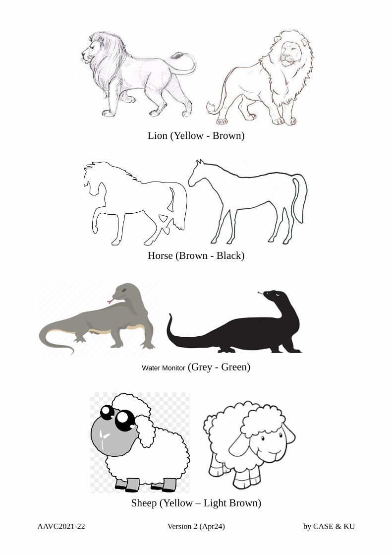
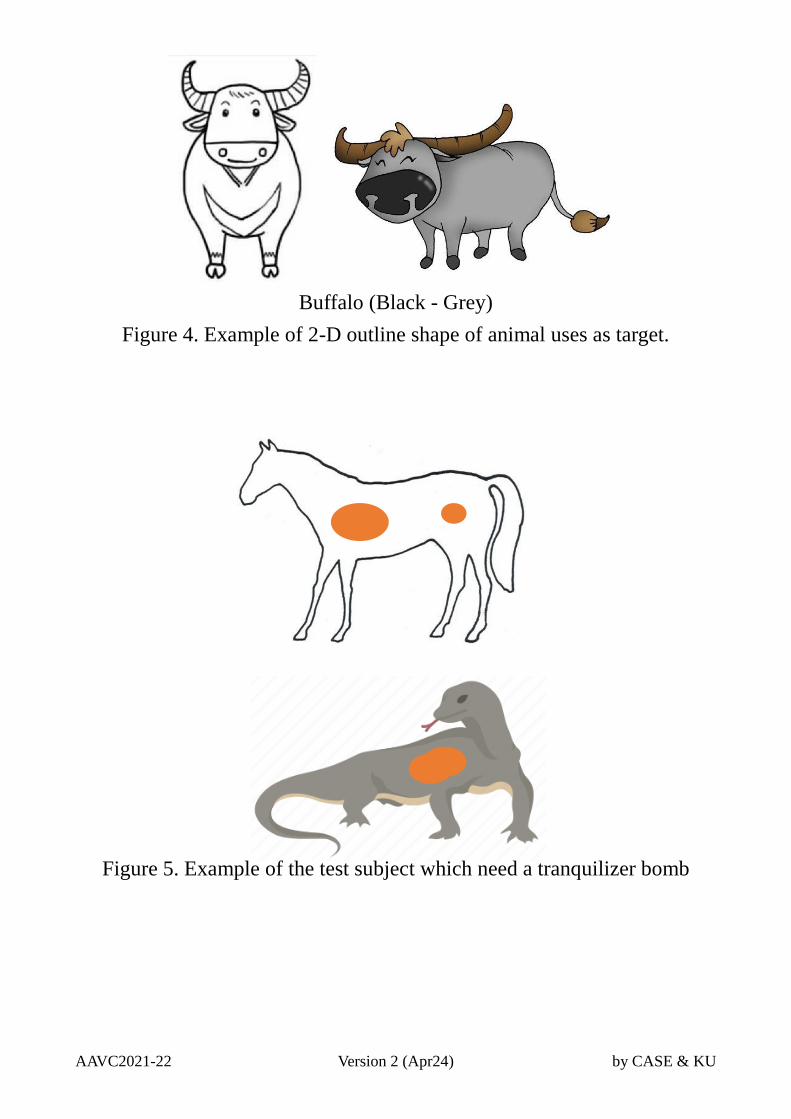
Target Placement
For this AAVC 2021-2022 challenge the targets are presented as the
2-D image of the outline shape of the animal species listed in the test
subject’s database (There are five animal species of test subjects; Lion,
Horse, Sheep, Water Monitor, and Buffalo). During the on-site operation
the image will be printed in about 2 x 2 meters vinyl sheets (color and
dimension may slightly different according to the type of animals) as
shown in Fig.4, which will be placed on the location by the field staff. The
example of the target is represent as a 2D drawing in a vinyl sheet as
illustrated in figure 5.
AAVC2021-22 Version 2 (Apr24) by CASE & KU
Lion (Yellow - Brown)
Horse (Brown - Black)
Water Monitor (Grey - Green)
Sheep (Yellow – Light Brown)
AAVC2021-22 Version 2 (Apr24) by CASE & KU
Buffalo (Black - Grey)
Figure 4. Example of 2-D outline shape of animal uses as target.
Figure 5. Example of the test subject which need a tranquilizer bomb
AAVC2021-22 Version 2 (Apr24) by CASE & KU
Event Schedule and Details
In addition to the on-site operational challenge, this AAVC 2021-
2022 event would includes the technical evaluation phase prior to the on-
site operational challenge, resulting as a two-phase event. The technical
evaluation committee (selected from the member of CASE) will evaluate
the reports submitted by all participating teams and rank the teams based
on the evaluation scores. The first twelve (12) teams in the ranking list will
be qualified for entering the on-site operation challenges directly.
However, the team that does not qualified in this phase will be granted for
a second opportunity by submitting the VDO footage demonstrating the
capability of the system within a specified time-frame after the technical
evaluation result is announced. The evaluation committee will then select
six (6) teams for participating in the on-site challenge.
Phase 1 : Technical report submission (2020)
The participating teams would submit the report describing the
technical detail regarding the development of the air vehicle including
engineering design, fabrication and testing. See section Technical report
guidelines for report structure and technical detail guidelines.
Phase 1 Submission Deadline : 1 July 2021
Phase 1 Evaluation Result Announcement : 31 July 2021
Submit via an email: [email protected]
Phase 2 : Demonstration Footage Submission (2021)
The participating teams that does not pass the technical evaluation
phase shall have an opportunity to enter the second evaluation by
submitting a five-minute video footage demonstrating the capability of
their UAS. In the submitted footage, the air vehicle must, at minimum,
demonstrate basic flight operation profile consists of take-off, climb,
cruise, descend, and landing.
Phase 2 Submission Deadline : 30 September 2021
Phase 2 Evaluation Result Announcement : 10 October 2021
AAVC2021-22 Version 2 (Apr24) by CASE & KU
Phase 3 : On-Site Aerial Challenges (2022)
A total of twenty teams (18 from phase 1 and phase 2 evaluation,
plus 2 teams by invitation) will enter the on-site operation challenges set in
January 2022 (Date: TBA and upon the Covid-19 Situation). The
participating teams will arrives at the challenges venue at the date
specified by the host organization. There will be a suitable time window
before the actual challenge begins (at least 24 hrs) for the flight
trials/practicing to ensure the team’s system and operational readiness as
well as enabling the team’s familiarization with the operational area.
The final detail including recent update of the situation (operating
environment), target data, the operating time-slot for each team would be
announced in due time before the date of an actual on-site operation.
During the actual on-site operation challenges the participating teams
will perform system set-up and other necessary preparations at the
assigned area, waiting for the organizing staff to escort them to the stand-
by area near the launch and recovery site. While waiting for the operation
time slot the team is allowed to perform the final system preparations, in
which all preparation activities must be conducted according to the safety
rules and restrictions (see annex for details).
Once team is cleared to move from stand-by area and to the launch
and recovering site, the team will have a total of twenty (20) minutes time
window to perform the mission where the first five (5) minutes window
would be dedicated for setting up the control station at a designated area as
well as positioning the air vehicle at the launch position. The team leader
will notify the committee when the system is ready for operational. The
committee will start timing for the fifteen minutes mission time window, in
which the team would perform the aerial challenge operation. If the team
is able to ready the system before the 5-minutes time window run out, the
committee will start the air operation timer (15 minutes count-down) and
discard the remaining preparation time. However, the mission timer will
start automatically if the 5-minutes time window is passed and the team is
still unable to ready the system, this would results in a reduced operation
time-window for the team to complete the operation.
Within the operation time-window, the team will operates the system,
manage the team, and make decisions with full autonomy. However, the
safety committee will have the authority to terminate (abort) the flight
operation in case of any unforeseen scenario that would considered critical
to safety.
AAVC2021-22 Version 2 (Apr24) by CASE & KU
During the period of air operation challenge the participating teams
are required to operates under the restrictions stated by the committee. See
regulation section for further details.
Scoring Matrix
During the air operation time window, the operational performance
for each team will be evaluated by the field technical committee based on
the scoring matrix design for each track.
Please see the next page
AAVC2021-22 Version 2 (Apr24) by CASE & KU
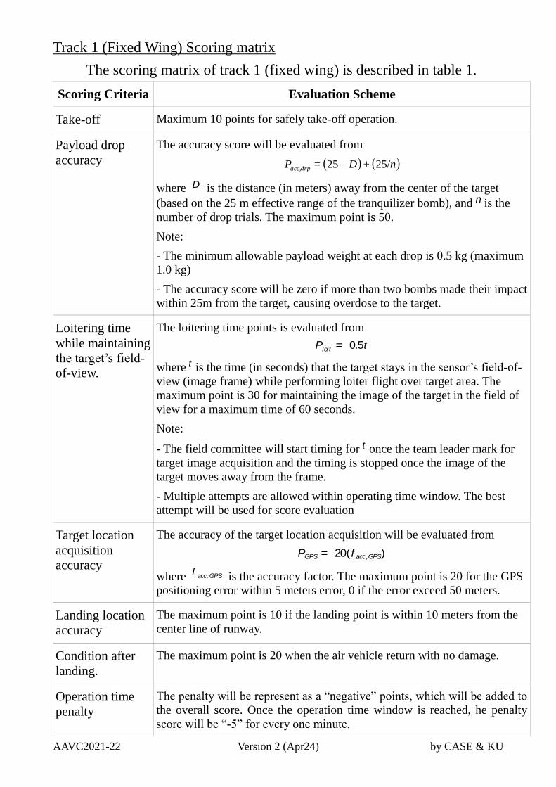
Track 1 (Fixed Wing) Scoring matrix
The scoring matrix of track 1 (fixed wing) is described in table 1.
Scoring Criteria Evaluation Scheme
Take-off Maximum 10 points for safely take-off operation.
Payload drop
accuracy
The accuracy score will be evaluated from
n+D=P drpacc, 25/25
where D is the distance (in meters) away from the center of the target
(based on the 25 m effective range of the tranquilizer bomb), and n is the
number of drop trials. The maximum point is 50.
Note:
- The minimum allowable payload weight at each drop is 0.5 kg (maximum
1.0 kg)
- The accuracy score will be zero if more than two bombs made their impact
within 25m from the target, causing overdose to the target.
Loitering time
while maintaining
the target’s field-
of-view.
The loitering time points is evaluated from
Ploit = 0.5t
where t is the time (in seconds) that the target stays in the sensor’s field-of-
view (image frame) while performing loiter flight over target area. The
maximum point is 30 for maintaining the image of the target in the field of
view for a maximum time of 60 seconds.
Note:
- The field committee will start timing for t once the team leader mark for
target image acquisition and the timing is stopped once the image of the
target moves away from the frame.
- Multiple attempts are allowed within operating time window. The best
attempt will be used for score evaluation
Target location
acquisition
accuracy
The accuracy of the target location acquisition will be evaluated from
PGPS = 20(f acc,GPS)
where f acc,GPS is the accuracy factor. The maximum point is 20 for the GPS
positioning error within 5 meters error, 0 if the error exceed 50 meters.
Landing location
accuracy
The maximum point is 10 if the landing point is within 10 meters from the
center line of runway.
Condition after
landing.
The maximum point is 20 when the air vehicle return with no damage.
Operation time
penalty
The penalty will be represent as a “negative” points, which will be added to
the overall score. Once the operation time window is reached, he penalty
score will be “-5” for every one minute.
AAVC2021-22 Version 2 (Apr24) by CASE & KU
Track 2 (Rotary Wing) Scoring matrix
The scoring matrix of track 2 (rotary wing) is described in table 2.
Scoring Criteria Evaluation Scheme
Take-off Maximum 10 points for safely take-off operation.
Payload drop
accuracy
The accuracy score will be evaluated from
n+D=P drpacc, 20/152
where D is the distance (in meters) away from the center of the target
(based on the 15 m effective range of the tranquilizer bomb), and n is the
number of drop trials. The maximum point is 50.
Note:
- The minimum allowable payload weight at each drop is 0.5 kg (maximum
1.0 kg)
- The accuracy score will be zero if more than two bombs made their impact
within 15m from the target, causing overdose to the target.
Hovering time
while maintaining
the target’s field-
of-view.
The loitering time points is evaluated from
Phov =t
1.5
where t is the time (in seconds) that the target stays in the sensor’s field-of-
view (image frame) while performing hovering flight over the target. The
maximum point is 20 for maintaining the image of the target in the field of
view for a maximum time of 30 seconds.
Note:
- The field committee will start timing for t once the team leader mark for
target image acquisition and the timing is stopped once the image of the
target moves away from the frame.
- Multiple attempts are allowed within operating time window. The best
attempt will be used for score evaluation
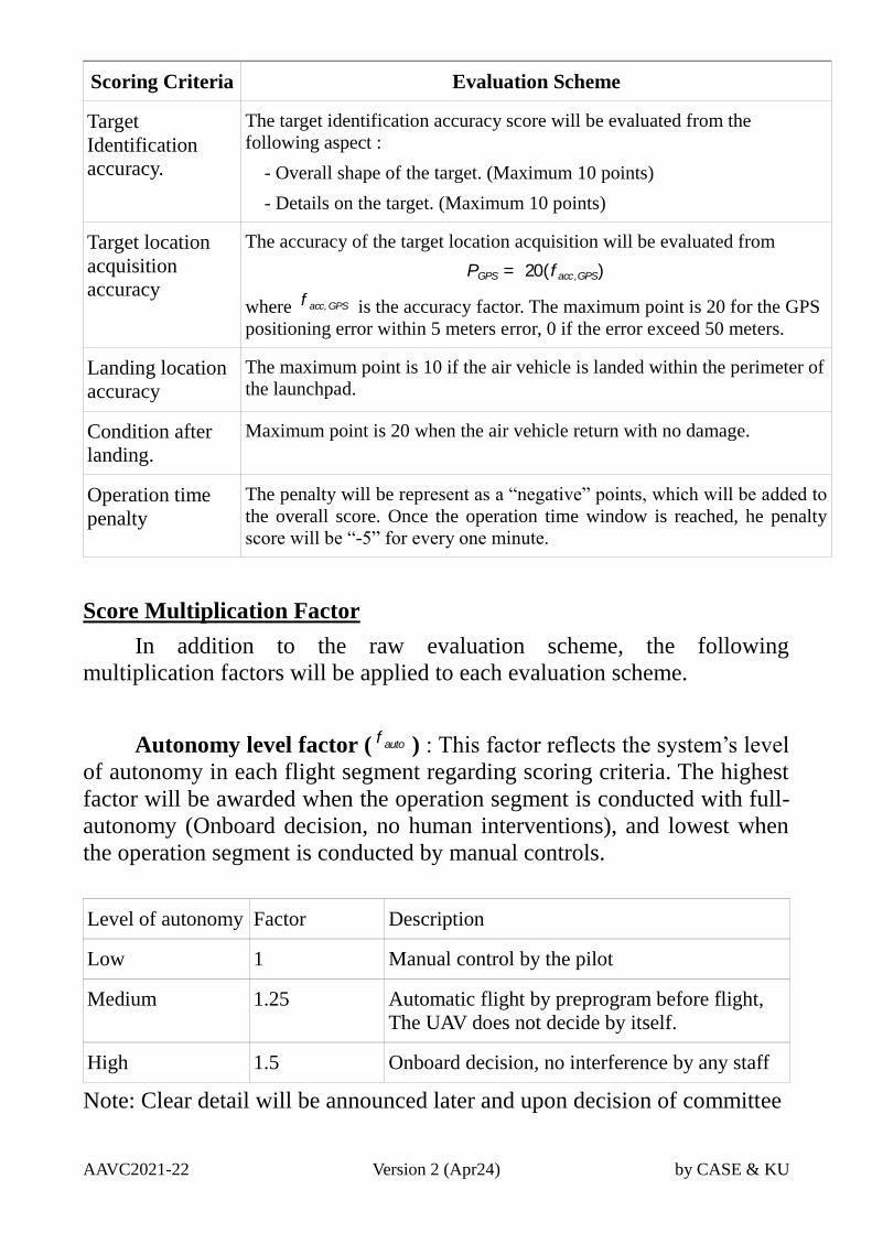
Target
Identification
accuracy.
The target identification accuracy score will be evaluated from the
following aspect :
- Overall shape of the target. (Maximum 10 points)
- Details on the target. (Maximum 10 points)
Target location
acquisition
accuracy
The accuracy of the target location acquisition will be evaluated from
PGPS = 20(f acc,GPS)
where f acc,GPS is the accuracy factor. The maximum point is 20 for the GPS
positioning error within 5 meters error, 0 if the error exceed 50 meters.
Landing location The maximum point is 10 if the air vehicle is landed within the perimeter of
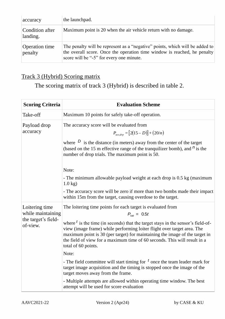
AAVC2021-22 Version 2 (Apr24) by CASE & KU
accuracy the launchpad.
Condition after
landing.
Maximum point is 20 when the air vehicle return with no damage.
Operation time
penalty
The penalty will be represent as a “negative” points, which will be added to
the overall score. Once the operation time window is reached, he penalty
score will be “-5” for every one minute.
Track 3 (Hybrid) Scoring matrix
The scoring matrix of track 3 (Hybrid) is described in table 2.
Scoring Criteria Evaluation Scheme
Take-off Maximum 10 points for safely take-off operation.
Payload drop
accuracy
The accuracy score will be evaluated from
n+D=P drpacc, 20/152
where D is the distance (in meters) away from the center of the target
(based on the 15 m effective range of the tranquilizer bomb), and n is the
number of drop trials. The maximum point is 50.
Note:
- The minimum allowable payload weight at each drop is 0.5 kg (maximum
1.0 kg)
- The accuracy score will be zero if more than two bombs made their impact
within 15m from the target, causing overdose to the target.
Loitering time
while maintaining
the target’s field-
of-view.
The loitering time points for each target is evaluated from
Ploit = 0.5t
where t is the time (in seconds) that the target stays in the sensor’s field-of-
view (image frame) while performing loiter flight over target area. The
maximum point is 30 (per target) for maintaining the image of the target in
the field of view for a maximum time of 60 seconds. This will result in a
total of 60 points.
Note:
- The field committee will start timing for t once the team leader mark for
target image acquisition and the timing is stopped once the image of the
target moves away from the frame.
- Multiple attempts are allowed within operating time window. The best
attempt will be used for score evaluation
AAVC2021-22 Version 2 (Apr24) by CASE & KU
Scoring Criteria Evaluation Scheme
Target
Identification
accuracy.
The target identification accuracy score will be evaluated from the
following aspect :
- Overall shape of the target. (Maximum 10 points)
- Details on the target. (Maximum 10 points)
Target location
acquisition
accuracy
The accuracy of the target location acquisition will be evaluated from
PGPS = 20(f acc,GPS)
where f acc,GPS is the accuracy factor. The maximum point is 20 for the GPS
positioning error within 5 meters error, 0 if the error exceed 50 meters.
Landing location
accuracy
The maximum point is 10 if the air vehicle is landed within the perimeter of
the launchpad.
Condition after
landing.
Maximum point is 20 when the air vehicle return with no damage.
Operation time
penalty
The penalty will be represent as a “negative” points, which will be added to
the overall score. Once the operation time window is reached, he penalty
score will be “-5” for every one minute.
Score Multiplication Factor
In addition to the raw evaluation scheme, the following
multiplication factors will be applied to each evaluation scheme.
Autonomy level factor ( f auto ) : This factor reflects the system’s level
of autonomy in each flight segment regarding scoring criteria. The highest
factor will be awarded when the operation segment is conducted with full-
autonomy (Onboard decision, no human interventions), and lowest when
the operation segment is conducted by manual controls.
Level of autonomy Factor Description
Low 1 Manual control by the pilot
Medium 1.25 Automatic flight by preprogram before flight,
The UAV does not decide by itself.
High 1.5 Onboard decision, no interference by any staff
Note: Clear detail will be announced later and upon decision of committee
AAVC2021-22 Version 2 (Apr24) by CASE & KU
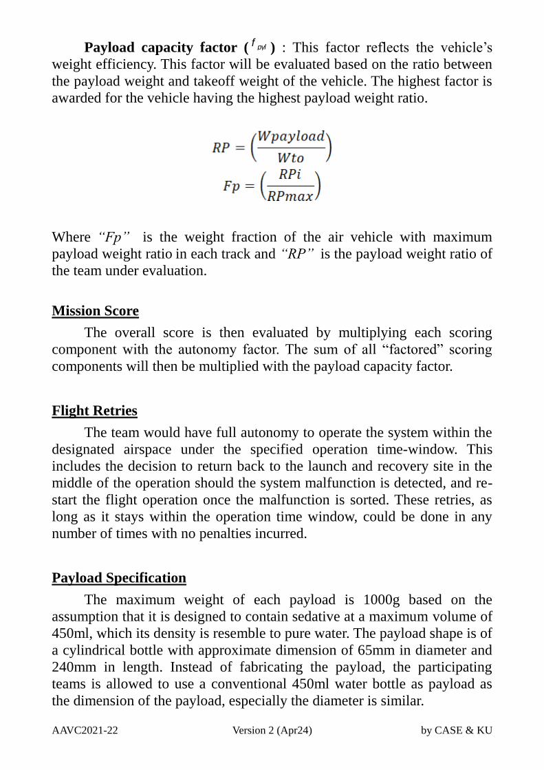
Payload capacity factor ( f pyl ) : This factor reflects the vehicle’s
weight efficiency. This factor will be evaluated based on the ratio between
the payload weight and takeoff weight of the vehicle. The highest factor is
awarded for the vehicle having the highest payload weight ratio.
Where “Fp” is the weight fraction of the air vehicle with maximum
payload weight ratio in each track and “RP” is the payload weight ratio of
the team under evaluation.
Mission Score
The overall score is then evaluated by multiplying each scoring
component with the autonomy factor. The sum of all “factored” scoring
components will then be multiplied with the payload capacity factor.
Flight Retries
The team would have full autonomy to operate the system within the
designated airspace under the specified operation time-window. This
includes the decision to return back to the launch and recovery site in the
middle of the operation should the system malfunction is detected, and re-
start the flight operation once the malfunction is sorted. These retries, as
long as it stays within the operation time window, could be done in any
number of times with no penalties incurred.
Payload Specification
The maximum weight of each payload is 1000g based on the
assumption that it is designed to contain sedative at a maximum volume of
450ml, which its density is resemble to pure water. The payload shape is of
a cylindrical bottle with approximate dimension of 65mm in diameter and
240mm in length. Instead of fabricating the payload, the participating
teams is allowed to use a conventional 450ml water bottle as payload as
the dimension of the payload, especially the diameter is similar.
AAVC2021-22 Version 2 (Apr24) by CASE & KU
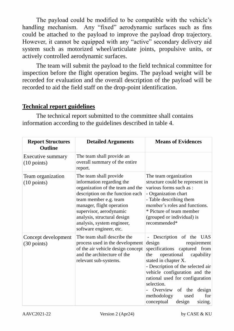
The payload could be modified to be compatible with the vehicle’s
handling mechanism. Any “fixed” aerodynamic surfaces such as fins
could be attached to the payload to improve the payload drop trajectory.
However, it cannot be equipped with any “active” secondary delivery aid
system such as motorized wheel/articulate joints, propulsive units, or
actively controlled aerodynamic surfaces.
The team will submit the payload to the field technical committee for
inspection before the flight operation begins. The payload weight will be
recorded for evaluation and the overall description of the payload will be
recorded to aid the field staff on the drop-point identification.
Technical report guidelines
The technical report submitted to the committee shall contains
information according to the guidelines described in table 4.
Report Structures
Outline
Detailed Arguments Means of Evidences
Executive summary
(10 points)
The team shall provide an
overall summary of the entire
report.
Team organization
(10 points)
The team shall provide
information regarding the
organization of the team and the
description on the function each
team member e.g. team
manager, flight operation
supervisor, aerodynamic
analysis, structural design
analysis, system engineer,
software engineer, etc.
The team organization
structure could be represent in
various forms such as :
- Organization chart
- Table describing them
member’s roles and functions.
* Picture of team member
(grouped or individual) is
recommended*
Concept development
(30 points)
The team shall describe the
process used in the development
of the air vehicle design concept
and the architecture of the
relevant sub-systems.
- Description of the UAS
design requirement
specifications captured from
the operational capability
stated in chapter X.
- Description of the selected air
vehicle configuration and the
rational used for configuration
selection.
- Overview of the design
methodology used for
conceptual design sizing.
AAVC2021-22 Version 2 (Apr24) by CASE & KU
Discussion regarding the
assumption used as well as the
validation of the calculation
scheme and/or mathematical
model is encourages.
- A summary of the overall
specification of the design
concept obtained from the
methodology used such as
weight, geometries, propulsion
thrust (or power) requirements
- Overview of the architecture
of an air vehicle and its sub-
system including its features
and capabilities e.g. flight
modes, imaging and target
acquisition, communications,
and payload handling, as well
as other relevant safety features
such as GEO fencing.
Preliminary and
detailed design
(40 points)
The team shall describe
technical detail regarding
engineering analysis method
applied to the air vehicle and
subsystems in major areas such
as aerodynamics, airframe
structure, flight performance,
and subsystem performance to
gives confidence on the
performance, safety and
reliability of the system.
- Description of the method
and assumptions used to
analyze/test for the air
vehicle’s aerodynamic
analysis, with the analysis/test
result.
- Description of the method
and assumptions used to
analyze/test for the air
vehicle’s propulsion
performance, with the
analysis/test result.
- Description of the method
and assumptions used to
analyze/test for the air
vehicle’s structural integrity,
with the analysis/test result.
- Description of the method
and assumptions used to
analyze/test for the air
vehicle’s subsystem
functionality reliability, with
the analysis/test result.
- Description of the safety
feature of the flight system e.g.
Geo-Fencing
- Description of the method
and assumptions used to
analyze/test for the air
AAVC2021-22 Version 2 (Apr24) by CASE & KU
vehicle’s flight performance,
with the analysis/test result.
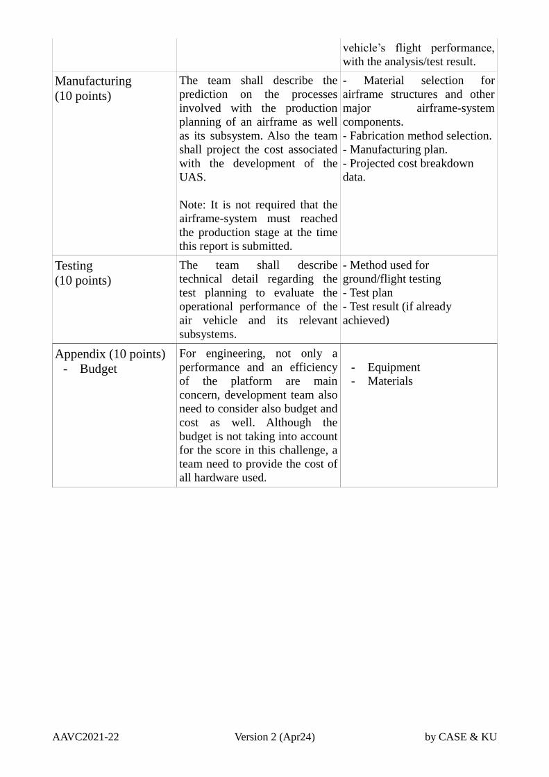
Manufacturing
(10 points)
The team shall describe the
prediction on the processes
involved with the production
planning of an airframe as well
as its subsystem. Also the team
shall project the cost associated
with the development of the
UAS.
Note: It is not required that the
airframe-system must reached
the production stage at the time
this report is submitted.
- Material selection for
airframe structures and other
major airframe-system
components.
- Fabrication method selection.
- Manufacturing plan.
- Projected cost breakdown
data.
Testing
(10 points)
The team shall describe
technical detail regarding the
test planning to evaluate the
operational performance of the
air vehicle and its relevant
subsystems.
- Method used for
ground/flight testing
- Test plan
- Test result (if already
achieved)
Appendix (10 points)
- Budget
For engineering, not only a
performance and an efficiency
of the platform are main
concern, development team also
need to consider also budget and
cost as well. Although the
budget is not taking into account
for the score in this challenge, a
team need to provide the cost of
all hardware used.
- Equipment
- Materials
AAVC2021-22 Version 2 (Apr24) by CASE & KU
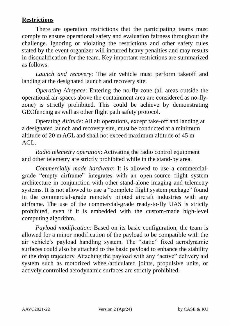
Restrictions
There are operation restrictions that the participating teams must
comply to ensure operational safety and evaluation fairness throughout the
challenge. Ignoring or violating the restrictions and other safety rules
stated by the event organizer will incurred heavy penalties and may results
in disqualification for the team. Key important restrictions are summarized
as follows:
Launch and recovery: The air vehicle must perform takeoff and
landing at the designated launch and recovery site.
Operating Airspace: Entering the no-fly-zone (all areas outside the
operational air-spaces above the containment area are considered as no-fly-
zone) is strictly prohibited. This could be achieve by demonstrating
GEOfencing as well as other flight path safety protocol.
Operating Altitude: All air operations, except take-off and landing at
a designated launch and recovery site, must be conducted at a minimum
altitude of 20 m AGL and shall not exceed maximum altitude of 45 m
AGL.
Radio telemetry operation: Activating the radio control equipment
and other telemetry are strictly prohibited while in the stand-by area.
Commercially made hardware: It is allowed to use a commercial-
grade “empty airframe” integrates with an open-source flight system
architecture in conjunction with other stand-alone imaging and telemetry
systems. It is not allowed to use a “complete flight system package” found
in the commercial-grade remotely piloted aircraft industries with any
airframe. The use of the commercial-grade ready-to-fly UAS is strictly
prohibited, even if it is embedded with the custom-made high-level
computing algorithm.
Payload modification: Based on its basic configuration, the team is
allowed for a minor modification of the payload to be compatible with the
air vehicle’s payload handling system. The “static” fixed aerodynamic
surfaces could also be attached to the basic payload to enhance the stability
of the drop trajectory. Attaching the payload with any “active” delivery aid
system such as motorized wheel/articulated joints, propulsive units, or
actively controlled aerodynamic surfaces are strictly prohibited.