Embed Size (px)
Citation preview
Appendix Q
Aviation Impact Assessment
Date: 13 March 2015
Author: Natalie Hakes
Revision: Issue 7
Osprey Ref: 70816 002
This document is of UK origin and has been prepared by Osprey Consulting Services Limited (Osprey) and, subject to any existing rights of third parties, Osprey is the owner of the copyright therein. The document is furnished in confidence under existing laws, regulations and agreements covering the release of data. This document contains proprietary information of Osprey and the contents or any part thereof shall not be copied or disclosed to any third party without Osprey’s prior written consent.
© Osprey Consulting Services Limited 2014 The Forge, London Road, Bentley, Hampshire. GU10 5HY 01420 520200 / [email protected] Registered in England and Wales under No: 6034579
Maighne Project Wind Farm Clusters: Focused Aviation Impact Assessment
Document Details
70816 002 | Issue 7
2
Document Details
Reference Description
Document Title Maighne Project Wind Farm Clusters: Focused Aviation Impact Assessment
Document Ref 70816 002
Issue Issue 7
Date 13 March 2015
Client Name Fehily Timoney & Company (FTCO)

Executive Summary
70816 002 | Issue 7
3
Executive Summary
Element Power is proposing the development of five Wind Farm Clusters in County Kildare, in the Irish Midlands, called the Maighne Project, which previously formed part of the Greenwire proposal but are now intended to connect to the Irish grid network and be used for domestic purposes. The proposed wind turbine tips planned for the Clusters are to be of a maximum height of 169 metres (m) above ground level (agl).
Initial aviation stakeholder engagement, has involved both the civil Irish Aviation Authority (IAA) and the Irish Department of Defence (DoD). Following this consultation, the IAA has not raised any specific concerns in regards to the proposed Clusters. Initial consultation with the DoD did not indicate an unacceptable impact on operations, however recent engagement has identified potential concerns in relation to the operations of the Irish Air Corps in the vicinity of Casement (Baldonnel) Aerodrome [Reference 1]. The basis of the DoD’s objection has been indicated to relate to a loss of navigability in the area, with potential impacts on military aircraft operating under Visual Flight Rules (VFR), particularly in terms of the requested motorway safeguarded areas and specified low flying Training Areas. Further adjustments to the project have been made since consultation with the Irish Air Corps commenced, including the removal of a significant number of the proposed turbines and a reduction in the maximum tip height of remaining turbines in order to address the DoD issues.
This document presents the results of a focused Aviation Impact Assessment (AIA) conducted by Osprey Consulting Services Ltd (Osprey), which considered the validity of the DoD’s stated Safeguarding Zones and the potential impacts of the proposed Maighne Wind Farm Clusters on VFR civil and military aviation operations.
It is Osprey’s expert and considered opinion that, following the implementation of simple, best practice, industry understood and accepted standard aviation mitigation, any potential adverse impacts in terms of VFR operations can be reduced to an insignificant level. This assessment is in line with the IAA’s position with regard to operations in the area; the IAA had no objection to the developments.
Assessment Conclusions
Aerodrome Safeguarding
The IAA issues regulatory guidance for aerodrome operations in relation to obstacles, stating that certain areas of an aerodrome’s local airspace must be defined, to assess the significance of existing or proposed obstacles, known as Obstacle Limitation Surfaces (OLS). For Casement Aerodrome, should the civilian guidance stipulated in the IAA Aerodrome Licensing Manual be applied [Reference 2, Chapter 5], the maximum lateral extent of the OLS is 15 kilometres (km) from the Casement Aerodrome Reference Point (ARP).
IAA guidance in terms of wind energy developments in proximity to aerodromes is limited. The UK Civil Aviation Authority (CAA) document CAP 764 CAA Policy and Guidelines on Wind Turbines [Reference 3] contains consultation guidance which is typically applied in the UK. The concerns raised by the DoD at Casement Aerodrome relate to the potential impact on VFR operations only, and therefore it is considered that a safeguarding zone of 17 km (typically applied to non-radar equipped licensed aerodromes with a runway of 1,100 m or
Executive Summary
70816 002 | Issue 7
4
greater) be applicable in this instance. Casement Aerodrome is not radar-equipped and the IAA has stated that under the Eurocontrol guidelines, a radar assessment may not be required if the distance between the radar site and wind farm exceeds 16 km.
Initial consultation indicated that the DoD were likely to object to any wind farm development within 20 Nautical Miles (NM) (37 km) of Casement Aerodrome [Reference 2]. This is not a legal requirement and this excessive range is not stipulated in any IAA or Eurocontrol safeguarding guidelines; there is no formal justification for a 37 km aerodrome safeguarding area. Previous engagement with the Irish Air Corps has not revealed any DoD justification for this requirement.
Wind Farm Examples
It is stressed that there are numerous examples of wind farms, which are located in close proximity to aerodromes. Examples of UK wind farms in close proximity to civilian and military Aerodromes include; o East Midlands Airport; two 45 m wind turbines located within 1 km of the ARP, o Lydd Airport; twenty-six wind turbines (115 m maximum hip height) approximately
8.4 km southwest, o Fife Airport; five wind turbines located within approximately 3 km of the ARP, and o RAF Lossiemouth; seven wind farm developments within a 30 km radius of this
extremely busy military fighter aerodrome.
Attention is drawn to the Case Study provided at Annex A1.
As a result of the cited wind farms continued presence and the continuation of aviation activities at the above aerodromes, any impacts posed by the wind turbines have been safely and effectively mitigated.
Casement Aerodrome
The proposed Maighne Wind Farm Clusters are located at significant distances from the Aerodrome; ranging from 24 km (Drehid Hortland, eastern cluster) to 34 km (Derrybrennan). As a result of this range, in consideration of the points given above, there will be no impact in terms of aerodrome safeguarding as a result of the development of the five Clusters, following the implementation of appropriate mitigation solutions.
The proposed mitigation solutions include: o Notification and Pilot Familiarisation: Notification is recommended in accordance with
the IAA publications; S.I 215 Obstacles to Aircraft in Flight [Reference 4] and S.I 423 En-route Obstacles to Air Navigation [Reference 5].
o Aviation Obstruction Lighting: To ensure flight safety, the fitting of aviation obstruction lighting to the turbines is recommended, conforming to industry standards. Further consultation with the DoD and IAA is expected to inform of specific requirements and light intensity prerequisites.
The provided solutions are compliant with industry standards and their application is in-line with previous mitigation requirements for obstacles within the area.
Current Aviation Activities
Military Operating Area (MOA)-4
The proposed Clusters are located within Class G uncontrolled airspace, which any aircraft can enter and transit without Air Traffic Control (ATC) clearance and subject only to a small set of mandatory rules, as stipulated in the IAA Integrated Aeronautical Information

Executive Summary
70816 002 | Issue 7
5
Package (IAIP) ENR Section 1.4-1 ATS Airspace Classification [Reference 6]. Aircraft operating in this area may be in receipt of an Air Traffic Service (ATS), however pilots are ultimately responsible for their own terrain and obstacle clearance [Reference 1, ENR Section 1.4-1]. In line with ICAO standards, the IAA Rules of The Air Order 2004 stipulates the Low Flying Rule such that aircraft shall not be flown closer than 500 ft vertically or laterally, to any person, vehicle, obstacle or structure [Reference 7, Part 2 Rule 3].
Four of the proposed Clusters are located within the lateral confine of MOA-4, with the Ballynakill Cluster located to the north, outside the designated Area. The MOA-4 stretches from surface level to Flight Level FL 450, and is typically utilised for aerobatic, and air combat training activities. Civilian aircraft are able to enter the Class G Area at their own discretion, up to but not including 4,500 ft above mean sea level (amsl) [Reference 6].
No impact is anticipated in terms of the Maighne Wind Farm Clusters; aircraft are able to enter MOA-4 and operate at altitudes up to 4,500 ft. Implementation of the identified mitigation solutions will ensure pilots maintain the required 500 ft obstacle clearance.
Restricted Area EIR 16
The proposed Maighne Wind Farm Clusters are located beneath military Restricted Area EIR 16. The EIR 16 is divided into several sections, with the airspace base stepped overhead the Clusters, varying from 1,000 ft to 1,500 ft amsl. The proposed 169 m wind turbines, at all Maighne Wind Farm Clusters, will not breach the military EIR 16 Restricted Area.
Civil VFR pilots may seek to operate below EIR 16, but are able to enter EIR 16 when active, with prior permission from Casement ATC [Reference 6, ENR Section 5.1-2]. Aircraft operating under VFR in the Class G airspace are responsible for their own terrain and obstacle clearance, and operate within Visual Meteorological Conditions (VMC), and so are required to remain clear of cloud and in sight of the surface at all times [Reference 6, Part 3 Rule 34: Visual Flight Rules].
Three Wind Farms are identified to be situated beneath the Restricted Area, with minimal impact; adequate vertical airspace exists for aircraft to transit directly overhead the proposed turbines, with the required 500 ft obstacle clearance, and still remain clear of the Restricted Area. In some instances the direct overflight of the proposed wind turbines may lead to a traffic funnelling effect (where aircraft are squeezed in to a particular smaller volume of airspace), however there is no formal requirement or need for the Wind Farms to be overflown, VFR pilots are legally obligated to be aware of, and comply with, airspace regulations.
The Drehid Hortland Cluster is partially located beneath EIR 16 – Area B, to the east, which is established from 1,000 ft amsl [Reference 6]. The maximum wind turbine tip heights for the site (subject to a full site survey) are 252 m (approximately 827 ft). Applying the IAA required obstacle clearance of 500 ft, turbines at the site may present a vertical restriction in terms of direct overflight, within the EIR 16 Area’s hours of operation. This limitation is expected to potentially affect civil aircraft, intending to operate below the EIR 16 airspace and wishing to directly overfly the wind turbines. However, the IAA has raised no concerns; there is no formal requirement for aircraft to route overhead any Wind Farm site.
Following the implementation of the suggested mitigation of appropriate documentation and aviation lighting, the potential effects on VFR operations due to the construction of the Maighne Wind Farm Clusters are considered insignificant and hence acceptable. Possible Cumulative Effects
Executive Summary
70816 002 | Issue 7
6
Element Power are planning to develop wind turbines across five Clusters, however, there are significant distances between the individual site external boundaries (an average of 5.2 km). This provides adequate space for aircraft to safely operate between the proposed Clusters, maintaining the required 500 ft obstacle clearance, should aircraft be operating at low level.
The DoD has raised concerns in terms of the potential creation of ‘choke-points’. As acknowledged, the development of the aforementioned proposed Clusters may result in reduced vertical airspace volumes for direct overflight of the turbines, for civil aircraft who have not requested to enter EIR 16, when active. However, there is no formal requirement or published procedure for any of the Clusters to be directly overflown and it is the pilots responsibility to be aware of and avoid obstacles within the Class G airspace.
Following appropriate documentation and lighting of the Clusters, the turbines will not be unmanageable to pilots, who fly within the limits of their licence and plan their routes accordingly. In addition, this is not an area indicated to be of concern, as EIR 16 does not extend to the surface, to the DoD and therefore is considered to pose less of a potential cumulative effect.
Any potential for wind turbine-induced wake turbulence has been considered through a review of existing policy and relevant research, indicating that whilst the effects of turbine-induced turbulence remains under assessment, a significant number of aviation stakeholders continue to operate within close proximity to wind developments (attention is drawn to Annex A3). To date, no turbine-induced turbulence related incidents have ever been reported to the UK CAA, in over 30 years of operation of a Mandatory Occurrence Report (MOR) system.
DoD Safeguarding
Low Flying Training Areas
The Cloncumber and Derrybrennan site centre-points are located within the boundary of the northwest DoD low flying Training Area. All the wind turbines are located beneath the lower limit of the EIR 16, and any aircraft can operate within this area, with pilots ultimately responsible for their own obstacle and terrain avoidance.
The DoD’s Training Area safeguarding requirement is not formally documented; the Training Areas are not published and therefore it appears that currently the DoD applies no statutory safeguarding in regard to these areas. Currently, civil VFR pilots are able to operate at their own discretion within the Training areas, below the base of the EIR 16 airspace. This is not in-line with typical European procedure; safeguarded areas, such as those utilised for low flying activities, are routinely published, allowing civil pilots operating in the region to be aware of such activities and to plan according (attention is drawn to Annex A2).
With the application of suitable mitigation, the effect of the proposed Clusters is considered to be acceptable. Additionally, it is suggested the presence of the illuminated turbines will provide a visual reference, which can be utilised to aid pilot navigation and training.
Requested Motorway Safeguarding
Two of the proposed Wind Farm Clusters are located within the DoD-specified 3 NM motorway safeguarding areas, including the Drehid Hortland and Windmill Clusters. The Ballynakill Cluster is further located within proximity to the M4/M6 motorway, but is situated outside the MOA-4 and as such, is not considered to pose any potential effect.
The DoD’s request for a 3 NM motorway safeguarding zone is strongly questioned; this equates to one and a half minutes flying time for a typical helicopter or light general aviation
Executive Summary
70816 002 | Issue 7
7
aircraft. The DoD’s safeguarding requirement is not formally documented and is not based on any IAA or Eurocontrol legal requirement or operational guidance. A 3 NM zone is deemed disproportionate for the safeguarding of non-published overland routes, when considered in terms of the typical aviation safeguarding limits and legal VFR obstacle clearance requirements [Reference 7]; the DoD’s requirements are not considered to be in-line with European operations. Additionally, it is noted that motorways in the UK are also utilised as visual references for VFR pilots; Table 3 in Section 5.3 indicates the significant extent of suitably mitigated wind turbine developments in the vicinity of motorways in the UK.
VFR flight must be operated within the legal limits of the VMC minima and at a speed which will enable the pilot adequate opportunity to observe other traffic or potential obstructions. It is considered that during flight in poor weather conditions, pilots are highly likely to operate in the immediate vicinity of any visual reference i.e. not requiring a range of 3 NM, as a helicopter would need to fly in much closer proximity to the feature in order to gain full utility. Should the weather conditions deteriorate, the pilot is legally obligated to curtail the flight as necessary.
A recent UK National Air Traffic Services (NATS) Aeronautical Information Circular (AIC) AIC P 067/2013 indicated safety issues related to a lack of visual cues, particularly in sparsely populated areas [Reference 8]. It is suggested that the Clusters themselves, particularly following the implementation of any aviation obstacle lighting, would aid in pilot navigation.
Following the implementation of suitable mitigation as detailed, the proposed Clusters will not pose an unacceptable effect on military operations based on typical aviation operations and regulations; the DoD at Casement Aerodrome will be able to continue to operate safely within their presence. Engagement with the DoD has been untaken to determine the sustainability of this safeguarding requirement; FTCO and Element Power are awaiting formal justification.
Casement Aerodrome Procedures
The Windmill and Ballynakill Clusters are located outside the range of any anticipated effect on Casement published Instrument Flight Procedures (IFPs) with no impact on Instrument Flight Rules (IFR) obstacle clearance requirements. The Drehid Hortland Cluster is located within the vicinity of the Casement published Instrument Approach Procedures for Runway 11. Should IFR traffic be operating in the vicinity of this site, the Casement Approach Procedures indicate that aircraft will be positioning at an attitude of 2,000 ft. Hence, there is no effect upon this procedure, however, the Casement Aerodrome Radar Vectoring Approach Chart indicates that the minimum altitude to be allocated by air traffic controllers in the vicinity of the Drehid Hortland cluster is 1,800 ft; this may impact in terms of the required IFR obstacle clearance of 1,000 ft [Reference 7]. Therefore, wind turbines with a maximum blade tip altitude of 814 ft within the eastern Cluster grouping and 860 ft within the western section, are anticipated to pose an impact on Casement IFR operations.
The impact on Casement Aerodrome’s IFR operations due to the Drehid Hortland turbines can be mitigated by raising the minimum vectoring altitude by 100 ft.,
Additionally, it is noted (subject to full site survey) that the Cloncumber Cluster is located within 3 NM of the designated 1,800 ft minimum altitude area and as such, is situated within the Primary Surveillance Minimum Altitude Area (SMAA) Buffer (PSB). The Derrybrennan Cluster is also located on the boundary of the 3 NM Buffer. Therefore, the proposed Clusters have the potential to impact IFR operations. The aforementioned IFR mitigation solution of a raised vectoring altitude is also considered to be applicable in this case.

Executive Summary
70816 002 | Issue 7
8
Recommendations
As a result of the undertaken Assessment, Osprey recommends the following Mitigation Solutions be implemented: o IAA Notification and Pilot Familiarisation; o Aviation Obstruction Lighting; and o Raising of the IFR vectoring altitude by 100 ft for Casement Aerodrome (subject to full
site survey).
Following the implementation of these solutions, it is Osprey’s expert and considered opinion that any potential adverse effects in terms of Casement’s operations will be mitigated to an insignificant level. This assessment is in line with the IAA position with regard to operations in the area; the IAA had no objection to the developments.
Table of Contents
70816 002 | Issue 7
9
Table of Contents
1 Introduction ............................................................................................................................... 12
1.1 General ......................................................................................................................................................... 12 1.2 Purpose and Scope.................................................................................................................................. 13 1.3 Document Structure ............................................................................................................................... 13
2 Maighne Wind Farm Clusters ............................................................................................... 15
2.1 Location ....................................................................................................................................................... 15
3 Airspace Environment ............................................................................................................ 17
3.1 Overview ..................................................................................................................................................... 17
4 Casement (Baldonnel) Aerodrome .................................................................................... 20
4.1 Overview ..................................................................................................................................................... 20 4.2 Safeguarding – Obstacle Limitation Surfaces .............................................................................. 20 4.3 Instrument Flight Procedures ............................................................................................................ 20 4.4 Visual Flight Rules (VFR) Operations ............................................................................................. 22
5 Safeguarding Criteria .............................................................................................................. 23
5.1 Obstacle Limitation Surfaces .............................................................................................................. 23 5.2 UK CAP 764 Consultation Zones ....................................................................................................... 23 5.3 DoD Requested Motorway Safeguarding Zones ......................................................................... 24 5.4 DoD Requested Training Areas ......................................................................................................... 27
6 Cloncumber Cluster ................................................................................................................. 29
6.1 Overview ..................................................................................................................................................... 29 6.2 Potential Impact....................................................................................................................................... 30 6.3 Mitigation Solutions ............................................................................................................................... 31 6.4 Conclusions ................................................................................................................................................ 32
7 Derrybrennan Cluster ............................................................................................................ 33
7.1 Overview ..................................................................................................................................................... 33 7.2 Potential Impact....................................................................................................................................... 34 7.3 Mitigation Solutions ............................................................................................................................... 35 7.4 Conclusions ................................................................................................................................................ 35
8 Drehid Hortland Cluster ........................................................................................................ 36
8.1 Overview ..................................................................................................................................................... 36
Table of Contents
70816 002 | Issue 7
10
8.2 Potential Impact....................................................................................................................................... 37 8.3 Mitigation Solutions ............................................................................................................................... 39 8.4 Conclusions ................................................................................................................................................ 39
9 Ballynakill Cluster .................................................................................................................... 40
9.1 Overview ..................................................................................................................................................... 40 9.2 Potential Impact....................................................................................................................................... 41 9.3 Mitigation Solutions ............................................................................................................................... 41 9.4 Conclusions ................................................................................................................................................ 41
10 Windmill Cluster ....................................................................................................................... 42
10.1 Overview ..................................................................................................................................................... 42 10.2 Potential Impact....................................................................................................................................... 43 10.3 Mitigation Solutions ............................................................................................................................... 44 10.4 Conclusions ................................................................................................................................................ 44
11 Cumulative Effects.................................................................................................................... 45
11.1 Cumulative Overview ............................................................................................................................ 45 11.2 Restriction Considerations .................................................................................................................. 47 11.3 Turbulence Review ................................................................................................................................. 47
12 Conclusions and Recommendations .................................................................................. 50
12.1 Overview ..................................................................................................................................................... 50 12.2 Potential Impact....................................................................................................................................... 50 12.3 Mitigation Solutions ............................................................................................................................... 53 12.4 Recommendations .................................................................................................................................. 53
13 References .................................................................................................................................. 55
A1 Wind Farm Case Study ............................................................................................................ 58
A1.1 Civil Operations ........................................................................................................................................ 58 A1.2 Military Operations ................................................................................................................................. 59
A2 Low Flying Operations ............................................................................................................ 61
A2.1 UK Low Flying System (LFS) ............................................................................................................... 61
A3 Turbulence Case Studies ........................................................................................................ 63
Table of Figures
Figure 1: Military Restricted Area, EIR 16; © Jeppersen data 2006, ......................................................... 18 Figure 2: Representation of the proposed Maighne Wind Farm Clusters Locations in Relation to the Airspace Environment (not to scale) ............................................................................................................. 19
Table of Contents
70816 002 | Issue 7
11
Figure 3: Casement Aerodrome, Radar Vectoring Instrument Approach Chart EIME AD2.24-22 Figure kindly provided by the DoD ........................................................................................................................... 21 Figure 4: Photograph of adjacent M1 motorway wind farm development within the UK. ............. 26 Figure 5: Location of the proposed Maighne Wind Farms in relation to the DoD’s safeguarding requests. Figure kindly provided by FTCO. ........................................................................................................... 28 Figure 6: Location of the proposed Cloncumber Cluster. Figure kindly provided by FTCO. ............ 29 Figure 7: Location of the proposed Derrybrennan Wind Farm. Figure kindly provided by FTCO. 33 Figure 8: Location of the proposed Drehid Hortland Cluster. Figure kindly provided by FTCO. . 36 Figure 9: Location of the proposed Ballynakill Cluster. Figure kindly provided by FTCO. ............... 40 Figure 10: Location of the proposed Windmill Cluster. Figure kindly provided by FTCO. ............... 42 Figure 11: Location of the proposed Maighne Wind Farm Clusters. Figure kindly provided by FTCO. ................................................................................................................................................................................... 46 Figure 13: Relative Location of Wind Farm developments within 30 km of RAF Lossiemouth ... 60 Figure 14: MoD UK Low Flying Map, 23 November 2011 [Reference 19] ............................................. 62 Figure 15: Westfield Wind Farm with 11RD illustrated. ............................................................................... 64 Figure 16: Location of Wind turbines on Caernarfon Airfield. Figure taken from a screen shot from the Caernarfon Airport website. ..................................................................................................................... 65
Table of Tables
Table 1: Element Power Maighne Wind Farms; Site Centre Coordinates .............................................. 15 Table 2; Maighne Wind Farm Clusters; Approximate Ground Elevation and Maximum Wind Turbine Tip Height ........................................................................................................................................................ 16 Table 3: Restricted Area EIR 16; Airspace Upper and Lower Limits ....................................................... 17 Table 4: Example of Wind Farms in the Vicinity of UK Motorways .......................................................... 27 Table 5: Table of References ..................................................................................................................................... 57
Introduction
70816 002 | Issue 7
12
1 Introduction
This section introduces the background, purpose and scope of this Aviation Impact Assessment.
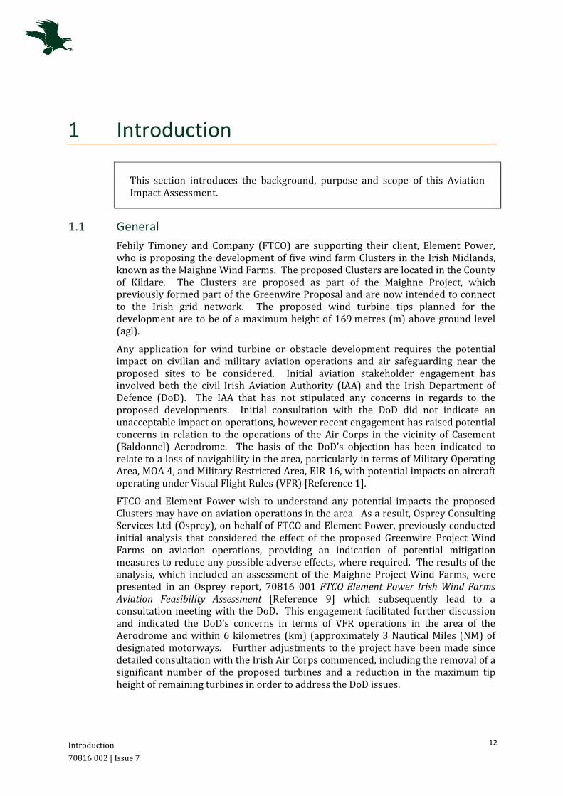
1.1 General
Fehily Timoney and Company (FTCO) are supporting their client, Element Power, who is proposing the development of five wind farm Clusters in the Irish Midlands, known as the Maighne Wind Farms. The proposed Clusters are located in the County of Kildare. The Clusters are proposed as part of the Maighne Project, which previously formed part of the Greenwire Proposal and are now intended to connect to the Irish grid network. The proposed wind turbine tips planned for the development are to be of a maximum height of 169 metres (m) above ground level (agl).
Any application for wind turbine or obstacle development requires the potential impact on civilian and military aviation operations and air safeguarding near the proposed sites to be considered. Initial aviation stakeholder engagement has involved both the civil Irish Aviation Authority (IAA) and the Irish Department of Defence (DoD). The IAA that has not stipulated any concerns in regards to the proposed developments. Initial consultation with the DoD did not indicate an unacceptable impact on operations, however recent engagement has raised potential concerns in relation to the operations of the Air Corps in the vicinity of Casement (Baldonnel) Aerodrome. The basis of the DoD’s objection has been indicated to relate to a loss of navigability in the area, particularly in terms of Military Operating Area, MOA 4, and Military Restricted Area, EIR 16, with potential impacts on aircraft operating under Visual Flight Rules (VFR) [Reference 1].
FTCO and Element Power wish to understand any potential impacts the proposed Clusters may have on aviation operations in the area. As a result, Osprey Consulting Services Ltd (Osprey), on behalf of FTCO and Element Power, previously conducted initial analysis that considered the effect of the proposed Greenwire Project Wind Farms on aviation operations, providing an indication of potential mitigation measures to reduce any possible adverse effects, where required. The results of the analysis, which included an assessment of the Maighne Project Wind Farms, were presented in an Osprey report, 70816 001 FTCO Element Power Irish Wind Farms Aviation Feasibility Assessment [Reference 9] which subsequently lead to a consultation meeting with the DoD. This engagement facilitated further discussion and indicated the DoD’s concerns in terms of VFR operations in the area of the Aerodrome and within 6 kilometres (km) (approximately 3 Nautical Miles (NM) of designated motorways. Further adjustments to the project have been made since detailed consultation with the Irish Air Corps commenced, including the removal of a significant number of the proposed turbines and a reduction in the maximum tip height of remaining turbines in order to address the DoD issues.

Introduction
70816 002 | Issue 7
13
FTCO and Element Power are keen to resolve any potential impacts and therefore, Osprey has completed in-depth analysis to consider all potential impacts of the five proposed Wind Farm Clusters, both individually and cumulatively. The results of the analysis are presented in this focused Aviation Impact Assessment (AIA) document, carried out in accordance with the guidance contained in International Civil Aviation Organisation (ICAO) Annex 14 [Reference 10].
1.2 Purpose and Scope
The purpose of this AIA is to identify any effects of the proposed Maighne Clusters, which could potentially present a physical obstruction to aviation operations. Osprey uses a number of resources, including IAA Aeronautical Charts, the Irish Integrated Aeronautical Information Package (IAIP) [Reference 6] and our own databases that we have built up over the years. We typically begin with the consultation zones for various airfield types in accordance with the IAA guidance document Aerodrome Licensing Manual [Reference 2] and UK Civil Aviation Authority (CAA) publication CAP 738 Safeguarding of Aerodromes [Reference 11]. However, we allow a significant margin as we recognise that objections often come from outside these areas, particularly in terms of en-route operations as stipulated in the IAA S.I 215 Obstacles to Aircraft in Flight [Reference 4].
This AIA considers the effect of the wind turbines once they are fully installed and operational, and does not consider any safety issues relating to the construction, installation or decommissioning, on each individual site. However, Osprey recommends that the developer considers the following information when assessing the safety of any installation, construction or decommissioning phases with respect to aviation interests.
Tall slender constructions such as wind turbines, despite their size, can be difficult to see from the air in certain weather conditions. Guidance has been issued by the IAA in publications S.I 215 Obstacles to Aircraft in Flight [Reference 4] and S.I 423 En-route Obstacles to Air Navigation [Reference 5], which recommends that to facilitate safe visual flight, day or night, in the vicinity of obstacles:
Appropriate information about the construction and any associated lighting (where applicable) should be promulgated in the IAA IAIP [Reference 6] and applicable aviation publications, with notification at least 30 days prior to obstacle construction.
Data should include location, height, date of erection, date of removal and lighting type (none, infra-red or lighting brightness); and
Local aerodromes identified during consultation (typically with a 10 km radius) should be notified, particularly any police helicopter or air ambulance unit.
1.3 Document Structure
The report covers general aviation background, airspace environments and flight regulations in Sections 1-5. The individual Maighne Wind Farms are considered in Sections 6-13. The report utilises the following structure:
Section 1 (this section) introduces the report; Section 2 provides an overview of the proposed Maighne Wind Farms; Section 3 introduces the Airspace Environment;
Introduction
70816 002 | Issue 7
14
Section 4 introduces the operations of Casement Aerodrome; Section 5 introduces the Safeguarding Requirements at Casement
Aerodrome; Section 6 introduces and assesses the potential impacts of the Cloncumber
Cluster; Section 7 introduces and assesses the potential impacts of the Derrybrennan
Cluster; Section 8 introduces and assesses the potential impacts of the Drehid
Hortland Cluster; Section 9 introduces and assesses the potential impacts of the Ballynakill
Cluster; Section 10 introduces and assesses the potential impacts of the Windmill
Cluster; Section 11 considers the potential Cumulative Impacts; and Section 12 provides a Summary of the assessment and Recommendations
drawn from the analysis. All references are listed at the end of the document.
There are three annexes to this AIA, which provide additional information in terms of Wind Farm developments, Low Flying Operations and Turbulence Case Studies.
Maighne Wind Farm Clusters
70816 002 | Issue 7
15
2 Maighne Wind Farm Clusters
This section gives an overview and location details of the proposed Element Power Maighne Wind Farms.
2.1 Location
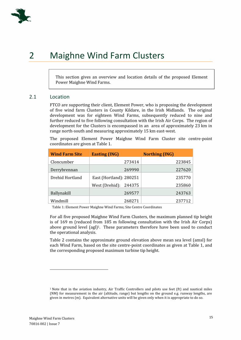
FTCO are supporting their client, Element Power, who is proposing the development of five wind farm Clusters in County Kildare, in the Irish Midlands. The original development was for eighteen Wind Farms, subsequently reduced to nine and further reduced to five following consultation with the Irish Air Corps. The region of development for the Clusters is encompassed in an area of approximately 23 km in range north-south and measuring approximately 15 km east-west.
The proposed Element Power Maighne Wind Farm Cluster site centre-point coordinates are given at Table 1.
Wind Farm Site Easting (ING) Northing (ING)
Cloncumber 273414 223845
Derrybrennan 269990 227620
Drehid Hortland East (Hortland): 280251
West (Drehid): 244375
235770
235860
Ballynakill 269577 243763
Windmill 268271 237712
Table 1: Element Power Maighne Wind Farms; Site Centre Coordinates
For all five proposed Maighne Wind Farm Clusters, the maximum planned tip height is of 169 m (reduced from 185 m following consultation with the Irish Air Corps) above ground level (agl)1. These parameters therefore have been used to conduct the operational analysis.
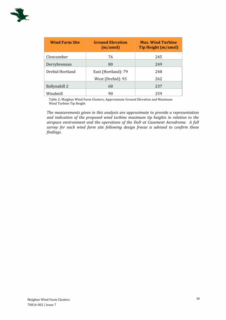
Table 2 contains the approximate ground elevation above mean sea level (amsl) for each Wind Farm, based on the site centre-point coordinates as given at Table 1, and the corresponding proposed maximum turbine tip height.
1 Note that in the aviation industry, Air Traffic Controllers and pilots use feet (ft) and nautical miles (NM) for measurement in the air (altitude, range) but lengths on the ground e.g. runway lengths, are given in metres (m). Equivalent alternative units will be given only when it is appropriate to do so.
Maighne Wind Farm Clusters
70816 002 | Issue 7
16
Wind Farm Site Ground Elevation (m/amsl)
Max. Wind Turbine Tip Height (m/amsl)
Cloncumber 76 245
Derrybrennan 80 249
Drehid Hortland East (Hortland): 79
West (Drehid): 93
248
262
Ballynakill 2 68 237
Windmill 90 259
Table 2; Maighne Wind Farm Clusters; Approximate Ground Elevation and Maximum Wind Turbine Tip Height
The measurements given in this analysis are approximate to provide a representation and indication of the proposed wind turbine maximum tip heights in relation to the airspace environment and the operations of the DoD at Casement Aerodrome. A full survey for each wind farm site following design freeze is advised to confirm these findings.
Airspace Environment
70816 002 | Issue 7
17
3 Airspace Environment
This section introduces the Airspace Environment within the area of the proposed Element Power Maighne Wind Farm Clusters.
3.1 Overview
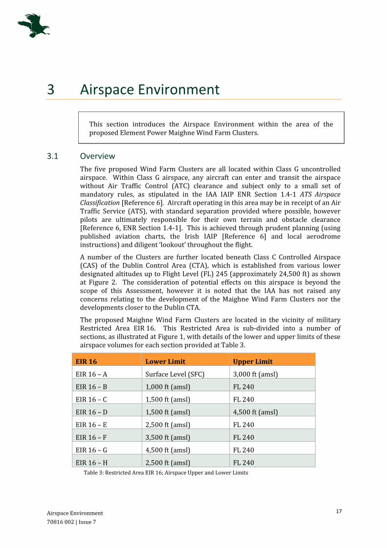
The five proposed Wind Farm Clusters are all located within Class G uncontrolled airspace. Within Class G airspace, any aircraft can enter and transit the airspace without Air Traffic Control (ATC) clearance and subject only to a small set of mandatory rules, as stipulated in the IAA IAIP ENR Section 1.4-1 ATS Airspace Classification [Reference 6]. Aircraft operating in this area may be in receipt of an Air Traffic Service (ATS), with standard separation provided where possible, however pilots are ultimately responsible for their own terrain and obstacle clearance [Reference 6, ENR Section 1.4-1]. This is achieved through prudent planning (using published aviation charts, the Irish IAIP [Reference 6] and local aerodrome instructions) and diligent ‘lookout’ throughout the flight.
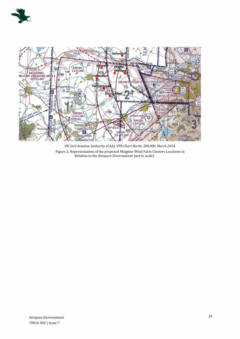
A number of the Clusters are further located beneath Class C Controlled Airspace (CAS) of the Dublin Control Area (CTA), which is established from various lower designated altitudes up to Flight Level (FL) 245 (approximately 24,500 ft) as shown at Figure 2. The consideration of potential effects on this airspace is beyond the scope of this Assessment, however it is noted that the IAA has not raised any concerns relating to the development of the Maighne Wind Farm Clusters nor the developments closer to the Dublin CTA.
The proposed Maighne Wind Farm Clusters are located in the vicinity of military Restricted Area EIR 16. This Restricted Area is sub-divided into a number of sections, as illustrated at Figure 1, with details of the lower and upper limits of these airspace volumes for each section provided at Table 3.
EIR 16 Lower Limit Upper Limit
EIR 16 – A Surface Level (SFC) 3,000 ft (amsl)
EIR 16 – B 1,000 ft (amsl) FL 240
EIR 16 – C 1,500 ft (amsl) FL 240
EIR 16 – D 1,500 ft (amsl) 4,500 ft (amsl)
EIR 16 – E 2,500 ft (amsl) FL 240
EIR 16 – F 3,500 ft (amsl) FL 240
EIR 16 – G 4,500 ft (amsl) FL 240
EIR 16 – H 2,500 ft (amsl) FL 240
Table 3: Restricted Area EIR 16; Airspace Upper and Lower Limits

Airspace Environment
70816 002 | Issue 7
18
This area, when active on weekdays between the notified times, is restricted for use by Military aircraft, however the IAA IAIP stipulates that entry by civilian aircraft within these periods is possible, with prior permission from ATC at Casement Aerodrome [Reference 6, ENR Section 5.1-2].
Figure 1: Military Restricted Area, EIR 16; © Jeppersen data 2006,
The Restricted Area EIR 16 forms part of a larger Exercise and Training Area, known as Military Operating Area (MOA)-4. This airspace is reserved for military training, including aerobatic and air combat activities. The designated MOA-4 stretches from surface level to FL 450; however, civilian aircraft are able to enter the area at their own discretion, up to but not including 4,500 ft amsl [Reference 6, ENR Section 5.2-1].
A representation of the proposed locations of the Maighne Wind Farm Clusters in relation to the airspace environment is given at Figure 2. Four of the proposed Clusters are situated beneath the designated EIR 16 and within MOA-4, with the one remaining Cluster (Ballynakill) located outside the Areas, beyond the northern lateral boundaries.
Airspace Environment
70816 002 | Issue 7
19
UK Civil Aviation Authority (CAA), VFR Chart North, 500,000, March 2014.
Figure 2: Representation of the proposed Maighne Wind Farm Clusters Locations in Relation to the Airspace Environment (not to scale)
Casement (Baldonnel) Aerodrome
70816 002 | Issue 7
20
4 Casement (Baldonnel) Aerodrome
This section introduces Casement Aerodrome, the runways and airspace environment, Obstacle Limitation Surfaces and operating procedures.
4.1 Overview
Casement Aerodrome is a military airfield located approximately 12.5 km southwest of the city of Dublin. The Aerodrome serves as the Headquarters and operating base of the Irish Air Corps. Casement Aerodrome has two runways of orientation 05/23 and 11/29 and respective lengths of 1,829 m and 1,463 m.
The nearest proposed site is the Drehid Hortland Cluster, located approximately 24 km from Casement Aerodrome, on a heading of 287°T.
4.2 Safeguarding – Obstacle Limitation Surfaces
Flight operations at and within the vicinity of an aerodrome, can be affected by obstacles inside and outside the aerodrome’s boundary. The IAA issues regulatory guidance on how aerodromes should manage operations in relation to obstacles and the licensing of an aerodrome depends on the extent to which these areas are free from current or new obstacles.
The regulatory guidance states that certain areas of the subject aerodrome’s local airspace must be defined to assess the significance of existing or proposed obstacles in its vicinity; these are Obstacle Limitation Surfaces (OLS). The OLS are determined according to the classification of the aerodrome and its runway length. The safeguarded areas are represented by a number of complex 2-D planes and 3-D shapes around the aerodrome; the absence of obstacles within these areas contributes to the safety of both visual and instrument based flight operations in the vicinity of the aerodrome.
For Casement Aerodrome, a runway length of over 1,800 m (for runway 05/23), results in an assumed Aerodrome Reference Code of 4, should the civilian guidance stipulated in the IAA Aerodrome Licensing Manual be applied [Reference 2, Chapter 5]. In this instance, the maximum lateral extent of the OLS established for a Code 4 classification, is 15 km from the Casement Aerodrome Reference Point (ARP).
4.3 Instrument Flight Procedures
Casement Aerodrome operates a number of Instrument Flight Procedures (IFPs), including both Standard Instrument Departures (SIDs) and Standard Terminal
Casement (Baldonnel) Aerodrome
70816 002 | Issue 7
21
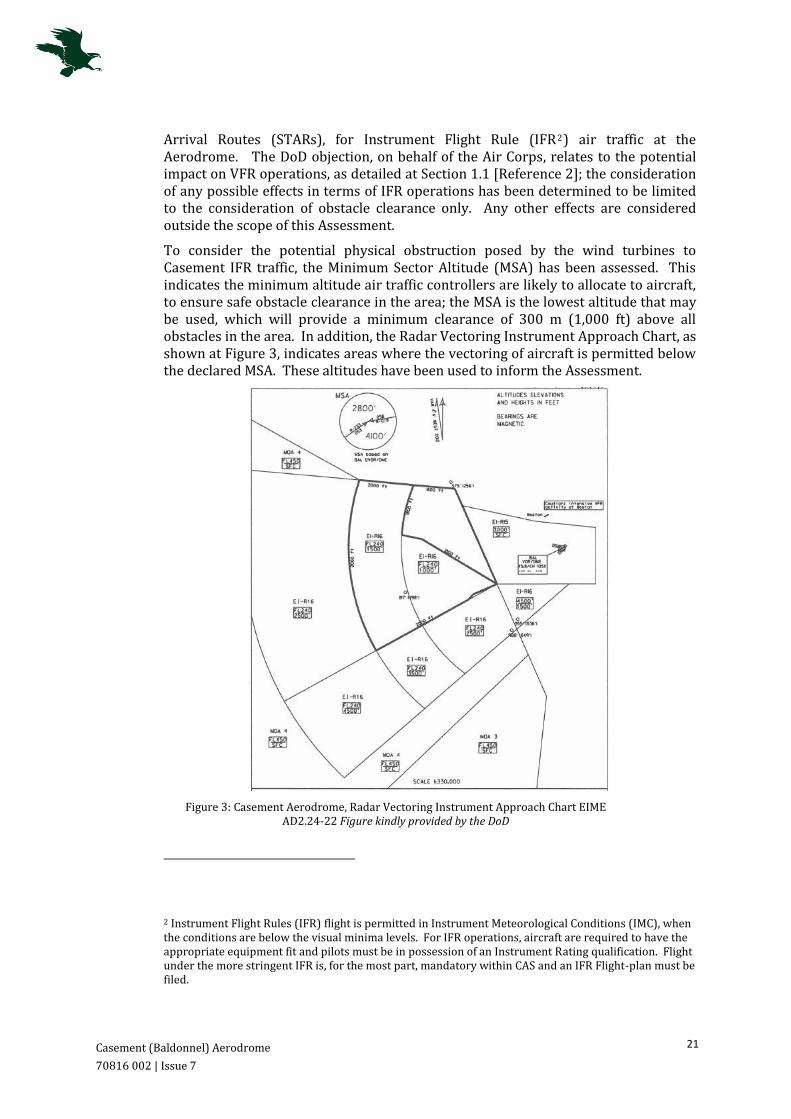
Arrival Routes (STARs), for Instrument Flight Rule (IFR2) air traffic at the Aerodrome. The DoD objection, on behalf of the Air Corps, relates to the potential impact on VFR operations, as detailed at Section 1.1 [Reference 2]; the consideration of any possible effects in terms of IFR operations has been determined to be limited to the consideration of obstacle clearance only. Any other effects are considered outside the scope of this Assessment.
To consider the potential physical obstruction posed by the wind turbines to Casement IFR traffic, the Minimum Sector Altitude (MSA) has been assessed. This indicates the minimum altitude air traffic controllers are likely to allocate to aircraft, to ensure safe obstacle clearance in the area; the MSA is the lowest altitude that may be used, which will provide a minimum clearance of 300 m (1,000 ft) above all obstacles in the area. In addition, the Radar Vectoring Instrument Approach Chart, as shown at Figure 3, indicates areas where the vectoring of aircraft is permitted below the declared MSA. These altitudes have been used to inform the Assessment.
Figure 3: Casement Aerodrome, Radar Vectoring Instrument Approach Chart EIME AD2.24-22 Figure kindly provided by the DoD
2 Instrument Flight Rules (IFR) flight is permitted in Instrument Meteorological Conditions (IMC), when the conditions are below the visual minima levels. For IFR operations, aircraft are required to have the appropriate equipment fit and pilots must be in possession of an Instrument Rating qualification. Flight under the more stringent IFR is, for the most part, mandatory within CAS and an IFR Flight-plan must be filed.
Casement (Baldonnel) Aerodrome
70816 002 | Issue 7
22
4.4 Visual Flight Rules (VFR) Operations
Flight in accordance to VFR3 requires an aircraft to be flown in accordance with the Visual Meteorological Conditions (VMC) minima appropriate to the classification of airspace. The Irish IAIP contains the IAA Rules of The Air Order 2004, stipulating the VMCs required for aircraft to operate under VFR [Reference 6]. For VFR flight at and below 3,000 ft amsl within the Class G uncontrolled airspace, aircraft are required to remain clear of cloud and in sight of the surface at all times, with a minimum flight visibility of 5 km [Reference 6, Part 3 Rule 34: Visual Flight Rules]. This visibility minimum is reduced to 3 km for aircraft operating at an indicated airspeed of 140 knots (kts) or less and 1 km for helicopters operating below 1,000 ft. It should be noted that VFR flight should not be conducted in conditions worse than the stated minima. Should the ambient conditions change or not be as predicted, pilots would be expected to adjust their route or curtail their flight in accordance with regulation.
VFR pilots operating within the Class G uncontrolled airspace are legally obligated to be familiar with and conform to the airspace structure and associated restrictions. In addition, VFR pilots may be in receipt of an ATS, but pilots are ultimately responsible for their own terrain and obstacle clearance, as stipulated within the Irish IAIP [Reference 6]. In line with ICAO standards, the IAA Rules of The Air Order 2004 stipulates the Low Flying Rule such that aircraft shall not be flown closer than 500 ft to any person, vehicle, obstacle or structure [Reference 7]. Hence, VFR pilots operating in the vicinity of the proposed Wind Farms are legally obliged to avoid the wind turbines by 500 ft, this can be achieved through prudent planning and routine ‘lookout’.
In terms of the DoD’s initial objections in relation to the proposed Wind Farms, the DoD indicated a concern relating to restricted VFR operations in the area [Reference 1]. There are no formally published VFR corridors or routings within the vicinity of the Wind Farm developments, and the Irish IAIP does not contain any published helicopter routes [Reference 6, ENR Section 3.4 ATS Routes: Helicopter Routes – this section contains only the statement ‘awaiting development’]. However, the DoD are known to utilise EIR 16 and the wider MOA-4, as detailed at Section 3, to conduct military training and VFR exercises. The potential effects on the VFR operations of the DoD based at Casement Aerodrome, are considered further within this focused AIA.
3 Visual Flight Rules (VFR) comprise of IAA Rules of the Air Regulations [Reference 3]. VFR flight is permitted in Visual Meteorological Conditions (VMC) during daytime within Irish airspace (dependent on Airspace classification).
Safeguarding Criteria
70816 002 | Issue 7
23
5 Safeguarding Criteria
This section introduces the safeguarding criteria applicable to flight operations at and in the vicinity of Casement Aerodrome, both in terms of the IAA’s legal requirements and the DoD’s specific stipulations.
5.1 Obstacle Limitation Surfaces
Initial consultation indicated that the DoD were likely to object to any wind farm development within 20 NM (37 km) of Casement Aerodrome [Reference 1]. This is not a legal requirement and this excessive range is not stipulated in any IAA or Eurocontrol safeguarding guidelines. The assessment of any potential impacts and obstructions owing to the development and operation of the proposed wind turbines is considered within this AIA, in terms of standard and applicable aviation industry regulations only; namely the IAA Obstacle Limitation Surfaces (OLS) and the UK CAA’s guidance contained within CAP 764.
As detailed at Section 4.2, Casement Aerodrome is considered to be classified as a Code 4 aerodrome. As a result, the maximum lateral extent of the OLS established for the safeguarding of obstacles in relation to the operations at Casement Aerodrome, is 15 km from the ARP [Reference 2].
The proposed Maighne Wind Farm Clusters are located at significant range from the Aerodrome, with the nearest Cluster known as Drehid Hortland, situated approximately 24 km northwest (measured to the site centre-point); hence, there is no anticipated impact on aerodrome OLS safeguarding requirements.
5.2 UK CAP 764 Consultation Zones
This Assessment is written in reference to formal and published IAA regulations. However, guidance in terms of Wind Farms is currently limited within IAA documentation. It is noted that the UK CAA has published a document for the safeguarding of air operations, namely CAP 764 CAA Policy and Guidelines on Wind Turbines [Reference 3]. Applying this regulatory guidance, an aerodrome with a surveillance radar facility has a consultation area of typically 30 km from the ARP. However, as the concerns raised by the DoD at Casement Aerodrome relate to the potential impact on VFR operations only, it is considered that a safeguarding zone of 17 km (typically applied to non-radar equipped licensed aerodromes with a runway of 1,100 m or greater) be applicable in this instance [Reference 3].
The proposed Maighne Clusters are located at significant range from the Aerodrome, located approximately 24 km northwest. Based on the assumption of a 17 km consultation zone, (due to there being no radar objection from stakeholders) there will be no impact in terms of aerodrome safeguarding as a result of the development of the five proposed Clusters. Furthermore, the IAA has stated that under the Eurocontrol guidelines, a radar assessment may not be required if the distance
Safeguarding Criteria
70816 002 | Issue 7
24
between the radar site and wind farm exceeds 16 km. In addition, it is stressed that these distances provide the boundaries of consultation zones, and not exclusion zones in terms of wind energy developments.
There are numerous examples of wind farms which are located in close proximity to aerodromes and which, by their continued presence and the continuation of aviation activities, have been safely and effectively mitigated. Examples of UK wind farms in close proximity to civilian aerodromes include East Midlands Airport, Lydd Airport and Fife Airport, and RAF Lossiemouth in terms of Military operations (Case Study provided at Annex A1).
The intention of the Case Study provided at Annex A1 is to illustrate that, with the implementation of appropriate mitigation, aerodrome aviation activities can continue safely in the presence of wind turbines. Although it is acknowledged that each wind farm application must be considered on an individual basis, it is strongly suggested that the development of wind farm sites within the vicinity of aerodromes is certainly not unique and is considered operationally manageable, following the implementation of the suitable mitigation solutions.
5.3 DoD Requested Motorway Safeguarding Zones
The airspace in the area of the proposed wind farms is noted to be of importance to the DoD at Casement Aerodrome, in terms of VFR flying and training activities, as detailed at Section 4.4. Given the nature of the operations in the area, previous consultation between FTCO, Element Power and the DoD indicated that a 3 NM safeguarding zone is required either side of the two motorways, the M4/M6 to the north and M7 to the south, which are utilised as navigational references [Reference 1]. This DoD stated requirement has been applied to the five proposed Maighne Wind Farm Clusters.
However, the viability of a 3 NM safeguarding zone either side of the motorways is strongly questioned. It is noted that this safeguarding requirement is not formally documented and is not based on any IAA or Eurocontrol legal requirement or operational guidance; the DoD requirements are not considered to be in-line with European operations. The DoD state the motorways are utilised as geographical line-features, which pilots may use as a reference and aid for navigation purposes, applying the Right-Hand Traffic Rule4, particularly in poor weather conditions [Reference 1]. However, there are no published procedures for DoD aircraft to route in reference to the motorways or formal requirements for this operation.
An obstacle avoidance of 3 NM is considered to be excessive; this equates to one and a half minutes flying time for a typical helicopter or light general aviation aircraft. As detailed at Paragraph 4.4, the regulatory requirement in terms of VFR obstacle
4 The IAA Statutory Instruments, S.I 72 of 2004; Rules of The Air Order, 2004 [Reference 3], gives the Right-Hand Traffic Rule. This Rules states that, except when flying in Controlled Airspace (CAS) and in accordance with instructions issued by ATC, an aircraft which is flying in sight of the ground and following a road, railway, canal or coastline, or any other line of landmarks, shall keep such line of landmarks on the left.
Safeguarding Criteria
70816 002 | Issue 7
25
avoidance is 500 ft (laterally or vertically) which takes into account aircraft safety together with the VFR cloud and visibility minima [Reference 7, Part 3 Rule 34: Visual Flight Rules]. The DoD have indicated the 3 NM is based on the operational experience of their crews, however, although an additional margin may be considered good airmanship, this is not a legal requirement.
It is emphasised that the VMC minima for helicopters operating in Class G airspace below 1,000 ft, is a flight visibility of not less than 1 km, remaining clear of cloud and in sight of the surface [Reference 7]. This guidance then goes on to state that helicopters ‘shall be maneuvered at a speed which would give the Pilot In Command adequate opportunity to observe other traffic or any obstruction in good time to avoid collision.’ VFR flight should not be conducted in weather conditions which are below these stated minima. The IAA regulations stipulate it is the pilot’s responsibility to study all available weather forecasts and reports prior to departure, and that it is the ‘responsibility of the Pilot In Command to determine whether the weather conditions expected or encountered during a flight are such as to enable him to conduct or continue flight in accordance to VFR’ [Reference 7]. Should the weather deteriorate, the pilot is legally obliged to discontinue his current planned operation as required and amend the initial route to destination, take alternative aerodrome options, or if the aircraft is appropriately equipped and the pilot qualified, request clearance to operate under IFR.
In addition, it is suggested that should helicopters be operating in poor weather conditions, it is highly likely that such helicopters will be routing in the immediate vicinity of the motorway, so as to maintain this visual cue. Hence, it is further reasoned that a 3 NM safeguarding buffer is not applicable as a helicopter would need to fly in much closer proximity to the feature in order to gain full utility. The nearest proposed Maighne wind turbine to the named motorways is located at the Ballynakill 2 Cluster (outside and to the north of the MOA-4/EIR16 boundaries), situated at a range of approximately 1 km. It is strongly suggested that pilots will be able to route in reference to the motorway, whilst still maintaining the required 500 ft obstacle separation distance.
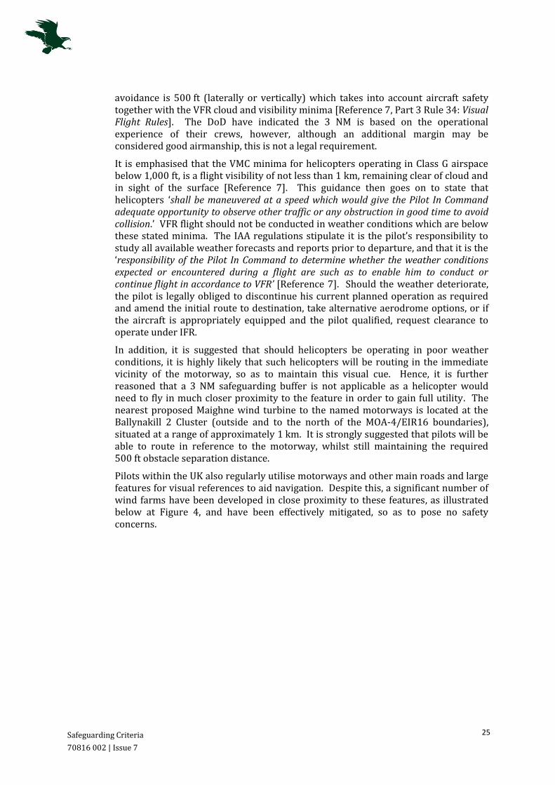
Pilots within the UK also regularly utilise motorways and other main roads and large features for visual references to aid navigation. Despite this, a significant number of wind farms have been developed in close proximity to these features, as illustrated below at Figure 4, and have been effectively mitigated, so as to pose no safety concerns.
Safeguarding Criteria
70816 002 | Issue 7
26
Figure 4: Photograph of adjacent M1 motorway wind farm development within the UK.
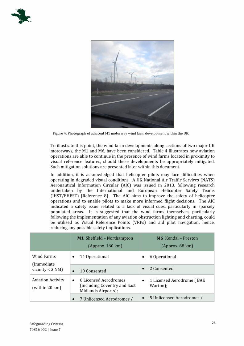
To illustrate this point, the wind farm developments along sections of two major UK motorways, the M1 and M6, have been considered. Table 4 illustrates how aviation operations are able to continue in the presence of wind farms located in proximity to visual reference features, should these developments be appropriately mitigated. Such mitigation solutions are presented later within this document.
In addition, it is acknowledged that helicopter pilots may face difficulties when operating in degraded visual conditions. A UK National Air Traffic Services (NATS) Aeronautical Information Circular (AIC) was issued in 2013, following research undertaken by the International and European Helicopter Safety Teams (IHST/EHEST) [Reference 8]. The AIC aims to improve the safety of helicopter operations and to enable pilots to make more informed flight decisions. The AIC indicated a safety issue related to a lack of visual cues, particularly in sparsely populated areas. It is suggested that the wind farms themselves, particularly following the implementation of any aviation obstruction lighting and charting, could be utilised as Visual Reference Points (VRPs) and aid pilot navigation; hence, reducing any possible safety implications.
M1 Sheffield – Northampton
(Approx. 160 km)
M6 Kendal – Preston
(Approx. 68 km)
Wind Farms
(Immediate vicinity < 3 NM)
14 Operational
6 Operational
10 Consented 2 Consented
Aviation Activity
(within 20 km)
6 Licensed Aerodromes (including Coventry and East Midlands Airports);
1 Licensed Aerodrome ( BAE Warton);
7 Unlicensed Aerodromes / 5 Unlicensed Aerodromes /
Safeguarding Criteria
70816 002 | Issue 7
27
Gliding Sites Gliding Sites.
Table 4: Example of Wind Farms in the Vicinity of UK Motorways5
Further consultation with the Irish Air Corps at Casement Aerodrome has taken place to discuss the validity and sustainability of the 3 NM motorway safeguarding requirement and a clear justification is still awaited.
5.4 DoD Requested Training Areas
Previous engagement with the DoD further indicated the utilisation of areas, represented by two circular zones, for Low Level flight training [Reference 2]. Low flying is a critical skill for military aircrew, which is obtained through specialist training. The location of the Training Areas in relation to the proposed wind farm developments is shown at Figure 5 following (in purple).
However, similarly to the DoD’s declared motorway safeguarding requirements, it is noted that the Training Areas safeguarding requirement is not formally documented; the Low Flying Training Areas are not formally published and therefore no statutory safeguarding is in place. This is not in-line with typical European procedure; safeguarded areas, such as those utilised for low flying activities, are routinely published, allowing civil pilots operating in the region to be aware of such activities and to plan according. Attention is drawn to the UK example, provided at Annex A2.
In addition, the presence of wind turbines in a low level Training Area is not necessarily operationally unmanageable. Should the turbines be appropriately documented and lit (as is the standard practice within the UK Low Flying System), pilots can plan to see and avoid the structures. In addition, the Wind Farms themselves may be utilised as a visual reference to aid navigation, as detailed previously at Section 5.3, allowing the turbines to aid flight training.
The level of impact considered attributable to the construction and operation of any wind turbines within the DoD’s declared Training Areas, can be mitigated.
5 UK Wind Energy Database, Information correct as of October 2014 [Reference 12].

Cloncumber Cluster
70816 002 | Issue 7
29
6 Cloncumber Cluster
This section introduces Cloncumber Cluster, it’s location in relation to Casement Aerodrome and an assessment of the potential impacts and appropriate mitigation solutions.
6.1 Overview
The proposed Cloncumber Cluster consists of eleven wind turbines, located approximately 11 km north of the town of Kildare. The approximate site boundary is illustrated below at Figure 6. The maximum height the proposed 169 m wind turbines are anticipated to reach is 245 m amsl, based on a site ground elevation of 76 m.
The proposed Cloncumber Cluster is located approximately 31 km west of Casement Aerodrome, on a bearing of 261°.
Figure 6: Location of the proposed Cloncumber Cluster. Figure kindly provided by FTCO.

Cloncumber Cluster
70816 002 | Issue 7
30
6.2 Potential Impact
6.2.1 Obstacle Clearance
The Cloncumber Cluster is located within MOA-4 and beneath EIR 16-C, which is established from 1,500 ft amsl. As the proposed ten wind turbines are anticipated to reach a vertical extent of 245 m / 804 ft amsl, minimal impact is expected in terms of VFR operations. There is no formal requirement for aircraft to route directly overhead the Cloncumber turbines, however should a pilot choose to do so, it is considered that the required 500 ft VFR obstacle clearance will be achievable. At an altitude of not below 1,400 ft (rounded to the nearest 100 ft), aircraft will be able to overfly the turbines whilst remaining clear of the EIR 16-C restricted airspace.
Should a pilot choose to route directly overhead the proposed Cluster, it is acknowledged that the turbines may create a traffic funnelling effect, within the EIR 16 Area’s hours of operation. This may potentially affect civil aircraft, intending to operate below the EIR 16 airspace. However there is no formal requirement for aircraft to route directly overhead and aircraft operating under VFR, do so within VMC, and so are required to remain clear of cloud and in sight of the surface at all times, as detailed in Section 4.4. In addition, VFR pilots operating in Class G airspace are ultimately responsible for their own terrain and obstacle clearance [Reference 6, ENR Section 1.4-1], and pilots are able to enter Area EIR 16 when active, with prior permission from Casement ATC [Reference 6, ENR Section 5.1-2]. As a result, the implementation of the suggested mitigation, is anticipated to result in the potential impacts on VFR operations due to the construction of the Cloncumber Wind Farm Cluster as being acceptable.
In addition, in terms of MOA-4, this requirement is not expected to pose any difficulty to pilots operating overhead the eleven proposed wind turbines; aircraft are able to enter MOA-4 and operate at altitudes up to 4,500 ft at their own discretion.
6.2.2 Casement Procedures
The eleven wind turbines will be situated at significant range from any of the Casement published IFPs. However, should IFR traffic be operating in the vicinity of the Cloncumber Cluster, the Casement IFPs indicate the MSA overhead the Wind Farm is 2,800 ft. As a result no impact is anticipated in terms of obstacle clearance. In addition, the Casement Aerodrome Radar Vectoring Instrument Approach Chart indicates the minimum altitude that an air traffic controller is likely to allocate within the vicinity of the proposed turbines, as 2,000 ft. The required obstacle separation for aircraft operating under IFR is 1,000 ft and as such, wind turbines at an altitude of 804 ft are not anticipated to pose any impact. It is however noted a portion of the proposed development (subject to full site survey) is located within 3 NM of an area of designated minimum altitude of 1,800 ft and as such is situated within the Primary Surveillance Minimum Altitude Area (SMAA) Buffer (PSB). Based on the provided height of the site centre-point, turbines established at 804 ft may effect this area by approximately 4 ft (1.2 m); a full site survey is recommended.
6.2.3 Safeguarding Regulations
The Cloncumber Cluster is located at significant distance from Casement Aerodrome, at a range of 31 km; beyond the stipulated OLS boundaries and the CAP 764
Cloncumber Cluster
70816 002 | Issue 7
31
consultation zones. Therefore, no impact is anticipated in terms of the IAA and industry-standard safeguarding regulations.
6.2.4 DoD’s Safeguarding
The proposed Cluster is located at range from the DoD stipulated motorway safeguarding zones; no effect is anticipated in terms of these areas.
The Cloncumber Cluster is located within a DoD specified Training Area, as detailed at Section 5.4. Applying the DoDs’ stipulations of the requirement to safeguard the two identified Low Flying Training Areas, the Cloncumber turbines would impinge on this area.
However, as suggested at Section 5.4, the wind turbines themselves, particularly following the implementation of any aviation obstruction lighting, could be utilised as VRPs and aid pilot navigation; hence, reducing any possible safety implications.
6.3 Mitigation Solutions
The Cloncumber Cluster is located within MOA-4 and in particular, within a DoD identified Training Area. Therefore, to ensure effective flight planning and the safe continuation of aviation activities, solutions are suggested. Implementation of the following solutions is considered to be in accordance with industry standards.
6.3.1 VFR Mitigation Solution 1: Notification and Pilot Familiarisation
As stated previously, VFR aircraft operations in VMC have been identified as potentially effected by wind farm developments situated within the MOA-4. Pilots operating under these rules are responsible for maintaining their own separation; pilots are obliged to be aware of any obstacles and maintain lateral separation or vertical separation of 500 ft [Reference 7]. Therefore, it is suggested that appropriate notification of the Cloncumber Cluster within both civilian and military aviation publications, would alert pilots to their whereabouts and aid in flight planning, reducing any potential risk to aviation within the immediate vicinity of the proposed development.
Attention is drawn to the details provided at Section 1.2, with notification recommended in accordance with the IAA publications; S.I 215 Obstacles to Aircraft in Flight [Reference 4] and S.I 423 En-route Obstacles to Air Navigation [Reference 5].
Notification of Air Corps and Garda pilots operating at Casement Aerodrome is not expected to pose a difficulty and could form part of any pre-exercise briefing, alerting pilots to the Wind Farms’ location and parameters.
6.3.2 VFR Mitigation Solution 2: Aviation Lighting
In addition, due to the nature of flight operations conducted and the acknowledgement that visually acquiring tall, thin structures from the air may pose some difficulty, the application of aviation obstacle lighting is recommended.
It is noted that the existing tall structures within MOA-4 are lit with aviation obstacle lighting, and depicted on aviation charts and documentation. These structures include the Lagan Cement Factory’s Flue structure southwest of Kinnegad and the Tullamore Radio Mast, extending to heights of 411 ft and 972 ft agl. Although each potential obstruction must be individually assessed, this demonstrates that aircraft operating within MOA-4 are currently safely able to maintain the required obstacle
Cloncumber Cluster
70816 002 | Issue 7
32
clearance from structures in the area, suggesting that the proposed Cluster, in isolation, would not pose an unacceptable impact to aircraft operations; the DoD would continue to operate following the wind farms development.
Therefore aviation obstacle lighting similar to the requirements to those presently implemented in the area, conforming to industry standards, is also appropriate for the identified wind farm Cluster. The turbines are anticipated to be lit with medium intensity obstruction lighting, as stipulated in the IAA Aerodrome Licensing Manual [Reference 2]. Further consultation with the DoD and IAA will inform the requirement specifics.
It is Osprey’s expert and considered opinion that the implementation of the suggested solutions will mitigate the VFR impacts of the proposed Cloncumber turbines to a manageable level; the DoD’s operations will be able to continue unaffected in the presence of the Wind Farm.
6.3.3 IFR Mitigation Solutions
Assessment has further indicated the proposed Cloncumber wind turbines may effect Casement’s IFPs in terms of the required IFR obstacle clearance, as a result of the Clusters location within the 1,800 ft PSB. Should this be confirmed following a full survey, any impacts can be mitigated by raising the minimum vector altitude by 100 ft. Consultation with the DoD will inform of possible changes to altitude allocations in the area.
6.4 Conclusions
Analysis indicates that the proposed Cloncumber Cluster will pose minimal impacts on Casement Aerodrome’s operations in terms of safeguarding requirements. It is acknowledged that the turbines are situated within a DoD declared Training Area and therefore, the implementation of pilot notification and aviation obstacle lighting is recommended to ensure the safe continuation of effective flight planning. It is considered that the implementation of the suggested solutions will effectively mitigate any adverse VFR impacts of the construction and operation of the Cloncumber wind turbines.
A full survey is recommended to confirm the indication that the turbines may impact IFR operations at Casement; further consultation will inform of the extent of the effects and the possible implementation of the identified mitigation solution.
Derrybrennan Cluster
70816 002 | Issue 7
33
7 Derrybrennan Cluster
This section introduces the Derrybrennan Cluster, it’s location in relation to Casement Aerodrome and an assessment of the potential impacts and possible mitigation solutions.
7.1 Overview
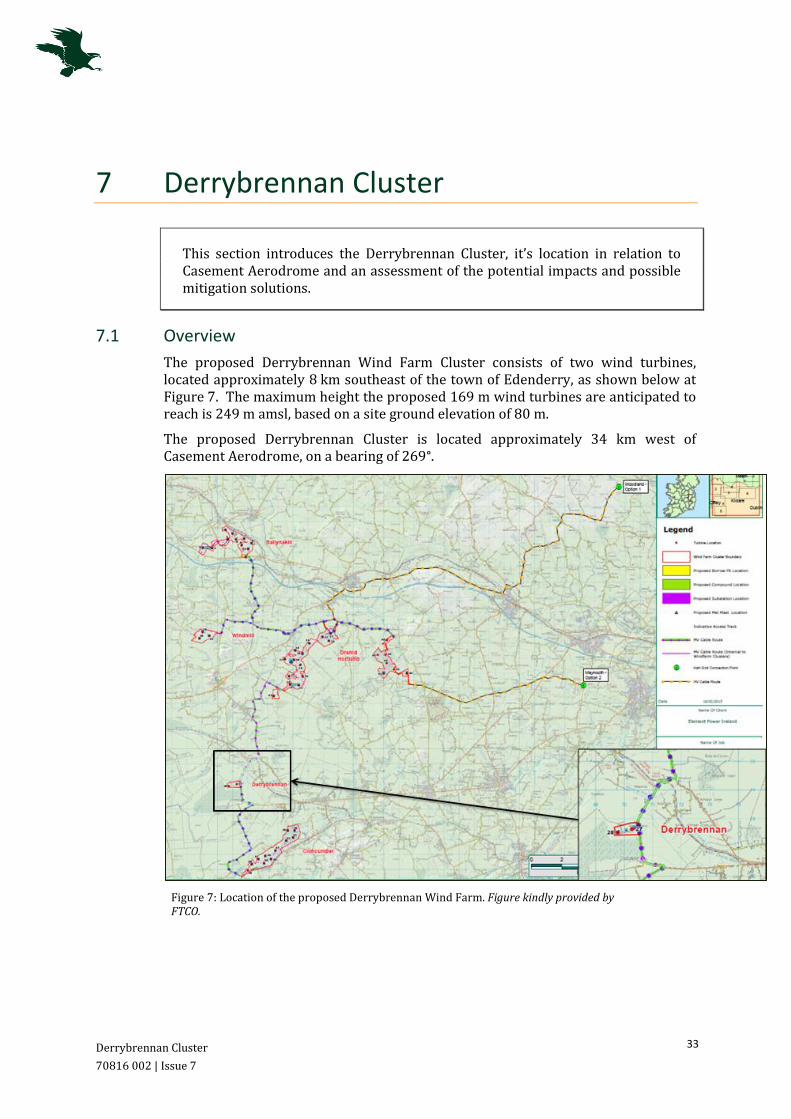
The proposed Derrybrennan Wind Farm Cluster consists of two wind turbines, located approximately 8 km southeast of the town of Edenderry, as shown below at Figure 7. The maximum height the proposed 169 m wind turbines are anticipated to reach is 249 m amsl, based on a site ground elevation of 80 m.
The proposed Derrybrennan Cluster is located approximately 34 km west of Casement Aerodrome, on a bearing of 269°.
Figure 7: Location of the proposed Derrybrennan Wind Farm. Figure kindly provided by FTCO.

Derrybrennan Cluster
70816 002 | Issue 7
34
7.2 Potential Impact
7.2.1 Obstacle Clearance
The Derrybrennan Cluster is located within MOA-4 and EIR 16-C, which is established from 1,500 ft amsl. As the proposed two wind turbines are anticipated to reach a vertical extent of 249 m / 817 ft amsl, minimal impact is anticipated in terms of VFR operations. There is no formal requirement for aircraft to route directly overhead the Derrybrennan turbines, however should a pilot choose to do so, it is considered that the required 500 ft VFR obstacle clearance will be achievable. At an altitude of not below 1,400 ft (rounded to the nearest 100 ft), aircraft will be able to overfly the turbines whilst remaining clear of the airspace.
Should a pilot choose to route directly overhead the proposed Cluster, it is acknowledged that the turbines may create a traffic funnelling effect, within the EIR 16 Area’s hours of operation. This may potentially affect civil aircraft, intending to operate below the EIR 16 airspace. However, there is no formal requirement for aircraft to route directly overhead and aircraft operating under VFR, do so within VMC, and are ultimately responsible for their own terrain and obstacle clearance, as detailed at Section 6.2.1. As a result, following the implementation of the suggested mitigation detailed at Section 8.3, the potential impacts on VFR operations due to the construction of the Derrybrennan Cluster is considered to be acceptable.
In addition, in terms of MOA-4, this requirement is not expected to pose any difficulty to pilots operating overhead the two proposed wind turbines; aircraft are able to enter MOA-4 and operate at altitudes up to 4,500 ft at their own discretion.
7.2.2 Casement Procedures
The two wind turbines will be situated at a significant distance from any of the Casement published IFPs. However, should IFR traffic be operating in the vicinity of the Derrybrennan Cluster, the Casement IFPs indicate the MSA overhead the turbines is 2,800 ft and the Casement Aerodrome Radar Vectoring Instrument Approach Chart indicates the likely minimum allocated altitude within the vicinity of the proposed turbines, is 2,000 ft. The required obstacle separation for aircraft operating under IFR is 1,000 ft and as such, wind turbines with a maximum blade tip altitude of 817 ft are not anticipated to pose any impact. It is however noted, that a portion of the proposed Cluster (subject to full site survey) is located on the boundary of 3 NM from an area of 1,800 ft designated minimum altitude and as such is situated on the border of the required IFR PSB. Based on the provided height of the site centre-point, should the turbines be located within the boundary, a tip height established at 817 ft may effect this area by approximately 17 ft (5.2 m); a full site survey is recommended.
7.2.3 Safeguarding Regulations
The Derrybrennan Wind Farm Cluster is located at significant distance from Casement Aerodrome, at a range of 34 km; beyond the stipulated OLS boundaries and the CAP 764 consultation zones. Therefore, no impact is anticipated in terms of the IAA and industry-standard safeguarding regulations.

Derrybrennan Cluster
70816 002 | Issue 7
35
7.2.4 DoD’s Safeguarding
The proposed Cluster is located at range from the DoD stipulated motorway safeguarding zones; no impact is anticipated in terms of these areas.
The Derrybrennan Cluster is located within a DoD specified Training Area, as shown at Figure 5, Section 5. Applying the DoDs’ stipulations of the requirement to safeguard the two identified Low Flying Training Areas, the Derrybrennan wind turbines would impinge on this area.
However, as suggested at Section 5.4, the wind turbines themselves, particularly following the implementation of any aviation obstruction lighting, could be utilised as visual references and aid pilot navigation; hence, reducing any possible safety implications.
7.3 Mitigation Solutions
The Derrybrennan Cluster is located within MOA-4 and in particular, within a DoD identified Training Area. Therefore, to ensure effective flight planning and the safe continuation of aviation activities, the implementation of mitigation solutions of pilot notification and aviation obstacle lighting is advised, as detailed at Section 6.3. Implementation of these mitigation solutions is considered to be in accordance with industry standards. Consultation with IAA and DoD will inform of lighting requirement specifics.
It is Osprey’s expert and considered opinion that the implementation of the suggested solutions will mitigate the VFR impacts of the proposed Derrybrennan turbines to a manageable level. Following suitable documentation and lighting, it is considered that, even in terms of the low flying Training Area, the DoD’s operations will be able to continue unaffected in the presence of the Wind Farm.
Assessment has further indicated the proposed Derrybrennan wind turbines may affect Casement’s IFPs in terms of the required IFR obstacle clearance, as a result of the Clusters location in the boundary of the 1,800 ft PSB. Should this be confirmed following a full survey, any impacts can be mitigated by raising the minimum vector altitude by 100 ft. Consultation with the DoD will inform of possible changes to altitude allocations in the area.
7.4 Conclusions
Analysis indicates that the proposed Derrybrennan Cluster will pose minimal impacts on Casement Aerodrome’s operations in terms of safeguarding requirements. It is acknowledged that the turbines are situated within a DoD declared Training Area and therefore, the implementation of pilot notification and aviation obstacle lighting is recommended to ensure the safe continuation of effective flight planning. It is considered that the implementation of the suggested solutions will effectively mitigate any adverse VFR impacts of the construction and operation of the Derrybrennan wind turbines.
A full survey is recommended to confirm the indication that the turbines may impact IFR operations at Casement; further consultation will inform of the extent of the effects and the possible implementation of the identified mitigation solution.
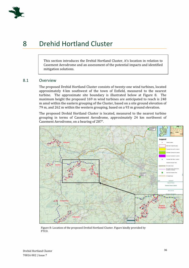
Drehid Hortland Cluster
70816 002 | Issue 7
36
8 Drehid Hortland Cluster
This section introduces the Drehid Hortland Cluster, it’s location in relation to Casement Aerodrome and an assessment of the potential impacts and identified mitigation solutions.
8.1 Overview
The proposed Drehid Hortland Cluster consists of twenty-one wind turbines, located approximately 4 km southwest of the town of Enfield, measured to the nearest turbine. The approximate site boundary is illustrated below at Figure 8. The maximum height the proposed 169 m wind turbines are anticipated to reach is 248 m amsl within the eastern grouping of the Cluster, based on a site ground elevation of 79 m, and 262 m within the western grouping, based on a 93 m ground elevation.
The proposed Drehid Hortland Cluster is located, measured to the nearest turbine grouping in terms of Casement Aerodrome, approximately 24 km northwest of Casement Aerodrome, on a bearing of 287°.
Figure 8: Location of the proposed Drehid Hortland Cluster. Figure kindly provided by FTCO.

Drehid Hortland Cluster
70816 002 | Issue 7
37
8.2 Potential Impact
8.2.1 Obstacle Clearance
The Drehid Hortland Cluster is located within MOA-4 and beneath EIR 16-B to the east and EIR 16-C to the west, which are established from 1,000 ft and 1,500 ft amsl respectively. The proposed twenty-one wind turbines are anticipated to reach a maximum worse-case vertical extent of 262 m / 860 ft amsl,
In line with ICAO standards, the Low Flying Rule states that VFR aircraft shall not be flown closer than 500 ft to any person, vehicle, obstacle or structure. Hence, whilst the proposed Drehid Hortland turbines would not breach the EIR 16 airspace, should a pilot choose to route directly overhead the eastern grouping of the proposed Cluster, situated beneath EIR 16-B, it is considered that the turbines may pose a vertical restriction, within the Area’s hours of operation. This effect is expected to potentially affect civil aircraft, intending to operate below the EIR 16 airspace.
There is no formal requirement for VFR aircraft to route directly overhead and it is considered highly feasible that aircraft could plan to safely avoid the turbines, Aircraft operating under VFR do so within VMC, and so are required to remain clear of cloud and in sight of the surface at all times, as detailed in Section 4.4. VFR pilots operating in Class G airspace are ultimately responsible for their own terrain and obstacle clearance [Reference 6, ENR Section 1.4-1] and pilots are able to enter Area EIR 16 when active, with prior permission from Casement ATC [Reference 6, ENR Section 5.1-2]. As a result, following the implementation of the suggested mitigation, the potential impacts on VFR operations within EIR 16 due to the construction of the Drehof Hortland Cluster is considered to be acceptable.
It is considered that with appropriate site notification and documentation, pilots could effectively route around the turbines with a minimum lateral separation of 500 ft; this is considered to be easily achievable.
In terms of MOA-4, the obstacle clearance requirements are not expected to pose any difficulty to pilots operating overhead the proposed wind turbines; aircraft are able to enter MOA-4 and operate at altitudes up to 4,500 ft at their own discretion.
8.2.2 Casement Procedures
The seven most-eastern proposed wind turbines will be situated in proximity of the Casement published Instrument Approach Procedures for Runway 11. Should IFR traffic be operating in the vicinity of these Drehid Hortland turbines, the Casement Approach procedures indicate that aircraft will be positioning at an attitude of 2,000 ft. However, the Casement Aerodrome Radar Vectoring Approach Chart, shown at Figure 3 Section 4, indicates that the minimum altitude to be allocated by air traffic controllers in the vicinity of the Drehid Hortland Cluster is 1,800 ft.
As a result, this may impact in terms of the required IFR obstacle clearance. The required obstacle separation for aircraft operating under IFR is 1,000 ft [Reference 7] and as such, wind turbines with a maximum blade tip altitude of 248 m (814 ft) within the eastern grouping, are anticipated to adversely affect (by 14 ft) Casement Aerodrome’s IFR operations. Additionally, an impact of 60 ft, based on the

Drehid Hortland Cluster
70816 002 | Issue 7
38
maximum blade tip altitude of 262 m (860 ft), of the western Cluster grouping, should be considered as a worse-case scenario.
The remaining fourteen wind turbines located to the west of the Drehid Hortland Cluster, as mentioned above, are considered to be situated at a significant distance from any of the Casement published IFPs. However, should IFR traffic be operating in the vicinity of these turbines, the Casement IFPs indicate the MSA overhead the turbines is 2,800 ft. It is however noted that the western grouping of the proposed Cluster is located within 3 NM of the area of designated minimum altitude of 1,800 ft and as such is situated within the required PSB.
The measurements provided within this Assessment are based on the site centre-point coordinates and are approximate only. A full site survey is recommended to confirm these findings.
8.2.3 Safeguarding Regulations
The Drehid Hortland Cluster is located at significant distance from Casement Aerodrome, at a range of 24 km to the nearest turbine to Casement, beyond the stipulated OLS boundaries. However, a number of the turbines are located within the CAP 764 consultation zone of 30 km.
As detailed at Section 5.2, the concerns raised by the DoD at Casement Aerodrome relate to the potential impact on VFR operations only. Therefore, it is considered that a safeguarding zone of 17 km be applicable in this instance [Reference 3]. Based on the assumption, there will be no impact in terms of aerodrome safeguarding because of the development of the proposed Drehid Hortland Cluster. In addition, as outlined at Section 5.2 and Annex A, there are numerous examples of wind farm developments that are operational within the vicinity of aerodromes. By their continued presence, these wind farms do not pose a safety risk when appropriately mitigated.
8.2.4 DoD’s Safeguarding
Analysis indicates that a portion of the proposed Drehid Hortland Cluster is located within the 3 NM DoD-declared range of the M4 motorway, at approximately 2.4 NM. Applying the stipulations of the DoD, the Drehid Hortland Cluster has the potential to impact on the DoD’s safeguarding request of the motorways, which are used as visual references, as line-features for routing to and from the west of Casement Aerodrome.
However, attention is drawn to Section 5.3; the DoD’s requirement for a 3 NM safeguarding zone is strongly questioned. A 3 NM zone is deemed disproportionate for the safeguarding of non-published overland routes, when considered in terms of the typical aviation safeguarding limits and legal obstacle clearance requirements to maintain 500 ft either vertically or laterally [Reference 7]. It is considered that during flight in poor weather conditions, pilots are highly likely to operate in the immediate vicinity of any visual reference i.e. not requiring a range of 3 NM. In addition, VFR flight must be operated within the legal limits of the VMC minima and at a speed, which will enable the pilot adequate opportunity to observe other traffic or potential obstructions. Should the weather conditions deteriorate, the pilot is obligated to curtail the flight as necessary. Engagement with the DoD has not revealed the Irish Air Corps justification for this safeguarding requirement.
Drehid Hortland Cluster
70816 002 | Issue 7
39
The Drehid Hortland Cluster is located beyond the boundaries of the two DoD specified Training Areas, as shown at Figure 5, Section 5; no impact is anticipated in terms of Military Low Flying areas.
8.3 Mitigation Solutions
The Drehid Hortland Cluster is located within MOA-4 and partially beneath EIR 16-B, which is established from 1,000 ft amsl. As the proposed wind turbines would present a vertical restriction in terms of VFR overflight, and to ensure effective flight planning and the safe continuation of aviation activities, the implementation of the mitigation solutions of pilot notification and aviation obstacle lighting is advised, as detailed at Section 6.3. These Solutions are also considered appropriate in terms of the DoD’s motorway safeguarding requirements, however consultation with the DoD will be required to confirm this. Implementation of these mitigation solutions is considered to be in accordance with industry standards. Consultation with IAA and DoD will inform of lighting requirement specifics.
Assessment has further indicated the proposed wind turbines may pose an impact to Casement’s IFPs in terms of the required IFR obstacle clearance. Should this be confirmed following a full survey, any impacts can be mitigated by raising the minimum vector altitude by 100 ft.
8.4 Conclusions
Analysis indicates that the proposed Drehid Hortland Cluster will affect Casement Aerodrome’s operations in terms of VFR and IFR obstacle clearance. In addition, it is acknowledged that the turbines are situated within 3 NM of the M4 motorway, however the validity of this safeguarding requirement is questioned.
The implementation of mitigation solutions to include pilot notification and aviation obstacle lighting is recommended, to ensure the safe continuation of effective flight planning. It is considered that the implementation of the suggested solutions will effectively mitigate any adverse impacts of the Drehid Hortland turbines in terms of VFR operations.
A full survey is recommended to confirm the indication that the turbines will impact on IFR operations at Casement; further consultation will inform of the extent of the effects and any possible mitigation solution.
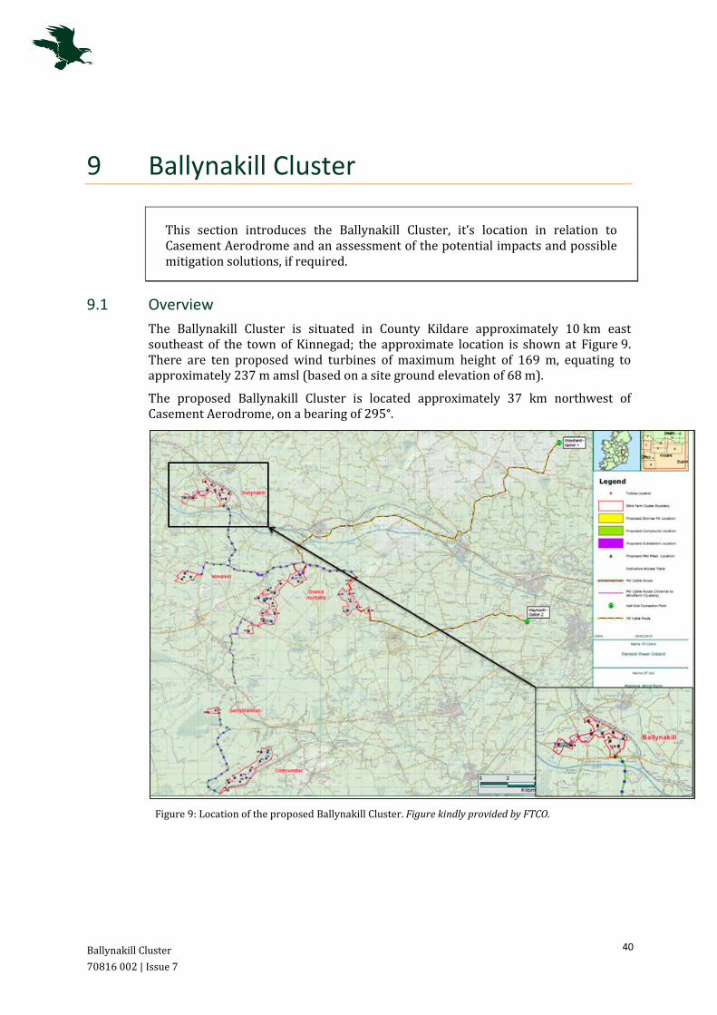
Ballynakill Cluster
70816 002 | Issue 7
40
9 Ballynakill Cluster
This section introduces the Ballynakill Cluster, it’s location in relation to Casement Aerodrome and an assessment of the potential impacts and possible mitigation solutions, if required.
9.1 Overview
The Ballynakill Cluster is situated in County Kildare approximately 10 km east southeast of the town of Kinnegad; the approximate location is shown at Figure 9. There are ten proposed wind turbines of maximum height of 169 m, equating to approximately 237 m amsl (based on a site ground elevation of 68 m).
The proposed Ballynakill Cluster is located approximately 37 km northwest of Casement Aerodrome, on a bearing of 295°.
Figure 9: Location of the proposed Ballynakill Cluster. Figure kindly provided by FTCO.
Ballynakill Cluster
70816 002 | Issue 7
41
9.2 Potential Impact
The Ballynakill Cluster is located beyond the lateral confines of both MOA-4 and EIR 16, situated approximately 4 km beyond the area’s northern boundaries. The Wind Farm is further located beyond the Casement safeguarding areas in terms of the stipulated OLS, CAP 764 consultation zones and the DoD’s declared Training Areas. It is noted that the ten proposed wind turbines are located at a distance of approximately 1 NM from the M4 motorway, however as the proposed Cluster is located outside the MOA-4, this indicates an area where military aircraft are not expected to routinely operate. Therefore, it is considered that the ten turbines would not pose an impact to VFR and DoD operations.
Should civilian VFR traffic be operating in the turbines vicinity, it is considered that the required 500 ft obstacle clearance will be easily achievable. The ten proposed wind turbines will have a vertical extent of 237 m (approximately 778 ft) amsl, enabling direct overflight at and above 1,300 ft (rounded to the nearest 100 ft).
9.3 Mitigation Solutions
Although the Ballynakill Cluster is located beyond any designated airspace boundaries, the implementation of appropriate notification (as outlined at Section 5.3) is considered important in terms of effective VFR flight planning for pilots operating in the region.
In addition, careful consideration should also be given to the lighting requirements; all the Maighne Wind Farm Clusters are located in relative proximity and the lighting of only a portion of wind turbines in the area may present a safety concern. It is therefore suggested that all the proposed turbines for all five Clusters be fitted with aviation obstacle lighting; further consultation with the DoD and IAA will inform the requirement specifics.
9.4 Conclusions
Analysis indicates that the proposed Ballynakill Cluster will pose no impact on Casement Aerodrome’s operations, either in terms of obstacle clearance or safeguarding requirements. The ten proposed wind turbines are located beyond the boundaries of the designated MOA-4 and EIR 16. Despite this, to ensure the safe continuation of effective flight planning and safe obstacle avoidance, mitigation solutions of pilot notification and aviation obstacle lighting are recommended.

Windmill Cluster
70816 002 | Issue 7
42
10 Windmill Cluster
This section introduces the Windmill Cluster, it’s location in relation to Casement Aerodrome and an assessment of the potential impacts and possible mitigation solutions.
10.1 Overview
The Windmill Cluster is situated in County Kildare approximately 10 km west southwest of the town of Enfield; the approximate location is shown at Figure 10. There are three proposed wind turbines of maximum height of 169 m, equating to approximately 259 m amsl (based on a site ground elevation of 90 m).
The proposed Windmill Cluster is located approximately 36 km northwest of Casement Aerodrome, on a bearing of 285°.
Figure 10: Location of the proposed Windmill Cluster. Figure kindly provided by FTCO.
Windmill Cluster
70816 002 | Issue 7
43
10.2 Potential Impact
10.2.1 Obstacle Clearance
The Windmill Cluster is located within MOA-4 and EIR 16-C, which is established from 1,500 ft amsl. As the three proposed wind turbines are anticipated to reach a vertical extent of 259 m / 850 ft amsl, minimal impact is anticipated in terms of VFR operations. There is no formal requirement for aircraft to route directly overhead the wind turbines, however should a pilot choose to do so, it is considered that the required 500 ft VFR obstacle clearance will be achievable [Reference 7]. At an altitude of not below 1,400 ft (rounded to the nearest 100 ft), aircraft will be able to overfly the Windmill turbines whilst remaining clear of the airspace.
Should a pilot choose to route directly overhead the proposed Cluster, it is acknowledged that the turbines may create a traffic funnelling effect, within the Area’s hours of operation. This may potentially affect civil aircraft, intending to operate below the EIR 16 airspace. However, there is no formal requirement for aircraft to route directly overhead and aircraft operating under VFR do so within VMC, and are ultimately responsible for their own terrain and obstacle clearance, as detailed at Section 6.2.1. As a result, following the implementation of the suggested mitigation detailed following, the potential impacts on VFR operations due to the construction of the Windmill Cluster is considered to be acceptable. It is recommended that the DoD are engaged to confirm this.
In addition, in terms of MOA-4, this requirement is not expected to pose any difficulty to pilots operating overhead the three proposed wind turbines; aircraft are able to enter MOA-4 and operate at altitudes up to 4,500 ft at their own discretion.
10.2.2 Casement Procedures
The three wind turbines will be situated at a significant distance from any of the Casement published IFPs. However, should IFR traffic be operating in the vicinity of the Windmill Cluster, the Casement IFPs indicate the MSA overhead the turbines is 2,800 ft and the Casement Aerodrome Radar Vectoring Instrument Approach Chart indicates the minimum altitude likely to be allocated within the vicinity of the proposed turbines, is 2,000 ft. The required obstacle separation for aircraft operating under IFR is 1,000 ft and as such, wind turbines with a maximum blade tip altitude of 850 ft are not anticipated to pose any impact on Casement Aerodrome’s IFR operations.
10.2.3 Safeguarding Regulations
The Windmill Cluster is located at significant distance from Casement Aerodrome, at a range of 36 km, beyond the stipulated OLS and CAP 764 consultation boundaries. Therefore, no impact is anticipated in terms of the IAA and industry-standard safeguarding regulations.
10.2.4 DoD’s Safeguarding
Analysis indicates that a portion of the proposed Windmill Cluster is located within the 3 NM DoD declared safeguarding area for the M4 motorway, at approximately 2.4 NM. Applying the stipulations of the DoD, the Windmill Wind Farm has the potential to impact on safeguarding requirements of the motorway, which are used as visual reference for routing to and from the west of Casement Aerodrome.
Windmill Cluster
70816 002 | Issue 7
44
However, attention is drawn to Section 5.3; the requirement for a 3 NM safeguarding zone is strongly questioned. A 3 NM zone is deemed disproportionate for the safeguarding of non-published overland routes, when considered in terms of the typical aviation safeguarding limits and legal obstacle clearance requirements to maintain 500 ft either vertically or laterally [Reference 7]. It is considered that during flight in poor weather conditions, pilots are highly likely to operate in the immediate vicinity of any visual reference i.e. not requiring a range of 3 NM. In addition, VFR flight must be operated within the legal limits of the VMC minima and at a speed which will enable the pilot adequate opportunity to observe other traffic or potential obstructions. Should the weather conditions deteriorate, the pilot is obligated to curtail the flight as necessary. Engagement with the DoD is strongly recommended to discuss the sustainability of this safeguarding requirement.
The Windmill Cluster is located beyond the boundaries of the two DoD specified Training Areas, as shown at Figure 4, Section 5; no impact is anticipated in terms of Military Low Flying.
10.3 Mitigation Solutions
The Windmill Cluster is located within MOA-4 and in particular, within 3 NM of the M4 motorway. As the proposed wind turbines would present a vertical restriction in terms of overflight, and to ensure effective flight planning and the safe continuation of aviation activities, the implementation of the mitigation solutions of pilot notification and aviation obstacle lighting is advised, as detailed at Section 6.3. Implementation of these mitigation solutions is considered to be in accordance with industry standards. Consultation with IAA and DoD will inform of lighting requirement specifics.
It is Osprey’s expert and considered opinion that the implementation of the suggested solutions will mitigate the impacts of the proposed Windmill turbines to a manageable level; the DoD’s operations will be able to continue unaffected in the presence of the Wind Farm.
10.4 Conclusions
Analysis indicates that the proposed Windmill Cluster will pose minimal impacts on Casement Aerodrome’s operations in terms of obstacle clearance and safeguarding requirements. It is acknowledged that the turbines are situated within 3 NM of the M4 motorway, however the validity of this safeguarding requirement is questioned. The implementation of mitigation solutions to include pilot notification and aviation obstacle lighting is recommended, to ensure the safe continuation of effective flight planning. It is considered that the implementation of the suggested solutions will effectively mitigate any adverse impacts of the construction and operation of the Windmill wind turbines.
Cumulative Effects
70816 002 | Issue 7
45
11 Cumulative Effects
This section assesses any potential Cumulative Impacts, Restriction or Turbulence Effects as a result of the development of the proposed Maighne Wind Farm Clusters.
11.1 Cumulative Overview
The proliferation of turbines and wind developments is known to be of major concern to Military Low Level Flying and Air Navigation Service Providers (ANSPs), such as Casement ATC. Consultation with the DoD at Casement Aerodrome will identify any cumulative effects that may occur due to the development of the proposed Maighne Wind Farm Clusters.
Element Power are planning the development of 47 wind turbines, across five Clusters. The possibility exists that the DoD may be able to accommodate these sites, however there could be a cumulative effect implication owing to the development of all planned Clusters. The combined effect of numerous individual turbines or multiple wind farms can sometimes be difficult to mitigate. In addition, it is known that there are a number of other developer-proposed wind sites within the Irish Midlands, which are currently in various stages of the planning process. It is not known if any of these sites will adversely affect the operations of the DoD, however there is the potential that the combined effect of developments in addition to the proposed five Clusters, may produce a possible cumulative effect.
However, the majority of the proposed sites are situated centrally, located between the M4/M6 motorways to the north and M7 to the south. The region of development for the Wind Farm Clusters is encompassed in an area of approximately 23 km in range north-south and measuring approximately 15 km east-west, with significant distance between the individual Cluster outer turbines as shown at Figure 11 following (an average of 5.2 km, measured to the nearest development). This provides adequate space for aircraft to operate between the proposed developments, should these be operating below 1,000 ft above ground level (agl). Following appropriate documentation and lighting of the wind farms, the turbines will not pose an unmanageable effect to pilots, who will plan their routes accordingly. In addition, this is not an area indicated to be of concern to the DoD, as EIR 16 does not extend to the surface, and therefore is considered to pose less of a potential cumulative effect.

Cumulative Effects
70816 002 | Issue 7
46
Figure 11: Location of the proposed Maighne Wind Farm Clusters. Figure kindly provided by FTCO.
Cumulative Effects
70816 002 | Issue 7
47
It is suggested that the Clusters closest together and particularly within the vicinity of the identified motorway, may potentially pose a cumulative effect, namely the site of Drehid Hortland and Windmill Clusters, south of the M4, whose site centre-points are located within 6 km of each other, measured to the Drehid Hortland Cluster western grouping. However, as detailed previously, the application of the identified mitigation solutions will enable effective flight planning and ensure the safe continuation of aviation activities.
In addition, careful consideration has been given to the mitigation solutions, as detailed at Section 9.3 in terms of the Ballynakill Cluster. Despite the proposed site being located beyond the MOA-4 and EIR 16 boundaries, it is considered, as the Maighne Wind Farm Clusters are located in relative proximity, lighting of only a portion of wind turbines in the area may present a safety concern. It is therefore suggested that all the proposed turbines, for all five Clusters, be fitted with aviation obstacle lighting.
FTCO and Element Power have to sought to determine the extent of any potential cumulative effects of the proposed five Wind Farm Clusters through consultation with the DoD; formal response is awaited.
11.2 Restriction Considerations
The DoD has raised concerns in terms of the potential creation of ‘choke-points’ in the Class G uncontrolled airspace, as a result of the proposed Maighne Wind Farm Clusters. Although it is noted in the previous Sections, that the direct overflight of the proposed Cloncumber, Derrybrennan, Drehid Hortland and Windmill developments may lead to a traffic-funnelling effect in some instances, this is not anticipated to pose any difficulties to pilots, following the implementation of appropriate mitigation and the reduction in turbine numbers.
Pilots maintaining the required 500 ft VFR obstacle clearance whilst routing overhead the turbines of the four aforementioned Clusters, may be operating in a reduced overhead volume of airspace, should they not request to enter Restricted Area EIR 16, when active. However, there is no formal requirement or procedure which would necessitate the direct overflight of any of the Maighne Wind Farm Clusters. It is stressed that it is the pilots responsibility to plan and avoid any obstacles when operating within Class G uncontrolled airspace, whilst complying with the relevant airspace regulations; with appropriate documentation and charting of the sites, as identified within the Mitigation Solutions, this is anticipated to be easily achievable.
It is Osprey’s opinion that, following the reduction in turbine numbers in the Clusters and the implementation of suitable documentation of the Wind Farm sites, any potential choke-point effects will be manageable, as pilots will be suitably notified and able to flight plan effectively.
11.3 Turbulence Review
The DoD has made reference to concerns as a result of the potential for turbine-induced wake turbulence. In order to attempt to establish a baseline against which wake turbulence could be measured a review of policy, literature and relevant research was completed.
Cumulative Effects
70816 002 | Issue 7
48
The following documents were assessed:
IAA Policy on Land Use and Planning and Offshore Development (Draft for Public
Consultation October 2014) [Reference 13];
UK CAA CAP 764 Policy and Guidelines on Wind Turbines, UK National Regulatory
Document [Reference 3];
Energy Research Centre of the Netherlands, Literature Review Aerodynamics of
wind turbine wakes [Reference 14]; and
Dutch Academic Paper, progress in Aerospace Sciences 39, 467–510, Wind
Turbine Wake Aerodynamics [Reference 15].
A summary of this literature adduces that turbulent wake behind a wind turbine maybe apportioned to:
• Blade-tip vortices due to air counteracting the blade;
• The finite length of the turbine blades; and
• Air velocity reduction due to power extraction.
Sufficiently far downstream from a wind turbine, increased turbulence and momentum deficit will diminish because of turbulent diffusion of the wake due to a vast array of factors not limited to, spacing, design, and environment. A study by EMD International A/S, (2010) [Reference 16] describes the shape of the turbulent wake behind a wind turbine as a fan that gradually widens and dissipates. This wake widening and diffusion tends to be greater on land than offshore due to higher ambient (geographic and environmental) air turbulence. The distance to which the wake from a wind turbine extends downstream may be represented in terms of a multiple of the wind turbine Rotor Diameter (RD). Turbulence from wind turbines has a fairly short spectral size and is quite predictable as it follows the circular motion of the rotor. From this we may conclude that high turbulence intensity from a wind turbine is therefore much less likely to have the violent spikes of aircraft induced wake turbulence.
The Draft IAA Policy on Land Use and Planning and Offshore Development [Reference 13] states that:
‘Turbulence caused by the wake of the turbine which extends stream-wise for a considerable distance behind the blades and the turbine tower. The dissipation of the wake intensity depends on the convection, the turbulence diffusion and local topography (terrain, obstacles etc.). Published research shows measurements at 16 rotor diameters downstream of the wind turbine indicating that turbulence effects are still noticeable. Smaller type aircraft, helicopters, hot air balloons and parachuting activity are particularly susceptible to this turbulence and pilots who experience it are encouraged to file a report via their applicable safety occurrence reporting scheme. In extreme cases turbulence can cause loss of aircraft control from which it is impossible to recover’.
The UK CAA operates a Mandatory Occurrence Report (MOR) Scheme and it is defined within CAP 382 [Reference 17] as follows:
‘The objective of the MOR Scheme is to contribute to the improvement of flight safety by ensuring that relevant information on safety is reported, collected, stored, protected
Cumulative Effects
70816 002 | Issue 7
49
and disseminated. The sole objective of occurrence reporting is the prevention of accidents and incidents and not to attribute blame or liability.’
In explaining what should be reported, the CAA state that a MOR should be submitted for:
‘Any incident which endangers or which, if not corrected would endanger an aircraft, its occupants or any other person.’
CAP 382 provides great detail as to what type of incident requires the raising of an MOR. Amongst those are:
• Inability to achieve predicted performance during take-off or initial climb;
• Loss of control (including partial or temporary) regardless of cause; and
• Unintentional significant deviation from airspeed, intended track or altitude (more than 300 ft) regardless of cause.
The MOR scheme is arguably the most mature (over 30 years old) aviation safety reporting system in the world, generating in excess of 12,000 reports per year. The UK is recognised as a world leader in addressing the problems of aviation interaction with wind turbines. The small land mass forces wind farms and aviation stakeholders to co-exist. Despite the wealth of knowledge gained over the past 10 years and the maturity of the MOR system, the CAA have stated that they have never received a MOR relating to the effect of wind turbine induced wake turbulence on an aircraft.
With respect to aviation, wake turbulence is commonly defined as being turbulence that forms behind an aircraft as it passes through the air, which should not be confused with downstream wind turbine turbulence. When evaluating the possibility of wake turbulence affecting aircraft it should be noted that there is a difference between the ability to measure a disturbance in the air (turbulence) and the presence of a disturbance sufficient to pose a threat to aircraft operations. Wind rolling off the top of the hill will cause turbulence, as will any man made structure (buildings etc.). All flights encounter turbulence to differing degrees. The issue in question relates to whether such disturbance could be considered dangerous.
Having stated that there is no knowledge of any reported wind turbine turbulence incidents in the UK, we believe it would be beneficial to highlight a number of disparate developments that have either been built or approved in close proximity to aviation activity. A number of wind development Case Studies are provided at Annex A3.
Conclusions and Recommendations
70816 002 | Issue 7
50
12 Conclusions and Recommendations
This section details the conclusions and recommendations drawn from the full range of analysis.
12.1 Overview
This Aviation Impact Assessment has sought to determine any potential impacts the construction of the proposed Maighne Wind Farm Clusters may have on VFR aviation operations conducted in the area, both in terms of obstacle clearance, operating procedures and safeguarding requirements.
12.2 Potential Impact
12.2.1 Obstacle Clearance
The five proposed Wind Farm Clusters have been assessed in terms of the EIR 16, which supports Military flight activities and training operations. Initial assessment of the proposed developments indicates that none of the wind turbines will breach the military Restricted Area, based on the ground elevation of the site centre-points.
Assessment identified that direct overflight of the Cloncumber, Windmill and Derrybrennan Clusters, and western-section of the Drehid Hortland Cluster, will be achievable whilst maintaining the 500 ft required VFR obstacle clearance. The required 500 ft obstacle clearance will be achievable below the respective base of EIR 16 for each site, however it is acknowledged this may in some instances lead to a funnelling effect of VFR traffic wishing to operate beneath the base of the designated EIR 16-C.
Direct overflight of the eastern-section of the Drehid Hortland Cluster is vertically restricted for VFR aircraft routing below the EIR 16-B airspace. However, as detailed, there is no formal requirement for aircraft to route directly overhead the turbines and aircraft operating under VFR do so within VMC, and so are required to remain clear of cloud and in sight of the surface at all times. In addition, VFR pilots operating in Class G airspace are ultimately responsible for their own terrain and obstacle clearance [Reference 1, ENR Section 1.4-1] and pilots are able to enter Area EIR 16 when active, with prior permission from Casement ATC [Reference 6, ENR Section 5.1-2]. As a result, following the implementation of the suggested mitigation, the potential impacts on VFR operations due to the construction of the Maighne Wind Farm Clusters are considered to be acceptable.
Four of the proposed Clusters are located within MOA-4. Although this Area stretches from surface level to FL 450, civilian aircraft are able to enter the Class G Area at their own discretion, up to but not including 4,500 ft amsl; indicating the airspace below 4,500 ft is potentially of less importance to the DoD’s activities. In addition, there are several existing tall structures within MOA 4, which, by their continued presence, are appropriately mitigation and deemed acceptable by the DoD.
Conclusions and Recommendations
70816 002 | Issue 7
51
12.2.2 Casement Procedures
Assessment indicates that two of the proposed developments are anticipated to be located within proximity to Casement published IFPs; namely the Drehid Hortland and Cloncumber Clusters.
The declared Casement Aerodrome Radar Vectoring Instrument Approach Chart indicates the minimum altitude that an air traffic controller is likely to allocate within the vicinity of the proposed Drehid Hortland Wind Farm, as 1,800 ft. As such, the Drehid Hortland Cluster is likely to affect IFR operations, as the requirement for a 1,000 ft obstacle clearance would not be satisfied.
The Cloncumber Cluster is situated within 3 NM of the aforementioned 1,800 ft area and as such is located within the required PSB and, subject to full site survey, the Cluster is also likely to effect IFR operations as the requirement for a 1,000 ft obstacle clearance would not be satisfied. The Derrybrennan Cluster is also located on the boundary of the 3 NM Buffer.
The measurements provided within this Assessment are based on the site centre-point coordinates and are approximate only. A full site survey is recommended to confirm these findings.
12.2.3 Safeguarding Regulations
All five proposed Clusters are located beyond the boundaries of the Casement Aerodrome OLS; no breach of the surfaces will occur as a result of the Maighne Wind Farm Clusters construction.
In terms of the UK CAA CAP 764 consultation zones, the Drehid Hortland Cluster is located within the 30 km zone, with several further Clusters located on the boundary of this requirement. However, as detailed at Section 5.2, the concerns raised by the DoD at Casement Aerodrome relate to the potential impact on VFR operations only, there is no objection based on effects on radar. Therefore, it is considered that a safeguarding zone of 17 km, be applicable in this instance [Reference 3]. Based on the assumption of a 17 km consultation zone, there will be no impact as a result of the development of the proposed Maighne Wind Farm Clusters. In addition, as outlined at Section 5.2 and Annex A, there are numerous examples of wind farm developments, which are operational within the vicinity of aerodromes. By their continued presence, these wind farms do not pose a safety risk when appropriately mitigated.
12.2.4 DoD’s Safeguarding
Motorway Safeguarding
Analysis indicates that two of the proposed Clusters are located within the DoD-specified 3 NM motorway safeguarding areas, including the Drehid Hortland and Windmill sites. The Ballynakill Cluster is further located within proximity to the M4/M6 motorway, but is situated outside the MOA-4 and as such, is not considered to pose an impact to military operations.
The DoD has requested the safeguarding of the motorways, which are used as visual references and line-features for routing to and from the west of Casement Aerodrome. However, attention is drawn to Section 5.3; the requirement for a 3 NM safeguarding zone is strongly questioned; this equates to one and a half minutes
Conclusions and Recommendations
70816 002 | Issue 7
52
flying time for a typical helicopter or light general aviation aircraft. It is noted that this safeguarding requirement is not formally documented and is not based on any IAA or Eurocontrol legal requirement or operational guidance; the DoD requirements are not considered to be in-line with European operations.
A 3 NM zone is deemed disproportionate for the safeguarding of non-published overland routes, when considered in terms of the typical aviation safeguarding limits and legal obstacle clearance requirements to maintain 500 ft either vertically or laterally [Reference 7]. It is considered that during flight in poor weather conditions, pilots are highly likely to operate in the immediate vicinity of any visual reference i.e. not requiring a range of 3 NM. In addition, VFR flight must be operated within the legal limits of the VMC minima and at a speed that will enable the pilot adequate opportunity to observe other traffic or potential obstructions. Should the weather conditions deteriorate, the pilot is obligated to curtail the flight as necessary.
It is acknowledged that helicopter pilots may face difficulties when operating in degraded visual conditions. A recent UK NATS published AIC indicates safety issues related to a lack of visual cues, particularly in sparsely populated areas. It is suggested that the Wind Farms themselves, particularly following the implementation of any aviation obstruction lighting, could aid in pilot navigation. Additionally, it is noted that motorways in the UK are also utilised as visual references for VFR pilots, however Table 3 in Section 5.3, indicates the extent of wind turbine development within 3 NM of motorways in the UK.
Following the implementation of suitable mitigation as detailed following (Section 12.3), it is suggested that the proposed Drehid Hortland and Windmill Clusters will not pose an unacceptable impact on military operations; the DoD at Casement Aerodrome will be able to continue to operate safely within their presence. Engagement with the DoD is strongly recommended to discuss the sustainability of this safeguarding requirement.
Low Flying Training Areas
The DoD have specified the requirement to maintain two Training Areas which are typically utilised for Low Flying operations, as detailed at Section 5.4. Based upon this requirement, two Cluster site centre-points have been identified to be located within the boundary of the northwest Area (Cloncumber and Derrybrennan). It is however noted that all the wind turbines are located beneath the lower limit of the military Restricted Area EIR 16, and that any aircraft can operate within this area, with pilots ultimately responsible for their own obstacle and terrain avoidance. The two Training Areas are not formally published and there is no statutory safeguarding requirement, as is considered standard practice within the UK and other parts of Europe. In addition, the presence of the lit turbines will provide a visual reference, which can be utilised to aid pilot navigation and training.
12.2.5 Cumulative Effects
The proliferation of turbines and wind developments is known to be of major concern to Military Low Level Flying and ANSPs, such as Casement ATC. Element Power are planning a number of wind turbines across five Clusters, however, there are significant distances between the periphery turbines of each site (an average of 5.2 km). This provides adequate space for aircraft to operate between the proposed Clusters, should aircraft be operating below 1,000 ft (agl). In addition, the DoD has
Conclusions and Recommendations
70816 002 | Issue 7
53
raised concerns in terms of the potential creation of ‘choke-points’. It is acknowledged that the development of four of the proposed Wind Farm Clusters may result in reduced vertical airspace volumes for direct overflight of the turbines, for civil aircraft who have not requested to enter EIR 16, when active. However, there is no formal requirement or published procedure for any of the Clusters to be directly overflown and it is the pilots responsibility to be aware of and avoid obstacles within the Class G airspace.
Following appropriate documentation and lighting of the Clusters, the turbines will not be unmanageable for pilots, who will plan their routes accordingly. Further, this is not an area indicated to be of concern to the DoD, as EIR 16 does not extend to the surface, and therefore is considered to pose less of a potential cumulative effect.
In addition, any potential for wind turbine-induced wake turbulence has been considered through a review of existing policy and relevant research. This review indicated that whilst the effects of turbine-induced turbulence remains under assessment, a significant number of aviation stakeholders continue to operate within close proximity to wind developments (attention is drawn to the Case Studies provided at Annex A3). To date, no turbine-induced turbulence related incidents have ever been reported to the UK CAA, in over 30 years of operation of the MOR system.
12.3 Mitigation Solutions
To ensure the safe continuation of operations in the vicinity of the Maighne Wind Farm Clusters, particularly with regard to VFR and IFR flight in Class G airspace, the following mitigation solutions have been identified:
Appropriate notification and pilot familiarisation with the proposed Clusters; attention is drawn to section 1.2;
Aviation obstruction lighting; requirement specifics and light intensity are anticipated to be informed through further consultation with the DoD and IAA; and
Raising the IFR minimum vector altitude by 100 ft for Casement Aerodrome (subject to site survey).
It is Osprey’s opinion that the implementation of the three aforementioned solutions will suffice in terms of mitigating the identified potential adverse impacts to flight, due to the development of the individually proposed Maighne Wind Farm Clusters; consultation with the DoD at Casement Aerodrome is required to confirm this mitigation.
12.4 Recommendations
Osprey recommends that the mitigation solutions identified in this report be implemented to negate the potential impacts of the proposed Maighne Wind Farm Clusters, denoting the Clusters as a realistic prospect. The provided solutions are compliant with industry standards and their application is in-line with previous mitigation requirements for obstacles within the area. A number of the proposed Clusters are located within the DoD imposed 3 NM motorway Safeguarding Zone and additionally, two Cluster site centre-points are located within a DoD Low Flying
Conclusions and Recommendations
70816 002 | Issue 7
54
Training Area. However, as detailed, consultation with the DoD has taken place to seek to understand and verify the validity of the safeguarding requests and any potential cumulative effects, particularly following the implementation of the identified mitigation solutions; FTCO and Element Power are awaiting a formal justification. It is strongly suggested that the implementation of the identified mitigation solutions will reduce all impacts on VFR and IFR traffic in the region, to a manageable and hence acceptable level.
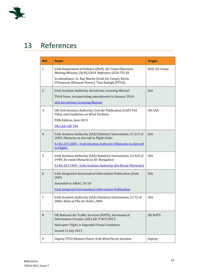
References
70816 002 | Issue 7
55
13 References
Ref Name Origin
1 Irish Department of Defence (DoD), Air Corps Objection: Meeting Minutes, 29/05/2014. Reference LE14-731-01
In attendance: Lt. Ray Martin (Irish Air Corps), Kevin O’Donovan (Element Power), Tina Raleigh (FTCO).
DoD, Air Corps
2 Irish Aviation Authority Aerodrome Licensing Manual
Third Issue, incorporating amendments to January 2014.
IAA Aerodrome Licensing Manual
IAA
3 UK Civil Aviation Authority Civil Air Publication (CAP) 764 Policy and Guidelines on Wind Turbines
Fifth Edition, June 2013
UK CAA CAP 764
UK CAA
4 Irish Aviation Authority (IAA) Statutory Instruments, S.I 215 of 2005; Obstacles to Aircraft in Flight Order
S.I No 215 2005 - Irish Aviation Authority (Obstacles to Aircraft in Flight)
IAA
5 Irish Aviation Authority (IAA) Statutory Instruments, S.I 423 of 1999; En-route Obstacles to Air Navigation
S.I No 423 1999 - Irish Aviation Authority (En-Route Obstacles)
IAA
6 Irish Integrated Aeronautical Information Publication (Irish IAIP)
Amended to AIRAC 14/10
Irish Integrated Aeronautical Information Publication
IAA
7 Irish Aviation Authority (IAA) Statutory Instruments, S.I 72 of 2004; Rules of The Air Order, 2004
IAA
8 UK National Air Traffic Services (NATS), Aeronautical Information Circular (AIC) AIC P 067/2013
Helicopter Flight in Degraded Visual Conditions
Issued 11 July 2013
UK NATS
9 Osprey FTCO Element Power Irish Wind Farms Aviation Osprey
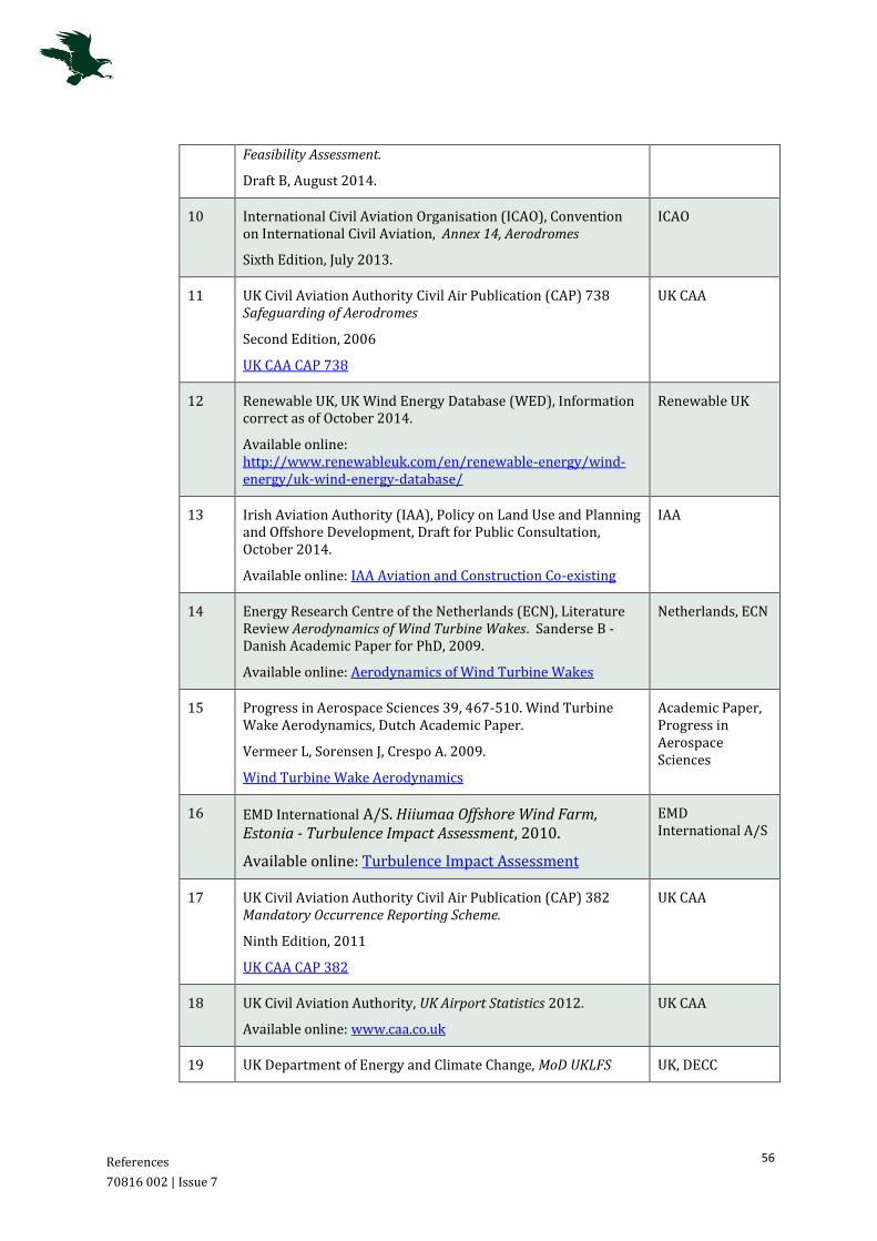
References
70816 002 | Issue 7
56
Feasibility Assessment.
Draft B, August 2014.
10 International Civil Aviation Organisation (ICAO), Convention on International Civil Aviation, Annex 14, Aerodromes
Sixth Edition, July 2013.
ICAO
11 UK Civil Aviation Authority Civil Air Publication (CAP) 738 Safeguarding of Aerodromes
Second Edition, 2006
UK CAA CAP 738
UK CAA
12 Renewable UK, UK Wind Energy Database (WED), Information correct as of October 2014.
Available online: http://www.renewableuk.com/en/renewable-energy/wind-energy/uk-wind-energy-database/
Renewable UK
13 Irish Aviation Authority (IAA), Policy on Land Use and Planning and Offshore Development, Draft for Public Consultation, October 2014.
Available online: IAA Aviation and Construction Co-existing
IAA
14 Energy Research Centre of the Netherlands (ECN), Literature Review Aerodynamics of Wind Turbine Wakes. Sanderse B - Danish Academic Paper for PhD, 2009.
Available online: Aerodynamics of Wind Turbine Wakes
Netherlands, ECN
15 Progress in Aerospace Sciences 39, 467-510. Wind Turbine Wake Aerodynamics, Dutch Academic Paper.
Vermeer L, Sorensen J, Crespo A. 2009.
Wind Turbine Wake Aerodynamics
Academic Paper, Progress in Aerospace Sciences
16 EMD International A/S. Hiiumaa Offshore Wind Farm, Estonia - Turbulence Impact Assessment, 2010.
Available online: Turbulence Impact Assessment
EMD International A/S
17 UK Civil Aviation Authority Civil Air Publication (CAP) 382 Mandatory Occurrence Reporting Scheme.
Ninth Edition, 2011
UK CAA CAP 382
UK CAA
18 UK Civil Aviation Authority, UK Airport Statistics 2012.
Available online: www.caa.co.uk
UK CAA
19 UK Department of Energy and Climate Change, MoD UKLFS UK, DECC

References
70816 002 | Issue 7
57
Safeguarding Map, 23 November 2011
Available online: https://restats.decc.gov.uk/cms/aviation-safeguarding-maps/
Table 5: Table of References

Annex A1
70816 002 | Issue 7
58
A1 Wind Farm Case Study
There are a number of aerodromes in the UK, both licensed and unlicensed, which operate safely in proximity to wind turbine developments. It is considered as beneficial to highlight a number of different developments that have either been built or approved in close proximity to aviation activity. It is important to note that the Maighne Wind Farm sites are certainly not unique and should not be treated as such. This Annex contains several examples, as follows:
A1.1 Civil Operations
East Midlands Airport
East Midlands Airport is the eleventh largest Airport in terms of passenger throughput in the UK and handled 4.3 million passengers in 2013. It was also the second busiest UK airport for freight traffic in 2013 [Reference 18]. The Airport provides regular domestic and international flights and is a significant airport in terms of freight operations.
In 2008, Manchester Airport Group Plc (MAG), owner and operator of East Midlands Airport, announced plans to construct wind turbines at the Airport site. East Midlands Airport currently has two operational 45 m wind turbines on site, and has been nationally acknowledge by several environmental groups for this development. Both wind turbines are located approximately 1 km from the runway mid-point.
Although the operations of East Midlands Airport are considered to be different to those at Casement Aerodrome, this Case Study has been included to demonstrate the acceptability of wind turbines within very close proximity, to a licensed runway operating with a high volume of traffic.
Lydd Airport
Lydd Airport (London Ashford) is a licensed aerodrome which operates an Aerodrome Traffic Zone (ATZ), established out to a maximum radius of 2 NM from the ARP, extending from surface level to 2000 ft. Lydd Airport supports IFR and VFR aircraft operations, with over 17,300 air traffic movements in 2012 [Reference 18].
Aircraft operating into and out of Lydd Airport are required to avoid the Hythe and Lydd Ranges, both of which are active danger areas. At their closest points, the Ranges are located at an approximate distance of 5 NM and 1 NM respectively, from the Airport. There is an additional permanent avoidance area in the vicinity of Dungeness Nuclear Power Station, which extends from surface level up to 2000 ft.
The RWE Innogy Ltd wind farm known as Little Cheyne Court, has been operational since 2009. The development consists of 26 wind turbines of maximum tip height 115 m. The centre-point of Little Cheyne Court wind farm is situated approximately 8.4 km west of the Lydd Airport ARP.
Lydd Airport has continued safe operations in the presence of the wind turbines, and the continued licensing of Lydd Airport demonstrates the fact that the Airport has successfully implemented measures to enable the safe operation of IFR, VFR and training flights in close proximity to two danger areas, a restricted area and the twenty-six turbine wind farm.
Annex A1
70816 002 | Issue 7
59
Fife Airport
Fife Airport is an unlicensed aerodrome, which provides a base for Tayside Aviation Flying School and supports parachuting and sky-diving activities. The Airport operates an ATZ, established out to a maximum radius of 2 NM from the ARP, extending from surface level to 2000 ft. The Airport is located within proximity (approximately 7 km) of Portmoak Airfield, which is operated by the Scottish Gliding Centre. As detailed at Section 4.2, the Scottish Gliding Centre supports intense gliding activity and forms the largest gliding club in Scotland.
In September 2011, members of Fife Council planning committee approved a 5 wind turbine, wind farm on the former Westfield open-cast coal site near Kinglassie, Fife. The Westfield Wind Farm is located on the Airport’s extended runway centreline, with the nearest turbine situated approximately 2.5 km from the runway; pilots approaching the Airport have no choice but to overfly the wind farm.
A1.2 Military Operations
RAF Lossiemouth
RAF Lossiemouth serves to provide a hub for large-scale multinational flying exercises. The Aerodrome is located in close proximity to RAF Kinloss, a Relief Landing Ground (RLG) and emergency diversion option, and Tain Range and the Highlands Restricted Area. The complex airspace environment surrounding RAF Lossiemouth has further been identified as an area utilised for regular military Low Flying activities. The RAF base is one of the largest and busiest in the UK and is the home to Tornado and Typhoon aircraft, together with a flight of Search and Rescue helicopters.
There are a number of operational Wind Farms located within the vicinity of RAF Lossiemouth, of varying wind turbine size and number. The approximate location of these developments in relation to the aerodrome is shown at Figure 13. The boundary line marks a 30 km radius.
It is noted, that following the implementation of suitable mitigation, the wind turbine developments have not posed an unacceptable impact on the military aviation activities conducted at and within the vicinity of RAF Lossiemouth.

Annex A1
70816 002 | Issue 7
60
This map shows estimated location data which may be subject to error and is provided for reference only. This map has been produced by Osprey Consulting Services Ltd using the OS OpenData 1:250000 2009 Scale Raster. Contains Ordnance
Survey Data © Crown Copyright and database right 2013.
Figure 12: Relative Location of Wind Farm developments within 30 km of RAF Lossiemouth
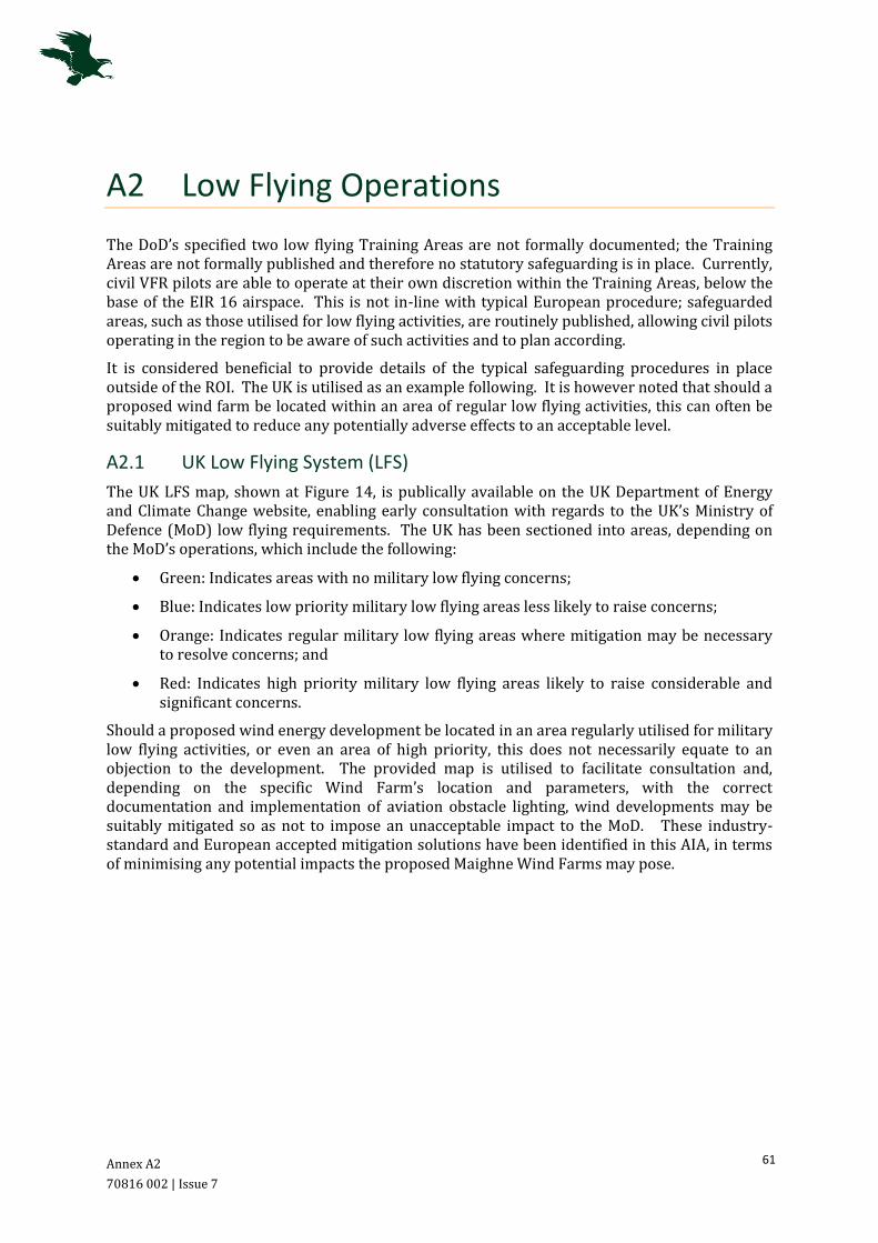
Annex A2
70816 002 | Issue 7
61
A2 Low Flying Operations
The DoD’s specified two low flying Training Areas are not formally documented; the Training Areas are not formally published and therefore no statutory safeguarding is in place. Currently, civil VFR pilots are able to operate at their own discretion within the Training Areas, below the base of the EIR 16 airspace. This is not in-line with typical European procedure; safeguarded areas, such as those utilised for low flying activities, are routinely published, allowing civil pilots operating in the region to be aware of such activities and to plan according.
It is considered beneficial to provide details of the typical safeguarding procedures in place outside of the ROI. The UK is utilised as an example following. It is however noted that should a proposed wind farm be located within an area of regular low flying activities, this can often be suitably mitigated to reduce any potentially adverse effects to an acceptable level.
A2.1 UK Low Flying System (LFS)
The UK LFS map, shown at Figure 14, is publically available on the UK Department of Energy and Climate Change website, enabling early consultation with regards to the UK’s Ministry of Defence (MoD) low flying requirements. The UK has been sectioned into areas, depending on the MoD’s operations, which include the following:
Green: Indicates areas with no military low flying concerns;
Blue: Indicates low priority military low flying areas less likely to raise concerns;
Orange: Indicates regular military low flying areas where mitigation may be necessary to resolve concerns; and
Red: Indicates high priority military low flying areas likely to raise considerable and significant concerns.
Should a proposed wind energy development be located in an area regularly utilised for military low flying activities, or even an area of high priority, this does not necessarily equate to an objection to the development. The provided map is utilised to facilitate consultation and, depending on the specific Wind Farm’s location and parameters, with the correct documentation and implementation of aviation obstacle lighting, wind developments may be suitably mitigated so as not to impose an unacceptable impact to the MoD. These industry-standard and European accepted mitigation solutions have been identified in this AIA, in terms of minimising any potential impacts the proposed Maighne Wind Farms may pose.
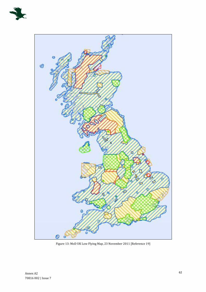
Annex A2
70816 002 | Issue 7
62
Figure 13: MoD UK Low Flying Map, 23 November 2011 [Reference 19]

Annex A3
70816 002 | Issue 7
63
A3 Turbulence Case Studies
It is considered beneficial to highlight a number of disparate developments, which have either been built or approved in close proximity to aviation activity. These Case Studies include wind turbine developments in the vicinity of East Midlands Airport, Truro Airfield, Fife Airport and Caernarfon Airport.
East Midlands Airport
As detailed at Annex A1, in 2008 MAG announced plans to build two wind turbines at East Midlands Airport and following extensive analysis, the turbines were commissioned in May 2011, 13 RDs south of the runway.
In addition to the Airport’s commercial activities (as detailed at Annex A1), the Airport is also home to a number of flying clubs and light aircraft. The positioning of the turbines is such that in southerly wind conditions any wake turbulence could cause catastrophic consequences to light aircraft at the most critical stage of flight. MAG, following 3 years of study, clearly felt there was no issue. There has not been a turbulence related incident at the Airport since the turbines were commissioned.
Truro Airfield, Cornwall
Truro Airfield, a General Aviation Airfield from which microlight aircraft operate, has 15 wind turbines within its circuit pattern, the closest turbine of the Four Burrows Wind Farm being less than 10 RD from the final approach. The owner of Truro Airfield announced during 2013 that he wants to build a 77 m turbine on the Airfield and the plans for the turbine are being considered by Cornwall Council. The owner of Truro airfield has stated that he did not expect operations at the Airfield to be affected by the turbine.
Westfield Wind Farm, Fife
On 20 September 2011, members of Fife Council planning committee approved the 5-turbine, wind farm on the former Westfield open-cast coal site near Kinglassie, Fife. The planning process for this development had been extremely difficult due to its location being directly on the extended runway centreline to Fife Airport; the nearest turbine is 2.5 km from the Airport.
Figure 15 following, illustrates the Wind Farm with 11 RD circles included. It is noted that 16 RD turbine effects would be closer to the Airport. Due to the proximity to Fife Airport, the site was subject to a concerted online campaign from General Aviation pilots and it is understood the Local Planning Authority received 104 letters stating aviation concerns. Fife Airport operators stated that:
‘If the wind turbine went ahead, we would not be able to operate Fife Airport as an airport.’
Between the objectors, the developer and the Local Planning Authority five aviation reports were commissioned to examine the potential aviation effect (including turbulence). It was agreed by the Council that there was no evidence to support the turbulence claim and the Wind Farm was approved. Shortly before the approval, the Airport began parachute jumping operations on the airfield, which would raise serious questions as to the validity of their turbulence concerns. Parachute activities continue at the Airport.

Annex A3
70816 002 | Issue 7
64
‘This map shows estimated location data which may be subject to error and is provided for reference only. This map has been produced by Osprey Consulting Services Ltd using the OS OpenData 1:250000 2009 Scale Raster. Contains Ordnance Survey Data © Crown Copyright and database right 2013.’
Figure 14: Westfield Wind Farm with 11RD illustrated.
Caernarfon Airport, Wales
Two 152 ft amsl wind turbines have been installed on the General Aviation Airfield at Caernarfon. The turbines are located approximately halfway down Runway 02/20 and 30 m from the runway edge. As a result of the turbines being built close to Runway 02/20, the runway is now unlicensed. The Caernarfon Airport website informs that:
‘the runway is still available at the sole discretion of the Airport Manager and pilots must obtain prior permission and briefing by telephone before use of runway 02/20 is permitted’
Runway 07/25 at the Airport is still licensed and available for use; Figure 16 following is a screen shot taken from the Caernarfon Airport Website that illustrates the position of the wind turbines in relation to the runway layout.

Annex A3
70816 002 | Issue 7
65
Figure 15: Location of Wind turbines on Caernarfon Airfield. Figure taken from a screen shot from the Caernarfon Airport website.