Embed Size (px)
Citation preview

Aviation inquiry 10-007:
Boeing 737-800, ZK-PBF and Boeing 737-800, VH-VXU, airspace incident,
near Queenstown Aerodrome, 20 June 2010
The Transport Accident Investigation Commission is an independent Crown entity established to
determine the circumstances and causes of accidents and incidents with a view to avoiding similar
occurrences in the future. Accordingly it is inappropriate that reports should be used to assign fault
or blame or determine liability, since neither the investigation nor the reporting process has been
undertaken for that purpose.
The Commission may make recommendations to improve transport safety. The cost of
implementing any recommendation must always be balanced against its benefits. Such analysis is
a matter for the regulator and the industry.
These reports may be reprinted in whole or in part without charge, providing acknowledgement is
made to the Transport Accident Investigation Commission.
Final Report
10-007
Boeing 737-800, ZK-PBF and
Boeing 737-800,VH-VXU
airspace incident
near Queenstown Aerodrome
20 June 2010
Approved for publication: 13 March 2012
Transport Accident Investigation Commission
About the Transport Accident Investigation Commission
The Transport Accident Investigation Commission (the Commission) is an independent Crown entity
responsible for inquiring into maritime, aviation and rail accidents and incidents for New Zealand, and
co-ordinating and co-operating with other accident investigation organisations overseas. The principal
purpose of its inquiries is to determine the circumstances and causes of occurrences with a view to
avoiding similar occurrences in the future. Its purpose is not to ascribe blame to any person or agency
or to pursue (or to assist an agency to pursue) criminal, civil or regulatory action against a person or
agency. The Commission carries out its purpose by informing members of the transport sector, both
domestically and internationally, of the lessons that can be learnt from transport accidents and
incidents.
Commissioners
Chief Commissioner John Marshall, QC
Deputy Chief Commissioner Helen Cull, QC
Commissioner Captain Bryan Wyness
Assessor Pat Scotter
Key Commission personnel
Chief Executive Lois Hutchinson
Chief Investigator of Accidents Captain Tim Burfoot
Investigator in Charge Peter R Williams
General Counsel Rama Rewi
Email [email protected]
Web www.taic.org.nz
Telephone + 64 4 473 3112 (24 hrs) or 0800 188 926
Fax + 64 4 499 1510
Address Level 16, AXA Centre, 80 The Terrace, PO Box 10 323, Wellington 6143, New Zealand
Important notes
Nature of the final report
This final report has not been prepared for the purpose of supporting any criminal, civil or regulatory
action against any person or agency. The Transport Accident Investigation Commission Act 1990
makes this final report inadmissible as evidence in any proceedings with the exception of a Coroner’s
inquest.
Ownership of report
This report remains the intellectual property of the Transport Accident Investigation Commission.
This report may be reprinted in whole or in part without charge, provided that acknowledgement is
made to the Transport Accident Investigation Commission.
Citations and referencing
Information derived from interviews during the Commission’s inquiry into the occurrence is not cited in
this final report. Documents that would normally be accessible to industry participants only and not
discoverable under the Official Information Act 1980 have been referenced as footnotes only. Other
documents referred to during the Commission’s inquiry that are publicly available are cited.
Photographs, diagrams, pictures
Unless otherwise specified, photographs, diagrams and pictures included in this final report are
provided by, and owned by, the Commission.

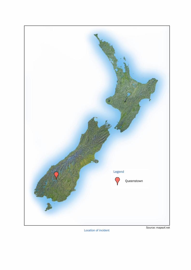
Location of incident
Legend
Queenstown
Source: mapsof.net

Contents
Abbreviations ..................................................................................................................................................... ii
Glossary ............................................................................................................................................................. ii
Data summary .................................................................................................................................................. iv
1. Executive summary ................................................................................................................................... 1
2. Conduct of the inquiry ............................................................................................................................... 3
3. Factual information ................................................................................................................................... 4
3.1. Instrument approach procedures – general description ........................................................... 4
3.2. History of the flights ..................................................................................................................... 6
3.3. Recorded flight data .................................................................................................................. 11
3.4. Personnel information ............................................................................................................... 12
3.5. Aerodrome information ............................................................................................................. 14
3.6. Meteorological information ....................................................................................................... 16
3.7. Aids to navigation ...................................................................................................................... 16
General....................................................................................................................................... 16
Instrument approach procedures ............................................................................................. 17
Missed approach ....................................................................................................................... 18
Visual manoeuvring (circling).................................................................................................... 19
Missed approach commenced from circling............................................................................ 21
Protection of the missed approach .......................................................................................... 21
ATC amendment or termination of missed approach procedure ........................................... 23
ATC separation of arriving aircraft ............................................................................................ 23
3.8. Organisational and management information ........................................................................ 23
3.9. Other occurrences ..................................................................................................................... 24
3.10. Other information ...................................................................................................................... 24
4. Analysis ................................................................................................................................................... 25
The suitability of the meteorological conditions ...................................................................... 25
Awareness of meteorological conditions behind Deer Park Hill ............................................. 26
Whether Queenstown circling approaches comply with PANS-OPS ....................................... 27
Pilot understanding of the design of instrument approach procedures ................................ 28
The separation of arriving IFR aircraft...................................................................................... 29
The validity of the figure-8 circuit and its suitability for jet aircraft ........................................ 30
The protection of the missed approach ................................................................................... 31
The naming of RNAV approaches ............................................................................................. 32
The safety of operations at Queenstown Aerodrome .............................................................. 33
5. Findings .................................................................................................................................................. 36
6. Safety actions ......................................................................................................................................... 38
7. Recommendations ................................................................................................................................. 39
8. Key lessons ............................................................................................................................................. 40
9. Citations .................................................................................................................................................. 41

Report 10-007 | Page i
Figures
Figure 1 Key terms in an instrument approach ....................................................................................... 5
Figure 2 Example of instrument approach in mountainous terrain ....................................................... 5
Figure 3 Approach flown by Pacific Blue .................................................................................................. 7
Figure 4 Queenstown Aerodrome layout .................................................................................................. 8
Figure 5 Approach flown by Qantas .......................................................................................................... 9
Figure 6 Visual circuit for large aircraft .................................................................................................. 10
Figure 7 Flight paths of both aeroplanes ............................................................................................... 12
Figure 8 Circuling area construction, and example ............................................................................... 20
Page ii | Report 10-007
Abbreviations
AIP Aeronautical Information Publication New Zealand
Airways Airways Corporation of New Zealand
ATC air traffic control
CAA Civil Aviation Authority
Commission Transport Accident Investigation Commission
Director Director of Civil Aviation
ft foot/feet
ICAO International Civil Aviation Organization
IFR instrument flight rules, or an aircraft being operated under those rules
Pacific Blue Pacific Blue Airlines
PANS-OPS ICAO Procedures for air navigation services – aircraft operations
Qantas Qantas Airways
RNAV area navigation
RNP required navigation performance
UTC coordinated universal time
VFR visual flight rules, or an aircraft being operated under those rules
VOR/DME very high frequency omni range / distance measuring equipment
Glossary
altitude height above mean sea level expressed in ft
area navigation a navigation method that permits aircraft operation on any desired
flight path within the coverage of ground or space-based navigation
aids, or within the capability of self-contained aids, or a combination of
these
circling an extension of an instrument approach procedure that provides for
visual manoeuvring around an aerodrome to align ane aircraft with the
runway
configuration the position of (typically) the flaps and the landing gear; e.g., whether
they are extended or retracted
elevation the vertical distance of a point or a level, on or fixed to the surface of
the Earth, measured from mean sea level
fix a geographical position

Report 10-007 | Page iii
instrument approach procedure a series of predetermined manoeuvres by reference to flight
instruments with specified protection from obstacles, from the initial
approach fix to a point from where a landing can be completed, and
thereafter, if a landing is not completed, to a position at which holding
or enroute obstacle clearance criteria apply
instrument flight rules prescribed operating procedures for a flight that is piloted solely by
reference to instruments
lateral to the side
minima the minimum meteorological conditions required, usually stated in
terms of the height of the cloud base and the flight visibility
minimum descent altitude a specified altitude in a non-precision approach or circling approach
below which descent may not be made without the required visual
reference
missed approach point that point in an instrument approach procedure at or before which the
prescribed missed approach procedure must be initiated in order to
ensure that the minimum obstacle clearance is not infringed
non-precision approach an instrument approach procedure that uses lateral guidance but not
vertical guidance
orbit fly a circular or race-track pattern at a constant altitude
protected in regard to the missed approach, means ATC has ensured that traffic
separation will continue in the event that the subject aircraft flies the
missed approach. Protection of the missed approach procedure would
remain in place until the aircraft carrying out the approach has landed
required navigation performance a statement of the navigation performance accuracy necessary
for operation within a defined airspace
separation the spacing of aircraft to achieve their safe movement in flight and
while taking off and landing. This is achieved by the controller applying
vertical, horizontal or visual separation. Horizontal separation is
achieved by applying longitudinal, lateral, geographical or radar
separation
threshold the beginning of that portion of the runway useable for landing
visual flight rules prescribed operating procedures for flight in visual meteorological
conditions
visual meteorological conditions weather equal to or better than minima specified in terms of
visibility, distance from cloud, and cloud ceiling
waypoint a specified geographical position used to define an area navigation
route
Page iv | Report 10-007
Data summary
Aircraft particulars
Aircraft registration: ZK-PBF VH-VXU
Type: Boeing 737-800 Boeing 737-800
Operator: Pacific Blue Airlines (Pacific
Blue)
Qantas Airways (Qantas)
Type of flight: scheduled domestic passenger scheduled international
passenger Persons on board: 88 162
Pilot’s total flying experience: 18 790 hours not requested
Date and time
20 June 2010, 13451
Location
vicinity of Queenstown Aerodrome
latitude: 45° 01.3´ south
longitude: 168° 44.3´ east
Injuries
nil
Damage
nil
1 Times in this report are in New Zealand Standard Time (UTC+12 hours) and expressed in the 24-hour mode.

Report 10-007 | Page 1
1. Executive summary
1.1. On 20 June 2010, a Boeing 737-800 aeroplane operated by Pacific Blue was being flown on a
conventional instrument approach to Queenstown Aerodrome. When making an instrument
approach, pilots must see the runway before they may descend below the minimum descent
altitude and they must maintain visual reference with the runway until landing. If visual
reference is lost, they must execute a missed approach procedure.
1.2. Because of the mountainous terrain, the minimum descent altitude for the conventional
instrument approach to Queenstown is about 3500 feet above the aerodrome. The terrain
prevents pilots descending straight ahead from the minimum altitude and landing. Instead,
they must circle while descending until their aircraft is in a position to land.
1.3. When the Pacific Blue aeroplane arrived at the minimum descent altitude, the pilots could see
lower cloud in the Queenstown basin, but the runway was clear. However, because low cloud
patches would have obstructed their manoeuvring to the final approach for runway 23, the
pilots reported to air traffic control (ATC) that they would attempt to land on the reciprocal
runway 05.
1.4. Meanwhile the controller had cleared another Boeing 737-800 aeroplane operated by Qantas
to begin an approach behind Pacific Blue. The Qantas pilots were flying a ‘required navigation
performance’ approach based on global navigation satellite system technology, which allowed
them to descend to a much lower minimum altitude. At the time, Pacific Blue had not applied
to the Civil Aviation Authority (CAA) for authorisation to use that technology. The controller
cleared Qantas for its approach based on an expectation that the Pacific Blue pilots, having
commenced circling, would land or, if unable to land, would remain in the aerodrome visual
circuit.
1.5. Lower cloud was likely to have prevented the Pacific Blue pilots maintaining visual contact
with runway 05, so they discontinued the circling and climbed directly to intercept the
prescribed missed approach track for the instrument procedure they had flown. They had not
planned to enter or remain in the visual circuit as the controller had expected and, because of
their position when they commenced the climb, probably could not have done so because of
their proximity to terrain.
1.6. The controller then instructed Qantas to conduct the missed approach for its procedure and at
the maximum rate of climb, in order to maintain separation from the Pacific Blue aeroplane.
The Queenstown ATC tower has no radar facility, because the surrounding mountains are
incompatible with that.
1.7. The Transport Accident Investigation Commission (Commission) did not investigate further
whether the minimum required 1000 ft vertical separation between the 2 aeroplanes was
breached, because it was clear that the potential for such a breach was high and that alone
was a safety issue that needed addressing.
1.8. The Commission’s key findings addressed the following issues:
the weather conditions were not suitable for Pacific Blue to descend below the minimum
descent altitude
the air traffic controller had not ensured that the required minimum separation would be
maintained between the 2 aeroplanes
the Pacific Blue pilots and the air traffic controller had different understandings of what
would occur in the event Pacific Blue did not land after circling
the various publications used by pilots and controllers that described instrument approach
procedures and circling procedures were not consistent, which was a hazard likely to lead
to misunderstandings between pilots and air traffic controllers
the circling manoeuvring that is required after a non-precision approach at Queenstown is
a demanding procedure that ought to be reviewed for suitability
Page 2 | Report 10-007
a wider review of the Queenstown air traffic management system and operational
procedures would be prudent, given the special features associated with operations at the
aerodrome and the increasing number of commercial jet aeroplane operations.
1.9. The Commission made recommendations to the Director of Civil Aviation (the Director) that he:
ensure that the current development of a strategic plan for air traffic management and the
risk assessment of Queenstown flight operations address the safety issues identified in
this report
eliminate the use of similar titles for different instrument approach procedures to the same
runway
require the procedural and compliance aspects of non-precision approaches at
Queenstown to be re-evaluated
ensure that common operational material published by different organisations be
accurately reproduced from the source documents
require a system to be installed to provide controllers with real-time observations of the
weather conditions behind Deer Park Hill.
1.10. The Commission identified the following key lessons in this inquiry:
a pilot must not descend below the applicable instrument approach minimum descent
altitude unless certain that the conditions are suitable for a landing
pilots must understand the operational assumptions in the design of instrument approach
procedures, and how those assumptions determine the limits of safe manoeuvring
organisations that re-publish mutually important operational information from authoritative
sources must ensure that the information is accurately reproduced so that all users
interpret the information correctly and apply it consistently.

Report 10-007 | Page 3
2. Conduct of the inquiry
2.1. On 21 June 2010, the CAA notified the Commission of this incident. An inquiry was opened
that day.
2.2. The investigator in charge interviewed the Pacific Blue pilots and senior operational managers
of the airline at its Christchurch head office in June 2010, and a further meeting was held with
Pacific Blue management in August 2010.
2.3. The involved ATC staff were interviewed at Queenstown Aerodrome in June 2010. Relevant
ATC data was reviewed at Queenstown and at the Airways Corporation of New Zealand
(Airways) national centre at Christchurch.
2.4. Recorded flight data was obtained from both airlines and analysed with the assistance of the
Australian Transport Safety Bureau. The details of the Qantas pilots were not obtained
because their aeroplane was incidentally involved.
2.5. Three meetings were held with representatives of the CAA and Airways during the inquiry, and
a preliminary draft was reviewed by an independent air traffic safety specialist.
2.6. On 14 December 2011, the Commission approved the circulation of a draft final report to
interested persons for their comment. Submissions were received from the captain and first
officer of the Pacific Blue aeroplane, Pacific Blue Airlines (the name of which was changed to
Virgin Australia Airlines (NZ) Limited in 2011), Airways and the CAA. Their submissions were
considered in preparing the final report.
2.7. The Queenstown Airport Corporation reviewed the draft final report and did not make a
submission.
2.8. On 13 March 2012 the Commission approved the publication of the report.

Page 4 | Report 10-007
3. Factual information
3.1. Instrument approach procedures – general description
3.1.1. An instrument approach is a series of predetermined manoeuvres for the orderly transfer of an
aircraft operating under instrument flight rules (IFR) from the beginning of the initial approach
to landing. The procedure design provides specified clearance from terrain and obstacles.
3.1.2. There are 2 main types of instrument approach procedure – non-precision and precision. A
non-precision approach provides lateral course guidance only and the pilot controls the height
of the aircraft to be at or above certain altitudes at certain points along the course. Non-
precision approaches may involve aircraft having to manoeuvre or circle after reaching the
minimum descent altitude in order to align with the runway. This requires the pilot to have
visual reference with the runway and the surrounding terrain.
3.1.3. A precision approach allows the pilot to fly a more exact approach path, because vertical
guidance is given as well. This brings the aircraft lower and closer to the runway before
reaching the minimum altitude. At the end of a precision approach the aircraft will be aligned
with the runway for a ‘straight-in’ landing.
3.1.4. The instrument approach procedures are depicted on ‘approach charts’ that show the
prescribed altitudes and tracks to be flown, as well as obstacles and some terrain. In
addition, they show the missed approach procedure to be flown if the aircraft does not land.
3.1.5. An aircraft’s vertical position is normally referenced to altitude. The approach minimum
descent altitude is the lowest altitude to which a pilot may descend before acquiring the
required visual reference to make a safe landing. If the required visual reference is not
achieved by the missed approach point, or cannot be maintained after that point, the missed
approach procedure must be flown (see Figure 1).
3.1.6. For a particular type of approach procedure, the minimum descent height above an
aerodrome varies according to the height and proximity of the terrain and obstacles
surrounding the aerodrome. For example, an approach to an aerodrome located on an
extensive Tibetan plateau will have a higher minimum descent altitude, because Tibet is well
above sea level, but could have a much lower minimum descent height than a similar type of
approach to an aerodrome like Queenstown, which is closer to sea level but closely
surrounded by high mountains (see Figure 2).
3.1.7. Circling to land is considered more difficult and is statistically less safe than a straight-in
landing. This is because the aircraft will normally be at a low height above the aerodrome and
must remain within a specified distance from the runway in order to be assured of obstacle
clearance while maintaining the minimum descent altitude. The procedure assumes that the
pilot will maintain visual contact with the runway while circling. If visual contact is lost, the
pilot must immediately carry out the published missed approach procedure, but is assured of
terrain clearance by being within the circling area and above the minimum descent altitude.
Report 10-007 | Page 5
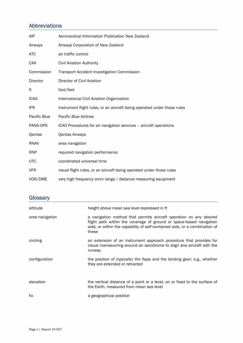
Figure 1
Key terms in an instrument approach
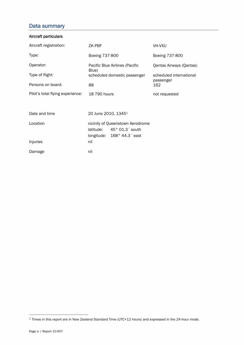
Figure 2
Example of instrument approach in mountainous terrain

Page 6 | Report 10-007
3.2. History of the flights
3.2.1. On 20 June 2010, a Boeing 737-800 aeroplane, registered ZK-PBF and operated by Pacific
Blue, was used on a scheduled service from Auckland to Queenstown. On board were 6 crew
members and 82 passengers. The flight was conducted under IFR and the captain was the
pilot flying, as required by the operator’s procedures for Queenstown flights.
3.2.2. The air traffic controller was under training and being supervised by an instructor. The
controller cleared the flight to conduct the VOR/DME (very-high-frequency omni-
range/distance measuring equipment) ‘ALFA’ instrument approach procedure, circling for
runway 23 (see Figures 3 and 4).2 The reported meteorological conditions at Queenstown
included cloud patches at 1000 ft, the cloud base at 5000 ft and visibility of 40 kilometres,
above the airline’s requirement of 10 kilometres.3 The pilots considered that the conditions
were ‘a bit marginal’ and had discussed the published procedure in case they could not land
and had to carry out a ‘missed approach’. However, the controller had earlier indicated twice
that they would become visual and should be able to land.
3.2.3. The pilots made visual contact with the terrain when about 500 ft above the procedure
minimum descent altitude of 4700 ft, which was approximately 3500 ft above the aerodrome
elevation. The captain said that they saw the hill tops in the Lake Hayes basin, the Frankton
Arm of Lake Wakatipu and the airport, and that there was low cloud close to the threshold
(approach end) of runway 23.
3.2.4. The flight continued to descend to the minimum descent altitude then orbited at that altitude
while the pilots reassessed the extent of the cloud in relation to their approach to runway 23.
3.2.5. At the same time, another Boeing 737-800, registered VH-VXU and operated by Qantas, was
inbound to Queenstown from Sydney with 6 crew members and 156 passengers on board.
This flight was also operating under IFR and its pilots had estimated they would land about 5
minutes after Pacific Blue. Qantas had been cleared previously to descend to 12000 ft on the
‘RNP [required navigation performance] ZULU approach runway 23’, but this was amended to
the ‘RNP ZULU approach runway 05’ (see Figure 5).4 QANTAS estimated that the aeroplane
would be at position ‘Coronet’, a few miles northwest of the VOR/DME station, at 1345.5
3.2.6. At about this time, 2 radio transmissions were made together, one of which might have been
Pacific Blue reporting visual contact. After Pacific Blue had commenced manoeuvring below
the instrument procedure minimum descent altitude, the pilots saw that the low cloud near
the threshold to runway 23 was more extensive than they had previously thought. The
controller could not see the aeroplane, which was overhead at that stage, and asked the pilots
if they were now circling for runway 05, but was told they were still circling for runway 23.
3.2.7. The controller then cleared Qantas for the ‘RNP ZULU approach runway 05’ and to ‘descend in
accordance with the profile’. This meant Qantas was cleared to descend to the minimum
altitude for that approach, which was 2183 ft or lower, depending on the specific capability of
that flight.
3.2.8. Twenty seconds later, Pacific Blue advised it would now track overhead the aerodrome and
‘try’ an approach to runway 05. It did not request a revised clearance to the different runway,
as it should have done, and ATC did not explicitly re-clear it. The pilots then asked ATC about
the cloud to the south and over the Frankton Arm, because they found it difficult to discern the
height of the cloud tops, and were told the cloud was quite thick to the south but the Frankton
Arm looked clear.
2 The runway designation is the magnetic heading in the take-off direction, rounded to the nearest 10 degrees. 3 The cloud base is the height above ground of the lowest layer of cloud covering more than half the sky. By convention,
the units are feet. 4 The correct approach titles and correct radiotelephony references were ‘RNAV [area navigation] approach runway …’
(International Civil Aviation Organization (ICAO) (2006b), Part III, s.5, para. 1.4.2.5). RNP referred to Qantas being
specially approved for approaches with much lower minima than the VOR/DME approach. 5 By convention, the units for flight procedure distances are nautical miles. One nautical mile is approximately 1.85
kilometres.
Report 10-007 | Page 7
Figure 3
Approach flown by Pacific Blue (All approach and aerodrome figures are from Aeronautical Information Publication New Zealand)
3.2.9. ATC was required to separate IFR flights in the Queenstown airspace, but as the Queenstown
facility was not equipped with radar, other vertical and horizontal separation procedures were
applied. The controller expected Pacific Blue to land off the circling approach or, if it did not
land, to join the large aircraft figure-8 visual circuit at 4000 ft (see Figure 6).6 The controller
then instructed Qantas to report passing 6000 ft, which she anticipated would occur when
Qantas was near Coronet. Her plan was that if Pacific Blue had not landed or had joined the
visual circuit when Qantas made the report, she would instruct Qantas to carry out a missed
approach in order to maintain at least 1000 ft vertical separation.
3.2.10. The controller advised Qantas that it might have to conduct a missed approach because
Pacific Blue was unable to land on runway 23 and was now circling for runway 05. The Qantas
pilots advised that in that event they would divert to Christchurch. The controller later
6 Incorrect references to ‘height’ in the reproduced figure were later corrected by the publisher.
Deer Park Hill
aerodrome

Page 8 | Report 10-007
explained that the gap between the estimated times of arrival of the flights had been about 5
minutes, but had reduced because Pacific Blue had orbited and would now have to back-track
on the runway after landing, in order to reach the terminal taxiway. This would have delayed
the Qantas landing.
Figure 4
Queenstown Aerodrome layout
3.2.11. ‘Deer Park Hill’ was a hill immediately south of the aerodrome. After Pacific Blue had flown
overhead the aerodrome and turned to go behind Deer Park Hill, the pilots saw that they
would likely lose visual contact with the runway because of low cloud. At 1345 they advised
ATC that they had commenced a missed approach and were tracking to position AFTON, the
missed approach holding point 15 miles from the VOR/DME.
3.2.12. The controller acknowledged the report and stated, ‘For separation, remain visual if able.’ The
Pacific Blue pilot said ‘We’ll do our best. [We are] intercepting the 212 radial’ (the published
missed approach track). The controller then asked the pilot if he could join the figure-8 circuit,
but he repeated that the flight was intercepting the 212 radial and was clear of terrain. The
controller immediately instructed the Qantas flight to commence a missed approach with the
best rate of climb. The instructor controller then took over from the trainee.
Report 10-007 | Page 9
Figure 5
Approach flown by Qantas
3.2.13. The Pacific Blue pilots told ATC that they ‘could not maintain visual contact in the basin above
about 5000 or 6000 feet’. The captain said later that had ATC instructed them beforehand to
fly the figure-8 circuit, they might have been able to comply, but having commenced the
missed approach it would have been difficult to turn right without getting too close to terrain.
However, they intercepted and flew the missed approach track before they entered cloud.
3.2.14. Pacific Blue was not authorised for the same high-precision approaches as Qantas, so its
pilots did not know all of the positions referred to by ATC and Qantas, and were concerned
initially that Qantas might be on an approach that came over the lake in the opposite direction
to the missed approach track they were flying.7 At one point the Pacific Blue pilots observed a
target on their traffic display, a couple of miles behind and 800 ft or 900 ft above them.8 The
collision avoidance systems fitted to the aeroplanes did not generate any traffic advisories or
warnings.
7 This was the similarly named ‘RNAV runway 05’ approach. 8 The traffic display was part of the Airborne Collision Avoidance System, equipment that was mandatory for aeroplanes
of this size.
aerodrome
Page 10 | Report 10-007
Figure 6
Visual circuit for large aircraft
3.2.15. Airways reported the incident as a possible loss of separation because Pacific Blue ‘did not
follow the published missed approach procedure’ and the controllers were not certain that the
minimum separation of 1000 ft had been maintained. At the time, Airways had a
multilateration surveillance system under trial that showed the positions of the 2 aeroplanes
and their altitudes.9 The data was unverified, but helped the controllers to manage the
situation.
9 A multilateration surveillance system uses multiple remote sensing units to track and display the positions of
transponder-equipped targets. The system can be used in locations usually incompatible with radar, such as
mountainous terrain and built-up ground environments.
aerodrome
Deer Park Hill

Report 10-007 | Page 11
3.2.16. The Pacific Blue captain said later that he believed he had flown the published missed
approach procedure. The first officer agreed, and queried the wisdom of turning back towards
the aerodrome and VOR/DME, which was the start point of the missed approach procedure, if
meteorological conditions were known to be poor.
3.2.17. The Commission obtained copies of the incident reports submitted by the captains to their
respective airlines. The Qantas report noted they were on the ‘RNAV 05’ approach, whereas
the flight was cleared for (and flew) the ‘RNAV runway 05 ZULU’ approach. That error is
discussed later in the context of similar names for different approaches.
3.2.18. The incident occurred in daylight at 1345.
3.3. Recorded flight data
3.3.1. The Commission reviewed recorded flight data from both aeroplanes. 10 Figure 7 shows parts
of the flight paths of both aeroplanes during the incident. The path for Pacific Blue is not
smoothed because the position data obtained was less accurate than that for Qantas. The 2
positions marked (o and o) are for the same time and were used to synchronise the data.
The pressure altitude was the only recorded parameter that was corrected (but not
validated).11
3.3.2. The Pacific Blue pilots initiated the missed approach shortly after the aeroplane had turned
towards the west behind Deer Park Hill, and when it was at an altitude of approximately 3400
ft. The speed did not exceed the procedure maximum of 160 knots until the aeroplane was
established on the published missed approach track.
3.3.3. A comparison of the recorded data from the 2 aeroplanes showed that the minimum
horizontal separation was about 2.7 miles, with an associated vertical separation of more than
3800 ft. This occurred about 30 seconds after Pacific Blue had commenced the missed
approach and when Qantas was descending through 7600 ft immediately east of the
aerodrome.
3.3.4. The Qantas missed approach was commenced just southeast of the aerodrome and at about
the time the flight had previously estimated for position ‘Coronet’, which was nearly 6 miles
north. The aeroplane was then passing approximately 7100 ft, with a speed of 185 knots. A
comparison with the RNAV runway 05 ZULU approach chart suggested that the aeroplane was
above the correct approach profile, but the reason for this was not examined. The vertical
separation between the aeroplanes then was about 2000 ft, but it decreased because of
Pacific Blue’s higher rate of climb at that time.
3.3.5. The vertical separation remained between 1600 ft and 1800 ft until Qantas climbed above
about 8200 ft, and it then decreased to a minimum of about 1000 ft when the aeroplanes
were about 4.2 miles apart, but about to head in opposite directions. Although one Pacific
Blue pilot recalled seeing an indicated altitude difference of about 800 or 900 ft, the
minimum vertical separation was not calculated more exactly because of the recorder time
base and position data approximations.12
10 Recorded data was analysed with the help of the Australian Transport Safety Bureau. 11 Recorded pressure altitudes were corrected by deducting 216 ft to give the altitude indicated to the pilots. 12 The relative height of the other aeroplane was shown on the Airborne Collision Avoidance System display.

Page 12 | Report 10-007
Figure 7
Flight paths of both aeroplanes
(Image courtesy of the Australian Transport Safety Bureau)
3.3.6. Pacific Blue was climbing through about 6300 ft when the aeroplane intercepted the
prescribed missed approach track approximately 7 miles from the VOR/DME, which was the
start point for the missed approach procedure. The procedure design minimum altitude at 7
miles was 5528 ft.13
3.4. Personnel information
3.4.1. The Pacific Blue captain held Australian and New Zealand airline transport pilot licences, with
a Boeing 737-800 rating obtained in 2006. He had been hired by the airline in January 2009
as a direct-entry captain on the Boeing 737-800. His medical certificate, renewed in January
2010, included a restriction that he wear spectacles when flying, which he said he was doing
on the incident flight. As at 20 June 2010 he had accrued 18 790 flying hours, including
2370 hours on the B737-800. His previous line check had been completed in September
2009 and his previous instrument rating check had been completed in December 2009. The
captain commuted from Australia for each roster period, but maintained accommodation in
Auckland, his roster base. The 4 days prior to 20 June had been free of duty, and although he
had returned to Auckland the night before the incident flight, he had considered himself fit for
duty.
3.4.2. The Pacific Blue first officer held a New Zealand commercial pilot licence (aeroplane) issued in
June 2000. He had obtained a B737-800 type rating in September 2008 and had been hired
by the airline in October 2008. His medical certificate, renewed in January 2010, had a
restriction that he wear spectacles when flying, which he said he was doing on the incident
flight. As at 20 June 2010 he had accrued 4500 flying hours, including 1300 hours on the
B737-800. His previous line check had been completed in May 2010 and his previous
instrument rating check had been completed in March 2010. He had had the 45 hours prior
to the 20 June flight off duty, and had considered himself well-rested before the incident flight.
13 The minimum altitude was determined from information given by a procedures design specialist at Airways.
Qantas descent,
then climbing
figure-8 missed
approach
Pacific Blue
missed approach
Deer Park Hill
aerodrome

Report 10-007 | Page 13
3.4.3. About 40 of Pacific Blue’s 150 pilots were qualified to operate into Queenstown. To qualify, a
captain had to complete a computer-based training package and a flight simulator session
and observe, from the flight-deck jump-seat, one or more arrivals into and departures from
Queenstown. Depending on previous experience, the candidate then had to operate a number
of training flights into and out of Queenstown before a check flight. First officers, at the time,
had to complete the computer-based training package only. Both of the incident pilots met
the company’s currency requirement for operating the flight.
3.4.4. The simulator training was intended to place ‘emphasis on the IFR arrival and departure
procedures’ and ‘to provide familiarisation with the transition to [visual meteorological
conditions] flight and manoeuvring considerations from the minima to touchdown.’14 The
captain said his training had covered the International Civil Aviation Organization (ICAO)
Procedures for air navigation services –aircraft operations (PANS-OPS) procedure for loss of
visual reference below the minimum descent altitude, and the figure-8 circuit procedure.15
The simulated cloud bases were at or above the minimum descent altitude, with no low cloud
to obscure ground features.
3.4.5. The Pacific Blue captain had completed the ground training in November 2009 and the route
training requirements in February 2010. He had flown into the aerodrome more than 15
times since and had completed a Queenstown line check and simulator revision in July 2010.
3.4.6. The first officer on the incident flight had not ‘crewed up’ for any simulator training set at
Queenstown. He had met the company’s Queenstown qualification in September 2009 and
had operated into Queenstown 4 times since.
3.4.7. The other jet operators into Queenstown required first officers to complete a simulator training
package before being cleared to operate as crew into the aerodrome.
3.4.8. Although its previous training programme had been approved by the CAA, following this
incident Pacific Blue amended the aerodrome qualification requirement to include simulator
training for first officers, and recurrent simulator training for both ranks. The CAA later made
simulator training a mandatory part of the aerodrome qualification for pilots of large aircraft
performing air transport operations into Queenstown.
3.4.9. All air traffic controllers in New Zealand are trained and employed by Airways. The ATC
instructor had been issued with a New Zealand air traffic controller licence on 2 February
2009 and held aerodrome and approach controller ratings, and an air traffic service instructor
rating issued in April 2010. All of his ATC experience had been gained at Queenstown
Aerodrome. His previous annual proficiency assessment had been completed on 15 July
2009, and he completed the next assessment on 12 July 2010. He held a current medical
certificate with a requirement to wear spectacles, which he said he was doing at the time of
the incident. While instructing, an instructor was fully responsible for the position being
trained.
3.4.10. The ATC trainee had had no aviation experience prior to commencing training in 2009. She
had been issued with an air traffic trainee licence on 9 September 2009 and had been at the
Queenstown Aerodrome since January 2010 for on-the-job training as a tower and approach
controller. The instructor considered she had completed approximately 60-70% of the
required objectives and experience by 20 June 2010 and was progressing well. The trainee
held a current medical certificate with no restrictions.
3.4.11. In addition to the trainee controller and the instructor, another controller was in the tower
acting as the Co-ordinator. The Co-ordinator had been issued with a New Zealand air traffic
controller licence on 22 September 2009 and held the appropriate aerodrome and approach
controller ratings. All of his controlling experience had been at Queenstown Aerodrome. His
previous annual proficiency assessment had been completed on 19 March 2010. He held a
current medical certificate with no restrictions.
14 Pacific Blue Operations Manual Suite Volume C1, Flight Crew Route Guide, p.3A-1, 5 Sep 2009. 15 ICAO Procedures for air navigation services – aircraft operations, Doc 8168.
Page 14 | Report 10-007
3.4.12. The instructor and trainee had started their duty at 1000 that day and returned from a break
approximately 25 minutes before the incident. The coordinator had started duty at 1145. The
instructor said the traffic was light and he did not know of any issues affecting the controllers’
fitness for duty.
3.4.13. As the Qantas flight was incidentally involved, the flight crew details were not requested.
3.5. Aerodrome information
3.5.1. Queenstown Aerodrome is located between the Frankton Arm of Lake Wakatipu and the
Arrowtown Basin, at an elevation of 1171 ft, and surrounded by mountainous terrain rising to
more than 7600 ft in the Remarkables Range, less than 8 kilometres from the aerodrome.
There are 2 runways, but only the sealed runway 05/23 is suitable for large aeroplanes.
Runway lighting was not installed at the time of this incident, but was installed in 2011.
3.5.2. Between 2000 and 2010 the number of international aircraft movements at Queenstown
increased by 524%, bringing a 666% increase in passengers. Domestic aircraft movements
increased by 17% and domestic passengers by 77%.16 International passenger growth
increased by 50% in the year to June 2011.17 The great majority of movements were by
scheduled airlines, but corporate and charter aircraft averaged one movement a day.
3.5.3. The Aeronautical Information Publication New Zealand (AIP) stated (AIP, p.NZQN AD 2-13),
‘Flight procedures for Queenstown are detailed on the … Arrival/Departure chart’, but in fact
none is given on that chart (AIP, p.NZQN AD 2-31.1).18 The AIP Aerodrome pages stated the
circuit directions, which included a right-hand circuit for runway 23, but also included a
different circuit procedure for aircraft with mass greater than 5700 kilograms (see Figure 6).
3.5.4. The different circuit for larger aircraft arose from airline concerns that a jet aeroplane going
around from its final approach to the main runway 05/23 could conflict with an aircraft on the
downwind leg of the circuit for the crossing grass runway. The internal ‘Request for Change’
submitted by the aerodrome chief controller noted there was a right-hand circuit for runway 23
promulgated under Civil Aviation Rules19, but added ‘terrain prohibits large aircraft carrying
out [the published] circuits, so the airlines have adopted a figure-8 type circuit pattern.’
3.5.5. The proposal was supported by an aerodrome users’ group meeting at which 3 major airlines
were represented, and the request was approved by the Airways’ Air Traffic Services Policy and
Standards Group in 2004.20
3.5.6. The AIP chart depicted the figure-8 circuit in relation to prominent terrain features and stated
the altitude to be flown. There was no speed or other requirement specified, so the ceiling
and visibility minima for visual flight rules (VFR) in the vicinity of an aerodrome in a control
zone were assumed to apply.21 The circuit, although described on the chart current then as
left-hand, resulted in right-hand base turns to runway 05 and runway 23, and an initial left
turn off runway 23. These turns were contrary to the directions published for light aircraft.
Notwithstanding the likely presence of ATC during large aircraft operations at Queenstown, the
Commission has previously commented on the safety issue of opposed circuits.22
3.5.7. The CAA was not identified as an interested party when the procedure was proposed, even
though the connection with Civil Aviation Rules Part 93 was noted by Airways in the original
request for change. Part 93 required the Director’s approval for the establishment or
withdrawal of a right-hand circuit, and the procedure required both types of change. Airways
and CAA staff commented during this investigation that the figure-8 circuit was seen as a
16 Traffic statistics provided by Queenstown Airport Corporation Limited, 22 August 2011. 17 Annual Review 2011 of Auckland International Airport Limited, part-owner of Queenstown Aerodrome. 18 The AIP is a CAA document, published on its behalf by Airways. 19 Civil Aviation Rules Part 93 – Special aerodrome traffic rules and noise abatement procedures, sub-part H, Right-hand
aerodrome traffic circuits. 20 The 3 airlines were Air New Zealand, Qantas and Mount Cook Airline. Pacific Blue did not commence domestic
operations until 2007. 21 These are to remain 2 kilometres horizontally and 500 ft vertically clear of cloud, with a minimum flight visibility of 5
kilometres (although, for the operators concerned, the minimum visibility was 10 kilometres). 22 See, for example, Commission reports 08-001 and 10-005.

Report 10-007 | Page 15
tactical intervention available to controllers at any time and therefore its use did not require
the specific approval of the Director.
3.5.8. At the time of the incident, the AIP chart showing the figure-8 circuit had a sub-heading
‘Procedure if aircraft is maintaining visual reference and unable to land (go-around)’. Most
pilots consider a ‘go around’ to be a discontinued landing attempt from the final approach,
and distinguish that from a ‘missed approach’ which can be started from any point in an
instrument approach or circling approach. The chart was placed in the visual approach
procedures of the AIP, and was not referred to in the instrument approach procedures. This
meant that a pilot of an IFR flight would not necessarily know that ATC expected the figure-8
circuit to be followed in the event of a missed approach while circling. The Jeppesen flight
procedures guide, used by Pacific Blue and Qantas and likely used by the majority of operators
of itinerant jet aeroplane flights into Queenstown, placed the figure-8 procedure with VFR
arrival procedures in its chart binder.23 A pilot conducting a crew briefing prior to an
instrument approach would not normally review the VFR procedures for that aerodrome.
3.5.9. In response to observations made during this investigation, the chief controller initiated an AIP
change to correct the description of the figure-8 circuit and clarify its purpose. On 10 February
2011, the chart sub-title was amended to read, ‘Procedure if aircraft is maintaining visual
reference or circling from an instrument approach and unable to land.’ The supporting
documentation for the change request noted that, if the change were not implemented, there
was ‘a high risk of misinterpretation by pilots unfamiliar with the procedure’. The request also
stated that ‘no one has been asked to consult on this [change]’, and the potential for the
procedure to be misinterpreted had not been identified earlier due to the procedure’s ‘very
rare use.’
3.5.10. The ATC instructor said that all operators had, at one time or another, flown the figure-8
pattern. A CAA publication intended mainly for VFR pilots noted, ‘Airline traffic may fly a non-
standard circuit. They normally make a large figure-eight approach.’ (CAA, 2008, p.20).
3.5.11. Pacific Blue had categorised Queenstown Aerodrome as a category ‘X’ aerodrome, the only
such aerodrome in its route network at that time. Before flying into a category X aerodrome, a
captain had to have completed the approved airport training programme discussed above.
Other airlines operating into Queenstown had a similar categorisation and required special
training for their pilots.
3.5.12. The Pacific Blue operations manual stated ‘Pacific Blue aircraft may circle visually in the event
of a missed approach/go-around within the [Queenstown] aerodrome traffic circuit, by day
only.’24 However, that manual elsewhere described the Queenstown visual circuit as ‘a visual
go-around procedure [applied] to provide separation from light aircraft circuit traffic.’25 The
incident pilots knew of the procedure and the captain had flown it in a flight simulator, but
they understood it to be a VFR procedure. They said they had briefed to fly the published
missed approach procedure for the VOR/DME approach if they did not land after circling and
did not know that ATC expected them to remain in the visual circuit in that event.
3.5.13. The Pacific Blue operations manual contained a further reference to the figure-8 circuit:26
In the event of an engine failure after take-off, manoeuvre via the figure eight
special procedure circuit.’
3.5.14. On 2 July 2010 Pacific Blue issued a Flight Crew Operational Notice that clarified the present
ATC use of the figure-8 circuit for protecting the missed approach.27
3.5.15. Fleet management representatives of most of the other Part 121 operators using Queenstown
Aerodrome at the time of the incident advised informally that they considered the figure-8
circuit as a go-around procedure once in the circuit, although one operator referred to an
unspecified ‘non-standard procedure for missed approaches into the circuit’ as an arrival
23 Jeppesen is a leading publisher of international flight procedures guides that are based on the national AIP. 24 Pacific Blue, Operations Manual Suite, Volume C1, Flight Crew Route Guide, p.2-48, effective 25 Feb 2010. 25 Pacific Blue Operations Manual Suite Volume C1, Flight Crew Route Guide, p.3-ZQN-10, 5 Sep 2009. 26 Pacific Blue Operations Manual Suite Volume C1, Flight Crew Route Guide, p.3-ZQN-11, 5 Sep 2009. 27 Pacific Blue FCON item 060/10 –effective 02 Jul 10.

Page 16 | Report 10-007
‘threat’ to be briefed by its pilots prior to approach. Qantas and Jetstar did not permit their
aeroplanes to fly the figure-8 pattern at any time. The majority were uncomfortable with
manoeuvring at relatively low level in mountainous terrain, especially as a missed approach
was most likely to arise because meteorological conditions were unsuitable for a landing.
3.6. Meteorological information
3.6.1. MetService advised that on 20 June 2010 a low pressure system was moving east over the
South Island with an associated front moving south.28 The automatic weather station at
Queenstown Aerodrome reported light rain and drizzle in the 2 hours preceding the incident,
with cloud detected between 4000 and 5000 ft above the aerodrome. At and after 1400,
lower patches of cloud and a rapidly lowering cloud base were detected.
3.6.2. On those days that it operated services to Queenstown, Pacific Blue flight operations
management received 3 updates of forecast and actual (current) weather, with attached
screen-shots (when conditions permitted) from a webcam that showed Deer Park Hill.
3.6.3. At 1315, while under the control of a different ATC position, one of the Pacific Blue pilots had
called Queenstown Tower to check the weather conditions before commencing the approach.
They informed Queenstown ATC that they had received the earlier broadcast weather
information ‘Foxtrot’. The controller said, ‘conditions are pretty much as mentioned in Foxtrot’
and ‘there is low cloud about 1000 feet right throughout the basin and to the south of Deer
Park.’29
3.6.4. A few minutes later the broadcast information was changed to ‘Golf’, one change being
increased cloud at 1000 ft above ground. Having been told by ATC that conditions were still
like those broadcast in information ‘Foxtrot’, the Pacific Blue pilots did not listen for ‘Golf’ prior
to the control of their flight being transferred to Queenstown Tower. The information was as
follows:
Information Golf at time 1318: expect a VOR/DME approach A, runway 23,
runway wet, surface wind 210 degrees magnetic at 3 kt, visibility 40 kilometres
in drizzle, cloud: few at 200 ft, scattered at 1000 ft, broken at 5000 ft, overcast
7000 ft, temperature 7oC, dew-point 6oC, [altimeter setting] 1005 hectoPascal,
forecast 2000 ft wind 190 degrees at 10 kt. ATC training in progress.
3.6.5. At 1347, shortly after the incident, the broadcast information was amended again, to report
generally lower cloud layers and to add a reference to cloud in the final approach area for
runway 23. The controller said later that the cloud patches had been fluctuating.
3.6.6. The Pacific Blue captain provided a sketch of the cloud conditions he had seen in the
Queenstown basin. Although the lower slopes of the major ranges were visible, low cloud
obscured much of the eastern half of the basin, and to the south of the aerodrome only
Frankton Arm and the summit of Deer Park Hill were visible. The captain later estimated that
the top of the low cloud had been 1500 ft above ground.
3.6.7. The visibility from the control tower at Queenstown is restricted through an arc of
approximately 35 degrees to the south, because the summit of Deer Park Hill is only 2
kilometres away and more than 1500 ft above the aerodrome. The operator of Queenstown
Aerodrome and Airways advised that previous attempts to find a viable method for remotely
observing conditions behind Deer Park Hill had not been successful.
3.7. Aids to navigation
General
3.7.1. The VOR/DME approach at Queenstown is a non-precision approach that was inaugurated in
1994 and is available for general use by suitably rated pilots and equipped aircraft. The high
terrain and mountain weather dictate unusually high approach minima. Similarly high cloud
28 MetService is a company certificated by the CAA to provide aviation meteorological products such as forecasts. 29 The ATC comment was taken from information obtained by Pacific Blue and not disputed by Airways, but made outside
the time period of ATC information requested by the Commission.

Report 10-007 | Page 17
base and visibility requirements exist for IFR departure procedures, with pilots required to fly a
visual segment until reaching the minimum altitude to ensure terrain clearance.
3.7.2. The high minimum descent height and location of the VOR/DME do not permit a straight-in
landing off the approach. Therefore, an unusual amount of visual manoeuvring (circling) is
required before landing. A number of pilots who had flown the procedure in the first few years
after its approval suggested that circling in earlier models of the Boeing 737 and in other
types was managed so that the runway was always kept in sight, particularly when circling
south of Deer Park Hill for runway 05.30 The Commission asked the CAA if there were any
conditions or assumptions associated with the initial approval of the approach, and which
might have addressed circling requirements, but no relevant documentation was found.
3.7.3. The continued refinement of aircraft navigation systems led ICAO to develop the concept of
performance-based navigation, which uses aircraft equipment and airspace characteristics to
define the required navigation performance for enroute and terminal procedures. RNAV
approach procedures with much lower Required Navigation Performance minima have been
progressively introduced at Queenstown Aerodrome since 2005. An operator provides special
training to its pilots and requires a CAA authorisation before it can conduct Required
Navigation Performance approaches, but the procedures provide the following benefits:
greater ATC and aircraft operational efficiency
much lower minimum approach heights
fewer missed approaches
departures under meteorological conditions similar to the approach minima
greater accuracy of procedure tracking.
3.7.4. The Commission obtained copies of the incident reports submitted by the captains to their
respective airlines. The Qantas captain had written that they were on the ‘RNAV 05’ approach,
whereas the flight was cleared (and flew) the ‘RNAV ZULU approach runway 05’. The similar-
sounding approaches have completely different tracks, but their titles meet the ICAO charting
procedures (ICAO, 2006b, Part 1, s.4, para 9.5.3).
Instrument approach procedures
3.7.5. The operating rules for, and design of, instrument approach procedures are found in the 2
volumes of ICAO PANS-OPS. These approach procedures assured terrain and obstacle
clearance only if the aircraft were flown in accordance with the relevant design and operating
assumptions. The only subjects in the CAA syllabus of ground training for a pilot licence
instrument rating that were directly relevant to understanding these assumptions were the
following (CAA, 2010, p.21):
[Pilots must be able to] state when descent below decision altitude or
minimum descent altitude may be made on an instrument approach.
[Pilots must be able to] describe the missed approach procedures and
limitations.
3.7.6. The source of information for both topics was given as the AIP, which repeated the
requirements of Civil Aviation Rule 91.413(c) for descent below the minimum descent
altitude. The Rule stated, in part:
91.413 Take-off and landing under IFR
(c) Operation below … minimum descent altitude. Where a … minimum descent
altitude is applicable, a pilot-in-command must not operate an aircraft at any
aerodrome below the minimum descent altitude … unless—
(1) the aircraft is continuously in a position from which a descent to a landing on
the intended runway can be made at a normal rate of descent using normal
manoeuvres that allows touchdown to occur within the touchdown zone of the
runway of intended landing; and
30 The pilots referred to were not, and had not been, employees of Pacific Blue.
Page 18 | Report 10-007
(2) the flight visibility is not less than the visibility published in the applicable AIP
for the instrument approach procedure being used; and
(3) … at least one of the following visual references for the intended runway is
distinctly visible and identifiable to the pilot—
(i) the approach lighting system; or
(ii) the threshold markings; or
(iii) the threshold lights; or
(iv) the runway-end identification lights; or
(v) the visual approach slope indicator; or
(vi) the touchdown zone or touchdown zone markings; or
(vii) the touchdown zone lights; or
(viii) the runway or runway markings; or
(ix) the runway lights.
(d) Landing. A pilot-in-command must not land an aircraft when the flight
visibility is less than the visibility published in the applicable AIP for the
instrument approach procedure used.
3.7.7. The Pacific Blue standard operating procedures included a restatement of rule 91.413(c). As
Queenstown Aerodrome at the time of the incident was not equipped with any lighting apart
from the precision approach path indicator (a form of visual approach slope indicator), the
runway or threshold itself had to be distinctly visible and identifiable while operating below the
minimum descent altitude.
Missed approach
3.7.8. A specific missed approach procedure is designed for, and is a part of, each instrument
approach procedure. The missed approach is flown when the approach is discontinued and
provides a track and climb profile that ensures obstacle clearance until the aircraft reaches a
safe altitude.
3.7.9. Obstacle clearance is ensured throughout the procedure, as long as the design assumptions
are met. One of those assumptions is that the missed approach will be initiated at, or before,
the missed approach point, (e.g. the VOR/DME), and at an altitude not lower than the
minimum descent altitude. Turns and/or speed limitations may also be prescribed. PANS-
OPS stated, ‘It is expected that the pilot will fly the missed approach procedure as published’
(ICAO, 2006a, 6.1.4).
3.7.10. Civil Aviation Rule 91.413(e) addressed missed approach procedures and conditions, stating:
91.413 Take-off and landing under IFR
(e) Missed approach procedures. A pilot-in-command must immediately execute the
missed approach procedure published in the applicable AIP if—
(1) the requirements of paragraph (c) [given in paragraph 3.7.6 above] are not
met at either of the following times:
(i) when the aircraft is being operated below minimum descent altitude;
or
(ii) upon arrival at the missed approach point … and any time after that
until touchdown; or
(2) an identifiable part of the aerodrome is not distinctly visible to the pilot during
a circling manoeuvre at or above minimum descent altitude, unless the inability
to see an identifiable part of the aerodrome results only from normal
manoeuvring of the aircraft during approach.
3.7.11. The AIP reference to missed approach procedures stated (AIP, p.ENR 1.5-30):
The published missed approach procedure must be executed [emphasis in AIP]:
(a) if, at the missed approach point … the pilot has not established visual reference
with any portion of the runway or visual landing aids …: or

Report 10-007 | Page 19
(b) an identifiable part of the aerodrome is not distinctly visible to the pilot during a
circling manoeuvre at or above minimum descent altitude; or
(c) at any time during the final approach when directed by ATC.
3.7.12. The AIP reference differs from Rule 91.413 by omitting Rule condition (e)(1)(i) and most of
condition (e)(1)(ii), which relate to a loss of visual reference when operating below the
minimum descent altitude, and also omits the exception in (e)(2) for loss of visual reference
caused solely by normal manoeuvring (e.g. banking a high-wing aeroplane) when at or above
the minimum descent altitude.
3.7.13. The Pacific Blue operations manual added a further option, stating, ‘The published missed
approach procedure [for the approach being flown] or, if applicable, a visual missed approach
must be initiated under the following circumstances …’ 31 [emphasis added], but elsewhere
the manual noted that at Queenstown ‘all missed approach procedures track over [the
VOR/DME]’.32
Visual manoeuvring (circling)
3.7.14. Circling describes the phase of flight after an instrument approach has been completed,
during which the aircraft is manoeuvred to align with the landing runway. Circling is a visual
flight manoeuvre, but an aircraft operating under IFR remains an IFR flight while circling. Each
circling situation is different because of the many variables, such as runway layout, terrain and
weather conditions. However, circling typically entails manoeuvring the aircraft from the
missed approach point to a point in the normal aerodrome circuit pattern that intercepts a
visual descent profile to the landing runway, at which point the aircraft can be descended from
the minimum descent altitude.
3.7.15. The circling area is defined by connecting tangents to arcs centred on the runway ends at the
aerodrome (see Figure 8). The radius of the arcs is related to the aircraft category and speed,
wind speed and a nominal 20 degrees bank angle for the turn. In the case of a Boeing 737-
800, the radius is 4.2 miles. Circling may be prohibited in a sector if terrain dictates, as the
Remarkables Range does at Queenstown. The highest terrain or obstacle within the circling
area is used to determine the minimum height for circling, which must be maintained until the
aircraft intercepts the visual descent profile.
3.7.16. PANS-OPS stated, ‘After initial visual contact, the basic assumption is that the runway
environment should be kept in sight while at minimum descent altitude/height (minimum
descent altitude/H) for circling. The runway environment includes features such as the
runway threshold or approach lighting aids or other markings identifiable with the runway’
(ICAO, 2006a, 7.2.2).
3.7.17. The circling approach at Queenstown was not typical, because the minimum descent height,
being 3500 ft above the aerodrome, and the close terrain required ‘extensive manoeuvring’.33
This meant that a pilot had to descend from the minimum descent altitude well before joining
a normal aerodrome circuit pattern (or abnormal circuit, in the case of runway 05) to avoid an
excessive rate of descent before intercepting a visual descent profile. The typical flight paths,
descending in an orbit or passing behind Deer Park Hill, usually involved a turn away from the
runway and the pilot losing sight of the runway.
3.7.18. The instructor controller said that after a pilot had reported ‘visual’ on the VOR/DME approach
at Queenstown, the controller would issue circuit joining instructions, such as ‘join right base
runway 23’. He said it was assumed that a pilot who reported ‘visual’ could manoeuvre
visually and would land. The report of ‘visual’, meaning a pilot could see the ground, was not
a request for a visual approach, for which a specific request was required.
31 Pacific Blue Operations Manual Suite Volume A1, Flight Crew Operating Manual, p.7-31, 20 May 2010. 32 Pacific Blue Operations Manual Suite Volume C1, Flight Crew Route Guide, p.3-ZQN-6, 25 Feb 2010. 33 Pacific Blue Operations Manual Suite Volume C1, Flight Crew Route Guide, p.3-ZQN-9, 5 Sep 2009.
Page 20 | Report 10-007
Figure 8
Circuling area construction, and example
(Figure taken from PANS-OPS (ICAO, 2006a, p.I-4-7-6))
3.7.19. The circling minimum descent altitude ensured obstacle clearance only when operating within
the circling area from which the minimum descent altitude was determined. When operating
below the minimum descent altitude, the circling area was irrelevant, because obstacle
clearance then depended on the pilot having visual reference. Therefore, PANS-OPS and the
national rules stated, in part (ICAO, 2006a, 7.3.3):
Descent below minimum descent altitude/H should not be made until:
visual reference has been established and can be maintained;
the pilot has the landing threshold in sight; and
the required obstacle clearance can be maintained and the aircraft is in
a position to carry out a landing.
3.7.20. The Pacific Blue operations manual listed the weather requirements for circling at
Queenstown, but not the preferred thrust/speed or configuration when manoeuvring visually
in the basin.
3.7.21. The Manual of Air Traffic Services (Airways, p.RAC 3-46, 8 April 2010), and similar AIP text,
stated:
A pilot on a circling approach may be instructed to join the aerodrome circuit when:
MET conditions are equal to or better than circling minima; and
[emphasis in original]
Report 10-007 | Page 21
The pilot has reported visual or is seen by the aerodrome controller to
have established visual reference.
Missed approach commenced from circling
3.7.22. The Pacific Blue standard operating procedures repeated the PANS-OPS mandatory
requirement to execute a missed approach if visual reference with the intended landing
runway were lost while operating below the minimum descent altitude or beyond the missed
approach point.34 The typical circling tracks at Queenstown Aerodrome did not allow pilots to
keep the runway in sight at all times.
3.7.23. In the event of a missed approach commenced when the aircraft was below the minimum
descent altitude, the pilot would have to maintain visual contact with terrain until able to join
the published missed approach track and meet the altitude criteria. If that could not be done,
the pilot would have to attempt to stay within the circling area while climbing back to the
minimum descent altitude.
3.7.24. The PANS-OPS procedure for a missed approach commenced from circling stated, in part
(ICAO, 2006a, 7.4.1):
If visual reference is lost while circling to land from an instrument approach, the
missed approach specified for that particular approach shall be followed. The
transition from the visual (circling) manoeuvre to the missed approach should be
initiated by a climbing turn, within the circling area, towards the landing runway, to
return to the circling altitude [minimum descent altitude] or higher, immediately
followed by interception and execution of the missed approach procedure.
3.7.25. Pacific Blue’s pilot training manual35 and the Jeppesen guide repeated the PANS-OPS
procedure, as did the Manual of Air Traffic Services, adding (Airways, p.RAC 3-48, 8 April
2010):
No other missed approach procedure other than that applicable to instrument
training aircraft is permitted.
3.7.26. However, the Manual of Air Traffic Services also included the following note (Airways, p.RAC 3-
48, 18 November 2010):
Unless instructions are issued to the contrary, an aircraft on an instrument approach
and instructed to ‘GO AROUND’ should carry out the published missed approach
procedure, whilst an aircraft operating VFR or an IFR aircraft on a visual approach
should continue in the circuit. The latter should be confirmed by a positive circuit
clearance/instruction.
3.7.27. The AIP repeated the Manual of Air Traffic Services’ statement that a pilot who initiated a go-
around while making a visual approach had to remain in the circuit (AIP, p.AD 1.5).
3.7.28. PANS-OPS noted that the actual manoeuvre required to establish on the missed approach
course would depend on where the aircraft was when visual reference was lost. The instructor
controller said he expected that a pilot carrying out a missed approach would remain in visual
conditions in the figure-8 visual circuit until ATC could issue other instructions.
3.7.29. The Pacific Blue captain said later that he had been trained to stay within the circling area
when commencing a missed approach from below the minimum descent altitude. Therefore
he stayed within 4 miles of the runway end and climbed quickly to intercept the missed
approach track, all the time maintaining visual contact with the terrain.
Protection of the missed approach
3.7.30. The AIP stated that ‘ATC will at all times protect the missed approach’, adding (AIP, p.ENR 1.5-
33, section 4.20, 12 Feb 09):
Where actual meteorological conditions are at or above the published circling minima
for the aircraft category and type of approach ATC may protect the missed approach by
34 Pacific Blue Operations Manual Suite, Volume A1, page 7-31, paragraph 7.9.5.2, effective 20 May 2010. 35 Boeing B737NG Flight Crew Training Manual, page 5-69, effective 30 June 2010.
Page 22 | Report 10-007
requiring an arriving aircraft to circle visually within the aerodrome traffic circuit …
provided circling is permitted for the aircraft category and type of approach, with the
following exceptions: ...
(b) for Category C aircraft the MET conditions must be equal to or better than a
ceiling of 2000 ft and visibility of 8 [kilometres] or the circling minima for the aircraft
approach category and type of approach, whichever is the higher …
This procedure will not be used by ATC when:
[meteorological] conditions (e.g. turbulence, crosswind) are such
that there is doubt an aircraft may be able to circle visually; or
the pilot may be unfamiliar with the aerodrome; or
when a pilot advises both Approach Control and Tower, each on
first contact, that they do not wish to carry out such a procedure.
Aircraft unable or no longer able to carry out this procedure must advise Approach Control
or Tower immediately.
3.7.31. The Manual of Air Traffic Services expressed the provision and its conditions differently
(Airways, p.RAC 5-42, 10 April 2008):
When conditions are at or above the published circling minima for an arriving
aircraft’s approach category and type of approach, the missed approach may be
protected by instructing the pilot to circle visually within the aerodrome traffic circuit
… … [emphasis added].
and noted:
The pilot may decline circling at any stage during the approach if it is considered unsafe. In this
circumstance, separation must be established by the quickest means practicable and essential traffic
information given if applicable. Confirmation of ability to circle should be established earlier rather
than later.
A controller shall not use this procedure when:
[meteorological] conditions such as fluctuating cloud base, severe
turbulence or strong cross winds are reported to an aircraft or broadcast
… ; or
It is known or suspected that the pilot is unfamiliar with the aerodrome;
or
The pilot advises approach or aerodrome control at any time that they
are unable to carry out this procedure.
3.7.32. The conditions on 20 June 2010 were better than the published circling minima for Pacific
Blue and none of the exceptions to ATC use of this procedure applied. However, the Pacific
Blue pilots did not advise ATC that they would not use this procedure, and the controller did
not instruct them to use it. As a consequence of this investigation, Airways revised the Manual
of Air Traffic Services and AIP to clarify the weather criteria and other restrictions applicable to
the use of the procedure. A new restriction was that an aircraft shall not be instructed to enter
the aerodrome traffic circuit when ‘there is any cloud in the circuit area that could cause the
pilot to lose sight of an identifiable part of the aerodrome.’
3.7.33. The instructor confirmed that, to protect the missed approach, controllers at Queenstown had
relied on a pilot who reported ‘visual’ being able to enter or remain in the figure-8 circuit.
However, usually no specific instruction was given to pilots to do so, and none was given in
this case.
3.7.34. There was a clear belief among Part 121 operators that ATC at all times protected the
published missed approach for the instrument approach procedure of all flights, irrespective
of other ATC action to separate traffic. They understood that the correct action when going
around from a circling manoeuvre was to stay within the circling area while climbing to the
minimum descent altitude and to then establish on the published missed approach track.
Report 10-007 | Page 23
ATC amendment or termination of missed approach procedure
3.7.35. ATC could issue alternative missed approach instructions to pilots of aircraft involved in
instrument training only, and in sufficient time for the pilot(s) to brief the revised procedure
(AIP, p.ENR 1.5-32).
3.7.36. The Manual of Air Traffic Services stated (Airways, p.RAC 3-48, 8 April 2010):
The missed approach is a critical stage of flight and pilots should be given time to
establish on the missed approach procedure, as published, before any instructions
are issued by ATC.
3.7.37. After a missed approach had been initiated, ATC was not permitted to instruct the pilot to fly a
procedure other than that published unless the aircraft was under radar control or had
reached the minimum missed approach holding altitude (Airways, p.RAC 3-49, 18 November
2010). There was no ATC radar facility at Queenstown, and the minimum missed approach
holding altitude for the VOR/DME procedure flown by Pacific Blue was 8500 ft.
ATC separation of arriving aircraft
3.7.38. The Queenstown control area and control zone were classified category D airspace in which
ATC had to apply separation between IFR flights. As there was no radar capability in the
vicinity of Queenstown, vertical separation of 1000 ft or horizontal separation criteria were
applied. Visual separation standards, including composite visual-geographical separation,
were not practical for jet aircraft in the Queenstown basin. Composite visual separation
requires the controller to have an aircraft continuously in sight, so if the sun, weather or
terrain might interfere with the controller’s ability to sight the aircraft concerned, composite
visual separation is not to be used (Airways, p.RAC 5-5, 25 November 2004).
3.7.39. The Manual of Air Traffic Services rules for providing separation between arriving aircraft
included the following (Airways, p.RAC 5-40, 4 June 2009):
A second aircraft shall not be cleared for an instrument approach until the preceding
aircraft:
Is in communication with and sighted by the aerodrome controller and reasonable
assurance exists that a normal landing can be accomplished, provided the vertical spacing
between aircraft shall never be less than the applicable vertical separation minima until
visual separation can be applied; or
Is on a visual approach and reasonable assurance exists that a normal landing can be
accomplished, provided the vertical spacing between the aircraft shall never be less than
the applicable vertical separation minima … until visual separation can be applied; or …
If on completion of an instrument approach the first aircraft is required to execute a visual
circling manoeuvre to the runway-in-use, care must be taken to ensure that there is no
likelihood of confliction by a following aircraft on instrument approach. [emphasis in
original].
3.7.40. The instructor said later that a following aircraft would not be cleared for its approach until the
preceding aircraft was manoeuvring visually.
3.8. Organisational and management information
3.8.1. Pacific Blue is a New Zealand-registered airline based at Christchurch, and a partner of Virgin
Australia. The airline commenced operations in 2004 between New Zealand and Australia
and some Pacific island destinations. Domestic services between New Zealand main centres
started in 2007, with Queenstown services added from September 2009.
3.8.2. Pacific Blue holds an air operator certificate issued by the CAA and its aeroplanes are on the
New Zealand aircraft register. The Chief Executive, Manager Aircraft Operations and many of
the senior operational managers and pilots are former employees of New Zealand airlines and
have personal experience of Queenstown operations.

Page 24 | Report 10-007
3.8.3. The airline’s risk register referred to the complexity of operations at Queenstown and made
numerous references to the need to stabilise its pilot experience levels in order to mitigate
some of the related hazards, such as collision with terrain, weather assessment and flights in
adverse weather. A frequently identified ‘treatment’ for those risks was the introduction of
Required Navigation Performance procedures, which the airline had hoped to achieve by
winter 2011.
3.9. Other occurrences
3.9.1. Two other occurrences illustrated the difficulty in assessing weather conditions behind Deer
Park Hill. On 22 June 2010, a Pacific Blue Boeing 737 was reported to have flown at low level
soon after taking off from Queenstown Aerodrome runway 23 and while following the Bowen 3
departure procedure.36 Information received at the time suggested the flight encountered low
cloud shortly after take-off, but then the aeroplane climbed rapidly from a position behind
Deer Park.37
3.9.2. On 13 July 2011, a Pacific Blue flight departing Queenstown Aerodrome on the Bowen 3
procedure encountered rapidly reducing flight visibility soon after take-off. The pilots decided
that the safest course of action was to continue the climb following the procedure.38
3.10. Other information
3.10.1. During this inquiry, the Commission heard that the CAA had a number of its departments
conducting risk assessments relevant to Queenstown operations, and that Airways was in the
process of completing a Queenstown Tower Five Year Strategic Plan 2011-2016. The CAA
advised that its risk assessments, which had different completion dates, included, but were
not limited to, the following areas:
the safety investigation of recent occurrences (including the subject of this inquiry)
the installation of runway lighting and a likely proposal for night operations
a safety review of conventional flight operations (e.g., VOR/DME approaches)
a review of the minima for Required Navigation Performance operations.
3.10.2. Airways provided a copy of its report on their 5-year strategic plan, which stated the aim was to
‘identify the procedures, processes, technology and resources required for Airways to safely
manage the projected growth of Queenstown Aerodrome between 2011 and 2016’.39 The
report covered, among many topics, the rapid growth in jet traffic; the proposed and
anticipated infrastructure changes by the airport operator; and the inadequacy of the current
route structure, equipment and staff to handle that growth.
36 The Bowen departure procedure included a requirement for the pilot to maintain visual contact with terrain while
climbing behind Deer Park Hill until the aircraft had reached a prescribed minimum altitude. 37 CAA occurrence number 10/2508. 38 CAA occurrence number 11/3132. 39 Airways, Queenstown Tower Five Year Strategic Plan 2011-2016, 3 August 2011.

Report 10-007 | Page 25
4. Analysis
4.1. The mountainous terrain and weather associated with Queenstown Aerodrome make aircraft
operations there challenging and potentially more hazardous than at most other airports in
New Zealand. The establishment of the VOR/DME and related instrument approaches in
1994 improved access, although the high approach minima meant that jet aeroplanes were
not guaranteed to complete every approach.
4.2. Recent advances in RNAV systems mean that true ‘all weather’ operations are now available
for flights approved to use that technology. Those airlines using approved RNAV procedures
are tending not to revert to conventional approaches if the required navigation performance is
not available, but even though the majority of scheduled services will soon be authorised for
RNAV approaches, non-precision approaches will continue to be used for some time.
4.3. The Commission did not investigate further whether the minimum required 1000 ft vertical
separation between the 2 aeroplanes had been breached, because it was clear that the
potential for such a breach was high and that alone was a safety issue that needed
addressing.
4.4. In addition, a mismatch between the understanding of pilots and ATC in regard to their
respective operational practices was identified. The investigation also identified some safety
issues that had been suspected or recognised by the industry prior to this incident, but not
adequately defined or resolved.
4.5. The key feature of this incident was that the pilots of the Pacific Blue aeroplane had a
different understanding from the controller of what they would do in the event of commencing
a missed approach from a circling manoeuvre. The different understanding resulted from a
mismatch between the various documented procedures available to pilots and controllers.
The incident also identified other safety issues that are discussed in the following order:
the suitability of the meteorological conditions for the Pacific Blue flight
the awareness of meteorological conditions behind Deer Park Hill
whether Queenstown circling approaches comply with PANS-OPS
pilot understanding of the design of instrument approach procedures
the separation of arriving IFR aircraft
the validity of the figure-8 circuit and its suitability for jet aircraft
the protection of the missed approach
the naming of RNAV approaches
the safety of operations at Queenstown Aerodrome.
The suitability of the meteorological conditions
4.6. The cloud base and visibility reported in the automated aerodrome information ‘Foxtrot’ and
‘Golf’ were better than the approach minima of 4700 ft and 10 kilometres for Pacific Blue’s
Boeing 737 aeroplanes. Therefore the pilots were justified in commencing the VOR/DME
approach. The pilots had not listened to ‘Golf’, but the controller had twice indicated that they
should be able to land and had also said that conditions might be better south of Deer Park
Hill. It was not until they had entered an orbit at the minimum descent altitude, having been
cleared for a circling approach, that they saw that the actual conditions were worse than they
had expected.
4.7. Because of the unusually high minimum descent altitude and the need to circle in
mountainous terrain and possibly demanding weather, a pilot’s decision to descend for a
landing can be more difficult to make at Queenstown than at other aerodromes. Looking
down from 3500 ft above the aerodrome, the Pacific Blue pilots had a clear view of the cloud
around the aerodrome and behind Deer Park Hill, but had difficulty determining the height of
the cloud tops there. However, what they saw, together with the earlier advice from ATC that
Page 26 | Report 10-007
there was cloud at 1000 ft above the ground throughout the basin, should have led them to
conclude that conditions were marginal for a landing. The pilots were better placed than the
controller to assess the conditions, because the controller could not see behind Deer Park Hill;
yet a short time later, while circling for runway 05, they asked the controller about the cloud to
the south and in the Frankton Arm. This late request and their earlier comment about ‘trying’
for runway 05 suggested that the pilots had not assessed correctly the conditions while
overhead, but that after descending below the approach minimum descent altitude of 4700 ft,
they did recognise that the conditions were marginal. The inquiry found that the requirements
to be met for descent below an approach minimum descent altitude were not understood
correctly by all operators and pilots.
4.8. When lower cloud ahead of the aeroplane made it unlikely that they would be able to maintain
visual reference with the runway, the Pacific Blue pilots, as required by Civil Aviation Rule
91.413(e), executed a missed approach.
4.9. Published instrument approach minima are stated in terms of cloud base and flight visibility
only, and do not consider lesser amounts of cloud below the minimum descent altitude. A
pilot conducting an instrument approach must decide whether conditions are suitable for a
landing, in accordance with company procedures. At aerodromes where a circling approach
can be flown at the minimum descent altitude, lower cloud patches might not bother a pilot
who joins the circuit pattern and can remain at the minimum descent altitude until
intercepting the visual descent profile to the runway. Should visual reference with the runway
or terrain be lost, the aircraft is already safe at the minimum descent altitude and the pilot
needs only to climb to join and fly the published missed approach.
4.10. In contrast, the unusually high minimum descent height at Queenstown means a pilot must
start losing some of that height as soon as the decision is made to land, in order to intercept
an acceptable final approach path to the runway. The mountainous terrain dictates a circling
flight path that, for the most part, bears no resemblance to a normal aerodrome circuit
pattern, but that does align with part of the figure-8 visual circuit. While the aeroplane is
below the minimum descent altitude, lower cloud can restrict visual reference and the safety
of the manoeuvre. If visual reference with the runway or ground is lost, a missed approach is
required and that will be started from below the minimum descent altitude. At aerodromes
like Queenstown where terrain is such a dominant factor, airline operational procedures
should give guidance on the acceptability of cloud below the minimum descent altitude. The
Pacific Blue operations manuals did not address this issue.
Finding:
The reported meteorological conditions were acceptable for the Pacific Blue flight to
commence the instrument approach, but, because of low cloud behind Deer Park Hill,
were not suitable for the flight to have descended below the instrument approach
minimum altitude.
Awareness of meteorological conditions behind Deer Park Hill
4.11. The visual circling manoeuvre to runway 05 and the visual segments of instrument departure
procedures from runway 23 are almost wholly to the south of Deer Park Hill, out of sight of
controllers in the aerodrome tower. When weather conditions are fluctuating or marginal,
controllers rely on pilot reports of cloud behind Deer Park Hill. The problem is that under such
conditions, fewer VFR flights operate, which reduces the frequency of such reports.
4.12. The inability of Queenstown ATC and flight crews preparing to depart the aerodrome to
observe directly the meteorological conditions behind Deer Park Hill deprives them of
essential information. This can be critical for IFR departures, as they include visual segments
during which pilots are required to maintain visual contact with terrain until reaching the start
of the relevant instrument segments. For arrivals and departures, if unsuitable conditions are
unexpectedly encountered behind Deer Park Hill, the imperative of terrain clearance might
require a pilot to deviate from the published procedure, contrary to the controller’s
expectation.
Report 10-007 | Page 27
4.13. The conditions behind Deer Park Hill are largely irrelevant to operators who are authorised to
conduct Required Navigation Performance approaches, as they can remain in instrument
meteorological conditions as late as alignment with the runway. Although the majority of
scheduled jet aeroplane services are soon likely to be approved for Required Navigation
Performance procedures, the continued use of non-precision approaches and departures that
incorporate visual segments suggests that the lack of a reliable system for remotely observing
conditions behind Deer Park Hill, for example, a camera system, is a safety issue. A
recommendation was made to the Director that he require Airways and the operator of
Queenstown Aerodrome to address that safety issue.
Finding:
The inability of air traffic controllers and pilots of aircraft taking off to observe the
meteorological conditions behind Deer Park Hill, an area in which pilots must be able to
maintain visual contact with terrain, is a safety issue that needs to be resolved.
Whether Queenstown circling approaches comply with PANS-OPS
4.14. The PANS-OPS circling procedure assumes that an aircraft will transition from the instrument
approach to join the aerodrome circuit pattern, remaining at or above the minimum descent
altitude and that its pilot will keep the runway environment in sight. The minimum descent
altitude must be maintained until the aircraft is in a position to descend to the runway at a
normal rate of descent and using normal manoeuvres.
4.15. Once a pilot descends below the minimum descent altitude, Rule 91.413(c) must be complied
with at all times. This requires identifiable features of the runway to be kept in sight and the
aeroplane to be continuously in a position from which only a normal rate of descent using
normal manoeuvres is required until landing. This is not a requirement that only need to be
satisfied at the point when the decision is made to descend below the minimum descent
altitude.
4.16. Most of the manoeuvring after making a non-precision approach to Queenstown Aerodrome is
conducted below the minimum descent altitude because of the unusual amount of height to
be lost before the aircraft is in a position for a steady descent to align with the runway. The
extensive circling is not a normal manoeuvre as envisaged by PANS-OPS, and it can involve
orbits, aerodrome flyovers and positioning behind terrain, during which the runway or
threshold cannot be kept in sight continuously. Therefore, particularly for pilots of jet
aeroplanes, compliance with the PANS-OPS and Civil Aviation Rule 91.413(c) requirements
throughout the circling manoeuvre is not always possible.
4.17. The practical considerations when descending from a high minimum descent height in difficult
terrain are acknowledged, but the accepted practice at Queenstown conflicts with the Rules
because under normal circumstances an identifiable feature of the runway cannot be kept in
sight continuously while operating below the minimum descent altitude. The differences
between procedure and practice beg the question as to whether a transition from a non-
precision approach to a landing at Queenstown Aerodrome is a true ‘circling’ approach.
4.18. The question applies to all aircraft, but the implication for jet aeroplanes is of more concern
because they operate at higher speeds and are less manoeuvrable than smaller aircraft.
Whether the initial approval of the VOR/DME approach had some associated assumptions or
conditions, as some experienced jet pilots believed, could not be determined, because the
records of the project that established the approach could not be found in CAA archives.
4.19. The difficulty in ensuring literal compliance with some of these PANS-OPS procedures at
Queenstown was acknowledged by some senior staff of the CAA, Airways and airlines. Tacit
acceptance of non-compliant procedures creates an unsafe precedent and can lead to false or
inconsistent assumptions being made by participants about the correct procedure. It would
be better to acknowledge any special requirements for aircraft operating into Queenstown and
to design the procedures accordingly. Therefore, the Commission is recommending that the
Director require non-precision approaches at Queenstown to be re-evaluated to determine
Page 28 | Report 10-007
whether any rule exemptions or procedural requirements are necessary to enable safe circling
manoeuvres.
Finding:
Pilots, particularly those of jet aeroplanes, making non-precision approaches to
Queenstown Aerodrome cannot fully meet the PANS-OPS requirements for such
approaches because the runway cannot be kept in sight at all times when circling below
the minimum descent altitude.
Pilot understanding of the design of instrument approach procedures
4.20. The incident suggested that the Pacific Blue pilots might have misunderstood some aspects of
the design of instrument approach procedures e.g. that there is no assured obstacle
clearance when operating below the minimum descent altitude, even though the aircraft might
remain within the horizontal limits of the circling area; and that obstacle clearance on the
missed approach is predicated on the procedure being initiated from not below the minimum
descent altitude and no later than the missed approach point (in this case the VOR/DME.
However, it was likely that the procedures were not as well understood by pilots generally as
they should have been.
4.21. The captain said he believed he took the safest course available to him at the time and place
that he abandoned the landing. The action was effectively an ‘escape’ manoeuvre, which was
achieved safely only because the pilots were able to keep the terrain in sight until they
intercepted the missed approach track, and the aeroplane had ample climb performance. If
the aeroplane had entered cloud, even while following the PANS-OPS procedure of turning
towards the aerodrome and the VOR/DME while climbing to the minimum descent altitude,
the manoeuvre would have been hazardous. The captain said that making a right turn to join
the visual circuit would have been difficult, and Deer Park Hill would also have been an
intervening obstacle. The pilots commented that they had kept within the circling radius of the
runway end while climbing directly to intercept the missed approach track, but the circling
area offered no assurance of terrain clearance while operating below the minimum descent
altitude.
4.22. The aeroplane was passing 6300 ft and about 7 miles from the missed approach point (the
VOR/DME) when it joined the prescribed missed approach track. The design minimum
altitude at 7 miles was 5528 ft; therefore by then the aeroplane was above the missed
approach profile.
4.23. Circling approaches into Queenstown Aerodrome appear to deviate routinely from the Civil
Aviation Rule 91.413(e) requirements for a mandatory missed approach. One example is
losing sight of the runway when operating below the minimum descent altitude, which
inevitably happens when flying a descending orbit to position for either runway, and which can
also occur when over-flying the aerodrome or passing behind Deer Park Hill for runway 05.
Although the Rule allows a pilot to lose sight of an identifiable part of the aerodrome owing to
normal manoeuvring of the aircraft e.g. when banked into a turn, that exception applies only
when the aircraft is at or above the minimum descent altitude.
4.24. The non-compliance had probably become routine because of the impracticality of achieving a
landing at Queenstown if one were to observe the Rule strictly, and because the AIP
restatement of the Rule was incomplete and inaccurate, in that it omitted the requirement to
carry out a missed approach if the pilot lost sight of the runway while operating below the
minimum descent altitude. Although the Rule had precedence, it was likely that pilots,
generally, were more familiar with the text of the AIP.
Report 10-007 | Page 29
Findings:
The Pacific Blue pilots were forced to fly an escape manoeuvre, but maintained visual
contact with terrain until they intercepted the prescribed missed approach track at a point
where they were above the procedure minimum height.
The incomplete and inaccurate AIP reference to Civil Aviation Rule 91.413(e) was likely a
factor in the routine non-compliance with the Rule by pilots making non-precision
approaches to Queenstown Aerodrome.
The separation of arriving IFR aircraft
4.25. The estimated arrival times for the 2 aeroplanes were originally about 10 minutes apart, but
the gap had reduced to 5 minutes by the time Pacific Blue was cleared for its instrument
approach. The gap was reduced further by Qantas changing to the RNAV 05 ZULU approach,
which reduced the distance to touchdown, and then again by Pacific Blue orbiting before
circling for runway 05.
4.26. The approach sequence for arriving flights is essentially in order of their estimated arrival
times, although a controller has some scope to vary the sequence for overall efficiency.
Without radar, ATC relies on pilots’ position reports. As Qantas was not using the VOR/DME
approach aid, the controller had to convert mentally its RNAV position reports and estimates
into a range and bearing from the VOR/DME in order to relate the Qantas flight progress to
that of Pacific Blue.
4.27. The controller cleared Qantas for the RNAV runway 05 ZULU approach after seeing Pacific
Blue above the aerodrome and after its pilots had confirmed they were circling for runway 23.
About 2 minutes after Pacific Blue had advised it was circling for runway 05, the controller
added a check against a loss of separation by instructing Qantas to report passing 6000 ft.
This instruction was based on the controllers’ expectation, which they assumed the Pacific
Blue pilots shared, that Pacific Blue would remain in the visual circuit at 4000 ft if it did not
land.
4.28. Controllers, generally, expected that a flight would land if its pilot had requested to circle,
which was a reasonable expectation given their collective experience. The Queenstown
controllers certainly did not expect a circling IFR aircraft to follow the published missed
approach procedure if it did not land.
4.29. The belated 6000 ft reporting requirement did not remove the risk of a loss of separation in
the unlikely event of a subsequent communications failure between ATC and Qantas. Qantas
was cleared for the approach ‘in accordance with the profile’ and therefore, without further
communication, could have descended through the visual circuit altitude to the much lower
decision altitude for its approach. If Pacific Blue had been in the figure-8 circuit, the Qantas
flight would have been joining an almost identical track. Composite visual separation could
not have been applied by the controller under such circumstances, because it was unlikely
that the Pacific Blue aeroplane could have been kept in sight continuously.
4.30. Had Pacific Blue joined the visual circuit, the controller expected to preserve vertical
separation by instructing Qantas to fly its missed approach, but if there had been a
communications problem and Qantas had continued its approach, the controller would not
have been able to revert to visual separation of the aeroplanes. The local terrain did not offer
an alternative area for Pacific Blue to hold where the controller could keep it in sight. A loss of
separation would have occurred.
4.31. Therefore, the approach clearance issued to Qantas did not meet the Manual of Air Traffic
Services’ requirements for the separation of IFR arrivals.
4.32. The Pacific Blue pilots had not planned to join the figure-8 circuit if they did not land. If,
instead of flying the direct escape manoeuvre, they had turned back towards the aerodrome
while climbing to the missed approach altitude of 8500 ft, a more hazardous loss of
Page 30 | Report 10-007
separation might have ensued, because Qantas had already been cleared to descend through
the same area.
4.33. The earlier arrival of Qantas in the vicinity of the aerodrome greatly reduced the ‘cushion’ that
the controller had anticipated between the 2 flights, and contributed to the separation
reducing when Pacific Blue discontinued its circling descent for the runway. However,
because the Qantas aeroplane was high on its approach profile, the separation did not
become critically close.
4.34. The concurrent approaches by aircraft using different approach aids and operating under
distinctly different criteria placed a high mental workload on the controllers, particularly as
there was training in progress and the weather was marginal. The incident suggested that the
procedures used and tools available to the controllers did not give them certainty that the
aircraft would be separated at all times until the first aeroplane landed.
4.35. The Pacific Blue pilots executed a rapid climb and followed what they believed was essentially
the procedure they had discussed before they commenced the instrument approach. The
captain had no choice but to climb, because the manoeuvre was initiated at a point that, in
this case, he determined did not allow him to turn back towards the aerodrome. Their
aeroplane quickly exceeded the 4000 ft limit of the visual circuit that the controller had
assumed they would follow. However, at no prior time had ATC requested or instructed Pacific
Blue to enter or remain in the visual circuit in the event of not landing.
Findings:
The procedure for circling below the minimum descent altitude after an instrument
approach to Queenstown Aerodrome needs to be clarified to ensure pilots and
controllers are in no doubt as to their respective actions to achieve separation from
other traffic.
The minimum required separation between the 2 IFR aeroplanes was not assured
because the approach clearance issued to Qantas did not allow for a potential
communications failure and it was based on the controllers’ shared assumption that
Pacific Blue would, without further instruction, remain in the visual circuit in the event of
not landing.
Had the Pacific Blue pilots turned back towards the aerodrome while climbing to the
missed approach altitude of 8500 ft, which was possible under PANS-OPS, a more
hazardous scenario might have ensued, because Qantas had already been cleared to
descend through the same area.
The validity of the figure-8 circuit and its suitability for jet aircraft
4.36. The figure-8 circuit was introduced to avoid a recognised potential conflict between light
aircraft in the aerodrome circuit, particularly the circuit for the crossing runway, and a large
(jet) aircraft going around instead of landing on the main runway. However, as IFR aircraft are
necessarily operating in visual conditions when circling after an instrument approach, and the
Manual of Air Traffic Services and the AIP said a circling IFR aircraft should enter the
aerodrome circuit in the event of a go-around, the procedure came to be Airways’ default
means for protecting the missed approach.
4.37. The intended use of the figure-8 circuit by large aircraft was apparently not clearly explained to
airlines, whose policies and practices, together with pilot perceptions, showed that the circuit
was seen as a VFR procedure. That view was supported by the procedure chart being placed
in the AIP and in the Jeppesen binder well removed from the instrument approach procedures.
There was no reference on any chart that the pilot of a large aircraft should, without prior
instruction from ATC (which the Manual of Air Traffic Services required), enter or remain in the
figure-8 pattern in the event of a missed approach commenced while circling.
4.38. The figure-8 procedure introduced circuit directions for large aircraft that were different from
those already published (for light aircraft). Airways and the CAA had the view that the figure-8
circuit was an allowable ATC tactical intervention and therefore not subject to Civil Aviation

Report 10-007 | Page 31
Rule Part 93, but the text of the procedure as published in the AIP, and Airways’ expectation of
using it to protect a missed approach, showed that it was intended to be a permanent
procedure. Therefore, the original proposal in 2004 to introduce right-hand circuits should
have been submitted to the CAA for the Director’s approval.
4.39. The large-aircraft circuit procedure assumed that, in the event of a go-around, a pilot could
descend to 2200 ft initially before climbing to 4000 ft. However, low cloud could be the
reason for a go-around when manoeuvring after an instrument approach and also prevent
compliance with this procedure. Such weather conditions would not necessarily prevent VFR
operations in the control zone.
4.40. The chief controller described the figure-8 circuit as very rarely used, which suggests that IFR
pilots routinely make good decisions about the suitability of conditions for a circling approach
and landing. However, as it is a necessary contingency procedure, Airways should ensure that
the procedure is properly approved, described and clearly communicated to potential users.
Findings:
Airways had not clearly explained to operators that it expected large aircraft that did not
land at Queenstown after circling to enter the visual aerodrome circuit.
The visual circuit procedure put in place by Airways for large aircraft at Queenstown
should have had the approval of the Director because it was intended as a permanent
change that introduced or varied right-hand circuits.
The protection of the missed approach
4.41. There was a clear mismatch between what the Pacific Blue pilots expected to do and what the
controllers expected them to do in the event that Pacific Blue discontinued the circling. The
pilots understood that when they had been cleared for an instrument approach ATC protected
the associated published missed approach. That understanding was supported by the
statements in the PANS-OPS, the Manual of Air Traffic Services and the AIP that in the event of
a missed approach a pilot should fly the published missed approach procedure. However,
whether that rule always applied when circling below the minimum descent altitude was
unclear.
4.42. The means available to ATC to protect the missed approach can be affected by the instrument
procedure minimum descent height. For a low minimum height and a typical circling
procedure flown at the minimum descent altitude, the meteorological conditions might not
permit ATC to instruct the first aircraft to remain in the visual circuit if it did not land.
Therefore, ATC must continue to protect the published missed approach procedure of the
circling aircraft, in effect, until it lands.
4.43. Where there is a very high minimum descent height, as at Queenstown, a pilot’s decision to
descend for circling must be supported by meteorological conditions that are also suitable for
the visual circuit. That would allow ATC to protect the missed approaches of both aircraft by
instructing the first aircraft to enter the aerodrome visual circuit, or by having an unambiguous
published procedure that it will do so. The figure-8 circuit procedure published at the time of
this incident did not make that clear, but it was later amended (see paragraph 6.2).
4.44. The need to avoid the difficult ATC situation that could result should the first aircraft then
make an emergency climb e.g. if its pilot lost visual contact with terrain, underscored the
importance of the first pilot correctly appraising the conditions before descending below the
minimum altitude.
4.45. ATC always protected the missed approach of the following aircraft, but if the first aircraft had
reported that it was continuing visually, and conditions allowed, its missed approach might be
protected by requiring it to enter the aerodrome visual circuit. The Manual of Air Traffic
Services differed from the AIP in describing the means of implementing that procedure. The
ATC manual required a controller to ‘instruct’ the pilot to enter the circuit and, although noting
Page 32 | Report 10-007
that an IFR aircraft on a visual approach ‘should continue in the circuit’, the manual added
that this ‘should be confirmed by a positive circuit clearance/instruction’.
4.46. The Pacific Blue captain doubted that he could have turned right into the figure-8 circuit from
the point he commenced a missed approach, had ATC given him earlier notice to do so, which
indicated that the aeroplane was not on an appropriate ground track for runway 05. That was
likely due to cloud obscuring the landmarks he normally used to position for that runway.
4.47. In spite of the guidance in the Manual of Air Traffic Services, Airways’ controllers had taken the
AIP interpretation as their default position when weather conditions permitted. The provision
works at most New Zealand aerodromes, including other international airports, but at
Queenstown the terrain and the nature of the figure-8 circuit demand a more cautious use of
this procedure. In any event, to ensure separation, controllers should take positive action
rather than rely on what they have incorrectly assumed will be the default response by pilots.
4.48. From their first contact with the Pacific Blue flight, the controller described low cloud in the
Queenstown basin and around the aerodrome. The low cloud ought to have alerted the
controllers and the pilots that conditions were probably unsuitable for a jet aeroplane to
remain in the visual circuit. For that reason, the controllers could have protected the missed
approach for Pacific Blue by another means, such as waiting until Pacific Blue had landed
before clearing Qantas for its approach.
4.49. During the incident, the altitude separation at first reduced because Pacific Blue was climbing
rapidly while Qantas was still descending. Once Qantas began its missed approach at
maximum climb rate, the altitude difference steadied at about 2000 ft before it slowly
reduced to a minimum of about 1000 ft.
4.50. Airways later amended the AIP to clarify the general requirement for an aircraft on a missed
approach to enter the aerodrome visual circuit. It also noted that an operator could inform
Airways if its aircraft would not carry out that procedure generally, or specifically at
Queenstown Aerodrome, rather than have individual pilots make that decision on the day.
Findings:
Had the controllers realised that the low cloud around the aerodrome made the visual
circuit unsuitable for a jet aeroplane, they could have protected the missed approach
for Pacific Blue by a more positive means, such as not clearing Qantas for its approach
until Pacific Blue had landed.
The controllers and the pilots of the Pacific Blue aeroplane did not share the same
understanding of how the published missed approach would be protected while Pacific
Blue was circling. The different texts in the AIP and the Manual of Air Traffic Services at
that time contributed to that misunderstanding.
The naming of RNAV approaches
4.51. The introduction of RNAV approaches at Queenstown has created an information gap for
operators unfamiliar with them. These approaches are complex, and the complexity extends
to the naming of the waypoints that define the procedure tracks. The names are not
necessarily related to familiar geographical or radio-navigation aids used for conventional
approaches, or to the visual reporting points used by pilots when passing their position to ATC.
Therefore, radiotelephony references to waypoints that cannot be visualised by pilots
unfamiliar with the associated RNAV procedures will be meaningless to those pilots.
4.52. The Pacific Blue pilots knew little about the RNAV approaches, which led to their concern for
the proximity of the Qantas flight when they began the missed approach. That concern was
not unfounded, because the Qantas crew, in their internal report on the incident, had
abbreviated the approach name to ‘RNAV 05’ approach, which would have been head-on,
whereas they were cleared (and actually flew) the RNAV runway 05 ZULU approach. The error
in the incident report might have been an unintentional abbreviation, but a similar error when
writing down an actual approach clearance could precede a serious incident.

Report 10-007 | Page 33
4.53. The similar titles of the ‘RNAV runway 05’ and ‘RNAV ZULU runway 05’ approaches met ICAO
requirements, and the same naming convention was used for VOR/DME approaches.
Although not relevant to this incident, the naming convention could cause confusion when
applied to the titles of different instrument approaches to a particular runway.
4.54. The hazard arises because the runway designation is included in the approach title, whereas
non-precision circling approaches are not to specific runways. Such a hazard is similar to the
recognised hazard of similar radiotelephony call-signs for different flights or aircraft, which has
on occasions led to pilots erroneously acting on ATC instructions meant for other aircraft and
to controllers taking action based on mistaken aircraft reports. A recommendation was made
to the Director to seek to eliminate this use of similar titles for different approaches to the
same runway.
Findings:
Pilots who are not approved for or not familiar with RNAV procedures may not
understand radioed position reports that refer to RNAV waypoints. The communication
gap that this potentially creates is a safety issue.
Although not a factor in this incident, the use of similar titles for different RNAV
approach procedures to the same runway is a hazard that could result in an aircraft
flying the wrong approach.
The safety of operations at Queenstown Aerodrome
4.55. The approach and departure flight paths around Queenstown Aerodrome are surrounded by
high terrain that severely limits flight path options. For this reason, operational procedures
need to be clearly formulated and described, and thoroughly understood and stringently
applied by all participants. The potential hazards demand strict operational discipline to
reduce the risks to an acceptable level.
4.56. The highly accurate Required Navigation Performance procedures offer significantly improved
safety, greater flexibility and an increased chance of aircraft landing. However, they are
independent of ground-based navigation aids, so the integration of aircraft using Required
Navigation Performance procedures with those using conventional navigation aids in the non-
radar airspace places additional demands on controllers, and can leave pilots using
conventional navigation aids ‘out of the picture’.
4.57. Seemingly unrelated incremental changes and the condoning of a less-strict adherence to
procedures can, over time, aggregate to produce unintended adverse effects on system safety
and performance. At Queenstown, some operational practices appear to have ‘drifted’ from
the original specifications, and taken together these changes may have raised the risk profile
of operations there. Examples of these changes are the long-standing acceptance of circling
approaches that at times cannot be in compliance with the Rules, the lack of guidance on the
acceptability of approaches when there is cloud below the minimum descent altitude, and the
evolution of the figure-8 circuit from being a simple go-around procedure to also the expected
procedure if an IFR aircraft discontinues a circling manoeuvre.
4.58. Another example of system drift leading to unintended deviations from the expected standard
is the different wording for a given rule or topic that can be found when comparing operational
documentation such as:
PANS-OPS and other ICAO standards
Civil Aviation Rules
the AIP
airline operations manuals
the Manual of Air Traffic Services.

Page 34 | Report 10-007
4.59. The examples given in this report of differences between Civil Aviation Rules and airline
manuals, and the Manual of Air Traffic Services and the AIP, have been raised in the context of
Queenstown operations, but they affect operations at any aerodrome.
4.60. Air traffic controllers and pilots primarily use their own organisations’ manuals, which are
governed by, and in part based on, Civil Aviation Rules. The Rules adopt many of the
standards and recommended practices of ICAO. The AIP is a mix of mandatory and advisory
information, as are the Jeppesen guides, which source much of their information from PANS-
OPS and the national AIPs of other countries. In theory, a pilot or controller should be able to
perform their duty primarily by reference to their organisation’s manuals.
4.61. Although it is intended that the manuals of ATC providers and airlines, and the AIP, will comply
with relevant source documents of higher authority, such as the Civil Aviation Rules, there are
inconsistencies between some manuals, even for text copied from the same source
document. Examples given in this report are the AIP restatement of Civil Aviation Rule 91.413
and of the Manual of Air Traffic Services’ means for protecting the missed approach. As this
incident showed, ‘front-line’ operators such as pilots and controllers are unlikely to know that
their respective organisation’s manuals conflict in regard to some mutually important matters.
4.62. The manuals used by certificated organisations, such as Airways and airlines, are approved by
the CAA. However, the CAA considered that the onus was on document holders to ensure that
the information and procedures that they published were accurate. The CAA did not have a
process, such as audits, to ensure that the content of manuals was accurate, nor to check
that common-source material was reproduced consistently by all users. Therefore, the
Commission is recommending to the Director that he ensure that operational material
published by document holders and approved by the Director is accurate and consistent
across all users and complies with the prescribed relevant standards.
4.63. Queenstown Aerodrome has special characteristics that make soundly based and consistently
applied procedures essential for safety, so the above evidence of system drift suggests that a
review of the entire air traffic management system and operational procedures used there
could be timely. Factors that make such a review necessary include, but are not limited to:
the increase in the number of domestic and international jet aeroplane services at
Queenstown
the predictable corresponding increase in VFR traffic and adventure aviation activities
there
the increasing use of Required Navigation Performance arrival and departure procedures
the conduct of circling approaches after a VOR/DME approach
the absence of a radar facility below 10 000 ft
the conduct of ATC training at Queenstown
the recent installation of aerodrome lighting and the likely demand for night operations
the access of VFR traffic and adventure aviation activities to airspace, which is limited by
the surrounding high terrain and shared by an increasing amount of jet traffic.
4.64. The Commission acknowledged the current work being undertaken by the CAA and Airways in
regard to operations at Queenstown Aerodrome, noting that the 2 projects, between them,
covered all of the above issues identified by the Commission. The Commission recommended
that the Director of Civil Aviation ensure that the strategic plan being developed by Airways
and the risk assessment being conducted by the CAA consider the safety issues identified in
this inquiry.

Report 10-007 | Page 35
Findings:
It is likely that the level of risk with flight operations at Queenstown Aerodrome has
increased because of changes in the variety and intensity of operations.
There is no effective means of ensuring that the common operational information and
procedures published by certificated organisations for their internal use are accurate
and consistent. That deficiency inevitably results in differences that lead to
misunderstandings between operational staff, which can compromise the safety of
operations.
Page 36 | Report 10-007
5. Findings
5.1. The reported meteorological conditions were acceptable for the Pacific Blue flight to
commence the instrument approach, but, because of low cloud behind Deer Park Hill, were
not suitable for the flight to have descended below the instrument approach minimum
altitude.
5.2. The inability of air traffic controllers and pilots of aircraft taking off to observe the
meteorological conditions behind Deer Park Hill, an area in which pilots must be able to
maintain visual contact with terrain, is a safety issue that needs to be resolved.
5.3. Pilots, particularly those of jet aeroplanes, making non-precision approaches to Queenstown
Aerodrome cannot fully meet the PANS-OPS requirements for such approaches because the
runway cannot be kept in sight at all times when their aircraft are circling below the minimum
descent altitude.
5.4. The Pacific Blue pilots were forced to fly an escape manoeuvre, but maintained visual contact
with terrain until they intercepted the prescribed missed approach track at a point where they
were above the procedure minimum height.
5.5. The incomplete and inaccurate AIP reference to Civil Aviation Rule 91.413(e) was likely a
factor in the routine non-compliance with the Rule by pilots making non-precision approaches
to Queenstown Aerodrome.
5.6. The procedure for circling below the minimum descent altitude after an instrument approach
to Queenstown Aerodrome needs to be clarified to ensure pilots and controllers are in no
doubt as to their respective actions to achieve separation from other traffic.
5.7. The minimum required separation between the 2 IFR aeroplanes was not assured because
the approach clearance issued to Qantas did not allow for a potential communications failure
and it was based on the controllers’ shared assumption that Pacific Blue would, without
further instruction, remain in the visual circuit in the event of not landing
5.8. Had the Pacific Blue pilots turned back towards the aerodrome while climbing to the missed
approach altitude of 8500 ft, which was possible under PANS-OPS, a more hazardous
scenario might have ensued, because Qantas had already been cleared to descend through
the same area.
5.9. Airways had not clearly explained to operators that it expected large aircraft that did not land
at Queenstown after circling to enter the visual aerodrome circuit.
5.10. The visual circuit procedure put in place by Airways for large aircraft at Queenstown should
have had the approval of the Director because it was intended as a permanent change that
introduced or varied right-hand circuits.
5.11. Had the controllers realised that the low cloud around the aerodrome made the visual circuit
unsuitable for a jet aeroplane, they could have protected the missed approach for Pacific Blue
by a more positive means, such as not clearing Qantas for its approach until Pacific Blue had
landed.
5.12. The controllers and the pilots of the Pacific Blue aeroplane did not share the same
understanding of how the published missed approach would be protected while Pacific Blue
was circling. The different texts in the AIP and the Manual of Air Traffic Services at that time
contributed to that misunderstanding.
5.13. Pilots who are not approved for or not familiar with RNAV procedures may not understand
radioed position reports that refer to RNAV waypoints. The communication gap that this
potentially creates is a safety issue.
5.14. Although not a factor in this incident, the use of similar titles for different RNAV approach
procedures to the same runway is a hazard that could result in an aircraft flying the wrong
approach.

Report 10-007 | Page 37
5.15. It is likely that the level of risk with flight operations at Queenstown Aerodrome has increased
because of changes in the variety and intensity of operations.
5.16. There is no effective means of ensuring that the common operational information and
procedures published by certificated organisations for their internal use are accurate and
consistent. That deficiency inevitably results in differences that lead to misunderstandings
between operational staff, which can compromise the safety of operations.
Page 38 | Report 10-007
6. Safety actions
General
6.1. The Commission classifies safety actions by 2 types:
(a) safety actions taken by the regulator or an operator to address safety issues identified
by the Commission during an inquiry that would otherwise result in the Commission
issuing a recommendation; and
(b) safety actions taken by the regulator or an operator to address other safety issues that
would not normally result in the Commission issuing a recommendation.
Safety actions addressing safety issues identified during this inquiry
6.2. On 10 February 2011, Airways amended AIP page NZQN AD2-51.3, which described the
Queenstown figure-8 circuit procedures, to clarify the direction of turns and the procedure
altitudes, and amended the chart sub-heading to read:
‘Procedure if aircraft is maintaining visual reference or circling from an
instrument approach and unable to land: … ‘ [emphasis in original].
6.3. On 16 June 2011, Pacific Blue amended its pilot qualification requirements for Queenstown
Aerodrome to include initial and recurrent simulator training for first officers.
6.4. On 17 November 2011, Airways amended the Manual of Air Traffic Services and the AIP to
state more clearly the minimum weather conditions before the missed approach could be
protected by instructing a pilot to enter the aerodrome traffic circuit, and the restrictions upon
a controller’s use of this procedure. The Manual of Air Traffic Services procedures confirmed
that protection of the missed approach shall remain in place until the aircraft has landed.
6.5. On 17 November 2011, the Aerodrome section of the AIP was amended to include the CAA’s
requirement that pilots of any air transport flight operating to or from Queenstown Aerodrome
be qualified for operations there by a comprehensive briefing. a simulator exercise and a
minimum of 2 familiarisation flights into and out of the aerodrome.
Safety actions addressing other safety issues
6.6. Nil

Report 10-007 | Page 39
7. Recommendations
General
7.1. The Commission may issue, or give notice of, recommendations to any person or organisation
that it considers the most appropriate to address the identified safety issues, depending on
whether these safety issues are applicable to a single operator only or to the wider transport
sector.
7.2. In the interests of transport safety it is important that these recommendations are
implemented without delay to help prevent similar accidents or incidents occurring in the
future.
Recommendations
7.3. On 13 March 2012, the Commission recommended to the Director of Civil Aviation that he:
7.3.1. ensure that the strategic plan being developed by Airways and the risk assessment being
conducted by the CAA in regard to Queenstown Aerodrome address the following safety issues
in respect of that aerodrome and, if applicable, generally:
i. the variability of procedures used by pilots when circling after a non-precision approach
and in the event of not landing off an approach
ii. the separation of aircraft making different types of instrument approach in Queenstown
controlled airspace
iii. the appropriateness of the large aircraft visual circuit procedure at Queenstown
iv. the naming convention for RNAV procedure waypoints, which makes waypoint
recognition difficult for pilots who are not approved for the procedures (012/12).
7.3.2. take action, in conjunction with certificated instrument flight procedure service organisations,
to eliminate the use of similar procedure titles for different instrument approaches to the
same runway (013/12)
7.3.3. require non-precision approaches at Queenstown to be re-evaluated to determine whether any
rule exemptions or special procedural requirements are necessary to enable safe circling
manoeuvres (014/12)
7.3.4. ensure that operational material published by document holders and approved by the Director
is accurate and consistent across all users and complies with the prescribed relevant
standards (015/12)
7.3.5. require Airways and the operator of Queenstown Aerodrome to install a system that provides
controllers with real-time observations of the weather conditions behind Deer Park Hill
(016/12).
Page 40 | Report 10-007
8. Key lessons
8.1. The key lessons from this inquiry were:
a pilot must not descend below the applicable instrument approach minimum descent
altitude unless certain that the conditions are suitable for a landing
pilots must understand the operational assumptions in the design of instrument approach
procedures, and how those assumptions determine the limits of safe manoeuvring
organisations that re-publish mutually important operational information from authoritative
sources must ensure that the information is accurately reproduced so that all users
interpret the information correctly and apply it consistently.

Report 10-007 | Page 41
9. Citations
Airways.(n.d). Manual of Air Traffic Services. Wellington.
CAA. (n.d). Aeronautical Information Procdure New Zealand. Wellington.
CAA. (2008). In, out and around Queenstown. Good aviation practice. Wellington.
CAA.(2010). Advisory circular 61-17, Pilot licences and ratings – instrument rating. Rev.7, 14 June
2010. Wellington.
ICAO.(2006a). Procedures for air navigation services – aircraft operations, Vol. 1 Flight procedures. 5th
ed. (Doc 8168). Montreal.
ICAO.(2006b). Procedures for air navigation services – aircraft operations, Vol. 2 Construction of visual
and instrument flight procedures. 5th ed. (Doc 8168). Montreal.


Recent Aviation Occurrence Reports published by
the Transport Accident Investigation Commission
(most recent at top of list)
10-005 Cessna A152, ZK-NPL and Robinson R22 Beta, ZK-HIE near-collision.
New Plymouth Aerodrome, 10 May 2010
10-003 Cessna C208 Caravan ZK-TZR engine fuel leak and forced landing, Nelson, 10
February 2010
10-006 Runway Incursion, Dunedin International Airport, 25 May 2010
10-001 Aerospatiale-Alenia ATR 72-212A, ZK-MCP and ZK-MCJ, severe turbulence
encounters, about 50 nautical miles north of Christchurch, 30 December 2009
09-002 ZK-DGZ, Airborne XT-912, 9 February 2009, and commercial microlight aircraft
operations
10-009 Interim Factual: Cessna C152 ZK-JGB and Cessna C152 ZK-TOD, mid-air collision,
near Feilding, Manawatu, 26 July 2010
09-007 Piper PA32-260, ZK-CNS, impact with ground following a loss of control after take-
off, near Claris, Great Barrier Island, 29 September 2009
09-005 Cessna 182N ZK-FGZ and Bombardier DHC-8 Q311 ZK-NEF,
loss of separation and near collision, Mercer, 40 km south of Auckland, 9 August
2009
08-007 Robinson Helicopter Company, R22 Alpha ZK-HXR, loss of control,
Lake Wanaka, 1 November 2008
09-006 Cessna 207, ZK-DEW aircraft starting incident resulting in runway incursion,
Queenstown Aerodrome. 5 September 2009
09-004 Britten Norman BN2A-Mk III Trislander, ZK-LOU loss of engine propeller
assembly, near Claris, Great Barrier Island, 5 July 2009
08-005 Kawasaki-Hughes 369D, ZK-HWE, un-commanded yaw and loss of control, Maori
Saddle, near Haast, Westland, 11 August 2008
08-001 Cessna 152 ZK-ETY and Robinson R22 ZK-HGV, mid-air collision, Paraparaumu,
17 February 2008

Price $38.00 ISSN 1179-9080 (Print)
ISSN 1179-9099 (Online)