Embed Size (px)
Citation preview
DRAFT version 9 – 7 July 2017
Background Document to the draft
Joint Recommendation for Offshore
Fisheries Management on the Cleaver
Bank under the revised Common
Fisheries Policy
The Hague, 7 July 2017
Draft Submission to the European Commission

2
Content
Content ............................................................................................................................ 2 1. Executive Summary ............................................................................................................ 3 PM ................................................................................................................................. 3 2. Introduction .................................................................................................................... 4
2.1 Aim of the background document ......................................................................................... 4 2.2 General principles .......................................................................................................... 4 3. Legal Framework............................................................................................................. 6 3.1 European Common Fisheries Policy ........................................................................................ 6 3.2 Habitats Directive in marine environment ................................................................................. 6 3.3 Reconciling nature conservation and fisheries policy ..................................................................... 7
3.3.1 Marine Guidelines (2007) ............................................................................................. 7 3.3.2 Guidelines for requesting CFP measures in N2000 sites (2008) ...................................................... 7
4. Process.......................................................................................................................... 9 4.1 FIMPAS project ............................................................................................................. 9 4.2 ICES advice ................................................................................................................ 10 4.3 Additional research leading to final proposal ............................................................................ 10
5 Spatial extent of the site boundaries ......................................................................................... 12 5.1 The Cleaver Bank and its natural features .................................................................................. 13
5.2 Natural distribution within the site ...................................................................................... 16 5.2.1 Depth contours ...................................................................................................... 16 5.2.3 Benthic communities ................................................................................................ 19 5.2.4 Fish community ...................................................................................................... 22
6 The Cleaver Bank in the context of the Habitats Directive ................................................................... 24 6.1 Legal status of the area .................................................................................................. 24 6.2 Standard Data Form ...................................................................................................... 24 6.2 Conservation objectives .................................................................................................. 25
6.2.1 Habitat H1170 ....................................................................................................... 25 6.2.2 Conservation Objective for H1170 .................................................................................. 26 6.2.3 Conservation Objectives for other features ......................................................................... 26
7 Impact analysis ................................................................................................................ 28 7.1 Impacts from fishing on H1170 .......................................................................................... 28
Effects of beam trawl fishing .............................................................................................. 30 Effects of otter board trawl fishing ....................................... Fout! Bladwijzer niet gedefinieerd. Effects of seine fishing .................................................... Fout! Bladwijzer niet gedefinieerd.
7.2 Other human activities, and their impact on H1170. .................................................................... 32 Platforms ................................................................................................................... 32 Cables and Pipelines ....................................................................................................... 32 Shipping routes ............................................................................................................ 32
8.1 Regional fleet activity (fishing days, effort) .............................................................................. 34 8.2 Fleet activity in effort, landings and landing value ...................................................................... 38
8.2.1 Species targeted ..................................................................................................... 41 8.2.2 Dutch fleet ........................................................................................................... 41
9 Management Measures ....................................................................................................... 44 10 Control and Enforcement .................................................................................................... 49
On the level of the Scheveningen Group guidelines for a common approach are in development. This common approach,
when ready, will be taken into account in the implementation of the proposal. ............... Fout! Bladwijzer niet
gedefinieerd. 11 Monitoring ................................................................................................................... 50 12 Evaluation of possible displacement of fishing effort and impact on new areas ........................................... 54 13 Implementation .............................................................................................................. 54 14 References ................................................................................................................... 56 Annex 1 .......................................................................................................................... 63 Seasonal trends in fisheries over the years 2006-2008 ........................................................................ 63
3
1. Executive Summary
PM
4
2. Introduction
2.1 Aim of the background document
This document contains the background information to the draft Joint Recommendation for
offshore fisheries management on the Cleaver Bank as provided for in art. 11 of Regulation
1380/2013 (EU, 2013). The draft Joint Recommendation contains a request to the European
Commission to regulate fisheries in parts of this area to ensure a key contribution to
achieving Natura 2000 conservation objectives for reefs (habitat type 1170) in the area of
the Cleaver Bank. The legal status under Community environmental law of the Cleaver Bank
is that it is a Site of Community Importance. The area is located in the EEZ of Netherlands.
PM This document is submitted to the ad hoc working group of the Scheveningen Group by
the initiating Member State The Netherlands. Final approval of the Joint Recommendation
was agreed by those Member States with a direct fisheries management interests in the
“High Level Group” and submitted to the commission by its Chair.
This chapter provides the aim, background and general principles of the proposed measures
on the Cleaver Bank.
Chapter 3 contains an analysis of the Habitats Directive in the marine environment and of
the Common Fisheries Policy. It describes how these two policy frameworks relate to each
other.
Chapter 4 describes the history and processes leading up the current proposal. Chapter 5
describes the proposed management measures and their rationale. This section is structured
in accordance with the requirements (the “11 information points”) as requested by the
European Commission1
2.2 General principles
The cooperative process was based on the following principles in accordance with article 11 of
Regulation 1380/2013 (EU, 2013):
- Sound scientific basis
The process is centred around a scientific approach and the best scientific information available.
- Stakeholder involvement
Key stakeholders are involved in the process. From the start of the process fishing industry and
nature organizations were invited to participate in an open and transparent manner on a national
as well as European level (through the North Sea Advisory Council). [PM]
- Transparency
The process is transparent on the data being used, on the steps being taken and on the
methodology being used.
- Proportionality
1 In its document entitled “Fisheries Measures for Marine Natura 2000 Sites – A consistent approach to request for fisheries management
measures under the Common Fisheries Policy”; see also “Guidelines for the establishment of the Natura 2000 Network in the marine
environment. Application of the Habitats and Birds Directive”, for paras. 3.1 – 3.3 incl. Both documents can be found on http://ec.europa.eu/environment/nature/natura2000/marine/index_en.htm.
5
The proposal is delivering a key contribution to the achievement of the conservation objectives
while minimizing the economic impact on the fishing industry.
- Non discrimination
The proposal will need to ensure that measures are not applied in a discriminatory manner.
Presenting a proposal to the European Commission for regulation in the framework of the CFP, will
ensure a level playing field for the fishing sector affected.
See chapter 9.2 for a more elaborate reference to these principles with regard to the proposed
measures.
6
3. Legal Framework
3.1 European Common Fisheries Policy
The European Common Fisheries Policy (CFP) is a key policy framework for the current
proposal. Any regulation of fisheries in European marine waters must follow the principles,
rules and procedures of the CFP. The basic rules are laid down in Basic Regulation EC
1380/2013 (EU, 2013), which is the umbrella policy framework of the CFP. European
Commission guidance on the management of fisheries in a Natura 2000 site proposes a
procedure by which appropriate fisheries measures should be obtained. This procedure is
explained and updated according to the revised Basic Regulation, in particular article 11,
in paragraph 3.3.2 below. Using this guidance, a Member State hosting a particular SCI,
Special Protection Area (SPA) or Special Area of Conservation (SAC) should formulate a
request for CFP measures to the European Commission. The European Commission will
then adopt this proposal into EU law. The present document substantiates and underpins
such a request for regulation of fisheries in light of the conservation objectives for habitat
type reefs (habitat type 1170) in the Cleaver Bank area. It is appended to the draft Joint
Recommendation for that purpose.
3.2 Habitats Directive in marine environment
The Habitats Directive (HD)2 was adopted in 1992. The Directive is aimed at conserving (the
natural habitats of) European wild flora and fauna. An important element of this directive is
the designation and protection of Special Areas of Conservation (SACs). Special Protection
Areas (SPA’s, Birds Directive) and SACs jointly constitute an ecologically coherent network of
conservation areas, the so-called Natura 2000 Network. The main objective of the Habitats
Directive is to bring habitats and species listed on Annex I and II of this directive into
“favourable conservation status”.
For a long time it was unclear whether the Habitats Directive was applicable outside
territorial waters in the marine environment. In 2005 the European Court of Justice (ECJ)
ruled that this Nature Directive not only applies to the territorial see, but also to areas
outside the territorial sea where Member States exercise Sovereignty3. Since then, the
international effort to extend the Natura 2000 network into the marine environment has
picked up momentum and had grown on an annual basis. Some of the most important
milestones in this respect include the establishment of the 2007 guidelines for application of
the Birds & Habitats Directives in the marine environment and the 2009 Biogeographical
Seminar on the listing of marine SACs in the Atlantic region. The List of Sites of Community
Importance was subsequently adopted by European Commission Decision of 22 December
20094. Since 2003 a European marine expert group (MEG) has been active to facilitate the
implementation of the Natura2000 network in the marine environment.
2 Council Directive 92/43/EEC of 21 May 1992 on the conservation of natural habitats and of wild fauna and flora, OJ L 206, 22.7.1992,
p. 7–50.
3 ECJ case C-6/04, 20 Oct 2005.
4 The most recent amended version of this list was adopted by Commission Decision of 3 December 2014 (COM(2015/72).
7
3.3 Reconciling nature conservation and fisheries policy
Proposing fisheries measures to the European Commission poses specific challenges,
because both the rules and procedures of nature policy (BD and HD) and fisheries policy
(CFP) must be adhered to simultaneously. For this purpose, the European Commission has
provided specific guidance documents to Member States. Notwithstanding the revised CFP
these documents have been at the basis of this background document.
3.3.1 Marine Guidelines (2007)
In 2007 the European Commission established the Guidelines for the establishment of the
Natura 2000 network in the Marine Environment. Application of the Birds and Habitats
Directive (May 2007). This guidance document provides advice inter alia on selection criteria,
boundary setting, and definitions of habitat types. This document has been used as a basic
starting point for Chapter 5.2 and 5.3 of the present document.
3.3.2 Guidelines for requesting CFP measures in N2000 sites (2008)
In 2008 the European Commission Services published the guidance document called
Fisheries measures for marine Natura 2000 sites - A consistent approach to request for
fisheries management measures under the Common Fisheries Policy. This document provides
guidance on how Member States should prepare and submit a proposal for fisheries
measures in the CFP framework, for delivering Natura 2000 conservation objectives. It
contains
• 11 information items which the Commission considers they should be part of the
proposal (they are discussed in detail in chapter 5 below);
• The basic procedure for proposing measures in the territorial sea and Exclusive
Economic Zone (EEZ) (see also updated procedure article 11 CFP below);
• The criteria that the European Commission will consider in taking the proposal
forward in the CFP decision making context:
o Consultation with stakeholders (notably involvement of the North Sea
Advisory Council (NSAC)) and scientific underpinning;
o Proportionality (appropriate balance between sustainable exploitation of
resources and the need to conserve important habitats, including a
precautionary approach to fisheries management);
o Non discrimination (equal treatment of Member States);
o Monitoring and control measures
Article 11 Reg. 1380/2013 provides conditions for management measures affecting fisheries. Paragraph 3 of this article states the following:
The initiating Member State shall provide the Commission and the other Member
States having a direct management interest with relevant information on the
measures required, including their rationale, scientific evidence in support and details on their practical implementation and enforcement. The initiating Member
State and the other Member States having a direct management interest may
submit a joint recommendation, as referred to in Article 18(1), within six months from the provision of sufficient information. The Commission shall adopt the
8
measures, taking into account any available scientific advice, within three months
from receipt of a complete request.
Under the auspices of the High Level Scheveningen Group a Technical FISH-ENVI Working Group has been established. This group has adopted the terms of reference for
the procedure of submission of a joint recommendation to the Scheveningen Group. The procedure for the adoption of this Joint Recommendation follows the terms of reference
for the High Level Scheveningen Group.
9
4. Process
4.1 FIMPAS project
In 2009, The Netherlands started the FIMPAS project (Fisheries Measures in Marine
Protected Areas)5. This project dealt with 3 Natura 2000 sites in the Dutch EEZ: Frisian Front,
Cleaver Bank and the Dutch section of the Dogger Bank. Overall responsibility for the
management of the project rested with the FIMPAS Steering Group, composed of experts
from ICES, The Netherlands government and the Irish Marine Institute.
In the project a series of workshops was held with stakeholders from fishing sector, NGO’s
and science communities in 2010 and 2011 to review existing data and scientific information
on the interaction of fisheries with natural features in the Natura 2000 sites. Preceding the
three workshops literature reviews were made available to participants. ICES committed
such reviews to contractors (van Hal et al., 2010; Deerenberg et al., 2010; ICES, 2011a) The
basic philosophy of FIMPAS is one of transparent decision making, involving the relevant
stakeholders. All relevant information was made available through a dedicated website6.
After the 3rd
workshop early 2011, a group of industry representatives presented a proposal
to the FIMPAS Steering Group. This proposal was reviewed by two independent experts and
assessed by the Steering Group. Subsequently, the fishing industry made further
amendments to complete a final proposal to the Steering Group on May 9, 2011. The NGO’s
informed the FIMPAS Steering Group that they did not want to consider any changes to the
original proposal as discussed at the 3rd
FIMPAS Workshop.
After the finalization of the industry proposal and based upon the expert reviews the
FIMPAS Steering Group concluded that the new industry proposal did not meet the
management principles of the 3rd FIMPAS workshop. The Steering Group did, however,
decide to amend its original proposal as tabled at FIMPAS 3, to account for the new
information provided by the Industry in its proposal. This lead to a new zoning proposal of
Cleaver Bank, whichwas published on 10 June 2011. Unfortunately the views of stakeholders
on this proposal were a world apart; the NGOs insisted on a full closure of Cleaver Bank SCI.
They wanted to maintain the original FIMPAS Steering Group proposal from the FIMPAS 3
workshop. The industry maintained its own 9 May proposal.
No new initiatives emerged to bridge the differences of views between sector and NGOs,
between June 2011 and summer of 2012. In this time period the same stakeholders did
invest heavily in a NSRAC7 process to reconcile their views on the Dogger Bank. However,
given the fact that this NSRAC process did not result in an agreement (in April 2012), no
further efforts were undertaken by either side on the Cleaver Bank either. Thus, the Steering
group proposal remained unchanged. The Chairmen of the FIMPAS Steering Group and the
FIMPAS Workshops wrote a letter to inform all FIMPAS participants and other stakeholders
on this process, before the next step was undertaken.
5 http://www.noordzeenatura2000.nl
6 http://groupnet.ices.dk/FIMPAS
7 North Sea Regional Advisory Council, now the North Sea Advisory Council

10
4.2 ICES advice
On September 4th 2012 the FIMPAS Steering Group sent in a request to ICES ACOM for
scientific advice. ICES was, requested to advise on the degree to which the implementation
of the proposed fisheries measures would contribute to the achievement of the
conservation objectives. In preparing its response ICES was asked to advise on the changes
that can be attributed solely or primarily to the implementation of the proposed fisheries
measures.
ICES presented its advice to the FIMPAS Steering Group on November 23rd
2012. In essence,
the ICES advise supported the zoning proposal, with the exception of the Botney Cut. ICES
considers that no immediate ban on beam trawling in the Botney Cut is necessary.
4.3 National process
In 2013, monitoring results demonstrated the need for additional research on the Cleaver
Bank to determine more precisely where the habitat type H1170 Reefs was located.
Additional surveys were done from 2013 until 2015 and a final report was published in 2016,
combining side scan sonar data, ROV video data and Hamon grab sample data. National
fisheries organisations and NGO’s were informed of the results and it was determined by all
groups that this was the best information available. In October 2016 a meeting with all
national stakeholders was held, but no progress could be made towards reaching common
ground. The Ministry representatives then made a proposal based on the latest research.
4.4 Regional (stakeholder) process
An important feature of the FIMPAS project was the involvement of neighbouring Member
States in the process. This started from the very early stages. Governments and stakeholders
from The Netherlands, Belgium, Germany, United Kingdom and Denmark attended all three
FIMPAS workshops.
Following the FIMPAS process, on January 17, 2017, the Ad hoc Scheveningen Group
meeting in London was informed on the Government’s proposal to protect the Cleaver Bank,
although the final decision on management measures was still to be formally approved. This
meeting was also attended by representatives from the NSAC.
On February 23, 2017, the NSAC, meeting in Edinborough, was informed on the approved
proposal for the Cleaver Bank.
This proposal was sent to the Scheveningen ad hoc group and the NS AC on 22 May 2017
and presented at the Ad hoc Scheveningen Group meeting in The Hague, June 20, 2017, also
attended by NSAC representatives.
The total body of information gathered in all of the processes described above has been
incorporated in the current proposal to the European Commission.
Opmerking [AMS1]: The ICES advice will be added as an Annex
11
[PM next steps]

12
5 Spatial extent of the site boundaries
Figure 5.1: Cleaver Bank site (encircled in red), source: Beleidsnota Noordzee 2016-2021.
The original site boundaries were located slightly more southward at the time of submitting
the site to the European Commission in 2009. Scientific rationale for these boundaries, as
submitted in the Standard Data Form (SDF8) can be found in: Lindeboom et al. (2005) and
Bos et al. (2008). At the time of submitting the site, it was estimated that the qualifying
habitattype 1170 reefs (further explained in section 5.3.) was present in approximately half
of the submitted pSCI, and that the location thereof was interdispersed throughout the
Cleaver Bank.
The FIMPAS project delivered two outcomes in this respect: Firstly, the interdispersed
presence of habitattype H1170 was confirmed both by the data delivered by the fishing
industry in their March/May 2011 proposal, as well as by the independent reviewers and
available data on the sediment (see Annex 1) This is further explained in section 3.3.
Secondly, on the basis of new data by the industry on presence of stones, pebbles, cobbles
and gravel, it was suggested to (1) move the Southern boundary to the North (thus excluding
an area where H1170 is not present) and (2) move the Northern boundary to the North (thus
including an area where H1170 is present).
8 http://natura2000.eea.europa.eu/natura2000/
13
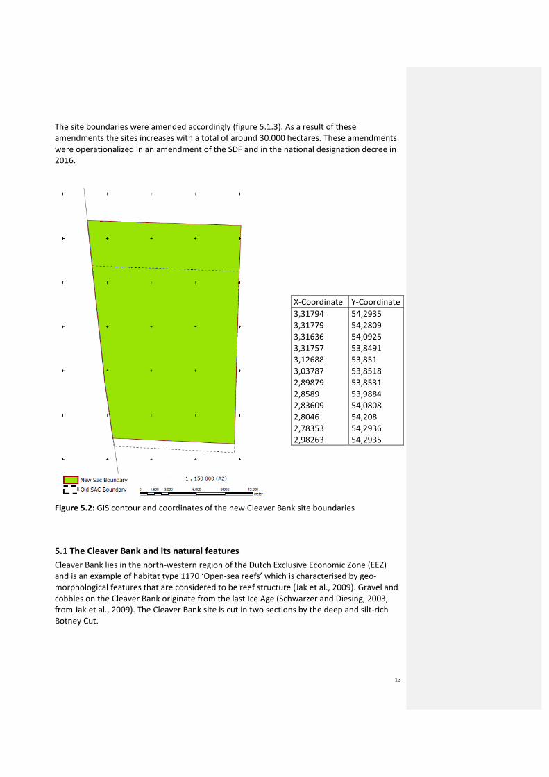
The site boundaries were amended accordingly (figure 5.1.3). As a result of these
amendments the sites increases with a total of around 30.000 hectares. These amendments
were operationalized in an amendment of the SDF and in the national designation decree in
2016.
Figure 5.2: GIS contour and coordinates of the new Cleaver Bank site boundaries
5.1 The Cleaver Bank and its natural features
Cleaver Bank lies in the north-western region of the Dutch Exclusive Economic Zone (EEZ)
and is an example of habitat type 1170 ‘Open-sea reefs’ which is characterised by geo-
morphological features that are considered to be reef structure (Jak et al., 2009). Gravel and
cobbles on the Cleaver Bank originate from the last Ice Age (Schwarzer and Diesing, 2003,
from Jak et al., 2009). The Cleaver Bank site is cut in two sections by the deep and silt-rich
Botney Cut.
X-Coordinate Y-Coordinate
3,31794 54,2935
3,31779 54,2809
3,31636 54,0925
3,31757 53,8491
3,12688 53,851
3,03787 53,8518
2,89879 53,8531
2,8589 53,9884
2,83609 54,0808
2,8046 54,208
2,78353 54,2936
2,98263 54,2935
14
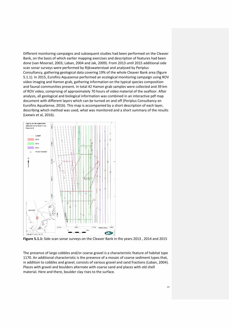
Different monitoring campaigns and subsequent studies had been performed on the Cleaver
Bank, on the basis of which earlier mapping exercises and description of features had been
done (van Moorsel, 2003; Laban, 2004 and Jak, 2009). From 2013 until 2015 additional side
scan sonar surveys were performed by Rijkswaterstaat and analysed by Periplus
Consultancy, gathering geological data covering 19% of the whole Cleaver Bank area (figure
5.1.1). In 2015, Eurofins Aquasense performed an ecological monitoring campaign using ROV
video imaging and Hamon grab, gathering information on the typical species composition
and faunal communities present. In total 42 Hamon grab samples were collected and 39 km
of ROV video, comprising of approximately 70 hours of video material of the seafloor. After
analysis, all geological and biological information was combined in an interactive pdf map
document with different layers which can be turned on and off (Periplus Consultancy en
Eurofins AquaSense, 2016). This map is accompanied by a short description of each layer,
describing which method was used, what was monitored and a short summary of the results
(Leewis et al, 2016).
Figure 5.1.1: Side scan sonar surveys on the Cleaver Bank in the years 2013 , 2014 and 2015
The presence of large cobbles and/or coarse gravel is a characteristic feature of habitat type
1170. An additional characteristic is the presence of a mosaic of coarse sediment types that,
in addition to cobbles and gravel, consists of various gravel and sand fractions (Laban, 2004).
Places with gravel and boulders alternate with coarse sand and places with old shell
material. Here and there, boulder clay rises to the surface.
15
Gravel and boulders offer a habitat for sessile epifauna to settle. Gravel with a grain size
larger than 30 mm can already be covered with sessile fauna. This suggests that the mobility
of these sediments is minimal. Sessile organisms are important because these organisms can
aggregate loose elements on the seafloor together, as can be learned from Georges Bank
(Collie et al., 1997). Sessile organisms also make the seafloor less sensitive to the effects of
water movement. The accretion of these sessile organisms is responsible for a radical
development of the three-dimensional structure of the habitat type, giving it complexity.
This complex, three-dimensional structure creates new niches that become occupied by
specialised organisms thereby increasing biodiversity (Jak et al., 2009).
Over large areas a thin layer of marine sands and silt has been deposited. Occasionally,
under the influence of the dominant water current, these form ‘sand ripples’ that run
parallel to the current direction and can be kilometres long (Laban, 2004 and Leewis et al,
2016). Maximum measured water current speeds vary between 0.25 and 0.40 m/s. Because
of the significant depth of the Cleaver Bank, the sand and finest gravel fractions on the
bottom are disturbed by wave action only in very heavy weather. As a consequence of this
dynamic, the gravel is relatively poor in silt. The visibility is so high that sunlight penetrates
even to a depth of 40 m to enable the growth of crustose calcareous red algae (van Moorsel,
2003). The mosaic pattern and the low mobility of a large part of the sediment in
combination with the clarity of the water make the Cleaver Bank unique in the Dutch EEZ,
although this combination of features is less rare in other parts of the North Sea (Jak et al,
2009).
Owing to the variety of sediment types, such as the occurrence of coarse sediments and
cobbles, the site hosts a great diversity of species. Of all the macrobenthic species present in
the EEZ, 44% occur exclusively on the Cleaver Bank (van Moorsel, 2003). The biodiversity of
the macrobenthos on the Cleaver Bank is among the highest in the Dutch EEZ (Lindeboom et
al., 2008, Jak et al., 2009; Bos et al., 2011, Leewis et al, 2016). In the 2015 monitoring
campaign, 246 unique species were found in 42 Hamon grab samples and 24 new species for
the Netherlands were discovered. To compare, in the Dutch standard monitoring campaign
in 2015 a total of 164 Boxcore samples were taken in the entire Dutch EEZ, and a total of 262
unique species were identified.
The common guillemot and razorbill are present on the Cleaver Bank primarily in April/May
(Arts and Berrevoets, 2005). In summer, concentrations of the harbour porpoise can be
found, particularly around the Botney Cut, and the minke whale, white-beaked dolphin and
seals are also observed here (Camphuysen and Peet, 2006; Brasseur et al., 2008). A more
recent review by Camphuyzen and Siemensma (2011) found no consistent patterns in space
and time for harbour porpoises in the area.
16
5.2 Natural distribution within the site
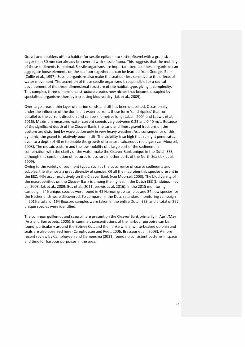
5.2.1 Depth contours
The Cleaver bank is located in quite deep water, average depths lie within -30 to -50 meters
(Jak et al., 2009), with a maximum depth of -71 m in the Botney Cut, a minimal depth of -30
m and an average depth of -43 m (Bos et al., 2008). Depth contours are shown in figure
5.2.2. The Cleaver Bank SCI is 1539 km2
in size.
Figure 5.2.2: Cleaver Bank SCI (in red) with depth lines
17
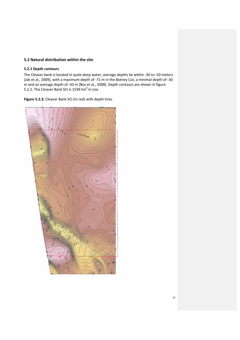
5.2.2 Sediment type
A sediment map from Leewis et al (2016, layers 3.2 and 3.3) provides insight in the gravel
content on the Cleaver Bank site and the identified rocks >30cm based on side scan sonar
data.
Figure 5.2.3: Cleaver Bank gravel content (dark brown = (sandy) gravel; dark yellow =
gravelly sand and beige = sand or clay) and identified rocks >30cm (blue lines = contours
based on actual reflection and interpolation) and SCI boundary (red line)
Figure 5.2.3 (produced in 2016) covers the entire Cleaver Bank area, but does not show the
intervals in high detail. Information brought forward by the fishing industry in the FIMPAS
18
project (industry proposal, 2011) provides additional information on presence of stony
ridges, stones, pebbles and areas known on fishermen’s maps as “messy” (implying the
presence of such features; see Figure 5.2.4).
This information was reviewed by two independent experts (Dr. C Laban at Marine
Geological Adviceand dr. M.S.S. Lavalaye at NIOZ / Royal Netherlands Institute for Sea
Research). It was found that the information provided in figure 5.2.4 was largely in
accordance with data from sampling observations. An important exception to this is the
stony area (‘stenen’) located in the North outside the old SCI boundary, which is different
from the sampling observations (which provide no such indication). A probable explanation
for this lies in the fact that this area was less densely sampled. The new research from 2016
does comply with the stony area in the Northeastern part.
Figure 5.2.4: Industry map (Fishing industry, 2011a) depicting stony ridges (amber/yellow);
stones (‘stenen’ and “st.”); messy areas (‘rommelig’), containing different sediments: sand,
gravel and stones; relatively sandy areas (‘relatief zandig’); clean areas (sandy without
19
stones, ‘schoon’), the muddy Botney Cut (blue, ‘modder’) and the old SCI boundary (yellow
line).
5.2.3 Benthic communities
Based on the report on the ecology of the Cleaver Bank by Van Moorsel (2003) and the
additional research from Leewis and Verduin (2016), a good picture of the fauna of the
Cleaver Bank has emerged. It is evident that the characteristic species of the Cleaver Bank
are precisely those restricted to the coarse, highly permeable sands and/or species that cling
to stable hard subsurface (gravel, cobbles, pebbles, stones). Van Moorsel (2003) indicated
that the sediment composition is often very variable even within a transect of 1 kilometer. It
is exactly this variation in the habitat which is important for the high biodiversity of the area
(Figure 5.2.5) (Lavaleye, 2011 and Leewis and Verduin, 2016).
Leewis and Verduin (2016) also did a statistical analysis on the relationship between faunal
communities and abiotic factors. This analysis showed two clear ‘clusters’ of typical H1170
species, divided over the Eastern and Western parts of the Cleaver Bank. The first cluster
(West) exhibits predominantly soft-bodied typical species that live on rocks and coarse
sediment and the second cluster (East) exists mainly of hard-bodied typical species usually
present on coarse sand and gravel. A third cluster of species was recognised which did not
clearly fall into one or the other. Reasons for this division cannot yet be statistically linked to
the abiotic factors that were taken into account, however do seem to be linked to different
abiotic aspects (Leewis and Verduin, 2016).

20
Figure 5.2.5: Map of depth contours and biodiversity aspects Shannon&Wiener index and
number of species per m2 sampled by Hamon grabs and ROV images.

21
These results concur with van Moorsel (2003), who only covered a section of the Cleaver
Bank area:
For the coarse permeable sands within the site, these characteristic species include the
European lancelet (Branchiostoma lanceolatum) and the sea urchin (Echinocyamus pusillus,
pea urchin). These species do not always occur in the greatest abundance but are
nevertheless characteristic by virtue of their association with this specific coarse sediment.
Other species named are the polychaeta Aonides paucibranchiata, Typosyllis cornuta and
Goniadella bobretzkii. The amphipod Urothoe marina is named as a crustacean typical of
coarse sand (Van Moorsel, 2003).
For the hard substrate (gravel, cobbles, pebbles, stones), characteristic sessile organisms are
dead men’s fingers (Alcyonium digitatum), crustose calcareous red algae (Lithothamnion
sonderi and Phymatolithon sp.) and, for example, the keel worm (Pomatoceros triqueter),
the ross worm (Sabellaria spinulosa) and the ribbed saddle oyster (Pododesmus
patelliformis) (Van Moorsel, 2003). These last three species cement the substrate and give
its structure and texture an extra dimension so that many other species can grow on it, such
as the rock-boring mollusc (Hiatella arctica) and moss animalcules (Bryozoa).
Species that occur specifically in coarse sediment are the rayed artemis (Dosinia exoleta) and
the blunt tellin (Arcopagia (=Tellina) crassa). These species have a thick shell, which makes
them well suited to the incidental movements of the gravel. Precisely these species occur in
the well-sorted lean (slit-poor) finer gravel and coarse sand fractions. Ocean quahog (Arctica
islandica), too, are regularly encountered. In view of the type of substrate, the site is
potentially suitable for the occurrence of the horse mussel (Modiolus modiolus) (Kenny and
Rees, 1996). This long-lived species can form mussel beds. The common whelk (Buccinum
undatum) can sustain itself well here because there is sufficient fixed substrate for the
deposit of egg cases, and moreover the TBT (tributyltin)concentrations, which along the
coast have caused imposex among common whelks, will presumably be too low here to
cause effects (OSPAR, 2008).
Also found on the Cleaver Bank are various species that are otherwise only common in the
deep more northern North Sea. Examples are the red whelk (Neptunea antiqua), the slender
colus or common spindle (Colus gracilis), the hermit crab Anapagurus laevis and the purple
heart urchin (Spatangus purpureus). A number of species new for The Netherlands has been
found at the site, for example, the Norway bullhead (Taurulus lilljeborgi) and the spiny squat
lobster Galathea strigosa. Northern species that occur on gravel-rich locations are the
worms Glycera lapidum, Dialychone dunerificta (as opposed to Chone Duneri, which was
determined initially, but later determined as only appearing In the Arctic) and Laonice
bahusiensis (Van Moorsel, 2003). Also in 2015 many new species for the Netherlands were
discovered, such as Drilonereis filum, the gastropod Graphis albida, Nothria conchilega,
Sphaerodoridium gracilis and polychaetes Ophelia celtica, Chaetozone zetlandica. The Cleaver
Bank is also probably the last site where the oval venus Timoclea ovata can still be found in
the Netherlands. The marine gastropod mollusc Caecum glabrum has not been found alive
often anymore, but is fairly common on the Cleaver Bank.
Less specific to the site are the burrowing crustaceans such as Callianassa subterranea and
Upogebia deltaura. At this site, these species are primarily restricted to the sediments in the

22
deep silt-rich Botney Cut that cuts through the gravel area. These species are not
characteristic of habitat type 1170.
5.2.4 Fish community
Located on the Cleaver Bank are two sampling points for the monitoring of commercial fish
stocks (Beam Trawl Survey and the International Bottom Beam Trawl Survey, see Lindeboom
et al., 2008). The standard methodology used in this respect is inadequate for monitoring
the fish species characteristic of the Cleaver Bank, many of which are small. The species
concerned are those such as gobies (Pomatoschistus spp.), small flatfishes like the scaldfish
(Arnoglossus laterna) and solenette (Buglossidium luteum) and the common dragonet
(Callionymus lyra). These species are common throughout the North Sea and also often
occur in other areas in the EEZ in large numbers (Van Moorsel, 2003). Two species prefer to
live on and between cobbles and as such can be called characteristic. These are the Norway
bullhead (Taurulus liljeborgi) and the two-spotted clingfish (Diplecogaster bimaculata). In the
area of the Cleaver Bank various fish species spawn, such as the whiting. In addition, the site
is potentially suitable as a spawning ground for herring (summarised in Ter Hofstede et al.,
2005). An expansion of the herring population could give rise to the need for new spawning
grounds (Van Moorsel, 2003). Finally, lancelets have not been found more commonly than
on the Cleaver Bank (Leewis and Verduin, 2016).
5.3 Proposed closures in relation to feature
On the basis of the areas which provide the most certainty of presence of the habitat feature
H1170, four management zones are drawn (Area 1 = North East; area 2 = East; area 3 = West
and area 4 = South West) according to the definition of H1170 given in 6.2.1. This includes a
combination of identified rocks larger than 30 cm (blue contours), (sandy) gravel; gravelly
sand and identified areas with high biodiversity aspects, Shannon&Wiener index and
average number of species per m2, based on side scan sonar, Hamon grabs and ROV images
(Figure 5.3.1). As these measurements provide the most detailed information there is on this
area, these four zones provide a robust protection of the habitat H1170, comprising 45% of
the entire Cleaver Bank SCI.

23
Figure 5.3.1: Proposed closures in relation to the habitat feature H1170 according to the
different layers of the additional research.
Area 1
Area 2 Area 3
Area 4

24
6 The Cleaver Bank in the context of the Habitats Directive
6.1 Legal status of the area
The Dutch site "Klaverbank" was included in the list of Sites of Community Importance,
pursuant to Art. 4(2) of the Habitats Directive, by Commission Decision 2010/43/EU of 22
December 2009. It was designated in a national designation decree on 27 May 2016.
6.2 Standard Data Form
Tables 5.3.1 and 5.3.2 present information from the Standard Data Form submitted by The
Netherlands. The Standard Data Form contains all relevant information, accompanying a
submission of a candidate site of community importance (pSCI). The full Standard Data Form,
including all underlying source information, are available at the website of the European
Commission9.
Table 6.1: Qualifying habitat type present on the site and assessment for it.
Habitat
Type
Cover (ha) Representativity Relative
surface
Conservation
status
Global
assessment
H1170 76934 B A C A
Representativity: A: excellent, B: good, C: significant, D: non-significant presence
Relative surface: A: between 100 to 15%, B: 15 to 2%, C: 2 to 0%
Conservation status: A: excellent , B: good, C: average or reduced conservation
Global assessment: A: excellent, B: good, C: significant value
Table 6.2: Other natural features
Code Name POPULATION SITE ASSESSMENT
Resi
dent
Migratory Popu-
lation
Conser-
vation
Iso-
lation
Glo-
bal
B
r
e
e
d
Wint
er
S
t
a
g
e
1364 Halichoerus
grypus
C C B C C
1365 Phoca
vitulina
R C B C C
1351 Phocoena
phocoena
C B B C B
Population: C: common, R: rare resident
Site assessment:
Population: A: between 100 to 15%, B: 15 to 2%, C: 2 to 0%
Conservation status: A: excellent , B: good, C: average or reduced conservation
Isolation degree: A: population (almost) isolated, B: population not-isolated, but on margins
of area of distribution, C: : population not-isolated within extended distribution range
9 http://natura2000.eea.europa.eu/natura2000/

25
Global assessments: A: excellent, B: good, C: significant value
The scientific information for the entries in the tables can be found in: Bos et al. (2008); Jak
et al. (2009) and Lindeboom et al. (2005).
6.2 Conservation objectives
6.2.1 Habitat H1170
The site Cleaver Bank has been selected as SCI for the presence of habitat type 1170. In the
EC Marine guidelines (EC, 2007) habitat type 1170 “Reefs” is defined as follows: “Reefs can
be either biogenic concretions or of geogenic origin. They are hard compact substrata on
solid and soft bottoms, which arise from the sea floor in the sublittoral and littoral zone.
Reefs may support a zonation of benthic communities of algae and animal species as well as
concretions and corallogenic concretions”. The main characteristics of the Cleaver Bank have
been described in the previous section 5.2.
Geomorphological features
Reefs of geogenic origin are present at the Cleaver Bank site (Lindeboom et al., 2005; Bos et
al., 2008 and Jak et al., 2009). Taking the definitions of the European interpretation manual
and the Marine Guidelines into account, Jak et al. (2009) distinguishes 3 size classes of hard
compact substrata that are (1) and can be (2, 3) part of the habitat type:
1. Hard compact substrata with a cross-section of at least 64 mm. The European
definition of H1170 (Interpretation Manual of European Union Habitats (EC, 2007))
states that the minimum requirement for reefs of geogenic origin is that they consist
of rocks, boulders or cobbles of ‘generally >64 mm’. Thus, these are included in the
habitat type.
2. Hard compact substrata with a cross-section of 8 to 64 mm. The characteristic of the
benthic communities of hard compact substrata is that they are sessile. These sessile
species also occur on gravel and cobbles measuring 8 to 64 mm. When the biotic
community of sessile organisms extends from the cobbles larger than 64 mm to
surrounding smaller cobbles, coarse gravel and shells, these are also included in the
habitat type.
3. Hard compact substrata with a cross-section smaller than 8 mm. This finer gravel
fraction (and possibly even finer sediments, including sand) can only form part of the
habitat type if (1) these sediments form only a thin, mobile layer over cobbles and
coarse gravel on which organisms live that are dependent on hard compact
substrata, or (2) if they occur in mosaic with the habitat type.
Benthic communities
The presence of coarse sediments in the form of gravel and boulders offers sessile epifauna
a habitat. These sessile organisms are important because they can continue to cement loose
bottom elements, making the bottom even less sensitive to any disturbance by water
motion. The accretion of these sessile organisms is responsible in turn for a radical
development of the three-dimensional structure of the habitat type, giving it complexity.
This complex, three-dimensional structure creates new niches that become occupied by
26
specialised organisms. As a consequence of this, the diversity increases compared to non-
reef structures.
EC marine guidelines state that reefs ‘may support a zonation of benthic communities of
algae and animal species as well as concretions and corallogenic concretions’. Thus this is
not a part of the minimum requirement but should be regarded as the good quality; without
such benthic communities the quality becomes moderate (Jak et al., 2009).
6.2.2 Conservation Objective for H1170
The conservation objectives for H1170 are: maintain distribution, maintain surface area and
improve quality. An improvement in quality is needed because the quality of the habitat is
currently assessed to be unfavourable–inadequate (Jak et al., 2009). Side-scan sonar
recordings show that in parts of the site the tracks of bottom fishery are present and that as
a result there is an elevated dynamic that disturbs the biotic communities present. Bottom
fishery can remove, homogenize and flatten the substrate of H1170 and cause changes
(mainly reduction) in abundance of its typical species (Deerenberg et al., 2010). Jak et al
(2009) concludes that the structure and function of the habitat have fundamentally
deteriorated due to repeated disturbance of the bottom compared to an undisturbed
situation.
Owing to the three-dimensional structure and the stable subsurface, habitat type 1170 can
offer living space to a well-developed sessile hard-substrate community. For such a
community to develop well, seabed stability is required (Watling and Norse, 1998). The
natural development and succession of a complex sessile biotic community is possible only if
the position and orientation of the hard substrate on which it grows do not change (Watling
and Norse, 1998).
It can be concluded from the above that the key factor to improve quality is to ensure that
habitat type 1170 is left undisturbed, by preventing human induced bottom disturbance
(elevated dynamics). If undisturbed, cementing of the different fractions (gravel, stones)
occurs, allowing for the establishment of typical sessile epibenthic species, while other
infauna (those which are able to withstand movement and increased dynamics, e.g. from
bottom fisheries) disappear.
6.2.3 Conservation Objectives for other features
There are conservation objectives for Harbour porpoise, Grey seal and Harbour seal, because
these natural features listed on Annex II of the Habitats Directive, are present on the site,
although the site has not been selected for these features. Objectives for Harbour porpoise
and Grey seal are: maintain the extent and quality of habitat in order to maintain the
population. Objectives for Harbour seal are: maintain the distribution, extent and quality of
habitat in order to maintain the population.
For harbour porpoise, FIMPAS (ICES 2011b) and the ICES advice (annex 1b) suggest not to
develop site specific measures, but rather to develop and implement generic protection
through a species protection plan and the possibility of capping effort on a regional scale.

27
The Netherlands has therefore developed a Harbour Porpoise Species protection Plan
(Camphuyzen & Siemensma, 2011) , which is currently being implemented. For seal species,
FIMPAS and the ICES advice concluded that no site specific measures for fisheries would be
needed. Therefore, this proposal only concerns H1170 and does not concern Harbour
porpoise and seal species.

28
7 Impact analysis
7.1 Impacts from fishing on H1170
Fishing occurs all over the southern North Sea. The Cleaver Bank is an important fishery
ground, albeit as part of a much larger area in the Southern North Sea (see effort maps in
section 7.5). It is important to make a distinction between different gear types in terms of
their impact on habitat type 1170. In the FIMPAS project Deerenberg et al. (2010) provided
an overview of the gear impacts in relation to Habitattype 1170. In the BENTHIS project
(www.benthis.eu) the impact of different types of gear in combination with habitat
vulnerability is further investigated (figure 7.1, Rijnsdorp et al., 2016a).
Figure 7.1 Impact of trawling on the sea bed. Source: Rijnsdorp et al. (2016)
Towed nets may affect the sea floor in various ways (figure 7.2, Eigaard et al., 2016). The
cables and ground rope that are dragged over the sea bed may homogenize the texture of
the sea bottom, destroy hard structures and move stones or shells. Heavy gear components
such as the otter boards or tickler chains will penetrate into the sea bed and disturb the
vertical structure of the sediment. Sediment may be brought into suspension by the
turbulence generated in the wake of the gear (O’Neill and Ivanovich, 2016). The physical
impact can therefore be broadly classified into:
• penetration into the sea bed, thus damaging or taking away benthos;
• collision with (hard) structures; and
• re-suspension of sediments.
As a result, the sea floor is homogenized, having an negative impact on deep digging species
such as shrimps. Those species are important for the structure, chemical conditions,
mineralization of the sea floor, enhancing the distribution other species (Slijkerman, 2013).
Bottom structure is more important on the depth gradient to the deeper, silt-rich sea bed
than for shallower sandy parts (Jak et al, 2009, referred to in Slijkerman 2013).
Bottom fishing causes mortality and results in a reduction of biomass and biodiversity. Long-
lived species are more vulnerable because they need a longer time to recover. Robustly built
animals are less susceptible than fragile species. Usually the share of long-lived species in
fished areas is lower than in unfished areas (van Denderen et al., 2015; Rijnsdorp et al.,
2016a, 2016b).
29
The sensitivity of the sea bed to disturbance of towed fishing gears depends primarily upon
the natural disturbance (shear stress) and the structure of the sea bed. The degree of natural
disturbance decreases with water depth. The grain size of the sediment is usually a good
indicator of the natural disturbance. High dynamic areas are usually characterized by coarse
sediments, low dynamic areas by fine sediments. The Cleaver Bank is a mixture of high and
low dynamic area with a variety of rocky and coarse sediments and is characterized by a
benthic community with a higher proportion of long-lived species (Rijnsdorp, 2015).
The vulnerability of habitat type 1170 on the Cleaver Bank is related to its physical features
(e.g., cobbles, coarse gravel and sand in a mosaic pattern, great clarity of the water column)
and the biological characteristics (e.g., sessile epifauna, trophic position) and the life
histories of the typical species (e.g., longevity). The resilience of open-sea reef habitats is
assumed to be low (Deerenberg et al., 2010 and Rijnsdorp, 2015).
Figure 7.2 Area of seabed swept in 1 h of fishing with an average-sized vessel with impact
at the surface level (sediment penetration up to 2 cm) and at both the surface and the subsurface (>
2 cm) level for 14 BENTHIS métiers. Eigaard et al. (2016)
Eigaard (2016) quantified the surface (up to 2 cm) impact and the subsurface (> 2 cm) impact
area of all towed fishing gears to the sea bed (Figure 7.2). Gears with surface impact disturb
the surface of the sea bed up to 2 cm. All towed gears cause abraision up to a depth of 2 cm.
Gears that impact surface over a large swept area include Scottish seines and Danish seines.
Almost all towed gears have a subsurface impact over 2 cm on the sea bed. A large part of
the southern North Sea is affected by towed gears (Figure 7.3; ICES.)
The relative impact of towed bottom contacting fisheries on benthos is much more
substantial than any other human activity at sea, even compared with extraction of surface
minerals, e.g. sand (Lindeboom, 2005, mentioned in Slijkerman, 2013). The footprint of
mobile bottom contacting gears is large. In only seven percent of the 1x1 minute grid cells in
the North Sea no bottom trawling was recorded during a 3-year period (Eigaard et al., 2017).
The trawling footprint, defined as the percentage of the sea floor trawled during a year, was
estimated at 63% (0-200m depth) and 31% (200-1000m depth) North Sea wide. For the
Dutch part of the North Sea this is more, 81%. Within the footprint, trawling is highly
aggregated with 90% of the effort occurring in less than 50% of the footprint. In these core
fishing grounds, the bulk of the landings is taken. ICES presented fishing intensity maps
based on Benthis results (figure 7.3)
30
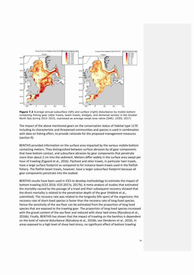
Figure 7.3 Average annual subsurface (left) and surface (right) disturbance by mobile bottom
contacting fishing gear (otter trawls, beam trawls, dredges, and demersal seines) in the Greater
North Sea during 2012–2015, expressed as average swept area ratios (SAR). (ICES, 2017)
The impact of the above mentioned gears on the conservation status of Habitat type 1170
including its characteristic and threatened communities and species is used in combination
with data on fishing effort, to provide rationale for the proposed management measures
(section 9).
BENTHIS provided information on the surface area impacted by the various mobile bottom
contacting metiers. They distinguished between surface abrasion by all gear components
that have bottom contact, and subsurface abrasion by gear components that penetrate
more than about 2 cm into the sediment. Metiers differ widely in the surface area swept per
hour of trawling (Eigaard et al., 2016). Flyshoot and otter trawls, in particular twin trawls,
have a large surface footprint as compared to for instance beam trawls used in the flatfish
fishery. The flatfish beam trawls, however, have a larger subsurface footprint because all
gear components penetrate into the seabed.
BENTHIS results have been used in ICES to develop methodology to estimate the impact of
bottom trawling (ICES 2016; ICES 2017a, 2017b). A meta-analysis of studies that estimated
the mortality caused by the passage of a trawl and their subsequent recovery showed that
the direct mortality is related to the penetration depth of the gear (Hiddink et al.,
submitted). The recovery rate was related to the longevity (life span) of the organisms: the
recovery rate of short-lived species is faster than the recovery rate of long-lived species.
Hence the sensitivity of the sea floor can be estimated from the proportion of long lived
species that are exposed to the trawling gear. The proportion of long-lived species increased
with the gravel content of the sea floor and reduced with shear bed stress (Rijnsdorp et al.,
2016b). Finally, BENTHIS has shown that the impact of trawling on the benthos is dependent
on the level of natural disturbance (Rijnsdorp et al., 2016b; van Denderen et al., 2016). In
areas exposed to a high level of shear bed stress, no significant effect of bottom trawling

31
could be detected. In areas with a more stable environment, bottom trawling shifted the
community to shorter lived taxa.
For the Cleaver Bank habitat with a relatively high gravel content and a low level of natural
disturbance, the benthos is expected to have a higher sensitivity to trawl disturbance as
compared to the more sandy habitats that are exposed to higher shear bed stress. The reef
habitat type H1170 is therefore assessed as being highly sensitive to all types of bottom
contacting gear, even gears with small subsurface impact, and larger surface impact.

32
7.2 Other human activities, and their impact on H1170.
The following section gives a preliminary assessment of impacts of other human activities
vis-a-vis fishing activities. It does not preclude any further impact assessment.
Besides fisheries there are several other human activities taking place in this area:
Platforms
There is one fixed platform (for oil/gas drilling) situated within the Cleaver Bank SCI site, in
the West, near the UK border. In 2010 and 2011 three operators were active with a total of 6
movable platforms (van der Burg et al., 2012, see also Annex 3, figure 1).
Mining platforms for the extraction of oil and gas form hard substrates where specific
organisms (epibenthos) can settle. Tamis et al (2011) determined the footprint per platform
(‘legs’) to be 0,025 ha. The potential loss of habitat type 1170 due to the presence of 2 fixed
platforms is thus 0,050 ha (500 m2). In comparison: the total area of habitat type 1170 on
the Cleaver Bank SCI is approximately 770 km2. Hence 0,025 ha = 0,000032% of the habitat
type 1170 area. The loss of H1170 due to the placement of a movable platform is assumed
to be similar to that of a fixed platform (0,025 ha). Its removal after 1-3 months provides
opportunities for recolonisation of benthic communities.
Each platform has a no fishing zone with a radius of 500 meters (Lindeboom et al., 2008).
These factors can influence the conservation objectives positively, whilst reducing the
potential fishing activity in this small area.
Cables and Pipelines
Four pipelines currently transect the SCI: North-South from Norway towards Belgium and
Norway to France and the NGT-pipeline, which transports gas to the Dutch coast.
Furthermore, from 2014 there is a pipeline transporting gas from the platform in the
Northwest of the SCI and one from 2006 that crosses the SCI from a UK platform in the West
to a platform North of the SCI. A fifth pipeline is foreseen in 2019, which will connect the UK
with Denmark. It will cross the Cleaver Bank slightly in the North West corner.
Whilst placing pipelines, the sediment is disturbed approximately 10m on each side of the
pipeline (Tamis et al., 2011). Roughly estimated, the total length of pipelines that currently
transect the Cleaver Bank habitat type 1170 area is 85 km. This amounts to 170 ha (0,2% of
the Cleaver Bank H1170 area) of sediment that was disturbed during placement. As (1) the
total footprint of these pipelines is very small, and (2) they are buried in the substrate, their
impact on the conservation objectives and the fishing activities can be considered very low.
Shipping routes
There is one defined shipping route that crosses the Cleaver Bank SCI in the South-East
corner (van der Burg et al., 2012). Shipping does not cause specific disturbance to habitat
type 1170. The frequency with which this route is used is relatively low. However because of
the fact that the ships that use this route usually transport harmful substances, effects can
be substantial when calamities occur. The number of reported discharges is relatively low.
33
The effects of shipping are considered to be low to marginal because of the low intensity
(Lindeboom et al., 2005).
34
8 Fleet activity on the site and in the region
In Cleaver Bank, the spatial distribution of habitat type 1170 is used as the guiding principle
in the development of the management measures. For Cleaver Bank, fisheries data have
been collected in order to (1) quantify fisheries pressure on the habitat type, and (2) provide
insights in the economic importance of the area for the fishing industry. Information on
fishing intensity for the whole region was produced by IMARES for FIMPAS Workshop 3,
2011, for the period 2006-2008. Furthermore, economic information specific for the Cleaver
Bank closures is given for the period 2010-2015 for the Dutch, British, Danish, German,
Belgian, Swedish and French fishing fleets (Hamon et al., 2017).
8.1 Regional fleet activity (fishing days, effort)
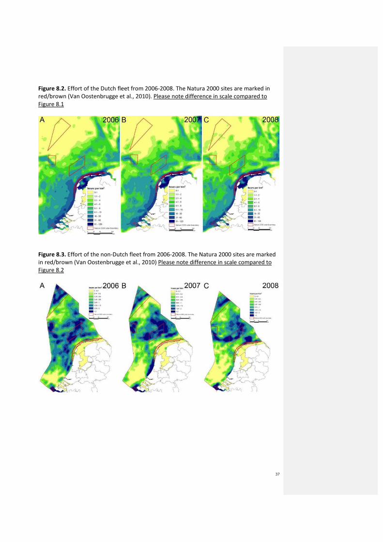
Figures 8.1, 8.2 and 8.3 clearly demonstrate the dynamics of the fisheries in the whole
region. The distribution of fishing effort for this period is not uniform in space or time over
the Cleaver Bank. The maps show significant year to year variability in effort among the
2006-2008 years. This variability is mainly driven by TAC/quota, fishing day constraints and
fuel prices. The main conclusions for the maps presented in this chapter are that (1) Fishing
effort for beam and otter trawl is considerably higher than fishing effort of other gears
(figure 8.1), and (2) effort is distributed all over the Cleaver Bank SCI but with significantly
higher fishing intensities in the Botney Cut (figure 8.2).
Fishing effort was analysed within the framework of the FIMPAS project by IMARES for 6
Member States (Belgium, Germany, Denmark, France, United Kingdom and The
Netherlands). Annex 1 contains the resulting quarterly maps of the fishing effort of beam
and otter trawl (vessels with engines higher than 300 HP) in the Dutch part of the North Sea
(indicated by the dotted line is the EEZ), for the years 2006 – 2008. Q1 = January-March, Q2
= April-June, Q3 = July-September, Q4 = October-December. The main conclusions from
these maps are that (1) both fisheries (beam and otter board trawling) have no marked
seasonality and (2) otter board trawling mainly takes place in the Botney Cut; beam trawling
does not exhibit a distinct spatial pattern. These conclusions were drawn for the years 2006-
2008, however more recent years also exhibit that the bulk of fisheries on the Cleaver Bank
takes place in the Botney Cut.
Opmerking [AMS2]: This information will be updated with 2016 information and new maps will be added.
Opmerking [AMS3]: Newer fisheries intensity map will be added

35
Figure 8.1a. Total fishing effort (KW*hrs) for beam and otter trawls combined for all
countries (B, D, DK, F, NL, UK) by year (produced by IMARES for FIMPAS Workshop 3, 2011).

36
Figure 8.1b. Total fishing effort (soak time hours) for gillnets and trammel nets combined for
all countries (B, D, DK, F, NL, UK) by year (produced by IMARES for FIMPAS Workshop 3,
2011). Please note that the scale is different from figure 8.1 a.
37
Figure 8.2. Effort of the Dutch fleet from 2006-2008. The Natura 2000 sites are marked in
red/brown (Van Oostenbrugge et al., 2010). Please note difference in scale compared to
Figure 8.1
Figure 8.3. Effort of the non-Dutch fleet from 2006-2008. The Natura 2000 sites are marked
in red/brown (Van Oostenbrugge et al., 2010) Please note difference in scale compared to
Figure 8.2
38
8.2 Fleet activity in effort, landings and landing value
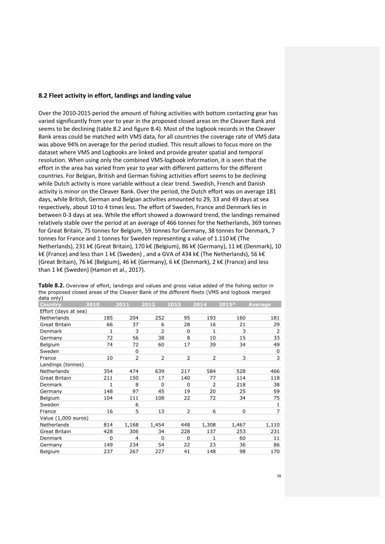
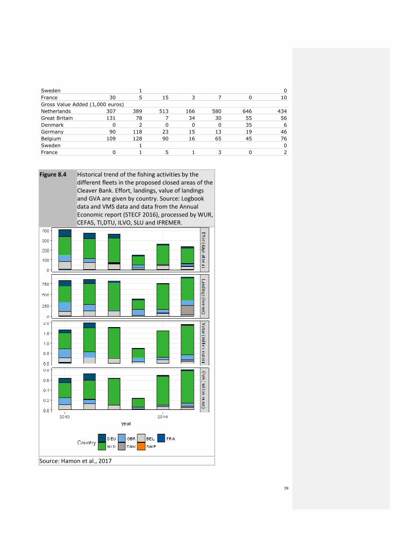
Over the 2010-2015 period the amount of fishing activities with bottom contacting gear has
varied significantly from year to year in the proposed closed areas on the Cleaver Bank and
seems to be declining (table 8.2 and figure 8.4). Most of the logbook records in the Cleaver
Bank areas could be matched with VMS data, for all countries the coverage rate of VMS data
was above 94% on average for the period studied. This result allows to focus more on the
dataset where VMS and Logbooks are linked and provide greater spatial and temporal
resolution. When using only the combined VMS-logbook information, it is seen that the
effort in the area has varied from year to year with different patterns for the different
countries. For Belgian, British and German fishing activities effort seems to be declining
while Dutch activity is more variable without a clear trend. Swedish, French and Danish
activity is minor on the Cleaver Bank. Over the period, the Dutch effort was on average 181
days, while British, German and Belgian activities amounted to 29, 33 and 49 days at sea
respectively, about 10 to 4 times less. The effort of Sweden, France and Denmark lies in
between 0-3 days at sea. While the effort showed a downward trend, the landings remained
relatively stable over the period at an average of 466 tonnes for the Netherlands, 369 tonnes
for Great Britain, 75 tonnes for Belgium, 59 tonnes for Germany, 38 tonnes for Denmark, 7
tonnes for France and 1 tonnes for Sweden representing a value of 1.110 k€ (The
Netherlands), 231 k€ (Great Britain), 170 k€ (Belgium), 86 k€ (Germany), 11 k€ (Denmark), 10
k€ (France) and less than 1 k€ (Sweden) , and a GVA of 434 k€ (The Netherlands), 56 k€
(Great Britain), 76 k€ (Belgium), 46 k€ (Germany), 6 k€ (Denmark), 2 k€ (France) and less
than 1 k€ (Sweden) (Hamon et al., 2017).
Table 8.2. Overview of effort, landings and values and gross value added of the fishing sector in
the proposed closed areas of the Cleaver Bank of the different fleets (VMS and logbook merged data only) Country 2010 2011 2012 2013 2014 2015* Average
Effort (days at sea)
Netherlands 185 204 252 95 193 160 181
Great Britain 66 37 6 28 16 21 29
Denmark 1 3 2 0 1 3 2
Germany 72 56 38 8 10 15 33
Belgium 74 72 60 17 39 34 49
Sweden 0 0
France 10 2 2 2 2 3 3
Landings (tonnes)
Netherlands 354 474 639 217 584 528 466
Great Britain 211 150 17 140 77 114 118
Denmark 1 8 0 0 2 218 38
Germany 148 97 45 19 20 25 59
Belgium 104 111 108 22 72 34 75
Sweden 6 1
France 16 5 13 2 6 0 7
Value (1,000 euros)
Netherlands 814 1,168 1,454 448 1,308 1,467 1,110
Great Britain 428 306 34 228 137 253 231
Denmark 0 4 0 0 1 60 11
Germany 149 234 54 22 23 36 86
Belgium 237 267 227 41 148 98 170
39
Sweden 1 0
France 30 5 15 3 7 0 10
Gross Value Added (1,000 euros)
Netherlands 307 389 513 166 580 646 434
Great Britain 131 78 7 34 30 55 56
Denmark 0 2 0 0 0 35 6
Germany 90 118 23 15 13 19 46
Belgium 109 128 90 16 65 45 76
Sweden 1 0
France 0 1 5 1 3 0 2
Figure 8.4 Historical trend of the fishing activities by the
different fleets in the proposed closed areas of the
Cleaver Bank. Effort, landings, value of landings
and GVA are given by country. Source: Logbook
data and VMS data and data from the Annual
Economic report (STECF 2016), processed by WUR,
CEFAS, TI,DTU, ILVO, SLU and IFREMER.
Source: Hamon et al., 2017
40
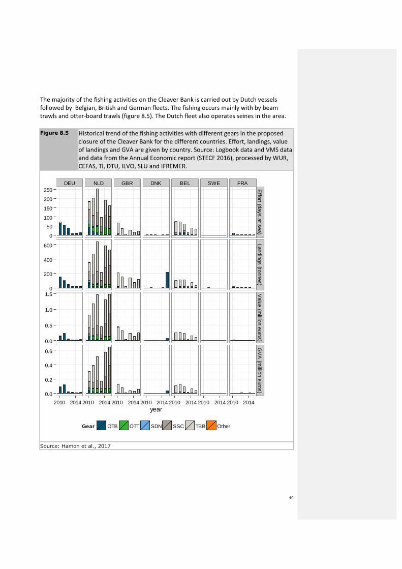
The majority of the fishing activities on the Cleaver Bank is carried out by Dutch vessels
followed by Belgian, British and German fleets. The fishing occurs mainly with by beam
trawls and otter-board trawls (figure 8.5). The Dutch fleet also operates seines in the area.
Figure 8.5 Historical trend of the fishing activities with different gears in the proposed
closure of the Cleaver Bank for the different countries. Effort, landings, value
of landings and GVA are given by country. Source: Logbook data and VMS data
and data from the Annual Economic report (STECF 2016), processed by WUR,
CEFAS, TI, DTU, ILVO, SLU and IFREMER.
DEU NLD GBR DNK BEL SWE FRA
0
50
100
150
200
250
0
200
400
600
0.0
0.5
1.0
1.5
0.0
0.2
0.4
0.6
Effort (days at sea)
Landings (tonnes)V
alue (million euros)
GV
A (m
illion euros)
2010 2014 2010 2014 2010 2014 2010 2014 2010 2014 2010 2014 2010 2014year
Gear OTB OTT SDN SSC TBB Other
Source: Hamon et al., 2017
41
8.2.1 Species targeted
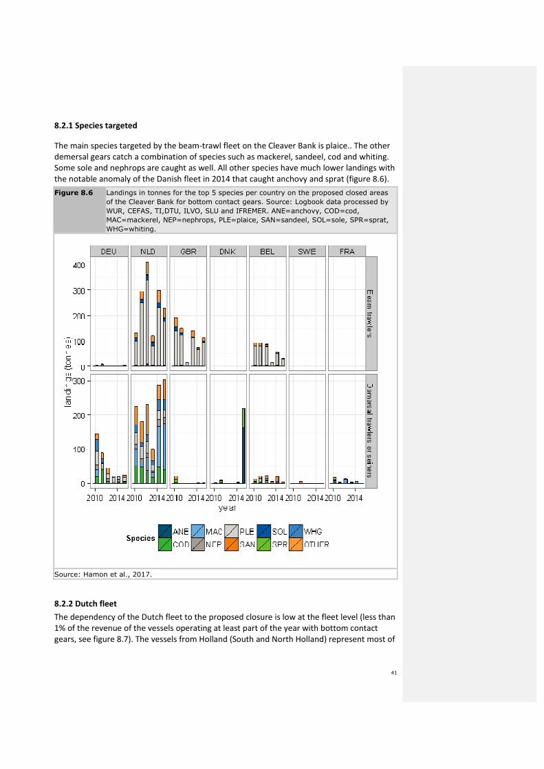
The main species targeted by the beam-trawl fleet on the Cleaver Bank is plaice.. The other
demersal gears catch a combination of species such as mackerel, sandeel, cod and whiting.
Some sole and nephrops are caught as well. All other species have much lower landings with
the notable anomaly of the Danish fleet in 2014 that caught anchovy and sprat (figure 8.6).
Figure 8.6 Landings in tonnes for the top 5 species per country on the proposed closed areas
of the Cleaver Bank for bottom contact gears. Source: Logbook data processed by
WUR, CEFAS, TI,DTU, ILVO, SLU and IFREMER. ANE=anchovy, COD=cod,
MAC=mackerel, NEP=nephrops, PLE=plaice, SAN=sandeel, SOL=sole, SPR=sprat,
WHG=whiting.
Source: Hamon et al., 2017.
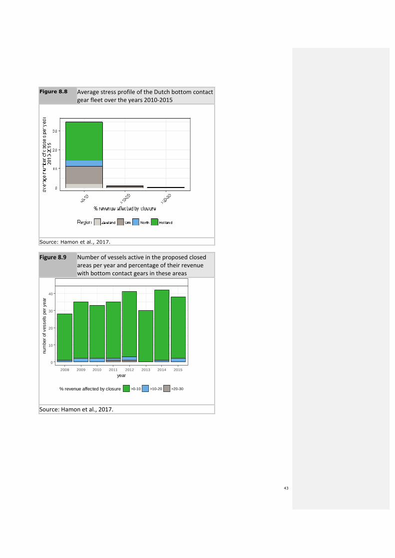
8.2.2 Dutch fleet
The dependency of the Dutch fleet to the proposed closure is low at the fleet level (less than
1% of the revenue of the vessels operating at least part of the year with bottom contact
gears, see figure 8.7). The vessels from Holland (South and North Holland) represent most of
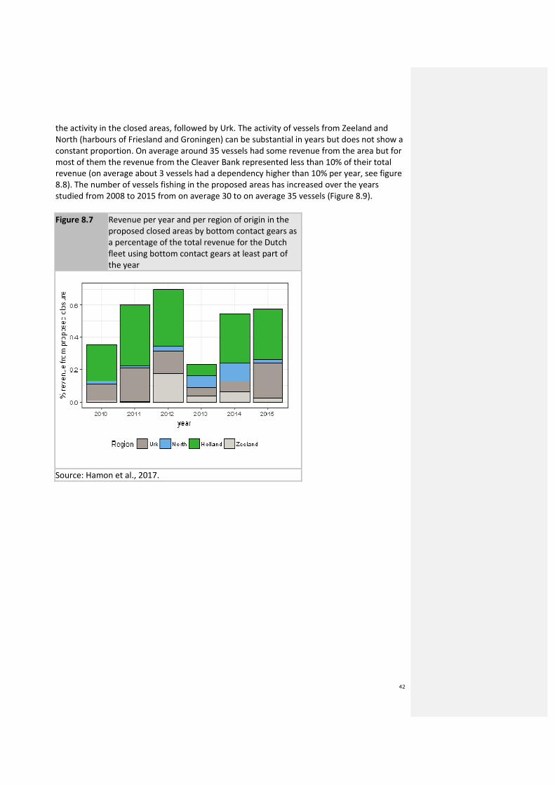
42
the activity in the closed areas, followed by Urk. The activity of vessels from Zeeland and
North (harbours of Friesland and Groningen) can be substantial in years but does not show a
constant proportion. On average around 35 vessels had some revenue from the area but for
most of them the revenue from the Cleaver Bank represented less than 10% of their total
revenue (on average about 3 vessels had a dependency higher than 10% per year, see figure
8.8). The number of vessels fishing in the proposed areas has increased over the years
studied from 2008 to 2015 from on average 30 to on average 35 vessels (Figure 8.9).
Figure 8.7 Revenue per year and per region of origin in the
proposed closed areas by bottom contact gears as
a percentage of the total revenue for the Dutch
fleet using bottom contact gears at least part of
the year
Source: Hamon et al., 2017.
43
Figure 8.8 Average stress profile of the Dutch bottom contact
gear fleet over the years 2010-2015
Source: Hamon et al., 2017.
Figure 8.9 Number of vessels active in the proposed closed
areas per year and percentage of their revenue
with bottom contact gears in these areas
2008 2009 2010 2011 2012 2013 2014 2015
0
10
20
30
40
year
num
ber
of v
esse
ls p
er y
ear
% revenue affected by closure >0-10 >10-20 >20-30
Source: Hamon et al., 2017.
44
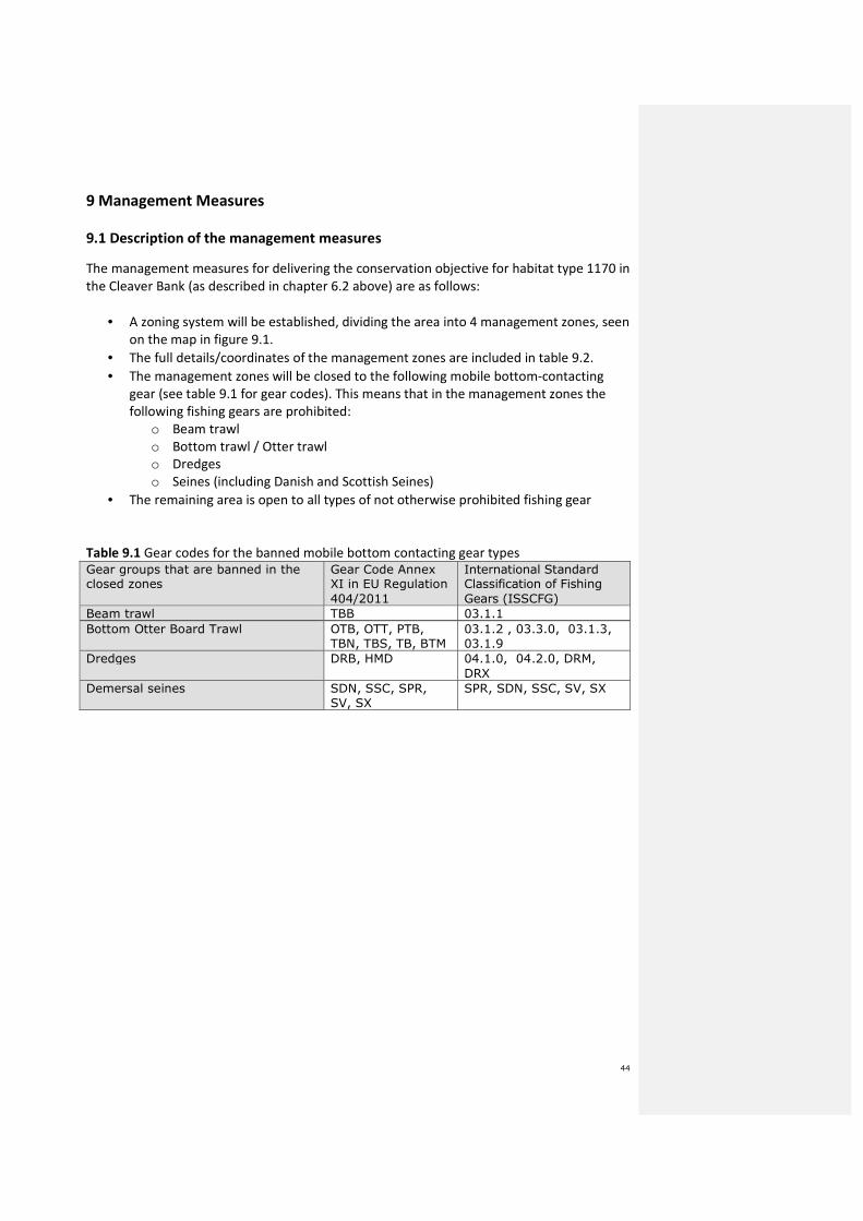
9 Management Measures
9.1 Description of the management measures
The management measures for delivering the conservation objective for habitat type 1170 in
the Cleaver Bank (as described in chapter 6.2 above) are as follows:
• A zoning system will be established, dividing the area into 4 management zones, seen
on the map in figure 9.1.
• The full details/coordinates of the management zones are included in table 9.2.
• The management zones will be closed to the following mobile bottom-contacting
gear (see table 9.1 for gear codes). This means that in the management zones the
following fishing gears are prohibited:
o Beam trawl
o Bottom trawl / Otter trawl
o Dredges
o Seines (including Danish and Scottish Seines)
• The remaining area is open to all types of not otherwise prohibited fishing gear
Table 9.1 Gear codes for the banned mobile bottom contacting gear types
Gear groups that are banned in the closed zones
Gear Code Annex XI in EU Regulation
404/2011
International Standard Classification of Fishing
Gears (ISSCFG)
Beam trawl TBB 03.1.1
Bottom Otter Board Trawl OTB, OTT, PTB,
TBN, TBS, TB, BTM
03.1.2 , 03.3.0, 03.1.3,
03.1.9
Dredges DRB, HMD 04.1.0, 04.2.0, DRM,
DRX
Demersal seines SDN, SSC, SPR,
SV, SX
SPR, SDN, SSC, SV, SX
45
Figure 9.1. Map with four management zones on the Cleaver Bank (numbers are surface
areas (ha).
Area 4
Area 1
Area 2 Area 3
Opmerking [AMS4]: Better map will be produced and one with alert zones
46
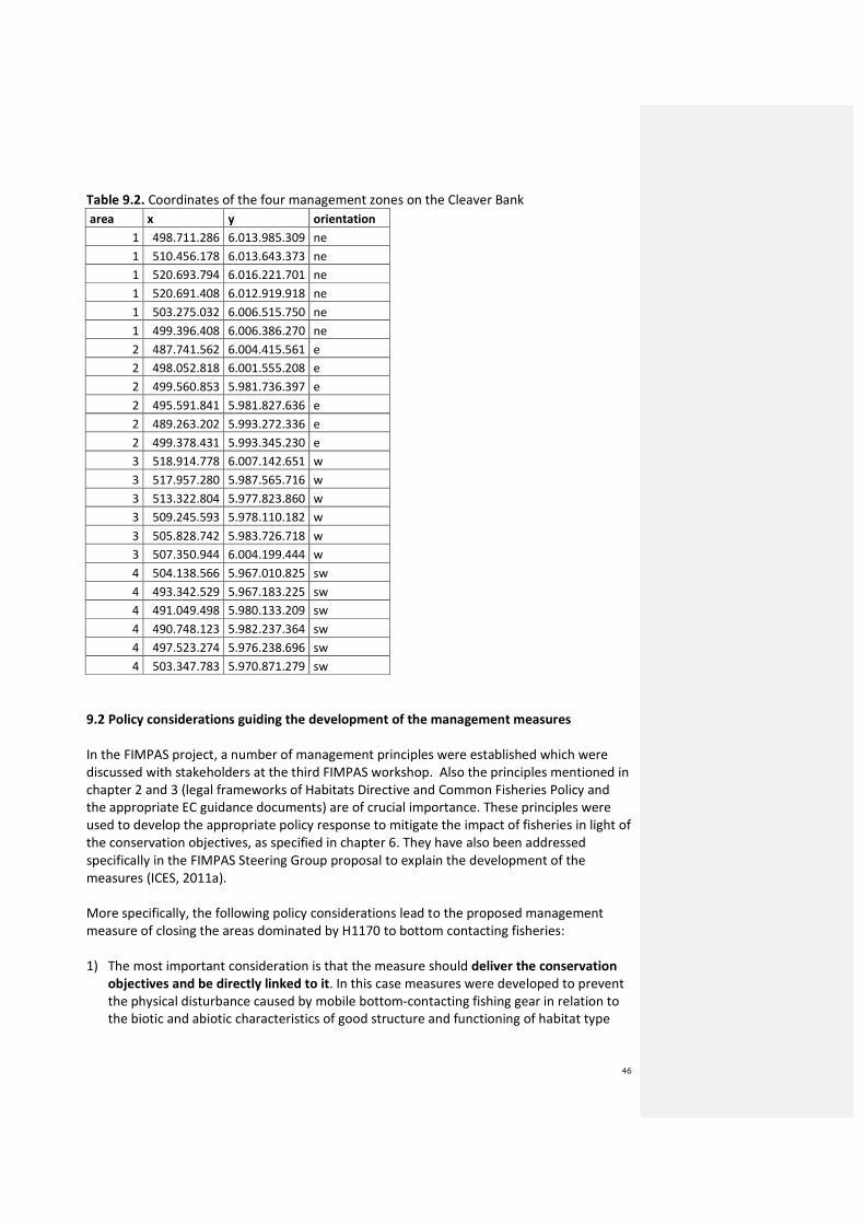
Table 9.2. Coordinates of the four management zones on the Cleaver Bank
area x y orientation
1 498.711.286 6.013.985.309 ne
1 510.456.178 6.013.643.373 ne
1 520.693.794 6.016.221.701 ne
1 520.691.408 6.012.919.918 ne
1 503.275.032 6.006.515.750 ne
1 499.396.408 6.006.386.270 ne
2 487.741.562 6.004.415.561 e
2 498.052.818 6.001.555.208 e
2 499.560.853 5.981.736.397 e
2 495.591.841 5.981.827.636 e
2 489.263.202 5.993.272.336 e
2 499.378.431 5.993.345.230 e
3 518.914.778 6.007.142.651 w
3 517.957.280 5.987.565.716 w
3 513.322.804 5.977.823.860 w
3 509.245.593 5.978.110.182 w
3 505.828.742 5.983.726.718 w
3 507.350.944 6.004.199.444 w
4 504.138.566 5.967.010.825 sw
4 493.342.529 5.967.183.225 sw
4 491.049.498 5.980.133.209 sw
4 490.748.123 5.982.237.364 sw
4 497.523.274 5.976.238.696 sw
4 503.347.783 5.970.871.279 sw
9.2 Policy considerations guiding the development of the management measures
In the FIMPAS project, a number of management principles were established which were
discussed with stakeholders at the third FIMPAS workshop. Also the principles mentioned in
chapter 2 and 3 (legal frameworks of Habitats Directive and Common Fisheries Policy and
the appropriate EC guidance documents) are of crucial importance. These principles were
used to develop the appropriate policy response to mitigate the impact of fisheries in light of
the conservation objectives, as specified in chapter 6. They have also been addressed
specifically in the FIMPAS Steering Group proposal to explain the development of the
measures (ICES, 2011a).
More specifically, the following policy considerations lead to the proposed management
measure of closing the areas dominated by H1170 to bottom contacting fisheries:
1) The most important consideration is that the measure should deliver the conservation
objectives and be directly linked to it. In this case measures were developed to prevent
the physical disturbance caused by mobile bottom-contacting fishing gear in relation to
the biotic and abiotic characteristics of good structure and functioning of habitat type
47
1170 (“Reefs”). In section 6 and 7 it has been explained that the crucial notion is to
prevent human induced physical disturbance of the three dimensional shape of habitat
type 1170 (Jak et al., 2009; ICES, 2012; Rijnsdorp, 2015). In essence this means that the
cobbles, rocks, pebbles, boulders and gravel (which collectively constitute habitat type
1170) should not be moved or touched by fishing gear. ICES advised that heavy bottom
trawl gear can destroy the physical structure of the habitat. ICES also advised that , for
protected of reefs in areas frequently exposed to mobile, bottom-contacting fishing
gears, complete closure may be necessary to restore habitats and species to favourable
conservation status.
2) A zoning approach of the area is especially suitable for this purpose. In other words: the
measure can be differentiated in function of the spatial distribution of habitat type
1170. For this reason only areas, which are dominated by habitat type 1170 (cobbles,
rocks, pebbles, boulders, gravel) are proposed to be closed. Other areas, where habitat
type 1170 is not dominant, are left open. ICES supported the proposal to close an area to
fishing with mobile bottom-contacting gear. As the final proposal does not delineate
significantly from the proposal that ICES assessed, and the scientific basis has only
improved, we assume the advice is equally valid for the current proposal. As such, zoning
contributes to a proportional policy response (see item 4 below). The delineation of the
management zone where habitat type 1170 is dominant was challenging. Throughout
the Cleaver Bank area, the reef habitat type is interdispersed with sandy and muddy
grounds. In the development of the proposal, all available information was used. The
starting point was geological information, including sediment maps, combined with
biological information on species distribution. ICES considered this to be a good proxy for
benthic community composition and therefore supports the demarcation of the closed
zones. But also information brought forward by practising fishermen was used, including
information on stony ridges and stones in fishing charts. In the end, the management
zone was demarcated using the best available information on the presence and location
of habitat type 1170. In addition, a second crucial notion in development of the zoning
was the fact that the variability of and connectivity between the different benthic
components on the Cleaver Bank (ridges, stones, pebbles, gravel, sand, mud, height
differences, all present in a mosaic) contributes considerably to the known biodiversity
of the area (Jak et al., 2009 and Lavalaye, 2011). Thirdly, enforceability and monitoring
was also part of the considerations (see item 7 below).
3) The proposed measure should be scientifically sound, which was the reason for seeking
ICES advice on it. ICES was explicitly requested to advice on the boundaries of the
management zones in light of the available data. ICES supported the proposal from 2012
to close the areas dominated by habitat type 1170 to bottom contacting fishing gear. As
the final proposal does not delineate significantly from the proposal that ICES assessed,
and the scientific basis has only improved, we assume the advice is equally valid for the
current proposal.
4) According to the EC Guidance the measure needs to be proportional: id est “an
appropriate balance between sustainable exploitation of resources should be sought,
including a precautionary approach to fisheries management”.

48
The proposed management is thought to be proportional because the closure of areas is
only directed at bottom contacting fisheries in the areas dominated by habitat type
1170. It means that the areas dominated by sandy and muddy sediments are not closed
to bottom contacting gears. Especially the high yielding fishing grounds of the Botney Cut
are not included. Furthermore, at the request of the fishing sector, some “clean grounds”
(not hosting habitat type 1170 in the South of the area) were taken out, and new areas
(hosting habitat type 1170 to the North of the area) were added.
Looking at the total landings of the demersal fishing fleet (from NL, BEL, UK and GER),
the income generated in the closed areas of the Cleaver Bank is deemed to be affected
proportionally. First of all, income need not be lost, because TACs/Quota are unaffected
by the measures (see also section 13). About 29% of the total landing value from the
Cleaver Bank SCI (2006-2011) was obtained in the proposed management zone (Hamon
et al., 2013). Specifically for the Dutch sector, an analysis by the LEI in the period 2010-
2015 concludes that the management zone represented 0,22% (2013) to 0,65% (2012) of
total revenue of the Dutch fleet. On average this is less than 0.5%. In comparison,
TAC/quota, fishing day constraints and fuel prices have a much larger influence on total
revenues. This is deemed to be proportional, although individual fisherman can be
affected. According to the LEI analysis, not more than 3 vessels in any one year are
affected to a considerable extent (10-30%) by the proposed measure (Hamon et al,
2017).
With regard to the precautionary approach: the Steering Group proposed to close the
deep muddy trench (the Botney Cut) to beam trawling, because of the mud plumes such
fishing could potentially cause. Such plumes could have a negative effect on some of the
typical species of habitat type 1170. ICES, however, did not support this proposal given
the very low effort of beam trawling in the Botney Cut. Therefore, while aligning the
proposal to ICES advice, this element is dropped from the regulatory measures. At the
same time, precautionary considerations on connectivity were important in the
demarcation of the zone dominated by H1170 (see items 2 and 7).
5) Consulting stakeholders and building on existing data (including socio-economic data)
were key policy considerations at the heart of the FIMPAS project and in the subsequent
process. See chapter 4 for further explanations on this.
6) The measure would need to be non-discriminatory, which is the reason for putting this
proposal to the European Commission for further decision making in the CFP context.
This guarantees that the measure is not only effective in terms of delivering conservation
objectives, but also equally applicable to bottom contacting gears on ships from all
Member States active in the area.
7) The measure needed to be controllable and enforceable. The current zoning approach,
with continuous and large closed areas contributes to ease of control and enforcement.
In the course of the development of the proposal the fishing sector proposed a total of 8
small scattered areas contributing to a very patch zoning, which was considered to be far
inferior in terms of effective control and enforcement. This is further explained in section
10.
49
8) An adaptive approach comprising a review of the regime after 6 years.
10 Control and Enforcement
[PM The content of this chapter is part of the discussions in the Joint Control Expert Group under
the Scheveningen Group.]
The proposed control, enforcement and compliance regime for the Cleaver Bank SCI consists
of a combination of surface and aerial surveillance, establishment of an alert zone around
the management zones, and remote monitoring of vessel position and gear activity. Such a
regime would be in line with future control and enforcement challenges within the CFP.
Key provisions, in accordance with Council Regulation (EC) No 1224/2009 of 20 November
2009 establishing a Community control system for ensuring compliance with the rules of
common fisheries policy (OJ L 343, 22.12.2009, p. 1), to be included in the delegated act to
facilitate control enforcement and compliance are:
• Fishing activities of all fishing vessels in the management zones and a 4nm wide alert
zone around the management zones shall be controlled by the fisheries monitoring
authorities of the coastal Member State by using their system to detect and to record
the vessels’ entry into, transit through and exit from the fishing restricted areas.
• Fishing vessels carrying on board any prohibited gear types and travelling under six
knots within the alert zone and management zone must use their vessel monitoring
system for reporting fishing vessel identification, geographical position, date, time,
course and speed. These data shall be transmitted every 10 minutes.
• The vessel will be under the obligation to report to the Fisheries Monitoring Centre of
its flag entry and exit of alert and management zone.
• Fishing vessels may transit alert zone and management zone with prohibited gears on
board provided that any prohibited gear on board be lashed and stowed during the
transit; and the speed during transit is not less than six knots except in case of force
majeure or adverse conditions. In such cases, the master shall without delay inform
the fisheries monitoring centre of the flag Member State which shall then inform the
competent authorities of the coastal Member State.
• The high frequency data can also be transmitted via GPRS/GSM. When GPRS/GSM
signal is not available data shall be safely stored and forwarded to the competent
authority on its request.
• A fishing vessel travelling at six knots or less that carries a prohibited gear entering
the Cleaver Bank alert zone area without such a system or not transmitting or storing
the data is in breach of the regulations, except in the case of force majeure or
adverse conditions.

50
11 Monitoring
In the Netherlands all marine monitoring, including for N2000 and MSFD purposes, is
programmed in the Marine Strategy for the Dutch part of the North Sea, part 2, the MSFD-
monitoring programme10
. This programme follows the structure of the MSFD on the basis of
the 11 descriptors. Per descriptor a description is given of: the environmental targets, the
associated indicators, the research needs per indicator, the research strategy, the functional
measurement needs, the monitoring strategy and the measurement plan.
Based on the measurement data, the Monitoring Programme provides insight into:
1. the status of the indicators, thereby indicating the extent to which an environmental
target is achieved (MSFD, Art. 10), in order to facilitate the ongoing assessment and
periodic updating of the environmental targets (MSFD, Art. 5)
2. the effectiveness of the programme of measures to be implemented under the
MSFD, of which N2000 measures are also part.
The “Informatiehuis Marien” is the supporting body which plays a central role in
implementing the MSFD monitoring cycle, particularly in monitoring quality, transparency,
availability and cost efficiency11
.
To reduce costs and improve consistency, the MSFD-monitoring programme is aligned as
much as possible with the existing monitoring programmes for the Birds and Habitats
Directive and the Water Framework Directive. International collaboration is pursued in all
steps of implementing the monitoring cycle. OSPAR plays an important role in achieving
regional cooperation, be it on common indicators, or joint monitoring.
In 2015 a baseline measurement campaign was done for benthos, focusing on the MPA’s in
the Netherlands, also on the Cleaver Bank. The baseline campaign and subsequent
monitoring focuses on the typical species (in accordance with the Habitats Directive) and on
a set of species indicative for the structure and function of the habitats, species that are
sensitive to disturbance by human activities and species indicative for recovery. The data will
be used for the update of the Initial Assessment in 2018, and also the reporting for the
Habitats Directive in 2019, and the evaluation of management plans for the different MPA’s.
The measurement campaigns will be repeated every three years, to be able to evaluate the
status and effectiveness of measures.
The Dutch monitoring plan is adaptive. The monitoring plan that has currently been designed
is able to detect a change of 50% in population distribution based on hit rate of the species
within the samples, with a power of 80%. Here, hit rate is considered to be a good proxy for
species distribution and/or abundance.
Once every three years samples are taken with a grab sampler and video tracks, both are
randomly located within the boundaries of the Natura 2000-site12
. If a change of 50% in
10https://www.noordzeeloket.nl/images/Marine%20Strategy%20for%20the%20Dutch%20part%20of%20the%20North%20Sea%202012
-2020%20Part%202%20-%20MSFD%20Monitoring%20Programme%20-%20summary_5169.pdf
11 http://www.informatiehuismarien.nl/uk/
12 Since the Botney Cut is not defined as a habitat under the Habitat Directive (deep, silty trench) no monitoring is required.

51
population distribution is detected, a further assessment and an adjustment of the
monitoring plan can take place if necessary.
All species found in the samples (grab and video) are recorded. The analysis needed for the
detection of an increase in hit rate will be performed only for the indicator species as
mentioned in table 11.1. A 50% change in hit rate for an indicator species triggers further
analysis of the monitoring plan, both at the level of (indicator) species and that of the basic
principles (spatial and temporal distribution).
This paragraph is based on Wijnhoven et al. (2013) and Troost et al. (2013)
11.1 Suitable biological and pressure indicators
The basic principle of a suitable biological indicator is that it indicates the quality of the
habitat type. This can be either a ‘positive indication’ (indicates quality improvement) or a
‘negative indication’ (indicates quality deterioration). The Marine Strategy Framework
Directive published a new Commission Decision ((EU) 2017/848), which provides a set of
indicators or criteria to assess the condition and change of the benthic environment. The
Netherlands have taken up the following criteria accordingly:
• Spatial extent and distribution of physical loss (permanent change) of the natural
seabed (D6C1) and of the natural extent of the habitat type in the assessment area
(D6C4).
• Spatial extent and distribution of physical disturbance pressures on the seabed
(D6C2).
• Spatial extent of each habitat type which is adversely affected, through change in its
biotic and abiotic structure and its functions (e.g. through changes in species
composition and their relative abundance, absence of particularly sensitive or fragile
species or species providing a key function, size structure of species), by physical
disturbance (D6C3).
• The extent of adverse effects from anthropogenic pressures on the condition of the
habitat type, including alteration to its biotic and abiotic structure and its functions
(e.g. its typical species composition and their relative abundance, absence of
particularly sensitive or fragile species or species providing a key function, size
structure of species), does not exceed a specified proportion of the natural extent of
the habitat type in the assessment area (D6C5).
Quality of the habitat is defined by the following quality aspects:
• physical structure
• diversity
• community structure
• typical species
Considering the conservation objective for habitat type 1170 on the Cleaver Bank (quality
improvement), biological indicators aim to indicate the improvement of these quality
aspects. And, considering the quality aspects, suitable indicator species are selected based
on the typical species from the Habitats Directive and species selected specifically for MSFD
purposes. A national benthos indicator was developed to assess the quality and account for

52
changes in quality on the Dutch part of the North Sea and the different protected areas,
among which the Cleaver Bank.
Besides the biological indicators, fisheries data are an important indicator to analyse the
temporal and spatial fine-scale distribution of fishing efforts through the Physical
Disturbance Indicator, which is developed by ICES and the Benthis project13
.
This indicator is a pressure indicator (impact of fisheries on the areas not closed for fishing
effort) by combining VMS data and information on footprint.
11.2 Principal properties of indicator species
The following principle properties of indicators species are hereby defined:
• Species should indicate improvement in the quality aspects of the habitat type.
• Species should be sensitive to the impact of mobile bottom contacting gear.
• The time of reaction of a species on the measure (being reduction or removal of
bottom contacting activities) should be considered (preferably after 6 or, at the
latest, 12 years).
• Species should be abundant enough to give quantitative information about the
effect/ effectiveness of the measure.
To assess quality status and detect effectiveness of measures, a list of indicator species is
drawn up. These are all benthic species (epi- and infauna) (table 11.1) and are considered to
cover the relevant quality aspects of the habitat as mentioned above. Mobile species, such
as fish, and rare species are excluded, since there is a low hit rate for these species. These
species will however be reported whenever found in video samples.
13 www.benthis.eu

53
Table 11.1. Indicator species to monitor the improvement of habitat type 1170 on the
Cleaver Bank.
54
12 Evaluation of possible displacement of fishing effort and impact on new
areas
Because certain areas of the SCI will be closed for certain gear types, some displacement is
likely to happen, both within the SCI and outside the SCI.
Displacement is difficult to quantify, and it is impossible to predict where exactly activities
will be displaced to. However, according to the ICES advice on Cleaver Bank, displacement of
(otter board, beam) trawl fisheries is not an issue of concern.
According to the WER report (WER, 2017) the future value of fishing areas will decline
and closure of these specific areas may result in smaller economic losses, when fishers
move their effort to different locations. It is assumed that fishers move their effort to
other locations in case of area closures. The effects of moving effort to another location
(displacement) on catch and revenue are less well understood and are not necessarily
negative. If effects are small at the scale of the fleet, this does not imply that individual
fishers will not be affected substantially by a closure of a specific area at sea. The effects
of closing a specific area are generally thought to have less effect fleet wide than on
specific individuals or fishing companies.
Because not all of the SCI is closed, some displacement will take place to areas within the SCI
that are not closed. Such a displacement within the SCI could lead to deterioration of those
areas left open and thus could jeopardize reaching the conservation objectives which are
designed to contribute significantly to the favourable conservation status. However, because
the closed areas will benefit from the prohibition of certain gears and given the knowledge
that 1st and 2nd trawl pass (Schroeder et al, 2008) are the most damaging, such potential
further deterioration is extremely difficult to assess. In any case, such developments are
dependent on the fishing intensity and distribution before the closure, the added fishing
activity caused by displacement and external factors (such as fish distribution, TAC/quota,
fuel prices, other spatial claims).
Therefore , as a part of the overall monitoring programme (see paragraph 11), the changes
in effort distribution within the SCI and any possible effects will be monitored. The
monitoring of activity in each site could assist in any future considerations relating to
displacement and could be used to indicate any changes in fishing trends and activity.
13 Implementation
In case of EC Regulation there is no need for implementation in national law. In order to
enforce the regulation a provision will be made in the Uitvoeringsregeling Zeevisserij
(implementing regulation for marine fisheries) under the Visserijwet 1963 (Fisheries Act
1963).
After a period of 6 years after the publication of the Regulation the initiating Member State
will assess the impact of the measure on the benthic ecosystem.
Fisheries industry and nature conservation organisations are invited to jointly give guidance
to the implementation process, the communication on it, the monitoring of the ecological
55
effects and evaluation of the measure and to the improvement of compliance and
enforcement.
56
14 References
Bos, O.G., Dijkman, E.M., Cremer, J., 2008. Gegevens voor aanmelding van mariene
Habitatrichtlijngebieden: Doggersbank, Klaverbank, Noordzeekustzone, Vlakte van de Raan.
IMARES report C081/08.
Bos, O.G. , R. Witbaard, M. Lavalaye, G. van Moorsel, L.R. Teal, R. van Hal, T. van der
Hammen, R. ter Hofstede, R. van Bemmelen, R.H. Witte, S. Geelhoed & E.M. Dijkman, 2011.
Biodiversity Hotspots on the Dutch Continental Shelf. Imares report C071/11.
Brasseur, S.M.J.M., M. Scheidat, G.M. Aarts, J.S.M. Cremer, O.G. Bos, 2008. Distribution of
marine
mammals in the North Sea for the generic appropriate assessment of future offshore wind
farms.
IMARES Report C046/08.
Burg, L.N. van den, de Lange, M., Verduin, E.C., 2012. Doggersbank, inventarisatie
gebruiksfuncties voor beheerplan, Grontmij report 2012, GM-0050608.
Camphuysen, K., Peet, G., 2006. Walvissen en dolfijnen in de Noordzee / Whales and
dolphins in the North Sea, Fontaine Uitgevers BV, 's Graveland / Stichting De Noordzee,
Utrecht.
Camphuysen, C.J. and Siemensma, M.L., 2011. Conservation plan for the Harbour Porpoise
Phocoena phocoena in The Netherlands: towards a favourable conservation status. NIOZ
Report 2011-07, Royal Netherlands Institute for Sea Research, Texel, 183pp.
Collie, J.S., Escanero G.A., Valentine P.C., 1997. Effects of bottom fishing on the benthic
megafauna of Georges Bank. Mar. Ecol. Prog. Ser. 155; 159-172.
Deerenberg C., Teal, L.R., Beare ,D., van der Wal, J.T., 2010. FIMPAS project –
Pre_assessment of the impact of fisheries on the conservation objectives of Dutch marine
protected areas IMARES Report number C071/10
Eigaard, O.R., Bastardie, F., Breen, M., Dinesen, G.E., Hintzen, N.T., Laffargue, P., Mortensen,
L.O., Nielsen, J.R., Nilsson, H.C., O’Neill, F.G., Polet, H., Reid, D.G., Sala, A., Sköld, M., Smith,
C., Sørensen, T.K., Tully, O., Zengin, M. & Rijnsdorp, A.D. (2015) Estimating seabed pressure
from demersal trawls, seines, and dredges based on gear design and dimensions. ICES J.
Mar. Sci., 73 S1, i27-i43.
Eigaard OR, Bastardie F, Hintzen NT, Buhl-Mortensen L, Buhl-Mortensen P , Catarino R,
Dinesen GE, Egekvist J, Fock H, Geitner K, Gerritsen H , González MM, Jonsson P, Kavadas S,
Laffargue P, Lundy M Mirelis GG, Nielsen JR, Papadopoulou N, Posen PE, Pulcinella J , Russo
T, Sala A, Silva C, Smith C, Vanelslander B, Rijnsdorp AD. 2017. The footprint of bottom
trawling in European waters: distribution, intensity and seabed integrity. ICES Journal of
Marine Science 73: 847-865

57
European Commission, 2007. Guidelines for the establishment of the Natura 2000 network
in the marine environment. Application of the Habitats and Birds Directives.
European Commission, 2007. Update of “Interpretation Manual of European Union Habitats.
Annex I Marine Habitat type definitions.
European Commission, DG Mare & DG Envi letter, 2012. Subject: Legal questions relating to
the Natura 2000 regime on the Dogger Bank. Ref. Ares(2012)834119 - 09/07/2012
European Commission Services, 2008. Fisheries measures for marine Natura 2000 sites - A
consistent approach to request for fisheries management measures under the Common
Fisheries Policy.
FIMPAS Steering Group report, 2011. A new proposal for fisheries measures on the Cleaver
Bank by the FIMPAS Steering Group, 10th June 2011.
Fishing industry, 2011a. Cleaver Bank proposal fishing industry. 11 March 2011, 11pp.
Fishing industry, 2011b. Final Cleaver Bank proposal fishing industry. 9 May 2011, 13pp.
GSEPN, 2012. Milieueffectrapport voor het gaswinningsplatform D18a-A. GDF SUEZ E&P
Nederland B.V. Augustus 2012
R. van Hal, L.R. Teal, J. Asjes, R.G. Jak, M. Scheidat, J.A.M. Craeymeersch, R.S.A. van
Bemmelen, F.J. Quirijns, T. van Polanen-Petel, C. Deerenberg, 2010. Data availability for the
fisheries impact assessment of the FIMPAS project, IMARES report nr C052/10.
Hamon, K., J.A.E van Oostenbrugge & H. Bartelings, 2013. Fishing activities on the Frisian
Front and the Cleaver Bank – Historic developments and effects of management. LEI
Memorandum 13-050, May 2013. LEI Wageningen UR, The Hague. 69 pp
Hamon, K., Hintzen, N.t. & J.A.E van Oostenbrugge, 2017. Overview of the international fishing
activities on the Cleaverbank and Frisian Front. LEI Memorandum XX, January 2017. LEI
Wageningen UR, The Hague
Hiddink, J.G., Jennings, S., Sciberras, M., Szostek, C.L., Hughes, K.M., Ellis, N., Rijnsdorp, A.D.,
McConnaughey, R.A., Mazor, T., Hilborn, R., Collie, J.S., Pitcher, R., Amoroso, R.O., Parma,
A.M., Suuronen, P. & Kaiser, M.J. Submitted Global analysis of depletion and recovery of
seabed biota following bottom trawling disturbance
ICES, 2006. Report of the Working Group on Ecosystem Effects of Fishing Activities
(WGECO).ICES CM 2006/ACE:05, Copenhagen (Denmark).
ICES, 2006. Report of the Workshop on Fisheries Management in Marine Protected Areas
(WKFMMPA), 3–5 April 2006. ICES CM 2006/MHC:10. 98pp.
58
ICES, 2007. Report of the Workshop on Fisheries Management in Marine Protected Areas
(WKFMMPA), 10–12 April 2007, ICES Headquarters. ICES CM 2007/MHC:06. 72pp.
ICES, 2008a. ICES Advisory Committee, 2008. ICES Advice 2008. Book 1: 303-317.
http://www.ices.dk/advice/icesadvice.asp
ICES, 2008b. Report of the Workshop on Fisheries Management in Marine Protected Areas
(WKFMMPA), 2-4 June 2008, ICES Headquarters, Copenhagen, Denmark. ICES CM
2008/MHC:11. 160pp.
ICES. 2010a. Report of the FIMPAS Workshop 1 Data Availability and Data Compilation, 22 -
24 February 2010, Scheveningen, The Netherlands. 1575 pp.
ICES. 2010b. Report of the FIMPAS Workshop 2 Fishery Impact and Conflicts with
Conservation Objectives , 30 June - 2 July 2010, Neufchatel-Hardelot, France. 45 pp.
ICES, 2010c. Report of the ICES-FAO Working Group on Fishing Technology and Fish
Behaviour (WGFTFB). 31 May - 4 June 2010, ICES CM 2010/SSGESST:14
ICES, 2011a. Fisheries Measures in Protected Areas (FIMPAS) within the Exclusive Economic
Zone (EEZ) of the Dutch part of the North Sea: areas outside the 12 nautical miles zone:
Proposals, Dates, Venue. FIMPAS Steering Group. 35 pp.
ICES, 2011b. Report of the FIMPAS Workshop 3 Management proposals for Dogger Bank,
Cleaver Bank and Frisian Front, 24 - 26 January 2011, Den Helder, The Netherlands. ICES
Advisory Committee. 75 pp.
ICES, 2012. ICES advice on Proposed fisheries measures for the Cleaver Bank Special Area of
Conservation. ICES Advice 2012, Book 6.
ICES 2016. Report of the Workshop on guidance on how pressure maps of fishing intensity
contribute to an assessment of the state of seabed habitats (WKFBI), 31 May – 1 June 2016,
ICES Head quarters, Copenhagen, Denmark. ICES CM 2016/ACOM:46. 109 pp.
ICES 2017a. Report of the Benchmark Workshop to evaluate regional benthic pressure and
imapct indicator(s) from bottom fishing (WKBENTH), 28 February – 3 March 2017, ICES Head
quarters, Copenhagen, Denmark. ICES CM 2017/ACOM:40.
ICES 2017b. Report on the Working Group to evaluate trade-offs between the impact on
seafloor habitats and provisions of catch/value (WKTRADE), 28-31 March 2017,
Copenhagen, Denmark. ICES CM 2017/ACOM:42.
Integraal Beheerplan Noordzee 2015. Tweede Kamer der Staten-Generaal, vergaderjaar
2004-2005, 30195, nr.1.
Jak, R.G., Bos, O.G., Witbaard, R., Lindeboom, H.J., 2009. Conservation objectives for Natura
2000 sites (SACs and SPAs) in the Dutch sector of the North Sea. IMARES report C065/09.

59
Kaiser, M.J., Clarke, K.R., Hinz, H., Austen, M.C.V., Somerfield, P.J. and Karakassis I., 2006.
Global analysis of response and recovery of benthic biota to fishing. Mar. Ecol. Prog. Ser.
311: 1–14.
Kenny, A.J. and Rees, H.L., 1996. The effects of marine gravel extraction on the
Macrobenthos: Results 2 years post-dredging. Marine pollution bulletin 8/9:615-622.
Laban C, 2004. Geologisch onderzoek grindgebied Klaverbank. Samenvattend onderzoek
rapport uitgevoerd van 1999 tot en met 2001. TNO-NITG 04-022-C. 42pp.
Lavaleye, M.S.S., 2011. Memo with comments and advice concerning a proposal (11-03-
2011) made by Dutch fishery organisations about fishery measures fot the Cleaver Bank
area. 23 March 2011, Royal Netherlands Institute for Sea Research, Texel.
Leewis L., van Lil R., van den Oever E.A., Verduin E., 2016, Leeswijzer bij de geo-ecologische
resultatenkaart Klaverbank, Integratie en kartering van beschikbare geologische en
ecologische data 2014/2015, Periplus Consultancy rapport nr 16C021-01, 11 augustus 2016
Lindeboom, H.J. and De Groot, S.J., 1998. IMPACT-II. The effetcs of different types of
fisheries on the North Sea and Irish Sea benthic ecosystems. NIOZ report 1998-1, RIVO-DLO
report C003/98.
Lindeboom H.J., Geurts van Kessel, A.J.M., Berkenbosch, A. 2005. Gebieden met bijzondere
ecologische waarden op het Nederlands Continentaal Plat. Rapport RIKZ/2005008, Den Haag
/ Alterra rapport 1109, Wageningen:103 p.
Lindeboom, H.J., 2008 Lindeboom, H.J., R. Witbaard, O.G. Bos, H.W.G. Meesters, 2008.
Gebiedsbescherming Noordzee,; Habitattypen, instandhoudingsdoelen en
beheersmaatregelen. Wageningen, Wettelijke Onderzoekstaken Natuur & Milieu,
WOtwerkdocument 114.
O'Neill, F. & Ivanović, A. (2015) The physical impact of towed demersal fishing gears on soft
sediments. ICES Journal of Marine Science: Journal du Conseil, fsv125
OSPAR (2998) 2007/2008 CEMP Assessment: Trends and concentrations of selected
hazardous substances in sediments and trends in TBT-specific biological effects. Assessment
and Monitoring Series. OSPAR Publication Number 378/2008.
Paschen, M., Richter, U., Köpnick, W., 2000. TRAPESE - Trawl Penetration in the Seabed. Final
Report EU Contract 96-006, University of Rostock.
Rijnsdorp, A.D., Bos, O.G. and Slijkerman, D., Impact Assessment of the Flyshoot fishery in
Natura 2000 and MSFD areas of the Dutch continental shelf. IMARES report C162/15, 2015.
Periplus Consultancy en Eurofins AquaSense, 2016, Resultatenkaart Klaverbank en
leeswijzer, versie 3.0, 15 augustus 2016.
Rijnsdorp AD, Bastardie F, Bolam SG, Buhl-Mortensen L, Eigaard OR, Hamon KG, Hiddink JG,
Hintzen NT, Ivanovic A, Kenny A, Laffargue P, Nielsen RN, O’Neill FG, Piet GJ, Polet H, Sala A,
60
Smith C, van Denderen PD, van Kooten T, Zengin MA 2016a. Towards a framework for the
quantitative assessment of trawling impacts on the sea bed and benthic ecosystem. ICES
Journal of Marine Science. 73 (suppl 1): i127-i138
Rijnsdorp, A.D., Bolam, S.G, Garcia, C. Hintzen, N., van Denderen P.D., 2016b. Impact of
Bottom Trawling on Sea Bed Integrity. BENTHIS Deliverable 1.2. pp 39.
Schroeder, A., Gutow, L., Gusky., M. (2008) FishPact: Auswirkungen von
Grundschlepnetzfishereien sowie Sand- und Kiesabbauvorhaben auf die
Meeresbodenstruktur und das Benthos in den Schutzgebieten der deutschen AWZ der
Nordsee (Mar 36032/15), Abschlussbericht für das Bundesamt für Naturschutz (BfN).
http://www.bfn.de/habitatmare/de/downloads/berichte/Auswirkungen_von_Grundsc
hleppnetzfischerei.pdf.
Schwarzer, K und M. Diesing, 2003. Erforschung der FFH-Lebensraumtypen Sandbank und
Riff in der AWZ der deutchen Nord- und Ostsee. FKZ-Nr 802 85 270 Institute of Geosciences
Christian
Albrechts Universitıt, Kiel.
Slijkerman, D.M.E., Bos, O.G., Van der Wal, J.T., Tamis, J.E., De Vries, P., Zeebodemintegriteit
en visserij op het Friese Front en de Centrale Oestergronden. Beschikbare kennis en 1e
uitwerkingen. IMARES Rapport 078/13 (2013)
Tamis, J.E., C.C. Karman, P. de Vries, R.G. Jak & C. Klok, 2011. Offshore olie- en
gasactiviteiten en Natura 2000. Inventarisatie van de mogelijke gevolgen voor de
instandhoudingsdoelen van de Noordzee. Wageningen IMARES Rapport C144/10.
Ter Hofstede, R., Heessen, H.J.L., Daan, N., 2005. Systeembeschrijving Noordzee:
natuurwaardenkaarten vis. RIVO Report C090/05.
Troost, K., van Asch, M., Craeymeersch, J., Duineveld, G., Escaravage, V., Goudswaard, K,
Lavaleye, M., Van Sluis, C. (2013). Monitoringsplan T0 VHR gebieden Noordzee. Rapportage
IMARES Wageningen UR.
van Denderen PD, Hintzen NT, Rijnsdorp AD., Ruardij P, van Kooten T. 2014. Habitat-specific
effects of fishing disturbance on benthic species richness in marine soft sediments.
Ecosystems 17:1216-1226
van Denderen PD, Bolam SG, Hiddink JG, Jennings S, Kenny A, Rijnsdorp AD, van Kooten T.
2015. Similar effects of bottom trawling and natural disturbance on composition and
function of benthic communities across habitats. Marine Ecology Progress Series 541: 15-30
van Marlen B, Piet GJ, Hoefnagel E, Taal K, Revill AS, O’Neill FG, Vincent B, Vold A, Rihan D,
Polet H, Stouten H, Depestele J, Eigaard OR, Dolmer P, Frandsen RP, Zachariassen K,
Innes J, Ivanovic A, Neilson RD, Sala A, Lucchetti A, De Carlo F, Canduci G & Robinson L
(2010) Development of fishing Gears with Reduced Effects on the Environment (DEGREE).
Final Publishable Activity Report - EU Contract SSP8-CT-2004-022576.
61
van Moorsel, G.W.N.M., 2003. Ecologie van de Klaverbank. BiotaSurvey 2002. Ecosub,
Doorn, 157 pp.
van Moorsel G. W.N.M. (1994) The Klaverbank (North Sea), geomorphology, macrobenthic
ecology and the effect of gravel extraction. Bureau Waardenburg Report: 94.24.
van Moorsel G.W.N.M. (2003) Ecologie van de Klaverbank : biotasurvey 2002. Ecosub, 28-05-
2003, 02x07. RKZ 1206.
Van Oostenbrugge, J.A.E., Bartelings, H., Buisman, F.C. (2010). Distribution of the North Sea
Fisheries – Methods and application in Natura 2000 areas. LEI Report 2010-067. LEI,
Wageningen University, The Hague.
Watling, L. and Norse, E. A., 1998. Disturbance of the seabed by mobile fishing gear: A
comparison to forest clearcutting. Conservation Biology 12: 1180-1197.
Wijnhoven, S., Duineveld, G., Lavaleye, M., Craeymeersch, J., Troost, K., van Asch, M., 2013.
Kaderrichtlijn Marien indicatoren Noordzee; Naar een uitgebalanceerde selectie van
indicator soorten ter evaluatie van habitats en gebieden en scenario’s hoe die te monitoren.
Monitor Taskforce Publication Series 2013 – 02. NIOZ, Den Hoorn & Yerseke, Nederland.
Witbaard, R. and M.J.N. Bergman 2003. The distribution and population structure of the
bivalve Arctica islandica L. in the North Sea: what possible factors are involved? J. Sea Res.
50: 11– 25.

62
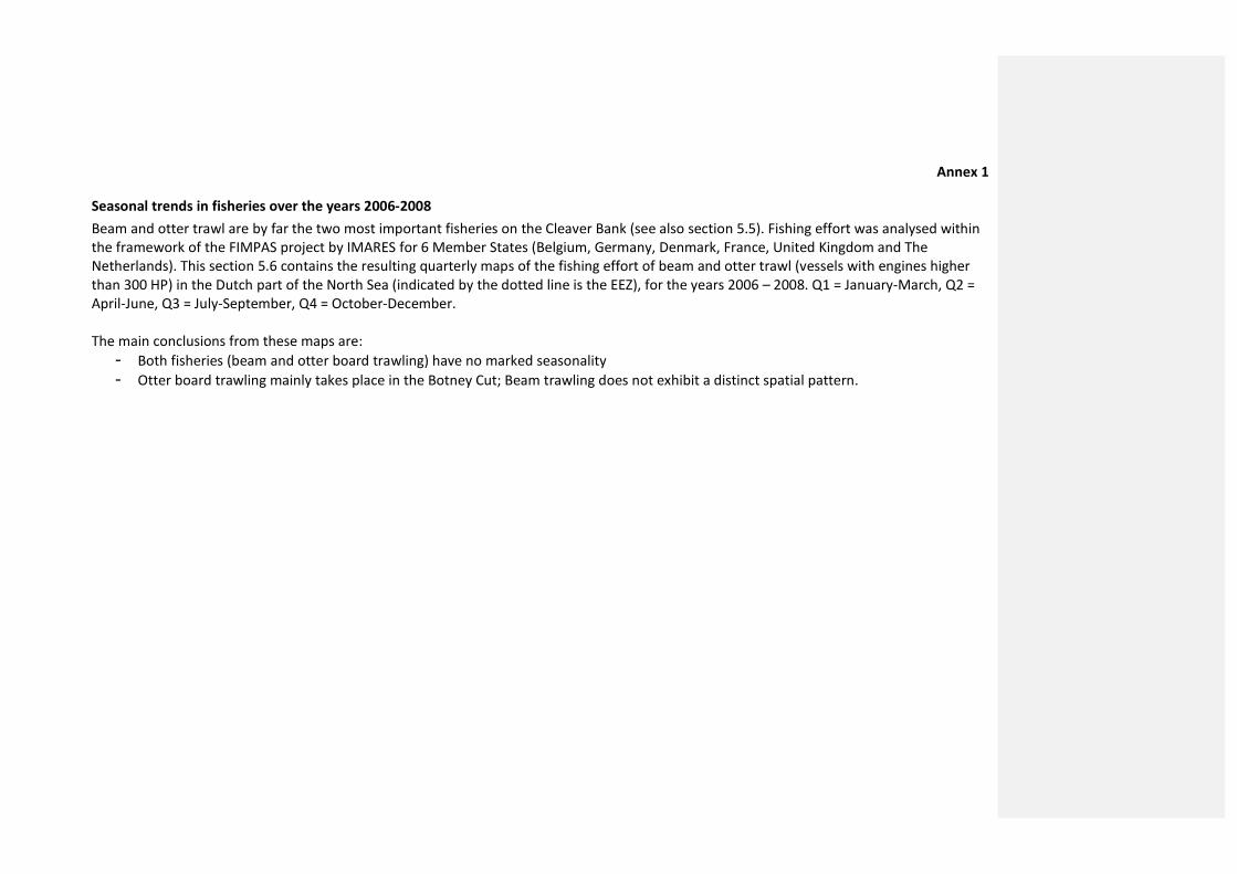
Annex 1
Seasonal trends in fisheries over the years 2006-2008
Beam and otter trawl are by far the two most important fisheries on the Cleaver Bank (see also section 5.5). Fishing effort was analysed within
the framework of the FIMPAS project by IMARES for 6 Member States (Belgium, Germany, Denmark, France, United Kingdom and The
Netherlands). This section 5.6 contains the resulting quarterly maps of the fishing effort of beam and otter trawl (vessels with engines higher
than 300 HP) in the Dutch part of the North Sea (indicated by the dotted line is the EEZ), for the years 2006 – 2008. Q1 = January-March, Q2 =
April-June, Q3 = July-September, Q4 = October-December.
The main conclusions from these maps are:
- Both fisheries (beam and otter board trawling) have no marked seasonality
- Otter board trawling mainly takes place in the Botney Cut; Beam trawling does not exhibit a distinct spatial pattern.
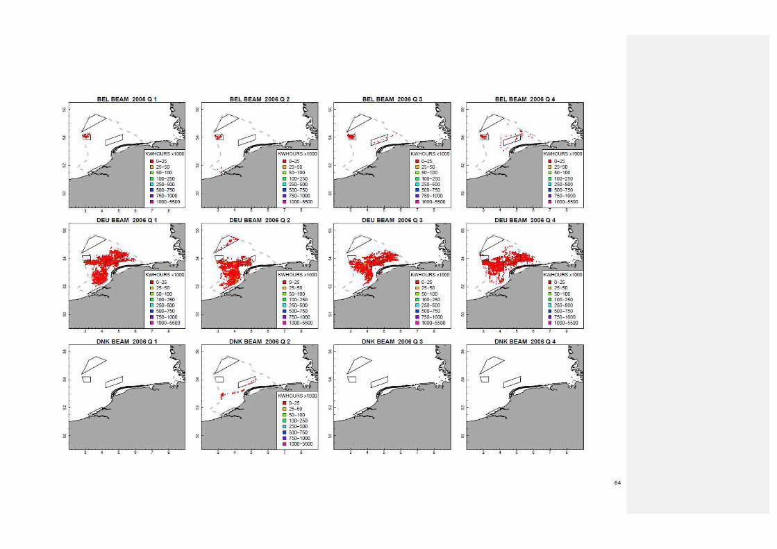
64
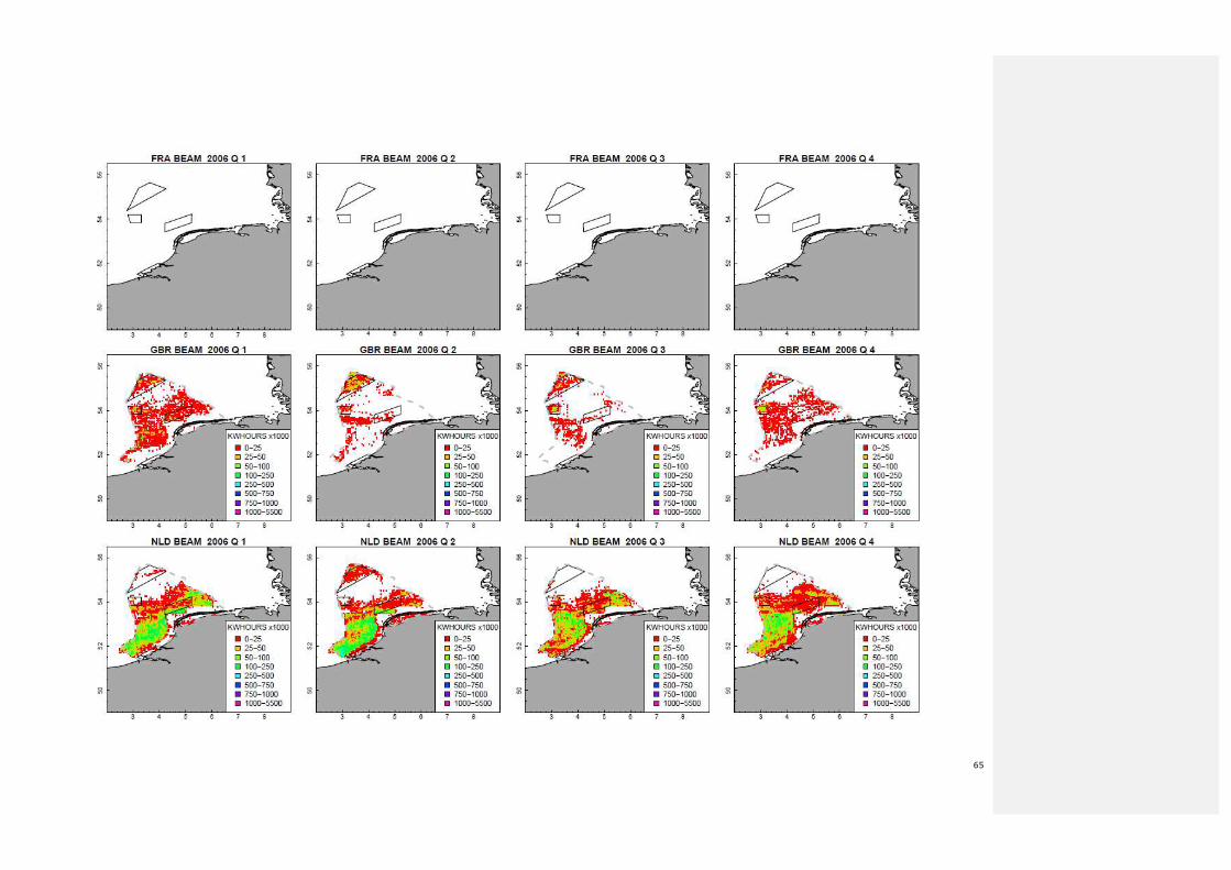
65
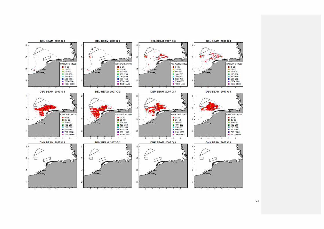
66
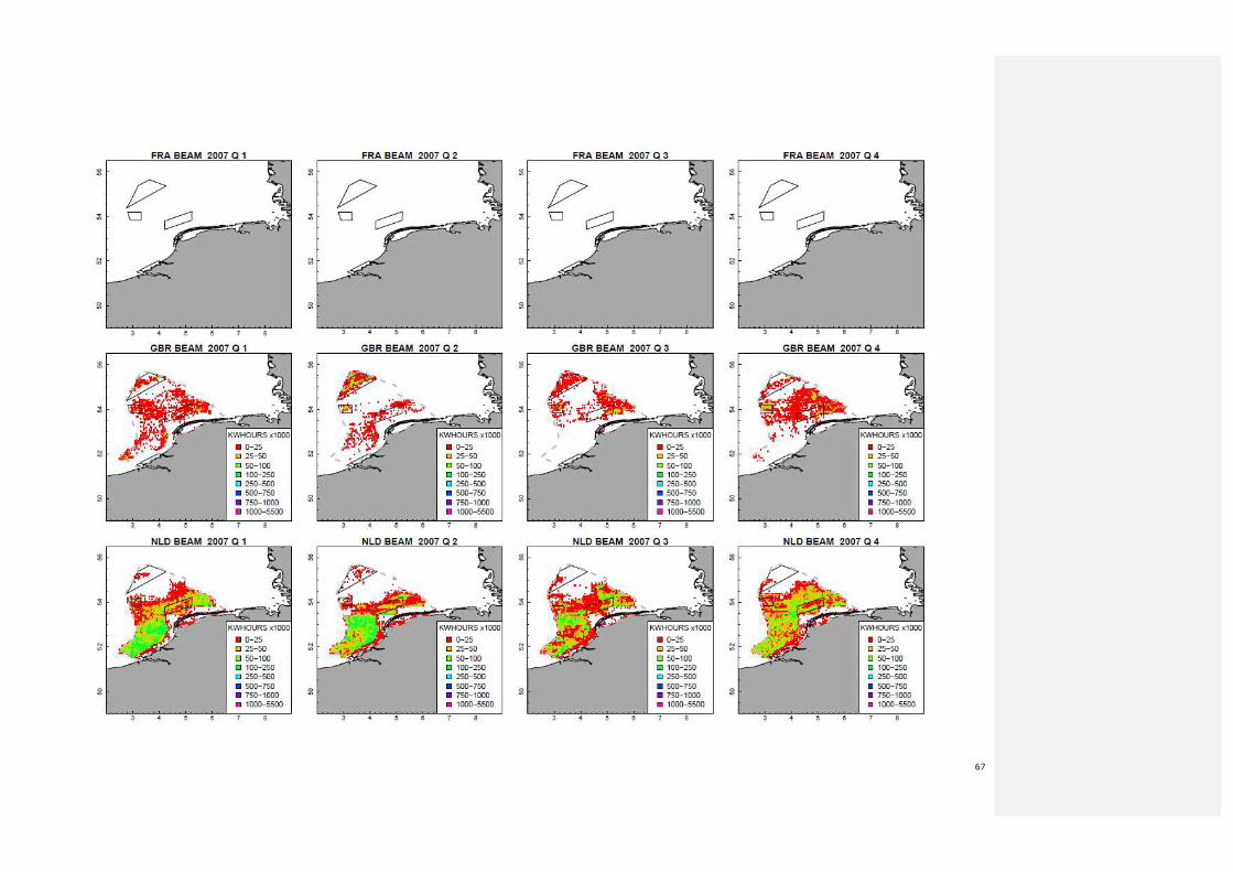
67
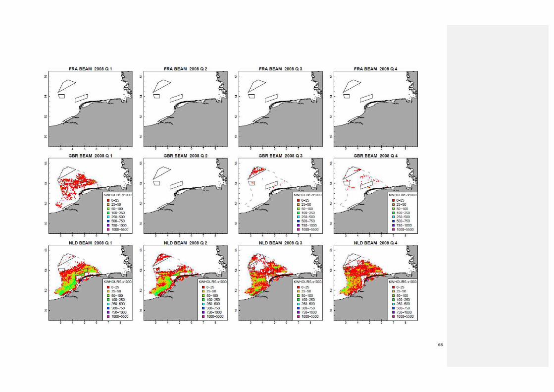
68

69

70

71

72
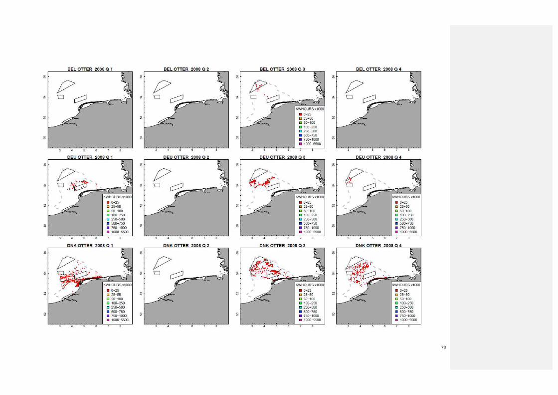
73
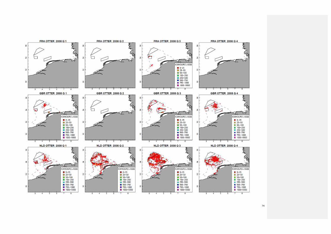
74


![DRAFT BACKGROUND DOCUMENT JOINT … · principles for developing measures at Frisian Front and Central Oyster Grounds have been defined [See paragraph 5.1]. Frisian Front and Central](https://img.pdfslide.net/doc/110x75/5d13a53088c993f1238bef06/draft-background-document-joint-principles-for-developing-measures-at-frisian.jpg)