Embed Size (px)
Citation preview
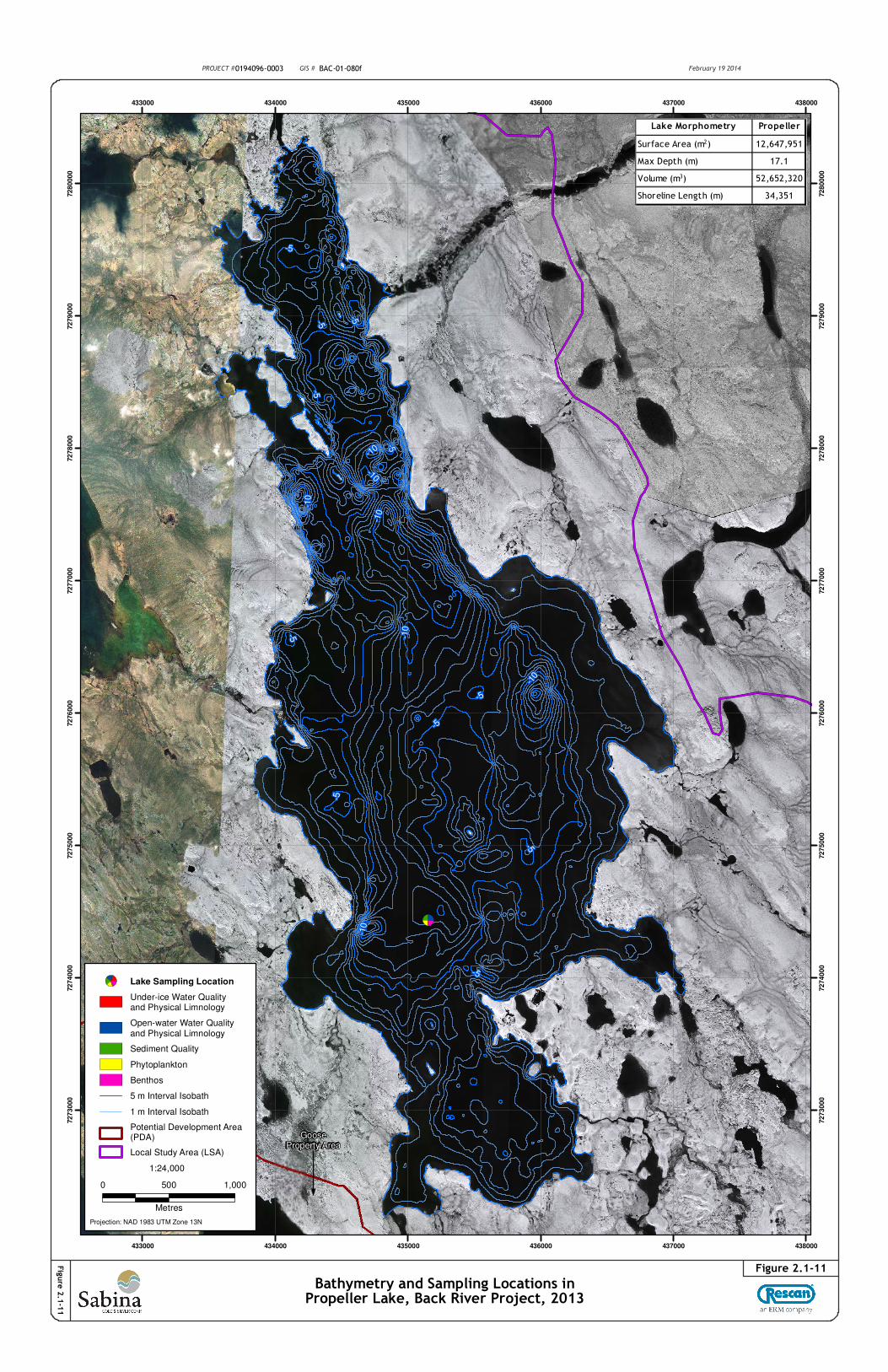
GooseProperty Area
-5
-10
-5
-10
-10
-5
-5
-5
-5
-10
-5
-5
-5
-10
-10
-5
-5
-10
433000
433000
434000
434000
435000
435000
436000
436000
437000
437000
438000
438000
72
73
00
0
72
73
00
0
72
74
00
0
72
74
00
0
72
75
00
0
72
75
00
0
72
76
00
0
72
76
00
0
72
77
00
0
72
77
00
0
72
78
00
0
72
78
00
0
72
79
00
0
72
79
00
0
72
80
00
0
72
80
00
0
PROJECT #0194096-0003 GIS # BAC-01-080f February 19 2014
Bathymetry and Sampling Locations inPropeller Lake, Back River Project, 2013
Figure 2.1-11
Fig
ure
2.1
-11
Projection: NAD 1983 UTM Zone 13N
1:24,000
0 500 1,000
Metres
Lake Sampling Location
Under-ice Water Qualityand Physical Limnology
Open-water Water Qualityand Physical Limnology
Sediment Quality
Phytoplankton
Benthos
5 m Interval Isobath
1 m Interval Isobath
Potential Development Area(PDA)
Local Study Area (LSA)
±Lake Morphometry Propeller
Surface Area (m2) 12,647,951
Max Depth (m) 17.1
Volume (m3) 52,652,320
Shoreline Length (m) 34,351
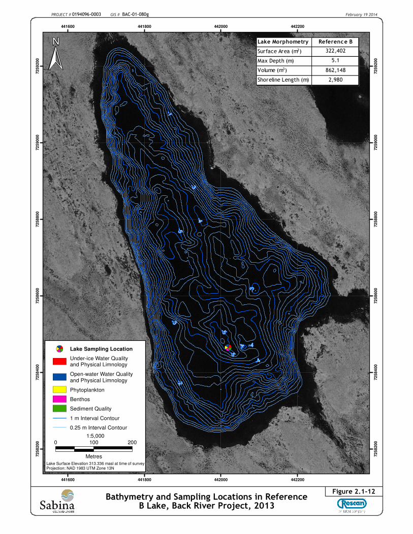
PROJECT # 0194096-0003 GIS # BAC-01-080g February 19 2014
Bathymetry and Sampling Locations in ReferenceB Lake, Back River Project, 2013
Figure 2.1-12
-1
-2
-3
-4
-5
-4
-3
-3-4
-5
-4
-5
441600
441600
441800
441800
442000
442000
442200
442200
72
58
20
0
72
58
20
0
72
58
40
0
72
58
40
0
72
58
60
0
72
58
60
0
72
58
80
0
72
58
80
0
72
59
00
0
72
59
00
0
72
59
20
0
72
59
20
0
1:5,000
0 100 200
Metres
Lake Surface Elevation 313.336 masl at time of surveyProjection: NAD 1983 UTM Zone 13N
±
Lake Sampling Location
Under-ice Water Qualityand Physical Limnology
Open-water Water Qualityand Physical Limnology
Phytoplankton
Benthos
Sediment Quality
1 m Interval Contour
0.25 m Interval Contour
Lake Morphometry Reference B
Surface Area (m2) 322,402
Max Depth (m) 5.1
Volume (m3) 862,148
Shoreline Length (m) 2,980
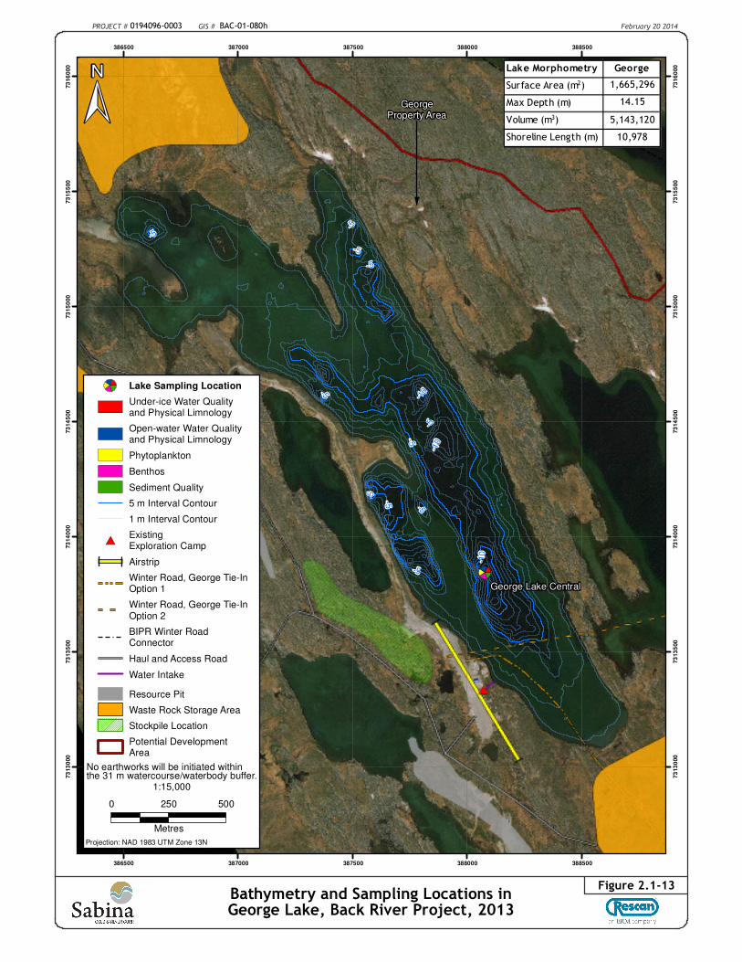
PROJECT # 0194096-0003 GIS # BAC-01-080h February 20 2014
Bathymetry and Sampling Locations inGeorge Lake, Back River Project, 2013
Figure 2.1-13
GeorgeProperty Area
-5
-10
-5
-5
-5
-5
-5
-5
-5
-5
-5
-5
-10
-10
George Lake Central
386500
386500
387000
387000
387500
387500
388000
388000
388500
388500
73
13
000
73
13
000
73
13
500
73
13
500
73
14
000
73
14
000
73
14
500
73
14
500
73
15
000
73
15
000
73
15
500
73
15
500
73
16
000
73
16
000
1:15,000
0 250 500
Metres
Projection: NAD 1983 UTM Zone 13N
±
Lake Sampling Location
Under-ice Water Qualityand Physical Limnology
Open-water Water Qualityand Physical Limnology
Phytoplankton
Benthos
Sediment Quality
5 m Interval Contour
1 m Interval Contour
#*ExistingExploration Camp
J
J Airstrip
Winter Road, George Tie-InOption 1
Winter Road, George Tie-InOption 2
BIPR Winter RoadConnector
Haul and Access Road
Water Intake
Resource Pit
Waste Rock Storage Area
Stockpile Location
Potential DevelopmentArea
Lake Morphometry George
Surface Area (m2) 1,665,296
Max Depth (m) 14.15
Volume (m3) 5,143,120
Shoreline Length (m) 10,978
No earthworks will be initiated withinthe 31 m watercourse/waterbody buffer.
!(
-5
-4-3
-2
-1
-4
-3
-2
-5
-4
-6
Bob (BM 1a)
387000
387000
387200
387200
387400
387400
387600
387600
387800
387800
73
13
80
0
73
13
80
0
73
14
00
0
73
14
00
0
73
14
20
0
73
14
20
0
73
14
40
0
73
14
40
0
73
14
60
0
73
14
60
0
Projection: NAD 1983 UTM Zone 13N
1:5,000
0 100 200
Metres
±
Lake Sampling Location
Under-ice Water Qualityand Physical Limnology
Open-water Water Qualityand Physical Limnology
Phytoplankton
Benthos
Sediment Quality
!( Benchmark
1 m Isobath Interval
Haul and Access Road
Resource Pit
Stockpile Location
PROJECT # 0194096-0003 GIS # BAC-01-080i February 19 2014
Bathymetry and Sampling Locations in BobLake, Back River Project, 2013
Figure 2.1-14
Water Surface Elevation - 340.882 mGeoid Model - Canada HT2_0
Lake Morphometry Bob
Surface Area (m2) 165,290
Max Depth (m) 6.2
Volume (m3) 325,280
Shoreline Length (m) 2,393
-1
-1
-1
-1
387200
387200
387400
387400
387600
387600
387800
387800
73
13
00
0
73
13
00
0
73
13
200
73
13
200
73
13
40
0
73
13
40
0
Projection: NAD 1983 UTM Zone 13N
Lake Sampling Location
Under-ice Water Quality andPhysical Limnology
Open-water Water Qualityand Physical Limnology
Phytoplankton
Benthos
Sediment Quality
1 m Interval Contour
0.2 m Interval Contour
J
J Airstrip
Winter Road, George Tie-InOption 2
Haul and Access Road
Resource Pit
Stockpile Location
1:3,750
±
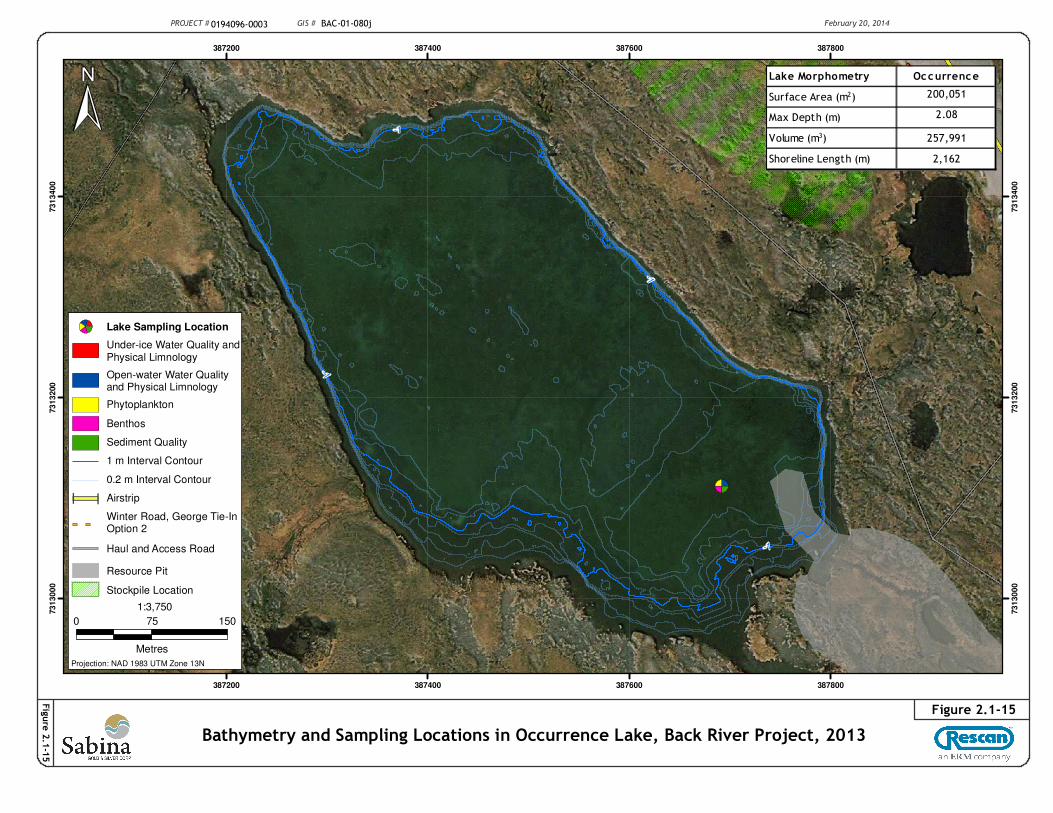
PROJECT # 0194096-0003 GIS # BAC-01-080j February 20, 2014
Figure 2.1-15
Bathymetry and Sampling Locations in Occurrence Lake, Back River Project, 2013
Fig
ure
2.1
-15
0 75 150
Metres
Lake Morphometry Occurrence
Surface Area (m2) 200,051
Max Depth (m) 2.08
Volume (m3) 257,991
Shoreline Length (m) 2,162