Embed Size (px)
Citation preview
Being an Expert Witness:
The Surveyor in Court
~ ~ ~
New York State Association ~of~
Professional Land Surveyors
Rochester, New York
Presented by
Gary R. Kent, L.S.
The Schneider Corporation
January 22, 2014

Program Agenda
I. Why Surveyors end up in court
II. Strategies and tactics for avoiding claims
A. Contracts
B. Communication and Documentation
C. Managing additional services and accounts receivables
III. The Role of the Surveyor
A. Expert or Consulting Witness
1. Types of Cases
2. Purpose for an Expert
3. Rules of Evidence and Civil Procedure
i. New York Rules of Evidence
ii. Federal Rules of Evidence
iii. New York Rules of Civil Procedure
iv. Federal Rules of Civil Procedure
4. Before Agreeing to be an Expert
5. Retention of Experts
i. How Attorneys Choose Experts
ii. Good Practices upon being Retained
6. Important Things to Remember
7. Formulating your Opinion
8. Challenges to Experts
9. Expert Reports
10. Depositions
i. Purpose
ii. Hints
iii. Typical Topics
iv. Other Questions
B. Example Expert Report
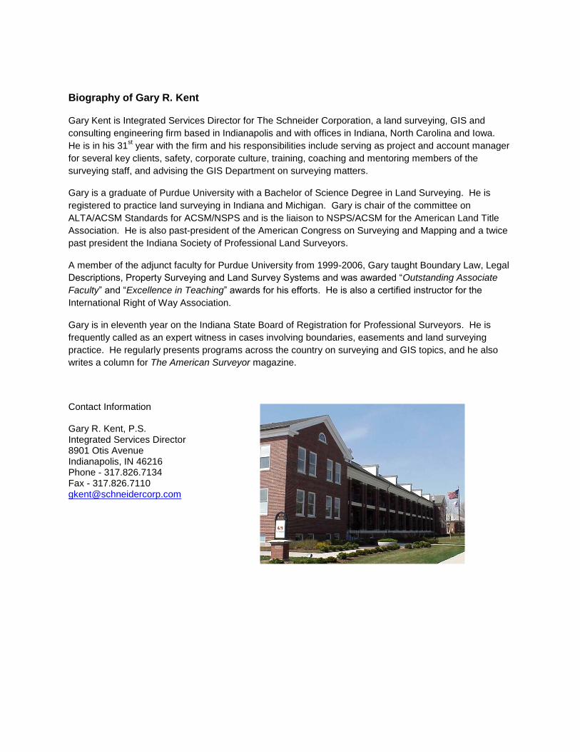
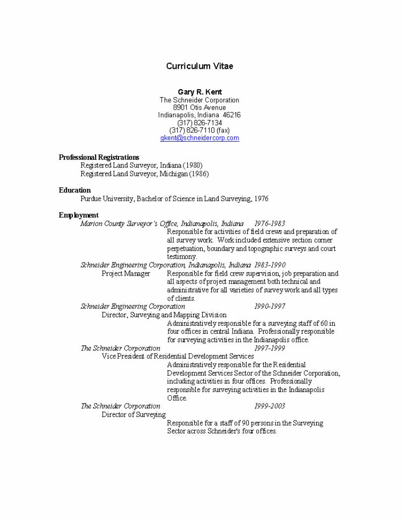
Biography of Gary R. Kent
Gary Kent is Integrated Services Director for The Schneider Corporation, a land surveying, GIS and
consulting engineering firm based in Indianapolis and with offices in Indiana, North Carolina and Iowa.
He is in his 31st year with the firm and his responsibilities include serving as project and account manager
for several key clients, safety, corporate culture, training, coaching and mentoring members of the
surveying staff, and advising the GIS Department on surveying matters.
Gary is a graduate of Purdue University with a Bachelor of Science Degree in Land Surveying. He is
registered to practice land surveying in Indiana and Michigan. Gary is chair of the committee on
ALTA/ACSM Standards for ACSM/NSPS and is the liaison to NSPS/ACSM for the American Land Title
Association. He is also past-president of the American Congress on Surveying and Mapping and a twice
past president the Indiana Society of Professional Land Surveyors.
A member of the adjunct faculty for Purdue University from 1999-2006, Gary taught Boundary Law, Legal
Descriptions, Property Surveying and Land Survey Systems and was awarded “Outstanding Associate
Faculty” and “Excellence in Teaching” awards for his efforts. He is also a certified instructor for the
International Right of Way Association.
Gary is in eleventh year on the Indiana State Board of Registration for Professional Surveyors. He is
frequently called as an expert witness in cases involving boundaries, easements and land surveying
practice. He regularly presents programs across the country on surveying and GIS topics, and he also
writes a column for The American Surveyor magazine.
Contact Information
Gary R. Kent, P.S. Integrated Services Director 8901 Otis Avenue Indianapolis, IN 46216 Phone - 317.826.7134 Fax - 317.826.7110 [email protected]

Boundary/Surveyor-related Litigation and Disputes Boundaries may end up in court for a wide variety of reasons. There may be a claim against a
surveyor for negligence related to a survey that either the client is simply not happy with or that
resulted in other litigation (i.e., with a neighbor). Forensic surveys are conducted for a variety of
reasons like accidents or specifically for purposes of retracing a boundary line. Surveys are also
conducted to support litigation – perhaps a suit to quiet title, for ejectment, to support a claim of
adverse possession or as related to a title claim. They may also be performed as part of a
partition action.
When the surveyor is hired to assist in litigation, the exact relationship between the surveyor, the
client, the attorney, and potentially even the court, must be well-understood. If working for a
client and not the court, the contract may be with the attorney to protect the surveyor’s work
from the discovery process. The surveyor should ask the attorney about the desired method and
documentation of any communications.
It is also critically important that surveyors understand these relationships for other reasons.
Unlike attorneys, who are, by law, advocates for their clients, surveyors cannot serve in that role
in the same sense. When it comes to performing surveys, surveyors are advocates for their
opinions, not for their clients. Otherwise, surveyors would simply ask their clients where they
would like the boundary to be located! If that were the case, the surveyor will lose all credibility
because there is be no appearance of the surveyor’s work being free from inappropriate influence
on the part of the client or his or her attorney.
The various states have statutes regarding procedures for litigating complaints against
professionals and for litigating boundaries and boundary-related disputes.
Avoiding Claims
Professional liability insurance managers report that most claims can be avoided of seriously
mitigated by:
Better (or any!) communication
Better documentation
Having a written contract
Carefully managing additional services
Keeping your accounts receivables current
Picking your clients carefully
The Victor O. Schinnerer Company and NSPS (formerly ACSM)1 have a Contracts Manual
available for purchase for a nominal fee. It contains a litany of suggestions regarding the use of
contracts and desirable contract wording.
1 http://www.nsps.us.com/index.cfm?fuseaction=Store.viewCat
Rules of Evidence (selected sections) - New York2
Rule 4515. Form of expert opinion. Unless the court orders otherwise, questions calling for the
opinion of an expert witness need not be hypothetical in form, and the witness may state his
opinion and reasons without first specifying the data upon which it is based. Upon cross-
examination, he may be required to specify the data and other criteria supporting the opinion.
Rule 4522. Ancient filed maps, surveys and records affecting real property. All maps,
surveys and official records affecting real property, which have been on file in the state in
the office of the register of any county, any county clerk, any court of record or any
department of the city of New York for more than ten years, are prima facie evidence of their
contents.
Rule 4523. Search by title insurance or abstract company. A search affecting real property,
when made and certified to by a title insurance, abstract or searching company, organized
under the laws of this state, may be used in place of, and with the same legal effect as, an
official search.
Rule 4534. Standard of measurement used by surveyor. An official certificate of any state,
county, city, village or town sealer elected or appointed pursuant to the laws of the state, or the
statement under oath of a surveyor, that the chain or measure used by him conformed to the
state standard at the time a survey was made is prima facie evidence of conformity, and an
official certificate made by any sealer that the implement used in measuring such chain or other
measure was the one provided the sealer pursuant to the provisions of the laws of the state is
prima facie evidence of that fact.
Federal Rules of Evidence3
Rule 702. Testimony by Expert Witnesses
A witness who is qualified as an expert by knowledge, skill, experience, training, or education
may testify in the form of an opinion or otherwise if:
(a) the expert’s scientific, technical, or other specialized knowledge will help the trier of fact to
understand the evidence or to determine a fact in issue;
(b) the testimony is based on sufficient facts or data;
(c) the testimony is the product of reliable principles and methods; and
(d) the expert has reliably applied the principles and methods to the facts of the case.
Rule 703. Bases of an Expert’s Opinion Testimony
An expert may base an opinion on facts or data in the case that the expert has been made aware
of or personally observed. If experts in the particular field would reasonably rely on those kinds
of facts or data in forming an opinion on the subject, they need not be admissible for the opinion
to be admitted. But if the facts or data would otherwise be inadmissible, the proponent of the
opinion may disclose them to the jury only if their probative value in helping the jury evaluate
the opinion substantially outweighs their prejudicial effect.
2 Laws of New York, Civil Practice Laws and Rules, Article 45 (Evidence)
3 www.federalevidence.com/downloads/rules.of.evidence.pdf

Rule 704. Opinion on an Ultimate Issue
(a) In General — Not Automatically Objectionable. An opinion is not objectionable just because
it embraces an ultimate issue.
(b) Exception. In a criminal case, an expert witness must not state an opinion about whether the
defendant did or did not have a mental state or condition that constitutes an element of the crime
charged or of a defense. Those matters are for the trier of fact alone.
Rule 705. Disclosing the Facts or Data Underlying an Expert’s Opinion
Unless the court orders otherwise, an expert may state an opinion — and give the reasons for it
— without first testifying to the underlying facts or data. But the expert may be required to
disclose those facts or data on cross-examination.
Rule 706. Court-Appointed Expert Witnesses
(a) Appointment Process. On a party’s motion or on its own, the court may order the parties to
show cause why expert witnesses should not be appointed and may ask the parties to submit
nominations. The court may appoint any expert that the parties agree on and any of its own
choosing. But the court may only appoint someone who consents to act.
(b) Expert’s Role. The court must inform the expert of the expert’s duties. The court may do so
in writing and have a copy filed with the clerk or may do so orally at a conference in which the
parties have an opportunity to participate. The expert:
(1) must advise the parties of any findings the expert makes;
(2) may be deposed by any party;
(3) may be called to testify by the court or any party; and
(4) may be cross-examined by any party, including the party that called the expert.
(c) Compensation. The expert is entitled to a reasonable compensation, as set by the court. The
compensation is payable as follows:
(1) in a criminal case or in a civil case involving just compensation under the Fifth
Amendment, from any funds that are provided by law; and
(2) in any other civil case, by the parties in the proportion and at the time that the court
direct — and the compensation is then charged like other costs
(d) Disclosing the Appointment to the Jury. The court may authorize disclosure to the jury that
the court appointed the expert.
(e) Parties’ Choice of Their Own Experts. This rule does not limit a party in calling its own
experts.
Rules of Civil Procedure (selected sections) – New York4
§ 3101. Scope of disclosure. (a) Generally. There shall be full disclosure of all matter
material and necessary in the prosecution or defense of an action, regardless of the burden of
proof, by:
(1) a party, or the officer, director, member, agent or employee of a party;
(2) a person who possessed a cause of action or defense asserted in the action;
4 Laws of New York, Civil Practice Laws and Rules, Article 31 (Disclosure)
(3) a person about to depart from the state, or without the state, or residing at a greater
distance from the place of trial than one hundred miles, or so sick or infirm as to afford
reasonable grounds of belief that he or she will not be able to attend the trial, or a person
authorized to practice medicine, dentistry or podiatry who has provided medical, dental or
podiatric care or diagnosis to the party demanding disclosure, or who has been retained by such
party as an expert witness; and
(4) any other person, upon notice stating the circumstances or reasons such disclosure is
sought or required.
(b) Privileged matter. Upon objection by a person entitled to assert the privilege, privileged
matter shall not be obtainable.
(c) Attorney's work product. The work product of an attorney shall not be obtainable.
(d) Trial preparation.
1. Experts. (i) Upon request, each party shall identify each person whom the party expects
to call as an expert witness at trial and shall disclose in reasonable detail the subject matter on
which each expert is expected to testify, the substance of the facts and opinions on which each
expert is expected to testify, the qualifications of each expert witness and a summary of the
grounds for each expert's opinion. However, where a party for good cause shown retains an
expert an insufficient period of time before the commencement of trial to give appropriate
notice thereof, the party shall not thereupon be precluded from introducing the expert's
testimony at the trial solely on grounds of noncompliance with this paragraph. In that instance,
upon motion of any party, made before or at trial, or on its own initiative, the court may make
whatever order may be just. In an action for medical, dental or podiatric malpractice, a party,
in responding to a request, may omit the names of medical, dental or podiatric experts but shall
be required to disclose all other information concerning such experts otherwise required by
this paragraph.
* * *
(iii) Further disclosure concerning the expected testimony of any expert may be obtained
only by court order upon a showing of special circumstances and subject to restrictions as to
scope and provisions concerning fees and expenses as the court may deem appropriate.
However, a party, without court order, may take the testimony of a person authorized to
practice medicine, dentistry or podiatry who is the party's treating or retained expert, as
described in paragraph three of subdivision (a) of this section, in which event any other party
shall be entitled to the full disclosure authorized by this article with respect to that expert
without court order.
* * *
2. Materials. Subject to the provisions of paragraph one of this subdivision, materials
otherwise discoverable under subdivision (a) of this section and prepared in anticipation of
litigation or for trial by or for another party, or by or for that other party's representative
(including an attorney, consultant, surety, indemnitor, insurer or agent), may be obtained
only upon a showing that the party seeking discovery has substantial need of the materials
in the preparation of the case and is unable without undue hardship to obtain the substantial
equivalent of the materials by other means. In ordering discovery of the materials when the
required showing has been made, the court shall protect against disclosure of the mental
impressions, conclusions, opinions or legal theories of an attorney or other representative of a
party concerning the litigation.
(e) Party's statement. A party may obtain a copy of his own statement.

(f) Contents of insurance agreement. A party may obtain discovery of the existence and
contents of any insurance agreement under which any person carrying on an insurance business
may be liable to satisfy part or all of a judgment which may be entered in the action or to
indemnify or reimburse for payments made to satisfy the judgment. Information concerning
the insurance agreement is not by reason of disclosure admissible in evidence at trial. For
purpose of this subdivision, an application for insurance shall not be treated as part of an
insurance agreement.
* * *
(i) In addition to any other matter which may be subject to disclosure, there shall be
full disclosure of any films, photographs, video tapes or audio tapes, including transcripts or
memoranda thereof, involving a person referred to in paragraph one of subdivision (a) of this
section. There shall be disclosure of all portions of such material, including out-takes,
rather than only those portions a party intends to use. The provisions of this subdivision shall
not apply to materials compiled for law enforcement purposes which are exempt from
disclosure under section eighty-seven of the public officers law.
§ 3102. Method of obtaining disclosure.
(a) Disclosure devices. Information is obtainable by one or more of the following
disclosure devices: depositions upon oral questions or without the state upon written
questions, interrogatories, demands for addresses, discovery and inspection of documents or
property, physical and mental examinations of persons, and requests for admission.
(b) Stipulation or notice normal method. Unless otherwise provided by the civil practice law
and rules or by the court, disclosure shall be obtained by stipulation or on notice without leave of
the court.
(c) Before action commenced. Before an action is commenced, disclosure to aid in bringing an
action, to preserve information or to aid in arbitration, may be obtained, but only by court
order. The court may appoint a referee to take testimony.
(d) After trial commenced. Except as provided in section 5223, during and after trial,
disclosure may be obtained only by order of the trial court on notice.
(e) Action pending in another jurisdiction. Except as provided in section three thousand
one hundred nineteen of this article, when under any mandate, writ or commission issued out of
any court of record in any other state, territory, district or foreign jurisdiction, or whenever
upon notice or agreement, it is required to take the testimony of a witness in the state, he or
she may be compelled to appear and testify in the same manner and by the same process as
may be employed for the purpose of taking testimony in actions pending in the state. The
supreme court or a county court shall make any appropriate order in aid of taking such a
deposition.
(f) Action to which state is party. In an action in which the state is properly a party, whether
as plaintiff, defendant or otherwise, disclosure by the state shall be available as if the state
were a private person.
§ 3131. Scope of interrogatories. Interrogatories may relate to any matters embraced in the
disclosure requirement of section 3101 and the answers may be used to the same extent as the
depositions of a party. Interrogatories may require copies of such papers, documents or
photographs as are relevant to the answers required, unless opportunity for this examination and
copying be afforded.
Federal Rules of Civil Procedure5 Rule 26. Duty to Disclose; General Provisions Governing Discovery6
(a) Required Disclosures.
(1) Initial Disclosure.
(A) In General. Except as exempted by Rule 26(a)(1)(B) or as otherwise stipulated or
ordered by the court, a party must, without awaiting a discovery request, provide to the other
parties:
(i) the name and, if known, the address and telephone number of each individual likely
to have discoverable information—along with the subjects of that information—that the
disclosing party may use to support its claims or defenses, unless the use would be solely
for impeachment;
(ii) a copy—or a description by category and location—of all documents,
electronically stored information, and tangible things that the disclosing party has in its
possession, custody, or control and may use to support its claims or defenses, unless the
use would be solely for impeachment;
(iii) a computation of each category of damages claimed by the disclosing party—who
must also make available for inspection and copying as under Rule 34 the documents or
other evidentiary material, unless privileged or protected from disclosure, on which each
computation is based, including materials bearing on the nature and extent of injuries
suffered; and
(iv) for inspection and copying as under Rule 34, any insurance agreement under
which an insurance business may be liable to satisfy all or part of a possible judgment in
the action or to indemnify or reimburse for payments made to satisfy the judgment.
(B) Proceedings Exempt from Initial Disclosure. The following proceedings are exempt
from initial disclosure:
(i) an action for review on an administrative record;
(ii) a forfeiture action in rem arising from a federal statute;
(iii) a petition for habeas corpus or any other proceeding to challenge a criminal
conviction or sentence;
(iv) an action brought without an attorney by a person in the custody of the United
States, a state, or a state subdivision;
(v) an action to enforce or quash an administrative summons or subpoena;
(vi) an action by the United States to recover benefit payments;
(vii) an action by the United States to collect on a student loan guaranteed by the
United States;
(viii) a proceeding ancillary to a proceeding in another court; and
(ix) an action to enforce an arbitration award.
(C) Time for Initial Disclosures—In General. A party must make the initial disclosures at
or within 14 days after the parties’ Rule 26(f) conference unless a different time is set by
stipulation or court order, or unless a party objects during the conference that initial
disclosures are not appropriate in this action and states the objection in the proposed
5 www.utd.uscourts.gov/forms/civil2010.pdf (As amended December 1, 2010)
6 As amended December 1, 2010

discovery plan. In ruling on the objection, the court must determine what disclosures, if any,
are to be made and must set the time for disclosure.
(D) Time for Initial Disclosures—For Parties Served or Joined Later. A party that is first
served or otherwise joined after the Rule 26(f) conference must make the initial disclosures
within 30 days after being served or joined, unless a different time is set by stipulation or
court order.
(E) Basis for Initial Disclosure; Unacceptable Excuses. A party must make its initial
disclosures based on the information then reasonably available to it. A party is not excused
from making its disclosures because it has not fully investigated the case or because it
challenges the sufficiency of another party's disclosures or because another party has not
made its disclosures.
(2) Disclosure of Expert Testimony.
(A) In General. In addition to the disclosures required by Rule 26(a)(1), a party must
disclose to the other parties the identity of any witness it may use at trial to present evidence
under Federal Rule of Evidence 702, 703, or 705.
(B) Witnesses Who Must Provide a Written Report. Unless otherwise stipulated or
ordered by the court, this disclosure must be accompanied by a written report — prepared
and signed by the witness — if the witness is one retained or specially employed to provide
expert testimony in the case or one whose duties as the party’s employee regularly involve
giving expert testimony. The report must contain:
(i) a complete statement of all opinions the witness will express and the basis and
reasons for them;
(ii) the facts or data considered by the witness in forming them;
(iii) any exhibits that will be used to summarize or support them;
(iv) the witness’s qualifications, including a list of all publications authored in the
previous 10 years;
(v) a list of all other cases in which, during the previous 4 years, the witness testified
as an expert at trial or by deposition; and
(vi) a statement of the compensation to be paid for the study and testimony in the
case.
* * * * *
(D) Time to Disclose Expert Testimony. A party must make these disclosures at the times
and in the sequence that the court orders. Absent a stipulation or a court order, the
disclosures must be made:
(i) at least 90 days before the date set for trial or for the case to be ready for trial; or
(ii) if the evidence is intended solely to contradict or rebut evidence on the same
subject matter identified by another party under Rule 26(a)(2)(B) or (C), within 30
days after the other party’s disclosure.
(E) Supplementing the Disclosure. The parties must supplement these disclosures when
required under Rule 26(e).
(b) Discovery Scope and Limits.
* * * * *
(3) Trial Preparation: Materials.
(A) Documents and Tangible Things. Ordinarily, a party may not discover documents and
tangible things that are prepared in anticipation of litigation or for trial by or for another
party or its representative (including the other party’s attorney, consultant, surety,

indemnitor, insurer, or agent). But, subject to Rule 26(b)(4), those materials may be
discovered if:
(i) they are otherwise discoverable under Rule 26(b)(1); and
(ii) the party shows that it has substantial need for the materials to prepare its case and
cannot, without undue hardship, obtain their substantial equivalent by other means.
(B) Protection Against Disclosure. If the court orders discovery of those materials, it
must protect against disclosure of the mental impressions, conclusions, opinions, or legal
theories of a party’s attorney or other representative concerning the litigation.
(C) Previous Statement. Any party or other person may, on request and without the
required showing, obtain the person’s own previous statement about the action or its
subject matter. If the request is refused, the person may move for a court order, and Rule
37(a)(5) applies to the award of expenses. A previous statement is either:
(i) a written statement that the person has signed or otherwise adopted or approved; or
(ii) a contemporaneous stenographic, mechanical, electrical, or other recording — or
a transcription of it — that recites substantially verbatim the person’s oral statement.
(4) Trial Preparation: Experts.
(A) Deposition of an Expert Who May Testify. A party may depose any person who has
been identified as an expert whose opinions may be presented at trial. If Rule 26(a)(2)(B)
requires a report from the expert, the deposition may be conducted only after the report is
provided.
(B) Trial-Preparation Protection for Draft Reports or Disclosures. Rules 26(b)(3)(A) and
(B) protect drafts of any report or disclosure required under Rule 26(a)(2), regardless of
the form in which the draft is recorded.
(C) Trial-Preparation Protection for Communications Between a Party’s Attorney and
Expert Witnesses. Rules 26(b)(3)(A) and (B) protect communications between the party’s
attorney and any witness required to provide a report under Rule 26(a)(2)(B), regardless
of the form of the communications, except to the extent that the communications:
(i) relate to compensation for the expert’s study or testimony;
(ii) identify facts or data that the party’s attorney provided and that the expert
considered in forming the opinions to be expressed; or
(iii) identify assumptions that the party’s attorney provided and that the expert relied
on in forming the opinions to be expressed.
(D) Expert Employed Only for Trial Preparation.
Ordinarily, a party may not, by interrogatories or deposition, discover facts known or
opinions held by an expert who has been retained or specially employed by another
party in anticipation of litigation or to prepare for trial and who is not expected to be
called as a witness at trial. But a party may do so only:
(i) as provided in Rule 35(b); or
(ii) on showing exceptional circumstances under which it is impracticable for the
party to obtain facts or opinions on the same subject by other means.
(E) Payment. Unless manifest injustice would result, the court must require that the party
seeking discovery:
(i) pay the expert a reasonable fee for time spent in responding to discovery under
Rule 26(b)(4)(A) or (D); and

(ii) for discovery under (D), also pay the other party a fair portion of the fees and
expenses it reasonably obtaining the expert’s opinions.
Comments on Being an Expert Witness
When first contacted by an attorney or potential client regarding your engagement as a consultant
or expert witness, the surveyor must review the details of the case and decide if he or she can
provide benefit to that side of the case. Caution should be taken before accepting an assignment
- all of the facts must be available in order that initial impressions can be formed. If an Attorney
or client wants to argue with the surveyor over his or her initial feelings, the surveyor should
listen carefully - the comments may offer some clarity about the case that was not otherwise
understood or grasped – but an otherwise solid impression should not be swayed by arguments
that are contrary to the surveyor’s opinion. Both the surveyor and the client will regret it later if
it turns out that the surveyor was talked you into a situation that was not fully supported.
Once the surveyor has accepted the assignment, he or she needs to know immediately who the
client will be. Normally it will not be the plaintiff or defendant; it will be their attorney in order
to potentially protect your communications from discovery. As part of that, the surveyor also
needs to have a clear understanding of how the attorney wants to communicate. Typically, they
will not want unbridled communications via email, letter or even voice mail due to the possibility
of discovery.
Most importantly, as an expert witness, surveyors must remember that they are advocates for
their opinions, not for their clients. This is a critical issue that the attorney should understand,
but that the ultimate client may not. Surveyors cannot shape or fashion their opinions simply to
agree with their client’s claim.
Most attorneys find expert witnesses based on word-of-mouth recommendations or referrals
from colleagues and acquaintances, not from published lists of supposed experts. They are not
interested in “professional” expert witnesses, who may give the impression of simply being a
“hired gun,” although they would like someone who has experience in the courtroom.
The first thing that the attorney will want is a copy of the surveyor’s Curriculum Vitae. A CV is
a far more comprehensive substitute for the traditional résumé and is used most often in
academic circles, and in medical and other professional fields. A CV details education to a
greater extent than a normal résumé and typically includes a comprehensive professional history
of every place of employment, academic credential, publication, contribution or significant
achievement. When used in conjunction with being considered as an expert witness, it should
also include information on past cases that the professional was involved in.
Initial steps in the process of being hired as an expert witness should include detailing the terms
of the engagement in a contract and starting a file that will include correspondence, billing
information, documents upon which the surveyor relied in forming his or her opinion, and the
surveyor’s own work products and expert report.
How communications with the attorney will be made must be clearly agreed upon and
understood at the onset.
A surveyor’s expert opinion must be solidly based on justifiable, defensible principles that can,
preferably, be cited in authoritative sources. Citations should be carefully documented and
provided. The opinion should be reviewed thoroughly with the attorney prior to finalizing it to
be sure it is understandable to the court and attorneys. Whether in an expert report or in
testimony, the surveyor must find a way to convey complicated or confusing facts, evidence
and/or principles in a way that can be readily understood by a judge or jury. That is why the
surveyor is hired as an expert – not to leave the court amazed at how much he or she knows yet
totally confused over what the testimony was or what the report said.
A surveyor’s opinion can be challenged under the rules of evidence and the surveyor and
attorney must work together to make sure what is written or said is as iron clad as it can be and
as well-supported as possible.
Depositions
The key point when an expert is giving a deposition is to recognize that the other side is not
going through the exercise to learn what the expert’s opinion is. They already know – by virtue
of the discovery process and the expert report that was submitted – what their opinion is. The
deposition is almost purely for purposes such as probing the witness for weaknesses in his or her
arguments, confirming what the other side already thinks they know, testing the witness’s
credibility under fire, seeing if there is anything substantively faulty in the reasoning or seeing
how well the witness will appear in court.
Depositions are similar to testifying in court - there is a court reporter documenting the
proceeding - but without the judge being present. Also, witnesses must to the extent that they
can, answer every question even if their attorney objects to it.
Questions may revolve around whether or not the witness has ever issued a contrary opinion and
under what circumstances, if this is the witnesses “final” opinion, if anything could change that
opinion, and what was the basis for the opinion.
Depositions are very important in the legal process; witnesses do not want to find themselves
testifying in court later on contradicting something they said in a deposition.
Summary of Investigation and Opinion
James C. White’s Fourth Addition to the Town of Kewanee
Summary of Question
The issue to be investigated in this case is the difference of opinion between Plumb Bob
Surveying LLC (Robert Hammer, PS) (hereinafter referred to as “Hammer”) and Golden Surveys,
Inc. (Simon Meridian, PS) (hereinafter referred to as “Meridian”) as to the location of the
common line between Lots 1 and 2 (on the west) and Lot 14 (on the east), all in James C.
White’s Fourth Addition to the Town of Kewanee.
Summary of Opinion
As a result of the investigation and analysis further described in this report, it is my opinion that
the methodology used by Hammer results in the correct conclusion – it is the more logical and
substantiated boundary location between Lots 1 and 2, and Lot 14.
Detail of Question
The east-west difference in the two surveys is approximately 36.4 feet at the southwest corner
of Lot 14, with the Meridian location falling east of and overlapping the location established by
Hammer.
The primary root cause of these differing opinions is whether the platted 330 foot length along
the south line of Lot 1 was laid out originally in 1874 from the centerline of what is now Main
Street, or whether it was measured from the east right of way line of Main Street.
Two other secondary issues related to the east-west location of the common line are the
direction of the dividing line between lots 1 and 2, and Lot 14, and the location of Main Street.
Meridian and Hammer disagreed on these two issues also; however, the difference between
the two surveys (33 of the 36 feet) is almost entirely related to the root issue.
There is also an approximately 6 foot difference in a north-south direction (with the Meridian
location falling south of the Hammer line); however, this is not an issue with respect to the
common line between Lots 1 and 2, and Lot 14, and other than this mention, it is specifically
not addressed as a part of this opinion.
The calculated east-west difference in the location of the common corner of Lots 1 and 14 that
would result from the primary root question is slightly less than 33 feet. The additional +/-3
foot difference of opinion between the surveyors results from the secondary issues mentioned
above (the direction of the dividing line and the location of Main Street). Meridian’s opinion

places Main Street about 3 feet east of Hammer’s opinion (as measured perpendicular to the
street).
The theory of location applied by Hammer was, in my opinion and stated in a formal sense,
based on monuments by common report (defined below). The monuments that were
recovered7 were found to agree well with each other, with the adjoining properties, with lines
of possession and, most importantly with respect to the primary question in this situation, with
holding the centerline of Main Street as the west end of the 330 foot distance.
The order of importance of monuments found within a subdivision is as follows (Brown’s
Boundary Control and Legal Principles, 6th Edition by Curtis Brown, Walter Robillard and
Donald Wilson):
1. Original Natural Monuments
2. Original Artificial Monuments set within the subdivision
3. Original Monuments correctly set to mark the perimeter of the subdivision
4. Uncalled-for monuments8 may control by “common report”
5. Improvements9 built soon after the original stakes were set, which are in agreement
with each other and long-acquiesced to by adjoiners
6. When two monuments, otherwise equal are in conflict, the one in harmony with
distance, angle or area will control
7. Judicial decisions affecting that particular subdivision
In Hammer’s Surveyors Report, it is reported that the plat shows no monuments set at the time
of platting. In my review, I found no such monuments either. Thus Items 1, 2 and 3 in the
above list were deemed unavailable as a source of reference. The next item, number 4 in the
order, is “Uncalled-for monuments may control by ‘common report.’” A monument by common
report has been described as the common acceptance by numerous surveyors of a monument
which is reputed to be correct, whose history is lost in antiquity, and the integrity of whose
position cannot be proved or disproved.
Hammer located and assessed the location and relationships of the various monuments found,
and determined that they were the best evidence of the original lot lines.
The theory of location applied by Meridian is more nuanced and requires more assumptions
and inferences. As reported in the Meridian Surveyor’s Report, it is based on the section and
7 In this context, a “monument” is a physical marker that marks the location of a boundary corner.
8 An ‘uncalled-for monument’ is one which exists on the ground, but which is not described or otherwise ‘called-
for’ in a record document. 9 In this context, an “improvement” is a man-made feature, such as a fence, ostensibly erected on or along a
boundary line. Such an improvement may indicate a line of possession or occupation.
quarter section corners referenced by the Lincoln County Surveyor’s Office, on the physical
centerline of Main Street, and most importantly, with respect to the primary issue in this case,
on an opinion that the 330 foot dimension on the south line of Lot 1 is measured from the right
of way line of Main Street and not the centerline.
The basis for Meridian’s determination on the 330 foot dimension was scaling from the record
plat in comparison to the scaled distances of other similar distances on the same plat, and a cite
from Evidence and Procedures for Boundary Locations, 4th Edition, (also by Brown, Robillard
and Wilson) regarding the manner in which a dimension is placed on a survey drawing (“Unless
otherwise proved by scaling, distances given on a plat are from the nearest point on each side of
the dimension as written.”)
Finally, Meridian ran the north-south lot line perpendicular to the south line of the section.
Documents Reviewed
Brown’s Boundary Control and Legal Principles, 6th Edition by Curtis Brown, Walter Robillard and Donald Wilson
Evidence and Procedures for Boundary Locations, 4th Edition, by Curtis Brown, Walter Robillard and Donald Wilson
The [Quasi-] Judicial Function of Surveyors, by Chief Justice of the Michigan Supreme Court Thomas Cooley, 1889.
Record plat of James James C. White’s Fourth Addition to the Town of Kewanee, recorded in Plat Book 1, Page 18 in the Office of the Lincoln County Recorder.
Plumb Bob Surveying LLC Surveyors Report and Plat of Retracement Survey certified by Robert Hammer, PS on June 10, 2010.
Golden Surveys, Inc. Surveyors Report and Plat of Retracement Survey certified by Simon Meridian, PS on January 21, 2011.
Methodology of Investigation
It is my opinion that items 1, 2 and 3 in the order of importance of monuments found within a
subdivision (outlined above) are not available here. Thus, the methodology I employed was to
determine if the next item in the order - monuments by common report - existed within the
area in question and, if so, to determine where the resulting boundary lines would fall. I then
checked to see if the lines of possession (improvements) in the block corroborated or refuted
those boundary lines.
Given that the north-south lot lines in this addition do, in fact, run in a generally north-south
direction and not at a radical angle, I decided to check for evidence of possession that might
represent lot lines along Beach Drive to see how those lines would match up with Main Street.

The manner in which they checked with Main Street would hopefully provide some evidence as
to which opinion was more substantiated – Meridian’s or Hammer’s.
In order to prevent myself from inadvertently getting biased results that might match one
opinion or the other (i.e. sometimes one will “get what they are looking for”), I started from an
arbitrary point that was not dependent on the issue in question.
Looking to the south, I estimated the extension of the east curb line of Main Street at the south
edge of pavement of Beach Drive and started my measurements from that location.
Using what is termed “stationing” in surveying terminology10, I called my beginning point
station 0+00 and started measuring east using a measuring wheel. Experience told me that
using a wheel along the surface of the pavement in this manner would probably result in
measurements over the length of the area I was checking that had a precision of about +/-2
feet. Knowing that we were trying to resolve a discrepancy of over 30 feet, exacting
measurements were not a concern, so I felt this level of precision would be acceptable. The
results of my measurements running east from my beginning point were as follows:
Measured Feature Located
Station
0+00 east curb line of Main Street extended to S. edge of pavement of Beach Dr.
2+35 fence line to south
3+06 privacy fence to south
3+19 approximate centerline of row of +/-14” pine trees to south
3+94 centerline of pavement of Pine Street to north
5+05 hedge row to south
6+15 very rough east line of Lot 14 (no definitive evidence observed)
7+03 centerline of pavement of Woodlawn to north
7+72 old fence to south
7+75 location of nail set by Hammer at northeast corner of subject property
9+37 old fence post to south
10+30 old T-post to south
10+89 possible property line to south
10
In this context, a “station” is a point whose position is given by its total distance from a starting point and reported in increments of 100 feet.

11+66 ¾ inch pipe to south
14+12 possible property line to north (no other evidence of property line)
15+31 line of utility poles to south
16+63 possible property line to north
17+98 centerline of pavement of Fairwood to the north
I then measured back to the west from my 17+98 foot mark to check the precision of my initial
measurements and arrived at the east curb line of Main Street within 2 feet of 1,798 feet. This
confirmed my hypothesis of the measurements having a precision of +/-2 feet.
The width of Main Street between the curbs was measured as 30 feet. Thus the 30 foot east
right of way line would ostensibly be 15 feet east of the curb line and the centerline would be
15 feet west of the curb line (both as measured perpendicular to the street). Based on the
angle of Main Street, this 15 feet calculates to about 16.4 feet as would be measured along
Beach Drive. I adjusted my stationing so that the locations I took would now relate directly to
the centerline of Main Street by adding 16 feet to each of my station locations.
Next, I needed to determine where the lot/deed lines along Beach Drive would fall if they were
located based on the 330 feet being from the centerline of Main Street. Then I would know if
any of the lines of possession were in agreement with those locations or, if the lines of
possession were generally 33 to 36 feet west of those locations. This would tell me if those
lines of possession to the east agreed with either of the two opinions - Meridian’s or Hammer’s.
Two issues initially needed to be resolved.
First of all, the question of whether the north-south dimensions of the lots fronting on Beach
Drive extend to the centerline of Beach Drive or to the right of way line had to be addressed.
The regular lots (e.g. 14 through 16, and 20 through 23) are shown on the plat as being 330 feet
in width and having 5 acres. Simple math reveals a depth for each of those lots of 660 feet (5
acres times 43,560 square feet per acre, divided by 330). Based on the north line and south line
of the subdivision being on aliquot lines11, the theoretical distance north-south through the
subdivision would be 1320 feet. The sum of the depths of the regular lots on each side of
Beach Drive is, in fact, 1320 feet (660 plus 660).
Since the record plat shows no indication of a surveyor or engineer having been involved in its
preparation, and since most laypersons assume that sections are, in fact, 5,280 feet square, the
only logical conclusion is that the subdivision was laid out as 1320 feet in depth, and the 660
11
“aliquot lines” are those lines bounding the aliquot parts of a section or quarter section. An “aliquot part” is a quarter division of a section of land (i.e. into quarter sections, quarter-quarter sections, half-quarter sections, etc.)

foot lot dimensions would thus extend to the centerline of Beach Drive. As an aside, this
revelation further corroborates the idea that the lot dimensions for Lots 1 and 2 were, likewise,
intended to extend to the center of Main Street.
The second issue came in attempting to determine where the lot lines along Beach Drive would
be located as measured east from Main Street. The problem is that Lot 13 has no width given
on the plat for its north line. Thus, this dimension needed to be determined by calculation.
There are a number of ways to make that calculation.
A number of potential solutions were available, although perhaps the most obvious (relying
primarily on the 1.5 acres shown on the record plat for Lot 13) results in a dimension of less
than 200 feet along the centerline of Beach Drive. This is clearly not a viable answer because it
would place everything nearly 100 feet off.
In his frequently-cited 1881 treatise “The [Quasi-] Judicial Function of Surveyors,” Chief Justice
of the Michigan Supreme Court Thomas Cooley (in what is typically referred to as “Cooley’s
Dictum”) stated the following with respect to establishing boundaries in conflict with lines of
possession:
“…[the surveyor] should hesitate long before doing anything to the disturbance of
settled possessions. Occupation, especially if long continued, often affords very
satisfactory evidence of the original boundary when no other is attainable…”
“…[the surveyor] would do mischief if he were to attempt to establish monuments which
he knew would tend to disturb settled rights.”
In other words, without solid, defensible evidence to the contrary, attempting to establish
boundary lines that disagree with long-standing lines of occupation is not a proper approach for
the surveyor to take.
Other possible solutions resulted in dimensions ranging from 291 to 299 feet. Several were in
the 298 to 299 foot range, so I elected to use 298 feet. Understanding that we are looking for
over 30 feet, this choice is not really significant because the most divergent dimension (291
feet) would still result in only a 7 foot difference.
The width of Lot 13 at the south edge of pavement on Beach Drive is approximately 5 feet less
than at the centerline (due to the angle of the west line of the lot), so I used 298 feet minus 5
feet = 293 feet for the width of Lot 13 at the south edge of pavement in the following analysis.
Stations for the lot and deed lines along the south side of Beach Drive were then calculated east
from the centerline of Main Street based on:

the depth of Lot 6 being 330 feet from the centerline of Main Street
using 293 feet as the width of Lot 13 at the south edge of pavement of Beach Drive (as explained above)
holding the widths of Lots 14 through 16 as 330 feet per the record plat of Reynolds Fourth Addition
fitting several other record plats and deeds in per their record descriptions (all of which were referenced to the corners of Lots 6, and 13 through 16).
The results of those calculations are shown below by numbers along the right hand side which
correspond to the measured lines of possession from the above table:
Measured Feature Located Station
Station per Plat/Deed
0+00 centerline of Main Street at S. edge of pvmt. of Beach Dr. 0+00
0+16 E. curb line of Main St. at S. edge of pvmt. of Beach Dr. 0+16
E. right of way line of Main Street 0+33
2+51 fence line to south 2+44
3+22 privacy fence to south 3+30
3+35 approximate centerline of row of +/-14” pine trees to south 3+29
4+10 centerline of pavement of Pine Street to north 4+24
5+21 hedge row to south 5+21
6+31 very rough east line of Lot 14 - no definitive evidence observed 6+23
7+19 centerline of pavement of Woodlawn to north 7+24
7+88 old fence to south 7+88
7+91 location of nail set by Hammer at NE cor. of subject property 7+88
9+53 old fence post to south 9+53
10+46 old T-post to south 10+47
11+05 possible property line to south 11+08
11+82 ¾ inch pipe to south 11+83
14+28 possible property line to north (no definitive evidence) (see comment below)
15+47 line of utility poles to south 12
16+79 possible property line to north (see comment below)
12
No deeds were researched this far east, therefore no correlation between record lines and lines of occupation was determined.

18+14 centerline of pavement of Fairwood to the north (see comment below)
Comment - Boundary lines north of Beach Drive were not investigated. One principle of
boundary locations within subdivisions is “It is safer to locate lots from the interior of a
subdivision than from the boundary line of a subdivision.”13 This principle applies likewise to the
individual blocks within a subdivision: “If possible, each block should be treated as distinct and
the shortage or surplusage therein apportioned among the lot owners.”14
Based on the assumptions and calculations detailed above, there are seven cases of good
correlation (+/-3 feet) between the lines of possession or survey markers, and the lot/deed
lines along Beach Drive, if the 330 foot dimension is held from the centerline of Main Street
rather than from the right of way line. [See bold, underlined stations in the above table]
Other Considerations
A review of aerial photos indicates that if the 330 feet is held from the right of way line of Main
Street rather than from the centerline, some plat/deed lines will likely fall inside some homes
(see attached Exhibit A). As noted above, lacking solid evidence to the contrary – which, in my
opinion, we do not have – Justice Cooley suggests this would not be a viable solution to the
problem.
Conclusion and Opinion
It is my opinion, based on the above analyses that the 330 foot depth of the lots fronting on
Main Street was originally, and therefore should today be, measured from the centerline of
Main Street. The fact that the dimensions for the lots fronting on Beach Drive extend to the
centerline of Beach Drive corroborates this contention.
Ultimately, the basis for this opinion is reliance on monuments by common report, and on
working from the inside of the subdivision rather than from the outside in. This is also the basis
for Hammer’s opinion. Likewise, it is my opinion that the direction of the north-south lot line
between Lots 1 and 2 and Lot 14 should be located based on monuments by common report.
It is, therefore, my opinion that conditions on the ground - monuments by common report and
long-established lines of possession – make Hammer’s approach the more logical and
substantiated solution.
Exactly where the centerline (and associated right of way line) of Main Street is located is also a
point of disagreement between Meridian and Hammer (and other prior surveyors, most notably
James Michaels). That difference, however, is in the realm of ‘only’ about 3 feet and is an 13
Brown’s Boundary Control and Legal Principles, 6th
Edition, p. 363. 14
Ibid, p. 387

entirely different issue from where the lot dimension should be measured from. In any case,
my opinion is that locating Main Street based on monuments by common report is also a more
logical and substantiated approach since the current physical location of the Main Street (curbs
and pavement) is clearly not where it was in 1874, and the old monuments may be better
evidence.
Gary R. Kent
Indiana Registered Land Surveyor #S0389 (aka LS 80040389)
September 6, 2011

Expert Report
ABC Pipe Line Easement Location
Silvercrown Estates Subdivision
Lincoln County, Indiana
Summary of Project
The Schneider Corporation was contracted by ABC Pipe Line Company, LP to survey and mark the limits
of their easements through Silvercrown Estates off West 6th Street in Anytown, Lincoln County, Indiana.
A professional opinion as to the location of the easement lines was developed in accordance with
appropriate boundary law principles and a plat of survey was prepared detailing this opinion both
graphically and in the accompanying Surveyors Report.
Summary of Opinion
It is the opinion of the undersigned, as outlined and supported below in this report, that (1) the record
plat of Silvercrown Estates cannot and does not control the location of the ABC easement lines, (2)
neither the Meridian Exhibit nor the Larman Sketch, based on accepted boundary law principles, show
the proper location of the ABC easement lines, and (3) Sheets 1 through 3 of 3 of the “Silvercrown Estate
Exhibit Drawing” drawn by KKE [Kyle Eichhorn, PS], checked by CMC [Coralina L. Candler, PS] and dated
April 24, 2012 properly show the location of the ABC easement lines.
Brief Statement of Qualifications
The undersigned Gary R. Kent is a registered land surveyor in Indiana and Michigan, having first been
licensed in Indiana in 1980 and in Michigan in 1989. He is a 1976 graduate of Purdue University with a
Bachelor of Science Degree in Land Surveying. He is a past president of the American Congress on
Surveying and Mapping (ACSM), and a past and current president of the Indiana Society of Professional
Land Surveyors (ISPLS). Since 2003, he has served as an appointee of Governors Kernan and Daniels on
the Indiana State Board of Registration for Land Surveyors. For a number of years, he has written regular
columns for The American Surveyor Magazine and the ACSM Bulletin. From 1999-2006, he was an
adjunct instructor teaching courses in Boundary Law, Property Surveying, Legal Descriptions and Land
Survey Systems at Indiana University-Purdue University in Indianapolis and, in 2006, at Purdue
University, West Lafayette. He regularly presents programs across the country on Boundary Law,
Easements, Surveying Standards and other topics. His Curriculum Vitae is attached herewith.
List of Publications – previous ten years
i. Author of ILTA Real Estate Handbook: Volume I - Intro and Legal Description, Indiana Land Title Association, 2012.
ii. Contributing author to Land Surveys: A Guide for Lawyers and Other Professionals, Third Edition, American Bar Association (Mitchell G. Williams, Esq., Editor), ABA, 2012.
iii. Co-author (with Richard F. Bales, Esq.) of The 2011 ALTA/ACSM Land Title Survey Standards, July/August 2011 edition of Probate & Property, American Bar Association.
iv. Contributing author to Commercial Real Estate Transactions, Mark Senn, Esq., Editor, Aspen, 2011.
v. Contributing author to The Architect’s Handbook of Professional Practice, American Institute of Architects (Joseph A. Demkin, AIA, Editor), Wiley, 2005.
vi. Contributing author to Land Development Handbook, Second Edition, The Dewberry Companies (Sidney O. Dewberry, Editor), McGraw-Hill, 2002.
vii. Author of Reconnaissance, a regular column in The American Surveyor magazine. viii. Author of ALTA/ACSM Standards, a regular column in The ACSM Bulletin.
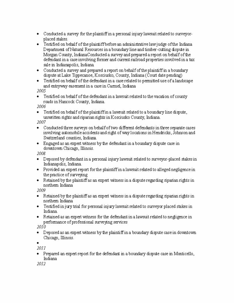
List of Cases – previous four years
Depositions
Vanessa Collier v. Stoeppelwerth & Associates, Inc. et al, Marion County, Indiana Superior Court, Cause No. 49-D05-0207-CT-001265 on April 3, 2008.
Michael L. Bogan et ux v. Trinity Homes, Inc. et al, Hamilton County, Indiana Superior Court I, Cause No. 29D01-0508-PL-747 on April 21, 2010.
MB Financial Bank, N.A. v. CemCon, LTD et al, Cook County, Illinois Circuit Court, No. 05-L-8643 on September 28, 2010.
Deibel v. Flaherty & Collins, et al, White County, Indiana Court on May 25, 2012.
Expert Testimony
Vanessa Collier v. Stoeppelwerth & Associates, Inc. et al, Marion Superior Court, Cause No. 49-D05-0207-CT-001265 on July 14, 2009.
Facts and Data Considered
Documents relied upon or reviewed in conducting this survey and forming the opinions expressed on
the Plat of Survey, in the accompanying Surveyors Report, and in this Expert Report included:
1. A copy of the record plat of Silvercrown Estates (Instrument Number XX-XXXX, Office of the Lincoln County Recorder).
2. A copy of the Final Judgment entered February 5, 1952 in the case of ABC Pipe Line Company v. Garvey in Lincoln Circuit Court Cause No. XXXX, entered in Order Book XX at Page XXX.
3. A copy of the Agreed Entry and Order Appointing Appraisers entered June 1, 1951 in the case of ABC Pipe Line Company v. Garvey et al in Lincoln Circuit Court Cause No. 68338, entered in Order Book XX at Page XX.
4. A copy of the Right of Way Grant from Harvey White and Joe White to ABC Pipe Line Company executed July 3, 1967 and recorded as Instrument Number 67-XXXX.
5. Copies of the section corner reference ties to the: a. Northeast corner b. Northwest corner, and
c. Southwest corner of the northwest quarter of Section 22, Township XX North, Range XX East of the Second Principal Meridian from the Lincoln County Surveyor’s Office (dated August 16, 2011, August 16, 2011 and June 6, 2000 respectively).
6. A copy of a “Site Sketch of Lots #4 and #5 of Silvercrown Estates” prepared for Larman by John, Registered Land Surveyor of Plumb Bob Engineering and Surveying, dated March 22, 2012 and last revised April 12, 2012. This sketch is referred to hereinafter as the “Larman Sketch.”
7. A copy of an “Exhibit Drawing” of Lot 7 in Silvercrown Estates prepared for Merrill drawn by (initials) MJJ of Meridian Surveying dated September 30, 2011 (with unsigned signature block dated October 4, 2011). This drawing is referred to hereinafter as the “Meridian Exhibit.”
In addition to the above referenced documents, field work performed as a part of this survey on April
18-19, 2012 was also relied upon in forming the opinions expressed on the Plat of Survey, in the
accompanying Surveyors Report, and in this Expert Report.
Exhibits
The attached copies of the following documents form the basis for, and summarize and support, the
opinions contained in this report. These exhibits are of the type typically relied upon by surveyors in
forming opinions.
A. Sheet 1 of 3 of a “Silvercrown Estate Exhibit Drawing” drawn by KKE [Kyle Eichhorn, PS], checked by CMC [Coralina L. Candler, PS] and dated April 24, 2012 showing the ABC Pipe Line easements through Lots 1, 4, 5, 7, 8 and 11.
B. Sheet 2 of 3 of a “Silvercrown Estate Exhibit Drawing” drawn by KKE [Kyle Eichhorn, PS], checked by CMC [Coralina L. Candler, PS] and dated April 27, 2012 showing the ABC Pipe Line easements through Lots 1, 4, 5, 7 and 8.
C. Sheet 3 of 3 of a “Silvercrown Estate Exhibit Drawing” drawn by KKE (Kyle Eichhorn, PS), checked by CMC [Coralina L. Candler, PS] and dated April 27, 2012 showing the ABC Pipe Line easements through Lots 4, 5, 7, 8 and 11.
D. Silvercrown Estates Retracement Survey and accompanying Surveyors Report certified by the undersigned of The Schneider Corporation on April 27, 2012.
Opinion, Basis and Reasoning
The opinion represented by this Report is the location of the easement lines depicted on the
retracement survey referenced above as item D in the Exhibits section of this Report (and attached
herewith).
A retracement survey is defined as “a survey of real property that has been previously described in
documents conveying an interest in the real property.”15 The survey of the ABC Pipe Line Company
easements that is the subject of this report is a retracement survey.
15
Indiana Administrative Code, 865 IAC 1-12-2(i).

In the United States, a retracement survey is the professional opinion of the surveyor as to the location
of the lines and corners of the property interest being retraced.
A proper boundary retracement is a function of the application of boundary law principles to the
surveyor’s interpretation of the best evidence available to him or her. In his oft-cited treatise from
1881, Chief Justice of the Michigan Supreme Court Thomas Cooley addressed the issues of evidence, the
surveyor’s opinion, and application of the law, viz.:
“The surveyor … must inquire into all the facts; giving due prominence to the acts of parties
concerned, and always keeping in mind, first, that neither his opinion nor his survey can be
conclusive upon the parties concerned; and, second, that courts and juries may be required to
follow after the surveyor over the same ground, and that it is exceedingly desirable that he
govern his action by the same lights and the same rules that will govern theirs.”16
The Indiana Administrative Code addresses the fact that boundary law has its roots in common law, viz.:
Sec. 2.
…
(m) "Theory of location" means applying:
(1) federal laws, including 43 U.S.C. 751 through 43 U.S.C. 775;
(2) state and local laws; and
(3) court precedent;
to establish the position of real property corners.17
Sec. 11. When conducting a retracement survey, a land surveyor shall do the following:
…
(5) Apply the theory of location as defined in section 2 of this rule.18
In retracing boundaries, the surveyor’s responsibility is to determine the intentions of the parties to the
conveyance.19 It is well-documented that unless there is an extrinsic ambiguity, the intentions of the
parties are to be interpreted only from the written conveyance.20 If there was an original survey of the
boundaries, and if the lines and corners of that survey can be retraced, the words of the written
conveyance are considered to have been derived from that survey. Thus, the lines and corners marked
16
The [Quasi] Judicial Capacity of Surveyors, Thomas M. Cooley, Chief Justice, Michigan Supreme Court, 1864-1885, 1881. 17
Indiana Administrative Code, 865 IAC 1-12-2(m). 18
Indiana Administrative Code, 865 IAC 1-12-11. 19
Brown’s Boundary Control and Legal Principles, 6th
Edition, Walter Robillard, Donald Wilson and Curtis Brown, Wiley, 2009. pp. 327-330. 20
Evidence and Procedures for Boundary Location, 5th
Edition, Walter Robillard, Donald Wilson and Curtis Brown, Wiley, 2009. p. 46-47.

on the ground on an original survey are considered the source of, and will control over, the words in the
conveyance.21
Although the record plat of Silvercrown Estates depicts the ABC Pipe Line Company (hereinafter “ABC”)
easements, the actual descriptions for those easements are contained in the 1967 Right of Way Grant
and, by reference, in the 1952 Final Judgment, which represent those easements’ original sources of
title. The subsequent platting over of those easements with the Silvercrown Estates plat cannot, in and
of itself, alter the lines of the easements. Thus the survey of the easements was based on those
originating documents, not on the lines of the easements shown on the plat.22
Legal descriptions often contain a variety of calls – distances, directions and monuments – and one of
the surveyor’s responsibilities is to interpret which of those calls are “controlling,” and which are not
“controlling” and are, therefore, merely “informational.” The boundary lines are then located based on
the controlling elements of the description.23
The locations of both easements are fixed in their respective descriptions at their westerly ends by
controlling calls south along the west line of the quarter section from the northwest corner thereof.
Likewise, they are fixed at their east ends by controlling calls south along the centerline of Morrison
Road from the quarter line in West 6th Street. Both easement descriptions give a series of bearings and
distances in courses connecting those two endpoints.
On this survey, the geometry (shape) of the respective reference line24 of each easement, between its
endpoints, was developed in accordance with the angles and distances along that reference line as
described in its record description.
As mentioned above, in order to locate the end points of the reference line of the respective easements,
their west ends were established based on the controlling calls south from the northwest corner of the
quarter section (546 and 578 feet, respectively).
Likewise, the east ends of the easements were established based on the respective controlling calls
south along the centerline of Morrison Road from the quarter line (707 and 754 feet, respectively).
Using the west end of each reference line (on the west line of the quarter section) as a hinge point, and
holding the geometry (shape) of each reference line as described, each reference line was then rotated
21
Brown’s, pp. 329-330. 22
In fact, due to missing dimensions, some of the easement lines depicted on the plat of Silvercrown Estates cannot be located based on that plat with an appropriate degree of precision or confidence. 23
Brown’s, pp. 323-324. 24
In the case of a strip description, like the descriptions of these two ABC easements, it is very common that the described reference line defining the easement (off each side of which, strips of land of given width define the full easement) is referred to as the “centerline” even though it is not literally the center line of the easement. In the case of the 1952 easement, the reference line of the 66 foot strip is actually a line described with 50 feet of the 66 foot easement lying north of the line and the remaining 16 feet lying south of the line. In the case of the 1967 easement, the reference line is the actual center line of the 66 foot easement. In this Report, the term “reference line” will be used when discussing the reference line whether that line represents the actual centerline or not.

until it intersected the centerline of Morrison Road at the specified distance noted above (707 and 754
feet). This methodology resulted several conditions that must be explained and addressed.
1. The angle off the west line of the quarter section contained within each description was determined to be an informative call, not a controlling call. Rather, the very definite controlling calls south along the west line of the quarter, and south along the centerline of Morrison Road must be held, and the geometry (shape) of each reference line was held. This approach is consistent with a boundary law principle that states, when appropriate, a distance will control over a direction.25 It is the undersigned’s considerable experience that the geometry (shape) of an easement’s described reference line normally has a good level of integrity as evidenced by the fact that the constructed improvement normally fits nicely with that geometry. When the geometry of such a reference line is initiated from an angle off a baseline (as the two ABC easements are off the west line of the quarter section); however, that angle was typically not actually measured off that base line itself, but rather off some supposed or presumed representation of that base line like a fence or road centerline. In this case, the quarter line is defined by the northwest and southwest corners of the quarter; the southerly of which is over 2000 feet south of the easements. In the past, it was not the regular practice of surveyors when conducting surveys for easement routes to extend their surveys out to connect to reference corners remotely distant from the route. It is the undersigned’s opinion that the angles off the quarter line given in these ABC descriptions were not measured off the actual quarter line and they were not, therefore, held as controlling for this survey. If they were held as controlling, the pipe lines themselves would be severely angled relative to the easements and, at its easterly end, one of the pipe lines would actually fall outside the easement. Such an approach – when logical alternative interpretations are available - is considered inappropriate and contrary to the intent of the descriptions. Regarding such a situation, and in support of the interpretation used, Justice Cooley stated:
“…he [the surveyor] would do mischief if he were to attempt to establish monuments
which he knew would tend to disturb settled rights;…”26
Justice Cooley’s admonishment above contains the word “attempt,” which, in the opinion of the
undersigned, means if the surveyor has a logical and defensible alternative, an attempt should
not be made to manufacture an artificial solution that unnecessarily conflicts with occupation.
However, this is not to say that occupation trumps an otherwise proper and appropriate
interpretation of the evidence. In fact, it is the considerable experience of the undersigned that
very frequently installed utility infrastructure is found to lie outside its respective easement.
Justice Cooley addressed this issue with yet another caution aimed at preventing surveyors from
arbitrarily setting aside good judgment in order to merely not disturb occupation, viz.:
“Of course nothing in what has been said can require a surveyor to conceal his own
judgment, or to report the facts one way when he believes them to be another. He has
25
Brown’s, pp. 340-343. 26
Cooley
no right to mislead, and he may rightfully express his opinion that an original monument
was at one place, when at the same time he is satisfied that acquiescence has fixed the
rights of the parties as if it were at another.”27
In addition, and more importantly, if the angles off the west line of the quarter section and the
geometry of each of the references lines were held, the controlling distances prescribed along
the centerline of Morrison Road cannot hold. Yet, the distances south along the centerline of
Morrison Road are unequivocally controlling. Thus, the angles off the west line of the quarter
section are informational, not controlling, and were not held.
2. The length of the last course of each reference line differs from that given in their respective descriptions. The length of this course in each easement must be terminated by the east title line of the easement, which is the centerline of Morrison Road. The centerline of Morrison Road is a controlling call and the easements cannot extend beyond that line. Thus the distances to the centerline of Morrison Road are informative, not controlling, and yield to the call for the centerline of Morrison Road.
The two easements overlap each other along the entire length of the surveyed area through Silvercrown
Estates from about 1 ½ to about 4 ½ feet (except at the far westerly end where the northerly easement
angles to the southwest before the southerly easement does). This is not unusual when easements
essentially parallel one another, and is not considered by the undersigned to be a red flag to the
opinions otherwise rendered in this Report. In fact, the Silvercrown Estates plat also shows an overlap
of the easements, albeit, as noted above, it is the undersigned’s opinion that the plat does not control
the location of the easements’ lines.
A review of the Meridian Exhibit, referenced previously, is not clear in showing how the easement lines
shown thereon were located. In any event, the drawing also notes “THE WITHIN LAND DESCRIPTION
AND/OR EXHIBIT DRAWING WAS PREPARED BASED UPON RECORD INFORMATION AND/OR PRIOR
SURVEYS OF THE PARENT TRACT. NO FIELD SURVEY WAS PERFORMED AND NO MONUMENTS SET WITH
THIS WORK. THIS LAND DESCRIPTION IS SUBJECT TO CHANGE BASED UPON A REVIEW OF A CURRENT
BOUNDARY SURVEY OF THE PREMISES.”
Notwithstanding that statement, the Meridian Exhibit does show survey markers as set, and some of the
monuments found on the undersigned’s survey (a mag nail and lath with orange flagging on Lot 7) are
believed to be some of the Meridian markers. Those lath, which are believed to be marking the south
line of the south easement per the Meridian Exhibit, were found to be 9 to 19 feet north of the line
determined this survey. On Lot 4, the southerly of the two pipe lines would actually run outside the
easement as shown on the Meridian Exhibit.
A review of those markers in conjunction with the undersigned’s survey seems to indicate that the
easement lines shown on the Meridian Exhibit and marked in the field were established based on an
interpretation of those lines as shown on the record plat of Silvercrown Estates. However, as noted
27
Cooley

above, those lines are not, in fact, definitively locatable based on said plat, and, in any event, the plat
does not fix where those easement lines are located - their record descriptions do.
A review of the Larman Sketch, referenced previously, in conjunction with the undersigned’s survey (and
lath found that are believed to have been set as a part of the Larman Sketch) indicate that the easement
lines shown thereon were established based on their respective record descriptions; holding the
described angles off the west line of the quarter section, holding the geometry of the reference lines per
the records, and ignoring the controlling calls south along the centerline of Morrison Road from the
quarter line in 6th Street.
As mentioned above, it is the opinion of the undersigned that: (1) the angles off the west line of the
quarter section are informational, not controlling, (2) the distances down Morrison Road from the north
line of the quarter section are controlling, and (3) the record plat of Silvercrown Estates cannot and does
not control the location of the easements. As a result, the undersigned’s opinion as the location of the
easement lines was not altered by the reviews of the Meridian Exhibit or of the Larman Sketch for the
reasons stated above.
Compensation for Expert Witness work
Compensation for conducting the survey and preparing this report is hourly in accordance with rates
negotiated with ABC Pipe Line Company, LP for the year 2012. The applicable rate under the rate sheet
is $250.00/hour for review of documents, meetings, preparation of expert report, etc., and
$300.00/hour for deposition or testimony.
Gary R. Kent, PS
June 19, 2012