Embed Size (px)
Citation preview
Beltline Highway:COBURG ROAD TO RIVER ROAD FACILITY PLAN VOLUME I
PREPARED FOR
Oregon Department of TransportationWITH SUPPORT FROMCity of Eugene Lane County Lane Council of Governments Lane Transit District
JULY 2014
TBG123010063911PDX 386813.13.08
BELTLINE HIGHWAY: COBURG ROAD TO RIVER ROAD FACILITY PLAN iii JULY 2014
Contents
Acknowledgements .......................................................................................................................... v
1 Introduction and Background ........................................................................................... 1 Organization of Facility Plan ............................................................................................... 1 Introduction ........................................................................................................................... 2 Background ............................................................................................................................ 2 Problem Statement ................................................................................................................ 3
2 Planning Process .................................................................................................................. 5 Study Area ............................................................................................................................. 5 Project Leadership................................................................................................................. 6 Public Involvement ............................................................................................................... 9 Existing Conditions ............................................................................................................ 10 Evaluation Framework ....................................................................................................... 17 Policy Framework ............................................................................................................... 18 Alternatives Development ................................................................................................. 20
3 Recommendations.............................................................................................................. 31 Recommendation Process .................................................................................................. 31 Recommended Concepts ................................................................................................... 31
4 Interchange Area Management Plans ............................................................................ 45 Interchange Area Management Plans .............................................................................. 45 River Road Interchange Area Management Plan ........................................................... 47 River Avenue/Division Avenue Interchange Area Management Plan ...................... 51 Delta Highway Interchange Area Management Plan .................................................... 57
5 Next Steps ............................................................................................................................ 61
Volume II: Appendices
A Existing and Future Conditions B Problem Statement C Public Involvement Process D Evaluation Framework E Policy Framework


BELTLINE HIGHWAY: COBURG ROAD TO RIVER ROAD FACILITY PLAN v JULY 2014
Acknowledgements
Project Staff
Savannah Crawford, ODOT
Terry Cole, ODOT
Chris Bailey, ODOT
Angela Kargel, ODOT
Dorothy Upton, ODOT
Ann Sanders, ODOT
Michael Morales, ODOT
Stephen Wilson, ODOT
Chris Henry, City of Eugene
Celia Barry, Lane County
Mark Bernard, Lane County
Lydia McKinney, Lane County
Jazmin Cassis, FHWA
Nathaniel Price, FHWA
Susan Payne, LCOG
Paul Thompson, LCOG
Tom Schwetz, LTD
Mary Archer, LTD
Sasha Luftig, LTD
Consultant Staff
Kristin Hull, CH2M HILL
Sam Seskin, CH2M HILL
Terra Lingley, AICP, CH2M HILL
Julia Kuhn, PE, Kittelson & Associates, Inc.
Brian Ray, PE, Kittelson & Associates, Inc.
Shaun Quayle, PE, Kittelson & Associates, Inc.
Karla Kingsley, Kittelson & Associates, Inc.
Project Steering Committee
Erik Havig, ODOT
Sonny Chickering, ODOT
Lisa Nell, ODOT
Frances Bindle, ODOT
Commissioner Rob Handy, Lane County
Commissioner Pat Farr, Lane County
Commissioner Jay Bozievich, Lane County
Councilor Mike Clark, City of Eugene
Councilor Andrea Ortiz, City of Eugene
Councilor Claire Syrett, City of Eugene
Stakeholder Advisory Committee
Barb Bellamy, Eugene School District
Charles Biggs, Friends of Eugene
Connie Bloom Williams, Commuter Solutions/point2point
Michael Brewster, emergency services
Theresa Brand, Commuter Solutions/point2point
Kent Calvin, Active Bethel Neighbors
John Faville, Northeast Neighbors
Heather Hannah, Active Bethel Neighbors
Mike Hawley, Sherman Brothers Trucking
Shane MacRhodes, Safe Routes to School, 4J School District
Kevin Matthews, Friends of Eugene
Troy McAllister, MWMC
Tom Mitchell, Cal Young Neighborhood Association
Ed Moore, Department of Land Conservation and Development

BELTLINE HIGHWAY: COBURG ROAD TO RIVER ROADFACILITY PLAN
VI BELTLINE HIGHWAY: COBURG ROAD TO RIVER ROAD FACILITY PLAN JULY 2014
Eileen Nittler, River Road Community Association
Jody Ogle, Lane County Roads Advisory Committee
Chris Opsahl, Sherman Brothers Trucking
Ryan Pape, Eugene Chamber of Commerce
Paul Spain, River Avenue area businesses
George Staples, Delta Sand and Gravel
Sarah Strand, Metropolitan Planning Organization Citizen Advisory Committee
Gary Wildish, Santa Clara Community Association

BELTLINE HIGHWAY: COBURG ROAD TO RIVER ROAD FACILITY PLAN 1 JULY 2014
1 Introduction and Background
Organization of Facility Plan
The Beltline Highway: Coburg Road to River Road Facility Plan includes five chapters and five appendixes, as follows:
Chapter 1 Introduction and Background: Explains the purpose of the facility plan, the background, and Problem Statement this plan addresses.
Chapter 2 Planning Process: Describes the planning process and provides an overview of the alternative development, and the public involvement process.
Chapter 3 Recommendations: Describes the recommendations endorsed by the advisory and technical committees.
Chapter 4 Interchange Area Management Plans: Describes the interchange area management plans for the three study area interchanges and high level policies to support the interchange recommendations.
Chapter 5 Next Steps: Describes how this facility plan will be used, and the expected further environmental work based on the recommended alternatives.
Appendix A Existing Conditions: Describes the existing plan and policy review, environmental and land use inventory, traffic operations, safety, and geometric conditions. These conditions were documented in Phase 1 of the project.
Appendix B Problem Statement: Describes the issues on the Beltline Highway and the need for the facility plan. The problem statement was documented in Phase 1 of the project.
Appendix C Public Involvement Process: Includes information, agendas, and summaries of project public involvement meetings and outreach.
Appendix D Evaluation Framework: Describes the framework for evaluating alternatives based on the project’s goals and objectives.
Appendix E Policy Framework: Contains policies and language to support the facility plan and move the plan into the next phase.

INTRODUCTION AND BACKGROUND
2 BELTLINE HIGHWAY: COBURG ROAD TO RIVER ROAD FACILITY PLAN JULY 2014
Introduction
Oregon 569 (the Randy Pape Beltline Highway) is a state facility located in Eugene, Oregon. The Beltline Highway is an east-west connection between Interstate 5 (I-5) and Oregon 99 and north-south between Oregon 99 and Oregon 126. Lane County constructed the highway in the 1960s to serve the largely rural land uses and low density suburban areas. It transferred the highway to the Oregon Department of Transportation (ODOT) in 1978. In the 40 years since the county designed and constructed the highway, the surrounding community has grown with more intense land uses and increased density causing a disconnect between the expected traffic when the highway was built and the current traffic volumes. ODOT currently classifies the Beltline Highway as a Statewide Highway on the National Highway System (NHS) and also as an Expressway, Bypass, and Freight Route.
The segment of Beltline Highway between River Road and Coburg Road has become increasingly congested during peak travel times. Vehicle conflicts on Beltline Highway at River Road, River Avenue/Division Avenue, the bridge over the Willamette River, Delta Highway, and Coburg Road result in safety and operational issues. Traffic congestion is expected to continue to increase with development of north and west Eugene and surrounding areas. Local roadways in the study area are also congested.
This facility plan addresses the Beltline Highway between River Road and Delta Highway, milepost (MP) 8.47 to 10.20. It includes three interchanges: River Road, River Avenue/Division Avenue, and Delta Highway. The Beltline Highway Facility Plan study area also includes Delta Highway (Lane County facility) between Green Acres Road/Crescent Avenue and Goodpasture Island Road, as they immediately contribute to the operations of the Beltline Highway.
Initially, the facility plan also included the Coburg Road interchange. Because the Coburg Road interchange was not a primary source of congestion, and ODOT made safety improvements at this interchange in 2009, the project team removed Coburg Road from the study area to allow more focus on the critical portions of the facility.
Background
This facility plan addresses the following issues:
Variety of trip types using the Beltline Highway – This section of the highway serves regional, statewide, cross-town, and local cross-river trips. Due to the limited connections over the Willamette River, some drivers use the Beltline Highway as a local roadway to cross the river.
Outdated highway design – The Beltline Highway was designed in the 1960s for lower speeds and less traffic than it currently carries. On- and off-ramps are closely spaced, and there is insufficient acceleration, deceleration and through lanes, which can contribute to congestion and crashes in the study area.
Deteriorating traffic operations – As traffic volumes increase, so does the intensity and duration of congestion experienced along both the Beltline Highway mainline and ramp terminal intersections.

BELTLINE HIGHWAY: COBURG ROAD TO RIVER ROAD FACILITY PLAN
BELTLINE HIGHWAY: COBURG ROAD TO RIVER ROAD FACILITY PLAN 3 JULY 2014
Roadway safety – Safety concerns associated with the design and operations of the Beltline Highway are documented in the crash history and trends within the study area.
The facility plan was completed in three phases. Phase 1 included analyzing existing conditions on the highway and study area intersections, and creating the problem statement. In Phase 2, the project team defined the study area boundaries, developed the evaluation framework, developed a range of alternatives, worked with the advisory committees and PMT to develop recommendations, and created a policy framework to support the plan. Phase 3 included interchange area management plans and preparation for future project development. This document will help guide future work by providing a narrow range of alternatives for future study.
Problem Statement
Beltline Highway
The Beltline Highway within the study area has four through travel lanes carrying between 55,000 and 90,000 cars and trucks each day. The roadway was not designed to carry this volume of traffic resulting in congestion, especially at peak periods. This congestion along with short merge and diverge areas contributes to a higher frequency of crashes than other similar facilities in the state. Congestion and crashes are prevalent between River Road and Delta Highway.
The Delta Highway and River Avenue/Division Avenue interchanges, and the River Avenue/Division Avenue and River Road interchanges are closely spaced (0.3 and 0.6 miles apart respectively). This close spacing, the short ramp lengths, and inadequate weaving distances increase congestion and potential for crashes.
Delta Highway Interchange
The ¾ cloverleaf design of this interchange results in short distances between loop ramps which contribute to increased congestion and are one factor that contributes to the potential for crashes. Both the Beltline Highway and Delta Highway are congested near this interchange. A large number of vehicles change lanes in a short distance as they enter and exit both highways resulting in a high incidence of crashes in this area.
Development increased over the last 40 years in this area and will continue to occur resulting in increased traffic volumes at this interchange. This interchange was not constructed to accommodate current or future traffic volumes.
Stakeholders observe frequent crashes on the northbound Delta Highway, near and at the eastbound and westbound Beltline Highway ramp connections.
River Avenue/Division Avenue Interchange
This interchange carries heavy peak period traffic volumes and is adjacent to the system bottleneck of the Willamette River bridge crossing, contributing to congested conditions. The interchange has a higher crash rate than similar facilities in the state. This interchange provides access to an aggregate mining business located immediately north of the highway. The proximity to industrial land uses requires the interchange to accommodate heavy trucks that need longer distances to accelerate to highway speeds and merge with through traffic. Compounding the existing congestion and the prevalence of large trucks, the interchange design creates limited sight-distance for drivers entering or exiting the Beltline Highway.
INTRODUCTION AND BACKGROUND
4 BELTLINE HIGHWAY: COBURG ROAD TO RIVER ROAD FACILITY PLAN JULY 2014
A regional north-south bike path passes underneath the Beltline Highway near this interchange, which means that cyclists with destinations north of the Beltline Highway travel through this congested area resulting in conflicts between auto and bike traffic.
Pedestrians cross under the Beltline Highway at this location.
The close proximity of this interchange to the Willamette River bridge forces eastbound merging and westbound diverging to occur in a short distance.
River Road Interchange
There is peak period congestion due to the current configuration and limited turn lanes for vehicles approaching the Beltline Highway along River Road under existing conditions. The congestion is compounded by the close proximity of signals and local accesses on River Road south of Beltline, beyond the first traffic signal.
The interchange provides important access to businesses and residents in the Santa Clara and River Road neighborhoods.
The northeast, southeast and southwest quadrants are flanked by concentrated development that is expected to continue and could result in increased traffic volumes at this interchange.
Bike movements on the regional north-south bike lanes in this busy area create conflicts between auto and bike traffic.
There are conflicts between pedestrians crossing River Road and vehicles turning onto the ramps.
Lane Transit District buses accessing the park and ride facility slow traffic in the right lane of the eastbound on-ramp to the Beltline Highway.
BELTLINE HIGHWAY: COBURG ROAD TO RIVER ROAD FACILITY PLAN 5 JULY 2014
2 Planning Process
Study Area
The project team defined the study area for the Beltline Highway Facility Plan to capture existing and future operational and safety deficiencies in the corridor between MP 8.47 and 10.05 which correlates roughly to Beltline Highway between River Road and Coburg Road. Figure 1 shows the study area.
The study area for the Beltline Highway Facility Plan is bounded to the north by Irvington Drive starting at Hyacinth Street, and continues east along Wilkes Drive. It includes areas outside of the Eugene Urban Growth Boundary (UGB) between Wilkes Drive, over the Willamette River, and reconnects with the northern UGB east of the river. Starting at the intersection of Coburg Road and North Game Farm Road, the study area follows Game Farm Road southeast to Interstate 5. The eastern edge of the study area follows I-5 south to OR 126, which forms the southern boundary until Delta Highway. The southern edge of the study area follows the north bank of the Willamette River along Valley River Way and then cuts across near the bike bridge to the Northwest Expressway. The study area boundary turns north along Park Avenue to Irving Road, heads west to Hyacinth Street, and then north to Irvington Drive.
There are a number of multi-use paths for bicyclists and pedestrians in the study area, most notably along the south side of River Avenue near the River Avenue/Division Avenue interchange, passing underneath the Beltline Highway on the west side of the Willamette River. Multi-use paths on the east side of the river include a connection between Green Acres Road underneath Beltline Highway to a riverfront path on the east side of the Willamette River. These paths are connected by the Owosso Bike Bridge south of the Beltline Highway. Both paths within the study area connect to the riverfront path system that runs along the Willamette River into downtown Eugene. Figure 2 shows the existing bicycle and pedestrian path system within the study area.
The study area includes a range of land uses; single and multifamily housing, small-scale retail, large-scale retail, and industrial activity. Most of the land on either side of the Beltline Highway is zoned for community commercial or low-density residential development. The area south of the Beltline Highway between the Delta Highway and the Willamette River has higher intensity uses including housing and retail. The area north of the highway between the Delta Highway and Division Avenue is home to a large aggregate mining operation. There is some limited land zoned for agriculture and publicly-owned open space in the corridor. As currently planned, these land uses could produce higher traffic volumes than can be accommodated by the existing roadway network. The project team developed the Beltline Facility Plan in coordination with Envision Eugene, Eugene’s comprehensive plan. The Beltline Facility Plan will be revisited once Envision Eugene is complete to ensure that the two plans are compatible.

PLANNING PROCESS
6 BELTLINE HIGHWAY: COBURG ROAD TO RIVER ROAD FACILITY PLAN JULY 2014
Project Leadership
Project Management Team
A project management team (PMT) consisting of staff from the City of Eugene, Oregon Department of Transportation (ODOT), Lane Council of Governments (LCOG), Lane County, Federal Highway Administration (FHWA), and Lane Transit District (LTD) provided regular guidance and policy direction throughout the process. The PMT reviewed and provided comments on all materials, participated in agency and public meetings, and supported the Steering Committee. The PMT met 16 times over the course of the project. Appendix C: Public Involvement includes summaries and agendas of PMT meetings.

BELTLINE HIGHWAY: COBURG ROAD TO RIVER ROAD FACILITY PLAN
BELTLINE HIGHWAY: COBURG ROAD TO RIVER ROAD FACILITY PLAN 7 JULY 2014
Figure 1 Study Area

PLANNING PROCESS
8 BELTLINE HIGHWAY: COBURG ROAD TO RIVER ROAD FACILITY PLAN JULY 2014
Figure 2 Pedestrian and Bicycle Facilities

BELTLINE HIGHWAY: COBURG ROAD TO RIVER ROAD FACILITY PLAN
BELTLINE HIGHWAY: COBURG ROAD TO RIVER ROAD FACILITY PLAN 9 JULY 2014
Steering Committee
The Steering Committee, comprised of officials representing the City of Eugene, Lane County, and ODOT, was responsible for making facility plan decisions. The Steering Committee met 13 times between July 2008 and April 2014. The Steering Committee reviewed input from the PMT and the Stakeholder Advisory Committee (SAC) prior to making decisions.
Steering Committee meetings were open to the public, and the committee included time for public comment at each meeting.
Appendix C: Public Involvement Process includes full Steering Committee meeting agendas and summaries.
Public Involvement
Stakeholder Advisory Committee
The Stakeholder Advisory Committee (SAC) included business leaders, neighborhood representatives and community members who met to provide input and advice on the plan and potential solutions. The SAC met 11 times between April 2009 and April 2014. They provided input on the study area, helped suggest solutions, and recommended concepts to carry forward for further study. SAC meetings were open to the public and each meeting included two public comment opportunities.
Appendix C: Public Involvement Process includes full SAC meeting agendas and summaries.
Public Open Houses
The general public was encouraged to provide input on the facility plan through a series of open houses. There were five open houses over the three phases of the project:
Phase 1 Open House #1 and #2: The project team hosted two open houses on August 4 and August 6, 2008 to gather public input on the current conditions and deficiencies found on the Beltline Highway. Attendees were encouraged to share their ideas about the issues affecting Beltline Highway within the project area. The project team collected comments on wall displays, maps, and via a comment form.
Phase 2 Open House #1: This open house, held in July 2009, provided attendees an opportunity to help identify solutions for the Beltline Highway, and collected information from attendees on which evaluation criteria was the most important to the community.
Phase 2 Open House #2: This open house, held in March 2010, presented the proposed solutions for the Beltline Highway. The project team presented ten concepts to improve the Beltline Highway, and gathered input on which concepts community members would like the project team to study further.
Phase 3 Open House: This open house, held in May 2014, presented the draft Beltline Highway Facility Plan for review and comment. It included the final concepts moving forward into the NEPA phase and the next steps for making a decision and implementing changes on the Beltline Highway.
Appendix C: Public Involvement Process includes more detailed summaries and displays of each of the open houses.

PLANNING PROCESS
10 BELTLINE HIGHWAY: COBURG ROAD TO RIVER ROAD FACILITY PLAN JULY 2014
Project Website
ODOT hosted and presented all relevant information relating to the Beltline Highway Facility Plan to the public website: www.beltlineplan.com. The project team shared summaries for both the SAC meetings and open houses on the website, along with the open house displays and all technical documents for the project. For three of the open houses, the comment form was available for community members to complete online.
Existing Conditions
Phase 1 evaluated the existing conditions within the study area. This analysis included an existing environmental and land use inventory, a plan and policy review, and traffic operations and safety analysis of existing conditions. This traffic analysis identified areas where there are deficiencies including congestion, safety, roadway geometry, and delay on the highway. At the Phase 1 open house, attendees added community concerns to this analysis to capture areas of concern in both the technical analysis and community.
Existing Traffic Conditions
The existing conditions analysis shows that two eastbound segments of the Beltline Highway do not meet Oregon Highway Plan (OHP) mobility targets during the afternoon peak hour. On westbound Beltline Highway, there is one section that does not meet OHP mobility targets. Two ramps at Delta Highway and Goodpasture Island Road do not meet Lane County mobility standards. Additionally, two of the seven on-ramps for Beltline Highway, and three of seven off-ramps do not meet applicable mobility targets.
There are also a number of geometric design features that negatively influence traffic operations on the highway and interchanges. The ramps at Delta Highway and the River Avenue/Division Avenue interchanges are closely spaced, there are insufficient acceleration and deceleration lanes along the corridor that negatively affect operations and can contribute to crashes.
Off the highway, six of 31 intersections on city and county roadways experience delay and congestion inconsistent with applicable standards. Additionally, queues extend between intersections along River Road near the Beltline Highway westbound and eastbound ramps, the Silver Lane intersection, and the Santa Clara Avenue intersection. The northbound queue on River Road extends south of the Silver Lane/River Avenue intersection and also blocks some of the access driveways east of River Road. Figures 3 and 4 show existing operational and geometric deficiencies on the Beltline Highway.
Traffic Safety
The study area crash rate is highest near the Delta Highway and River Road interchanges. The crashes are mostly rear end crashes occurring during the morning and evening commute when traffic volumes are highest and congestion is most acute.
Additionally, ODOT identifies areas with high crash rates with their Safety Priority Index System (SPIS), and prioritizes areas with high crash rates by region. Two segments of the Beltline Highway are identified as top 10 percent on ODOT’s 2012 SPIS list: the Beltline Highway/Delta Highway (MP 9.78 to 9.87), and the Beltline Highway/Delta Highway (MP 9.99 to 10.12). A higher rate of crashes was also reported at the Delta Highway/Green Acres Road (westbound Beltline on-ramp) intersection relative to other study intersections. Figure 5 shows safety issues on the Beltline Highway.

BELTLINE HIGHWAY: COBURG ROAD TO RIVER ROAD FACILITY PLAN
BELTLINE HIGHWAY: COBURG ROAD TO RIVER ROAD FACILITY PLAN 11 JULY 2014
Adaptive Ramp Signals
Between Phase 2 and Phase 3 of the Beltline Highway Facility Plan Process, ODOT implemented adaptive ramp signals on the Beltline Highway ramps to reduce traffic delays, improve safety, and decrease fuel consumption and air pollution during peak morning and afternoon travel times. The signals are triggered by congestion on the highway mainline, and reduce traffic flow rates onto the highway at the ramps. In more congested conditions, the ramp meters slow the rate of cars entering the highway, and as congestion reduces, the signal timing adjusts to allow more cars to enter the highway. When the highway is not congested, the meters are not activated. Over time, the ramp meters will continue to be adjusted to traffic flow, but the eastbound meters are expected to be operational during the weekday morning peak (approximately 6:30 - 9:30 a.m.), and westbound ramp meters are likely to be operational in the weekday afternoon peak (approximately 3:00-6:45 p.m.). Additionally, metering may occur during other times when traffic is congested such as during traffic incidents or during events.
ODOT installed adaptive signals in July 2013 for four ramps in the project study area: Green Acres Road on-ramp to westbound Beltline Highway, River Road on-ramp to eastbound Beltline Highway, River Avenue on-ramp to eastbound Beltline Highway, and Coburg Road on-ramp to westbound Beltline. ODOT will continue to monitor and adjust these signals based on operational analysis and testing to verify traffic flow benefits on the Beltline Highway.

PLANNING PROCESS
12 BELTLINE HIGHWAY: COBURG ROAD TO RIVER ROAD FACILITY PLAN JULY 2014
Figure 3 Current Congestion

BELTLINE HIGHWAY: COBURG ROAD TO RIVER ROAD FACILITY PLAN
BELTLINE HIGHWAY: COBURG ROAD TO RIVER ROAD FACILITY PLAN 13 JULY 2014
Figure 4 Beltline Deficiencies
PLANNING PROCESS
14 BELTLINE HIGHWAY: COBURG ROAD TO RIVER ROAD FACILITY PLAN JULY 2014
Environmental and Land Use Conditions
The study area is in the Willamette River basin resulting in hydrological, floodplain/floodway, wetland, and fish habitat considerations. Land uses near the Beltline Highway are generally single-family residential, large retail and office developments, and smaller-scale retail along the local roads. There are a number of neighborhood organizations including Cal Young Neighborhood Association, Northeast Neighbors1, River Road Community Organization, the Santa Clara Community Organization, and the Active Bethel Citizens. Zoning and comprehensive plan zoning are consistent with the existing land use. There may also be some historical and archeological resources within the study area which would be determined during the environmental review process. Figure 6 shows existing environmental and community context near the Beltline Highway.
Plan and Policy Review
The project team analyzed and determined the relevance of state, regional, and local goals to the Beltline Highway Facility Plan. The State Transportation Improvement Plan (STIP) includes projects with funding to support the planning and safety/modernization of study area interchanges, along with bicycle and pedestrian paths. A number of other regional and local plans include mention of projects related to the Beltline Highway.
Appendix A: Existing Conditions includes more detail about applicable plans and policies.
1 Prior to 2013, Northeast Neighbors was part of the Harlow Neighborhood Association.

BELTLINE HIGHWAY: COBURG ROAD TO RIVER ROAD FACILITY PLAN
BELTLINE HIGHWAY: COBURG ROAD TO RIVER ROAD FACILITY PLAN 15 JULY 2014
Figure 5 Safety Issues on Beltline

PLANNING PROCESS
16 BELTLINE HIGHWAY: COBURG ROAD TO RIVER ROAD FACILITY PLAN JULY 2014
Figure 6 Environmental and Community Context

BELTLINE HIGHWAY: COBURG ROAD TO RIVER ROAD FACILITY PLAN
BELTLINE HIGHWAY: COBURG ROAD TO RIVER ROAD FACILITY PLAN 17 JULY 2014
Evaluation Framework
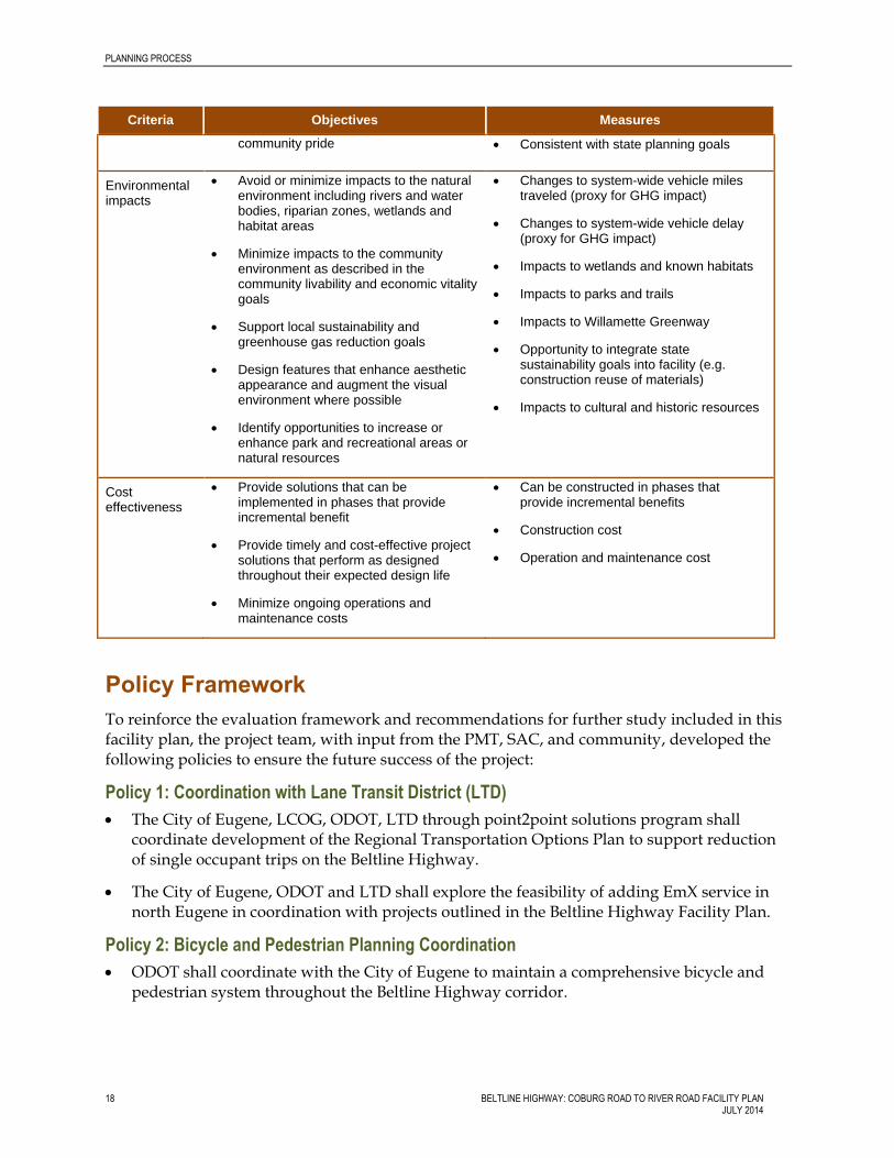
The PMT, SAC, and Steering Committee provided input on project goals and objectives during the problem statement phase of the project. From these goals, the project team developed an evaluation framework shown in Table 1. The project team established this framework to assure that the recommended alternatives respond to community values and technical needs. The team developed and subsequently evaluated draft alternatives based on these criteria. The criteria were not weighted or prioritized.
The PMT, SAC and Steering Committee reviewed the evaluation framework and agreed to use it to evaluate the proposed alternatives.
Table 1: Evaluation Framework
Criteria Objectives Measures
Mobility, reliability and connectivity
Design for projected future traffic volumes as a result of future growth and land use changes
Minimize congestion and optimize traffic flow on the mainline, in the interchange areas, and on critical study area roadways
Provide transportation improvements to reduce trip length and potential travel times for all modes
Provide improved connectivity across the Willamette River for motorists, bicyclists, and pedestrians
Demand-to-capacity (D/C) – planning-level analysis regarding the ability of the transportation system to accommodate potential demand on the mainline and on other critical study area roadways
Traffic operations for study area ramps and ramp terminal interchanges. Based on-ramp spacing and/or eliminating or improving merge, diverge, and weaving maneuvers
Trip length and travel time between key origins and destinations for all modes in the study area
Improve local connectivity for all modes
Safety Improve the highway and interchange areas to increase safety for users and reduce crash frequency, thereby improving reliability
Consider the needs of emergency response vehicles
Places in the study are where the Beltline Highway or interchanges violate known engineering best practices or design guidelines
Reduce conflict points for motorists and between motorists and bicyclist or pedestrians
Provide system redundancy and/or enhanced mobility for emergency response routes and vehicles
Community livability and economic vitality
Support local and regional goals for mode choices
Consider positive and negative effects on adjacent residential and business areas
Serve existing and planned land uses
Accommodate freight movement
Create a facility design that instills
Minimize residential impacts
Consistent with community and neighborhood goals
New or improved multimodal facilities
Minimize business displacements
Access to the interchange area businesses that is both safe and convenient
PLANNING PROCESS
18 BELTLINE HIGHWAY: COBURG ROAD TO RIVER ROAD FACILITY PLAN JULY 2014
Criteria Objectives Measures
community pride Consistent with state planning goals
Environmental impacts
Avoid or minimize impacts to the natural environment including rivers and water bodies, riparian zones, wetlands and habitat areas
Minimize impacts to the community environment as described in the community livability and economic vitality goals
Support local sustainability and greenhouse gas reduction goals
Design features that enhance aesthetic appearance and augment the visual environment where possible
Identify opportunities to increase or enhance park and recreational areas or natural resources
Changes to system-wide vehicle miles traveled (proxy for GHG impact)
Changes to system-wide vehicle delay (proxy for GHG impact)
Impacts to wetlands and known habitats
Impacts to parks and trails
Impacts to Willamette Greenway
Opportunity to integrate state sustainability goals into facility (e.g. construction reuse of materials)
Impacts to cultural and historic resources
Cost effectiveness
Provide solutions that can be implemented in phases that provide incremental benefit
Provide timely and cost-effective project solutions that perform as designed throughout their expected design life
Minimize ongoing operations and maintenance costs
Can be constructed in phases that provide incremental benefits
Construction cost
Operation and maintenance cost
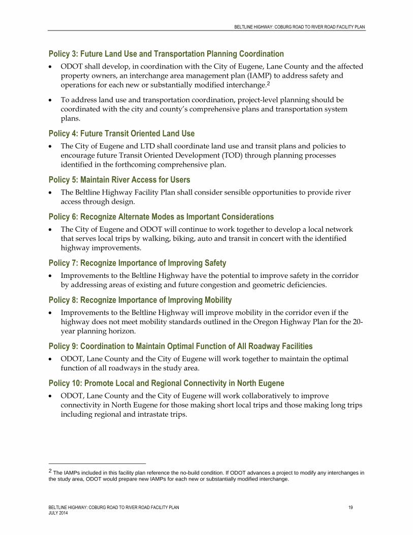
Policy Framework
To reinforce the evaluation framework and recommendations for further study included in this facility plan, the project team, with input from the PMT, SAC, and community, developed the following policies to ensure the future success of the project:
Policy 1: Coordination with Lane Transit District (LTD)
The City of Eugene, LCOG, ODOT, LTD through point2point solutions program shall coordinate development of the Regional Transportation Options Plan to support reduction of single occupant trips on the Beltline Highway.
The City of Eugene, ODOT and LTD shall explore the feasibility of adding EmX service in north Eugene in coordination with projects outlined in the Beltline Highway Facility Plan.
Policy 2: Bicycle and Pedestrian Planning Coordination
ODOT shall coordinate with the City of Eugene to maintain a comprehensive bicycle and pedestrian system throughout the Beltline Highway corridor.
BELTLINE HIGHWAY: COBURG ROAD TO RIVER ROAD FACILITY PLAN
BELTLINE HIGHWAY: COBURG ROAD TO RIVER ROAD FACILITY PLAN 19 JULY 2014
Policy 3: Future Land Use and Transportation Planning Coordination
ODOT shall develop, in coordination with the City of Eugene, Lane County and the affected property owners, an interchange area management plan (IAMP) to address safety and operations for each new or substantially modified interchange.2
To address land use and transportation coordination, project-level planning should be coordinated with the city and county’s comprehensive plans and transportation system plans.
Policy 4: Future Transit Oriented Land Use
The City of Eugene and LTD shall coordinate land use and transit plans and policies to encourage future Transit Oriented Development (TOD) through planning processes identified in the forthcoming comprehensive plan.
Policy 5: Maintain River Access for Users
The Beltline Highway Facility Plan shall consider sensible opportunities to provide river access through design.
Policy 6: Recognize Alternate Modes as Important Considerations
The City of Eugene and ODOT will continue to work together to develop a local network that serves local trips by walking, biking, auto and transit in concert with the identified highway improvements.
Policy 7: Recognize Importance of Improving Safety
Improvements to the Beltline Highway have the potential to improve safety in the corridor by addressing areas of existing and future congestion and geometric deficiencies.
Policy 8: Recognize Importance of Improving Mobility
Improvements to the Beltline Highway will improve mobility in the corridor even if the highway does not meet mobility standards outlined in the Oregon Highway Plan for the 20-year planning horizon.
Policy 9: Coordination to Maintain Optimal Function of All Roadway Facilities
ODOT, Lane County and the City of Eugene will work together to maintain the optimal function of all roadways in the study area.
Policy 10: Promote Local and Regional Connectivity in North Eugene
ODOT, Lane County and the City of Eugene will work collaboratively to improve connectivity in North Eugene for those making short local trips and those making long trips including regional and intrastate trips.
2 The IAMPs included in this facility plan reference the no-build condition. If ODOT advances a project to modify any interchanges in the study area, ODOT would prepare new IAMPs for each new or substantially modified interchange.
PLANNING PROCESS
20 BELTLINE HIGHWAY: COBURG ROAD TO RIVER ROAD FACILITY PLAN JULY 2014
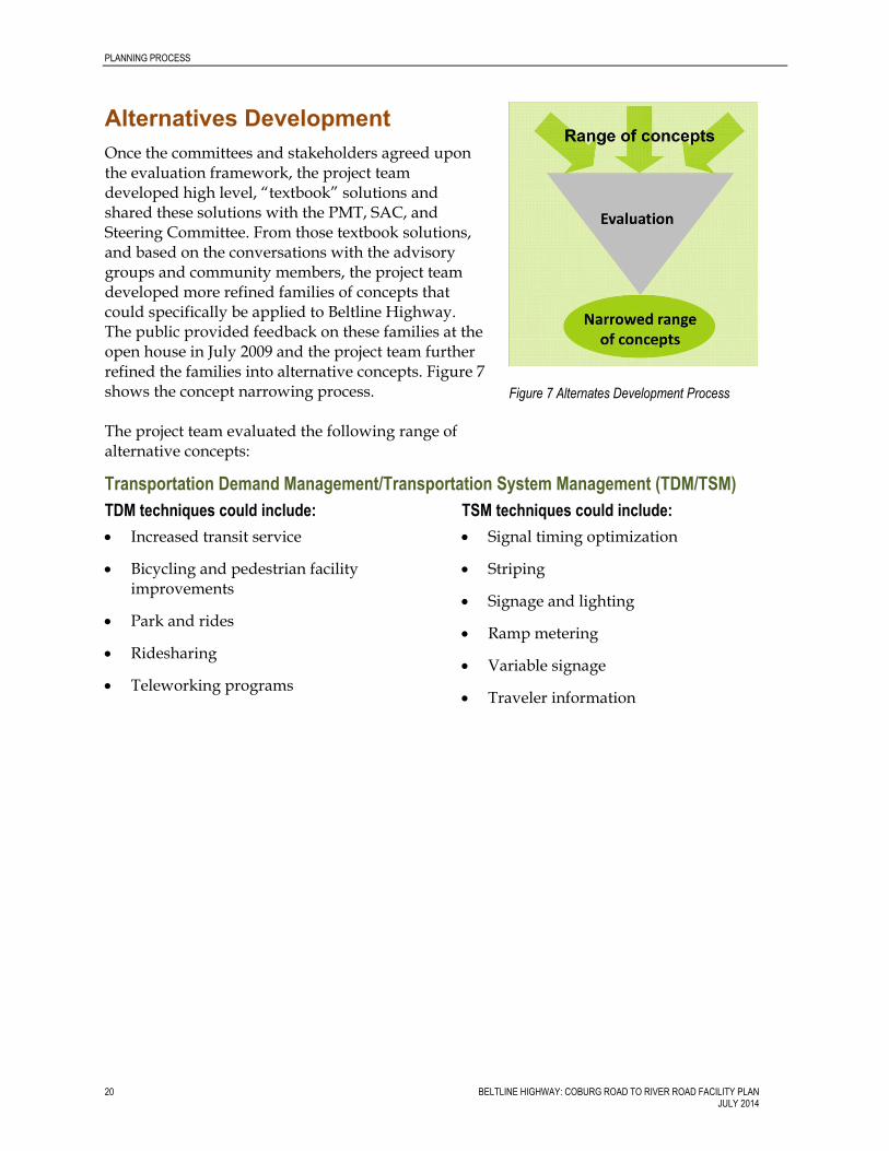
Alternatives Development
Once the committees and stakeholders agreed upon the evaluation framework, the project team developed high level, “textbook” solutions and shared these solutions with the PMT, SAC, and Steering Committee. From those textbook solutions, and based on the conversations with the advisory groups and community members, the project team developed more refined families of concepts that could specifically be applied to Beltline Highway. The public provided feedback on these families at the open house in July 2009 and the project team further refined the families into alternative concepts. Figure 7 shows the concept narrowing process. The project team evaluated the following range of alternative concepts:
Transportation Demand Management/Transportation System Management (TDM/TSM)
TDM techniques could include:
Increased transit service
Bicycling and pedestrian facility improvements
Park and rides
Ridesharing
Teleworking programs
TSM techniques could include:
Signal timing optimization
Striping
Signage and lighting
Ramp metering
Variable signage
Traveler information
Figure 7 Alternates Development Process

BELTLINE HIGHWAY: COBURG ROAD TO RIVER ROAD FACILITY PLAN
BELTLINE HIGHWAY: COBURG ROAD TO RIVER ROAD FACILITY PLAN 21 JULY 2014
Low Build Concept 1
Low Build 1 Concept3 would:
Extend the westbound off-ramp to the Delta Highway from westbound Beltline Highway.
Extend the eastbound off-ramp to the Delta Highway from eastbound Beltline Highway.
Low Build Concept 2
In addition to the features of Low Build 1 Concept, Low Build 2 Concept would:
Extend the eastbound auxiliary lane to Beltline Highway from the Delta Highway eastbound loop ramp.
Extend the distance for westbound acceleration to westbound Beltline Highway from the Delta Highway westbound loop ramp.
Rebuild the northbound loop ramp terminal intersection to Delta Highway northbound to improve the sight-distance.
Close the eastbound on-ramp from River Avenue in the peak period, decreasing congestion related to the short distance for merging and diverging.
3 All concepts initially included closing Ruby Avenue at River Road to reduce congestion at River Road. Subsequent analysis showed that this change would result in increased congestion in other areas. As a result, the project team updated all concepts to show that the intersection of Ruby Avenue and River Road would remain open.
Figure 8 Low Build Concept 1
Figure 9 Low Build Concept 2

PLANNING PROCESS
22 BELTLINE HIGHWAY: COBURG ROAD TO RIVER ROAD FACILITY PLAN JULY 2014
Low Build Concept 3
In addition to the features of Low Build 1 and 2 Concepts, Low Build 3 Concept would:
Change the northeast loop ramp at the Delta Highway/Beltline Highway interchange, to increase the acceleration distance onto the westbound Beltline Highway.
Remove the loop ramp from eastbound Beltline Highway to northbound Delta Highway. Northbound traffic would exit with southbound traffic, and then pass through a controlled intersection (signal or other control) to continue northbound on Delta Highway.
Add auxiliary lanes across the river in both directions between the Delta Highway and the River Avenue/Division Avenue ramps and rebuild the connection between River Avenue and Division Avenue under the Beltline Highway. This would require replacing the Willamette River bridges.
Improve the Division Avenue/Beaver Street intersection to facilitate right turns to access the Santa Clara Neighborhood.
Figure 10 Low Build Concept 3
BELTLINE HIGHWAY: COBURG ROAD TO RIVER ROAD FACILITY PLAN
BELTLINE HIGHWAY: COBURG ROAD TO RIVER ROAD FACILITY PLAN 23 JULY 2014
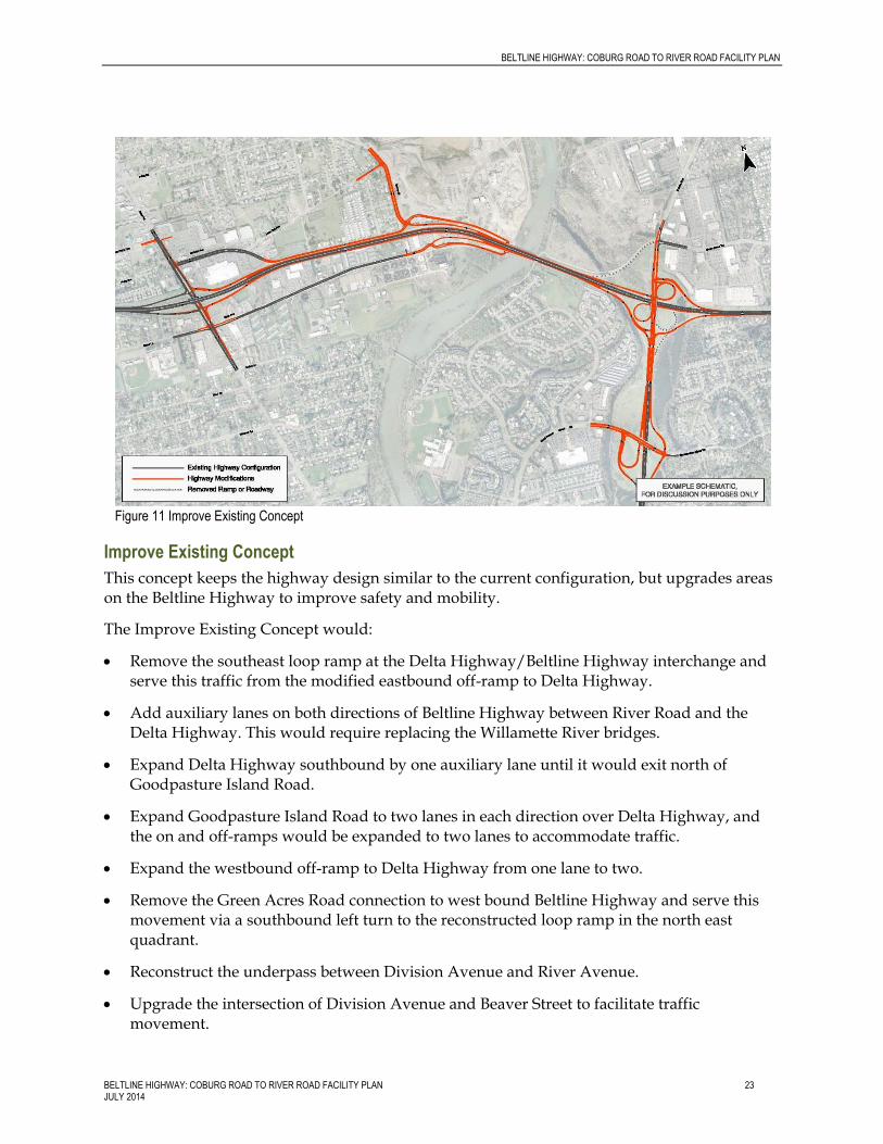
Improve Existing Concept
This concept keeps the highway design similar to the current configuration, but upgrades areas on the Beltline Highway to improve safety and mobility.
The Improve Existing Concept would:
Remove the southeast loop ramp at the Delta Highway/Beltline Highway interchange and serve this traffic from the modified eastbound off-ramp to Delta Highway.
Add auxiliary lanes on both directions of Beltline Highway between River Road and the Delta Highway. This would require replacing the Willamette River bridges.
Expand Delta Highway southbound by one auxiliary lane until it would exit north of Goodpasture Island Road.
Expand Goodpasture Island Road to two lanes in each direction over Delta Highway, and the on and off-ramps would be expanded to two lanes to accommodate traffic.
Expand the westbound off-ramp to Delta Highway from one lane to two.
Remove the Green Acres Road connection to west bound Beltline Highway and serve this movement via a southbound left turn to the reconstructed loop ramp in the north east quadrant.
Reconstruct the underpass between Division Avenue and River Avenue.
Upgrade the intersection of Division Avenue and Beaver Street to facilitate traffic movement.
Figure 11 Improve Existing Concept

PLANNING PROCESS
24 BELTLINE HIGHWAY: COBURG ROAD TO RIVER ROAD FACILITY PLAN JULY 2014
Improve Division Avenue between Beaver Street along Beltline Highway.
Upgrade the intersection with Lone Oak Road and Beaver Road to enhance connectivity.
Lengthen the River Avenue/Division Avenue ramps and reconfigure to improve the acceleration to and from the Beltline Highway.
Modify and improve other ramps but keep in current locations and configurations.
Local Arterial Bridge Concept
This concept would add an arterial bridge to the north of the Beltline Highway, providing a local connection option for traffic to travel over the river to provide alternative routes to the Beltline Highway over the Willamette River. The local arterial bridge would have two lanes in each direction, connecting Green Acres Road across the Willamette River from the Delta Highway Interchange area to the Beaver Street area west of the River Avenue/Division Avenue interchange on Beltline Highway.
There would be some upgrades to the Delta Highway interchange to provide a connection to the new arterial bridge including removing the Green Acres Road connection to westbound Beltline Highway. The movement would be served via a southbound left turn to the reconstructed loop ramp in the north east quadrant. The local arterial bridge as a treatment could be added to most of these concepts except the Collector-Distributor Road Concept as an interchangeable component.
Figure 12 Local Arterial Bridge Concept
BELTLINE HIGHWAY: COBURG ROAD TO RIVER ROAD FACILITY PLAN
BELTLINE HIGHWAY: COBURG ROAD TO RIVER ROAD FACILITY PLAN 25 JULY 2014
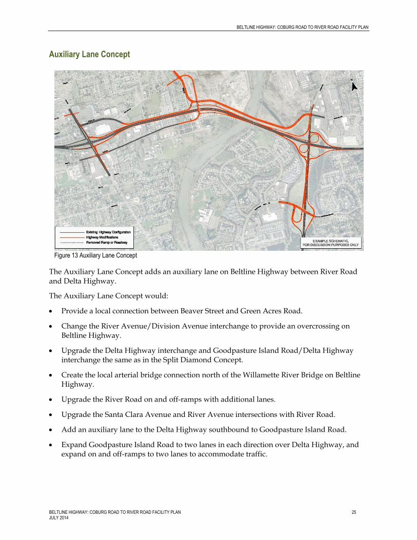
Auxiliary Lane Concept
The Auxiliary Lane Concept adds an auxiliary lane on Beltline Highway between River Road and Delta Highway.
The Auxiliary Lane Concept would:
Provide a local connection between Beaver Street and Green Acres Road.
Change the River Avenue/Division Avenue interchange to provide an overcrossing on Beltline Highway.
Upgrade the Delta Highway interchange and Goodpasture Island Road/Delta Highway interchange the same as in the Split Diamond Concept.
Create the local arterial bridge connection north of the Willamette River Bridge on Beltline Highway.
Upgrade the River Road on and off-ramps with additional lanes.
Upgrade the Santa Clara Avenue and River Avenue intersections with River Road.
Add an auxiliary lane to the Delta Highway southbound to Goodpasture Island Road.
Expand Goodpasture Island Road to two lanes in each direction over Delta Highway, and expand on and off-ramps to two lanes to accommodate traffic.
Figure 13 Auxiliary Lane Concept

PLANNING PROCESS
26 BELTLINE HIGHWAY: COBURG ROAD TO RIVER ROAD FACILITY PLAN JULY 2014
Split Diamond Concept
The Beltline Highway/Delta Highway interchange would be configured very similarly to the Improve Existing Concept.
The Split Diamond Concept would:
Add an auxiliary lane to the Delta Highway southbound to Goodpasture Island Road.
Expand Goodpasture Island Road to two lanes in each direction over Delta Highway, and expand on and off-ramps to two lanes to accommodate traffic.
Retain the local arterial bridge north of the Beltline Highway.
Include improvements to Beaver Street, Lone Oak Avenue, and local collectors in the Santa Clara Neighborhood.
Remove driveway and public road access from Division Avenue; serve adjacent properties from Lone Oak Avenue.
Reconfigure the River Avenue/Division Avenue interchange with an overpass over Beltline Highway.
Add auxiliary lanes to the Beltline Highway between River Road and Delta Highway.
Reconfigure River Avenue near the Beltline Highway.
Add a westbound connecting ramp between the River Avenue/Division Avenue and River Road interchanges.
Figure 14 Split Diamond Concept

BELTLINE HIGHWAY: COBURG ROAD TO RIVER ROAD FACILITY PLAN
BELTLINE HIGHWAY: COBURG ROAD TO RIVER ROAD FACILITY PLAN 27 JULY 2014
Upgrade the River Road/Beltline Highway interchange.
Collector-Distributor Roadway Concept
The Collector-Distributor Roadway Concept would provide a separate roadway parallel to the Beltline Highway from River Avenue/Division Avenue to east of the Delta Highway.
The Collector-Distributor Roadway Concept would:
Collect all traffic eastbound from River Avenue, Division Avenue, and Delta Highway, to merge with Beltline Highway east of the Delta Highway interchange.
Collect merging and diverging westbound traffic east of the Delta Highway interchange to merge onto Beltline Highway near the existing River Avenue/Division Avenue interchange.
Add an auxiliary lane to the Delta Highway southbound to Goodpasture Island Road.
Expand Goodpasture Island Road to two lanes in each direction over Delta Highway, and expand on and off-ramps to two lanes to accommodate traffic.
Allow traffic merging onto westbound Beltline Highway from the River Avenue/Division Avenue interchange to travel along Division Avenue to the River Road interchange, and enter Beltline Highway west of River Road.
Provide eastbound Beltline Highway access via intersection control (roundabout or signal) north of the highway, allowing traffic to pass under the Beltline Highway to access Beltline Highway eastbound, or to move traffic from the highway onto the local roads including Beaver Street or Division Avenue westbound.
Figure 15 Collector-Distributor Concept
PLANNING PROCESS
28 BELTLINE HIGHWAY: COBURG ROAD TO RIVER ROAD FACILITY PLAN JULY 2014
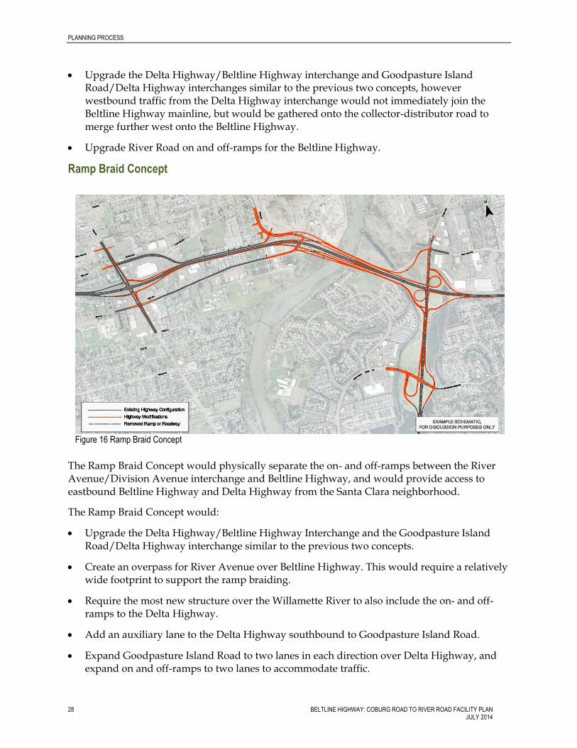
Upgrade the Delta Highway/Beltline Highway interchange and Goodpasture Island Road/Delta Highway interchanges similar to the previous two concepts, however westbound traffic from the Delta Highway interchange would not immediately join the Beltline Highway mainline, but would be gathered onto the collector-distributor road to merge further west onto the Beltline Highway.
Upgrade River Road on and off-ramps for the Beltline Highway.
Ramp Braid Concept
The Ramp Braid Concept would physically separate the on- and off-ramps between the River Avenue/Division Avenue interchange and Beltline Highway, and would provide access to eastbound Beltline Highway and Delta Highway from the Santa Clara neighborhood.
The Ramp Braid Concept would:
Upgrade the Delta Highway/Beltline Highway Interchange and the Goodpasture Island Road/Delta Highway interchange similar to the previous two concepts.
Create an overpass for River Avenue over Beltline Highway. This would require a relatively wide footprint to support the ramp braiding.
Require the most new structure over the Willamette River to also include the on- and off-ramps to the Delta Highway.
Add an auxiliary lane to the Delta Highway southbound to Goodpasture Island Road.
Expand Goodpasture Island Road to two lanes in each direction over Delta Highway, and expand on and off-ramps to two lanes to accommodate traffic.
Figure 16 Ramp Braid Concept

BELTLINE HIGHWAY: COBURG ROAD TO RIVER ROAD FACILITY PLAN
BELTLINE HIGHWAY: COBURG ROAD TO RIVER ROAD FACILITY PLAN 29 JULY 2014
These alternative concepts were evaluated against the criteria described above. The results of the evaluation were shared with the three advisory groups. The SAC and PMT then developed a recommendation to the Steering Committee about which concepts to carry forward into the next phase.
Appendix D: Evaluation Framework includes full ratings and explanation of how the project team rated each measure.

PLANNING PROCESS
30 BELTLINE HIGHWAY: COBURG ROAD TO RIVER ROAD FACILITY PLAN JULY 2014
This page intentionally left blank.

BELTLINE HIGHWAY: COBURG ROAD TO RIVER ROAD FACILITY PLAN 31 JULY 2014
3 Recommendations
Through both phases 2 and 3, the PMT, SAC, and PSC refined and narrowed the concepts reaching consensus about a set of concepts to advance to the environmental process.
Recommendation Process
The PMT, SAC and Steering Committee developed recommendations at several steps in the process. Detailed information about individual committee recommendations is provided in Appendix C Public Involvement. At each decision point, the PMT first reviewed the technical analysis and developed a recommendation for consideration by the SAC. The SAC reviewed the PMT recommendation and developed additional input for consideration by the Steering Committee. The Steering Committee reached consensus at each decision point.
Recommended Concepts
This facility plan recommends advancing the following concepts for further analysis during the NEPA process:
Improve Existing Concept
Auxiliary Lane Concept
Collector-Distributor Roadway Concept
All concepts include TDM and TSM strategies, which assume a future increase in transit, bicycle, and pedestrian use. The Improve Existing Concept and Auxiliary Lane Concept include the local arterial bridge. These concepts are very similar except for the interchange at River Avenue/Division Avenue. The local arterial bridge is not included in the Collector-Distributor Roadway Concept because the collector-distributor roadway provides a similar off-highway connection across the Willamette River. LTD reviewed all of the remaining concepts and agreed that these concepts are compatible with future transit service improvements.
Improve Existing
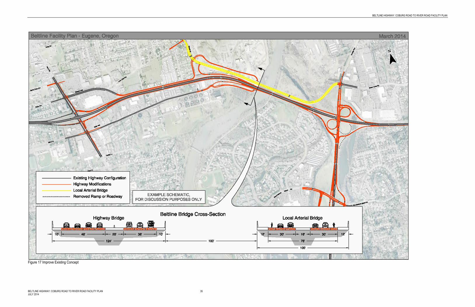
Figure 17 shows the Improve Existing Concept.
This concept maintains most of the Highway and interchanges similar to where they are today, with upgrades to ramp length and configurations to improve safety and address congestion. This description focuses on the Beltline Highway mainline and local roadway connections, the Interchange Configuration section includes more information on each of the three interchanges.
The Improve Existing Concept would:
Include a local arterial bridge connection between Beaver Street and Green Acres Road.

RECOMMENDATIONS
32 BELTLINE HIGHWAY: COBURG ROAD TO RIVER ROAD FACILITY PLAN JULY 2014
Add auxiliary lanes across the river in both directions between the Delta Highway and the River Avenue/Division Avenue ramps. This would require replacing the Willamette River bridges.
Expand Delta Highway southbound by one auxiliary lane until it would exit north of Goodpasture Island Road.
Create a new intersection at Division Avenue, Beaver Street, and the local arterial bridge connection.
Upgrade Division Avenue between Beaver Street along Beltline Highway (maintaining one lane in each direction).
Upgrade the intersection of Lone Oak Avenue and Beaver Street.
The Improve Existing Concept would make the following modifications to the Delta Highway and Goodpasture Island Road interchange (these changes are the same for all recommended concepts):
Extend the westbound and eastbound off-ramps to the Delta Highway from Beltline Highway.
Extend the eastbound auxiliary lane to Beltline Highway from the Delta Highway eastbound loop ramp.
Extend the distance for westbound acceleration to westbound Beltline Highway from the Delta Highway westbound loop ramp.
Reconfigure the northbound loop ramp terminal intersection to Delta Highway northbound to improve the sight-distance.
Remove the loop ramp from eastbound Beltline Highway to northbound Delta Highway. Northbound traffic would exit with southbound traffic, and then pass through a controlled intersection (signal or other control) to continue northbound on Delta Highway.
Expand Delta Highway southbound by one auxiliary lane until it would exit north of Goodpasture Island Road.
Expand Goodpasture Island Road to two lanes in each direction over Delta Highway, and the on and off-ramps would be expanded to two lanes to accommodate traffic.
Expand the westbound off-ramp to Delta Highway from one lane to two.
Summary of Costs
The planning level cost estimate for this concept is between $200 and $210 million in 2013 dollars (includes replacing the Willamette River bridges but does not include right-of-way).
Property Impacts
River Road/Beltline Highway Interchange This concept could impact a parking lot on the southeast corner of River Avenue and River Road.
BELTLINE HIGHWAY: COBURG ROAD TO RIVER ROAD FACILITY PLAN
BELTLINE HIGHWAY: COBURG ROAD TO RIVER ROAD FACILITY PLAN 33 JULY 2014
River Avenue and Division Avenue/Beltline Highway Interchange Property impacts between River Road and Delta Highway, including the River Avenue, Division Avenue/Beltline Highway interchange, may include:
Buildings and property south of the Beltline Highway between River Avenue and Division Avenue.
Buildings and property north of the Beltline highway from reconstructing Division Avenue as it approaches the Beltline Highway.
Buildings between Beaver Street and Hunsaker Lane.
The arterial bridge may have impacts to the Delta Sand and Gravel property.
Delta Highway/Beltline Highway Interchange This concept could have property impacts east of Delta Highway and north of Beltline Highway.
Mobility
This concept would provide sufficient capacity for forecasted traffic volumes in 2035. In 2035 during the PM peak hour, the Beltline Highway would operate at a v/c of 0.71 westbound and 0.62 eastbound between the River Road and Division Avenue interchanges, and a v/c of 0.75 westbound and 0.63 eastbound between the Division Avenue and Delta Highway interchanges. The arterial bridge would operate at a v/c of 0.65 westbound and 0.23 eastbound.
Travel demand across the river is essentially the same for all scenarios.
Ramp terminal intersections and other nearby intersections operate below or near capacity, but can accommodate forecasted volumes with changes such as signal retiming and adding turn lanes, where needed for all concepts.
The arterial bridge reduces demand on Beltline Highway, and will carry 17,000 vehicles on average per day.

RECOMMENDATIONS
34 BELTLINE HIGHWAY: COBURG ROAD TO RIVER ROAD FACILITY PLAN JULY 2014
This page intentionally left blank.
BELTLINE HIGHWAY: COBURG ROAD TO RIVER ROAD FACILITY PLAN
BELTLINE HIGHWAY: COBURG ROAD TO RIVER ROAD FACILITY PLAN 35 JULY 2014
Figure 17 Improve Existing Concept

RECOMMENDATIONS
36 BELTLINE HIGHWAY: COBURG ROAD TO RIVER ROAD FACILITY PLAN JULY 2014
This page intentionally left blank.

BELTLINE HIGHWAY: COBURG ROAD TO RIVER ROAD FACILITY PLAN
BELTLINE HIGHWAY: COBURG ROAD TO RIVER ROAD FACILITY PLAN 37 JULY 2014
Auxiliary Lane
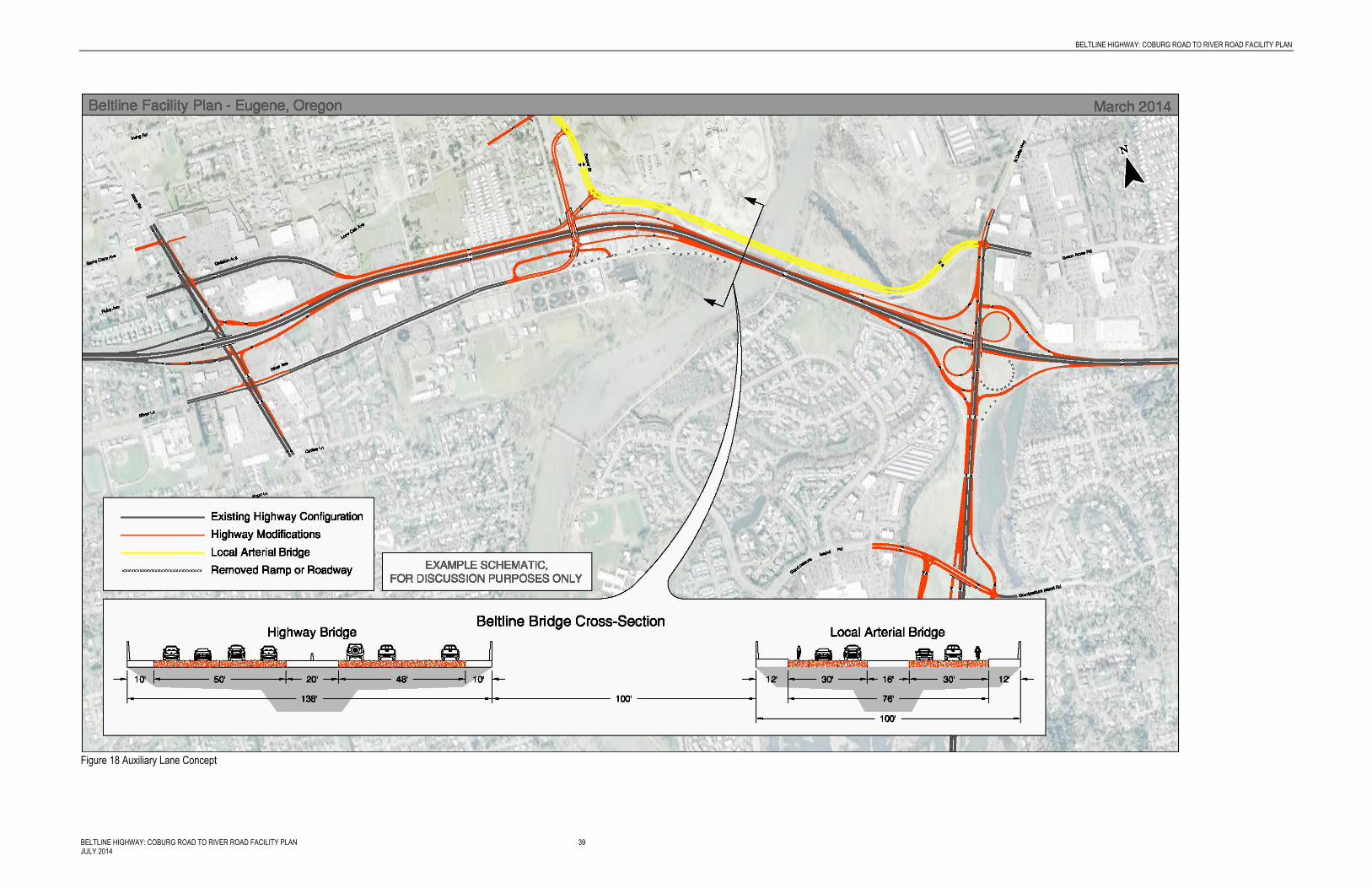
Figure 18 shows the Auxiliary Lane Concept.
The Auxiliary Lane Concept adds an auxiliary lane on Beltline Highway between River Road and Delta Highway to provide more room for merging/diverging movements to improve traffic flow. This description focuses on the Beltline Highway mainline and local roadway connections; the next section includes more information on interchange concepts and configurations.
The Auxiliary Lane Concept would:
Include a local arterial bridge connection between Beaver Street and Green Acres Road.
Add one lane to Beltline Highway in each direction over the Willamette River starting just west of Delta Highway to where the River Road interchange ramps connect to the mainline. This would require replacing the Willamette River bridges.
Upgrade Division Avenue (maintaining one lane in each direction) and reconfigure the intersection with Beaver Street.
Reconfigure the River Avenue connection to Beltline Highway and create a new intersection with Lone Oak Avenue and Beaver Street.
Make changes to the Delta Highway and Goodpasture Island Road as described in the Improve Existing Concept
Summary of Costs
The planning level cost estimate for this concept is between $215 and $225 million in 2013 dollars (includes replacing the Willamette River bridges but does not include right-of-way).
Property Impacts
River Road/Beltline Highway Interchange and Delta Highway/Beltline Highway Interchange Property impacts at the River Road/Beltline Highway interchange are the same for all concepts. For impacts, see the section under the Improve Existing Concept.
River Avenue and Division Avenue/Beltline Highway Interchange Property impacts between River Road and Delta Highway, including the River Avenue, Division Avenue/Beltline Highway Interchange may include:
Buildings and property north of the Beltline Highway from reconstructing Division Avenue as it approaches the Beltline Highway.
Buildings and property south of the Beltline Highway between River Avenue and Division Avenue
The arterial bridge and Beltline Highway overcrossing may have impacts to the Delta Sand and Gravel property.
Mobility This concept would provide sufficient capacity for forecasted traffic volumes in 2035. In 2035 during the PM peak hour, the Beltline Highway would operate at a v/c of 0.71 westbound and
RECOMMENDATIONS
38 BELTLINE HIGHWAY: COBURG ROAD TO RIVER ROAD FACILITY PLAN JULY 2014
0.64 eastbound between the River Road and Division Avenue interchanges, and a v/c of 0.78 westbound and 0.65 eastbound between the Division Avenue and Delta Highway interchanges. The arterial bridge would operate at a v/c of 0.64 westbound and 0.24 eastbound.
BELTLINE HIGHWAY: COBURG ROAD TO RIVER ROAD FACILITY PLAN
BELTLINE HIGHWAY: COBURG ROAD TO RIVER ROAD FACILITY PLAN 39 JULY 2014
Figure 18 Auxiliary Lane Concept
RECOMMENDATIONS
40 BELTLINE HIGHWAY: COBURG ROAD TO RIVER ROAD FACILITY PLAN JULY 2014
This page intentionally left blank.

BELTLINE HIGHWAY: COBURG ROAD TO RIVER ROAD FACILITY PLAN
BELTLINE HIGHWAY: COBURG ROAD TO RIVER ROAD FACILITY PLAN 41 JULY 2014
Collector-Distributor Road
Figure 19 shows the Collector-Distributor Road Concept.
The Collector-Distributor Roadway Concept would provide a separate roadway parallel to the Beltline Highway from River Avenue/Division Avenue to east of the Delta Highway, moving most of the merge/diverge traffic movements off the mainline and onto a collector-distributor road.
The Collector-Distributor Roadway Concept would:
Collect all traffic eastbound from River Avenue, Division Avenue, and Delta Highway, to merge with Beltline Highway east of the Delta Highway interchange.
Collect merging and diverging westbound traffic east of the Delta Highway interchange to merge onto Beltline Highway near the existing River Avenue/Division Avenue interchange.
Collect traffic merging onto westbound Beltline Highway from the River Avenue/Division Avenue interchange on Division Avenue to River Road, where it would enter the highway at the interchange.
Make changes to the Delta Highway and Goodpasture Island Road as described in the Improve Existing Concept.
Summary of Costs
The planning level cost estimate for this concept is between $260 and $270 million in 2013 dollars (includes replacing the Willamette River bridges but does not include right-of-way).
Property Impacts
River Road/Beltline Highway Interchange and Delta Highway/Beltline Highway Interchange Property impacts at the River Road/Beltline Highway interchange are the same for all concepts. For impacts, see the section under the Improve Existing Concept.
River Avenue and Division Avenue/Beltline Highway Interchange Property impacts between River Road and Delta Highway, including the River Avenue, Division Avenue/Beltline Highway Interchange may include:
Buildings and property south of the Beltline Highway between River Avenue and Division Avenue
Buildings and property south of the Beltline Highway between River Avenue and Division Avenue
The Beltline Highway undercrossing and local road connections may have impacts to the Delta Sand and Gravel property.
Delta Highway/Beltline Highway Interchange This concept may impact buildings and property south of Beltline Highway west of Delta Highway.

RECOMMENDATIONS
42 BELTLINE HIGHWAY: COBURG ROAD TO RIVER ROAD FACILITY PLAN JULY 2014
Goodpasture Island Road/Delta Highway Interchange Property impacts at the Goodpasture Island Road/Delta Highway interchange are the same for all concepts. For impacts, see the section under the Improve Existing Concept.
Mobility This concept adds capacity with the collector-distributor roads over the river, though the lack of a local arterial bridge does not reduce demand on Beltline Highway.
This concept would provide sufficient capacity for forecasted traffic volumes in 2035. In 2035 during the PM peak hour, the Beltline Highway would operate at a v/c of 0.65 westbound and 0.68 eastbound between the River Road and Division Avenue interchanges, and a v/c of 0.63 westbound and 0.67 eastbound between the Division Avenue and Delta Highway interchanges. The collector-distributor roads would operate at a v/c of 0.69 westbound and 0.60 eastbound.

BELTLINE HIGHWAY: COBURG ROAD TO RIVER ROAD FACILITY PLAN
BELTLINE HIGHWAY: COBURG ROAD TO RIVER ROAD FACILITY PLAN 43 JULY 2014
Figure 19 Collector-Distributor Concept

RECOMMENDATIONS
44 BELTLINE HIGHWAY: COBURG ROAD TO RIVER ROAD FACILITY PLAN JULY 2014
This page intentionally left blank.
BELTLINE HIGHWAY: COBURG ROAD TO RIVER ROAD FACILITY PLAN 45 JULY 2014
4 Interchange Area Management Plans
Oregon Administrative Rule (OAR) 734-051-0155 requires an IAMP for new and upgraded interchanges to ensure safe and efficient operations between connecting roadways to protect the function of the interchange and minimize the need for future major interchange improvements.
The State Legislature passed Senate Bill 408 (SB408) in 2013 to address access management in facility plans which recommend changes to properties abutting State Highways. While the rules were under development during this planning effort, the project team determined that no access closures would be recommended as part of this facility plan and that access would be managed through City policies and ODOT/City coordination. As the NEPA process refines each concept to select a preferred alternative, and the rule is further developed, SB408 will continue to be applied if access changes are proposed. This chapter explains those access management policy concepts.
The interchange area management plans that follow recommended access management policies that can be implemented ahead of design and construction of the recommended interchanges as well as a description of potential access impacts, changes and management tools that may be explored prior to implementation of interchange improvements.
Specific funding sources to implement this facility plan have not yet been identified, though funding is likely to come from the City, LCOG, and ODOT. As the city develops Eugene’s TSP, and LCOG finalizes the RTSP, ODOT will work with these two jurisdictions to include the Facility Plan and potential early implementation elements in the financially constrained list, as appropriate.
Interchange Area Management Plans
This facility plan includes IAMPs based on recommendations that will move forward into the NEPA phase. As the participating agencies determine the preferred alternative in the environmental study phase, these IAMPs may need to be refined to include additional high-level policies and actions that address how best to protect interchange improvements and function by identifying necessary transportation, land use, and access management actions. Additionally, if the city or ODOT make any large changes to the interchange concepts during the environmental study phase, the IAMPs will be updated to reflect these changes.
To comply with OAR 734-051-0155, the City of Eugene and the Oregon Transportation Commission will need to agree on IAMPs prior to construction of substantial interchange improvements. Prior to construction, the IAMPs prepared for the Beltline Highway will need to:
Be developed no later than the time an interchange is designed or is being redesigned

INTERCHANGE AREA MANAGEMENT PLANS
46 BELTLINE HIGHWAY: COBURG ROAD TO RIVER ROAD FACILITY PLAN JULY 2014
Identify opportunities to improve operations and safety in conjunction with roadway projects and property development or redevelopment and adopt policies, provisions, and development standards to capture those opportunities
Include short, medium, and long-range actions to improve operations and safety within the designated study area
Consider current and future traffic volumes and flows, roadway geometry, traffic control devices, current and planned land uses and zoning, and the location of all current and planned approaches
Provide adequate assurance of the safe operation of the facility through the design traffic forecast period, typically 20 years
Consider existing and proposed uses of all the property within the designated study area consistent with its comprehensive plan designations and zoning
Be consistent with any applicable Access Management Plan, corridor plan or other facility plan adopted by the Oregon Transportation Commission
Include policies, provisions, and standards from local comprehensive plans, transportation system plans, and land use and subdivision codes that are relied upon for consistency and that are relied upon to implement the IAMP
Additionally, the three interchanges will need to be monitored by the city, county, and ODOT to ensure that the interchanges continue to function at a reasonable level. Based on the traffic analysis found earlier in this Facility Plan, all recommended concepts meet applicable ODOT mobility targets and Eugene mobility standards.

BELTLINE HIGHWAY: COBURG ROAD TO RIVER ROAD FACILITY PLAN
BELTLINE HIGHWAY: COBURG ROAD TO RIVER ROAD FACILITY PLAN 47 JULY 2014
River Road Interchange Area Management Plan
River Road is a major north-south five lane arterial in north Eugene. The interchange study area includes the signalized on- and off-ramps for the Beltline Highway, the signalized River Avenue/River Road/Silver Lane intersection, the signalized River Road/Division Avenue/Ruby Avenue intersection, LTD’s River Road Transit Station, commercial development, and a number of associated commercial driveways. LTD is studying transit improvements in this area; future improvements to the River Road interchange will need to be coordinated with LTD.
Existing and Future Safety and Traffic Conditions
Between 2007 and 2011, there were higher occurrences of reported crashes along River Road north of Beltline Highway and also at the Silver Lane/River Road intersection just south of Beltline Highway compared to other study intersections. Most of these crashes were either rear-end crashes or turning crashes.
On River Road between Silver Lane and Corliss Lane within the study area, the left-turn egress movement at four of the access driveways does not meet city level of service standards. Currently, vehicles making turns onto River Road can experience long delays when trying to make this movement. These accesses serve Abby’s Pizza, Key Bank, Bi-Mart, and the Wendy’s. Additionally, queuing analysis shows that during peak periods, queues can extend between intersections along River Road near the Beltline Highway westbound and eastbound ramps, the Silver Lane intersection, and the Santa Clara intersection. The northbound queue on River Road extends south of the Silver Lane/River Avenue intersection and also blocks some of the access driveways on the east side of River Road.
Future (2035) congestion on River Road is expected to increase from existing conditions at River Road/Ruby Avenue/Division Avenue, and vehicles making turns onto River Road will experience delays at a five of the unsignalized driveways on River Road between River Avenue and Corliss Lane. Future anticipated vehicle queues extend nearly the full length of the River Road corridor within the study area both northbound and southbound in the peak hour.
Existing Accesses
North of the Beltline Highway, two private accesses onto River Road are located within a quarter mile of the Beltline Highway off-ramp (one right-in entrance only and one full-access driveway). Both private accesses are on the east side of River Road. The intersections of River Road and Division Avenue/Ruby Avenue and Santa Clara Avenue are also within a quarter mile of the interchange north of the highway.
South of the Beltline Highway, the River Road/Silver Lane intersection is within a quarter mile of the Beltline Highway ramp terminal. There are nine accesses on the west side of River Road, and five on the east, all accessing commercial properties. All of these private accesses accommodate traffic both entering and exiting except for one pair of driveways that operate as a couplet with entrance only and exit only.
Additionally, Eugene has city-specific standards in city code which apply to River Road. Within the influence area of a controlled (signalized) intersection of a major arterial, city code states that “except when an existing lot or parcel is located entirely within the intersection influence area, no access connection to an arterial or major collector street shall be located within the

INTERCHANGE AREA MANAGEMENT PLANS
48 BELTLINE HIGHWAY: COBURG ROAD TO RIVER ROAD FACILITY PLAN JULY 2014
intersection influence area.” For River Road, the intersection influence area is 250 feet. Outside of intersection influence areas, according to city code, accesses should be spaced 200 feet apart. None of the accesses south of the River Road/River Avenue/Silver Lane intersection meet this 250 foot standard for intersection influence, or the 200 foot standard for distance between accesses.
Interchange Concept
Figure 20 shows the detail of the proposed improvement to the existing conditions at the River Road interchange.
The River Road interchange would have the same configuration with any corridor concept. The following changes would occur:
Widen the eastbound on- and off-ramps by one lane each creating a three lane off-ramp and a two lane on-ramp at River Road.
Widen the westbound off-ramp from Beltline Highway to River Road to four lanes.
Improve the ramp terminal intersections at River Road better accommodate turning vehicles.
Widen River Road northbound north of Corliss Lane to three lanes, and widen to four lanes between River Avenue and Beltline Highway
Widen River Road northbound north of Beltline Highway to three lanes to Santa Clara Road.

BELTLINE HIGHWAY: COBURG ROAD TO RIVER ROAD FACILITY PLAN
BELTLINE HIGHWAY: COBURG ROAD TO RIVER ROAD FACILITY PLAN 49 JULY 2014
Figure 20 Detail of the River Road Interchange

INTERCHANGE AREA MANAGEMENT PLANS
50 BELTLINE HIGHWAY: COBURG ROAD TO RIVER ROAD FACILITY PLAN JULY 2014
Access Management Policies
As parcels redevelop or apply for use changes with the city, according to the City of Eugene’s Arterial and Collector Street Plan, Eugene will “look for opportunities to consolidate multiple accesses into fewer driveways, particularly on commercial frontage along arterials.” No changes to existing accesses are recommended at this point, and future access management actions will rely on the city implementing their access policies if and when these commercial properties along River Road are redeveloped or the property owner applies for a zoning change. In the no-build condition, ODOT will not consider changes to private access or public streets.
The city controls the signalized intersections at Ruby Avenue/Division Avenue and River Road, and Silver Lane/River Avenue and River Road and will work closely with ODOT to use these signals to manage traffic and access to the adjacent Beltline Highway ramp terminals. Coordination between the city and ODOT could help reduce congestion and safety concerns at the ramp terminals.
Additionally, the Eugene TSP will recommend access management policies on key transit corridors including River Road to ensure safe and smooth traffic operations. The facility plan and IAMPs in this document defer to the Eugene TSP to implement future access management policies and changes.
Eugene is beginning a study of transit improvements between northwest Eugene and Lane Community College; River Road may be studied during this process. Future evaluation of concepts should consider transit service improvements on River Road.
Alternative Mobility Standards
The River Road on- and off-ramps operate within the OHP mobility target of 0.90 v/c in both the existing and future no-build conditions. The westbound ramps operate at a v/c of 0.63 in the existing condition and 0.73 in the 2035 no-build condition. The eastbound ramps operate at a v/c of 0.71 and 0.82 in the existing and future conditions, respectively. Though the ramp termini operate within mobility targets, substantial queuing occurs on River Road in both the existing and future no-build conditions. Appendix A includes more information about the existing and future conditions. In the future build condition, all on- and off-ramps meet applicable mobility targets. Alternative mobility targets will not be needed in the no-build condition.

BELTLINE HIGHWAY: COBURG ROAD TO RIVER ROAD FACILITY PLAN
BELTLINE HIGHWAY: COBURG ROAD TO RIVER ROAD FACILITY PLAN 51 JULY 2014
River Avenue/Division Avenue Interchange Area Management Plan
The River Avenue/Division Avenue interchange is a button-hook style interchange with Division Avenue north of Beltline Highway, and River Avenue south of Beltline Highway. The two streets are connected via an underpass on the west bank of the Willamette River. From the westbound Beltline Highway, vehicles exit to Division Avenue, and can either pass underneath Beltline Highway to access River Avenue, or access neighborhoods and commercial areas north of Beltline Highway by staying on Division Avenue.
The Beltline Highway eastbound off-ramp crosses River Avenue at a stop-controlled intersection with the eastbound on-ramp, creating confusion for some drivers who may be unfamiliar with the interchange configuration. The eastbound on-ramp from River Avenue is very short and requires vehicles to merge immediately onto mainline Beltline Highway before the two-lane bridge over the Willamette River.
Existing and Future Safety and Traffic Conditions
In 2010, two fatal crashes occurred near this interchange; alcohol was cited as contributing factor in both crashes. There were also a number of reported crashes along Beltline Highway near this interchange, and on Division and River Avenues. Most of the crashes on the mainline near this interchange were rear-end crashes, which are likely a result of congestion on the highway.
The Division Avenue/Beaver Street intersection will not meet county level of service standards in 2035, indicating that vehicles will experience delay and congested conditions as they move through the intersection, though the other ramps and intersections near this interchange meet current city, county, and ODOT standards in the future condition.
Existing Accesses
Similar to the River Road interchange, 12 private accesses and one public road are located along River Avenue within a quarter mile of the ramp terminals, mostly north of River Avenue, accessing commercial properties. Though none of these accesses meet ODOT spacing standards, this IAMP does not recommend change at this time. Three private accesses to the aggregate mining property north of Beltline Highway are located on Division Avenue are located within a quarter mile of the ramp terminal. The public street intersection of Division Avenue and Beaver Street is also located, within a quarter mile of the ramp terminal.
Interchange Concepts
The River Avenue/Division Avenue interchange configuration would vary with each concept.
Improve Existing
This concept includes the local arterial bridge, which would connect from Delta Highway at Green Acres Road to Beaver Street north of Beltline Highway and Division Avenue. With this concept, the River Avenue/Division Avenue interchange would be reconstructed in its current form with an underpass west of the Willamette River under Beltline Highway between River Avenue and Division Avenue. The location of the intersection of the local arterial bridge and Beaver Street, the footprint of the new underpass and the location of the intersection of the

INTERCHANGE AREA MANAGEMENT PLANS
52 BELTLINE HIGHWAY: COBURG ROAD TO RIVER ROAD FACILITY PLAN JULY 2014
westbound off-ramp could vary in this concept. Figures 21 and 22 show the two interchange options. Figure 22 is a refinement to minimize impacts to adjacent properties.
Figure 21 Improve Existing Option 1
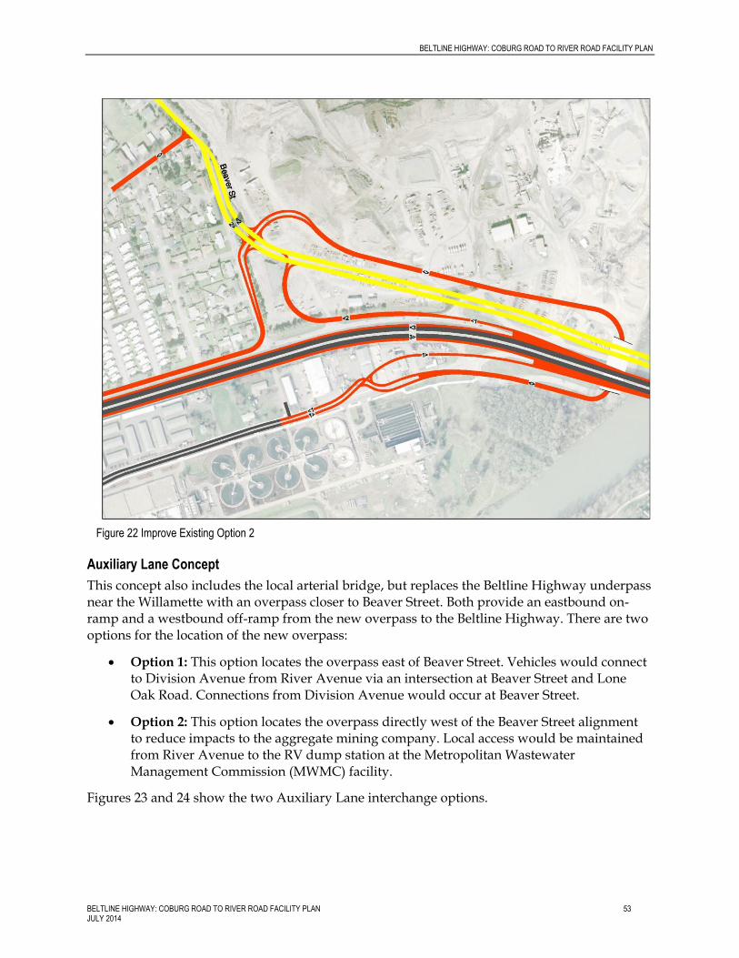
BELTLINE HIGHWAY: COBURG ROAD TO RIVER ROAD FACILITY PLAN
BELTLINE HIGHWAY: COBURG ROAD TO RIVER ROAD FACILITY PLAN 53 JULY 2014
Auxiliary Lane Concept
This concept also includes the local arterial bridge, but replaces the Beltline Highway underpass near the Willamette with an overpass closer to Beaver Street. Both provide an eastbound on-ramp and a westbound off-ramp from the new overpass to the Beltline Highway. There are two options for the location of the new overpass:
Option 1: This option locates the overpass east of Beaver Street. Vehicles would connect to Division Avenue from River Avenue via an intersection at Beaver Street and Lone Oak Road. Connections from Division Avenue would occur at Beaver Street.
Option 2: This option locates the overpass directly west of the Beaver Street alignment to reduce impacts to the aggregate mining company. Local access would be maintained from River Avenue to the RV dump station at the Metropolitan Wastewater Management Commission (MWMC) facility.
Figures 23 and 24 show the two Auxiliary Lane interchange options.
Figure 22 Improve Existing Option 2

INTERCHANGE AREA MANAGEMENT PLANS
54 BELTLINE HIGHWAY: COBURG ROAD TO RIVER ROAD FACILITY PLAN JULY 2014
Figure 23 River Avenue/Division Avenue Interchange Auxiliary Lane Concept Option 1
Figure 24 River Avenue/Division Avenue Interchange Auxiliary Lane Concept Option 2

BELTLINE HIGHWAY: COBURG ROAD TO RIVER ROAD FACILITY PLAN
BELTLINE HIGHWAY: COBURG ROAD TO RIVER ROAD FACILITY PLAN 55 JULY 2014
Collector-Distributor Concept
This concept is the only concept advanced that does not include the local arterial bridge. The collector-distributor road effectively serves as this local connection. In lieu of the local arterial bridge, vehicles would use the collector-distributor roadway to cross the Willamette River without using the mainline. The concept maintains the underpass connection between River and Division Avenues, but would elongate the on- and off-ramps and separate merging/diverging traffic onto the collector-distributor road. It creates two controlled intersections; one between River and Division Avenues, and one between Division Avenue and Beaver Street. The interchange would impact businesses south of Beltline Highway on River Avenue. Two design variations have been developed that have different business impacts. Figures 25 and 26 show the two interchange configuration options.
Figure 25 Collector- Distributor River Avenue/Division Avenue Interchange Option 1

INTERCHANGE AREA MANAGEMENT PLANS
56 BELTLINE HIGHWAY: COBURG ROAD TO RIVER ROAD FACILITY PLAN JULY 2014
Access Management Policies
No changes to existing accesses are recommended at this point, and future access management rely on the city implementing their access policies if and when these commercial properties along River and Division Avenues are redeveloped or the property owner applies for a zoning change.
Alternative Mobility Standards
The River Avenue and Division Avenue on- and off-ramps operate within the OHP mobility target of 0.90 in both the existing and future conditions. The Division Avenue westbound ramps operate at a v/c of 0.28 in the existing condition and 0.46 in the 2035 no-build condition. The eastbound River Avenue and Division Avenue ramps operate at a v/c of 0.31 and 0.49 in the existing and future conditions, respectively. Appendix A includes more information about the existing and future conditions. In the future build concept, all on- and off-ramps meet applicable mobility targets. Alternative mobility targets will not be needed in the no-build condition.
Figure 26 Collector- Distributor River Avenue/Division Avenue Interchange Option 2

BELTLINE HIGHWAY: COBURG ROAD TO RIVER ROAD FACILITY PLAN
BELTLINE HIGHWAY: COBURG ROAD TO RIVER ROAD FACILITY PLAN 57 JULY 2014
Delta Highway Interchange Area Management Plan
The Delta Highway interchange at Beltline Highway is a three loop cloverleaf with a northwest quadrant on-ramp. The three “leaves” of the cloverleaf are characterized by very short merge/diverge areas. The eastbound ramp is especially problematic where vehicles merging onto mainline Beltline Highway conflict with vehicles exiting the highway to go north on Delta Highway.
Existing and Future Safety and Traffic Conditions
The Delta Highway/Green Acres Road (westbound Beltline Highway on-ramp) intersection has a higher rate of reported crashes relative to other intersections. One fatal accident occurred in this area; alcohol was cited as a factor. The segment of Beltline Highway at the interchange and the segment just east where the Green Acres on-ramp meets the mainline are statewide Safety Priority Index System (SPIS) top 10 percent segments. Additionally, there are a high number of reported crashes for the eastbound to southbound Beltline Highway off-ramp, and leading to the westbound off-ramp.
Forecast no-build traffic conditions in 2035 will fail to meet city and county intersection operation standards:
Western-most unsignalized commercial access along Green Acres Road
Unsignalized access at Market of Choice on Green Acres Road
Northern Home Depot unsignalized access on Delta Highway
Delta Highway and Green Acres Road/westbound Beltline Highway On-Ramp terminal intersection
Traffic queues extend from the signal at Delta Highway along Green Acres Road, blocking commercial access points along the road to the signalized access to Home Depot and past the signal east of Home Depot.
Existing Accesses
Seven private non-controlled accesses are located north of Beltline Highway on Delta Highway within a quarter mile of the ramp terminals. Additionally, two public accesses, Green Acres Road and the westbound Beltline Highway on-ramp, and two private (access-restricted) driveways are located north of Beltline Highway on Delta Highway. South of Beltline Highway, at the interchange at Goodpasture Island Road is within a quarter mile of the ramp terminals.
The southbound access spacing between Beltline Highway and Goodpasture Island Road meets Lane County access management standards of 700 feet, but the spacing between the northbound Goodpasture Island/Delta Highway on-ramp and the Beltline Highway eastbound off-ramp does not meet Lane County standards found in the Lane County Code section 15.138.
Interchange Concept
The Delta Highway interchange would change substantially under all concepts. The new interchange would not include the loop ramp from eastbound Beltline Highway to northbound Delta Highway. Northbound traffic would exit with southbound traffic and pass through a

INTERCHANGE AREA MANAGEMENT PLANS
58 BELTLINE HIGHWAY: COBURG ROAD TO RIVER ROAD FACILITY PLAN JULY 2014
controlled intersection (e.g. signal) making a left turn to go north on Delta Highway. Other changes would include:
Extend the eastbound and westbound off-ramp to the Delta Highway.
Extend the eastbound auxiliary lane to Beltline Highway from the Delta Highway eastbound loop ramp.
Extend the acceleration distance to Beltline Highway from the Delta Highway westbound loop ramp.
Change the northeast loop ramp to increase the acceleration distance onto the westbound Beltline Highway.
Add an auxiliary lane to Delta Highway southbound to Goodpasture Island Road.
For the Improve Existing and Auxiliary Lane Concepts, the existing westbound on-ramp from Green Acres Road becomes a connection to the local arterial bridge and no longer provides for a connection to westbound Beltline Highway; in both concepts southbound on Delta Highway is able to access the westbound Beltline Highway via a left turn to the loop ramp (Improve Existing Concept) or a new on-ramp (Auxiliary Lane Concept). For the Collector-Distributor Road Concept, the on-ramp from Green Acres Road becomes the on-ramp to the westbound collector-distributor roadway. Figures 27, 28, and 29 show the three interchange concepts.
Figure 27 Detail of the Delta Highway Interchange – Improve Existing Concept
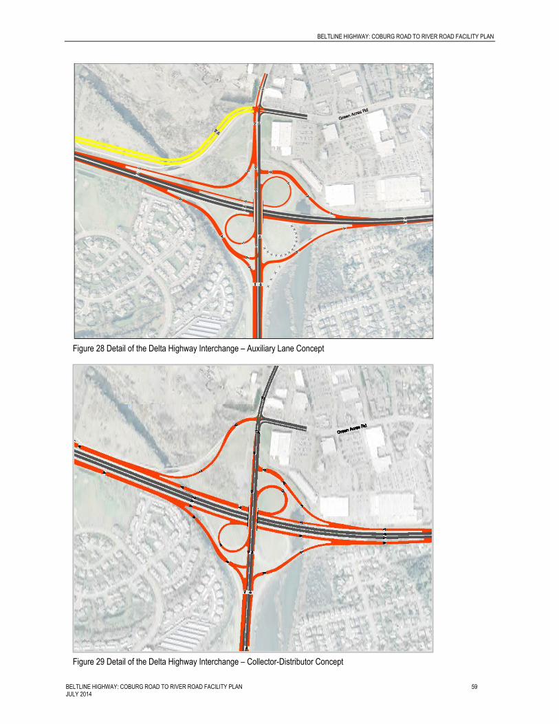
BELTLINE HIGHWAY: COBURG ROAD TO RIVER ROAD FACILITY PLAN
BELTLINE HIGHWAY: COBURG ROAD TO RIVER ROAD FACILITY PLAN 59 JULY 2014
Figure 28 Detail of the Delta Highway Interchange – Auxiliary Lane Concept
Figure 29 Detail of the Delta Highway Interchange – Collector-Distributor Concept
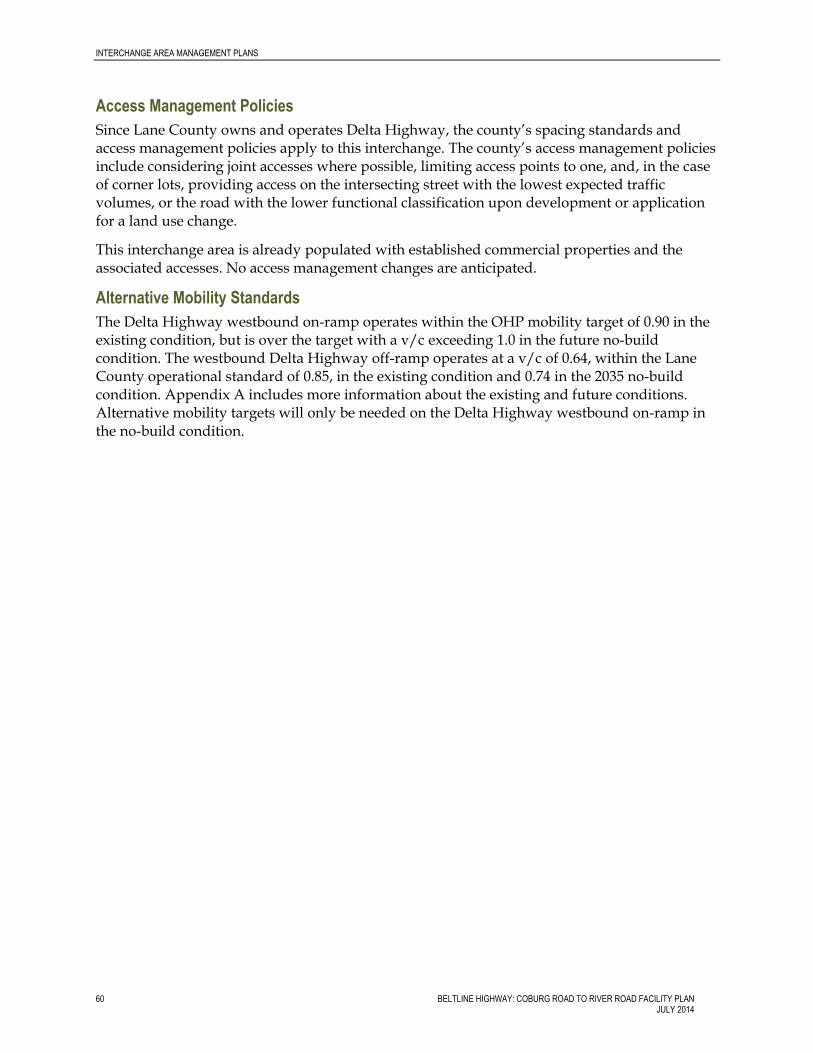
INTERCHANGE AREA MANAGEMENT PLANS
60 BELTLINE HIGHWAY: COBURG ROAD TO RIVER ROAD FACILITY PLAN JULY 2014
Access Management Policies
Since Lane County owns and operates Delta Highway, the county’s spacing standards and access management policies apply to this interchange. The county’s access management policies include considering joint accesses where possible, limiting access points to one, and, in the case of corner lots, providing access on the intersecting street with the lowest expected traffic volumes, or the road with the lower functional classification upon development or application for a land use change.
This interchange area is already populated with established commercial properties and the associated accesses. No access management changes are anticipated.
Alternative Mobility Standards
The Delta Highway westbound on-ramp operates within the OHP mobility target of 0.90 in the existing condition, but is over the target with a v/c exceeding 1.0 in the future no-build condition. The westbound Delta Highway off-ramp operates at a v/c of 0.64, within the Lane County operational standard of 0.85, in the existing condition and 0.74 in the 2035 no-build condition. Appendix A includes more information about the existing and future conditions. Alternative mobility targets will only be needed on the Delta Highway westbound on-ramp in the no-build condition.
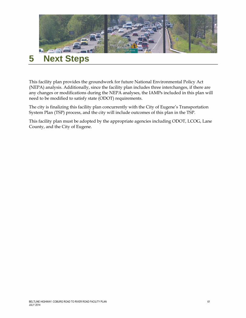
BELTLINE HIGHWAY: COBURG ROAD TO RIVER ROAD FACILITY PLAN 61 JULY 2014
5 Next Steps
This facility plan provides the groundwork for future National Environmental Policy Act (NEPA) analysis. Additionally, since the facility plan includes three interchanges, if there are any changes or modifications during the NEPA analyses, the IAMPs included in this plan will need to be modified to satisfy state (ODOT) requirements.
The city is finalizing this facility plan concurrently with the City of Eugene’s Transportation System Plan (TSP) process, and the city will include outcomes of this plan in the TSP.
This facility plan must be adopted by the appropriate agencies including ODOT, LCOG, Lane County, and the City of Eugene.


![[Michael quayle] purchasing_and_supply_chain_manag(bokos-z1)](https://img.pdfslide.net/doc/110x75/5576c26ed8b42ae3108b48e6/michael-quayle-purchasingandsupplychainmanagbokos-z1.jpg)