Embed Size (px)
Citation preview
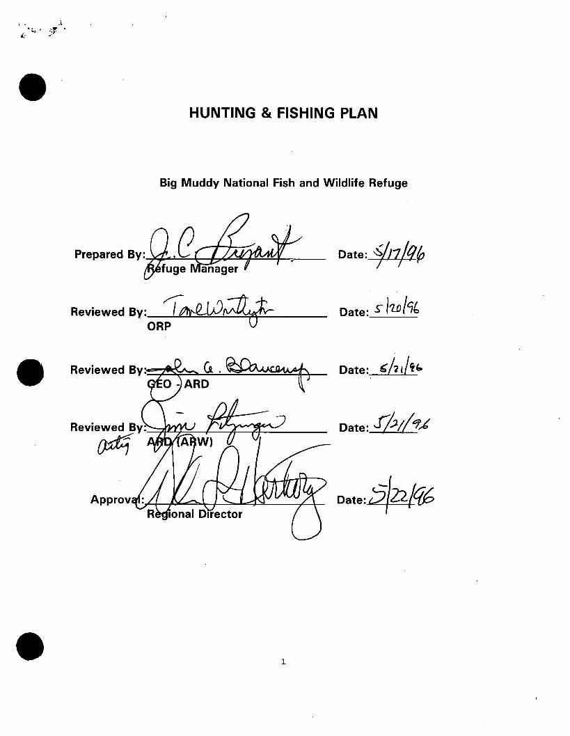
HUNTING & FISHING PLAN
Big Muddy National Fish and Wildlife Refuge
Reviewed By: "/" ~ ORP
Approv
1
Date:#~
Date: S h.o/7b
Date: .Jft.;(~,t
'' > ~ I
(
L
·I .
I. INTROPUCTION
The Big Muddy National Fish and Wildlife Refuge (Refuge) proposal covers the Kansas City to St. Louis reach of the Missouri river and its flood plain and will involve the acquisition of approximately 60,000 acres on twenty to thirty different sites.
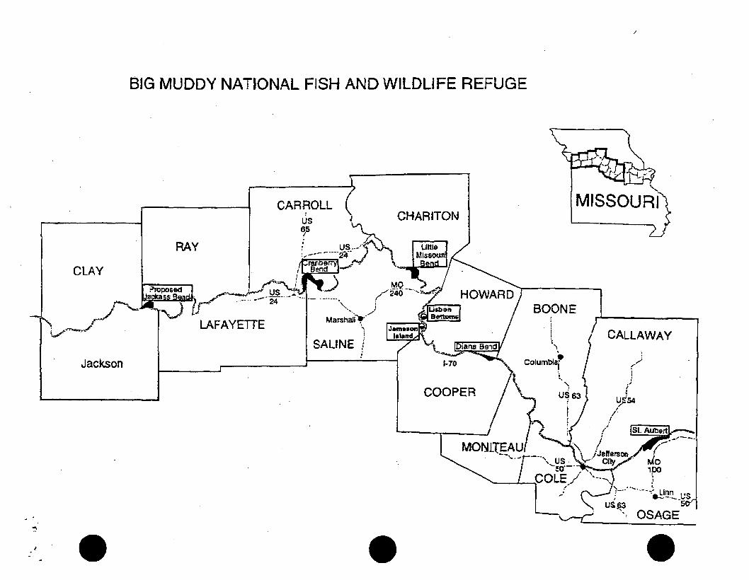
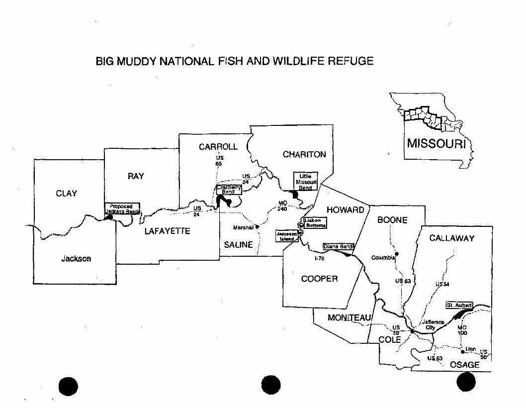
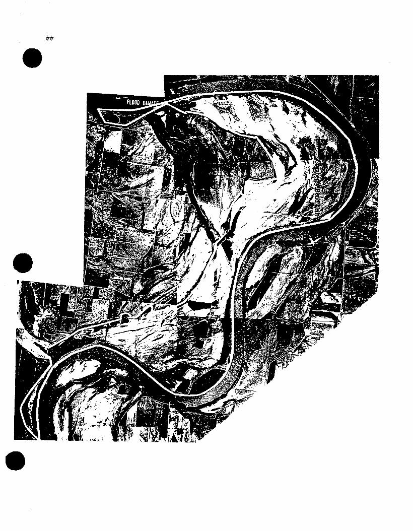
Seven sites have been identified for acquisition and are located from just east of Kansas City to slightly down river from Jefferson City. The Refuge presently con·sist of these seven, separate areas which are approved for acquisition. These areas are: (1) Jameson Island Unit, 2,200 acres in Saline county; (2) Lisbon Bottoms Unit, 2,300 acres in Howard county; (3) Cranberry Bend Unit, 4,410 acres in Saline and Lafayette counties; (4) Little Missouri Bend Unit, 2,260 in Saline county; (5) Diana Bend Unit, 1 ,622 acres in Cooper county; (6) St. Aubert's Island Unit, 2,536 acres in Osage county and; (7) Jackass Bend Unit, 1,300 acres in Ray, Clay and Jackson counties. These seven units, with varying amounts of acquired tracts, from none to several, total 16,628 acres.
II. CONFORMANCE WITH STATUTORY AUTHORITIES
The Refuge was established on September 9, 1994, " ... for the development, advancement, management, conservation, and protection of fish and wildlife resources ... "[16 U.S.C. §742f(a)(4)]. Its purpose is to.fill a public need to preserve and restore natural river floodplain, manage fish and wildlife habitats, and provide for compatible public use. Land acquisition programs in support of the Refuge can facilitate cooperative efforts among private interests and .local, state and federal governments for the management and conservation of the Missouri River and its floodplain. Funding for the hunting and fishing program will be a part of the Refuge's operation and maintenance fund which is approximately $115,000 annually. It is anticipated that the hunting and fishing program will require one person-month at a cost to the Service of approximately $3,000 annually.
Since the area to be opened is presently quite small (slightly over 2000 acres), the anticipated hunter and angler usage will be minimal, probably consisting of at most 300-500 use days per year. Usage will likely increase as additional areas are
. purchased and made available for public use.
Ill. STATEMENT OF OBJECTIVES
The Refuge was established for the development, advancement, management, conservation, and protection of Missouri River fish and wildlife resources. It is intended to fill a public need to preserve and restore the natural river floodplain,
2
' l
"·.! r •I •
manage fish and wildlife habitats, and provide for compatible public use.
The Refuge will preserve, restore, and manage critical riverine habitats such as backwaters, chutes, sloughs, sandbars, emergent wetlands, and seasonally flooded bottomland forests at selected locations along the Missouri River between Kansas City and St. Louis, Missouri.
A. Refuge objectives:
• Restoration of habitat sufficient to protect the seven federally-listed threatened and endangered species and nine candidate species known to exist within the project area.
• Restoration of natural floodplain conditions and associated native habitats including bottomland forest, wetlands wet prairie, and other grasslands.
• Restoration of natural riverine functions on public lands (connect the river with the floodplain; allow some natural meandering, widening of the channel, creation of sandbars, chutes, sloughs, etc.
• Conserv~, manage, and restore the.biodiversity and abundance of. ·native endemic fish and wildlife populations.
• Provide additional public areas for compatible fish and wildlife dependent recreation and increase public understanding of Missouri River resources.
B. Hunting and fishing program objectives:
The Refuge will provide for public recreational opportunities in a manner which is compatible with the purpose for which the refuge was established. Presidential Executive Order of March 25, 1996 states in Section 2 part (a), "The Refuge System provides important opportunities for compatible wildlifedependent recreational activities involving hunting, fishing, wildlife observation and photography, and environmental education and interpretation."
The Refuge has as an objective the provision of public hunting and fishing opportunity consistent with regulations promulgated by the Missouri Department of Conservation. Therefore, although the regulations relative to hunting and fishing are the same both prior to and after refuge acquisition, the accessibility to the public to the land itself will be enhanced by bringing
3
' •. :_ • ' J • { ..
the lands into public ownership.
IV. ASSESSMENT
A. Federal and State regulations permit hunting of species to maximize utilization of harvestable surpluses of resident game and migratory birds and to tailor harvest opportunities to local needs. These regulations permit harvests that are consistent with the well being of waterfowl and game animal populations that use the area. A major priority on the Refuge is the re-establishment of bottomland forest. The harvest of white-tailed deer can improve seedling survival and growth, thus enhancing one of the Refuge's primary objectives. As Refuge land ownership increases, this harvest may become an increasingly important component of the reforestation strategy.
Fishery populations present on Refuge lands are considered healthy enough to support recreational fishing at the level that has occurred prior to Service acquisition.
B. Use conflicts: As more land is acquired and the magnitude of the hunting and fishing program is expanded, potential public use conflicts will be minimized by seeking a balance between these consumptive uses and non-hunting/fishing uses such as wildlife observation, environmental education interpretation. This could entail delineating hunting and fishing closed areas, or by adjustment of hunting/fishing areas and dates.
C. Administrative conflicts: There are no known administrative conflicts associated with the proposed hunting and fishing program. All features of the program are in compliance with state and Federal objectives for the region.
V. DESCRIPTION OF HUNTING AND FISHING PROGRAM
A. Areas to be opened for recreational hunting and fishing support harvestable populations of resident and migratory species.
B. Areas to be open presently include several tracts of varying size within four of the seven approved areas. (See maps) The Refuge land ownership pattern will be constantly changing as new lands are acquired. These lands will be considered for inclusion in the hunting/fishing program, and the Refuge staff will file an annual amendment to the plan to update and identify new areas available for
4
'• ·- I 1 t e I.
these activities. This annual amendment process will continue until the Refuge is fully acquired.
C. Primary species to be taken include:
Upland game Bob white quail, cottontail rabbit, fox and gray squirrel, raccoon, opossum, red and gray fox, and coyote.
Big game · White-tailed deer and eastern wild turkey.
Migratory birds All migratory species that are legally allowed to be taken in the area including waterfowl, doves, woodcock, snipe and rails.
Largemouth bass, bluegill, crappie, channel catfish and flathead catfish.
Hunting and fishing periods will correspond with state regulations. As additional lands are acquired and Refuge management programs are instituted, it may become necessary to impose some regulations that are more restrictive than state laws, (closed areas for waterfowl sanctuary purposes, reduced shooting hours, etc.). These modifications will be included during the annual amendment process, and the public will be informed through the media and posting. Hunting success (harvest) will be determined initially on the basis of random, periodic hunter interviews conducted by the Refuge staff. With ·Missouri's required deer and turkey check station program, it will be possible to obtain a good assessment of the Refuge's harvest of these two species. Fishing success will likewise be monitored by random interviews of fishermen utilizing Refuge lands.
D. No special refuge hunting or fishing permit will be required at this time. As additional lands are acquired and Refuge management programs are instituted. The need for a permit program will be assessed.
E. Consultation will be made with Missouri Department of Conservation District Fishery and Wildlife Biologists to discuss the merit .and success of the Refuge's hunting/fishing program, the status of the area's fish and game resources, and to consider rec<;>mmendations for program modifications via the annual amendments. The public will be encouraged to participate in this review.
F. Law enforcement activities will be conducted jointly by the refuge
5
' . '·' I ,, c
staff and the local Conservation Officers of the Missouri Department of Conservation.
G. The refuge hunting and fishing program will be reviewed annually. As additional areas are acquired and the size of the program expands, . manpower needs for regulation and monitoring will be re-evaluated in relation to Refuge staffing and the complexity of the program.
VI. MEASURES TAKEN TO AVOID CONFLICTS WITH OTHER MANAGEMENT OBJECTIVES
The Refuge is within the known range of several federally-listed endangered or threatened species. Those species in jeopardy on a national basis include 4 Federally threatened (T) or endangered (E) listed species and 2 candidate species in the areas recently approved for acquisition. The same species could also be found on areas of the Missouri River floodplain which may at some later time become part of the Refuge. The protection of endangered or threatened species is carefully reviewed in this planning process and in the promulgation of state hunting and fishing regulations. A summary of this review, by species, follows.
1 . pallid sturgeon - Restoration and protection of aquatic habitat through the purchase of lands for the Big Muddy NFWR would result in a beneficial effect for the species. Fishing or hunting programs administered by the refuge, consistent with state hunting and fishing regulations, would not be considered detrimental to the species. A low number of river bank anglers could access the river via the refuge. At refuge access points, signs which distinguish between the pallid sturgeon and more common shovelnose sturgeon will be erected to prevent inadvertent take of pallid sturgeon through fishing.
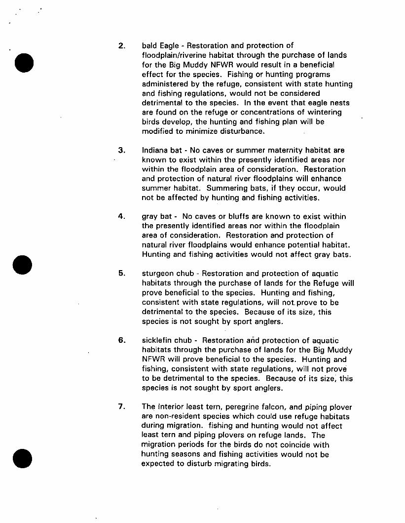
2.. bald eagle - Restoration and protection of floodplain/riverine habitat through the purchase of lands for the Big Muddy NFWR would result in a beneficial effect for the species. Fishing·or hunting programs administered by the refuge, consistent with state hunting and fishing regulations, would not be considered detrimental to the species. In the event that eagle nests are found on the refuge or concentrations of wintering birds develop, the hunting and fishing plan will be modified to minimize disturbance.
6
• ' .... ' ,,, .
3. Indiana bat - No caves or summer maternity habitat are known to exist within the presently identified areas nor within the floodplain area of consideration. Restoration and protection of natural river floodplains will enhance summer habitat. Summering bats, if they occur, would not be affected by· hunting and fishing activities.
4. gray bat - No caves or bluffs are known to exist within the presently identified areas nor within the floodplain area of consideration. Restoration and protection of natural river floodplains would enhance potential habitat. Hunting and fishing activities would not affect gray bats. .
5. sturgeon chub - Restoration and protection of aquatic habitats through the purchase of lands for the Refuge will prove beneficial to the species. Hunting and fishing, consistent with state regulations, will not prove to be detrimental to the species. Because of its size, this species is not sought by sport anglers.
6. sicklefin chub- Restoration and protection of aquatic habitats through the purchase of lands for the Big Muddy NFWR will prove beneficial to the species. Hunting and fishing, consistent with state regulations, will not prove to be detrimental to the species. Because of its size, this species is not sought by sport anglers.
7. The Interior least tern, peregrine falcon, and piping plover are non-resident species which could use refuge habitats during migration. The migration periods for the birds do not coincide with hunting seasons and fishing activities would not be expected to disturb migrating birds. In the event migrating peregrine falcons are attracted to concentrations of waterfowl, the plan can be modified to minimize disturbance to this species.
The proposed opening of the Refuge to hunting and fishing will not conflict with the recovery of any of these species. Attached and included in this proposal is a Section 7 analysis and an Environmental Assessment specifically for the hunting and fishing program.
VII. CONDUCT OF THE HUNTING AND FISHING PROGRAM
A. The hunting and fishing program will permit the hunting of migratory
7
' ... _ :\ ..
birds, upland game and big game, and the catching of game fish as listed in item V.(C) of this plan. Hunting and fishing, as authorized by state law and subject to any posted regulations, is permitted on designated areas of the Refuge (See attached maps.)
B. The initial public use for hunting/fishing on the Refuge will be minimal due to the small acreage currently .involved. However, as the Refuge continues to grow in size, the magnitude of the program will increase and will become an important part of the overall operation. Local communities should experience positive economic impacts.
C. Hunter or angler registration at open areas will not be required at this time. As additional lands are acquired and Refuge management programs are initiated, it may become necessary to institute a registration to better assess harvest and use levels.
D. Limiting the number of hunters or anglers will not be necessary at this time due to the limited area available and the anticipated low initial use.
E. An announcement of the availability of public hunting and fishing opportunities, the areas which are open, which species may be taken and how to obtain additional information relative to the hunting and fishing program will be made available through local media and the Missouri Department of Conservation.
F. Hunter orientation will be through the use of a hunting regulation leaflets with maps delineating areas open for hunting and fishing. The leaflet will be available at Refuge Headquarters and posted in the field at access points. These leaflets will be updated as new lands are acquired and approved for inclusion into the hunting and fishing program. Because of the patchwork nature of refuge lands characteristic of newly-established refuges, the public will be apprised of the need to obtain landowner permission in those instances when Refuge lands a·re landlocked and lack public access.
G. All applicable Federal migratory bird hunting and MDC license requirements and regulations will be in affect on Refuge lands. No special Refuge permit will be required.
8
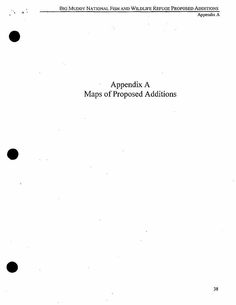
BIG MUDDY NATIONAL FISH AND WILDLIFE REFUGE PROPOSED ADDITIONS ' •J • Appendix A
Appendix A Maps of Proposed Additions
38
:'
/
BJG MUDDY NATIONAL FISH AND WILDLiFE REFUGE
CARROLL
RAY
CLAY r"""'
..¥ ... ??RUt ~~ .US •..• ..i. :--..._ \ r .. -··· -- 24 ······- ·-••m
,J 1'--' .. v~ LAFAYETTE
SAUNE f Jackson
COOPER
" MISSOUJ
BOONE
'\
•• colum'biaf
l~
CALLAWAY ;
(,.;
. .... 1.1 •
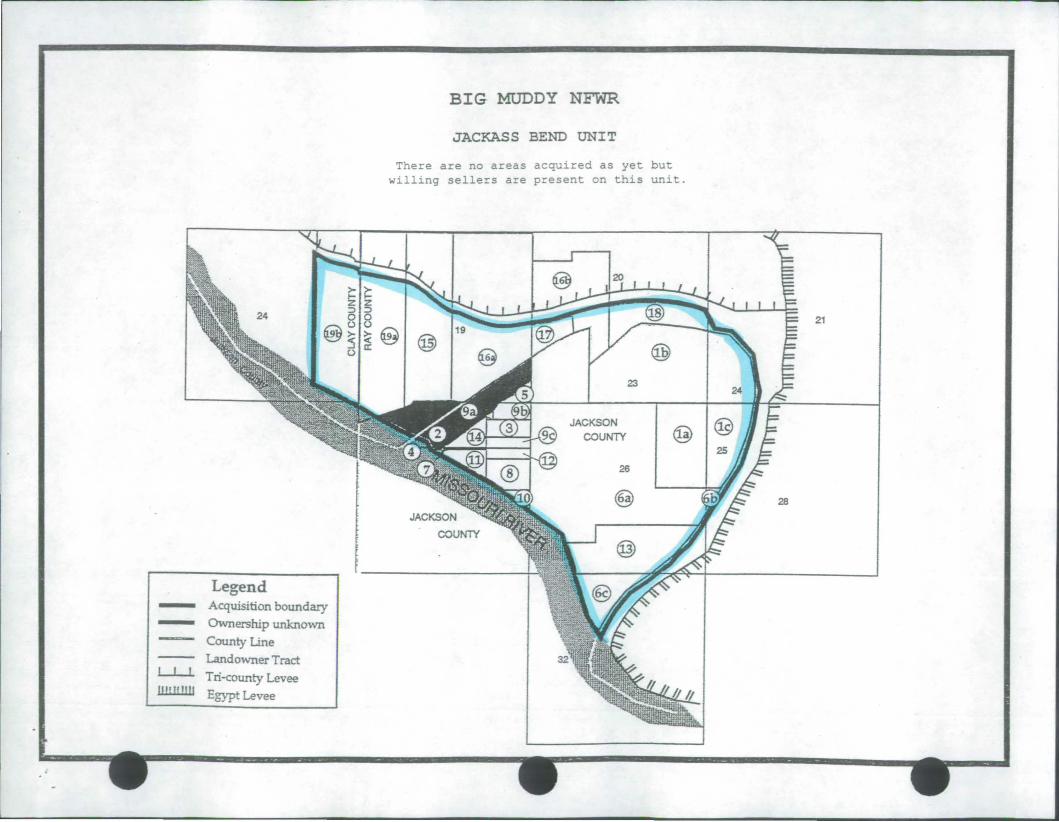
BIG MUDDY NFWR
JACKASS BEND UNIT
--Legend
Acquisition boundary Ownership unknown County Line
Landowner Tract Ll-1 Tri-county Levee lill.U!lll Egypt Levee
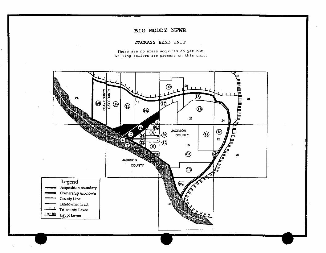
BIG MUDDY NFWR
JACKASS BEND UNIT
There are no areas acquired as yet but willing sellers are present on this unit.
@I@
23
JACKSON I 1'1.:\. COUNTY \:!31
26
@
COUNTY
21
28
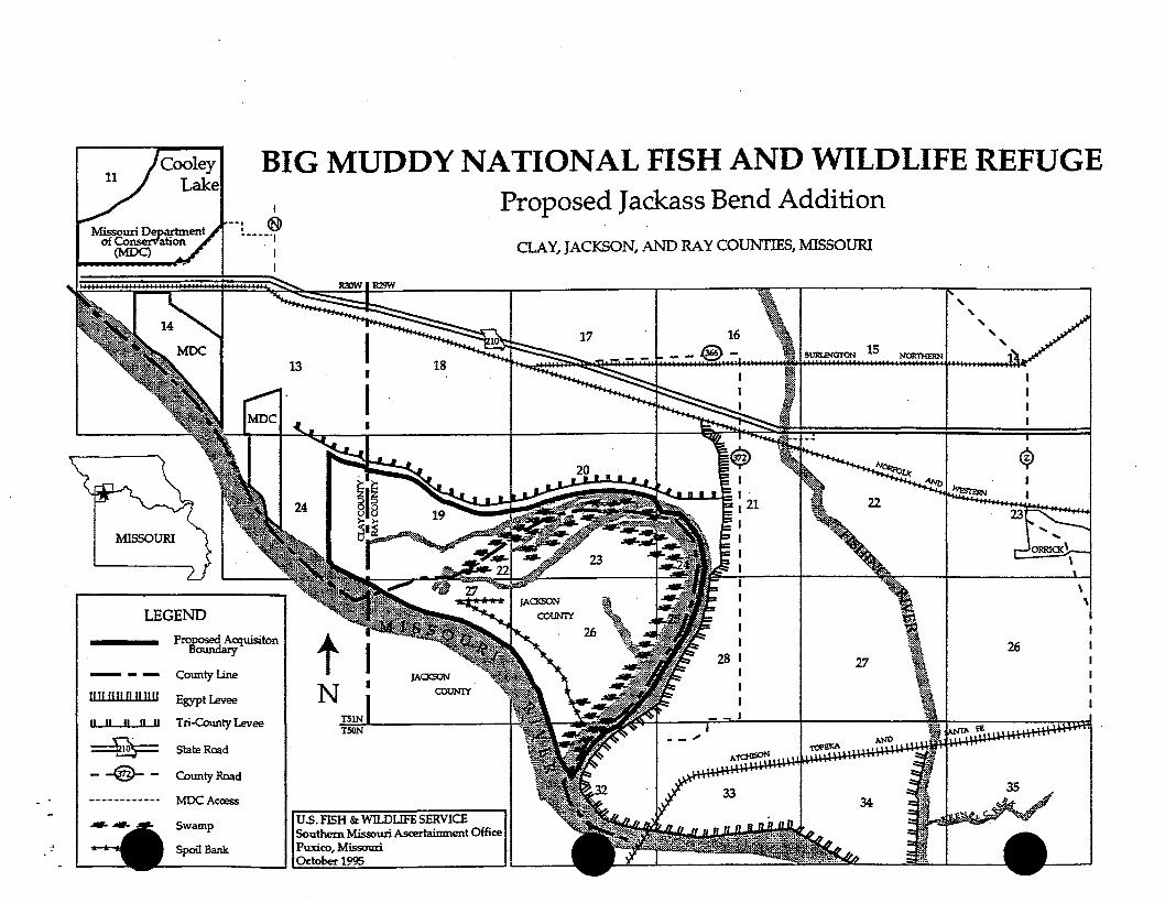
11 BIG MUDDY NATIONAL FISH AND WILDLIFE REFUGE
I
I ® -----·1
MISSOURI
LEGEND Prooosed A . "to
Boundary cquiSl n
---!111!11!1111111!
CountyLine
Egypt Levee
U U II II II Tri-County Levee
~ StateRoad
- -@- - County Road
-----------· 'MDC Acress
Swamp
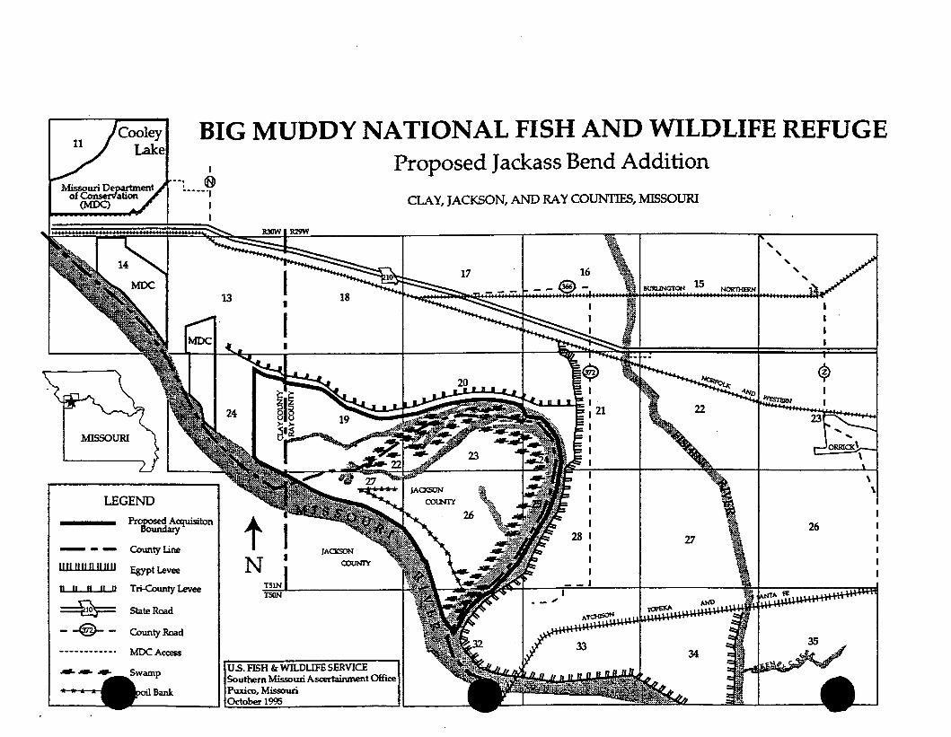
Proposed Jackass Bend Addition
t N I
JA<XSON COUN'IY
US. FISH & Wll.DUFE SERVICE Southern Missouri Asa!rtainment Office
CLA Y1 JACKSON, AND RAY COUNTIES, MISSOURI
BUltl.INGTON 15
27
Spoil Bank II Puxico, Missouri I • -~-O~d~o~~~l~~-~--------------~-~------
~
26
BIG MUDDY NFWR
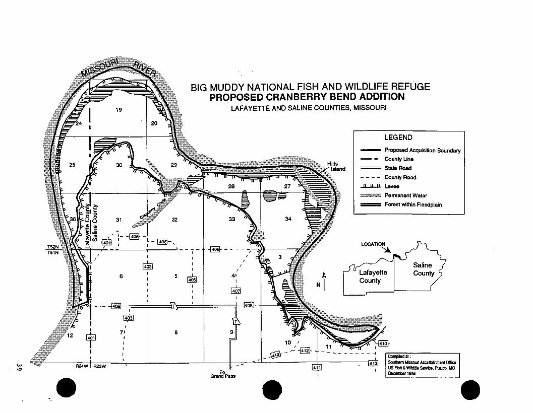
CRANBERRY BEND UNIT
~ § 0 v
""' ""' 0
~ ~
S_,l
25 z. -/:jar·
Ca./1/c Co
""
Ner:yn W v <:nic.Jns
4.$5
/'1ervyn W c.lenk,n..s
1
~ftJIC
.30
BIG MUDDY NFWR
CRANBERRY BEND UNIT
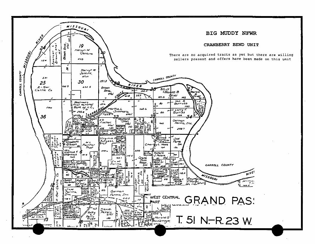
There are no acquired tracts as yet but there are willing sellers present and offers have been made on this unit
CARROl.L C OUNrY
CENTRAL GRAND_ P8S~ 1\M"'..,.,......D •• J.. .-..J , · - - -- .
T 51 N:-R. 23 W
·c..> ..,-.I:>
.. ·
32
/AI_ -~ -l - @§1-' I I I
~ 6 5
BIG MUDDY NATIONAL FISH AND WILDLIFE REFUGE PROPOSED CRANBERRY BEND ADDITION
LAFAYETTE AND SALINE COUNTIES, MISSOURI
I
~
33
-@----I
I
41
I
~
Jl .
Nt
LEGEND
Proposed Acquisition Boundary
County Une
State Road
County Road
1l...ll..J1. Levee
@::::::::~::::;:;~:::~ Permanent Water
Forest within Floodplain
Lafayette County
:CJ~~.L - -- f4o81 'in I I I~ ~~I
I
~ I
R24W I R23W
1$1 I
71 I
8
To Grand Pass
Cof1lliledat: Sou1hem Missouri Ascertainment Office US Fish & Wildllle Service, Puxico, MO December 1994
. ' ~ .
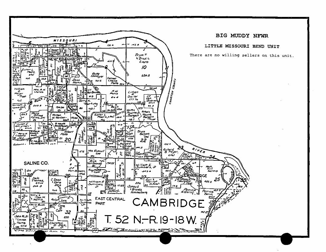
BIG MUDDY NFWR
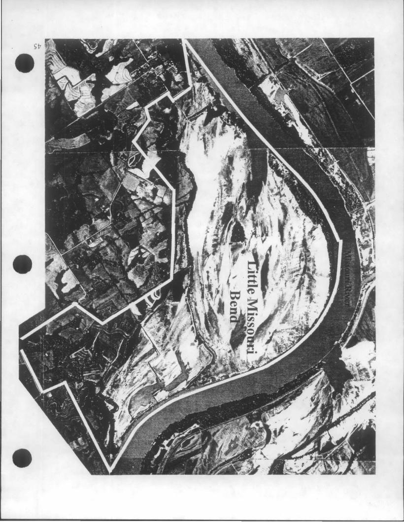
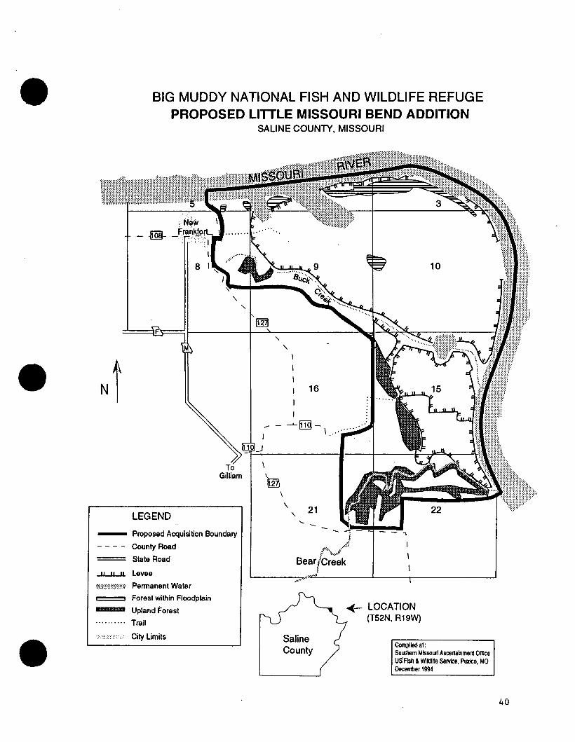
LITTLE MISSOURI BEND UNIT
BIG MUDDY NFWR
LITTLE MISSOURI BEND UNIT
There are no willing sellers on this unit.
CAMBRIDGE • 14Z
T 52 N:-R.I9-18W
. • /1>
BIG MUDDY NATIONAL FISH AND WILDLIFE REFUGE PROPOSED LITTLE MISSOURI BEND ADDITION
SALINE COUNTY, MISSOURI
8
LEGEND
To Gilliam
-- Proposed Acquisition Boundary
County Road
State Road ----..J.LJL..ll. levee
'''''''''''''~m::::m Permanent Water
Forest within Floodplain
Upland Forest
.......... Trail
,,,,,,,, ,,,, City limits
" " ) I
I
16
..---'-~- .·· I ~ \ .... ·····
I
rn \
\ 21
Saline County
~-LOCATION (T52N, R19W)
Compiled at : Southern Mlssou~ Ascertainment Ollice US' Fish & Wildine Service, Puxico, MO December 1994
40
.,. . ...
BIG MUDDY NFWR
JAMESON ISLAND UNIT
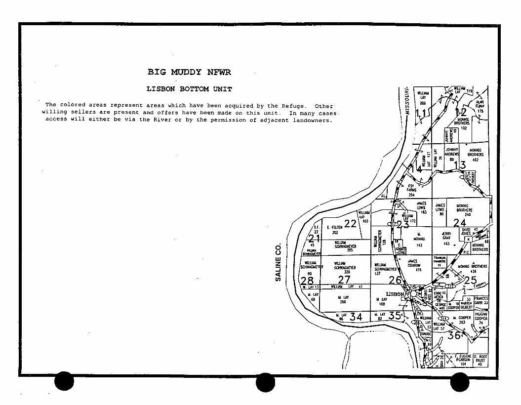
LISBON BOTTOM UNIT
BIG MUDDY NFWR
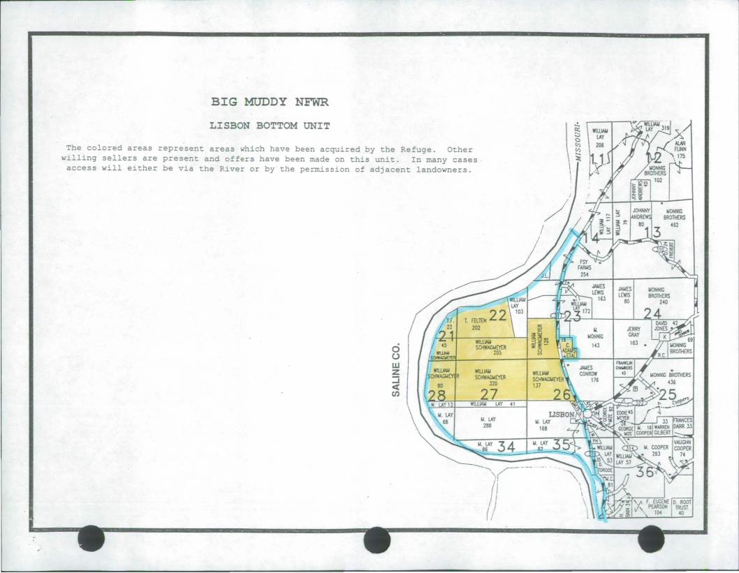
LISBON BOTTOM UNIT
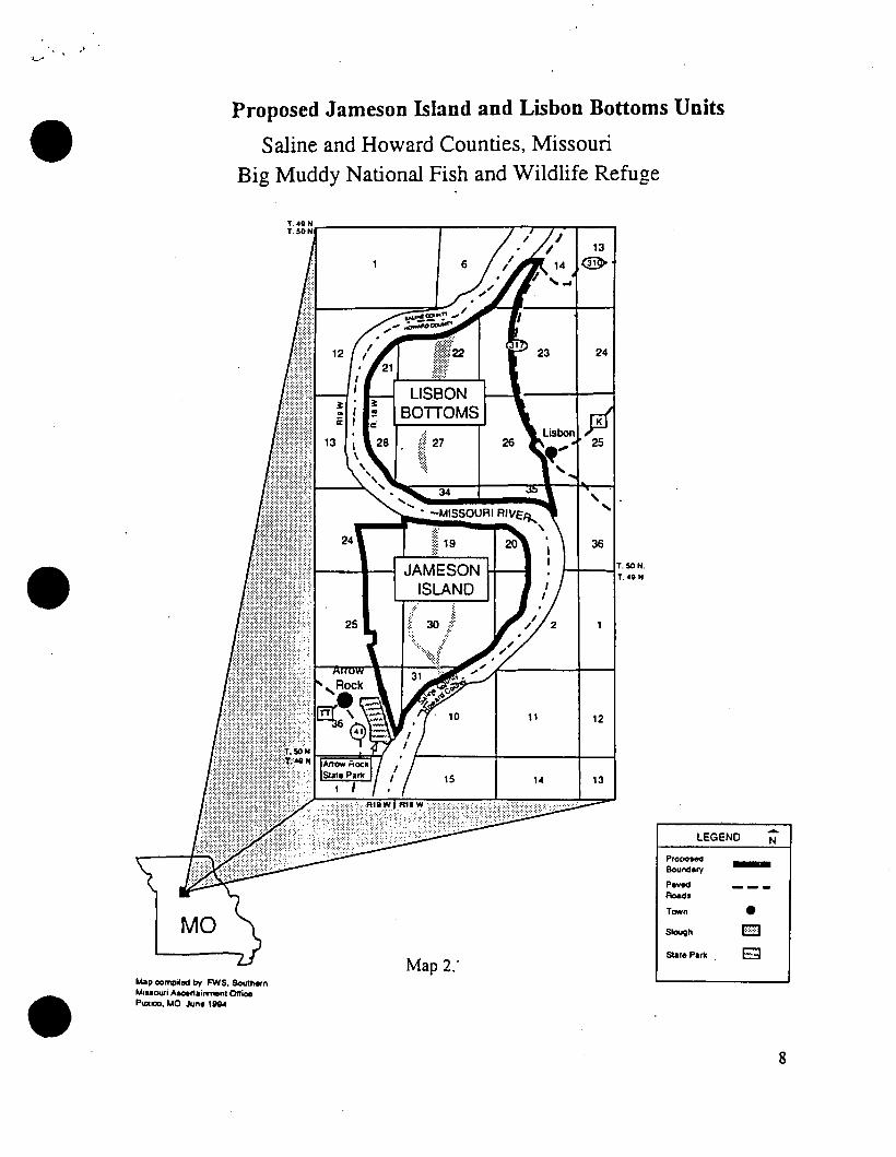
The colored areas represent areas which have been acquired by the Refuge. Other willing sellers are present and offers have been made on this unit. In many cases access will either be via the River or by the permission of adjacent landowners.
202
( I /211 .. , ci u w
I I:~IR WlllJAII
~ I SCHW.4GI.IEYEII 320
27 WIUJAJ,I lAY 41
1.1. lAY 288 I lL lAY
168
I.IONNIC BROTHERS
462
1/3.7
1525
BIG MUDDY NFWR
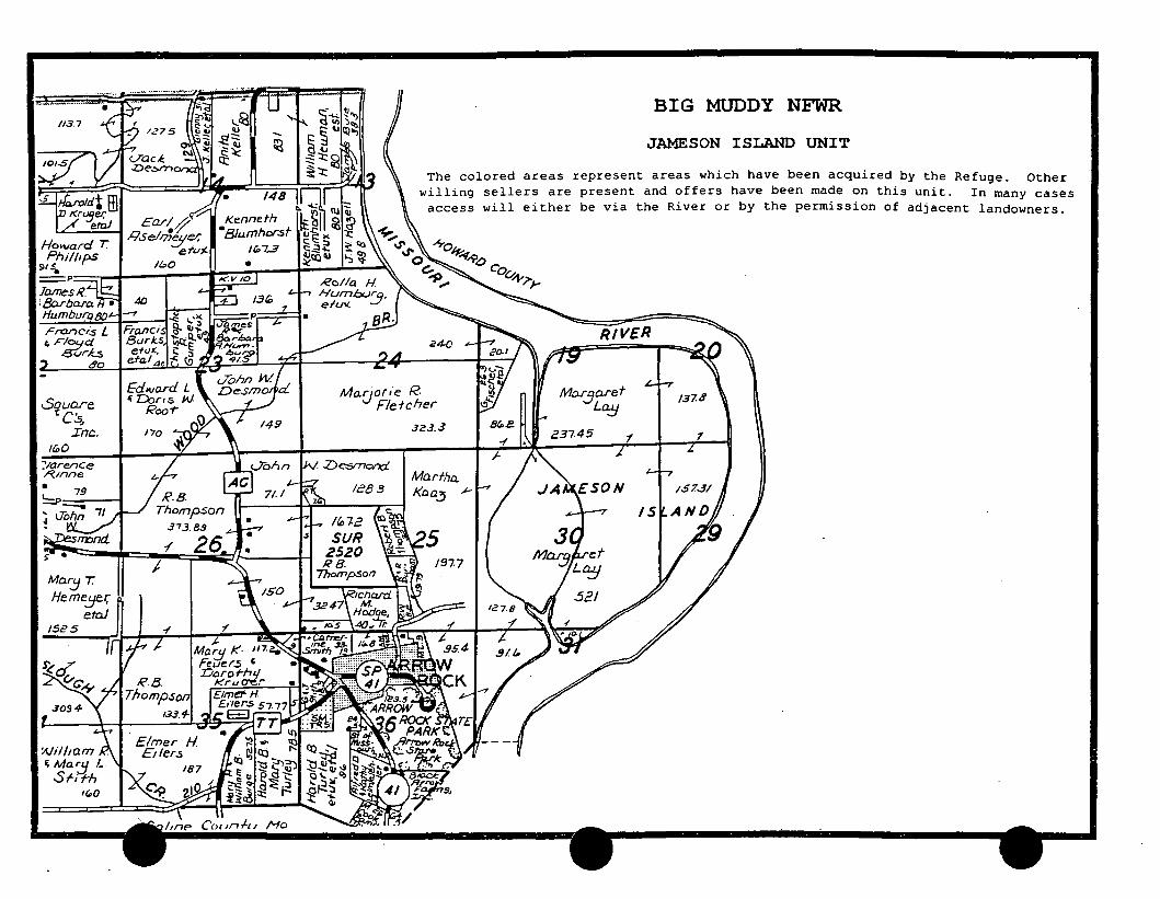
JAMESON ISLAND UNIT
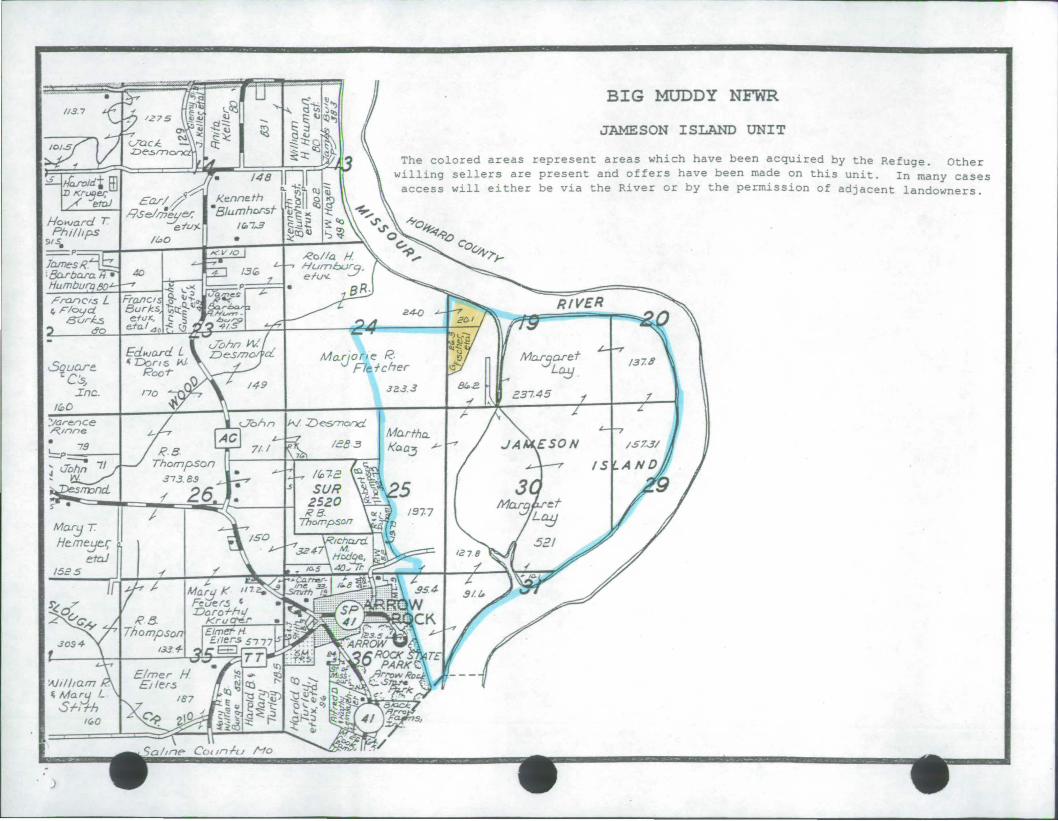
The colored areas represent areas which have been acquired by the Refuge. Other willing sellers are present and offers have been made on this unit. In many cases access will either be via the River or by the permission of adjacent landowners.
RIVER
Ma.c)o (l e R. Fle tcher
JZ.3 . .3
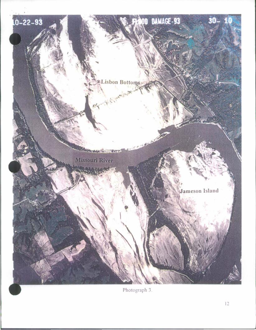
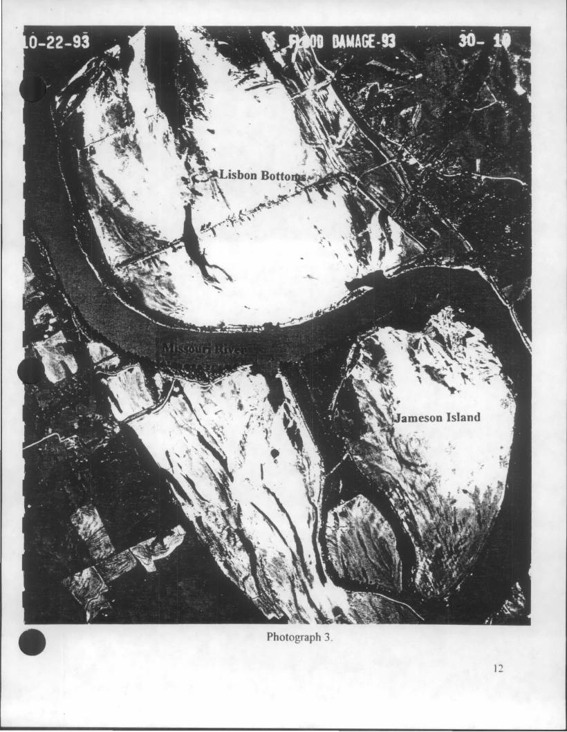
Photograph ..,
12
I '\ ,.t ......
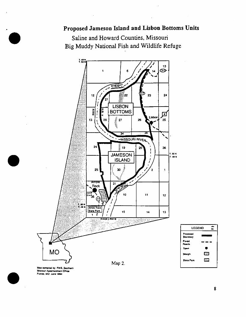
Proposed Jameson Island and Lisbon Bottoms Units
Saline and Howard Counties, Missouri Big Muddy National Fish and Wildlife Refuge
13 @
24
11 12
LEGEND -. N
Prooooed Boundary -
MO
Map oomp~ed by FWS, Southern ll.lououri "-r1airwnent Ottice Pllllooo, MO June 1894
Map 2.·
Paved Roads
r-n e Slough I3J State Park . E;J
8
I.' ·, ' _., .
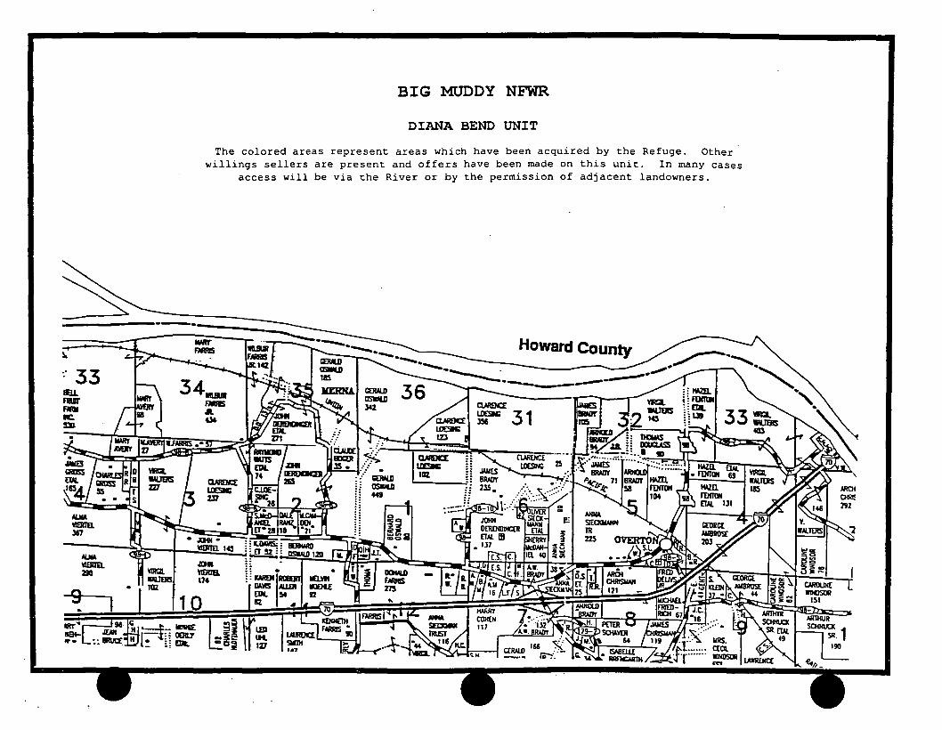
BIG MUDDY NFWR
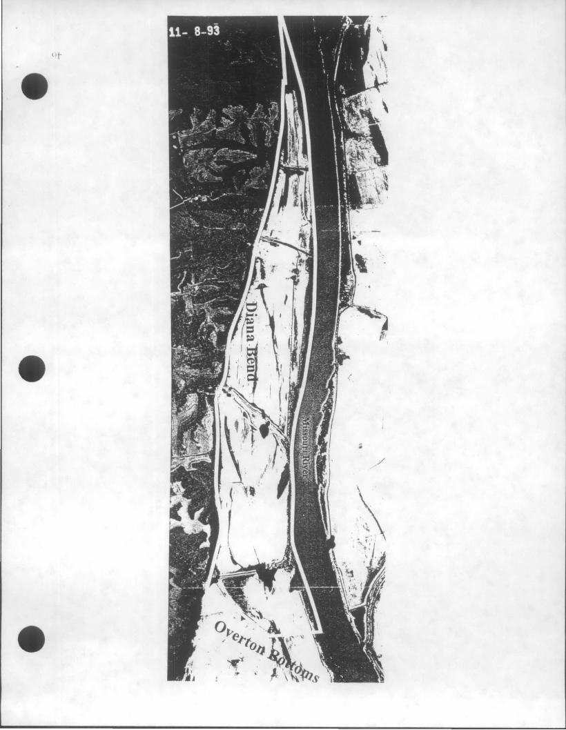
DIANA BEND UNIT
. '
3 l..
-· 33
~ '49!ril. Z!IO
BIG MUDDY NFWR
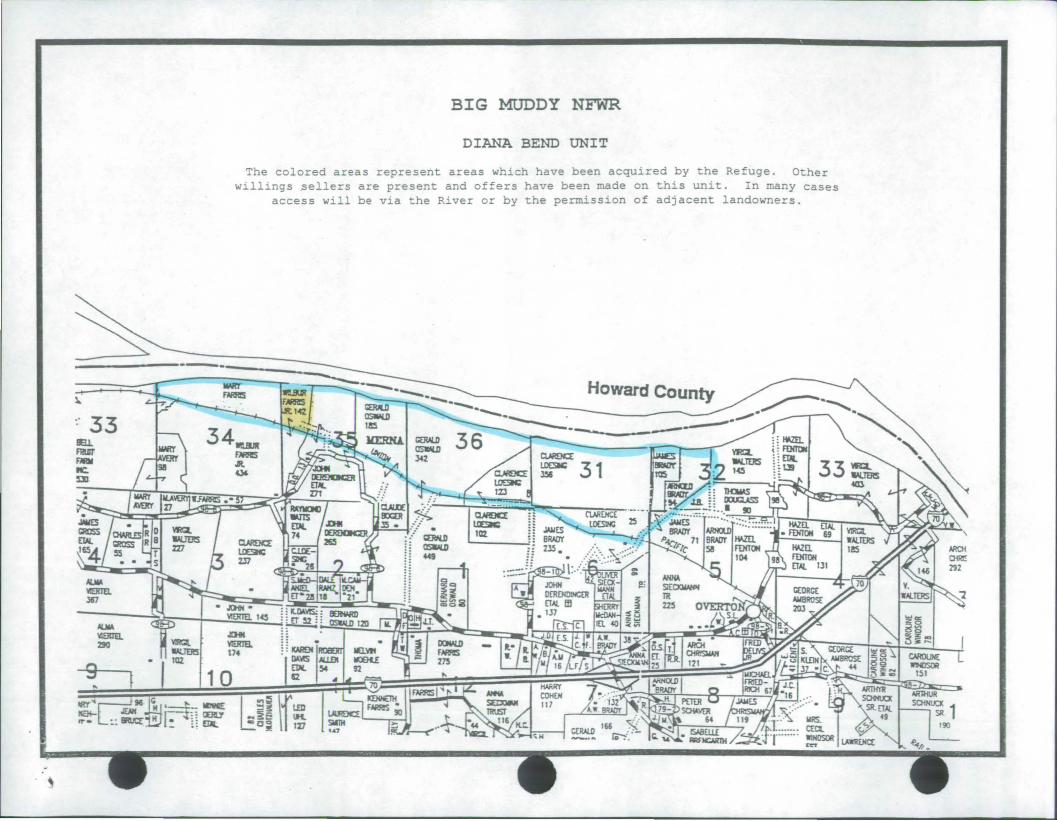
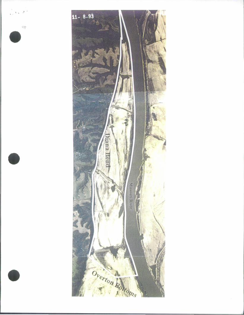
DIANA BEND UNIT
The colored areas represent areas which have been acquired by the Refuge. Other willings sellers are present and offers have been made on this unit. In many cases
access will be via the River or by the permission of adjacent landowners.
,..,
·' ..
BIG MUDDY NFWR
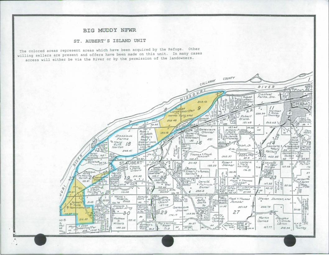
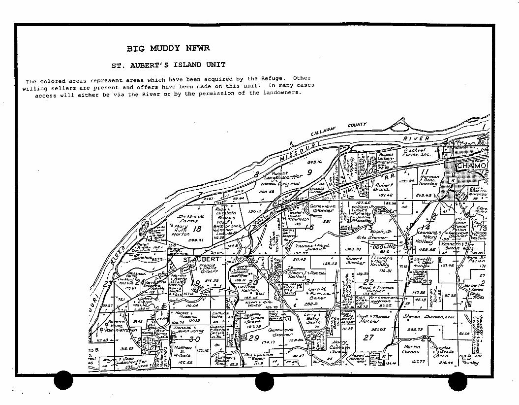
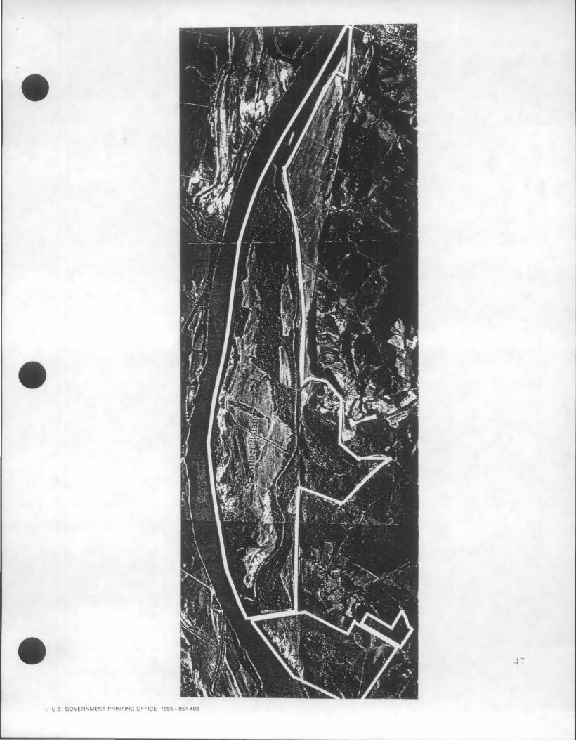
ST. AUBERT ' S ISLAND UNIT
The colored areas represent areas which have been acquired by the Refuge . Other willing sellers are present and offers have been made on this unit. In many cases
access will either be via the River or by the permission of the landowners.
. . ; .
47
~ US GOVERNMENT PAINTING OFFICE 1995-657-403
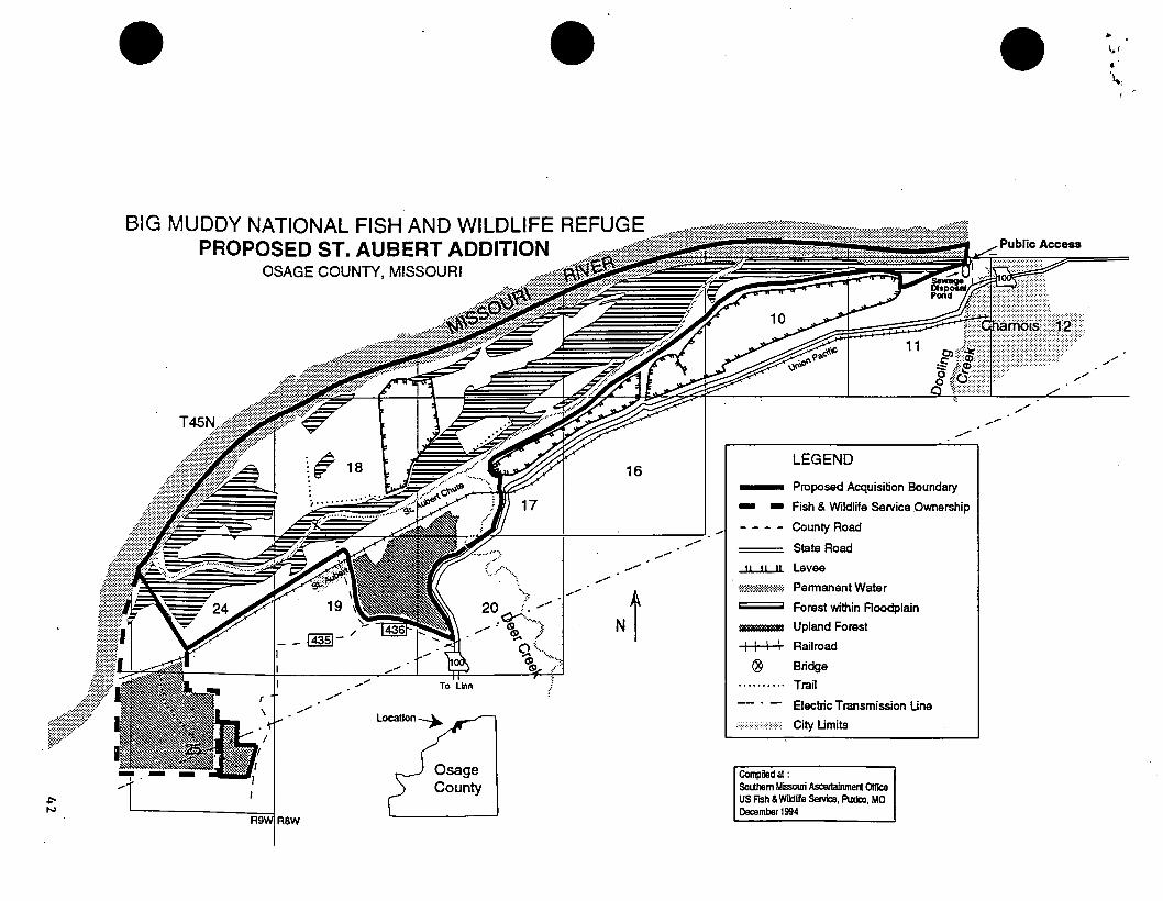
~ N
BIG MUDDY NATIONAL FISH AND WILDLIFE REFUGE PROPOSED ST. AUBERT ADDITION
OSAGE COUNTY, MISSOURI
16
...... ..........
_- N i ...... ......
...... LEGEND
- Proposed Acquisition Boundary
- - Fish & Wildlife Service Ownership
- - - - County Road
State Road
..J.L....lL..J1 Levee
om:::o~~:::=::::::::m Pennanent Watar
~ Forest within Aoodplain
II888II8888888B Upland Forest
++-H- Railroad
® Bridge
..,...... T,.. • 11"1" ~ I · · · · · ·. · · · Trail ...... ........
-:=:.;-::;:;:;:::;::;:;:;:·:::
Compiled at:
Electric Transmission Line
City Limits
Soutllem Missouri Ascertalnment Olllce US FISh & Wiklli!e Servk:e, Puxi:o, MO December 1994
.... --
..........
.. 1,1
• \.,
_.,/
.. ;:: •
34
/
/
/
/
/
T48N i - - - - -miD - - - < "
11....JL.LI
3
LEGEND
' '
Proposed Acquisition Boundary
State Road
County Road
Levee
;::$:@:'fili~m Permanent Water
Forest within Floodplain
=== Interstate
t-H--t Railroad
I
l~al
2 I I
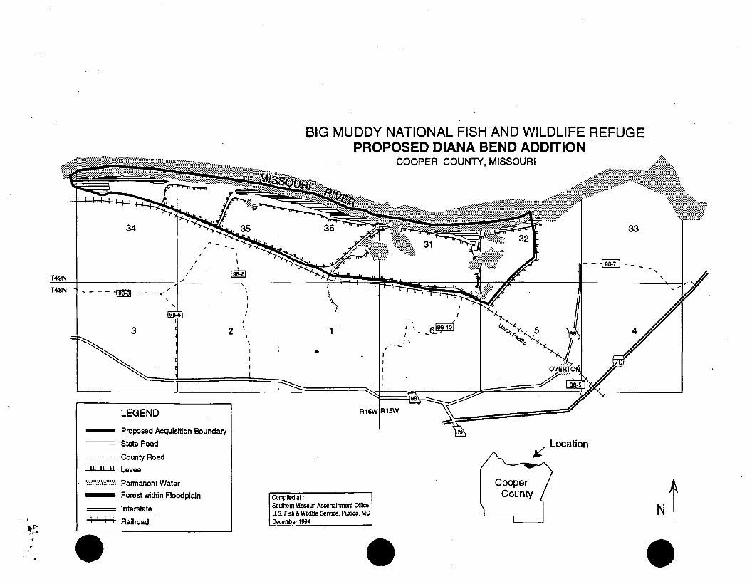
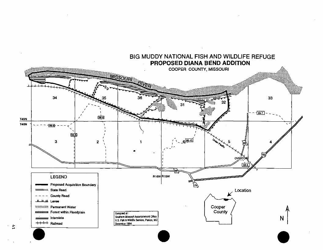
BIG MUDDY NATIONAL FISH AND WILDLIFE REFUGE PROPOSED DIANA BEND ADDITION
•
Rl
Compiled at : Southern Missouri Ascertainment Ollice U.S. FISh & Wildlife Service, Puxico, MO Decerrber 1994
I
COOPER COUNTY, MISSOURI
- I
: 1 __ s!9~1of - t:•
/ -
33
--~----, '
j;{ Location
Ni
._. ·, . .. .
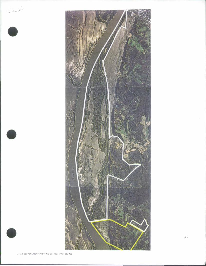
BIG MUDDY NFWR
ST. AUBERT'S ISLAND UNIT
13:23 BIG MUDDt NWR ~ 85173376899 NU.4lb
MISSOURI DEPARTMENT OF CONSERVATION Headquarter$
2901 West Truman Boulevard, P.O. Box 180, Jefferson City, Missouri 65102·0180 Telephone: 573/751-4115 • Missouri Relay Center: 1-800-735-2966 (TDD)
May 22, 1996
Mr. J. C. Bryant, Project Manager U. S. Fish and Wildlife Service Big Muddy National Fish and Wildlife Refuge 4200 New Haven Road Columbia, Missouri 65201
Dear Mr. 6fYMlt!- ~ .. r I
JERRY j, PRESLEY. Director
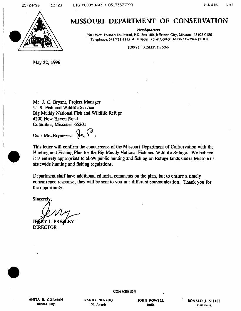
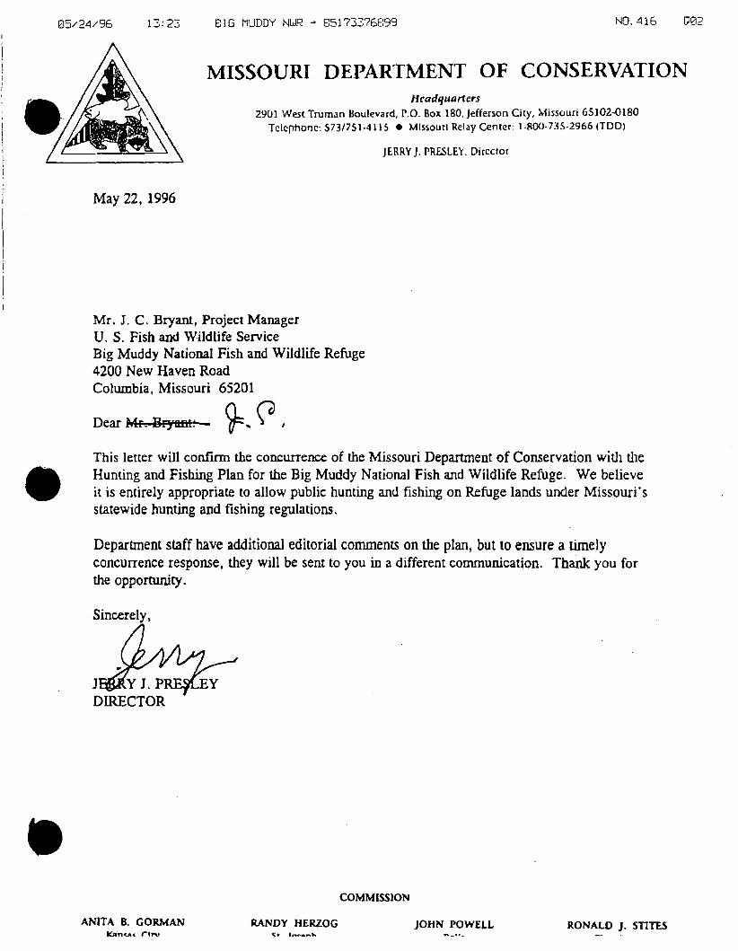
This letter will confinn the concurrence of the Missouri Department of Coruervation with the Hunting and Fishing Plan for the Big Muddy National Fish and Wildlife Refuge. We believe il is entirely appropriate to allow public hunting and fishing on Refuge lands under Missouri's statewide hunting and fishing regulations.
Department staff have additional editorial comments on the plan, but to ensure a timely concurrence response, they will be sent to you in a different communicalion. Thank you for the opportunity.
Sincerely,
ANITA B. GORMAN Kansas City
RANDY HERZOG Sr. Joseph
COMMISSiON
JOHN POWELL Rolla
RONALD J. STITES Plattsbur.R
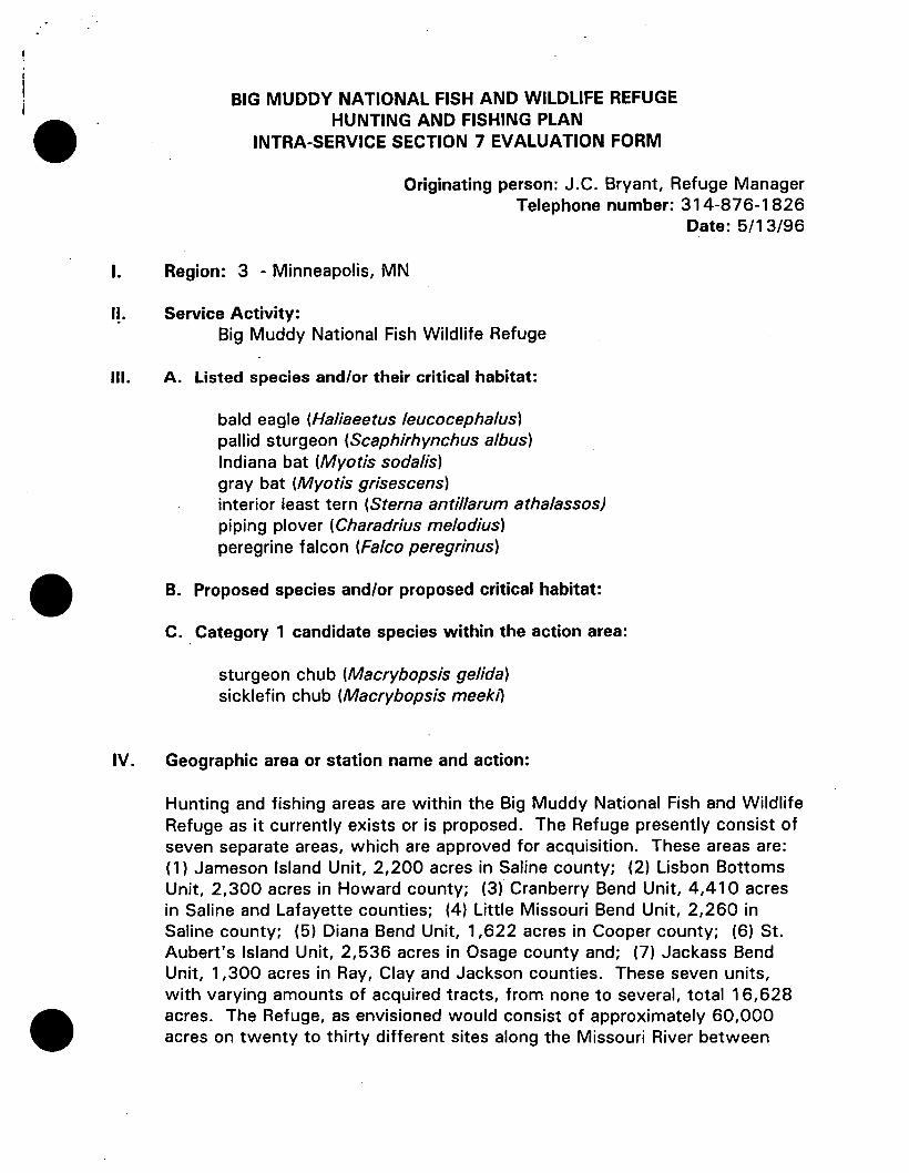
BIG MUDDY NATIONAL FISH AND WILDLIFE REFUGE HUNTING AND FISHING PLAN
INTRA-SERVICE SECTION 7 EVALUATION FORM
Originating person: J.C. Bryant, Refuge Manager Telephone number: 314-876-1826
Date: 5/1 3/96
I. Region: 3 - Minneapolis, MN
1~. Service Activity: Big Muddy National Fish Wildlife Refuge
Ill. A. Listed species and/or their critical habitat:
bald eagle (Haliaeetus /eucocephalus) pallid sturgeon (Scaphirhynchus a/bus) Indiana bat (Myotis soda/is) gray bat (Myotis grisescens) interior least tern (Sterna antillarum athalassos) piping plover (Charadrius melodius) peregrine falcon (Falco peregrinus)
B. Proposed species and/or proposed critical habitat:
C. Category 1 candidate species within the action area:
sturgeon chub (Macrybopsis gelida) sicklefin chub (Macrybopsis meek1l
IV. Geographic area or station name and action:
Hunting and fishing areas are within the Big Muddy National Fish and Wildlife Refuge as it currently exists or is proposed. The Refuge presently consist of seven separate areas, which are approved for acquisition. These areas are: (1) Jameson Island Unit, 2,200 acres in Saline county; (2) Lisbon Bottoms Unit, 2,300 acres in Howard county; (3) Cranberry Bend Unit, 4,410 acres in Saline and Lafayette counties; (4) Little Missouri Bend Unit, 2,260 in Saline county; (5) Diana Bend Unit, 1,622 acres in Cooper county; (6) St. Aubert's Island Unit, 2,536 acres in Osage county and; (7) Jackass Bend Unit, 1,300 acres in Ray, Clay and Jackson counties. These seven units, with varying amounts of acquired tracts, from none to several, total 16,628 acres. The Refuge, as envisioned would consist of approximately 60,000 acres on twenty to thirty different sites along the Missouri River between

Kansas City and St. Louis. The proposed action is to allow public hunting and fishing on currently owned lands, as well as, other lands as they are acquired for the Refuge while assuring that this action is consistent with Refuge objectives, Service guidelines and other pertinent regulations.
V. Location (attach map): Figures 1.
A. County and State:
Clay, Jackson, Ray, Lafayette, Carroll, Saline, Chariton, Howard, Cooper, Boone, Moniteau, Cole, Callaway, Osage, Gasconade, Montgomery, Warren, Franklin, St. Charles,. and St. Louis counties in the state of Missouri.
B. Section, township, and range:
See attached. maps
C. Distance (miles) and direction to nearest town:
Jameson Island Unit- 1 mile west to Arrow Rock, MO. Lisbon bottoms Unit- 1 mile east to Lisbon, MO. Cranberry Bend Unit- 2 miles south to Grand Pass, MO. Little Missouri Bend- 1 mile west to New Frankfort, MO. Diana Bend Unit- 2 miles east to Overton, MO. St. Aubert's Island Unit- 1 mile east to Chamois, MO. Jackass Bend Unit- 3 miles east to Orrick, MO.
Other areas are yet to be determined.
VI. Description of proposed action:
The Big Muddy NFWR was established on September 9, 1994, " .... for the development, advancement, management, conservation, and protection of fish and wildlife resources ... "[16 U.S.C. §742f(a)(4)]. Its purpose is to fill a public need to preserve and restore natural river floodplain, manage fish and wildlife habitats, and provide for compat.ible public use. Up to 60,000 acres of floodplain land are proposed to be purchased in scattered tracts from Kansas City MO. to St. Louis, MO.
The action under consideration consist of opening the presently acquired areas, and other areas as they are acquired, to hunting and fishing activities consistent with state regulations governing such activities.
This proposal action would:
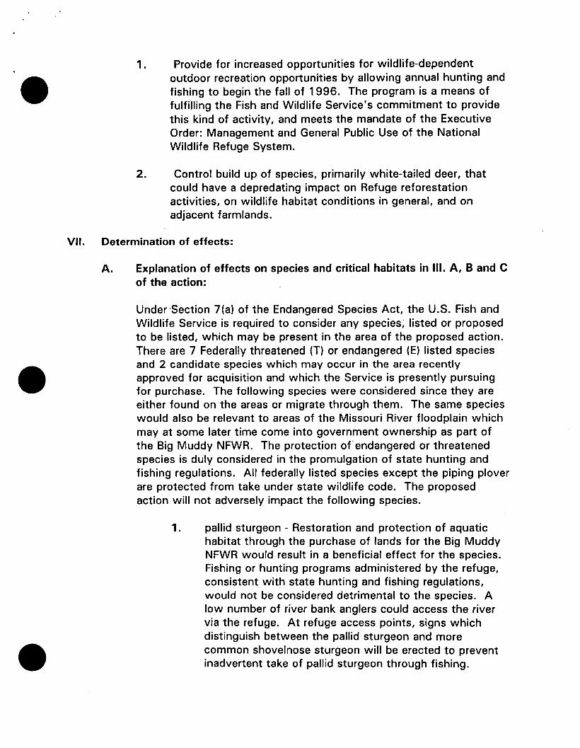
1. Provide for increased opportunities for wildlife-dependent outdoor recreation opportunities by allowing annual hunting and fishing to begin the fall of 1 996. The program is a means of fulfilling the Fish and Wildlife Service's commitment to provide this kind of activity, and meets the mandate of the Executive Order: Management and General Public Use of the National Wildlife Refuge System.
2. Control build up of species, primarily white-tailed deer, that could have a depredating impact on Refuge reforestation activities, on wildlife habitat conditions in general, and on adjacent farmlands.
VII. Determination of effects:
A. Explanation of effects on species and critical habitats in Ill. A, 8 and C of the action:
Under ·Section 7(a) of the Endangered Species Act, the U.S. Fish and Wildlife Service is required to consider any species; listed or proposed to be listed, which may be present in the area of the proposed action. There are 7 Federally threatened (T) or endangered (E) listed species and 2 candidate species which may occur in the area recently approved for acquisition and which the Service is presently pursuing for purchase. The following species were considered since they are either found on the areas or migrate through them. The same species would also be relevant to areas of the Missouri River floodplain which may at some later time come into government ownership as part of the Big Muddy NFWR. The protection of endangered or threatened species is duly considered in the promulgation of state hunting and fishing regulations. All federally listed species except the piping plover are protected from take under state wildlife code. The proposed action will not adversely impact the following species.
1. pallid sturgeon - Restoration and protection of aquatic habitat through the purchase of lands for the Big Muddy NFWR would result in a beneficial effect for the species. Fishing or hunting programs administered by the refuge, consistent with state hunting and fishing regulations, would not be considered detrimental to the species. A low number of river bank anglers could access the river via the refuge. At refuge access points, signs which distinguish between the pallid sturgeon and more common shovelnose sturgeon will be erected to prevent inadvertent take of pallid sturgeon through fishing.
2. bald Eagle - Restoration and protection of floodplain/riverine habitat through the purchase of lands for the Big Muddy NFWR would result in a beneficial effect for the species. Fishing or hunting programs administered by the refuge, consistent with state hunting and fishing regulations, would not be considered detrimental to the species. In the event that eagle nests are found on the refuge or concentrations of wintering birds develop, the hunting and fishing plan will be modified to minimize disturbance.
3. Indiana bat - No caves or summer maternity habitat are known to exist within the presently identified areas nor within the floodplain area of consideration. Restoration and protection of natural river floodplains will enhance summer habitat. Summering bats, if they occur, would not be affected by hunting and fishing activities.
4. gray bat - No caves or bluffs are known to exist within the presently identified areas nor within the floodplain area of consideration. Restoration and protection of natural river floodplains would enhance potential habitat. Hunting and fishing activities would not affect gray bats.
5. sturgeon chub - Restoration and protection of aquatic habitats through the purchase of lands for the Refuge will prove beneficial to the species. Hunting and fishing, consistent with state reg~:-~Jations, will not. prove to be detrimental to the species. Because of its size, this species is not sought by sport anglers.
6. sicklefin chub - Restoration and protection of aquatic habitats through the purchase of lands for the Big Muddy NFWR will prove beneficial to the species. Hunting and fishing, consistent with state regulations, will not prove to be detrimental to the species. Because of its size; this species is not sought by sport anglers.
7. The Interior least tern, peregrine falcon, and piping plover are non-resident species which could use refuge habitats during migration. fishing and hunting would not affect least tern and piping plovers on refuge lands. The migration periods for the birds do not coincide with hunting seasons and fishing activities would not be expected to disturb migrating birds.
In the event migrating peregrine falcons are attracted to concentrations of waterfowl, the plan can be modified to minimize disturbance to this species.
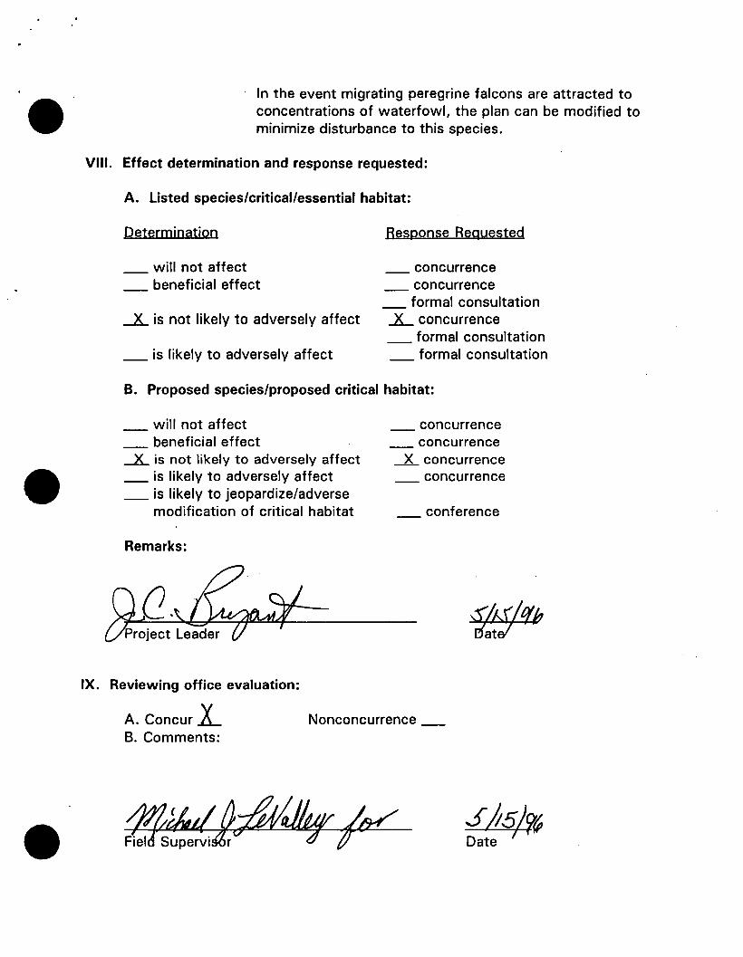
VIII. Effect determination and response requested:
A. Listed species/critical/essential habitat:
Determination Response Beguested
will not affect concurrence _ beneficial effect _ concurrence
formal consultation · _x_ is not likely to adversely affect .lL concurrence
_ formal consultation _ is likely to adversely affect formal consultation
B. Proposed species/proposed critical habitat:
will not affect _ beneficial effect _x_ is not likely to adversely affect _ is likely to adversely affect _ is likely to jeopardize/adverse
modification of critical habitat
Remarks:
IX. Reviewing office evaluation:
_ concurrence concurrence
_x_ concurrence _ concurrence
conference
A. Concur 1._ Nonconcurrence _ B. Comments:
I •
-· ......
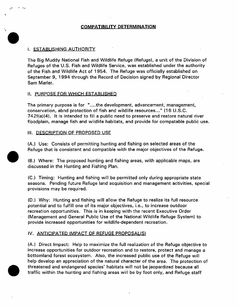
COMPATIBILITY DETERMINATION
I. ESTABLISHING AUTHORITY
The Big Muddy National Fish and Wildlife Refuge (Refuge), a unit of the Division of Refuges of the U.S. Fish and Wildlife Service, was established under the authority of the Fish and Wildlife Act of 1 954. The Refuge was officially established on September 9, 1994 through the Record of Decision signed by Regional Director Sam Marler.
II. PURPOSE FOR WHICH ESTABLISHED
The primary purpose is for " .... the development, advancement, management, conservation, abnd protection of fish and wildlife resources ... " ( 16 U.S.C. 742f(a)(4). It is intended to fill a public need to preserve and restore natural river floodplain, manage fish and wildlife habitats, and provide for compatable public use.
Ill. DESCRIPTION OF PROPOSED USE
(A.) Use: Consists of permitting hunting and fishing on selected areas of the Refuge that is consistent and compatible with the major objectives of the Refuge.
(B.) Where: The proposed hunting and fishing areas, with applicable maps, are discussed in the Hunting and Fishing Plan.
{C.) Timing: Hunting and fishing will be permitted only during appropriate state seasons. Pending future Refuge land acquisition and management activities, special provisions may be required.
{D.) Why: Hunting and fishing will allow the Refuge to realize its full resource potential and to fulfill one of its major objectives, i.e., to increase outdoor recreation opportunities. This is in keeping with the recent Executive Order (Management and General Public Use of the National Wildlife Refuge System) to provide increased opportunities for wildlife-dependent recreation.
IV. ANTICIPATED IMPACT OF REFUGE PROPOSAUS)
(A.) Direct Impact: Help to maximize the full realization of the Refuge objective to increase opportunities for outdoor recreation and to restore, protect and manage a bottomland forest ecosystem. Also, the increased public use of the Refuge will help develop an appreciation of the natural character of the area. The protection of threatened and endangered species' habitats will not be jeopardized because all traffic within the hunting and fishing areas will be by foot only, and Refuge staff
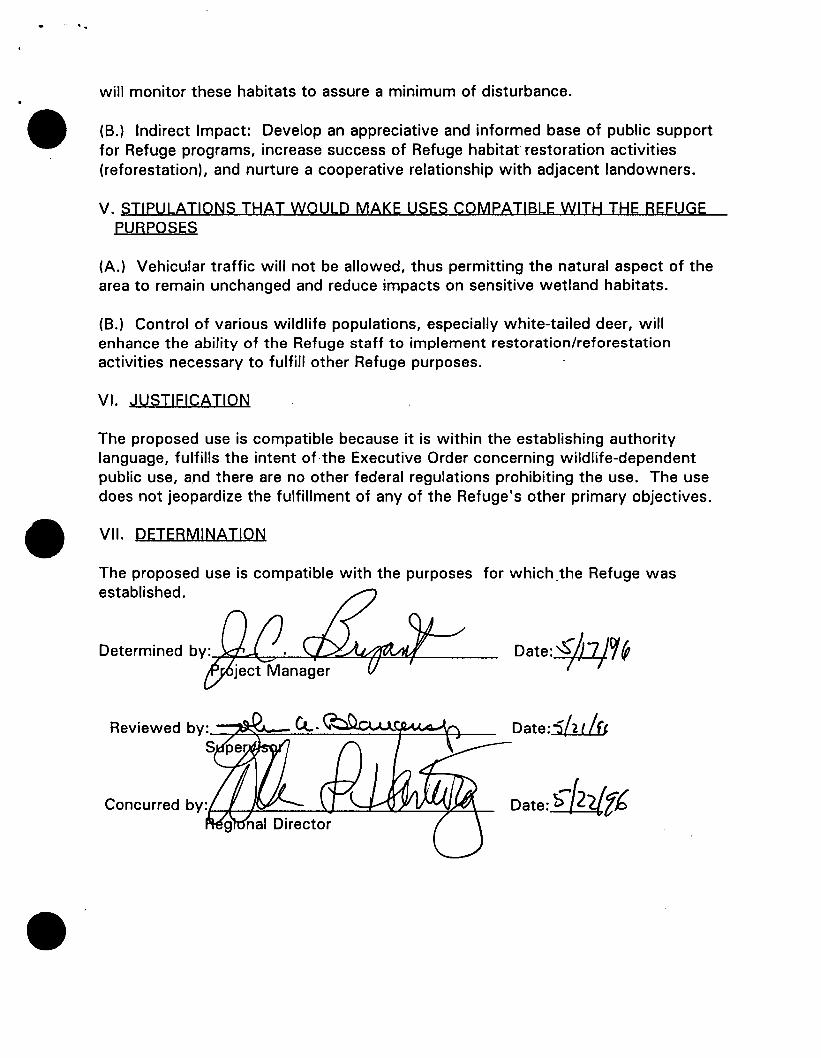
will monitor these habitats to assure a minimum of disturbance.
(B.) Indirect Impact: Develop an appreciative and informed base of public support for Refuge programs, increase success of Refuge habitat restoration activities (reforestation), and nurture a cooperative relationship with adjacent landowners.
V. STIPULATIONS THAT WOULD MAKE USES COMPATIBLE WITH THE REFUGE PURPOSES
(A.) Vehicular traffic will not be allowed, thus permitting the natural aspect of the area to remain unchanged and reduce impacts on sensitive wetland habitats.
(B.) Control of various wildlife populations, especially white-tailed deer, will enhance the ability of the Refuge staff to implement restoration/reforestation activities necessary to fulfill other Refuge purposes.
VI. JUSTIFICATION
The proposed use is compatible because it is within the establishing authority language, fulfills the intent ofthe Executive Order concerning wildlife-dependent public use, a.nd there are no other federal regulations prohibiting the use. The use does not jeopardize the fulfillment of any of the Refuge's other primary objectives.
VII. DETERMINATION
The proposed use is compatible with the purposes for which .the Refuge was established.
Date:§/a!.o/ (p
Date:ibt/u
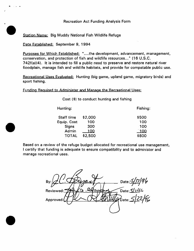
Recreation Act Funding Analysis Form
Station Name: Big Muddy National Fish Wildlife Refuge
Pate Established: September 9, 1994
Purposes for Which Established: " .... the development, advancement, management, conservation, and protection of fish and wildlife resources ... " (1 6 U.S.C. 742f(a)(4). It is intended to fill a public need to preserve and restore natural river floodplain, manage fish and wildlife ~abitats, and provide for compatable public use.
Recreational Uses Evaluated: Hunting (big game, upland game, migratory birds) and sport fishing.
Funding Required to Administer and Manage the Recreational Uses:
Cost ( $) to conduct hunting and fishing
Hunting:
Staff time Equip. Cost
Signs Admin TOTAL
$2,000 100 300 100
$2,500
Fishing:
$500 100 100 100
$800
Based on a review of the refuge budget allocated for recreational use management, I certify that funding is adequate to ensure compatibility and to administer and manage recreational uses.
Date:§jn/ q ~ Date: 5/lt(H,.
ate:_$Z/f?
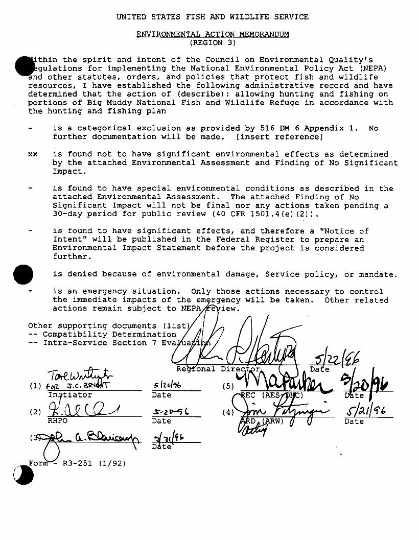
UNITED STATES FISH AND WILDLIFE SERVICE
ENVIRONMENTAL ACTION MEMORANDUM (REGION 3)
thin the spirit and intent of the Council on Environmental Quality's lations for implementing the National Environmental Policy Act (NEPA) other statutes, orders, and policies that protect fish and wildlife
resources, I have established the following administrative record and have determined that the action of (describe) : allowing hunting and fishing on portions of Big Muddy National Fish and Wildlife Refuge in accordance with the hunting and fishing plan
is a categorical exclusion as provided by 516 DM 6 Appendix 1. No further documentation will be made. [insert reference]
xx is found not to have significant environmental effects as determined by the attached Environmental Assessment and Finding of No Significant Impact.
is found to have special environmental conditions as described in the attached Environmental Assessment. The attached Finding of No Significant Impact will not be final nor any actions taken pending a 30-day period for public review (40 CFR 1501.4(e) (2)).
is found to have significant effects, and therefore a "Notice of Intent" will be published in the Federal Register to prepare an Environmental Impact Statement before the project is considered further.
is denied because of environmental damage, Service policy, or mandate.
is an emergency situation. Only those actions necessary to control the immediate impacts of the em will be taken. Other related actions remain subject to NEPA
Other supporting documents (list) Compatibility Determination
-- Intra-Service Section 7 Eva
I rMLJ .. ;:{}:_t,.. ( 1) fll(l.. :S .c:vi~1jiT-
Inrtiator
(2) Cb _Qg c...Q.-d RHPO
Date
S..-2.~(. Date
.s-J~,f i'& Date
\.
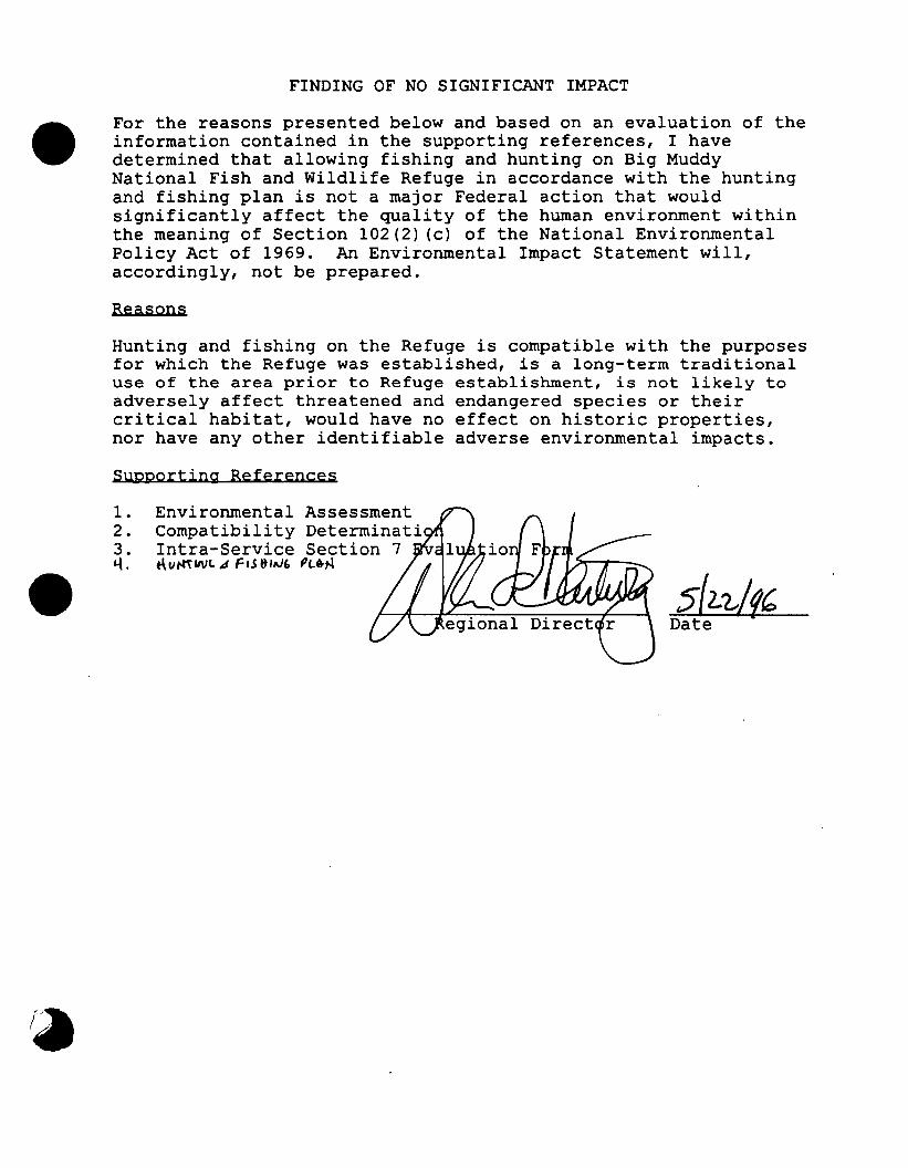
FINDING OF NO SIGNIFICANT IMPACT
For the reasons presented below and based on an evaluation of the information contained in the supporting references, I have determined that allowing fishing and hunting on Big Muddy National Fish and Wildlife Refuge in accordance with the hunting and fishing plan is not a major Federal action that would significantly affect the quality of the human environment within the meaning of Section 102(2) (c) of the National Environmental Policy Act of 1969. An Environmental Impact Statement will, accordingly, not be prepared.
Reasons
Hunting and fishing on the Refuge is compatible with the purposes for which the Refuge was established, is a long-term traditional use of the area prior to Refuge establishment, is not likely to adversely affect threatened and endangered species or their critical habitat, would have no effect on historic properties, nor have any other identifiable adverse environmental impacts.
Supporting References
1. Environmental Assessment 2. Compatibility Determinati 3. Intra-Service Section 7 &..(. t\u~IIVt. 14 FI.S lt!AJE. PL&N
5(2:1./1(, Date
1
U.S. DEPARTMENT OF THE INTERIOR
FISH AND WILDLIFE SERVICE
ENVIRONMENTAL ASSESSMENT
for
Hunting and Fishing on Portions of Big Muddy National Fish and Wildlife Refuge as Proposed in the 1996 Hunting and Fishing Plan
Abstract:
Regional Director U.S. Fish and Wildlife Service
Bishop Henry Whipple Federal Building 1 Federal Drive
Fort Snelling, Minnesota 55111-4056 (612) 725-3507
The U.S. Fish and Wildlife Service proposes to permit hunting and fishing on portions of the Big Muddy National Fish and Wildlife Refuge (Refuge) for hunting (migratory birds, white-tailed deer and a variety of upland game) and sport fishing. This proposal is being made so that the Refuge can comply with major National Wildlife Refuge System goals regarding outdoor recreation opportunities, and Refuge objectives for providing compatible fish and wildlife-dependent recreation. Alternatives considered in this proposal include: A) No action (no hunting or fishing); B) Permitting hunting and fishing on select areas to hunting and fishing; and C) Opening all areas to hunting and fishing in accordance with applicable state and federal regulations. Alternative B is the preferred alternative.
For further information contact:
J.C. Bryant Refuge Manager, Big Muddy NFWR
4200 New Haven Road Columbia, MO. 65201
Phone 573-876-1826
2
CHAPTER 1. PURPOSE AND NEED FOB ACTION
SECTION 1.1 BACKGROUND/INTRODUCTION
The Big Muddy National Fish and Wildlife Refuge (Refuge) was established under the authority of the Fish and Wildlife Act of 1954 and currently consists of seven units. The Refuge was established on September 9, 1994, " ... for the development, advancement, management, conservation, and protection of fish and wildlife resources ... " (16 U.S.C. §742f(a)(4)). It is intended to fill a public need to preserve and restore the Missouri River floodplain, manage fish and wildlife habitats, and provide for compatible public use. Approximately 60,000 acres of floodplain land may eventually be purchased or protected in some other way. A Refuge of this size will contribute to goals for river ecosystem conservation and restoration, threatened and endangered species recovery, neotropical migrant bird conservation, biological diversity, and fish and wildlife oriented public recreation on a portion of the Missouri River floodplain.
The Refuge also supports and complements the Missouri Department of Conservation's (MDC) 10 year fisheries strategic plan for the Missouri River and the U.S. Army Corps of Engineers' (Corps) Missouri River Fish and Wildlife Mitigation Project authorized by the Water Resources Development Act of 1986. The U.S. Fish and Wildlife Service (Service) recognizes the magnitude of the task of restoring sections of the Missouri River's natural floodplain and its associated wildlife habitats and plant communities and the critically important role of conservation partnerships with other agencies, States, Tribes, organizations, and members of the general public. The Service action along this section of the Missouri River, in cooperation with other governmental entities, private groups, and individuals, will demonstrate the type of restoration that is possible on other stretches of the Missouri River.
Seven units have been identified for acquisition. These are located from just east of Kansas City to slightly down river from Jefferson City. These areas are: (1) Jackass Bend Unit, 1,300 acres in Ray, Clay and Jackson counties (2) Cranberry Bend Unit, 4,410 acres in Saline and Lafayette counties; (3) Little Missouri Bend Unit, 2,260 in Saline county; (4) Lisbon Bottoms Unit, 2,300 acres in Howard county; (5) Jameson Island Unit, 2,200 acres in Saline county; (6) Diana Bend Unit, 1,622 acres in Cooper county; and (7) St. Aubert's Island Unit, 2,536 acres in Osage county. These seven units, with varying amounts of acquired tracts, total 16,628 acres. The establishment of the Refuge was contemplated prior to the Flood of 1993, but emergency Federal funding to assist landowners impacted by the flood provided an opportunity to help them move out of the floodplain while restoring a more natural biological system.
.3.
Providing compatible wildlife-dependent recreation and education activities on units of the National Wildlife Refuge System has always been a Service priority. In fact, one of the goals of the National Wildlife Refuge System is to "to provide an understanding and appreciation of fish and wildlife ecology and man's role in his environment, and to provide refuge visitors with high quality, safe, wholesome, and enjoyable recreational experiences oriented toward wildlife to the extent these activities are compatible with the purposes for which the refuge was established."
In addition, a presidential Executive Order (Management and General Public Use of the National Wildlife Refuge System) issued on March 25, 1996 makes as a primary affirmation of the National Wildlife Refuge System that it, " ..... provides important opportunities for compatible wildlife-dependent recreational activities involving hunting, fishing, wildlife observation and photography, and environmental education and interpretation." In this same Executive Order, the Secretary of the Interior is directed to provide activities such as hunting and fishing as priority public uses of a National Wildlife Refuge, and to expand these opportunities in a manner which is compatible and consistent with sound wildlife management and in the public interest.
In summary, hunting and fishing, as herein proposed, is intended to: A) fulfill the Service's commitment to provide the public with opportunities for outdoor recreation; 8) provide valid fish and wildlife management techniques to influence the distribution and abundance of these animals and aid Refuge habitat restoration and management activities; and C) help insure healthy wildlife populations in balance with available habitat.
SECTION 1.2 DECISIONS THAT NEED TO BE MADE
The Regional Director, U.S. Fish and Wildlife Service, Twin Cities, Minnesota, is the official responsible for determining the action to be taken in the proposal by choosing an alternative. He will also determine whether the selected alternative has a significant impact on the quality of the human environment, thus requiring the preparation of an Environmental Impact Statement.
SECTION 1.3 ISSUES AND CONCERNS
Major public use issues expressed during the public meetings and comments period as part of acquisition environmental assessment process were:
• Traditional public use opportunities, especially hunting and fishing, should be provided on Refuge lands
• A balance of public uses should be accommodated.
• A concern by about trespass from private landowners adjacent to Refuge lands that public use would cause additional trespass problems.
• Hunting and fishing programs should be biologically sound from a populations and habitat standpoint.
SECTION 1.4 PERMITS, LICENSES AND OTHER COMPLIANCES REQUIRED
Permits: No federal, state or local permits or licenses are required to institute the Refuge public hunting and fishing programs.
Endangered species: The Refuge is within the known range of several federallylisted endangered or threatened species. Those species in jeopardy on a national basis include 7 Federally threatened or endangered listed species and 2 candidate species in the areas recently approved for acquisition and which the Service is pursuing for purchase.
A consultation pursuant to Section 7 of the Endangered Species Act was conducted as part of this assessment and is attached. No impacts are anticipated.
Historic preservation: Hunting and fishing activities result in no ground disturbance or disturbance to standing structures, and they would have no effect on historic properties.
Compatibility and Funding Certification: In compliance with the National Wildlife Refuge System Administrative Act and the Refuge Recreation Act, public uses must be compatible with the purpose(s) of a refuge and funding for administration of the use must be available. Separate compatibility and funding certifications have been completed and are attached to the Hunting and Fishing Plan.
CHAPTER 2. ALTERNATIVES
SECTION 2.1 INTRODUCTION
This chapter will explain how alternatives were formulated, describe alternatives, compare alternatives, and identify the preferred alternative.
SECTION 2.2 FORMULATION OF ALTERNATIVES
Alternatives were developed that considered public input, would be consistent
with current development and acquisition activities, and would complement future management programs of the Refuge.
SECTION 2.3 ALTERNATIVES ELIMINATED FROM DETAILED STUDY
No alternatives were eliminated from consideration.
SECTION 2.4 DESCRIPTION OF ALTERNATIVES
Alternative A: No hunting or fishing fNo Action)
Under provisions of the National Wildlife Refuge Administration Act of 1966, refuges are "closed until opened." Thus, if the Service takes no action in regards to public use management, all activities would be prohibited.
Under this alternative, lands currently owned by the Service would remain closed to hunting, fishing and all other public use. Future acquisitions as part of the Refuge would also be closed upon title transfer.
Under this alternative, the Service would likely need to reduce populations of certain species of wildlife to maintain habitat objectives. This would likely entail only the harvest of white-tailed deer, a species which can do serious damage to the under story component of forest habitats through over browsing, and limit the success of bottom land reforestation efforts. Harvest would be by Service personnel using firearms. Animals harvested in this manner would likely be distributed to charitable organizations for distribution to people of need.
Alternative B fPreferred Alternative): Permitting hunting and fishing on portions of Big Muddy NEWR as deemed appropriate by Refuge staff in coordination with local Missouri Department of Conservation biologists and interested public
This alternative would allow hunting and fishing on some or all of the areas acquired by the Refuge after determining that: 1) such activity is consistent with other resource objectives, and 2) biological monitoring programs on the Refuge and local MDC properties provide adequate assurances that target species supports a harvestable surplus. Existing areas of the Refuge currently proposed under this alternative are shown in the attached Hunting and Fishing Plan.
Hunting and fishing would be conducted in accordance with all applicable state and federal regulations. Coordination with MDC biologists will promote continuity and understanding of Service and state resource goals and objectives, and will help assure that the decision-making process takes into account all interests. White-tailed deer, upland game and waterfowl, will be the primary focus of most
hunting activity, although a minor amount of incidental hunting for other species will also occur.
Fishing interests will likely concentrate on panfish and largemouth bass in isolated ponds, oxbows, scour holes and side channels while catfish will make up the majority of the catch in the Missouri River.
Harvest estimates are difficult to project in that hunter and angler response is unknown at this time. Considering the limited acreage currently acquired by the Refuge, it is anticipated that hunters and anglers will record less than 500 use days the first year. This figure will increase in proportion and at a rate comparable to future Refuge land acquisitions. Yearly updates will be made to the Hunting and Fishing Plan to incorporate these acquisitions.
Alternative C: Open all areas of Big Muddy NFWR hunting and fishing in accordance with applicable state and federal regulations.
Under this alternative, all lands acquired as part of the Big Muddy NFWR would be open to hunting and fishing. State seasons and regulations would be in effect, as well as applicable federal hunting regulations and refuge use regulations.
CHAPTER 3. AFFECTED ENVIRONMENT
Historically, the Missouri River was an ever-changing system of sloughs, islands, sandbars, and backwaters. River features and habitats were continuously modified by on-going bank erosion and deposition and frequent floods resulting in braided, meandering channels and constantly shifting sandbars and islands. The river's floodplain was dominated by forest, emergent wetlands, and prairies. In 1826, 76 percent of the floodplain in Missouri was mature forest (Bragg and Tatschl 1977). Between Ponca, Nebraska and St. Louis, Missouri, prairie, wetlands, and sandbars accounted for 7, 16, and 30 percent, respectively of the floodplain and channel (Hesse eta/. 1988).
These habitats supported at least 160 species of resident and migrant wildlife, and 156 species of native fish in the main stem river and its tributaries (Hesse eta/. 1988, Hesse eta/. 1989). Scientific data on the pre-development fish community are not available, but reports of early settlers and commercial fishing records (Funk and Robinson, 1974) suggest an immense and productive fishery. The river was and continues to be an important migration route for migratory birds. Records from the fur trade and waterfowl and shorebird market hunting era indicate the high value of river habitats to wildlife populations.
Since European settlement, large losses in river habitats and fish and wildlife
1
populations have occurred. By the year 2003, the Corps of Engineers projects that over 84,000 acres of natural channel habitat, and 220,000 acres of meander belt habitat will have been lost due to the effects of structurally modifying the lower 730 miles of the river for navigation (Corps of Engineers, 1990). These modifications alone eliminated 75-90 percent of the shallow water habitat (0-5 foot depths) in the river, and reduced high bank-to-high bank widths by 75 percent. Between 1879 and 1972, engineering projects for navigation shortened the river in Missouri by almost 46 miles, reduced the river's surface area by over 50 percent (61 ,000 acres lost), reduced the number of islands from 161 (24, 419 acres) to 18 (419) acres, and converted nearly 67,000 acres of river habitat from public to private ownership (Funk .and Robinson 1974). This former aquatic habitat is now mostly converted to agriculture. Floodplain forest was reduced from 76 percent of floodplain vegetation early in the 19th century to 13 percent by 1972 ( a loss of 63%), while croplands increased from 18 to 83 percent (an increase of 65%) of floodplain land uses (Bragg and Tatschl 1977).
Besides physical habitat losses, the river and floodplain hydrology has been altered by mainstem dam regulation and levee construction. Prior to flow regulation by the mainstem dams, low flows occurred from late summer through winter, and high flows occurred in spring and early summer. Under regulated conditions, high spring flows are reduced, and low summer, fall, and winter flows are increased. In the Lower Missouri River below Kansas City, the river retains a hydrograph similar in shape to the natural condition because the influence of the reservoirs is lessened by inflows from large tributaries. However, except during large floods, levees largely prevent overbank flows on the floodplain in this reach. Latka eta/. ( 1993) concluded that historic frequent spring and summer flooding in the river led to the development of an aquatic community adapted to these inundations. Spawning by many species of river fish coincides with these historic, preregulation river floods (Gardner and Stewart 1987; Pfleiger and Grace 1987).
The range of plant communities along the Missouri River is a result of natural processes of erosion and deposition. Recently deposited and exposed alluvium sites are rapidly colonized by willow (Salix spp.). Cottonwood (populus deltoides) succeeds the willow association and dominates the canopy for up to 30 years but is eventually replaced by American elm (Ulmus americana), red mulberry (Morus rubra), box elder (Ascer negundo), and silver maple (Ascer saccharinum). Hackberry (Celtis occidentalis) and American elm dominate older floodplain forests, with black walnut (Juglans nigra), green ash (Fraxinus pennsylvanica), sycamore (Platanus occidentalis), and an occasional large cottonwood present (Bragg and Tatsch!, 1977). Pawpaw (Asimina triloba) is a useful indicator of a mature forest stand as it occurs almost exclusively in the under story of old floodplain forests (Bradbury 1809, Burgess et a/.1973, Munger eta/. 1974).
CHAPTER 4. ENVIRONMENTAL CONSEQUENCES
BACKGROUND
The Refuge Recreation Act of 1962 (1 6 U.S.C. 460K) and the National Wildlife Refuge System Administration Act of 1966 (1 6 U.S.C. 668-ddee) provide authorization for hunting and fishing on National Wildlife Refuges. The effects of hunting and fishing on refuges have been examined in several environmental review documents, including the Final Environmental Impact Statement on the Operation of the National Wildlife Refuge System (1 976), Recommendations on the Management of the National Wildlife Refuge System (1 978), and the Draft Environmental Impact Statement on the Management of the National Wildlife Refuges (1 988). Nothing in the establishment authority for the Big Muddy National Fish and Wildlife Refuge (Fish and Wildlife Act of 1956, as amended [16 U.S.C. § 742 f(a){4))) precludes hunting and fishing on the Refuge.
ENVIRONMENTAL CONSEQUENCES BY ISSUE/CONCERN
Issue/Concern: Traditional public use opportunities, especially hunting, should be provided on Service lands.
Under Alternative A, the Refuge would essentially represent a sanctuary unavailable to· the public for the harvest of fish and wildlife resources or any other use. The public desire for public use opportunities would not be met, and actually decrease from levels when several tracts of lands were in private ownership. National Wildlife Refuge System goals, the President's Executive Order, and Refuge objectives for public use opportunities would not be met.
Alternatives B and C would have a positive impact on this issue since lands would be open to hunting, fishing and other public uses. Alternative D would negatively impact public opportunity for hunting of popular species, especially white-tailed deer.
Issue/Concern: A balance of public uses should be accommodated.
Under Alternative A, there would be no public use, thus a negative impact on this issue. Under Alternative B, areas open to public hunting and fishing would also be open to wildlife observation, hiking, environmental education, and interpretation. Time and spacing considerations in the Hunting Plan would help accommodate a variety of user groups. Alternative C, with its "wide open" approach, could negatively impact non-hunting/fishing visitors during certain times of the year since little control would be in place. Alternative D, harvest by Service staff, would have a
negative effects on hunting since it would not be permitted, but favor the nonhunting visitor.
Issue/Concern: A concern by private landowners adjacent to Refuge lands that public use would cause additional trespass problems.
.9.
Alternative A would alleviate this concern since no access would be permitted and there would be no visitation. Trespass problems would remain at current unquantified levels. Alternative Band C could cause some increase in trespass on private lands. However, it can also have the opposite effect since the availability of open public lands gives the public a "place to go" and removes part of the incentive for trespassing on private lands. Public information and signing provisions in the Hunting and Fishing Plan, as well as an active law enforcement program by both Service and MDC officers, are designed to alleviate any problems with trespass.
Issue/Concern: Hunting and fishing programs should be biological sound from a populations and habitat standpoint.
Under Alternative A, ecological impacts would center around the expected increase in the white-tailed deer population without hunting and the absence of natural predators. Large numbers of deer would degrade existing habitat through over-browsing, having negative effects on both Refuge flora and deer health. The loss of some under story species, and the impact to reforestation efforts (seedling destruction) would negatively impact other wildlife which depends on these habitats. Without hunting and fishing, several species would die of natural causes, representing a loss of human use of a renewable resource.
Under Alternatives B and C, hunting and fishing will result in the removal of game species and resulting decrease in the populations of these species. However, this loss of individuals from populations, in accordance with specified seasons and regulations, is expected to be compensatory in nature. By compensatory, this means removing part of the populations of animals by hunting or fishing is only at the level that is lost naturally from predation, injury, disease, weather, competition, and other factors.
Annual analysis of these populations using available harvest data, periodic surveys, and consultation with personnel from adjacent state wildlife management lands will help determine any necessary annual adjustments in the hunting and fishing program.
Disturbance of non-targeted wildlife species under Alternatives B and C could result in additional stress on these animals, but the impacts are not expected to be
significant. Hunter and angler ingress and egress will be limited to foot travel, and Refuge regulations prohibit the removal of any plant materials. With these constraints on visitor behavior, impacts to wildlife habitat and local plant communities are expected to be minor.
Alternative B would provide some closed areas, offering an undisturbed site for all species of wildlife while meeting the needs of wildlife observers during hunting seasons. Alternative C would provide no such areas since all Refuge lands would be open. Overall disturbance to populations would be highest under this alternative.
List of Preparers and Reviewers
This document was written by J.C. Bryant, Refuge Manager, U.S. Fish and Wildlife Service, Big Muddy River National Fish and Wildlife Refuge. Review and editing was provided by Don Hultman, Chief, Division of Refuges, U.S. Fish and Wildlife Service, Region 3. The Hunting and Fishing plan was reviewed by the Missouri Department of Conservation. They support the proposal (letter forthcoming).
BIG MUDDY NATIONAL FISH AND WILDLIFE REFUGE PROPOSED ADDITIONS
Appendix A
Appendix A Maps of Proposed Additions
38
CLAY
Jackson
BIG MUDDY NATIONAL FISH AND WILDLIFE REFUGE
RAY
CARROLL us ~5
\,_ . .... /
Marshall ... ...
SAUNE f
CHARiTON
BOONE
\ Columbiai
(
COOPER
" MISSOUJ
CALLAWAY ;
(; ' .~
(
'/ •
_, __ --MO 100
i '
. ·'···--"~ Linn e-:--·-
u~~~' OSAGE
BIG MUDDY NFWR
JACKASS BEND UNIT
24
Legend
~~ ::>::> 00
~ 0 (.) ~>~ :Sa:
(.)
- Acquisition boundary
- Ownership unknown CountyUne
Landowner Tract L..Ll. Tri-county Levee 1J.!.W.WJ Egypt Levee
BIG MUDDY NFWR
JACKASS BEND UNIT
There are no areas acquired as yet but willing sellers are present on this unit.
9 @
JACKSON
COUNTY
23
26
~
@
21
28
11 BIG MUDDY NATIONAL FISH AND WILDLIFE REFUGE
I
·: ® -----·1
Proposed Jackass Bend Addition
CLAY, JACKSON, AND RAY COUNTIES, MJSSOURI
BURI.INGTON 15
~
LEGEND
---1111111111111111
0 II II II II
~ --®-------------·
Pro~cquisiton
County tine
Egypt levee
Tri-County Levee
State Road
County Road
MDC Access
t - JACXSON
N I COUNIY
US. FISH & WILDLIFE SERVICE Southern Missouri Ascertainment Office
Bank II Puxico, Missouri I • .~.Ocl~o~~~~~~~----------------------~-~------~
26 27
BIG MUDDY NFWR
CRANBERRY BEND UNIT
~ § 8 .... c: 5
.S~I
25 Z.- ~a,.
Callie Co
/9 NerynW
<./~ni<Jn:;,
4~5
1'1~rvyn W Jt!nk.tn~,
t!f<JIC
30
BIG MUDDY .NFWR
CRANBERRY BEND UNIT
There are no acquired tracts as yet but there are willing sellers present and offers have been made on this unit
CARROLL COUNrY
CENTRAL GRAND_ P~S~ 1\#".....,....D ....... ,__, , ,_ - --
T 51 N:-R. 23 W
I..> -.D
31 32
... ,"I_-~-
[ill} I l - f40sl-l I ~'
~ 6 5
BIG MUDDY NATIONAL FISH AND WILDLIFE REFUGE PROPOSED CRANBERRY BEND ADDITION
LAFAYETIE AND SALINE COUNTIES, MISSOURI
I
~
33
--- dl -'" -@-- I
I
41 I
~
I
LEGEND
- Proposed Acquisition Boundary
- - County Line
= StateRoad
- - - - County Road
..JL..J1..J1. Levee
~=@~~;;:;:::m:~ Permanent Water
Forest within Floodplain
- -- f4Qiil - 1Is . ! I-~I I I
+ R24W I R23W
~ I
71 I
8
To Grand Pass
CoJ1111leda1: Soulhem Missoun Ascertalnment Dnice US Fish & WBdllle Service, Pulico, MO December 1994
BIG MUDDY NFWR
LITTLE MISSOURI BEND UNIT
BIG MUDDY NFWR
LITTLE MISSOURI BEND UNIT
f3r~ r. f, cro.d c...
There are no willing sellers on this unit.
E.VQI\S
/0
~5
CAMBRIDGE
T 52 N:-R.I9-18 W
BIG MUDDY NATIONAL FISH AND WILDLIFE REFUGE PROPOSED LllTLE MISSOURI BEND ADDITION
SALINE COUNTY, MISSOURI
- ~--
LEGEND
8
To Gilliam
-- Proposed Acquisition Boundary
County Road
----II II II
State Road
levee
Permanent Water
Forest within Floodplain
Upland Forest
.......... Trail
·.:-. ·,,, . .,, .. ··· City Limits
' ' I
I
16
- - -'-[19-I I
\ 21
Saline County
..(- LOCATION (T52N, R19W)
Compiled al: Soulhern Missouri Ascertalnmenl Olllce US'Fish & WildiKe Service, Puxico, MO December 1994
40

BIG MUDDY NFWR
JAMESON ISLAND UNIT
LISBON BOTTOM UNIT
BIG MUDDY NFWR
LISBON BOTTOM UNIT
The colored areas represent areas which have been acquired by the Refuge. Other willing sellers are present and offers have been made on this unit. In many cases. access will either be via the River or by.the permission of adjacent landowners.
202
( I /211 .. , ci (.)
; Ill~ WU!IAII SCH!IAGII£YEII
l20
27 ~Y41
II. lAY 288
IIONNIC BROTH£115
462
/13.7
.Square c~
Inc. ltDO
-:;arence R.tnne •
/S2S
'"0
BIG MUDDY NFWR
JAMESON ISLAND UNIT
The colored areas represent areas which have been acquired by the Refuge. Other willing sellers are present and offers have been made on this unit. In many cases access will either be via the River or by the permission of adjacent landowners.
RIVER
Ma.cJorle R . Fletcher
.n.J . .J
Photograph 3.
12
Proposed Jameson Island and Lisbon Bottoms Units
Saline and Howard Counties, Missouri Big Muddy National Fish and Wildlife Refuge
13
@
24
11 12
14 13
LEGEND -. N
MO
Mop COrrc>~ed by FWS, Soul,_n Mluouro ~nainrnent Oil ice
Plllloco. MO Juno •-
Map 2.
ProooM<I Boundary
Poved Aoedt
T-n
Slough
Slate Pori!
-• CJ G)
8
BIG MUDDY NFWR
DIANA BEND UNIT
~
BIG MUDDY NFWR
DIANA BEND UNIT
The colored areas represent areas which have been acquired by the Refuge. Other willings $ellers are present and offers have been made on this unit. In many cases
access will be via the River or by the permission of adjacent landowners.
--------------------------~
.. 33
~ ~ 290
.....
/
\ . .... I ~ '
~ ....
34
T49N /
/
/
/
T48N 'I - - - - ~ - - - < "'
' '
3
LEGEND
Proposed Acquisition Boundary
State Road
County Road
11....ll....l1. Levee
:::~:>;>>::;;;~>==<~~ Permanent Water
Forest within Floodplain
=== Interstate ~ Railroad
l~el
2 I I
BIG MUDDY NATIONAL FISH AND WILDLIFE REFUGE PROPOSED DIANA BEND ADDITION
COOPER COUNTY, MISSOURI
1
• /
I
R1""'1~:~1c;w
Compiled at : Southern MissOUri Ascertainment OHice U.S. FISh & W~dlile Service, Puxico, MO Oecerrber 1994
I
- I
( 1 __ 5!9~1of 1-•
)It Location
33
- ~ 98-71- - --
Ni
BIG MUDDY NFWR
ST. AUBERT'S ISLAND UNIT
BIG MUDDY NFWR
ST. AUBERT'S ISLAND UNIT
The colored areas represent areas which have been acquired by the Refuge. Other willing sellers are present and offers have been made on this unit. In many cases
access will either be via the River or by the permission of the landowners.
-. U 5 GOVERNMENT PAINTING OFFICE 1995-657-403

~ N
BIG MUDDY NATIONAL FISH AND WILDLIFE REFUGE PROPOSED ST. AUBERT ADDITION
OSAGE COUNTY, MISSOURI
~ ··-...
~~
....... :: .. --20 <.--
<:)--"' ··.··h· ...
----·~ /' - - l43sl- /
----__ ....
.... --
----
Osage County
16
........ __ ....
----
Ni
----__ ....
........
LEGEND
- Proposed Acquisition Boundary
- - Fish & Wildlife Service Ownership
- - - - County Road
State Road
..JL..JLJL Levee
,,,~~:::::~::~:::::::::::::: Pennanent Water
Forest within Floodplain
Upland Forest
++++ Railroad
® Bridge
·········· Trail
Compiled at :
Electric Transmission Une
City Umits
Southam Missouri Ascanalrunent Ollk:e US F'ISII & WijiJe Se!vice, f'l41co, MO December 1994
,' ,'
__ ....
13:23 BIG MUDDY NWR ~ 85173375899 N0.415 D02
MISSOURI DEPARTMENT OF CONSERVATION Headquarters
2901 West Truman tioulevard, P.O. Box 180, Jefferson City, Missouri 65102·0180 Telephone: 573/751-4115 • Missouri Relay Center: 1-800-nS-2966 (TDDJ
May 22, 1996
Mr. J. C. Bryant, Project Manager U. S. Fish and Wildlife Service Big Muddy National Fish and Wildlife Refuge 4200 New Haven Road Columbia, Missouri 65201
Dear Mr. BfYtt:H£!- ~ ... r I
JERRY]. PRF..SLEY. Director
This letter will confirm the concurrence of the Missouri Department of Conservation with the Hunting and Fishing Plan for the Big Muddy National Fish and Wildlife Refuge. We believe il is entirely appropriate to allow public hunting and fishing on Refuge lands under Missouri's statewide hunting and fishing regulations.
Department staff have additional editorial commems on the plan, but to ensure a timely concurrence response, they will be sent to you in a different communication. Thank you for the opportunity.
Sincerely,
COMMISSION
ANITA B. GORMAN RANDY HERZOG jOHN POWELL RONALD J. STITES